International Society for Mangrove Ecosystems (ISME), … · International Society for Mangrove...
71
25-Mar-09, 10:12 AM
Transcript of International Society for Mangrove Ecosystems (ISME), … · International Society for Mangrove...

International Society for Mangrove Ecosystems (ISME),c/o Faculty of Agriculture, University of the Ryukyus,1 Senbaru, Nishihara, Okinawa, 903-0129 Japan
Manual Cover Layout.pmd 25-Mar-09, 10:12 AM1

MANUAL ON GUIDELINES FORREHABILITATION OF COASTAL FORESTS
DAMAGED BY NATURAL HAZARDSIN THE ASIA-PACIFIC REGION
H.T. Chan & S. Baba
International Society for Mangrove Ecosystems (ISME),c/o Faculty of Agriculture, University of the Ryukyus,
1 Senbaru, Nishihara, Okinawa, 903-0129 Japan
International Society for Mangrove Ecosystemsand
International Tropical Timber Organization
Manual Roman 1 - 4.pmd 25-Mar-09, 11:10 AM1

ii
1ST PROOF
© International Society for Mangrove Ecosystems (ISME) and International Tropical TimberOrganization (ITTO), 2009
All rights reserved. No part of this publication may be reproduced or stored in any formthat can be retrieved or transmitted in any form or by any means, electronic or mechanical,including photocopy, recording or any other means, without written permission from thepublishers.
Citation:
Chan, H.T. & Baba, S., 2009. Manual on Guidelines for Rehabilitation of Coastal Forestsdamaged by Natural Hazards in the Asia-Pacific Region. International Society for MangroveEcosystems (ISME) and International Tropical Timber Organization (ITTO), 66 pp.
Published by:
International Society for Mangrove Ecosystems (ISME) and International Tropical TimberOrganization (ITTO)
Printed by:
City Reprographic Services, No. 2, Jalan Vivekananda, Brickfields, 50470 Kuala Lumpur,Malaysia ([email protected])
ISBN: 978-4-906584-13-0
Copies are available from the International Society for Mangrove Ecosystems (ISME), c/oFaculty of Agriculture, University of the Ryukyus, 1 Senbaru, Nishihara, Okinawa, 903-0129 Japan ([email protected])
Cover photographs:
General view of the Andaman mangroves in India by K. Tsuruda
Young plantation of Rhizophora mucronata in Malaysia by K.H. Tan
Women planting Terminalia cattapa in the Maldives by S. Yamagami
Fringing belt of planted Rhizophora stylosa in Kiribati by T. Suzuki
Manual Roman 1 - 4.pmd 25-Mar-09, 11:10 AM2

iii
1ST PROOF
CONTENTS
PREFACE iv
1. TYPES OF COASTAL FORESTS
1.1 Mangrove forests 11.2 Beach and dune forests 41.3 Forests of coral islands 6
2. NATURAL HAZARDS AFFECTING COASTAL FORESTS
2.1 Tsunamis 92.2 Tropical cyclones 112.3 Coastal erosion 132.4 Sea-level rise 15
3. PROTECTIVE ROLES OF COASTAL FORESTS
3.1 Overview 193.2 Mangrove forests 203.3 Other coastal forests 22
4. GUIDELINES FOR REHABILITATION OF COASTAL FORESTS
4.1 Overview 23Concepts and rationale 23Rehabilitation efforts 24
4.2 Mangrove forests 25Rationale for rehabilitation 25Choice of species 26Site selection and preparation 30Propagation and planting 31Monitoring and tending 32Case studies 32
4.3 Other coastal forests 37Rationale for rehabilitation 37Choice of species 38Site selection and preparation 45Propagation and planting 46Monitoring and tending 47Case studies 47
REFERENCES 59
Manual Roman 1 - 4.pmd 25-Mar-09, 11:10 AM3

iv
1ST PROOF
PREFACE
The ISME/ITTO Pre-Project on Restoration of Mangroves and other Coastal Forestsdamaged by Tsunamis and other Natural Hazards in the Asia-Pacific Region [ITTO/ISME PPD 134/07 Rev.1 (F)] was implemented by the International Society forMangrove Ecosystems (ISME) from January 2008 to March 2009.
The Proceedings of the Meeting and Workshop on Guidelines for the Rehabilitation ofMangroves and other Coastal Forests damaged by Tsunamis and other Natural Hazardsin the Asia-Pacific Region was the first output of the Pre-Project. Edited by Chan, H.T.& Ong, J.E., and published in November 2008 as ISME Mangrove EcosystemsProceedings No. 5, the document was a compendium of a meeting and workshop. Themeeting, organised by ISME and ITTO in collaboration with University of the Ryukyuswas held in Okinawa, Japan from 15-16 June 2007. It coincided with the 21st PacificScience Congress held from 12-16 June 2007. The workshop was held in Bangkok,Thailand on 23 August 2008 in conjunction with the Seventh General Assembly ofISME. It was organised by ISME and ITTO in collaboration with Thailand EnvironmentInstitute (TEI) and Department of Marine and Coastal Resources (DMCR) of Thailand.
Another output of the Pre-Project was the Proposal on Rehabilitation and SustainableManagement of Mangrove Forests subjected to Commercial Harvesting for Woodchipsin Sabah, Malaysia. Prepared by ISME for submission to ITTO by the Government ofJapan, the main objectives of the proposal are to assess the state of the mangrove forestsin Sabah previously harvested for woodchips and to prepare a five-year MangroveRehabilitation Management (MRM) Plan for rehabilitation of these degraded mangroves.Outputs of the project will include: 1) An assessment report on the degree of degradationand recovery of the forests; 2) Establishment of six one-hectare pilot plots fordemonstrating best practice rehabilitation techniques; and 3) A five-year MRM Planfor the affected forest areas. The project will also provide hands-on training to the staffof the Sabah Forestry Department involved. A graduate from Japan and another fromSabah, both engaged under the project, will be given the opportunity to pursue theirM.Sc. using data and information from this project.
The present Manual on Guidelines for Rehabilitation of Coastal Forests damaged byNatural Hazards in the Asia-Pacific Region is the final output of the Pre-Project. Themanual includes introductory chapters on coastal forests (mangrove forests, beach anddune forests, and forests of coral islands), natural hazards (tsunamis, tropical cyclones,coastal erosion and sea-level rise), and the protective roles of coastal forests. The mainchapter provides an overview (concepts and rationale of rehabilitation, and rehabilitationefforts), and guidelines for rehabilitation of mangroves and other coastal forests. Theguidelines include the rationale for rehabilitation; choice of species; site selection andpreparation; propagation and planting; monitoring and tending; and case studies. Thecase studies provide useful lessons of success and failure of past and on-going projectsin coastal forest rehabilitation.
Manual Roman 1 - 4.pmd 25-Mar-09, 11:10 AM4

Types of coastal forests
1
1ST PROOF
Manual on Guidelines for Rehabilitation of Coastal Forests, H.T. Chan & S. Baba, 2009; p. 1–8
1.1 Mangrove forests
Mangroves are tidal forests of tropical and sub-tropical shores. They thrive insheltered coastal areas with relatively calm waters such as estuaries, accretingshores, bays and lagoons (e.g. Spalding, 2004; Duke, 2006; Cochard, 2008). Theyare also found in areas protected by sand bars, islands, coral reefs and/or sea grassbeds. Under sheltered conditions, they contribute to land accretion by colonisingand stabilising mud banks with their extensive rooting systems. Trees of Sonneratiaand Avicennia are the main pioneer species. On firmer and more compact sedimentsalong the banks of creeks, bays and lagoons, trees of Rhizophora with stilt roots(Fig. 1) and Bruguiera with knee roots are the dominant species. Fringing largerivers, mangroves may occur upstream for tens of kilometres, depending on tidalrange, freshwater discharge and topography (Giesen et al., 2007). Upstreammangroves include Barringtonia asiatica, Sonneratia caseolaris and Nypa fruticans.
Globally, mangroves occur in 114 countries and territories (Spalding et al., 1997;Spalding, 2004). The total global area has been estimated at 181,000 km2 (Table1). The centre for mangrove biodiversity is in Southeast Asia with up to 45 speciesof flora. In the Pacific Islands, many of which are atolls, 31 species of mangrovesand five hybrids have been reported (Ellison, 2008). Common species found on theseislands are Heritiera littoralis, Sonneratia alba, Lumnitzera littorea, Rhizophorastylosa, Bruguiera gymnorhiza, Excoecaria agallocha and Xylocarpus granatum.
Table 1. Estimation of global mangrove areas (Spalding et al., 1997)
Region Area (km2) Percent
South and Southeast Asia 75,173 41.5
Australasia 18,789 10.4
Americas 49,096 27.1
West Africa 27,995 15.5
East Africa and Middle East 10,024 5.5
Total 181,077 100
Chapter 1
TYPES OF COASTAL FORESTS
01 - 08 Chapter 1.pmd 25-Mar-09, 9:22 AM1

Manual on Guidelines for Rehabilitation of Coastal Forests Damaged by Natural Hazards
2
1ST PROOF
Mangrove vegetation typically displays zonation patterns dominated by one or twospecies (e.g. Giesen et al., 2007; Twilley, 2008). Succession in mangroves is oftenequated with zonation which has been attributed to a number of factors. Biologicalfactors include salinity tolerance, seedling dispersal patterns and inter-specificcompetition. Physical factors include soil types, wave actions, salinity, freshwaterinflow and tidal influence.
Mangroves have developed specialised adaptive features to live in the tidalenvironment which is characterised by saline, water-logged and anaerobic soils. Allmangroves are able to exclude salt from sea water (Spalding, 2004). Most specieshave an ultra-filtration process at the root endodermis that is highly efficient inexcluding salt. Examples are species of Bruguiera, Lumnitzera, Rhizophora andSonneratia. Species of Aegialitis, Aegiceras and Avicennia, which are less efficientin salt exclusion, actively secrete salt from their leaves through salt glands. Anothermorphological feature for which mangroves are best known is the development ofaerial roots. Prop or stilt roots are characteristic of Rhizophora, knee roots ofBruguiera, pneumatophores of Avicennia and Sonneratia, and plank-like buttressroots of Xylocarpus and Heritiera.
Mangrove forests have been categorised into various classes based on the frequencyof inundation by tides (Watson, 1928). The classes include those inundated by allhigh, medium and normal high tides, and those inundated only by spring andequinoctial tides (Table 2). Common tree species found in these inundation classesare listed in Table 3.
Table 2. Inundation classes of mangroves (Watson, 1928)
Class Flooded by Height above Flooding frequencychart datum (m) (times/month)
1 All high tides 0 < 2.4 56 – 62
2 Medium high tides 2.4 < 3.4 45 – 59
3 Normal high tides 3.4 < 4.0 20 – 45
4 Spring high tides 4.0 < 4.6 2 – 20
5 Equinoctial tides 4.6 + < 2
01 - 08 Chapter 1.pmd 25-Mar-09, 9:22 AM2

Types of coastal forests
3
1ST PROOF
Table 3. Common species found in the various inundation classes of mangroves
Inundation class Common tree species
1. Deeply inundated by all high Avicennia alba, Avicennia marina andtides (seaward shores) Sonneratia alba
2. Inundated by all high tides Rhizophora mucronata(banks of tidal creeks)
3. Inundated by normal high tides Bruguiera gymnorhiza, Bruguiera cylindrica,(central mangroves) Bruguiera parviflora, Bruguiera sexangula
and Rhizophora apiculata
4. Inundated only by occasional Excoecaria agallocha, Ficus microcarpa,spring tides (back mangroves) Instia bijuga, Lumnitzera littorea,
Lumnitzera racemosa, Xylocarpus granatumand Xylocarpus moluccensis
5. Inundated only by very rare Cerbera manghas, Cerbera odollam,equinoctial tides Nypa fruticans, Oncosperma tigillarium(riverine mangroves) and Sonneratia caseolaris
Mangrove species can be categorised into true mangroves and mangrove associates(Selvam, 2007). Plants that occur in the coastal environment and also found withinmangroves are considered as mangrove associates. True mangroves are specieswhich are adapted to the mangrove environment and do not extend into other coastalplant communities. True mangroves consist of a core group of some 30-40 species(Spalding, 2004). They are the most important, both numerically and structurally,and are found in almost all mangrove communities.
Mangroves occur in ecological conditions that approach its limit of tolerance withregard to soil salinity and inundation regime (Blasco et al., 1996). If the durationsof daily inundation were to be modified, mangrove species either re-adjust to thenew conditions through recovery or succumb to the unsuitable conditions throughmortality.
The socio-economic values of mangroves have been well documented (e.g. Clough,1993; Spalding, 2004; Walters et al., 2008). Most of the people living in or adjacentto mangrove areas derive their livelihood from forestry and fisheries. Rhizophoratrees are harvested for pole, firewood and charcoal production. Mangrove wood isalso used for construction of houses and fish traps. Fronds of Nypa fruticans areparticularly valued in Southeast Asia for use as thatch for roofing. Sap from itsinflorescence is tapped for producing sugar or alcoholic beverages.
01 - 08 Chapter 1.pmd 25-Mar-09, 9:22 AM3

Manual on Guidelines for Rehabilitation of Coastal Forests Damaged by Natural Hazards
4
1ST PROOF
The linkage of mangroves and associated fisheries is well recognised (e.g. Robertson& Duke, 1990; Walters et al., 2008). Fisheries include species that spend their entirelife-cycle in mangrove systems, species that are associated with mangroves duringat least one stage in their life-cycle, and species that are sporadic users ofmangroves. The fry of penaeid shrimps enter the mangrove environment, where theyfeed and grow into juveniles and sub-adults before migrating back to the sea tocomplete their life cycle. Fish species, which have a close association withmangroves, include the grouper, snapper, sea-perch, mullet, catfish and milkfish.Mangroves also support many mollusc species that constitute an important in situfishery. Edible species of oysters, mussels, cockles and gastropods are collectedfor the local market. The cockle Anadara granosa is commercially cultured inmangrove estuaries of Southeast Asia.
In recent years, mangrove ecosystems have become popular destinations forecotourism and nature education. Visitors are fascinated by the range of species offlora and fauna that can be easily observed from boardwalks. Boat tours forphotography, and for watching of birds, primates and fire-flies are now generatingsignificant revenue for local communities.
Mangrove ecosystems have important ecological and environmental values (e.g.Clough, 1993; Kaly & Jones, 1998). They play a role in the out-welling of nutrientsto adjacent near-shore areas, and can function as a cleansing system for sedimentsand nutrients in estuaries.
Mangroves also play an important role in stabilising coastal sediments and inprotecting coastal areas from storm damage (Spalding, 2004; Braatz et al., 2007).This role is frequently overlooked until major storm events hit coastlines wheremangroves have been removed. The massive and devastating cyclones that regularlyimpact the coastline of the Bay of Bengal have drawn particular attention to theseissues (Blasco, 2008). Some countries e.g. Bangladesh have established mangroveplantations to stabilise sediments and to reduce the impact of storm surges (Saenger& Siddiqi, 1993).
1.2 Beach and dune forests
Beaches and dunes occur in tropical and temperate coastal areas worldwide. Theyare among the most dynamic landscapes, shifting with the winds, incoming wavesand storm tides (e.g. Craft et al., 2008; Cochard, 2008; Moreno-Casasola, 2008).Dunes are formed from sand delivered to the beach from the near-shore by waves.The exposed sand, dried by the sun, is then transported inland by wind to formdunes. Formation of dunes requires a source of sand, usually carried from the beachby onshore winds, and vegetation to trap and stabilise the sand.
01 - 08 Chapter 1.pmd 25-Mar-09, 9:22 AM4

Types of coastal forests
5
1ST PROOF
Coastal dunes serve as reservoirs of sand to re-nourish the beach during storms aserosion transports the sand offshore where it is deposited on sand bars to be returnedgradually by the tides (Craft et al., 2008). They act as a buffer to winds and waves,and they shelter communities in the hinterland (Moreno-Casasola, 2008). They arealso important habitats for plants and animals including the nesting of sea turtles.
Dunes are stressful environments characterised by shifting sand that abradesvegetation, salt spray, and soils with extreme temperatures, low water holdingcapacity and poor nutrient content, especially nitrogen (e.g. Cochard, 2008; Craftet al., 2008; Moreno-Casasola, 2008).
Plant communities of coastal dunes (Fig. 2), also referred to as strand vegetation,consist of three zones (e.g. BPA, 2004; Craft et al., 2008). They are: 1) the pioneerzone with primary stabilising plants of mainly herbaceous species; 2) the shrub zonewith secondary stabilising plants consisting of shrubs, herbs and grasses; and 3)the forest zone consisting of shrubs and trees. Common plant species found in thevarious zones of coastal beaches and dunes are shown in Table 4.
Strand vegetation plays an important part in the formation and stabilisation ofcoastal dunes (BPA, 2004). Pioneer plants trap and hold wind-blown sand in thefore-dune and help create conditions which encourage the establishment and growthof other plant communities such as scrub and heath forests. All plants have a rolein the development of vegetative cover and together they bring about dunestabilisation. Sand trapped in the fore-dune by strand vegetation serves as a reservoirof sand for the beach during periods of erosion. In the absence of dune vegetation,sand from the beach moves inland, resulting in coastline recession.
Table 4. Common plant species found in the various zones of coastal beachesand dunes
Zone Common plant species
Pioneer Ischaemum muticum, Canavalia rosea, Wedelia biflora, Ipomoea pes-caprae and Sesuvium portulacastrum
Shrub Spinifex littoreus, Vitex trifolia, Wedelia biflora, Pandanus odoratissimus,Pandanus tectorius, Scaevola taccada, Pemphis acidula, Hibiscustiliaceus and Thespesia populnea
Forest Calophyllum inophyllum, Terminalia cattapa, Barringtonia asiatica,Melaleuca cajuputi and Casuarina equisetifolia
Establishing vegetation cover will reduce wind speed and thereby stabilises the dunesby trapping sand (Cochard, 2008). Shading by foliage increases water retention of
01 - 08 Chapter 1.pmd 25-Mar-09, 9:22 AM5
Manual on Guidelines for Rehabilitation of Coastal Forests Damaged by Natural Hazards
6
1ST PROOF
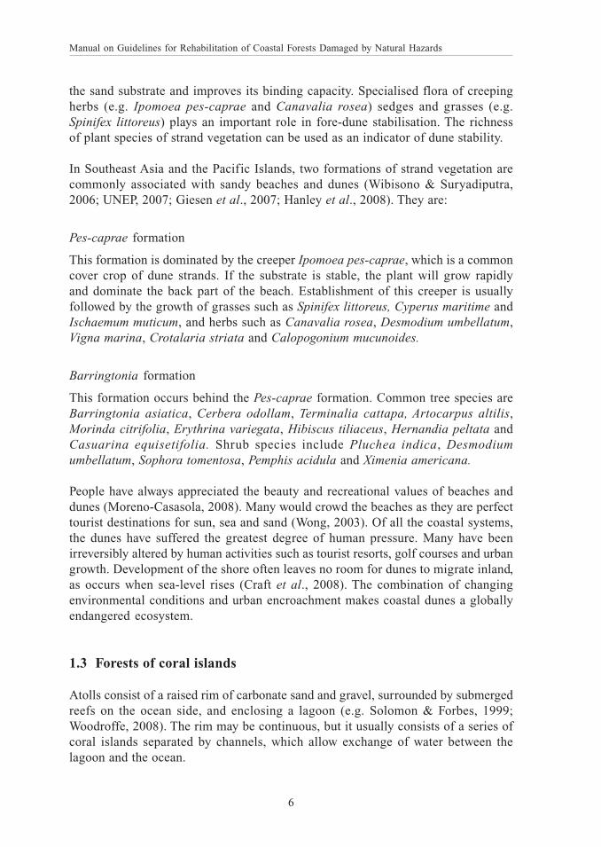
the sand substrate and improves its binding capacity. Specialised flora of creepingherbs (e.g. Ipomoea pes-caprae and Canavalia rosea) sedges and grasses (e.g.Spinifex littoreus) plays an important role in fore-dune stabilisation. The richnessof plant species of strand vegetation can be used as an indicator of dune stability.
In Southeast Asia and the Pacific Islands, two formations of strand vegetation arecommonly associated with sandy beaches and dunes (Wibisono & Suryadiputra,2006; UNEP, 2007; Giesen et al., 2007; Hanley et al., 2008). They are:
Pes-caprae formation
This formation is dominated by the creeper Ipomoea pes-caprae, which is a commoncover crop of dune strands. If the substrate is stable, the plant will grow rapidlyand dominate the back part of the beach. Establishment of this creeper is usuallyfollowed by the growth of grasses such as Spinifex littoreus, Cyperus maritime andIschaemum muticum, and herbs such as Canavalia rosea, Desmodium umbellatum,Vigna marina, Crotalaria striata and Calopogonium mucunoides.
Barringtonia formation
This formation occurs behind the Pes-caprae formation. Common tree species areBarringtonia asiatica, Cerbera odollam, Terminalia cattapa, Artocarpus altilis,Morinda citrifolia, Erythrina variegata, Hibiscus tiliaceus, Hernandia peltata andCasuarina equisetifolia. Shrub species include Pluchea indica, Desmodiumumbellatum, Sophora tomentosa, Pemphis acidula and Ximenia americana.
People have always appreciated the beauty and recreational values of beaches anddunes (Moreno-Casasola, 2008). Many would crowd the beaches as they are perfecttourist destinations for sun, sea and sand (Wong, 2003). Of all the coastal systems,the dunes have suffered the greatest degree of human pressure. Many have beenirreversibly altered by human activities such as tourist resorts, golf courses and urbangrowth. Development of the shore often leaves no room for dunes to migrate inland,as occurs when sea-level rises (Craft et al., 2008). The combination of changingenvironmental conditions and urban encroachment makes coastal dunes a globallyendangered ecosystem.
1.3 Forests of coral islands
Atolls consist of a raised rim of carbonate sand and gravel, surrounded by submergedreefs on the ocean side, and enclosing a lagoon (e.g. Solomon & Forbes, 1999;Woodroffe, 2008). The rim may be continuous, but it usually consists of a series ofcoral islands separated by channels, which allow exchange of water between thelagoon and the ocean.
01 - 08 Chapter 1.pmd 25-Mar-09, 9:22 AM6

Types of coastal forests
7
1ST PROOF
Coral islands are formed by a combination of current and wave activities. They arevery low-lying with elevations of 3-5 m asl (Solomon & Forbes, 1999). The substrateis ill-consolidated coralline material of sand and gravel, piled up over a reef platform(Mueller-Dombois & Fosberg, 1998). Coral islands show variations in the soilsubstrate. The inner or lagoon beach is sandy with the interior having higher humuscontent. At the outer or ocean beach, the substrate consists of broken coral rocks,gravel and coarse sand. Among the Pacific Islands, Tuvalu, Kiribati, Tokelau andMarshall Islands are true atolls, while the Federated States of Micronesia and CookIslands are volcanic islands with atolls (Ellison, 2008).
Unlike continental islands which have a full or partial complement of plant speciesof the continent before they became isolated, oceanic islands such as atolls areformed without plant life (Gillespie, 2007). As such, coral islands do not have muchtopographical features and they harbour relatively few plant species with littleendemism.
The vegetation of coral islands is essentially the same as strand vegetation ofbeaches and dunes. In the Pacific, herbaceous cover of creeping plants of Ipomoeapes-caprae, Canavalia rosea and Wedelia biflora are found, including sedges andgrasses at the high tide level (Mueller-Dombois & Fosberg, 1998). Further inland,shrubs of Scaevola taccada, Pandanus tectorius, Pemphis acidula and Hibiscustiliaceus occur alongside trees of Barringtonia asiatica, Terminala cattapa,Calophyllum inophyllum and Casuarina equisetifolia. In the Maldives, tree speciesfound include Terminalia cattapa, Hibiscus tiliaceus, Thespesia populnea,Calophyllum inophyllum, Pemphis acidula, Barringtonia asiatica, Pongamia pinnataand Scaevola taccada (Jagtap & Untawale, 1999).
Low-lying coral islands on the rim of atolls are perceived as fragile ecosystemsthat are particularly vulnerable to the impacts of sea-level rise. Anticipated effectsof sea-level rise are shoreline erosion, tidal inundation and salt water intrusion (e.g.Mimura, 1999; Wong, 2003; Gillespie, 2007). Other coastal hazards include damageby winds, waves and flooding during tropical cyclones (Solomon & Forbes, 1999).
For many people, coral islands surrounding lagoons are the perfect conditions foran ideal tourist destination (Wong, 2003). Attractions are full privacy, all-yearsunshine, warm water, white sandy beaches and coral reefs. Besides sun, sea andsand, one can also experience sunrise and sunset. The Maldives have developed theone-island one-resort concept for small islands (Naseer, 2007). When an island isdeveloped as a resort, the whole reef ecosystem surrounding the island effectivelycomes under the jurisdiction of the resort’s management. Besides tourism, fishingis another important industry of coral islands. Activities include offshore and near-shore reef fishing.
01 - 08 Chapter 1.pmd 25-Mar-09, 9:22 AM7

Manual on Guidelines for Rehabilitation of Coastal Forests Damaged by Natural Hazards
8
1ST PROOF
Fig. 1. Mangrove forest of Rhizophora species fringing the banks of a creek
K. Tsuruda
Fig. 2. Typical sandy beach and dune strand vegetation in the tropics
K.H. Tan
01 - 08 Chapter 1.pmd 25-Mar-09, 9:22 AM8

Natural hazards affecting coastal forests
9
1ST PROOF
Manual on Guidelines for Rehabilitation of Coastal Forests, H.T. Chan & S. Baba, 2009; p. 0–00
2.1 Tsunamis
Tsunamis are series of waves caused by a large displacement of the ocean bed dueto an earthquake or volcanic eruption (King, 2008). The effects of tsunamis can bedevastating due to the immense volume of water and energy involved. It has beenrecognised as one of the deadliest natural hazards (Osti et al., 2008).
In the deep ocean, tsunami waves can travel at speeds of more than 750 kph, withwave heights of less than a metre (Solomon & Forbes, 1999). However, when theyapproach shallow waters, they slow down and increase in height dramatically. Thiseffect is more pronounced on gradual and shallow shores (Wells et al., 2006).Tsunamis can cause substantial damage to locations protected from wind-generatedwaves, as they can accelerate through channels and inlets, rapidly increasing inheight. When reflected by obstacles, they can also travel in different directions.
The 2004 Indian Ocean tsunami caused severe economic and ecological damage to13 countries in Asia including Africa (Kathiresan & Rajendran, 2005; Chandrasekar& Ramesh, 2007; Osti et al., 2008). The sea waves were generated by a massiveearthquake in the ocean bed that measured 9.3 on the Richter scale. Located closeto northwest coast of Sumatra, the epicentre of the earthquake (3.7ºN, 95ºE)generated waves that travelled in all directions with speeds up to 900 kph. Thegigantic waves killed more than 200,000 people, made about two million peoplehomeless and resulted in property loss of US$ 6 billion.
The following are descriptions of the disastrous effects of the 2004 tsunami oncoastal areas of five countries bordering the Indian Ocean:
Indonesia
With the earthquake epicentre less than 40 km from the northwest coast of Sumatra,Indonesia was the worst affected (Srinivas & Nakagawa, 2008). Extending 1-2 kminland, some 600 km of the coast of Sumatra were damaged (Shofiyati et al., 2005).In areas with flat topography such as Banda Aceh, the width of the corridor reached4 km inland. The city was one of the worst hit areas with 74% of 3,860 ha ofsettlement area destroyed. Besides the massive human toll of more than one millionkilled or displaced, the economic and environmental damage was extensive. Coral
Chapter 2
NATURAL HAZARDS AFFECTINGCOASTAL FORESTS
09 - 17 Chapter 2.pmd 25-Mar-09, 9:26 AM9

Manual on Guidelines for Rehabilitation of Coastal Forests Damaged by Natural Hazards
10
1ST PROOF
reefs, mangroves, coastal forests, agricultural crops and aquaculture ponds wereadversely affected. The total area destroyed in Sumatra was estimated at 120,300ha, of which 22% was settlement and 28% was agricultural land. In the Provinceof Aceh, the total area of mangroves damaged was estimated at 32,000 ha with 15districts and towns affected (Wibisono & Suryadiputra, 2006).
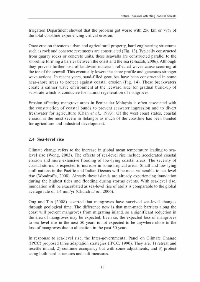
Damage to coastal vegetation in Aceh occurred at two stages (Wibisono &Suryadiputra, 2006). The first stage was caused by the energy of the tsunami, whichdirectly struck the coast, and destroyed mangroves and other coastal forests includingcash crop plantations. This happened extremely fast and the coastal vegetation wasdamaged instantly with trees uprooted or branches of trees torn off by the brutalforce of the waves (Fig. 3). The second stage was caused by the inundation of seawater brought by the tsunami. The saline soils gradually killed the coastal vegetationas can be seen by the withering of leaves, crown die-backs and standing dead trees(Fig. 4).
Thailand
Much of the impact on Thailand was along the Andaman coast, affecting the coastalprovinces of Phuket, Phang Nga, Krabi, Ranong, Trang and Satun (Harakunarak &Aksornkoae, 2005). The tsunami killed at least 5,300 people, affected 490 fishingvillages and left tens of thousands homeless. Damage to mangrove forests wasconsiderably less than in other countries, with less that 1% affected (Srinivas &Nakagawa, 2008). Mangrove forests in Phang Nga significantly mitigated the impactof the tsunami. They suffered damage at the seaward fringe, but reduced the tsunamiwave energy and provided protection to the mangrove forests further inland.
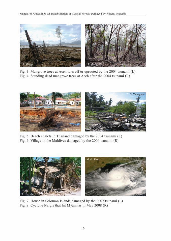
Paphavasit et al. (2007) reported that only 390 ha of mangrove forests in Thailandwere impacted by the tsunami. Mangrove forests in Phang Nga were slightlydamaged with only 90 ha in Ranong severely damaged. The area impaired wasrelatively small when compared with other coastal ecosystems such as coral reefs(690 ha) and sandy beaches (990 ha). The most severely affected beach forestswere in Ranong and Phang Nga. Beach resorts at Khao Lak were badly damaged(Fig. 5).
Sri Lanka
The f irst wave reached the east coast of Sri Lanka about 1.5 hour after theearthquake, with a surge height of 5.5-6.5 m (Srinivas & Nakagawa, 2008). Overtwo-thirds of the 12 districts were affected. The impact was not uniform due tovarying topography and bathymetry. The presence of houses and other buildings atthe sea-front increased the overall damage and destruction to infrastructure andproperty.
09 - 17 Chapter 2.pmd 25-Mar-09, 9:26 AM10

Natural hazards affecting coastal forests
11
1ST PROOF
The Maldives
Many of the coral islands of the Maldives were in the direct path of the tsunamiabout three hours after the earthquake (Srinivas & Nakagawa, 2008). The low humancasualty was attributed to protection by the surrounding reefs. Most of the damagewas on coastal infrastructure including villages (Fig. 6), harbours and resorts. Therewas some damage to coastal vegetation but beach erosion and sea water intrusionwere extensive. The tsunami displaced more than 10,000 people with three islandstotally evacuated (Naseer, 2007). Economic sectors adversely affected were tourism,fisheries and agriculture.
Peninsular Malaysia
Although located close to the epicentre of the tsunami, Peninsular Malaysia wasshielded from the initial waves by Sumatra and was only impacted by reflected waves(Tan & Ong, 2008). Whilst there was some loss of lives and damage to property,all mangrove forests remained intact. The secondary waves only arrived after thedirect waves hit the Andaman coast of Thailand farther north. As such, the waveswere mild and resulted in minor damage in the north-western coast of the peninsula.
Following the 2004 Indian Ocean tsunami, two more tsunamis occurred. Theyaffected Java in 2006 and Solomon Islands in 2007 (Fig. 7) with estimated deathtolls of 800 and 50, respectively (Osti et al., 2008). Several years prior to the IndianOcean tsunami were the tsunamis of Pakistan in 1999 and Papua New Guinea in1998.
2.2 Tropical cyclones
Tropical cyclones are formed between latitudes of 10º and 25º, and they differ fromtemperate cyclones by being seasonal and having smaller whirlwinds (Mueller-Dombois & Fosberg, 1998). They are called hurricanes when wind speeds exceed64 knots. Hurricanes are called typhoons in countries such as Guam, Taiwan,Philippines and Japan.
Cyclones are intense atmospheric depressions in which the winds whirl around asmall calm ‘eye’ (BPA, 1999). In coastal areas, cyclones bring the hazards of largewaves and storm surges in addition to strong winds and torrential rain. The intensewinds of cyclones are capable of generating very high seas. A temporary rise inthe sea level is known as a storm surge. The major part of the surge is usually causedby strong onshore winds which exert a stress on the sea surface, causing the waterto accumulate. As a cyclone moves into shallow coastal waters, the near-shore bedand coastline modify the surge, resulting in a substantial amplification of its height.The great loss of human lives due to cyclones has often been a result of high stormsurges that led to drowning.
09 - 17 Chapter 2.pmd 25-Mar-09, 9:26 AM11
Manual on Guidelines for Rehabilitation of Coastal Forests Damaged by Natural Hazards
12
1ST PROOF
The large waves that accompany cyclones can cause severe damage to coastal areas(Coch, 1994; BPA, 1999). The extent of erosion depends on the storm surge at thetime of greatest wave attack. High water levels allow large waves to reach the dunesand cause erosion as sand is moved offshore by the backwash of breaking waves.Cyclones can substantially erode beach and dune systems and can wreckinfrastructure if they are located too close to the beach. Strong winds can damagedune vegetation and expose the sand to wind erosion. Where sand is permanentlylost, the beach and frontal dunes become susceptible to erosion.
The following are descriptions of the impacts of cyclones on coastal areas ofAustralia, Bangladesh and Myanmar:
Cyclone Winifred hit the coast of Queensland, Australia, from 29 January to 1February 1986 (BPA, 1986). With winds gusting up to 200 kph, the cyclonegenerated waves of 1.5 m and a storm surge of 1.8 m. No human death andsignificant loss of property were report except for beach erosion and the over-topping of frontal beach ridges in some areas.
Cyclone Larry lashed the Queensland coast 60 km south of Cairns in the morningof 20 March 2006 with wind up to 300 kph (Williams et al., 2007). Although therewas damage to buildings, forests and cash crops, there was no loss of human lives.Commercial, recreational and naval vessels in the port of Cairns were protectedfrom the destructive winds by docking in the sheltered creeks of the Trinity Inletmangroves.
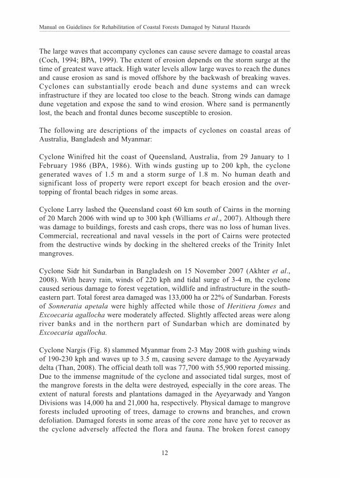
Cyclone Sidr hit Sundarban in Bangladesh on 15 November 2007 (Akhter et al.,2008). With heavy rain, winds of 220 kph and tidal surge of 3-4 m, the cyclonecaused serious damage to forest vegetation, wildlife and infrastructure in the south-eastern part. Total forest area damaged was 133,000 ha or 22% of Sundarban. Forestsof Sonneratia apetala were highly affected while those of Heritiera fomes andExcoecaria agallocha were moderately affected. Slightly affected areas were alongriver banks and in the northern part of Sundarban which are dominated byExcoecaria agallocha.
Cyclone Nargis (Fig. 8) slammed Myanmar from 2-3 May 2008 with gushing windsof 190-230 kph and waves up to 3.5 m, causing severe damage to the Ayeyarwadydelta (Than, 2008). The official death toll was 77,700 with 55,900 reported missing.Due to the immense magnitude of the cyclone and associated tidal surges, most ofthe mangrove forests in the delta were destroyed, especially in the core areas. Theextent of natural forests and plantations damaged in the Ayeyarwady and YangonDivisions was 14,000 ha and 21,000 ha, respectively. Physical damage to mangroveforests included uprooting of trees, damage to crowns and branches, and crowndefoliation. Damaged forests in some areas of the core zone have yet to recover asthe cyclone adversely affected the flora and fauna. The broken forest canopy
09 - 17 Chapter 2.pmd 25-Mar-09, 9:26 AM12

Natural hazards affecting coastal forests
13
1ST PROOF
encouraged colonisation of invasive light-demanding plant species such as Acanthusilicifolius, Phoenix paludosa and Acrostichum aureum. New nesting mounds of thecrocodile (Crocodylus porosus) were found in the mangrove plantations where ithas never come to nest, as their natural nesting sites have been destroyed.
2.3 Coastal erosion
Mangrove forests are stable, accreting or eroding (e.g. Chan et al., 1993; Giesen etal., 2007). An accreting mangrove shore typically has a low crop of pioneer speciesof Avicennia moving seawards as the plants colonise the newly formed mud flats.A stable shore is one that is neither accreting nor eroding. An eroding shore ischaracterised by the general lowering of the near-shore profile, formation ofretreating scarps due to scouring of mangrove substrate (Fig. 9), collapsing ofmangrove trees (Fig. 10) and deposition of sand cheniers (Fig. 11). Comprisingmostly shell fragments, these cheniers are mobile and highly abrasive, and can causetrees to die. The lowering of the shore profile leads to the generation of strong waveactions which accelerate the erosion process.
Globally, retreating coastlines have been reported to exceed advancing coastlines(Bird, 1985). About 20% of the world’s coastlines are sandy; of these, more than70% experienced net erosion over the past few decades, less than 10% showedaccretion, and the remaining 20% was stable. There is increasing evidence thatcoastal erosion is an escalating environmental threat of global concern. Factorsinfluencing coastal erosion are natural or human induced. Climate change and sea-level rise are seen as major factors causing coastal erosion.
It is anticipated that the problem of coastal erosion would be most severe for low-lying and small coral islands. The causes of beach erosion are increased wave energy,interruption to littoral transport, deprivation of sediment input, human activities andsea-level rise (Bird, 1996). Human activities which contribute to shoreline erosioninclude mining of beach sand, poorly designed seawalls and revetments, anddestruction of coastal vegetation.
Measures of shore protection to combat coastal erosion are well known (Ghazali,2006). They include hard engineering structures such as seawalls, groins andbreakwaters. Of the soft engineering measures, beach nourishment is most widelypractised. The construction process involves dredging, transport and placement ofsand onto the eroding beach. It is considered semi-permanent and requires periodicreplenishment of sand.
The following are descriptions of the extent and severity of coastal erosion in severalcountries of South and Southeast Asia:
09 - 17 Chapter 2.pmd 25-Mar-09, 9:26 AM13

Manual on Guidelines for Rehabilitation of Coastal Forests Damaged by Natural Hazards
14
1ST PROOF
Thailand
Coastal erosion in Thailand has intensified during the past decade (Thampanya etal., 2006). The coastline of the Gulf of Thailand in the east was more dynamic thanthe Andaman coastline in the west. Erosion rates were 3.6 and 2.9 m per year versusaccretion rates of 2.6 and 1.5 m per year, respectively. It was observed that areaswith mangroves had less erosion while accretion occurred at sheltered river mouthsand in bays. Erosion was severe in areas with extensive shrimp farms (Fig. 12).Erosion of the Bang Khun Thien mangroves in the Gulf of Thailand has beenattributed to the construction of coastal dikes and dams, and to local subsidencedue to ground water withdrawal (Winterwerp et al., 2005).
Sri Lanka
Sri Lanka’s coastline is retreating with the problem most severe in the west andsouthwest (Samaranayake, 2007). The degree of erosion varied between locationswith maximum rates of up to 12 m per year. The average rate was 0.5 m per year.In some areas, the rate of retreat has increased due to human activities.
Peninsular Malaysia
In Peninsular Malaysia, the problem of coastal erosion was realised since the 1980s.A national coastal erosion study was conducted to assess the severity of coastalerosion, to map the locations of eroding shores and to recommend remedialmeasures (EPU, 1986). Erosion was categorised as critical, significant or acceptable(Table 5).
Table 5. Classification of coastal erosion in Peninsular Malaysia (EPU, 1986)
Category of erosion Description of category
Critical Eroding shoreline is in a state where shore-based facilitiesand infrastructure are in immediate danger of collapse ordamage
Significant Shoreline is eroding at a rate whereby public property andagriculture land of value will become threatened within 5-10 years unless remedial action is taken
Acceptable Shoreline is experiencing erosion but with no or minorconsequent economic loss if left unchecked
Critically eroding areas were reported to be 131 km or 41% of the total coastlinein 1986 (EPU, 1986). A follow-up study conducted in 2006 by the Drainage and
09 - 17 Chapter 2.pmd 25-Mar-09, 9:26 AM14
Natural hazards affecting coastal forests
15
1ST PROOF
Irrigation Department showed that the problem got worse with 256 km or 78% ofthe total coastline experiencing critical erosion.
Once erosion threatens urban and agricultural property, hard engineering structuressuch as rock and concrete revetments are constructed (Fig. 13). Typically constructedfrom quarry rocks or concrete units, these seawalls are constructed parallel to theshoreline forming a barrier between the coast and the sea (Ghazali, 2006). Althoughthey prevent further loss of landward material, reflected waves cause scouring atthe toe of the seawall. This eventually lowers the shore profile and generates strongerwave actions. In recent years, sand-filled geotubes have been constructed in somenear-shore areas to protect against coastal erosion (Fig. 14). These breakwaterscreate a calmer wave environment at the leeward side for gradual build-up ofsubstrate which is conducive for natural regeneration of mangroves.
Erosion affecting mangrove areas in Peninsular Malaysia is often associated withthe construction of coastal bunds to prevent seawater ingression and to divertfreshwater for agriculture (Chan et al., 1993). Of the west coast states, coastalerosion is the most severe in Selangor as much of the coastline has been bundedfor agriculture and industrial development.
2.4 Sea-level rise
Climate change refers to the increase in global mean temperature leading to sea-level rise (Wong, 2003). The effects of sea-level rise include accelerated coastalerosion and more extensive flooding of low-lying coastal areas. The severity ofcoastal storms is expected to increase in some tropical areas. Small and low-lyingatoll nations in the Pacific and Indian Oceans will be most vulnerable to sea-levelrise (Woodroffe, 2008). Already these islands are already experiencing inundationduring the highest tides and flooding during storms events. With sea-level rise,inundation will be exacerbated as sea-level rise of atolls is comparable to the globalaverage rate of 1.4 mm/yr (Church et al., 2006).
Ong and Tan (2008) asserted that mangroves have survived sea-level changesthrough geological time. The difference now is that man-made barriers along thecoast will prevent mangroves from migrating inland, so a significant reduction inthe area of mangroves may be expected. Even so, the expected loss of mangrovesto sea-level rise in the next 50 years is not expected to be anywhere close to theloss of mangroves due to alienation in the past 50 years.
In response to sea-level rise, the Inter-governmental Panel on Climate Change(IPCC) proposed three adaptation strategies (IPCC, 1990). They are: 1) retreat andresettle inland; 2) continue occupancy but with some adjustments; and 3) protectusing both hard structures and soft measures.
09 - 17 Chapter 2.pmd 25-Mar-09, 9:26 AM15
Manual on Guidelines for Rehabilitation of Coastal Forests Damaged by Natural Hazards
16
1ST PROOF
Fig. 3. Mangrove trees at Aceh torn off or uprooted by the 2004 tsunami (L)Fig. 4. Standing dead mangrove trees at Aceh after the 2004 tsunami (R)
T. Miyagi T. Miyagi
Fig. 7. House in Solomon Islands damaged by the 2007 tsunami (L)Fig. 8. Cyclone Nargis that hit Myanmar in May 2008 (R)
T. Hiraishi
M.M. Than
Fig. 5. Beach chalets in Thailand damaged by the 2004 tsunami (L)Fig. 6. Village in the Maldives damaged by the 2004 tsunami (R)
S. Yamagami
S. Yamagami
09 - 17 Chapter 2.pmd 25-Mar-09, 9:26 AM16

Natural hazards affecting coastal forests
17
1ST PROOF
Fig. 9. Retreating scarps formed due to scouring of mangrove substrate (L)Fig. 10. Collapsing of mangrove trees and deposition of sand cheniers (R)
H.T. Chan H.T. Chan
Fig. 11. Cheniers of abrasive shell fragments along eroding shores (L)Fig. 12. Severe coastal erosion threatening shrimp farms in Thailand (R)
S. HavanondV. Jeyanny
Fig. 13. Rock revetments constructed to safeguard against coastal erosion (L)Fig. 14. Sand-filled geotubes constructed to protect eroding shores (R)
H.T. Chan
Raja Barizan
09 - 17 Chapter 2.pmd 25-Mar-09, 9:26 AM17

18 A
09 - 17 Chapter 2.pmd 25-Mar-09, 9:26 AM18

Protective roles of coastal forests
19
1ST PROOF
Manual on Guidelines for Rehabilitation of Coastal Forests, H.T. Chan & S. Baba, 2009; p. 0–00
3.1 Overview
A technical workshop on Coastal protection in the aftermath of the Indian Oceantsunami: What role for forests and trees? was convened by FAO in Khao Lak,Thailand from 28-31 August 2006. The objective of the workshop was to improveunderstanding of the role of coastal trees and forests in protecting populations andassets from natural hazards, including not only tsunamis but also cyclones, erosion,and wind and salt spray. The workshop brought together the best available knowledgeand experience to give a clearer picture of the roles that forests and trees play inprotection against natural hazards. Conclusions of the FAO workshop (Braatz et al.,2007), which are considered the most authoritative statements on the protectivefunctions of coastal vegetation, were:
Coastal forests and trees can, under certain conditions, act as bio-shields toprotect lives and valuable assets against coastal hazards, including: tsunamis,cyclones, wind and salt spray, and coastal erosion.
The degree of protection offered by coastal bio-shields depends on a numberof variables, including characteristics of the hazard itself (e.g. type, force,frequency); features of the site (e.g. bathymetry, coastal geomorphology); andcharacteristics of the bio-shield (e.g. type of forest/tree, width, height anddensity of the forest).
Care must be taken to avoid making generalisations about the protective role offorests and trees based on evidence from one or a few areas; the many factorsthat influence the protective role of forests/trees must be understood and takeninto consideration before lessons can be learned and applied elsewhere.
Coastal forests and trees are not able to provide effective protection againstall hazards (e.g. extremely large tsunami waves, flooding from cyclones andcertain types of coastal erosion); provisions for other forms of protection and(in extreme events) for evacuation must be relied upon. Care must be takennot to create a false sense of protection against coastal hazards.
The importance of incorporating coastal protection as an integral part ofcoastal area planning and management is recognised.
Options for protection include soft and hard solutions, and a hybrid of thetwo. If none of these is appropriate and viable, it may be necessary to zonecoastal land-use to prevent (further) settlement and construction of valuableassets in the vulnerable zone.
Chapter 3
PROTECTIVE ROLES OF COASTAL FORESTS
19 - 22 Chapter 3.pmd 25-Mar-09, 9:28 AM19

Manual on Guidelines for Rehabilitation of Coastal Forests Damaged by Natural Hazards
20
1ST PROOF
It is important to match species with the site in order to avoid high mortalityand low performance of the planted trees. Some forest types and tree speciescannot survive or thrive in areas exposed to specific coastal hazards. Theyare not candidates for protective measures.
Development of bio-shields is not possible in all situations owing to interalia biological limitations, space constraints, incompatibility with priorityland-uses and prohibitive costs.
The level of knowledge and understanding of the functions of forests and treesin coastal protection is still insufficient. There is a lack of multi-disciplinaryresearch in this field. Specific areas needing further attention include researchin non-mangrove coastal forests, collection of data, and development ofmodels on interaction between physical and ecological parameters.
There is a need to recognise that many years are required to establish andgrow bio-shields to a size and density that could offer protection againstcoastal hazards.
Considerable research and field initiatives related to forests and coastalprotection have been carried out over the past several years; they provide auseful foundation for further work to improve understanding of the protectiverole that forests can offer.
Based on the impacts of past tsunamis, Harada and Imamura (2005) reviewed themitigation effects of coastal forests. According to them, the four main protectivefunctions of coastal forests are: 1) Reduce damage by stopping drifts and boatscarried by a tsunami; 2) Reduce the overall tsunami energy; 3) Form sand dunesthat provide protection from tsunamis as well as high waves; and 4) Catch personscarried back by a tsunami to the sea. However, they cautioned that the protectivefunctions of coastal forests would be destroyed if the tsunami waves exceed 4 m inheight.
3.2 Mangrove forests
Mangroves are considered as natural barriers protecting the lives and property ofcoastal communities from storms, cyclones, flooding, and coastal erosion (Walterset al., 2008). This remains a principal reason for planting mangroves along manylow-lying coasts. Construction of engineering structures such groins and breakwatersto protect the coastline are expensive and may not be as effective.
Areas with mangroves sustained much less damage from the 2004 Indian Oceantsunami than areas where mangroves have been removed and where coastaldevelopment has reached the seafront areas (e.g. Kathiresan & Rajendran, 2005;Danielsen et al., 2005). Mangrove deforestation compounded the effects of the
19 - 22 Chapter 3.pmd 25-Mar-09, 9:28 AM20

Protective roles of coastal forests
21
1ST PROOF
tsunami. These reports albeit anecdotal have been supported by evidence of satelliteimages taken before and after the tsunami. Results showed that areas with mangrovesor tree cover were less susceptible to tsunami damage. Mangrove vegetation isconsidered more effective in mitigating the impacts of tsunamis than other coastalvegetation.
Although the 2004 tsunami had severe impacts on affected coasts, loss of humanlives and the degree of damage to property and infrastructure were less in placeswith healthy mangrove or coastal forests, such as the Andaman and Nicobar Islandsand parts of Tamil Nadu in India (Osti et al., 2008).
Despite some controversy over whether the presence of mangroves saved lives duringthe 2004 tsunami, Wolanski (2006) concluded that mangroves and other coastalforests do provide tangible coastal protection to the extent that the establishmentof coastal green belts as buffers against storm and tsunami events is justified.
The protective role of planted mangroves in dissipating wave actions has beenreported (e.g. Mazda et al., 1997; Kogo & Kogo, 2004; Wolanski & Richmond,2008). In the district of Thai Thuy, Vietnam, a seaward belt of Kandelia candel treesplanted at close spacing was established. Six years after planting, a 1 m waveentering the forest was reduced to 0.05 m at the shoreline. Without the shelteringeffect of the planted mangroves, the resultant waves would be 0.75 m.
Studies have shown that for mangroves and other coastal forests to effectively bufferagainst storm surges and tsunamis, they should be at least 100 m in width (Mazdaet al., 1997) or have 400 trees per 10 m of shoreline in density (Hiraishi, 2008).However, it has been envisaged that once the height of waves impacting a coastreaches 2 m or more, the forest will usually fail, and the trees themselves becomepart of the debris that causes damage further inland (Hanley, 2007).
Cochard (2008) supported the argument that mangroves and other coastal vegetationplay a minor role in buffering against tsunami waves. Whether or not vegetationdoes provide protection depends on many factors, including stand size, density,species composition, structure and homogeneity. The most important predictorvariables of the tsunami hazard are distance from the tsunami source and coastaltopography, in particular near-shore bathymetry. In locations, far from the tsunamisource, coastal vegetation probably provided some protection. In many otherlocations, however, the vegetation provided no protection. In some cases, they mayeven have aggravated the problem e.g. by contributing to flow debris and bychannelling water flows. The establishment of tsunami greenbelts should not betreated as an alternative to early warning systems. Greenbelts may only beconsidered as economical and multi-functional means to provide relative hazardprotection for material assets such as infrastructure and agriculture.
19 - 22 Chapter 3.pmd 25-Mar-09, 9:28 AM21

Manual on Guidelines for Rehabilitation of Coastal Forests Damaged by Natural Hazards
22
1ST PROOF
Since the 2004 tsunami, the general picture emerging is that mangroves are not themain factor influencing the extent of damage on the coastline (Wells et al., 2006).Near-shore bathymetry and coastline prof ile are probably the key factorsdetermining the force of tsunami waves at any particular location. Shores adjacentto deep water tended to be less affected than those next to shallow and graduallysloping shelves. The shape of the coastline is another factor, with headlandsproviding protection while bays and inlets act as funnels, restricting and focusingthe force of the waves. More research is required before it will be possible to predictwhere, and in what way, mangroves will help to reduce the impact of a tsunami.
The role of mangroves in protecting the shoreline from coastal erosion remainsunclear. Blasco et al. (1996) pointed out that mangroves do not prevent coastalerosion but their elaborate root structures are likely to slow down the processconsiderably. Although mangroves can provide limited protection against erosiveforces, Hanley et al. (2008) emphasised that mangroves typically colonise shelteredareas where fine sediments are deposited by coastal processes. Once established,they can enhance the process of sedimentation by increasing the rate of deposition.Mangroves do not, however, initiate sedimentation and are not able to colonise orpersist at high energy shorelines. Natural hazards such as storms, cyclones, floodsand tsunamis create severe erosion and in many cases mangroves can reduce thescale of these impacts. However, if episodes are frequent enough then the coastlinewill recede and eventually the mangroves will disappear.
3.3 Other coastal forests
It has been suggested that pure stands of Casuarina equisetifolia trees with littleundergrowth provide limited resistance against the hazardous tsunami waves(Cochard et al., 2008). The dense, multi-layered strand formation of Barringtoniaasiatica, Pandanus tectorius and Scaevola taccada probably provides betterprotection. In many locations, strand vegetation has been replaced by coconut groveswhich afford the least physical protection.
Compared to mangrove forests, strand vegetation may not provide adequateprotection against tsunami (Kathiresan & Rajendran, 2005). Field observationsfollowing the 2004 tsunami showed that most of the beach and dune vegetation wasaffected with browning of canopies and trees shedding their leaves. However, theywould hold good as wind-breakers during coastal storms.
Strand vegetation has been reported to provide protection of beaches and dunesagainst coastal erosion. For example, trees of Scaevola taccada serve as a protectivebarrier for the beaches of Kerala in India (Sundaresan, 1993). Natural vegetationbelt of Scaevola taccada and Pandanus odoratissimus, with their masses of exposedroots and branches, have been effective in reducing wave energy and coastal erosionon Bintan Island in Indonesia (Wong, 2003).
19 - 22 Chapter 3.pmd 25-Mar-09, 9:28 AM22

Guidelines for rehabilitation of coastal forests
23
1ST PROOF
Manual on Guidelines for Rehabilitation of Coastal Forests, H.T. Chan & S. Baba, 2009; p. 0–00
4.1 Overview
Concepts and rationale
Rehabilitation of coastal forests can be defined as the act of partially replacing theirstructural or functional characteristics that have been diminished or lost (Field,1998a). This would mean re-establishing some of the ecological attributes.Restoration of coastal forests is the act of bringing them back, as nearly as possible,to their original condition. By implication, all the key ecological processes andfunctions including all the former biodiversity are re-established (Wells et al., 2006).The creation of plantations of a few coastal species does not equate to restoration.As restoring a coastal forest ecosystem to its original undisturbed condition is notrealistic, rehabilitation is the preferred term to use.
The shortage of productive land in developing countries has resulted in coastalforests being converted for development. The rapid alienation of coastal forestshas prompted a worldwide movement to plant new forest areas (Field, 1998a).Another impetus behind the rehabilitation of coastal forests is the spectacular riseof environmental consciousness in recent decades. The devastation of coastal areasby the Indian Ocean tsunami in December 2004 and cyclone Nargis in May 2008has presented yet another rationale for establishing plantations of coastal forestsfor protection against natural hazards.
If the rationale of rehabilitation is to establish protective coastal belts to safeguardagainst natural hazards, there are no valid reasons for planting coastal species atfixed spacing along lines as traditionally done in plantation forestry. Other optionssuch as cluster planting and phased planting can be tried out.
Cluster planting may be favoured in heterogeneous habitats (e.g. seaward tidal flats)where some sites are unsuitable for rehabilitation. Efforts should focus onestablishing clusters of trees in favourable sites. Over time, these clusters wouldestablish themselves and serve as mother populations to seed up the remaining sitesthrough natural regeneration. The concept is essentially planting to assist in thenatural recovery process.
Phased planting may work well in difficult habitats with harsh environmentalconditions (e.g. coastal dune formations). Initial efforts will focus on planting
Chapter 4
GUIDELINES FOR REHABILITATION OFCOASTAL FORESTS
23 - 57 Chapter 4.pmd 25-Mar-09, 11:35 AM23

Manual on Guidelines for Rehabilitation of Coastal Forests Damaged by Natural Hazards
24
1ST PROOF
pioneer herbaceous plant species to stabilise the site and to ameliorate siteconditions. The planting of woody tree species will only commence after the sitehas stabilised and conditions improved.
Finally, if all initial trials failed in a given coastal area, the best option would be todo nothing and allow the shore to change naturally without intervention. As shorechanges are usually cyclical, the site conditions may gradually improve to levelswhere rehabilitation becomes feasible.
A report by the Environmental Justice Foundation has rightly asserted that mangroveforests may recover without active rehabilitation efforts, once stresses to them havebeen removed (EJF, 2006). Rather than to launch straight into massive replantingprogrammes, at high cost and with a low probability of success, it may be far moresensible for governments of tsunami-affected countries to concentrate on the naturalregrowth and recovery of remaining mangroves. Undoubtedly, this advice alsoapplies to other coastal forests.
Rehabilitation efforts
The two main criteria for assessing the success of a coastal rehabilitation programmeare the effectiveness and efficiency of the planting (Field, 1998b). The former canbe considered as the closeness to which the new mangrove forest meets the originalgoals of the planting programme. The latter can be measured in terms of the amountof labour, resources and material that were used. In most cases, the effectivenessand efficiency of rehabilitation are not always quantified.
With every rehabilitation effort of coastal forests, there is always a high degree ofuncertainty over the success of meeting its objectives (Yap, 2000). The level ofdifficulty varies with the different forest types and site conditions, and so does theassociated expenditure in terms of manpower and financial resources. It is generallyacknowledged that mangroves are easier to rehabilitate compared to other coastalforests.
Following the aftermath of the Indian Ocean tsunami, governments of countries inSouth and Southeast Asia have pledged their support for mangrove rehabilitation(Check, 2005). Malaysia has allocated $25 million to replant 4,000 ha of mangroves.Indonesia has pledged $22 million and has already planted 300,000 seedlings inAceh. The Thai government has expressed its support for mangrove and coastalforest rehabilitation. The government of India has pledged $8 million to supplementan on-going programme to rehabilitate mangroves damaged by cyclones.
As many as 124 international NGOs participated in the reconstruction andrehabilitation of Aceh and Nias (Wibisono & Suryadiputra, 2006; UNEP, 2007).About 20 of them were involved in coastal rehabilitation programmes. They included
23 - 57 Chapter 4.pmd 25-Mar-09, 11:35 AM24

Guidelines for rehabilitation of coastal forests
25
1ST PROOF
Oxfam International, Islamic Relief, Mercy Corps, GTZ, FAO and WetlandsInternational. More than 430 national NGOs participated but less than 20% wereinvolved in coastal rehabilitation. In Aceh, over 10,000 ha of mangroves have beenplanted by the Board of Rehabilitation and Reconstruction of the Ministry ofForestry in areas affected by the tsunami (Triswanto, 2006).
Elsewhere in the region, post-tsunami projects were also implemented. An exampleis the mangrove rehabilitation project in Sri Lanka and Thailand (Qureshi, 2008).Funded by the Ministry of Environment of Spain, the project was implemented byIUCN from September 2005 to December 2007. In Phang Nga, more than 200 haof mangroves damaged by the tsunami have been rehabilitated by the Departmentof Marine and Coastal Resources (DMCR) in collaboration with local residents(Paphavasit et al., 2007). DMCR also planted 3,000 seedlings of Cocos nucifera,Casuarina equisetifolia, Barringtonia asiatica and Pandanus odoratissimus. InPeninsular Malaysia, although hardly affected by the tsunami, about 150 ha ofmangroves and 18 ha of beach forests have been planted in the various states bythe Forestry Department in 2005 (Mohd Ridza, 2006).
4.2 Mangrove forests
Rationale for rehabilitation
Mangroves have been planted for various purposes including: a) wood productionto support commercial or small-scale forestry; b) shoreline and storm protectionfor coastal settlements; c) fisheries, aquaculture and wildlife enhancement; and d)ecological restoration (Field, 1996; Yap, 2000; Walters et al., 2008).
Since the Indian Ocean tsunami and with more intensified coastal erosion, there isincreased interest in planting mangroves for coastal protection (Check, 2005). InThailand, concern over mangrove deforestation by shrimp farms has motivated manycoastal households to participate in mangrove rehabilitation programmes (Barbier,2006).
In the past, mangroves are considered easy to rehabilitate. Viviparity of theirseedlings enables direct planting of propagules which are available in abundance,and planted seedlings often have good survival and growth rates. Reforestationprogrammes have been successful in many countries of the Asia-Pacific region(Field, 1996).
Recently, many post-tsunami mangrove rehabilitation projects have failed orachieved limited success as exemplified by those implemented in Aceh (e.g. Check,2005; Wibisono & Suryadiputra, 2006; UNEP, 2007; Hanley et al., 2008). Lessonslearnt from these failed projects included planting too soon, wrong choice of species,planting in the wrong places, and the lack of monitoring and tending after planting.
23 - 57 Chapter 4.pmd 25-Mar-09, 11:35 AM25

Manual on Guidelines for Rehabilitation of Coastal Forests Damaged by Natural Hazards
26
1ST PROOF
Erftemeijer and Lewis III (1999) emphasised that during low tides, the intertidalmud flats serve as important feeding grounds for migratory shore birds and ashabitats for local people to collect bivalves and crabs. Any attempts at mangroverestoration on mud flats would represent a form of habitat conversion.
Past attempts in planting mangroves on tidal flats to mitigate coastal erosion inMalaysia and Thailand have failed. In Selangor, Malaysia, Chan et al. (1988)reported that several planting trials of Avicennia officinalis on an exposed mud flatsseaward of an eroding shoreline were not successful. Among the factors adverselyaffecting survival and growth of mangrove plants are strong wave actions, high soilsalinity, barnacle infestation, prolonged inundation and lack of tidal flow. At BanDon Bay in southern Thailand, mangroves were planted on newly-formed mud flats(Angsupanich & Havanond, 1996). Seedlings of Avicennia alba and Sonneratiacaseolaris died within eight months while those of Rhizophora mucronata diedwithin a year. Seedling mortality was attributed to severe infestation by barnaclesand frequent immersion in seawater during high tide.
Choice of species
For the rehabilitation of mangroves, the choice of species and their propagationmethods described here are by no means exhaustive. The species have been selectedbecause some knowledge is available on their silviculture and they have potentialsfor coastal protection. The species, and their life-forms, habitat types, salinity rangesand inundation classes are listed in Table 6.
Table 6. List of mangrove species, and their life-forms, habitats, salinity rangesand inundation classes
Choice of species Life-form Habitat type Salinity Inundationrange (ppt) class*
Acrostichum aureum Fern Back mangroves < 15 4
Avicennia marina Tree Seaward shores > 25 1
Bruguiera gymnorhiza Tree Central mangroves 15 – 25 3
Ceriops tagal Tree Central mangroves 15 – 25 3
Nypa fruticans Palm Riverine mangroves < 15 5
Rhizophora apiculata Tree Central mangroves 15 – 25 3
Rhizophora mucronata Tree Banks of tidal creeks 15 – 25 2
Rhizophora stylosa Tree Central mangroves 15 – 25 3
Sonneratia alba Tree Seaward shores > 25 1
* Refer to Table 2 for description of inundation classes
23 - 57 Chapter 4.pmd 25-Mar-09, 11:35 AM26

Guidelines for rehabilitation of coastal forests
27
1ST PROOF
References to information of these mangrove species are mainly from Tomlinson(1986), Kitamura et al. (1997), Duke (2006), Giesen et al. (2007), Selvam (2007)and Hanley et al. (2008).
Acrostichum aureum
Acrostichum aureum (Pteridaceae) is a mangrove fern that grows to 4 m in height.Stems of fronds are stout, erect and covered with large scales. Tips of fertile leavesare rusty-brown, maturing dark brown during spore release. Spores are large andtetrahedral in shape. Tips of sterile leaves are blunt with a short tip. Leaf venationis net-like. It can be distinguished from Acrostichum speciosum by being taller, withyoung fronds being reddish and leaves with blunt tips. In open, degraded and inlandmangrove areas that are seldom inundated, the species forms tall dense thickets (Fig.15). The species can easily be propagated by rhizomes. Considered a weed whichstifles the regeneration of commercial tree species by foresters, eradication byuprooting the fern is difficult as the exposed rhizomes can still sprout.
Avicennia marina
Avicennia marina (Avicenniaceae) is a tree that grows to 10 m tall and ischaracterised by its pencil-like pneumatophores. The bark is smooth, grey, mottledgreen and peeling in patches. Leaves are single, opposite, leathery, yellowish-greenand silver-grey below with pointed apex. The under surface of leaves has specialsalt secreting glands. Flowers are small, sessile, fragrant and pale yellow. Fruitsare heart-shaped, rounded or sometimes shortly beaked and greyish with fine hairs.It grows throughout the intertidal zones of estuaries, lagoons and backwater. Itprefers fine clay and alluvial soil, and tolerates a wide range of soil salinity. Thespecies can be easily propagated by propagules. Collected from trees or from theforest floor, propagules are soaked in brackish water to facilitate shedding of theirouter coat. When sowing in the nursery, the radicle part of the propagules is lightlypushed into the soil. Nursery-raised seedlings of about 30 cm can be out-planted.
Bruguiera gymnorhiza
Bruguiera gymnorhiza (Rhizophoraceae) is a moderate-sized tree that grows to 15m, occasionally up to 30 m tall. It has short buttresses and characteristic knee-shapedbreathing roots. Bark is dark grey to black and conspicuously fissured. Leaves aresimple, opposite, leathery and dark green with long leaf stalks. Flowers are singleand axillary in position. Calyx is reddish to scarlet with 10-14 pointed lobes (Fig.16). Petals are orange-brown in matured flowers and bi-lobed with each lobe having3-4 long bristles. Propagules are cigar-shaped, 15-25 cm in length, 2 cm in diameter,stout with blunt apex. When mature, they are reddish-brown or greenish-red. Thespecies is capable of growing well in somewhat dry and well-aerated soils. It is
23 - 57 Chapter 4.pmd 25-Mar-09, 11:35 AM27

Manual on Guidelines for Rehabilitation of Coastal Forests Damaged by Natural Hazards
28
1ST PROOF
one of the most shade-tolerant mangrove species and seedlings may grow under afull forest canopy. It is propagated from propagules. Direct planting of propaguleshas been successful. Nursery-raised seedlings of 35 cm in height can be out-planted.
Ceriops tagal
Ceriops tagal (Rhizophoraceae) is a small tree that grows to 6 m in height. It hasshort buttresses and knee-like breathing roots. The bark is pale grey to reddish-brown, smooth in young trees and deeply fissured in old trees. Leaves are simple,shiny, opposite and ovate. Leaves are dark green in shade and bright greenish-yellowin full sun. Leaf apex is rounded or notched. Inflorescence is a condensed cymeand axillary with 5-10 flowers. Calyx is deeply sunken and divided into five greenlobes. Petals are five in number and white turning brown, two-lobed and ending in2-4 bristles. Propagules are slender and yellowish-green, warty, ribbed and widestat the distal half (Fig. 17). Surface of the propagules is warty and ridged. Maturepropagules are recognised by their yellow collar and brownish-green hypocotyl.Freshly plucked from mother trees or collected from the ground, they can be usedfor direct planting. Nursery-raised seedlings 20 cm in height can be used for out-planting.
Nypa fruticans
Nypa fruticans (Arecaceae) is a stemless palm with branching undergroundrhizomatous roots. Growing to 10 m tall, fronds are erect and slightly recurved witha stout stalk that is strongly flanged at the base (Fig. 18). Each frond has 100-120leaflets with a shiny green upper surface and a pale lower surface. The midrib ofeach leaflet is marked by brown scales. The species is monoecious with femaleflowers forming a spherical head of congested flowers. The bright yellow maleflowers are catkins, located below the female head of flowers. The fruiting body isa spherical aggregate of individual brown fruits which are obovate, angular andfibrous. Each fruit contains a white, egg-shaped seed. The species is monotypicand occurs on soft, fine-grained substrates at the upper limits of tidal waterwayswhere there is a regular supply of fresh water. It grows gregariously forming purestands. Propagation is by sowing seeds in the nursery and out-planting of seedlingsafter several months.
Rhizophora apiculata
Rhizophora apiculata (Rhizophoraceae) is a large-sized tree that grows to 30 m inheight with 50 cm trunk diameter. It is characterised by the presence of stilt roots,which are looping from the base of the trunk, and occasionally has aerial rootsemerging from lower branches. The bark is grey to dark grey and sometimeslongitudinally fissured. Leaves are simple, opposite and narrowly elliptic with fine
23 - 57 Chapter 4.pmd 25-Mar-09, 11:35 AM28

Guidelines for rehabilitation of coastal forests
29
1ST PROOF
black dots on the under surface. The inflorescence is axillary and a two-floweredcyme (Fig. 19). The peduncle is stout and grey. The calyx is four-lobed, greenish-yellow inside and reddish-green outside. Petals are four in number and white.Viviparous propagules are 25-30 cm long, greenish-brown, warty or relativelysmooth. The species can be easily propagated from propagules. Matured propagulesare characterised by a prominent red collar at the junction of the fruit and hypocotyl.Propagules can be stored for several days by soaking in brackish water. They canbe directly planted in the field. Seedlings can be raised in the nursery before out-planting. After 4-5 months, seedlings of about 30 cm in height and with two pairsof leaves can be out-planted. The survival rate of nursery-raised seedlings is higherthan those from directly planted propagule but at a higher planting cost. The speciesstarts producing flowers and propagules 5-6 years after planting.
Rhizophora mucronata
Rhizophora mucronata (Rhizophoraceae) is a tree that reaches 25-30 m in height.Trees are characterised by stilt roots looping from the base of trunks. The bark isdark grey and horizontally fissured. Leaves are single, opposite, leathery, broadlyelliptic to oblong with clear black dots on the under surface. The inflorescence isaxillary and a dichotomously branched cyme, with 4-8 flowers (Fig. 20). Thepeduncle is slender, yellow and 2-3 cm long. Flowers are creamy white, fleshy andfragrant. Calyx is deeply four-lobed and pale yellow. Petals are four in number, lightyellowish in colour with dense hairs along the margin. Viviparous propagules are50-70 cm long, cylindrical, warty and yellowish-green. The species grows well alongcreek banks in deep soft mud, which is rich in humus. It is easily propagated frompropagules. Mature propagules have a prominent yellowish collar at the junctionof the fruit and hypocotyl. They can be out-planted directly or raised in the nurseryprior to planting in the field. Growth is generally vigorous and planted trees arereproductive 3-4 years after planting.
Rhizophora stylosa
Rhizophora stylosa (Rhizophoraceae) is a small tree with single or multiple trunks.It grows to 10 m tall with 10-15 cm trunk diameter. The bark is smooth, reddish-brown to pale grey and fissured. It has stilt roots with aerial roots emerging fromthe lower branches. Leaves are broadly elliptic, leathery, with spots at the lowersurface and an extended pointed tip. The inflorescence is axillary, forking 3-5 timeswith 5-8 bisexual flowers (Fig. 21). The four pale yellow calyx lobes, remainingon the fruit, are re-curved. The four yellowish to whitish petals have densely woollymargins. Each flower has eight stamens and a 4-6 mm long style. The fruit iselongated, pear-shaped and brown when mature. Flowers and fruits are producedthroughout the year. This pioneer species grows in a variety of tidal habitatsincluding tidal flats and coral islands.
23 - 57 Chapter 4.pmd 25-Mar-09, 11:35 AM29

Manual on Guidelines for Rehabilitation of Coastal Forests Damaged by Natural Hazards
30
1ST PROOF
Sonneratia alba
Sonneratia alba (Sonneratiaceae) is a tree that grows to 20 m tall. The bark is creamto brown and smooth with fine longitudinal fissures. Arising from underground cableroots are stout conical pneumatophores. Leaves are simple, opposite, leathery, ovateand bear vestigial glands at the base of leaf stalks. Bisexual flowers occur eithersolitarily or in groups of three (Fig. 22). The 6-7 persistent sepals are green outsideand red inside. Flowers have an attractive display of numerous long and whitestamens that soon shed following anthesis. Flowering occurs all year round. Thefruit is a flattened round berry with persistent sepals at its base and contains manyseeds. The species is a pioneer found in seaward habitats of consolidating mud andsand. It also occurs on rocky shores and on coral islands.
Site selection and preparation
It is crucial to determine the site conditions before embarking on any mangroverehabilitation project (e.g. Ong, 1995; Kaly & Jones, 1998). Abiotic factors includeshore dynamics e.g. exposure to storms and wave actions; shore profile e.g. eroding,accreting or stable; soil properties e.g. salinity and pH; amount and type ofsedimentation; frequency and degree of tidal inundation; and availability offreshwater inputs. Biotic factors include availability and quality of planting material;incidence of pests e.g. barnacles; and presence or absence of natural regenerationof tree species and associated fauna.
If the conditions of a particular site are unfavourable, the best option would be todefer planting and to select other more suitable sites. It should be emphasised thatmangroves typically colonise sheltered coastal areas with deposition of sedimentsand freshwater inputs. Priority should therefore be accorded to sheltered estuariesparticularly in the enrichment of degraded forest areas. Tidal flats at the seafrontwith deep mud that are exposed to the vagaries of storms and wave actions, deeplyinundated during high tide, and devoid of any life forms, should be avoided (Fig.23). Tidal flats with some early colonising individuals of pioneer species are moresuitable for rehabilitation (Fig. 24). In cases of uncertainty, small-scale feasibilitytrials to assess site suitability can be conducted. Failing which the best option wouldbe to do nothing and allow the shore to change naturally without intervention. Toomany attempts have failed when planting mangroves in such exposed habitats.
In the Philippines, planting of mangroves on seaward tidal flats had only 10-20%survival (Primavera & Esteban, 2008). In former mangrove areas that have beenbunded and tidal flow restricted, it is crucial to re-establish the tidal drainage(Wolanski & Richmond, 2008). Too often, mangrove seedlings have been plantedwithout re-establishing tidal flow. Where water stagnates, the seedlings invariablystop growing and gradually die. The more successful mangrove rehabilitation
23 - 57 Chapter 4.pmd 25-Mar-09, 11:35 AM30

Guidelines for rehabilitation of coastal forests
31
1ST PROOF
projects are those located in areas with low-energy and with an appropriate elevationwithin the intertidal zone (Yap, 2000).
Following damage to mangroves of the Ayeyarwady delta in Myanmar by cycloneNargis in May 2008, it was reported that the damaged canopy encouraged thecolonisation of invasive light-demanding species such as Acanthus ilicifolius,Phoenix paludosa and Acrostichum aureum (Than, 2008). These species form densethickets and would require site treatment prior to planting. A cost-effective techniquehas been reported by Chan et al. (1987). It involved cutting lines through the thicketsusing a saw-edged disc cutter before planting mangrove propagules. The competitionfor light would encourage more rapid growth of the mangrove plants.
Propagation and planting
Direct planting of propagules
Direct planting of propagules is by far the most widely used technique for mangroverehabilitation (Chan, 1996). Its timing largely depends on the availability ofpropagules and hence planting is often carried out during the fruiting season.Gathering of fresh-fallen propagules from the forest floor is preferred as this willensure their maturity. The plucking of pre-dispersed propagules from mother treesis discouraged. Not only the process is more tedious, there is every possibility thatimmature propagules are collected. Only sound propagules are selected for plantingwith those damaged by beetles or rough handling rejected.
Direct planting of propagules of Rhizophora, Bruguiera and Ceriops is simple andcan be done by untrained labourers. It involves inserting the elongated propagulesinto the often soft and moist mud. The depth of planting would depend on the lengthof propagules. In plantation forestry, planting is carried out along predeterminedlines and at f ixed spacing by the planting crew. Planted trees of Rhizophoramucronata and Rhizophora apiculata are reproductive 3-4 years and 5-6 years afterplanting, respectively. Although direct planting of Avicennia propagules is rarelydone, techniques of broadcasting or burying propagules (several per hole) can betried out. For Sonneratia species, direct planting of portions of mature fruits withenclosed seeds may be worth trying.
Planting of potted seedlings
Collected propagules are sorted to ensure that only sound ones will be potted inthe nursery. The choice of site for establishing the nursery is crucial so that thetides inundate the potted seedlings daily. For convenient transportation of seedlings,the nursery may be located at the planting site. Nursery seedlings require a growthperiod of 5-6 months before they can be out-planted in the field. By then, they wouldhave acquired 2-3 pairs of leaves. Polythene bags should be removed before the
23 - 57 Chapter 4.pmd 25-Mar-09, 11:35 AM31

Manual on Guidelines for Rehabilitation of Coastal Forests Damaged by Natural Hazards
32
1ST PROOF
seedlings are planted. Besides having higher survival rates, planting using pottedseedlings is an effective technique in overcoming the problems related to predation.Potted seedlings with woody stems are resistant to both crab and monkey attack(Chan, 1996). In view of the higher cost of planting, the use of potted seedlingsshould be restricted to more problematic sites.
Planting of wildings
Natural regeneration of mangrove species is often bountiful. Wildings are readilyavailable in the vicinity of mother trees, can therefore be used as planting stockfor rehabilitation. The planting of bare root wildings is not recommended as survivalis low. The planting of rooted wildings has been shown to be effective (Chan, 1988;Chan, 1996). The technique of collection is simple and essentially involvesextracting wildings of 0.5-1.0 m in height using a specially designed steel corer of10 cm diameter. The corer is pushed into the ground in a spiral motion and thenshaken to dislodge the plug of soil carrying the wilding. Penetration is aided byturning the two handles and by having a serrated edge at the bottom of the corer.Collected wildings are then placed onto wooden trays and transported for planting.Boats will be required for transporting wildings over greater distances.
Monitoring and tending
At Aceh, seedling survival of many of the post-tsunami mangrove rehabilitationprojects was very low (Wibisono & Suryadiputra, 2006; UNEP, 2007). This waspartly attributed to the lack of monitoring and tending of planted seedlings.Rehabilitation work was considered completed as soon as the seedlings had beenplanted. Neither monitoring nor tending was deemed necessary.
Monitoring and tending of mangrove plantations are crucial as they provide usefulinformation for future projects. Many lessons can be learnt based on the growthperformance of planted seedlings. They include site selection, choice of species,causes of mortality, and effectiveness of silvicultural treatments such as replantingand pest control.
Case studies
Mangrove afforestation in Bangladesh
In 1966, the Forest Department of Bangladesh initiated a mangrove afforestationprogramme to protect coastal areas from cyclone damage (Saenger & Siddiqi, 1993).Initial planting of Sonneratia apetala and Avicennia officinalis at 320 ha per yearwas highly successful in protecting and stabilising coastal areas. This led to a large-scale mangrove afforestation initiative. Funded by the World Bank, the MangroveAfforestation Project planted 120,000 ha of mangroves from 1980-1990.
23 - 57 Chapter 4.pmd 25-Mar-09, 11:35 AM32
Guidelines for rehabilitation of coastal forests
33
1ST PROOF
During the cyclone of April 1991, many of the mangrove plantations were damaged.Young plantations seemed to have suffered most. Several months later, most of theplantations showed signs of recovery. Damage to non-mangrove trees planted onthe coastal embankments was signif icantly higher. The susceptibility of non-mangroves to wind-throw was attributed to their less developed root systems.Subsequently, it was acknowledged that the most significant benefit of mangroveplantations was their ability to recover from storm damage through self-repair. Theestablishment of mangrove plantations has contributed to coastal stabilisation andprotection in Bangladesh.
Post-tsunami mangrove rehabilitation in Aceh, Indonesia
According to a report by FAO, many of the post-tsunami mangrove rehabilitationprojects in Aceh were generally sub-standard due to various reasons (Hanley et al.,2008). They include the following:
Limited areas planted - in many cases a few hundred seedlings have beenplanted in a very small area.
Seedlings were planted too close together - distance between seedlings of 50cm was common and there were examples of seedlings planted just 10 cmapart.
Seedlings were planted without removal from polythene bags - it is possiblethat some plants may survive, but most plants will die.
Poor site selection - many seedlings were planted in inappropriate sites.
Typically, only seedlings of Rhizophora apiculata were planted. Those ofRhizophora mucronata were also present at some sites but there was littleevidence of species being matched to sites with respect to shore elevation,substrate type, salinity, etc.
Often seedlings were planted among debris which damaged seedlings whenmoved by the tide and freshwater flow.
There was little or no community commitment to maintenance of the seedlings- many NGOs undertook planting as cash-for-work schemes and were notexpected maintain the plantations.
According to UNEP (2007), 30 million mangrove seedlings covering 27,500 ha hadbeen planted in Aceh since the tsunami. Unfortunately, most of the mangroves wereplanted in damaged pond areas and many seedlings were destroyed by the heavymachinery used in repair work. Other mangrove planting areas were destroyed bythe construction of infrastructure, suggesting a lack of coordination among thevarious actors. The need to avoid such poor planning in planting efforts is one ofthe lessons learnt, the others being:
23 - 57 Chapter 4.pmd 25-Mar-09, 11:35 AM33

Manual on Guidelines for Rehabilitation of Coastal Forests Damaged by Natural Hazards
34
1ST PROOF
Short-term, project-based, cash-for-work schemes in which local peopleworked as paid labourers. With limited supervision, training or education,there was little after-care of planted seedlings and mortality rates of seedlingswere high.
With most of planted seedlings being Rhizophora mucronata, the resultingmangrove monocultures lack structural and taxonomic diversity and zonation,which may render them vulnerable to environmental shocks and diseases
Importing seeds and seedlings from Java to relieve local supply shortagesmeant that many (35-50%) died during shipping, and the rest were stressedand weakened
The use of mature seeds and seedlings is essential to high survival rates afterplanting
The choice of site for nurseries is important to seedling production, the bestsites being tidal, flat and sheltered from the wind
The use of growth media with little mud content causes seedlings to die
A 1-2 month hardening period is needed before planting, during which theseedlings are progressively deprived of fresh water and shade
Seedlings were often planted in the wrong sites i.e. in sandy areas, in areasprone to drying out, and in high-energy locations vulnerable to currents andwind
Planting in privately-owned areas without the owner’s permission may resultin the seedlings being removed later
Various technical errors can kill or weaken seedlings, including planting atthe hottest times of day, transporting seedlings with bare roots, and plantingseedlings still in their polythene bags
Young seedlings are vulnerable to pest attack especially by barnacles, crabsand mud lobsters
Seedlings need to be protected against browsing livestock
The study by UNEP (2007) concluded that key priorities were stakeholdercoordination, full long-term community participation, awareness of the correcttechniques, sites and species matching, and biological indicators. Educational andawareness-raising activities are important, and diversification of species plantedshould also be encouraged.
Another study on lessons learnt from mangrove rehabilitation efforts in Aceh wasconducted by the Wetlands International – Indonesia Programme (WIIP) jointly withUNEP (Wibisono & Suryadiputra, 2006). It was reported that only a small fractionof rehabilitation efforts has been successful. The rest has failed based on the lowsurvival rate of plants in the field. Among the reasons given were:
23 - 57 Chapter 4.pmd 25-Mar-09, 11:35 AM34

Guidelines for rehabilitation of coastal forests
35
1ST PROOF
Mistakes in the selection of planting sites and unsuitable choice of plants
Insufficient preparation and inadequate guidance
Low capacity of human resources and limited amount of communityinvolvement
No tending of the plants as rehabilitation activity is considered completedafter planting
Emphasis was on the number of seedlings planted and not on the numberthat survived
Mangrove planting projects in Aceh, Indonesia
WIIP has been implementing mangrove planting projects in Aceh by negotiatingagreements with villagers (Check, 2005). Villagers are committed to plant an agreednumber of seedlings they collect from the wild. In return, the programme providessupport staff and loan to enable the villagers to initiate businesses such as chickenand goat farms. If 70% of the seedlings planted are still alive after five years, thevillagers can keep the money; otherwise they have to repay part of the loan. Thesenegotiated agreements encourage villagers both to plant and care for the forests,making them more likely to survive. Villagers have planted 350 ha along 3.5 kmof the coast through these arrangements.
Post-tsunami mangrove planting in Peninsular Malaysia
The following case studies on post-tsunami planting of mangroves in PeninsularMalaysia have been reported by Ong (2007), and by Tan and Ong (2008).
On the northwest coast of Penang, Rhizophora apiculata seedlings were plantedunder an already good cover of Avicennia marina forest. Most of the plantedseedlings died probably due to inadequate light and high soil salinity. This activityraises the fundamental question as to the purpose of planting, apart from obtainingfunds to carry out the work.
On the southwest coast of Penang, dredged spoils from earthworks carried out soonafter the tsunami, were piled on one bank of the estuary. There were not enoughculvert openings to provide the necessary hydrological circulation for the mangrovecommunity dominated by Avicennia marina and a patch of mangroves died behindthe bund. Again, mangrove seedlings were introduced to the dead patch of Avicennia.As the seedlings planted were Rhizophora apiculata, most of them died. This isanother example of knee-jerk reaction by simply planting mangrove seedlings.
Another mangrove rehabilitation project was near Pulau Sayap in Kedah. Rhizophoraapiculata seedlings grown in PVC tubes, presumably to protect the shoreline from
23 - 57 Chapter 4.pmd 25-Mar-09, 11:35 AM35

Manual on Guidelines for Rehabilitation of Coastal Forests Damaged by Natural Hazards
36
1ST PROOF
coastal erosion, were planted on the mud flats seaward of an existing mangroveforest of mainly Avicennia marina. Within weeks, most of the seedlings haddisappeared and their PVC tubes were strewn everywhere by wave actions (Fig. 25).Subsequent attempts at planting Rhizophora mucronata seedlings in bamboo tubeswere also unsuccessful (Fig. 26). Even if waves are not a problem, mud flats arecertainly not the correct places to plant mangroves. Mangroves cannot survive onexposed low-elevation tidal flats.
MANGREEN – Ecological mangrove restoration in India
The coastline of Tamil Nadu or Land of the Temples in southern India was hit bythe 2004 tsunami. Through the initiatives of DEEPWAVE (Initiative for theProtection of the High Seas) and OMCAR (Organization for Marine Conservation,Awareness and Research), the MANGREEN project was initiated (Balaji & Gross,2006; GNF, 2007). In September 2005, Ecological Mangrove Restoration (EMR)sites for natural and artificial regeneration were established in two fishing villages,Keezhathottam and Velivayal, located at Agni estuary in the northern Palk Bay. Thesesites have been established after careful study on soil quality, species suitability,natural recruitment, land elevation, water sources, grazing effect and land-use. Thevillagers have been recruited for excavation of water channels, fencing, seedcollection, plantation and maintenance. More than 10,000 mangrove seedlings havebeen planted and 4,000 saplings have been raised in nurseries. It was reported thatnursery-raised seedlings showed higher survival rates than direct planting ofpropagules.
Mangrove rehabilitation project in Kiribati
The Republic of Kiribati comprises 16 atolls with low-lying coral islands of lessthan 4 m asl surrounding lagoons (Mueller-Dombois & Fosberg, 1998). The soilsare coarse textured, alkaline with pH of 8.2-8.9 and deficient in trace elements.Principal food crops are Cocos nucifera, Artocarpus altilis, Pandanus tectorius andCyrtosperma chamissonis. Beach strand vegetation consists of Scaevola taccada,Terminalia littoralis, Calophyllum inophyllum, Hernandia nymphaeifolia andThespesia populnea. Mangrove species include Rhizophora stylosa, Sonneratia alba,Bruguiera gymnorhiza and Lumnitzera littorea (Fig. 27).
With support from the local Ministry of Environment, Land and AgricultureDevelopment, and the Ministry of Education, Youth and Sports, the InternationalSociety for Mangrove Ecosystems (ISME) has implemented a mangroverehabilitation project in Tarawa, Kiribati since 2005 (Baba et al., 2008). Funded byCosmo Oil Company Ltd. Japan, the objectives of the project are to establish coastalgreen belts especially along the banks of causeways using simple plantingtechniques, to create suitable grounds for fisheries resources, and to educate schoolchildren and youths on the importance of mangrove ecosystems.
23 - 57 Chapter 4.pmd 25-Mar-09, 11:35 AM36

Guidelines for rehabilitation of coastal forests
37
1ST PROOF
Propagules of Rhizophora stylosa were collected locally and planted in groups ofthree propagules each at close spacing of 0.5 x 0.5 m (Fig. 28). Some 31,000propagules have been planted in nine sites. As the substrate is mainly coral gravel,small iron rods were used to dig planting holes. These planting programmes wereparticipated by school children and youths (Fig. 29). In successful sites, survivalwas 80% a year after planting and 50% three years after planting (Fig. 30). Besidesthe poor nutrient contents of soils and the lack of freshwater supply, other factorsadversely affecting seedling growth are prolonged tidal submersion, strong waveactions, barnacle infestation and seaweed entanglement.
4.3 Other coastal forests
Rationale for rehabilitation
Beaches and dunes
Strand vegetation is critical to the formation and stabilisation of beaches and dunes(Craft, 2008; Cochard, 2008). Selection of suitable plant species is of paramountimportance when rehabilitating vegetation on bare dunes. Dune plants must be ableto survive sand blasting, sand burial, salt spray, saltwater flooding, heat, droughtand limited soil nutrient. Only a few plant species can tolerate these stresses. Mostpost-tsunami attempts at planting tree species on beaches and dunes have faileddue to poor site and species selection, grazing by livestock and no maintenanceafter planting (Wibisono & Suryadiputra, 2006).
It is therefore essential to adopt a prudent approach when rehabilitating beachesand dunes. Planting programmes can be implemented in two stages. Initial plantingof primary sand-colonising herbaceous plants should be undertaken. They includecreeping herbs (e.g. Ipomoea pes-caprae and Canavalia rosea), sedges and grasses(e.g. Spinifex littoreus) for fore-dune stabilisation. Only when the dunes have anadequate cover of ground vegetation, will the planting of woody tree speciescommences. Progressively, natural regeneration will also play a role in thedevelopment of the strand vegetation.
Coral islands
For many years, agro-forestry has become an integral component of the traditionalsubsistence of people living on coral islands (Manner, 1993). Agro-forestrypractices, a sustainable land-use system, include wetland taro agriculture, mixedtree gardening, backyard or kitchen gardens, and intermittent tree gardening. Thelocal communities know which varieties of food and native plants grew well orpoorly on their atolls, how to propagate them, and where they grew best (Stone etal., 2000). They recognise the problems of inadequate rainfall in some years andpoor soil fertility in many places when growing plants on atolls. They have addressed
23 - 57 Chapter 4.pmd 25-Mar-09, 11:35 AM37

Manual on Guidelines for Rehabilitation of Coastal Forests Damaged by Natural Hazards
38
1ST PROOF
these limitations by planting tolerant plants such as coconut and Pandanus species,and by the intensive use of organic fertilizers from debris and household wastes.
Recognising the vulnerability of coral island to natural hazards such as tsunamis,hurricanes and sea-level rise, efforts in rehabilitation of these islands should takecognition of the limiting environmental factors and the wealth of local traditionalknowledge in growing plants on atoll soils. The use of indigenous tree species andorganic fertilizers is strongly encouraged. Small-scale planting trials to assessgrowth performance are essential before embarking on large-scale rehabilitationprojects.
Choice of species
For the rehabilitation of other coastal forests, the choice of species and theirpropagation methods described here are by no means exhaustive. They serve as aguide and have been selected because some knowledge is available on theirsilviculture. They are important forest trees and/or major food crops and they canplay a role in coastal protection. The species, and their life-forms, habitats andpropagation methods are listed in Table 7.
Table 7. List of coastal species, and their life-forms, habitats andpropagation methods
Choice of species Life-form Habitat Propagation
Artocarpus altilis Tree Atoll Seed/root sucker
Barringtonia asiatica Tree Dune/atoll Seed
Calophyllum inophyllum Tree Dune/atoll Seed
Canavalia rosea Creeper Beach/dune Seed/cutting
Casuarina equisetifolia Tree Dune/atoll Seed
Cocos nucifera Palm Dune/atoll Seed
Hibiscus tiliaceus Tree Dune/atoll Seed/cutting
Ipomoea pes-caprae Creeper Beach/dune Seed/cutting
Melaleuca cajuputi Tree Dune Seed
Pandanus odoratissimus Herb Dune/atoll Seed/cutting
Scaevola taccada Shrub Dune/atoll Seed/cutting
Spinifex littoreus Grass Dune Seed/cutting
Terminalia cattapa Tree Dune/atoll Seed
Thespesia populnea Tree Dune/atoll Seed/cutting
Vitex trifolia Shrub Dune Seed/cutting
23 - 57 Chapter 4.pmd 25-Mar-09, 11:35 AM38

Guidelines for rehabilitation of coastal forests
39
1ST PROOF
References to information of these coastal species are mainly from Kitamura et al.(1997); Stone et al. (2000), BPA (2004), Giesen et al. (2007), Selvam (2007), Craftet al. (2008) and Hanley et al. (2008).
Artocarpus altilis
Artocarpus altilis (Moraceae) or breadfruit is a tree that grows to 30 m in height.Leaves are alternately arranged, thick, leathery and deeply fissured with 5-11 pointedlobes (Fig. 31). The upper leaf surface is dark glossy green with conspicuous yellowveins. Being monoecious, male and female inflorescences are present on the sametree. Male flowers are arranged densely on drooping, cylindrical or club-shapedspike. Female inflorescences are upright and cylindrical with numerous embeddedflowers. Fruits are compound, ovoid to oblong in shape and vary from 10-35 cm inlength. The outer skin of the fruit is thin and patterned with irregular, 4-6 sidedfaces, each of which has a minute, black pointed but flexible spine in the centre.Fruits are green when young and yellowish-green or yellow when ripe. All parts ofthe tree exude white latex. The species is an important staple food of the PacificIslands. In the Maldives, fruits are eaten raw, boiled, steamed or roasted. Amongthe food crops grown on coral islands, breadfruit is the least tolerant to soil salinity.The species is normally propagated by transplanting root suckers. Trees grown fromroot suckers will bear fruit in five years and will be productive for more than 50years. Seeded varieties are propagated in the nursery and seedlings are out-plantedwhen they are 0.5 m tall.
Barringtonia asiatica
Barringtonia asiatica (Lecythidaceae) or sea putat is a small- to medium-sized treewith heights ranging from 7-20 m. Leaves, spirally arranged in rosettes, are obovate,thick and leathery. Flowers are large (10 cm in diameter) and scented with greenish-white petals and showy white stamens with pink tips (Fig. 32). Fruits are large (10-15 cm in diameter), cubic and have a broad square base that tapers towards the tipwhich carries two persistent calyx lobes. Green when young and yellowish brownwhen mature, the fruit has a tough fibrous husk and contains one large seed. Thespecies occurs from Madagascar to South and Southeast Asia, and from northernAustralia to the Pacific. The species is often planted as a shade tree along boulevardsand avenues along the sea, and grows well when planted inland. It is a littoral speciesoccurring on sandy and rocky shores, and occasionally in mangroves. It forms adense forest with overlapping crowns. It can be grown as windbreak, wave barrierand shade trees. It is considered as one of the early colonisers of coral islands. Itcan be propagated in the nursery with partial shade by embedding fruits with singleseeds in polythene bags with sandy soil. Seedlings with at least two pairs of leavesand more than 30 cm in height are hardened before they are out-planted at 2-4 mspacing.
23 - 57 Chapter 4.pmd 25-Mar-09, 11:35 AM39

Manual on Guidelines for Rehabilitation of Coastal Forests Damaged by Natural Hazards
40
1ST PROOF
Calophyllum inophyllum
Calophyllum inophyllum (Guttiferae) or laurel wood is a spreading tree of 10-30 min height. It has a pale grey bark with shallow longitudinal grooves. Stems exudesticky yellow or white latex when cut. Leaves are glossy, opposite, dark green aboveand characterised by fine and dense parallel veins and a pale midrib. Flowers (2-3cm in diameter) occurring in clusters are showy, white and fragrant with numerousyellow stamens. Fruits are round, single-seeded berries (3-4 cm in diameter) thathang from a long stalk (Fig. 33). Seeds are round and brownish-orange when mature.The species occurs on sandy beaches and non-swampy coastal areas and isdistributed from East Africa through South and Southeast Asia to Polynesia. Thespecies is hardy and thrives well on sandy well-drained sites and is resistant to saltspray. It is useful for shade, shelter and wind-breaks. Its fine timber is widely usedfor boat building. It is quick to establish and is effective in stabilising coastal dunes.Seeds may be sown directly or seedlings can be raised in the nursery before out-planting. To improve the rate of germination, ripe fruits may be soaked in waterovernight. Nursery-raised seedlings should be hardened for 1-3 months before out-planting at 2-4 m spacing.
Canavalia rosea
Canavalia rosea (Fabaceae) or sea bean is a perennial creeper of sandy beachesand rocky shores. It is easily recognised by its round, trifoliate leaves and lilacflowers (Fig. 34). Flowers are sweet scented and have a white streak in the middleto attract pollination by bees. Fruits are 6-15 cm long, bean-like pods with 2-10seeds. Flowers are used for flavouring, and young pods and seeds are edible afterboiling. The species is suitable as ground cover against soil erosion of sandy beachesand dunes. Its long, creeping and branching stems with roots at the nodes spreadover the sand surface to form dense blankets. Being a legume, it can fix nitrogenfrom the atmosphere. It often forms dense ground cover when growing incombination with Spinifex littoreus and Ipomoea pes-caprae, and is a useful speciesfor mixed plantings on the frontal dune. It can be propagated from seeds which aredirectly sown. Seeds with seed coat scarified germinate well in the nursery andnursery seedlings can be out-planted. It can also be propagated from stem cuttingswith at least two rooted nodes for successful establishment.
Casuarina equisetifolia
Casuarina equisetifolia (Casuarinaceae) or she-oak is a fast-growing tree thatreaches 20-30 m in height. It resembles pine trees with their long-drooping needlesand small cones (Fig. 35). Trunks are straight, cylindrical, 5-8 m in height andbuttressed in older trees. The bark is smooth and greyish-brown when young, turningto thick, fissured, flaky and dark brown when old. Whorls of tiny male flowers areborne on branches which eventually drop off. Female flowers occurring as globular
23 - 57 Chapter 4.pmd 25-Mar-09, 11:35 AM40

Guidelines for rehabilitation of coastal forests
41
1ST PROOF
clusters are borne on permanent branches. After pollination, the female flowers formcones which are green when young and brown when mature. These woody coneseventually shed small shiny brown winged seeds. The species is native to Australia,Malaysia and the Pacific Islands. Although the species is a non-legume, it can fixatmospheric nitrogen. This process improves the nitrogen content of the sandy soilsand enables other more nutrient-demanding species to establish. This salt-tolerantand wind-resistant species is a valuable sand-binder. It grows in pure stands andprovides protection for the landward vegetation. It produces good firewood andcharcoal. It is propagated mainly by seeds which are collected from mature cones.Seeds are sown in the nursery and out-planted when seedlings are about 0.3-0.5 mtall. Seeds can be sown without any pre-treatment and seeds germinate within twoweeks. Seedlings can be planted singly or in groups of 3-4 seedlings at 3-5 mspacing.
Cocos nucifera
Cocos nucifera (Arecaceae) or coconut palm is a tall tree with a stout, straight orslightly curved trunk, rising from a swollen base surrounded by a mass of roots.Trunk is greyish-brown, smooth with rings of leaf scars. Tall varieties may attainheights of 20-30 m. Fronds are pinnate, up to 6 m long and 1.5-2.0 m wide with200-250 leaflets arranged on either side of the rachis. Male and female flowers areborne on the same inflorescence called a spadix that develops within a woody canoe-shaped sheath and have 10-50 branchlets or spikelets. Male flowers are small, lightyellow, numerous and found at the tips of branchlets. Each spikelet has up to threelarge female flowers at the base. Fruits are ovoid in shape and occur in bunches(Fig. 36). Each fruit has a thick, fibrous husk surrounding a spherical nut with ahard hairy shell. Three sunken holes or ‘eyes’ of soft tissue are present at one endof the nut. Inside the shell is a thin, white, fleshy kernel. There are tall and dwarfvarieties of coconut with the former commonly cultivated around the world. Thespecies is well adapted to a wide variety of soils in the coastal areas. It grows wellin deep loamy and clayey soils with good drainage, and tolerates saline and infertilesoils but is intolerant to drought. It is a multiple-use palm which is considered asone of the ten most useful trees in the world. It plays an important role in theeconomy, and food security of many countries. It can only be propagated by seedscollected from mature nuts with husk turning brown from green. Mature nuts arestored in a shaded nursery and after 3-4 months, sprouted nuts are out-planted. Thehole is half filled with organic materials such as coconut husks. After placing thesprouted nut, the hole is topped up with soil. Mature nuts can also be planted inthe nursery by burying two-third of their length in the soil to reduce desiccation.Germination occurs 4-6 weeks after sowing and continues over an eight-week period.Regular watering during this period is necessary. Nuts with fully developedcompound leaves are the best to be transferred to the field. Seedlings should beout-planted not later than six months.
23 - 57 Chapter 4.pmd 25-Mar-09, 11:35 AM41

Manual on Guidelines for Rehabilitation of Coastal Forests Damaged by Natural Hazards
42
1ST PROOF
Hibiscus tiliaceus
Hibiscus tiliaceus (Malvaceae) or sea hibiscus is a fast-growing tree that reaches15 m tall. Leaves are leathery, hairy beneath, heart-shaped and have 1-3 nectaryglands at the base of the underside mid-rib. Flowers occurring singly are bell-shaped,each with a maroon heart and stigma (Fig. 37). Flowers are yellow in the morning,turning orange-red in the evening. The species is a coastal plant of the tropics andsub-tropics. It is commonly found along the sandy shores of tropical Asia andAustralia, and is abundant in the Pacific Islands. It can withstand drought andtolerate a wide variety of soils on coral islands. Soils range from coralline to swampysoils. It is propagated from seeds and stem cuttings. Seeds, collected when thecapsules split, are scarified by lightly nicking their coats. Seedlings, 5-6 monthsold and 25 cm in height, are suitable for out-planting. Stem cuttings, 2-3 m longand collected from straight branches, are commonly used for propagation.
Ipomoea pes-caprae
Ipomoea pes-caprae (Convolvulaceae) or goat’s foot convolvulus is a perennialcreeping vine with milky sap. Roots are produced at the nodes. Leaves are alternateand oval-shaped resembling the footprint of a goat. Flowers are attractive, pink orpurple and bell-shaped resembling those of the morning glory (Fig. 38). Fruits area flattened capsule with four black and densely hairy seeds. The species is commonalong sandy beaches of Southeast Asia. It is a primary sand-stabilising species, beingone of the earliest plants to colonise the sand dunes including the seaward duneslopes. Growing in association with Spinifex littoreus, this plant is a useful sand-binder, thriving under conditions of sand blast and salt spray. It is propagated fromseeds or stem cuttings.
Melaleuca cajuputi
Melaleuca cajuputi (Myrtaceae) or paper bark tree grows to 25 m tall. The bark isthick, whitish and flaky (Fig. 39). The crown is dense and green, with silvery newleaf flush. Leaves are dull green and stiff with pointed tips. Flower spikes are whiteor creamy, and fluffy resembling a bottlebrush. Capsules are grey-brown, broadlycylindrical, thick-walled and contain numerous very fine seeds. The species is sand-and salt-tolerant, and grows well in low-lying swamps, landward of frontal dunes.Propagation is usually from seeds. Seedlings can be raised in the nursery and out-planted when they are 30-40 cm tall.
Pandanus odoratissimus
Pandanus odoratissimus (Pandanaceae) or screw pine is an erect and coarselybranched plant. Growing to 15 m in height, the plant resembles a candle-stickholder. Stems are usually pale grey-brown, hollow, ringed by leaf scars and produce
23 - 57 Chapter 4.pmd 25-Mar-09, 11:35 AM42

Guidelines for rehabilitation of coastal forests
43
1ST PROOF
prop roots at the base. Leaves are sword-like and arranged spirally in three rows(Fig. 40). At the basal underside of leaves are two clear pale green strips, one oneither side of the midrib. The leaf apex is long and flagella-like. Under exposedconditions, leaves hang downwards giving the plants a characteristic droopingappearance. The species is dioecious with male and female flowers occurring inseparate plants. Male flowers are tiny, white, fragrant and last only for a day. Femaleinflorescences are composed of free or joined carpels. Fruits, resembling pineapples,are globular with tightly bunched, wedge-shaped fleshy drupes. They are green whenyoung and orange-red when ripe. Ripe fruits are eaten raw, drank as juice and usedin various food preparations. The species is commonly found growing in grovesalong sandy and rocky shores. It an important food crop of the Pacific Islands andthe Maldives. It is propagated from seeds and branch cuttings. Seeds can be collectedfrom intact drupes. After soaking in water for several days, viable phalanges willfloat. They can then be sown directly or propagated in a nursery. Seedlings, 4-12months old, can be out-planted. Stem cuttings (20-40 cm) with some intact rootscan be planted immediately after collection to enable higher rate of establishment.
Scaevola taccada
Scaevola taccada (Goodeniaceae) or sea lettuce is a sprawling perennial shrub thatgrows in dense stands to 3 m tall. Leaves are spoon-shaped, yellowish-green, thickand spaced at 2 cm along the stem (Fig. 41). Stems are woody, slightly succulentand crooked. Flowers are white, fragrant and petals are arranged in a 1.5 cm widefan. Fruits are a shiny, succulent and globular drupe, 2 cm in diameter, and whiteor purple. The species is an effective sand-binder and is one of the early colonisersof beaches. It grows in sites protected from strong winds and sand blasting. It canbe raised from seeds or stem cuttings. Both methods need shade and regularwatering. A dense stand can be established by planting seedlings or rooted cuttingsat 1 x 1 m spacing.
Spinifex littoreus
Spinifex littoreus (Poaceae) or sand spinifex is a stout perennial grass with strongcreeping runners which produce roots and rigid, spiny leaves at the nodes (Fig. 42).The species is dioecious with male and female inflorescences borne on differentplants. Male inflorescences consist of stalked racemes while female inflorescencesconsist of large, spiny and spherical head of stalkless racemes. The species is fairlycommon along sandy shores and dunes from South and Southeast Asia to Taiwanand southern Japan. It is a pioneer sand-stabilising species. The plant is salt-tolerantand has the ability to grow in wind-blown sand. It grows well on frontal dunes andis the dominant species colonising the seaward dune slopes. It is the main speciesused in planting programmes for re-vegetating frontal dunes and is the mostsuccessful sand-trapping plant colonising dunes along most of the coastline of
23 - 57 Chapter 4.pmd 25-Mar-09, 11:35 AM43

Manual on Guidelines for Rehabilitation of Coastal Forests Damaged by Natural Hazards
44
1ST PROOF
Queensland, Australia. It can be propagated from seedlings raised from seeds inthe nursery. Stem cuttings of 40-60 cm long can be directly planted in the field ata depth of 20-30 cm.
Terminalia cattapa
Terminalia cattapa (Combretaceae) or Indian almond is a deciduous, moderate-sizedtree, 10-25 tall, with horizontal branching when young (Fig. 43). Leaves are spirally-arranged and oval-obovate with 6-9 pairs of widely-spaced veins. Fruit pods areangular and flattened. They are hard and green when young, turning red whenmature. Seeds contained in each pod are elliptic, tapering at both ends. Native toSoutheast Asia, the species is commonly found throughout the tropics and sub-tropics. The species occurs on sandy and rocky shores and is commonly planted asa shade tree. It grows on silty, loamy and clayey soils, and tolerates slightly salinesoils and moderate drought. It is an important timber tree in some countries. Theouter flesh and nut of the fruit are eaten fresh or dried. The species can be readilypropagated from seeds. Seeds, collected from mature fruits, should be sown within4-6 weeks. No pre-treatment is needed. Seedlings grow rapidly in the initial stages.Seedlings, four months of age or about 25 cm in height, can be used for out-planting.Stem cuttings of 20-30 cm can be rooted in the nursery before planting.
Thespesia populnea
Thespesia populnea (Malvaceae) or tulip tree is a small, evergreen tree, 6-10 m inheight with short and often crooked trunk. The crown is round, broad, dense andregular. The bark is brownish or greyish and fissured. Leaves are simple, alternate,broadly ovate, pointed at the tip and slightly heart-shaped at the base. Leaves arefleshy and shiny with palmate veins, turning yellow and red before falling. Flowersare large, bell-shaped and axillary. Petals are five in number, broad, rounded,overlapping and yellow with a maroon heart at the inside base of the corolla. Flowercolour changes from yellow to purplish as the day progress. Fruits are rounded butflattened capsules. Mature capsules are brown to grey and exude a bright yellowresin when cut. Seeds are brown and hairy. The species can be propagated fromseeds and stem cuttings. Seeds, collected from mature capsules by crushing, aresoaked in water overnight before sowing. Nursery-raised seedlings, 40-50 cm inheight, are hardened before out-planting. Stem cuttings are rooted in the nurserybefore planting.
Vitex trifolia
Vitex trifolia (Lamiaceae) or coastal vitex is a low sprawling shrub with radiatingstems. The shrub produces adventitious roots and short, erect, flowering branchesat nodes along the stems. Leaves are greyish-green and flowers borne on erect
23 - 57 Chapter 4.pmd 25-Mar-09, 11:35 AM44

Guidelines for rehabilitation of coastal forests
45
1ST PROOF
inflorescences are purplish-blue or lilac (Fig. 44). The species is widely distributedthroughout the tropics and sub-tropics. It can withstand moderate salt spray andsand blasting. It grows well when planted behind the frontal dunes where it canform dense stands. Being able to tolerate partial burial by wind-blown sand, it is auseful secondary sand-stabilising species because of its sprawling growth habit andsand-binding ability. It is propagated from nursery-raised seedlings or rootedcuttings. Seeds germinate well in the nursery. Seedlings or rooted cuttings plantedin moist sand should produce a dense stand.
Site selection and preparation
In dune areas devoid of any vegetation, sand fences are often erected to trap sandand to initiate dune building before planting can be undertaken (Craft et al., 2008).Fences may be built using wooden pickets, bamboo, reeds or branches that deflectand slow the wind. Guidelines for using fences include: 1) fences with 40-50%porosity are most efficient in trapping sand; 2) install fences parallel to the shoreline;and 3) a single row of fence is suitable for sites with lower wind speed and doublefences may be needed for sites with higher wind speed. As the dune builds,continued sand trapping and dune growth are facilitated by installing additionalfences atop the original fences as they become buried. Planting can commence oncesand-binding pioneer species begin to colonise the site.
Seedlings should be planted in a manner to reproduce the natural vegetation zonation(BPA, 2004). Guidance can be obtained by observing similar adjacent undisturbedsites. Tree seedlings should not planted seaward of the fore-dune which can onlybe colonised by the herbaceous pioneer plants. Casuarina equisetifolia can beplanted on the crest and landward slope of the fore-dune while other coastal speciescan be planted in more sheltered areas landward of the fore-dune crest.
Post-tsunami planting of coastal species in Aceh included Terminalia cattapa,Casuarina equisetifolia, Cocos nucifera and Calophyllum inophyllum (Wibisono &Suryadiputra, 2006; UNEP, 2007). Survival rate was only 20-50%. The major reasonfor the low survival was poor selection of planting sites which included open, labileand inundated sandy beaches and dunes. Open sandy beach is very difficult torehabilitate. Apart from being labile as the sand is easily moved by the wind, it ishighly saline and stores heat from the sun. It would seem obvious that such an areais unsuitable for planting as nothing is growing on it. Nevertheless, planting hasbeen attempted on these sites and, as a result, most of the seedlings died. For coastalspecies, inundation especially by saltwater is detrimental to plants. Some projectshave failed because coastal species were planted in places that were inundated.
23 - 57 Chapter 4.pmd 25-Mar-09, 11:35 AM45

Manual on Guidelines for Rehabilitation of Coastal Forests Damaged by Natural Hazards
46
1ST PROOF
Propagation and planting
Seed collection, storage and treatment
Seed should be collected from mother trees growing on coastal dunes or atolls. Itis important to collect seeds from mature fruits (BPA, 2004). Collected fruits aredried in the sun to release the seeds. Seeds of fleshy fruits are removed from thepulp before drying. After drying, the seeds can be stored in airtight jars, kept undercool, dry and dark conditions, or in a refrigerator. Seeds of dune plants with a hardouter coat have to be treated by nicking with a sharp blade or by dipping in hotwater.
Raising seedlings in the nursery
Small seeds should be germinated in seed beds before seedlings are transplantedinto pots (BPA, 2004). Seeds can be sown evenly over the potting mixture beforecovering with a thin layer of vermiculite. Larger seeds can be directly sown inpolythene bags. Several seeds are usually sown into each bag and later culled toleave one plant. The sown seeds are kept moist by watering.
Seedling hardening
Nursery seedlings for dune or atoll planting must be hardened by exposing them tofull sun, wind and moderate moisture stress (BPA, 2004). Hardening usually takes2-6 weeks. It is good practice to prune off some foliage of the seedlings duringout-planting to reduce excessive moisture loss.
Planting time and method
High temperature and low moisture of soils in planting sites are the major causesof mortality of planted seedlings (BPA, 2004; Craft et al., 2008). Planting shouldcommence at the onset of the rainy season to avoid high soil temperatures and togive the plants adequate soil moisture to colonise the site. There is much greaterflexibility in time of planting if the seedlings can be watered during the criticalestablishment period.
At planting sites, the soil should be kept moist and the planting hole dug deepenough to allow the root system to be completely buried (BPA, 2004). It is alsoimportant to check that the root system of seedlings is healthy and is sufficientlywell-developed to hold the potting mixture firmly when the polythene bags areremoved. Seedlings are placed into planting holes and topped up with soil, whichis tamped down to complete the planting operation. Seedlings should be wateredbefore and after planting.
23 - 57 Chapter 4.pmd 25-Mar-09, 11:35 AM46

Guidelines for rehabilitation of coastal forests
47
1ST PROOF
Stems cuttings of sand-binding primary species such as Spinifex littoreus, Ipomoeapes-caprae and Canavalia rosea can be collected for direct planting in the field.Cuttings with several rooted nodes should be planted obliquely into moist soil sothat the growing end projects above the soil surface (BPA, 2004). Some form ofsurface stabilisation such as brush matting may be required for sites exposed towind erosion. Because the stem cuttings are planted before their root system hasgrown, some losses are common. Plant spacing ranges from 0.5-1.0 m dependingon the amount of planting material available.
Fertilizer application
The dune environment is harsh as sandy soils hold little water and are poor innutrients especially nitrogen (Craft et al., 2008). Dune vegetation respondsfavourably to fertilizer which is applied 2-3 months after planting and in severalapplications spread over the growing season.
For planting on atoll soils, the use of organic manure and/or household food wasteis recommended (Stone et al., 2000). Another source of fertilizer is compost fromleaves and coconut husks. These plant materials can be dumped into pits dug atsites intended for planting.
Monitoring and tending
Poor survival of seedlings planted on dunes is often due to the moisture stress inthe f irst few weeks (BPA, 2004). This problem can be greatly reduced if theseedlings are pruned and watered during this critical early stage. It is essential tokeep planted sites free of vehicular and foot traffic (Craft et al., 2008). In someareas, fencing or caging of planted seedlings may be necessary to overcome theproblem of browsing by livestock. This would incur additional costs to therehabilitation effort.
For plants grown on atoll soils, water supply to the plants relies solely on the rainwhich is scarce during periods of drought (Stone et al., 2000). On some atolls, rainwater runoff from roofs is stored and used for watering. Even waste water frombathing and household washing is diverted to the plants. Sometimes, weeding andmulching of plants are carried out to conserve soil moisture.
Case studies
Coastal rehabilitation project in the Maldives
The Republic of Maldives consists of some 1,190 low-lying coral islands, including26 atolls (Jagtap & Untawale, 1999). Most of the islands (2 m asl) are enclosed bycoral reefs with shallow lagoons and deep channels. The soil is young, shallow and
23 - 57 Chapter 4.pmd 25-Mar-09, 11:35 AM47

Manual on Guidelines for Rehabilitation of Coastal Forests Damaged by Natural Hazards
48
1ST PROOF
composed mainly of coral debris and sandy loam with some surface humus. It isalkaline with high calcium content and poor water retention capacity.
Common mangrove tree species found in the Maldives are Rhizophora mucronata,Bruguiera cylindrica and Lumnitzera racemosa (Jagtap & Untawale, 1999; Selvam,2007). Other coastal tree species include Terminalia cattapa, Hibiscus tiliaceus,Thespesia populnea, Calophyllum inophyllum, Pemphis acidula, Barringtoniaasiatica, Pongamia pinnata and Scaevola taccada.
With support from the local government, ISME has implemented a coastalrehabilitation project in the Maldives since 2006. Funded by the Japan Fund forGlobal Environment, the project is aimed at rehabilitating coastal forests in the wakeof the 2004 tsunami, severe coastal erosion and anticipated effects of sea- level rise.The project is on-going with local communities participating in all activities of fruitcollection, seed processing, raising of seedlings in the nursery and planting in thefield (Baba & Yamagami, 2007). The project is located on Mulaku Atoll, and onthe islands of Boli Mulah, Dhiggaru and Maduvvari.
Coastal species planted were Terminalia cattapa, Calophyllum inophyllum,Barringtonia asiatica and Pometia pinnata. Nursery seedlings of these species wereraised successfully (Fig. 45). About 1,000 seven-month old seedlings of Terminaliacattapa were planted on a beach of coral sand (Fig. 46). Although about 85% ofthe seedlings were washed away by strong waves during high tide, the remainingseedlings grew healthily after five months. Planting trials showed some promise asthe seedlings were neither watered nor fertilised. Future planting will include theuse of stakes to anchor the seedlings. Results of initial planting trials of the otherspecies showed that seedlings of Barringtonia asiatica had outstanding growth.
Post-tsunami rehabilitation in Aceh, Indonesia
Following the 2004 tsunami, government agencies and NGOs had implementedplanting projects on beaches and dunes. The total number and area planted were403,400 seedlings and 29,000 ha, respectively (Wibisono & Suryadiputra, 2006;UNEP, 2007). Of the total, 109,000 seedlings and 150 ha were planted through smallgrants of the Green Coast Project coordinated by WIIP. Species planted were Cocosnucifera, Terminalia cattapa, Casuarina equisetifolia, Azadirachta indica andCalophyllum inophyllum.
Among the reasons for the failure of rehabilitation in some areas were planting onlabile and bare sandy beaches (Wibisono & Suryadiputra, 2006; UNEP, 2007). Insuch sites, planted seedlings were exposed to winds, waves, saline soils and tidalinundation. Other reasons included browsing by livestock, and the lack of monitoringand evaluation. It was recommended that labile and bare sandy beaches should beavoided, and planting should commence from the back to the front of the beach.
23 - 57 Chapter 4.pmd 25-Mar-09, 11:35 AM48

Guidelines for rehabilitation of coastal forests
49
1ST PROOF
Natural regeneration in Lhok Nga, Aceh, Indonesia
Several years after the 2004 tsunami, coastal strand vegetation started to regeneratenaturally in Aceh (Wibisono & Suryadiputra, 2006). Mangroves performed poorlywith some localised regrowth of Nypa fruticans and Avicennia species. Comparedto mangroves, the natural regeneration of other coastal species was much better.Shrub forests consisting of a variety of plant species started to establish.
Lhok Nga in Aceh, famous for its scenic sandy beaches and Casuarina forests, wasimpacted by the 2004 tsunami (Wibisono & Suryadiputra, 2006). Two years later,most of the dune areas had very good natural regrowth of Casuarina equisetifoliatrees with dense ground cover of Ipomoea pes-caprae. A survey conducted by WIIPin July 2006 showed densities of 3,800 saplings per hectare with heights rangingfrom 0.5-3.5 m.
23 - 57 Chapter 4.pmd 25-Mar-09, 11:35 AM49

Manual on Guidelines for Rehabilitation of Coastal Forests Damaged by Natural Hazards
50
1ST PROOF
H.T. Chan
Fig. 17. Propagules of Ceriops tagal (L)Fig. 18. Gregarious stand of Nypa fruticans (R)
M. Kainuma
Fig. 15. Dense thicket of Acrostichum aureum ferns (L)Fig. 16. Wasp visiting flowers of Bruguiera gymnorhiza (R)
H.T. Chan K. Noguchi
Fig. 19. Inflorescences of Rhizophora apiculata (L)Fig. 20. Rhizophora mucronata in flower (R)
H.T. ChanH.T. Chan
23 - 57 Chapter 4.pmd 25-Mar-09, 11:35 AM50

Guidelines for rehabilitation of coastal forests
51
1ST PROOF
Fig. 21. Leaves, inflorescences and flowers of Rhizophora stylosa
H.T. Chan
S. Baba
Fig. 22. Butterfly visiting flower of Sonneratia alba
S. Baba
23 - 57 Chapter 4.pmd 25-Mar-09, 11:35 AM51

Manual on Guidelines for Rehabilitation of Coastal Forests Damaged by Natural Hazards
52
1ST PROOF
Fig. 23. Tidal flat with deep mud is exposed to the vagaries of storms andwave actions, deeply inundated, and devoid of any life forms
K.H. Tan
Fig. 24. Tidal flat with some early colonising individuals of pioneer species
H.T. Chan
23 - 57 Chapter 4.pmd 25-Mar-09, 11:35 AM52

Guidelines for rehabilitation of coastal forests
53
1ST PROOF
Fig. 25. PVC tubes strewn on the mudflats due to strong wave actions (L)Fig. 26. Unsuccessful planting of Rhizophora seedlings in bamboo tubes (R)
Fig. 27. Forests of Bruguiera gymnorhiza (a), Sonneratia alba (b) and Rhizophorastylosa (c) in Kiribati (L)Fig. 28. Line planting of Rhizophora stylosa propagules in groups of three in Kiribati(R)
K.H. Tan K.H. Tan
T. Suzuki
b
c
a
Y. Nakao
Fig. 29. School children participating in mangrove planting in Kiribati (L)Fig. 30. One-year-old stand of Rhizophora stylosa planted in Kiribati (R)
Y. NakaoY. Nakao
23 - 57 Chapter 4.pmd 25-Mar-09, 11:35 AM53

Manual on Guidelines for Rehabilitation of Coastal Forests Damaged by Natural Hazards
54
1ST PROOF
Fig. 31. The breadfruit tree Artocarpus altilis (L)Fig. 32. Flowers of the sea putat Barringtonia asiatica (R)
H.T. Chan M. Kainuma
Fig. 33. Fruits of Calophyllum inophyllum (L)Fig. 34. The sea bean Canavalia rosea (R)
K.H. Tan H.T. Chan
Fig. 35. Mono-specific stand of Casuarina equisetifolia (L)Fig. 36. The coconut palm Cocos nucifera (R)
S. Havanond H.T. Chan
23 - 57 Chapter 4.pmd 25-Mar-09, 11:35 AM54

Guidelines for rehabilitation of coastal forests
55
1ST PROOF
Fig. 37. The sea hibiscus Hibiscus tiliaceus (L)Fig. 38. The beach creeper Ipomoea pes-caprae (R)
H.T. Chan H.T. Chan
Fig. 39. Flowers, trunk and bark of Melaleuca cajuputi (L)Fig. 40. The screw pine Pandanus odoratissimus (R)
K.H. Tan H.T. Chan
Fig. 41. The sea lettuce Scaevola taccada (L)Fig. 42. The sand-stabilising grass Spinifex littoreus (R)
H.T. Chan H.T. Chan
23 - 57 Chapter 4.pmd 25-Mar-09, 11:35 AM55

Manual on Guidelines for Rehabilitation of Coastal Forests Damaged by Natural Hazards
56
1ST PROOF
Fig. 43. The sea almond Terminalia cattapa
H.T. Chan
Fig. 44. The beach shrub Vitex trifolia
H.T. Chan
23 - 57 Chapter 4.pmd 25-Mar-09, 11:35 AM56

Guidelines for rehabilitation of coastal forests
57
1ST PROOF
Fig. 46. Women planting seedlings (L) and healthy planted seedling (R) ofTerminalia cattapa
S. Yamagami
Fig. 45. Seedlings of Terminalia cattapa (L) and Calophyllum inophyllum(R) in the nursery
S. Yamagami
23 - 57 Chapter 4.pmd 25-Mar-09, 11:35 AM57

58 A
23 - 57 Chapter 4.pmd 25-Mar-09, 11:35 AM58

References
59
1ST PROOF
Manual on Guidelines for Rehabilitation of Coastal Forests, H.T. Chan & S. Baba, 2009; p. 0–00
Akhter, M., Iqbal, M.Z. & Chowdhury, R.M., 2008. ASTER imagery of forest areasof Sundarban damaged by cyclone Sidr. ISME/GLOMIS Electronic Journal 6:1–2.
Angsupanich, S. & Havanond, S., 1996. Effects of barnacles on mangrove seedlingtransplantation at Ban Don Bay, Southern Thailand. In: Proceedings of theFORTROP ’96: Tropical Forestry in the 21st Century, 25-28 November 1995,Kasetsart University, Bangkok, Thailand, pp. 72–81.
Baba, S. & Yamagami, S., 2007. Progress of restoration of coastal forests for localcommunities and coastal environment in small islands of Republic of Maldives.Unpublished report of ISME submitted to the Japan Fund for GlobalEnvironment (in Japanese), 23 pp.
Baba, S., Suzuki, T. & Nakao, Y., 2008. Progress of mangrove planting in Tarawa,Republic of Kiribati. Unpublished report of ISME submitted to the Cosmo OilEco Card Fund (in Japanese), 6 pp.
Balaji, V. & Gross, O., 2006. MANGREEN - Mangrove restoration and ecology inIndia. Deepwave Report No. 4/06, 40 pp.
Barbier, E.B., 2006. Natural barriers to natural disasters: replanting mangroves afterthe tsunami. Frontiers in Ecology and the Environment 4: 124–131.
Bird, E., 1985. Coastline Changes: A Global Review. John Wiley and Sons, 219pp.
Bird, E., 1996. Beach Management. John Wiley and Sons, 281 pp.
Blasco, F., 2008. Impacts of recent natural hazards on mangrove ecosystems in theBay of Bengal. In: Chan, H.T. & Ong, J.E. (Eds.) Proceedings of the Meetingand Workshop on Guidelines for the Rehabilitation of Mangroves and otherCoastal Forests damaged by Tsunamis and other Natural Hazards in the Asia-Pacific Region. ISME and ITTO Mangrove Ecosystems Proceedings No. 5, pp.97.
Blasco, F., Saenger, P. & Janodet, E., 1996. Mangroves as indicators of coastalchange. Catena 27: 167–178.
BPA, 1986. Report on cyclone Winifred. Beach Protection Authority, EnvironmentalProtection Agency of Queensland, 18 pp.
REFERENCES
59 - 66 References.pmd 26-Mar-09, 10:25 AM59

Manual on Guidelines for Rehabilitation of Coastal Forests Damaged by Natural Hazards
60
1ST PROOF
BPA, 1999. Cyclones and their effects on beaches. Coastal Technical Series 3, BeachProtection Authority, Environmental Protection Agency of Queensland, 4 pp.
BPA, 2004. Coastal Dune Management. Coastal Technical Series 1-5, BeachProtection Authority, Environmental Protection Agency of Queensland.
Braatz, S., Fortuna, S., Broadhead, J. & Leslie, R. (Eds.), 2007. Proceedings of theRegional Technical Workshop on Coastal Protection in the Aftermath of theIndian Ocean Tsunami: What role for forests and trees? Khao Lak, Thailand,28-31 August 2006.
Chan, H.T., Husin, N. & Chong, P.F., 1987. Is there a need to eradicate Acrostichumspeciosum prior to planting of Rhizophora mucronata in logged-over mangroveforest areas? FRIM Occasional Papers 1/87, Forest Research Institute Malaysia.
Chan, H.T., 1988. Rehabilitation of logged-over mangrove areas using wildings ofRhizophora apiculata. Journal of Tropical Forest Science 1(2): 187–188.
Chan, H.T., Chong, P.F. & Ng. T.P., 1988. Silvicultural efforts in restoring mangrovesin degraded coastal areas in Peninsular Malaysia. In: Proceedings of theInternational Symposium on Conservation and Management of Coral Reef andMangrove Ecosystems. Galaxea 7: 307–314.
Chan, H.T., 1996. Mangrove reforestation in Peninsular Malaysia: a case study ofMatang. In: Field, C. (Ed.) Restoration of Mangrove Ecosystems. InternationalSociety for Mangrove Ecosystems, Okinawa, Japan, pp. 64–75.
Chan, H.T., Ong, J.E., Gong, W.K. & Sasekumar, A., 1993. The socio-economic,ecological and environmental values of mangrove ecosystems in Malaysia andtheir present state of conservation. In: Clough, B. (Ed.) The Economic andEnvironmental Values of Mangrove Forests and their Present State ofConservation in South-East Asia/Pacific Region. ISME, ITTO and JIAMMangrove Ecosystems Technical Reports, pp. 41–81.
Chandrasekar, N. & Ramesh, R., 2007. Tsunami damage to the south eastern coastof India. In: Murty, T.S., Aswathanarayana, U. & Nirupama, N. (Eds.) The IndianOcean Tsunami. Taylor & Francis Group, LLC, pp. 351–363.
Check, E., 2005. Natural disasters: roots of recovery. Nature 438: 910–911.
Church, J.A., White, N.J., Hunter, J.R., 2006. Sea-level rise at tropical Pacific andIndian Ocean islands. Global and Planetary Change 53: 155–168.
Clough, B. (Ed.), 1993. The Economic and Environmental Values of MangroveForests and their Present State of Conservation in South-East Asia/PacificRegion. ISME, ITTO and JIAM Mangrove Ecosystems Technical Reports Vol. 1,202 pp.
59 - 66 References.pmd 26-Mar-09, 10:25 AM60

References
61
1ST PROOF
Coch, N.K., 1994. Geologic effects of hurricanes. Geomorphology 10: 37–63.
Cochard, R., 2008. The 2004 tsunami in Aceh and Southern Thailand: a review oncoastal ecosystems, wave hazards and vulnerability. Perspectives in PlantEcology, Evolution and Systematics 10(1): 3–40.
Craft, C.B., Bertram, J. & Broome, S., 2008. Coastal zone restoration. In: Jorgensen,S.E. & Fath, B. (Eds.) Encyclopedia of Ecology, 2008 Elsevier Ltd., pp. 637–644.
Dahdouh-Guebas, F., Jayatissa, L.P., Di Nitto, D., Bosire, J.O., Lo Seen, D. &Koedam, N., 2005. How effective were mangroves as a defence against the recenttsunami? Current Biology 15(12): R443–R447.
Daniel, M. & Alongi, D.M., 2008. Mangrove forests: resilience, protection fromtsunamis, and responses to global climate change. Estuarine, Coastal and ShelfScience 76(1): 1–13.
Danielsen, F., Sorensen, M.K., Olwig, M.F., Selvam, V., Parish, F., Burgess, N.D.,Hiraishi, T., Karunagaran, V.M., Rasmussen, M.S., Hansen, L.B., Quarto, A. &Suryadiputra, N., 2005. The Asian tsunami: a protective role for coastalvegetation. Science 310: 643.
Duke, N.C., 2006. Australia’s Mangroves. The authoritative guide to Australia’smangrove plants. University of Queensland, Brisbane, 200 pp.
EJF, 2006. Mangroves: nature’s defence against tsunamis - a report on the impactof mangrove loss and shrimp farm development on coastal defences.Environmental Justice Foundation, London, UK, 32 pp.
Ellison, J.C., 2008. Wetlands of the Pacific Island region. Wetlands Ecology andManagement, DOI 10.1007/s11273-008-9097-3.
EPU, 1986. National Coastal Erosion Study – Final Report. Report prepared forthe Economic Planning Unit of the Prime Minister’s Department Malaysia byStanley Consultants, Moffat & Nichol, and Jurutera Konsultant (SEA) Sdn. Bhd.
Erftemeijer, P.L.A. & Lewis III, R.R., 1999. Planting mangroves on intertidalmudflats: habitat restoration or habitat conversion. Paper presented at theECOTONE-VIII Seminar on Enhancing Coastal Ecosystem Restoration for the21st Century, 23-28 May 1999, Ranong and Phuket, Thailand.
Field, C. (Ed.), 1996. Restoration of Mangrove Ecosystems. International Societyfor Mangrove Ecosystems, Okinawa, Japan, 250 pp.
Field, C., 1998a. Rehabilitation of mangrove ecosystems: an overview. MarinePollution Bulletin 37(8-12): 383–392.
59 - 66 References.pmd 26-Mar-09, 10:25 AM61

Manual on Guidelines for Rehabilitation of Coastal Forests Damaged by Natural Hazards
62
1ST PROOF
Field, C., 1998b. Rationale and practices of mangrove afforestation. Marine andFreshwater Research 49: 353–358.
Giesen, W., Wulfraat, S., Zieren, M. & Scholten, L., 2007. Mangrove Guidebookfor Southeast Asia. FAO and Wetland International, 769 pp.
Ghazali, N.H.M., 2006. New innovations and technologies in coastal rehabilitation.In: Phang, S.M. et al. (Eds.) Innovations and Technologies in Oceanographyfor Sustainable Development. University of Malaya Maritime Research Centre,pp. 141–156.
Gillespie, R.G., 2007. Oceanic islands: models of diversity. In: Levin, S.A. (Ed.)Encyclopedia of Biodiversity, 2007 Elsevier Inc., pp 1-13.
GNF, 2007. Mangrove Rehabilitation Guidebook. Published in the framework of theEU-ASIA PRO ECO II B Post Tsunami Project in Sri Lanka, Global NatureFund, 68 pp.
Hanley, J.R., 2007. Integrated land management to improve long-term benefits incoastal areas of Asian tsunami-affected countries. In: Broadhead, J.S. & Leslie,R.N. (Eds.) Proceedings of the Workshop on Area Planning and ManagementTsunami-affected Countries, 27-29 September 2006, Bangkok, Thailand, pp.253–286.
Hanley, R., Mamonto, D. & Broadhead, J., 2008. Coastal Forest RehabilitationManual for Aceh Province and North Sumatra. Food and AgricultureOrganisation of the United Nations (FAO), Bangkok, 66 pp.
Harada, K. & Imamura, F., 2005. Effects of coastal forest on tsunami hazardmitigation – a preliminary investigation. In: Satake, K. (Ed.) Tsunamis: CaseStudies and Recent Developments © 2005 Springer, pp. 279–292.
Harakunarak, A. & Aksornkoae, S., 2005. Life-saving belts: post-tsunami re-assessment of mangrove ecosystem values and management in Thailand. TropicalCoasts July 2005, pp. 48–55.
Hiraishi, T., 2008. Effectiveness of coastal forests in mitigating tsunami hazards.In: Chan, H.T. & Ong, J.E. (Eds.) Proceedings of the Meeting and Workshopon Guidelines for the Rehabilitation of Mangroves and other Coastal Forestsdamaged by Tsunamis and other Natural Hazards in the Asia-Pacific Region.ISME and ITTO Mangrove Ecosystems Proceedings No. 5, pp. 65–73.
IPCC, 1990. Strategies for Adaptation to Sea Level Rise. Coastal Zone ManagementSubgroup, The Hague: Ministry of Transport and Public Work.
59 - 66 References.pmd 26-Mar-09, 10:25 AM62
References
63
1ST PROOF
Jagtap, T.G. & Untawale, A.G., 1999. Atoll mangroves and associated flora fromrepublic of Maldives, Indian Ocean. Mangrove Ecosystem Technical Reports,ISME 5: 17–25.
Kaly, U.L. & Jones, G.P., 1998. Mangrove restoration: a potential tool formanagement in tropical developing countries. Ambio 27(8): 656–661.
Kathiresan, K. & Rajendran, N., 2005. Coastal mangrove forests mitigated tsunami.Estuarine, Coastal and Shelf Science 65: 601–606.
King, D., 2008. Beach and shoreline. In: Lerner, B. & Lerner, K. (Eds.) ClimateChange: In Context. Detroit: Gale, 1: 119–120.
Kitamura, S., Anwar, C., Chaniago, A. & Baba, S., 1997. Handbook of Mangrovesin Indonesia – Bali and Lombok. Ministry of Forestry Indonesia, JICA andISME, 119 pp.
Kogo, M. & Kogo, K., 2004. Towards sustainable use and management for mangroveconservation in Vietnam. In: Vannucci, M. (Ed.) Mangrove Management andConservation. United Nations University, pp. 233–248.
Manner, H.I., 1993. A review of traditional agroforestry in Micronesia. In:Proceedings of the Workshop Methodologies and Applications for Pacific IslandAgroforestry, 16-20 July 1990; Pohnpei, Federated States of Micronesia, pp. 32–36.
Mazda, Y., Magi, M., Kogo, M. & Phan, N.H., 1997. Mangroves as coastal protectionfrom waves in Tong King Delta, Vietnam. Mangroves and Saltmarshes 1: 127–135.
Mimura, N., 1999. Vulnerability of island countries in the South Pacific to sea levelrise and climate change. Climate Research 12: 137–143.
Mohd Ridza, A., 2006. Coastal forest rehabilitation and management in Malaysia.Presented in the Workshop on Coastal Forest Rehabilitation and Management.Bangkok, Thailand, 26 September 2006.
Moreno-Casasola, P., 2008. Ecosystems: Dunes. In: Jorgensen, S.E. & Fath, B. (Eds.)Encyclopedia of Ecology, 2008 Elsevier Ltd., pp. 971–976.
Mueller-Dombois, A. & Fosberg, F.R., 1998. Vegetation of the Tropical PacificIslands. Springer-Verlag, 733 pp.
Naseer, A., 2007. Pre-and post-tsunami coastal planning and land-use policies andissues in the Maldives. In: Broadhead, J.S. & Leslie, R.N. (Eds.) Proceedingsof the Workshop on Area Planning and Management Tsunami-affected Countries,27-29 September 2006, Bangkok, Thailand, pp. 147–164.
59 - 66 References.pmd 26-Mar-09, 10:25 AM63

Manual on Guidelines for Rehabilitation of Coastal Forests Damaged by Natural Hazards
64
1ST PROOF
Ong, J.E., 1995. The ecology of mangrove conservation and management.Hydrobiologia 295: 343–351.
Ong, J.E., 2007. Pre- and post-tsunami coastal planning and land-use policies andissues in Malaysia. In: Broadhead, J.S. & Leslie, R.N. (Eds.) Proceedings ofthe Workshop on Area Planning and Management Tsunami Affected Countries,27-29 September 2006, Bangkok, Thailand, pp. 131–146.
Ong, J.E. & Tan, K.H., 2008. Mangrove and sea-level change. In: Chan, H.T. &Ong, J.E. (Eds.) Proceedings of the Meeting and Workshop on Guidelines forthe Rehabilitation of Mangroves and other Coastal Forests damaged by Tsunamisand other Natural Hazards in the Asia-Pacific Region. ISME and ITTO MangroveEcosystems Proceedings No. 5, pp. 89–96.
Osti, R., Tanaka, S. & Tokioka, T. (2008). The importance of mangrove forest intsunami disaster mitigation. Disasters 33: 203–213.
Paphavasit, N., Chotiyaputta, C. & Siriboon, S., 2007. Pre-and post-tsunami coastalplanning and land-use policies and issues in Thailand. In: Broadhead, J.S. &Leslie, R.N. (Eds.) Proceedings of the Workshop on Area Planning andManagement Tsunami-affected Countries, 27-29 September 2006, Bangkok,Thailand, pp. 199–227.
Qureshi, M.T., 2008. Rehabilitation of mangroves in Sri Lanka and Thailand afterthe 2004 Indian Ocean tsunami. In: Chan, H.T. & Ong, J.E. (Eds.) Proceedingsof the Meeting and Workshop on Guidelines for the Rehabilitation of Mangrovesand other Coastal Forests damaged by Tsunamis and other Natural Hazards inthe Asia-Pacific Region. ISME and ITTO Mangrove Ecosystems ProceedingsNo. 5, pp. 15–20.
Robertson, A.I. & Duke, N.C., 1990. Recruitment, growth and residence time offishes in a tropical Australian mangrove system. Estuarine, Coastal and ShelfScience 31: 723–743.
Saenger, P. & Siddiqi, N.A., 1993. Land from the sea: the mangrove afforestationprogram of Bangladesh. Ocean & Coastal Management 20: 23–39.
Samaranayake, R.A.D.B., 2007. Pre-and post-tsunami coastal planning and land-use policies and issues in Sri Lanka. In: Broadhead, J.S. & Leslie, R.N. (Eds.)Proceedings of the Workshop on Area Planning and Management Tsunami-affected Countries, 27-29 September 2006, Bangkok, Thailand, pp. 167–198.
Selvam, V., 2007. Trees and Shrubs of the Maldives. FAO Regional Office for Asiaand the Pacific, Bangkok, Thailand, RAP Publication 2007/12.
59 - 66 References.pmd 26-Mar-09, 10:25 AM64

References
65
1ST PROOF
Shofiyati, R., Dimyati, R.D., Kristijono, A. & Wahyunto, 2005. Tsunami effect inNanggroe Aceh Darussalam and North Sumatra Provinces, Indonesia. AsianJournal of Geoinformatics 5(2): 1–16.
Solomon, S.M. & Forbes, D.L., 1999. Coastal hazards and associated managementissues on South Pacific Islands. Ocean & Coastal Management 42: 523–554.
Spalding, M.D., Blasco, F. & Field, C.D. (Eds.), 1997. World Mangrove Atlas.International Society for Mangrove Ecosystems, Okinawa, Japan, 178 pp.
Spalding, M., 2004. Mangroves. In: Burley, J. (Ed.) Encyclopedia of Forest Sciences,2004, Elsevier Ltd., pp. 1704–1712.
Srinivas, H. & Nakagawa, Y., 2008. Environmental implications for disasterpreparedness: Lessons learnt from the Indian Ocean Tsunami. Journal ofEnvironmental Management 89: 4–13.
Stone, E.L., Migvar, L. & Robison, W.L., 2000. Growing Plants on Atoll Soils.Lawrence Livermore National Laboratory, University of California, UCRL-LR-137517, 33 pp.
Sundaresan, J., 1993. Protection of tropical barrier beaches – a potential remedialmeasure. Environmental Geology 22: 272–275.
Tan, K.H. & Ong, J.E., 2008. Coastal vegetation rehabilitation for the mitigationof coastal hazards – The Malaysian experience. In: Chan, H.T. & Ong, J.E. (Eds.)Proceedings of the Meeting and Workshop on Guidelines for the Rehabilitationof Mangroves and other Coastal Forests damaged by Tsunamis and other NaturalHazards in the Asia-Pacific Region. ISME and ITTO Mangrove EcosystemsProceedings No. 5, pp. 57–63.
Thampanya, U., Vermaat, J.E., Sinsakul, S. & Panapitukkul, N., 2006. Coastalerosion and mangrove progradation of southern Thailand. Estuarine, Coastaland Shelf Science 68: 75–85.
Than, M.M., 2008. Devastation of the 2008 cyclonic storms on mangrove and othercoastal ecosystems in Myanmar. In: Chan, H.T. & Ong, J.E. (Eds.) Proceedingsof the Meeting and Workshop on Guidelines for the Rehabilitation of Mangrovesand other Coastal Forests damaged by Tsunamis and other Natural Hazards inthe Asia-Pacific Region. ISME and ITTO Mangrove Ecosystems ProceedingsNo. 5, pp. 31–36.
Tomlinson, P.B., 1986. The Botany of Mangroves. Cambridge University Press, 413pp.
59 - 66 References.pmd 26-Mar-09, 10:25 AM65

Manual on Guidelines for Rehabilitation of Coastal Forests Damaged by Natural Hazards
66
1ST PROOF
Triswanto, A., 2006. Coastal forest rehabilitation and management in Indonesia.Presented in the Workshop on Coastal Forest Rehabilitation and Management.Bangkok, Thailand, 26 September 2006.
UNEP, 2007. After the Tsunami Coastal Ecosystem Restoration: Lessons learnt.United Nations Environment Program, 55 pp.
Walters, B.B., Ronnback, P., Kovacs, J.M., Crona, B., Hussain, S.A., Badola, R.,Primavera, J.H., Barbier, E. & Dahdouh-Guebas F., 2008. Ethnobiology, socio-economics and management of mangrove forests: a review. Aquatic Botany89(2): 220–236.
Watson, J.G., 1928. Mangrove Forests of the Malay Peninsula. Malayan ForestRecords No. 6, 275 pp.
Wells, S.M., Ravilious, C. & Corcoran, E., 2006. In the front line: shorelineprotection and other ecosystem services from mangroves and coral reefs. UNEP-WCMC Biodiversity Series, No. 24, 33 pp.
Wibisono, I.T.C. & Suryadiputra, I.N.N., 2006. Study of Lessons Learned fromMangrove/Coastal Ecosystem Restoration Efforts in Aceh since the Tsunami.Wetlands International – Indonesia Programme, Bogor, 83 pp.
Williams, M.J., Coles, R. & Primavera, J.H., 2007. A lesson from cyclone Larry:an untold story of the success good coastal planning. Estuarine, Coastal andShelf Science 71: 364–367.
Winterwerp, J.C., Borst, W.G. & De Vries, M.B., 2005. Pilot study on the erosionand rehabilitation of a mangrove mud coast. Journal of Coastal Research 21:223–230.
Wolanski, E., 2006. Protective functions of coastal forests and trees against naturalhazards. In: Braatz et al. (Eds.) Coastal protection in the aftermath of the IndianOcean tsunami: What role for forests and trees? 28-31 August 2006, Khao Lak,Thailand. Bangkok, FAO, pp. 5–32.
Wolanski, E. & Richmond, R.H., 2008. Estuary restoration. In: Jorgensen, S.E. &Fath, B. (Eds.) Encyclopedia of Ecology, 2008 Elsevier Ltd.
Wong, P.P., 2003. Where have all the beaches gone? Coastal erosion in the tropics.Singapore Journal of Tropical Geography 24(1): 111–132.
Woodroffe, C.D., 2008. Reef-island topography and the vulnerability of atolls tosea-level rise. Global and Planetary Change 62: 77–96.
Yap, H.T., 2000. The case for restoration of tropical coastal ecosystems. Ocean &Coastal Management 43: 841–851.
59 - 66 References.pmd 26-Mar-09, 10:25 AM66