International river basins in the Baltic Sea · PDF fileProject part-financed by the European...
18
Project part-financed by the European Union (European Regional Development Fund) within the BSR INTERREG III B Programme International river basins in the Baltic Sea Region February 2006 By Susanna Nilsson, Royal Institute of Technology (KTH), Department of Land and Water Resources Engineering ([email protected] ) There are 14 larger international river basins within the Baltic Sea Drainage Basin. These river basins vary in size, number of countries sharing the basins, environmental problems experienced and the way they are managed. But, they do have something in common. They are all international and they are all situated in the same geographical area, the Baltic Sea Region. The Interreg IIIB project TRABANT, launched to address topical issues in international water management, has decided to set up a small “fact sheet” for international river basins within the Baltic Sea Region. The fact sheet gives an overview of international cooperation and pressures on and status of water resources in the international basins. This may be of interest to water managers, stakeholders and other interested in international water management in the region. Description The Baltic Sea Drainage Basin (BSDB) is a large heterogeneous region. The drainage basin covers an area of 1 739 000 km 2 , is shared by 14 countries (Belarus, Czech Republic, Denmark, Estonia, Finland, Germany, Latvia, Lithuania, Norway, Poland, Russia, Slovakia, Sweden and Ukraine) and home to about 84 million people (Hannerz and Destouni, 2005). Within the BSDB there are 14 larger international river basins, covering a total area of 1 050 000km 2 (figure 1). The following river basins have been included in the characterization: Klarälven- Trysilelva/Göta Älv, Indalsälven, Torne River, Kemijoki, Vuoksi/Lake Ladoga-Neva River, Narva River/Lake Peipsi, Gauja, Figure 1. Fourteen largest international river basins in the Baltic Sea Drainage Basin. Daugava, Lielupe, Venta, Nemunas, Vistula, Pregola and Oder. For each river basin, a one-page “fact sheet” has been produced. Each fact sheet lists the following information: • Area of basin (km 2 ) • Population (total number of inhabitants) • Land cover (% of total river basin) • Total runoff to the Baltic Sea in year 2000 (million m 3 /a) • Total N load to the Baltic Sea in year 2000 (tonnes) • Total P load to the Baltic Sea in year 2000 (tonnes) • Total BOD 7 load to the Baltic Sea in year 2000 (tonnes)
Transcript of International river basins in the Baltic Sea · PDF fileProject part-financed by the European...

Project part-financed by the European Union (European Regional Development Fund) within the BSR INTERREG III B Programme
International river basins in the Baltic Sea Region February 2006 By Susanna Nilsson, Royal Institute of Technology (KTH), Department of Land and Water Resources Engineering ([email protected]) There are 14 larger international river basins within the Baltic Sea Drainage Basin. These river basins vary in size, number of countries sharing the basins, environmental problems experienced and the way they are managed. But, they do have something in common. They are all international and they are all situated in the same geographical area, the Baltic Sea Region. The Interreg IIIB project TRABANT, launched to address topical issues in international water management, has decided to set up a small “fact sheet” for international river basins within the Baltic Sea Region. The fact sheet gives an overview of international cooperation and pressures on and status of water resources in the international basins. This may be of interest to water managers, stakeholders and other interested in international water management in the region.
Description The Baltic Sea Drainage Basin (BSDB) is a large heterogeneous region. The drainage basin covers an area of 1 739 000 km2, is shared by 14 countries (Belarus, Czech Republic, Denmark, Estonia, Finland, Germany, Latvia, Lithuania, Norway, Poland, Russia, Slovakia, Sweden and Ukraine) and home to about 84 million people (Hannerz and Destouni, 2005). Within the BSDB there are 14 larger international river basins, covering a total area of 1 050 000km2 (figure 1). The following river basins have been included in the characterization: Klarälven-Trysilelva/Göta Älv, Indalsälven, Torne River, Kemijoki, Vuoksi/Lake Ladoga-Neva River, Narva River/Lake Peipsi, Gauja,
Figure 1. Fourteen largest international river basins in the Baltic Sea Drainage Basin. Daugava, Lielupe, Venta, Nemunas, Vistula, Pregola and Oder. For each river basin, a one-page “fact sheet” has been produced. Each fact sheet lists the following information:
• Area of basin (km2) • Population (total number of
inhabitants) • Land cover (% of total river basin) • Total runoff to the Baltic Sea in
year 2000 (million m3/a) • Total N load to the Baltic Sea in
year 2000 (tonnes) • Total P load to the Baltic Sea in
year 2000 (tonnes) • Total BOD7 load to the Baltic Sea
in year 2000 (tonnes)

• Countries sharing the basin and share of each country (% of total river basin)
• Existence of a water treaty and/or water commission, countries signatories to the treaty and tasks of the treaty/commission
Sources of information The information for the fact sheets have been collected from different databases, scientific reports, internet pages of ministries of environments and environmental protection agencies, and
through personal contacts. Only harmonized, publicly available geographical datasets covering the whole region have been used in the work. Table 1 lists the data sources used.
Other references Hannerz, F. and Destouni G. (2005) Spatial characterization of the Baltic Sea drainage basins and its unmonitored catchments. (Accepted for publication in Ambio).
Table 1. Data sources used. Information Data source Scale /
resolution Definition of BSDB
Dataset from: Hannerz, F. and Destouni G. (2005) Spatial characterization of the Baltic Sea drainage basins and its unmonitored catchments. (Accepted for publication in Ambio).
1:1 000 000
Area of river basin
Dataset on river basins from: JRC. (2000). Catchment Database, GISCO. Produced by GI GIS project and Natural
Hazards – Flooding project, JRC. http://eusoils.jrc.it/gisco_dbm/dbm/home.htm
1:1 000 000
Population Oak Ridge National Laboratory. (2005). LandScan 2003 Global Population Database. http://www.ornl.gov/sci/landscan/index.html
30 x 30 arc seconds
Land cover JRC. (2003b). Global Land Cover for the Year 2000. http://www-gvm.jrc.it/glc2000/
30 x 30 arc seconds
Runoff, N, P and BOD7 load
HELCOM. (2004). The Fourth Baltic Sea Pollution Load Compilation (PLC-4). (Balt. Sea Environ. Proc. No. 93). Helsinki: Helsinki Commission.
Kotilainen, P. (2005). HELCOM Baltic Sea pollution load compilation data. (Personal communication)
Countries sharing the basin
Dataset on river basins from: JRC. (2000). Catchment Database, GISCO. Produced by GI GIS project and Natural
Hazards – Flooding project, JRC. http://eusoils.jrc.it/gisco_dbm/dbm/home.htmDataset on international boundaries from: ESRI. (2005). ESRI Data & Maps 2005. http://www.esri.com/
1:1 000 000
Information about water treaties /commissions
CTC. (2005). Peipsi Center for Transboundary Cooperation. Retrieved 25.07.2005, from http://www.ctc.ee
Finnish-Russian Commission on the utilization of frontier watercourses. (1995). Cooperation on the frontier water courses during thirty years. Helsinki: Painatuskeskus.
Kinnunen, K. (2005). Personal communication. Ministry of Environment Estonia. (2005). Estonia and Latvia manage the transboundary
water bodies together. Retrieved 25.07.2005, from http://www.envir.eeOregon State University. (2002). International Freshwater Treaties Database.
http://www.transboundarywaters.orst.edu/ Roll, G., Maximova, T., & Aliakseyeva, N. (1999). The Daugava Directory -
Environmental Organisations, Water Protection and Management. Tartu-Pskov: Center for Transboundary Cooperation.
Swedish EPA. (2003). The Transboundary Waters Programme of the Swedish Environmental Protection Agency 1997-2002. Stockholm: Swedish Environmental Protection Agency.
Swedish EPA. (2005). Beskrivning, kartläggning och analys av Sveriges vatten – sammanfattande rapport, Rapportering 22 mars 2005 enligt EU:s ramdirektiv för vatten (2000/60/EG). Stockholm: Naturvårdsverket. (In Swedish)
Topilko, J., Zharkov, D., Lagzdina, E., & Sare, M. (2004). Public Participation in water management in the Eastern Baltic Sea Region. Tartu, Riga, Vilnius, Gdansk: Global Water Partnership CEE, Public Participation Task Force.

Klarälven-Trysilelva/Göta Älv
Area (km2) 48 326
Population 1 003 300
Land cover (% of total river basin) Forest 63, Shrub or herbaceous 4,9, Cultivated areas 8,6, Mosaic (cropland / tree cover / shrub / herbaceous) 4,8, Bare areas 0,1, Water bodies 18, Artificial surface 0,7
Total runoff to the Baltic Sea in year 2000 (million m3/a) 23 100
Total N load to the Baltic Sea in year 2000 (tonnes) 20 300
Total P load to the Baltic Sea in year 2000 (tonnes) 420
Total BOD7 load to the Baltic Sea in year 2000 (tonnes) -
Countries (% of total river basin) Sweden 84, Norway 16
Management regime Treaty: Convention between Norway and Sweden about all shared watercourses Year: 1929 Commission: No Tasks: Hydraulic construction works, water regulation

Indalsälven
Area (km2) 25 518
Population 109 200
Land cover (% of total river basin) Forest 71, Shrub or herbaceous 16, Cultivated areas 1,0, Mosaic (cropland / tree cover / shrub / herbaceous) 2,6, Bare areas 0,9, Water bodies 8,3, Artificial surface 0,2
Total runoff to the Baltic Sea in year 2000 (million m3/a) 19 100
Total N load to the Baltic Sea in year 2000 (tonnes) 6 700
Total P load to the Baltic Sea in year 2000 (tonnes) 240
Total BOD7 load to the Baltic Sea in year 2000 (tonnes) -
Countries (% of total river basin) Sweden 92, Norway 8,0
Management regime Treaty: Convention between Norway and Sweden about all shared watercourses Year: 1929 Commission: No Tasks: Hydraulic construction works, water regulation

Torne River
Area (km2) 39 705
Population 79 700
Land cover (% of total river basin) Forest 58, Shrub or herbaceous 33, Cultivated areas 0,5, Mosaic (cropland / tree cover / shrub / herbaceous) 0,8, Bare areas 2,4, Water bodies 4,9, Artificial surface 0,1
Total runoff to the Baltic Sea in year 2000 (million m3/a) 17 800
Total N load to the Baltic Sea in year 2000 (tonnes) 8 100
Total P load to the Baltic Sea in year 2000 (tonnes) 490
Total BOD7 load to the Baltic Sea in year 2000 (tonnes) 27 200
Countries (% of total river basin) Sweden 64, Finland 35, Norway 1
Management regime Treaty: Agreement between Finland and Sweden concerning frontier waters Year: 1971 Commission: Frontier river commission Tasks: Hydraulic construction works, water regulation, fishing, pollution Comment: In order to meet the requirements of the EU Water Framework Directive, the countries have decided to develop a new agreement. This agreement is planned to be signed 2006. In the meantime, the countries have in 2003 signed a note where the partners agree upon establishing an international river basin district (according to the EU Water Framework Directive). Links: Torne River International Watershed, TRIWA, http://www.triwa.org/

Kemijoki
Area (km2) 51 036
Population 108 100
Land cover (% of total river basin) Forest 78, Shrub or herbaceous 16, Cultivated areas 0,2, Mosaic (cropland / tree cover / shrub / herbaceous) 1,8, Bare areas 0, Water bodies 3,8, Artificial surface 0
Total runoff to the Baltic Sea in year 2000 (million m3/a) 23 300
Total N load to the Baltic Sea in year 2000 (tonnes) 8 500
Total P load to the Baltic Sea in year 2000 (tonnes) 460
Total BOD7 load to the Baltic Sea in year 2000 (tonnes) 23 700
Countries (% of total river basin) Finland 97, Russia 3
Management regime Treaty: Agreement between Finland and the Union of Soviet Socialist Republics concerning frontier watercourses Year: 1964 Commission: Finnish-Russian Frontier River Commission Tasks: Industrial use of water, joint management

Neva River
Area (km2) 286 553
Population 6 107 900
Land cover (% of total river basin) Forest 73, Shrub or herbaceous 4,0, Cultivated areas 1,7, Mosaic (cropland / tree cover / shrub / herbaceous) 5,0, Bare areas 0, Water bodies 16, Artificial surface 0,1
Total runoff to the Baltic Sea in year 2000 (million m3/a) 66 500
Total N load to the Baltic Sea in year 2000 (tonnes) 52 500
Total P load to the Baltic Sea in year 2000 (tonnes) 2 400
Total BOD7 load to the Baltic Sea in year 2000 (tonnes) 147 000
Countries (% of total river basin) Russia 80, Finland 20
Management regime Concerning Finnish-Russian cooperation, see fact sheet Vuoksi River.
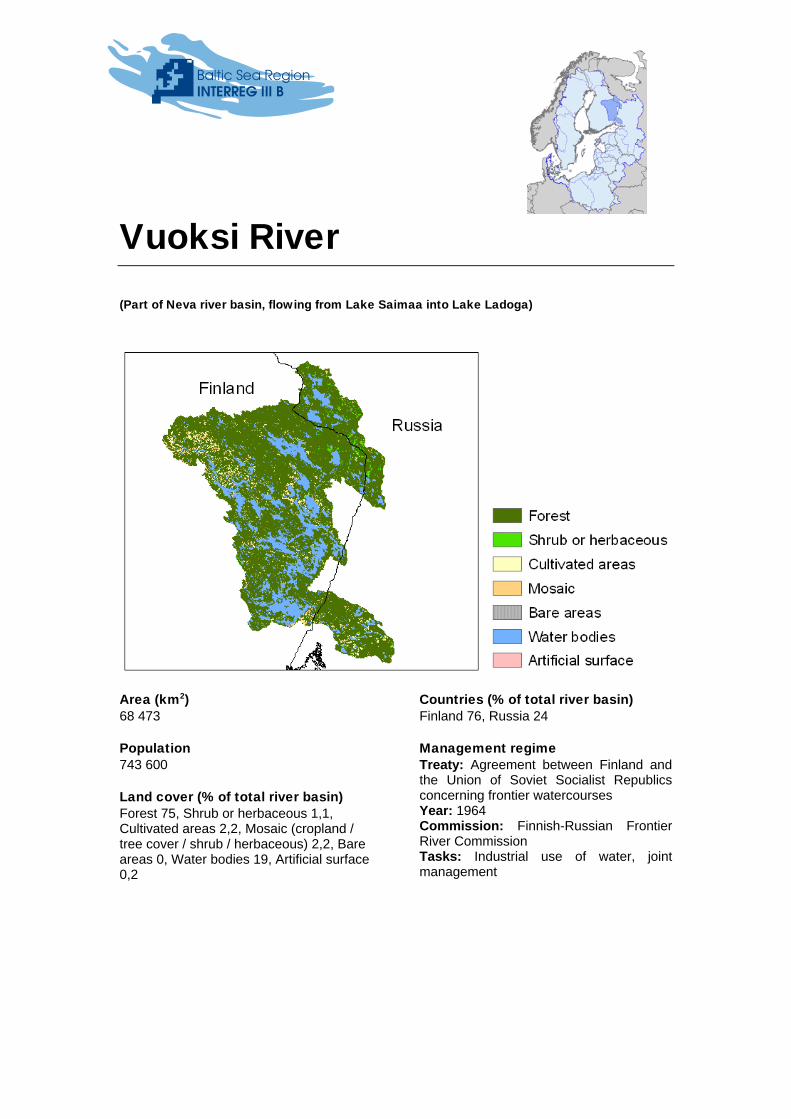
Vuoksi River (Part of Neva river basin, flowing from Lake Saimaa into Lake Ladoga)
Area (km2) 68 473
Population 743 600
Land cover (% of total river basin) Forest 75, Shrub or herbaceous 1,1, Cultivated areas 2,2, Mosaic (cropland / tree cover / shrub / herbaceous) 2,2, Bare areas 0, Water bodies 19, Artificial surface 0,2
Countries (% of total river basin) Finland 76, Russia 24
Management regime Treaty: Agreement between Finland and the Union of Soviet Socialist Republics concerning frontier watercourses Year: 1964 Commission: Finnish-Russian Frontier River Commission Tasks: Industrial use of water, joint management

Narva River/Lake Peipsi
Area (km2) 56 797
Population 936 100
Land cover (% of total river basin) Forest 51, Shrub or herbaceous 5,4, Cultivated areas 24, Mosaic (cropland / tree cover / shrub / herbaceous) 11, Bare areas 0, Water bodies 8, Artificial surface 0,3
Total runoff to the Baltic Sea in year 2000 (million m3/a) 10 700
Total N load to the Baltic Sea in year 2000 (tonnes) 6 500
Total P load to the Baltic Sea in year 2000 (tonnes) 530
Total BOD7 load to the Baltic Sea in year 2000 (tonnes) 21 800
Countries (% of total river basin) Russia 63, Estonia 31, Latvia 6
Management regime Treaty: Agreement between the government of Estonia and the government of the Russian Federation on the protection and rational use of transboundary waters Year: 1997 Commission: Estonian-Russian Joint Commission on Transboundary Waters Tasks: Exchange of monitoring data, agreement on common water quality indicators, facilitating cooperation between agencies
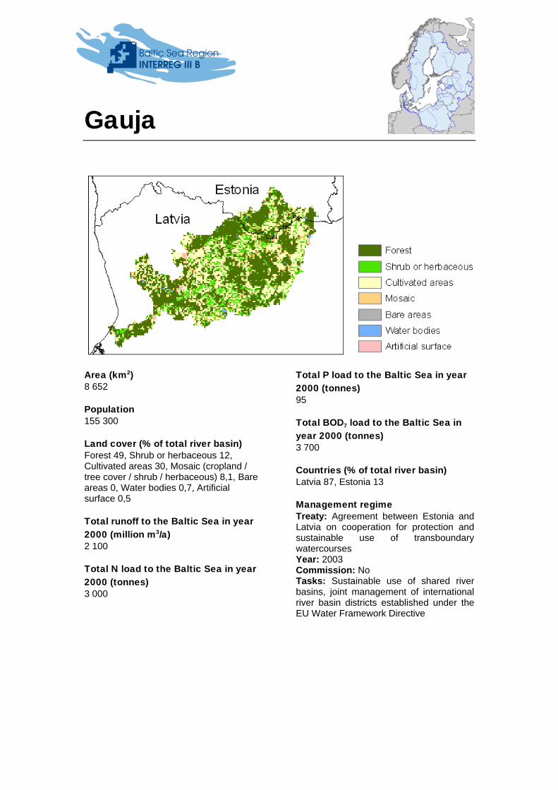
Gauja
Area (km2) 8 652
Population 155 300
Land cover (% of total river basin) Forest 49, Shrub or herbaceous 12, Cultivated areas 30, Mosaic (cropland / tree cover / shrub / herbaceous) 8,1, Bare areas 0, Water bodies 0,7, Artificial surface 0,5
Total runoff to the Baltic Sea in year 2000 (million m3/a) 2 100
Total N load to the Baltic Sea in year 2000 (tonnes) 3 000
Total P load to the Baltic Sea in year 2000 (tonnes) 95
Total BOD7 load to the Baltic Sea in year 2000 (tonnes) 3 700
Countries (% of total river basin) Latvia 87, Estonia 13
Management regime Treaty: Agreement between Estonia and Latvia on cooperation for protection and sustainable use of transboundary watercourses Year: 2003 Commission: No Tasks: Sustainable use of shared river basins, joint management of international river basin districts established under the EU Water Framework Directive
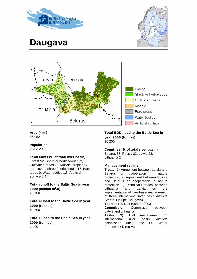
Daugava
Area (km2) 86 052
Population 2 783 200
Land cover (% of total river basin) Forest 52, Shrub or herbaceous 9,2, Cultivated areas 20, Mosaic (cropland / tree cover / shrub / herbaceous) 17, Bare areas 0, Water bodies 1,5, Artificial surface 0,4
Total runoff to the Baltic Sea in year 2000 (million m3/a) 20 700
Total N load to the Baltic Sea in year 2000 (tonnes) 40 600
Total P load to the Baltic Sea in year 2000 (tonnes) 1 400
Total BOD7 load to the Baltic Sea in year 2000 (tonnes) 36 200
Countries (% of total river basin) Belarus 38, Russia 32, Latvia 28, Lithuania 2
Management regime Treaty: 1) Agreement between Latvia and Belarus on cooperation in nature protection, 2) Agreement between Russia and Belarus on cooperation in nature protection, 3) Technical Protocol between Lithuania and Latvia on the implementation of river basin management of three international river basin districts (Venta, Lielupe, Daugava) Year: 1) 1994, 2) 1994, 3) 2003 Commission: Commission between Latvia and Lithuania Tasks: 3) Joint management of international river basin districts established under the EU Water Framework Directive

Lielupe
Area (km2) 17 876
Population 668 200
Land cover (% of total river basin) Forest 20, Shrub or herbaceous 8,1, Cultivated areas 64, Mosaic (cropland / tree cover / shrub / herbaceous) 6,4, Bare areas 0, Water bodies 0,5, Artificial surface 0,9
Total runoff to the Baltic Sea in year 2000 (million m3/a) 2 400
Total N load to the Baltic Sea in year 2000 (tonnes) 10 700
Total P load to the Baltic Sea in year 2000 (tonnes) 230
Total BOD7 load to the Baltic Sea in year 2000 (tonnes) 6 000
Countries (% of total river basin) Latvia 50, Lithuania 50
Management regime Treaty: Technical Protocol between Lithuania and Latvia on the implementation of river basin management of three international river basin districts (Venta, Lielupe, Daugava) Year: 2003 Commission: Commission between Latvia and Lithuania Tasks: Joint management of international river basin districts established under the EU Water Framework Directive
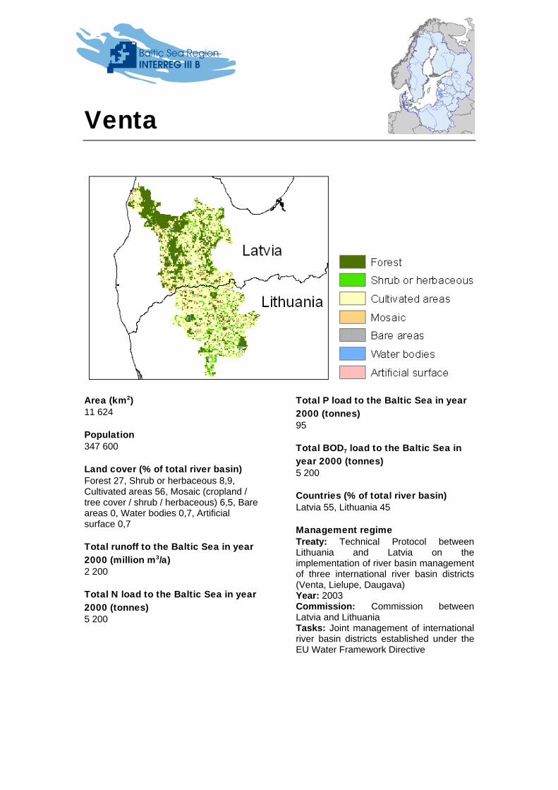
Venta
Area (km2) 11 624
Population 347 600
Land cover (% of total river basin) Forest 27, Shrub or herbaceous 8,9, Cultivated areas 56, Mosaic (cropland / tree cover / shrub / herbaceous) 6,5, Bare areas 0, Water bodies 0,7, Artificial surface 0,7
Total runoff to the Baltic Sea in year 2000 (million m3/a) 2 200
Total N load to the Baltic Sea in year 2000 (tonnes) 5 200
Total P load to the Baltic Sea in year 2000 (tonnes) 95
Total BOD7 load to the Baltic Sea in year 2000 (tonnes) 5 200
Countries (% of total river basin) Latvia 55, Lithuania 45
Management regime Treaty: Technical Protocol between Lithuania and Latvia on the implementation of river basin management of three international river basin districts (Venta, Lielupe, Daugava) Year: 2003 Commission: Commission between Latvia and Lithuania Tasks: Joint management of international river basin districts established under the EU Water Framework Directive

Nemunas
Area (km2) 92 318
Population 4 890 900
Land cover (% of total river basin) Forest 30, Shrub or herbaceous 7,7, Cultivated areas 49, Mosaic (cropland / tree cover / shrub / herbaceous) 12, Bare areas 0, Water bodies 1,0, Artificial surface 0,8
Total runoff to the Baltic Sea in year 2000 (million m3/a) 20 000
Total N load to the Baltic Sea in year 2000 (tonnes) 46 800
Total P load to the Baltic Sea in year 2000 (tonnes) 1 800
Total BOD7 load to the Baltic Sea in year 2000 (tonnes) 100 600
Countries (% of total river basin) Belarus 48, Lithuania 47, Poland 3, Russia 2
Management regime Treaty: 1) Agreement between Poland and the USSR concerning the regime on the Soviet-Polish state frontier, 2) Agreement between the Lithuanian Department of Environment and the Ministry of Environmental Protection, Nature, Conservation and Forestry of Poland, 3) Agreement between the environmental protection ministry of the Republic of Lithuania and the ministry of environmental protection, nature conservation and forestry of the Republic Poland, 4) Agreement between the Ministry of Natural Resources and Environmental Protection of the Republic of Belarus and the Environmental Protection Ministry of the Republic of Lithuania on cooperation in the field of environmental protection Year: 1) 1948, 2) 1992, 3) 1994, 4) 1995 Commission: No Tasks: 1) Navigation, 2) Cooperation in environmental protection, including border river basins. Preparation and realisation of joint programs and projects, consultations between experts, formation of working groups, convocation of conferences and seminars, exchange of specialists, and exchange of scientific, technological, legislative and other information, 3) Qualitative protection of water resources: inventories of point pollution sources, common research, quality assurance of laboratory analysis, 4) Establishes a working group on water quality issues.

Vistula
Area (km2) 193 347
Population 23 487 300
Land cover (% of total river basin) Forest 26, Shrub or herbaceous 12, Cultivated areas 55, Mosaic (cropland / tree cover / shrub / herbaceous) 4,9, Bare areas 0, Water bodies 0,7, Artificial surface 1,2
Total runoff to the Baltic Sea in year 2000 (million m3/a) 42 400
Total N load to the Baltic Sea in year 2000 (tonnes) 124 000
Total P load to the Baltic Sea in year 2000 (tonnes) 7 500
Total BOD7 load to the Baltic Sea in year 2000 (tonnes) 163 000
Countries (% of total river basin) Poland 87, Ukraine 7, Belarus 5, Slovakia 1
Management regime Treaty: 1) Agreement between Poland and the USSR concerning the regime on the Soviet-Polish state frontier, 2) Agreement between the government of the Polish People's Republic and the government of the Union of Soviet Socialist Republics concerning the use of water resources in frontier waters Year: 1) 1948, 2) 1964 Commission: No Tasks: 1) Navigation, 2) Standards relating to water purity, procedures for controlling pollution.

Pregola
Area (km2) 14 783
Population 1 283 600
Land cover (% of total river basin) Forest 16, Shrub or herbaceous 6,2, Cultivated areas 70, Mosaic (cropland / tree cover / shrub / herbaceous) 4,7, Bare areas 0, Water bodies 2,0, Artificial surface 1,0
Total runoff to the Baltic Sea in year 2000 (million m3/a) 2 700
Total N load to the Baltic Sea in year 2000 (tonnes) 9 500
Total P load to the Baltic Sea in year 2000 (tonnes) 570
Total BOD7 load to the Baltic Sea in year 2000 (tonnes) 6 700
Countries (% of total river basin) Poland 52, Russia 48
Management regime Treaty: 1) Agreement between Poland and the USSR concerning the regime on the Soviet-Polish state frontier, 2) Agreement between the government of the Polish People's Republic and the government of the Union of Soviet Socialist Republics concerning the use of water resources in frontier waters Year: 1) 1948, 2) 1964 Commission: No Tasks: 1) Navigation, 2) Standards relating to water purity, procedures for controlling pollution.
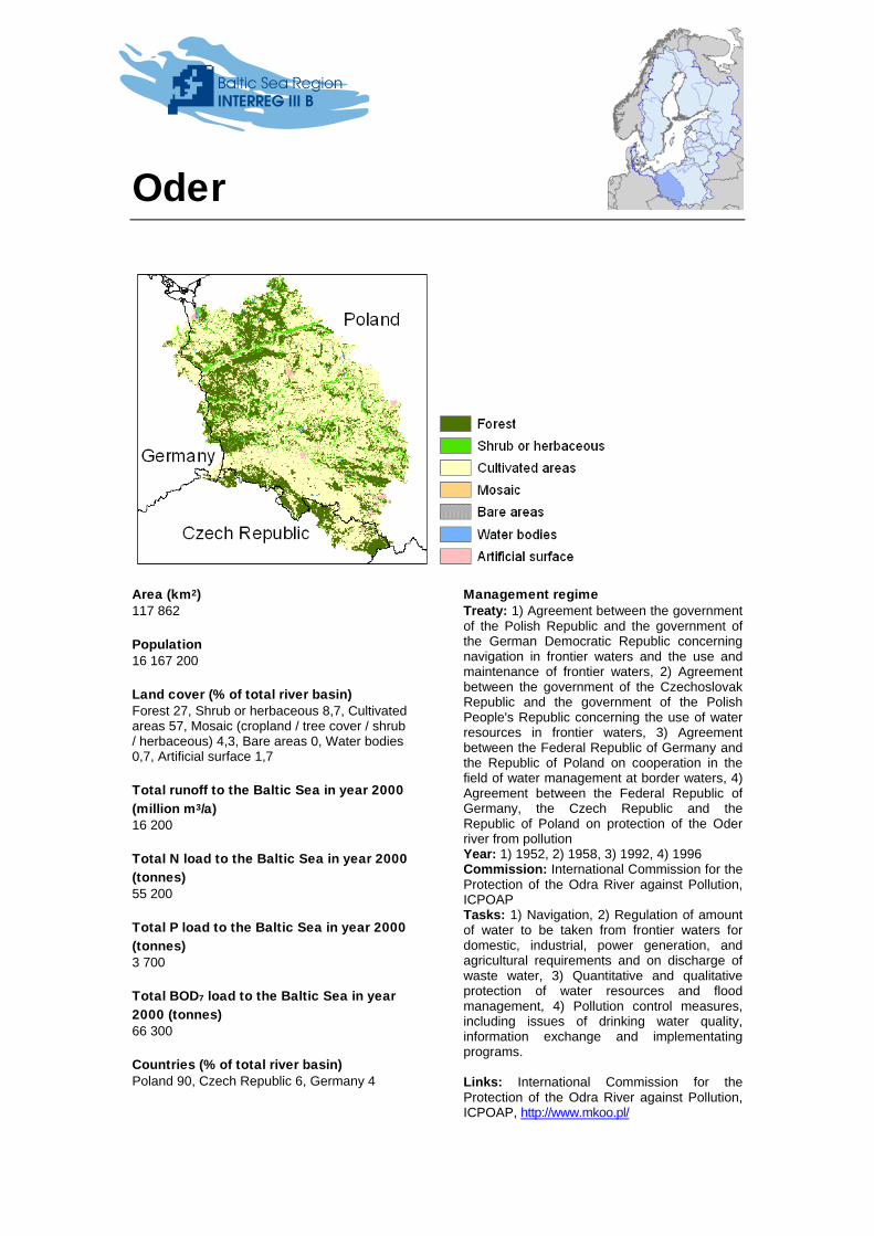
Oder
Area (km2) 117 862
Population 16 167 200
Land cover (% of total river basin) Forest 27, Shrub or herbaceous 8,7, Cultivated areas 57, Mosaic (cropland / tree cover / shrub / herbaceous) 4,3, Bare areas 0, Water bodies 0,7, Artificial surface 1,7
Total runoff to the Baltic Sea in year 2000 (million m3/a) 16 200
Total N load to the Baltic Sea in year 2000 (tonnes) 55 200
Total P load to the Baltic Sea in year 2000 (tonnes) 3 700
Total BOD7 load to the Baltic Sea in year 2000 (tonnes) 66 300
Countries (% of total river basin) Poland 90, Czech Republic 6, Germany 4
Management regime Treaty: 1) Agreement between the government of the Polish Republic and the government of the German Democratic Republic concerning navigation in frontier waters and the use and maintenance of frontier waters, 2) Agreement between the government of the Czechoslovak Republic and the government of the Polish People's Republic concerning the use of water resources in frontier waters, 3) Agreement between the Federal Republic of Germany and the Republic of Poland on cooperation in the field of water management at border waters, 4) Agreement between the Federal Republic of Germany, the Czech Republic and the Republic of Poland on protection of the Oder river from pollution Year: 1) 1952, 2) 1958, 3) 1992, 4) 1996 Commission: International Commission for the Protection of the Odra River against Pollution, ICPOAP Tasks: 1) Navigation, 2) Regulation of amount of water to be taken from frontier waters for domestic, industrial, power generation, and agricultural requirements and on discharge of waste water, 3) Quantitative and qualitative protection of water resources and flood management, 4) Pollution control measures, including issues of drinking water quality, information exchange and implementating programs. Links: International Commission for the Protection of the Odra River against Pollution, ICPOAP, http://www.mkoo.pl/

This fact sheet reflects the author's views. The European Union, the Joint Secretariat of the Baltic Sea Region Interreg III B Programme and/or Investitionsbank Schleswig-Holstein are not liable for any use that may be made of the information contained therein.