International Law and Order: The Indian Ocean and South ... · PDF fileInternational Law and...
21
International Law and Order: The Indian Ocean and South China Sea Caitlyn Antrim Chapter Five The Indian Ocean and South China Sea encompass a wide range of geographical, geological, and biological features. The region includes several of the most heavily travelled international straits, major fisheries, and areas with high potential for discovery of energy resources. Meanwhile, the nations bordering the region range from some of the most prosperous and dynamic countries of the developing world to some of the developing world’s poorest and most dysfunctional states. The diversity of interests of nations bordering this region can lead to conflict. International law, particularly the 1982 UN Convention on the Law of the Sea, plays a pivotal role in peacefully resolving such conflicts. Yet while legal measures and policy initiatives have helped mitigate international tensions through diplomatic processes, political, economic, and environmental issues can still lead to disputes and conflict. Introduction In the decades since World War II, advances in maritime technology, increases in maritime trade, and the growing economic value of offshore energy, mineral, and living resources have collectively led to a breakdown of the centuries-old division of the ocean between three-mile territorial seas under coastal state authority and the high seas, where freedom of navigation and exploitation typically reigned. Following a period of expanding coastal state claims over the sea and its resources, the 1982 UN Convention on the Law of the Sea (UNCLOS) established a new order of the oceans that promised the stability needed to protect sovereignty, provide for national security, promote trade and development, and safeguard the marine environment. UNCLOS defines ocean zones and the rights and obligations of states within those zones (see Figure 5.1). It establishes organizations to carry out collective responsibilities for both defining the boundaries of national jurisdiction and managing mineral resources beyond those limits. It also provides alternative processes for conflict resolution, with some issues subject to mandatory settlement of disputes. UNCLOS is also a framework agreement upon which more specialized treaties, organizations, and activities are established. These agreements, organizations, and activities include a framework convention governing fish stocks on the high seas; the operation of the International Seabed Authority in managing minerals beyond national jurisdiction; and the implementation of security and environmental pacts negotiated under the International Maritime Organization, as well as security partnerships such as the Proliferation Security Initiative.
Transcript of International Law and Order: The Indian Ocean and South ... · PDF fileInternational Law and...
International Law and Order: The Indian Ocean and South China Sea
Caitlyn Antrim
Chapter Five
The Indian Ocean and South China Sea encompass a wide range of geographical, geological, and biological features. The region includes several of the most heavily travelled international straits, major fisheries, and areas with high potential for discovery of energy resources. Meanwhile, the nations bordering the region range from some of the most prosperous and dynamic countries of the developing world to some of the developing world’s poorest and most dysfunctional states. The diversity of interests of nations bordering this region can lead to conflict. International law, particularly the 1982 UN Convention on the Law of the Sea, plays a pivotal role in peacefully resolving such conflicts. Yet while legal measures and policy initiatives have helped mitigate international tensions through diplomatic processes, political, economic, and environmental issues can still lead to disputes and conflict.
IntroductionIn the decades since World War II, advances in maritime technology, increases in maritime trade, and the growing economic value of offshore energy, mineral, and living resources have collectively led to a breakdown of the centuries-old division of the ocean between three-mile territorial seas under coastal state authority and the high seas, where freedom of navigation and exploitation typically reigned. Following a period of expanding coastal state claims over the sea and its resources, the 1982 UN Convention on the Law of the Sea (UNCLOS) established a new order of the oceans that promised the stability needed to protect sovereignty, provide for national security, promote trade and development, and safeguard the marine environment.
UNCLOS defines ocean zones and the rights and obligations of states within those zones (see Figure 5.1). It establishes organizations to carry out collective responsibilities for both defining the boundaries of national jurisdiction and managing mineral resources beyond those limits. It also provides alternative processes for conflict resolution, with some issues subject to mandatory settlement of disputes.
UNCLOS is also a framework agreement upon which more specialized treaties, organizations, and activities are established. These agreements, organizations, and activities include a framework convention governing fish stocks on the high seas; the operation of the International Seabed Authority in managing minerals beyond national jurisdiction; and the implementation of security and environmental pacts negotiated under the International Maritime Organization, as well as security partnerships such as the Proliferation Security Initiative.

66 | Indian Ocean Rising
In a broad sense, the law of the sea—both under the Convention and as implemented through other treaties, organizations, and agreements—provides the stable legal order necessary to manage the increasingly intense development of the ocean and its resources. This is particularly important in the Indian Ocean and the South China Sea, where overlapping claims of sovereignty and sometimes dysfunctional governments are placing the international legal regime under great stress.
Figure 5.1: Ocean Zones: Rights and Responsibilities
Under the UN Convention on the Law of the Sea, the ocean is classified into eight zones:
Territorial Sea: The coastal seas extending as far as 12 miles from shore, in which the coastal state has sovereign authority, subject to the recognition of the right of innocent passage for ships on their way from one location to another.
Contiguous Zone: An area extending 12 miles beyond the territorial sea, in which the coastal state may enforce its fiscal, customs, immigration, sanitary, and security laws.
Exclusive Economic Zone (EEZ): The seas beyond the territorial sea extending to 200 nautical miles, in which the coastal state has the sovereign right to manage, exploit, and protect mineral and living resources, subject to providing access to unused portions of what the coastal state determines to be the maximum allowable catch of the living resources. Other states are guaranteed high seas navigation rights and the right to lay and maintain cables and pipelines.
Continental Shelf: Both the seabed of the EEZ and the areas of the seabed beyond the EEZ that meet geological requirements specified in UNCLOS. The coastal state manages the resources of the continental shelf (and shares revenues derived from exploitation of mineral resources of the shelf beyond the EEZ) with the international community.
High Seas: The waters beyond the EEZ in which vessels and activities are under the authority of the flag state, and subject to only a limited number of international prohibitions, such as measures outlawing piracy and the slave trade.
The Area: The portion of the ocean floor beyond the limits of national jurisdiction. Mineral resources of the Area are managed by the International Seabed Authority, as established by UNCLOS.
International Straits: Straits that are used in international navigation regardless of whether they are sufficiently narrow to otherwise be considered territorial seas subject to innocent passage. International straits are subject to the regime of Transit Passage, in which ships and aircraft may pass through or over international straits in their “normal mode” without the restrictions imposed on innocent passage.
Archipelagic Waters: Those waters within boundary lines drawn to encompass the islands of archipelagic states. Passage through archipelagic waters is subject to conditions similar to Transit Passage in designated sea lanes and innocent passage in other areas of the waters.

International Law and Order: The Indian Ocean and South China Sea | 67
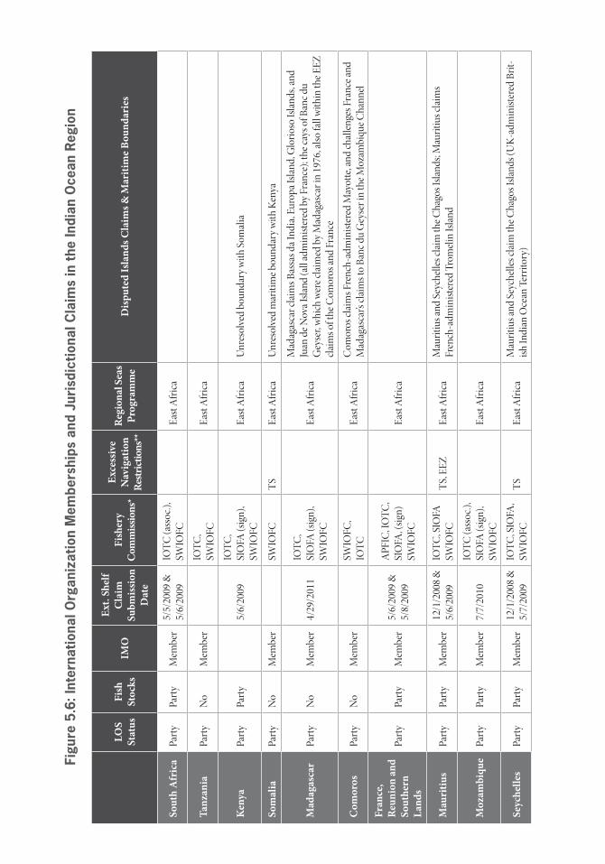
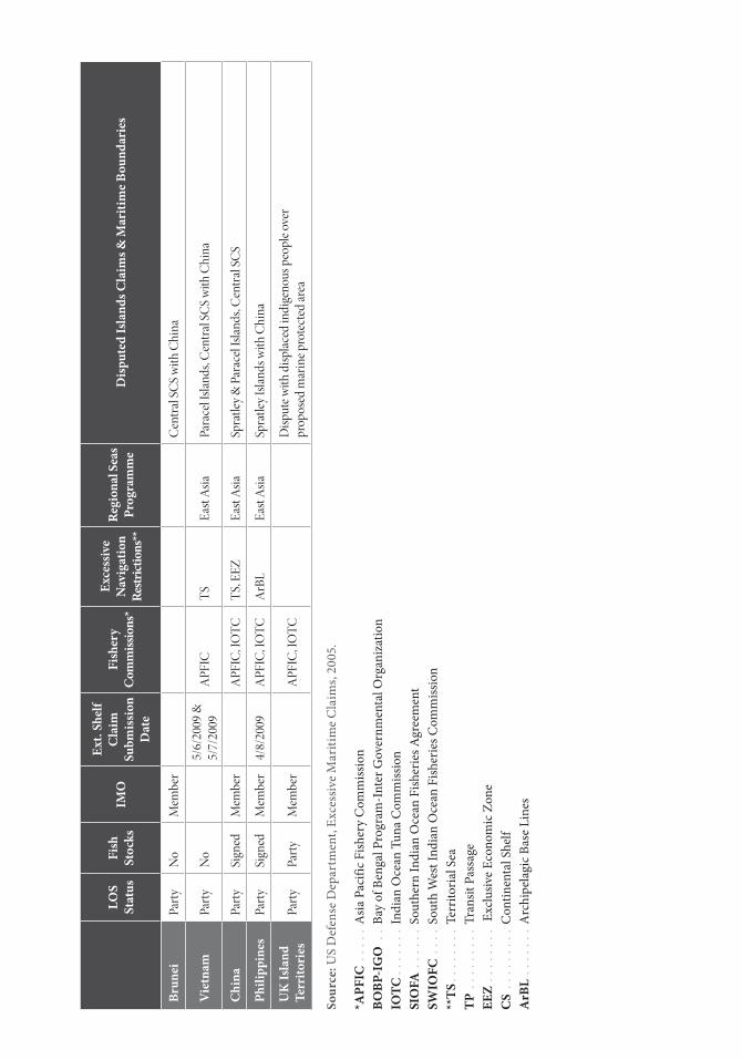
International Agreements and OrganizationsThe region encompassing the Indian Ocean and South China Sea is an area of intense multinational activity. All but two of the coastal nations bordering the Indian Ocean and South China Sea are parties to UNCLOS. Those two countries, Iran and Cambodia, have signed the Convention and are expected eventually to seek approval for accession through their domestic legal processes. All of the littoral states are members of the International Maritime Organization (as well as members of at least one regional fisheries organization), and most are also members of a regional seas program that addresses environmental concerns (see Annex I).
Maritime BoundariesWith the exception of the central South China Sea, the delimitation of national maritime boundaries in the greater Indian Ocean region (IOR) has been remarkably smooth. While there exist some legal challenges to the specific baselines along the coast, boundaries between adjacent nations have in many cases been established by treaty and reflect principles of equidistance, equity, history, and special circumstances. In some cases, disputes have been taken to one of the venues specified in UNCLOS.
The central South China Sea—which has witnessed periodic eruptions of conflict and is subject of regional diplomatic efforts—represents a special case. Resolution of claims of sovereignty and access in this area has been complicated by uncertainties regarding the potential economic value of the natural resources (fisheries, minerals, oil and natural gas) to be found in the South China Sea, and by the changing interests and ambitions of the surrounding states.
International Fishing AgreementsFisheries and fish stocks that exist wholly or partially outside national jurisdictions pose a special problem for fishery management. Fishing on the high seas is a freedom for all states, but the lack of effective enforcement of sustainable fishing policies permits highly mobile fishing fleets to overexploit a resource and move on, leaving once-rich resources depleted and damaged.
The UN “Fish Stocks Agreement” was opened for signature in 1995 and came into force in 2001.1 The agreement provides the framework for the establishment and operation of regional agreements to manage high seas and straddling fish stocks in accordance with UNCLOS. As an example, the Southern Indian Ocean Fisheries Agreement (SIOFA) is a regional agreement negotiated under the Fish Stocks Agreement to address high seas fisheries in the southern Indian Ocean region.
As the UN agency responsible for international fishery issues, the Food and Agriculture Organization (FAO) plays a key role in promoting sustainable fishing in regions around the world, both in national waters and on the high seas. Under the FAO, four other regional fishery commissions have been established in the Indian Ocean and Southeast Asian region: the Asia Pacific Fishery Commission, Bay of Bengal Program-Inter-Governmental Organization, Indian Ocean Tuna Commission, and South West Indian Ocean Fisheries Commission.

68 | Indian Ocean Rising
Figure 5.2: Jurisdictional Claims in the Indian Ocean Region
Seabed Minerals Beyond National JurisdictionAll parties to UNCLOS are also members of the International Seabed Authority (ISA), the agency that manages the mineral resources of the seabed beyond the limits of national jurisdiction. There are three known classes of hard minerals on the world’s deep seabed:
› Polymetallic nodules of manganese and iron oxides enriched in nickel, copper, cobalt, and rare earth elements are found on the abyssal plains;
› Cobalt crusts consisting of iron and manganese oxides enriched in cobalt and rare earth elements, and found on the slopes of seamounts; and
› Polymetallic sulfides of copper and zinc, sometimes enriched with gold, that are found near spreading centers and subduction zones.
Over the past decade, rising demand (particularly in China) for seabed minerals with industrial applications drove metal prices upward, resulting in increased commercial interest in seabed mineral deposits. India and China have each sponsored national applicants for ISA recognition of exclusive rights to explore mineral sites in the Indian Ocean. India’s claim is for a deposit of polymetallic nodules, while China’s claim is for a deposit of polymetallic sulfides.
Source: Stimson

International Law and Order: The Indian Ocean and South China Sea | 69
Maritime Safety and Security AgreementsAll of the coastal states of the Indian Ocean and South China Sea are members of the International Maritime Organization (IMO). The IMO is the source of international rules and guidelines governing shipping operations that flag states, port states, and coastal states apply to international shipping in order to protect against vessel-source marine pollution. The IMO also works with straits and archipelagic states to gain agreement on the designation of sea lanes in international straits.
Several key maritime safety and security conventions have been negotiated under the auspices of the IMO. With regard to shipping, two of the most important are the Convention on Safety of Life at Sea (SOLAS) and the Convention on the Suppression of Unlawful Acts (SUA). Both are evolving agreements that have been supplemented and modified through subsequent protocols. Most recently, protocols to the SUA have been negotiated to address acts of international terrorism.
The IMO also supports regional efforts to promote maritime security. In 2009, the IMO convened a meeting in which East African nations adopted a “Code of Conduct Concerning the Repression of Piracy and Armed Robbery against Ships in the Western Indian Ocean and the Gulf of Aden.” The signatories requested that IMO and other international organizations provide support in implementing the Code of Conduct, particularly in building national maritime and legal capacity to implement it effectively.
In addition to the IMO, the UN Security Council has the authority to intervene in matters affecting peace and security in the oceans. In recent years, the threat of piracy off the coast of Somalia led the Security Council to issue a series of resolutions encouraging a maritime response and authorizing actions that would otherwise exceed national authority as recognized by UNCLOS. For example, UNSC Resolution 1946 provided (for a period of 12 months) explicit authority for foreign ships to enter the territorial sea of Somalia to counter piracy and armed robbery as if they were on the high seas. It also ensured that this authority did not undercut the rights normally accorded by UNCLOS and did not establish new customary international law. This authority, and the conditions placed on it, has been renewed in successive Security Council resolutions.2
Smaller groupings of coastal states have also established specific regional initiatives. In 2004, the states bordering the Strait of Malacca began tripartite cooperation in anti-piracy activities. A Regional Cooperation Agreement on Anti-Piracy—including East, Southeast, and South Asian states—focuses on information sharing, capacity building, and cooperative agreements, including an Information Sharing Center established in Singapore.
70 | Indian Ocean Rising
Source: Stimson
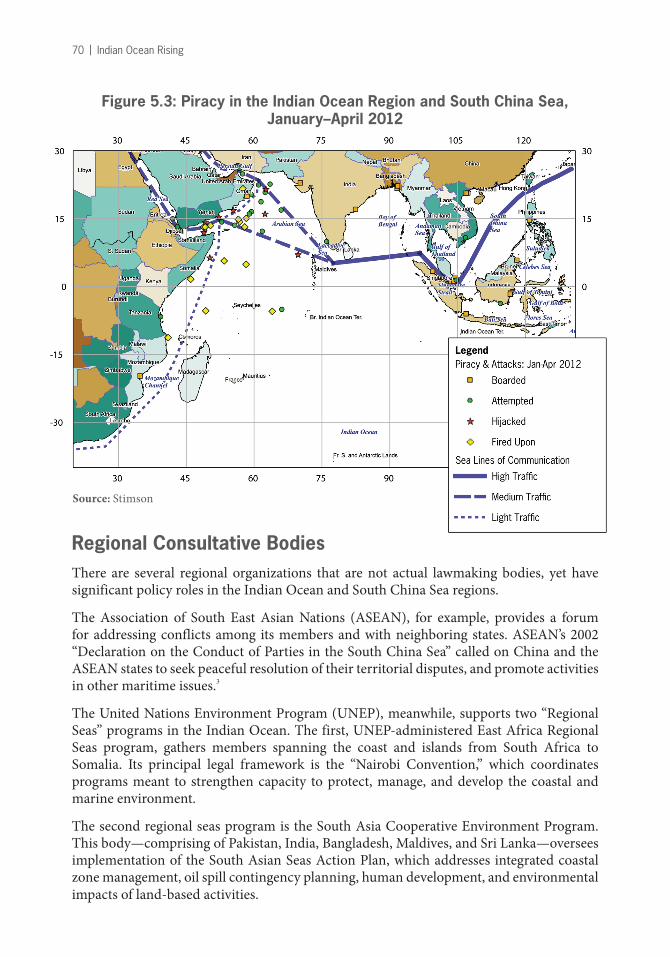
Figure 5.3: Piracy in the Indian Ocean Region and South China Sea, January–April 2012
Regional Consultative BodiesThere are several regional organizations that are not actual lawmaking bodies, yet have significant policy roles in the Indian Ocean and South China Sea regions.
The Association of South East Asian Nations (ASEAN), for example, provides a forum for addressing conflicts among its members and with neighboring states. ASEAN’s 2002 “Declaration on the Conduct of Parties in the South China Sea” called on China and the ASEAN states to seek peaceful resolution of their territorial disputes, and promote activities in other maritime issues.3
The United Nations Environment Program (UNEP), meanwhile, supports two “Regional Seas” programs in the Indian Ocean. The first, UNEP-administered East Africa Regional Seas program, gathers members spanning the coast and islands from South Africa to Somalia. Its principal legal framework is the “Nairobi Convention,” which coordinates programs meant to strengthen capacity to protect, manage, and develop the coastal and marine environment.
The second regional seas program is the South Asia Cooperative Environment Program. This body—comprising of Pakistan, India, Bangladesh, Maldives, and Sri Lanka—oversees implementation of the South Asian Seas Action Plan, which addresses integrated coastal zone management, oil spill contingency planning, human development, and environmental impacts of land-based activities.

International Law and Order: The Indian Ocean and South China Sea | 71
International Dispute Settlement BodiesAs parties to UNCLOS, regional coastal states (except for non-parties Iran and Cambodia) have recourse to the dispute settlement mechanisms created by the Convention—the International Tribunal on the Law of the Sea or the Arbitration and Special Arbitration panels provided by the Convention. (Additionally, they have recourse to the International Court of Justice.) The Convention’s dispute-resolution system has been used on several occasions to resolve maritime boundary disputes in the Indian Ocean and South China Sea, but there is a strong preference for diplomatic processes over judicial approaches to resolve boundary disputes.
Current Regional Ocean Issues and DisputesIn some cases, UNCLOS provides detailed prescriptions of rights and obligations at sea. In other cases, general guidance is provided for later definition, leaving issues of jurisdiction to be resolved when they arise. This has led to a number of current or potential disputes in the five areas of concern listed below.
1. Maritime Boundaries, Sovereignty, and Resources
Determination of areas of sovereignty and national jurisdiction is moving in a generally satisfactory direction, with only a few significant problem areas:
› Territorial claims and conflicts. The most difficult issue in determining zones of maritime authority is not related to the law of the sea. Instead, the problems lie in the determination of sovereignty over land in the form of islands and rocks in the South China Sea. These small points of earth were unimportant until nations began to consider the economic potential of the resources in and beneath the surrounding waters. As jurisdiction over the seabed and fisheries rose in importance, nations began to claim jurisdiction on whatever basis they could justify. China justifies its claims over the islands and rocks of the Spratly and Paracel chains based on records of claims dating back to the 15th century and by reference to the international law of that era that is said to have not required occupation to establish and retain national claims. Vietnam and the Philippines, meanwhile, make claims based on more recent use, and all contenders have attempted to demonstrate jurisdiction by establishing outposts and occupation.
› Determination of maritime jurisdiction. Maritime boundaries are primarily based on sovereignty over the adjoining land territory, with rules based both on UNCLOS for breadth, including principles of equidistance and equity in dividing jurisdiction between adjacent or opposing states. There is a considerable body of international law that governs the application of these principles, but their practical implementation necessarily rests on the prior resolution of any disputes regarding sovereignty over the neighboring land territory.
› Confrontations in the South China Sea. China’s claim of authority in the South China Sea is based on its “9 Dash Line.” This has led to confrontations and incidents related to fishing activities, oil and gas exploration, and habitation on rocks and islets. China’s
72 | Indian Ocean Rising
claim of historic rights is countered by arguments from the Philippines and Vietnam for resolution based on UNCLOS, but efforts to resolve the conflict must first address the nationality of individual islands and determination of which ones qualify for EEZs. Without diplomatic resolution of sovereignty issues, all parties are likely to confront one another to defend their claims.
› Shifting coastlines and disappearing islands. Areas of coastal state jurisdiction are based largely on the baselines drawn along coasts and around archipelagos. UNCLOS was written with only limited consideration of possible shifts in the geography of the coastline upon which the baselines are constructed. Coastal states are to submit their baselines to the UN, but guidance on how to revise baselines to reflect changes of physical coasts exist in the case of deltas only. In this case, the coastal state need not revise its baselines in the face of shifting coastlines.
Beyond the case of deltas, there are three cases in which baselines, and the maritime jurisdiction they convey, might be reconsidered based on changes of geography. The first concerns the removal or addition of physical material in a way that changes baselines. A decade ago, Indonesia expressed concern that Singapore’s use of sand to extend land beyond its previous boundaries could change the median line in the waters between Singapore and Indonesia to Indonesia’s disadvantage. A 2010 treaty resolved the issue by establishing permanent base points to determine the maritime boundary between the neighbors regardless of future changes in the physical coastline.4 A second case concerns the modification of a coastline due to natural disaster, such as the subsidence of territory in an earthquake or massive coastal erosion due to tsunamis or hurricanes. If a permanent retreat of the coastline results from such disaster, does the baseline need to be redrawn? A third case potentially looms as sea levels rise, prospectively submerging some or all of the territory of an island nation. Would a nation, or at least its claim to maritime jurisdiction, disappear if its territory no longer qualified as an island or rock under UNCLOS? This is a serious issue for the Maldives off the southwestern coast of India, where sea level rise could force migration of the population. If claims to EEZs and continental shelves could be retained in spite of loss of the islands on which claims were made, they might provide financial support for the population wherever it might relocate. Alternatively, some islands might attempt to shore up or reinforce their receding coastlines by adding materials before the land is lost to the sea. But such artificial enhancement or enlargement of island territory could run afoul of exemptions ordinarily excluding the extension of maritime zones around artificially created islands.
› Archipelagic baselines and sea lanes. As archipelagic states, Indonesia and the Philippines are able to draw baselines enclosing their islands from which the countries’ respective territorial seas and EEZs may be determined. Self-interest and domestic public pressure encourage the broadest of interpretation in establishing these baselines, sometimes exceeding the provisions of UNCLOS. The zones of authority may encroach on jurisdictional claims of nearby states or on the freedom of navigation of maritime nations. In these cases, it may be preferable to resort to the “special arbitration” annex of UNCLOS, in which disputes over maritime boundaries could be submitted to arbitral panels of experts in maritime boundary delimitation.
International Law and Order: The Indian Ocean and South China Sea | 73
Similarly, the establishment of sea lanes through archipelagos could become a source of friction or conflict if they are established without due consideration of the interests of maritime nations in shipping and aviation routes or paths for undersea cables.
The Special Case of Boundaries in the South China Sea
Determination of national jurisdiction in the South China Sea is a difficult problem that has been exacerbated by coastal states’ interest in exploiting fisheries and controlling the region’s potential energy resources. In recent years, competing claims to islands and rocks in the Spratley and Paracel Island groups, questionable claims that barren rocks meet UNCLOS’ standard of human habitability (thereby gaining EEZs and the continental shelf, in addition to a 12-mile territorial sea), differing legal and historical claims for land jurisdiction, and a historical record of recourse to force have all combined to leave jurisdiction over islands (and maritime zones derived from the land) uncertain.
China continues to assert its claim of jurisdiction in the heart of the South China Sea, enclosed by China’s “9-dash line,” while Vietnam and the Philippines claim jurisdiction over specific islands in the Spratley and Paracel groups. China refuses to address jurisdiction through formal dispute settlement processes, and has so far resisted multilateral approaches to resolve the fate of the two island groups.
While armed confrontation linked to the Spratley and Paracel island groups had diminished during a period of cooperation between China and the ASEAN states, the potential for confrontation has once again increased, in part due to China’s designation of the South China Sea as a “core interest” on the same level of strategic importance as Taiwan and Tibet. There has also been continuing economic pressure throughout the region to exploit the continental shelf ’s energy resources. However, a new agreement between China and Vietnam to resolve their territorial disputes in accordance with international law suggests the use of force is again off the table—at least for the time being.
Claims in the southwest region of the South China Sea involving Indonesia, Singapore, Malaysia, and Brunei have been settled peacefully, but the claim indicated by China’s “9 Dash Line” remains in conflict with these otherwise resolved boundaries.
If island and maritime claims in the South China Sea are not resolved in the near future, there exist four potential long-term outcomes. First, political uncertainty may discourage all commercial development of energy resources, and competing coast guards may deter significant fishing activities. Second, limited development activities may take place under state military protection. Third, the regional states may reach an agreement on an interim joint development regime while retaining their jurisdictional claims. Fourth, disputes may spiral into armed conflict.

74 | Indian Ocean Rising
Figure 5.4: Jurisdictional Claims in the South China Sea
2. Coastal State Threats to Maritime Freedoms
UNCLOS is a comprehensive document in terms of the issues it addresses, but it does not spell out every detail of how it is to be implemented. States that are party to the Convention are expected to implement its provisions in good faith, including respecting the rights of other parties. This is particularly true in the EEZ, where coastal states may establish laws and regulations pertaining to exploration and exploitation of natural resources, marine scientific research, and the marine environment, while taking into account rights of other states to exercise high seas freedoms. Warships and ships on government service are exempt from the provisions related to the marine environment, but are expected to honor their intent as much as possible.
Innocent passage. The right of innocent passage through the territorial sea is long standing, with the 1982 Convention simply providing greater clarity and limiting discretion by the coastal state over passage. Innocent passage never included a requirement for prior notification in customary law (and was not added by the 1982 Convention), but a number of states in the region—among them China, India, and Pakistan—now claim that foreign
Source: Stimson

International Law and Order: The Indian Ocean and South China Sea | 75
flag vessels must give prior notification before exercising this right. Bangladesh requires advance notice for vessels entering its territorial sea with cargos containing “dangerous goods and chemicals, oil, noxious liquid, harmful substances, and radioactive material.”5 These claims are challenged periodically under the US Navy’s “Freedom of Navigation” program.
Transit passage. The right of transit passage derives from pre-Convention rights to pass through straits used in international navigation, with additional navigational freedoms defined in the Convention. Some strait states have claimed that the right of transit passage is available only to parties to the Convention, and that non-parties have only the more limited right to innocent passage through international straits.6
As traffic through straits has increased, the financial and regulatory burdens on states bordering the straits has risen, as have the risks of catastrophic accidents, piracy, and armed robbery at sea. The UNCLOS regime leaves strait states responsible for providing for the safety of navigation and protection against crime, but it does not provide mechanisms for covering the domestic costs of supplying this international service. These costs can be quite high for a developing state, and to date, efforts to secure funding through voluntary contributions have fallen short. In the future, some international arrangements will be needed that provide for necessary services while respecting the sovereignty of the strait states and protecting the freedom of navigation for maritime states.
Limits on activities in the EEZ. In spite of provisions of the Convention that protect high seas navigation rights in the EEZ—and specifically protect rights of government ships, including warships—some states have sought to limit military activities within their EEZ. Most notable has been China’s interference with military aircraft and government-owned ships engaged in survey and observation activities beyond the territorial sea. In 2001, the mid-air collision of a Chinese fighter and a US Navy EP3 reconnaissance aircraft (with the loss of the life of the Chinese pilot) demonstrated the seriousness of this effort to expand coastal-state jurisdiction at sea. Meanwhile, India claims the right to require prior consent for foreign military activities in its EEZ. The United States has protested all of these activities as unjustified restrictions on navigation rights.
Advanced notice of cable and pipeline maintenance in the EEZ. The right to lay and maintain cables and pipelines across the seabed of the EEZ is explicitly protected in UNCLOS. Despite the fact that undersea cables constitute the communication infrastructure for the Indian Ocean and South China Sea, some countries in the region have claimed the right to demand that firms submit advance notification and obtain prior permission before conducting cable-maintenance activities in their EEZs, in spite of the requirement that such activities not be impeded by the coastal state. While advance notice can facilitate managing uses of the ocean floor, it also allows bureaucratic inefficiency to delay essential maintenance operations. Submarine-cable companies must rely on their parent governments to challenge these requirements through diplomatic channels, with UNCLOS being a major source of leverage for action.
76 | Indian Ocean Rising
3. Monitoring, Regulation, and Enforcement
Parties to UNCLOS have the right to manage resource development, marine scientific research, and environmental protection in their EEZs, as well as the duty to combat piracy on the high seas. Without the capability to monitor activities and enforce regulations at sea, coastal states lack the ability to fulfill their responsibilities to combat illegal practices, and may suffer losses and damages as a result.
Piracy. As the most heavily travelled and high-value sea routes in the world, the points of confluence of sea lanes in the Indian Ocean and South China Sea have become attractive hunting grounds for pirates. Small-scale piracy—based on the capture of ships and cargo over the past few years near the Horn of Africa and the Strait of Malacca—has been supplanted by capture and ransom activities against lightly crewed vessels with high-value cargoes traveling from the Persian Gulf and the Suez Canal, even as piracy in the eastern Indian Ocean has declined. (As of April 23, 2012, there were 151 acts against shipping worldwide, with 51 off the coast of Somalia. Of these, there were 13 hijackings, of which 11 were off the Somalia coast, while 158 of 173 hostages worldwide were taken off Somalia.7 The distribution of incidents and hijackings in 2012 is shown in Figure 5.3 on page 70.)
While piracy is an international crime to which all maritime nations must respond, many states have failed to provide domestic authority or resources to act against pirates. For example, local actions against Somalia-based pirates were impeded by the lack of a capable national government to act against pirates within national waters. Given that action by foreign states within a coastal state’s territorial sea is normally a violation of international law, maritime states have had to seek and obtain a UN Security Council resolution to authorize states to pursue and capture pirates within Somalia’s territorial sea. Since 2008, the UN Security Council has adopted 12 resolutions dealing with piracy, armed robbery at sea, and arms trafficking in maritime spaces.8 The Security Council has also endorsed operations of Combined Task Force 151 and other forces combating piracy off Somalia’s shores.
Illegal, unreported, and unregulated fishing on the high seas. The increasing sophistica-tion of fishing systems has allowed modern fishing vessels and fleets to enter a fishery and quickly harvest available resources before moving on to other grounds. Many poor devel-oping states have limited resources to invest in coast guards capable of patrolling their EEZ and enforcing fishery regulations. This situation has left these countries’ offshore resources vulnerable to illegal, unreported, and unregulated (IUU) fishing, with major economic losses both to the state and to local fishing industries. IUU fishing has proven even more problematic for fisheries that straddle the EEZ and the high seas, or fisheries that migrate across national boundaries.
Somalia serves as a case in point regarding the loss of a national resource due to a lack of capacity for offshore management and regulation. While it would be an exaggeration to blame the rise of Somalia-based piracy solely on the decimation of the country’s offshore fisheries and the subsequent displacement of fishermen to other livelihoods, the failure to protect and utilize Somalia’s once-rich offshore fisheries is a major economic loss that undermines the development of a national government capable of regulating activities in its own EEZ.9

International Law and Order: The Indian Ocean and South China Sea | 77
Figure 5.5: Strengths, Weaknesses, Opportunities, and Threats Analysis
Strengths of international law in promoting peace and sustainability in the Indian Ocean:
› Rules and processes for determining maritime boundaries defuse conflict by focusing on implementation of agreed upon principles rather than national competition
› Increased clarity of national rights and obligations in ocean zones for both coastal and distant water states reduces chances for serious disputes
› Mechanisms for settlement of maritime disputes under UNCLOS have increasingly gained respect and application
› Regional recognition of UNCLOS and membership in the International Maritime Organization provide common basis for establishing international ocean policy and addressing disputes among nations
Weaknesses of international law as a basis for regional peace:
› Implementation of principles and general provisions depends on good faith obligations of sovereign states to implement provisions of the Convention
› Additional agreements are necessary to create binding rules and regulations for protection of the marine environment
› Delineation of maritime boundaries depends upon agreement on sovereignty over land, and on functional governments to negotiate boundary agreements
› Without means to monitor offshore activities and enforce rules at sea, rights of coastal states under UNCLOS cannot be assured
› Long-term stability of international law requires adherence by all major ocean powers
Opportunities to improve peace and stability through application of international law:
› Roles for regional and functional international organizations and agreements to address multinational and transboundary issues
› Formal review process of claims to continental shelves beyond the 200-mile EEZ
› Regional organizations can lead or assist in the development of binding multilateral agreements to protect the marine environment
› Partnerships with the US and other advanced maritime states can enhance monitoring capability and bolster training of coast guards’ monitoring and enforcement capacities
› The International Tribunal and UNCLOS arbitral panels have gained a positive reputation for dispute resolution in the region that can provide a trusted alternative to use of force
Threats to international law, peace, and stability:
› Unilateral declarations of authority over the seas and seabed in excess of UNCLOS provisions
› Failed states and states that lack the capability to monitor their waters and enforce their laws
› Unresolved, overlapping claims to islands in the South China Sea
› Retreat of coastal baselines due to rising sea level or natural disaster
› Non-party status of the US—a global sea power with maritime interests in the Indian Ocean and South China Sea—undermines commitments of parties to their obligations under the Convention, and leaves the option for other states to leave the Convention

78 | Indian Ocean Rising
The weakness of many littoral states notwithstanding, all of the coastal countries bordering the Indian Ocean and South China Sea belong to one or more regional fishery bodies and most belong to a regional seas program. Increasingly, they may turn to inter-governmental and non-governmental organizations for assistance in developing management plans for their EEZs.
In the years ahead, heightened demand for fish for domestic consumption and international trade will increase pressure on high seas– and straddling fish stocks. If coastal states and flag states prove unable to both monitor fishing in the EEZ and enforce regulations in port and at sea, then IUU fishing will likely increase, to the detriment of coastal state fishing interests and consumers.
4. Protection of the Marine Environment
Ship breaking. Dismantling ships to salvage equipment and recycle metals is highly labor intensive. This is one of the primary reasons the ship-dismantling industry has moved to India and other nations with large, low-cost labor forces. Instead of dismantling vessels in a dock, ships are often simply run up on shore, where they are broken apart. Over their working life, ships accumulate significant petroleum-related residues. Dismantling ships releases these hazardous materials into coastal waters to the detriment of the environment, local populations, and marine ecosystems.
Under UNCLOS, states are responsible for enacting and enforcing laws to prevent pollution of the marine environment, but by itself, this responsibility is not enforceable at the international level. The Convention encourages the development of regional and global agreements that lay out specific rules addressing pollution from land or continental shelf activities.
Climate change and sea level rise. Rising sea levels driven by global climate change have potentially serious implications for coastal cities and infrastructure. There are also significant implications for maritime jurisdiction, since rising sea levels can move maritime baselines inward, taking with them the territorial seas and EEZs that are drawn from those baselines. More critical is the threat that rising seas pose to small island nations, where in some cases the highest points of land sit only meters above current ocean levels. Rising sea levels could eventually submerge these island states’ land territory, and with it all of their claims to EEZs and continental shelves.
Migration driven by rising seas has already occurred with the submergence of Bangladesh’s Bhola Island in 1995. The loss of Bhola Island, which was located inside Bangladesh’s coastal baselines, had no effect on the country’s maritime jurisdiction, however.10 Looking forward, the Maldives—where 80 percent of the country’s territory has an elevation of one meter or less above sea level—may be similarly submerged. This would force the Maldivian population off the archipelago and eliminate the Maldives’ EEZ, with parts of its continental shelf likely being transferred to India and the British Indian Ocean Territories.

International Law and Order: The Indian Ocean and South China Sea | 79
Proposal for a marine protected area in the British Indian Ocean Territories. A proposal by the United Kingdom to establish a marine protected area in the Indian Ocean in the region of the British Indian Ocean Territories has provoked opposition to date, given that it would prevent indigenous people from returning to the territories from which they were ejected 50 years ago when the UK began preparations for establishing the US naval base in Diego Garcia. Supporters of the UK proposal for a marine protected area in these waters include the British government, as well as a handful of major international environmental NGOs. Meanwhile, opponents—human rights organizations, other environmental organizations, and some neighboring island states where people displaced by the British have migrated—claim that designating a marine protected area is a ploy to make it impossible for displaced populations to return to productive livelihoods in their former home. Efforts to resolve the issue via financial compensation have thus far been rejected by the UK.
Implications of the Ocean Legal Regime for US Presence in the Indian Ocean and South China Sea
Unless the US is willing to maintain a presence in the littorals of every country that challenges navigational freedoms in the EEZ and international straits, such freedoms must be protected through legal and maritime challenges. As a non-party to UNCLOS, the US may not be able to have its disputes addressed in international fora. Further, as long as US maritime interests must be pursued through international partnerships (such as the multinational anti-piracy task force), military challenges to excessive maritime claims will have to be balanced against maintaining foreign support for other critical activities and minimizing foreign disapproval of US military demonstrations off foreign shores. It is one thing to risk irritating the public of an adversary; it is another to undermine relations with essential allies.
As home to the most strategic and heavily travelled sea routes, the Indian Ocean and South China Sea are critical to US economic and security interests in the world at large. It is important to preserve US navigation rights in the region. As such, it is also important that rights not be the source of confrontations with allies, and that jurisdictional claims not spill over into maritime conflict.
While UNCLOS and other binding international maritime agreements establish the international order for the seas, their adoption does not put an end to ocean diplomacy. This is especially true in the Indian Ocean and South China Sea. However, the leverage of the US in guiding the development of ocean law and regulation is significantly weakened by its failure to become a signatory party to UNCLOS. The US Navy policy of challenging what are viewed as excessive claims can only be a stopgap measure, particularly when challenges must be made against nations that have other non-maritime interests that compete for US attention in the realms of bilateral and international diplomacy.

80 | Indian Ocean Rising
5. Dispute Settlement
Claims to maritime zones are guided by UNCLOS rules, but the application on some principles—such as equity and historic use—can require further negotiation, conciliation, or binding settlement to resolve overlapping claims. While resolution of disputes over sovereign control, resources, or territory can lead to armed conflict, coastal nations in the Indian Ocean and South China Sea have resolved (or are in the process of seeking peaceful resolution of) a number of boundary disputes. For example, India and Sri Lanka have a negotiated maritime boundary, while Bangladesh and Myanmar recently resolved a case before the International Tribunal on the Law of the Sea regarding maritime boundaries in the Bay of Bengal. This latter case is particularly encouraging, in that the affected parties have used the UNCLOS dispute-settlement provision to seek clarification on maritime boundary issues rather than prolonging the dispute or turning to the use of force for its resolution.
Outlook for International Law and Peace in the Indian Ocean and South China SeaAs international law for the oceans developed in the aftermath of World War II, a contest emerged, pitting maritime nations interested in freedom of navigation on the seas against coastal states, which were interested in extending both the seaward extent of their authority and the degree of jurisdiction they could assert over the sea, its resources, and activities in its waters.
More than 35 years were spent negotiating a delicate balance between these interests. This balance was eventually codified in UNCLOS in 1982, and it would take another 12 years for the Convention to be brought into force. Yet establishing the Convention represented only one of the steps needed to accommodate the interests of both maritime and coastal states. The next key step will be continuing the process of interpreting and implementing the Convention while protecting the rights of its signatory parties.
Interpretations of coastal state jurisdiction and navigational freedoms differ from country to country. Issues such as fish-stock exploitation and seabed genetic resources beyond the limits of national jurisdiction remain potential sources of conflict. The Indian Ocean and South China Sea comprise a region with three significant maritime powers—India, China, and the US—but no hegemon to enforce its version of proper order for the seas. In place of a dominant power, the states of the region accept the legal order established by UNCLOS, and the international agreements and organizations within its framework.
UNCLOS enjoys near universal acceptance. It provides coastal states with essential tools to protect their coasts and manage offshore resources, while also safeguarding the rights of navigation, overflight, and seabed communications that are essential to maritime powers and trading states. UNCLOS also provides a structure for peaceful resolution of disputes regarding maritime issues. And by meeting the essential needs of coastal and maritime states, UNCLOS reduced the likelihood of conflict over coastal states’ efforts to enclose the seas.
By itself, UNCLOS does not meet all the needs of regional parties. Many of its provisions leave details to be resolved through diplomatic efforts as new issues arise. Its provisions on

International Law and Order: The Indian Ocean and South China Sea | 81
maritime boundaries rest on determination of control of coasts and islands, some of which remain highly disputed as of early 2012. Further, while the Convention identifies rights and authorities at sea, few of the states of the region have the technical capability to monitor activities, implement laws and regulations, and enforce those laws in their territorial waters.
As a framework, the Convention provides opportunities to improve the maritime order of the region. International organizations, particularly the International Maritime Organization, the Food and Agriculture Organization, and the UN Environment Program all play roles in helping states manage the ocean and its resources. Potential exists to develop partnerships with more advanced maritime states to gain technical capacity, training, and enforcement assistance. Meanwhile, having demonstrated their competence, UNCLOS arbitral panels provide appealing avenues for resolving conflicts.
There remain threats to maritime order provided by the Convention. While grand expansions of coastal state authority have been put to rest, temptations persist to expand authority in smaller steps, such as restricting navigation and access to offshore waters. Security threats have originated in failed states like Somalia, where pirates and armed robbers operate in waters that lie beyond the authority of other states, requiring UN Security Council intervention to exceed the limits of the Convention. The retreat of coastlines and submersion of islands raise tricky questions about who controls offshore waters when the baselines from which such zones are measured shift or disappear. Long-term sea level rise also threatens coastal infrastructure throughout the Indian Ocean and South China Sea regions. Finally, changes in islands’ and coastal regions’ habitability could trigger problematic large-scale migrations, either within a country or across borders, necessitating massive relocation of port infrastructure and other maritime facilities.
There are two existential threats to the order provided by UNCLOS. The first is the dispute over control of small islands and rocks in the South China Sea’s Spratly and Paracel island groups. The Convention cannot guide the establishment of national baselines and boundaries until the question of sovereignty is resolved. Recent recognition of the economic importance of seabed- and living resources has pressured nearby states to make, demonstrate, and enforce claims to maritime territory. However, while China is focused on controlling resources and activities off its coasts, the country’s investment in fueling stations and naval facilities in the Indian Ocean, growing dependence on foreign trade, and interest in Arctic exploration suggest a gradual shift in Beijing’s outlook from coastal state control to high seas freedoms.
The second threat to the maritime order is the failure of the US to complete the process of joining the Convention. As a non-party, the US—the sole major maritime power outside the Convention—has undercut its own moral authority to press other states to abide by the Convention. Moreover, the US stance holds the door open for other states currently party to UNCLOS to leave the Convention and pursue their interests via means that they cannot utilize as parties. The departure of a country such as China could provide political cover to other countries that disagree with aspects of the Convention, allowing them to justify their exit. With each departure, the stability of the maritime order would be weakened and the world would move closer to the enclosure of the seas by coastal states—to the detriment of maritime powers and trading states. To mitigate this threat, the US needs to complete its ratification process and become party to the Convention.
82 | Indian Ocean Rising
Notes1 “United Nations Agreement for the Implementation of the Provisions of the United Nations Convention
on the Law of the Sea,” December 10, 1982; “Conservation and management of straddling fish stocks and highly migratory fish stocks,” in UN Document A/CONF.164/37, September 8, 1995. (Entered into force on December 11, 2001.)
2 “United Stations Security Council Resolution 1846 (2008), S/RES/1846, Paragraph 10,” December 2, 2008, http://daccess-dds-ny.un.org/doc/UNDOC/GEN/N08/630/29/PDF/N0863029.pdf?OpenElement.
3 Association of Southeast Asian Nations (ASEAN), “Declaration on the conduct of parties in the South China Sea,” November 4, 2002, http://www.asean.org/13163.htm.
4 Treaty between Indonesia and Singapore relating to the delimitation of the territorial seas of the two countries in the western part of the Strait of Singapore, signed March 10, 2009, in force as of August 31, 2010, http://www.mfa.gov.sg/2006/pdf/2009_Boundary_Treaty_Eng.pdf.
5 India claims UNCLOS does “not authorize other States to carry out in the exclusive economic zone and on the continental shelf military exercises or manoeuvres, in particular those involving the use of weapons or explosives without the consent of the coastal State.” Item (b), Declaration upon ratification, June 29, 1985. Bangladesh contends that a “notification requirement is needed in respect of nuclear-powered ships or ships carrying nuclear or other inherently dangerous or noxious substances. Furthermore, no such ships shall be allowed within Bangladesh waters without the necessary authorization.” Item 4. Declaration upon ratification, July 27, 2001, http://www.un.org/depts/los/convention_agreements/convention_declarations.htm.
6 Transit passage permits warships to operate in their “normal mode” so submarines may remain submerged and aircraft may operate in waters above the strait. The right of transit passage may not be suspended by the coastal state. Innocent passage limits operations of warships, requires submarines to operate on the surface, and does not apply to aircraft. The right of innocent passage may be suspended temporarily by the coastal state after giving advance notice of its intent.
7 International Chamber of Commerce Commercial Crime Services, “Piracy news and figures,” http://www.icc-ccs.org/piracy-reporting-centre/piracynewsafigures.
8 11 UN resolutions address piracy and armed robbery off the coast of Somalia, http://www.un.org/depts/los/piracy/piracy_documents.htm.
9 Jasmine Hughes, “The piracy-illegal fishing nexus in the western Indian Ocean,” in Strategic Analysis Paper: Future Directions International (Australia), 2011, http://somfin.org/files/0/9/6/4/8/293199-284690/Piracy_IUU_relation.pdf.
10 Emily Wax, “In flood-prone Bangladesh, a future that floats,” in Washington Post, September 27, 2007, http://www.washingtonpost.com/wp-dyn/content/article/2007/09/26/AR2007092602582.html.
LOS
Stat
usFi
sh
Stoc
ksIM
O
Ext.
Shel
f C
laim
Su
bmis
sion
D
ate
Fish
ery
C
omm
issio
ns*
Exce
ssiv
e N
avig
atio
n Re
strict
ions
**
Regi
onal
Sea
s Pr
ogra
mm
eD
ispu
ted
Isla
nds C
laim
s & M
ariti
me
Boun
dari
es
Sout
h A
fric
aPa
rty
Part
yM
embe
r5/
5/20
09 &
5/
6/20
09IO
TC (a
ssoc
.),
SWIO
FCEa
st A
frica
Tanz
ania
Part
yN
oM
embe
rIO
TC,
SWIO
FCEa
st A
frica
Ken
yaPa
rty
Part
y5/
6/20
09IO
TC,
SIO
FA (s
ign)
, SW
IOFC
East
Afri
caU
nres
olve
d bo
unda
ry w
ith S
omal
ia
Som
alia
Part
yN
oM
embe
rSW
IOFC
TSEa
st A
frica
Unr
esol
ved
mar
itim
e bou
ndar
y with
Ken
ya
Mad
agas
car
Part
yN
oM
embe
r4/
29/2
011
IOTC
, SI
OFA
(sig
n),
SWIO
FCEa
st A
frica
Mad
agas
car c
laim
s Bas
sas d
a Ind
ia, E
urop
a Isla
nd, G
lorio
so Is
land
s, an
d Ju
an d
e Nov
a Isla
nd (a
ll ad
min
ister
ed b
y Fra
nce)
; the
cays
of B
anc d
u G
eyse
r, w
hich
wer
e cla
imed
by M
adag
asca
r in
1976
, also
fall
with
in th
e EEZ
cla
ims o
f the
Com
oros
and
Fran
ce
Com
oros
Part
yN
oM
embe
rSW
IOFC
, IO
TCEa
st A
frica
Com
oros
clai
ms F
renc
h-ad
min
ister
ed M
ayot
te, a
nd ch
allen
ges F
ranc
e and
M
adag
asca
r’s cl
aim
s to
Banc
du
Gey
ser i
n th
e Moz
ambi
que C
hann
el
Fran
ce,
Reu
nion
and
So
uthe
rn
Land
s
Part
yPa
rty
Mem
ber
5/6/
2009
&
5/8/
2009
APF
IC, I
OTC
, SI
OFA
, (sig
n)
SWIO
FCEa
st A
frica
Mau
ritiu
sPa
rty
Part
yM
embe
r12
/1/2
008 &
5/
6/20
09IO
TC, S
IOFA
SW
IOFC
TS, E
EZEa
st A
frica
Mau
ritiu
s and
Sey
chel
les cl
aim
the C
hago
s Isla
nds;
Mau
ritiu
s cla
ims
Fren
ch-a
dmin
ister
ed T
rom
elin
Islan
d
Moz
ambi
que
Part
yPa
rty
Mem
ber
7/7/
2010
IOTC
(ass
oc.),
SI
OFA
(sig
n),
SWIO
FCEa
st A
frica
Seyc
helle
sPa
rty
Part
yM
embe
r12
/1/2
008
&
5/7/
2009
IOTC
, SIO
FA,
SWIO
FCTS
East
Afri
caM
aurit
ius a
nd S
eych
elles
clai
m th
e Cha
gos I
sland
s (U
K-a
dmin
ister
ed B
rit-
ish In
dian
Oce
an T
errit
ory)
Figu
re 5
.6: I
nter
natio
nal O
rgan
izat
ion
Mem
bers
hips
and
Jur
isdi
ctio
nal C
laim
s in
the
Indi
an O
cean
Reg
ion

LOS
Stat
usFi
sh
Stoc
ksIM
O
Ext.
Shel
f C
laim
Su
bmis
sion
D
ate
Fish
ery
C
omm
issio
ns*
Exce
ssiv
e N
avig
atio
n Re
strict
ions
**
Regi
onal
Sea
s Pr
ogra
mm
eD
ispu
ted
Isla
nds C
laim
s & M
ariti
me
Boun
dari
es
Mal
dive
sPa
rty
Part
yM
embe
r7/
26/2
010
BOBP
-IG
O,
IOTC
, SW
IOFC
TS, E
EZ,
ArB
LSo
uth
Asia
n
Yem
enPa
rty
No
Mem
ber
3/20
/200
9SW
IOFC
TS
Om
anPa
rty
Part
yM
embe
rIO
TCTP
Iran
Sign
edPa
rty
Mem
ber
IOTC
TS, E
EZ, C
S
Ther
e is n
o ag
reed
mar
itim
e bou
ndar
y bet
wee
n Ir
aq an
d Ir
an al
ong t
he
Shat
t al A
rab
Wat
erw
ay, w
hich
pro
mpt
s jur
isdic
tion
disp
utes
bey
ond
the
mou
th o
f the
Shat
t al A
rab
into
the P
ersia
n G
ulf;
Iran
and
UAE
cont
inue
to
disp
ute t
he T
unb
Islan
ds an
d Ab
u M
usa I
sland
, whi
ch ar
e occ
upie
d by
Iran
Paki
stan
Part
ySi
gned
Mem
ber
4/20
/200
9A
PFIC
, IO
TCTS
, EEZ
Sout
h A
sian
See I
ndia
Indi
aPa
rty
Part
yM
embe
r5/
11/2
009
APF
IC, B
OBP
-IG
O, I
OTC
TS, E
EZSo
uth
Asia
n
Indi
a and
Pak
istan
seek
tech
nica
l res
olut
ion
of th
e disp
uted
bou
ndar
y in
Sir C
reek
estu
ary a
t the
mou
th o
f the
Ran
n of
Kut
ch in
the A
rabi
an S
ea;
Bang
lade
sh h
as re
ferr
ed it
s mar
itim
e bou
ndar
y cla
ims w
ith B
urm
a and
In
dia t
o th
e Int
erna
tiona
l Trib
unal
on
the L
aw o
f the
Sea
Pot
entia
l EEZ
/CS
boun
dary
with
Ban
glad
esh
Bang
lade
shPa
rty
Sign
edM
embe
r2/
25/2
011
APF
IC, B
OBP
-IG
OTS
, EEZ
Sout
h A
sian
Mar
itim
e bou
ndar
y with
Mya
nmar
at IT
LOS
Sri L
anka
Part
yPa
rty
Mem
ber
5/8/
2009
APF
IC, B
OBP
-IG
O, I
OTC
TSSo
uth
Asia
n
Mya
nmar
Part
yN
oM
embe
r12
/12/
2008
APF
ICTS
, EEZ
Mar
itim
e bou
ndar
y with
Ban
glad
esh
at IT
LOS
Thai
land
Part
yN
oM
embe
rA
PFIC
, IO
TCEa
st A
sia
Cam
bodi
aSi
gned
No
Mem
ber
APF
ICEa
st A
sia
Mal
aysi
aPa
rty
No
Mem
ber
5/6/
2009
APF
IC, I
OTC
TS, E
EZEa
st A
siaC
entr
al SC
S with
Chi
na
Sing
apor
ePa
rty
No
Mem
ber
East
Asia
Indo
nesi
aPa
rty
Part
y6/
16/2
008
APF
IC, I
OTC
TS, A
rBL
East
Asia
Cen
tral
SCS w
ith C
hina
Sour
ce: U
S D
efen
se D
epar
tmen
t, Ex
cess
ive
Mar
itim
e C
laim
s, 20
05.
*APF
IC .
....
Asia
Pac
ific F
isher
y C
omm
issio
nBO
BP-I
GO
..B
ay o
f Ben
gal P
rogr
am-I
nter
Gov
ernm
enta
l Org
aniz
atio
nIO
TC .
....
..In
dian
Oce
an T
una
Com
miss
ion
SIO
FA .
....
.Sou
ther
n In
dian
Oce
an F
isher
ies A
gree
men
tSW
IOFC
...
.Sou
th W
est I
ndia
n O
cean
Fish
erie
s Com
miss
ion
**TS
...
....
.Ter
ritor
ial S
eaTP
...
....
..Tr
ansit
Pas
sage
EEZ
....
....
Exc
lusiv
e Ec
onom
ic Z
one
CS
....
....
.Con
tinen
tal S
helf
ArB
L ..
....
.Arc
hipe
lagi
c Bas
e Li
nes
LOS
Stat
usFi
sh
Stoc
ksIM
O
Ext.
Shel
f C
laim
Su
bmis
sion
D
ate
Fish
ery
C
omm
issio
ns*
Exce
ssiv
e N
avig
atio
n Re
strict
ions
**
Regi
onal
Sea
s Pr
ogra
mm
eD
ispu
ted
Isla
nds C
laim
s & M
ariti
me
Boun
dari
es
Brun
eiPa
rty
No
Mem
ber
Cen
tral
SCS w
ith C
hina
Vie
tnam
Part
yN
o5/
6/20
09 &
5/
7/20
09A
PFIC
TSEa
st A
siaPa
race
l Isla
nds,
Cen
tral
SCS w
ith C
hina
Chi
naPa
rty
Sign
edM
embe
rA
PFIC
, IO
TCTS
, EEZ
East
Asia
Spra
tley &
Par
acel
Islan
ds, C
entr
al SC
S
Phili
ppin
esPa
rty
Sign
edM
embe
r4/
8/20
09A
PFIC
, IO
TCA
rBL
East
Asia
Spra
tley I
sland
s with
Chi
na
UK
Isla
nd
Terr
itori
esPa
rty
Part
yM
embe
rA
PFIC
, IO
TCD
isput
e with
disp
lace
d in
dige
nous
peo
ple o
ver
prop
osed
mar
ine p
rote
cted
area


![Indo-Pacific Climate Modes in Warming Climate: Consensus ...Indian Ocean dipole . Indian Ocean basin warming . Indo-western Pacific ocean ... [17], inducing a north Indian Ocean (NIO)](https://static.fdocuments.us/doc/165x107/611a7e4e613a58782f2e061c/indo-pacific-climate-modes-in-warming-climate-consensus-indian-ocean-dipole.jpg)