International Atlas of Clouds and of States of the Sky · national cloud code; this is based on the...
99
INTERNATIONAL METEOROLOGICAL COMMITTEE COMMISSION FOR THE STUDY OF CLOUDS International Atlas of Clouds and of States of the Sky ABRIDGED EDITION FOR THE USE OF OBSERVERS PARIS Office National Meteorologique, Rue de I'Universite, 176 193O
Transcript of International Atlas of Clouds and of States of the Sky · national cloud code; this is based on the...

INTERNATIONAL METEOROLOGICAL COMMITTEE
COMMISSION FOR THE STUDY OF CLOUDS
International Atlasof
Cloudsand of
States of the Sky
ABRIDGED EDITION
FOR THE USE OF OBSERVERS
PARIS
Office National Meteorologique, Rue de I'Universite, 176
193O


International Atlas
of
Cloudsand of
States of the Sky
THIS WORK
FOR THE USE OF OBSERVERS
CONSISTS OF :
1. This volume of text.
2. An album of 41 plates.
It is an abreviation of the complete work :
The International Atlas
of
C l o u d s
and of
States of the Sky.
It is published thanks to the generosity of
The Paxtot Instituteof Catalonia.

INTERNATIONAL METEOROLOGICAL COMMITTEE
COMMISSION FOR THE STUDY OF CLOUDS
International Atlasof
Cloudsand of
States of the Sky
ABRIDGED EDITION
FOR THE USE OF OBSERVERS
Kon. Nad. Metoor. Intl.
De Bilt
PARIS
Office National Meteorologique. Rue de I'Universite. 176
193O

In memory of our Friend
A. DE QUERVAIN
Member ofthe International Commluion
forthe Study of Cloudt

INTRODUCTION
Since 1922 the International Commission for the Study of Cloudshas been engaged in studying the classification of clouds for a newInternational Atlas. The complete work will appear shortly, and in itwill be found a history of the undertaking.
This atlas is only a summary of the complete work, and is intendedfor the use of observers. The necessity for it was realised by the Inter-national Conference of Directors, in order to elucidate the new inter-national cloud code; this is based on the idea of the state of the sky,but observers should be able to use it without difficulty for the separateanalysis of low, middle, and high clouds. It also explains the place takenin this summary by the essentially practical commentary on the newcloud code. This is also why the extract appears before the completework, which might seem paradoxical at first sight; but it gives obser-vers a guide to the new code as early as possible.
The second part (aerial observations) and the third part (statesof the sky) of the complete atlas have been omitted, as they are notindispensible for the work of ordinary observation. Only 41 of the174 plates of the complete atlas have been included; they are thosewhich are best adapted to the two colour process, a process which givesclearness and an appearance of relief to the skyscape.
Thus reduced, the work comprises a first part (Clouds) compri-sing a description of cloud forms, and intsructions for their observation,and a second part (Cloud Codes) which is a practical and detailed com-mentary on the new code. The plates have been chosen so as to illus-trate the first as well as the second part, and they are referred to in thetext as much as possible; but they have been arranged in the order ofthe code, for the atlas should be used principally in its application tothe code. It is hoped that the atlas has been produced in such a waythat observers may find this application easy; thus the type used for
(i) MM. J. BJERKNES, KEIL, and WEHM.E were chosen by the Commission for Synoptic Weather Infor-mation to revise the work of the International Commission for the Study of Clouds.

— II —
each description of the code has been chosen to facilitate references;the detailed definition is in heavy type, the explanatory remarks inordinary type, the remainder in small type, including those parts whichexplain how to avoid confusion between different cloud forms. Ithas been thought best to avoid all considerations of synoptic meteorologyin the text, the observer being supposed to ignore the general weathersituation; at the same time the observer should not be entirely deprivedof the assistance that he might obtain from the connection between thestate of the sky and the evolution of disturbances; he will thereforefind at the end of the second part a diagram showing where the diffe-rent forms of low, middle, and high clouds are found in relation to adisturbance.
This atlas is the result of the collective work of the Cloud Com-mission. Its form, the work of Messrs. BERGERON and WEHRLE, hasbeen decided upon by the Office National M6t6orologique of France;the English and German translations are due to Messrs. CAVE andKEIL respectively.
It is produced at a remarkably low price, and International Meteoro-logy owes this to the generosity of a member of the Cloud Commission,M. Rafel PATXOT, the Maecenas of the Science of Clouds; we arealready indebted to him for the very interesting study of clouds madeby la Fundacio Concepcio Rabell i Cibils; he is almost entirely res-ponsible for the publication of the complete atlas, a work which hasbeen of so great a benefit to this summary.
PARIS, February 25 th. 1930.
E. DELCAMBRE,
President of the International Commissionfor the Study of Clouds.
PART I
CLOUDS
I. — TABLE OF CLOUD CLASSIFICATION
At nearly all levels clouds may appear under the following forms :
a) Isolated, heap clouds with vertical development during theirformation, and a spreading out when they are dissolving.
b) Sheet clouds which are divided up into filaments, scales, or roun-ded masses, and which are often stable or in process of disintegration.
c) More or less continuous cloud sheets, often in process of forma-tion or growth.

CLASSIFICATION INTO FAMILIES AND GENERA
Family A : HIGH CLOUDS
(Mean lower level 6.000 m.) (0
1. Genus Cirrus.2. Genus Cirrocumulus.
Form c \. Genus Cirrostratus.
Family B : MIDDLE CLOUDS
(Mean upper level 6.000 m.mean lower level 2.000 m.)
Form?) 4. Genus Altocumulus. (2>
Form c j 5. Genus Altostratus.
Family C : Low CLOUDS
(Mean upper level 2.000 m.Mean lower level close to the ground)
Form A i ^' Genus Stratocumulus. (2)
7. Genus Stratus.' 8. Genus Nimbostratus.
Family D : CLOUDS WITH VERTICAL DEVELOPMENT
(Mean upper level that of the cirrus,Mean lower level 500 m.)
9. Genus Cumulus.a ' 10. Genus Cumulonimbus.
(1) It should be noted that the heights given are for temperate latitudes, and refer, not to sea level, butto the general level of the land in the region. It should be noted that in certain cases there may be large depar-tures from the given mean heights, especially as regards cirrus, which may be found as low as 3000 metres intemperate latitudes, and in polar regions even almost as low as the surface.
(2) Most altocumulus and Stratocumulus clouds come under category b; but the varieties cumuliformisand particularly castellatus belong to category a.
II. — DEFINITIONS AND DESCRIPTIONSOF THE FORMS OF CLOUDS
I. - CIRRUS (Ci.)
A. — DEFINITION
Detached clouds of delicate and fibrous appearance, without shading,generally white in colour, often of a silky appearance (PI. 33 to 37).
Cirrus appears in the most varied forms, such as isolated tufts(PI. 35), lines drawn across a blue sky (PI. 33), branching feather-likeplumes, curved lines ending in tufts, &c; they are often arranged in bandswhich cross the sky like meridian lines, and which, owing to the effect ofperspective, converge to a point on the horizon, or to two opposite points(cirrostratus and cirrocumulus often take part in the formation of thesebands).
B. — EXPLANATORY REMARKS
Cirrus clouds are always composed of ice crystals, and their trans-parent character is due to the state of division of the crystals.
As a rule these clouds cross the sun's disc without dimming itslight. But when they are exceptionally thick they may veil its lightand obliterate its contour. This would also be the case with patches ofaltostratus, but cirrus is distinguished by its dazzling whiteness andsilky edges.
Haloscl) are rather rare in cirrus.Sometimes isolated wisps of snow are seen against the blue sky,
and resemble cirrus; they are of a less pure white and less silky thancirrus (PI. 31); wisps of rain (PI. 22) are definitely grey, and a rainbow,should one be visible, shows their nature at once, for this cannot beproduced in cirrus.
Before sunrise and after sunset, cirrus is sometimes coloured brightyellow or red. These clouds are lit up long before other clouds and fadeout much later; sometimes after sunset they become grey. At allhours of the day cirrus near the horizon is often of a yellowish colour,
(i) Cf. p. 6, note (i).
A
this is due to distance and to the great thickness of air traversed by therays of light.
Cirrus, being in general more or less inclined to the horizontal,tends less than other clouds to become parallel to the horizon, underthe effect of perspective, as the horizon is approached; often on the con-trary it seems to converge to a point on the horizon (PL 37).
C. — SPECIES
Amongst the more remarkable forms one may note :
1° Cirrus filosus (PL 33).More or less straight or irregularly curved filaments (neither tufts
nor little points) and without any of the parts being fused together.
2° Cirrus uncinus (PL 36 and 37).Cirrus in the shape of a comma, the upper part ending in a little
tuft or point.
3° Cirrus densus (PL 35).Cirrus clouds with such thickness that without care an observer
might mistake them for middle or low clouds.
4° Cirrus nothus (Hybrid cirrus) (PL 34).Cirrus proceeding from a cumulonimbus and composed of the
debris of the upper frozen parts of these clouds.
D. — VARIETIES
Ordinary cirrus may appear in many very different forms. Onemay particularly note the forms floccus and vertebratus which are reallyaspects of the Varieties cumuliformis and undulatus radiatus respectively(cf. p. 20).
n. - CIRROCUMULUS (Cicu.)
A. — DEFINITION
A drriform layer or patch composed of small white flakes or of verysmall globular masses, without shadows (PL 41), which are arranged ingroups or lines, or more often in ripples resembling those of the sand onthe sea shore (PL 37).
B. — EXPLANATORY REMARKS
In general cirrocumulus represents a degraded state of cirrus andcirrostratus both of which may change into it (PI. 41). In this case thechanging patches often retain some fibrous structure in places.
Real cirrocumulus is uncommon. It must not be confused withsmall altocumulus patches on the edges of altocumulus sheets (PL 41).There are in fact all states of transition between cirrocumulus and alto-cumulus proper; this is only to be expected as the process of forma-tion is the same. In the absence of any other criterion the term cirro-cumulus should only be used when :
i° There is evident connection with cirrus or cirrostratus (PI. 41).2° The cloud observed, results from a change in cirrus or cirro-
stratus (PI. 41).3° The cloud observed, shows some of the characteristics of ice
crystal clouds which will be found enumerated under cirrus (p. 3).Clear rifts are often seen in a sheet of cirrocumulus.
ffl. - CIRROSTRATUS (Cist.)
A. — DEFINITION
A thin whitish veil (PI. 37 to 40) which does not blur the outlinesof the sun or moon, but gives rise to halos. Sometimes it is quite diffuseand merely gives the sky a milky look (PI. 37); sometimes it more orless distinctly shows a fibrous structure with disordered filaments (PI. 39).
B. — EXPLANATORY REMARKS
A sheet of cirrostratus which is very extensive, though in placesit may be interrupted by rifts, nearly always ends by covering the wholesky. The border of the sheet may be straight edged and clear-cut (PI. 40)but more often it is ragged or cut up (PI. 37).
During the day, when the sun is sufficiently high above the hori-zon, the sheet is never thick enough to mask the shadows of objectson the ground.
A milky veil of fog is distinguished from a veil of cirrostratus of

— 6 —
a similar appearance by the halo phenomena (l) which the sun or themoon nearly always produce in a layer of cirrostratus.
What has been said above of the transparent character and coloursof cirrus is true to a great extent of cirrostratus.
C. — SPECIES
Cirrostratus has two principal aspects which correspond to the twofollowing species :
1° Cirrostratus nebulosus.
A very uniform light nebulous veil, sometimes very thin and hardlyvisible, sometimes relatively dense (PI. 40), but always without definitedetails and with halo phenomena.
2° Cirrostratus filosus.A white fibrous veil, where the strands are more or less definite,
often resembling a sheet of cirrus densus from which indeed it mayoriginate (PI. 38 and 39).
IV. - ALTOCUMULUS (Acu.)
A. — DEFINITION
A layer, or patches composed of lamina or rather flattened globularmasses (PI. 19 to 30), the smallest elements of the regularly arrangedlayer being fairly small and thin, with or without shading. Theseelements are arranged in groups, in lines, or waves, following one ortwo directions (PI. 19 and 24), and are sometimes so close together thattheir edges join (PI. 19, 38, and 30).
The thin and semitransparent edges of the elements often showirisations which are rather characteristic of this class of doud.
From the definition it follows that altocumulus comprises thesub-genera :
1° Altocumulus translucidus (PI. 19 and 24).
Altocumulus formed of elements whose colour — from dazzling
(I) The following are the principal halo phenomena : — I. A circle of 22° radius round the sun or moon ;this is roughly the angle subtended by the hand placed at right angles to the arm when the latter is extended ;this halo is sometimes, but rarely, accompanied by one of 46° radius. 2. Parhelia, Paraselenae (mock suns ormock moons) luminous patches, often showing prismatic colours, a little over 22° from the sun or moon and atthe same elevation. 3. A luminous column (sun pillar) placed vertically above and sometimes below, the sun.
Often only small fragments of these appearances are visible but they are none the less characteristicof high clouds.
white to dark grey — and whose thickness vary much from one exampleto another, or even in the same layer; the elements are more or lessregularly arranged and distinct. In the definition of the elements itis the variation in the transparency of the layer, variable from one pointto another, that plays the essential part. There appears in the inters-tices either the blue of the sky, or at least a marked lightening of thelayer of cloud due to a thinning out.
2° Altocumulus opacus (PI. 28).Altocumulus sheet which is continuous, at least over the greater
part of the layer, and consisting of dark and more or less irregular ele-ments, in the definition of which transparency does not play a greatpart, owing to the thickness and density of the layer; but the elementsshow in real relief on the lower surface of the cloud sheet.
B. — EXPLANATORY REMARKS
The limits within which altocumulus is met with are very wide.At the greatest heights, altocumulus, made up of small elements
(PI. 21), resembles cirrocumulus ; altocumulus however is distinguishedby not possessing any of the following characters of cirrocumulus :
i° Connection with cirrus or cirrostratus.2° An evolution from cirrus or cirrostratus.3° Properties due to physical structure (ice crystals) enumerated
under cirrus.At lower levels, where altocumulus may be derived from a sprea-
ding out of the tops of cumulus clouds (PL 25), it may easily be mistakenfor stratocumulus ; the convention is that the cloud is altocumulus if thesmallest, well defined, and regularly arranged elements which are obser-ved in the layer (leaving out the detached elements which are generallyseen on the edges) are not greater than ten solar diameters in their smal-lest diameters.
When the edge or a thin semitransparent patch of altocumuluspasses in front of the sun or moon a corona appears close up to them;this is a coloured ring with red outside and blue inside ; the colours maybe repeated more than once. This phenomenon is infrequent in the caseof cirrocumulus arid only the higher forms of stratocumulus can show it.
Irisation, mentioned above, is a phenomenon of the same type asthe corona ; it is a sure mark of altocumulus as distinguished from cirro-cumulus or stratocumulus.
Q „._„
Altocumulus clouds often appear at different levels at one andthe same time (PI. 21). Often too they are associated with other typesof cloud (PI. 25).
The atmosphere is often hazy just below altocumulus clouds.
When the elements of a sheet of altocumulus fuse together andmake a continuous layer altostratus or nimbostratus is the result (PI. 28).On the other hand a sheet of altostratus can change into altocumulus. Itmay happen that these two aspects of a cloud sheet may alternate witheach other during the whole course of a day. It is also not rare to havea layer of altocumulus coexisting with a veil resembling altostratus ata height very little less than the altocumulus (PI. 27), (altocumulusduplicates, de Quervain).
It is interesting to note that one may often observe filiform descend-ing trails to which the name virga has been given (PI. 22).
C. — SPECIES
Among the most remarkable kinds one may note :
Altocumulus cumulogenitus (Cumulo-stratus, de Quervain).
This is an altocumulus cloud formed by the spreading out of thetops of cumulus, the lower parts of the cumulus clouds having meltedaway j the layer has the appearance of altocumulus opacus in the firststages of its growth (PI. 25).
D. — VARIETIES
An important variety of altocumulus should be noted namelyaltocumulus cumuliformis (cf. p. 20) which has two different aspects :
Altocumulus floccus (PI. 30).
Tufts resembling small cumulus clouds without a base, and moreor less ragged.
Altocumulus castellatus (PI. 29).
Cumuliform masses with more or less vertical development, arran-ged in a line, and resting on a common horizontal base, which givesthe cloud a crenellated appearance.
— 9 —
The hoods or veils which form above a cumulus by the uplift ofa damp layer, and which may be pierced by the tops of the cumulus(PI. 2), are considered as a detail of cumulus, and denoted by the termpileus attached to the name cumulus; but in reality they are aberrantforms of altocumulus translucidus. Moreover similar clouds, independentof cumulus, can be formed by the same process by the effect of a risingcurrent caused by a mountain or any obstacle. They are then namedaltocumulus, and they are classed, on account of their form with thevariety lenticularis (cf., p. 20).
V. - ALTOSTRATUS (Ast.)
A. — DEFINITION
Striated or fibrous veil, more or less grey or bluish in colour (PI. 17and 18). This cloud is like thick cirrostratus but without halo pheno-mena ; the sun or moon shows vaguely, with a faint gleam, as thoughthrough ground glass. Sometimes the sheet is thin (PI. 17), with formsintermediate with cirrostratus (cirrostratus translucidus). Sometimes itis very thick and dark (PI. 18), (altostratus opacus), sometimes evencompletely hiding the sun or moon. In this case differences of thicknessmay cause relatively light patches between very dark parts; but thesurface never shows real relief, and the striated or fibrous structure isalways seen in places in the body of the cloud (PI. 18).
Every form is observed between high altostratus and cirrostratuson the one hand, and low altostratus and nimbostratus on theother.
Rain or snow may fall from altostratus (altostratus precipitans),but when the rain is heavy the cloud layer will have grown thicker andlower, becoming nimbostratus; but heavy snow may fall from a layerthat is definitely altostratus.
From the definition of altostratus it follows that there are threesub-classes :
— 10 —
1° Altostratus translucidus (PL 17).
A sheet of altostratus resembling thick cirrostratus; the sun andthe moon show as through ground glass.
2° Altostratus opacus (PL 18).
An opaque layer of altostratus of variable thickness which mayentirely hide the sun, at any rate in parts, but showing a fibrous struc-ture in some parts.
3° Altostratus precipitans.
A layer of opaque altostratus which has not yet lost its fibrouscharacter, and from which there are light falls of rain or snow, eithercontinuous or intermittent. This precipitation may not reach theground in which case it forms virga.
B. — EXPLANATORY REMARKS
The limits between which altostratus may be met with are fairlywide (about 5000 to 2000 metres).
A sheet of high altostratus is distinguished from a rather similarsheet of cirrostratus by the convention that halo phenomena are notseen in altostratus, nor are the shadows of objects on the groundvisible.
A sheet of low altostratus may be distinguished from a somewhatsimilar sheet of nimbostratus by the following characters : nimbostratusis of a much darker and more uniform grey, and shows nowhere anywhitish gleam or fibrous structure; one cannot definitely see the limitof its undersurface which has a " soft " look, due to the rain, which maynot reach the ground.
The convention is also made that nimbostratus always hides thesun and moon in every part of it, while altostratus only hides them inplaces behind its darker portions, but they reappear through the lighterparts (PL 18).
Careful observation may often detect virga hanging from alto-stratus, and these may even reach the ground causing slight rain. Ifthe sheet still has the character of altostratus it will then be called alto-stratus precipitans, but not if it has become nimbostratus.
A sheet of altostratus, even if it has rifts in places, has a general

— 11 —
fibrous character (PI. 18). A cloud layer, even a continuous one,which has no fibrous structure, and in which rounded cloud massesmay be seen is classed as altocumulus (PI. 28) or nimbostratus accor-ding to circumstances.
Altostratus may result from a transformation of a sheet of alto-cumulus, and on the other hand altostratus may often break up intoaltocumulus.
C. — SPECIES
There are many varieties; some of them may be distinguished byadding one of the general qualifying adjectives to the name of thesubspecies (e. g. altostratus opacus, undulatus, &c. cf. p. 20).
VI. - STRATOCUMULUS (Stcu.)A. — DEFINITIONS
A layer or patches composed of lamina or globular masses j the smallestof the regularly arranged elements are fairly large; they are soft and grey,with darker parts (PI. 7 to 10).
These elements are arranged in groups, in lines, or in waves, ali-gned in one or in two directions. Very often the rolls are so close thattheir edges join together; when they cover the whole sky, as on the con-tinent, especially in winter, they have a wavy appearance.
From the definition it follows that stratocumulus comprises twokinds :
1° Stratocumulus translucidus (PI. 9).A not very thick layer; in the interstices between its elements
either the blue sky appears, or at any rate there are much lighter partsof the cloud sheet, which here is thinned out on its upper surface.
2° Stratocumulus opacus (PI. 10).A very thick layer made up of a continuous sheet of large, dark,
rounded masses ; their shape is seen not by a difference in transparency,but they stand out in real relief from the under surface of the cloud layer.
There are transitional forms between stratocumulus and altocu-mulus on the one hand and between stratocumulus and stratus on theother (PI. 10).
B. — EXPLANATORY REMARKS
The difference between stratocumulus and altocumulus is givenunder the latter (page 7).

— 12 —
It should also be noted that the cloud sheet called altocumulus byan observer at a small height would appear as stratocumulus to an obser-ver at a sufficient height.
It often happens that stratocumulus is not associated with anyclouds of the second or third families ; but it fairly often coexists withclouds of the fourth family (PI. 13 and 14).
The elements of thick stratocumulus (stratocumulus opacus) oftentend to fuse together completely, and the layer can, in certain cases,change into nimbostratus. The cloud is called nimbostratus whenthe cloud elements of stratocumulus have completely disappeared andwhen, owing to the trails of falling precipitation, the lower surface hasno longer a clear cut boundary.
Stratocumulus can change into stratus (PI. 10), and vice versa.The stratus, being lower, the elements appear very large and very soft,so that the structure of regularly arranged globular masses and wavesdisappears as far as the observer can see. The cloud will be calledstratocumulus as long as the structure remains visible (PI. 10).
C. — SPECIES
1° Stratocumulus vesperalis (PI. 7).This name is given to flat elongated clouds which are often seen
to form about sunset as the final product of the diurnal changes ofcumulus.
2° Stratocumulus cumulogenitus (PI. 8).Stratocumulus formed by the spreading out of the tops of cumulus
clouds, which latter have disappeared ; the layer in the early stages ofits formation looks like stratocumulus opacus.
D. — VARIETIESThe cloud called roll cumulus in England and Germany is desig-
nated stratocumulus undulatus (cf., p. 20); its wave system is inone direction only. It must not be confused with flat cumulus cloudsranged in line, Stratocumulus often has a mammatus (festooned)character (cf., p. 20) that is to say there is a high relief on the lowersurface where pendant rounded masses or corrugations are observed,and at times these look as though they would become detached from thecloud. Care must be taken not to confuse this cloud with some kindsof altostratus opacus whose under surface may appear to be slightlycorrugated; the latter is distinguished by its fibrous structure.
— 13 —
VH. - STRATUS (St.)
A. — DEFINITION
A uniform layer of cloud, resembling fog, but not resting on the ground(PL n).
When this very low layer is broken up into irregular shreds it isdesignated fractostratus (Frst).
B. — EXPLANATORY REMARKS
A veil of true stratus generally gives the sky a hazy appearancewhich is very characteristic, but which in certain cases may cause confu-sion with nimbostratus. When there is precipitation the difference ismanifest : nimbostratus gives continuous rain (sometimes snow), preci-pitation composed of drops which may be small and sparse, or elselarge (at least some of then) and close together, while stratus only givesa drizzle, that is to say small drops very close together.
When there is no precipitation a dark and uniform layer of stratuscan easily be mistaken for nimbostratus. The lower surface of nimbo-stratus however has always a soft appearance (widespread trailingprecipitation, " virga "); it is quite uniform and it is not possible tomake out definite detail; stratus on the other hand has a " dryer " appear-ance, and however uniform it may be it shows some contrasts and somelighter transparent parts, that is, places less dark where the cloud isthinner, corresponding to the interstices between the rolls and globularmasses of stratocumulus, but considerably larger, while nimbostratusseems only to be feebly illuminated, and as though lit up fromwithin.
Stratus is often a local cloud, and when it breaks up the blue skyis seen.
Fractostratus sometimes originates from the breaking up of a layerof stratus (PL n), sometimes it forms independently and develops tillit forms a layer below nimbostratus, which latter may be seen in theinterstices (PL 12).
A layer of fractostratus may be distinguished from nimbostratusby its darker appearance, and by being broken up into cloud elements.If these elements have a cumuliform appearance in places the cloudlayer is called fractocumulus and not fractostratus (l).
(i) Such fractostratus or fractocumulus clouds may be called nimbus (cf. p. 14, note i).

— 14 —
Vffl. - NIMBOSTRATUS (l> (Nbst.)
A. — DEFINITION
A low, amorphous, and rainy layer, of a dark grey colour and nearlyuniform; feebly illuminated seemingly from inside. When it givesprecipitation it is in the form of continuous rain or snow.
But precipitation alone is not a sufficient criterion to distinguishthe cloud which should be called nimbostratus even when no rain orsnow falls from it.
There is often precipitation which does not reach the ground;in this case the base of the cloud is always diffuse and looks " wet "on account of the general trailing precipitation, virga, so that it isnot possible to determine the limit of its lower surface.
B. — EXPLANATORY REMARKS
The usual evolution is as follows : a layer of altostratus grows thickerand lower until it becomes a layer of nimbostratus. Beneath the latterthere is generally a progressive development of very low ragged clouds,isolated at first, then fusing together into an almost continuous layer,in the interstices of which however the nimbostratus can generally be seen.These very low clouds are called fractocumulus or fractostratus accor-ding as to whether they appear more or less cumuliform or stratiform(1)
Generally the rain only falls after the formation of these very lowclouds, which are then hidden by the precipitation or may even meltaway under its action. The vertical visibility then becomes very bad.
In certain cases the precipitation may precede the formation offractocumulus or fractostratus, or it may happen that these clouds donot form at all.
Rather rarely a sheet of nimbostratus may form by an evolutionfrom a stratocumulus.
(i) The introduction of nimbostratus is considered indispensable by the President of the InternationalCommittee for the study of clouds, on account of criticisms made on the definition of nimbus in theProvisional Atlas. This modification has not yet been able to be submitted for the approval of the Inter-national Meteorological Committee. It is therefore only introduced here subject to its being ultimately approved.
The following are the reasons for this new definition : — the definition of nimbus in the Atlas of 1910led to some confusion ; in fact, in different countries the name nimbus was given a) to a low amorphous rainy,layer, originating directly by change from a descending layer of altostratus. b) to very low, dark, ragged cloudsisolated at first though not later, which form very often below altostratus or under the rainy layer describedabove, a).
In the present Altas it was intended to give the cloud (a) the new name of Nimbostratus, which is abetter name than nimbus for a continuous layer which is formed by evolution from altostratus. As to clouds (6)they are classed as fractocumulus or fractostratus (according as they are more or less cumuliform) fromwhich they are not distinguished either in shape, or in their mode of formation (turbulence); when howeverthey look dark in colour, owing to special lighting (e. g. the presence of a higher cloud sheet) and so have avery different colour from ordinary fractocumulus or fractostratus, they may if thought necessary, be called nun bus.

_ 15 —
IX. - CUMULUS (Cu.)
A. — DEFINITION
Thick clouds with vertical development, the upper surface is domeshaped and exhibits protuberances, while the base is nearly horizontal(PI. i to 3, and 12-13).
When the cloud is opposite to the sun the surfaces normal to theobserver are brighter than the edges of the protuberances. When thelight comes from the side, the clouds exhibit strong contrasts of lightand shade; against the sun, on the other hand, they look dark witha bright edge (PI. i).
True cumulus is definitely limited above and below, its surfaceoften appears hard and clear cut (PI. 2). But one may also observea cloud resembling ragged cumulus in which the different parts showconstant change (PI. i). This cloud is designated fractocumulus (frcu).
B. — EXPLANATORY REMARKSTypical cumulus (PI. i) develops on days of clear skies, and is
due to the currents of diurnal convection; it appears in the morning,grows, and then more or less dissolves again towards the evening.
Cumulus whose base is generally of a grey colour, has a uniformstructure, that is to say it is composed of rounded parts right up to itssummit, with no fibrous structure (PI. 2). Even when highlydeveloped, cumulus can only produce light precipitation.
Cumulus, when it reaches the altocumulus level, is sometimescapped with a light, diffuse, and white veil of more or less lenticularshape, with a delicate striated or flaky structure on its edges ; it is gene-rally shaped like a bow which may cover several domes of the cumulus,and finally be pierced by them (PI. 2). This cloud which does notconstitute a species is given the name of pileus, a cap or hood.
The clouds which form below altostratus or nimbostratus andwhich can develop into a complete layer, through whose intersticesthe altostratus or nimbostratus is generally seen, are usually fracto-stratus ; but if they have a cumuliform appearance (PI. 17) they shouldbe classed as fractocumulus (cf.p. 13 and p. 14 note i). They rarely havethis appearance during or soon after rain ; on the other hand it isfrequent at the beginning of the formation of the low cloud, and whenit breaks up.
— 16 —
C. — SPECIES
Among the more remarkable species one may note :
1° Cumulus humilis (PL i).
Cumulus with little vertical development, and seemingly flattened.These clouds are generally seen in fine weather.
2° Cumulus congestus (PL a).Very distended and swollen cumulus, whose domes have a cauliflower
appearance.
X. - CUMULONIMBUS (Cunb.)
A. — DEFINITION
Heavy masses of cloud, with great vertical development, whose cumu-liform summits rise in the form of mountains or towers, the upper partshaving a fibrous texture and often spreading out in the shape of an anvil(PL 4 to 6, and 16).
The base resembles nimbostratus, and one generally notices virga.This base (PL 16) has often a layer of very low ragged clouds below it(fractostratus, fractocumulus, cf. p. 13 and 14 note i).
Cumulonimbus clouds generally produce showers of rain or snow(PL 6), and sometimes of hail or soft hail, and often thunderstormsas well.
If the whole of the cloud cannot be seen the fall of a real shower isenough to characterise the cloud as a cumulonimbus.
B. — EXPLANATORY REMARKS
Even if a cumulonimbus were not distinguished by its shape froma strongly developed cumulus its essential character is evident in thedifference of structure of its upper parts, when these are visible(fibrous structure and cumuliform structure). Masses of cumulus howeverheavy they may be, and however great their vertical development, shouldnever be classed as cumulonimbus unless the whole or a part of theirtops is transformed (PL 5) or is in process of transformation (PL 4) intoa cirrus mass.
Although the upper cirriform parts of a cumulonimbus may takeon very varied shapes, yet in certain cases they spread out into the formof an anvil (PL 5). To this interesting variety the name incus is given.
In certain types of cumulonimbus, which are especially common
— 17 —
in spring in moderately high latitudes, the fibrous structure extendsto nearly the whole cloud mass (PI. 16), so that the cumuliform partsalmost wholly disappear; the cloud is reduced to a mass of cirrus and ofvirga.
The veil cloud pileus is seen with cumulonimbus clouds as withcumulus.
When a cumulonimbus covers nearly all the sky the base alone isvisible, and resembles nimbostratus (PI. 16), with or without fracto-stratus or fractocumulus below(l). The difference between the base ofa cumulonimbus and a nimbostratus is often rather difficult to make out.If the cloud mass does not cover all the sky, or if even small portionsof the upper parts of the cumulonimbus appear, the difference is evident.If not it can only be made out if the preceeding evolution of the cloudshas been followed, or if precipitation occurs; its character is violentand intermittent (showers) in the case of cumulonimbus, as opposed tothe relatively gentle and continuous precipitation of a nimbostratus.
The front of a thunder cloud of great extent is sometimes accom-panied by a roll cloud of a dark colour in the shape of an arch, of a frayedout appearance, and circumscribing a part of the sky of a lighter grey. Thiscloud is named arcus and is nothing more or less than a particular caseof fractocumulus or fractostratus(1) (PI. 16).
Fairly often mammatus structure appears in cumulonimbus,either at the base, or on the lower surface of the lateral parts of the anvil.
When a layer of menacing cloud covers the sky and virga andmammatus structure are both seen it is a sure sign that the cloud isthe base of a cumulonimbus, even in the absence of all other signs.
Cumulonimbus is a real factory of clouds ; it is responsible in greatmeasure for the clouds in the rear of disturbances. By the spreadingout of the more or less high parts and the melting away of the under-lying parts, cumulonimbus can produce either more or less thick sheetsof altocumulus or stratocumulus (spreading out of the cumuliform parts—PI. 8), or dense cirrus (spreading out of the cirriform parts — PI. 34).
C. — SPECIES
Amongst the remarkable species may be noted :
1° Cumulonimbus calvus (PI. 4).Cumulonimbus characterised by the thunderstorm or the shower
(i) Cf. p. 13 and p. 14, note (i).

— 18 —
that it causes, or by virga, but in which at first no cirriform partscan be made out. Nevertheless the freezing of the upper parts hasalready begun; the tops are beginning to lose their cumulus structure,that is to say their rounded outlines and clear cut contours; the hardand " cauliflower " swellings soon become confused and melt awayso that nothing can be seen in the white mass but more or less verticalfibres (PL 4). The freezing, accompanied by the change into a fibrousstructure, often goes on very rapidly.
2° Cumulonimbus capillatus (PL 5).
Cumulonimbus which displays distinct cirriform parts, havingsometimes (PL 5), but not always, the shape of an anvil.

— 19 —
III. — INSTRUCTIONS FOR THE OBSERVATIONOF CLOUDS
I. — DETERMINATION OF THE CLOUD FORM, VARIETIES ANDCASUAL DETAILS
At the time of each observation it is essential to determine thefamily to which the clouds belong (high cloud, middle cloud, low cloud,or cloud with vertical development).
The observer will then specify and enter in the observation book :
i° The genus of the cloud described by the international codenumber used in the Atlas. It must be remembered that typical formsare relatively rare; it is generally forms more or less intermediate thatare observed; consequently one must determine the typical form whichthe cloud observed most closely resembles, making use of the plates anddescriptions in the Atlas.
2° The species (the particular kind of cloud belonging to the genusalready determined) making use of the definitions, the illustrations, andthe names given in the Atlas under the cloud in question.
3° The variety (that is one of the particular forms common todifferent genera) using the definitions and abreviations given below.
4° The casual details, which do not characterise either species orvarieties, according to the definitions given below.
Finally if an observed cloud closely resembles a cloud reproducedin the Atlas the observer would do well to note the number of the platein question.
If the cloud is in process of evolution the observer should note boththe present and the preceeding forms.
A) PRINCIPAL VARIETIES
The chief varieties common to different genera are as follows :
1° Fumulus (Fum.).At all levels, from cirrus to stratus,, a very thin veil may form, so
delicate that it may be almost invisible. These veils seem to be mostfrequent on hot days, and in low latitudes. Occasionally they may

— 20 —
be observed to thicken rapidly, forming clouds easily visible, especiallycirrus and cumulus. The clouds thus produced seem unstable however,and usually melt away soon after their formation.
Cirrus fumulus must not be confused with cirrostratus nebulosus.The latter is much more stable and does not show the phenomenon ofthe formation and subsequent rapid disappearance of cirrus clouds.
2° Lenticularis (Lent.).
Clouds of an ovoid shape, with clean cut edges, and sometimesirisations, especially common on days of fohn, sirocco, and mistralwinds. This form exists at all levels from cirrostratus to stratus. Seeplate 20 for altocumulus lenticularis.
3° Cumuliformis (Cuf.).
The rounded form resembling cumulus which the upper parts ofother clouds may sometimes assume. This may be seen at all levelsfrom cirrus to stratus. See plate 29 for altocumulus castellatus, andplate 30 for altocumulus floccus.
4° Mammatus (Mam.).
This description is given to all clouds whose lower surfaces formpockets or festoons. This form is found especially in stratocumulusand in cumulonimbus, either at the base, or even more often on thelower surface of anvil projections. It is also found, though rarely, in cirrusclouds, probably when they have originated in the anvil of a dispersingcumulonimbus.
5° Undulatus (Und.).
This term is applied to clouds composed of elongated and parallelelements, like waves of the sea. It is well to note the orientation of theselines or waves. When there is an appearance of two distinct systems,as when the cloud is divided up into rounded masses by undulationsin two directions, the observer will note the orientation of the two sys-tems. Observation should be made on lines as near the zenith as pos-sible to avoid errors due to perspective. See plates 19 and 23 for alto-cumulus undulatus.
— 21 —
6° Radiatus (Rad.).
This term is applied to clouds in parallel bands (polar bands),which owing to perspective seem to converge to a point on the horizon,or to two opposite points if the bands cross the whole sky. The pointis called the Radiant point, or Vanishing point, and its position on thehorizon should be noted (N, NNE... &c.). See plate 24 for altocumu-lus radiatus. The point on the horizon should be noted where the bands,if prolonged, would converge, if they do not actually reach the horizon.
B) CASUAL VARIETIES
The chief casual varieties are the following :
i° Virga, wisps or falling trails of precipitation; applied prin-cipally to altocumulus and altostratus. See plate 20 for altocumulusvirga.
2° Pileus, a cap or hood ; applied principally to cumulus or cumulo-nimbus. See plate 2 for cumulus pileus.
3° Incus, anvil; applied to cumulonimbus. See plate 5 for cumu-lonimbus incus.
4° Areas, arch cloud; applied to cumulonimbus. See plate 16 forcumulonimbus arcus.
C) SUPPLEMENTARY CHARACTERS
i° In the case of veil clouds (cirrostratus or altostratus) one mayalso note :
a) The thickness of the veil, using the following scale :
0. Very thin and irregular.1. Thin but regular.2. Moderately thick.3. Thick.4. Very thick, and of a dark colour.
b) The direction in which the veil is thickest.
2° The optical phenomena (halo, corona, irisation &c.); it shouldbe stated whether the phenomena are evanescent or persistent.
30 An observation of the state of the sky should also contain an esti-mate of the cloudiness ; both the total cloud amount, that is the amountof the sky, in tenth parts, covered by all the clouds, and the partialcloud amounts for each genus of cloud, that is the amount of the sky,

— 22 —
in tenths, that would be covered by each genus of cloud if it were alonein the sky.
In estimating the cloud amount it is best to ignore the part of the skyclose to the horizon, for there the clouds seem to be packed togetherowing to perspective, so that the cloud amount seems greater than it reallyis. When the amount of cloud is large it is easier to estimate the amountof the sky that is free from cloud, and from this, by subtraction, toobtain the cloud amount.
In estimating partial cloud amounts a difficulty occurs when thereare superposed sheets or patches of cloud. But it is generally feasibleto wait till the patches of low cloud, whose apparent movement is usuallyrapid, have moved away, so that the previously hidden parts of thehigh layer can be seen.
H. — DIRECTION OF MOTION AND VELOCITY OF THE CLOUDS
Measurements of the above complete the observation of the sky.
A) MEASUREMENT OF THE DIRECTION OF MOTION
AND OF THE ANGULAR VELOCITY
a) An observer with a comb, or other type of nephoscope, caneasily determine the direction of motion of the clouds and their angularvelocity.
Apparatus for upper air observations may be used as a nephos-cope, as long as the clouds are not too high, and if the magnificationis not too great (otherwise the cloud would appear too soft so that itwould be difficult to fix on a definite point). A definite point of thecloud is followed exactly as a pilot balloon is followed during an ascent.
b) If the observer has no special instrument he can proceed asfollows, by making use of any vertical line (mast, lightning conductor&c.) : a definite point in the cloud is chosen, not too far from the zenith ;the observer takes up his position at such a distance from the mast thathis line of sight to the cloud point passes through the top of the mast,and in such a direction that the cloud point seems to move down or upthe length of the mast; the direction of the straight line from the feetof the observer to the base of the mast gives the direction of cloud mo-tion in the first case, and the reverse of the direction in the second case.
— 23 —
If for any reason it is found that one cannot get into such a position that thecloud seems to move down or up the length of the mast, one can place oneself in anyposition at such a distance from the mast that the line of sight from a definite cloudpoint passes through the top of the mast. As the cloud moves the observer moves too,keeping the point of the cloud " on " with the top of the mast. The ground is marked withthe heel at the beginning and end of the operation to mark the direction of cloud motion ;the sense of the direction is obtained by remembering that the observer has moved in anopposite direction to the movement of the cloud.
As regards the apparent or angular movement an observer withouta nephoscope can only roughly estimate the motion on a simple scale :slow (displacement almost imperceptible), moderate (displacement quiteappreciable) and fast (l).
B) DETERMINATION OF THE TRUE MOTION OF A CLOUD
To obtain the true motion one must multiply the angular motionby the height, but the height cannot generally be determined at allaccurately.
At a station where pilot balloons are available however the heightcan be determined from the time between the liberation of the balloonand its disappearance in the cloud layer.
In mountainous countries the height of a cloud layer can often beroughly determined by using the natural datum marks afforded bythe mountains.
In general the estimation of the height of a cloud from its genusor species may lead to very large errors.
ffl. — THE NECESSITY OF NOTING THE STATE OF THE SKYAS A WHOLE AND OF FOLLOWING THE EVOLUTION OF
THE CLOUDS
A) THE NECESSITY OF NOTING THE STATE OF THE SKY AS A WHOLE
It is evident from the specifications of the cloud code (second part,p. 27) that to describe the sky at the station at a particular time logicallyand completely it is not enough to know the genera or even the speciesof the clouds present; for example altocumulus appears in seven
(i) When there are several layers it is of interest to note their apparent relative velocities.
— 24 —
specifications of the code, and cirrus in nine. In reality each specifi-cation of the code, as the explanations show, is not so much a dryenumeration of the genera or species of clouds in the sky, as a generalindication of the structure, the organization, and the evolution of thecloud complex which makes up the state of the sky. Some specifica-tions only refer to the general structure ; for example CM =9 is a thun-dery sky; everyone knows that in thundery conditions degenerate cloudforms are met with which are very difficult to classify, while thethundery look of the whole sky is apparent immediately and withoutany doubt.
Each specification of the code corresponds to a state of the skylower, middle, or high. The observer should have at his fingers endsthe commentaries accompanying the definitions; he should consideras a whole the lower, middle, or high clouds there described, and tryto make a considered judgement of the observed sky as a whole, sothat he can directly apply to it a number of the code.
The detailed analysis of the individual clouds should follow andnot precede this recognition of the state of the sky as a whole. If theobserver gets used to this course he will find in a short time that thedifferent states of the sky, lower, middle and high, corresponding withthe code, will seem just as " live " as the typical cloud forms, and itwill be just as easy to identify a state of the sky as the form of acloud.
B) NECESSITY OF FOLLOWING THE EVOLUTION OF THE SKY
The aspect of the sky is continually changing, and many transi-tional forms exist between the different types of cloud described in theAtlas. It is relatively rare for the observer to see typical clouds of onegenus which float past, or persist in the sky for any considerable time; inmost cases he will find that he has difficulties at the time of observation ifhe has not taken the trouble to watch the sky since the last observation.If however he has taken this precaution he will often be able to refer aconfusing state of the sky, or a particular cloud, to a previous state whichwas typical and easy to identify. Moreover most of the specificationsof the cloud code take into account the evolution of the clouds. Asingle isolated observation is insufficient.
— 25 —
As regards evolution, the recognition of the state of the sky as awhole, recommended in the previous paragraph, is better than theidentification of clouds considered by themselves, for as a matter offact the evolution of the state of the sky can be followed indefinitelyat one station, while the evolution of a cloud, if, as is usual, it is a " mi-grant " can only be observed during the relatively short time that ittakes to cross the sky.
SECOND PART
CLOUD CODE
I. — LOWER CLOUDS CL
0.— No lower clouds.
1.— Cumulus of fine weather (Li — PL i).
This is observed under different aspects : (i) in a state of formation,in general in the morning (2) Completely formed in general in the middleof the day, with definite horizontal bases, the air being more or lesscalm. These are a) with rounded tops but without " cauliflower "heads, or b) flat and " deflated " (3). Completely formed but brokenup by the wind; in this case they remain separate and are white incolour. The cumulus clouds of fine weather usually have a markeddiurnal period, growing until the middle of the afternoon, and decreas-ing later, both as to amount of cloud in the sky and in their verticaldevelopment. The photograph Li (PI. i) corresponds to the secondclass (variety b with some traces of a); individual clouds of the thirdclass may also be noticed.
These cumulus clouds are only found away from disturbances.When the veil of cirrostratus, which fringes the front of a disturbance,begins to cover the sky, the cumulus of fine weather changes fromtype 2 a) to type 2 b) and finally disappears entirely.
The fractocumulus of fine weather noticed above as type 3, and coded as CL = i,must not be confused with the fractocumulus of bad weather 0) which is coded CL = 6,or CL = 9 (see p. 30to 31). The former are detached white clouds in a blue sky, and remaindetached; the latter are found in the central part of a disturbance or in its rear; inthe first case (CL = 6) they form under a grey sheet of altostratus or of nimbostratus;in the second case (CL = f), in a sky crowded with clouds at all altitudes, they .formunder the bases of cumulonimbus or very large cumulus clouds or in the spaces

— 28 —
between these. In both cases they are dark, receiving little light, and generally
become very numerous, while the fractocumulus clouds of fine weather show white on
a blue sky, and remain detached.
2.—Cumulus, heavy and swelling, without anvil top (Lza — PL 2 andl2b — PL 3).
There are two types of these :i° In calm air and especially on hot days with a thundery tendency
they form heavy masses with horizontal bases, and very great verticaldevelopment (Lza — PL 2) they are sometimes in the form of towers,sometimes of complex heaps with " cauliflower " formation. They arethen often capped with hoods, pileus (Lza* — PI. 2).
2° In strong winds in the rear of disturbancies they also formtowering masses, with great vertical development but tossed about andbroken up. (L,2b— PI. 3.)
These cumulus clouds, especially those of the second class, are often associatedwith thick cirrus (CH = 3) and with extensions of stratocumulus and altocumulus (CM = 6).None of these cumulus clouds should show ice crystal clouds (hybrid cirrus) at their tops ;this would mean that they had reached the cumulonimbus stage which would entail codeCL = 3.
3.—Cumulonimbus (L3a — PL 4, L$b — PL 5, and L3c — PL 6).Cumulus clouds of great vertical development, with the tops com-
posed of ice crystal clouds. Sometimes the nascent ice crystal cloudis merely mingled with the " cauliflower " tops, where a fibrous struc-ture appears and the clear-cut outlines fray out (L^a — PI. 4), some-times the completely formed ice crystal clouds crown the cumuluswith a definite plume of cirrus of a shape more or less that of an anvil (L^b— PI. 5). Sometimes especially in the spring and in high latitudes theice crystal formation involves nearly the whole cloud even to the base(L.3C — PI. 6). At the end of the growth of a cumulonimbus the lowercumuliform part of the cloud often tends to disappear leaving only theupper or cirrus part.
The photographs "L^a (PI. 4), and 1,36 (PI. 5), represent fairlydistant cumulonimbus clouds seen in elevation; Photograph "Ly (PI. 6)shows a less simple aspect j the cloud is not seen as a whole bjr the observer,nor in its normal proportions; this aspect of a cumulonimbus approachingthe observer is however frequent; the anvil, reaching nearly to thezenith, begins to overshadow the observer. In this case, a mammatusstructure will often be seen on the lower surface of the anvil projection.
Like the heavy and swelling cumulus, cumulonimbus is formed

— 29 —
either in calms, especially on hot thundery days, or in a strong wind inthe rear of disturbances.
Cumulonimbus is a regular factory of clouds (1/46 — PI. 5). By extension atvarious levels it often produces either cirrus masses by an extension of the ice crystalparts, or masses of altocumulus or stratocumulus by an extension of the cumuliformparts, and these may end by becoming detached from the parent cloud. Thus cumu-lonimbus, CL = 3, may coexist with cloud sheets that should be coded CH = 3 or CM = 6(cf. M6 — PI. 25).
At the end of the evolution of cumulonimbus, CL = 3 should only be coded whenthe cumuliform parts are still visible, otherwise Cn = 3 should be coded. The photographH3« (PI. 34) represents cumulonimbus anvils which have lost their cumuliform parts.
When cumulonimbus nears the zenith, and its base, with low dark clouds underit, often in the form of a roller or an arch, has covered all or nearly all the sky, code CL
= 3 should be replaced by CL = 9. Photograph 1^96 (PI. 16) shows such a sky, wherethe black roller shows very clearly. Photograph I^y (PI. 6) shows a cumulonimbus whenthe anvil has nearly reached the zenith; it is a view intermediate between that shownin photographs L3« (PI. 4) and 1/36 (PI. 5) where a fairly distant cumulonimbus isclearly seen in elevation, and that shown in photograph 1,96 (PI. 16) where the base of acumulonimbus in the zenith covers all the sky.
4. — Stratocumulus formed by the flattening of cumulus clouds— PL 7, and l^b — PL 8).
Cumulus tops may settle down (L^a — PL 7) and the bases mayspread out; this is a frequent end to the progressive changes of the cumu-lus of fine weather. On the other hand (Lqb — PL 8), the bases maymelt away and the tops may spread out ; this is a common phenomenonin the rear of a disturbance after squalls or showers. Very opaquesheets or a layer of stratocumulus may be formed in this way, often show-ing a festooned formation (mam.ma.tus) in places. At the end of theprocess the clouds thus formed may thin out.
The first case is stratocumulus vesperalis, the second stratocumulus cumulogenitus.
5. — Layer of stratus or stratocumulus (L5a — PL 9, L^b — PL 10, andL5c - PL n).
Clouds usually forming a single layer, fairly regular and not verydark or menacing ; they have a certain stability. The stratocumulushas often semitransparent parts, or even clear spaces between the ele-ments of the cloud (L^a — PL 9).
Photograph L,^a (PL 9) shows a layer of stratocumulus, L,^c (PL 1 1)a layer of stratus, and L5& (PL 10) a transitional state, stratocumulustending towards stratus.
These cloud formations are common on the continent, especially

— 30 —
in winter, and are found outside the regions of disturbances, or on theirextreme lateral edges.
The layer of stratocumulus may often be broken up ; code CL = 5 is only used forthose sheets of stratocumulus that are not formed from cumulus; otherwise they arecoded CL = 4. The observer may be in doubt between CL = 5 and CM = 3 ; the codeCL = 5 is only used when the stratocumulus is fairly low and rather like stratus (largeand rather diffuse tessellations or waves); if it is clearly high up and related to altocumulusit is coded CM = 3.
6.—Low broken up clouds of bad weather ( l > (L6 — PL 12).
The following is the ordinary course of formation of these clouds :when a veil of altostratus becomes lower, and tends to turn into nimbo-stratus, it usually has below it a gradually increasing layer of fractocu-mulus or fractostratus; these clouds are isolated at first. Plate Mishows the beginning of the fractocumulus forming below a typicalaltostratus. They ultimately fuse together into a continuous sheet;but through interstices the veil.of relatively light higher cloud may beseen (L6 — PI. 12). The continuous rain does not usually occur untilafter the formation of the fractostratus or fractocumulus, which is thenhidden by the precipitation, or may even disappear under its influence.
This type is found in the middle of a typical disturbance.For the difference between the fractocumulus of bad weather and that of fine
weather see the explanation under CL = 2.
7.—Cumulus of fine weather and stratocumulus (Ly — PI. 13).Cumulus clouds may form below an already existing sheet of strato-
cumulus, which they do not penetrate.Before the formation of the cumulus the layer of stratocumulus
would have been coded CL = 5 or CM = 3 according to its height.As in photograph L7 (Pi. 13) there should not be any continuous merging of the tops
of the cumulus clouds with the layer above them; if that were the case it would showthat the layer was formed from the extension of the tops of the cumulus, and it shouldin that case be coded CL = 4, or if the layer were not too low CM = 7, and at the sametime the cumulus should be coded CL = i.
If the cumulus penetrates the stratocumulus layer it must be coded CL = 8.
8.—Heavy or swelling cumulus, or cumulonimbus, and stratocumulus(L8 - PL 14).Heavy or swelling cumulus, or cumulonimbus may form below an
already existing sheet of stratocumulus, and some of the cumulus orcumulonimbus may penetrate the layer.
i(i) These clouds represent one of the forms of Fractostratus or Fractocumulus, as described in the Interna-
t tional Atlas for 1930, wich may, if considered necessary, be called nimbus, cf. p. 14, note (i).
— 31 —
This is a formation analagous to CL = 7 except that the vertical developmentof the convection clouds is more marked, so that in the absence of the upper layer theywould be coded CL = 2 or CL = 3, In photograph 1,8 (PI. 14) it is clearly shown thatsome of the cumulus penetrates the stratocumulus layer.
9.—Heavy or swelling cumulus (or cumulonimbus) and low raggedclouds of bad weather ( l ) (Lga — PL 15 and Lgb — PL 16).
When a heavy or swelling cumulus or a cumulonimbus nears thezenith it can hide all, or nearly all the sky with its base; the latter maysomewhat resemble nimbostratus, but is distinguished from it by itsprevious history, or by the broken character of the rain, which, in thecase in question, falls to the ground in showers, or, if it does not reachthe ground, is seen falling from the lower surface of the cloud in wispsof rain or snow called virga (cf. M4C — PI. 22). Generally below thebase of such a great cloud there is a greater or smaller amount of lowercloud broken up in the manner of fractocumulus or fractostratus (Lga— PL 15), these low clouds may sometimes be in the form of a rotter,or an arch (Lgb — PL 16).
It may also happen that low dark clouds of the nature of fractocu-mulus or fractostratus may grow in amount in a sky covered with heavyor swelling cumulus or with cumulonimbus and may fill the spacesbetween the main cumulus clouds. In Lga (PI. 15) it should benoticed that the low ragged clouds have already invaded the bases of thecumulus and cumulonimbus clouds.
Only in these two cases should CL — 9 be coded.i° When a cumulus cloud approaches the zenith and its upper parts are still
visible it should be coded CL = 2 or CL = 3 according as to whether it is a heavy andswelling cumulus or a cumulonimbus. I/3C — PI. 6 corresponds to such a case interme-diate between the clouds of plates 4 (L3«) and 5 (1*36) and those of photograph Lgb(PI. 16).
2° In damp climates it may happen that dark fractocumulus or fractostratusform a layer completely closing up the spaces between the masses of heavy cumulus. Insuch cases one cannot distinguish individual cumulonimbus clouds under their typicalaspect; but their passage overhead is manifest by a temporary darkening of the sky andby showers. Their presence, thus made known, allows the code CL = 9 to be used andnot merely CL = 6.
(i) These clouds represent one of the forms of Fractostratus or Fractocumulus, as described in the Inter-national Atlas for 1930, which may if considered necessary be called nimbus cf. p. 14, note (i).

— 32 —
II. — MIDDLE CLOUDS CM
0.—No middle clouds.1.—Typical altostratus, thin (Mi — PL 17).
A sheet of this cloud resembles thick cirrostratus, from which itis often derived without any break; but halo phenomena, sunpillar, &c., are not seen in altostratus, and the sun appears as thoughshining through ground glass and does not cast shadows.
This cloud is found in the central part of a typical disturbance.If there were halo phenomena or if the sun cast shadows one would code CH = 5,
CH = 6, CH = 7, or CH = 8 according to circumstances. If the sun were hidden, orliable to be completely hidden by a thick part of the sheet, the code CM = 2 should beused.
In Photograph Mi (PL 17) it should be noted that some fractocumulus CL =6 appears below the altostratus.
2. —Typical altostratus, thick(1) (Ma — PL 18).The sun and moon are completely hidden, at any rate by some
parts of the cloud sheet. Typical thick altostratus can be formed eitherby a thickening of typical thin altostratus, CM= i or by the fusingtogether of the cloudlets in a sheet of altocumulus, CM = 7.
Nimbostratus is derived either by a change from typical thick altos-tratus, or by the fusing together of the cloudlets in a sheet of stratocu-mulus (CL = 5).
This type is found in the central parts of a typical disturbance.In photograph M2 (PL 18) the sun still shows vaguely through a relatively thin part
of the altostratus, but at G it would be completely hidden by a thicker part of the sheet.In the case of a transition from altocumulus into altostratus, if no fibrous struc-
ture is visible in the layer, and if it shows either in whole or part the structure of alto-cumulus (ripples, waves, or tesselations) it is coded CM = 7- In the case of a changefrom stratocumulus to nimbostratus, it will also be coded CM = 7 if the lower surfaceshows a real relief (waves or tesselations) instead of showing a smooth under surface.Thick typical altostratus and nimbostratus are often accompanied by underlying andvery low clouds, which are ragged and dark (fractocumulus or fractostratus) ; in the gapsone can generally see the altostratus or the nimbostratus of a lighter grey ; this case willbe coded as CL = 6, or CM = 2. If the lowest clouds form a continuous sheet theobserver will not assume what is above, but will code CL = 6, CM =/, CH =/ (middleand upper clouds invisible).
3.—Altocumulus, or high stratocumulus, sheet at one level only (M-j- PI. 19).A cloud generally forming a single layer; it is fairly regular, and
of uniform thickness, the cloudlets, tesselations or waves, being always
(i) The Nimbostratus of the International Atlas for 1930 will be similarly coded.

— 33 —
separated by clear spaces or lighter gaps; the cloudlets are neither verylarge nor very dark. This layer is generally fairly stable, that is to sayit changes but slowly. In tropical and subtropical regions, includingthe Mediterranean, such a layer often forms at the end of the nightin calm weather, even at a high altitude, in the absence of any disturbance.
This layer of cloud is sometimes broken up but it is only coded as CM = 3 if thelayer does not proceed from the extensions of the tops of cumulus clouds; in the lattercase it is coded as CM = 6. For the difference between CM = 3 and CL = 5 see the ex-planatory remarks on CL =5. The layer of altocumulus that should be coded CM = 3is distinguished from that coded CM = 5 by its stability with no tendency to increase,and by a greater regularity and uniformity.
4.—Altocumulus U) in small isolated patches, individual clouds oftenshowing signs of evaporation and being more or less lenticular inshape (M4a — PI. 20, M45 — PI. 21 et IVfyc — PI. 22).As regards the smallness of the cloudlets these little patches of
altocumulus resemble cirrocumulus, but do not show the characters ofclouds formed of ice crystals. Lenticular altocumulus clouds showthe most beautiful irisations ; when this is the case they are lensshaped, fairly thick, but with little or no shadows and of a pure dazzlingwhite; they are slightly wavy at the edges. (Photograph M4a—PI. 20).Generally (M4.6 — PI. 21) they are scattered over the sky quiteirregularly and are often at different levels; they are mostly in constantchange so that if one looks away from the sky for only a few minutesit is difficult afterwards to identify the clouds previously seen. Indi-vidually they are often in process of dissolution, but the amount ofcloud over the whole sky does not in general become greater orless.
This type of cloud is common on the extreme lateral edge of dis-turbances and also in mountainous districts under the influence of thefohn wind.
The characteristics mentioned above are very typical. Nevertheless in caseswhere the observer is doubtful between CM —A and CM = 6 or between CM = 4 andCM = 5 they can be discriminated in the followi«fc7ay: the sheets of altocumulus of CM = 4are higher and more delicate than those of CM = 6 and they have not the same regularstructure as those of CM =5- Wisps of rain or snow (virga) may sometimes be seenfalling from the underside of sheets of altocumulus of class CM = 3- In photograph M.^c(PI. 22) the lenticular form of an altocumulus sheet is well seen near the horizon; in thesame plate a wisp of rain, considerably larger than is usually observed, is seen fallingfrom a sheet near the zenith, but does not reach the ground.
(i) Under this denomination will also be found certain forms of the cirrocumulus described as such in theInternational Cloud Atlas for 1910.

— 34 —
5.—Altocumulus arranged in more or less parallel bands, or an orderedlayer advancing over the sky (JVTja — PI. 23 and Mtf — PL 24).
The essential feature of this type is that the sky becomes more andmore covered; the process often begins (photograph Mja — PL 23) withaltocumulus in large parallel bands, which often have a roughly lenti-cular shape. On their edges they may show signs of evaporating, buton the whole the amount of cloud and the thickness of the sheets increases.
Sometimes altocumulus appears from the beginning as a sheet(photograph NLjb — PI. 24), often under the form of a vast pavement with
more or less rectilinear joints, and the semitransparent parts allow theblue of the sky to be seen. This layer very soon thickens in places,or has another layer, lower and darker, forming beneath it.
This cloud is met with on the lateral side of a typical disturbanceor on the front of a weak disturbance.
This type of altocumulus is distinguished from that coded as CM = 3 by the pro-gressive deterioration of the sky, and by the irregular thickness of the layer. Again theproportions of these sheets and their regular structure differentiate them from thosecoded as CM = 4.
6.—Altocumulus formed by a spreading out of the tops of cumulus(M6 - PI. 25). '
Cumulus clouds of sufficiently great vertical development mayundergo an extension of their summits while their bases may gradually" melt away". These sheets of altocumulus are generally fairly thickand opaque at first (M6 — PI. 25), with rather large elements, darkand soft; later they may thin out and finally have rifts in them, or atany rate semitransparent interstices.
The phenomenon of the extension of cumuliform masses is commonin the rear of disturbances, after squalls and showers.
These extensions from the summits of cumulus clouds must not be confused withthe ice crystal extensions of a cumulonimbus from which the anvil and hybrid cirrus is for-med. The anvil, and even the cirrus, detached from the cumulus which produced it,may sometimes have a festooned appearance on the lower surfaces, and thus may havea certain likeness to a sheet of altocumulus. But the altocumulus does not have thewhiteness, the silky appearance, nor the fibrous structure of a cirrus anvil.
To discriminate between the altocumulus coded CM = 6 on the one hand, and thealtocumulus coded CM = 3, CM = 4, and CM = 5 on the other see the explanations ofCM = 3, CM = 4. and CM = 5-
The observer may in certain cases be in doubt between codes CM = 6 and CL = 5 •At the end of the evolution of sheets of altocumulus cumulogenitus when they may havethinned out and become semitransparent one would not of course think of coding CL = 5 ;but at the beginning of the change when the cloud elements are rather large, dark, and
— 35 —
soft there are all the transitions between stratocumulus and altocumulus. It is a ques-tion of the apparent size of the elements ; the convention is that the cloud in question isaltocumulus when the smallest well defined cloud elements observed over the sheet asa whole (and ignoring the separated portions which may exist beyond the edges of thesheet) are not greater than ten diameters of the sun; in case of doubt it is best to codeCM = 6, which allows one to note (Cj, = 2 or CL = 3) cumulus clouds which are visibleat the same time.
7.—Altocumulus associated with altostratus, or altostratus witha partially altocumulus character (Mya — PL 26, Mjb — PL 27,and Myc — PL 28).
Different clouds are comprised in this section :
i° Typical altostratus can lie above sheets of altocumulus whichare at a definitely lower level (photograph Mya — PL 26). This type inclu-ding typical altostratus can only exist in the central part of a distur-bance.
2° A more or less continuous layer of altocumulus can have belowit a grey veil of cloud, often hardly visible, lying at a level very littlelower; in places, and for short times it hides the cloudlets of the alto-cumulus sheet sufficiently to give it in places the appearance of altos-tratus (photograph Mjb —PI. 2yXThis type is found in the central partof a weak disturbance, or on the lateral'edge of the central part of atypical disturbance.
3° In a layer of altocumulus which is growing thicker (CM = 5)the cloudlets may fuse together and the layer may become altostratus,the cloud loses its tessellations, and takes on a fibrous structure; thistransitional state is coded CM = y, as is also the transition from stra-tocumulus to nimbostratus. It is observed in the same situation asthe preceeding cloud.
4° Again altostratus, and even nimbostratus can change progressi-vely into altocumulus, and in this case also the state of transition iscoded CM = y. This phenomenon is common after continuous rain,when the altostratus breaks up, that is to say at the passing away of theend of the central part of a typical disturbance. It is also found in theactual centre when the disturbance is in course of filling up.
5° The opaque cloud sheets with a more or less irregular corru-gated structure, too dense and thick for the transparence of theripples to afford any criterion for their classification, should be coded
— 36 —
as CM = 7. The wave structure, though not visible as lighter parts,is nevertheless apparent, and gives a corrugated appearance to the undersurface. These sheets were sometimes called " wrinkled " altostratusin the old classification, but they should now be called altocumulusopacus (Photograph Myc—PI, 28). They are met with in the same situa-tions as classes 2, and 3 above.
These different types have this in common, that they denote aweakening of a disturbance, because they are related either to one whichis weakened as a whole, or to a weakened, lateral part of a typical distur-bance.
As regards the usually ephemeral change of altostratus, or nimbostratus to alto-cumulus or stratocumulus, or vice versa (class 3 and 4 above) and the differences betweencodes CM = 2 and CM = 7, see the notes on CM = 2.
Corrugated altostratus opacus (class 5 above) has two origins ; either it forms a)like the cloud sheets of class 3 above, by the uniting of the cloudlets and the general thick-ening of a layer of altocumulus coded as CM = 5 (or more rarely CM = 3), or b) as inclass 4 above, it forms from thick altostratus or from nimbostratus (CM = 2) which isin process of dissolution ; but it represents a definitely more stable type than 3 or 4 ; inthe case of these latter there is a quick and almost direct change of the altocumulus trans-lucidus into altostratus or vice versa; in the case of class 5 the intermediate stage of alto-cumulus opacus can be maintained for some time. The layer of corrugated altocumulusopacus (CM = 7) is distinguished from sheets of altocumulus coded CM = 3 or CM = 5by its greater thickness which gives it a darker colour and a menacing appearance, and bythe very marked irregularity of the relief of the under surface which gives it a character-istic pendant appearance (festoon clouds, pendant corrugations).
8.—Altocumulus castellatus, or scattered cumuliform tufts (M8a —PL 29, and MSB — PL 30).
The character common to these types of altocumulus is a domedshape, but they have very different aspects.
i° Altocumulus castellatus (M8a — PI. 29) is composed of a seriesof small cumuliform masses with more or less vertical development,arranged in line and resting on a common horizontal base (reducedsometimes to plain grey wisps); this gives the cloud a crenellated appea-rance.
2° The second kind (M86 — PI, 30) is observed in scattered tufts,white or grey, but without definite shadow, with the rounded partsvery slightly domed j they resemble very small, more or less brokenup cumulus clouds without a base.
These cloud forms are the precursers of thunderstorms, but thefirst named variety may appear a long way in advance.

9.—Altocumulus ( l > in several sheets at different levels, generallyassociated with thick fibrous veils of cloud, and a chaotic appear-ance of the sky (Mga — PL 31, and Mgb — PL 32).
This type is very difficult to analyse; it is generally complex, andpatches of middle cloud, more or less fragmentary, are seen superposed ;they are often badly defined and with soft outlines; there are all thetransitional forms between low altocumulus and the fibrous veil (Mga— PI. 31). The sky moreover is covered with clouds of different layers,but as in general there is not a continuous sheet, blue patches may beseen (Mgb — PL 32). Luckily though these middle clouds are verydifficult to classify individually the state of the whole sky is very typical;it has (Mgb — PL 32) a disordered, heavy, and stagnant appearance(calm or light wind).
These appearances are characteristic of the central parts of thun-dery disturbances.
The clouds of other levels which almost always exist in a thundery sky are princi-pally cirrus densus (Ca = 3) and large cumulus (CL = 2) or cumulonimbus (Ci, = 3).
It would be too complicated, and hardly worth while, to attempt to analyse in de-tail the individual characters of the altocumulus sheets in a thundery sky. It shouldbe carefully noted that such a sky can be identified by its general appearance as awhole, which is quite typical. There is only one other type which in this respect may beconfused with a thundery sky, because it also has a more or less disordered appea-rance ; this is the sky in the rear of a disturbance, but this latter is fairly easily distin-guished by its " tossed about" and " windswept" appearance.
(i) Under this name will be found certain forms of the cirrocumulus of the International Cloud Atlas for 1910.

— 38 —
UPPER CLOUDS CH
0. — No upper clouds.
1. — Cirrus, delicate, not increasing scattered and isolated masses.
This type of isolated cirrus is widely scattered ; its amount doesnot noticeably increase either in time or in any particular direction.It does not collect into sheets or bands, and there is no tendency forthe elements to fuse together into masses of cirrostratus. The cirrusclouds whose strands end in an upturned hook or tuft must not be inclu-ded in this class.
Cirrus clouds of this type are indications of a very distant distur-bance, and are found either on its front or on its borders. The placewhere these clouds are observed is generally not influenced by thedisturbance, at any rate for some time.
The chief characteristic of the type CH = i is the sparseness of the cirrus. Itis only distinguished from the type Cra = 2 (see photograph Ha — PI. 33) by this fact ofthe cirrus being more sparse.
This type of cirrus is distinguished : i° from that of class CH = 3 in that it is deli-cate and does not originate in anvil clouds ; 2° from class CH = 4 in that it does notincrease either in time or in any particular direction of the sky, and that it does not be-long to the uncinus type (strands with upturned ends) ; 3° from class CH = 5 and classCH = 6 in that it does not increase in time or in any particular direction, that it does notform into sheets or bands, and that it does not show, in any part of the sky, any tendencyto pass into cirrostratus.
2. — Cirrus, delicate, not increasing, abundant but not forming a con-tinuous layer (Ha — PL 33).
The definition of this type is precisely the same as the preceeding,with the exception that in this type the cirrus is more abundant overthe whole sky, but without any tendency to increase in any particulardirection,
Cirrus of this type is the forerunner of a disturbance either on itsfront or on its borders.
3. — Cirrus of anvil clouds, usually dense (Hsa — PL 34 and H^b — PL 35).
In this type the cirrus either actually proceeds from the anvil of acumulonimbus, in which case one sees cirriform masses attached tothe remains of cumulus H3« — PI. 34, or it has probably so originated,being still anvil like in shape, or else remarkable (JA^b — PI. 35) for itsdensity and frayed out appearance, generally showing virga in places.
Originating in cumulonimbus this type of cirrus is met with either

in the rear of typical disturbances or else round thunderstorms.
In the first case the cloud is hybrid cirrus ; in the second it is dense cirrus, in whichcase the cumulonimbus stage may have ended some time previously. Photograph £[36(PI. 34), "shows dense cirrus originating probably in the anvil of a thundercloud, thoughit has lost the anvil character.
4. —Cirrus, increasing, generally in the form of hooks ending in a pointor in a small tuft (H4 — PI. 36).
This type of cirrus which is often in the form of streaks endingin a little upturned point or in a small tuft, photograph ILj. (PI. 36), increasesin amount both in time and in a certain direction. In this directionit reaches the horizon where there is a tendency for the cloud elementsto fuse together, but the clouds do not pass into cirrostratus.
This type often occurs on the front of a typical disturbance.
If the cirrus increases in time and in a certain direction, tending also to pass intocirrostratus in this direction it should be coded as CH = 6 or CH = 5 according as towhether the front of the cirrus sheet, formed out of the scattered cirrus is at a greater orlesser altitude than 45° above the horizon.
5.—Cirrus (often in polar bands), or cirrostratus (1) advancing overthe sky, but not more than 45° above the horizon (H5 — PL 37).
Sheet of fibrous cirrus (H5 — PI. 37) partly uniting into cirrostra-tus, especially towards the horizon in the direction where the cirrusstrands tend to fuse together; the cirrus is often in a herring-bone for-mation, or is in great bands converging more or less to a point on thehorizon. In this class is also included a sheet of cirrostratus withoutany cirrus. In either case the front of the sheet is not more than 45°above the horizon.
This type occurs in the front of a typical disturbance.
The varieties included in this definition are " herring-bone cirrus " and " polarbands ". What is termed the front of the sheet means the front either of the cirrostra-tus sheet, if this cloud exists without cirrus, or of that part of the sky where the cirrusfibres are close enough to each other to appear welded together, instead of being discretemasses like the cirrus which precedes this sheet.
6.—Cirrus (often in polar bands) or cirrostratus 0) advancing overthe sky, and more than 45° above the horizon (H6 — PL 38).
The definition of this type is exactly the same as the previous one,with the sole exception that the edge of the sheet is more than 45° abovethe horizon.
(i) Cirrus and cirrostratus may coexist.

— 40 —
This type is found in the front part of a typical disturbance, a littlenearer the centre than the former type.
The same remarks on the limits of the cloud sheet apply as for CH = 5-
Photograph H6 (PI. 38) represents a case of a veil of rather thin cirrostratus whenthe fibrous structure is clearly visible. Judging by the position of the sun and the timeof day this cirrostratus cloud is certainly at an altitude greater than 45° ; but to code itas CH = 6 we must consider that it does not cover the whole sky, otherwise it wouldbe coded as CH = 7.
7. — Veil of cirrostratus covering the whole sky (Hy — PL 39).
There are two cases : i° Thin, very uniform nebulous veil someti-mes hardly visible, sometimes relatively dense, always without defi-nite detail, but always producing halo phenomena (halo, sun pillar)round the sun and moon. 2° A white fibrous sheet (Hy — PI. 39) withmore or less clearly defined fibres, often like a sheet of fibrous cirrus,from which indeed it may be derived.
This type is found in a typical disturbance immediately in frontof the central area.
8.—Cirrostratus not increasing, and not covering the whole sky (H8- PI. 40).
This is a case of a veil or sheet of cirrostratus (H8 — PI. 40) reachingthe horizon in one direction but leaving a segment of blue sky in theother direction ; this segment of blue sky does not grow smaller. Grene-rally the edge of this sheet is clear cut, and does not tail off into scatter-ed cirrus.
This type is found on the north lateral edge of a disturbance, theaspect of the cloud being generally very different from that of the cloudson the south lateral edge; (the terms north and south apply to themost frequent case of a disturbance moving from west to east).
If the segment of blue sky is diminishing the cloud must be coded as CH =,7 orCH = 6 according as to whether the elevation of the sheet of cirrostratus is greater orless than 45°.
9.—Cirrocumulus (!) predominating, associated with a small quan-tity of cirrus (H9 — PL 41).
An absolutely necessary characteristic of cirrocumulus, accordingto the new definition of this cloud, is its relationship to cirrus or cirros-tratus.
(i) N. B. — The definition of this cloud is that of the Atlas of 1930. It should be noted that Cirro-cumulus may be present in each of the skies described in sections I. to 8.

— 41 —
This type is found on the front or lateral edges of a weak disturbance.
If the cirrus fibres, or the sheet of cirrostratus merely becomes slightly corrugatedin parts (H5 — PL 37) the cirrocumulus is neglected. But if the bank of cirrus or ofcirrostratus degenerates wholly into cirrocumulus (Hg — PI. 41) it is coded as CH = 9 ;this is an important sign of the weakening of a disturbance.

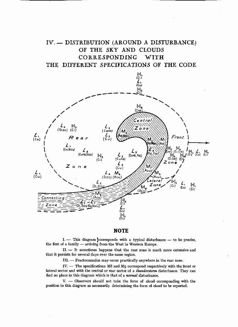
IV. — DISTRIBUTION (AROUND A DISTURBANCE)OF THE SKY AND CLOUDSCORRESPONDING WITH
THE DIFFERENT SPECIFICATIONS OF THE CODE
H,(C i J
(c.u)H2
JCif
X
-Connect/nq- - -- (AcuJ TT--- — — y — ~ r _ r - T j = r T=Z
~— (St.stcu; (Cu,st.cu;
//
// Lt y3
/ (Slcu) (Ci)
(Cu'j ' Rear
\l / fl
\)
\C'
\e (Cu-,
^ , \. M6
(CuJ \j (Acu.)
X . ^ (Ci)
NOTEI. — This diagram [corresponds with a typical disturbance — to be precise,
the first of a family — arriving from the West in Western Europe.
II. — It sometimes happens that the rear zone is much more extensive andthat it persists for several days over the same region.
III. — Fractocumulus may occur practically anywhere in the rear zone.
IV. — The specifications M8 and Mg correspond respectively with the front orlateral sector and with the central or rear sector of a thunderstorm disturbance. They canfind no place in this diagram which is that of a normal disturbance.
V. — Observers should not take the form of cloud corresponding with theposition in this diagram as necessarily determining the form of cloud to be reported.

TABLE OF CONTENTS
INTRODUCTION..
PART I
CLOUDS
I. — TABLE OF CLOUD CLASSIFICATION .. 2
II. — DEFINITIONS AND DESCRIPTIONS OF THE FORMS OF CLOUDS
1. Cirrus 32. Cirrocumulus 43. Cirrostratus 54. Altocumulus 65. Altostratus 96. Stratocumulus n7. Stratus 138. Nimbostratus 149. Cumulus 15
10. Cumulonimbus 16
III. — INSTRUCTIONS FOR THE OBSERVATION OF CLOUDS
1. Determination of the cloud form, varieties and casual details 192. Direction of motion and velocity of the clouds 223. The necessity of noting the state of the sky as a whole and of following the
evolution of the clouds 23
PART II
CLOUDS CODE
I. — LOWER CLOUDS CL
0. No lower clouds 271. Cumulus of fine weather 272. Cumulus heavy and swelling, without anvil top 283. Cumulonimbus 284. Stratocumulus formed by the flattening of cumulus clouds 295. Layer of stratus or Stratocumulus 296. Low broken up clouds of bad weather 307. Cumulus of fine weather and Stratocumulus 308. Heavy or swelling cumulus, or cumulonimbus, and Stratocumulus . . . . 309. Heavy or swelling cumulus (or cumulonimbus) and low ragged clouds of bad
weather 31
II. — MIDDLE CLOUDS CM
0. No middle clouds 321. Typical altostratus, thin 322. Typical altostratus, thick 323. Altocumulus, or high stratocumulus, sheet at one level only 324. Altocumulus in small isolated patches, individual clouds often show signs of
evaporation and are more or less lenticular in shape 335. Altoculumus arranged in more or less parallel bands, or an ordered layer advan-
cing over the sky 346. Altocumulus formed by a spreading out of the tops of cumulus 347. Altocumulus associated with altostratus or altostratus with a partially altocu-
mulus character 358. Altocumulus castellatus, or scattered cumuliform tufts 369. Altocumulus in several sheets at different levels, generally associated with
thick fibrous veils of cloud and a chaotic appearance of the sky .. .. 37
III. — UPPER CLOUDS CH
0. No upper clouds 381. Cirrus, delicate, not increasing, scattered and isolated masses 382. Cirrus, delicate, not increasing, abundant but not forming a continuous layer 383. Cirrus of anvil clouds, usually dense 384. Cirrus, increasing hooks generally in the form of ending in a point or in a
small tuft 395. Cirrus (often in polar bands), or cirrostratus advancing over the sky, but not
more than 45° above the horizon .. .. 396. Cirrus (often in polar bands) or cirrostratus advancing over the sky and more
than 45° above the horizon 407. Veil of cirrostratus covering the whole sky 408. Cirrostratus not increasing and not covering the whole sky 409. Cirrocumulus predominating, associated with a small quantity of cirrus .. 40
IV. — DISTRIBUTION (AROUND A DISTURBANCE) OF THE
SKY AND CLOUDS CORRESPONDING WITH THE
DIFFERENT SPECIFICATIONS OF THE CODE

INDEX OF PLATES
God, T I T L E SPlate .. ,
Number
1 L 1 Cumulus of fine weather (Cumulus humilis).
2 L 2 Heavy Cumulus without anvil (Cumulus congestus).
2 L 2 Cumulus pileus.
3 L 2 Cumulus agitated, rather heavy without anvil.
4 L 3 Cumulonimbus (Cumulonimbus calvus).
5 L 3 Cumulonimbus (Cumulonimbus incus).
6 L 3 Cumulonimbus.
7 L 4 Stratocumulus formed by extension from Cumulus (Stratocumulusvesperalis. — Melting away of the tops and spreading out of the bases).
8 L 4 Stratocumulus formed by the spreading out of Cumulus (Strato-cumulus cumulogenitus. — Melting away of the base, and spreadingout of the top).
9 L 5 Layer of Stratocumulus (Stratocumulus translucidus).
10 L 5 Layer of Stratocumulus (Stratocumulus opacus).
11 L 5 Layer of Stratus.
12 L 6 Low, ragged, dark grey clouds of bad weather.
13 L 7 Cumulus of fine weather and Stratocumulus.
14 L 8 Heavy Cumulus or Cumulonimbus and Stratocumulus.
15 L 9 Heavy Cumulus or Cumulonimbus with underlying low, raggedclouds of bad weather.
16 L 9 Cumulonimbus with an underlying layer of low, ragged cloudsof bad weather, which have a definite roll formation (Cumu-lonimbus arcus).
17 M l Typical thin Altostratus (Altostratus translucidus).
18 M 2 Typical thick Altostratus (Altostratus opacus).
19 M 3 Sheet of Altocumulus at one level (Altocumulus translucidus).
20 M 4 Altocumulus in small isolated lenticular patches (Altocumuluslenticularis).
21 M 4 Altocumulus in small isolated patches more or less lenticularin shape.
22 M 4 Altocumulus in small isolated patches, more or less lenticularin shape and with trailing precipitation (Altocumulus virga).
23 M S Altocumulus arranged in parallel bands spreading over the sky.
24 M S Altocumulus in a definitely organized layer spreading over thesky (Altocumulus translucidus).
Cod. T I T L E SNumbe,
25 M 6 Altocumulus formed by the spreading out of the tops of Cumulus(Altocumulus cumulogenitus).
26 M 7 Altocumulus associated with Altostratus.
27 M 7 Altocumulus associated with Altostratus.28 M 7 Altocumulus predominating with parts resembling Altostratus
(Altocumulus opacus).
29 M 8 Altocumulus castellatus.
30 M 8 Altocumulus floccus, scattered cumulus-shaped tufts (Altocumulusfloccus).
31 M 9 Altocumulus in several patches at different levels, associatedwith thick fibrous sheets. Chaotic grouping of clouds.
32 M 9 Altocumulus in several patches or layers at different levels, asso-ciated with thick fibrous sheets. Chaotic aspect.
33 H 2 Delicate Cirrus, not increasing in amount, extensive sheet butnot forming a continuous layer (Cirrus filosus).
34 H 3 Dense Cirrus derived from an anvil (Cirrus nothus).
35 H 3 Dense Cirrus probably derived from anvils (Cirrus densus).
36 H 4 Delicate Cirrus, increasing in amount, filaments in the form ofhooks ending in a little claw or upturned end (Cirrus unarms).
37 H 5 Cirrus and Cirrostratus increasing in amount, but not higherthan 45° above the horizon.
38 H 6 Cirrostratus increasing in amount, and more than 45° abovethe horizon.
39 H 7 Cirrostratus covering all the sky (Cirrostratus filosus).
40 H 8 Cirrostratus not increasing in amount, and not covering all thesky (Cirrostratus nebulosus).
41 H 9 Cirrocumulus predominating, associated with a Cirrus mass.

L IPI. 1
Office National Meteorologique, Paris, Aug. 12'" 1925, 13 h. 03, looking S, altitude 27".
Cumulus of fine weather (Cumulus humilis). —• Code number L I . — The clouds are scatteredand have a flat and deflated appearance even at the diurnal maximum of cloud development in the early afternoon.Their horizontal extension is greater than the vertical, as can be seen directly in the clouds near the horizon, andindirectly in the clouds near the zenith; these have small areas of shadow (O)or are even transparent (T) whichshows that their thickness is not great. At (CC) the clouds are slightly rounded. Near the horizon the bases (BB)are clearly shown. The cloud (T) which has no horizontal base and whose edges are ragged is a fractocumulus.
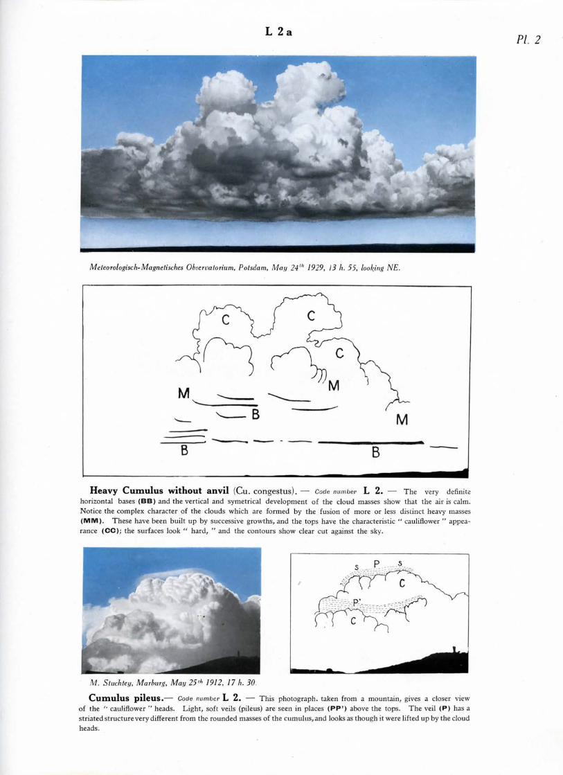
L 2PL 2
Meleorologisch-Magnetisches Obiervalorium, Potsdam, May 24"' 1929, 13 h. 55, looking NE.
Heavy Cumulus without anvil (Cu. COngCStus). — Code number L 2. — The very definitehorizontal bases (BB) and the vertical and symetrical development of the cloud masses show that the air is calm.Notice the complex character of the clouds which are formed by the fusion of more or less distinct heavy masses(MM). These have been built up by successive growths, and the tops have the characteristic " cauliflower " appea-rance (CO); the surfaces look " hard, " and the contours show clear cut against the sky.
M. Stuchtey, Marburg, May 25>l> 1912, 17 h. 30.
Cumulus pileus.— Code number L 2. — This photograph, taken from a mountain, gives a closer viewof the " cauliflower '' heads. Light, soft veils (pileus) are seen in places (PP1) above the tops. The veil (P) has astriated structure very different from the rounded masses of the cumulus, and looks as though it were lifted up by the cloudheads.
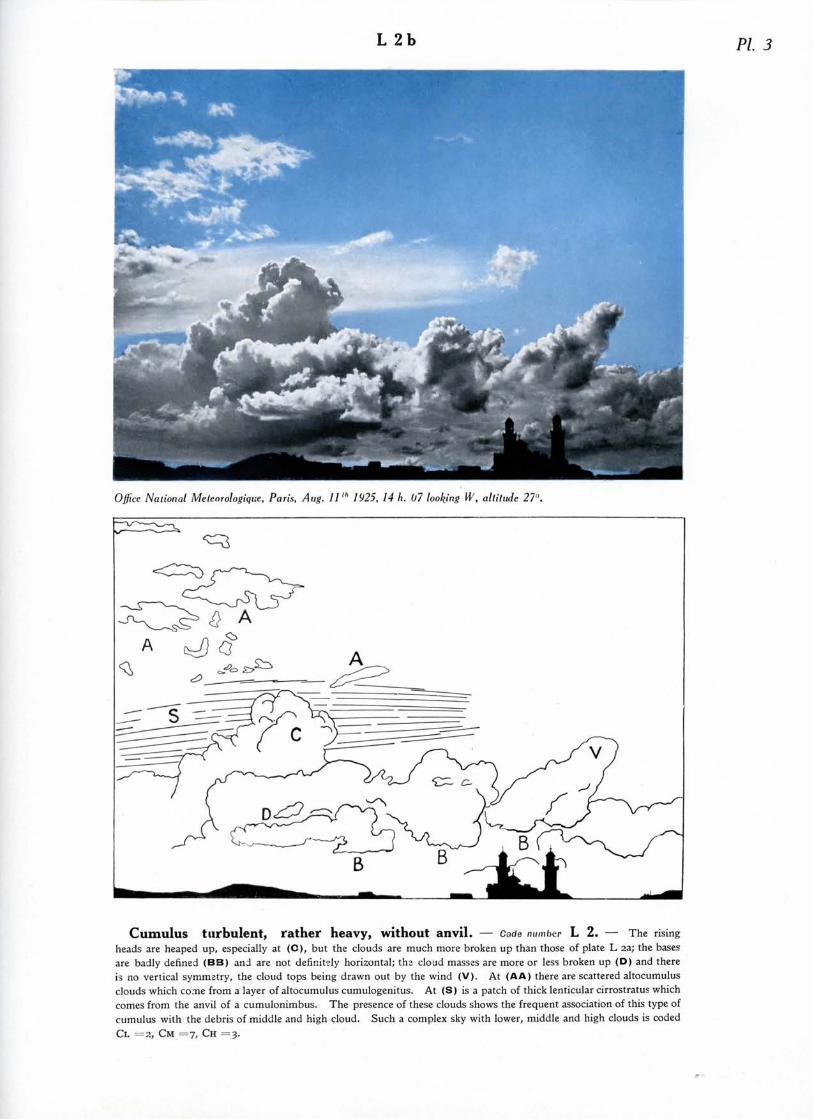
L 2b PL 3
Office National Meteorologique, Paris, Aug. 11'" 1925. 14 h. 07 looking W, altitude 27"
Cumulus turbulent, rather heavy, without anvil. — Code number L 2. — The risingheads are heaped up, especially at (C), but the clouds are much more broken up than those of plate L aa; the basesare badly defined (BB) and are not definitely horizontal; th: cloud masses are more or less broken up (D) and thereis no vertical symmetry, the cloud tops being drawn out by the wind (V). At (AA) there are scattered altocumulusclouds which come from a layer of altocumulus cumulogenitus. At (S) is a patch of thick lenticular cirrostratus whichcomes from the anvil of a cumulonimbus. The presence of these clouds shows the frequent association of this type ofcumulus with the debris of middle and high cloud. Such a complex sky with lower, middle and high clouds is codedCL = 3, CM =7, CH =3.

PL 4L 3
F. W. Baker, Yateley, Hants, Jane 10'" 1920, 18 h. 55, looking E.
Cumulonimbus (Cumulonimbus calvus).— Code number L 3.— The tops are just beginning to takeon a cirriform structure. At (FF) the cloud is "smoking," a sign that it is in active growth. An anvil is begin-ning to form at (E). The clear cut cumulus structure at (B) begins to soften, and the hard " cauliflower " domesdissolve and give place to a fibrous structure; this state is generally rather ephemeral, being one of transition, and thecomplete cirrus anvil is soon formed. At (SS) are dark fractocululus clouds of the base. At (H) are independentcirrus clouds.
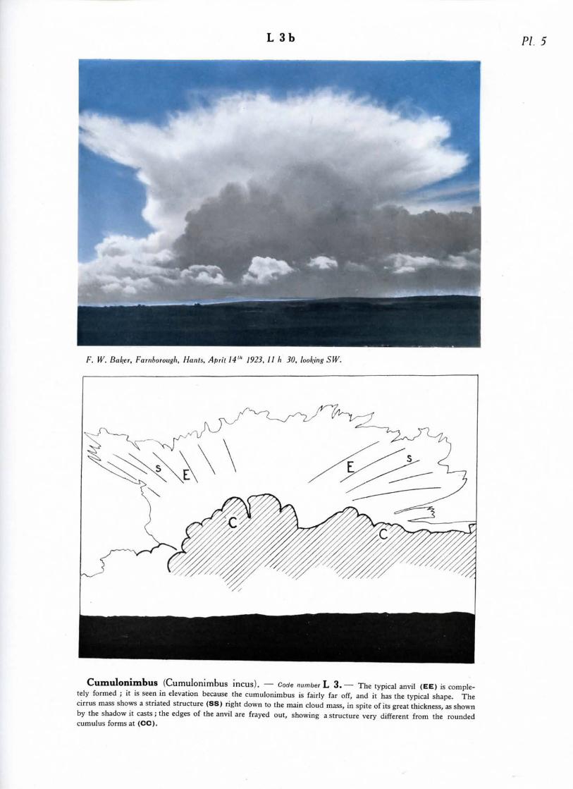
L 3b PI. 5
F. W. Baker, Farnborough, Hants, April 14'" 1923, 11 h 30, looking SW.
Cumulonimbus (Cumulonimbus incus). — Code number L 3.— The typical anvil (EE) is comple-tely formed ; it is seen in elevation because the cumulonimbus is fairly far off, and it has the typical shape. Thecirrus mass shows a striated structure (SS) right down to the main cloud mass, in spite of its great thickness, as shownby the shadow it casts; the edges of the anvil are frayed out, showing a structure very different from the roundedcumulus forms at (CC).

L 3
C. J. P. Cave, Petersfield, Hants, Apr. 1923, 12 h., looking N.
Cumulonimbus. — Code number L 3. — The cloud is nearing the zenith. The different parts of the cloud are not very clearlyshown, as happens frequently in similar cases. There is a shower of snow or hail as far down as (p), which is at the level at which the snowmelts and falls as rain, or else where the shower evaporates without reaching the ground. At (C) is a very dark cumuliform part of the cloud.At (E) is the anvil. At (G) above the falling snow it is evident that the freezing point comes down very low. At (H) is cirrostratus, probably theanvil of another cumulonimbus. At (AA) is fractostratus of the base, or rather degraded stratocumulus formed by extension from the main cloud.At (FF) is cumulus and fractocumulus.
Ox

PL 7L 4a
F. W. Baker.
Stratocumulus formed by extension from Cumulus (Stratocumulus vesperalis.Melting away of the tops and spreading out of the bases). — Code number L 4. — The time is thatof the end of the diurnal formation of cumulus. The clouds, in the course of disappearing, are almost completelyflattened, and resemble lines of stratus (AA), dark against the setting sun (S). At (CC) some traces of roundedcumulus can still be seen.
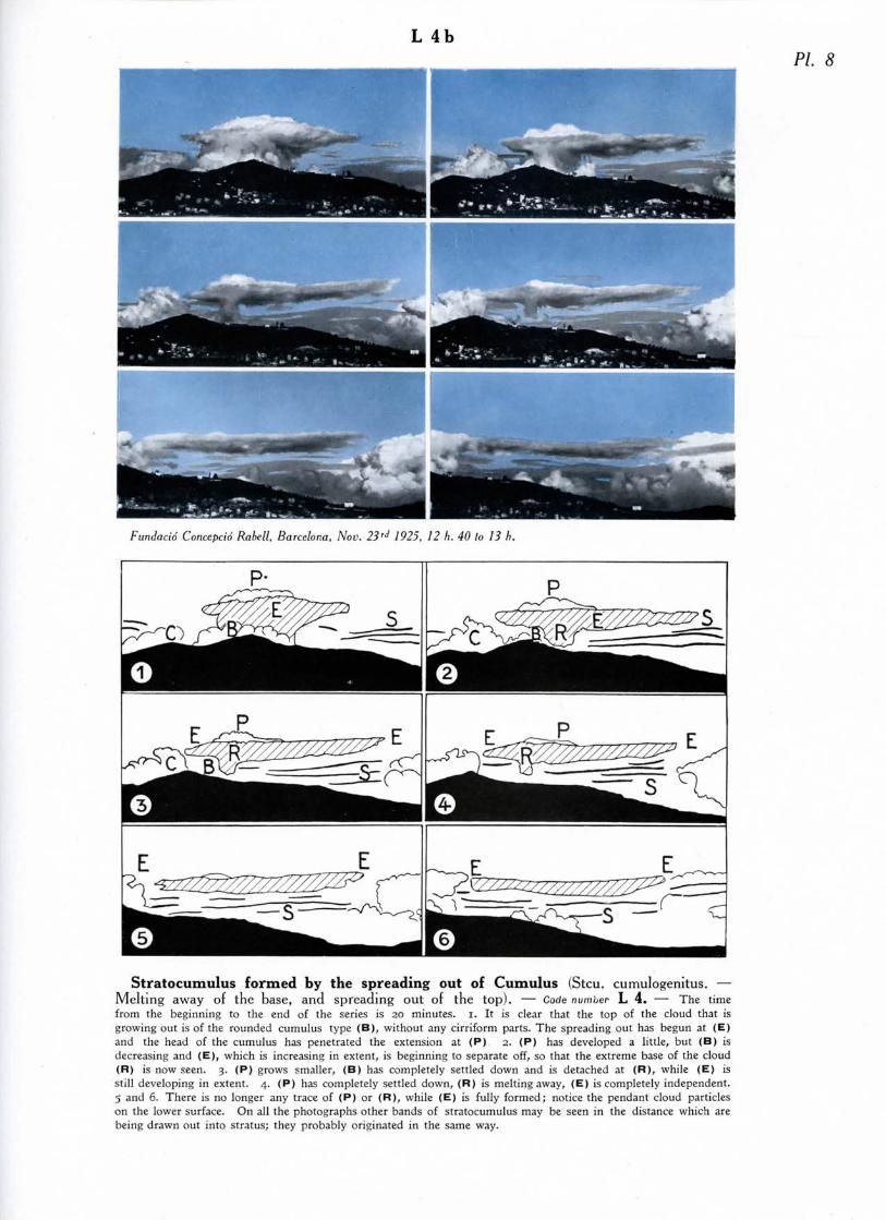
L 4bPL 8
Fundacid Concepcid Rabell, Barcelona, Nov. 23'J 1925, 12 h. 40 lo 13 h.
Stratocumulus formed by the spreading out of Cumulus (Stcu. cumulogenitus. —Melting away of the base, and spreading out of the top). — Code number L 4. — The timefrom the beginning to the end of the series is 20 minutes, i. It is clear that the top of the cloud that isgrowing out is of the rounded cumulus type (B), without any cirriform parts. The spreading out has begun at (E)and the head of the cumulus has penetrated the extension at (P) 2. (P) has developed a little, but (B) isdecreasing and (E), which is increasing in extent, is beginning to separate off, so that the extreme base of the cloud(R) is now seen. 3. (P) grows smaller, (B) has completely settled down and is detached at (R), while (E) isstill developing in extent. 4. (P) has completely settled down, (R) is melting away, (E) is completely independent.5 and 6. There is no longer any trace of (P) or (R), while (E) is fully formed; notice the pendant cloud particleson the lower surface. On all the photographs other bands of Stratocumulus may be seen in the distance which arebeing drawn out into stratus; they probably originated in the same way.
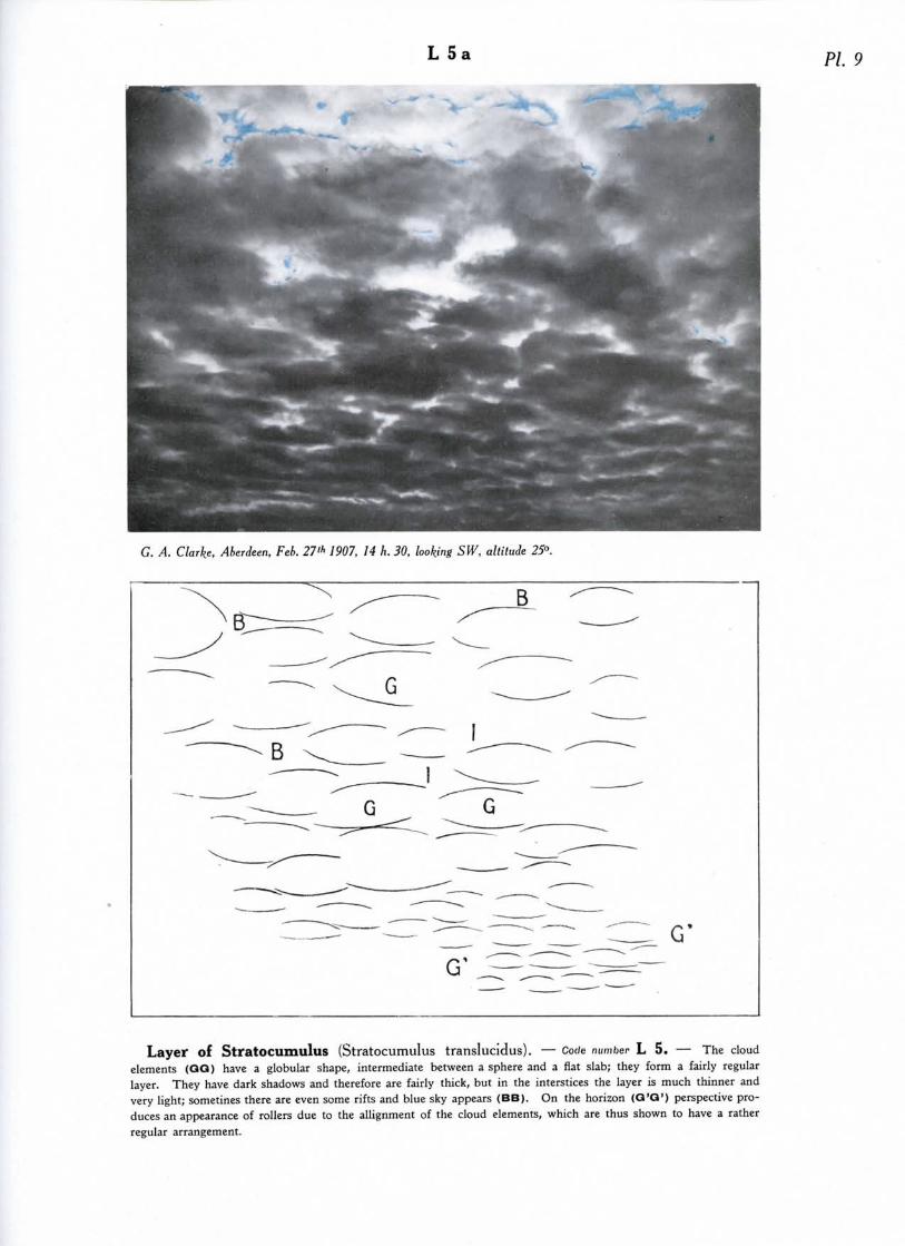
L 5a PL 9
G. A. Clarke, Aberdeen, Feb. 27 "> 7907, 14 h. 30, looking SW, altitude 25°.
Layer of Stratocumulus (Stratocumulus translucidus). — Code number L 5. — The cloudelements (QQ) have a globular shape, intermediate between a sphere and a flat slab; they form a fairly regularlayer. They have dark shadows and therefore are fairly thick, but in the interstices the layer is much thinner andvery light; sometines there are even some rifts and blue sky appears (BB). On the horizon (Q'Q1) perspective pro-duces an appearance of rollers due to the allignment of the cloud elements, which are thus shown to have a ratherregular arrangement.
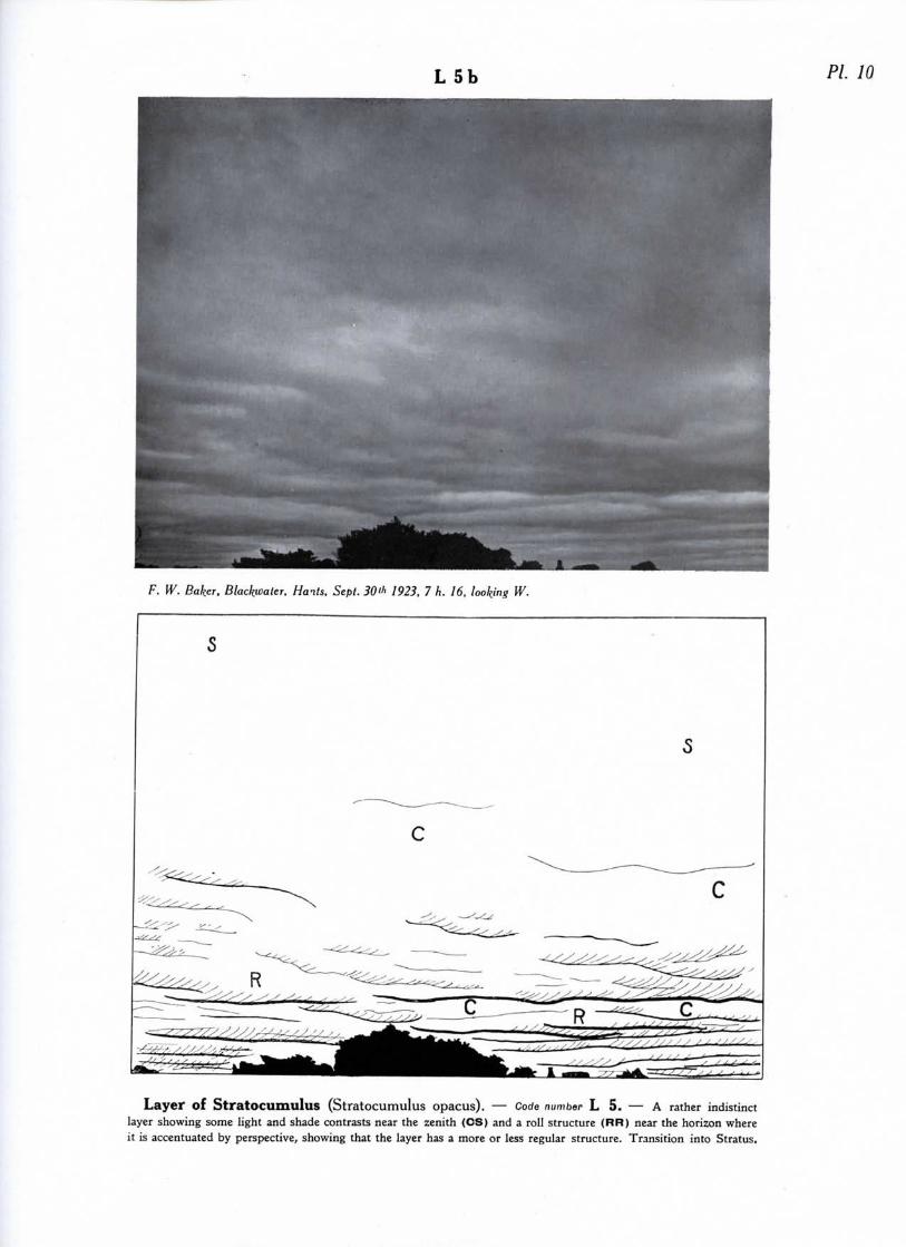
L 5b PL 10
F. W. Baker, Blackuater, Hails, Sept. 30* 1923, 7 h. 16, looking W.
Layer of StratOCUmulus (Stratocumulus opacus). — Code number L 5. — A rather indistinctlayer showing some light and shade contrasts near the zenith (CS) and a roll structure (RR) near the horizon whereit is accentuated by perspective, showing that the layer has a more or less regular structure. Transition into Stratus.
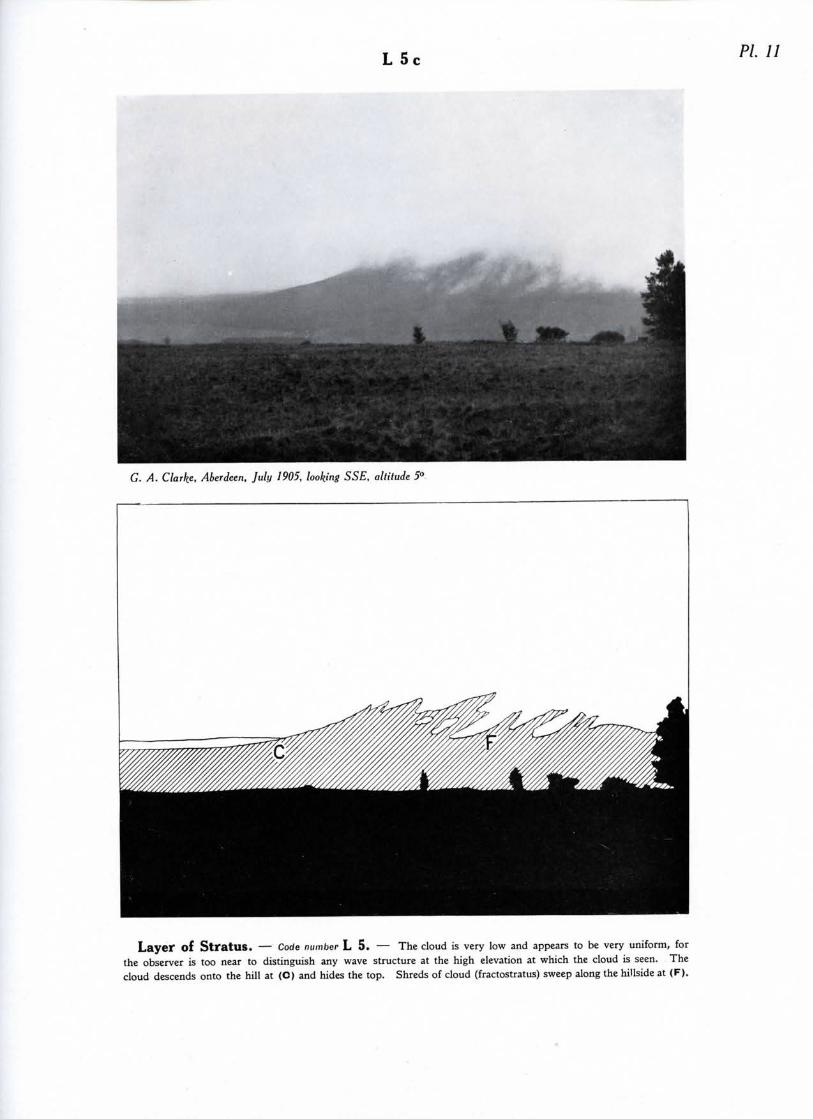
L 5 PL 11
G. A. Clarke, Aberdeen, July 1905, looking SSE, altitude 5°
Layei* of StratUS. — Code number L 5. — The cloud is very low and appears to be very uniform, forthe observer is too near to distinguish any wave structure at the high elevation at which the cloud is seen. Thecloud descends onto the hill at (C) and hides the top. Shreds of cloud (fractostratus) sweep along the hillside at (F).
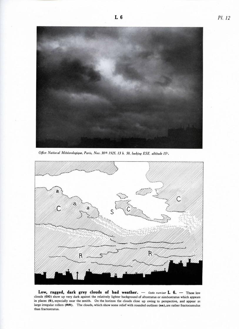
L 6 PI. 12
Office National Meteorologique, Paris, Nov. 30"> 1925, 13 h. 50, looking ESE. altitude /5>
Low, ragged, dark grey clouds of bad weather. — Code number L 6. — These lowclouds (CC) show up very dark against the relatively lighter background of altostratus or nimbostratus which appearsin places (S), especially near the zenith. On the horizon the clouds close up owing to perspective, and appear aslarge irregular rollers (RR) . The clouds, which show some relief with rounded outlines (aa),are rather fractocumulusthan fractostratus.
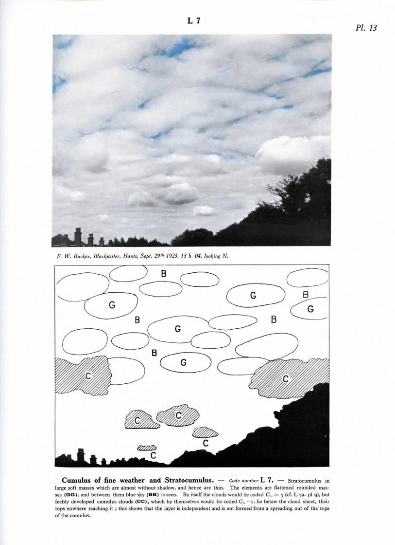
L 7PI. 13
F. W. Backer, Black^aler, Hants, Sept. 29th 1923, 13 h 04, looking N.
Cumulus of fine Weather and StratOCUmuluS. — Code number L 7. — Stratocumulus inlarge soft masses which are almost without shadow, and hence are thin. The elements are flattened rounded mas-ses (QG), and between them blue sky (BB) is seen. By itself the clouds would be coded d. = 5 (cf. L 53. pi 9), butfeebly developed cumulus clouds (CC), which by themselves would be coded Ci. "i. lie below the cloud sheet, theirtops nowhere reaching it ; this shows that the layer is independent and is not formed from a spreading out of the topsof the cumulus.

L 8 PI. 14
C. J. P. Cave, Bosham, Sussex, September, 1924
Heavy Cumulus, or Cumulonimbus, and Stratocumulus. — Code number L 8. —At (RR) is a corrugated sheet of cumulonimbus which if it were alone would be coded G. =5 (cf. L 5b. pi loVAt (CC) there is lower cumulus which penetrates the stratocumlus at (PP). It is a definite case of penetrationwithout any transition of one cloud form into the other. The Stratocumulus is independent of the cumulus and doesnot originate in a spreading out of the latter ; but the convection is sufficiently powerful for the cumulus to bestrongly developed, so that it reaches and penetrates the pre-existing layer ; perhaps the convection clouds arecumulonimbus, but since their tops are invisible this cannot be determined.

L 9a PI. 15
Office National Meteorologique, Paris, Sept. 24'h 1925, 15 h. 08, looking N, altitude 13°.
Heavy Cumulus or Cumulonimbus with underlying low, ragged clouds of badweather. — Code number L 9. — The rounded cumulus at (CO) is seen rising above distant banks of stra-tocumulus or altocumulus (AA). At (P) a veil cloud is lifted up by the top of a cumulus. At (S) is the base of acumulonimbus (resembling nimbostratus) with low ragged clouds below (FF), fractostratus rather than fractocu-mulus ; these seem to encroach on the base of the cumulonimbus. There is a shower at (a) and a rift at (E).
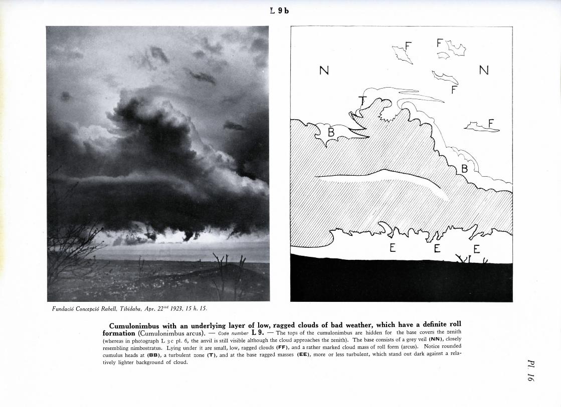
9b
Fundacid Concepcid Rabell, Tibidaba, Apr. 22"" 1923, 15 h. 15.
Cumulonimbus with an underlying layer of low, ragged clouds of bad weather, which have a definite rollformation (Cumulonimbus arcus). —• Code number L 9. — The tops of the cumulonimbus are hidden for the base covers the zenith(whereas in photograph L 3 c pi. 6, the anvil is still visible although the cloud approaches the zenith). The base consists of a grey veil (NIM), closelyresembling nimbostratus. Lying under it are small, low, ragged clouds (FF), and a rather marked cloud mass of roll form (arcus). Notice roundedcumulus heads at (BB), a turbulent zone (T), and at the base ragged masses (EE), more or less turbulent, which stand out dark against a rela-tively lighter background of cloud.
ON
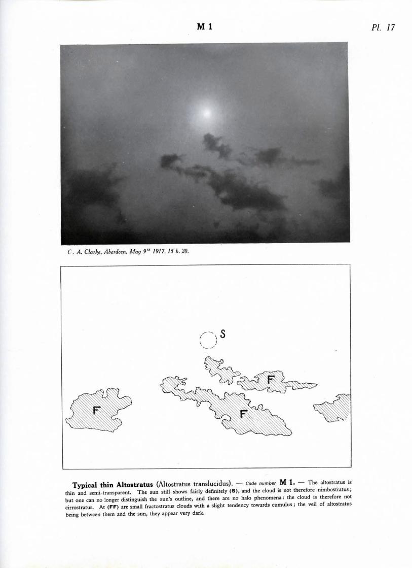
M 1 PL 17
C. A. Clarke. Aberdeen, May 9"1 1917, 15 h. 20.
Typical thin AltOStratUS (Altostratus translucidus). — Code number M l . — The altostratus isthin and semi-transparent. The sun still shows fairly definitely (S), and the cloud is not therefore nimbostratus;but one can no longer distinguish the sun's outline, and there are no halo phenomena: the cloud is therefore notcirrostratus. At (FF) are small fractostratus clouds with a slight tendency towards cumulus; the veil of altostratusbeing between them and the sun, they appear very dark.
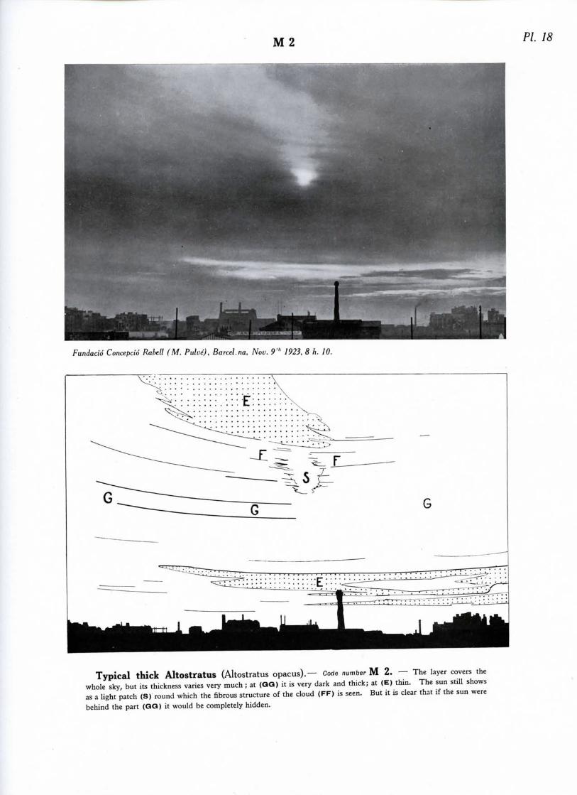
M 2 PI. 18
Fundacid Concepcid Rabell (M. Pulve), BarceLna, Nov. 9'1' 1923, 8 h. 10.
Typical thick Altostratus (Altostratus opacus).— Code number M 2. — The layer covers thewhole sky, but its thickness varies very much; at (QQ) it is very dark and thick; at (E) thin. The sun still showsas a light patch (S) round which the fibrous structure of the cloud (FF) is seen. But it is clear that if the sun werebehind the part (QQ) it would be completely hidden.
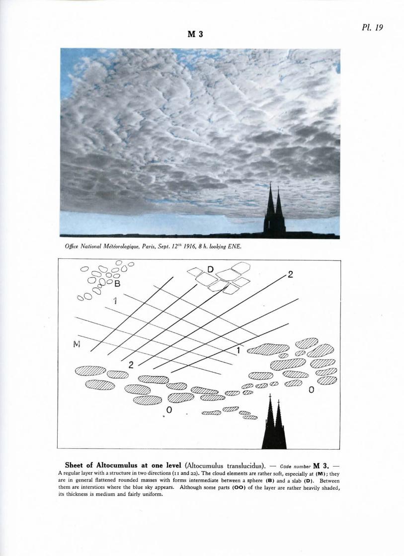
M 3PL 19
Office National Meteorologique, Paris, Sept. 12"' 1916, 8 h. looking ENE.
O
Sheet of Altocumulus at one level (Altocumulus translucidus). — Code number M 3. —A regular layer with a structure in two directions (i i and 22). The cloud elements are rather soft, especially at (M); theyare in general flattened rounded masses with forms intermediate between a sphere (B) and a slab (D). Betweenthem are interstices where the blue sky appears. Although some parts (OO) of the layer are rather heavily shaded,its thickness is medium and fairly uniform.

M 4 PL 20
C. J. P. Cave, Petersfield, Hants, April 21" 1924, about 8 h., looking E.
Altocumulus in small isolated lenticular patches (Altocumulus lenticularis). —Code number M 4. — This is a case of typical lenticular altocumulus, with well defined lens shaped masses ofa dazzling white, and capable of producing beautiful irisations. Although the edges of the patches show a shreddedand fibrous outline, and though the patch on the right has no shadow, the clouds should be classed as altocumulus andnot cirrocumulus ; these patches being quite alone in the sky, there is no connection between them and any cirrusmass ; also the patch on the left, obviously of the same kind as the other, has strong shading (O).

M 4b PI. 21
Office National Meteorologique, Paris, Nov. 17'" 1926, 14 h. 55, looking WSW, altitude 35"
Altocumulus in small isolated patches more or less lenticular in shape. —Code number M 4. — The lenticular tendency in the patches is obvious. The details show a complex structure,from a typical globular shape (B) to the small tessellations and ripples of cirrocumulus (C), and even to a fibrous ap-pearance (FF). There are probably at least two layers of cloud: the upper one composed of very delicate andlight patches (C, FF), the lower typical altocumulus (at B and below) strongly shaded. The cloud patches arechanging rapidly ; note that the cloud at (DD) is in process of dissolution.

M 4
Meteorologisch-Magnetisches Observalorium, Postdam, May 25"' 1904. 12 h., looking WSW, altitude 18".
Altocumulus in small isolated patches, more or less lenticular in shape and with trailing precipitation(Altocumulus Virga). — Code number M 4. — The cloud elements of the principal patch are very irregularly arranged; it seems of consi-derable extent because it is at a high elevation above the horizon, but the total amount of cloud in the sky is small. At (BB'J can be seen thetypical globular structure of altocumulus; the elements (B) seem at first sight to be fairly large, but in reality each is made up of smaller globularmasses fused together. Trailing wisps of rain (VV) called virga, are falling from the part of the cloud near the zenith, but they evaporate beforereaching the ground. These virga are of rather exceptional size. At (DD) it is evident that the patch is in process of evaporation. Lower downnear the horizon the patches (L) show a more or less lenticular shape in perspective.
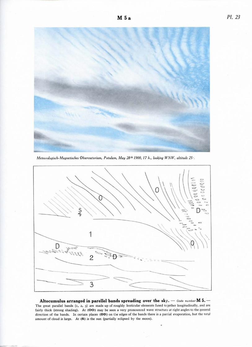
M 5 PI. 23
Meteorologisch-Magnetisches Observalorium, Potsdam, May 28lh 1900, 17 h., looking WNW, altitude 25'.
Altocumulus arranged in parellel bands spreading over the sky. — Code number M 5.—The great parallel bands (i, 2, 3) are made up of roughly lenticular elements fused together longitudinally, and arefairly thick (strong shading). At (OO) may be seen a very pronounced wave structure at right angles to the generaldirection of the bands. In certain places (DD) on the edges of the bands there is a partial evaporation, but the totalamount of cloud is large. At (S) is the sun (partially eclipsed by the moon).

M 5b
Office National Meleorologique, Paris, Aug. 6'1' 1925, 9 h. 45, looking S, altitude 25°.
Altocumulus in a definitely organized layer spreading over the sky (Altocumulus translucidus). — Code number M 5.— A vast pavement with more or less rectilinear joints, the cloud elements being fairly thin lamina ; these are arranged in lines (FF) in the direc-tion of view ; a second system of waves at right angles to the first can be seen at (OO). At (D) is a uniform layer of cloud that one might takefor cirrostratus but the structure at the edge of the sheet at (AA) shows that we are dealing with the same layer of altocumulus. There arecumulus clouds (CO) slightly developed and half hidden in a very hazy atmosphere (especially at A A) ; this bad visibility is frequent in weakdisturbances.

M 6
Office National Meteorologique, Paris, Sept. 25"' 1925,10h.46, looking N, altitude 13 '. Office National Meteorologique! Paris, Sept. 25'" 1925,10 h. 46, looking £NE, altitude 10' .
Altocumulus formed by the spreading out of the tops of Cumulus (Altocumulus cumulogenitus). — Code numberM 6. — The rather rounded cumulus is becoming flatter ( I I ) (photograph 2), the summits spread out and end by forming a layer of altocumulus(SS). The phenomenon is especially well seen at (A) (photograph 2). The structure is well shown in photograph 2; large soft rounded masses(QQ) which are not very thick have no shadows, and have interstices where the blue sky shows through.

Pi 26M 7a
C. /. P. Cave, Pelersfield, Hants, Sept. 27"- 1923. 18 h., looking W.
Altocumulus associated with AltOStratUS. — Code number M 7. — The veil of altostratus isvery variable in thickness ; at (VV) especially, are thicker and darker parts, at (EE) thinner and lighter parts. Thealtocumulus clouds which are below the altostratus consist of elongated and more or less lenticular patches (LL), or ofglobular masses (B). There are no low clouds. During the subsequent development of these clouds there wereonly traces of rain.

M 7 b PL 27
M. Boissonas, Geneva, Sept. 25th 1923, 18 h., looking S>W.
Altocumulus associated with AltOStratUS. — Code number M 7. — Two cloud layers can beseen. The upper layer is composed of globular masses of altocumulus (BB) between which a good deal of blue skyis seen (TT). The lower layer is composed of fragments of a corrugated veil (RR). This cloud association is some-times called altocumulus duplicatus. There is an absence of low cloud. This cloud formation can only causea very light rain.
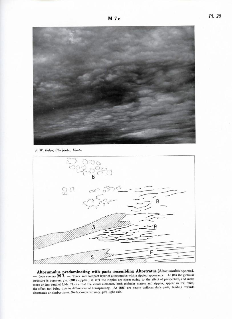
M 7c PL 28
F. W. Baker, Blackuater, Hants.
O°p-^B (
Altocumulus predominating with parts resembling Altostratus (Altocumulus opacus).— Code number M 7. — Thick and compact layer of altocumulus with a rippled appearance. At (B) the globularstructure is apparent ; at (RR) ripples ; at (P) the ripples are closer owing to the effect of perspective, and makemore or less parallel folds. Notice that the cloud elements, both globular masses and ripples, appear in real relief,the effect not being due to differences of transparency. At (SS) are nearly uniform dark parts, tending towardsaltostratus or nimbostratus. Such clouds can only give light rain.
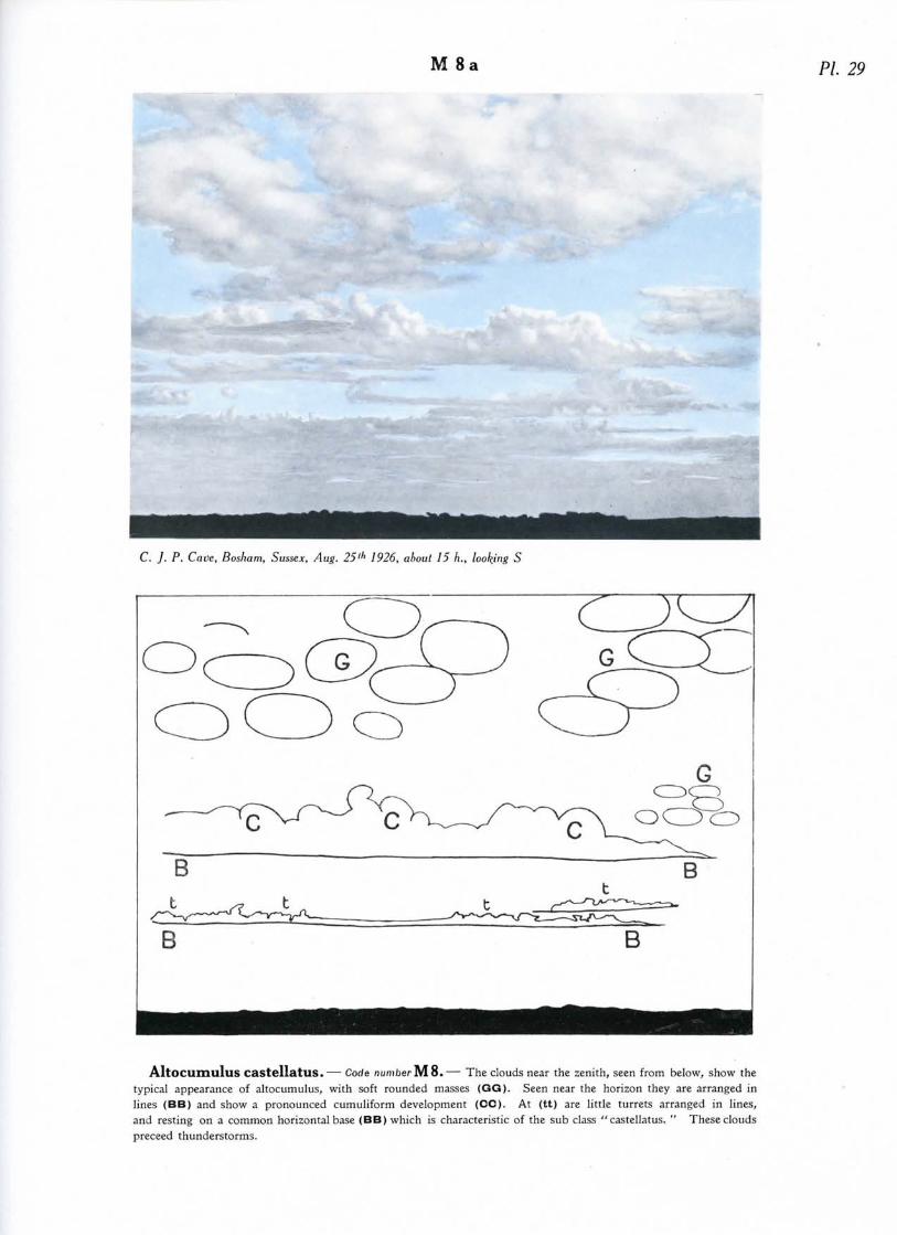
M 8 PL 29
C. J. P. Cave, Bosham, Sussex, Aug. 25th 1926, about 15 h., looking S
B
Altocumulus castellatus.— Code number M 8.— The clouds near the zenith, seen from below, show thetypical appearance of altocumulus, with soft rounded masses (GG). Seen near the horizon they are arranged inlines (BB) and show a pronounced cumuliform development (CC). At (tt) are little turrets arranged in lines,and resting on a common horizontal base (BB) which is characteristic of the sub class " castellatus. " These cloudspreceed thunderstorms.

M 8b PI. 30
C. /. P. Cave, Petersfield, Hants, Aug. 5'" 1923, 15 h. 30, looking NE
Altocumulus floccus, scattered cumulus-shaped tufts. — Code number M 8. —The cloud elements (CC) resemble small fractocumulus clouds, or cumulus without bases, and have no charac-teristic shadows. Some elements (FF) are quite ragged and broken up ; others are partially so (dd) ; others(BB) are ill developed globular masses, rather white and, resembling cumulus heads. At (Q) the elements are arran-ged in a series of diagonal lines, the allignment being heightened by perspective. These clouds preceed thunderstorms.
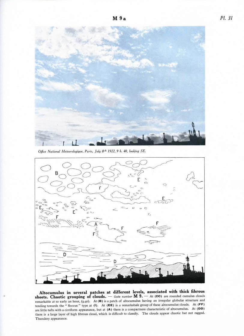
M 9 PL 31
I f LL ^Office National Meleorologiqtie, Paris, July 8lh 1922, 9 h. 40, looking SE.
Altocumulus in several patches at different levels, associated with thick fibroussheets. Chaotic grouping of clouds. — Code number M 9. — At (CC) are rounded cumulus cloudsremarkable at so early an hour, (9.40). At (B) is a patch of altocumulus having an irregular globular structure andtending towards the " floccus " type at (f) . At (EE) is a remarkabale group of these altocumulus clouds. At (FF)are little tufts with a cirriform appearance, but at (A) there is a compactness characteristic of altocumulus. At (DD)there is a large layer of high fibrous cloud, which is difficult to classify. The clouds appear chaotic but not ragged.Thundery appearance.

M 9b PL 32
Office National Meteorologique, Paris, Aug. II11' 1925, 8 h. 55, looking W altitude 27'.
Altoscumulus in several patches or layers at different levels, associated with thickfibrous sheets. Chaotic aspect. — Code number M 9. — At (CO) are cumulus clouds in spite of the earlyhour (8.55) ; these are markedly rounded in places (QQ). At (AA) are clouds at different levels, as is well seen at (N).Here the clouds at the low level are altocumulus, showing dark, with globular structure (BB) ; at the higher level is alighter, but thick fibrous sheet of doubtful species ; its fibrous structure appears in places (F) ; there are rifts whereblue sky shows (TT). The clouds are chaotic but not ragged ; they are " heavy " and " stagnant" (absence of wind).Thundery appearance.
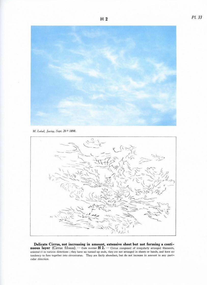
H 2 PL 33
M. Loisel, Juvisy, Sept. 20-h 1898.
Delicate Cirrus, not increasing in amount, extensive sheet but not forming a conti-nuous layer (Cirrus fllosus).— Code number H 2. — Cirrus composed of irregularly arranged filaments,orientated in various directions ; they have no turned up ends, they are not arranged in sheets or bands, and have notendency to fuse together into cirrostratus. They are fairly abundant, but do not increase in amount in any parti-cular direction.
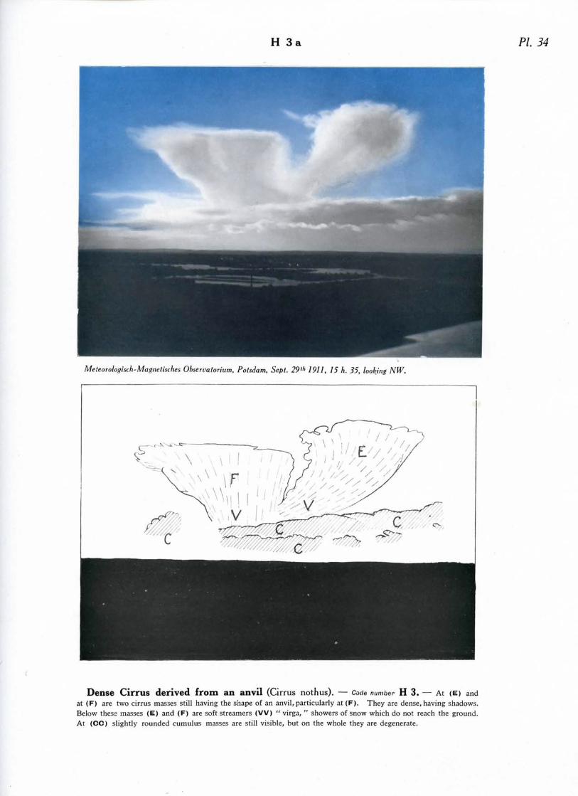
H 3a PI. 34
Meteorologisch-Magnetisches Observatorium, Potsdam, Sept. 29th 1911, 15 h. 35, looking NIV.
Dense Cirrus derived from an anvil (Cirrus nothus). — Code number H 3. — At (E) andat (F) are two cirrus masses still having the shape of an anvil, particularly at (F). They are dense, having shadows.Below these masses (E) and (F) are soft streamers (VV) " virga, " showers of snow which do not reach the ground.At (CC) slightly rounded cumulus masses are still visible, but on the whole they are degenerate.
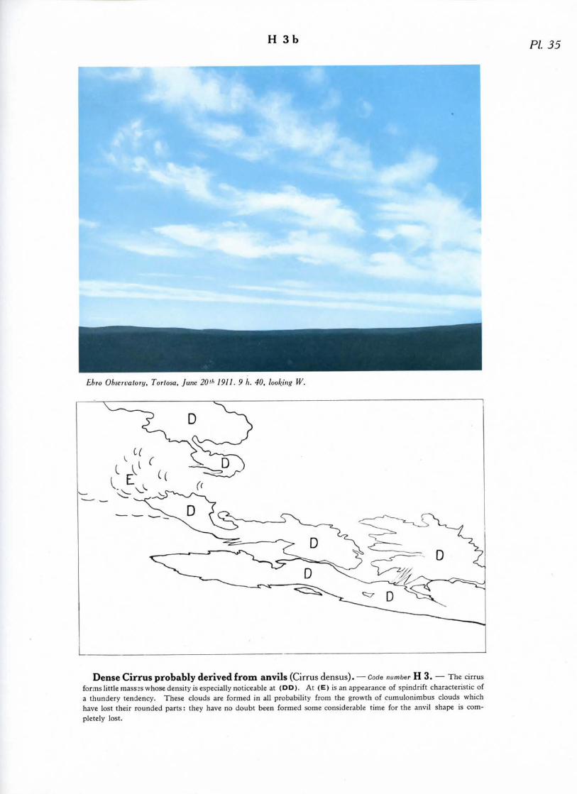
H 3bPL 35
Ebro Observatory, Torlosa, June 20"1 1911. 9 h. 40, looking W.
Dense Cirrus probably derived from anvils (Cirrus densus). — Code number H 3. — The cirrusforms little masses whose density is especially noticeable at (DD) . At (E) is an appearance of spindrift characteristic ofa thundery tendency. These clouds are formed in all probability from the growth of cumulonimbus clouds whichhave lost their rounded parts: they have no doubt been formed some considerable time for the anvil shape is com-pletely lost.
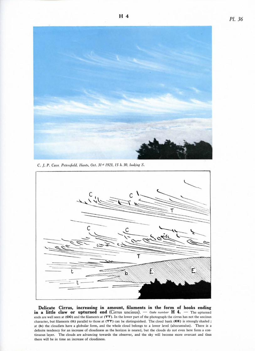
H 4PL 36
C. J. P. Cave Pelersfield, Hants, Oct. 31« 1923, 15 h. 30, looking S.
Delicate Cirrus, increasing in amount, filaments in the form of hooks endingin a little claw or upturned end (Cirrus uncinus). — Code number H 4. — The upturnedends are well seen at (CO) and the filaments at (TT). In the lower part of the photograph the cirrus has not the uncinuscharacter, but filaments (tt) parallel to those at (TT) can be distinguished. The cloud bank (EE) is strongly shaded ;at (b) the cloudlets have a globular form, and the whole cloud belongs to a lower level (altocumulus). There is adefinite tendency for an increase of cloudiness as the horizon is neared, but the clouds do not even here form a con-tinuous layer. The clouds are advancing towards the observer, and the sky will become more overcast and thusthere will be in time an increase of cloudiness.
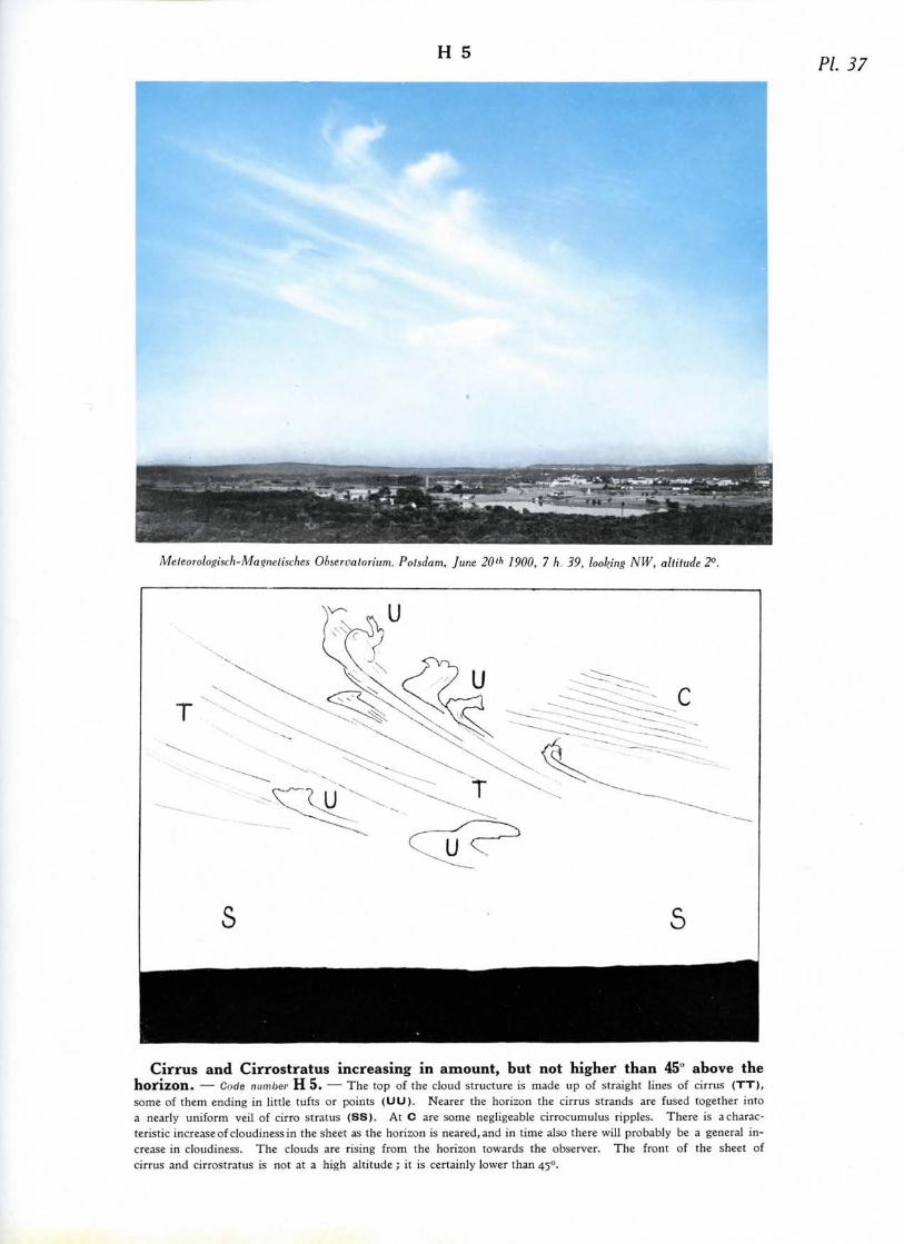
H 5PL 37
Meleorologisch-Ma<>nelische.s Ohservatorium, Polsdam, June 20>h 1900, 7 h 39, looking NW, altitude 2°.
Cirrus and Cirrostratus increasing in amount, but not higher than 45" above thehorizon. — Code number H 5. — The top of the cloud structure is made up of straight lines of cirrus (TT),some of them ending in little tufts or points (UU) . Nearer the horizon the cirrus strands are fused together intoa nearly uniform veil of cirro stratus (SS). At C are some negligeable cirrocumulus ripples. There is a charac-teristic increase of cloudiness in the sheet as the horizon is neared, and in time also there will probably be a general in-crease in cloudiness. The clouds are rising from the horizon towards the observer. The front of the sheet ofcirrus and cirrostratus is not at a high altitude ; it is certainly lower than 45°.

PI. 38H 6
Meleorologisch-Magnetisches Observatorium, Potsdam, Sept. 23'J 1916, 15 h., looking SW, altitude 27°.
Cirrostratus increasing in amount, and more than 45" above the horizon. —Code number H 6. — A fibrous sheet of cirrostratus with the sun at (S) and a halo at ( H H H ) , practically thewhole circle being visible. The fibrous structure ( f f ) of the sheet of cirrostratus is well seen near the halo. Lowdown, at (F), the cirrus clouds are noticeably thicker; high up on the other hand they are much thinner, and are onlyrevealed by the halo; one can infer from this that the sheet of cirrostratus, though it is higher than 45°, does notcover all the sky.
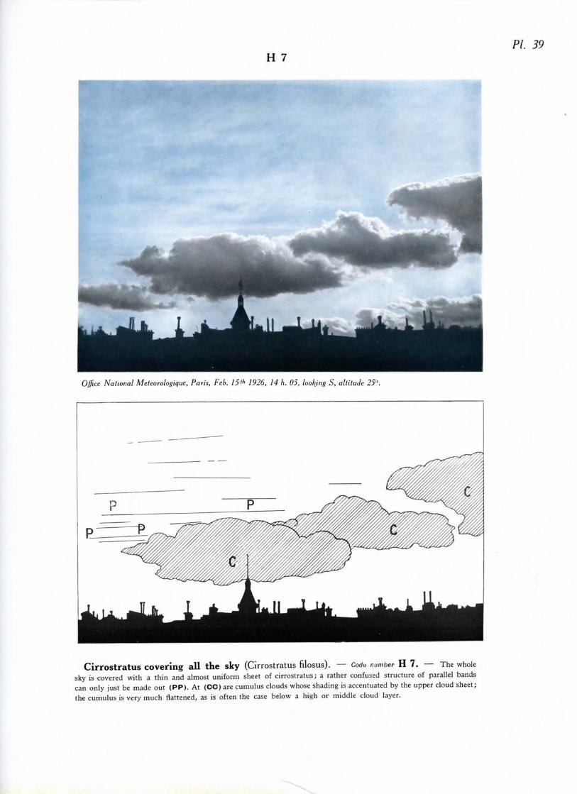
H 7Pi 39
Office National Meteorologique, Paris, Feb. 15»> 1926, 14 h. 05, looking S, altitude 25"
Cirrostratus covering all the sky (Cirrostratus filosus). — Corfu number H 7. — The wholesky is covered with a thin and almost uniform sheet of Cirrostratus; a rather confused structure of parallel bandscan only just be made out (PP). At (CC) are cumulus clouds whose shading is accentuated by the upper cloud sheet;the cumulus is very much flattened, as is often the case below a high or middle cloud layer.

H 8 PL 40
G. A. Clarke, Aberdeen, April!" 1917, 12 h. 30, looking W.
s
Cirrostatus not increasing in amount, and not covering all the sky (Cirrostratusnebulosus). — Code number H 8. — At (SS) is a sheet of rather dense cirrostratus (the density is exaggeratedin the photograph) which covers the whole sky from the horizon behind the observer to the edge which is quite sharp.At (CC) are small degenerate cumulus clouds ; a Fractocumulus is to be found in (F). One may suppose that theclear part of the sky does not increase in extent, that is that the sheet (SS) moves at right angles to the line of sight.

H 9 PL 41
Professor A. Mac AJie. Blue Hill Observatory, Readville, Mass. Sefil. 3'd 1924, 11 h 51.
H
^^ 0^~
•r>°°.o*4Z>° *m,^o /"/,
Cirrocumulus predominating, associated with a Cirrus mass. — Code number H 9. —The cloud bank has a fairly uniform central part (S), perhaps to be classed as cirrostratus. It has very variedcharacters; at (B) small globular masses; at (L) a tendency for the formation of rifts; at (RR) delicate ripples;at (AA) delicate herring-bone structure; at (H) a cirriform part; the fibrous nature of the cloud is clearly seen atthe edges (F). We are here dealing with a cirrus mass which has changed considerably in the direction of cirrocu-mulus. At (CC) on the horizon are some very flat cumulus clouds.