Intermountain 2045 Regional Transportation Plan
9
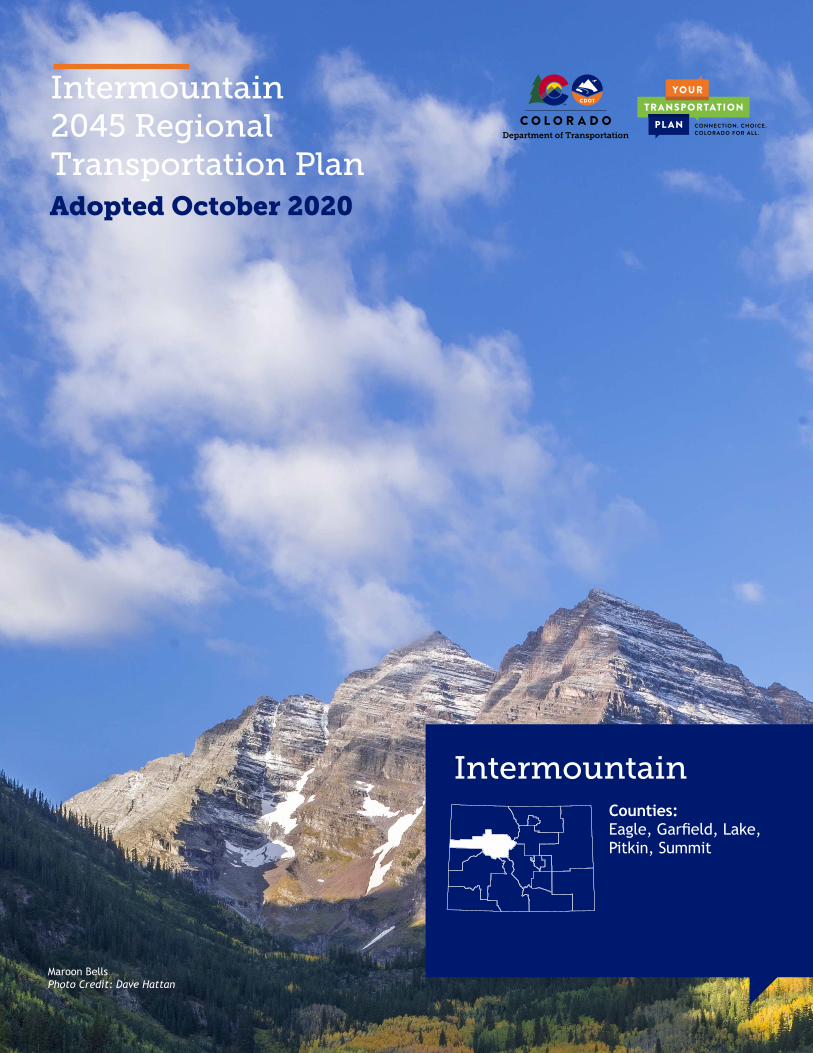
Intermountain 2045 Regional Transportation Plan Intermountain Adopted October 2020 Maroon Bells Photo Credit: Dave Hattan Counties: Eagle, Garfield, Lake, Pitkin, Summit
Transcript of Intermountain 2045 Regional Transportation Plan
Intermountain 2045 Regional Transportation Plan
Intermountain
Adopted October 2020
Maroon BellsPhoto Credit: Dave Hattan
Counties: Eagle, Garfield, Lake, Pitkin, Summit
PAGE 2 PAGE 3
Dear Neighbor,
As Chair of the Intermountain Transportation Planning Region (TPR), representing Eagle, Garfield, Lake, Pitkin, and Summit Counties, it is my responsibility to ensure that our area’s transportation needs and priorities are recognized, that information on our planning efforts is made easily accessible to the public, and that the process is clearly communicated to the public and key transportation decision-makers. The Regional Transportation Plan (RTP) planning group, made up of representatives from all jurisdictions within the region, recognizes current needs and priorities, while formulating ideas and solutions to keep pace with regional growth and changing conditions within the tight financial constraints the state is currently experiencing for transportation projects and maintenance.
This document reflects TPR member input, various types of available data and information, and public sentiment expressed. Much of the discussion during preparation of this Plan surrounded the priorities of the region: tourism needs, impacts of oil and gas development on local and state roads, and the astounding importance of alternative modes of transportation to our residents
and visitors, including transit, bicycle, and pedestrian facilities. Current federal and state highway funding is wildly insufficient, and we need to continue the discussion at all levels to find new funding streams for our aging transportation infrastructure.
This RTP will help inform decisions the Colorado Department of Transportation makes about the state’s transportation system and is intended to be a living, useful document that is referred to when transportation decisions are being made. It will be revisited periodically to ensure that we are on the right path toward accomplishing the vision and goals set forth in this plan.
Your familiarity with our region’s transportation needs and priorities and the challenges that we face is important now and into the future. I invite you to review this plan and become more engaged in the Intermountain Transportation Planning Region’s transportation future.
Bentley HendersonIntermountain TPR Chair
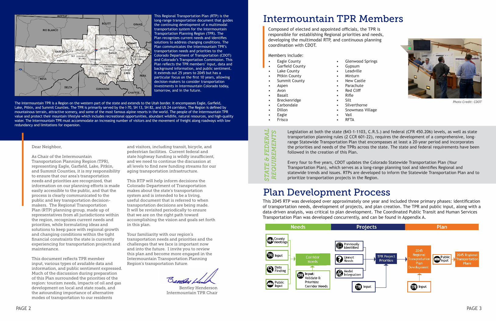
Intermountain TPR MembersComposed of elected and appointed officials, the TPR is responsible for establishing Regional priorities and needs, developing the multimodal RTP, and continuous planning coordination with CDOT.
Members include:
Legislation at both the state (§43-1-1103, C.R.S.) and federal (CFR 450.206) levels, as well as state transportation planning rules (2 CCR 601-22), requires the development of a comprehensive, long-range Statewide Transportation Plan that encompasses at least a 20-year period and incorporates the priorities and needs of the TPRs across the state. The state and federal requirements have been followed in the creation of this Plan.
Every four to five years, CDOT updates the Colorado Statewide Transportation Plan (Your Transportation Plan), which serves as a long-range planning tool and identifies Regional and statewide trends and issues. RTPs are developed to inform the Statewide Transportation Plan and to prioritize transportation projects in the Region.S
TA
TE
& F
ED
ER
AL
R
EQ
UIR
EM
EN
TS
This 2045 RTP was developed over approximately one year and included three primary phases: identification of transportation needs, development of projects, and plan creation. The TPR and public input, along with a data-driven analysis, was critical to plan development. The Coordinated Public Transit and Human Services Transportation Plan was developed concurrently, and can be found in Appendix A.
Plan Development Process
Photo Credit: CDOT
This Regional Transportation Plan (RTP) is the long-range transportation document that guides the continuing development of a multimodal transportation system for the Intermountain Transportation Planning Region (TPR). The Plan recognizes current needs and identifies solutions to address changing conditions. The Plan communicates the Intermountain TPR’s transportation needs and priorities to the Colorado Department of Transportation (CDOT) and Colorado’s Transportation Commission. This Plan reflects the TPR members’ input, data and background information, and public sentiment. It extends out 25 years to 2045 but has a particular focus on the first 10 years, allowing decision-makers to consider transportation investments in Intermountain Colorado today, tomorrow, and in the future.
The Intermountain TPR is a Region on the western part of the state and extends to the Utah border. It encompasses Eagle, Garfield, Lake, Pitkin, and Summit Counties. The TPR is primarily served by the I-70, SH 13, SH 82, and US 24 corridors. The Region is defined by mountainous terrain, attractive scenery, and some of the most famous alpine resorts in the world. The people of the Intermountain TPR value and protect their mountain lifestyle which includes recreational opportunities, abundant wildlife, natural resources, and high-quality water. The Intermountain TPR must accommodate an increasing number of visitors and the movement of freight along roadways with low redundancy and limitations for expansion.
• Eagle County• Garfield County• Lake County• Pitkin County• Summit County • Aspen• Avon• Basalt• Breckenridge• Carbondale• Dillon• Eagle• Frisco
• Glenwood Springs• Gypsum• Leadville• Minturn• New Castle• Parachute• Red Cliff• Rifle• Silt• Silverthorne• Snowmass Village • Vail• RFTA
PAGE 4 PAGE 5
ROADWAY DEPARTURE
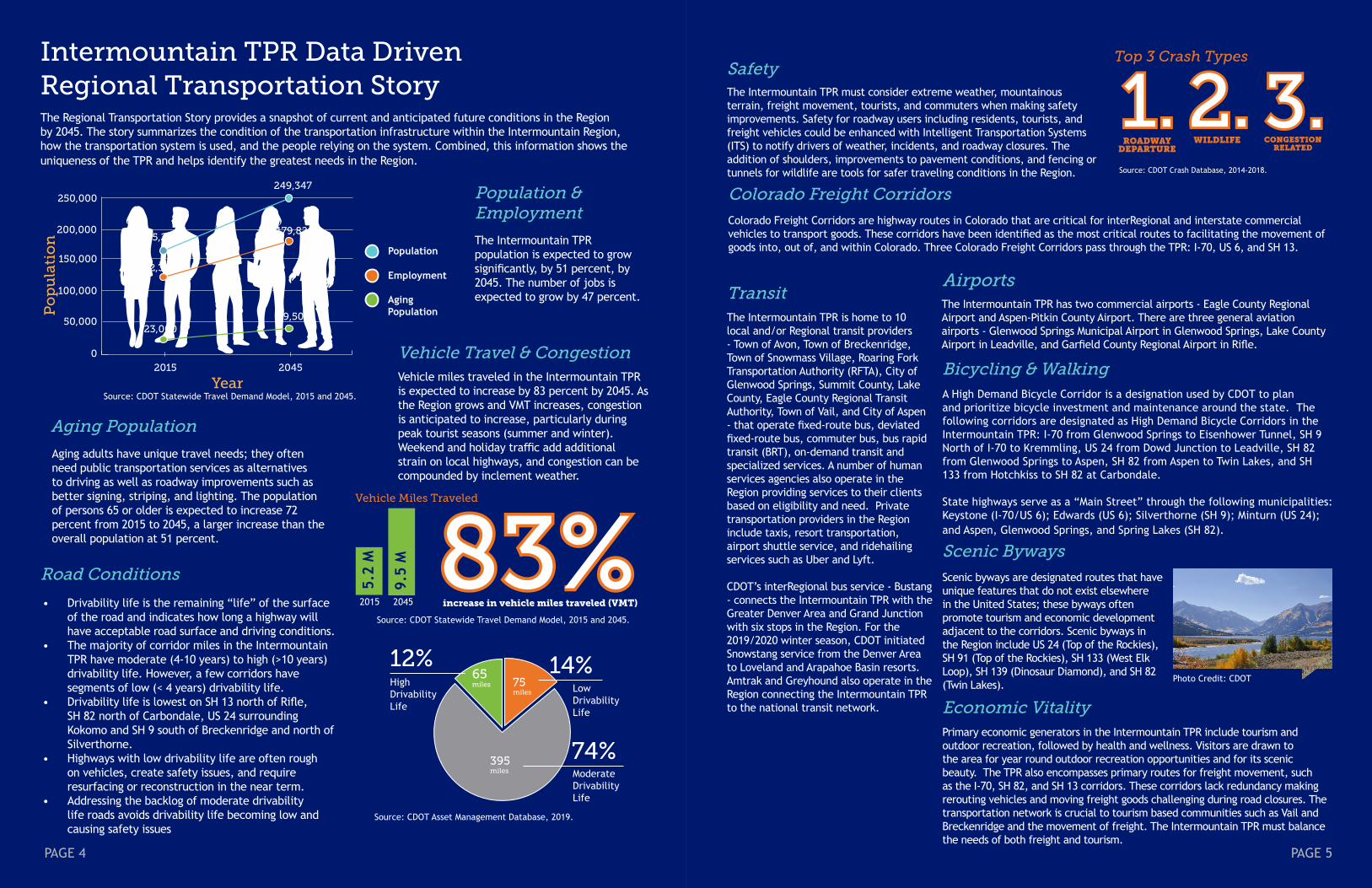
Intermountain TPR Data DrivenRegional Transportation Story
Population & Employment
The Intermountain TPR population is expected to grow significantly, by 51 percent, by 2045. The number of jobs is expected to grow by 47 percent.
Aging adults have unique travel needs; they often need public transportation services as alternatives to driving as well as roadway improvements such as better signing, striping, and lighting. The population of persons 65 or older is expected to increase 72 percent from 2015 to 2045, a larger increase than the overall population at 51 percent.
Aging Population
Vehicle miles traveled in the Intermountain TPR is expected to increase by 83 percent by 2045. As the Region grows and VMT increases, congestion is anticipated to increase, particularly during peak tourist seasons (summer and winter). Weekend and holiday traffic add additional strain on local highways, and congestion can be compounded by inclement weather.
Vehicle Travel & Congestion
Road Conditions
• Drivability life is the remaining “life” of the surface of the road and indicates how long a highway will have acceptable road surface and driving conditions.
• The majority of corridor miles in the Intermountain TPR have moderate (4-10 years) to high (>10 years) drivability life. However, a few corridors have segments of low (< 4 years) drivability life.
• Drivability life is lowest on SH 13 north of Rifle, SH 82 north of Carbondale, US 24 surrounding Kokomo and SH 9 south of Breckenridge and north of Silverthorne.
• Highways with low drivability life are often rough on vehicles, create safety issues, and require resurfacing or reconstruction in the near term.
• Addressing the backlog of moderate drivability life roads avoids drivability life becoming low and causing safety issues
SafetyThe Intermountain TPR must consider extreme weather, mountainous terrain, freight movement, tourists, and commuters when making safety improvements. Safety for roadway users including residents, tourists, and freight vehicles could be enhanced with Intelligent Transportation Systems (ITS) to notify drivers of weather, incidents, and roadway closures. The addition of shoulders, improvements to pavement conditions, and fencing or tunnels for wildlife are tools for safer traveling conditions in the Region.
TransitThe Intermountain TPR is home to 10 local and/or Regional transit providers - Town of Avon, Town of Breckenridge, Town of Snowmass Village, Roaring Fork Transportation Authority (RFTA), City of Glenwood Springs, Summit County, Lake County, Eagle County Regional Transit Authority, Town of Vail, and City of Aspen - that operate fixed-route bus, deviated fixed-route bus, commuter bus, bus rapid transit (BRT), on-demand transit and specialized services. A number of human services agencies also operate in the Region providing services to their clients based on eligibility and need. Private transportation providers in the Region include taxis, resort transportation, airport shuttle service, and ridehailing services such as Uber and Lyft.
CDOT’s interRegional bus service - Bustang - connects the Intermountain TPR with the Greater Denver Area and Grand Junction with six stops in the Region. For the 2019/2020 winter season, CDOT initiated Snowstang service from the Denver Area to Loveland and Arapahoe Basin resorts. Amtrak and Greyhound also operate in the Region connecting the Intermountain TPR to the national transit network.
Colorado Freight CorridorsColorado Freight Corridors are highway routes in Colorado that are critical for interRegional and interstate commercial vehicles to transport goods. These corridors have been identified as the most critical routes to facilitating the movement of goods into, out of, and within Colorado. Three Colorado Freight Corridors pass through the TPR: I-70, US 6, and SH 13.
Scenic BywaysScenic byways are designated routes that have unique features that do not exist elsewhere in the United States; these byways often promote tourism and economic development adjacent to the corridors. Scenic byways in the Region include US 24 (Top of the Rockies), SH 91 (Top of the Rockies), SH 133 (West Elk Loop), SH 139 (Dinosaur Diamond), and SH 82 (Twin Lakes).
AirportsThe Intermountain TPR has two commercial airports - Eagle County Regional Airport and Aspen-Pitkin County Airport. There are three general aviation airports - Glenwood Springs Municipal Airport in Glenwood Springs, Lake County Airport in Leadville, and Garfield County Regional Airport in Rifle.
Economic VitalityPrimary economic generators in the Intermountain TPR include tourism and outdoor recreation, followed by health and wellness. Visitors are drawn to the area for year round outdoor recreation opportunities and for its scenic beauty. The TPR also encompasses primary routes for freight movement, such as the I-70, SH 82, and SH 13 corridors. These corridors lack redundancy making rerouting vehicles and moving freight goods challenging during road closures. The transportation network is crucial to tourism based communities such as Vail and Breckenridge and the movement of freight. The Intermountain TPR must balance the needs of both freight and tourism.
The Regional Transportation Story provides a snapshot of current and anticipated future conditions in the Region by 2045. The story summarizes the condition of the transportation infrastructure within the Intermountain Region, how the transportation system is used, and the people relying on the system. Combined, this information shows the uniqueness of the TPR and helps identify the greatest needs in the Region.
Top 3 Crash Types
1.1. 2.2. 3.3.WILDLIFE
Source: CDOT Crash Database, 2014-2018.
CONGESTION RELATED
increase in vehicle miles traveled (VMT)
83% 83% 9.5
M
2045
5.2
M
2015
Vehicle Miles Traveled
Source: CDOT Statewide Travel Demand Model, 2015 and 2045.
Bicycling & WalkingA High Demand Bicycle Corridor is a designation used by CDOT to plan and prioritize bicycle investment and maintenance around the state. The following corridors are designated as High Demand Bicycle Corridors in the Intermountain TPR: I-70 from Glenwood Springs to Eisenhower Tunnel, SH 9 North of I-70 to Kremmling, US 24 from Dowd Junction to Leadville, SH 82 from Glenwood Springs to Aspen, SH 82 from Aspen to Twin Lakes, and SH 133 from Hotchkiss to SH 82 at Carbondale.
State highways serve as a “Main Street” through the following municipalities: Keystone (I-70/US 6); Edwards (US 6); Silverthorne (SH 9); Minturn (US 24); and Aspen, Glenwood Springs, and Spring Lakes (SH 82).
Photo Credit: CDOT
Source: CDOT Statewide Travel Demand Model, 2015 and 2045.
Po
pu
lati
on
Year
Population
Employment
Aging Population
250,000
200,000
150,000
50,000
0
165,218
249,347
122,363
179,820
23,00039,500
2015 2045
100,000
395 miles
75 miles
65 miles
74%
14%12%Low Drivability Life
Moderate Drivability Life
High Drivability Life
Source: CDOT Asset Management Database, 2019.
PAGE 6 PAGE 7
420,000 truck miles daily or approximately 156 million miles a year. Industry and residents in the Region rely on a strong transportation network for freight movement within and through the state to support economic development and provide communities with necessary goods and services. The Intermountain TPR is also served by the Union Pacific Railroad.
Environmental MitigationTransportation, like all human activities, affects the environment. The rules governing the statewide and Regional planning process require CDOT to consider environmental impacts potentially caused by transportation projects. These planning regulations require plans and projects to be coordinated with other local, state, and federal agencies to identify and discuss how to maintain projects and/or restore the environments impacted by the transportation projects. For example, if a project is anticipated to worsen air quality, the project solutions should seek to avoid, minimize, or mitigate this impact. In this case, mitigation measures could include optimizing the traffic signal to improve traffic flow and reduce vehicle emissions. The state and federal requirements pertaining to environmental consultation have been followed in the creation of this Plan.
Intermountain TPR’s Transportation Focus AreasTransportation impacts the lives of residents, employees, and visitors of Colorado in various ways across the state. The Intermountain TPR members identified the following topics that highlight what is most relevant and unique to the TPR when it comes to transportation.
Photo Credit: CDOT
Road ConditionsWell maintained roads are essential to the quality of life for residents, employers, visitors, and the movement of freight. The Intermountain TPR faces challenges such as severe winter weather, rockfall, wear and tear from cars and heavy vehicles, and low redundancy. Roadway conditions are critical on I-70, SH 9, SH 13, SH 82, and SH 91 where closures inhibit emergency vehicles, access to essential services, and the delivery of necessary goods such as medical supplies and groceries. Communities in the Region depend on resilient roadways to avoid closures that impact access and connectivity. When roads are well maintained in the TPR, drivers are safer, the wear and tear on cars, trucks, and heavy vehicles is minimized, goods and services can be provided to the Region, and transit services can reliably be accessed and provided. Roadway conditions impact the economic vitality and ability for people to travel in and through the Intermountain TPR. Maintaining assets such as roadways, bridges, and winter maintenance operations are critical to the Region.
Photo Credit: CDOT
Tourism Tourism is a top economic generator for the Intermountain TPR that takes place year round. Attractions in the Region include scenic byways, high demand bicycle corridors, popular winter and summer resort destinations, and federal lands. Tourism in the Intermountain TPR depends on the resiliency of roadways, particularly for communities that rely on a single corridor for connectivity; such as Snowmass Canyon and Glenwood Canyon’s reliance on SH 82. The Federal Lands Transportation Program (FLTP) and Federal Lands Access Program (FLAP) were created by the US Congress to dedicate funding towards improving and maintaining access to national parks, forests, wildlife refuges, national historic sites, and many other recreation and resource extraction site types. These funds could be used to enhance access to the lands vital to the Regions tourism economy. More information regarding Federal Lands Access can be found in Appendix C.
Photo Credit: CDOT
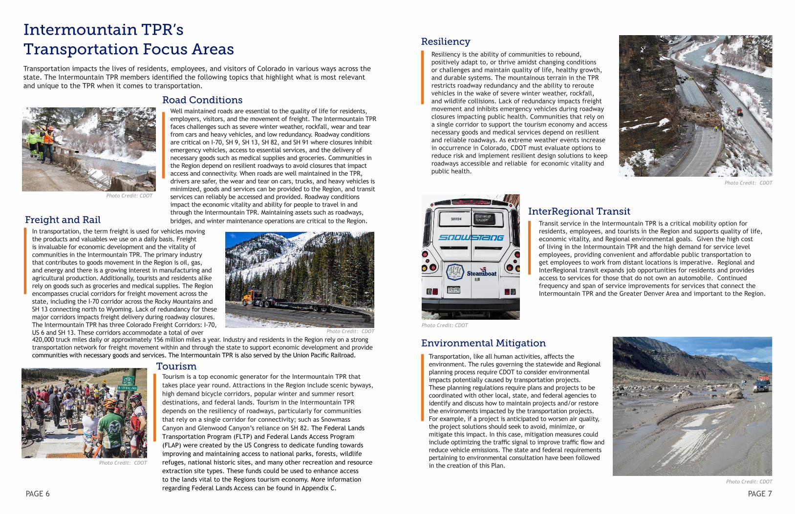
ResiliencyResiliency is the ability of communities to rebound, positively adapt to, or thrive amidst changing conditions or challenges and maintain quality of life, healthy growth, and durable systems. The mountainous terrain in the TPR restricts roadway redundancy and the ability to reroute vehicles in the wake of severe winter weather, rockfall, and wildlife collisions. Lack of redundancy impacts freight movement and inhibits emergency vehicles during roadway closures impacting public health. Communities that rely on a single corridor to support the tourism economy and access necessary goods and medical services depend on resilient and reliable roadways. As extreme weather events increase in occurrence in Colorado, CDOT must evaluate options to reduce risk and implement resilient design solutions to keep roadways accessible and reliable for economic vitality and public health.
Photo Credit: CDOT
Freight and RailIn transportation, the term freight is used for vehicles moving the products and valuables we use on a daily basis. Freight is invaluable for economic development and the vitality of communities in the Intermountain TPR. The primary industry that contributes to goods movement in the Region is oil, gas, and energy and there is a growing interest in manufacturing and agricultural production. Additionally, tourists and residents alike rely on goods such as groceries and medical supplies. The Region encompasses crucial corridors for freight movement across the state, including the I-70 corridor across the Rocky Mountains and SH 13 connecting north to Wyoming. Lack of redundancy for these major corridors impacts freight delivery during roadway closures. The Intermountain TPR has three Colorado Freight Corridors: I-70, US 6 and SH 13. These corridors accommodate a total of over Photo Credit: CDOT
InterRegional TransitTransit service in the Intermountain TPR is a critical mobility option for residents, employees, and tourists in the Region and supports quality of life, economic vitality, and Regional environmental goals. Given the high cost of living in the Intermountain TPR and the high demand for service level employees, providing convenient and affordable public transportation to get employees to work from distant locations is imperative. Regional and InterRegional transit expands job opportunities for residents and provides access to services for those that do not own an automobile. Continued frequency and span of service improvements for services that connect the Intermountain TPR and the Greater Denver Area and important to the Region.
Photo Credit: CDOT
What We’ve Heard: Online Map Comments by Category
PAGE 8 PAGE 9
The vision of the Intermountain TPR is to be a Region composed of physically distinct, unique, diverse communities interconnected by a multimodal transportation network that promotes preservation of the unique character of each community through open-space buffering, while providing economic, cultural, environmental, and outdoor recreational benefits.
Vis
ion
:
• Bring planning efforts together in order to develop a 10-year strategic pipeline of projects, inclusive of all modes, informed both by a data-driven needs assessment and public and stakeholder input
• Develop a Regional perspective or vision for the geographic distribution of people, goods and services, and recreation
• Better coordinate land use and multimodal transportation planning
• Address existing and future needs/inadequacies • Integrate multimodal options into all planning
and funding decisions • Phase in useful increments • Evaluate projects based on total cost of
construction and maintenance through the year 2045
• Provide maximum flexibility for use of funds • Tap into all potential funding sources
• Provide for efficient energy use • Preserve land and critical environmental values • Reflect direct and indirect environmental
impacts (e.g. air quality, noise, etc.) • Maximize system efficiency and minimize
needless trips • Provide travel options to attainable/accessible
housing, medical, and overall community services
• Recognize the uniqueness of individual communities
• Provide equity of funding for services • Recognize diverse needs of transportation users • Support/preserve existing transportation
patterns that enhance economic development • Consider social costs of transportation services • Engage in an open and comprehensive public
involvement process to prioritize and implement projects that meet the Region’s needs and goals
Go
als:
CDOT officials engaged local and Regional stakeholders and community members in the Intermountain TPR — in person, over the phone, and online. As a result, we heard from many residents throughout the TPR and learned how they travel. Outreach in the Region included:
Through this stakeholder and public outreach, the highest priority transportation trends and issues in the Intermountain TPR were identified as:
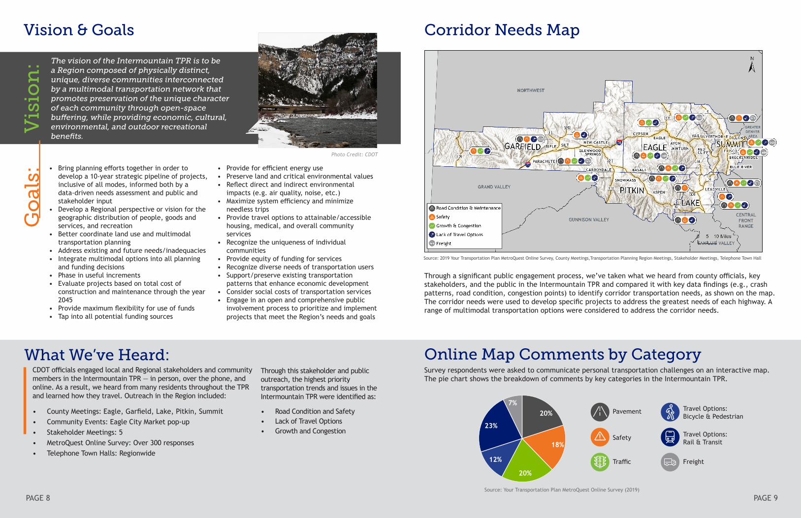
Corridor Needs Map
Through a significant public engagement process, we’ve taken what we heard from county officials, key stakeholders, and the public in the Intermountain TPR and compared it with key data findings (e.g., crash patterns, road condition, congestion points) to identify corridor transportation needs, as shown on the map. The corridor needs were used to develop specific projects to address the greatest needs of each highway. A range of multimodal transportation options were considered to address the corridor needs.
Survey respondents were asked to communicate personal transportation challenges on an interactive map. The pie chart shows the breakdown of comments by key categories in the Intermountain TPR.
Source: Your Transportation Plan MetroQuest Online Survey (2019)
Vision & Goals
Source: 2019 Your Transportation Plan MetroQuest Online Survey, County Meetings,Transportation Planning Region Meetings, Stakeholder Meetings, Telephone Town Hall
• County Meetings: Eagle, Garfield, Lake, Pitkin, Summit• Community Events: Eagle City Market pop-up• Stakeholder Meetings: 5• MetroQuest Online Survey: Over 300 responses• Telephone Town Halls: Regionwide
Photo Credit: CDOT
20%
23%
7%20%
12%
18%
Pavement
Safety
Traffic
Travel Options: Bicycle & Pedestrian
Travel Options:Rail & Transit
Freight
• Road Condition and Safety• Lack of Travel Options• Growth and Congestion
PAGE 10 PAGE 11
Photo Credit: CDOT
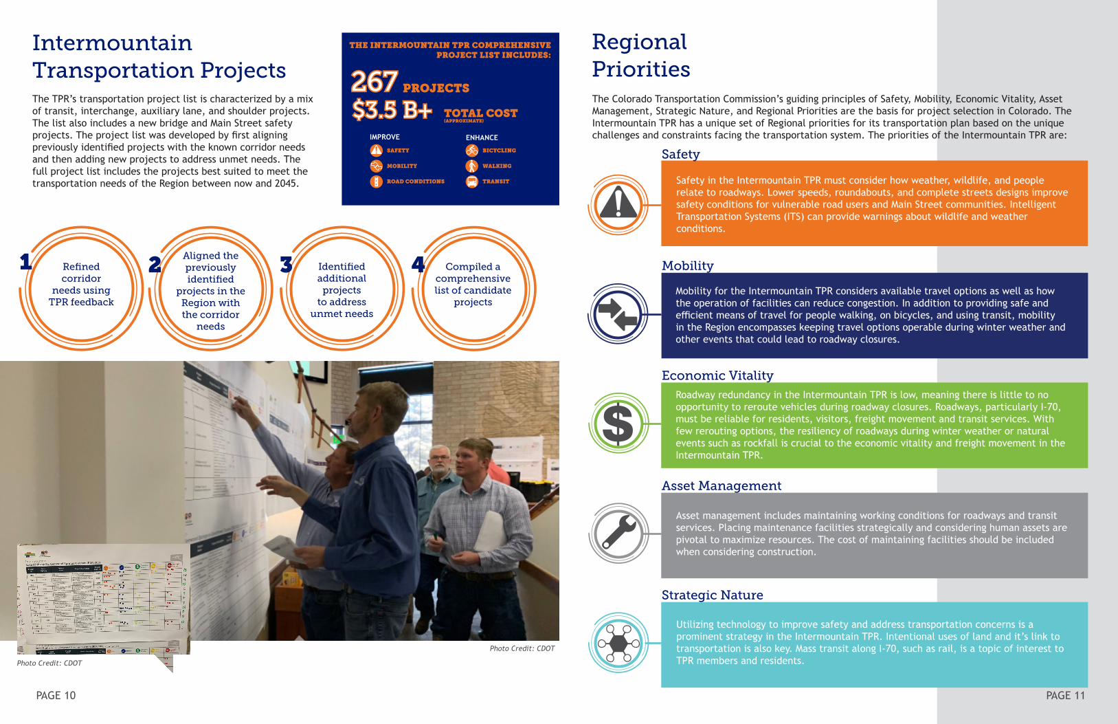
Intermountain Transportation ProjectsThe TPR’s transportation project list is characterized by a mix of transit, interchange, auxiliary lane, and shoulder projects. The list also includes a new bridge and Main Street safety projects. The project list was developed by first aligning previously identified projects with the known corridor needs and then adding new projects to address unmet needs. The full project list includes the projects best suited to meet the transportation needs of the Region between now and 2045.
Regional Priorities
Safety
Mobility
Economic Vitality
Asset Management
Strategic Nature
Photo Credit: CDOT
The Colorado Transportation Commission’s guiding principles of Safety, Mobility, Economic Vitality, Asset Management, Strategic Nature, and Regional Priorities are the basis for project selection in Colorado. The Intermountain TPR has a unique set of Regional priorities for its transportation plan based on the unique challenges and constraints facing the transportation system. The priorities of the Intermountain TPR are:
PAGE 11
Refined corridor
needs using TPR feedback
Aligned the previously identified
projects in the Region with the corridor
needs
Identified additional
projects to address
unmet needs
Compiled a comprehensive list of candidate
projects
1 2 3 4
Safety in the Intermountain TPR must consider how weather, wildlife, and people relate to roadways. Lower speeds, roundabouts, and complete streets designs improve safety conditions for vulnerable road users and Main Street communities. Intelligent Transportation Systems (ITS) can provide warnings about wildlife and weather conditions.
Mobility for the Intermountain TPR considers available travel options as well as how the operation of facilities can reduce congestion. In addition to providing safe and efficient means of travel for people walking, on bicycles, and using transit, mobility in the Region encompasses keeping travel options operable during winter weather and other events that could lead to roadway closures.
Roadway redundancy in the Intermountain TPR is low, meaning there is little to no opportunity to reroute vehicles during roadway closures. Roadways, particularly I-70, must be reliable for residents, visitors, freight movement and transit services. With few rerouting options, the resiliency of roadways during winter weather or natural events such as rockfall is crucial to the economic vitality and freight movement in the Intermountain TPR.
Asset management includes maintaining working conditions for roadways and transit services. Placing maintenance facilities strategically and considering human assets are pivotal to maximize resources. The cost of maintaining facilities should be included when considering construction.
Utilizing technology to improve safety and address transportation concerns is a prominent strategy in the Intermountain TPR. Intentional uses of land and it’s link to transportation is also key. Mass transit along I-70, such as rail, is a topic of interest to TPR members and residents.
267267 PROJECTS
$3.5 B+$3.5 B+ TOTAL COST(APPROXIMATE)
IMPROVE
SAFETY
MOBILITY
ROAD CONDITIONS
ENHANCE
BICYCLING
WALKING
TRANSIT
THE INTERMOUNTAIN TPR COMPREHENSIVE PROJECT LIST INCLUDES:
PAGE 12 PAGE 13
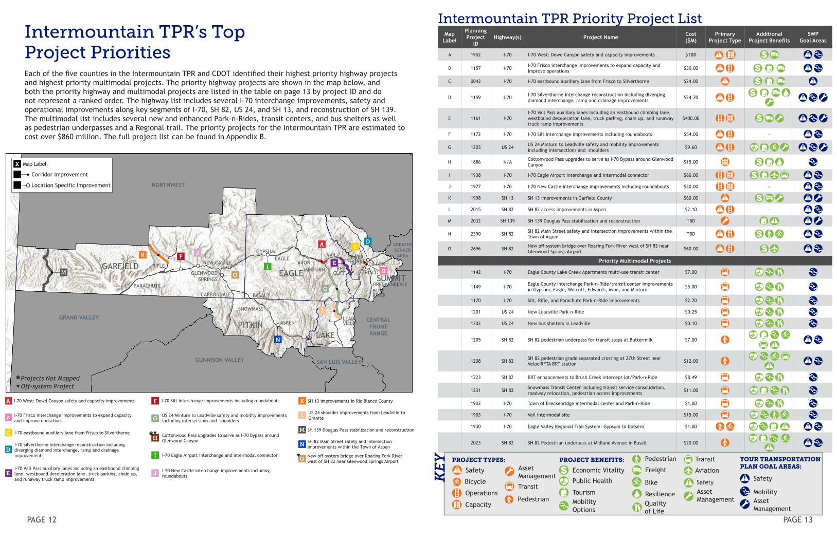
Map Label
PlanningProject
IDHighway(s) Project Name Cost
($M)Primary
Project TypeAdditional
Project BenefitsSWP
Goal Areas
A 1952 I-70 I-70 West: Dowd Canyon safety and capacity improvements $TBD
B 1157 I-70 I-70 Frisco interchange improvements to expand capacity and improve operations $30.00
C 0043 I-70 I-70 eastbound auxiliary lane from Frisco to Silverthorne $24.00
D 1159 I-70 I-70 Silverthorne interchange reconstruction including diverging diamond interchange, ramp and drainage improvements $24.70
E 1161 I-70I-70 Vail Pass auxiliary lanes including an eastbound climbing lane, westbound deceleration lane, truck parking, chain up, and runaway truck ramp improvements
$400.00
F 1172 I-70 I-70 Silt interchange improvements including roundabouts $54.00 -
G 1203 US 24 US 24 Minturn to Leadville safety and mobility improvements including intersections and shoulders $9.60
H 1886 N/A Cottonwood Pass upgrades to serve as I-70 Bypass around Glenwood Canyon $15.00
I 1938 I-70 I-70 Eagle Airport interchange and intermodal connector $60.00
J 1977 I-70 I-70 New Castle interchange improvements including roundabouts $30.00 -
K 1998 SH 13 SH 13 improvements in Garfield County $60.00
L 2015 SH 82 SH 82 access improvements in Aspen $2.10 -
M 2032 SH 139 SH 139 Douglas Pass stabilization and reconstruction TBD
N 2390 SH 82 SH 82 Main Street safety and intersection improvements within the Town of Aspen TBD
O 2696 SH 82 New off-system bridge over Roaring Fork River west of SH 82 near Glenwood Springs Airport $60.00
Priority Multimodal Projects
1142 I-70 Eagle County Lake Creek Apartments multi-use transit center $7.00
1149 I-70 Eagle County interchange Park-n-Ride/transit center improvements in Gypsum, Eagle, Wolcott, Edwards, Avon, and Minturn $5.00
1170 I-70 Silt, Rifle, and Parachute Park-n-Ride improvements $2.70
1201 US 24 New Leadville Park-n-Ride $0.25
1202 US 24 New bus shelters in Leadville $0.10
1205 SH 82 SH 82 pedestrian underpass for transit stops at Buttermilk $7.00
1208 SH 82 SH 82 pedestrian grade separated crossing at 27th Street near VelociRFTA BRT station $12.00
1223 SH 82 BRT enhancements to Brush Creek intercept lot/Park-n-Ride $8.49
1231 SH 82 Snowmass Transit Center including transit service consolidation, roadway relocation, pedestrian access improvements $11.00
1902 I-70 Town of Breckenridge intermodal center and Park-n-Ride $1.00
1903 I-70 Vail intermodal site $15.00
1930 I-70 Eagle Valley Regional Trail System: Gypsum to Dotsero $1.00
2023 SH 82 SH 82 Pedestrian underpass at Midland Avenue in Basalt $20.00
PROJECT TYPES:
Operations
Capacity
Transit
YOUR TRANSPORTATION PLAN GOAL AREAS:
Safety
Asset Management
Mobility
KEY PROJECT BENEFITS:
Safety
Bicycle
Economic Vitality
Public Health
Mobility Options
Quality of Life
Bike
ResilienceTourism AssetManagement
Safety
FreightAsset Management
Transit
Aviation
Intermountain TPR’s Top Project PrioritiesEach of the five counties in the Intermountain TPR and CDOT identified their highest priority highway projects and highest priority multimodal projects. The priority highway projects are shown in the map below, and both the priority highway and multimodal projects are listed in the table on page 13 by project ID and do not represent a ranked order. The highway list includes several I-70 interchange improvements, safety and operational improvements along key segments of I-70, SH 82, US 24, and SH 13, and reconstruction of SH 139. The multimodal list includes several new and enhanced Park-n-Rides, transit centers, and bus shelters as well as pedestrian underpasses and a Regional trail. The priority projects for the Intermountain TPR are estimated to cost over $860 million. The full project list can be found in Appendix B.
08/10/20
SH 13 improvements in Rio Blanco County
US 24 shoulder improvements from Leadville to Granite
B
CD
F
G
I
JK
L
A
M
N
O
M O
N
RIFLE
PARACHUTE
GLENWOODSPRINGS
NEW CASTLE
CARBONDALE
SNOWMASS
ASPEN
BASALT
GYPSUMEAGLE
AVONMINTURN
VAIL SILVER-THORNE DILLON
FRISCO
BRECKENRIDGEBLUERIVER
LEAD-VILLE
REDCLIFF
GARFIELDEAGLE
PITKINLAKE
SUMMIT
Map LabelX
Corridor Improvement
Location Specific Improvement
A F K
LG
H
I
J
B
C
D
E
I-70 West: Dowd Canyon safety and capacity improvements
I-70 Frisco interchange improvements to expand capacity and improve operations
I-70 Silt interchange improvements including roundabouts
US 24 Minturn to Leadville safety and mobility improvements including intersections and shoulders
Cottonwood Pass upgrades to serve as I-70 Bypass around Glenwood Canyon
I-70 Eagle Airport interchange and intermodal connector
I-70 New Castle interchange improvements including roundabouts
SH 139 Douglas Pass stabilization and reconstruction
SH 82 Main Street safety and intersection improvements within the Town of Aspen
New off-system bridge over Roaring Fork River west of SH 82 near Glenwood Springs Airport
I-70 eastbound auxiliary lane from Frisco to Silverthorne
I-70 Silverthorne interchange reconstruction including diverging diamond interchange, ramp and drainage improvements
I-70 Vail Pass auxiliary lanes including an eastbound climbing lane, westbound deceleration lane, truck parking, chain up, and runaway truck ramp improvements
E
NORTHWEST
CENTRALFRONTRANGE
SAN LUIS VALLEY
GRAND VALLEY
GUNNISON VALLEY
GREATERDENVER
AREA
Projects Not MappedOff-system Project
Intermountain TPR Priority Project List
Pedestrian
Pedestrian
PAGE 14 PAGE 15
Relation to the Colorado Statewide Transportation PlanThis RTP is a standalone document that identifies transportation needs and priorities for the Region. The Statewide Transportation Plan (Your Transportation Plan) integrates and consolidates the 15 RTPs from around the state, and the RTPs are appendices in Your Transportation Plan. The Intermountain TPR’s project priorities were discussed at a joint meeting with the CDOT Region 3 Regional Transportation Director and the TPR Chairs from the Region. This meeting enabled the Intermountain TPR Chair to advocate for inclusion of the Region’s priority projects in the 10-Year Strategic Project Pipeline, a primary outcome of Your Transportation Plan. This method of planning helps ensure that Your Transportation Plan addresses multiple levels of the transportation network. The RTPs identify contextual solutions that support the statewide vision and initiatives. This approach is key to delivering a comprehensive and cohesive plan customized to the unique needs of each region.
Intermountain TPR’s Implementation Strategies
The following discussion contains information about actions that the TPR will take to implement its RTP. Implementation actions are meant to be near-term, practicable measures related to the Intermountain TPR’s vision, goals, and priority projects.
The following strategies have been developed as a way for the TPR members to actively implement the RTP:
• Advocate for local safety improvements, such as rumble strips, skid-resistant surfaces, guardrails and barriers, intersection safety improvements, signs at pedestrian/ bicycle crossing/school crossings, and auxiliary lanes (passing, turn, acceleration/deceleration lanes).
• Work with CDOT and local jurisdictions to incorporate bike lanes on existing roadways where shoulders are already wide enough to meet AASHTO standards and include those bike lanes on CDOT’s bicycle facilities mapping.
• Work with towns and cities to create awareness for biking and walking by supporting efforts associated with Bike Month in June and Pedestrian Month in October.
• Investigate and incorporate grade-separated bike and pedestrian access (i.e., underpasses).
• Assist in maintaining the physical integrity and condition of the existing transportation infrastructure by communicating to CDOT Region staff about surface treatment and bridge needs for consideration when additional funds are available.
• Review local coordinated transit/human services plan to see what measures the TPR could assist with implementing services plan to see what measures the TPR could assist with implementing.
• Coordinate with CDOT and identify local funding opportunities in support of projects with statewide significance that travel through the Region.
This approach is key to delivering a comprehensive and cohesive plan customized to the unique needs of each region.
Photo Credit: CDOT
PAGE 15
Transportation Funding
CDOT relies primarily on state ($0.22 per gallon) and federal ($0.184 per gallon) fuel taxes for long-term funding, which have not increased since 1991 and 1993, respectively. CDOT also funds transportation improvements with federal and state transportation funds, including state funds established through FASTER legislation in 2009. Stagnant revenue sources, declining purchasing power of the current fuel tax rate, and increasing vehicle fuel efficiency has gradually diminished CDOT’s ability to fund the maintenance and improvement of the state’s transportation system.
Your Transportation Plan (the Statewide Plan) envisions a long-term investment to build a 10-Year Strategic Project Pipeline. The pipeline reflects a balanced approach to transportation investment that can be acted upon if current funding opportunities from the Colorado Legislature are extended. It also puts Colorado in a good position, with ready projects, in the event of a future economic stimulus package. The 10-year pipeline includes projects in years 1 through 4 that are anticipated to be funded, and projects for years 5 through 10 that are currently unfunded. The aspirational funding for years 5 through 10 would enable an estimated $169 million for projects in the Intermountain TPR. This funding level is based on what could reasonably be delivered in that timeframe, recognizing the needs statewide and in other TPRs. The Intermountain projects in the 10-Year Strategic Project Pipeline were identified through a collaborative effort among CDOT Region 3 and the TPRs within the CDOT Region.
For the longer term, 25-year planning horizon, the Intermountain TPR will have considerable transportation investment needs (as listed in Appendix B) beyond 2030 and the conclusion of the proposed 10-Year Strategic Project Pipeline. Without the additional funding envisioned in the 10-Year Strategic Project Pipeline, CDOT would continue to focus on maintaining the existing system. Subsequently, funding for roadway, freight, and transit improvements would be greatly reduced.
There are three sets of projects that pertain to the Intermountain TPR:
• Comprehensive list of project needs in the Region (Appendix B)
• TPR’s priority projects (pages 12-13)• Intermountain projects included in the 10-Year
Strategic Project Pipeline
TO LEARN MORE:YourTransportationPlan.com