INTENSIVE ARCHITECTURE/HISTORY EVALUATION...
87
INTENSIVE ARCHITECTURE/HISTORY EVALUATION FOR THE UPPER HARBOR TERMINAL Minneapolis, Hennepin County, Minnesota April 2017
Transcript of INTENSIVE ARCHITECTURE/HISTORY EVALUATION...
INTENSIVE ARCHITECTURE/HISTORY EVALUATION FOR THE UPPER HARBOR TERMINAL
Minneapolis, Hennepin County, Minnesota
April 2017
INTENSIVE ARCHITECTURE/HISTORY EVALUATION FOR THE UPPER HARBOR TERMINAL Minneapolis, Hennepin County, Minnesota 106 Group Project No. 1961 City of Minneapolis Contract No. C-41593 SUBMITTED TO:
City of Minneapolis Community Planning & Economic Development 105 5th Avenue South, Room 200 Minneapolis, MN 55401 SUBMITTED BY: 106 Group 1295 Bandana Blvd. #335 St. Paul, MN 55108 PRINCIPAL INVESTIGATOR: Saleh Miller, M.S. REPORT AUTHORS: Nicole Foss, M.A. Saleh Miller, M.S. April 2017
Upper Harbor Terminal Intensive Architecture/History Evaluation
Page i
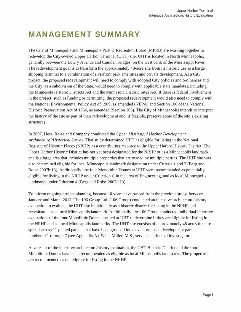
MANAGEMENT SUMMARY The City of Minneapolis and Minneapolis Park & Recreation Board (MPRB) are working together to redevelop the City-owned Upper Harbor Terminal (UHT) site. UHT is located in North Minneapolis, generally between the Lowry Avenue and Camden bridges, on the west bank of the Mississippi River. The redevelopment goal is to transform the approximately 48-acre site from its historic use as a barge shipping terminal to a combination of riverfront park amenities and private development. As a City project, the proposed redevelopment will need to comply with adopted City policies and ordinances and the City, as a subdivision of the State, would need to comply with applicable state mandates, including the Minnesota Historic Districts Act and the Minnesota Historic Sites Act. If there is federal involvement in the project, such as funding or permitting, the proposed redevelopment would also need to comply with the National Environmental Policy Act of 1969, as amended (NEPA) and Section 106 of the National Historic Preservation Act of 1966, as amended (Section 106). The City of Minneapolis intends to interpret the history of the site as part of their redevelopment and, if feasible, preserve some of the site’s existing structures. In 2007, Hess, Roise and Company conducted the Upper Mississippi Harbor Development Architectural/Historical Survey. That study determined UHT as eligible for listing in the National Register of Historic Places (NRHP) as a contributing resource to the Upper Harbor Historic District. The Upper Harbor Historic District has not yet been designated for the NRHP or as a Minneapolis landmark, and is a large area that includes multiple properties that are owned by multiple parties. The UHT site was also determined eligible for local Minneapolis landmark designation under Criteria 1 and 3 (Berg and Roise 2007b:13). Additionally, the four Monolithic Domes at UHT were recommended as potentially eligible for listing in the NRHP under Criterion C in the area of Engineering, and as local Minneapolis landmarks under Criterion 4 (Berg and Roise 2007a:13). To inform ongoing project planning, because 10 years have passed from the previous study, between January and March 2017, The 106 Group Ltd. (106 Group) conducted an intensive architecture/history evaluation to evaluate the UHT site individually as a historic district for listing in the NRHP and reevaluate it as a local Minneapolis landmark. Additionally, the 106 Group conducted individual intensive evaluations of the four Monolithic Domes located at UHT to determine if they are eligible for listing in the NRHP and as local Minneapolis landmarks. The UHT site consists of approximately 48 acres that are spread across 11 platted parcels that have been grouped into seven proposed development parcels; numbered 1 through 7 (see Appendix A). Saleh Miller, M.S., served as principal investigator. As a result of the intensive architecture/history evaluation, the UHT Historic District and the four Monolithic Domes have been recommended as eligible as local Minneapolis landmarks. The properties are recommended as not eligible for listing in the NRHP.
Upper Harbor Terminal Intensive Architecture/History Evaluation
Page ii
TABLE OF CONTENTS
1.0 Introduction ....................................................................................... 4
2.0 Methods ............................................................................................. 6
2.1 Objectives .................................................................................................................... 6 2.2 Background Research ................................................................................................. 6 2.3 Field Methods .............................................................................................................. 6 2.4 Inventory Forms ........................................................................................................... 6 2.5 Evaluation .................................................................................................................... 6
3.0 Literature Search ............................................................................... 8
3.1 Previously Listed and Determined Eligible Architecture/History Properties .................. 8
4.0 Historic Contexts ............................................................................... 9
4.1 Previously Developed Contexts ................................................................................... 9 4.2 Thematic Contexts ....................................................................................................... 9
4.2.1 City-Owned Industrial Developments in Minneapolis ...................................................... 9 4.2.2 Design and Construction of Monolithic Domes ............................................................. 13
5.0 Results ............................................................................................ 17
5.1 Upper Harbor Terminal Historic District (HE-MPC-9699) ........................................... 17 5.2 Four Monolithic Domes (HE-MPC-9263, HE-MPC-9264, HE-MPC-9265, HE-MPC-
9266) ....................................................................................................................... 53
6.0 Recommendations ........................................................................... 65
LIST OF FIGURES FIGURE 1. PROJECT LOCATION ................................................................................................................................. 5FIGURE 2. DAVID AND BARRY SOUTH’S MONOLITHIC DOME PATENT (SOUTH 2014) ...................................... 15FIGURE 3. MONOLITHIC DOME TYPICAL BULK STORAGE STRUCTURE CROSS SECTION (SOUTH 2011) ..... 16FIGURE 4. UPPER HARBOR TERMINAL HISTORIC DISTRICT ............................................................................... 20FIGURE 5. UHT PARCELS 1 AND 2 FROM ACROSS MISSISSIPPI RIVER, FACING NORTHWEST (CITY OF MINNEAPOLIS ET AL. 2016) ....................................................................................................................................... 21FIGURE 6. UHT PARCEL 2 FROM ACROSS WASHINGTON AVENUE, FACING SOUTHEAST .............................. 21FIGURE 7. UHT SITE FROM VICINITY OF 33RD AVENUE NORTH CIRCA 1985, FACING NORTHWEST (ON FILE AT UHT) ....................................................................................................................................................................... 22
Upper Harbor Terminal Intensive Architecture/History Evaluation
Page iii
FIGURE 8. UHT SITE FROM VICINITY OF 42ND AVENUE NORTH CIRCA 1985, FACING SOUTHEAST (ON FILE AT UHT) ....................................................................................................................................................................... 22FIGURE 9. OFFICE BUILDING (HE-MPC-9244), FACING NW ................................................................................... 23FIGURE 10. SCALE HOUSE (HE-MPC-9245) AND TRUCK SCALE (HE-MPC-9246), FACING EAST ...................... 26FIGURE 11. WAREHOUSE (HE-MPC-9254), SOUTH DOCK IN BACKGROUND (HE-MPC-9252), AND ABANDONED RAIL LINE, FACING SOUTH ............................................................................................................... 27FIGURE 12. CONVEYORS (HE-MPC-9257), FACING NORTHWEST ........................................................................ 28FIGURE 13. LOAD-OUT TOWER (HE-MPC-9256), FACING NORTH ........................................................................ 30FIGURE 14. GRAIN ELEVATOR (HE-MPC-9259), FACING NORTHWEST ............................................................... 31FIGURE 15. DUST COLLECTION TANK AND STORAGE TANK (HE-MPC-9262), FACING NORTHEAST .............. 32FIGURE 16. NORTH MOORING CELL (HE-MPC-9249) AND PETROLEUM DOCK (HE-MPC-9253), FACING SOUTHEAST ............................................................................................................................................................... 35FIGURE 17. LOAD-OUT SHELTER (HE-MPC-9268), FACING NORTHWEST .......................................................... 36FIGURE 18. MONOLITHIC DOMES ............................................................................................................................ 54FIGURE 19. MONOLITHIC DOME (HE-MPC-9263), FACING NORTHEAST ............................................................. 55FIGURE 20. INTERIOR OF MONOLITHIC DOME (HE-MPC-9263) (CITY OF MINNEAPOLIS) ................................. 55FIGURE 21. MONOLITHIC DOME (HE-MPC-9264), FACING NORTHWEST ............................................................ 56FIGURE 22. INTERIOR OF MONOLITHIC DOME (HE-MPC-9264) (CITY OF MINNEAPOLIS) ................................. 56FIGURE 23. MONOLITHIC DOME (HE-MPC-9265), FACING NORTHWEST ............................................................ 57FIGURE 24. MONOLITHIC DOMES (HE-MPC-9265), FACING SOUTHWEST .......................................................... 58FIGURE 25. MONOLITHIC DOME (HE-MPC-9266), FACING SOUTHWEST ............................................................. 58FIGURE 26. MONOLITHIC DOME (HE-MPC-9266), FACING NORTHEAST ............................................................. 59
LIST OF TABLES TABLE 1. UPPER HARBOR TERMINAL HISTORIC DISTRICT RESOURCES .......................................................... 18TABLE 2. UPPER HARBOR TERMINAL HISTORIC DISTRICT RECOMMENDATION .............................................. 50TABLE 3. MONOLITHIC DOMES ................................................................................................................................ 53 APPENDIX A: ALTA 2015 SURVEY APPENDIX B: PROJECT PERSONNEL
Upper Harbor Terminal Intensive Architecture/History Evaluation
Page 4
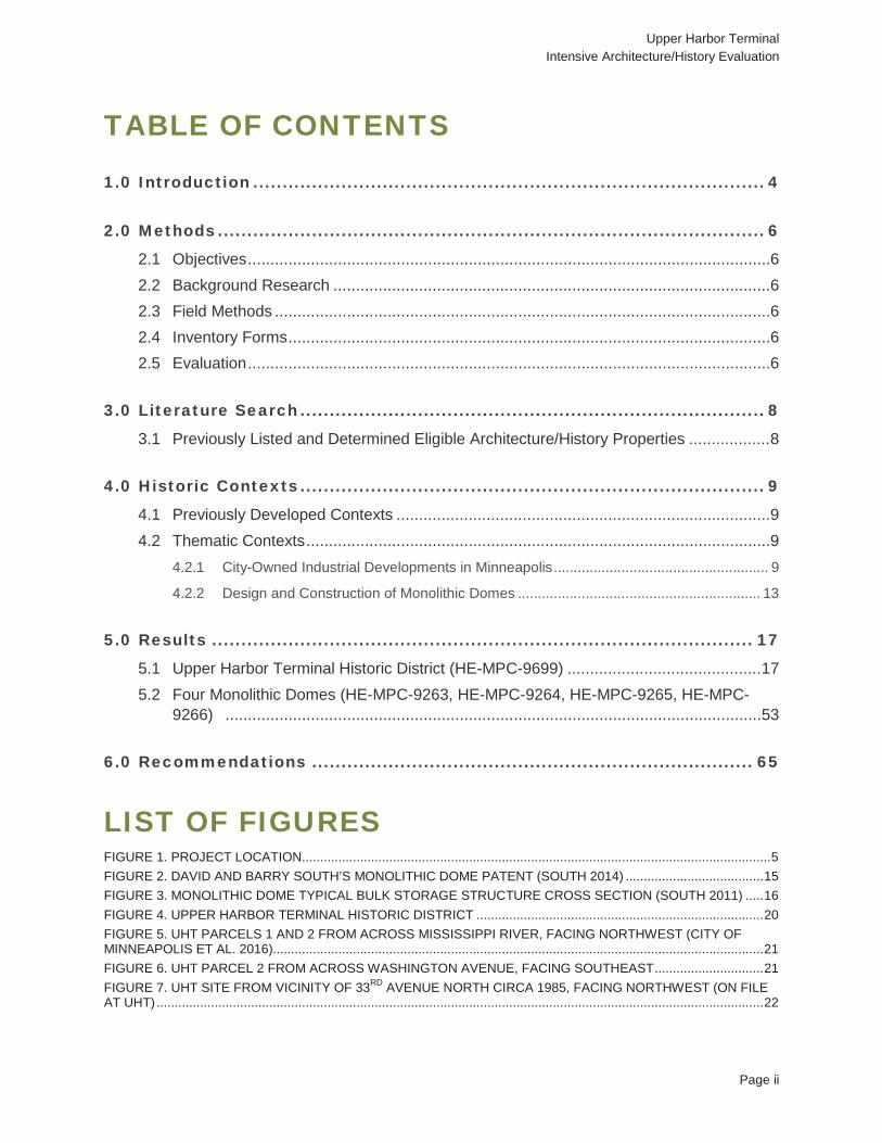
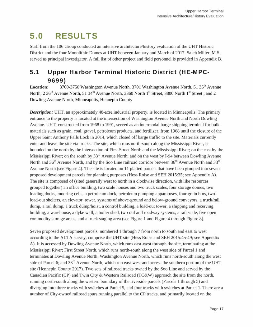
1.0 INTRODUCTION The City of Minneapolis and Minneapolis Park & Recreation Board (MPRB) are working together to redevelop the City-owned Upper Harbor Terminal (UHT) site. UHT is located in North Minneapolis, generally between the Lowry Avenue and Camden bridges, on the west bank of the Mississippi River (Figure 1). The redevelopment goal is to transform the approximately 48-acre site from its historic use as a barge shipping terminal to a combination of riverfront park amenities and private development. As a City project, the proposed redevelopment will need to comply with adopted City policies and ordinances and the City, as a subdivision of the State, would need to comply with applicable state mandates, including the Minnesota Historic Districts Act and the Minnesota Historic Sites Act. If there is federal involvement in the project, such as funding or permitting, the proposed redevelopment would also need to comply with the National Environmental Policy Act of 1969, as amended (NEPA) and Section 106 of the National Historic Preservation Act of 1966, as amended (Section 106). The City of Minneapolis intends to interpret the history of the site as part of their redevelopment and, if feasible, preserve some of the site’s existing structures. In 2007, Hess, Roise and Company conducted the Upper Mississippi Harbor Development Architectural/Historical Survey. That study determined UHT as eligible for listing in the National Register of Historic Places (NRHP) as a contributing resource to the Upper Harbor Historic District. The Upper Harbor Historic District has not yet been designated for the NRHP or as a Minneapolis landmark, and is a large area that includes multiple properties that are owned by multiple parties (see Section 3.1). The UHT site was also determined eligible for local Minneapolis landmark designation under Criteria 1 and 3 (Berg and Roise 2007b:13). Additionally, the four Monolithic Domes at UHT were recommended as potentially eligible for listing in the NRHP under Criterion C in the area of Engineering, and as local Minneapolis landmarks under Criterion 4 (Berg and Roise 2007a:13). To inform ongoing project planning, because 10 years have passed from the previous study, between January and March 2017, The 106 Group Ltd. (106 Group) conducted an intensive architecture/history evaluation to evaluate the UHT site individually as a historic district for listing in the NRHP and reevaluate it as a local Minneapolis landmark. Additionally, the 106 Group conducted individual intensive evaluations of the four Monolithic Domes located at UHT to determine if they are eligible for listing in the NRHP and as local Minneapolis landmarks. The UHT site consists of approximately 48 acres that are spread across 11 platted parcels that have been grouped into seven proposed development parcels; numbered 1 through 7 (see Appendix A). Saleh Miller, M.S., served as principal investigator.

29thA
veNE
N 3rd St
4th St N
30th A
ve NE
23rd A
ve NE
26th A
ve NE
NE31s
tAve
39th A
ve N
34th A
ve N
Edge Pl
41st Av
e N
NE 1st St
NE Grand St
36th A
ve N
29th A
ve N
30th A
ve N
31st Av
e N
35th A
ve N
Dowli
ng Av
e N
Colfax Ave N
Bryant Ave N
Aldrich Ave N
California St NE
6th St NWashington Ave N
1st St N
Saint Anthony Pkwy
40th A
ve N 37t
h Ave
N
33rd A
ve N
28th A
ve NE
NE Randolph St
Lyndale Ave N
Washington Ave N
2nd St N
NE Main St
NE Grand St
NE Columbia Ave
42nd
Ave N
27th
Ave N
E
NE Marshall St
22nd
Ave N
E
30th
Ave N
E
N Pacific St
41st
Ave N
Saint
Antho
ny P
kwy
31st
Ave N
Lowr
y Ave
NE
Dowl
ing Av
e N
Lowr
yAv
eN
§̈¦94
Project Location
Upper Harbor TerminalIntensive Architecture/HistoryEvaluationMinneapolis, Hennepin County, Minnesota
Map Produced by 106 Group 3/16/2017Source: 106 Group
0 150 Meters
0 400 Feet [1:8,000
Service Layer Credits: Sources: Esri, HERE, DeLorme, Intermap, increment P Corp., GEBCO, USGS, FAO, NPS, NRCAN, GeoBase, IGN, Kadaster NL, Ordnance Survey, Esri Japan, METI, Esri China (Hong Kong), swisstopo, MapmyIndia, ©OpenStreetMap contributors, and the GIS User Community
Project Location
Figure 1
Upper Harbor Terminal Intensive Architecture/History Evaluation
Page 6
2.0 METHODS 2.1 Objectives The primary objectives of the architecture/history investigation were to determine whether UHT as a historic district is eligible for listing in the NRHP and reevaluate it for eligibility as a local Minneapolis landmark; and determine if the four Monolithic Domes at UHT are individually eligible for listing in the NRHP or as local Minneapolis landmarks. All work was conducted in accordance with the Minnesota Historic Preservation Office’s (MnHPO) Guidelines for History/Architecture Projects in Minnesota, The Secretary of the Interior’s Standards and Guidelines for Archeology and Historic Preservation, and Chapter 599 of Title 23 of the Minneapolis Code of Ordinances (National Park Service [NPS] 1983; MnHPO 2010; City of Minneapolis 2016c).
2.2 Background Research Between January and February 2017, staff from the 106 Group reviewed previous documentation on UHT, including previous NRHP and local landmark evaluations, and historical plans and photographs provided by the City of Minneapolis and River Services, Inc. River Services, Inc. has been contracted by the City of Minneapolis to manage UHT since 1991. Background research was conducted at the MnHPO and Minneapolis Heritage Preservation Commission (HPC) to identify other applicable survey reports or historic contexts. Research was conducted at the City of Minneapolis Development Review in order to obtain historical building permits; the University of Minnesota in order to obtain historical aerial photographs, plat and atlas maps, and engineering information on the domes; the Minneapolis Central Library in order to obtain city publications and government records on the development and history of UHT; the Minnesota Historical Society to obtain historical documents, newspaper clippings, and photographs; and various online repositories.
2.3 Field Methods All buildings, structures, objects, and sites on UHT parcels 1, 2, and 6 were documented with field notes and digital photography. The ground piles and vacant land of parcels 3, 4, and 7 were also documented with digital photography. Field survey was not conducted directly on parcel 5 due to security fencing around the current lumber operations; however, the general area was documented from 33rd Avenue North (see Appendix A for listing of parcels).
2.4 Inventory Forms A Minnesota Architecture-History Inventory Form was completed for the UHT Historic District, and one for each of the four Monolithic Domes. These five inventory forms document the NRHP recommendations, as well as the local Minneapolis landmark recommendations.
2.5 Evaluation Upon completion of the fieldwork, the eligibility of the four Monolithic Domes and the UHT Historic District for listing in the NRHP was assessed based on the property’s significance and integrity. The NRHP criteria, summarized below, were used to help assess the significance of each property:
Upper Harbor Terminal Intensive Architecture/History Evaluation
Page 7
• Criterion A – association with the events that have made a significant contribution to the broad patterns of our history;
• Criterion B – association with the lives of persons significant in our past; • Criterion C – embodiment of the distinctive characteristics of a type, period, or method of
construction; representation of the work of a master; possession of high artistic values; or representation of a significant and distinguishable entity whose components may lack individual distinction; or
• Criterion D – potential to yield information important to prehistory or history (NPS 1997). The Minneapolis Heritage Preservation Ordinance defines a historic resource as “a property that is believed to have historical, cultural, architectural, archaeological or engineering significance and to meet at least one (1) of the criteria for designation as a landmark or historic district” (City of Minneapolis 2016c). The seven criteria for designation are:
1) The property is associated with significant events or with periods that exemplify broad patterns of cultural, political, economic or social history.
2) The property is associated with the lives of significant persons or groups. 3) The property contains or is associated with distinctive elements of city or neighborhood identity. 4) The property embodies the distinctive characteristics of an architectural or engineering type or
style, or method of construction. 5) The property exemplifies a landscape design or development pattern distinguished by innovation,
rarity, uniqueness or quality of design or detail. 6) The property exemplifies works of master builders, engineers, designers, artists, craftsmen or
architects. 7) The property has yielded, or may be likely to yield, information important in prehistory or history
(City of Minneapolis 2016c). The ordinance also defines historic districts as, “all property within a defined area designated as an historic district by the city council because of the historical, cultural, architectural, archaeological or engineering significance of the district, or designated as an historic district by state law” (City of Minneapolis 2016c). In addition to historic significance, integrity is a key factor in evaluating properties. The National Park Service and the Minneapolis Heritage Preservation Ordinance have identified seven aspects of integrity to be considered when evaluating the ability of a property to convey its significance: location, design, setting, materials, workmanship, feeling, and association. The integrity of each property was assessed in regard to these seven aspects. The properties were also assessed to determine if they represent a type of resource to be evaluated using the NRHP Criteria Considerations (NPS 1997:44; City of Minneapolis 2016c).

Upper Harbor Terminal Intensive Architecture/History Evaluation
Page 8
3.0 LITERATURE SEARCH 3.1 Previously Listed and Determined Eligible
Architecture/History Properties The project area is defined by the UHT property boundaries, and within it there are no NRHP-listed properties (see Figure 1). In 2007, Hess, Roise and Company conducted the Upper Mississippi Harbor Development Architectural/Historical Survey, which determined UHT as eligible for listing in the NRHP as a contributing resource to the Upper Harbor Historic District. The Upper Harbor Historic District has not been officially designated for the NRHP or as a Minneapolis landmark, but is eligible for listing in the NRHP under Criterion A within the areas of Commerce, Industry, Maritime History, and Transportation (Berg and Roise 2007b:13). The NRHP eligible Upper Harbor Historic District is roughly bound by properties on both sides of the Mississippi River from the Northern Pacific Railroad Bridge at the south extending approximately 1.5 miles north to the Soo Line Railway Bridge near the city limits, which includes multiple properties owned by multiple parties (Berg and Roise 2007a:3, 26, 44). The UHT site is also eligible for local Minneapolis landmark designation under Criteria 1 and 3 (Berg and Roise 2007b:13). Additionally, Hess, Roise and Company recommended the four Monolithic Domes at UHT as potentially eligible for listing in the NRHP under Criterion C in the area of Engineering, and as local Minneapolis landmarks under Criterion 4 (Berg and Roise 2007a).
Upper Harbor Terminal Intensive Architecture/History Evaluation
Page 9
4.0 HISTORIC CONTEXTS 4.1 Previously Developed Contexts UHT was evaluated within the established historic context Terminal Development in the Upper Harbor, which was prepared in 2007 by Hess, Roise and Company (Berg and Roise 2007a:15-21).
4.2 Thematic Contexts The following property-specific historic contexts were developed by 106 Group as part of this investigation in order to evaluate the architecture/history properties.
4.2.1 CITY-OWNED INDUSTRIAL DEVELOPMENTS IN MINNEAPOLIS Municipal enterprises “are businesses owned by local governments that provide services and typically generate revenue for local communities” (Community-Wealth.Org 2017). Examples of municipal enterprises commonly owned by American cities, including Minneapolis, are sanitation; water; transportation; schools and libraries; police, health, and fire departments; and streets and sidewalks. These are funded through taxes, fees, fines, and grants (Corporation for Enterprise Development 2011; National League of Cities 2016; City of Minneapolis 2017a). A 2004 study by the Minnesota Office of the State Auditor (OSA) organized municipal enterprises into three general categories: necessary enterprises, quality of life enterprises, and enterprises for profit (OSA 2004:1). Necessary enterprises are those that “provide an important public benefit regardless of the revenue they generate,” and include sewer, water, electric utilities, and hospitals (OSA 2004:1). The OSA recommends that “necessary enterprises should strive to break even with fees covering the cost of provision plus any maintenance and renewal and replacement costs” (OSA 2004:1). Quality of life enterprises contribute to the quality of life within the city, and “may or may not have a private sector equivalent available”; examples include recreational programming, community centers, and commercial ports (OSA 2004:1, 7). The OSA recommends that quality of life enterprises “should strive to break even but may need to be subsidized in order to operate” (OSA 2004:1). The third category of municipal enterprise is enterprises for profit, which are “those for which a private sector alternative either exists or reasonably could exist”; examples include marinas, parking, leases, and liquor stores (OSA 2004:1, 7). The OSA recommends that enterprises for profit “exist primarily to generate revenue to subsidize other city functions. If they fail to do so, they should not exist” (OSA 2004:1). The City of Minneapolis owns all three types of municipal enterprises. The most common in Minneapolis are the necessary enterprises, which are also the most common statewide, making up 78.1 percent of all enterprise funds in the 2004 OSA study (OSA 2004:1). Examples of quality of life enterprises owned by the City of Minneapolis include the Minneapolis Convention Center and the Target Center. UHT, as a commercial port, is also an example of a quality of life enterprise owned by the City, but City-owned quality of life enterprises of an industrial nature are less common in the City’s history than other types of quality of life enterprises. A 1999 study of the urban land market in Minneapolis found that relatively
Upper Harbor Terminal Intensive Architecture/History Evaluation
Page 10
little land has been available for industrial development in Minneapolis, particularly since the late 1940s, when “major rezoning ordinances ... converted industrial land to other uses” (Lukermann et al. 1991:35). Minneapolis has its early origins in the water-powered milling industry, which began with the first U.S. Government-owned mill at Saint Anthony Falls in the 1820s. The towns of Minneapolis and Saint Anthony rapidly developed around the burgeoning milling industry concentrated at the Falls Soon after the land on the east bank of the Falls was made available for private ownership in the 1840s and the land on the west bank was made available in the 1850s (Kane 1966:19, 32-33; Anfinson 1989:22-23). Minneapolis and Saint Anthony merged in 1872, further facilitating the harnessing of waterpower at the Falls. By the 1870s, the introduction of steam power freed sawmills from their dependence on falling water to power the machinery, which enabled lumber mills to move into the previously-residential areas north of downtown Minneapolis. The influx of railroads along the western bank further spurred the growth of industry between downtown Minneapolis and the northern part of the city. The northern portion of Minneapolis’ west bank filled in with sawmilling, scrap metal, railroading, and brickmaking industries from the 1880s to the 1920s, although some pockets of housing remained (Mead and Hunt 2011:11; Stark and Lauber 2009:16-18; Foote 1892; Egan 1903). During the 1930s to the 1950s, the vast majority of Minneapolis’ downtown mills were dismantled, and by the 1940s, much of the heavy industry along the northern portion of the west bank had closed as well. It was in 1948 that the City first introduced a rezoning ordinance to restrict industrial land use, followed by similar ordinances in 1962 and 1981 (Lukermann et al. 1991:35). This marked the beginning of the City’s ongoing effort to redevelop blighted former heavy industrial areas and rail land into light industrial uses (Ann Calvert, City of Minneapolis, Personal Communication, March 22, 2017). While a number of the industrial buildings in downtown Minneapolis were razed in the 1960s and 1970s to make way for new kinds of development such as housing, retail, and office spaces, a variety of light and general industrial businesses remained in the upper river corridor (defined here as the zone bounded by I-94 to the west, 42nd Avenue North to the north, the Mississippi River to the east, and Plymouth Avenue to the south) (Mill City Museum 2016; Anfinson 1989; BRW, Inc. 1999:3). At present, most of the upper river corridor remains zoned for light, medium, and general industrial use (City of Minneapolis 2014). In 2006, the City published an industrial land use study which recommended that “Minneapolis should pursue industrial redevelopment” to facilitate “higher job density, more living wage jobs for residents, enhanced economic growth, as well as the aesthetic transformation of blighted properties” by “reach[ing] out to growing targeted industrial business and guid[ing] these businesses to potential redevelopment sites”, which the City would then help redevelop through business assistance funds. This positions the City as a facilitator, rather than owner, of industrial business development, and is indicative of the City’s primary position regarding industrial businesses throughout Minneapolis’ history—a role growing, guiding, and assisting industrial development, rather than owning and operating industrial businesses (City of Minneapolis 2006:1). The City’s 2009 Minneapolis Plan for Sustainable Growth identifies specific areas for industrial growth and expansion, as well as future uses for some current industrial areas, such as portions of the upper river, which will be transitioned to parks and open space (City of Minneapolis 2009:1-39). These plans reflect the City’s desire to “develop and maintain a land use pattern
Upper Harbor Terminal Intensive Architecture/History Evaluation
Page 11
that strengthens the vitality, quality and urban character of its downtown core, commercial corridors, industrial areas, and neighborhoods while protecting natural systems and developing a sustainable pattern for future growth” (City of Minneapolis 2009:1-1). While the City has long demonstrated a commitment to facilitating industrial growth within a broader economic context, there have only been a few City-owned industrial enterprises in Minneapolis’ history, and they have been focused along the Minneapolis riverfront. These include not only UHT and its predecessor, the Washington Avenue Terminal constructed in 1927, but also a City-owned brickyard, which opened near 50th Avenue North along the Mississippi River in 1904, and employed inmates from the City workhouse (Stark and Lauber 2009:18; Hines 2015). The City-owned brickyard, was located directly adjacent to, and associated with, the Minneapolis workhouse, also known as the Camden Station. The workhouse property was bounded by 49th Avenue North on the south, Dupont Avenue on the west, 51st Avenue North on the north, and Lyndale Avenue on the east. The City-owned brickyard property was roughly bounded by 50th Avenue North on the south, Lyndale Avenue North on the west, 51st Avenue North on the north, and the Mississippi River on the east (Foote 1892; Benneche 1914). The City opened the workhouse in 1886 to house individuals convicted of misdemeanors (Citizens League 1965:4). In 1904, Frank McDonald, the superintendent of the workhouse, discovered a clay deposit on the workhouse grounds, and, in search of a way to provide work for the inmates, established a brickyard adjacent to the workhouse along the Mississippi River at which the male inmates were employed (Hudson 1908:509). In 1910, 2.4 million bricks were manufactured, and the majority were sold to paying customers, with the remainder being used for City construction projects (City of Minneapolis 1910:11). The following year, the Minneapolis Morning Tribune reported “City Workhouse Pays Big Profit in 1910” (Minneapolis Morning Tribune 1911). In 1930 male inmates were relocated to the Parkers Lake Workhouse in Plymouth, Minnesota, and in 1953, female inmates were transferred to the Women’s Detention Home at the Parkers Lake Workhouse. Although documentation regarding the date of closure for the brickyard was not located during research, it likely closed by the time that the male inmates who staffed it were relocated in 1930, if not before. The land on which the original workhouse stood was converted to agricultural use (Citizens League 1965:4). Although City-owned industrial businesses have been rare during the City’s history, the City was highly motivated to develop and support municipal barge terminals during the twentieth century to provide competition for the railroads, which were otherwise able to charge prohibitively high rates that could hinder Minneapolis’ economic development (Anfinson 2003:110). In 1927, the City of Minneapolis took a decisive step to draw river traffic to its shores when it began construction of a municipal barge terminal near the Washington Avenue bridge, evicting the residents of Bohemian Flats to make way for the development (Hines 2015). The City had been trying for decades to convince the U.S. Congress to extend the navigable channel of the Mississippi River to Minneapolis’ shores, and with the authorization of a six-foot channel from Cairo, Illinois, to Minneapolis in 1907 and the opening of Lock and Dam No. 1 in 1917 between Minneapolis and Saint Paul, barge traffic was finally able to reach Minneapolis - it only needed adequate barge terminal facilities at which to dock (USACE 1996:2-3).
Upper Harbor Terminal Intensive Architecture/History Evaluation
Page 12
The municipal barge terminal, known as the Washington Avenue Terminal, boasted a coal dock; 26,640-square foot warehouse; oil storage facilities; and railroad trackage (MIDC 1979:3) At the same time that Minneapolis’ Washington Avenue Terminal was being constructed, influential politicians and businessmen of the city were redoubling their efforts to make Minneapolis the head of navigation. Minnesota Senator Henrik Shipstead led the push for a nine-foot navigation channel, arguing that “waterway improvements were needed to fulfill the economic potential of the Midwest” (Berg and Roise 2007a:8). In 1930, an amendment to the Rivers and Harbors Act of 1930 including a nine-foot channel from St. Louis to Minneapolis finally passed, and the U.S. Army Corps of Engineers (USACE) made plans for 26 locks and dams, in addition to Lock and Dam No. 1, completed in 1917 in Saint Paul, and Lock and Dam No. 2, completed in 1930 in Hastings, Minnesota (NPS 2016a; NPS 2016b; MIDC 1979:1; Berg and Roise 2007a:8). Within 10 years of its construction, the Washington Avenue Terminal was found to be inadequate, suffering from frequent floods and lack of space in which to expand, and its operations were gradually transferred to UHT during the 1970s (MIDC 1979). The City contracted with private companies for the management of both Washington Avenue Terminal and UHT throughout the duration of these businesses, in contrast to the City-owned brickyard, which was managed by city employees (MIDC 1979; City of Minneapolis 1994). And while the City brickyard seemed to be profitable, at least during its first decade, neither the Washington Avenue Terminal nor UHT succeeded in consistently generating revenue for the City (City of Minneapolis 1910; MIDC 1979). Minneapolis has subsidized UHT throughout much of UHT’s existence, with the recognition that, in addition to providing competition for the railroads and thereby helping to keep railroad rates from becoming inflated, UHT also provided indirect benefits to Minneapolis (BRW, Inc., et al. 1999; Dollhausen 1997; City of Minneapolis 1994). These indirect benefits included employment at the site and improved logistics for Minneapolis Public Works, which stored their salt, dredged sand, and sewer pipe on the site. In addition, UHT consistently provided the majority of the one million-ton tonnage minimum required by USACE for the operation of the Upper Saint Anthony Falls Lock (Upper Lock), from which other businesses and recreational boaters also benefitted (City of Minneapolis 1994:ii). The subsidization of UHT has been consistent with the OSA’s 2004 finding that quality of life enterprises such as commercial ports “should strive to break even but may need to be subsidized in order to operate” (OSA 2004:1). However, external factors have resulted in diminishing indirect benefits from the continued operation of UHT. For example, with the closure of the Upper Lock in 2015, access to the upper harbor for rivercraft has ceased, as has the obtainment of sand from the dredging of the upper harbor. In addition, although facilitating river traffic into the upper harbor was deemed an important priority for Minneapolis during the 1950s and early 1960s, the authorization of the federal Interstate Highway System in 1956 and its subsequent construction provided substantial competition to both rail and river transportation. The development of the Interstate Highway System provided precipitated railroad bankruptcies and service abandonments across the country (Association of American Railroads 2016). Interstate 94 (I-94), which was constructed in Minnesota during the 1960s and forms the western boundary of the UHT site, exits onto Dowling Avenue North, which is the primary roadway access to the UHT site. The construction of I-94 directly adjacent to UHT provided the site with direct access to other
Upper Harbor Terminal Intensive Architecture/History Evaluation
Page 13
parts of the city, state, and region, incentivizing the use of trucks to transport materials into and out of the site. Although UHT continued to receive railroad service into the early 2000s, it was eventually determined that barge and truck transport were more economical, and service was ended to UHT in 2003 (Personal Communication, Jerry Christensen, UHT Site Manager, January 18, 2017). While the City of Minneapolis has a wide range of revenue streams, City-owned quality of life enterprises of an industrial nature have not been common in the City’s history, nor have they proven to be a reliable source of income over time. The City-owned brickyard was relatively short-lived, and the Washington Avenue Terminal – deemed inadequate only 10 years after its construction in 1927 – was phased out by the late 1970s and replaced by UHT. In January 2017, the City of Minneapolis selected a master developer team for the UHT site in preparation for the closing of UHT operations and a new vision for the property, a half-century after construction first began at the site (City of Minneapolis 2017b).
4.2.2 DESIGN AND CONSTRUCTION OF MONOLITHIC DOMES The use of domes in architecture goes back thousands of years, to round huts and tombs in the ancient Middle East, India, and the Mediterranean. The Romans perfected large-scale masonry construction and evolved the masonry dome from the arch, most famously in 120-124 A.D. when the Pantheon in Rome was constructed. Domes have been famously used in architecture throughout the world and can be best be exemplified in Brunelleschi’s dome on the Basilica de Santa Maria del Fiore in Florence, Italy; the Dome of the Rock in Jerusalem; the Hagia Sophia in Istanbul, Turkey; the Taj Mahal in Agra, India; and the United States Capital (Ching 1996). There are many types of domes used in architecture, including those that date back to Paleolithic times like the corbel dome, and those that were common during the Roman and Byzantine eras such as the cloister vault, crossed-arch dome, ribbed dome, and hemispherical dome. While these types of domes are commonly used in religious, government, and social buildings, domes can also serve a more utilitarian function, such as those that were designed during the twentieth century which include the geodesic and monolithic domes. Geodesic domes are sphere-like structures that are built of a network of triangles which provide a self-balancing structural framework. Geodesic domes were developed by American engineer and architect R. Buckminster Fuller in the late 1940s (Buckminster Fuller Institute 2017). Two of his most prominent structures are listed in the NRHP for their significance within the areas of Invention and Architecture: the R. Buckminster Fuller and Anne Hewlett Dome Home in Carbondale, Illinois, and the ASM Headquarters and Geodesic Dome in Materials Park, Ohio (NPS 2017). Monolithic domes are a type of monolithic architecture, which means they are carved, cast, or excavated from a single piece of material, such as an igloo or cave dwelling. Modern monolithic dome structures began to be built in the mid-twentieth century. Reportedly the first one was the Winter Garden Ice Rink, later named Ream’s Turtle, which was built in Provo, Utah, in 1963. Ream’s Turtle was a triaxial elliptical dome that was built by first creating a mound of dirt in the desired shape of the shell, 240 feet
Upper Harbor Terminal Intensive Architecture/History Evaluation
Page 14
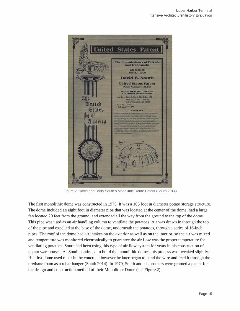
long by160 feet wide by 40 feet high. The mound was then covered in a grid of rebar, to provide strength, and a layer of concrete approximately 4 inches thick. After the concrete was cured, the dirt was excavated through the doorways, leaving the roof standing in its place. The floor was then poured to finish the structure. This local engineering landmark was demolished in 2006 (Parker 2009). Today, monolithic domes are used in a variety of residential, commercial, and industrial projects. Because of the strength, durability and economics, they are used to store large amounts of various commodities in the cement, fertilizer, agricultural, power and mining industries. However, current construction methods differ significantly from the concrete over dirt method employed by Ream’s Turtle. Since the mid-1970s through today, they follow a process that was developed in Idaho by David B. South and his brothers Barry and Randy (Parker 2009; Architecture Week 2001). David B. South invented the design for the modern day monolithic dome. He was inspired by a speech he heard in 1956 by R. Buckminster Fuller on the benefits of dome construction. South studied engineering and business in college, but in order to support his family put his hobby of calculating the designs for domes on the back burner. By 1970, he was managing the Chicago Northwestern Railroad computer center in Chicago when he decided to move back home to Idaho to be closer to family. However, before leaving Chicago he attended a seminar on casting polyurethane foam, and knew that this process would be key in insulating his dome designs. After his move to Idaho he began looking into the uses of polyurethane foam more, found some equipment, and founded a concrete company that would finance an insulation loan if the polyurethane foam worked on concrete buildings, which it did. It turned out the need for polyurethane foam was very high in Idaho, especially for use in potato storage. Typical potato storage facilities collect moisture on the inside, and the insulation would eventually become saturated, however polyurethane foam was waterproof and therefore did not have a similar problem. Less than a year later South started his own urethane foam company (South 2014). While South was focused on his urethane foam business, he still had a personal interest in domes. In 1972 he built a geodesic dome storage shed in his backyard in Taylor, Idaho. Geodesic domes are constructed by cutting lumber and forming it into the shape of a dome, which requires a lot of materials and makes the geodesic domes very susceptible to leaks. This led South to become disillusioned with geodesic domes altogether and he again focused his energy on his urethane foam business (South 2014). In 1975, he figured out that his polyurethane domes, particularly those used for potato storage, could be fireproofed if the foam was sprayed with a layer of stucco or plaster about a half inch thick. Then he began experimenting with spraying the polyurethane with concrete. South had read about someone building a house by inflating a large plastic balloon and then spraying the inside with polyurethane foam. He thought he could use the same process but then also spray it with concrete. This began his testing to design a completely different type of potato storage structure. South worked with his brothers, Barry and Randy South, and hired a local engineer to design a 105 foot in diameter by 35 foot in height dome for potato storage. The structure was formed by inflating a large fabric membrane, spraying the inside with three inches of polyurethane form followed by three inches of reinforced concrete. The design met all of South’s expectations and he began to plan for manufacturing the new structures (South 2014).
Upper Harbor Terminal Intensive Architecture/History Evaluation
Page 15
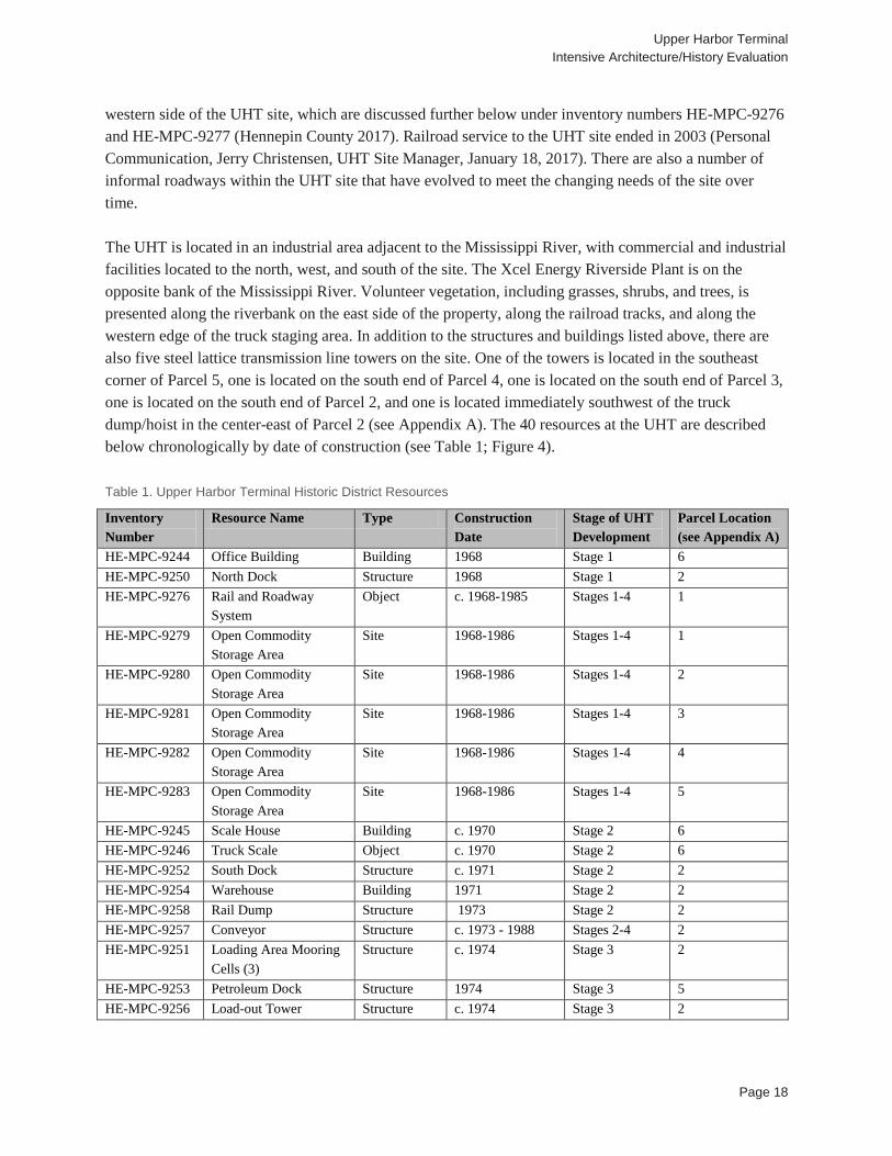
Figure 2. David and Barry South’s Monolithic Dome Patent (South 2014)
The first monolithic dome was constructed in 1975. It was a 105 foot in diameter potato storage structure. The dome included an eight foot in diameter pipe that was located at the center of the dome, had a large fan located 20 feet from the ground, and extended all the way from the ground to the top of the dome. This pipe was used as an air handling column to ventilate the potatoes. Air was drawn in through the top of the pipe and expelled at the base of the dome, underneath the potatoes, through a series of 16-inch pipes. The roof of the dome had air intakes on the exterior as well as on the interior, so the air was mixed and temperature was monitored electronically to guarantee the air flow was the proper temperature for ventilating potatoes. South had been using this type of air flow system for years in his construction of potato warehouses. As South continued to build the monolithic domes, his process was tweaked slightly. His first dome used rebar in the concrete; however he later began to bend the wire and feed it through the urethane foam as a rebar hanger (South 2014). In 1979, South and his brothers were granted a patent for the design and construction method of their Monolithic Dome (see Figure 2).
Upper Harbor Terminal Intensive Architecture/History Evaluation
Page 16
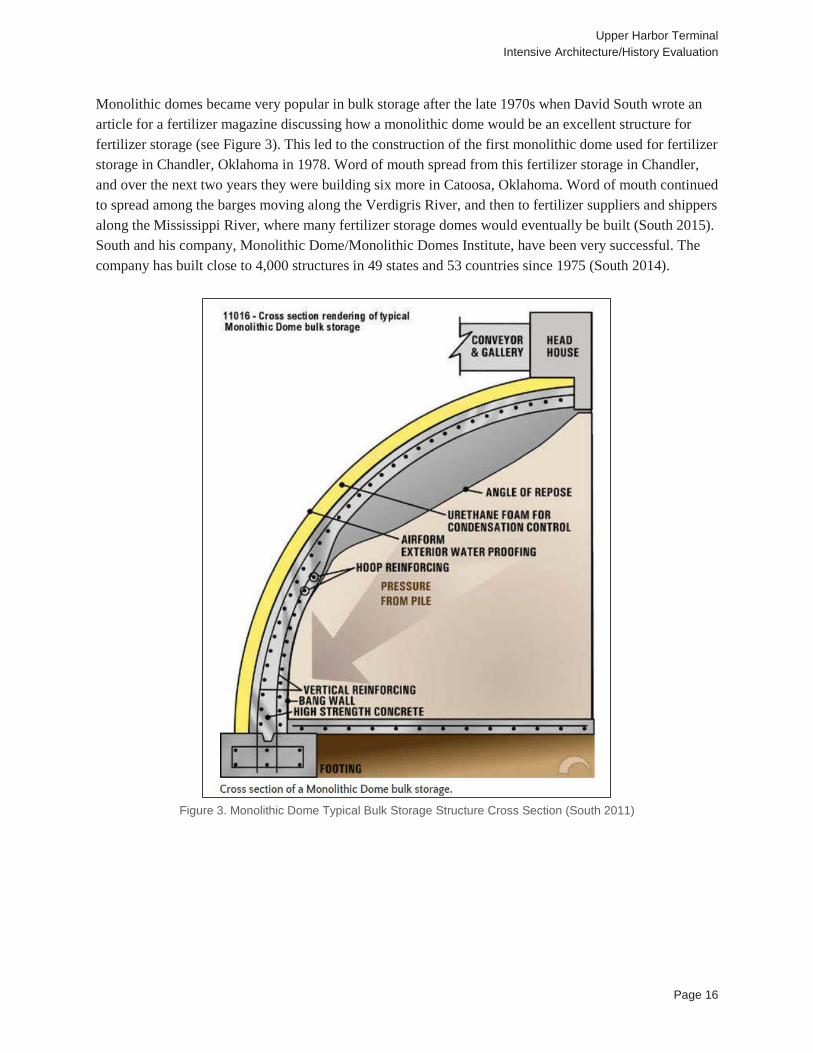
Monolithic domes became very popular in bulk storage after the late 1970s when David South wrote an article for a fertilizer magazine discussing how a monolithic dome would be an excellent structure for fertilizer storage (see Figure 3). This led to the construction of the first monolithic dome used for fertilizer storage in Chandler, Oklahoma in 1978. Word of mouth spread from this fertilizer storage in Chandler, and over the next two years they were building six more in Catoosa, Oklahoma. Word of mouth continued to spread among the barges moving along the Verdigris River, and then to fertilizer suppliers and shippers along the Mississippi River, where many fertilizer storage domes would eventually be built (South 2015). South and his company, Monolithic Dome/Monolithic Domes Institute, have been very successful. The company has built close to 4,000 structures in 49 states and 53 countries since 1975 (South 2014).
Figure 3. Monolithic Dome Typical Bulk Storage Structure Cross Section (South 2011)
Upper Harbor Terminal Intensive Architecture/History Evaluation
Page 17
5.0 RESULTS Staff from the 106 Group conducted an intensive architecture/history evaluation of the UHT Historic District and the four Monolithic Domes at UHT between January and March of 2017. Saleh Miller, M.S. served as principal investigator. A full list of other project and field personnel is provided in Appendix B.
5.1 Upper Harbor Terminal Historic District (HE-MPC-9699)
Location: 3700-3750 Washington Avenue North, 3701 Washington Avenue North, 51 36th Avenue North, 2 36th Avenue North, 51 34th Avenue North, 3360 North 1st Street, 3800 North 1st Street , and 2 Dowling Avenue North, Minneapolis, Hennepin County Description: UHT, an approximately 48-acre industrial property, is located in Minneapolis. The primary entrance to the property is located at the intersection of Washington Avenue North and North Dowling Avenue. UHT, constructed from 1968 to 1991, served as an intermodal barge shipping terminal for bulk materials such as grain, coal, gravel, petroleum products, and fertilizer, from 1968 until the closure of the Upper Saint Anthony Falls Lock in 2014, which closed off barge traffic to the site. Materials currently enter and leave the site via trucks. The site, which runs north-south along the Mississippi River, is bounded on the north by the intersection of First Street North and the Mississippi River; on the east by the Mississippi River; on the south by 33rd Avenue North; and on the west by I-94 between Dowling Avenue North and 36th Avenue North, and by the Soo Line railroad corridor between 36th Avenue North and 33rd Avenue North (see Figure 4). The site is located on 11 platted parcels that have been grouped into seven proposed development parcels for planning purposes (Hess Roise and SEH 2015:35; see Appendix A). The site is composed of (sited generally west to north in a clockwise direction, with like resources grouped together) an office building, two scale houses and two truck scales, four storage domes, two loading docks, mooring cells, a petroleum dock, petroleum pumping apparatuses, four grain bins, two load-out shelters, an elevator tower, systems of above-ground and below-ground conveyors, a truck/rail dump, a rail dump, a truck dump/hoist, a control building, a load-out tower, a shipping and receiving building, a warehouse, a dyke wall, a boiler shed, two rail and roadway systems, a rail scale, five open commodity storage areas, and a truck staging area (see Figure 1 and Figure 4 through Figure 8). Seven proposed development parcels, numbered 1 through 7 from north to south and east to west according to the ALTA survey, comprise the UHT site (Hess Roise and SEH 2015:45-49; see Appendix A). It is accessed by Dowling Avenue North, which runs east-west through the site, terminating at the Mississippi River; First Street North, which runs north-south along the west side of Parcel 1 and terminates at Dowling Avenue North; Washington Avenue North, which runs north-south along the west side of Parcel 6; and 33rd Avenue North, which run east-west and access the southern portion of the UHT site (Hennepin County 2017). Two sets of railroad tracks owned by the Soo Line and served by the Canadian Pacific (CP) and Twin City & Western Railroad (TC&W) approach the site from the north, running north-south along the western boundary of the riverside parcels (Parcels 1 through 5) and diverging into three tracks with switches at Parcel 5, and four tracks with switches at Parcel 1. There are a number of City-owned railroad spurs running parallel to the CP tracks, and primarily located on the
Upper Harbor Terminal Intensive Architecture/History Evaluation
Page 18
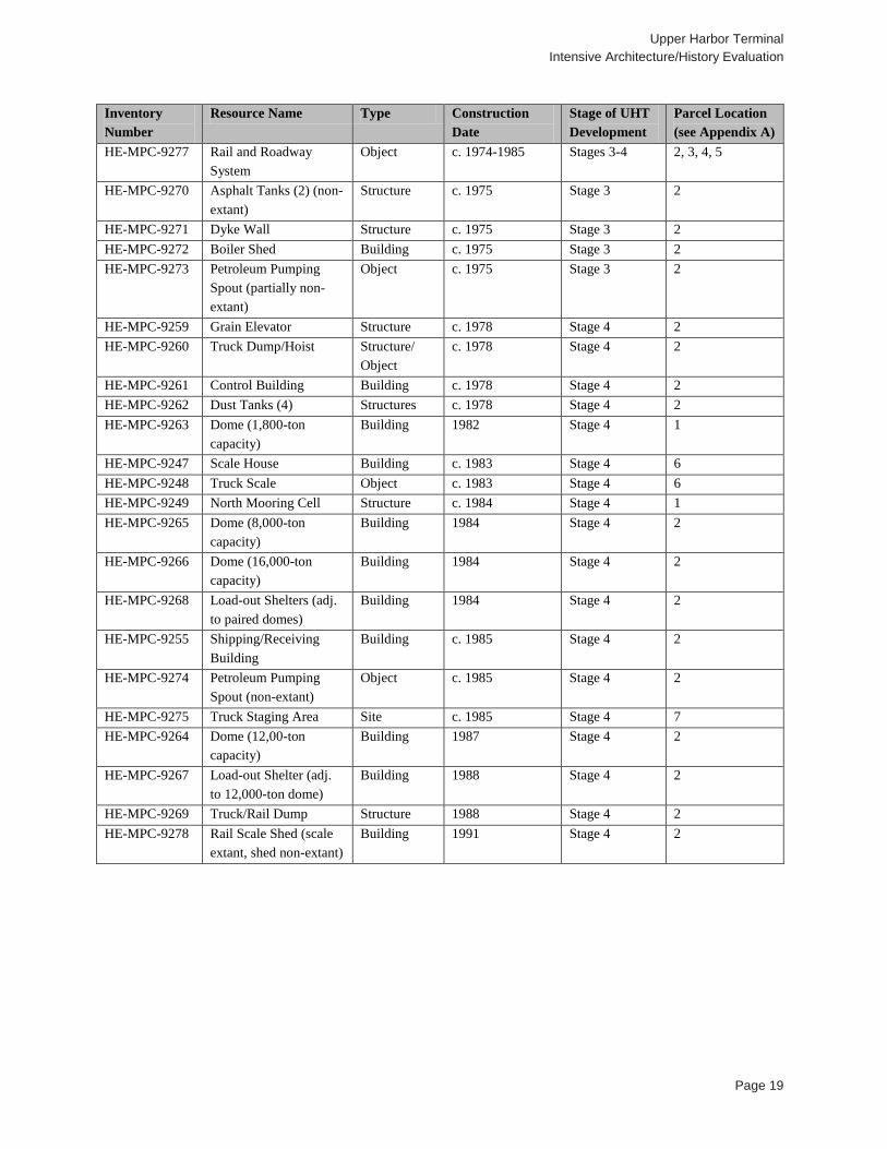
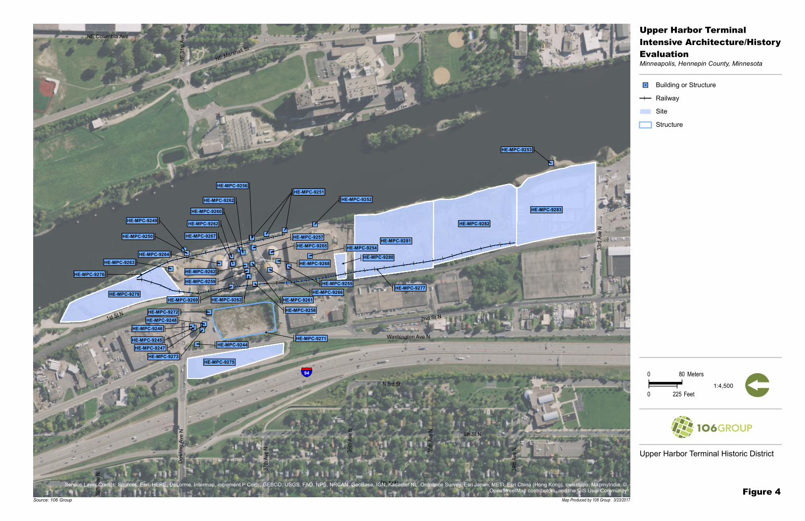
western side of the UHT site, which are discussed further below under inventory numbers HE-MPC-9276 and HE-MPC-9277 (Hennepin County 2017). Railroad service to the UHT site ended in 2003 (Personal Communication, Jerry Christensen, UHT Site Manager, January 18, 2017). There are also a number of informal roadways within the UHT site that have evolved to meet the changing needs of the site over time. The UHT is located in an industrial area adjacent to the Mississippi River, with commercial and industrial facilities located to the north, west, and south of the site. The Xcel Energy Riverside Plant is on the opposite bank of the Mississippi River. Volunteer vegetation, including grasses, shrubs, and trees, is presented along the riverbank on the east side of the property, along the railroad tracks, and along the western edge of the truck staging area. In addition to the structures and buildings listed above, there are also five steel lattice transmission line towers on the site. One of the towers is located in the southeast corner of Parcel 5, one is located on the south end of Parcel 4, one is located on the south end of Parcel 3, one is located on the south end of Parcel 2, and one is located immediately southwest of the truck dump/hoist in the center-east of Parcel 2 (see Appendix A). The 40 resources at the UHT are described below chronologically by date of construction (see Table 1; Figure 4).
Table 1. Upper Harbor Terminal Historic District Resources
Inventory Number
Resource Name Type Construction Date
Stage of UHT Development
Parcel Location (see Appendix A)
HE-MPC-9244 Office Building Building 1968 Stage 1 6 HE-MPC-9250 North Dock Structure 1968 Stage 1 2 HE-MPC-9276 Rail and Roadway
System Object c. 1968-1985 Stages 1-4 1
HE-MPC-9279 Open Commodity Storage Area
Site 1968-1986 Stages 1-4 1
HE-MPC-9280 Open Commodity Storage Area
Site 1968-1986 Stages 1-4 2
HE-MPC-9281 Open Commodity Storage Area
Site 1968-1986 Stages 1-4 3
HE-MPC-9282 Open Commodity Storage Area
Site 1968-1986 Stages 1-4 4
HE-MPC-9283 Open Commodity Storage Area
Site 1968-1986 Stages 1-4 5
HE-MPC-9245 Scale House Building c. 1970 Stage 2 6 HE-MPC-9246 Truck Scale Object c. 1970 Stage 2 6 HE-MPC-9252 South Dock Structure c. 1971 Stage 2 2 HE-MPC-9254 Warehouse Building 1971 Stage 2 2 HE-MPC-9258 Rail Dump Structure 1973 Stage 2 2 HE-MPC-9257 Conveyor Structure c. 1973 - 1988 Stages 2-4 2 HE-MPC-9251 Loading Area Mooring
Cells (3) Structure c. 1974 Stage 3 2
HE-MPC-9253 Petroleum Dock Structure 1974 Stage 3 5 HE-MPC-9256 Load-out Tower Structure c. 1974 Stage 3 2
Upper Harbor Terminal Intensive Architecture/History Evaluation
Page 19
Inventory Number
Resource Name Type Construction Date
Stage of UHT Development
Parcel Location (see Appendix A)
HE-MPC-9277 Rail and Roadway System
Object c. 1974-1985 Stages 3-4 2, 3, 4, 5
HE-MPC-9270 Asphalt Tanks (2) (non-extant)
Structure c. 1975 Stage 3 2
HE-MPC-9271 Dyke Wall Structure c. 1975 Stage 3 2 HE-MPC-9272 Boiler Shed Building c. 1975 Stage 3 2 HE-MPC-9273 Petroleum Pumping
Spout (partially non-extant)
Object c. 1975 Stage 3 2
HE-MPC-9259 Grain Elevator Structure c. 1978 Stage 4 2 HE-MPC-9260 Truck Dump/Hoist Structure/
Object c. 1978 Stage 4 2
HE-MPC-9261 Control Building Building c. 1978 Stage 4 2 HE-MPC-9262 Dust Tanks (4) Structures c. 1978 Stage 4 2 HE-MPC-9263 Dome (1,800-ton
capacity) Building 1982 Stage 4 1
HE-MPC-9247 Scale House Building c. 1983 Stage 4 6 HE-MPC-9248 Truck Scale Object c. 1983 Stage 4 6 HE-MPC-9249 North Mooring Cell Structure c. 1984 Stage 4 1 HE-MPC-9265 Dome (8,000-ton
capacity) Building 1984 Stage 4 2
HE-MPC-9266 Dome (16,000-ton capacity)
Building 1984 Stage 4 2
HE-MPC-9268 Load-out Shelters (adj. to paired domes)
Building 1984 Stage 4 2
HE-MPC-9255 Shipping/Receiving Building
Building c. 1985 Stage 4 2
HE-MPC-9274 Petroleum Pumping Spout (non-extant)
Object c. 1985 Stage 4 2
HE-MPC-9275 Truck Staging Area Site c. 1985 Stage 4 7 HE-MPC-9264 Dome (12,00-ton
capacity) Building 1987 Stage 4 2
HE-MPC-9267 Load-out Shelter (adj. to 12,000-ton dome)
Building 1988 Stage 4 2
HE-MPC-9269 Truck/Rail Dump Structure 1988 Stage 4 2 HE-MPC-9278 Rail Scale Shed (scale
extant, shed non-extant) Building 1991 Stage 4 2
HE-MPC-9244HE-MPC-9245
HE-MPC-9246
HE-MPC-9247
HE-MPC-9248
HE-MPC-9249
HE-MPC-9250
HE-MPC-9251HE-MPC-9251HE-MPC-9251HE-MPC-9252
HE-MPC-9253
HE-MPC-9254
HE-MPC-9255
HE-MPC-9256
HE-MPC-9257
HE-MPC-9258
HE-MPC-9259
HE-MPC-9260
HE-MPC-9261HE-MPC-9262
HE-MPC-9262
HE-MPC-9262
HE-MPC-9262
HE-MPC-9263HE-MPC-9264
HE-MPC-9265
HE-MPC-9266
HE-MPC-9267
HE-MPC-9268
HE-MPC-9269
HE-MPC-9272
HE-MPC-9273
HE-MPC-9276
HE-MPC-9277
HE-MPC-9275
HE-MPC-9279
HE-MPC-9282
HE-MPC-9281
HE-MPC-9283
HE-MPC-9280
HE-MPC-9271
39th A
ve N 37t
h Ave
N 35th A
ve N
34th A
ve N36 t
h Ave
N 4th St N
6th St N
N 3rd St
33rd A
ve N
1st St N
NE 31
st Ave
Dowl
ingA v
e N
NE Columbia Ave
2nd St N
NE Marshall St
Washington Ave N
§̈¦94
""! Building or StructureRailwaySiteStructure
Upper Harbor TerminalIntensive Architecture/HistoryEvaluationMinneapolis, Hennepin County, Minnesota
Map Produced by 106 Group 3/23/2017Source: 106 Group
0 80 Meters
0 225 Feet [1:4,500
Service Layer Credits: Sources: Esri, HERE, DeLorme, Intermap, increment P Corp., GEBCO, USGS, FAO, NPS, NRCAN, GeoBase, IGN, Kadaster NL, Ordnance Survey, Esri Japan, METI, Esri China (Hong Kong), swisstopo, MapmyIndia, ©OpenStreetMap contributors, and the GIS User Community
Upper Harbor Terminal Historic District
Figure 4
Upper Harbor Terminal Intensive Architecture/History Evaluation
Page 21
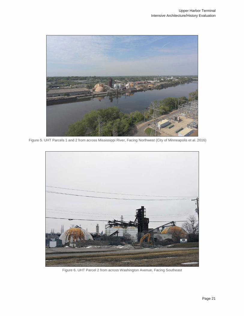
Figure 5. UHT Parcels 1 and 2 from across Mississippi River, Facing Northwest (City of Minneapolis et al. 2016)
Figure 6. UHT Parcel 2 from across Washington Avenue, Facing Southeast
Upper Harbor Terminal Intensive Architecture/History Evaluation
Page 22
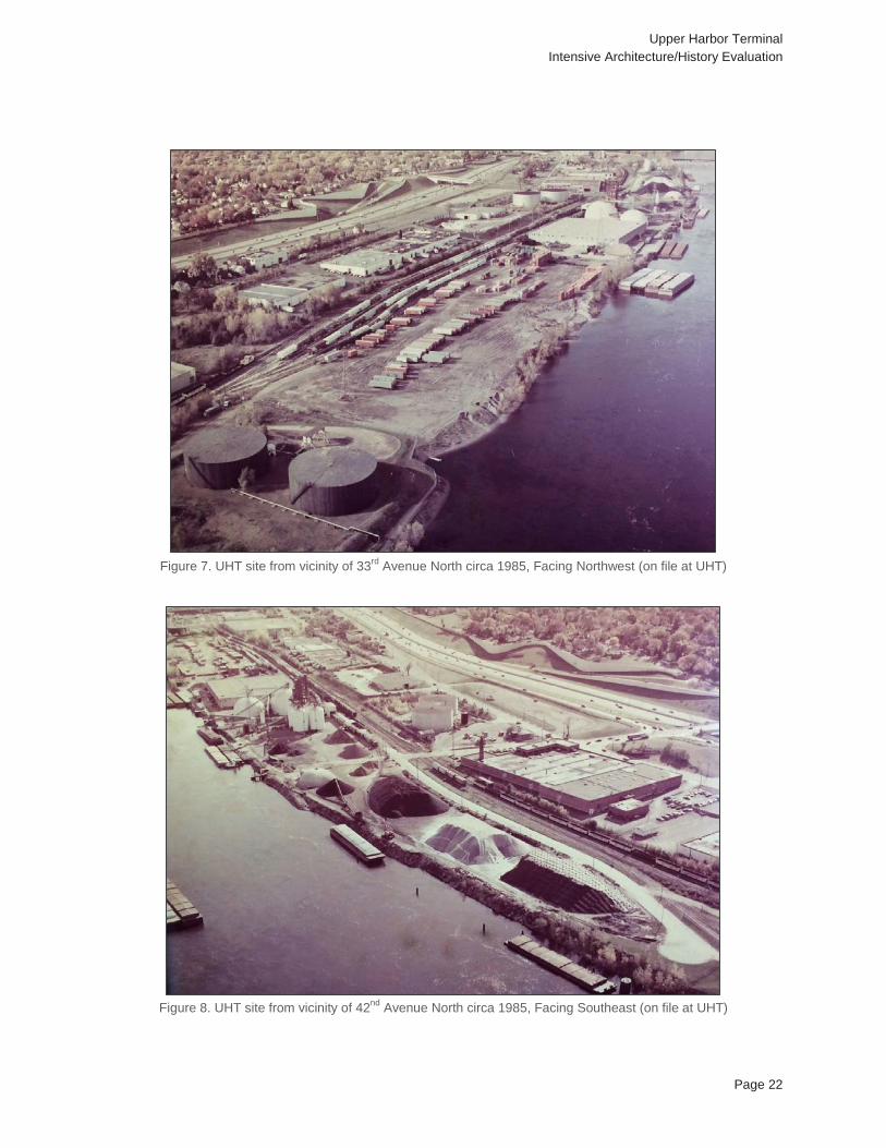
Figure 7. UHT site from vicinity of 33rd Avenue North circa 1985, Facing Northwest (on file at UHT)
Figure 8. UHT site from vicinity of 42nd Avenue North circa 1985, Facing Southeast (on file at UHT)
Upper Harbor Terminal Intensive Architecture/History Evaluation
Page 23
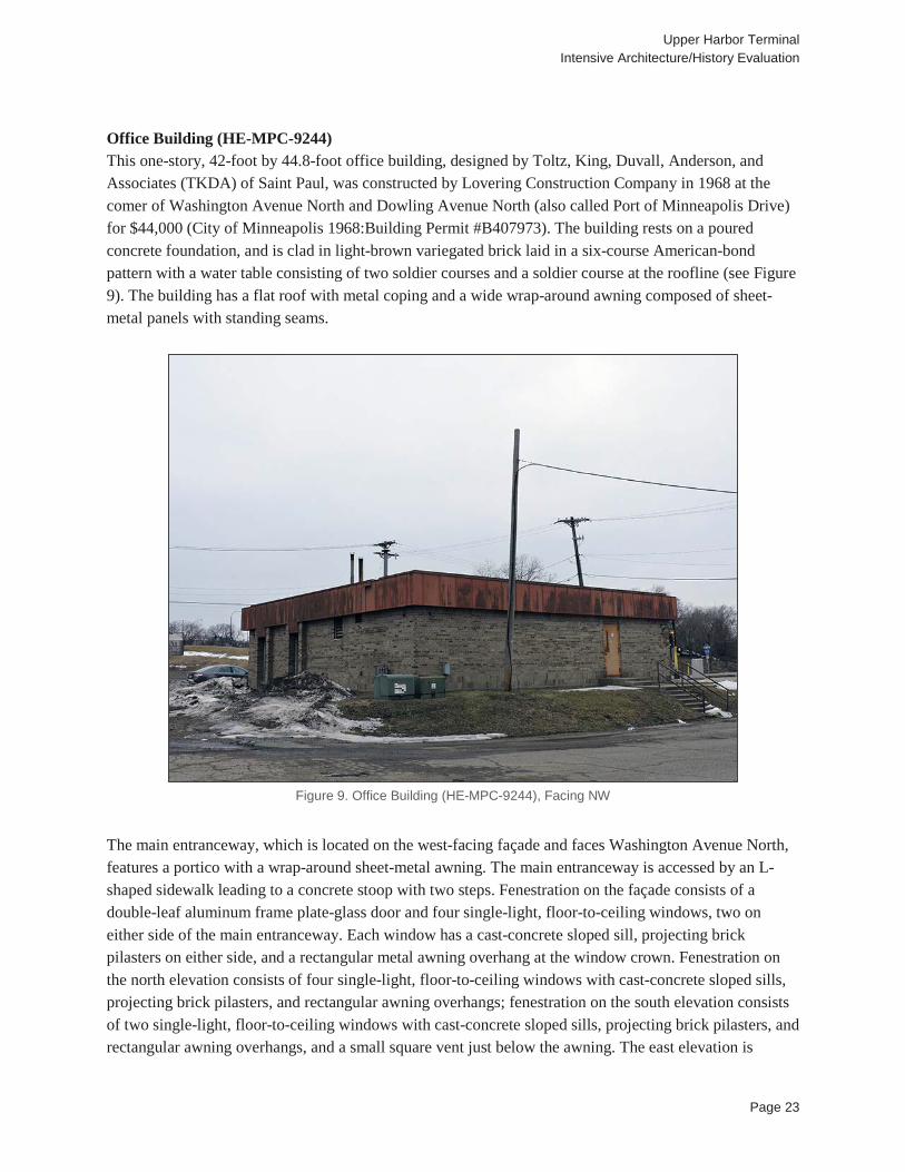
Office Building (HE-MPC-9244) This one-story, 42-foot by 44.8-foot office building, designed by Toltz, King, Duvall, Anderson, and Associates (TKDA) of Saint Paul, was constructed by Lovering Construction Company in 1968 at the comer of Washington Avenue North and Dowling Avenue North (also called Port of Minneapolis Drive) for $44,000 (City of Minneapolis 1968:Building Permit #B407973). The building rests on a poured concrete foundation, and is clad in light-brown variegated brick laid in a six-course American-bond pattern with a water table consisting of two soldier courses and a soldier course at the roofline (see Figure 9). The building has a flat roof with metal coping and a wide wrap-around awning composed of sheet-metal panels with standing seams.
Figure 9. Office Building (HE-MPC-9244), Facing NW
The main entranceway, which is located on the west-facing façade and faces Washington Avenue North, features a portico with a wrap-around sheet-metal awning. The main entranceway is accessed by an L-shaped sidewalk leading to a concrete stoop with two steps. Fenestration on the façade consists of a double-leaf aluminum frame plate-glass door and four single-light, floor-to-ceiling windows, two on either side of the main entranceway. Each window has a cast-concrete sloped sill, projecting brick pilasters on either side, and a rectangular metal awning overhang at the window crown. Fenestration on the north elevation consists of four single-light, floor-to-ceiling windows with cast-concrete sloped sills, projecting brick pilasters, and rectangular awning overhangs; fenestration on the south elevation consists of two single-light, floor-to-ceiling windows with cast-concrete sloped sills, projecting brick pilasters, and rectangular awning overhangs, and a small square vent just below the awning. The east elevation is

Upper Harbor Terminal Intensive Architecture/History Evaluation
Page 24
accessed by concrete steps with metal railings on either side leading up to an off-center single-leaf metal door with a narrow rectangular light. The building site itself is slightly elevated above the parking lot which surrounds the south and east sites of the building site. North Dock (HE-MPC-9250) The north dock, constructed in 1968, measures approximately 202 feet by 45 feet, and consists of earth-filled sheet piling topped with a concrete pad (MIDC 1979; University of Minnesota 2017a). Six tie-offs are located on the eastern (riverside) edge of the dock. In 2015, Hess Roise and SEH noted:
[The north dock] is 202 feet long and consists of tied-back PZ-27 sheet pile. Original construction drawings indicate a MZ-27 designation, which is an old U.S. Steel designation. Hot-rolled sheet pile manufacturers changed to a uniform “PZ” designation in the early 1980s. The sheet pile are 42 feet long and embedded 20 feet below the mudline. The tie-backs are on 7.5-foot centers and consist of 2½-inch diameter, 36 ksi, steel rods upset to 3¼-inches at the connections to the sheet pile wall and the concrete deadmen. The tips of the Dock #1 sheet pile terminate in firm to stiff clay alluvium (Hess Roise and SEH 2015:21).
In the 2015 study, Hess Roise and SEH identified the north dock as part of a riverwall, which “comprises four distinct stretches of sheetpile structure” (Hess Roise and SEH 2015:20). These are, from north to south: 1) a storm sewer outfall wall to the north of the north dock, 2) the north dock, 3) 604 feet of wall with riverside fill between the north and south dock, and 4) the south dock. Open Commodity Storage Areas (HE-MPC-9279, HE-MPC-9280, HE-MPC-9281, HE-MPC-9282, and HE-MPC-9283) There are five open commodity storage areas located at the UHT site, consisting of approximately 27 acres in total. Four of these open storage areas (HE-MPC-9279, HE-MPC-9281, HE-MPC-9282, HE-MPC-9283) were developed beginning with the site’s initial construction in 1968, and were largely established by 1986 (University of Minnesota 2017a; University of Minnesota 2017b; University of Minnesota 2017c; University of Minnesota 2017d; University of Minnesota 2017e ; Berg and Roise 2007b:3). Open storage area HE-MPC-9280, which is a paved storage area used for coal located just south of the warehouse, was established in the mid-1980s (University of Minnesota 2017d; University of Minnesota 2017e; Berg and Roise 2007b:5). Storage areas HE-MPC-9279 AND HE-MPC-9283 have all or parts of their surface areas paved, while the other two storage areas (HE-MPC-9281 AND HE-MPC-9282) appear to be unpaved (Hennepin County 2017). The open storage areas have been used to store materials such as dredging from the Mississippi River, coal, gravel, salt, and fertilizer; some of the materials were stored covered with tarps to shelter them from the elements (Personal Communication, Jerry Christensen, UHT Site Manager, January 18, 2017). Some of the bulk materials are corralled by large, portable concrete cubes, which are repositioned as needed. Storage area HE-MPC-9279 is located on Parcel 1, storage area HE-MPC-9280 is located on Parcel 2, storage area HE-MPC-9281 is located on Parcel 3, storage area HE-MPC-9282 is located on Parcel 4, and storage area HE-MPC-9283 is located on Parcel 5. Rail and Roadway System (HE-MPC-9276 and HE-MPC-9277)
Upper Harbor Terminal Intensive Architecture/History Evaluation
Page 25
Both railroad spurs and informal roadways connect the various portions of the UHT site. The first of these transportation systems (HE-MPC-9276) was developed beginning with the site’s initial construction in 1968, and was largely established by 1985 (University of Minnesota 2017a; University of Minnesota 2017b; University of Minnesota 2017c; University of Minnesota 2017d; University of Minnesota 2017e; Berg and Roise 2007b:3). The second of these transportation systems was developed beginning circa 1974, and was largely established by 1985 (University of Minnesota 2017b; University of Minnesota 2017c; University of Minnesota 2017d; University of Minnesota 2017e; TKDA 1974; TKDA 1975b; Berg and Roise 2007b:3). The transportation systems include seven sets of railroad tracks, totaling two-and-a-half miles in length, for staging railroad cars; and informal roadways running between extant buildings, structures, and objects on the site that have evolved to meet the needs of the site over time. The informal roads lack curbs or markings. The railroad tracks on the site are spur lines running through Parcels 1, 2, 3, 4, and 5, and serving structures, buildings, and areas such as the load-out tower, rail dump, truck/rail dump, and open storage commodity areas. Since railcar service to UHT ended in 2003, some of the spur lines have become partially buried by earth and gravel (Personal Communication, Jerry Christensen, UHT Site Manager, January 18, 2017). Established roads serving the site include Dowling Avenue North, which runs east-west through the site, terminating at the Mississippi River; First Street North, which runs north-south along the west side of Parcel 1 and terminates at Dowling Avenue North; Washington Avenue North, which runs north-south the west side of Parcel 6, and 33rd Avenue North, which run east-west and access the southern portion of the UHT site (Hennepin County 2017). Low, metal gates are located on Dowling Avenue North at the entrance to the UHT property. The northern portion of Parcel 6, where the office building and scale houses are located, is paved, as are portions of Parcel 2 around the grain-handling structures in the center of the site. Scale House (HE-MPC-9245) This one-story, 15-foot by 15-foot square scale house, constructed circa 1970, is located on Dowling Avenue North, east of the office building (TKDA 1970a; University of Minnesota 2017a). No building permit was on file at the City of Minneapolis Development Review for this building. The scale house rests on a non-visible foundation, and is clad in light-brown variegated brick in a stretcher-bond pattern. The building has a flat roof with metal coping and a wide wrap-around awning that projects trapezoidally from the cornice, composed of sheet-metal panels with standing seams. Fenestration on the façade, which is on the north elevation of the building, consists of a central sliding window with a large, single-light, and a fixed metal-framed window on either side of it; together, the three windows form a band spanning the length of the façade. There is one single-light, fixed metal-framed window on the north end of both the east and west elevations abutting the band of windows on the façade; the window on the east elevation is covered with a piece of plywood. All five windows on the scale house have a sill of bricks laid in a soldier-course. The west elevation also has a single-leaf metal door with a single rectangular light, and an elevated poured-concrete stoop that is accessed by an L-shaped sidewalk. Truck Scale (HE-MPC-9246) The truck scale is located just north of the scale house (HE-MPC-9245), between the scale house and Dowling Avenue North. The scale was constructed circa 1970, and consists of a large, rectangular, metal-
Upper Harbor Terminal Intensive Architecture/History Evaluation
Page 26
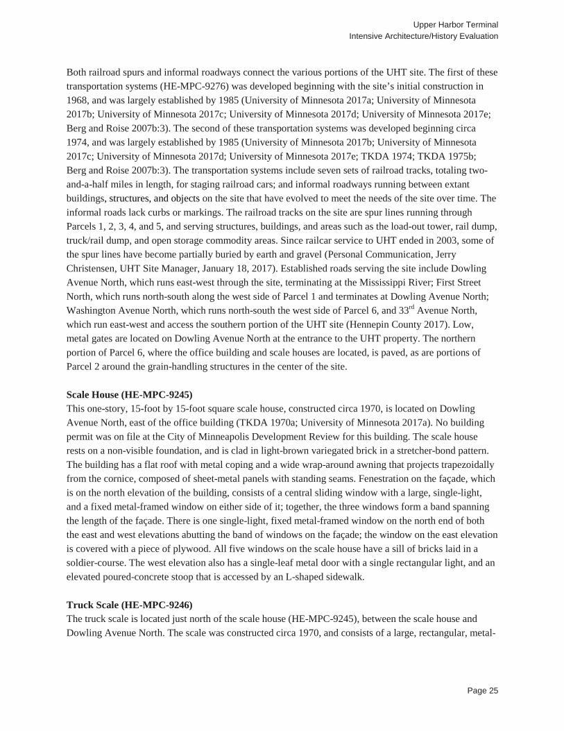
rimmed concrete pad measuring approximately 70 feet by 10 feet set within a concrete driveway running in front of the scale house’s façade (TKDA 1970b; University of Minnesota 2017a) (see Figure 10).
Figure 10. Scale House (HE-MPC-9245) and Truck Scale (HE-MPC-9246), Facing East
South Dock (HE-MPC-9252) The south dock, constructed circa 1971, measures approximately 205 feet by 45 feet, and consists of earth-filled sheet piling topped with a concrete pad (Mott Company 1971; University of Minnesota 2017a; University of Minnesota 2017b). Seven tie-offs are located on the eastern (riverside) edge of the dock. According to the 2015 study:
[The south dock] is 205 feet long and consists of tied-back PZ-38 sheet pile. Original construction drawings indicate a MZ-38 designation, which is an old U.S. Steel designation. Hot-rolled sheet pile manufacturers changed to a uniform “PZ” designation in the early 1980s. The sheet pile are 52 feet long and embedded 24 feet below the mudline. The tie-backs are on 6-foot centers and consist of 2½-inch diameter, 36 ksi, steel rods upset to 3¼-inches at the connections to the sheet pile wall and the concrete deadmen. The tips of the Dock #2 sheet pile terminate in medium dense silty sand till (Hess Roise and SEH 2015:22).
Warehouse (HE-MPC-9254) This one-story warehouse is approximately 301 feet by 358 feet and 23 feet high, and was constructed by the Lund-Martin Company in 1971 for a cost of approximately $824,000 (City of Minneapolis 1970:Building Permit #B425510). The warehouse rests on a poured concrete foundation, is faced in precast concrete panels with vertical ribs, and has a flat roof with alternating domed, rectangular skylights
Upper Harbor Terminal Intensive Architecture/History Evaluation
Page 27
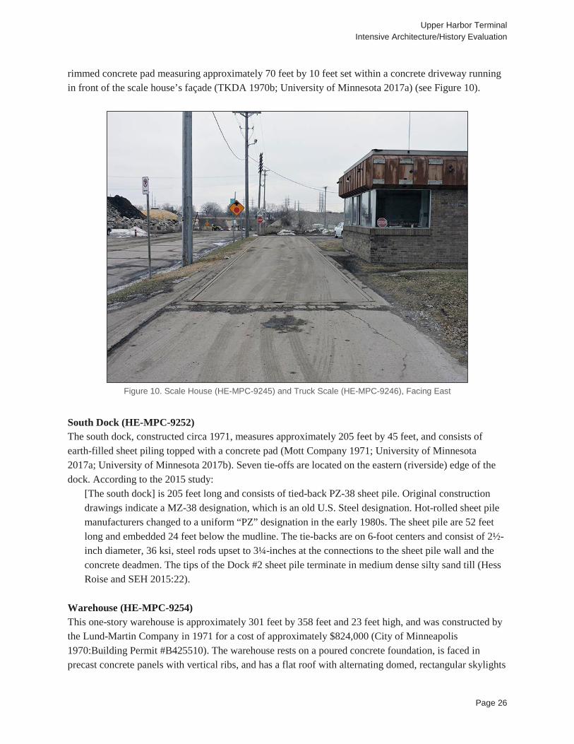
and rectangular vents laid out in a grid pattern (see Figure 11). Fenestration on the north elevation consists of 11 single-light fixed windows and two rectangular vents on the upper one-third of the elevation set between the concrete ribs; a single-bay overhead door; and two single-leaf metal pedestrian doors, one of which is accessed by concrete steps with a metal railing. Fenestration on the east elevation consists of six single-bay overhead dock doors and three single-leaf metal pedestrian doors. Fenestration on the south elevation consists of 11 single-light fixed windows and two rectangular vents on the upper one-third of the elevation set between the concrete ribs; seven single-bay overhead dock doors; and two single-leaf metal pedestrian doors. There is no visible fenestration on the west elevation. There is a raised, angled concrete loading dock measuring approximately 150 feet by 60 feet projecting out from the south half of the east elevation of the warehouse, which serves as a counterweight with tiebacks for the nearby river wall (Mott Company 1971). The loading dock is accessed by a ramp on the north, and concrete steps on the south. Floodlights on poles on are located on the parapet of the north, east, and south elevations.
Figure 11. Warehouse (HE-MPC-9254), South Dock in background (HE-MPC-9252), and abandoned rail line, Facing
South
Rail Dump (HE-MPC-9258) The rail dump, a building measuring approximately 64 feet by 25 feet and approximately three stories in height, rests on a non-visible foundation and is clad in vertical corrugated metal panels over the majority of the structure, with a band of T1-11 siding on the lower one-sixth of the east elevation and the lower one-third of the west elevation. A building permit is on file at the City of Minneapolis for the rail dump,
Upper Harbor Terminal Intensive Architecture/History Evaluation
Page 28
labeled a “materials handling pit and shaft,” to be constructed by Lund-Martin Company in 1973for an estimated cost of $60,000 (City of Minneapolis 1973:Building Permit #B442880). The building has a front-gabled roof that is covered in corrugated metal panels. On the southern end of the east elevation is an attached 12-foot by 12-foot plywood shed with a shed roof that is covered in asphalt shingles. Visible fenestration consists of large openings spanning the lower two-thirds of the north and south elevations through which rail cars would pass, and a pedestrian door located on the northern end of the east elevation two-thirds of the way up the side of the building, accessed by a fixed metal ladder with a ladder cage. There is a single-leaf door of unknown composition with a metal grate outer door on the north elevation of the shed, and a boarded up wooden window on the south elevation of the shed. Rail cars accessed the rail dump building via a railroad spur that runs lengthwise through the building. The building shelters a grated floor over a concrete pit through which rail cars emptied grain into underground hoppers. The grain was then transported to the grain elevator via the underground conveyor system.
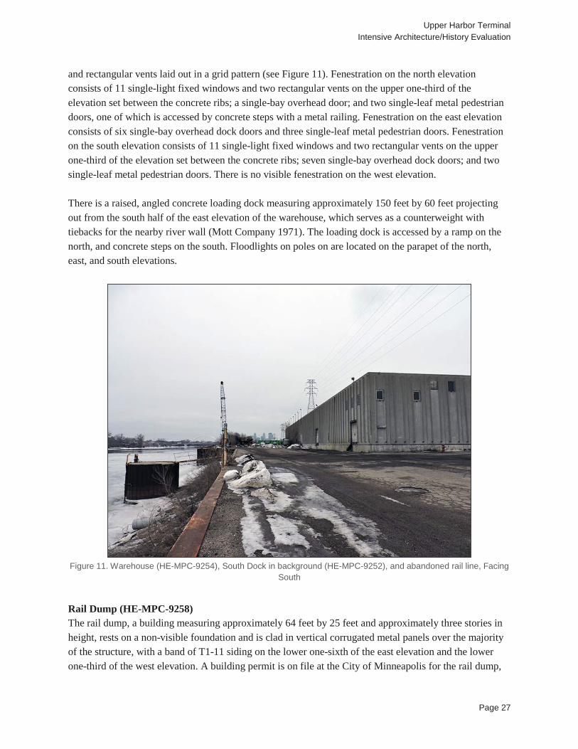
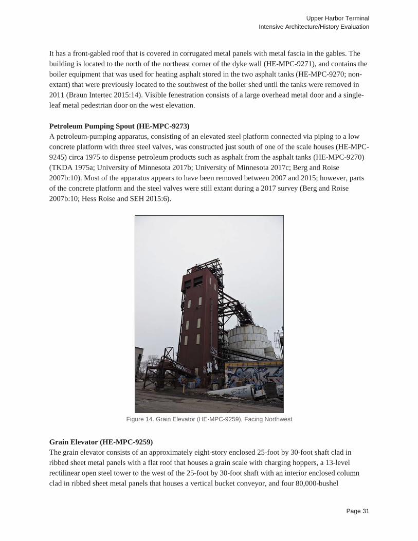
Figure 12. Conveyors (HE-MPC-9257), Facing Northwest
Conveyor (HE-MPC-9257) The conveyor system consists of several segments of belt conveyors elevated on open steel towers of varying heights on concrete footings (see Figure 12). The conveyors themselves consist of belts supported by steel trusses, which are covered by a domed cover. The conveyors form an interconnected system linking the load-out tower, storage domes, grain elevator, and rail- and truck-dump structures. There is also an underground component to the conveyor system by which grain was conveyed from railroad cars to the grain elevator. The underground conveyor system is accessed by concrete stairs located between the control building (HE-MPC-9261) and the grain elevator (HE-MPC-9259), as well as access hatches with

Upper Harbor Terminal Intensive Architecture/History Evaluation
Page 29
steel and concrete covers. Construction on the conveyor system began circa 1973, and was largely completed by 1988; its largest expansions occurred with the construction of the grain elevator circa 1978 and the domes in the mid-to-late 1980s (Mott Company 1973; MIDC 1979; University of Minnesota 2017b; Kibcor Engineering Company 1980a; Kibcor Engineering Company 1980b; Dome Systems Corporation 1988). The underground conveyor system was not surveyed as part of the 2007, 2015, or 2017 site surveys (Berg and Roise 2007b; Hess Roise and SEH 2015). While most of the conveyor system is fixed, some conveyor segments are portable; Hess Roise and SEH identify these as equipment rather than structures (Hess Roise and SEH 2015:28). Loading Area Mooring Cells (HE-MPC-9251) Three earth-filled sheetpile mooring cells are located between the north dock (HE-MPC-9250) and the south dock (HE-MPC-9252). The mooring cells, constructed of PS28 sheet pile and approximately 18 feet in diameter, were built circa 1974 (MIDC 1979; TKDA 1973; University of Minnesota 2017a; University of Minnesota 2017b). The mooring cells each have a tie-off and are connected to the shore by metal catwalks. The northernmost mooring cell of the three supports the load-out tower (HE-MPC-9256). According to the 2015 study:
The concrete caps at the top of the cells are somewhat complicated by five (5) embedded anchorages connected by rebar to an 8-inch thick bottom slab located just above the River’s low water level, approximately 9 feet below the cap. The purpose of the bottom slab is to provide pull-out resistance for the mooring pipes. The top slab is 12-inches thick. Both slabs are reinforced with #5 bars, both ways, top and bottom (Hess Roise and SEH 2015:23).
Petroleum Dock (HE-MPC-9253) This petroleum dock, which was constructed circa 1974, consists of a riprap pier and a narrow pipe projecting approximately 50 feet into the river, slightly above the waterline (MIDC 1979:5; University of Minnesota 2017a; University of Minnesota 2017b). The dock was constructed to serve Trumbull Asphalt from 1974 to the early 1990s (Berg and Roise 2007b:12). The pipe connected to an underground petroleum-piping system which in turn was connected to two asphalt tanks located on this portion of the site. The dock is still extant, although it is in a deteriorated condition. Based on aerial photographs, it appears the tanks were removed sometime between 1993 and 2003 (University of Minnesota 2017e; NETR 2003). The underground piping system, which was used to transport petroleum between the tanks and barges, was not surveyed as part of the 2007, 2015, or 2017 site surveys (Berg and Roise 2007b; Hess Roise and SEH 2015). Load-out Tower (HE-MPC-9256) The load-out tower is a “four-level, rectilinear, open steel tower” sited on the northernmost mooring cell of the cluster of three mooring cells located between the north and south docks (HE-MPC-9251); it was constructed circa 1974 (Mott Company 1973; University of Minnesota 2017b). An enclosed operator’s office clad in plywood is located on the third level, and a concrete block shed housing mechanical and hydraulic equipment is located on the ground level (see Figure 13). The conveyor system (HE-MPC-9257) connects to the tower at the third and fourth levels. The tower is accessed by four flights of stairs and a folding catwalk, and there are platforms on the upper three levels.
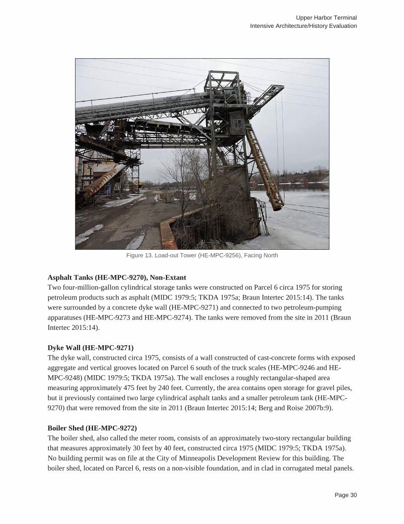
Upper Harbor Terminal Intensive Architecture/History Evaluation
Page 30
Figure 13. Load-out Tower (HE-MPC-9256), Facing North
Asphalt Tanks (HE-MPC-9270), Non-Extant Two four-million-gallon cylindrical storage tanks were constructed on Parcel 6 circa 1975 for storing petroleum products such as asphalt (MIDC 1979:5; TKDA 1975a; Braun Intertec 2015:14). The tanks were surrounded by a concrete dyke wall (HE-MPC-9271) and connected to two petroleum-pumping apparatuses (HE-MPC-9273 and HE-MPC-9274). The tanks were removed from the site in 2011 (Braun Intertec 2015:14). Dyke Wall (HE-MPC-9271) The dyke wall, constructed circa 1975, consists of a wall constructed of cast-concrete forms with exposed aggregate and vertical grooves located on Parcel 6 south of the truck scales (HE-MPC-9246 and HE-MPC-9248) (MIDC 1979:5; TKDA 1975a). The wall encloses a roughly rectangular-shaped area measuring approximately 475 feet by 240 feet. Currently, the area contains open storage for gravel piles, but it previously contained two large cylindrical asphalt tanks and a smaller petroleum tank (HE-MPC-9270) that were removed from the site in 2011 (Braun Intertec 2015:14; Berg and Roise 2007b:9). Boiler Shed (HE-MPC-9272) The boiler shed, also called the meter room, consists of an approximately two-story rectangular building that measures approximately 30 feet by 40 feet, constructed circa 1975 (MIDC 1979:5; TKDA 1975a). No building permit was on file at the City of Minneapolis Development Review for this building. The boiler shed, located on Parcel 6, rests on a non-visible foundation, and in clad in corrugated metal panels.
Upper Harbor Terminal Intensive Architecture/History Evaluation
Page 31
It has a front-gabled roof that is covered in corrugated metal panels with metal fascia in the gables. The building is located to the north of the northeast corner of the dyke wall (HE-MPC-9271), and contains the boiler equipment that was used for heating asphalt stored in the two asphalt tanks (HE-MPC-9270; non-extant) that were previously located to the southwest of the boiler shed until the tanks were removed in 2011 (Braun Intertec 2015:14). Visible fenestration consists of a large overhead metal door and a single-leaf metal pedestrian door on the west elevation. Petroleum Pumping Spout (HE-MPC-9273) A petroleum-pumping apparatus, consisting of an elevated steel platform connected via piping to a low concrete platform with three steel valves, was constructed just south of one of the scale houses (HE-MPC-9245) circa 1975 to dispense petroleum products such as asphalt from the asphalt tanks (HE-MPC-9270) (TKDA 1975a; University of Minnesota 2017b; University of Minnesota 2017c; Berg and Roise 2007b:10). Most of the apparatus appears to have been removed between 2007 and 2015; however, parts of the concrete platform and the steel valves were still extant during a 2017 survey (Berg and Roise 2007b:10; Hess Roise and SEH 2015:6).
Figure 14. Grain Elevator (HE-MPC-9259), Facing Northwest
Grain Elevator (HE-MPC-9259) The grain elevator consists of an approximately eight-story enclosed 25-foot by 30-foot shaft clad in ribbed sheet metal panels with a flat roof that houses a grain scale with charging hoppers, a 13-level rectilinear open steel tower to the west of the 25-foot by 30-foot shaft with an interior enclosed column clad in ribbed sheet metal panels that houses a vertical bucket conveyor, and four 80,000-bushel
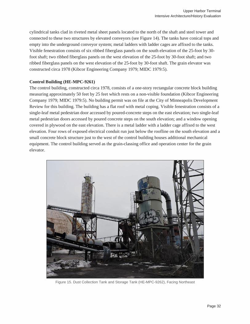
Upper Harbor Terminal Intensive Architecture/History Evaluation
Page 32
cylindrical tanks clad in riveted metal sheet panels located to the north of the shaft and steel tower and connected to these two structures by elevated conveyors (see Figure 14). The tanks have conical tops and empty into the underground conveyor system; metal ladders with ladder cages are affixed to the tanks. Visible fenestration consists of six ribbed fiberglass panels on the south elevation of the 25-foot by 30-foot shaft; two ribbed fiberglass panels on the west elevation of the 25-foot by 30-foot shaft; and two ribbed fiberglass panels on the west elevation of the 25-foot by 30-foot shaft. The grain elevator was constructed circa 1978 (Kibcor Engineering Company 1979; MIDC 1979:5). Control Building (HE-MPC-9261) The control building, constructed circa 1978, consists of a one-story rectangular concrete block building measuring approximately 50 feet by 25 feet which rests on a non-visible foundation (Kibcor Engineering Company 1979; MIDC 1979:5). No building permit was on file at the City of Minneapolis Development Review for this building. The building has a flat roof with metal coping. Visible fenestration consists of a single-leaf metal pedestrian door accessed by poured-concrete steps on the east elevation; two single-leaf metal pedestrian doors accessed by poured concrete steps on the south elevation; and a window opening covered in plywood on the east elevation. There is a metal ladder with a ladder cage affixed to the west elevation. Four rows of exposed electrical conduit run just below the roofline on the south elevation and a small concrete block structure just to the west of the control building houses additional mechanical equipment. The control building served as the grain-classing office and operation center for the grain elevator.
Figure 15. Dust Collection Tank and Storage Tank (HE-MPC-9262), Facing Northeast
Upper Harbor Terminal Intensive Architecture/History Evaluation
Page 33
Four Dust Tanks (HE-MPC-9262) The dust tanks, constructed circa 1978, consist of three steel cylindrical cyclone collection tanks and one cylindrical storage tank, all of which have funnel-shaped bases, connected to the grain-handling machinery by large-diameter pipes (Kibcor Engineering Company 1979; MIDC 1979:5). All are elevated above the ground on open, rectangular steel frames (see Figure 15). The collection tanks are elevated approximately 3-4 feet off the ground, while the storage tank is elevated approximately 12 feet off the ground. One collection tank is located on the west side of the grain elevator between one of the grain bins and the elevator shaft (HE-MPC-9259); one collection tank is located on the east side of the grain elevator between one of the grain bins and the elevator shaft; and the third collection tank is located to the southwest side of the truck dump/hoist (HE-MPC-9260). The storage tank, which is taller in height than the collection tanks, is located to the north of the load-out shelter (HE-MPC-9267) adjacent to the 12,000-ton capacity dome (HE-MPC-9264), and connects to the collection tanks via narrow-diameter pipes. Truck Dump/Hoist (HE-MPC-9260) The truck dump/hoist consists of a tall, narrow wood frame building measuring approximately 15 feet by 18 feet with a shed roof that rests on a non-visible foundation; a small, concrete block building measuring approximately 6 feet by 10 feet with a side-gabled roof adjacent to the tall building’s west elevation which also rests on a non-visible foundation; and a truck hoist consisting of a flat metal panel measuring approximately 60 feet by 12 feet set into a concrete liner just to the north of the tall building. The truck dump/hoist was constructed circa 1978 (MSM Corporation 1977; Berg and Roise 2007b:3). No building permit was on file at the City of Minneapolis Development Review for this building. Triangular steel brackets are positioned on the east and west sides of the hoist. The walls and the roof of the tall building are composed of corrugated sheet metal, as is the roof and awning of the concrete block building. Visible fenestration consists of a large opening on the north elevation of the tall building through which rail cars would enter via a set of railroad tracks; a Plexiglas window on the north elevation of the concrete block building; and a single-leaf metal pedestrian door on the west elevation of the concrete block building. There is a metal grate set into the floor of the tall building, below which is located an underground hopper, while the concrete block building houses mechanical equipment. Monolithic Dome (HE-MPC-9263) This dome is the northernmost of the four domes at UHT, located just to the north of the extension of Dowling Avenue North. It is also the smallest of the four to be constructed and was the first built. The dome was designed by Monolithic Dome, a company from Idaho that originally developed domes for potato storage in the mid-1970s. This dome was designed in December of 1981, by Monolithic’s structural engineer Arnold Wilson, and construction was completed in 1982. The dome is 90 feet in diameter and 30 feet high (Wilson 1981). The structure was formed by inflating a large fabric membrane, spraying the inside with three inches of polyurethane foam followed by reinforced concrete (South 2014). According to cross sections, the concrete shell is five inches thick at the floor, six inches thick up to the height of 22 feet and then three inches thick above that, and includes radial steel up to 22 feet in height. The structure includes a 16 foot wide by 12 foot high door that projects from the south elevation. The door is supported by a five foot by 12 inch thick concrete beam. This dome was built to hold fill up to a
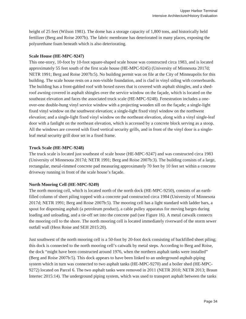
Upper Harbor Terminal Intensive Architecture/History Evaluation
Page 34
height of 25 feet (Wilson 1981). The dome has a storage capacity of 1,800 tons, and historically held fertilizer (Berg and Roise 2007b). The fabric membrane has deteriorated in many places, exposing the polyurethane foam beneath which is also deteriorating. Scale House (HE-MPC-9247) This one-story, 10-foot by 10-foot square-shaped scale house was constructed circa 1983, and is located approximately 55 feet south of the first scale house (HE-MPC-9245) (University of Minnesota 2017d; NETR 1991; Berg and Roise 2007b:5). No building permit was on file at the City of Minneapolis for this building. The scale house rests on a non-visible foundation, and is clad in vinyl siding with cornerboards. The building has a front-gabled roof with boxed eaves that is covered with asphalt shingles, and a shed-roof awning covered in asphalt shingles over the service window on the façade, which is located on the southeast elevation and faces the associated truck scale (HE-MPC-9248). Fenestration includes a one-over-one double-hung vinyl service window with a projecting wooden sill on the façade; a single-light fixed vinyl window on the southwest elevation; a single-light fixed vinyl window on the northwest elevation; and a single-light fixed vinyl window on the northeast elevation, along with a vinyl single-leaf door with a fanlight on the northeast elevation, which is accessed by a concrete block serving as a stoop. All the windows are covered with fixed vertical security grills, and in front of the vinyl door is a single-leaf metal security grill door set in a fixed frame. Truck Scale (HE-MPC-9248) The truck scale is located just southeast of scale house (HE-MPC-9247) and was constructed circa 1983 (University of Minnesota 2017d; NETR 1991; Berg and Roise 2007b:3). The building consists of a large, rectangular, metal-rimmed concrete pad measuring approximately 70 feet by 10 feet set within a concrete driveway running in front of the scale house’s façade. North Mooring Cell (HE-MPC-9249) The north mooring cell, which is located north of the north dock (HE-MPC-9250), consists of an earth-filled column of sheet piling topped with a concrete pad constructed circa 1984 (University of Minnesota 2017d; NETR 1991; Berg and Roise 2007b:5). The mooring cell has a light standard with ladder bars, a spout for dispensing asphalt (a petroleum product), a cable pulley apparatus for moving barges during loading and unloading, and a tie-off set into the concrete pad (see Figure 16). A metal catwalk connects the mooring cell to the shore. The north mooring cell is located immediately riverward of the storm sewer outfall wall (Hess Roise and SEH 2015:20). Just southwest of the north mooring cell is a 50-foot by 20-foot dock consisting of backfilled sheet piling; this dock is connected to the north mooring cell’s catwalk by metal steps. According to Berg and Roise, the dock “might have been constructed around 1976, when the northern asphalt tanks were installed” (Berg and Roise 2007b:5). This dock appears to have been linked to an underground asphalt-piping system which in turn was connected to two asphalt tanks (HE-MPC-9270) and a boiler shed (HE-MPC-9272) located on Parcel 6. The two asphalt tanks were removed in 2011 (NETR 2010; NETR 2013; Braun Intertec 2015:14). The underground piping system, which was used to transport asphalt between the tanks
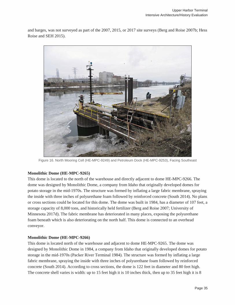
Upper Harbor Terminal Intensive Architecture/History Evaluation
Page 35
and barges, was not surveyed as part of the 2007, 2015, or 2017 site surveys (Berg and Roise 2007b; Hess Roise and SEH 2015).
Figure 16. North Mooring Cell (HE-MPC-9249) and Petroleum Dock (HE-MPC-9253), Facing Southeast
Monolithic Dome (HE-MPC-9265) This dome is located to the north of the warehouse and directly adjacent to dome HE-MPC-9266. The dome was designed by Monolithic Dome, a company from Idaho that originally developed domes for potato storage in the mid-1970s. The structure was formed by inflating a large fabric membrane, spraying the inside with three inches of polyurethane foam followed by reinforced concrete (South 2014). No plans or cross sections could be located for this dome. The dome was built in 1984, has a diameter of 107 feet, a storage capacity of 8,000 tons, and historically held fertilizer (Berg and Roise 2007; University of Minnesota 2017d). The fabric membrane has deteriorated in many places, exposing the polyurethane foam beneath which is also deteriorating on the north half. This dome is connected to an overhead conveyor. Monolithic Dome (HE-MPC-9266) This dome is located north of the warehouse and adjacent to dome HE-MPC-9265. The dome was designed by Monolithic Dome in 1984, a company from Idaho that originally developed domes for potato storage in the mid-1970s (Packer River Terminal 1984). The structure was formed by inflating a large fabric membrane, spraying the inside with three inches of polyurethane foam followed by reinforced concrete (South 2014). According to cross sections, the dome is 122 feet in diameter and 80 feet high. The concrete shell varies is width: up to 15 feet high it is 10 inches thick, then up to 35 feet high it is 8
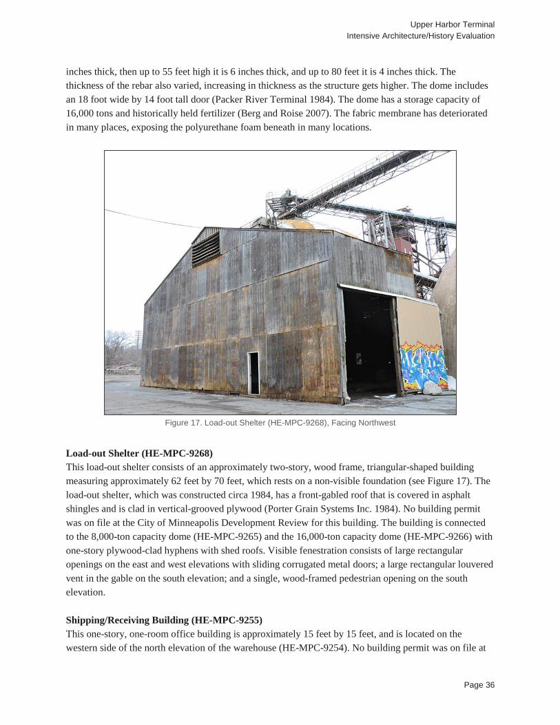
Upper Harbor Terminal Intensive Architecture/History Evaluation
Page 36
inches thick, then up to 55 feet high it is 6 inches thick, and up to 80 feet it is 4 inches thick. The thickness of the rebar also varied, increasing in thickness as the structure gets higher. The dome includes an 18 foot wide by 14 foot tall door (Packer River Terminal 1984). The dome has a storage capacity of 16,000 tons and historically held fertilizer (Berg and Roise 2007). The fabric membrane has deteriorated in many places, exposing the polyurethane foam beneath in many locations.
Figure 17. Load-out Shelter (HE-MPC-9268), Facing Northwest
Load-out Shelter (HE-MPC-9268) This load-out shelter consists of an approximately two-story, wood frame, triangular-shaped building measuring approximately 62 feet by 70 feet, which rests on a non-visible foundation (see Figure 17). The load-out shelter, which was constructed circa 1984, has a front-gabled roof that is covered in asphalt shingles and is clad in vertical-grooved plywood (Porter Grain Systems Inc. 1984). No building permit was on file at the City of Minneapolis Development Review for this building. The building is connected to the 8,000-ton capacity dome (HE-MPC-9265) and the 16,000-ton capacity dome (HE-MPC-9266) with one-story plywood-clad hyphens with shed roofs. Visible fenestration consists of large rectangular openings on the east and west elevations with sliding corrugated metal doors; a large rectangular louvered vent in the gable on the south elevation; and a single, wood-framed pedestrian opening on the south elevation. Shipping/Receiving Building (HE-MPC-9255) This one-story, one-room office building is approximately 15 feet by 15 feet, and is located on the western side of the north elevation of the warehouse (HE-MPC-9254). No building permit was on file at
Upper Harbor Terminal Intensive Architecture/History Evaluation
Page 37
the City of Minneapolis Development Review for this building. The office was constructed circa 1985 (Berg and Roise 2007b:3). The building rests on a non-visible foundation, is clad in T1-11 siding, and has a front-gabled roof that is covered in asphalt shingles. Visible fenestration consists of a one-over-one, double-hung, wood window on the east and west elevations; a one-over-one, double-hung, wood window; and a single-leaf nine-light vinyl door, accessed by a metal grate that serves as a stoop, on the north-facing façade. The south elevation, which abuts the warehouse, is not visible. All the windows are covered with fixed vertical security grills, and in front of the vinyl door is a single-leaf metal security grill door set in a fixed frame. Petroleum Pumping Spout (HE-MPC-9274) A second petroleum-pumping apparatus, consisting of an elevated steel platform connected via piping to a plywood-clad structure below the platform, was constructed near the asphalt tanks (HE-MPC-9270) circa 1985. This apparatus was removed between 2007 and 2015 (Berg and Roise 2007b:10; Hess Roise and SEH 2015:6). No parts of the apparatus were observed during a 2017 survey. Truck Staging Area (HE-MPC-9275) This truck staging area consists of a two-acre gravel-covered elongated area between Washington Avenue North and I-94. The area, used for staging semi-trailers, is enclosed by earth berms on the north and west, and accessed by gravel inlets from Washington Avenue North located at the north and south ends of the area. The staging area was established in the mid-1980s (University of Minnesota 2017d; University of Minnesota 2017e; Berg and Roise 2007b:10). Monolithic Dome (HE-MPC-9264) This dome is located in the center of UHT, was constructed in 1987, has a capacity of 12,000 tons, and historically held fertilizer (Berg and Roise 2007). The dome was designed by Monolithic Dome, a company from Idaho that originally developed domes for potato storage in the mid-1970s. The structure was formed by inflating a large fabric membrane, spraying the inside with three inches of polyurethane foam that was followed by reinforced concrete (South 2014). According to site plans, this dome is 132 feet in diameter and 66 feet tall (Dome Systems Corporation 1988). Cross sections for this structure were not found in order to provide more construction details. The fabric membrane has deteriorated in many places, exposing the polyurethane foam beneath. This dome is connected to an overhead conveyor. Load-out Shelter (HE-MPC-9267) This load-out shelter consists of an approximately two-story, wood frame, rectangular building measuring approximately 70 feet by 40 feet, which rests on a non-visible foundation. The building, which was constructed circa 1988, has a front-gabled roof that is covered in asphalt sheets, and is clad in vertical-grooved plywood (Dome Systems Corporation 1988). It is located to the south of the 12,000-ton capacity dome (HE-MPC-9264). No building permit was on file at the City of Minneapolis Development Review for this building. Visible fenestration consists of a large rectangular opening with a sliding plywood door on the east elevation; a single-leaf pedestrian door of unknown composition on the south elevation; and a large rectangular louvered vent at in the gable on the south elevation. The load-out shelter is used to provide shelter for loading and unloading materials from trucks.
Upper Harbor Terminal Intensive Architecture/History Evaluation
Page 38
Truck/Rail Dump (HE-MPC-9269) The truck/rail dump consists of an approximately two-story, wood frame, rectangular building measuring approximately 80 feet by 38 feet resting on wooden posts set into asphalt. The building, which was constructed circa 1988, has a front-gabled roof that is covered in asphalt shingles, and is clad in vertical-grooved plywood (Dome Systems Corporation 1988). No building permit was on file at the City of Minneapolis Development Review for this building. Visible fenestration consists of two large openings, one rectangular and one rectangular with angled upper corners, on both the south and north elevations, through which rail cars would enter and exit the truck/rail dump; and a single wood-framed pedestrian opening on the east elevation. The building is connected to the 12,000-ton capacity dome via an overhead conveyor elevated by a triangular steel tower. Rail Scale Shed (HE-MPC-9278) In 1991, TC&W Railroad paid for the construction of a rail scale and rail scale shed along a railroad spur running adjacent to the western exterior wall of the warehouse (HE-MPC-9254). The scale shed consisted of a small, square-shaped building with a gable roof, and was used to house a standing operator and electrical equipment for the scale (City of Minneapolis 1994:7; Berg and Roise 2007b:10). The scale shed was removed between 2007 and 2010; however, the rail scale, which consists of a metal platform set between the tracks of the railroad spur, was extant as of 2016 (Berg and Roise 2007b:10; USGS 2010; USGS 2016). Historic Context: UHT was evaluated within the established historic context Terminal Development in the Upper Harbor, prepared in 2007 by Hess, Roise and Company (Berg and Roise 2007a). In addition, UHT was evaluated within the context City-Owned Industrial Development in Minneapolis that was prepared by the 106 Group for this project (see Section 4.2.1). Historic Narrative: In 1964, one year after the opening of the Upper Saint Anthony Falls Lock, the Citizens’ Upper Harbor Committee was established by the Minneapolis City Council (City Council) to identify ways for the City to most successfully utilize the newly opened upper harbor. The Citizens’ Upper Harbor Committee in turn submitted a bill to the Minnesota State Legislature granting the City Council the powers of a port authority, and recommended the establishment of an Industrial Development Commission. In 1965, the Minneapolis Industrial Development Committee (MIDC) was established with the purpose of marketing land for industrial development and issuing industrial revenue bonds (Hult 1987:49). One of the primary duties with which MIDC was tasked was facilitating the development of public river terminal facilities in the newly opened upper harbor. In March 1967, at the recommendation of the Citizens’ Upper Harbor Committee and MIDC, a new municipal river terminal was established in the upper harbor, and consultant Merlin H. Berg was hired in May of that year to prepare an economic study and preliminary engineering layout for the new terminal facility (MIDC 1979:2-3). Berg’s report, completed in 1968, recommended that the new terminal, named the Upper Harbor Terminal, be located at a 21.17-acre City-owned site bounded by Dowling Avenue North, 36th Avenue North, Washington Avenue North, and the Mississippi River (Berg 1968). This site offered level terrain
Upper Harbor Terminal Intensive Architecture/History Evaluation
Page 39
above the floodplain, room to expand, a natural harbor, good soil drainage, and access to both railways and roads, all features that the existing municipal Washington Avenue Terminal below Saint Anthony Falls lacked, and was located in an area of the city that was primarily used for scrap yards (MIDC 1979:2; Peterson and Zellie 1998:40). That same year, Northern Waterway Terminals Corporation (NWTC), which had operated the Washington Avenue Terminal for the City since 1949, was authorized by the City Council to use a portion of the newly selected UHT site for a grain handling operation (MIDC 1979:4). The City agreed to reimburse Northern Waterway Terminals Corporation for their investment in the property if the operation was terminated, minus 10 percent depreciation per year (MIDC 1979:4). Construction on UHT commenced in 1968 and was carried out over four stages (see Table 1). The first stage, financed by NWTC, included the construction of an office building, 200 feet of dock, a truck scale and scale house, an open storage area, and concrete roadways, all of which were completed by August 1968 (MIDC 1979:4; Berg and Roise 2007b:3). The office building was designed by TKDA (City of Minneapolis 1968:Building Permit #B407973). In July 1969, the City Council entered into an agreement with TKDA, to design the remainder of the UHT site and provide architecture and engineering services (MIDC 1979:4). That same year, the City acquired 5.76 acres from the Osborne McMillen estate (MIDC 1979:3). In 1970, the City Council contracted NWTC to operate UHT for a period of 10 years, and reimbursed NWTC for their expenditures during stage one of UHT construction, which totaled $211,000 (MIDC 1979:4). During the second stage of construction, which began around 1970 and was largely completed by 1973, a warehouse, granular handling facility, railroad tracks, barge mooring areas, and additional internal rail spurs and roadways were constructed (see Table 1) (Berg and Roise 2007b:12; MIDC 1979:5). The total cost of stages one and two was approximately 3 million dollars (MIDC 1979:5). During the second stage, in 1972, the City acquired two more tracts of land to add to the UHT site - 7.91 acres from the Grinell Company, and 13 acres from the Tri-State Company (MIDC 1979:3). In 1973, NWTC, which was operating both UHT and the Washington Avenue Terminal for the City of Minneapolis, as well as facilities in Saint Paul and Clinton, Iowa, filed for bankruptcy. Along with claiming financial difficulties at their other facilities, “Northern [NWTC] also alleged that payments to the City of Minneapolis required under the operating agreement for Upper Harbor Terminal were too much of a financial burden ... [a] contributing factor was that the facility ... did not generate sufficient business and income to meet the expense of operation” (MIDC 1979:8-9). In 1974, the City of Minneapolis took over operations for both terminals, losing $500,000 during that year, and in 1975, Bolander Conlan Terminal Corporation leased UHT from the City. In the mid-1970s the third stage of development commenced, resulting in the construction of three storage tanks for petroleum and linseed oil products, which totaled 2 million dollars in costs, and added agricultural products to the list of materials that UHT handled (MIDC 1979:5). In 1976 the City acquired the final addition of land to the UHT site, a 2.34-acre parcel from Carmen Realty Company (MIDC 1979:3). From 1975 to 1979, Bolander Conlan Terminal Corporation leased UHT from the City, until a contract dispute resulted in the termination of its contract, which was assumed by Con-Agra (City of Minneapolis 1994:9). During this time, both the Washington Avenue Terminal (which became known as the Lower Harbor
Upper Harbor Terminal Intensive Architecture/History Evaluation
Page 40
Terminal after the opening of UHT), and UHT were operated by Con-Agra (City of Minneapolis 1994:9). During the late 1970s, operations at the Washington Avenue Terminal were gradually phased out as the City consolidated its terminal operations at UHT (MIDC 1979). The fourth stage of development began in 1978 with the construction of a high-speed grain-handling facility to further increase UHT’s grain-handling abilities, as grain commodities brought in a higher price per ton than other bulk commodities handled at UHT, thereby increasing the City’s gross revenue (MIDC 1979:5). In 1978, the ordinance under which MIDC was established was revised, and its goals were broadened to focus on developing industry in Minneapolis in such a way as to encourage the City’s economic viability, generate employment, and meet the needs of the City, residents, and local businesses. MIDC’s activities included commercial and industrial development, local and federal financing programs, commercial rehabilitation loan programs, and industrial revenue bond financing, in addition to Port Authority functions for UHT. Along with UHT, MIDC’s projects included the introduction of light industry into the Camden neighborhood and the vicinity of East Twenty-Ninth Street and Hiawatha Avenue, and the development of City-owned land into the Northeast River Industrial Park in northern Minneapolis (MIDC 1980). In 1980, the Minnesota State Legislature formed the quasi-independent Minneapolis Community Development Agency (MCDA), into which MIDC and the Minneapolis Housing Redevelopment Authority were merged in 1981 (Hult 1987:49). MCDA, which was established to increase employment and housing opportunities, expand the City’s task base including commercial and industrial valuation, and encourage private investment and redevelopment, “was responsible for managing those commercial, industrial, and downtown development projects that relied on government subsidies or were funded through the sale of city bonds” (Hult 1987:53-55). The newly created MCDA took over MIDC’s UHT responsibilities. In 1982, Con-Agra brought a lawsuit against the City, which Con-Agra lost, and its lease was terminated. Packer River Terminals then took over operations of UHT starting in 1983 (City of Minneapolis 1994:9). In addition to the grain-handling facility constructed in 1978, a variety of other buildings, structures, and objects were added to UHT during stage four in the 1980s, including a truck dump and hoist; a grain elevator, control building, and dust tanks; conveyor belts; a load-out tower; additional petroleum tanks and petroleum-pumping apparatuses; an additional truck scale and scale house; four Monolithic storage domes and associated load-out shelters; a shipping and receiving building; a truck/rail dump; and lastly, in 1991, a rail scale. All but the rail scale, which was financed by the TC&W Railroad, were financed by the City using general obligation bonds, and subsidized between $500,000 and $1 million per year, a subsidy for which MCDA was responsible (City of Minneapolis 1994:7). The fourth stage of construction also included further development and expansion of the UHT site’s internal roadways and open commodity storage areas (MIDC 1979:5; Berg and Roise 2007b:3; City of Minneapolis 1994:5; University of Minnesota 2017c; University of Minnesota 2017d; University of Minnesota 2017e). In 1988, Packer River Terminals and the City entered into a contract dispute after Packer River Terminals withheld payments from the City, arguing that it was justified in doing so due to a drought in 1987 and 1988 that reduced its revenues. The lawsuit was settled in the City’s favor, and in 1991 the City contracted with River Services, Inc. to manage UHT (Dollhausen 1997:7; City of Minneapolis 1994:9).
Upper Harbor Terminal Intensive Architecture/History Evaluation
Page 41
River Services, Inc. has continued to manage UHT since 1991. The City’s operating agreement with River Services, Inc. was renewed in 1992, 1995, and 2000, and in 2004 a new 10-year agreement was made with River Services, Inc. (City of Minneapolis 2010:2; Personal Communication, Jerry Christensen, UHT Site Manager, January 18, 2017). In addition to UHT, Northern States Power (1963), the American Iron and Supply Company (1964, 1985), Dundee Cement (1967), Scherer Brothers Lumber (1964), and J.L. Shiely Company (1987) constructed moorage and dock facilities in the upper harbor. By 1994, the City of Minneapolis noted that “It has been three decades since the channel opened and most of the Terminals were built. Since that time only one new Terminal has been built in Minneapolis. In fact, a majority of the docks have closed” (City of Minneapolis 1994:5). Most river terminals in the upper harbor have not achieved long-term financial success; in particular, UHT has not consistently generated revenue. A 1996 report on UHT found that the revenues that the facility generates do not cover its expenses, with UHT operating at a deficit of between approximately $450,000 and $1,120,000 between 1990 and 1996 (Dollhausen 1997:8). In 1999, a master plan for the Upper Mississippi River noted that “The City of Minneapolis has invested millions of dollars in UHT and has not to date received any identifiable economic benefit,” and that UHT has been subsidized by the City of Minneapolis between $500,000 and $1 million per year from 1969 to 1999 (BRW, Inc. 1999:19-20). Although the annual debt service was paid off permanently in 1999, UHT has not consistently generated an annual profit (City of Minneapolis 2010:5). In 2003, the MCDA was folded into the City of Minneapolis’ new Department of Community Planning and Economic Development (CPED) that included the MCDA along with other business units of the City. The MCDA’s assets and liabilities, as well as many of its responsibilities were transferred to CPED, including oversight of UHT (City of Minneapolis 2003:2; City of Minneapolis 2016a; City of Minneapolis 2016b). Tied to the financial success of the upper harbor terminals has been the amount of tonnage that passes through the terminals, and the Upper Lock that serves them, each year. The minimum amount of tonnage required by USACE for operation of the Upper Lock was one million tons; as of 1999, tonnage totals fluctuated between 2.3 million in 1974, and 0.66 million in 1989 (BRW, Inc. 1999:19). Meeting the minimum tonnage was complicated by the fact that the Upper Lock was only able to hold two barges at a time, which limited the amount of barge traffic that could pass to and from the upper harbor during the peak shipping season (Personal Communication, Jerry Christensen, UHT Site Manager, January 18, 2017). As of 1997, the federally-funded cost to operate the Upper and Lower lock and dam systems at St. Anthony Falls was 3.1 million dollars per year (Dollhausen 1997:10). By 2013, Aggregate Industries - Yard D (formerly owned by the J.L. Shiely Company), Northern Metal Recycling (formerly owned by the American Iron and Supply Company), and River Services, Inc., were the only companies managing active terminals in the upper harbor (MnDOT 2013). In 2014, the tonnage that passed through the Upper Lock was approximately 700,000 tons. The following year, USACE announced that the Upper Lock would be closed to stop the spread of an invasive carp species into the upper river; the lock closed permanently in June of that year (Lager 2015). Although the primary reason given for the closure was the invasive carp, historian John Anfinson noted that “the lock and dam wouldn’t have closed had Minneapolis thought it was significant to its economy” (Sepic 2015). Since that time UHT has continued to handle materials that enter and exit the site via trucks. Ultimately, the achievement of the dream of extending river traffic
Upper Harbor Terminal Intensive Architecture/History Evaluation
Page 42
beyond Saint Anthony Falls was relatively short-lived, although the groundwork for the dream was nearly a century in the making. Even so, with the continuing operation of the lower lock and dam, Minneapolis remains the head of navigation on the Upper Mississippi. NRHP Significance: UHT was previously evaluated for listing in the NRHP by Berg and Roise in 2007 and determined eligible for listing in the NRHP as a contributing resource to the Upper Harbor Historic District, under Criterion A in the areas of Commerce, Industry, Maritime, History, and Transportation (Berg and Roise 2007a; Hess Roise and SEH 2015). Berg and Roise also recommended UHT as individually eligible for Minneapolis historic landmark designation under Criteria 1, 3, and 4 (Berg and Roise 2007a). For this evaluation, UHT was evaluated as a historic district under the historic contexts, Terminal Development in the Upper Harbor and City-Owned Industrial Developments in Minneapolis. A historic district, as defined by the National Park Service (NPS), “possesses a significant concentration, linkage, or continuity of sites, buildings, structures, or objects united historically or aesthetically by plan or physical development” (NPS 1997:5). To be eligible for listing under NRHP Criterion A, “a property must be associated with one or more events important in the defined historic context” (NPS 1997:5). However, “mere association with historic events or trends is not enough, in and of itself, to qualify under Criterion A: the property’s specific association must be considered important as well. For example, a building historically in commercial use must be shown to have been significant in commercial history” (NPS 1997:12). UHT is associated with the historic event of barge terminal development above Saint Anthony Falls described in the historic context Terminal Development in the Upper Harbor, as it is one of at least six terminal facilities developed in the upper harbor between the year the upper harbor opened in 1963, and 1987, the date the last terminal facilities in the upper harbor were developed. Northern States Power was the first to establish a barge terminal in the upper harbor in 1963, followed by the American Iron Supply Company and Scherer Brothers Lumber in 1964, and Dundee Cement in 1967. UHT was the fourth terminal facility developed in the upper harbor. As it was City-owned, UHT had the advantage of being established on large parcels of then-vacant City-owned land, and was subsidized by the city from its establishment in 1968 through 1999 (MIDC 1979: BRW, Inc. et al. 1999). UHT was the largest developed barge terminal in Minneapolis, as well as the only terminal in the upper harbor designed to handle multiple types of commodities. Its City-owned predecessor, the Washington Avenue Terminal which had been located just south of Saint Anthony Falls, had been equipped to handle multiple commodities as well. Although the operation of UHT, which required annual subsidization by the City of Minneapolis, was necessary to meet the minimum barge tonnage required to justify the cost of operating the Upper Lock, as the annual combined tonnage of the other terminals in the upper harbor did not meet the minimum requirement, UHT itself did not generate profit for the City (BRW, Inc. et al. 1999). By 2014, barge tonnage was not consistently meeting the one-million-tonnage minimum even with the continuing operation of UHT, and the decision was made to close the Upper Lock the following year to river traffic (BRW, Inc. et al. 1999; Sepic 2015). Even before construction began on UHT, barge traffic on the Upper

Upper Harbor Terminal Intensive Architecture/History Evaluation
Page 43
Mississippi in Minneapolis was already facing cost-effective transportation competition from the newly constructed Interstate Highway System, which runs along the western boundary of the UHT property. Therefore, although UHT represents the final development effort to realize the many decades-long dream of Minneapolis politicians, business leaders, and civic boosters to become the head of navigation on the Mississippi, it was envisioned relatively late in the timeline of the development of the upper harbor. Its conception postdated the construction of the Upper and Lower St. Anthony Falls locks and the opening of the upper harbor, and was therefore not a driving factor in any of these events. In regards to the significance of UHT within the context of the development of upper harbor terminals, it was the largest and most diverse (in terms of commodities handled and industries served) of the terminals, but its impact on terminal development in the upper harbor was relatively self-contained. UHT was the fourth terminal facility to be constructed in the upper harbor, and had little observable influence on the construction of terminals that followed, or on further development or diversification of the terminals that preceded it, all of which were largely single-commodity. By the time development of UHT was complete in 1991, years of City subsidies and lawsuits associated with lost profits between the City and companies hired to manage UHT indicated that UHT’s operation could not provide the financial justification for the upper harbor development that City leaders once hoped it would. Its lack of financial sustainability did not prompt new innovations in the further development of terminals in the upper harbor, such as adoption of new technologies or shipping methods. UHT did provide the majority of the minimum tonnage required for the operation of the Upper Lock, but by the time that the Interstate Highway System was completed, truck and rail shipping was able to supplement, and in some cases, supplant, other terminals’ reliance on barge shipping. Overall, UHT’s association with, and influence on, terminal development in the upper harbor were relatively self-contained, and therefore UHT does not appear to have been significant within the City’s industrial and commercial history. Therefore, UHT does not have significance under NRHP Criterion A within the historic context Terminal Development in the Upper Harbor. In addition, although UHT is one of only a few City-owned industrial industries, it does not stand out as a particularly economically successful or influential example of the City’s relatively few efforts to develop and promote city-owned industrial businesses, in contrast to the City’s robust efforts to facilitate the development of non-City owned industrial businesses to sustain municipal growth and development. In fact, the City restricted industrial zoning in Minneapolis two decades before UHT was established, as well as in two subsequent ordinances during UHT’s development, indicating a switch in the City’s focus from heavy industry to other types of commercial efforts, including light industry, to develop the City’s economic base. In addition, as a City-owned industry, UHT employed a relatively small workforce, was heavily subsidized throughout most of its existence, and was established simultaneous to the construction of the Interstate Highway System through Minnesota, which eventually replaced both rail and river transportation to and from the UHT site. Therefore, UHT does not have significance under NRHP Criterion A within the historic context City-Owned Industrial Developments in Minneapolis. The metal grain elevator and four tanks at UHT were constructed circa 1978, and would be the last of their kind in Minneapolis if the University of Minnesota moves forward with the demolition of the

Upper Harbor Terminal Intensive Architecture/History Evaluation
Page 44
Electric Steel Elevator complex on the Minneapolis East Bank campus that were engineered by C.A.P. Turner and constructed between 1901 and 1914. The Electric Steel Elevator complex is eligible for listing in the NRHP. Although the grain elevator at UHT could soon be the last of its kind in the City, rarity alone does not constitute NRHP eligibility. Additionally, the Electric Steel Elevator complex is eligible due to its design and engineering using steel, which was a prominent building material in elevators around the turn of the century before concrete became the primary building material. The UHT grain elevator was constructed many years after steel was commonplace in elevator construction, and as such does not likely have individual significance under NRHP Criterion A within an established historic context like Euro-American Farms in Minnesota, 1820-1960. However, an individual eligibility evaluation of the UHT grain elevator was not part of this current study. To be eligible for listing under NRHP Criterion B, a property must be associated with “individuals whose activities are demonstrably important within a local, State, or national historic context,” and the property must “illustrate ... a person’s important achievements” (NPS 1997:14). While a number of individual politicians and business leaders played prominent roles in the promotion of Minneapolis as the head of navigation on the Mississippi river during the early to mid-twentieth century, research did not reveal the names of any prominent individuals associated with the promotion and development of UHT itself. The site was planned by consultant Melvin H. Berg, a Professional Engineer (Berg 1968). Although Berg was retained the following year for further planning work, research did not reveal that he had made demonstrably important contributions, or is individually significant, within a local, state, or national historic context. Therefore, UHT does not have significance under NRHP Criterion B. To be eligible for listing under NRHP Criterion C, a property must: “embody distinctive characteristics of a type, period, or method of construction; represent the work of a master; possess high artistic value; [or] represent a significant and distinguishable entity whose components may lack individual distinction” (NPS 1997:17). UHT was designed and constructed using methods, planning, and techniques similar to other harbor facilities typical of the time period in which it was built, but does not represent an exceptional example of terminal design, planning, or construction of harbor facilities. TKDA designed and constructed the earliest building on the site, the office building, as well as provided initial design, architecture, and engineering services for the site. TKDA was founded in Saint Paul in 1910 by Maximilian Toltz as the Toltz Engineering Company. In 1956, Toltz was joined by partners King, Duvall, and Anderson. Since the company’s founding more than a century ago, it has “played a significant role in designing the city’s landmarks,” including the Marjorie McNeely (Como Park) Conservatory, the Hamm Building, and the Robert and Wabasha Street bridges, all in Saint Paul, where the company has been located since it was established (TKDA 2017; Pioneer Press 2010). TKDA has provided architectural and engineering services for a wide variety of buildings and structures throughout Minnesota and internationally (TKDA 2017). While TKDA has designed a number of buildings and structures, many of which have attained importance within local and regional history, the buildings designed by TKDA at UHT, and the UHT site itself, do not serve as an exceptional representation of the “technical or aesthetic achievements” of this company (NPS 1997:17).
Upper Harbor Terminal Intensive Architecture/History Evaluation
Page 45
UHT is a utilitarian industrial complex and it does not “possess high artistic value (NPS 1997:17).” While UHT shows TKDA’s abilities to design industrial buildings, it does not embody a particular architectural style. As several other designs by TKDA are distinct, including the Marjorie McNeely (Como Park) Conservatory, the Hamm Building, and the Robert Street Bridge, UHT does not stand out within TKDA’s body of work. UHT also does not represent a significant or unique phase or aspect of TKDA’s career. Other companies associated with design and construction of buildings, structures, and objects at UHT include the Lund-Martin Company, the Lovering Construction Company, Porter Grain Systems Inc., Kibcor Engineering Company, the MSM Corporation, the Mott Company, and Monolithic Domes (City of Minneapolis 1970:Building Permit #B425510; City of Minneapolis 1968:Building Permit #B407973; Porter Grain Systems Inc. 1984; Kibcor Engineering Company 1979; Kibcor Engineering Company 1980a; Kibcor Engineering Company 1980b; MSM Corporation 1977; Mott Company 1971 Mott Company 1973). The Lund-Martin Company, which was founded in 1952 and is headquartered in Minneapolis, constructed the warehouse and the rail dump at UHT (Emporis 2017a). Research did not provide additional information regarding the Lund-Martin Company. The Lovering Construction Company, which constructed the office building, was headquartered in Saint Paul and specialized in the construction of high-rises and skyscrapers during the 1960s through the 1980s, including Mortensen Tower at Augsburg College in Minneapolis and The Pointe of Saint Paul in Saint Paul; the company is no longer in operation (Emporis 2017b). Porter Grain Systems Inc. designed the load-out shelter between two of the domes. Porter Grain Systems was founded in Iowa at an unknown date; it is no longer active (System Companies 2017). A 1993 Indianapolis Star article reported that the assets of Porter Grain Systems Inc., which was doing business as Dome Systems Corporation, were being sold off (Indianapolis Star 1993). Research did not provide additional information regarding Porter Grain Systems Inc. Kibcor Engineering Company designed some of the conveyor systems for UHT. Kibcor Engineering’s parent company, T.E. Ibberson Company, was founded in 1881 and is currently headquartered in Hopkins, Minnesota (Emporis 2017c). It is not known when Kibcor Engineering Company was established, but by 1989, Kibcor Engineering was no longer in existence as a separate company from T.E. Ibberson. In a 1989 court case, T.E. Ibberson Company and Ibberson Engineering, Inc. were identified as “formerly known as Kibcor Engineering” (Justia 2017a). Research did not provide additional information regarding Kibcor Engineering Company. The MSM Corporation designed the truck dump and part of the conveyor system at UHT. The MSM Corporation was established in the early 1960s by John T. Scott, Wayne E. Murphey, and Marvin L. Montgomery (Justia 2017b). Research did not provide additional information regarding the MSM Corporation. The Mott Company designed some of the dock facilities at UHT. Research did not provide additional information regarding the Mott Company. The four monolithic domes at UHT were constructed based on designs by Monolithic Domes, which was developed by Idaho brothers David, Barry, and Randy South in 1975. The design and construction method for the Monolithic Domes was patented in 1979. While these domes have no architectural style, but rather are utilitarian structures, they appear to follow the general form and construction methods of the patented Monolithic Dome, and therefore are representative of a particular type and method of construction. The four Monolithic Domes constructed at UHT between 1982 and 1987 are the only known structures of this type located in Minneapolis, all of which retain the primary characteristics of the
Upper Harbor Terminal Intensive Architecture/History Evaluation
Page 46
patented dome design. Therefore, these domes were evaluated for individual listing in the NRHP and local landmark designation (see Sections 5.2 through 5.5). While UHT shows the abilities of the above-mentioned companies to construct industrial buildings, structures, and objects, the property does not stand out in any of these firms’ body of work. Therefore, the UHT Historic District does not have significance under NRHP Criterion C, in the areas of Architecture or Engineering as a work of a master for its association with any of the above mentioned architectural and engineering companies. To be eligible for listing under NRHP Criterion D, a property “must have, or have had, information to contribute to our understanding of human history or prehistory, and the information must be considered important” (NPS 1997:20). Because of the extensive documentation on UHT, including numerous reports, plans, and drawings documenting its conception, planning, construction, materials, history, and operations, it is unlikely that the property itself would yield information important in history. Due to the extensive disturbance at the site from over a century of industrial activity, as well as the documented presence of fill of unknown origin at the site, it is unlikely that the property would yield information important in prehistory (Braun Intertec 2015). Therefore, UHT does not have significance under NRHP Criterion D. Local Landmark Significance: Under Chapter 599 of Title 23 of the Minneapolis Code of Ordinances, the Minneapolis Heritage Preservation Commission (HPC) is authorized to “make recommendations to the city council on the proposed designation of landmarks and historic districts” (City of Minneapolis 2016c). Because of its association with the concluding phase of the development of the upper harbor, described in the historic context Terminal Development in the Upper Harbor, as well as its history as a City-owned industrial business envisioned and developed as a final effort to establish Minneapolis as the head of navigation on the Mississippi River and justify the construction and operation of the Upper Lock, UHT has local significance under HPC Criterion 1. While a number of individual politicians and business leaders played prominent roles in the promotion of Minneapolis as the head of navigation on the Mississippi River during the early to mid-twentieth century, research did not reveal the names of any prominent individuals associated with the promotion and development of UHT itself. Therefore, UHT does not have local significance under HPC Criterion 2. UHT exhibits elements common to other riverfront industrial facilities constructed within Minneapolis’ upper harbor as part of the Upper Mississippi Harbor Development. As such, UHT contains, and is associated with, distinctive elements of Minneapolis’ upper harbor, which, while not defined as a single neighborhood, is a discrete part of the City’s geography and built environment. In addition, UHT embodies the distinctive architectural and engineering characteristics of an Upper Mississippi barge terminal facility, and is the largest developed barge terminal in Minneapolis. Therefore, UHT has local significance under HPC Criteria 3 and 4.
Upper Harbor Terminal Intensive Architecture/History Evaluation
Page 47
UHT exhibits the industrial design and development pattern typical of a riverfront industry facility in Minneapolis, and is not “distinguished by innovation, rarity, uniqueness, or quality of design or detail” (City of Minneapolis 2016c). Therefore, UHT does not have local significance under HPC Criterion 5. UHT is a utilitarian industrial complex and while it shows the abilities of the architectural, engineering, and construction companies who worked on its development to design and construct industrial buildings, UHT does not exemplify “works of master builders, engineers, designers, artists, craftsmen or architects,” and therefore, UHT does not have local significance under HPC Criterion 6 (City of Minneapolis 2016c). Due to the extensive disturbance at the site from over a century of industrial activity, as well as the documented presence of fill of unknown origin at the site, it is unlikely that UHT would yield information important in prehistory. Because of the extensive documentation on UHT, including numerous reports, plans, and drawings documenting its conception, planning, construction, materials, history, and operations, it is unlikely that the property itself would yield information important in history. Therefore, UHT does not have local significance under HPC Criterion 7. For planning and survey purposes, the City of Minneapolis generally uses a 30-year benchmark in order for properties to be eligible for local designation as landmarks or historic districts without meeting exceptional significance (Personal Communication, Brian Schaffer, CPED, March 9, 2017). The NPS notes that “‘exceptional importance’ may be applied to the extraordinary importance of an event or to an entire category of resources so fragile that survivors of any age are unusual” (NPS 1997:42). UHT has been found not to have significance for its association with historic events identified in the historic contexts reviewed for this evaluation. In addition, there are a number of extant barge terminal facilities within the Twin Cities, statewide, regionally, and nationally; as such, UHT does not represent a “fragile” category of resources. Therefore, UHT does not appear to have exceptional significance. UHT was developed between 1968 to 1991; however, as the historic district does not appear to meet exceptional significance, the period of significance for local designation as a landmark historic district within Criteria 1, 3, and 4 begins in 1968, when construction began at UHT, and ends in 1987, the 30-year age cut-off for local landmark eligibility. Integrity: UHT was developed over a period of 23 years, from 1968 to 1991. In 1968, the first buildings and structures on the site were completed, and by 1991, the phased development of the site was complete. In the mid-1990s, removal of some of the distinguishing features of the site began, including two large asphalt tanks that were removed from the southern end of the site between 1993 and 1999 (University of Minnesota 2017e; Berg and Roise 2007b:11). The property consisted initially of 21.17 acres owned by the City of Minneapolis and recommended as the site for the future UHT in 1968, and was gradually expanded through property acquisitions by the City from 1972 to 1976, resulting in the approximately 48-acre present-day site of UHT (MIDC 1979). Although two asphalt tanks at the southern end of the site were removed in the 1990s, two asphalt tanks at the northern end of the site (HE-MPC-9270) were removed in 2011, two petroleum-pumping spout apparatuses (HE-MPC-9273 and HE-MPC-9274) were removed circa 2011, and the rail scale shed over the rail scale (HE-MPC-9278) was removed between 2007 and 2015, the extant buildings, structures, and objects remain in their original location, retaining the
Upper Harbor Terminal Intensive Architecture/History Evaluation
Page 48
site’s historic configuration (Berg and Roise:2007b:11; Braun Intertec 2015:14). Portable conveyors, which have been identified as equipment rather than structures, are moved around the site’s core as needed for conveyance of materials (Hess Roise and SEH 2015:28). Therefore, the site and extant buildings, structures, and objects retain excellent integrity of location. The UHT Historic District retains its historic composition of form, spacing, and layout, and the extant buildings, structures, and objects on the site retain their original forms. No intrusive buildings or structures have been added to the complex outside of the site’s period of development, and historic access and transportation and circulation patterns within the site have been maintained. The areas where the asphalt tanks were previously located were converted to open storage areas once the storage tanks were removed, a use which is consistent with the use of other open areas on the site. A few structures have been removed from UHT since 1987. These include the two asphalt tanks (HE-MPC-9270) removed in 2011, most of the structure for petroleum-pumping spout HE-MPC- 9273 and the entirety of petroleum pumping-spout HE-MPC-9274 (both removed between 2007 and 2015), as well as the rail scale shed (HE-MPC-9278) over the rail scale constructed in 1991. The rail scale shed was removed between 2007 and 2010. In addition, the petroleum dock at the south end of the site (HE-MPC-9253) exhibits poor integrity. However, despite the loss of these structures, UHT retains the vast majority of buildings, structures, and objects associated with its period of development, which themselves are in good to excellent condition, and the historic fabric of the site remains largely intact. Therefore, the UHT Historic District retains good integrity of design. The area of northern Minneapolis around the site has largely remained a commercial and industrial center with residential properties west of I-94, which was constructed in the 1960s and runs along UHT’s far western boundary. Roadways that bound and access the site have remained relatively unchanged from the site’s original construction to the present (University of Minnesota 2017b; Hennepin County 2017). Based on the original site plans and layout, as well as historical aerials, there was no formalized, unified landscape design for UHT, and volunteer vegetation has been allowed to grow along the perimeters of UHT throughout its operation (Berg 1968; Berg 1969; University of Minnesota 2017b; University of Minnesota 2017e). Volunteer vegetation, including grasses, shrubs, and trees, continues to be present in these locations, including along the riverbank on the east side of the property, along the railroad tracks, and along the western edge of the truck staging area. Therefore, the site and extant buildings, structures, and objects retain good integrity of setting. While basic upkeep maintenance has been performed on extant buildings, structures, and objects, there are no visible, intrusive replacement parts or materials, with the exception of the replacement siding, windows, and a door on one of the scale houses (HE-MPC-9247). However, the replacement siding, windows, and door are consistent in design, materials, or workmanship with those constructed during UHT’s period of development. One window opening on one of the scale houses (HE-MPC-9245), and a window on the control building (HE-MPC-9261) have been covered by plywood. Buildings, structures, and objects on the site exhibit very few alterations, although most exhibit signs of deterioration. This includes the deterioration of the fabric membrane covering the Monolithic domes; delamination on grooved plywood siding on the load-out shelters, truck/rail dump, and shipping/receiving building; and
Upper Harbor Terminal Intensive Architecture/History Evaluation
Page 49
rusting and indentations on metal structures and components throughout the site. However, this wear is consistent with the industrial use of the site’s extant buildings, structures, and objects and does not adversely affect integrity. Overall, the UHT Historic District retains good integrity of materials and workmanship. The historic size, appearance, connection, ownership, and use of the overall complex have been retained; therefore, UHT retains excellent integrity of feeling and association. Overall, the UHT Historic District retains good integrity. Recommendation: With the opening of the Upper Lock in 1963, Minneapolis’ upper harbor became accessible to barge traffic. From the time of its initial construction in 1968 until rail traffic ended to the site in 2003, and barge traffic was closed to the site in 2015, UHT provided a terminal for intermodal transfer of bulk materials between barges, trucks, and railcars. However, UHT itself, like its predecessor, the municipal Washington Avenue Terminal, did not prove to be a financially solvent city-owned industrial business. Construction on UHT began four years after the opening of the upper harbor, and represented the final step in the realization of a dream long-promoted by Minneapolis business leaders, politicians, and civic boosters, to make Minneapolis the head of navigation on the Mississippi. But this final step perhaps came too late, for UHT opened only a few years after the construction of the Interstate Highway System through Minnesota, a transportation system that would offer competition for both rail and barge traffic to and from UHT. In time, truck transportation would prove to be the most cost effective method of transport for some products, such as coal, handled by UHT (Personal Communication, Jerry Christensen, UHT Site Manager, January 18, 2017). While barge shipping may have remained the most cost-effective method of transport for other products, because the overall minimum tonnage requirement to justify the cost of operating the Upper Lock was not consistently being met, barge traffic was not able to remain the most overall cost-effective method when the cost of operating the Upper Lock was factored in. Within 35 years after UHT’s opening, rail traffic to and from the site ended, and in less than a half-century after its opening, the Upper Lock was closed, ending barge traffic to UHT. Throughout the majority of its existence, UHT has been heavily subsidized by the City of Minneapolis, and in January 2017, the City of Minneapolis selected a master developer team for the UHT site in preparation for the closing of UHT operations and a new vision for the property, a half-century after construction first began at the site. UHT has been previously determined eligible for listing in the NRHP as a contributing resource to the Upper Harbor Historic District, however it does not appear that UHT itself conveys the significance necessary to be individually eligible under Criterion A. UHT did not play an important role in the development of the upper harbor, which took place from 1950 to 1968, but rather its establishment “came about as something of an afterthought, and was less firmly tied to the channel extension than was the development of the harbor as a whole” (Berg and Roise 2007a:27). And while UHT was one of at least six terminals developed within Minneapolis’ upper harbor between 1963, the date the upper harbor opened to barge traffic, and 1987, the date the last harbor was established, it did not play a particularly influential or important role in the development of terminal facilities within the upper harbor. Therefore, UHT is recommended as not eligible under Criterion A. UHT was not found to be associated within any
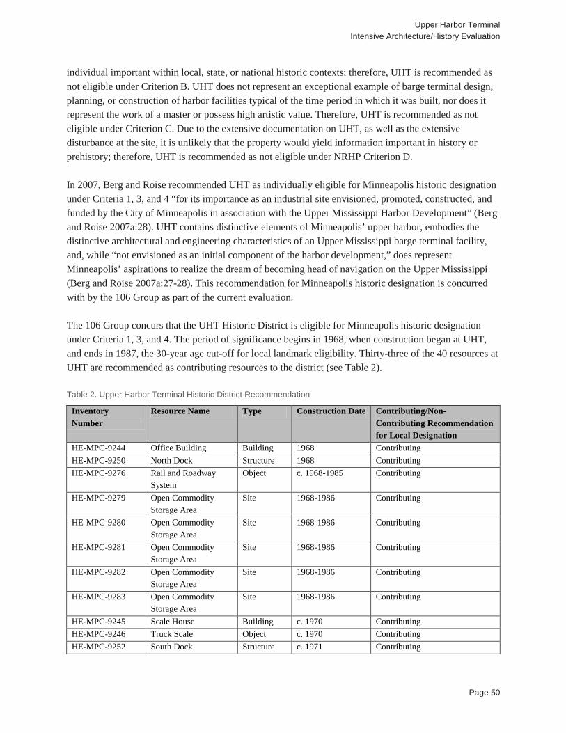
Upper Harbor Terminal Intensive Architecture/History Evaluation
Page 50
individual important within local, state, or national historic contexts; therefore, UHT is recommended as not eligible under Criterion B. UHT does not represent an exceptional example of barge terminal design, planning, or construction of harbor facilities typical of the time period in which it was built, nor does it represent the work of a master or possess high artistic value. Therefore, UHT is recommended as not eligible under Criterion C. Due to the extensive documentation on UHT, as well as the extensive disturbance at the site, it is unlikely that the property would yield information important in history or prehistory; therefore, UHT is recommended as not eligible under NRHP Criterion D. In 2007, Berg and Roise recommended UHT as individually eligible for Minneapolis historic designation under Criteria 1, 3, and 4 “for its importance as an industrial site envisioned, promoted, constructed, and funded by the City of Minneapolis in association with the Upper Mississippi Harbor Development” (Berg and Roise 2007a:28). UHT contains distinctive elements of Minneapolis’ upper harbor, embodies the distinctive architectural and engineering characteristics of an Upper Mississippi barge terminal facility, and, while “not envisioned as an initial component of the harbor development,” does represent Minneapolis’ aspirations to realize the dream of becoming head of navigation on the Upper Mississippi (Berg and Roise 2007a:27-28). This recommendation for Minneapolis historic designation is concurred with by the 106 Group as part of the current evaluation. The 106 Group concurs that the UHT Historic District is eligible for Minneapolis historic designation under Criteria 1, 3, and 4. The period of significance begins in 1968, when construction began at UHT, and ends in 1987, the 30-year age cut-off for local landmark eligibility. Thirty-three of the 40 resources at UHT are recommended as contributing resources to the district (see Table 2). Table 2. Upper Harbor Terminal Historic District Recommendation
Inventory Number
Resource Name Type Construction Date Contributing/Non-Contributing Recommendation for Local Designation
HE-MPC-9244 Office Building Building 1968 Contributing HE-MPC-9250 North Dock Structure 1968 Contributing HE-MPC-9276 Rail and Roadway
System Object c. 1968-1985 Contributing
HE-MPC-9279 Open Commodity Storage Area
Site 1968-1986 Contributing
HE-MPC-9280 Open Commodity Storage Area
Site 1968-1986 Contributing
HE-MPC-9281 Open Commodity Storage Area
Site 1968-1986 Contributing
HE-MPC-9282 Open Commodity Storage Area
Site 1968-1986 Contributing
HE-MPC-9283 Open Commodity Storage Area
Site 1968-1986 Contributing
HE-MPC-9245 Scale House Building c. 1970 Contributing HE-MPC-9246 Truck Scale Object c. 1970 Contributing HE-MPC-9252 South Dock Structure c. 1971 Contributing
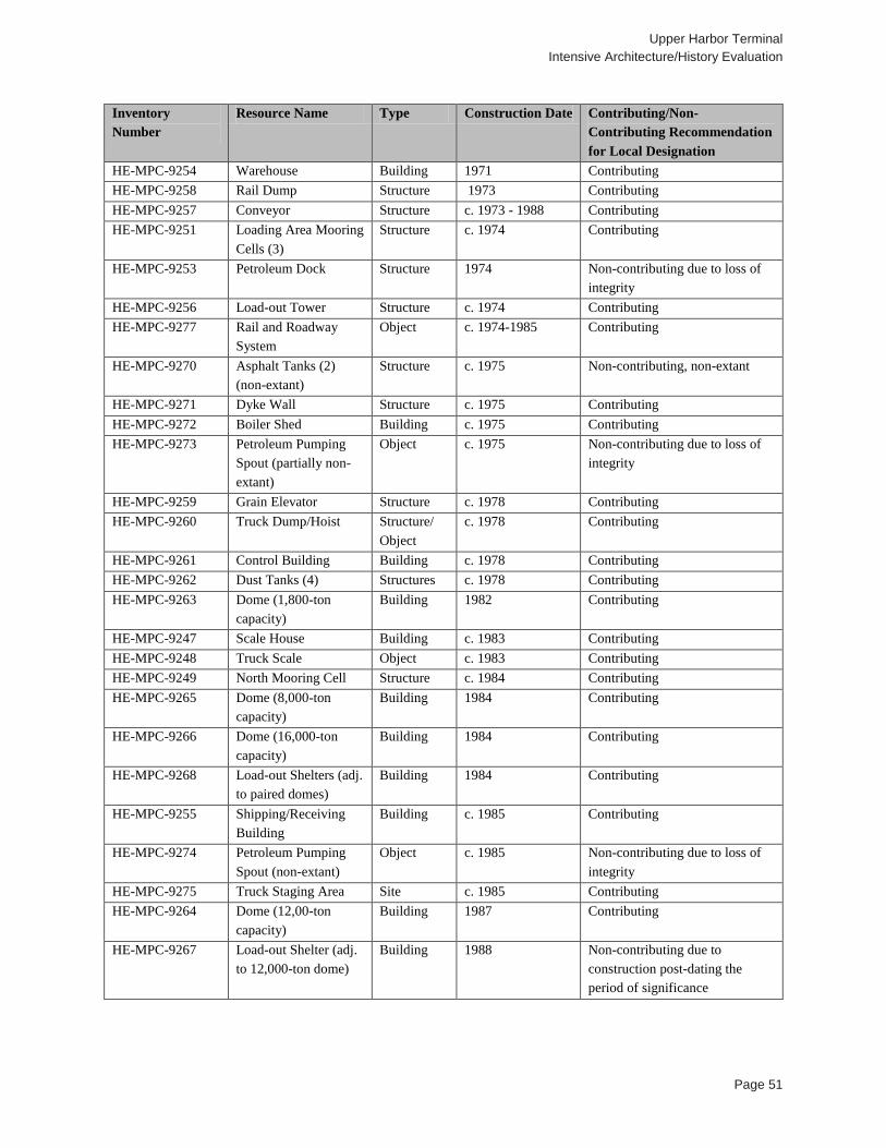
Upper Harbor Terminal Intensive Architecture/History Evaluation
Page 51
Inventory Number
Resource Name Type Construction Date Contributing/Non-Contributing Recommendation for Local Designation
HE-MPC-9254 Warehouse Building 1971 Contributing HE-MPC-9258 Rail Dump Structure 1973 Contributing HE-MPC-9257 Conveyor Structure c. 1973 - 1988 Contributing HE-MPC-9251 Loading Area Mooring
Cells (3) Structure c. 1974 Contributing
HE-MPC-9253 Petroleum Dock Structure 1974 Non-contributing due to loss of integrity
HE-MPC-9256 Load-out Tower Structure c. 1974 Contributing HE-MPC-9277 Rail and Roadway
System Object c. 1974-1985 Contributing
HE-MPC-9270 Asphalt Tanks (2) (non-extant)
Structure c. 1975 Non-contributing, non-extant
HE-MPC-9271 Dyke Wall Structure c. 1975 Contributing HE-MPC-9272 Boiler Shed Building c. 1975 Contributing HE-MPC-9273 Petroleum Pumping
Spout (partially non-extant)
Object c. 1975 Non-contributing due to loss of integrity
HE-MPC-9259 Grain Elevator Structure c. 1978 Contributing HE-MPC-9260 Truck Dump/Hoist Structure/
Object c. 1978 Contributing
HE-MPC-9261 Control Building Building c. 1978 Contributing HE-MPC-9262 Dust Tanks (4) Structures c. 1978 Contributing HE-MPC-9263 Dome (1,800-ton
capacity) Building 1982 Contributing
HE-MPC-9247 Scale House Building c. 1983 Contributing HE-MPC-9248 Truck Scale Object c. 1983 Contributing HE-MPC-9249 North Mooring Cell Structure c. 1984 Contributing HE-MPC-9265 Dome (8,000-ton
capacity) Building 1984 Contributing
HE-MPC-9266 Dome (16,000-ton capacity)
Building 1984 Contributing
HE-MPC-9268 Load-out Shelters (adj. to paired domes)
Building 1984 Contributing
HE-MPC-9255 Shipping/Receiving Building
Building c. 1985 Contributing
HE-MPC-9274 Petroleum Pumping Spout (non-extant)
Object c. 1985 Non-contributing due to loss of integrity
HE-MPC-9275 Truck Staging Area Site c. 1985 Contributing HE-MPC-9264 Dome (12,00-ton
capacity) Building 1987 Contributing
HE-MPC-9267 Load-out Shelter (adj. to 12,000-ton dome)
Building 1988 Non-contributing due to construction post-dating the period of significance
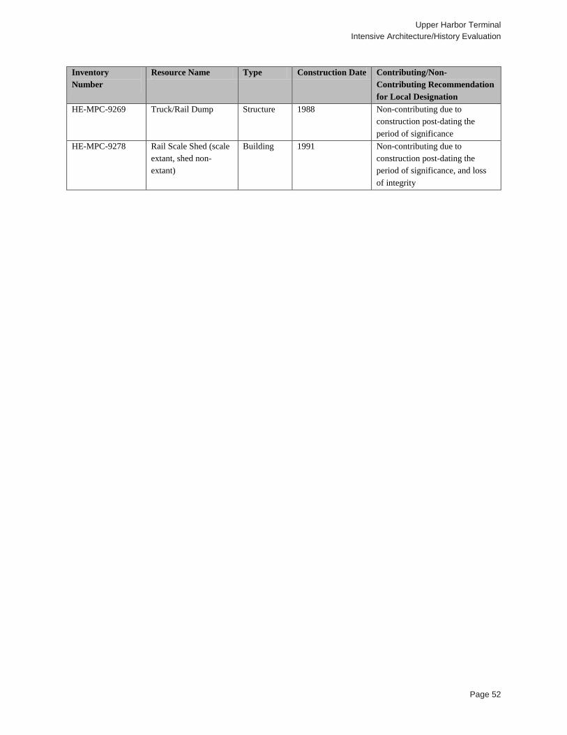
Upper Harbor Terminal Intensive Architecture/History Evaluation
Page 52
Inventory Number
Resource Name Type Construction Date Contributing/Non-Contributing Recommendation for Local Designation
HE-MPC-9269 Truck/Rail Dump Structure 1988 Non-contributing due to construction post-dating the period of significance
HE-MPC-9278 Rail Scale Shed (scale extant, shed non-extant)
Building 1991 Non-contributing due to construction post-dating the period of significance, and loss of integrity
Upper Harbor Terminal Intensive Architecture/History Evaluation
Page 53
5.2 Four Monolithic Domes (HE-MPC-9263, HE-MPC-9264, HE-MPC-9265, HE-MPC-9266)
Location: Upper Harbor Terminal, Minneapolis, Hennepin County Description: UHT contains four Monolithic Domes, all of which are described in detail below (see Figure 18; Table 3). Table 3. Monolithic Domes
Inventory Number Resource Name Type Construction Date HE-MPC-9263 Monolithic Dome (1,800 ton) Structure 1982 HE-MPC-9264 Monolithic Dome (12,000 ton) Structure 1987 HE-MPC-9265 Monolithic Dome (8,000 ton) Structure 1984 HE-MPC-9266 Monolithic Dome (16,000 ton) Structure 1984
HE-MPC-9263 Description: This dome is the northernmost of the four domes at UHT, located just to the north of the extension of Dowling Avenue (see Figures 18-20). It is also the smallest of the four to be constructed and was the first built. The dome was designed by Monolithic Dome, a company from Idaho that originally developed domes for potato storage in the mid-1970s. This dome was designed in December of 1981, by Monolithic’s structural engineer Arnold Wilson, and construction by Monolithic was completed in 1982. The dome is 90 feet in diameter and 30 feet high (Wilson 1981; Personal Communication, Cynthia Teer, Monolithic Constructors, Inc., March 2017). The structure was formed by inflating a large fabric membrane, spraying the inside with three inches of polyurethane foam followed by reinforced concrete (South 2014). According to cross sections, the concrete shell is five inches thick at the floor, six inches thick up to the height of 22 feet and then three inches thick above that, and includes radial steel up to 22 feet in height. The structure includes a 16 foot wide by 12 foot high door that projects from the south elevation. The door is supported by a five foot by 12 inch thick concrete beam. This dome was built to hold fill up to a height of 25 feet (Wilson 1981). The dome has a storage capacity of 1,800 tons, and historically held fertilizer (Berg and Roise 2007b). The fabric membrane has deteriorated in many places, exposing the polyurethane foam beneath which is also deteriorating. HE-MPC-9264 Description: This dome is located in the center of UHT, was constructed in 1987, has a capacity of 12,000 tons, and historically held fertilizer (see Figures 18, 21 and 22) (Berg and Roise 2007b). The dome was designed by Monolithic Dome, a company from Idaho that originally developed domes for potato storage in the mid-1970s. The structure was formed by inflating a large fabric membrane, spraying the inside with three inches of polyurethane foam that was followed by reinforced concrete (South 2014). According to site plans, this dome is 132 feet in diameter and 66 feet tall (Dome Systems Corporation 1988). Cross sections for this structure were not found in order to provide more construction details. The fabric membrane has deteriorated in many places, exposing the polyurethane foam beneath. This dome is connected to an overhead conveyor.
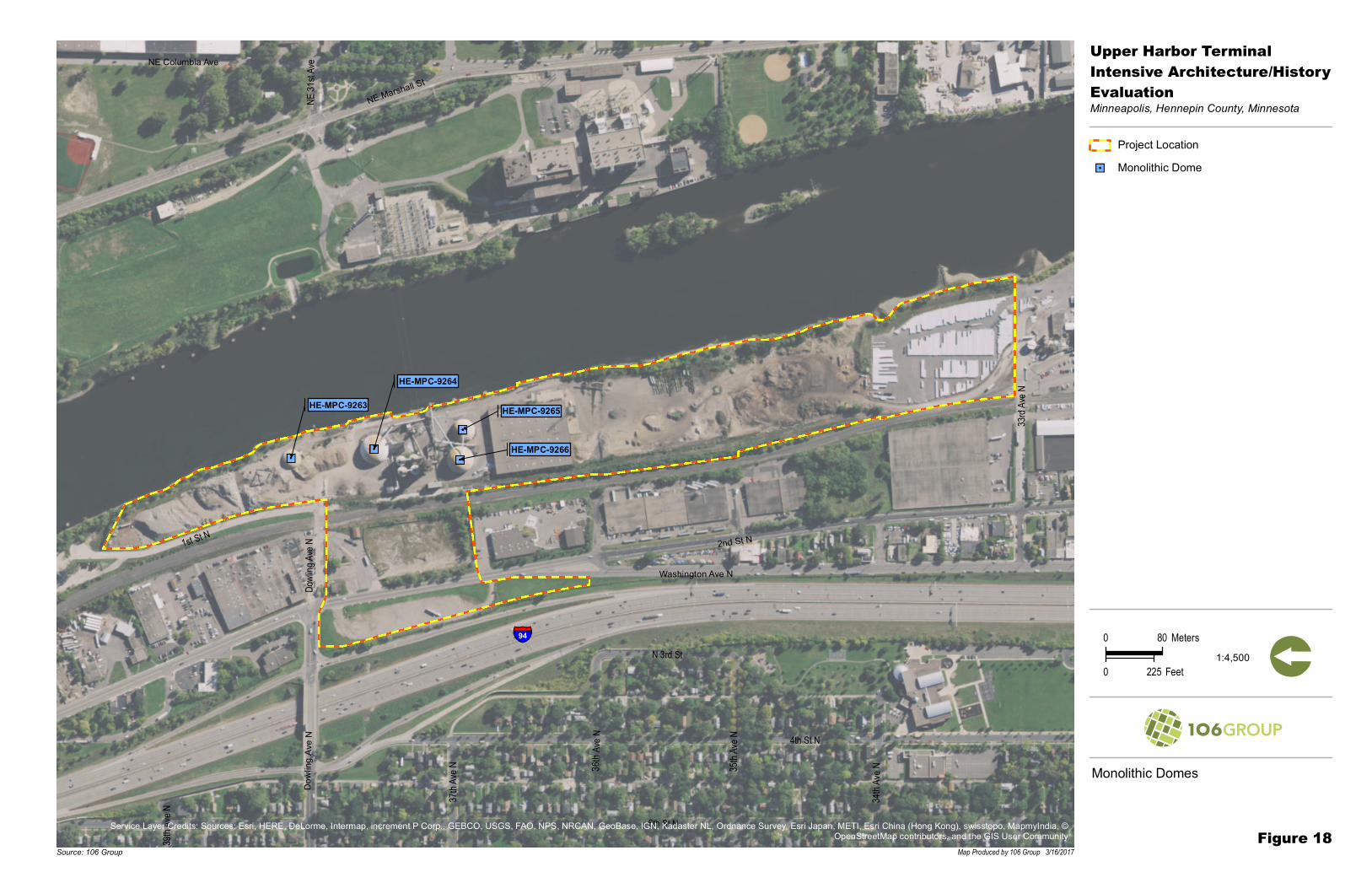
HE-MPC-9263
HE-MPC-9264
HE-MPC-9265
HE-MPC-9266
39th A
ve N 37t
h Ave
N 35th A
ve N
34th A
ve N36 t
h Ave
N 4th St N
6th St N
Dowli
ng Ave
N
N 3rd St
33rd A
ve N
1st St N
NE 31
st Ave
Dowl
ingA v
e N
NE Columbia Ave
2nd St N
NE Marshall St
Washington Ave N
§̈¦94
Monolithic Domes
Project Location""! Monolithic Dome
Figure 18
Upper Harbor TerminalIntensive Architecture/HistoryEvaluationMinneapolis, Hennepin County, Minnesota
Map Produced by 106 Group 3/16/2017Source: 106 Group
0 80 Meters
0 225 Feet [1:4,500
Service Layer Credits: Sources: Esri, HERE, DeLorme, Intermap, increment P Corp., GEBCO, USGS, FAO, NPS, NRCAN, GeoBase, IGN, Kadaster NL, Ordnance Survey, Esri Japan, METI, Esri China (Hong Kong), swisstopo, MapmyIndia, ©OpenStreetMap contributors, and the GIS User Community

Upper Harbor Terminal Intensive Architecture/History Evaluation
Page 55
Figure 19. Monolithic Dome (HE-MPC-9263), Facing Northeast
Figure 20. Interior of Monolithic Dome (HE-MPC-9263) (City of Minneapolis)
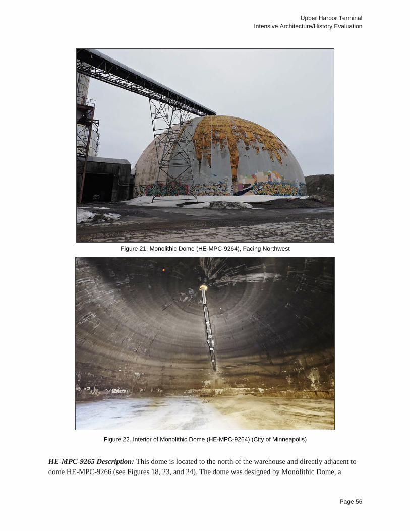
Upper Harbor Terminal Intensive Architecture/History Evaluation
Page 56
Figure 21. Monolithic Dome (HE-MPC-9264), Facing Northwest
Figure 22. Interior of Monolithic Dome (HE-MPC-9264) (City of Minneapolis)
HE-MPC-9265 Description: This dome is located to the north of the warehouse and directly adjacent to dome HE-MPC-9266 (see Figures 18, 23, and 24). The dome was designed by Monolithic Dome, a

Upper Harbor Terminal Intensive Architecture/History Evaluation
Page 57
company from Idaho that originally developed domes for potato storage in the mid-1970s. The structure was formed by inflating a large fabric membrane, spraying the inside with three inches of polyurethane foam followed by reinforced concrete (South 2014). No plans or cross sections could be located for this dome. The dome was built in 1984, has a diameter of 107 feet, a storage capacity of 8,000 tons, and historically held fertilizer (Berg and Roise 2007b; University of Minnesota 2017d). The fabric membrane has deteriorated in many places, exposing the polyurethane foam beneath which is also deteriorating on the north half. This dome is connected to an overhead conveyor. HE-MPC-9266 Description: This dome is located north of the warehouse and adjacent to dome HE-MPC-9265 (see Figure 18, Figure 25, and Figure 26). The dome was designed and built by Monolithic Dome in 1984, a company from Idaho that originally developed domes for potato storage in the mid-1970s (Packer River Terminal 1984; Personal Communication, Cynthia Teer, Monolithic Constructors, Inc., March 2017). The structure was formed by inflating a large fabric membrane, spraying the inside with three inches of polyurethane foam followed by reinforced concrete (South 2014). According to cross sections, the dome is 122 feet in diameter and 80 feet high. The concrete shell varies is width: up to 15 feet high it is 10 inches thick, then up to 35 feet high it is 8 inches thick, then up to 55 feet high it is 6 inches thick, and up to 80 feet it is 4 inches thick. The thickness of the rebar also varied, increasing in thickness as the structure gets higher. The dome includes an 18 foot wide by 14 foot tall door (Packer River Terminal 1984). The dome has a storage capacity of 16,000 tons and historically held fertilizer (Berg and Roise 2007b). The fabric membrane has deteriorated in many places, exposing the polyurethane foam beneath in many locations.
Figure 23. Monolithic Dome (HE-MPC-9265), Facing Northwest
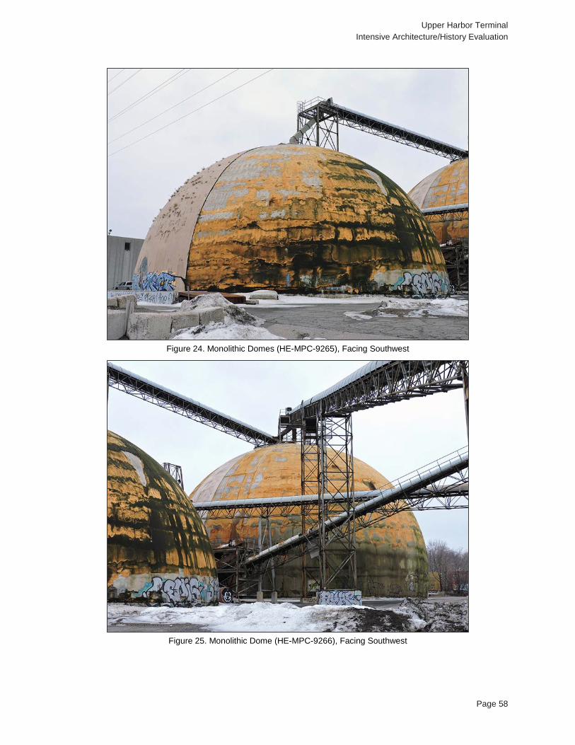
Upper Harbor Terminal Intensive Architecture/History Evaluation
Page 58
Figure 24. Monolithic Domes (HE-MPC-9265), Facing Southwest
Figure 25. Monolithic Dome (HE-MPC-9266), Facing Southwest
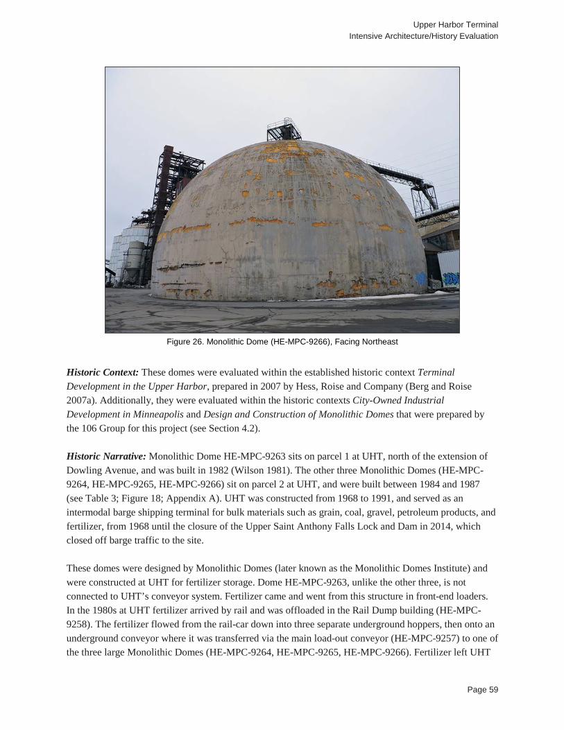
Upper Harbor Terminal Intensive Architecture/History Evaluation
Page 59
Figure 26. Monolithic Dome (HE-MPC-9266), Facing Northeast
Historic Context: These domes were evaluated within the established historic context Terminal Development in the Upper Harbor, prepared in 2007 by Hess, Roise and Company (Berg and Roise 2007a). Additionally, they were evaluated within the historic contexts City-Owned Industrial Development in Minneapolis and Design and Construction of Monolithic Domes that were prepared by the 106 Group for this project (see Section 4.2). Historic Narrative: Monolithic Dome HE-MPC-9263 sits on parcel 1 at UHT, north of the extension of Dowling Avenue, and was built in 1982 (Wilson 1981). The other three Monolithic Domes (HE-MPC-9264, HE-MPC-9265, HE-MPC-9266) sit on parcel 2 at UHT, and were built between 1984 and 1987 (see Table 3; Figure 18; Appendix A). UHT was constructed from 1968 to 1991, and served as an intermodal barge shipping terminal for bulk materials such as grain, coal, gravel, petroleum products, and fertilizer, from 1968 until the closure of the Upper Saint Anthony Falls Lock and Dam in 2014, which closed off barge traffic to the site. These domes were designed by Monolithic Domes (later known as the Monolithic Domes Institute) and were constructed at UHT for fertilizer storage. Dome HE-MPC-9263, unlike the other three, is not connected to UHT’s conveyor system. Fertilizer came and went from this structure in front-end loaders. In the 1980s at UHT fertilizer arrived by rail and was offloaded in the Rail Dump building (HE-MPC-9258). The fertilizer flowed from the rail-car down into three separate underground hoppers, then onto an underground conveyor where it was transferred via the main load-out conveyor (HE-MPC-9257) to one of the three large Monolithic Domes (HE-MPC-9264, HE-MPC-9265, HE-MPC-9266). Fertilizer left UHT
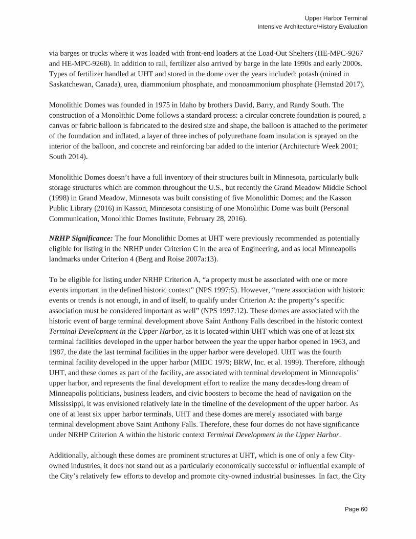
Upper Harbor Terminal Intensive Architecture/History Evaluation
Page 60
via barges or trucks where it was loaded with front-end loaders at the Load-Out Shelters (HE-MPC-9267 and HE-MPC-9268). In addition to rail, fertilizer also arrived by barge in the late 1990s and early 2000s. Types of fertilizer handled at UHT and stored in the dome over the years included: potash (mined in Saskatchewan, Canada), urea, diammonium phosphate, and monoammonium phosphate (Hemstad 2017). Monolithic Domes was founded in 1975 in Idaho by brothers David, Barry, and Randy South. The construction of a Monolithic Dome follows a standard process: a circular concrete foundation is poured, a canvas or fabric balloon is fabricated to the desired size and shape, the balloon is attached to the perimeter of the foundation and inflated, a layer of three inches of polyurethane foam insulation is sprayed on the interior of the balloon, and concrete and reinforcing bar added to the interior (Architecture Week 2001; South 2014). Monolithic Domes doesn’t have a full inventory of their structures built in Minnesota, particularly bulk storage structures which are common throughout the U.S., but recently the Grand Meadow Middle School (1998) in Grand Meadow, Minnesota was built consisting of five Monolithic Domes; and the Kasson Public Library (2016) in Kasson, Minnesota consisting of one Monolithic Dome was built (Personal Communication, Monolithic Domes Institute, February 28, 2016). NRHP Significance: The four Monolithic Domes at UHT were previously recommended as potentially eligible for listing in the NRHP under Criterion C in the area of Engineering, and as local Minneapolis landmarks under Criterion 4 (Berg and Roise 2007a:13). To be eligible for listing under NRHP Criterion A, “a property must be associated with one or more events important in the defined historic context” (NPS 1997:5). However, “mere association with historic events or trends is not enough, in and of itself, to qualify under Criterion A: the property’s specific association must be considered important as well” (NPS 1997:12). These domes are associated with the historic event of barge terminal development above Saint Anthony Falls described in the historic context Terminal Development in the Upper Harbor, as it is located within UHT which was one of at least six terminal facilities developed in the upper harbor between the year the upper harbor opened in 1963, and 1987, the date the last terminal facilities in the upper harbor were developed. UHT was the fourth terminal facility developed in the upper harbor (MIDC 1979; BRW, Inc. et al. 1999). Therefore, although UHT, and these domes as part of the facility, are associated with terminal development in Minneapolis’ upper harbor, and represents the final development effort to realize the many decades-long dream of Minneapolis politicians, business leaders, and civic boosters to become the head of navigation on the Mississippi, it was envisioned relatively late in the timeline of the development of the upper harbor. As one of at least six upper harbor terminals, UHT and these domes are merely associated with barge terminal development above Saint Anthony Falls. Therefore, these four domes do not have significance under NRHP Criterion A within the historic context Terminal Development in the Upper Harbor. Additionally, although these domes are prominent structures at UHT, which is one of only a few City-owned industries, it does not stand out as a particularly economically successful or influential example of the City’s relatively few efforts to develop and promote city-owned industrial businesses. In fact, the City
Upper Harbor Terminal Intensive Architecture/History Evaluation
Page 61
restricted industrial zoning in Minneapolis two decades before UHT was established, as well as in two subsequent ordinances during UHT’s development, indicating a switch in the City’s focus to other types of commercial efforts to develop the City’s economic base. In addition, as a City-owned industry, UHT and the fertilizer shipping which relied on storage at the domes employed a relatively small workforce, was heavily subsidized throughout most of its existence, and was established simultaneous to the construction of the Interstate Highway System through Minnesota, which provided a cost-effective alternative to shipping some products handled by UHT. While barge shipping may have remained the most cost-effective method of transport for other products, because the overall minimum tonnage requirement to justify the cost of operating the Upper Lock was not consistently being met, barge traffic was not able to remain the most overall cost-effective method when the cost of operating the Upper Lock was factored in. Eventually, truck transportation replaced both rail and river transportation to and from the UHT site, resulting in the closure of the property’s barge terminal operations. Therefore, these domes do not have significance under NRHP Criterion A within the historic context City-Owned Industrial Developments in Minneapolis. To be eligible for listing under NRHP Criterion B, a property must be associated with “individuals whose activities are demonstrably important within a local, State, or national historic context,” and the property must “illustrate ... a person’s important achievements” (NPS 1997:14). There are no known individuals associated with these domes that are significant within a local, state, or national historic context. Therefore, these domes do not have significance under NRHP Criterion B. To be eligible for listing under NRHP Criterion C, a property must “embody distinctive characteristics of a type, period, or method of construction; represent the work of a master; possess high artistic value; [or] represent a significant and distinguishable entity whose components may lack individual distinction” (NPS 1997:17). These domes were constructed between 1982 and 1987 based on designs by Monolithic Domes. Monolithic Domes were first constructed in 1975 and the design and construction method for the dome was patented in 1979. While these domes have no architectural style, but rather are utilitarian structures, it appears they follow the general form and construction methods of the patented Monolithic Dome, and therefore are representative of a particular type and method of construction. These domes retain all characteristics of a Monolithic Dome, including parts of the outer fabric membrane, the polyurethane and reinforced concrete structure, as well as the interior vent shaft and bang walls, and the entry doors. A comprehensive set of plans and sections have not been located for these domes, and therefore, a comparative analysis between the four domes could not be conducted in order to determine if one of them best represents the Monolithic Domes type and method of construction. These four domes are the only known structures of this type located in Minneapolis, all of which retain the primary characteristics of the patented dome design. Therefore, individually all four of these domes have local significance under NRHP Criterion C within the area of Engineering, as exceptional examples of an important structural type that was designed for bulk storage, the Monolithic Dome. To be eligible for listing under NRHP Criterion D, a property “must have, or have had, information to contribute to our understanding of human history or prehistory, and the information must be considered important” (NPS 1997:20). The construction of these domes between 1982 and 1987 does not contribute
Upper Harbor Terminal Intensive Architecture/History Evaluation
Page 62
to our understanding of human history or prehistory, and therefore, does not have significance under NRHP Criterion D. These domes have significance under NRHP Criterion C within the area of Engineering; however they were also evaluated under NRHP Criteria Consideration G, because they were built less than 50 years ago. To meet Criteria Consideration G, a property that is 50 years of age or younger must demonstrate “exceptional importance” (NPS 1997:41-42). NPS notes that “‘exceptional importance’ may be applied to the extraordinary importance of an event or to an entire category of resources so fragile that survivors of any age are unusual” (NPS 1997:42). These domes were built between 1982 and 1987 based on designs by Monolithic Domes. While an important engineering design, other types and forms of monolithic domes have been around for thousands of years, so the construction of these domes does not constitute an extraordinary event. Additionally, the company founded by the patent holders of the Monolithic Dome, Monolithic Domes/Monolithic Domes Institute, has built more than 4,000 structures in 49 states and 53 countries since 1975 (South 2014). Therefore, these domes do not represent a fragile category of resources, and do not appear to have significance under NRHP Criterion Consideration G. Local Landmark Significance: Under Chapter 599 of Title 23 of the Minneapolis Code of Ordinances, the Minneapolis HPC is authorized to “make recommendations to the city council on the proposed designation of landmarks and historic districts” (City of Minneapolis 2016c). These domes do not appear to be “associated with significant events or with periods that exemplify broad patterns of cultural, political, economic or social history,” and therefore they do not have local significance under HPC Criterion 1 (City of Minneapolis 2016c). These domes do not appear to be “associated with the lives of significance person or groups,” and therefore, they do not have local significance under HPC Criterion 2 (City of Minneapolis 2016c). Collectively, these four domes represent an iconic visual feature of the Minneapolis riverfront and its history of terminal shipping and industrial storage, and as such are “associated with distinctive elements of city or neighborhood identity,” and therefore, collectively they have local significance under HPC Criterion 3 (City of Minneapolis 2016c). These four domes embody the distinctive characteristics of an engineering type and method of construction, following the form and design of the patented Monolithic Dome. A comprehensive set of plans and sections have not been located for these domes, and therefore, a comparative analysis between the four domes could not be conducted in order to determine if one of them best represents the Monolithic Domes type and method of construction. Therefore, individually all four of these domes have local significance under HPC Criterion 4. These domes do not exemplify “a landscape designed or development pattern distinguished by innovation, rarity, uniqueness or quality of design or detail,” and therefore, they do not have local significance under HPC Criterion 5 (City of Minneapolis 2016c).
Upper Harbor Terminal Intensive Architecture/History Evaluation
Page 63
These domes do not exemplify “works of master builders, engineers, designers, artists, craftsmen or architects,” and therefore, they do not have local significance under HPC Criterion 6 (City of Minneapolis 2016c). It is unlikely that these domes would yield information important in prehistory or history, and therefore, they do not have local significance under HPC Criterion 7. Although these domes do not have exceptional significance under NRHP Criterion Consideration G, for planning and survey purposes the City of Minneapolis generally uses a 30-year benchmark in order for properties to be eligible for local designation as landmarks or historic districts without meeting exceptional significance (Personal Communication, Brian Schaffer, CPED, March 9, 2017). Therefore, the local designation period of significance would be the year in which each of these domes were built, 1982, 1984, and 1987. Integrity: These four monolithic domes retain excellent integrity of location as they remain in their original location. The area of northern Minneapolis where UHT and these domes are sited has largely remained a commercial and industrial center with residential properties west of I-94. Roadways that bound and access the site have remained relatively unchanged from the site’s original construction to the present (University of Minnesota 2017b; Hennepin County 2017). These domes were constructed during the fourth stage of expansion at UHT between 1982 and 1987, which followed construction of the majority of the buildings and structures at the site, most of which remain extant. Therefore, these domes retain excellent integrity of setting. These domes retain their original size and form as designed by Monolithic Dome in 1982, 1984, and 1987 respectively. The exterior fabric membrane on all four of them has deteriorated in places, exposing the polyurethane foam beneath which is also deteriorating. However, this natural deterioration does not adversely affect the integrity of materials. Overall, the domes retain excellent integrity of the design, materials, and workmanship. The appearance, ownership, and use of these domes have been retained overtime, and therefore, they retain excellent integrity of feeling and association. Overall, these domes retain excellent integrity. Recommendation: Collectively, these four domes represent an iconic visual feature of the Minneapolis riverfront and its history of terminal shipping and industrial storage, and therefore, collectively they have local significance under HPC Criterion 3. Individually, these domes embody the distinctive characteristics of an engineering type and method of construction, following the form and design of the patented Monolithic Dome, and therefore, they have local significance under HPC Criterion 4. The period of significance for local landmark designation is the domes respective construction dates of 1982, 1984, and 1987. Individually, these four domes do not have significance for listing in the NRHP.
Upper Harbor Terminal Intensive Architecture/History Evaluation
Page 64
These four domes are also contributing resources to the UHT Historic District (HE-MPC-9699), which is recommended as eligible for Minneapolis historic designation under Criteria 1, 3, and 4. The UHT Historic District is recommended as not eligible for listing in the NRHP (see Section 5.1).
Upper Harbor Terminal Intensive Architecture/History Evaluation
Page 65
6.0 RECOMMENDATIONS As a result of the intensive architecture/history evaluation, the UHT Historic District and the four Monolithic Domes have been recommended as eligible as local Minneapolis landmarks. The properties are recommended as not eligible for listing in the NRHP.
Upper Harbor Terminal Intensive Architecture/History Evaluation
Page 66
REFERENCES CITED Anfinson, John O.
2003 River of History: A Historic Resources Study of the Mississippi National River and Recreation Area. Saint Paul District of the U. S. Army Corps of Engineers, Saint Paul, Minnesota.
Anfinson, Scott
1989 Archaeology of the Central Minneapolis Waterfront, Part 1: Historical Overview and Archaeological Potentials. Minnesota Archaeologist Vol. 48.
Architecture Week
2001 Building Monolithic Domes. Electronic document, http://www.architectureweek.com/2001/0328/building_1-1.html, accessed March 1, 2017.
Association of American Railroads
2016 A Short History of U.S. Freight Railroads. Electronic document, https://www.aar.org/BackgroundPapers/Railroad%20History%20May%202016.pdf, accessed February 25, 2017.
Benneche, H.W.
1914 Atlas of Minneapolis, Hennepin County, Minnesota, Including Parts of St. Louis Park and Golden Valley Township in Hennepin County, Also Part of Ramsey County Known as the Midway District. Minneapolis Real Estate Board, Minneapolis, Minnesota.
Berg, Melvin H.
1968 Report on Economic and Engineering Study of Upper Harbor Terminal, Minneapolis, Minn. Prepared for Department of Public Works. On file at the Minnesota Historical Society, Saint Paul, Minnesota.
1969 Physical Facilities Inventory, Minnesota Waterborne Transportation. Prepared for the
Minnesota State Planning Agency. On file at the Minnesota Historical Society, Saint Paul. Berg, Erin Hanafin and Charlene Roise
2007a Upper Mississippi Harbor Development Architectural/Historical Survey. Prepared by Hess, Roise and Company. On file at the Minnesota Historic Preservation Office, Saint Paul, Minnesota.
2007b Minnesota Architecture/History Inventory Form for the Upper Harbor Terminal. Hess, Roise
and Company. On file at the Minnesota Historic Preservation Office, Saint Paul, Minnesota.

Upper Harbor Terminal Intensive Architecture/History Evaluation
Page 67
Braun Intertec Corporation [Braun Intertec] 2015 Phase I Environmental Site Assessment, Upper Harbor Terminal, Nine Parcels North of 33rd
Avenue North, West of Mississippi River, Minneapolis, Minnesota. Prepared for City of Minneapolis and Minneapolis Park and Recreation Board. On file at the City of Minneapolis, Minneapolis, Minnesota.
BRW, Inc. et al.
1999 Above the Falls: A Master Plan for the Upper River in Minneapolis. Prepared for Minneapolis Park and Recreation Board, Hennepin County, Minneapolis Planning Department, and Minneapolis Community Development Agency.
Buckminster Fuller Institute
2017 Geodesic Domes. Electronic document, https://www.bfi.org/about-fuller/big-ideas/geodesic-domes, accessed March 2, 2017.
Citizens League
1965 Citizens League Report No. 177: Should the Minneapolis Workhouse be Transferred to Hennepin Co. Electronic document, https://citizensleague.org/wp-content/uploads/2013/07/177.Report.Should-the-Workhouse-be-Transferred-to-Hennepin-Co.pdf, accessed February 20, 2017.
City of Minneapolis
1910 Annual Report of the Workhouse. City of Minneapolis, Minneapolis, Minnesota. 1968 Building Permit # B407973. On file at Minneapolis Development Review, Minneapolis,
Minnesota. 1970 Building Permit # B425510. On file at Minneapolis Development Review, Minneapolis,
Minnesota. 1973 Building Permit #B442880. On file at Minneapolis Development Review, Minneapolis,
Minnesota. 1994 Upper Harbor Terminal: History, Status, and Options. City of Minneapolis, Minneapolis,
Minnesota.
2003 Request for City Council Committee Action from the Department of Community Planning and Economic Development, November 10, 2003. Electronic document, http://www.ci.minneapolis.mn.us/www/groups/public/@council/documents/webcontent/convert_276152.pdf, accessed February 22, 2017.
Upper Harbor Terminal Intensive Architecture/History Evaluation
Page 68
2009 Minneapolis Plan for Sustainable Growth. Electronic document, http://www.ci.minneapolis.mn.us/cped/planning/cped_comp_plan_update_draft_plan, accessed March 23, 2017.
2010 Request for City Council Committee Action from the Department of Community Planning and
Economic Development, April 20, 2010. Electronic document, http://www.minneapolismn.gov/www/groups/public/@council/documents/webcontent/convert_271136.pdf, accessed February 22, 2017.
2014 Zoning Maps. Electronic document,
http://www.ci.minneapolis.mn.us/zoningmaps/zoning_maps_index, accessed March 23, 2017. 2016a Official Proceedings Minneapolis City Council, Regular Meeting of November 18, 2016.
Electronic document, http://www.minneapolismn.gov/www/groups/public/@council/documents/proceedings/wcmsp-190517.pdf, accessed February 23, 2017.
2016b Upper Harbor Terminal Phase I Redevelopment. Electronic document,
http://www.minnesotabids.com/government-agencies/hennepin/minneapolis-community-planning-and-economic-development-cped-115540/7234427-upper-harbor-terminal-phase-1-redevelopment.html, accessed February 20, 2017.
2016c Title 23 - Heritage Preservation, Chapter 599 - Heritage Preservation Regulations. Electronic
document, https://www.municode.com/library/mn/minneapolis/codes/code_of_ordinances?nodeId=MICOOR_TIT23HEPR_CH599HEPRRE_ARTIIDUDEMABOOF_599.120HEPRCO, accessed January 28, 2017.
2017a City Services Directory. Electronic document, http://apps.ci.minneapolis.mn.us/deptdirapp/,
accessed February 22, 2017.
2017b Upper Harbor. Electronic document, http://upperharbormpls.com/, accessed February 22, 2017.
City of Minneapolis and Minneapolis Park & Recreation Board
2016 UHT Existing Structures. Electronic document, http://upperharbormpls.com/uht-existing-structures/, accessed March 3, 2017.
Ching, Francis D.K.
1996 Architecture: Form, Space, and Order. Second Edition. John Wiley & Sons, Inc., New York, New York.
Upper Harbor Terminal Intensive Architecture/History Evaluation
Page 69
Community-Wealth.Org 2017 Municipal Enterprise. Electronic document, http://community-
wealth.org/strategies/panel/municipal/index.html, accessed February 10, 2017. Corporation for Enterprise Development
2011 Building Economic Securities in America’s Cities: New Municipal Strategies for Asset Building and Financial Empowerment. Corporation for Enterprise Development, Washington, D.C.
Dollhausen, Christina
1997 Upper Harbor Terminal Policy & Action Research Project Report. Prepared for the Neighborhood Planning for Community Revitalization, Minneapolis, Minnesota.
Dome Systems Corporation
1988 Packer River Terminal, Urea Storage Facility, Site Plan. On file at the Upper Harbor Terminal, Minneapolis, Minnesota.
Egan, James E.
1903 Atlas of the City of Minneapolis. City of Minneapolis, Minneapolis, Minnesota. Electronic document, http://geo.lib.umn.edu/collections/digitizedplatbooks/minn1903index.htm, accessed February 22, 2017.
Emporis
2017a Lund Martin Construction, Inc. Electronic document, https://www.emporis.com/companies/157920/lund-martin-construction-inc-minneapolis-mn-usa, accessed March 3, 2017.
2017b Lovering Construction Company. Electronic document,
https://www.emporis.com/companies/125678/lovering-construction-company-st-paul-mn-usa, accessed March 3, 2017.
2017c T.E. Ibberson Company. Electronic document, https://www.emporis.com/companies/218171/t-
e-ibberson-company-hopkins-mn-usa, accessed March 3, 2017. Foote, C.M.
1892 City of Minneapolis. Electronic document, http://geo.lib.umn.edu/collections/digitizedplatbooks/minn1892index.htm, accessed February 22, 2017.
Hemstad, Michael
2017 Material Flow through Upper Harbor Terminal. Unpublished field notes, on file at SEH and 106 Group, St. Paul, Minnesota.
Upper Harbor Terminal Intensive Architecture/History Evaluation
Page 70
Hennepin County Assessor’s Office [Hennepin County] 2017 Hennepin County Property Data. Electronic document, https://gis.hennepin.us/property/map/,
accessed February 22, 2017. Hess Roise and SEH
2015 Existing Condition Inspection and Re-Use Report: Upper Harbor Terminal, City of Minneapolis, Minnesota. Prepared for the Minneapolis Community Planning and Economic Development Department. On file at the City of Minneapolis, Minneapolis, Minnesota.
Hines, Rachel
2015 Living With the Mississippi: Who Owns the River? River Life. Electronic document, http://riverlife.umn.edu/2015/03/living-with-the-mississippi-who-owns-the-river/, accessed February 22, 2017.
Hudson, Horace B.
1908 A Half Century of Minneapolis. Hudson Publishing Company, Minneapolis, Minnesota. Hult, Karen M.
1987 Agency Merger and Bureaucratic Redesign. University of Pittsburgh Press, Pittsburgh, Pennsylvania.
Indianapolis Star [Indianapolis, Indiana]
1993 Equipment Auction. 24 January 1993. Indianapolis Star, Indianapolis, Indiana. Justia
2017a Wellons, Inc., a Corporation, Appellant, v. T.e. Ibberson Company and Ibberson Engineering, Inc.,formerly Known As Kibcor Engineering, Inc.,corporations, Appellees, 869 F.2d 1166 (8th Cir. 1989). Electronic document, http://law.justia.com/cases/federal/appellate-courts/F2/869/1166/339743/, accessed March 3, 2017.
2017b M.S.M. Corporation v. Knutson Company. Electronic document, http://law.justia.com/cases/minnesota/supreme-court/1969/41354-1.html, accessed March 3, 2017.
Kane, Lucile
1966 The Waterfall That Built A City. Minnesota Historical Society, Saint Paul, Minnesota. Kibcor Engineering Company
1979 Site Plan. On file at the Upper Harbor Terminal, Minneapolis, Minnesota.
1980a Dust Syst. - Receiving Conveyor L101. On file at the Upper Harbor Terminal, Minneapolis, Minnesota.
Upper Harbor Terminal Intensive Architecture/History Evaluation
Page 71
1980b Upper Conveyor Sections. On file at the Upper Harbor Terminal, Minneapolis, Minnesota.
Lager, William
2015 Upper St. Anthony Lock Closing After Half A Century; Blame the Carp. MPR News. Electronic document, http://www.mprnews.org/story/2015/06/08/upper-st-anthony-lock, accessed February 22, 2017.
Lukermann, Barbara, Judith A. Martin, and Sandra de Montille
1991 Vacant Lands in Minneapolis and St. Paul: An Examination of the Urban Land Market in the Central City. Center for Urban and Regional Affairs, Minneapolis, Minnesota.
Mead and Hunt
2011 Historic Resources Inventory: Historic Resources in the Camden Area including the Victory, Shingle Creek, Webber-Camden, Humboldt Industrial Area, and Lind-Bohanon Neighborhoods, and Portions of the Folwell, McKinley, and Cleveland Neighborhoods. Report Prepared for the City of Minneapolis, Minneapolis, Minnesota.
Mill City Museum
2016 Flour Milling History. Electronic document, http://www.millcitymuseum.org/flour-milling-history, accessed February 22, 2016.
Minneapolis Industrial Development Committee [MIDC]
1979 A Report on the Minneapolis Upper Harbor Terminal. Minneapolis Industrial Development Committee, Minneapolis, Minnesota.
1980 Data for Review of MIDC’s Role in Economic Development. Minneapolis Industrial
Development Committee, Minneapolis, Minnesota. Minneapolis Morning Tribune [Minneapolis, Minnesota]
1911 “City Workhouse Pays Big Profit in 1910.” 17 January 1911, Minneapolis Morning Tribune, Minneapolis, Minnesota.
Minnesota Department of Transportation [MnDOT]
2013 Minnesota’s River Terminals. Minnesota Department of Transportation, Saint Paul, Minnesota. Minnesota Historic Preservation Office [MnHPO]
2010 Guidelines for History/Architecture Projects in Minnesota. Electronic document, http://www.mnhs.org/shpo/survey/docs_pdfs/HistoryArchitectureSurveyManualOctober2010.pdf, accessed January 3, 2017.

Upper Harbor Terminal Intensive Architecture/History Evaluation
Page 72
Minnesota Office of the State Auditor [OSA] 2004 Special Study: Municipal Enterprise Activities. Electronic document,
https://www.auditor.state.mn.us/reports/gid/2004/enterprise/enterprise_04_overview.pdf, accessed February 27, 2017.
Mott Company
1971 Upper Harbor Municipal Terminal Warehouse - Layout and Detail of Counter Shaft Pier. On file at the Upper Harbor Terminal, Minneapolis, Minnesota.
1973 Conveyor Elevations. On file at the Upper Harbor Terminal, Minneapolis, Minnesota.
MSM Corporation
1977 Layout Truck Dump and Conveyor System. On file at the Upper Harbor Terminal, Minneapolis, Minnesota.
National Environmental Title Research, LLC [NETR]
1991 Historical Aerial Photograph, Ramsey County, Minnesota. Electronic document, http://historicaerials.com/, accessed February 13, 2017.
2003 Historical Aerial Photograph, Ramsey County, Minnesota. Electronic document,
http://historicaerials.com/, accessed February 13, 2017.
2010 Historical Aerial Photograph, Ramsey County, Minnesota. Electronic document, http://historicaerials.com/, accessed February 13, 2017.
2013 Historical Aerial Photograph, Ramsey County, Minnesota. Electronic document,
http://historicaerials.com/, accessed February 13, 2017. National League of Cities
2016 City Fiscal Conditions in 2014. Electronic document, http://www.nlc.org/resource/city-fiscal-conditions-in-2014-0, accessed February 20, 2017.
National Park Service [NPS]
1983 Secretary of the Interior’s Standards and Guidelines for Archeology and Historic Preservation. Federal Register 48(190):44716-4474
1997 National Register Bulletin: How to Apply the National Register Criteria for Evaluation. United
States Department of the Interior, Washington, D.C.
2016a Lock and Dam No. 1. Electronic document, https://www.nps.gov/miss/planyourvisit/lockdam1.htm, accessed February 22, 2017.

Upper Harbor Terminal Intensive Architecture/History Evaluation
Page 73
2016b Lock and Dam No. 2. Electronic document, https://www.nps.gov/miss/planyourvisit/lockdam2.htm, accessed February 22, 2017.
2017 National Register of Historic Places Search. Electronic document, https://npgallery.nps.gov/nrhp,
accessed March 7, 2017. Packer River Terminal
1984 Packer River Terminal Dome. Cross Section. On file at Upper Harbor Terminal, Minneapolis, Minnesota.
Parker, Freda
2009 Dr. Arnold Wilson and the Ream’s Turtle. Electronic document, http://www.monolithic.org/benefits/benefits-strength/dr-arnold-wilson-and-the-ream-s-turtle, accessed March 6, 2017.
2011 Dr. Arnold Wilson and Domes – Past, Present and Future. Electronic document,
http://www.monolithic.org/dr-wilson/dr-arnold-wilson-and-domes-past-present-and-future, accessed March 1, 2017.
Peterson, Garneth O. and Carole Zellie
1998 North Minneapolis Historic Context Study. Submitted to the Minneapolis Heritage Preservation Commission and the Minneapolis Planning Department. Landscape Research, Saint Paul, Minnesota.
Pioneer Press
2010 St. Paul Engineering Firm TKDA Marks a Century of Building City’s Most-Known Landmarks. Electronic document, http://www.twincities.com/2010/05/25/st-paul-engineering-firm-tkda-marks-a-century-of-building-citys-most-known-landmarks/, accessed March 14, 2017.
Porter Grain Systems Inc.
1984 Potash and Urea Domes and Loadout Shelter. On file at the Upper Harbor Terminal, Minneapolis, Minnesota.
Sepic, Matt
2015 After Waterway Closure, Minneapolis Sees an End to River Shipping. Electronic document, http://www.npr.org/2015/06/22/414897901/after-waterway-closure-minneapolis-sees-an-end-to-river-shipping, accessed February 23, 2017.
South, David
2011 Anatomy of a Monolithic Bulk Storage. Electronic document, http://www.monolithic.org/storages/more/anatomy-of-a-monolithic-bulk-storage, accessed March 2, 2017.

Upper Harbor Terminal Intensive Architecture/History Evaluation
Page 74
2014 The Birth of the Monolithic Dome – A Closer Look. Electronic document,
http://www.monolithic.org/blogs/presidents-sphere/birth-of-the-monolithic-dome-a-closer-look, accessed February 23, 2017.
2015 The first fertilizer storage and a barbed wire plaque. Electronic document,
http://www.monolithic.org/blogs/presidents-sphere/first-fertilizer-storage, accessed February 23, 2017.
Stark, William E. and John Lauber
2009 Historic Resources Inventory: Northside Industrial Area, Minneapolis, Hennepin County, Minnesota. Prepared for City of Minneapolis Department of Community Planning & Economic Development, and Minnesota State Historic Preservation Office.
System Companies
2017 Porter Grain Systems, Inc. Electronic document, https://www.systemcompanies.org/porter-grain-systems-inc, accessed March 3, 2017.
Toltz, King, Duvall, Anderson, and Associates [TKDA]
1970a Scale Masters’ House: Floor Plan, Schedules & Details. On file at the Upper Harbor Terminal, Minneapolis, Minnesota.
1970b Scale Masters’ House: Electrical Plan & Details. On file at the Upper Harbor Terminal,
Minneapolis, Minnesota.
1973 Plans for Barge Mooring Cells. On file at the Upper Harbor Terminal, Minneapolis, Minnesota.
1974 City of Minneapolis Municipal River Terminal Railroad Truck Layout. On file at the Upper Harbor Terminal, Minneapolis, Minnesota.
1975a Site Plan Fuel Oil Storage & Handling Facilities. On file at the Upper Harbor Terminal,
Minneapolis, Minnesota.
1975b Railroad Extension - Phase III. On file at the Upper Harbor Terminal, Minneapolis, Minnesota.
2017 Our Story. Electronic document, http://www.tkda.com/our-company/our-story/, accessed February 20, 2017.
United States Army Corps of Engineers (USACE)
1996 Draft Environmental Impact Statement: 9-Foot Navigation Channel Project, Channel Maintenance Management Plan, Upper Mississippi River, Head of Navigation to Guttenberg, Iowa. USACE, Saint Paul, Minnesota.

Upper Harbor Terminal Intensive Architecture/History Evaluation
Page 75
United States Geological Survey [USGS]
2010 Historical Aerial Photograph, Hennepin County, Minnesota. Electronic document, accessed March 2, 2017.
2016 Historical Aerial Photograph, Hennepin County, Minnesota. Electronic document, accessed
March 2, 2017. University of Minnesota
2017a Minnesota Historical Aerial Photographs Online, Hennepin County, 1970. Electronic document, https://www.lib.umn.edu/apps/mhapo/, accessed March 1, 2017.
2017b Minnesota Historical Aerial Photographs Online, Hennepin County, 1974. Electronic
document, https://www.lib.umn.edu/apps/mhapo/, accessed March 1, 2017.
2017c Minnesota Historical Aerial Photographs Online, Hennepin County, 1978. Electronic document, https://www.lib.umn.edu/apps/mhapo/, accessed March 1, 2017.
2017d Minnesota Historical Aerial Photographs Online, Hennepin County, 1983. Electronic
document, https://www.lib.umn.edu/apps/mhapo/, accessed March 1, 2017.
2017e Minnesota Historical Aerial Photographs Online, Hennepin County, 1993. Electronic document, https://www.lib.umn.edu/apps/mhapo/, accessed March 1, 2017.
Wilson, Arnold
1981 Circular Concrete Dome, Minneapolis, Minnesota. Cross Section. Structural Engineer, Arnold Wilson. On file at Upper Harbor Terminal, Minneapolis, Minnesota.

APPENDIX A: ALTA 2015 SURVEY
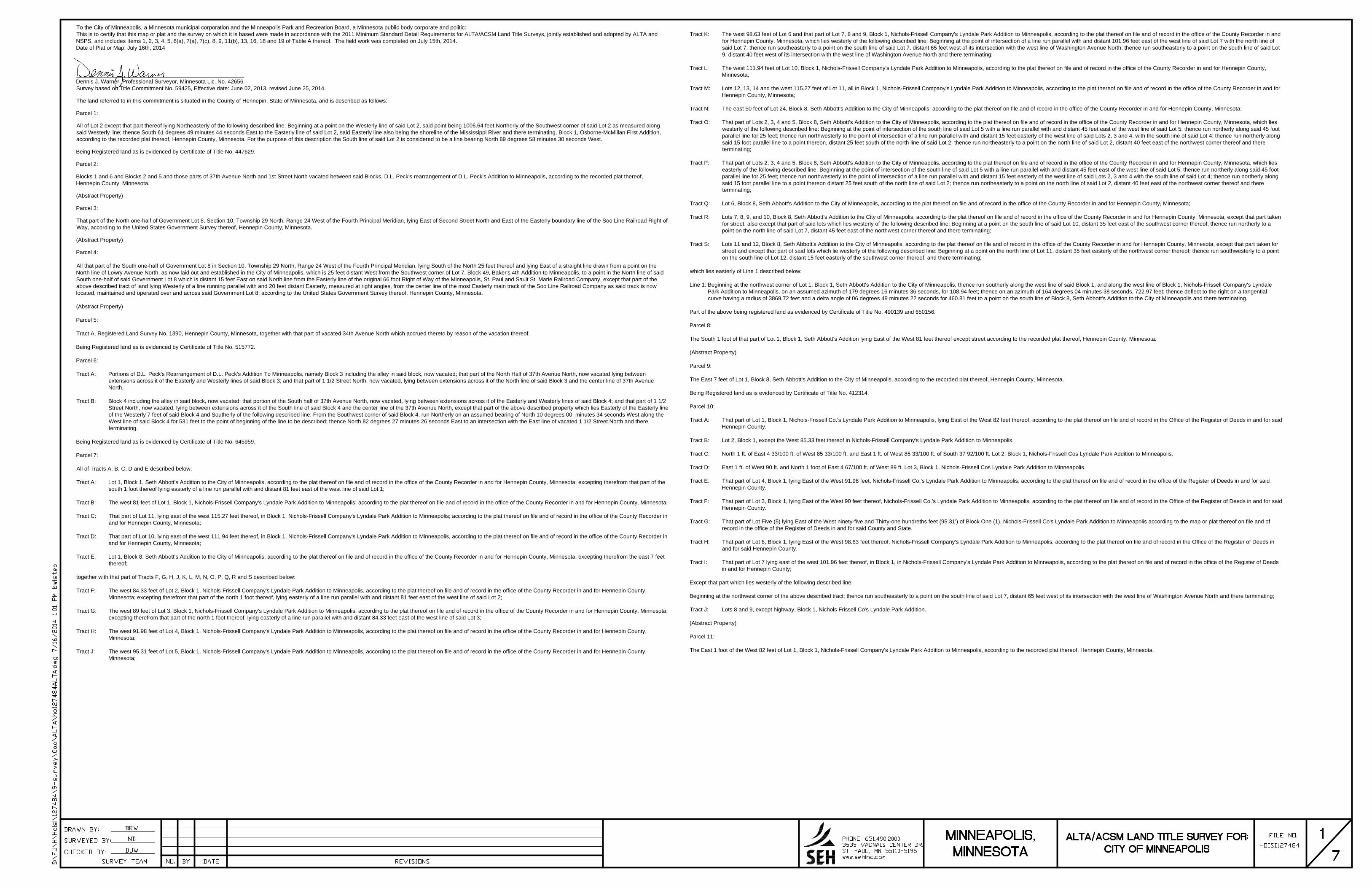
To the City of Minneapolis, a Minnesota municipal corporation and the Minneapolis Park and Recreation Board, a Minnesota public body corporate and politic:This is to certify that this map or plat and the survey on which it is based were made in accordance with the 2011 Minimum Standard Detail Requirements for ALTA/ACSM Land Title Surveys, jointly established and adopted by ALTA andNSPS, and includes Items 1, 2, 3, 4, 5, 6(a), 7(a), 7(c), 8, 9, 11(b), 13, 16, 18 and 19 of Table A thereof. The field work was completed on July 15th, 2014.Date of Plat or Map: July 16th, 2014
______________________________________________________Dennis J. Warner, Professional Surveyor, Minnesota Lic. No. 42656Survey based on Title Commitment No. 59425, Effective date: June 02, 2013, revised June 25, 2014.
The land referred to in this commitment is situated in the County of Hennepin, State of Minnesota, and is described as follows:
Parcel 1:
All of Lot 2 except that part thereof lying Northeasterly of the following described line: Beginning at a point on the Westerly line of said Lot 2, said point being 1006.64 feet Northerly of the Southwest corner of said Lot 2 as measured alongsaid Westerly line; thence South 61 degrees 49 minutes 44 seconds East to the Easterly line of said Lot 2, said Easterly line also being the shoreline of the Mississippi River and there terminating, Block 1, Osborne-McMillan First Addition,according to the recorded plat thereof, Hennepin County, Minnesota. For the purpose of this description the South line of said Lot 2 is considered to be a line bearing North 89 degrees 58 minutes 30 seconds West.
Being Registered land as is evidenced by Certificate of Title No. 447629.
Parcel 2:
Blocks 1 and 6 and Blocks 2 and 5 and those parts of 37th Avenue North and 1st Street North vacated between said Blocks, D.L. Peck's rearrangement of D.L. Peck's Addition to Minneapolis, according to the recorded plat thereof,Hennepin County, Minnesota.
(Abstract Property)
Parcel 3:
That part of the North one-half of Government Lot 8, Section 10, Township 29 North, Range 24 West of the Fourth Principal Meridian, lying East of Second Street North and East of the Easterly boundary line of the Soo Line Railroad Right ofWay, according to the United States Government Survey thereof, Hennepin County, Minnesota.
(Abstract Property)
Parcel 4:
All that part of the South one-half of Government Lot 8 in Section 10, Township 29 North, Range 24 West of the Fourth Principal Meridian, lying South of the North 25 feet thereof and lying East of a straight line drawn from a point on theNorth line of Lowry Avenue North, as now laid out and established in the City of Minneapolis, which is 25 feet distant West from the Southwest corner of Lot 7, Block 49, Baker's 4th Addition to Minneapolis, to a point in the North line of saidSouth one-half of said Government Lot 8 which is distant 15 feet East on said North line from the Easterly line of the original 66 foot Right of Way of the Minneapolis, St. Paul and Sault St. Marie Railroad Company, except that part of theabove described tract of land lying Westerly of a line running parallel with and 20 feet distant Easterly, measured at right angles, from the center line of the most Easterly main track of the Soo Line Railroad Company as said track is nowlocated, maintained and operated over and across said Government Lot 8; according to the United States Government Survey thereof, Hennepin County, Minnesota.
(Abstract Property)
Parcel 5:
Tract A, Registered Land Survey No. 1390, Hennepin County, Minnesota, together with that part of vacated 34th Avenue North which accrued thereto by reason of the vacation thereof.
Being Registered land as is evidenced by Certificate of Title No. 515772.
Parcel 6:
Tract A: Portions of D.L. Peck's Rearrangement of D.L. Peck's Addition To Minneapolis, namely Block 3 including the alley in said block, now vacated; that part of the North Half of 37th Avenue North, now vacated lying betweenextensions across it of the Easterly and Westerly lines of said Block 3; and that part of 1 1/2 Street North, now vacated, lying between extensions across it of the North line of said Block 3 and the center line of 37th AvenueNorth.
Tract B: Block 4 including the alley in said block, now vacated; that portion of the South half of 37th Avenue North, now vacated, lying between extensions across it of the Easterly and Westerly lines of said Block 4; and that part of 1 1/2Street North, now vacated, lying between extensions across it of the South line of said Block 4 and the center line of the 37th Avenue North, except that part of the above described property which lies Easterly of the Easterly lineof the Westerly 7 feet of said Block 4 and Southerly of the following described line: From the Southwest corner of said Block 4, run Northerly on an assumed bearing of North 10 degrees 00 minutes 34 seconds West along theWest line of said Block 4 for 531 feet to the point of beginning of the line to be described; thence North 82 degrees 27 minutes 26 seconds East to an intersection with the East line of vacated 1 1/2 Street North and thereterminating.
Being Registered land as is evidenced by Certificate of Title No. 645959.
Parcel 7:
All of Tracts A, B, C, D and E described below:
Tract A: Lot 1, Block 1, Seth Abbott's Addition to the City of Minneapolis, according to the plat thereof on file and of record in the office of the County Recorder in and for Hennepin County, Minnesota; excepting therefrom that part of thesouth 1 foot thereof lying easterly of a line run parallel with and distant 81 feet east of the west line of said Lot 1;
Tract B: The west 81 feet of Lot 1, Block 1, Nichols-Frissell Company's Lyndale Park Addition to Minneapolis, according to the plat thereof on file and of record in the office of the County Recorder in and for Hennepin County, Minnesota;
Tract C: That part of Lot 11, lying east of the west 115.27 feet thereof, in Block 1, Nichols-Frissell Company's Lyndale Park Addition to Minneapolis; according to the plat thereof on file and of record in the office of the County Recorder inand for Hennepin County, Minnesota;
Tract D: That part of Lot 10, lying east of the west 111.94 feet thereof, in Block 1, Nichols-Frissell Company's Lyndale Park Addition to Minneapolis, according to the plat thereof on file and of record in the office of the County Recorder inand for Hennepin County, Minnesota;
Tract E: Lot 1, Block 8, Seth Abbott's Addition to the City of Minneapolis, according to the plat thereof on file and of record in the office of the County Recorder in and for Hennepin County, Minnesota; excepting therefrom the east 7 feetthereof;
together with that part of Tracts F, G, H, J, K, L, M, N, O, P, Q, R and S described below:
Tract F: The west 84.33 feet of Lot 2, Block 1, Nichols-Frissell Company's Lyndale Park Addition to Minneapolis, according to the plat thereof on file and of record in the office of the County Recorder in and for Hennepin County,Minnesota; excepting therefrom that part of the north 1 foot thereof, lying easterly of a line run parallel with and distant 81 feet east of the west line of said Lot 2;
Tract G: The west 89 feet of Lot 3, Block 1, Nichols-Frissell Company's Lyndale Park Addition to Minneapolis, according to the plat thereof on file and of record in the office of the County Recorder in and for Hennepin County, Minnesota;excepting therefrom that part of the north 1 foot thereof, lying easterly of a line run parallel with and distant 84.33 feet east of the west line of said Lot 3;
Tract H: The west 91.98 feet of Lot 4, Block 1, Nichols-Frissell Company's Lyndale Park Addition to Minneapolis, according to the plat thereof on file and of record in the office of the County Recorder in and for Hennepin County,Minnesota;
Tract J: The west 95.31 feet of Lot 5, Block 1, Nichols-Frissell Company's Lyndale Park Addition to Minneapolis, according to the plat thereof on file and of record in the office of the County Recorder in and for Hennepin County,Minnesota;
Tract K: The west 98.63 feet of Lot 6 and that part of Lot 7, 8 and 9, Block 1, Nichols-Frissell Company's Lyndale Park Addition to Minneapolis, according to the plat thereof on file and of record in the office of the County Recorder in andfor Hennepin County, Minnesota, which lies westerly of the following described line: Beginning at the point of intersection of a line run parallel with and distant 101.96 feet east of the west line of said Lot 7 with the north line ofsaid Lot 7; thence run southeasterly to a point on the south line of said Lot 7, distant 65 feet west of its intersection with the west line of Washington Avenue North; thence run southeasterly to a point on the south line of said Lot9, distant 40 feet west of its intersection with the west line of Washington Avenue North and there terminating;
Tract L: The west 111.94 feet of Lot 10, Block 1, Nichols-Frissell Company's Lyndale Park Addition to Minneapolis, according to the plat thereof on file and of record in the office of the County Recorder in and for Hennepin County,Minnesota;
Tract M: Lots 12, 13, 14 and the west 115.27 feet of Lot 11, all in Block 1, Nichols-Frissell Company's Lyndale Park Addition to Minneapolis, according to the plat thereof on file and of record in the office of the County Recorder in and forHennepin County, Minnesota;
Tract N: The east 50 feet of Lot 24, Block 8, Seth Abbott's Addition to the City of Minneapolis, according to the plat thereof on file and of record in the office of the County Recorder in and for Hennepin County, Minnesota;
Tract O: That part of Lots 2, 3, 4 and 5, Block 8, Seth Abbott's Addition to the City of Minneapolis, according to the plat thereof on file and of record in the office of the County Recorder in and for Hennepin County, Minnesota, which lieswesterly of the following described line: Beginning at the point of intersection of the south line of said Lot 5 with a line run parallel with and distant 45 feet east of the west line of said Lot 5; thence run northerly along said 45 footparallel line for 25 feet; thence run northwesterly to the point of intersection of a line run parallel with and distant 15 feet easterly of the west line of said Lots 2, 3 and 4, with the south line of said Lot 4; thence run northerly alongsaid 15 foot parallel line to a point thereon, distant 25 feet south of the north line of said Lot 2; thence run northeasterly to a point on the north line of said Lot 2, distant 40 feet east of the northwest corner thereof and thereterminating;
Tract P: That part of Lots 2, 3, 4 and 5, Block 8, Seth Abbott's Addition to the City of Minneapolis, according to the plat thereof on file and of record in the office of the County Recorder in and for Hennepin County, Minnesota, which lieseasterly of the following described line: Beginning at the point of intersection of the south line of said Lot 5 with a line run parallel with and distant 45 feet east of the west line of said Lot 5; thence run northerly along said 45 footparallel line for 25 feet; thence run northwesterly to the point of intersection of a line run parallel with and distant 15 feet easterly of the west line of said Lots 2, 3 and 4 with the south line of said Lot 4; thence run northerly alongsaid 15 foot parallel line to a point thereon distant 25 feet south of the north line of said Lot 2; thence run northeasterly to a point on the north line of said Lot 2, distant 40 feet east of the northwest corner thereof and thereterminating;
Tract Q: Lot 6, Block 8, Seth Abbott's Addition to the City of Minneapolis, according to the plat thereof on file and of record in the office of the County Recorder in and for Hennepin County, Minnesota;
Tract R: Lots 7, 8, 9, and 10, Block 8, Seth Abbott's Addition to the City of Minneapolis, according to the plat thereof on file and of record in the office of the County Recorder in and for Hennepin County, Minnesota, except that part takenfor street; also except that part of said lots which lies westerly of the following described line: Beginning at a point on the south line of said Lot 10, distant 35 feet east of the southwest corner thereof; thence run northerly to apoint on the north line of said Lot 7, distant 45 feet east of the northwest corner thereof and there terminating;
Tract S: Lots 11 and 12, Block 8, Seth Abbott's Addition to the City of Minneapolis, according to the plat thereof on file and of record in the office of the County Recorder in and for Hennepin County, Minnesota, except that part taken forstreet and except that part of said lots which lie westerly of the following described line: Beginning at a point on the north line of Lot 11, distant 35 feet easterly of the northwest corner thereof; thence run southwesterly to a pointon the south line of Lot 12, distant 15 feet easterly of the southwest corner thereof, and there terminating;
which lies easterly of Line 1 described below:
Line 1: Beginning at the northwest corner of Lot 1, Block 1, Seth Abbott's Addition to the City of Minneapolis, thence run southerly along the west line of said Block 1, and along the west line of Block 1, Nichols-Frissell Company's LyndalePark Addition to Minneapolis, on an assumed azimuth of 179 degrees 16 minutes 36 seconds, for 108.94 feet; thence on an azimuth of 164 degrees 04 minutes 38 seconds, 722.97 feet; thence deflect to the right on a tangentialcurve having a radius of 3869.72 feet and a delta angle of 06 degrees 49 minutes 22 seconds for 460.81 feet to a point on the south line of Block 8, Seth Abbott's Addition to the City of Minneapolis and there terminating.
Part of the above being registered land as evidenced by Certificate of Title No. 490139 and 650156.
Parcel 8:
The South 1 foot of that part of Lot 1, Block 1, Seth Abbott's Addition lying East of the West 81 feet thereof except street according to the recorded plat thereof, Hennepin County, Minnesota.
(Abstract Property)
Parcel 9:
The East 7 feet of Lot 1, Block 8, Seth Abbott's Addition to the City of Minneapolis, according to the recorded plat thereof, Hennepin County, Minnesota.
Being Registered land as is evidenced by Certificate of Title No. 412314.
Parcel 10:
Tract A: That part of Lot 1, Block 1, Nichols-Frissell Co.'s Lyndale Park Addition to Minneapolis, lying East of the West 82 feet thereof, according to the plat thereof on file and of record in the Office of the Register of Deeds in and for saidHennepin County.
Tract B: Lot 2, Block 1, except the West 85.33 feet thereof in Nichols-Frissell Company's Lyndale Park Addition to Minneapolis.
Tract C: North 1 ft. of East 4 33/100 ft. of West 85 33/100 ft. and East 1 ft. of West 85 33/100 ft. of South 37 92/100 ft. Lot 2, Block 1, Nichols-Frissell Cos Lyndale Park Addition to Minneapolis.
Tract D: East 1 ft. of West 90 ft. and North 1 foot of East 4 67/100 ft. of West 89 ft. Lot 3, Block 1, Nichols-Frissell Cos Lyndale Park Addition to Minneapolis.
Tract E: That part of Lot 4, Block 1, lying East of the West 91.98 feet, Nichols-Frissell Co.'s Lyndale Park Addition to Minneapolis, according to the plat thereof on file and of record in the office of the Register of Deeds in and for saidHennepin County.
Tract F: That part of Lot 3, Block 1, lying East of the West 90 feet thereof, Nichols-Frissell Co.'s Lyndale Park Addition to Minneapolis, according to the plat thereof on file and of record in the Office of the Register of Deeds in and for saidHennepin County.
Tract G: That part of Lot Five (5) lying East of the West ninety-five and Thirty-one hundreths feet (95.31') of Block One (1), Nichols-Frissell Co's Lyndale Park Addition to Minneapolis according to the map or plat thereof on file and ofrecord in the office of the Register of Deeds in and for said County and State.
Tract H: That part of Lot 6, Block 1, lying East of the West 98.63 feet thereof, Nichols-Frissell Company's Lyndale Park Addition to Minneapolis, according to the plat thereof on file and of record in the Office of the Register of Deeds inand for said Hennepin County.
Tract I: That part of Lot 7 lying east of the west 101.96 feet thereof, in Block 1, in Nichols-Frissell Company's Lyndale Park Addition to Minneapolis, according to the plat thereof on file and of record in the office of the Register of Deedsin and for Hennepin County;
Except that part which lies westerly of the following described line:
Beginning at the northwest corner of the above described tract; thence run southeasterly to a point on the south line of said Lot 7, distant 65 feet west of its intersection with the west line of Washington Avenue North and there terminating;
Tract J: Lots 8 and 9, except highway, Block 1, Nichols Frissell Co's Lyndale Park Addition.
(Abstract Property)
Parcel 11:
The East 1 foot of the West 82 feet of Lot 1, Block 1, Nichols-Frissell Company's Lyndale Park Addition to Minneapolis, according to the recorded plat thereof, Hennepin County, Minnesota.

SE
E P
AG
E 3
SEE PAGE 6
SE
E P
AG
E 6
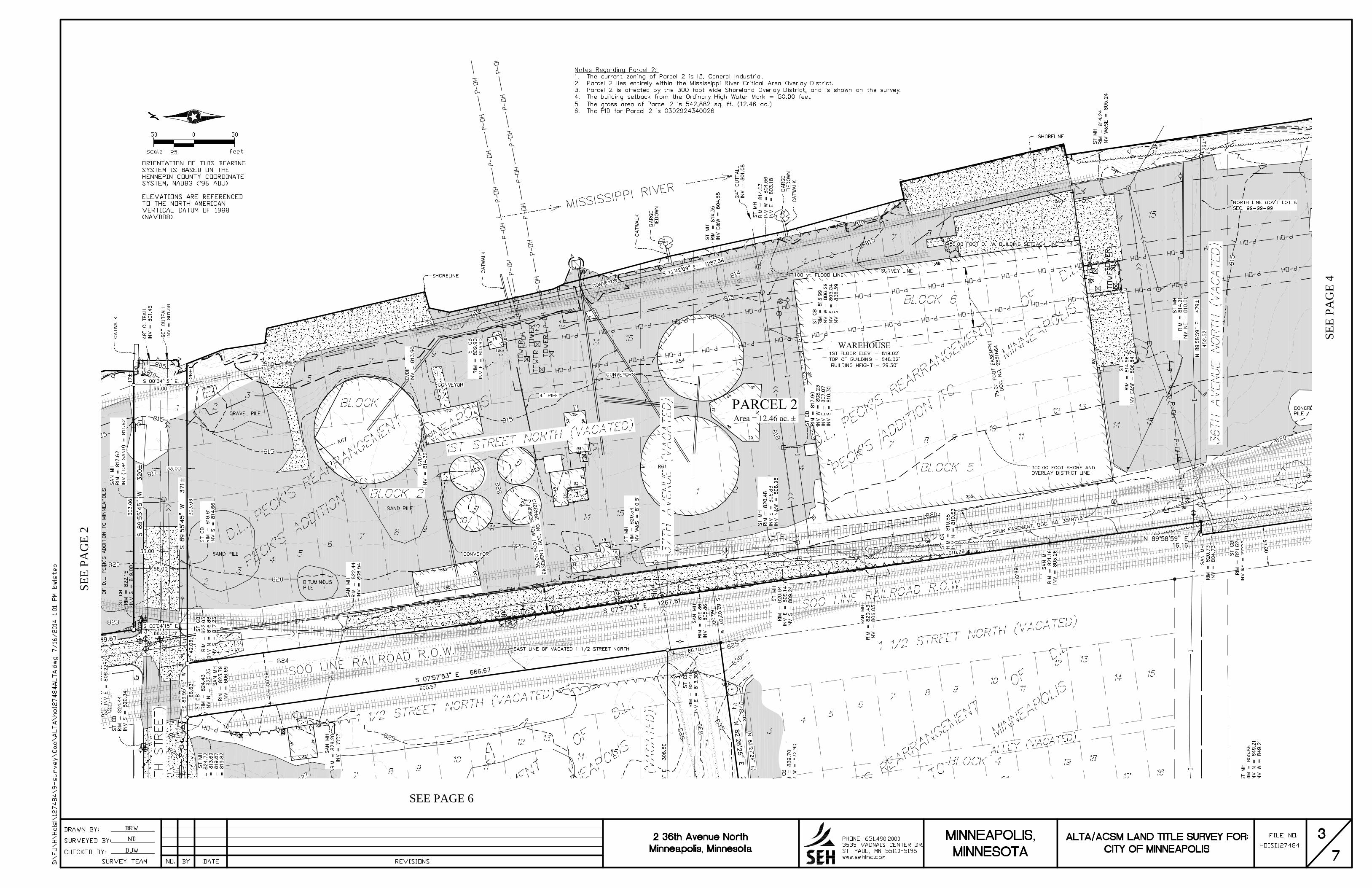
SE
E P
AG
E 2
SEE PAGE 6
SE
E P
AG
E 4
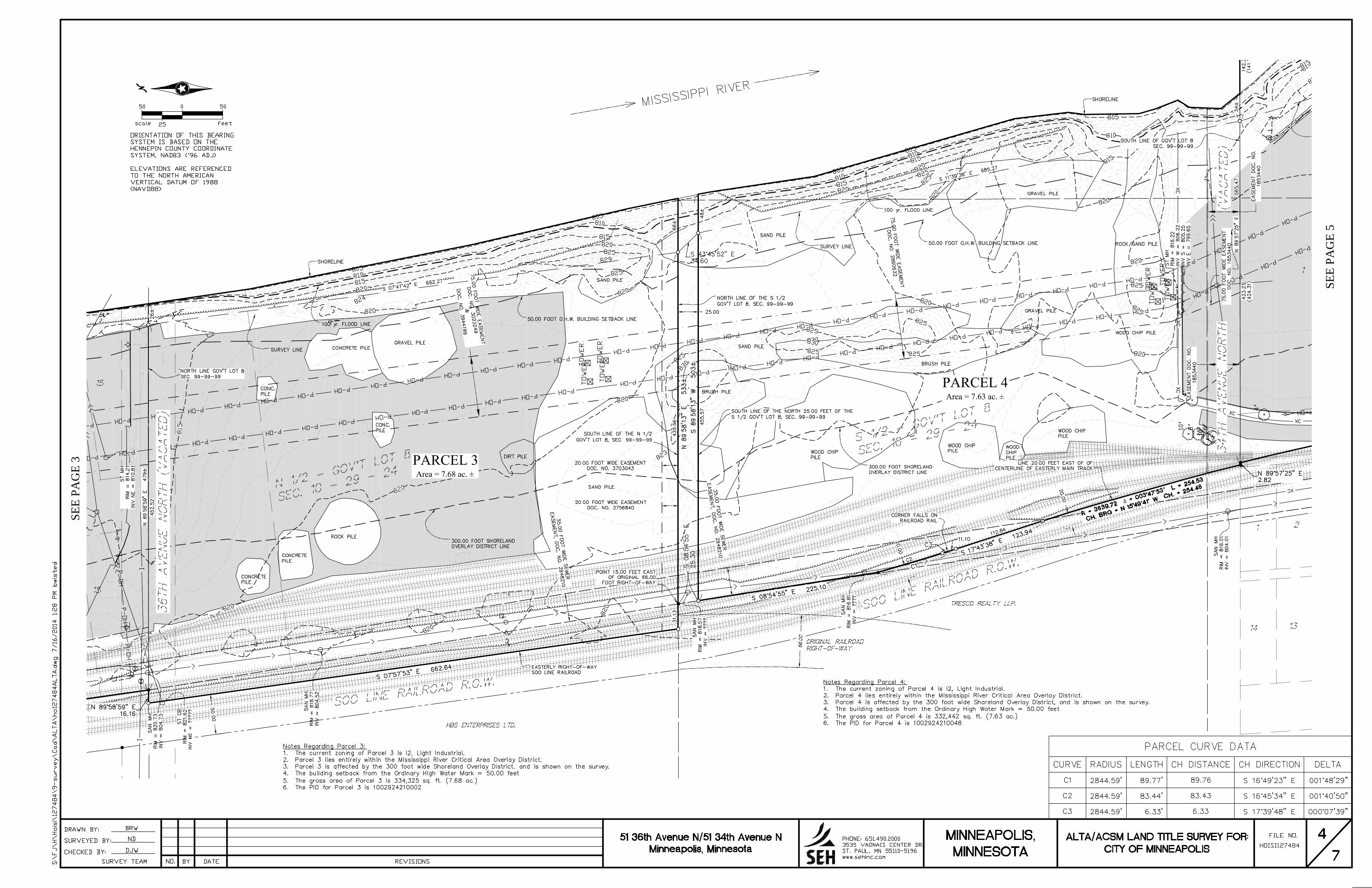
SE
E P
AG
E 3
SE
E P
AG
E 5
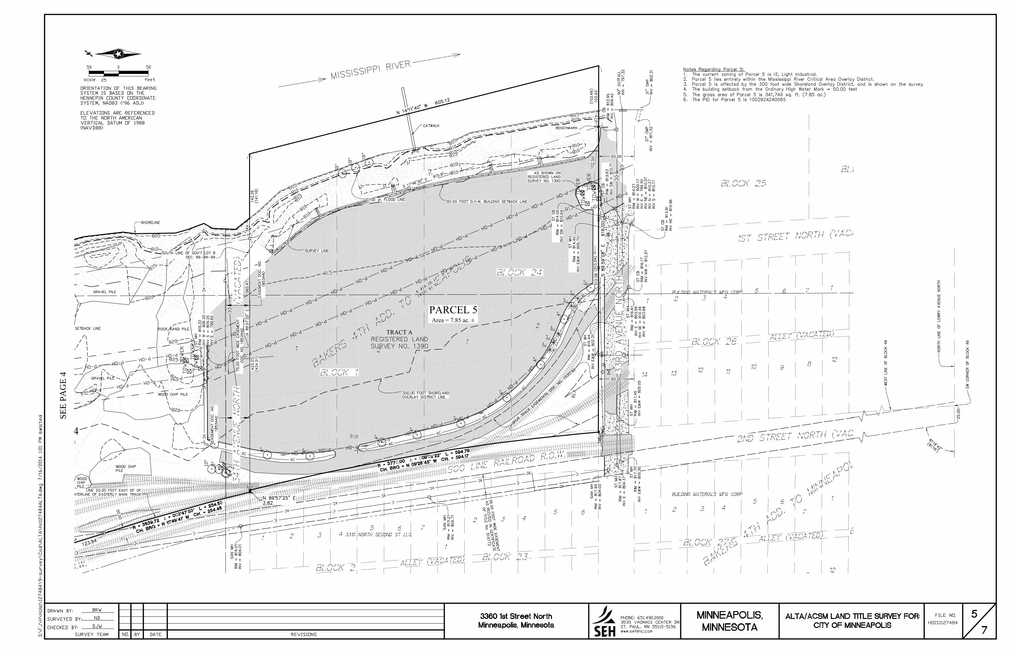
SE
E P
AG
E 4
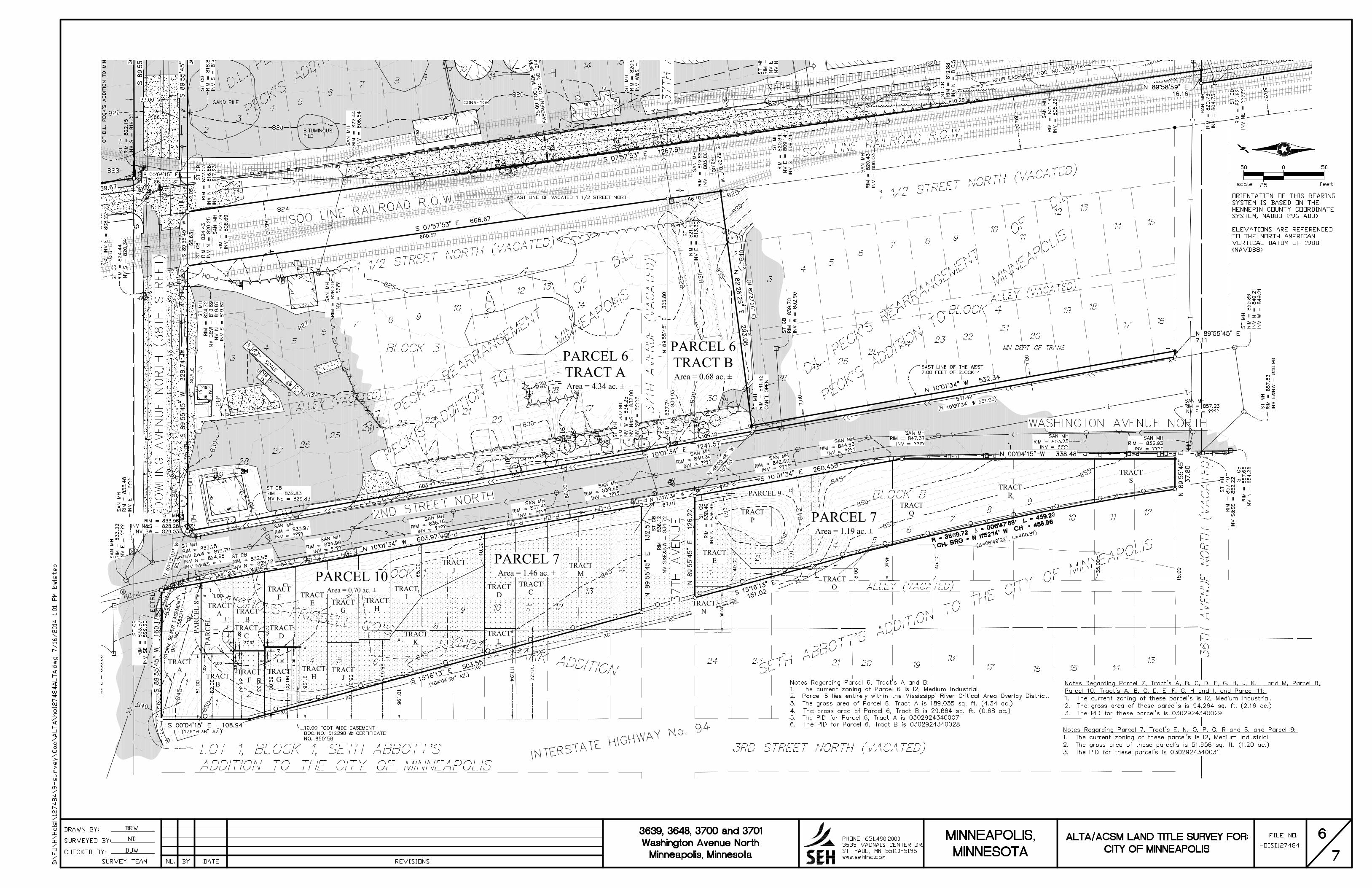
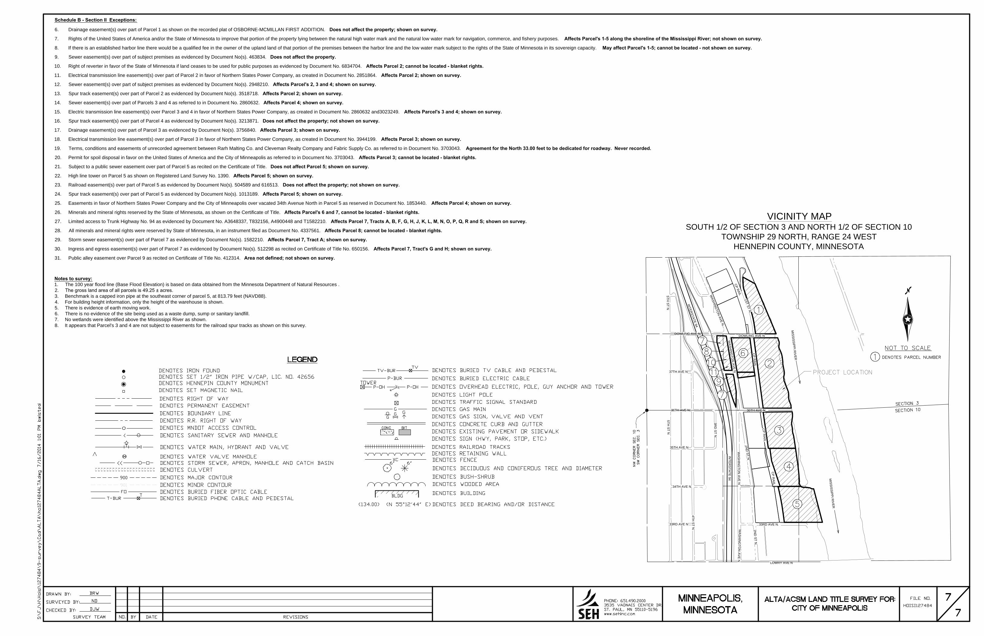
Schedule B - Section II Exceptions:
6. Drainage easement(s) over part of Parcel 1 as shown on the recorded plat of OSBORNE-MCMILLAN FIRST ADDITION. Does not affect the property; shown on survey.
7. Rights of the United States of America and/or the State of Minnesota to improve that portion of the property lying between the natural high water mark and the natural low water mark for navigation, commerce, and fishery purposes. Affects Parcel's 1-5 along the shoreline of the Mississippi River; not shown on survey.
8. If there is an established harbor line there would be a qualified fee in the owner of the upland land of that portion of the premises between the harbor line and the low water mark subject to the rights of the State of Minnesota in its sovereign capacity. May affect Parcel's 1-5; cannot be located - not shown on survey.
9. Sewer easement(s) over part of subject premises as evidenced by Document No(s). 463834. Does not affect the property.
10. Right of reverter in favor of the State of Minnesota if land ceases to be used for public purposes as evidenced by Document No. 6834704. Affects Parcel 2; cannot be located - blanket rights.
11. Electrical transmission line easement(s) over part of Parcel 2 in favor of Northern States Power Company, as created in Document No. 2851864. Affects Parcel 2; shown on survey.
12. Sewer easement(s) over part of subject premises as evidenced by Document No(s). 2948210. Affects Parcel's 2, 3 and 4; shown on survey.
13. Spur track easement(s) over part of Parcel 2 as evidenced by Document No(s). 3518718. Affects Parcel 2; shown on survey.
14. Sewer easement(s) over part of Parcels 3 and 4 as referred to in Document No. 2860632. Affects Parcel 4; shown on survey.
15. Electric transmission line easement(s) over Parcel 3 and 4 in favor of Northern States Power Company, as created in Document No. 2860632 and3023249. Affects Parcel's 3 and 4; shown on survey.
16. Spur track easement(s) over part of Parcel 4 as evidenced by Document No(s). 3213871. Does not affect the property; not shown on survey.
17. Drainage easement(s) over part of Parcel 3 as evidenced by Document No(s). 3756840. Affects Parcel 3; shown on survey.
18. Electrical transmission line easement(s) over part of Parcel 3 in favor of Northern States Power Company, as created in Document No. 3944199. Affects Parcel 3; shown on survey.
19. Terms, conditions and easements of unrecorded agreement between Rarh Malting Co. and Cleveman Realty Company and Fabric Supply Co. as referred to in Document No. 3703043. Agreement for the North 33.00 feet to be dedicated for roadway. Never recorded.
20. Permit for spoil disposal in favor on the United States of America and the City of Minneapolis as referred to in Document No. 3703043. Affects Parcel 3; cannot be located - blanket rights.
21. Subject to a public sewer easement over part of Parcel 5 as recited on the Certificate of Title. Does not affect Parcel 5; shown on survey.
22. High line tower on Parcel 5 as shown on Registered Land Survey No. 1390. Affects Parcel 5; shown on survey.
23. Railroad easement(s) over part of Parcel 5 as evidenced by Document No(s). 504589 and 616513. Does not affect the property; not shown on survey.
24. Spur track easement(s) over part of Parcel 5 as evidenced by Document No(s). 1013189. Affects Parcel 5; shown on survey.
25. Easements in favor of Northern States Power Company and the City of Minneapolis over vacated 34th Avenue North in Parcel 5 as reserved in Document No. 1853440. Affects Parcel 4; shown on survey.
26. Minerals and mineral rights reserved by the State of Minnesota, as shown on the Certificate of Title. Affects Parcel's 6 and 7, cannot be located - blanket rights.
27. Limited access to Trunk Highway No. 94 as evidenced by Document No. A3648337, T832156, A4900448 and T1582210. Affects Parcel 7, Tracts A, B, F, G, H, J, K, L, M, N, O, P, Q, R and S; shown on survey.
28. All minerals and mineral rights were reserved by State of Minnesota, in an instrument filed as Document No. 4337561. Affects Parcel 8; cannot be located - blanket rights.
29. Storm sewer easement(s) over part of Parcel 7 as evidenced by Document No(s). 1582210. Affects Parcel 7, Tract A; shown on survey.
30. Ingress and egress easement(s) over part of Parcel 7 as evidenced by Document No(s). 512298 as recited on Certificate of Title No. 650156. Affects Parcel 7, Tract's G and H; shown on survey.
31. Public alley easement over Parcel 9 as recited on Certificate of Title No. 412314. Area not defined; not shown on survey.
INTER
STATE 94
INTE
RS
TATE
94
DOWLING AVE N
1ST ST N
CP RAILWASH
ING
TON
AVE N
WASH
ING
TON
AVE N
CP R
AIIL
36TH AVE N
2ND
ST N
WA
SH
ING
TON
AV
E N
33RD AVE N
2ND
ST N
WA
SH
ING
TON
AV
E N
LOWRY AVE N
33RD AVE N
34TH AVE N
35TH AVE N
36TH AVE N
37TH AVE N
DOWLING AVE N
CP R
AIIL
CP R
AIIL
4TH S
T N
3RD
ST N
5TH S
T N5TH
ST N
MISSISSIPPI R
IVER
MISSISSIPPI R
IVER
VICINITY MAPSOUTH 1/2 OF SECTION 3 AND NORTH 1/2 OF SECTION 10
TOWNSHIP 29 NORTH, RANGE 24 WESTHENNEPIN COUNTY, MINNESOTA
Notes to survey:1. The 100 year flood line (Base Flood Elevation) is based on data obtained from the Minnesota Department of Natural Resources .2. The gross land area of all parcels is 49.25 ± acres.3. Benchmark is a capped iron pipe at the southeast corner of parcel 5, at 813.79 feet (NAVD88).4. For building height information, only the height of the warehouse is shown.5. There is evidence of earth moving work.6. There is no evidence of the site being used as a waste dump, sump or sanitary landfill.7. No wetlands were identified above the Mississippi River as shown.8. It appears that Parcel's 3 and 4 are not subject to easements for the railroad spur tracks as shown on this survey.

APPENDIX B: PROJECT PERSONNEL
LIST OF PERSONNEL Project Director Jennifer Bring, B.A. Project Manager Saleh Miller, M.S. Principal Investigator Saleh Miller, M.S. Field Historians Nicole Foss, M.A. Saleh Miller, M.S. Graphics and GIS Molly McDonald, MGIS