Intelligent Versatile Productive, Precise
2
SPECIFICATIONS Intelligent , Versatile , Productive, Precise Linux OS All constellations Tilt survey LCD Radio Router AP hot spot Bimodule bluetooth Industrial 3-proofings Cloud service Electronic bubble 8G SSD storage RINEX support -Innovative IMU-RTK Receiver- SOUTH SURVEYING & MAPPING TECHNOLOGY CO., LTD. GNSS Performance Channels......................................................................336, 965(optional) BDS......................................................................... B1, B2, B3 GPS.......................................................... L1C/A, L2C, L2E, L5 GLONASS....................................... L1C/A, L1P, L2C/A, L2P, L3 GALILEO....................................... E1, E5A, E5B, E5AltBOC, E6 SBAS....................................................................... L1C/A, L5 IRNSS................................................................................. L5 QZSS......................................... .L1 C/A, L1 SAIF, L2C, L5, LEX SBAS....................................................................... L1 C/A, L5 [1] L-Band................................................................ Trimble RTX Positioning output rate.............................................. 1Hz~50Hz Initialization time.............................................................. <10s Initialization reliability.................................................. >99.99% IMU tilt angle ............................................................ 0°~ 60° [3] RTX Horizontal ..................................................... 0.25m+1ppm RMS Real-time kinematic surveying Horizontal ................................................. 2.5mm+0.5ppm RMS Horizontal ....................................................... 8mm+1ppm RMS Vertical ......................................................... 0.50m+1ppm RMS Vertical RTK.................................................. 5+20mm/min RMS Vertical ......................................................... 15mm+1ppm RMS Horizontal ..................................................................... 4-10cm Vertical ......................................................................... 8-20cm SBAS positioning.................................... Typically<5m 3DRMS Code differential GNSS positioning [2] xFill Static GNSS surveying Vertical ........................................................ 5mm+0.5ppm RMS Positioning precision Horizontal RTK.............................................. 5+10mm/min RMS Indicators........................................................................4 LED indicators With the access of the internal web interface management via WIFI or USB connection, users are able to monitor the receiver status and change the configuration freely Operating system.............................................................................Linux iVoice intelligent voice technology provides status and operation voice guidance, supports Chinese, English, Korean, Russian, Portuguese, Spanish, Turkish, and allows to user defined local voice. Secondary development Cloud service Buttons.......................................2 buttons and visual operation interface Operating system/User interface LCD...............................0.96 inch HD OLED screen, 128 x 64 resolution Web interaction Voice guidance Provides secondary development package, and opens the OpenSIC observation data format and interaction interface definition. The powerful cloud platform provides online services like remote manage, update firmware, online register and etc. Communications I/O port...................................5-PIN LEMO port, 7-PIN USB port (OTG), 1 GSM(4G) antenna port, 1 UHF antenna port, 1 SIM card slot UHF frequency....................................................................403-473MHz UHF protocol.......................................Trimtalk450S, SOUTH, SOUTH+, SOUTHx, huace, ZHD, Satel External UHF............................ ......... 5W/25W radio transmitter Cellular mobile network...........TDD-LTE, FDD-LTE 4G network modem, Internal UHF...........................1W/2W/3W radio receiver and transmitter downward compatible with 3G network and 2G network Bluetooth......................BLEBluetooth 4.0 standard, Bluetooth 2.1+EDR Shock/vibration..............MIL-STD-810G standard vibration test certified with the indicator displaying the power usage Hardware performance Dimension...........................................................152mm(Φ)× 137mm(H) Weight..............................................................1.44kg (including battery) Material.................................................................Magnesium alloy shell Storage temperature.........................................................-55°C ~ +85°C Humidity...............................................................100% Non-condensing Waterproof/Dustproof................IP67 standard, protected from long time Electrical.................................................9-25V wide voltage DC design, Battery ................................................7.4V, 6800mAh removable battery Operating temperature..................................................... -45°C ~ +60°C immersion to depth of 1m with overvoltage protection optional battery solution of 7*24 hrs Battery life........................>30 hrs in static mode, >15 hrs in RTK mode, correction via WiFi datalink accessing with any mobile terminals W F datalink ii .................................The receiver can transmit and receive WiFi Standard.........................................................................IEEE 802.11 b/g W F hotspot ii ..........................Receiver broadcasts its hotspot for web UI supported, changeable sampling intervalup to 50Hz Data transmission...............................................USB data transmission, Data storage/ transmission Data storage.......................8GB internal storage, external USB storage FTP download, HTTP download GPS output data format.................NMEA 0183, PJK plane coordinates, supporting NTRIP protocol binary code, Trimble GSOF Network model support.................................................VRS, FKP, MAC, Differential data format................CMR+, SCMRx, RTCM 2.x, RTCM 3.x intelligent temperature control tech nology, and immue to magnetic interference, Thermometer ..............................Built-in thermometer sensors, adopting monitoring and adjusting the receiver temp. correcting coordinates automatically Electronic bubble..............................Built-in E-Bubble sensor, controller software displays e-bubble, checking leveling status of the carbon pole real-time Inertial sensing system Tilt survey ........................................Built-in IMU module, calibration-free according to tilt direction and angle [3] The RTX accuracies depend on correction service chosen. And 95% of the time with initializations are around 5-30 minutes. [1] It requires a subscription to data service. [2] xFill also requires a subscription to the data service, and precision is dependent on GNSS satellite availability. xFill positioning ends after 5 minutes of radio downtime. Remarks: Measurement accuracy and operation range might vary due to atmospheric conditions, signal multipath, obstructions, observation time, temperature, signal geometry and number of tracked satellites. Specifications subject to change without prior notice Add: South Geo-information Industrial Park, No.39 Si Cheng Rd, Guangzhou, China Tel: +86-20-23380888 Fax: +86-20-23380800 E-mail: [email protected] [email protected] [email protected] [email protected] http://www.southinstrument.com http://www.southsurvey.com
Transcript of Intelligent Versatile Productive, Precise

SPECIFICATIONS
Intelligent, Versatile,
Productive, Precise
Linux OS All constellations Tilt survey
LCD Radio Router
AP hot spot
Bimodulebluetooth
Industrial3-proofings
Cloud service Electronic bubble 8G SSD storage RINEX support
-Innovative IMU-RTK Receiver-
SOUTH SURVEYING & MAPPING TECHNOLOGY CO., LTD.
GNSS PerformanceChannels......................................................................336, 965(optional)BDS.........................................................................B1, B2, B3GPS..........................................................L1C/A, L2C, L2E, L5GLONASS....................................... L1C/A, L1P, L2C/A, L2P, L3GALILEO.......................................E1, E5A, E5B, E5AltBOC, E6SBAS....................................................................... L1C/A, L5 IRNSS.................................................................................L5 QZSS..........................................L1 C/A, L1 SAIF, L2C, L5, LEXSBAS.......................................................................L1 C/A, L5
[1 ]L-Band................................................................Trimble RTXPositioning output rate.............................................. 1Hz~50HzInitialization time.............................................................. <10sInitialization reliability..................................................>99.99%
IMU tilt angle ............................................................ 0°~ 60°
[3]RTX
Horizontal.....................................................0.25m+1ppm RMS
Real-time kinematic surveying
Horizontal.................................................2.5mm+0.5ppm RMS
Horizontal.......................................................8mm+1ppm RMS
Vertical.........................................................0.50m+1ppm RMS
Vertical RTK..................................................5+20mm/min RMS
Vertical.........................................................15mm+1ppm RMS
Horizontal.....................................................................4-10cm Vertical.........................................................................8-20cm
SBAS positioning....................................Typically<5m 3DRMS
Code differential GNSS positioning
[2]xFill
Static GNSS surveying
Vertical........................................................5mm+0.5ppm RMS
Positioning precision
Horizontal RTK..............................................5+10mm/min RMS
Indicators........................................................................4 LED indicators
With the access of the internal web interface management via WIFI or USB connection, users are able to monitor the receiver status and change the configuration freely
Operating system.............................................................................Linux
iVoice intelligent voice technology provides status and operation voice
guidance, supports Chinese, English, Korean, Russian, Portuguese,
Spanish, Turkish, and allows to user defined local voice.
Secondary development
Cloud service
Buttons.......................................2 buttons and visual operation interface
Operating system/User interface
LCD...............................0.96 inch HD OLED screen, 128 x 64 resolution
Web interaction
Voice guidance
Provides secondary development package, and opens the OpenSIC observation data format and interaction interface definition.
The powerful cloud platform provides online services like remote manage, update firmware, online register and etc.
CommunicationsI/O port...................................5-PIN LEMO port, 7-PIN USB port (OTG), 1 GSM(4G) antenna port, 1 UHF antenna port, 1 SIM card slot
UHF frequency....................................................................403-473MHzUHF protocol.......................................Trimtalk450S, SOUTH, SOUTH+,
SOUTHx, huace, ZHD, SatelExternal UHF............................ ......... 5W/25W radio transmitterCellular mobile network...........TDD-LTE, FDD-LTE 4G network modem,
Internal UHF...........................1W/2W/3W radio receiver and transmitter
downward compatible with 3G network and 2G networkBluetooth......................BLEBluetooth 4.0 standard, Bluetooth 2.1+EDR
Shock/vibration..............MIL-STD-810G standard vibration test certified
with the indicator displaying the power usage
Hardware performanceDimension...........................................................152mm(Φ)× 137mm(H)
Weight..............................................................1.44kg (including battery)Material.................................................................Magnesium alloy shell
Storage temperature.........................................................-55°C ~ +85°C
Humidity...............................................................100% Non-condensing
Waterproof/Dustproof................IP67 standard, protected from long time
Electrical.................................................9-25V wide voltage DC design,
Battery................................................7.4V, 6800mAh removable battery
Operating temperature..................................................... -45°C ~ +60°C
immersion to depth of 1m
with overvoltage protection
optional battery solution of 7*24 hrsBattery life........................>30 hrs in static mode, >15 hrs in RTK mode,
correction via WiFi datalink
accessing with any mobile terminalsW F datalinki i .................................The receiver can transmit and receive
WiFiStandard.........................................................................IEEE 802.11 b/gW F hotspoti i ..........................Receiver broadcasts its hotspot for web UI
supported, changeable sampling intervalup to 50Hz
Data transmission...............................................USB data transmission,
Data storage/ transmissionData storage.......................8GB internal storage, external USB storage
FTP download, HTTP download
GPS output data format.................NMEA 0183, PJK plane coordinates,
supporting NTRIP protocol
binary code, Trimble GSOFNetwork model support.................................................VRS, FKP, MAC,
Differential data format................CMR+, SCMRx, RTCM 2.x, RTCM 3.x
intelligent temperature control tech nology,
and immue to magnetic interference,
Thermometer..............................Built-in thermometer sensors, adopting
monitoring and adjusting the receiver temp.
correcting coordinates automatically
Electronic bubble..............................Built-in E-Bubble sensor, controller software displays e-bubble, checking
leveling status of the carbon pole real-time
Inertial sensing systemTilt survey........................................Built-in IMU module, calibration-free
according to tilt direction and angle
[3] The RTX accuracies depend on correction service chosen. And 95% of the time with initializations are around 5-30 minutes.
[1] It requires a subscription to data service.[2] xFill also requires a subscription to the data service, and precision is dependent on GNSS satellite availability. xFill positioning ends after 5 minutes of radio downtime.
Remarks: Measurement accuracy and operation range might vary due to atmospheric conditions, signal multipath, obstructions, observation time, temperature, signal geometry and number of tracked satellites. Specifications subject to change without prior notice
Add: South Geo-information Industrial Park, No.39 Si Cheng Rd, Guangzhou, ChinaTel: +86-20-23380888 Fax: +86-20-23380800 E-mail: [email protected] [email protected] [email protected] [email protected]://www.southinstrument.com http://www.southsurvey.com
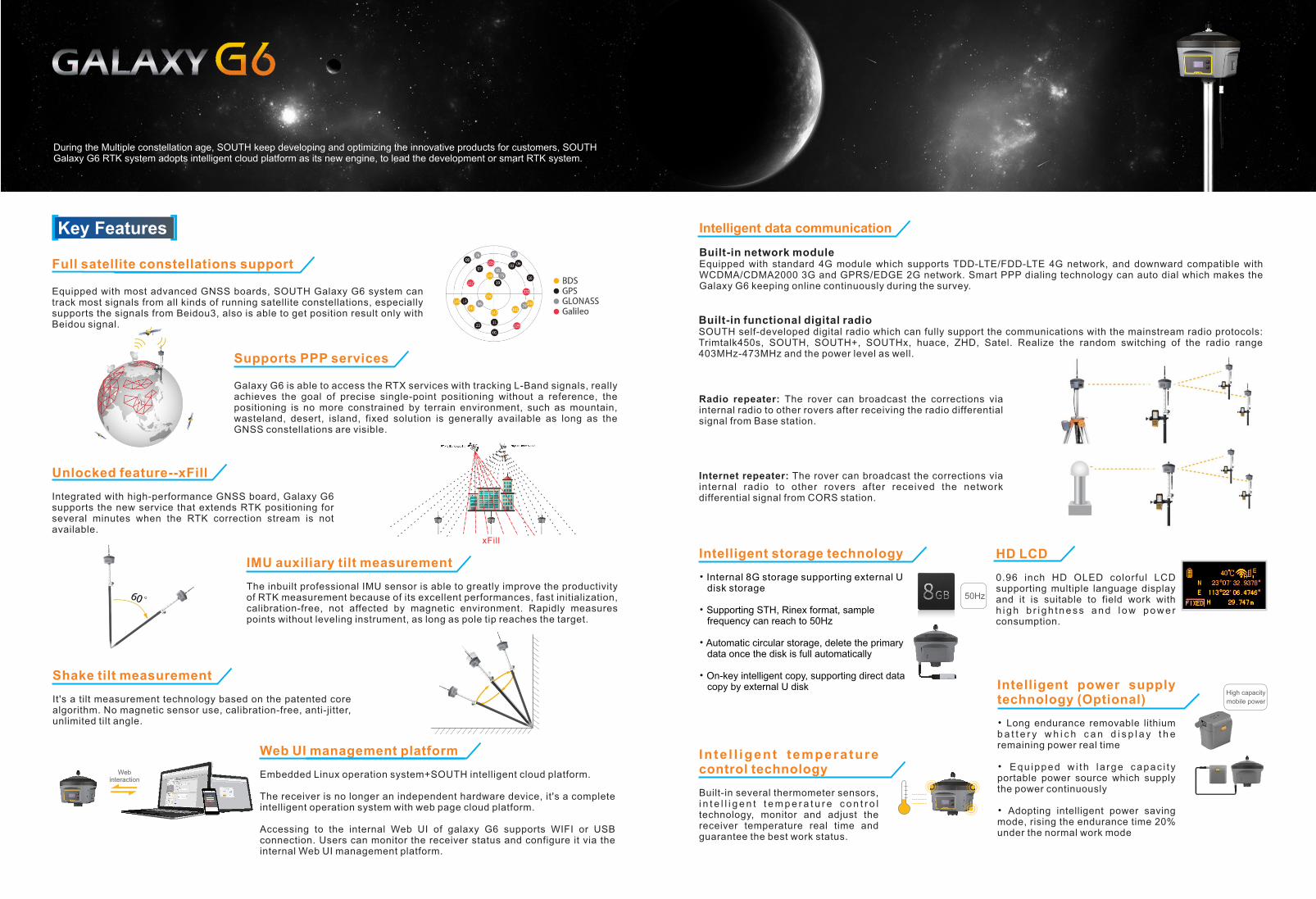
Web UI management platform
Embedded Linux operation system+SOUTH intelligent cloud platform.
The receiver is no longer an independent hardware device, it's a complete intelligent operation system with web page cloud platform.
Accessing to the internal Web UI of galaxy G6 supports WIFI or USB connection. Users can monitor the receiver status and configure it via the internal Web UI management platform.
During the Multiple constellation age, SOUTH keep developing and optimizing the innovative products for customers, SOUTH Galaxy G6 RTK system adopts intelligent cloud platform as its new engine, to lead the development or smart RTK system.
IMU auxiliary tilt measurement
The inbuilt professional IMU sensor is able to greatly improve the productivity of RTK measurement because of its excellent performances, fast initialization, calibration-free, not affected by magnetic environment. Rapidly measures points without leveling instrument, as long as pole tip reaches the target.
Shake tilt measurement
It's a tilt measurement technology based on the patented core algorithm. No magnetic sensor use, calibration-free, anti-jitter, unlimited tilt angle.
Unlocked feature--xFill
Integrated with high-performance GNSS board, Galaxy G6 supports the new service that extends RTK positioning for several minutes when the RTK correction stream is not available.
Supports PPP services
Galaxy G6 is able to access the RTX services with tracking L-Band signals, really achieves the goal of precise single-point positioning without a reference, the positioning is no more constrained by terrain environment, such as mountain, wasteland, desert, island, fixed solution is generally available as long as the GNSS constellations are visible.
Web interaction
Built-in network module
Intelligent data communication
Equipped with standard 4G module which supports TDD-LTE/FDD-LTE 4G network, and downward compatible with WCDMA/CDMA2000 3G and GPRS/EDGE 2G network. Smart PPP dialing technology can auto dial which makes the Galaxy G6 keeping online continuously during the survey.
Built-in functional digital radioSOUTH self-developed digital radio which can fully support the communications with the mainstream radio protocols: Trimtalk450s, SOUTH, SOUTH+, SOUTHx, huace, ZHD, Satel. Realize the random switching of the radio range 403MHz-473MHz and the power level as well.
Radio repeater: The rover can broadcast the corrections via internal radio to other rovers after receiving the radio differential signal from Base station.
Internet repeater: The rover can broadcast the corrections via internal radio to other rovers after received the network differential signal from CORS station.
Key Features[ ]
xFill
Equipped with most advanced GNSS boards, SOUTH Galaxy G6 system can track most signals from all kinds of running satellite constellations, especially supports the signals from Beidou3, also is able to get position result only with Beidou signal.
Full satellite constellations support
0.96 inch HD OLED colorful LCD supporting multiple language display and it is suitable to field work with h i g h b r i g h t n e s s a n d l o w p o w e r consumption.
HD LCD
Built-in several thermometer sensors, i n t e l l i g e n t t e m p e r a t u r e c o n t r o l technology, monitor and adjust the receiver temperature real time and guarantee the best work status.
In te l l igent temperature control technology • Equ ipped w i th l a rge capac i t y
portable power source which supply the power continuously
• Adopting intelligent power saving mode, rising the endurance time 20% under the normal work mode
• Long endurance removable lithium b a t t e r y w h i c h c a n d i s p l a y t h e remaining power real time
Intelligent power supply technology (Optional)
Intelligent storage technology
• Internal 8G storage supporting external U disk storage
• Supporting STH, Rinex format, sample frequency can reach to 50Hz
• Automatic circular storage, delete the primary data once the disk is full automatically
copy by external U disk • On-key intelligent copy, supporting direct data
50Hz
High capacity
mobile power