Intelligent Transport Systems for Indian Cities - USENIX · PDF fileIntelligent Transport...
6
Intelligent Transport Systems for Indian Cities Rijurekha Sen, Bhaskaran Raman {riju, br}@cse.iitb.ac.in Department of Computer Science and Engineering Indian Institute of Technology, Bombay Abstract Road traffic congestion is a recurring problem worldwide. In India, a fast growing economy, the problem is acutely felt in almost all major cities. This is primarily because infras- tructure growth is slow compared to growth in number of vehicles, due to space and cost constraints. Secondly, Indian traffic being non-lane based and chaotic, is largely different from the western traffic. The difference can be understood fully only through experience, but some example scenarios can be seen at [1]. Thus, Intelligent Transport Systems (ITS), used for efficient traffic management in developed countries, cannot be used as it is in India. ITS techniques have to un- dergo adaptation and innovation to suit the contrasting traf- fic characteristics of Indian roads. In this position paper, we present a comprehensive study of all available ITS systems,including both research proto- types and deployed systems. We next pose a set of interest- ing open research problems in the context of Indian ITS. Fi- nally, we list a set of public and private organizations, that play a role in Indian traffic management and research, as meaningful collaboration between field practitioners and re- searchers is needed for efficient transfer of relevant technol- ogy. Though our paper focuses on the Indian traffic sce- nario because of our hands-on experience of working with it [2, 3, 4], many of the problems and solutions outlined in this paper, are relevant for other developing countries as well. 1 Introduction India, the second most populous country in the world, and a fast growing economy, is seeing terrible road con- gestion problems in its cities. Building infrastructure, levy- ing proper taxes to curb private vehicle growth and improv- ing public transport facilities are long-term solutions to this problem. These permanent solution approaches need gov- ernment intervention. The Government of India has commit- ted Rs.234,000 crores in the urban infrastructure sector [5]. Bus Rapid Transit (BRT), metro rails and mono rails are be- ing built in different cities to encourage the use of public transport. But still there is a steep growth of private vehi- cles [6]. Some cities like Bengaluru, Pune, Hyderabad and Delhi-NCR, with their sudden growths in the IT sector, also have a steep growth in population, further increasing trans- portation needs. Meeting such growth with infrastructure growth is seemingly infeasible, primarily because of space and cost constraints. Intelligent management of traffic flows and making commuters more informed about traffic and road status, can reduce the negative impact of congestion, though cannot solve it altogether. This is the idea behind Intelligent Transport Systems (ITS). ITS in India, however, cannot be a mere replication of deployed and tested ITS in the developed countries. The non-lane based disorderly traffic with high heterogeneity of vehicles, need the existing techniques to be adapted to the Indian scenario, before they can be used. Thus ITS in the Indian context needs significant R&D efforts. ITS is an interdisciplinary research area. Building road sensors need embedded systems background. Using mobile phones for sensing need mobile computing background. An- alyzing sensed data needs signal processing or computer vi- sion background. Communication among sensors and traffic control authorities need wired or wireless networking back- ground. The traffic classification and prediction algorithms need machine learning or statistics background. Applica- tions like traffic signal management need transportation en- gineering background. So the ITS literature is very wide- spread with papers appearing in seemingly unrelated venues. In this paper, we make a comprehensive list of ITS literature, to give an overview of all existing techniques. We follow it up with a set of open research questions in the context of Indian roads and traffic. Finally, we list a set of public and private sector organizations and academic institutions, who are active in research or application in this field, as meaning- ful collaborations and technology transfer should happen if research has to make any practical impact. 2 ITS applications Indian traffic can benefit from several possible ITS appli- cations. One set of applications is for traffic management. (1) Intersection control - At intersections, deciding the to- tal signal cycle and the split of green times among different flows, is one of the most basic traffic management applica- tions [7]. (2) Incident detection - Pinpointing locations of accidents or vehicle breakdown is important to handle the emergency situations. (3) Vehicle classification - Knowing 1
Transcript of Intelligent Transport Systems for Indian Cities - USENIX · PDF fileIntelligent Transport...

Intelligent Transport Systems for Indian Cities
Rijurekha Sen, Bhaskaran Raman{riju, br}@cse.iitb.ac.in
Department of Computer Science and EngineeringIndian Institute of Technology, Bombay
Abstract
Road traffic congestion is a recurring problem worldwide.In India, a fast growing economy, the problem is acutely feltin almost all major cities. This is primarily because infras-tructure growth is slow compared to growth in number ofvehicles, due to space and cost constraints. Secondly, Indiantraffic being non-lane based and chaotic, is largely differentfrom the western traffic. The difference can be understoodfully only through experience, but some example scenarioscan be seen at [1]. Thus, Intelligent Transport Systems (ITS),used for efficient traffic management in developed countries,cannot be used as it is in India. ITS techniques have to un-dergo adaptation and innovation to suit the contrasting traf-fic characteristics of Indian roads.
In this position paper, we present a comprehensive studyof all available ITS systems,including both research proto-types and deployed systems. We next pose a set of interest-ing open research problems in the context of Indian ITS. Fi-nally, we list a set of public and private organizations, thatplay a role in Indian traffic management and research, asmeaningful collaboration between field practitioners and re-searchers is needed for efficient transfer of relevant technol-ogy. Though our paper focuses on the Indian traffic sce-nario because of our hands-on experience of working withit [2, 3, 4], many of the problems and solutions outlinedin this paper, are relevant for other developing countries aswell.
1 Introduction
India, the second most populous country in the world,and a fast growing economy, is seeing terrible road con-gestion problems in its cities. Building infrastructure, levy-ing proper taxes to curb private vehicle growth and improv-ing public transport facilities are long-term solutions tothisproblem. These permanent solution approaches need gov-ernment intervention. The Government of India has commit-ted Rs.234,000 crores in the urban infrastructure sector [5].Bus Rapid Transit (BRT), metro rails and mono rails are be-ing built in different cities to encourage the use of publictransport. But still there is a steep growth of private vehi-cles [6]. Some cities like Bengaluru, Pune, Hyderabad and
Delhi-NCR, with their sudden growths in the IT sector, alsohave a steep growth in population, further increasing trans-portation needs. Meeting such growth with infrastructuregrowth is seemingly infeasible, primarily because of spaceand cost constraints. Intelligent management of traffic flowsand making commuters more informed about traffic and roadstatus, can reduce the negative impact of congestion, thoughcannot solve it altogether. This is the idea behind IntelligentTransport Systems (ITS). ITS in India, however, cannot be amere replication of deployed and tested ITS in the developedcountries. The non-lane based disorderly traffic with highheterogeneity of vehicles, need the existing techniques tobeadapted to the Indian scenario, before they can be used. ThusITS in the Indian context needs significant R&D efforts.
ITS is an interdisciplinary research area. Building roadsensors need embedded systems background. Using mobilephones for sensing need mobile computing background. An-alyzing sensed data needs signal processing or computer vi-sion background. Communication among sensors and trafficcontrol authorities need wired or wireless networking back-ground. The traffic classification and prediction algorithmsneed machine learning or statistics background. Applica-tions like traffic signal management need transportation en-gineering background. So the ITS literature is very wide-spread with papers appearing in seemingly unrelated venues.In this paper, we make a comprehensive list of ITS literature,to give an overview of all existing techniques. We follow itup with a set of open research questions in the context ofIndian roads and traffic. Finally, we list a set of public andprivate sector organizations and academic institutions, whoare active in research or application in this field, as meaning-ful collaborations and technology transfer should happen ifresearch has to make any practical impact.
2 ITS applications
Indian traffic can benefit from several possible ITS appli-cations. One set of applications is for traffic management.(1) Intersection control - At intersections, deciding the to-tal signal cycle and the split of green times among differentflows, is one of the most basic traffic management applica-tions [7]. (2) Incident detection -Pinpointing locations ofaccidents or vehicle breakdown is important to handle theemergency situations.(3) Vehicle classification -Knowing
1

what kind of vehicles, and in what proportions, ply a cer-tain road stretch, helps to choose appropriate road width andpavement materials.(4) Monitoring - Pollution and roadquality monitoring are necessary for taking corrective mea-sures.(5) Revenue collection -Toll taxes for infrastructuremaintenance and fines for rule enforcement need to be col-lected. (6) Historical traffic data - Long term data helpsto plan new infrastructure, calibrate traffic signal times,addpublic transport and so on.
Another set of applications can aid the commuters onroads. (1) Congestion maps and travel time estimates -These help commuters in route selection.(2) Public trans-port information - Information about arrival of public trans-port helps in choice of travel mode and reduces wait delays.(3) Individual vehicle management - Getting informationabout parking places or estimates of carbon footprint, helpowners of private vehicles.(4) Accident handling - Emer-gency services after accidents are a vital necessity.
3 Sensing
To handle any road application, the first thing that weneed is information from the road. Sensors on roads can pro-vide such information. There are several existing modes ofsensing:static sensing, where sensors are statically placedon the road,mobile sensing, where sensors are placed in themoving vehicles andhybrid sensing, where both in-vehicleand on-road infrastructure are needed. In this section, wediscuss the key technologies in each category and outlinesome open questions in the context of Indian roads.
3.1 Static sensing: techniques
(1) Loops and magnetic sensors -Vehicle detection andcounting using magnetic sensors or loops under the road sur-face, has been explored in research [8, 9, 10] and deployedsystems [11].(2) Images and videos -Video surveillanceto monitor traffic states and detect incidents and hotspots isfairly common [12]. [13] gives a comprehensive survey ofthe major computer vision techniques used in traffic applica-tions. (3) Acoustic sensors -Some recent research is beingdone to use acoustic sensors for traffic state estimation, es-pecially in developing regions, where traffic being chaoticis noisy [2, 3, 14, 15]. (4) RF sensors - Wireless radiosplaced across the road have communication signals affectedby vehicular movement in between. There are commercialproducts [16] and research efforts [4] using this for trafficmonitoring.
3.2 Static sensing: India specific questions
Adapting to chaotic traffic - Magnetic loops have tra-ditionally been used in developed countries with lane-basedorderly traffic (see Fig. 1)(a). Loops are placed under eachlane. How should the placement be in absence of lanes?(Fig. 2) What methods to count and classify vehicles wouldwork for heterogeneous traffic that move in a chaotic fash-ion?
Figure 1. Loops and cameras in lane-based traffic
Similarly, vision algorithms exist [13] for settings likeFig. 1(b). [17] is a preliminary work on image processingalgorithms for chaotic traffic. The algorithms in [17] are of-fline, so the trade-off between computation and communica-tion is not understood. Also the sensing accuracy itself hasbeen tested on only 2 minutes of video clip. [18] is anotherrecent work to use low quality images from CCTV for traf-fic sensing. But computational overhead, real-timeliness andaccuracy of the designed algorithms haven’t been evaluated.Thus for existing sensing mechanisms like loops and images,several aspects like sensor placement, real time algorithmsto measure chaotic traffic, implementability of algorithmsinon-road embedded platforms, computation vs communica-tion to remote server trade-offs, accuracy to handle differentapplications etc. have to be carefully designed and empiri-cally evaluated in real settings.
New techniques for chaotic traffic -Apart from adapt-ing traditional sensors to chaotic traffic, efforts can be madeto design new sensing solutions for chaotic traffic. If thesesolutions are low-cost and deployable on road-side, (underroad sensors like loop hamper flow during installation andmaintenance), that will add greater value. We have come upwith two such techniques based on acoustic sensing [2, 3]and RF sensing [4]. There are several other options to ex-plore like passive infrared sensors, pollution sensors, vibra-tion sensors etc. For each technique, some of the key ques-tions to explore are - (a) what to sense, (b) how long to senseto handle the real-timeliness vs accuracy trade-off, (c) howto build sensing models for different road widths and vehicletypes with minimum manual supervision etc.
Figure 2. Indian traffic (source [19])
3.3 Mobile sensing: techniques
(1) GPS on public transport or fleet vehicles - Manypublic transport and fleet companies have GPS installedin their vehicles for real time tracking. Several research

projects have tried to exploit these as a source of road in-formation. [20] was one of the early papers to analyze GPStraces from buses to classify road segments as free-flow andcongested using threshold based classification. The Mo-bile Millennium Project at Berkeley [21] used GPS on afleet of taxis and estimated travel times in London over 6months. [22] is a recent large scale study of GPS traces of ataxi fleet in Singapore, to know fare and travel delays in realtime. Another category of work using GPS on public trans-port has been to predict bus arrival times [23, 24, 25, 26].
(2) GPS on smartphones - With the recent prolifera-tion of smartphones, smartphone GPS is being studied forhotspot detection and travel time estimation, after handlingnoise in GPS readings [27].(3) Sensors on smartphones- Other than GPS, smartphones also have sensors that canprovide interesting information. [28] solved the problem ofreorienting the accelerometer of a smartphone to match thecar axes. The accelerometer readings were then used to de-tect road events like bumps and brakes. A lot of braking,accompanied by honking (detected by smartphone micro-phone) was interpreted as congestion. [29] improves uponthe accelerometer reorientation mechanism by using smart-phone magnetometer. [30] uses smartphone accelerometer todetect if the phone is in a transit vehicle and if so, uses GPSto know travel times and arrival times of the vehicle. [31]uses the smartphone microphone for urban noise mappingand [32] uses the smartphone camera to predict the trafficsignal ahead for automatic speed control of vehicle.(4) Us-ing ordinary phones - Some researchers have tried usingordinary cell phones, instead of smartphones, for traffic sens-ing. Localizing ordinary phones based on only cellular towerand Wi-Fi information ( [33, 34]) and adding sensors to or-dinary phone hardware ( [35, 36]) are two main research fo-cus in this area This sensing using phones, popularly calledcrowdsourcingor participatory sensing, has related researchon privacy ( [37, 38]) and power ( [39, 40]) issues, as thesewould affect user participation.
(5) Specialized hardware on vehicles - Some re-searchers have used specialized hardware in vehicles. [41],which detects road anomalies and [42], which tracksstolen properties are examples. [43], which uses ultrasoundtransceivers to find empty parking spaces and [44], whichcalculates fuel usage, are applications for individual vehicleowners using customized hardware.(6) Social networking- [45] took a fresh perspective of getting information fromcrowd through blogs posted via smartphones.
3.4 Mobile sensing: India specific questions
Adapting techniques for Indian roads GPS is knownto have errors that affect localization of traffic information.Does this error have more impact on the dense Indian roadnetworks? Is enhancing GPS with Wi-Fi [27, 33], feasible?To see Wi-Fi penetration and coverage, war-driving effortsmight be made on Indian roads.
New social networking models - Ordinary cell-phonepenetration and usage is very high in India. Blog or MMS
based crowd sourcing needs GPRS or 3G connectivity. In-stead, ordinary sms or voice calls can be explored for infor-mation sharing to increase the participant pool manifold.
Incentive models - Designing proper incentive modelsfor participatory sensing is an active research area. Sim-ilar questions for the Indian population will give interest-ing research problems. Should we use a payment basedsystem [46, 47]? Or should we use games? What kindof games should we design? Should low income groupslike auto-rickshaw and taxi drivers be given monetary incen-tives whereas the middle and higher income groups are givengaming incentives? If such incentive schemes are not empir-ically evaluated, all the mobile sensing techniques discussedabove would be rendered useless in practice.
Noise reduction - Trustworthiness of web informa-tion [48, 49, 50] is a recent active area of research.Still newer is research on trustworthiness of participatorydata [51, 52]. In the context of participatory sensing for In-dian ITS, similar work on data trustworthiness and noise re-duction will be interesting. Paid incentive models run therisk of inducing selfish behavior among participants, whowould start contributing wrong data. The system should beable to cross check data sanity, possibly through data aggre-gation from multiple participants. This would need high tomoderate level of penetration. Another possible option is tobuild reputation systems using input from other sensors (sayvideo), for parts of the data. Participants who score high inthese checks can be given higher weights in future than theparticipants who score low.
3.5 Hybrid sensing: techniques
There are a set of techniques that use both static infras-tructure and mobile sensors to gain traffic information.(1)Teledensity -Cell phone operators can give approximate ve-hicle densities in the neighborhood of a given cell tower,based on subscribers seen at that tower. There are commer-cial systems like [53] and research efforts [54] based on this.(2) Bluetooth - [55] is a system where roadside Bluetoothdetectors sense Bluetooth radios in phones inside vehicles.Correlating the sensed Bluetooth addresses among differentdetectors, gives travel times of the vehicles between the de-tectors.(3) RFID - Similar systems are being explored usingRFID tags on vehicles and RFID readers on roads [56].
4 The ITS architecture
Having discussed a set of intended applications and sev-eral possible sensing methods, the next question to ask ishow to put it all together for Indian cities, so that the maxi-mum possible number of applications are handled with easeand accuracy. Should we prioritize the list of applications, sothat some are given higher importance than the others? Howshould we select what sensing methods to use? What shouldbe the overall system architecture, including the communi-cation model needed to gather sensed and/or computed datafrom the roads and dissipate information back to commuters

on the road? Many of these lead to interesting research ques-tions as we will see.
Figure 3. City-wide sensing architecture (source [57])
Choice of applications -Our discussions with the Ben-galuru Traffic Police gave us insight into their ITS needs.Fig. 3 shows a road map of Bengaluru. There are two mainkinds of roads, the yellow lines denote the major roads andthe white lines denote minor roads. The junctions where themajor roads intersect one another are shown by red squaresand those where the minor roads intersect the major roadsare shown by blue dots.Traffic light controlis a vital neces-sity for both these type of intersections, that will govern thetraffic flow pattern over the entire city. Currently, in absenceof automated signal control techniques, the traffic lights areeither statically calibrated, or controlled by on-road police-men, or remotely controlled by manually seeing video feedsat the traffic control room.Localizing incidentsis another vi-tal application, to send traffic personnels to affected areas orpenalize traffic violators. The other applications described inSection 2 are also necessary, in no definite order of priority.As most Indian cities have similar road patterns, the applica-tion needs of other traffic control authorities are expectedtobe similar.
As for Indian commuters, the traffic applications cur-rently available are rudimentary, with periodic updates gath-ered from traffic police broadcast on FM radios [58]. Thereare a few route planners [59] that give bus and train plans, butthe plans are static, without considering the current conges-tion levels on different roads. Thus any application, outlinedin Section 2 would be valuable to commuters.
Choice of sensing method -Participatory sensing datais inherently noisy [52]. Also probe vehicles might not bepresent at a given intersection at all times. Such sensingmethods can thus be used for applications like travel timeestimates and congestion maps to be disseminated to com-muters, which can tolerate aperiodicity and noisiness. Ap-plications like traffic light control on the other hand, need
Figure 4. Bengaluru Traffic Control Room
dedicated static sensors on the road that give highly accurateand strictly periodic updates about traffic conditions. Staticsensors are costly but accurate, mobile and hybrid sensorsare cheap but noisy. Based on applications, we need to makea careful choice of which mode to use when and how to mixthem appropriately. The red squares and blue dots in Fig. 3would thus be probable candidates for static sensing, whilethe mobile and hybrid sensors would span the city, in varyingdensities over time, as the green triangles in the figure. Evenwithin each mode, choices can be made based on level of in-formation needed and installation and maintenance costs. Ifvehicle classification is vitally important, videos are a must.But if only level of congestion or length of traffic queues areneeded for certain intersections, RF sensors, cheaper thanvideos or loops, can be used.
Choice of communication model -Given a set of chosenapplications and a set of sensing methods to handle them,how should the communication model be? For static sen-sors, the sensed data need to be transferred to traffic controlrooms. At present, out of 160 cameras in Bengaluru, con-nected to central traffic control room by BSNL leased lines,at most 90 cameras send data at any given time [61], be-cause of problems in the wired connections. Instead of thisstar topology, will a tiered architecture help, where videofeeds from a subset of roads are processed at local con-trol rooms, before the information is passed to central con-trol? Should there be a mix of wired and wireless commu-nication to reduce cost and overhead of laying copper, orwill wireless be too unreliable? Can communication costsbe reduced through in-field computation and data compres-sion? As for mobile sensing models, quantitative analysis of3G and GPRS performance on Indian roads, using mobilecloud for data upload and download, peer-to-peer network-ing among commuters with similar travel patterns, are someinteresting communication problems to explore.
5 A subset of the players in Indian transport
We might know what traffic applications are needed forIndian roads. We might design and implement sensingtechnologies needed to handle those applications for Indianchaotic traffic. We might build robust, low-cost communi-cation models to gather data from sensors and disseminateinformation to commuters. But unless we test our solutionsin the field in medium to large scales, we will never cometo know about practical issues. Building collaboration withthe public sector is an absolute necessity for this domain aslab tests and simulations will never give the true picture of
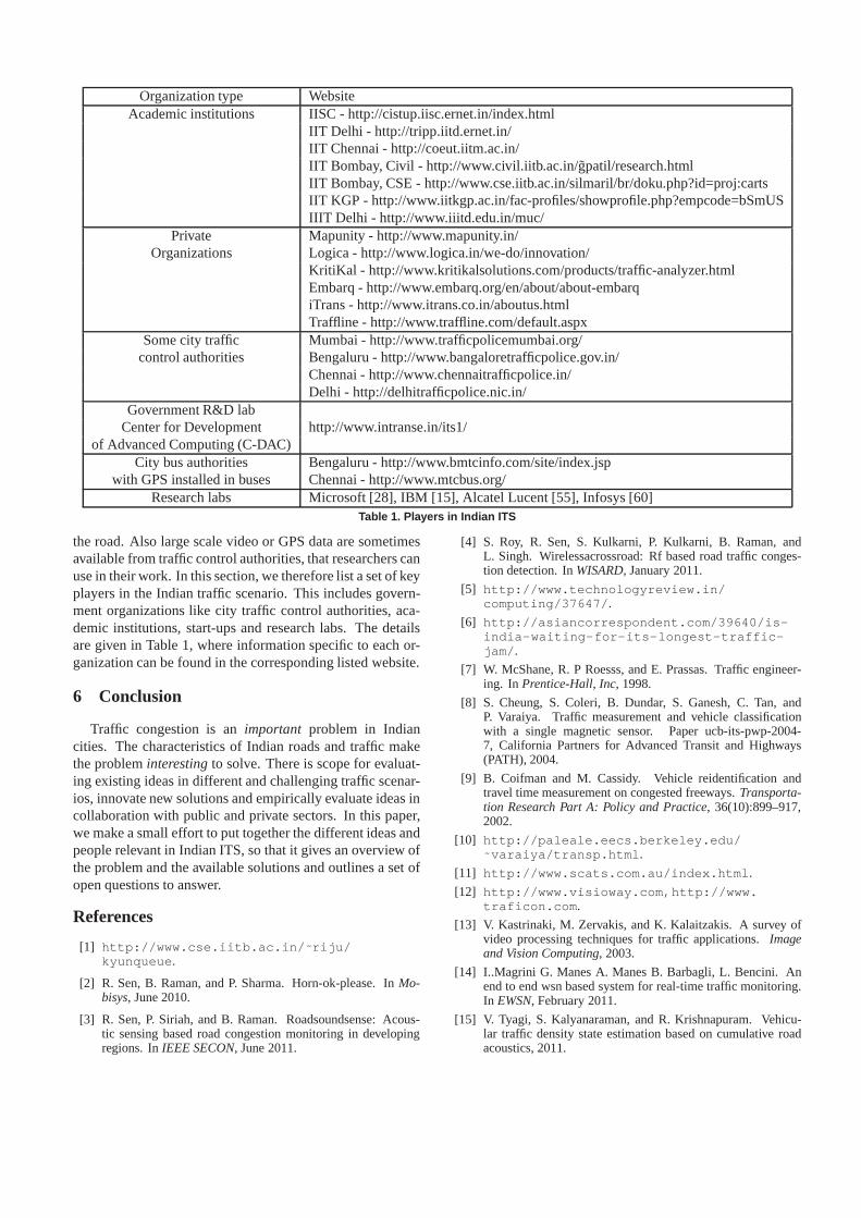
Organization type WebsiteAcademic institutions IISC - http://cistup.iisc.ernet.in/index.html
IIT Delhi - http://tripp.iitd.ernet.in/IIT Chennai - http://coeut.iitm.ac.in/IIT Bombay, Civil - http://www.civil.iitb.ac.in/g̃patil/research.htmlIIT Bombay, CSE - http://www.cse.iitb.ac.in/silmaril/br/doku.php?id=proj:cartsIIT KGP - http://www.iitkgp.ac.in/fac-profiles/showprofile.php?empcode=bSmUSIIIT Delhi - http://www.iiitd.edu.in/muc/
Private Mapunity - http://www.mapunity.in/Organizations Logica - http://www.logica.in/we-do/innovation/
KritiKal - http://www.kritikalsolutions.com/products/traffic-analyzer.htmlEmbarq - http://www.embarq.org/en/about/about-embarqiTrans - http://www.itrans.co.in/aboutus.htmlTraffline - http://www.traffline.com/default.aspx
Some city traffic Mumbai - http://www.trafficpolicemumbai.org/control authorities Bengaluru - http://www.bangaloretrafficpolice.gov.in/
Chennai - http://www.chennaitrafficpolice.in/Delhi - http://delhitrafficpolice.nic.in/
Government R&D labCenter for Development http://www.intranse.in/its1/
of Advanced Computing (C-DAC)City bus authorities Bengaluru - http://www.bmtcinfo.com/site/index.jsp
with GPS installed in buses Chennai - http://www.mtcbus.org/Research labs Microsoft [28], IBM [15], Alcatel Lucent [55], Infosys [60]
Table 1. Players in Indian ITS
the road. Also large scale video or GPS data are sometimesavailable from traffic control authorities, that researchers canuse in their work. In this section, we therefore list a set of keyplayers in the Indian traffic scenario. This includes govern-ment organizations like city traffic control authorities, aca-demic institutions, start-ups and research labs. The detailsare given in Table 1, where information specific to each or-ganization can be found in the corresponding listed website.
6 Conclusion
Traffic congestion is animportant problem in Indiancities. The characteristics of Indian roads and traffic makethe probleminterestingto solve. There is scope for evaluat-ing existing ideas in different and challenging traffic scenar-ios, innovate new solutions and empirically evaluate ideasincollaboration with public and private sectors. In this paper,we make a small effort to put together the different ideas andpeople relevant in Indian ITS, so that it gives an overview ofthe problem and the available solutions and outlines a set ofopen questions to answer.
References
[1] http://www.cse.iitb.ac.in/ ˜ riju/kyunqueue .
[2] R. Sen, B. Raman, and P. Sharma. Horn-ok-please. InMo-bisys, June 2010.
[3] R. Sen, P. Siriah, and B. Raman. Roadsoundsense: Acous-tic sensing based road congestion monitoring in developingregions. InIEEE SECON, June 2011.
[4] S. Roy, R. Sen, S. Kulkarni, P. Kulkarni, B. Raman, andL. Singh. Wirelessacrossroad: Rf based road traffic conges-tion detection. InWISARD, January 2011.
[5] http://www.technologyreview.in/computing/37647/ .
[6] http://asiancorrespondent.com/39640/is-india-waiting-for-its-longest-traffic-jam/ .
[7] W. McShane, R. P Roesss, and E. Prassas. Traffic engineer-ing. In Prentice-Hall, Inc, 1998.
[8] S. Cheung, S. Coleri, B. Dundar, S. Ganesh, C. Tan, andP. Varaiya. Traffic measurement and vehicle classificationwith a single magnetic sensor. Paper ucb-its-pwp-2004-7, California Partners for Advanced Transit and Highways(PATH), 2004.
[9] B. Coifman and M. Cassidy. Vehicle reidentification andtravel time measurement on congested freeways.Transporta-tion Research Part A: Policy and Practice, 36(10):899–917,2002.
[10] http://paleale.eecs.berkeley.edu/˜ varaiya/transp.html .
[11] http://www.scats.com.au/index.html .
[12] http://www.visioway.com,http://www.traficon.com .
[13] V. Kastrinaki, M. Zervakis, and K. Kalaitzakis. A survey ofvideo processing techniques for traffic applications.Imageand Vision Computing, 2003.
[14] I..Magrini G. Manes A. Manes B. Barbagli, L. Bencini. Anend to end wsn based system for real-time traffic monitoring.In EWSN, February 2011.
[15] V. Tyagi, S. Kalyanaraman, and R. Krishnapuram. Vehicu-lar traffic density state estimation based on cumulative roadacoustics, 2011.
[16] http://www.ceos.com.au/products/tirtl.htm .
[17] A. Quinn and R. Nakibuule. Traffic flow monitoring incrowded cities. InAAAI Spring Symposium on Artificial In-telligence for Development, 2010.
[18] V. Jain, A. Sharma, and L. Subramanian. Road traffic conges-tion in the developing world. InACM DEV, 2011.
[19] http://www.pluggd.in/indian-traffic-entrepreneurial-lessons-297/ .
[20] J. Yoon, B. Noble, and M. Liu. Surface street traffic estima-tion. In MobiSys. ACM, 2007.
[21] http://traffic.berkeley.edu/theproject.html .
[22] R.Balan, N.Khoa, and J.Lingxiao. Real-time trip informationservice for a large taxi fleet. InMobisys, Jun 2011.
[23] J. Biagioni, T. Gerlich, T. Merrifield, and J. Eriksson.Easy-tracker: automatic transit tracking, mapping, and arrivaltimeprediction using smartphones. InSenSys, 2011.
[24] R. E. Anderson, A. Poon, C. Lustig, W. Brunette, G. Borriello,and B. E. Kolko. Building a transportation information systemusing only gps and basic sms infrastructure. InICTD, 2009.
[25] W. Lin and J. Zeng. Experimental study of real-time bus ar-rival time prediction with gps data.Transportation ResearchRecord, (1666):101–109, 1999.
[26] D.J.Dailey, S.D.Maclean, F.W.Cathey, and Z.R.Wall. Transitvehicle arrival prediction: An algorithm and a large scale im-plementation.Transportation Research Record, (1771), 2001.
[27] A. Thiagarajan, L. Ravindranath, K. LaCurts, S. Madden,H. Balakrishnan, S. Toledo, and J. Eriksson. Vtrack: Accu-rate, energy-aware road traffic delay estimation using mobilephones. InSensys, November 2009.
[28] P. Mohan, V. Padmanabhan, and R. Ramjee. Nericell: richmonitoring of road and traffic conditions using mobile smart-phones. InSenSys. ACM, 2008.
[29] R. Bhoraskar, N. Vankadhara, B. Raman, and P. Kulka-rni. Wolverine : Traffic and road condition estimation usingsmartphone sensors. InWISARD, January 2012.
[30] A. Thiagarajan, J. Biagioni, T. Gerlich, and J. Eriksson. Co-operative transit tracking using smart-phones. InSensys,November 2010.
[31] R. Rana, C. Chou, S. Kanhere, N. Bulusu, and W. Hu. Ear-phone: an end-to-end participatory urban noise mapping sys-tem. InIPSN, April 2010.
[32] E.Koukoumidis, L.Peh, and M.Martonosi. Signalguru: Lever-aging mobile phones for collaborative traffic signal scheduleadvisory. InMobisys, Jun 2011.
[33] A. Thiagarajan, L. Ravindranath, H. Balakrishnan, S. Mad-den, and L. Girod. Accurate, low-energy trajectory mappingfor mobile devices. InNSDI, 2011.
[34] A. Singh P. Singh K. Yadav, V.Naik and U. Chandra.Low energy and sufficiently accurate localization for non-smartphones. InMDM, July 2012.
[35] A. Singh V.Naik P. Singh A. Bharadwaj, P. Arjunan. Melos:A low cost and low energy generic sensing attachment formobile phones. InNSDR, June 2011.
[36] Borriello G. Thies W. Chaudhri, R. Foneastra: Making mobilephones smarter. InNSDR, 2010.
[37] B. Hoh, M. Gruteser, R. Herring, J. Ban, D. Work, J. Her-rera, A. Bayen, M. Annavaram, and Q. Jacobson. Virtual triplines for distributed privacy-preserving traffic monitoring. InMobisys, 2008.
[38] C. Cornelius, A. Kapadia, D. Kotz, D. Peebles, M. Shin, andN. Triandopoulos. Anonysense: privacy-aware people-centricsensing. InMobisys, 2008.
[39] R. Jurdak, P. Corke, D. Dharman, and G. Salagnac. Adaptivegps duty cycling and radio ranging for energy-efficient local-ization. InSensys, 2010.
[40] K. Lin, A. Kansal, D. Lymberopoulos, and F. Zhao. Energy-accuracy trade-off for continuous mobile device location.InMobisys, 2010.
[41] J. Eriksson, L. Girod, B. Hull, R. Newton, S. Madden, andH. Balakrishnan. The Pothole Patrol: Using a Mobile SensorNetwork for Road Surface Monitoring. InMobiSys’08, Jun2008.
[42] S. Guha, K. Plarre, D. Lissner, S. Mitra, B. Krishna, P. Dutta,and S. Kumar. Autowitness: locating and tracking stolenproperty while tolerating gps and radio outages. InSensys,November 2010.
[43] S. Mathur, T. Jin, N. Kasturirangan, J. Chandrasekaran,W. Xue, M. Gruteser, and W. Trappe. Parknet: drive-by sens-ing of road-side parking statistics. InMobisys, 2010.
[44] R. Ganti, N. Pham, H. Ahmadi, S. Nangia, and T. Abdelzaher.Greengps: a participatory sensing fuel-efficient maps applica-tion. In Mobisys, 2010.
[45] S. Gaonkar, J. Li, R. Choudhury, L. Cox, and A. Schmidt.Micro-blog: sharing and querying content through mobilephones and social participation. InMobisys, 2008.
[46] https://www.mturk.com/mturk/welcome .[47] A. Ratan W. Thies and J. Davis. Paid crowdsourcing as a
vehicle for global development. InCHI Workshop on Crowd-sourcing and Human Computation, 2011.
[48] X. Yin, J. Han, and P. S. Yu. Truth discovery with multipleconflicting information providers on the web. InSIGKDD,2007.
[49] J. Pasternack and D. Roth. Knowing what to believe (whenyou already know something). InCOLING, 2010.
[50] X. L. Dong, L. Berti-Equille, and D. Srivastava. Integratingconflicting data: the role of source dependence. 2009.
[51] A. Dua, N. Bulusu, W. Feng, and W. Hu. Towards trustworthyparticipatory sensing. InHotSec, 2009.
[52] H. Le, J. Pasternack, H. Ahmadi, M. Gupta, Y. Sun, T. F. Ab-delzaher, J. Han, D. Roth, B. K. Szymanski, and S. Adali.Apollo: Towards factfinding in participatory sensing. InIPSN, 2011.
[53] http://www.indianweb2.com/2008/07/live-road-traffic-details-mapunity-2/ .
[54] W. Pattara-attikom and R. Peachavanish. Estimating road traf-fic congestion from cell dwell time using neural network. InITST ’07. 7th International Conference on ITS, 2007.
[55] http://www.youtube.com/watch?v=\_KJBQJSpn-8 .
[56] http://www.intranse.in/its1/sites/default/files/7-Congestion%20Management-Somprakash.pdf .
[57] http://www.mapofbangalore.com/maps/bangalore-road-map.html .
[58] http://www.trafficnetwork.in/ .[59] http://www.cse.iitb.ac.in/navigator2/
Main .[60] http://simula.stanford.edu/Incentive_
mechanisms/Projects.html .[61] http://www.btis.in/traffic .