Integrated Project Team A66 Northern Trans-Pennine PEIR ...
33
A66 Northern Trans-Pennine PEIR - 02. The Project 17/09/21 Revision P01 2-ii Integrated Project Team CONTENTS 2 The Project ............................................................................................................ 1 2.1 Introduction............................................................................................................. 1 2.2 Need for the Project ................................................................................................ 1 2.3 Project Objectives ................................................................................................... 2 2.4 Project Location ...................................................................................................... 3 2.5 Project Description .................................................................................................. 4 2.6 Project Description (scheme-by-scheme) ................................................................. 8 2.8 Construction, Operation and Long-term Management ............................................ 22 2.9 Maintenance ......................................................................................................... 32 2.10 Decommissioning.................................................................................................. 32 FIGURES 2.1 – M6 Junction 40 to Kemplay Bank 2.2 – Penrith to Temple Sowerby 2.3 – Temple Sowerby to Appleby 2.4 – Appleby to Brough 2.5 – Bowes Bypass 2.6 – Cross Lanes to Rokeby 2.7 – Stephen Bank to Carkin Moor 2.8 – A1(M) Junction 53 Scotch Corner APPENDICES None
Transcript of Integrated Project Team A66 Northern Trans-Pennine PEIR ...
A66 Northern Trans-Pennine PEIR - 02. The Project
17/09/21 Revision P01 2-ii
IntegratedProjectTeam
CONTENTS
2 The Project ............................................................................................................ 1
2.1 Introduction ............................................................................................................. 1
2.2 Need for the Project ................................................................................................ 1
2.3 Project Objectives ................................................................................................... 2
2.4 Project Location ...................................................................................................... 3
2.5 Project Description .................................................................................................. 4
2.6 Project Description (scheme-by-scheme) ................................................................. 8
2.8 Construction, Operation and Long-term Management ............................................ 22
2.9 Maintenance ......................................................................................................... 32
2.10 Decommissioning.................................................................................................. 32
FIGURES
2.1 – M6 Junction 40 to Kemplay Bank
2.2 – Penrith to Temple Sowerby
2.3 – Temple Sowerby to Appleby
2.4 – Appleby to Brough
2.5 – Bowes Bypass
2.6 – Cross Lanes to Rokeby
2.7 – Stephen Bank to Carkin Moor
2.8 – A1(M) Junction 53 Scotch Corner
APPENDICES
None
A66 Northern Trans-Pennine PEIR - 02. The Project
17/09/21 Revision P01 2-1
IntegratedProjectTeam
2 The Project
2.1 Introduction
2.1.1 This chapter of the Preliminary Environmental Information (PEI) Report provides an overview of the project location and context, together with a description of the project. It also outlines details of the incorporated environmental mitigation measures, and the construction, operation and long-term management of the project.
2.2 Need for the Project
2.2.1 The A66 Northern Trans-Pennine Project (‘the project’) is being progressed by Highways England, supported by AmeyArup. Options appraisal has been undertaken through a staged process (see Chapter 3: Alternatives) and a Preferred Route was announced in March 2020. The design has been developed, assumptions tested and validated, and the Environmental Impact Assessment (EIA) process is ongoing, in order to support an application for a Development Consent Order (DCO).
2.2.2 The existing A66 is a key national and regional strategic transport corridor and link for a range of travel movements. It carries high levels of freight traffic and is an important route for tourism and connectivity for nearby communities. There are no direct rail alternatives for passenger or freight movements along the corridor.
2.2.3 Despite the strategic importance of the A66, the route between the M6 at Penrith and the A1(M) at Scotch Corner is only intermittently dualled and has six separate sections of single carriageway. The route also carries local slow moving agricultural and other traffic making short journeys, which can have an impact on other users, especially on the single carriageway sections. The variable road standards, together with the lack of available diversionary routes when incidents occur, affects road safety, reliability, resilience and attractiveness of the route.
2.2.4 If the existing A66 route is not improved, it will constrain national and regional connectivity and may threaten the transformational growth envisaged by the Northern Powerhouse initiative1 and the achievement of the Government levelling up agenda.
2.2.5 The A66 forms part of the most direct route between the Tees Valley, north, south and west Yorkshire, the East Midlands, eastern England, north Cumbria, and the central belt of Scotland and Cairnryan (for access to Ireland). The recent improvements to bring the A1(M) carriageway to motorway standards between Leeming Bar and the A66(M) is also expected to increase the attractiveness of south-to-north movements along the A66.
2.2.6 The need for improvements to the A66 corridor was identif ied in the Northern Trans-Pennine Routes (NTPR) Strategic Study announced as part of the first Road Investment Strategy 1 (RIS1) in December 2014 (Department for Transport, 2015a)2. The study was one of six national strategic studies. Funding for the A66 corridor
1 Transport for the North (2019) Strategic Transport Plan, available at: https://transportforthenorth.com/wp-content/uploads/TfN-final-strategic-transport-plan-2019.pdf [accessed 19 August 2021] 2 Department for Transport (2015a) Road investment strategy: 2015 to 2020, available at: https://www.gov.uk/government/publications/road-investment-strategy-for-the-2015-to-2020-road-period [accessed 19 August 2021]
A66 Northern Trans-Pennine PEIR - 02. The Project
17/09/21 Revision P01 2-2
IntegratedProjectTeam
improvements was committed to in the Road Investment Strategy 2 (RIS2) in March 2020 (Department for Transport, 2020a)3.
2.2.7 Subsequently to the Preferred Route Announcement (PRA) it was determined that works are also required to the junctions with the M6 at Penrith (J40) and the A1(M) at Scotch Corner, in order to ensure the entire route achieves consistent standards and meets the project objectives.
2.3 Project Objectives
2.3.1 Highways England has been appointed by the Secretary of State (SoS) to be the strategic highways company and therefore highway authority, traffic authority and street authority for the Strategic Road Network Initial Report (SRN) (Highways England, 2017)4 and pursuant to the Infrastructure Act 2015. As such Highways England has set the objectives for the project which are presented by theme in Table 2-1: A66 Project objectives.
Table 2-1: A66 Project objectives
Theme Project Objectives
Economic Regional: Support the economic growth objectives of the Northern Powerhouse and Government levelling up agenda.
Ensure the improvement and long-term development of the SRN through providing better national connectivity including freight.
Maintain and improve access for tourism served by the A66.
Seek to improve access to services and jobs for local road users and the local community.
Transport Improve road safety, during construction, operation and maintenance for all, including road users, Non-Motorised Users (NMU), road workers, local businesses and local residents.
Improve journey time reliability for road users.
Improve and promote the A66 as a strategic connection for all traffic and users.
Improve the resilience of the route to the impact of events such as incidents, roadworks and severe weather events.
Seek to improve NMU provision along the route.
Community Reduce the impact of the route on severance for local communities.
Environment Minimise adverse impacts on the environment and where possible optimise environmental improvement opportunities.
3 Department for Transport (2020a) Road investment strategy: 2020 to 2025, available at: https://assets.publishing.service.gov.uk/government/uploads/system/uploads/attachment_data/file/951100/road-investment-strategy-2-2020-2025.pdf [accessed 1 March 2021] 4 Highways England (2017) Strategic Road Network Initial Report, available at: https://assets.publishing.service.gov.uk/government/uploads/system/uploads/attachment_data/file/666884/Highways_England_Strategic_Road_Network_Initial_Report_-_WEB.pdf [accessed 1 March 2021]

A66 Northern Trans-Pennine PEIR - 02. The Project
17/09/21 Revision P01 2-3
IntegratedProjectTeam
2.3.2 Part 4 Aims and Objectives of Highways England: Licence (Department for Transport, 2015b)5 states that Highways England has a duty to “minimise the environmental impacts of operating, maintaining and improving its network and seek to protect and enhance the quality of the surrounding environment” and “conform to the principles of sustainable development”.
2.4 Project Location
2.4.1 The A66 lies within three local planning authority administrative areas: Eden District, Durham County and Richmondshire District as illustrated in Figure 1.1: A66 Location and Overview Plan, in Chapter 1: Introduction.
2.4.2 The A66 runs through the North Pennines Area of Outstanding Natural Beauty (AONB) between Brough and Bowes. The Lake District National Park is approximately 2km south-west of Penrith and the Yorkshire Dales National Park is located approximately 3.5km south of the A66.
2.4.3 The A66 lies within an area of rolling landscape. From Penrith the road corridor generally passes through gentle valleys characterised by large regular fields and areas of deciduous woodland. The road generally follows a similar route to the River Eamont and the River Eden as far as Appleby-in-Westmorland. Moving east the elevation rises rapidly from approximately 170m above ordnance datum (AOD) at Brough to a high point of approximately 440m AOD as it passes over Bowes Moor, before gradually descending again to an elevation of approximately 150m AOD at Scotch Corner.
2.4.4 The highway roughly follows the line of a Roman road and as a result is straight in alignment for large sections, but, with notable deviations as it passes around key settlements along the route, including, Penrith, Temple Sowerby, Kirkby Thore, Appleby-In-Westmorland, Brough, Bowes, Greta Bridge and Scotch Corner.
2.4.5 The majority of the surrounding land is agricultural with a number of farms lying adjacent and having direct accesses onto the A66. Some of this land is classified as being Grade 2 which is defined as ‘very good’ agricultural land.
2.4.6 There are a number of historic constraints along the route including conservation areas, Scheduled Monuments and a large number of Grade I, II* and II listed buildings, many of which lie directly adjacent to the A66. These are presented on Figures 8.1: Designated Assets within 1km to Figure 8.3: Historic Landscape Character Areas in Chapter 8: Cultural Heritage.
2.4.7 The North Pennine Moors Special Protection Area (SPA) and Special Area of Conservation (SAC) are encompassed within the North Pennines AONB. The River Eden SAC and its tributaries which run adjacent to and underneath the A66 are also a key consideration. These sites are all important at European level and are presented in Figure 6.1: Designated Sites, in Chapter 6: Biodiversity.
2.4.8 The River Eden (designated a main river) crosses the A66 at Coupland Viaduct and 3km south-east of Appleby-In-Westmorland. Flood Zones 2 and 3 associated with the River Eden, its tributaries and other watercourses are located along the route presented in Figures 14.1: Surface Water Features to Figure 14.8: Groundwater Flooding Susceptibility, in Chapter 14: Road Drainage and the Water Environment.
5 Department for Transport (2015b) Highways England: Licence, available at: https://assets.publishing.service.gov.uk/government/uploads/system/uploads/attachment_data/file/431389/strategic-highways-licence.pdf [accessed 19 August 2021]

A66 Northern Trans-Pennine PEIR - 02. The Project
17/09/21 Revision P01 2-4
IntegratedProjectTeam
2.5 Project Description
Overview
2.5.1 The project includes upgrading the existing single lane sections of the A66 to dual two-lane all-purpose roads with a speed limit of 70mph, with the exception of a section of the A66 from the M6 junction 40 through Kemplay Bank which will have a speed limit of 50mph. The project also includes amendments to existing junctions and accesses within these sections.
2.5.2 The project has been split into eight schemes (refer to Figure 1.1: A66 Location and Overview Plan, in Chapter 1: Introduction). A description of each scheme is presented in Section 2.6.
2.5.3 In addition to the ongoing design development of the scheme, as a result of further ongoing work to understand the baseline environment and further development of the design of the Preferred Route and the terminal junctions, as well as ongoing consideration of consultation and engagement responses, it was considered appropriate to undertake some additional detailed appraisal of alternative alignment routes for a small number of the schemes (see Chapter 3: Alternatives and the project Route Development Report (Highways England, 2021a)6). The Route Development Report describes the process of selecting the proposed route, including the early route optioneering stages, the reasons for further consideration of alternatives for these schemes and the process followed in selecting the preferred alternative. Chapter 3: Alternatives summarises that process and sets out the environmental factors that have been considered in the decision making.
2.5.4 The design of the project is underpinned by traffic modelling, which has demonstrated the need for the proposed upgrades and inf ormed the alignment of the routes and junctions. The traffic modelling undertaken to date is set out in the Local Traffic Report6. Figures 2.1: M6 Junction 40 to Kemplay Bank to Figure 2.8: A1(M) Junction 53 Scotch Corner include the illustrative alignment of each scheme and any alternative alignment routes still under consideration. More detailed maps, showing the preliminary design for consultation are provided in the consultation map book7.
2.5.5 Figures 2.1: M6 Junction 40 to Kemplay Bank to Figure 2.8: A1(M) Junction 53 Scotch Corner also present the current draft DCO boundary7. This may be subject to further design and assessment work as the DCO application is progressed. The draft DCO boundary has been derived using the latest design for each scheme or scheme alternative. The draft DCO boundary includes land that will be required for the scheme (‘the engineering boundary’) and land required for proposed mitigation (‘the environmental mitigation boundary’). Refer to Section 4.5 in Chapter 4: Environmental Assessment Methodology for definitions of what land is included within the engineering and environmental mitigation boundaries, and more information on the approach to defining the draft DCO boundary.
2.5.6 The DCO will define the boundary within which the development of the project will take place. It will also set out limits of deviation, which will allow some flexibility for the final design (in order to address any issues arising from pre-construction surveys or detailed design) whilst ensuring that the project is delivered within an approved ‘envelope’ and within the Order limits. The approach to this, and how it will be
6 Highways England (2021a) Route Development Report, the Local Traffic Report and map book, available as part of the consultation material on http://www.highwaysengland.co.uk/A66-NTP 7 In this PEI Report the term ‘draft DCO boundary’ is used to refer to the proposed draft DCO site boundary for the purpose of consultation.

A66 Northern Trans-Pennine PEIR - 02. The Project
17/09/21 Revision P01 2-5
IntegratedProjectTeam
addressed in the ES is set out in Section 4.5 in Chapter 4: Environmental Assessment Methodology.
2.5.7 The remainder of this chapter describes the overall design principles being adopted for the project, the key components of each scheme and any key embedded mitigation in the form of design measures that have been incorporated to avoid or reduce likely significant effects. Where applicable, any alternative alignment routes that are still under consideration at the time of writing are also described in the remainder of this chapter.
2.5.8 It should be noted that the assessment reported in this PEI Report, and this project description, is based on a design ‘snap shot’. The design of the project has continued and will continue to evolve in response to information arising from surveys and modelling, and in response to the statutory consultation. As the design is ongoing, there are a number of locations where there has been design refinement since the design snap shot was taken and there may be small differences between the design shown and assessed within this report and the latest design illustrated within the map book. Examples of these changes include small changes to the alignment of junctions on the Temple Sowerby to Kirkby Thore scheme, pond locations within the Appleby to Brough scheme and the draft DCO boundary for the Cross Lanes to Rokeby scheme. These changes have been reviewed and are not expected to give rise to any additional or different likely significant effects than those presented in this PEI Report. The final design (including relevant parameters and limits of deviation) included with the DCO application will be the design on which the ES is based.
2.5.9 This description is intended to provide an overview of the key design features to aid understanding of the potential impacts arising from the project. Further details about the project design are provided in the consultation brochure8 and map book9.
Overall design principles
Highway and junction design
2.5.10 The highway design will achieve a full standard rural cross-section, however in certain situations it may be necessary to propose narrow verges or retaining structures to minimise impacts on adjacent land. This will be determined on a scheme-by-scheme basis.
2.5.11 Typically, each carriageway will comprise two standard 3.65m wide lanes in each direction, 1m hardstrips and a central reserve. Unless there are specific constraints identif ied, a minimum verge width of 2.5m will be provided, which will be increased as required to provide adequate visibility splays, highway drainage, communication ducts and street furniture. Where sections of the existing route are to be replaced on a new alignment, the intention is that the replaced section of road ceases to be a part of the trunk road network.
2.5.12 Where possible, the central reserve will be grass with appropriate allowance for surface water channels and barriers. Large areas of hardstanding within the central reserve will be avoided where possible.
2.5.13 New central reserve gaps for right turning traffic will not be proposed, and all side roads included in the design to replace existing access will be designed as left in/left
8 The consultation brochure is available as part of the consultation material on http://www.highwaysengland.co.uk/A66-NTP 9 The map book is available as part of the consultation material on http://www.highwaysengland.co.uk/A66-NTP

A66 Northern Trans-Pennine PEIR - 02. The Project
17/09/21 Revision P01 2-6
IntegratedProjectTeam
out junctions. Existing side roads and private means of access will be combined and brought into a single access point to the A66 where appropriate to minimise the number of direct accesses onto the A66.
2.5.14 A number of ‘all movement’ junctions (i.e. junctions that allow movement to/from all side roads onto both the eastbound and westbound carriageways of the A66) are proposed, which will take the form of compact grade-separated junctions.
Drainage strategy and drainage design
2.5.15 Highway drainage for trunk and side roads will be designed in accordance with the
Design Manual for Roads and Bridges (DMRB) CG 501 Design of highway drainage systems (Highways England, 2020a)10 and DMRB LA 113 Road drainage and the water environment (Highways England, 2020b)11.
2.5.16 The A66 mainline and slip road drainage systems will be adopted and maintained by Highways England. The side road drainage systems will be adopted and maintained by the local authority. Road drainage for the project will be managed using a series of attenuation basins.
2.5.17 Approximate locations and layouts of ponds are shown on Figures 2.1: M6 Junction 40 to Kemplay Bank to Figure 2.8: A1(M) Junction 53 Scotch Corner, however drainage design will continue to develop and these locations and layouts may change.
Flood risk
2.5.18 All sources of flood risk to and from the project, including the impact of a changing climate on flood risk, are being assessed as part of a Flood Risk Assessment which will accompany the Environmental Statement (ES) (see Chapter 14: Road Drainage and the Water Environment).
2.5.19 The project will be designed to manage a 1 in 100-year return period event plus an allowance of 40% for climate change. It will ensure that there is no surface water flooding for a 1 in 5-year return period event.
2.5.20 Flood compensation areas may be required as part of the project based on preliminary flood modelling. Land has been included in the draft DCO boundary for the provision of flood compensation storage, exact areas and form will be confirmed through detailed modelling and design, and agreed in consultation with the Environment Agency.
Walking, cycling and horse-riding
2.5.21 A network of Public Rights of Way (PRoW) exists around the A66 corridor. The network comprises mainly of footpaths and a small number of bridleways and restricted byways, however safe crossing points are limited where these routes interface with the existing A66.
2.5.22 Mitigation required, and opportunities for enhancement of the PRoW network, are being explored with stakeholders.
10 Highways England (2020a) Design of highway drainage systems DMRB CG 501, available at: https://www.standardsforhighways.co.uk/prod/attachments/ada3a978-b687-4115-9fcf-3648623aaf f2?inline=true [Accessed 11 January 2020] 11 Highways England (2020b) Design Manual for Roads and Bridges LA 113 Road drainage and the water environment, available at: https://www.standardsforhighways.co.uk/prod/attachments/d6388f5f-2694-4986-ac46-b17b62c21727?inline=true [Accessed 11 January 2020]
A66 Northern Trans-Pennine PEIR - 02. The Project
17/09/21 Revision P01 2-7
IntegratedProjectTeam
2.5.23 Overall, the project aims to ensure that routes remain accessible for the community and visitors to the area.
Lighting
2.5.24 The requirement for street lighting is an important consideration within the project and its specification will be in line with best practice associated with any appropriate safety assessments and further to consideration of the results of the assessments in the ES in respect of sensitive human and ecological receptors.
2.5.25 The current design intention is to minimise the amount of lighting throughout the project, given its rural setting. The motorway junctions (J40 of the M6 and Scotch Corner) and Kemplay Bank Roundabout are already lit, and where necessary the lighting will be adjusted to account for the upgrades. Lighting elsewhere in the project will be limited to only locations identif ied by road safety audits and traffic assessments where it is required for safety purposes. At the current time, only one location (at Bowes, away from the main A66) has been identif ied as potentially requiring lighting, though this will be reviewed as the design is finalised.
2.5.26 The assessment within this PEI Report is undertaken on the basis of this approach to minimal lighting. It considers the effects of light from the headlights of traffic, but assumes the only locations where significant lighting is provided is at the junctions with the M6 and A1(M).
Vehicular restraint systems
2.5.27 Vehicle Restraint Barriers (VRS) barriers are proposed in the central reserve between the two carriageways and in the verges to protect traffic from potential hazards.
Fencing
2.5.28 There will be fencing around the highway boundary that will generally comprise of timber post and four-rail fencing.
2.5.29 At certain locations, noise fencing and/or stockproof treatments may be required to mitigate noise impacts and/or prevent local fauna crossing/penetrating the fence line, or alternative boundary fencing may be used to help integrate the road into its surrounding landscape. This may include mammal-proof fencing or landscape-led elements such as hedgerows and dry-stone walling.
Road signs and markings
2.5.30 Large Advanced Direction Signs and Local Direction Signs (ADS/LDS) are proposed
in advance of the junctions on the mainline and associated side roads, within the junctions, and at isolated locations along the mainline for destination information. Warning signs and regulatory signs will be provided within the junctions and the side roads. The large ADS/LDS signs will be unlit but the smaller regulatory and warning signs (speed limit, give way, stop, roundabout ahead etc.) will be lit.
Technology
2.5.31 The project includes limited technology to support the maintenance and operation of the new road and will be developed in agreement with the Highways England Maintenance, Operations and Technology teams.

A66 Northern Trans-Pennine PEIR - 02. The Project
17/09/21 Revision P01 2-8
IntegratedProjectTeam
2.6 Project Description (scheme-by-scheme)
M6 Junction 40 to Kemplay Bank
2.6.1 See Figure 2.1: M6 Junction 40 to Kemplay Bank. This scheme will provide a three-lane circulatory carriageway with spiral markings on the current roundabout at Kemplay Bank. The A66 eastern arm of the roundabout will be widened to three lanes in each direction between M6 Junction 40 and Kemplay Bank Roundabout. Widening will be required on the following five approach arms to provide addit ional lanes and a dedicated left turn facility, each controlled under its own signal phase: M6 North, M6 South, A66 East, A66 West, and A592 Ullswater Road.
2.6.2 All existing local and depot accesses will be accommodated and it is proposed to relocate the existing access to Skirsgill Depot by approximately 95m east. This scheme will also include controlled crossings serving the existing shared cycle/footway connection on the western side.
2.6.3 All existing pedestrian and cycle connections will be retained on the Penrith South Bridge western side alongside Skirsgill Business Park. This will also be the case for the Skirsgill North-West pedestrian and cycle connections. The existing cycle/pedestrian route to Skirsgill Depot will be directed through a controlled crossing at the roundabout, due to safety considerations with the existing uncontrolled crossing which will be exacerbated by the widening of the A66 Eastern Arm to three lanes. This will be an improvement to the safety of this route.
2.6.4 The existing police platform located on the Penrith North Bridge to the eastern side, between the M6 off slip and A592, is to be retained in its current location. The existing police platform on the Penrith South Bridge western side will be relocated further into the widened verge to allow for the new dedicated left-hand lane from the M6 off slip.
2.6.5 Further to the east, at the Kemplay Bank Roundabout, the scheme will provide a new underpass beneath the existing roundabout, allowing free-flowing traffic east-west and improving access to Penrith and the A6. This scheme includes new on-slip and off-slip roads with the A6 and A686 allowing users to safely join and leave the A66 in both directions, serving the local road network with links to Penrith, Eamont Bridge and other local settlements.
2.6.6 It is proposed that the speed limit between M6 Junction 40 and Kemplay Bank will be reduced from the National Speed Limit to 50mph in both directions (approximately 2.3km) which allows for a change in vertical alignment of the proposed Kemplay Bank Roundabout. This allows for the retention of an existing underpass off Carleton Avenue which provides access to the Police and Fire site to the south of the existing A66. As this is a critical access requirement, retaining it has avoided the need to construct a replacement underpass or overbridge to maintain access (therefore reducing construction impacts and avoided embodied carbon). This existing underpass will be extended to accommodate the widening of the A66. The reduced speed limit is considered acceptable for this section of the route due to the proximity to key junctions with the A6, A686 and M6 and associated safety considerations.
2.6.7 Signalisation of the Kemplay Bank Roundabout will be retained to facilitate safe crossing at all f ive arms. Cycleways and footways currently located through the centre of the roundabout will be re-routed around the roundabout. The existing exit from the fire station linked with the existing traffic signals will be maintained throughout construction and remain in place once the works are complete.

A66 Northern Trans-Pennine PEIR - 02. The Project
17/09/21 Revision P01 2-9
IntegratedProjectTeam
2.6.8 A replacement layby will be provided on the eastbound carriageway between the M6 Junction 40 and Kemplay Bank Roundabout. The existing layby on the westbound carriageway between Kemplay Bank Roundabout and M6 Junction 40 will be removed and will not be replaced.
2.6.9 Three ponds will be required for this scheme for the purpose of drainage of the road network and to maintain water quality before the water is discharged into the surrounding watercourses. The eastern most of these ponds is located to the south of the existing A66 to the east of the West Coast Mainline, the second is located to the south of the A66 in the open fields between the M6 and the A6, and the western most pond is situated to the south of the A66 to the west of the Fire and Police site. Infrastructure will be constructed to allow maintenance access to these ponds. The locations of these ponds have been selected to ensure effective drainage, minimise impacts on future proposed development in the area, and minimise environmental impacts.
2.6.10 No demolition of property is required as part of this scheme, however there will be demolition works associated with the upgrading of the existing A66.
Penrith to Temple Sowerby
2.6.11 See Figure 2.2: Penrith to Temple Sowerby. This scheme will provide full dualling of the existing A66 single carriageway section between Penrith and Temple Sowerby. The scheme will predominantly involve online widening using the existing carriageway to form one side of the new dual carriageway. The second carriageway will be constructed to the north of the existing carriageway.
2.6.12 A new grade-separated junction will be constructed to replace the existing Center Parcs junction to connect this facility with the new alignment of the A66. This will provide access to Center Parcs and the local road network. The junction will cater for all movements on and off the A66, making it easier and safer for users to join the main highway and preventing tail backs at peak times.
2.6.13 A new left-in/left-out junction will be introduced to the B6262 to facilitate safe access to the local road network. Another new left-in/left-out junction will facilitate access to St Ninian’s Church on Winderwath Estate. These new left-in/left out junctions will be provided with associated acceleration and deceleration lanes to enable safe access to homes and businesses.
2.6.14 An existing access serving Whinfell Holme Wastewater Treatment Works will be converted to left-in/left-out. There is potential that this access will have to be relocated to the east to facilitate widening of the A66 over the existing Shell pipeline and maintain appropriate ground cover over this utility. The requirement for this will be confirmed following further investigations and consultation with the relevant utility managers.
2.6.15 As a result of works to widen the carriageway, which will affect the parking space available to the business, the Llama Karma Kafe hospitality business will close and the property and land will be acquired by Highways England. It is proposed that this area be converted to an amenity parking area with footway access to the Countess Pillar historic monument to the east of this site, to provide an enhancement and accessibility for the public to an important heritage feature along the route . There will be demolition works associated with the upgrading of the existing A66.
2.6.16 The current scheme removes existing crossing points of the A66. Two accommodation overpasses (i.e. structures carrying roads that are means of private access rather than public highway) have been included to facilitate the safe crossing

A66 Northern Trans-Pennine PEIR - 02. The Project
17/09/21 Revision P01 2-10
IntegratedProjectTeam
of the A66 for agricultural vehicles where its alignment divides land. One of these is situated approximately 260m east of the existing junction with the B6262, and the other is situated approximately 180m east of existing entrance to Whinfell Park.
2.6.17 Seven ponds are proposed at various locations through this scheme for the purpose of attenuating drainage and run-off from the road network in order to manage the water quality before it is discharged into the surrounding watercourses. A number of access tracks have been provided to the north and to the south of the route to facilitate access to ponds for maintenance purposes and accommodate landowner movements.
Temple Sowerby to Appleby
2.6.18 See Figure 2.3: Temple Sowerby to Appleby. Temple Sowerby to Appleby is a scheme where there are three alternative routes being considered in order to determine the best way to minimise the potential impact on Trout Beck watercourse, which is a part of the River Eden Special Area of Conservation (SAC).
2.6.19 The exact PRA alignment is no longer under consideration and is therefore not described below, however there is an evolved version of the PRA alignment (where a section runs further to the east than the PRA in order to minimise the environmental effects of the crossing of Trout Beck) under consideration, hereafter referred to as the Blue alternative. The following sections describe the three alternative routes currently under consideration. For all of the alternatives under consideration, the crossing of Trout Beck will be an open, multispan viaduct. The design and location of the piers for the viaduct will be determined through flood and geomorphological modelling, with the aim of minimising any impact on flood flows. The piers will also be designed to be water and scour resistant, allowing the watercourse to move within its floodplain
Blue alternative (evolved preferred route)
2.6.20 The Blue alternative is an evolved version of the route that was described in the PRA and will comprise a new offline bypass around the north of Kirkby Thore, then passing to the north of Crackenthorpe. This route will include a number of new junctions and improvements throughout its alignment.
2.6.21 Design evolution since the PRA has not altered the proposed route from the western end of the village to the junction at the British Gypsum site to the north of Kirkby Thore. As the route travels south-east the alignment has moved approximately 100m east from the PRA alignment in order to alter the location at which the route crosses Trout Beck. This alternative will cross Trout Beck at a more perpendicular angle than the route indicated at the PRA. The length of this crossing is about 400m. The intention of this crossing at this point is to reduce the overall length of the structure required to cross the Trout Beck and its floodplain, reducing the impact on floodplain connectivity and shading of the watercourse.
2.6.22 A new multi-span viaduct will be provided for the crossing over Trout Beck and its associated flood plain. The design of this viaduct will be informed by design review, flood modelling and the Habitats Regulations Assessment process, which is ongoing.
2.6.23 A new junction, referred to as the Temple Sowerby Bypass Junction, will provide connections between the existing A66 and the local road network. A short section of road will connect from Temple Sowerby Bypass junction to the existing A66, allowing access for local traffic and other road users from Temple Sowerby to Crackenthorpe and to wider settlements.
A66 Northern Trans-Pennine PEIR - 02. The Project
17/09/21 Revision P01 2-11
IntegratedProjectTeam
2.6.24 A new junction will be provided at Main Street to the north-east of Kirkby Thore. Main Street will pass over the proposed A66 alignment on a bridge structure. This junction will maintain the key local connection onto the A66 and also provide access to the British Gypsum plant via a private access road. This will contribute to a reduction in the number of Heavy Goods Vehicles (HGV) movements through Kirkby Thore. New merge and diverge lanes will be incorporated as part of this junction to enable users to safely join and leave the A66 in both directions. The property of Whinthorn House will need to be demolished to accommodate the route.
2.6.25 New bridge structures for both Station Road and Sleastonhowe Lane will enable access over the A66 for local traffic. A diversion will lead from Priest Lane to Station Road to maintain local traffic access.
2.6.26 At Crackenthorpe a new junction on the westbound carriageway of the new A66 alignment will provide left-in/left-out access. The junction will link to the previous A66 alignment and the B6542 and provide access to both Crackenthorpe and Appleby. New merge and diverge lanes will be incorporated to enable users to safely join and leave the A66.
2.6.27 Provision of an additional left-in junction to the eastbound carriageway at the existing Appleby bypass junction will make better use of the existing infrastructure. This, together with the proposed Crackenthorpe junction, will provide all movement access to the A66 west of Appleby. This will require land take within the existing Appleby Fair ground to the north east of the existing junction with the B6542. This is to be reviewed through further design refinement and discussions are underway regarding replacement if it cannot be avoided.
2.6.28 Accommodation works will be undertaken to maintain access for properties where the Blue alternative has potential to disconnect existing access routes. The existing underpass will be widened and undergo redesign to maintain access for Spittals Farm. A new accommodation overbridge will be used to carry an existing bridleway over the new A66 at its north western extent and maintain access for Crossfell House Farm. To the eastern extent of the route, a new accommodation overbridge will maintain access over the new A66 for Rogerhead Farm.
2.6.29 There are 15 proposed ponds along this alternative located at various points, for the purpose of drainage and run-off attenuation and managing water quality before it is discharged into the surrounding ditch networks. Access to ponds will be provided to facilitate maintenance.
Orange alternative (online alternative route)
2.6.30 The Orange alternative falls slightly to the south of the existing A66 and will follow a similar alignment to the existing A66 through Kirkby Thore. The existing A66 will remain and be used as a local route. The Orange alternative will cross Trout Beck at Bridge End, where the crossing is already constrained by the existing A66 bridge and the built environment around Kirkby Thore, thereby avoiding the need for additional construction and structures on a currently unbuilt section of the watercourse. A new bridge will be required for the new A66, with the existing crossing being retained for the current A66 which will become a local access route. The Orange alternative will re-join the alignment of the route included in the PRA at the Long Marton junction and then continue to the north of Crackenthorpe. There will require land take within the existing Appleby Fair ground as per the PRA.
2.6.31 The Orange alternative will utilise the existing A66 grade-separated junction at Temple Sowerby. This will link local traffic up to Priest Lane, which will be upgraded to a 6m wide carriageway. This will enable access to the north of Kirkby Thore,
A66 Northern Trans-Pennine PEIR - 02. The Project
17/09/21 Revision P01 2-12
IntegratedProjectTeam
connecting Cross Street, the British Gypsum plant and Main Street; to enable HGVs to avoid traveling through the centre of Kirkby Thore. This junction together with a diversion of the old A66 east of the village will provide east to west connectivity between the villages of Temple Sowerby and Appleby.
2.6.32 Accommodation works involve works to the existing underpass at Spittals Farm to maintain access beneath the A66. A new accommodation access road will be required to maintain access to the wastewater treatment works.
2.6.33 There are 10 proposed ponds along this alternative located at various points, for the purpose of drainage and run-off attenuation and managing water quality before it is discharged into the surrounding ditch networks. Access to ponds will be provided to facilitate maintenance.
Red alternative (offline alternative route)
2.6.34 The Red alternative remains the same as the route included in the PRA from the western end of the village and up to Sleastonhowe Lane. This alternative will then travel further to the east in order to cross Trout Beck at one of the narrowest points of its flood plain. It is estimated the crossing over Trout Beck will be approximately 250m at this location, which allows for the crossing of Trout Beck and a local road that runs alongside. The structure required for this crossing is estimated to be approximately 18m in height at its tallest point from ground level. An additional watercourse crossing of Keld Syke will also be required, which is not within the River Eden SAC designation but is a tributary that flows into the River Eden. The property of Whinthorn House will need to be demolished to accommodate this alternative also.
2.6.35 The Red alternative will overall be longer than the Blue or the Orange, however it will be further from the village of Kirkby Thore, allowing existing accesses to businesses north of Kirkby Thore to be maintained. This alternative from Sleastonhowe Lane will be designed to follow the natural landscape as far as practicable.
2.6.36 This alternative will, however, move closer to the village of Long Marton and a junction will be provided along this stretch of the route. The location and design of this junction is still evolving. The Red alternative will re-join the route as included in the PRA to the north of Crackenthorpe. There will require land take within the existing Appleby Fair ground as per the PRA.
2.6.37 Accommodation structures will be as in the Blue alternative.
2.6.38 There are 11 proposed ponds along this alternative located at various points, for the purpose of drainage and run-off attenuation and managing water quality before it is discharged into the surrounding ditch networks. Access to ponds will be provided to facilitate maintenance.
Route selected for DCO
2.6.39 We have considered the options outlined and our preferred route for this scheme is the Blue alternative. The full reasons for this selection are outlined in more detail in the Route Development Report which sets out and summarises the environmental, policy and other factors leading to route selection.
Appleby to Brough
2.6.40 See Figure 2.4: Appleby to Brough. The scheme comprises dualling a section of single carriageway between Coupland Beck and Brough. A number of junction improvements are proposed to enable access on and off the A66 to improve user safety and reduce congestion. Appleby to Brough is a scheme where consideration of sections of alternative alignments is ongoing in response to stakeholder feedback

A66 Northern Trans-Pennine PEIR - 02. The Project
17/09/21 Revision P01 2-13
IntegratedProjectTeam
and to consider the potential impact on the North Pennines AONB located to the north of the existing A66.
2.6.41 Alternatives have been considered at the eastern end tie in, where there is potential interface with the AONB, and in the central section in response to feedback from the local communities. As these sections can be altered with minimal impact outside of them, the route through Appleby to Brough scheme was divided into 3 sections: west, central, and east, with each of the proposed routes comprising a combination of these alternative sections.
2.6.42 The only alignment being considered in the western section is the Black evolved preferred route alignment. Within the central section there is one alternative to the Black evolved PRA route, which is referred to as the Blue alternative. Within the east section, there is one alternative to the Black evolved preferred route, which is referred to as the Orange alternative.
2.6.43 The route described in the PRA has undergone design development and the evolved version of this full route through the scheme is described below as the Black-Black-Black route.
Black-Black-Black route (evolved version of the Preferred Route announced in Spring 2020)
Black western section (no alternatives to the Black)
2.6.44 The western extent of the Black-Black-Black route comprises 2.6km of online widening with a new westbound carriageway to the south of the existing carriageway. The dualled section will require junction improvements to enable access on and off the A66 to improve user safety and reduce congestion.
2.6.45 A left-in/left-out junction will be provided at Café 66 providing access to the eastbound carriageway to match existing. From this there will be an access track linking to the replacement New Hall Farm Underpass.
2.6.46 A replacement underpass will be provided for New Hall Farm and Far Bank End and a left in/left out junction will be provided on the westbound carriageway. Access tracks will link underpass and each carriageway providing access to A66 in all directions for farms, properties and land at this location.
2.6.47 A new junction will provide a link to the B6259 to Sandford/Warcop as well as providing links for PRoW. A new underpass is proposed to facilitate access to agricultural land on the south side of the new A66 and for footpath connectivity to be provided adjacent to Wheatsheaf Farm. A new underpass for footpath connectivity will also be provided east of Moor Beck.
Black central section
2.6.48 The section begins around Wheatsheaf Farm and would continue to follow an alignment to the south of the existing A66. A new underpass would be constructed at Wheatsheaf Farm to maintain access. A new structure will carry the route over Moor Beck and convey an existing footpath beneath the A66.
2.6.49 A new junction is proposed at Warcop on the westbound and eastbound carriageways facilitating access to the A66 in both directions and providing access to the village of Warcop and the de-trunked A66. This allows access to be maintained to the Ministry of Defence (MoD) Warcop Training Centre, side roads, properties and land to the north of the A66. The proposed left-in/left-left out priority junctions will be approximately 1.1km apart, designed to utilise existing side road connections, minimise earthworks and reduce environmental impacts. The proposed alignment between these junctions will be constructed on an embankment of up to 8m at its
A66 Northern Trans-Pennine PEIR - 02. The Project
17/09/21 Revision P01 2-14
IntegratedProjectTeam
highest point. This alternative section will require land take within the Brough Horse Fair grounds for which there is currently no identified replacement.
2.6.50 A further junction is proposed at Langrigg near the current junction location. Movements will be limited by providing a left-only T-junction with appropriate diverge and merge tapers on the westbound carriageway only. A new local road to the south of the new A66 alignment will link with the village of Flitholme, providing access to the westbound A66 and the local road network.
2.6.51 Another local road will be provided to the south of the new A66 from Langrigg Lane to the west to link with a new overbridge, connecting to the existing A66 near The Gatehouse and Turks Head. This will provide access via the local road network west to Warcop or east towards Brough via a new local road that connects the existing A66 route into Brough avoiding the new A66 route
Black eastern section
2.6.52 From the Gate House overbridge, the route continued to follow an alignment to the south of the existing A66 before tying into the Brough Bypass. The de-trunked sections of the A66 will enable use for access to the local road network west of Warcop and a new local road will be provided to the north from Turks Head into Brough. This will encroach into the AONB. A left-only T-junction with appropriate diverge and merge tapers on the west-bound carriage will be provided to maintain access to the properties, and agricultural land and property on the south side of the new dual carriageway. Eastbound local movements to Brough would be via the accommodation bridge to join with the local road into Brough.
2.6.53 A new farm access road and an overbridge for walkers, cyclists and horse-riders will be provided at the eastern end of the scheme near West View Farm, providing access to land on the north side of the A66 from the farm located to the south, as well as providing footpath and bridleway connectivity. This overbridge and access road connection does fall within the AONB and will therefore be designed to minimise the footprint and visual impact. There will be an encroachment of up to 134m into the AONB.
2.6.54 There are 18 proposed ponds along this route located at various points, for the purpose of drainage and run-off attenuation and managing water quality before it is discharged into the surrounding ditch networks. Access to ponds will be provided to facilitate maintenance.
Blue alternative central section
2.6.55 From Wheatsheaf Farm the Blue alternative central section will move the A66
approximately 50m to the south of the existing A66 then follow an alignment utilising the existing A66 as the eastbound carriageway and a new westbound carriageway will be constructed directly to the south of the existing A66 alignment. This alignment is closer to the existing A66 compared to the Black alternative central section.
2.6.56 The Blue alternative central section will be at a largely similar grade to the existing A66, compared to the 8m embankment required to the Black, therefore reducing the amount of earthworks required.
2.6.57 As in the Black alternative central section, new structure is proposed to cross the Moor Beck. A new underpass is proposed to retain connectivity to the east of Walk Mill Barn.
2.6.58 A new local road will be provided to the north of the new A66 dual carriageway in order to maintain local access and facilitate movement on and off the A66 to both Warcop and the MoD facility. This local road does encroach up to 150m into the

A66 Northern Trans-Pennine PEIR - 02. The Project
17/09/21 Revision P01 2-15
IntegratedProjectTeam
AONB, and an MoD tank storage and refuelling compound which requires replacement, though does avoiding direct impacts on residential properties. This is not required in the Black Central alternative.
2.6.59 The Blue alternative central will require the use of MoD land but will result in reduced land take of East Field Farm compared to the Black alternative central section. The alignment is further from the village of Warcop compared to the Black alternative central section. However, two residential properties on the north side of the old A66 will experience additional land take compared to the Black route.
2.6.60 This alternative section will require land take within the Brough Horse Fair grounds, though to a lesser extent than in the Black alternative section, and in this instance, there is a potential replacement location identif ied within the MoD Bivvy Site.
2.6.61 A second MoD compound is located further to the east. It is proposed that the tank storage and refuelling compound will be relocated and integrated with this compound. Through rationalisation of the structures at this location and design of a new facility bespoke to its current and likely future use, it is possible the new facility can be located within the current boundary of the second compound, though may need a small extension to the north. Landscaping will also be introduced to this site to improve the visual impact of the existing facility. Access will be maintained to this second MoD compound. This is not required as a part of the Black alternative central section.
2.6.62 The junction and local road network differs from the Black alternative central section. New junctions will be provided at Warcop on the westbound and eastbound carriageways facilitating access to the A66 in both directions and providing access to the village of Warcop and the de-trunked A66. These junctions will maintain access to the village of Warcop, the MoD facility, side roads, properties and land to the north and south of the A66 via a new overbridge located to the east of Moor Beck bridge.
2.6.63 A local road will be provided to the south of the new A66 connecting Flitholme and Langrigg allowing residents a connection to the new westbound carriageway and local roads to the south via Musgrave Lane.
2.6.64 The proposed left-in/left-left out priority junctions will be approximately 0.6km apart and designed to utilise existing side road connections and minimise earthworks.
2.6.65 Drainage design for the Blue alternative central section is still ongoing and therefore locations for ponds are yet to be finalised, though indicative locations are shown in the map book12. Accesses will be provided to facilitate maintenance.
Orange alternative eastern section
2.6.66 This differs from the Black alternative eastern section by moving south from the existing alignment of the A66 from near The Gatehouse and Turks Head, and take a route to the south of West View Farm and residential properties adjacent to the existing A66.
2.6.67 A new crossing of the Lowgill Beck will be required, which is not required as part of the Black alternative eastern section. The new route continues on a south easterly direction will require the demolition of property Mains House. This route will tie back into the existing A66 at Musgrave Lane Overbridge.
12 The map book is available as part of the consultation material at: http://www.highwaysengland.co.uk/A66-NTP

A66 Northern Trans-Pennine PEIR - 02. The Project
17/09/21 Revision P01 2-16
IntegratedProjectTeam
2.6.68 A new farm accommodation underpass is proposed to provide access to land on the south side of the new A66, and to maintain footpath and bridleway connectivity. This is not a part of the Black alternative eastern section in this section.
2.6.69 The existing A66 will be de-trunked and a two-way connection into Main Street at Brough is proposed to maintain local road and access into the AONB and west to east movements.
2.6.70 Drainage design for the Orange alternative is still ongoing and therefore locations for ponds are yet to be finalised. Accesses will be provided to facilitate maintenance.
Potential full route alignments
2.6.71 At this stage in the project, it is possible that the route eventually selected for this scheme could comprise any combination of the alternatives described in each section. There are therefore four possible route variations under consideration:
• Black - Black - Black (evolved PRA alignment).
• Black - Blue - Black (deviates from PRA in the central section only).
• Black - Black - Orange (deviate from PRA in the eastern section only).
• Black - Blue - Orange (deviate from PRA in the central and eastern sections).
Route selected for DCO
2.6.72 We have considered the alternatives outlined and our preferred route for this scheme is the Black-Blue-Black route. The full reasons for this selection are outlined in more detail in the Route Development Report6 which sets out and summarises the environmental, policy and other factors leading to route selection.
Bowes Bypass
2.6.73 See Figure 2.5: Bowes Bypass. This scheme will closely follow the existing A66 alignment to the north of the village of Bowes, with a new adjacent eastbound carriageway to the north. The existing carriageway will be changed to carry westbound traffic. The new carriageway will begin east of Clint Lane Overbridge running to the eastern scheme extents.
2.6.74 The existing A66 from the west passes through the AONB. At the westernmost end of this scheme, the AONB boundary forms the kerbline of the westbound A66 (i.e. the highway verge falls within the AONB boundary). Work to tie in the new dual carriageway with the existing dual carriageway therefore falls within the AONB boundary at this location. A retaining wall will be constructed to the south of the westbound carriageway to ensure existing buildings and a track to the south are retained. This will minimise works within the AONB at this location.
2.6.75 At the junction with the A67, an underbridge will carry the new eastbound carriageway. Two new slip roads will accommodate traffic travelling to and from the east. These will provide access to and from the A67 and Bowes. Two derelict buildings at the junction and a barn structure will need to be demolished. Lyndale Farm Underpass will be extended under the new carriageway to maintain access to Lyndale Farm. Blacklodge Farm Underpass will be extended to the north under the new carriageway to maintain access for Blacklodge Farm.
2.6.76 The A67 will be widened to the east to create a staggered junction and a right turn lane for the eastbound slip road. The existing eastbound slip carrying traffic from the east will be realigned to the north to make way for the new eastbound A66 carriageway. The existing westbound slip road will have minor improvements made

A66 Northern Trans-Pennine PEIR - 02. The Project
17/09/21 Revision P01 2-17
IntegratedProjectTeam
to create a safer merge. There is an existing underpass immediately east of the A67 at the junction which will be infilled.
2.6.77 Access from Bowes to the A66 (via the Roman road known as The Street, and locally known as Low Road) will be stopped up. The upgraded grade-separated Bowes Junction will provide safer access to the A66 for local traffic.
2.6.78 The existing westbound layby to the west of Stone Bridge Farm will be relocated to make way for the new westbound off-slip. A westbound layby will be constructed to replace the existing one.
2.6.79 The route will continue in a south-east direction, generally on embankment up to 3m on the northern side and at grade on the southern side.
2.6.80 East of Bowes an accommodation overpass will be constructed to ensure Stone Bridge Farm, Mid Low Fields Farm and East Low Fields Farm (to the south), and, Low Broats Farm and High Broats Farm (to the north) have continued access to the A66 via the improved junction with the A67.
2.6.81 The house at Low Broats Farm and three associated farm buildings will be demolished to facilitate the new eastbound carriageway.
2.6.82 Five ponds will be required for this scheme for the purpose of drainage and run-off attenuation and managing water quality before it is discharged into the surrounding ditch networks. Accesses will be provided to facilitate maintenance.
Cross Lanes to Rokeby
2.6.83 See Figure 2.6: Cross Lanes to Rokeby. Cross Lanes to Rokeby is one of the schemes where further consideration of alternative alignment routes is ongoing , in order to further assess and minimise the potential impact upon landowners, heritage assets and to improve traffic movements in the area. The following section describes the alternative alignment routes currently under consideration.
Black route (evolved version of the Preferred Route announced in Spring 2020)
2.6.84 The Black route will mostly follow the existing A66 alignment, with a new adjacent westbound carriageway constructed to the south between the B6277 junction at Cross Lanes and the existing Tutta Beck Cottage access. Both carriageways will then be routed to the south of The Old Rectory and St Mary’s Church, re-joining the existing A66 at Rokeby.
2.6.85 The single carriageway B6277 Moorhouse Lane (to the north) will be stopped up and realigned to connect to a new compact grade-separated junction at Cross Lanes. This road will run in a north-westerly direction from the junction, connecting to the existing B6277 Moorhouse Lane which provides access to Barnard Castle to the north. Access to residential properties at Ivy Cottage and Cross Lanes will be maintained via a connection to the realignment.
2.6.86 The B6277 Moorhouse Lane (to the south) will be stopped up and realigned to connect the new grade-separated Cross Lanes Junction.
2.6.87 The existing junction at Cross Lanes will be upgraded to a compact grade-separated junction, maintaining and improving access to the B6277 (Moorhouse Lane) for Barnard Castle, Cross Lanes Organic Farm Shop and Café, Grade II listed Cross Lanes Farm House and other local farms and residential properties. Access to Street Side Farm and adjacent fields will be maintained via a connection to the new grade-separated Cross Lanes Junction. The existing access to Street Side Farm and Birk House Farm will be stopped up. Realigned access to Birk House Farm will be
A66 Northern Trans-Pennine PEIR - 02. The Project
17/09/21 Revision P01 2-18
IntegratedProjectTeam
provided via a new accommodation access road connecting to the B6277 Moorhouse Lane south of the A66.
2.6.88 The alignment leaves the existing A66 carriageway diverting south of The Old Rectory.
2.6.89 The existing A66 will be de-trunked west of St Mary’s Church to the local road known as Barnard Castle Road. A new compact grade-separated junction will be constructed at this location to allow access to Barnard Castle Road via the de-trunked A66, Rokeby and other local properties. This new junction will maintain existing HGV access to Barnard Castle.
2.6.90 A new junction (which will include Rokeby Junction Underbridge) will be constructed to the west of The Old Rectory and St Mary’s Church. This will provide access to Tutta Beck Cottages to the south-west, Ewebank Farm to the south-east and Rokeby Grange to the north. Rokeby Junction will also provide access to the de-trunked A66, St Mary’s Church and The Old Rectory. The evolution from the PRA, which had this junction as an overbridge, is that the junction will now be constructed as an underpass (i.e. the junction passes under the A66) in order to minimise the visual impact and potential setting impact on local historical assets. See Chapter 3: Alternatives for further information on how this route has evolved from the PRA alignment.
2.6.91 The existing access to Tack Room Cottage will be stopped up. Alternative access via the existing route from Greta Bridge will be maintained.
2.6.92 A new culvert will also be constructed to accommodate Tutta Beck.
2.6.93 Five ponds will be required for this scheme for the purpose of drainage and run-off attenuation and managing water quality before it is discharged into the surrounding ditch networks. Accesses will be provided to facilitate maintenance.
Alternative alignments
2.6.94 A number of alternative alignment routes to the Black route are now under further
detailed consideration for this scheme. Though it should be noted the operation of the two junctions is linked (in that the location of each junction in relation to the other affects how traffic would potentially utilise the junctions, particularly in relation to accessing Barnard Castle), and this has been taken into consideration in the assessment of the alternatives. In order to aid description of these alternatives, this scheme has been divided into two sections – Cross Lanes and Rokeby – as follows:
• Cross Lanes - there are two possible junction options: Black (i.e. the evolved PRA position discussed above) and Blue.
• Rokeby (beginning east of St Mary’s Church) - there are two possible junction alternatives: Black (i.e. the evolved PRA position discussed above) and Red.
Cross Lanes
Blue (Cross Lanes) alternative junction
2.6.95 The Blue alternative will mostly follow the existing A66 alignment. A link road will be constructed linking Rutherford Lane to the south and the B6277 Moorhouse Lane to the north, located west of the existing Cross Lanes priority junction. The proposed link road will travel north east from the tie-in at Rutherford Lane and pass over the A66 before the tie-in with the B6277. All movements between the A66, Rutherford Lane and the B6277 Moorhouse Lane will be maintained. Rutherford Lane (to the south) priority junction will be stopped up, and a section of Rutherford Lane will be
realigned to tie-in to the proposed link road.

A66 Northern Trans-Pennine PEIR - 02. The Project
17/09/21 Revision P01 2-19
IntegratedProjectTeam
2.6.96 Access to the private property (to the south) and adjacent fields will be maintained via a new accommodation access road connecting to the existing Rutherford Lane.
2.6.97 Access to North Bitts (to the north) and adjacent fields will be maintained via a new accommodation access road connecting to the proposed connector road.
2.6.98 The single carriageway B6277 Moorhouse Lane (to the north) will be stopped up, and a section of the B6277 Moorhouse Lane will be realigned to tie-in to the proposed link road.
2.6.99 The B6277 Moorhouse Lane (to the south) will be stopped up. A link road is proposed connecting Moorhouse Lane to the proposed link road west of Cross Lanes, passing immediately south of the Cross Lanes farm shop.
2.6.100 Access to Street Side Farm and adjacent fields will be maintained via a connection to the B6277 Moorhouse Lane north of the A66.
2.6.101 The current access to Street Side Farm and Birk House Farm will be stopped up. Realigned access to Birk House Farm will be provided via a new accommodation access road connecting to the B6277 Moorhouse Lane south of the A66.
2.6.102 A new culvert will also be constructed to accommodate Tutta Beck.
2.6.103 Drainage design for the Blue alternative is still ongoing and therefore locations for any ponds are yet to be determined.
Rokeby
Red (Rokeby) alternative junction
2.6.104 An eastbound slip road (diverge) is proposed, connecting the new A66 to the de-trunked A66 which will form a local access road. The existing access to Tutta Beck farm will be stopped up. Access will be maintained via a new accommodation access road which runs parallel with the A66, connecting to the proposed compact grade-separated junction.
2.6.105 The Red alternative leaves the existing A66 carriageway diverting south around The Old Rectory.
2.6.106 The existing access to Ewebank Farm will be stopped up. Access will be maintained via a new accommodation access road connecting to the proposed compact grade-separated junction.
2.6.107 A junction will pass beneath the A66 in an underpass providing connectivity for westbound traffic to the Barnard Castle Road. This junction will span the registered park and garden at its narrowest point. Direct construction impacts will be reinstated post-construction as much as possible, including the existing path which connects St Mary's church with the registered park and garden, and vegetation forming part of the Church Plantation.
2.6.108 The existing access to Tack Room Cottage will be stopped up. Alternative access via the existing route from Greta Bridge will be maintained.
2.6.109 A proposed eastbound slip road (merge) will be constructed on the north side to provide connectivity from the de-trunked A66 to the A66 mainline. The existing priority junction (to the north) will be modified to accommodate the proposed slip road.
2.6.110 Drainage design for the Red alternative is still ongoing and therefore locations for any ponds are yet to be determined.

A66 Northern Trans-Pennine PEIR - 02. The Project
17/09/21 Revision P01 2-20
IntegratedProjectTeam
Potential full route alignments
2.6.111 At the time the design snap-shot was taken to inform this PEI Report, it was considered possible that the route eventually selected for this scheme could comprise any combination of the alternatives described in each section. There are therefore four possible route variations considered within the assessment presented in this report:
• Black + Black (evolved PRA)
• Black + Red (evolved PRA for Cross Lanes with an alternative junction for Rokeby)
• Blue + Black (an alternative junction for Cross Lanes with the PRA for Rokeby)
• Blue + Red (an alternative junction for both Cross Lanes and Rokeby).
2.6.112 It should be noted, however, that subsequent to the assessment being completed that is reported in this PEI Report, the Black + Black combination was ruled out, due to the effect it would have on local traffic movements (see the Route Development Report6 for further information). The remaining three combinations were then converted into three separate route alignments and are described as such in the Consultation Brochure and Route Development Report6. The descriptions in this PEI Report have not been updated because the assessments already completed were based on the consideration of each junction alternative in isolation. For clarity therefore, where they are described together the terminology presented above is used. Table 2-2: Route description terminology for Cross Lanes to Rokeby alternatives, compares the terminology used in the PEI Report and the other consultation material, for clarity.
Table 2-2: Route description terminology for Cross Lanes to Rokeby alternatives
Junctions Route Description used in PEI Report
Route Description used in Consultation Brochure
Cross Lanes East + Rokeby West
Black + Black Not presented
Cross Lanes East + Rokeby East
Black + Red Red Route
Cross Lanes West + Rokeby West
Blue + Black Black Route
Cross Lanes West + Rokeby East
Blue + Red Blue Route
2.6.113 No demolitions are required for this scheme, including for any of the route alternatives.
Route selected for DCO
2.6.114 We have considered the options outlined and our preferred route for this scheme is the Blue + Black route. The full reasons for this selection are outlined in more detail in the Route Development Report6 which sets out and summarises the environmental, policy and other factors leading to route selection.
Stephen Bank to Carkin Moor
2.6.115 See Figure 2.7: Stephen Bank to Carkin Moor. This scheme will comprise a new dual carriageway section between Stephen Bank and Carkin Moor Farm. The new dual carriageway will be to the north of the existing A66 and the properties at Fox Hall and Mainsgill Farm, rejoining the existing A66 alignment after Mainsgill Farm.

A66 Northern Trans-Pennine PEIR - 02. The Project
17/09/21 Revision P01 2-21
IntegratedProjectTeam
2.6.116 A new accommodation underpass will be provided to the north of Dick Scott Lane to allow access to land to the north of the new A66 alignment. This underpass will also allow the existing bridleway to pass beneath the proposed alignment.
2.6.117 The existing A66 will be de-trunked and will be used as a collector road for local access. In order to maintain existing access, this section of road will be realigned over a distance of 600m to facilitate the revised vertical realignment of Collier Lane.
2.6.118 An overbridge will be provided to link Collier Lane to the de-trunked A66.
2.6.119 A layby will be provided in an eastbound direction.
2.6.120 A new grade-separated junction to the western boundary of the existing alignment of Moor Lane will provide connectivity between the de-trunked A66 and the proposed mainline of the new A66.
2.6.121 The southern section of Moor Lane will be realigned and placed into a cutting beneath the proposed mainline and ultimately connected to the de-trunked A66 to the west of its current location, introducing a safe stagger arrangement with surrounding junctions. The existing bridleway will be rerouted along the proposed realigned section of Moor Lane and along the Western Boundary of Mainsgill Farm. The existing bridleway which proceeds through Mainsgill Farm will be stopped up.
2.6.122 The road will be widened through Carkin Moor Scheduled Monument to Carkin Moor Farm (within the existing cutting). Retaining structures will be provided to reduce the scheme footprint as far as practicable whilst passing in the vicinity of Carkin Moor Scheduled Monument, in order to retain the road within the existing cutting and minimise any potential for impact on the Scheduled Monument.
2.6.123 The existing right turn to Warrener Lane will be removed with traffic joining the A66 via a new link road to Moor Lane grade-separated junction. This has been located to avoid the Scheduled Monument.
2.6.124 A new bridleway underpass will be provided to the north of Warrener Lane to allow grade-separated crossing of the new A66.
2.6.125 The new alignment severs existing access to fields to the east of Stephen Bank. Proposals for alternative access to these fields are currently being developed.
2.6.126 Eleven ponds will be required for this scheme for the purpose of drainage and run-off attenuation and managing water quality before it is discharged into the surrounding ditch networks. Accesses will be provided to facilitate maintenance.
2.6.127 No demolitions are required.
A1(M) Junction 53 Scotch Corner
2.6.128 See Figure 2.8: A1(M) Junction 53 Scotch Corner. The only component of this scheme is the widening of the Middleton Tyas Lane approach to the A1(M) Junction 53 at Scotch Corner roundabout, from one lane to two lanes.
2.6.129 A section of existing footway and existing signage and lighting columns will require relocation to the edge of the widened carriageway and road markings will be required to tie in with existing.
2.6.130 No ponds or demolitions are required for this scheme.
A66 Northern Trans-Pennine PEIR - 02. The Project
17/09/21 Revision P01 2-22
IntegratedProjectTeam
2.8 Construction, Operation and Long-term Management
Construction programme
2.8.1 Construction works are expected to commence in 2024, with all schemes targeted for a 2029 completion or sooner depending on traffic management interface challenges. Some of the smaller or less complex schemes will be completed in a shorter duration. For the purposes of the assessment in this PEI Report, it is assumed that the worst-case scenario is that all of the schemes will be under construction at the same time. Further detail on the main phases of the construction programme will be provided in the ES.
2.8.2 Additional information about how the construction phase is expected to be undertaken is provided in the Construction Method Statement (CMS)13. This document is indicative at this stage, to provide consultees with information about how the construction phase might progress, and will be developed further. The CMS builds on the information presented within this chapter and assessed in this PEI Report . It should be noted that it was produced after the assessment was completed therefore has some additional detail, not set out here or used within the assessment. The final CMS will underpin the construction phase assessments presented in the ES.
Construction activities
2.8.3 The construction methodology for each scheme comprises the widening of the original carriageway in places, with new improved underpasses or overbridges, or the construction of complete new alignments for offline sections.
2.8.4 To facilitate the construction works, the schemes will be divided into phased traffic management elements to enable parts of the new road to be constructed in sequence, to minimise disruption to road users. Overbridges, depending on their size will be constructed from steel or concrete girders/beams with a variety of reinforced concrete or retained earth solutions being used for the abutments. Underbridges will most likely be constructed from reinforced concrete, with earth retained elements to accommodate the surrounding ground. For the road widening, upgrades or new construction elements, material recovered from the site will be used where suitable to profile the new vertical and horizontal geometry, with imported aggregate, cementitious/asphalt bound aggregate or pre-cast products used for the road construction.
2.8.5 Throughout the project, material will need to be excavated and placed to construct the desired road alignments. Each scheme has been designed as far as possible to minimise the need to move material between schemes, however this has not been possible in all cases. Suitable haul routes will be identif ied to mitigate impacts of moving the material on stakeholders and the environment. Where possible all excavated material will be reused in the construction of the road itself or included in the landscaping proposals to reduce the environmental effects of the project.
2.8.6 As part of the project, there will be an upgrade to the management of surface water runoff from the schemes, with each scheme being designed to minimise the impacts
13 The Construction Method Statement available as part of the consultation material on
http://www.highwaysengland.co.uk/A66-NTP
A66 Northern Trans-Pennine PEIR - 02. The Project
17/09/21 Revision P01 2-23
IntegratedProjectTeam
on the local water environment, with dedicated attenuation ditches and storage ponds being incorporated into the design.
2.8.7 The works will be undertaken within the draft DCO boundary, including site compounds, material storage/ movement along with the construction/ upgrade of the new A66 and associated connections. These aspects are not currently fixed, and therefore a worst-case approach has been adopted to defining the draft DCO boundary at this stage, with allowance made for areas that may or may not be required for construction. It is anticipated that this will evolve as a more detailed understanding of the construction methodology develops, and the area of land included for construction will likely reduce. The final DCO boundary (which will be assessed within the ES) will incorporate all land required for construction.
Construction compounds and site access
2.8.8 For a project of this scale, several access points and independent haul routes, work areas and compounds will need to be established. It is expected that most schemes will have a main site compound established, with some likely to be larger than others to suit the scheme or to help service other schemes. Where bridges, overbridges, underpasses and culverts are required, more plant and materials will be required, and therefore larger compound areas are likely to be required. The compound sizes will be relative to the available land, connectivity with the A66 and interface with utilities to minimise the environmental impacts of the works. Table 2-3: Indicative compound locations per scheme, presents indicative main compound locations for each of the schemes.
Table 2-3: Indicative compound locations per scheme
Indicative A66 Compound Locations
Scheme/Chainage Location Descriptor Compound Type Approximate Duration
M6 Junction 40 to Kemplay Bank
Potential compound located to the east of J40 on the M6 close to Cumbria council depot (A66 Westbound to M6
Southbound)
Site welfare, site vehicles, traffic management vehicles and small material storage.
61 months
Potential compound located to the south, accessed via the local police headquarters access road.
Site welfare, site vehicles, traffic management vehicles and material storage
area
Penrith to Temple Sowerby
Potential compound located to the north of the A66 with new access road formed off the main
road
Site welfare, site vehicles, traffic management vehicles and
material storage.
45 months
Potential compound located to the south of the A66 between the A66 and the junction with Centre
Site welfare, site vehicles, traffic management
45 months

A66 Northern Trans-Pennine PEIR - 02. The Project
17/09/21 Revision P01 2-24
IntegratedProjectTeam
Indicative A66 Compound Locations
Scheme/Chainage Location Descriptor Compound Type Approximate Duration
Parcs with new access road formed off the main road.
vehicles and material storage.
Temple Sowerby to Appleby
Potential compound located to the north of the A66 where the route deviates from the existing A66 with new access
road formed off the main road.
Site welfare, site vehicles, traffic management vehicles and material storage.
36 months
Potential compound located to the north of the new A66, location near new proposed left-in/left-
out junction A66 or utilisation of a possible designated material storage area.
Site welfare, site vehicles, traffic management vehicles and
material storage.
36 months
Appleby to Brough Potential compound located to the south of the A66, between Sandford at the B6259 and Moorhouse Lane, with
new access road formed off the B6259
Site welfare, site vehicles, traffic management vehicles and material storage.
35 months
Potential compound located to the south of the A66, between Warcop and Flitholme junctions
passing East Field Farm, with new access road formed off the main road.
Site welfare, site vehicles, traffic management vehicles and
material storage.
35 months
Bowes Bypass
Potential compound located to the west of
Clint Lane to the north of the A66 with new access road formed off the A67.
Site welfare, site vehicles, traff ic
management vehicles and material storage.
36 months
Cross Lanes to Rokeby
Potential compound located to the north of the A66, west of Cross Lanes
Organic Farm Shop with new access road formed off the B6277.
Site welfare, site vehicles, traffic management
vehicles and material storage.
27 months
Potential compound located to the south of the
Site welfare, site vehicles, traffic
27 months

A66 Northern Trans-Pennine PEIR - 02. The Project
17/09/21 Revision P01 2-25
IntegratedProjectTeam
Indicative A66 Compound Locations
Scheme/Chainage Location Descriptor Compound Type Approximate Duration
A66, east of The Old Rectory with new access road formed off the
existing A66.
management vehicles.
Stephen Bank to Carkin Moor
Potential compound located to the north of the A66, east of Collier Lane with new access road
formed off Collier Lane.
Site welfare, site vehicles, traffic management vehicles and
material storage.
18 months
A1(M) Junction 53 Scotch Corner
To the east of Middleton Tyas Lane approach to the A1(M) Junction 53 at Scotch Corner roundabout
Site welfare, site vehicles, traffic management vehicles and material storage.
Not applicable
2.8.9 There will also be several small satellite compounds, likely to range from 1,000m2 to 2,000m2 with some of the larger compounds exceeding 40,000m2. Small compounds will provide temporary welfare and site parking with some waste storage facilities. In contrast larger compounds will feature large temporary welfare buildings, significant parking for cars and traffic management vehicles along with the storage of materials for key activities.
2.8.10 To minimise the impacts on the environment, compound locations will be selected where reduced earthworks will be required and where nearby utilities can be utilised to prevent running elements ‘off grid’, significantly reducing potential carbon emissions. Where possible import of raw materials will be kept to a minimum with value engineered pavement and foundations solutions sought for these temporary areas.
2.8.11 On completion of the permanent works, these areas will be incorporated into the schemes or removed and reinstated as part of the landscaping works.
2.8.12 The exact locations and extents of the compound areas outlined in Table 2-3: Indicative compound locations per scheme, are indicative and will be refined during ongoing definition of the construction approach and when finalised will be fully assessed in the ES.
Material storage and stockpiles
2.8.13 Due to the number of schemes and the scale of the road upgrade works, there will be significant earthworks at most of the scheme locations, with achieving a cut and fill balance forming a key imperative of the design. Due to traffic management restrictions and the logistics of constructing elements online and offline, it is not possible to excavate and place material directly in some instances, thus there will be a requirement to store it on site in bunded areas. Storage areas will be proposed where large fill requirements are needed or where key structures are required. These will be located along the scheme within the site boundary. The footprint of the stockpiles will generally be returned to their former use, unless incorporated in the schemes landscaping design. Material movements will be programmed to reduce storage periods and subsequent movements after placement.
A66 Northern Trans-Pennine PEIR - 02. The Project
17/09/21 Revision P01 2-26
IntegratedProjectTeam
2.8.14 In relation to imported materials that have been manufactured, such materials will be stored in the site compounds where possible or at the work location. Where large volumes of material are required, materials will be coordinated from a logistics perspective to best utilise the land available within the compound areas, with deliveries coordinated to minimise disruption to stakeholders. Key structures such as underpasses and overbridges will require material to be imported to site and stored .
Material reuse and recycling
2.8.15 With the growing demand for construction products and the ever-increasing pressure to reduce the environmental impacts of depleting natural resources, there is a significant percentage of construction materials that are produced from recycled material. In the case of concrete, it is common for 20% of the material by volume to be secondary sourced material, which can be increased beyond 40% depending on the mix, workability and strength gain requirements. In the case of steel, most of the steel sourced for bridge beams or ground support solutions is made from over 90% recycled steel. In relation to drainage products, there are now many drainage products on the market that incorporate over 60% recycled content, most notably with plastic drainage products and kerbs. Materials utilised for the project will use the highest practicable recycled content.
2.8.16 In some instances, it is not environmentally sustainable to source recycled materials due to the damaging effects of the transport distance. In such instances, whole lifecycle assessments will be undertaken on quarried products which present a viable solution where there is an unavoidable demand. Subject to suitability, where material can be locally recovered from a scheme as part of demolition or clearance works, such material will be processed on site and utilised over primary aggregates.
2.8.17 When evaluating site won material in comparison to imported material, it is noted that due to large scale earthworks across the scheme and minimal structures, the percentage of site won material is likely to be over 98% by volume. This will vary by scheme, in relation to the structures, new road construction and associated earthworks.
2.8.18 The earthworks for the project have been designed to achieve a balance within each scheme where possible. For schemes with significant cutting or raising of land, this may not be possible, and for these schemes the intention will be to share materials between schemes where practicable. The construction methodology is under development, and will be reported and assessed in more detail in the ES. Table 2 -4: Earthworks estimates for each scheme, sets out the initial earthworks estimates on which the assessment in this PEI Report is based. It should be noted that the earthworks calculations for alternatives associated with the Appleby to Brough and Cross Lane to Rokeby alternatives are not currently available. It is, however, expected that the Blue alternative for Appleby to Brough could result in an overall reduction of the deficit for that scheme by circa 200,000m3. For Cross Lane to Rokeby, the alternative Cross Lanes junction (Blue alternative) is expected to lead to a positive movement in the balance of circa 40,000m3 (i.e. the blue alternative would result in there being excess material for this scheme rather than a deficit). The assessment of impact of these alternatives in relation to earthworks is therefore qualitative, and based on the indicative differences set out here.
2.8.19 If the overall project has a deficit of re-usable material (either due to the design, the timing of the construction of each scheme, or the nature of the material excavated) then borrow pits may be required to provide general fill material for the project. Two
A66 Northern Trans-Pennine PEIR - 02. The Project
17/09/21 Revision P01 2-27
IntegratedProjectTeam
potential locations have been identif ied to date and included within the draft DCO boundary:
• M6 Junction 40 to Kemplay Bank Roundabout, south of the existing A66 alignment at Eamont Bridge – potential to provide up to 60,000m3 of general fill
material.
• Appleby to Brough, north of the A66 dual carriageway to the east of Café 66 – potential to provide up to 500,000m3 of general f ill material.
2.8.20 The assessment within this PEI Report assumes that either or both of these locations could be utilised. Final details of the necessity for, and locations of, any borrow pits for the project, along with the restoration plans following their use, will be included in the ES.
2.8.21 The design will seek to achieve a balance of cut and fill at an individual scheme, package and project level, taking into account the complexity of the phasing of delivery. The Scoping Opinion (The Planning Inspectorate, 2021)14 highlighted the importance of the re-use of material within the scheme, through achieving a cut and fill balance. This remains a focus of the design, and the extent to which it can be achieved, and the effects that would be expected to arise from the earthworks strategy will be fully reported in the ES.
2.8.22 The earthworks strategy, including management of excess material, is to be developed further as part of the emerging design and Environmental Impact Assessment (EIA) process. This will examine further options for re-using material on-site to achieve an earthworks cut/fill balance and ensure waste will not be disposed outside of the region.
14 The Planning Inspectorate (2021) Scoping Opinion: Proposed A66 Northern Trans-Pennine Project

A66 Northern Trans-Pennine PEIR - 02. The Project
17/09/21 Revision P01 2-28
IntegratedProjectTeam
Table 2-4: Earthworks estimates for each scheme
Scheme Cut (m3) Usable Cut (m3)
Fill (m3) Scheme Balance (m3)
Package Balance (m3)
Cut (tonnes)
Usable Cut (tonnes)
Fill (tonnes)
Scheme Balance (tonnes)
Package Balance (tonnes)
M6 Junction
40 to Kemplay Bank
247,549 219,502 37,204 186,798 145,528
371,324 329,253 55,805 280,197 218,292
Penrith to Temple
Sowerby
224,434 207,602 248,872 -41,270 336,651 311,402 373,307 -61,905
Temple Sowerby to Appleby – Orange
331,837 N/A 594,699 -262,862 N/A 497,756 N/A 892,049 -394,293 N/A
Temple Sowerby
to Appleby – Red
1,333,432 N/A 496,776 836,656 N/A 2,000,148 N/A 745,164 1,254,984 N/A
Temple Sowerby to Appleby – Blue
1,392,462 N/A 494,709 897,753 N/A 2,088,693 N/A 742,064 1,346,630 N/A
Appleby to Brough
457,500 393,588 945,500 -513,625 N/A 686,250 590,382 1,418,250 -770,437 N/A
Bowes Bypass
110,478 102,192 92,378 9,814 -191,491 165,717 153,288 138,567 14,722 -287,237
Cross Lane to Rokeby
89,764 83,032 284,337 -201,305 134,646 124,548 426,505 -301,957
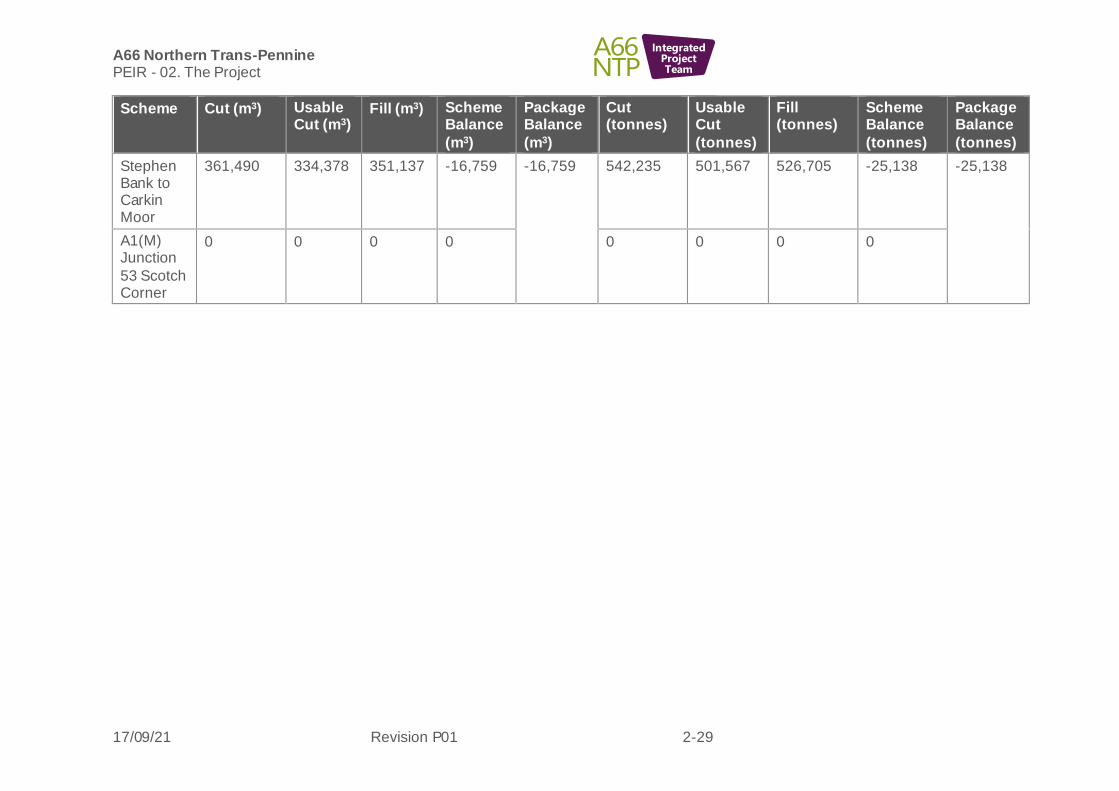
A66 Northern Trans-Pennine PEIR - 02. The Project
17/09/21 Revision P01 2-29
IntegratedProjectTeam
Scheme Cut (m3) Usable Cut (m3)
Fill (m3) Scheme Balance
(m3)
Package Balance
(m3)
Cut (tonnes)
Usable Cut
(tonnes)
Fill (tonnes)
Scheme Balance
(tonnes)
Package Balance
(tonnes)
Stephen Bank to Carkin Moor
361,490 334,378 351,137 -16,759 -16,759 542,235 501,567 526,705 -25,138 -25,138
A1(M) Junction
53 Scotch Corner
0 0 0 0 0 0 0 0

A66 Northern Trans-Pennine PEIR - 02. The Project
17/09/21 Revision P01 2-30
IntegratedProjectTeam
Construction access and vehicle movements (on-site)
2.8.23 Construction of the project will require a large quantity of plant and equipment. The high volume of material to be moved will require large excavators, articulated dump trucks, dozers, compactors plus graders, bowsers and stabilising plant. To construct the structures, large piling rigs and heavy-duty cranes will also be required. Exact plant numbers and type will be determined by the construction methodology and the volume of material to be handled on site.
2.8.24 It is currently assumed that a haul road strip 10m wide will be required parallel to new embankment/structures with access gained via upgrading existing farm tracks, as necessary. Land required for the assumed haul road has been included within the engineering boundary which has informed the assessments presented in this PEI Report.
2.8.25 Where possible the new A66 footprint will be used to form access roads across the site to aid construction and the movement of people and materials. Where works are taking place online or in areas of congested traffic management, additional haul roads will be required to provide connectivity between key work interfaces. In the initial phase of the project, access points will be required off the A66 to enable service identif ication, protection and or diversion works to commence. Where possible such access points will be adopted as part of the main works.
2.8.26 Additional haul routes are essential where large earth movements are required as required for a number of the schemes. Haul roads will be constructed based on value engineered solutions that aim to maximise the properties of the soil and reduce import of quarried or recycled material. In some instances, haul routes will be constructed on proposed farm access track locations, being adopted on completion of the scheme, reducing the environmental impacts. Where haul roads are no longer required, they will be removed and the land restored or incorporated as part of the new works. Where possible, no material that is suitable will be discarded off site.
Construction traffic (off-site)
2.8.27 Most of the material excavated within the schemes will be retained and used (and ground investigation works to date have confirmed that the majority of material will be suitable for reuse), but in some instances, there will be a need for additional fill to be imported or excavated material to be exported depending on the new road alignment and topography. Where this occurs, efforts will be made to reduce the off -site haul distance of such material, with incorporation of neighbouring schemes that require the material. Despite detailed geo-environmental procedures and treatments that are available to improve soils, which will be employed on the project, it is expected that there will still be a very small percentage of unsuitable or contaminated material generated from the works that cannot be reused. Such material will need to be transported to licensed waste management facilities.
2.8.28 Other construction traffic will consist of vehicles delivering the products required for the construction of the schemes, including concrete, bitumen, aggregates, pipes and steel. Some deliveries will arrive as abnormal loads, such as large construction plant and bridge elements.
Existing A66 during construction
2.8.29 Appropriate traffic management measures will be put in place to ensure that traffic flows on the existing A66 are maintained where possible with limited disruption caused. Due to the few east to west alternative Trans-Pennine routes to the A66 and

A66 Northern Trans-Pennine PEIR - 02. The Project
17/09/21 Revision P01 2-31
IntegratedProjectTeam
the requirement for both online and offline working, an extensive traffic management programme will be implemented for the project. All works will be phased to ensure that A66 traffic can be maintained, with more complex interface areas likely being undertaken on nights to further reduce any disruption.
2.8.30 Traffic management plans will be developed for the construction phase, to address both management of construction traffic and also detailed plans for management of road traffic through the construction works. These will define routes to be taken for construction traffic movement and other mitigation measures to minimise the impact of construction traffic, but also to minimise the impact of construction on road traffic. Outlines of these documents will be included with the DCO application, and assessed within the ES, with the detail being developed by the contractors alongside the detailed design.
Statutory utilities
2.8.31 Construction of the project will likely require the diversion, relocation or protection of several existing utility assets including water, wastewater, electricity and telecommunications.
2.8.32 The affected statutory utilities infrastructure is predominately located alongside roads. The main exceptions are high voltage electricity cables and water mains which run through fields.
2.8.33 Consultation with the statutory utilities is ongoing to determine exact diversion requirements, and whilst locations of diversions are not fully confirmed, land has been incorporated into the draft DCO boundary (within the engineering boundary) to allow for likely utility diversions. At the current stage of design, it is not anticipated that significant diversions will be required thus specific corridors for diversions are not shown.
2.8.34 The required diversions will be planned in detail by the contractor as part of the construction works.
Demolitions
2.8.35 Any requirement for demolition of existing structures is identif ied in the scheme-specific description presented above. Any properties or business facilities that require demolition for the project will be subject to replacement or compensation, to be agreed. Demolitions have the potential to be noise and dust generating, therefore will be undertaken during daytime hours only and measures will be put in place to limit disturbance to any nearby residents or sensitive receptors. Where the existing road is to be upgraded, there may also need to be demolition of road infrastructure, planing of surfaces and removal of existing drainage, signs etc. This will be managed as part of the wider construction programme and controls to manage environmental effects implemented through the Environmental Management Plan (EMP).
2.8.36 Full details of the proposed demolitions, with justif ication, will be provided in the ES.
Construction environmental management
2.8.37 Measures identif ied through the EIA process to further prevent, reduce and, where possible, offset any adverse effects on the environment will be described in the relevant topic chapters of the ES. These essential mitigation measures will be summarised in the Register of Environmental Actions and Commitments (REAC), contained within the EMP, a draft of which will be submitted as part of the DCO
A66 Northern Trans-Pennine PEIR - 02. The Project
17/09/21 Revision P01 2-32
IntegratedProjectTeam
application. An outline of the EMP is included at Appendix 4-1: Outline of Environmental Management Plan.
2.8.38 Where the project design and the parameters included in the DCO allow for some flexibility in design or how aspects of the project are constructed, the EMP will specify the mitigation objective to be achieved and any specific constraints on the design, construction or operation that need to be implemented. Where relevant, indicative layouts of mitigation measures will be shown on the visual Environmental Mitigation Plans submitted as part of the DCO application and included in the EMP.
2.8.39 It is important to note that the precise content of the Environmental Mitigation Plans will not be intended to be ‘secured’ by way of the DCO – instead, they will present indicative layouts to show how the relevant mitigation measures could be implemented so as to be effective in terms of mitigating effects. However, as detailed design progresses it may be the case that the layout indicated on the Environmental Mitigation Plans needs to be altered. Importantly, this could only be done insofar as the layout complies with the EMP.
2.8.40 Prior to the commencement of the construction works, the EMP will be refined by the contractor, in line with DMRB standard LA 120 (Highways England, 2020)15.
2.8.41 Further information regarding the proposed construction process can be found in the Construction Method Statement (Highways England, 2021)16.
2.9 Maintenance
2.9.1 Maintenance will be authorised under the DCO. As required by DMRB, industry standard control measures will be applied and encapsulated in the EMP at the end of construction to inform the handover process, and ensure key requirements are met during operation so that the mitigation implemented continues to be effective . With the implementation of these measures no significant effects from maintenance are considered likely that will not already be considered for the construction phase and so maintenance activities are not considered separately.
2.10 Decommissioning
2.10.1 The traffic assessment demonstrates that the proposed improvements will operate adequately in the Design Year of 2044 (15 years after opening). Typically, highways projects are designed to have a materials (e.g. pavements, etc.) lifespan of between 20 and 40 years before major maintenance and upgrading is required, dependent on material properties, maintenance and usage. Elements including structural concrete and steelwork have extended design lives of up to 120 years.
2.10.2 It is considered highly unlikely that the project will be decommissioned as the road is likely to become an integral part of the infrastructure in the area. Decommissioning will not be either feasible or desirable and is therefore not proposed to be considered in the EIA.
15 Highways England (2020) Environmental Management Plans LA 120, Accessed January 2021, https://www.standardsforhighways.co.uk/prod/attachments/a3a99422-41d4-4ca1-bd9e-eb89063c7134?inline=true [accessed 19 August 2021] 16 Highways England (2021) A66 NTP Construction Method Statement, available as part of the consultation material on http://www.highwaysengland.co.uk/A66-NTP