INSTRUCTIONS FOR COMPLETINGTHE …rev_04_2017).pdf · instructions for completingthe...
34
INSTRUCTIONS FOR COMPLETING THE APPLICATION FORMS FOR CONDITIONAL LETTERS OF MAP REVISION AND LETTERS OF MAP REVISION CONTENTS MT-2 Revision Request Submittal Checklist ................................................................................................................ 2 General .......................................................................................................................................................................... 3 When to Use These Forms............................................................................................................................................. 3 When Not to Use These Forms ...................................................................................................................................... 4 Summary of Forms ........................................................................................................................................................ 4 Fees................................................................................................................................................................................ 5 What to Submit .............................................................................................................................................................. 5 Where to Submit ............................................................................................................................................................ 6 Instructions for Completing the Overview & Concurrence Form (Form 1) .................................................................. 8 Instructions for Completing the Riverine Hydrology & Hydraulics Form (Form 2) ................................................... 11 Instructions for Completing the Riverine Structurres Form (Form 3) ......................................................................... 19 Instructions for Completing the Coastal Analysis Form (Form 4) .............................................................................. 24 Instructions for Completing the Coastal Structures Form (Form 5) ............................................................................ 25 Instructions for Completing the Alluvial Fan Flooding Form (Form 6) ...................................................................... 26 Instructions for Completing the Payment Information Form....................................................................................... 27 Instructions for Completing the Endangered Species Act Compliance Documentation.............................................. 28 Appendix A - Commonly Used Acronyms.................................................................................................................. 29 Appendix B - Useful Internet Sites .............................................................................................................................. 31 Appendix C - DHS-FEMA Offices ............................................................................................................................. 33 FEMA has developed the Online LOMC tool to allow applicants to submit their requests electronically. This tool is a convenient way for applicants to upload all information and supporting documentation and check the status of their request online. Users can submit requests through this tool instead of filing the paper form via Online LOMC mail. You can find additional information about FEMA’s Online LOMC Tool at www.fema.gov/online-lomc. Instructions MT-2 Forms 1
Transcript of INSTRUCTIONS FOR COMPLETINGTHE …rev_04_2017).pdf · instructions for completingthe...

INSTRUCTIONS FOR COMPLETING THE APPLICATION FORMS FOR CONDITIONAL LETTERS OF MAP REVISION
AND LETTERS OF MAP REVISION
CONTENTS MT-2 Revision Request Submittal Checklist 2 General 3 When to Use These Forms 3 When Not to Use These Forms 4 Summary of Forms 4 Fees 5 What to Submit 5 Where to Submit 6 Instructions for Completing the Overview amp Concurrence Form (Form 1) 8 Instructions for Completing the Riverine Hydrology amp Hydraulics Form (Form 2) 11 Instructions for Completing the Riverine Structurres Form (Form 3) 19 Instructions for Completing the Coastal Analysis Form (Form 4) 24 Instructions for Completing the Coastal Structures Form (Form 5) 25 Instructions for Completing the Alluvial Fan Flooding Form (Form 6) 26 Instructions for Completing the Payment Information Form 27 Instructions for Completing the Endangered Species Act Compliance Documentation 28 Appendix A - Commonly Used Acronyms 29 Appendix B - Useful Internet Sites 31 Appendix C - DHS-FEMA Offices 33
FEMA has developed the Online LOMC tool to allow applicants to submit their requests electronically This tool is a convenient way for applicants to upload all information and supporting documentation and check the status of their request online Users can submit requests through this tool instead of filing the paper form via
Online LOMC
mail You can find additional information about FEMArsquos Online LOMC Tool at wwwfemagovonline-lomc
Instructions MT-2 Forms 1
MT-2 REVISION REQUEST SUBMITTAL CHECKLIST
PART A GENERAL REQUIREMENTS ELEMENTS Yes NA
NARRATIVE Please provide a written description about the purpose of the request and the scope of the proposedas-built project and the methodology used to analyze the project effects MT-2 APPLICATION FORMS Please provide completed forms applicable to your request Ensure that MT-2 Form 1 was signed by the requester certifying engineer and each community affected by the revision HYDROLOGIC ANALYSIS If applicable please provide a FEMA acceptable hydrologic analysis in digital format drainage area map and associated backup information (eg calculations used to determine lag time CN and loss values as well as landuse and soil maps) FEMA-acceptable models can be accessed at wwwfemagovnational-flood-insurance-program-flood-hazard-mappingnumerical-models-meeting-minimum-requirements HYDRAULIC ANALYSIS Please provide a FEMA acceptable hydraulic analysis in digital format FEMA-acceptable models can be accessed at wwwfemagovnational-flood-insurance-program-flood-hazard-mappingnumerical-models-meeting-minimum-requirements CERTIFIED TOPOGRAPHIC WORK MAP Please provide a certified topographic work map that meets the mapping requirements outlined in MT-2 Form 2 If available please provide digital Computer-Aided Design (CAD) or Geographic Information System (GIS) data that is spatially referenced ANNOTATED FIRM Please submit a revised FIRM at the scale of the effective FIRM which shows the revised boundary delineation of the base floodplain 02-percent-annual-chance floodplain and regulatory floodway and how it ties into the boundary delineation shown on the effective FIRM at the downstream and upstream ends of the revised reach REVIEW FEE PAYMENT Please include the appropriate review fee payment The current fee schedule is available on the FEMA Web site at httpswwwfemagovflood‐map‐related‐fees MEET 6510 REQUIREMENT If the request intends to show that a bermleveeflood wall provides flood protection please submit all of the data requirements outlined in Section 6510 of the NFIP regulations OPERATION AND MAINTENANCE PLAN If the request involves a berm levee flood wall dam andor detention basin project please submit an officially adopted maintenance and operation plan PROPOSEDAS-BUILT PLANS If applicable please submit proposedas-built plans certified by a registered Professional Engineer for all the project elements FLOODWAY NOTICE If the revision result in changing or establishing floodway boundaries please provide floodway public notice or a statement by your community that it has notified all affected property owners in compliance with NFIP regulation Subparagraph 657(b)(1) PROPERTY OWNER NOTIFICATION If the revision result in any wideningshiftingestablishing of the base floodplain andor any BFE increasesestablishing BFEs please provide copy of the individual legal notices sent to all the property owners affected by any increases in the flood hazard information
PART B CLOMR SPECIFIC REQUIREMENTS Endangered Species Act COMPLIANCE Please submit documentation of compliance with the ESA Requirements To learn more about ESA Compliance please see the MT-2 Instructions manual 6512 REGULATORY REQUIREMENTS If the Base (1-percent-annual-chance) Flood Elevation (BFE) increases greater than 000 foot as a result of encroachment within a floodway or 10 foot within Zone AE that has no floodwayZone A between the pre-project (existing) conditions and the proposed conditions as a result of the proposed project Please submit a) Certification that no structures are affected by the increased BFE b) Documentation of individual legal notice to all affected property owners explaining the impact of the proposed action on their property and c) An evaluation of alternatives that would not result in an increase in BFE
Note Applicants are encouraged to submit their revision request using the Online LOMC tool To learn more about the Online LOMC tool visit the FEMA website at wwwfemagovonline-lomc
Instructions MT-2 Forms 2
GENERAL
In 1968 the US Congress passed the National Flood Insurance Act which created the National Flood Insurance Program (NFIP) The NFIP was designed to reduce future flood losses through local floodplain management and to provide protection for property owners against potential losses through flood insurance
As part of the agreement for making flood insurance available in a community the NFIP requires the participating community to adopt floodplain management ordinances containing certain minimum requirements intended to reduce future flood losses The NFIP regulations for floodplain management are the minimum criteria a community must adopt for participation in the NFIP The community is responsible for approving all proposed floodplain development and for ensuring that permits required by Federal or State law have been received State and community officials based on knowledge of local conditions and in the interest of safety may set higher standards for construction or may limit development in floodplain areas If the State or Community has adopted more restrictive or comprehensive floodplain management criteria those criteria take precedence over the minimum NFIP requirements
The community is also responsible for submitting data to the US Department of Homeland Security - Federal Emergency Management Agency (DHS-FEMA) reflecting revised flood hazard information so that NFIP maps can be revised as appropriate This will allow risk premium rates and floodplain management requirements to be based on current data
Submissions to DHS-FEMA for revisions to effective Flood Insurance Studies (FISs) Flood Insurance Rate Maps (FIRMs) or Flood Boundary Floodway Maps (FBFMs) by individual and community requesters will require the signing of application forms These forms will provide DHS-FEMA with assurance that all pertinent data relating to the revision are included in the submittal They will also ensure that (a) the data and methodology are based on current conditions (b) qualified professionals have assembled data and performed all necessary computations and (c) all individuals and organizations affected by proposed changes are aware of the changes and will have an opportunity to comment on them
If the submission involves revisions to multiple flooding sources then separate forms should be completed for each flooding source
NFIP regulations can be accessed at httpwwwaccessgpogovnaracfrwaisidx_0244cfrv1_02html or can be obtained by calling DHS-FEMArsquos Map Information eXchange (FMIX) at 1-877-FEMA MAP (1-877-336-2627) DHS-FEMArsquos Internet site at httpwwwfemagovnational-flood-insurance-program-flood-hazard-mappingmt-2-application-forms-and-instructions provides access to the forms and latest fees and revision procedures DHS-FEMA is preparing online tutorials to
assist users of the NFIP maps that are available at httpwwwfemagovonline-tutorials
WHEN TO USE THESE FORMS
This package is applicable for requests of the following
Conditional Letter of Map A letter from DHS-FEMA commenting on whether a proposed Revision (CLOMR) project if built as proposed would meet minimum NFIP
standards or proposed hydrology changes [see 44 Code of Federal Regulations (CFR) Ch 1 Parts 60 65 and 72]
Letter of Map Revision (LOMR) A letter from DHS-FEMA officially revising the current NFIP map to show changes to floodplains floodways or flood elevations (see 44 CFR Ch 1 Parts 60 65 and 72)
Instructions MT-2 Forms 3
WHEN NOT TO USE THESE FORMS
This package is not applicable for requests of the following
Letter of Map Amendment A letter from DHS-FEMA stating that an existing structure or (LOMA) parcel of land that has not been elevated by fill (natural
ground) would not be inundated by the base flood
Conditional Letter of A letter from DHS-FEMA stating that a proposed structure Map Amendment (CLOMA) that is not to be elevated by fill (natural ground) would not
be inundated by the base flood if built as proposed
Letter of Map Revision A letter from DHS-FEMA stating that an existing structure Based on Fill (LOMR-F) or parcel of land that has been elevated by fill would not be
inundated by the base flood
Conditional Letter of Map A letter from DHS-FEMA stating that a parcel of land or Revision Based on Fill proposed structure that will be elevated by fill would not be (CLOMR-F) inundated by the base flood if fill is placed on the parcel as
proposed or the structure is built as proposed
For these requests either the MT-EZ form package titled Amendments to National Flood Insurance Program Maps Application Form for Single Residential Lot or Structures or the MT-1 form package titled Amendments and Revisions to National Flood Insurance Program Maps Application Forms and Instructions for Letters of Map Amendment Conditional Letters of Map Amendment Letters of Map Revision Based on Fill and Conditional Letters of Map Revision Based on Fill are appropriate The MT-EZ forms are used for single structure or lot requests that do not involve the placement of fill The MT-1 forms are used for requests involving multiple structures or lots These forms may be completed online through the Online LOMC Application at httpshazardsfemagovfemaportalonlinelomcsignin The MT-EZ form package may be downloaded from DHS-FEMArsquos Internet site at httpwwwfemagovletter-map-amendment-letter-map-revision-based-fill-processmt-ez-form-application-form-single and the MT-1 form package may be downloaded from DHS-FEMArsquos Internet site at httpwwwfemagovnational-flood-insurance-program-flood-hazard-mappingmt-1-application-forms-instructions Either form package may also be obtained by calling DHS-FEMArsquos Map Information eXchange (FMIX) at 1-877-FEMA MAP (1-877-336-2627)
SUMMARY OF FORMS
Application forms for requesting a revision from DHS-FEMA are included in the back of this package There are six forms a payment form plus information about Endangered Species Act (ESA) compliance documentation in this package which cover various situations for revisions When submitting a request only the forms applicable to the request need to be submitted The following is a list of the forms and a brief summary of when each is applicable
Form 1 - Overview amp Concurrence Form provides the basic information regarding the revision request and requires the signatures of the requester community official and engineer This form is required for all revision requests
Form 2 - Riverine Hydrology amp Hydraulics Form provides the basic information on the scope and methodology of hydrologic andor hydraulic analyses that are prepared in support of the revision request This form should be used for revision requests that involve new or revised hydrologic andor hydraulic analyses of rivers streams ponds or small lakes
Form 3 - Riverine Structures Form provides the basic information regarding hydraulic structures constructed in the stream channel or floodplain This form should be used for revision requests that involve new or proposed channelization bridgesculverts damsbasins andor leveesfloodwalls Requires the signature of the PE in charge of complete submittal for Levees
Form 4 - Coastal Analysis Form provides the basic information on the scope and methodology of coastal analyses that are prepared in support of the revision request This form should be used for any revision requests that involve new or revised coastal analyses
Instructions MT-2 Forms 4
Form 5 - Coastal Structures Form provides the basic information regarding hydraulic structures constructed along the coast This form should be used for revision requests that involve new or proposed leveesdikes breakwaters bulkheads seawalls andor revetments located along the coast
Form 6 - Alluvial Fan Flooding Form provides the basic information for analyses of alluvial fans This form should be used for revision requests involving alluvial fans
Payment Information Form - Provides the basic information regarding any fees paid for a CLOMR LOMR or External Data Request
ESA Compliance Documentation ndash Documented ESA compliance must be submitted for CLOMRs only CLOMR applicants are responsible for documenting to FEMA that Endangered Species Act (ESA) compliance has been achieved prior to FEMArsquos review of a CLOMR application Information outlining these requirements is available on Page 28 of this instruction packet
FEES
DHS-FEMA has implemented a procedure to recover costs associated with reviewing and processing requests for modifications to published flood information and maps The current fees for review and processing of CLOMR and LOMR requests may be obtained from DHS-FEMArsquos Internet site at httpswwwfemagovflood-map-related-fees or by calling DHS-FEMArsquos Map Information eXchange (FMIX) at 1-877-FEMA MAP (1-877-336-2627)
Some requests for revisions may be exempt from the fees NFIP Regulation 44 CFR Ch 1 Section 725 describes the circumstances for requests to be exempt from paying the fees The exemptions are also described on DHS-FEMArsquos Internet site at httpwwwfemagovforms-documents-and-softwareflood-map-related-fees
Payment must be made by credit card check or money order Checks and money orders should be made payable in US funds to the National Flood Insurance Program Please note that the fee is to be sent to the same address as the request package See Pages 6 and 7 for where to submit the request package and fees
WHAT TO SUBMIT
A CLOMR or LOMR request should include the application forms along with the appropriate supporting information The submittal should include but not necessarily be limited to the items listed below A checklist with more details is provided at the beginning of these instructions
1 Completed application forms 2 Narrative on project and submittal (optional but very helpful) Knowing the project and purpose of the
request better ensures the needs of the requester are met 3 Hydrologic Computations (if applicable) along with digital files of computer models used 4 Hydraulic Computations (if applicable) along with digital files of computer models used 5 Certified topographic map with floodplain and floodway (if applicable) delineations 6 Annotated DHS-FEMA FIRM andor FBFM to reflect changes due to project (FIRMs and or FBFMs can
be accessed on-line at httpsmscfemagovportal) 7 As-built plans or survey for LOMRs and design plans for CLOMRs for all hydraulic structures or grading
within the floodplain along the revised reach 8 Items required to satisfy any DHS-FEMA NFIP regulatory requirements 9 Review fee payment if applicable 10 ESA compliance documentation required for CLOMRs only
Before DHS-FEMA will replace the effective FIS information with the revised the requester must (a) provide all of the data used in determining the revised floodplain boundaries flood profiles floodway boundaries etc (b) provide all data necessary to demonstrate that the physical modifications to the floodplain meet NFIP regulations as well as ESA regulations (for CLOMRs only) have been adequately designed to withstand the impacts of the 1 annual chance flood event and will be adequately maintained and (c) demonstrate that the revised information (eg hydrologic and hydraulic analyses and the resulting floodplain and floodway boundaries) is consistent with the effective FIS information
Instructions MT-2 Forms 5
WHERE TO SUBMIT
Applicants are encouraged to submit their revision request using the Online LOMC tool To learn more about Online LOMC tool visit the FEMA website at wwwfemagovonline-lomc For hardcopy submittals the completed package should be submitted to the appropriate address indicated below
Where to mail your request and fees tohellip
Under CTP agreements with DHS-FEMA State of North Carolina Mecklenburg County North Carolina State of Alabama State of Illinois Denver Urban Drainage and Flood Control District Harris County Flood Control District and the San Antonio River Authority have begun reviewing and processing LOMCs for their jurisdictions The North Carolina State will receive all MT-2 LOMC requests within the state except for sites within Mecklenburg County The Mecklenburg County Flood Mitigation Program will receive and review requests for locations within City of Charlotte and Mecklenburg County The Urban Drainage and Flood Control District will receive and review requests for locations within the Denver metropolitan area The Harris County Flood Control District will receive and review requests for locations within Harris County and incorporated communities within Harris County The San Antonio River Authority will receive and review requests within the San Antonio River basin which includes Bexar Goliad Karnes and Wilson Counties
All requests for CLOMRs and LOMRs for locations within the most of the country except for areas within the States of Alabama Illinois and North Carolina and the areas within the jurisdiction of the Denver Urban Drainage and Flood Control District Harris County Flood Control District and the San Antonio River Authority should be mailed to
LOMC CLEARINGHOUSE 3601 EISENHOWER AVENUE SUITE 500
ALEXANDRIA VA 22304-6426
All requests for CLOMRs and LOMRs in Harris County TX (wwwhcfcdorg) should be mailed to
HARRIS COUNTY FLOOD CONTROL DISTRICT ATTN MT-2 LOMC COORDINATOR
9900 NORTHWEST FREEWAY HOUSTON TX 77092
All requests for CLOMRs and LOMRs in Alabama (wwwadecaalabamagovfloods) should be mailed to
ALABAMA OFFICE OF WATER RESOURCES ATTN MT-2 LOMC COORDINATOR
401 ADAMS AVENUE MONTGOMERY AL 36104
All requests for CLOMRs and LOMRs in Illinois (httpwwwiswsillinoisedu) should be mailed to
ILLINOIS STATE WATER SURVEY 2204 GRIFFITH DRIVE CHAMPAIGN IL 61820
ATTN CHRIS HANSTAD MT2iswsillinoisedu
Instructions MT-2 Forms 6
All requests for CLOMRs and LOMRs in North Carolina (outside of Mecklenburg County) (httpwwwncfloodmapscomtop_abouthtm) should be mailed to
Mailing Address NC MT-2 LOMC Depot
4218 Mail Service Center Raleigh NC 27699-4218
Physical Address (Overnight Deliveries) NC MT-2 LOMC Depot
Claude T Bowers Military Center 4105 Reedy Creek Road Raleigh NC 27607-6410
All requests for CLOMRs and LOMRs in City of Charlotte and Mecklenburg County North Carolina ( httpcharmeckorgstormwaterPagesdefaultaspx) should be mailed to
CHARLOTTE-MECKLENBURG COUNTY STORM WATER SERVICES 700 N TRYON STREET
CHARLOTTE NC 28202 ATTN DAVID LOVE PE CFM PROJECT MANAGER
All requests for CLOMRs and LOMRs within the jurisdiction of the San Antonio River Authority (Bexar Wilson Karnes and Goliad Counties TX) (httpwwwsara-txorg) should be mailed to
SAN ANTONIO RIVER AUTHORITY ATTN WATERSHED ENGINEERING DEPT LOMC ADMINISTRATOR
PO BOX 839980 SAN ANTONIO TX 78283-9980
All requests for CLOMRs and LOMRs within the Denver Colorado metropolitan area (Urban Drainage and Flood Control District) (httpudfcdorg) should be mailed to
URBAN DRAINAGE AND FLOOD CONTROL DISTRICT 2480 WEST 26TH AVENUE SUITE 156-B
DENVER CO 80211 ATTN BILL DEGROOT PE
Instructions MT-2 Forms 7
INSTRUCTIONS FOR COMPLETING THE OVERVIEW amp CONCURRENCE FORM
(FORM 1)
This form provides the basic information regarding revision requests and must be submitted with each request It contains much of the material needed for the US Department of Homeland Security - Federal Emergency Management Agency (DHS-FEMA) to assess the nature and complexity of the proposed revision It will identify (a) the type of response expected from DHS-FEMA (b) those elements that will require supporting data and analyses and (c) items needing concurrence of others This form will also ensure that the community is aware of the impacts of the request and has notified affected property owners if required All items must be completed accurately If the revision request is being submitted by an individual firm or other non-community official contact should be made with appropriate community officials National Flood Insurance Program (NFIP) regulation Title 44 CFR Ch 1 Section 654 requires that revisions based on new technical data be submitted through the Chief Executive Officer (CEO) of the community or a designated official Should the CEO refuse to submit such a request on behalf of another party DHS-FEMA will agree to review it only if written evidence is provided indicating that the CEO or designee has been requested to do so
Section A Requested Response from DHS-FEMA
Indicate the type of response being requested Brief descriptions of possible responses are provided in the introduction more detail regarding these responses and the data required to obtain each response are provided in the NFIP regulations Title 44 CFR Ch 1
Section B Overview
1 The Community Number Community Name State Map Number Panel Number and Effective Date can be obtained from the Flood Insurance Rate Map (FIRM) title block The sample FIRM panels (Figures 1 and 2 on the following page) provide a convenient example of information to complete item 1 The effective FIRMs can be obtained from the communityrsquos map repository or from FEMArsquos Map Information eXchange (FMIX) website at httpmscfemagov
2 a Flooding source refers to a specific lake stream ocean etc This should match the flooding source name shown on the FIRM if it has been labeled (Examples Lake Michigan Duck Pond or Big Hollow Creek)
b Indicate the types of flooding associated with the revision request
3 Project NameIdentifier can be the name of a flood control project or other pertinent structure having an impact on the effective FIS the name of a subdivision or area or some other identifying phrase
4 a The effective zone designations affected can be obtained from the FIRM
5 Enter the coordinates at approximately the center of the area to be revised
6 a Indicate the basis for the revision request Physical Changes include watershed development flood control structures etc Note that fees will be
assessed for DHS-FEMAs review of proposed and as-built projects as outlined in NFIP regulations 44 CFR Ch 1 Part 72
Improved MethodologyData may be a different technique (model) or adjustments to models used in the effective FIS
Regulatory Floodway Revisions involve any shift in the DHS-FEMA-designated floodway boundaries regardless of whether the shift is mappable
Other involves any basis for the request not including the above items
b Indicate the types of structure(s) associated with the revision request
7 Please submit documents relating to Endangered Species Act (ESA) for CLOMR requests Please note that CLOMR requests will not be reviewed until ESA documents are received by FEMA Please refer to Page 28 of this MT-2 instruction package for more details
Instructions MT-2 Forms 8
Section C Review Fee
Enter the fee amount associated with the request or attach an explanation as to why the revision meets the requirements for a fee exemption The current fees for review and processing of Conditional Letter of Map Revision (CLOMR) and Letter of Map Revision (LOMR) requests may be obtained from DHS-FEMArsquos Internet site at httpswwwfemagovflood-map-related-fees
Section D Signature
Signature and Title of Revision Requester
The person signing this certification should own the property involved in the request or have legal authority to represent a groupfirmorganization or other entity in legal actions pertaining to the NFIP
The requester is responsible for obtaining all necessary Federal State and local permits as a condition of obtaining a LOMR or CLOMR The community is required to make sure that all necessary permits have been obtained prior to issuing a floodplain development permit The most commonly required Federal permits are wetlands permits under Section 404 of the Clean Water Act of 1972 and incidental take permits under Section 10 of the Endangered Species Act of 1972 Necessary State permits vary depending on the State If the requester needs a wetlands permit or is not sure if one is required he should contact the US Army Corps of Engineers District Office If the requesterrsquos proposed development impacts threatened or endangered species or if he is unsure if it does he should consult with the nearest US Fish and Wildlife Service field office
Signature and Title of Community Official
The person signing this certification should be the CEO for the community involved in this revision request or an official legally designated by the CEO If more than one community is affected by the change the community official from the community that is most affected should sign the form and letters from the other affected communities should be enclosed If the community or communities disagree with the proposed revision a signed statement should be attached to the request explaining the reasons or basis for disagreement
Instructions MT-2 Forms 9
Under 44 CFR 603(a)(2) the community is required to ensure prior to issuing a floodplain development permit that an applicant has obtained all necessary Federal and State permits related to development The most commonly required Federal permits are wetlands permits under Section 404 of the Clean Water Act of 1972 and incidental take permits under Section 10 of the Endangered Species Act of 1972 Necessary State permits vary depending on the State If the community is not sure if a wetlands permit is required refer the applicant to the US Army Corps of Engineers District Office If the proposed development impacts on threatened or endangered species or the community is unsure if it does have the applicant consult with the nearest US Fish and Wildlife Service field office
Certification by Registered Professional Engineer andor Land Surveyor
The person certifying this submittal must provide a valid license number and expiration date for their license If this information is provided affixing a seal is optional If a seal is available however it may be affixed in the seal box provided on this form The licensed professional engineer andor land surveyor should have a current license in the State where the affected communities are located While the individual signing this form is not required to have obtained the supporting data or performed the analyses he or she must have supervised and reviewed the work
A certification by a registered professional engineer or other party does not constitute a warranty or guarantee of performance expressed or implied Certification of data is a statement that the data is accurate to the best of the certifiers knowledge Certification of analyses is a statement that the analyses have been performed correctly and in accordance with sound engineering practices Certification of structural works is a statement that the works are designed in accordance with sound engineering practices to provide protection from the 1 annual chance flood Certification of as-built conditions is a statement that the structure(s) has been built according to the plans being certified is in place and is fully functioning
If the requester is a Federal agency who is responsible for the design and construction of flood control facilities a letter stating that the analyses submitted have been performed correctly and in accordance with sound engineering practices may be submitted in lieu of certification by a registered professional engineer Regarding the certification of completion of flood control facilities a letter from the Federal agency certifying its completion and the flood frequency event to which the project protects may be submitted in lieu of this form
Forms Submitted
Indicate which forms are submitted with the revision request
Instructions MT-2 Forms 10
INSTRUCTIONS FOR COMPLETING THE RIVERINE HYDROLOGY amp HYDRAULICS FORM (FORM 2)
This form should be used for revision requests that involve new or revised hydrologic andor hydraulic analyses of rivers streams ponds or small lakes A separate form should be used for each flooding source
SECTION A HYDROLOGY
This section is to be completed when discharges other than those used in the effective Flood Insurance Study (FIS) are proposed
1 Indicate the reason for the new or revised hydrologic analysis For revisions based on alternative methodologies or improved data an explanation as to why the alternative methodology or improved data provides better results over the FIS must be presented and supported throughout the form The revised hydrology should result in a statistically significant difference when compared to the effective discharges
2 Compare the effective 1 annual chance (100-year) discharges to the revised 1 annual chance discharges at three representative locations
In accordance with National Flood Insurance Program (NFIP) regulations if only a portion of a detailed study stream is revised transition to the unrevised portion must be ensured to maintain the continuity of the study Attach an explanation of how the proposed discharge in the revised portion of the stream transitions to the effective discharge in the unrevised portion of the stream and vice versa
3 Specify the method used for the new analysis a Rainfall Runoff Model Attach any additional backup computations and supporting data such as a
drainage area map soils map soil group names time of concentration computations curve numbers source of rainfall data storm duration node-link diagram (if applicable) etc CDs with the digital models should also be included Models submitted in support of a revision request must meet the requirements of Subparagraph 656(a)(6) of the NFIP regulations A list of accepted DHS-FEMA hydrologic models can be found at httpwwwfemagovnational-flood-insurance-program-flood-hazard-mappinghydrologic-models-meeting-minimum-requirement
b Statistical Analyses of gage records Please indicate the gaging record location and identification number and methodology used for the analysis Bulletin 17B Guidelines For Determining Flood Frequencies is the recommended approach for analyzing gage records If Bulletin 17B was not used in the gage analysis please provide the reasons why it was not applicalble Please submit the historical records of the flow data for the gaged data and statistical model results
c Regional Regression Methodology Please indicate the source of the regional regression equation and provide the description and justification of the parameters used in the regression equation USGS regression equations are available nationwide and recommended for use If the USGS regression equations were not used please provide the reasons these equations are not applicable
4 If approval of the new hydrologic analysis is required by a local State or Federal agency indicate if the analysis and resulting peak discharge value(s) have been approved by the appropriate local State or Federal agency and attach evidence of the approval
5 In locations where sediment transport affects hydrology the effects of sediment transport should be considered in the hydrology and Section F of Form 3 should be submitted
SECTION B HYDRAULICS
This section is to be completed when the request involves a hydraulic analysis for riverine flooding that differs from that used to develop the Flood Insurance Rate Map (FIRM)
1 Indicate the reach of stream to be revised The area of the revision is defined by an effective tie-in at the upstream and downstream limits For streams that have a detailed study an effective tie-in is obtained when the revised base flood and floodway elevations are within 05 feet of the effective elevations and the revised floodway encroachment stations match the effective floodway stations at both the upstream and downstream limits For streams that do not have a detailed study an effective tie-in is obtained when the revised base flood elevations are within 05 feet of the pre-project conditions model at both the upstream and downstream limits
Instructions MT-2 Forms 11
Please note that the area of revision and the project area are not necessarily the same If the revised model does not tie-in to the effective study at the project limits the model must be extended upstream and downstream until it ties-in to the effective study
2 Indicate the Hydraulic Method used for the revision A list of Hydraulic models accepted by DHS-FEMA can be found at httpwwwfemagovhydraulic-numerical-models-meeting-minimum-requirement-national-flood-insurance-program If using a hydraulic model that does not appear on the list of accepted models please provide documentation showing that the model meets the requirements of NFIP regulation 656(a)(6) For unsteady state hydraulic models please ensue that hydrology section of this Form is also filled out and relevant hydrologic back up data are provided For 2-dimensional models Please indicate the grid size used and explain how floodway (if applicable) is modeled
2 Indicate if the CHECK-2 or CHECK-RAS programs were used to verify that the hydraulic estimates and assumptions in the model are comparable to the assumptions and limitations of HEC-2 or HEC-RAS CHECK-2 and CHECK-RAS are review tools that identify areas of potential error or concern These tools do not replace engineering judgment CHECK-2 and CHECK-RAS can be downloaded from DHS-FEMArsquos Internet site at httpwwwfemagovsoftware We recommend that you review your HEC-2 and HEC-RAS models with CHECK-2 and CHECK-RAS If you disagree with the comment messages please attach an explanation of why the messages are not valid in each case To reduce processing time review your hydraulic model and resolve valid modeling discrepancies before submitting it for review
3 Indicate the hydraulic models submitted Provide name of plans used if HEC-RAS models are submitted Also indicate vertical datum used for each of the submitted hydraulic models
Duplicate Effective Model
The duplicate effective model is a copy of the hydraulic analysis used in the effective FIS referred to as the effective model The effective model should be obtained and then reproduced on the requesterrsquos equipment to produce the duplicate effective model This is required to ensure that the effective modelrsquos input data has been transferred correctly to the requesterrsquos equipment and to ensure that the revised data will be integrated into the effective data to provide a continuous FIS model upstream and downstream of the revised reach For information on how to obtain copies of the effective FIS models see DHS-FEMArsquos Internet site at httpswwwfemagovengineering-library
Corrected Effective Model
The Corrected Effective Model is the model that corrects any errors that occur in the Duplicate Effective Model adds any additional cross sections to the Duplicate Effective Model or incorporates more detailed topographic information than that used in the current effective model The Corrected Effective Model must not reflect any man-made physical changes since the date of the effective model An error could be a technical error in the modeling procedures or any construction in the floodplain that occurred prior to the date of the effective model but was not incorporated into the effective model
Existing or Pre-Project Conditions Model
The Duplicate Effective Model or Corrected Effective Model is modified to produce the Existing or Pre-Project Conditions Model to reflect any modifications that have occurred within the floodplain since the date of the Effective model but prior to the construction of the project for which the revision is being requested If no modification has occurred since the date of the effective model then this model would be identical to the Corrected Effective Model or Duplicate Effective Model The existing or pre-project model may be required to support conclusions about the actual impacts of the project associated with the revised or post-project model or to establish more up-to-date models on which to base the revised or post-project conditions model
Revised or Post-Project Conditions Model
The Existing or Pre-Project Conditions Model (or Duplicate Effective Model or Corrected Effective Model as appropriate) is modified to reflect revised or post-project conditions This model must incorporate any physical changes to the floodplain since the effective model was produced as well as
Instructions MT-2 Forms 12
the effects of the project When the request is for a proposed project this model must reflect proposed conditions
The information requested on the Riverine Hydrology amp Hydraulics Form is intended to document the steps taken by the requester in the process of preparing the revised or post-project conditions hydraulic model and the resulting revised FIS information The following guidelines should be followed when completing the form
All changes to the duplicate and subsequent models must be supported by certified topographic information bridge plans construction plans survey notes etc
Changes to the hydraulic models should be limited to the stream reach for which the revision is being requested Cross sections upstream and downstream of the revised reach should be identical to those in the effective model If this is done water surface elevations and topwidths computed by the revised models should match those in the effective models upstream and downstream of the revised reach as required
There must be consistency between the revised hydraulic models the revised floodplain and floodway delineations the revised flood profiles topographic work map annotated FIRMs andor Flood Boundary Floodway Maps (FBFMs) construction plans bridge plans etc
Submittal requirements for hydraulic analyses Digital copies of all hydraulic analyses must be submitted along with all supporting data (eg description of vegetation and land use map) for the source of input parameters used in the models listed above must be provided The summary must include a description of any changes made from model to model (eg Duplicate Effective Model to Corrected Effective Model) At a minimum the Duplicate Effective Model (if available) and the Revised or Post-Project Conditions Model must be submitted for LOMRs For CLOMRs a pre-project (existing conditions) model must also be provided The hydraulic analyses shall be performed for all flood frequencies published in the effective FIS If there is an effective floodway revised floodway analyses must also be submitted
SECTION C MAPPING REQUIREMENTS
A certified topographic map of suitable scale contour interval and planimetric definition must be submitted showing the applicable items indicated on the form If a digital version of the map is available it may be submitted so that the FIRM may be more easily revised The vertical datum used to reference the topographic elevations must be specified and should be consistent with the datum used to reference the elevations in the hydraulic analysis
Attach an annotated FIRM panel showing the revised 1 and 02 annual chance floodplains and floodway boundaries The revised boundaries must tie into the effective boundaries The annotated FIRM ensures that DHS-FEMA is aware of how the requester anticipates the FIRM will be revised
Indicate if annotated FIRM andor FBFM and digital mapping data (GIS or CADD) submitted If digital data is submitted please include any supporting documentation or metadata with the data submission including relevant projection information Current mapping standards utilize the Universal Transverse Mercator (UTM) projection and State Plane Coordinate System in accordance with FEMA mapping specifications Data not submitted in ESRI mapping format can be submitted in any supported data format which includes AutoCAD Microstation and MapInfo
SECTION D COMMON REGULATORY REQUIREMENTS
1 a Indicate ldquoyesrdquo for the following situations Projects that will have construction within the floodway which cause the BFEs to increase (more
than 000 feet) or Projects that will have construction within the floodplain of streams that have a detailed effective
study but for which a floodway has not been established which cause the BFEs to increase more than 10 foot (or any other more stringent requirement set by the community or State)
If either of the two situations occurs then the conditions in NFIP Regulation 44 CFR Ch 1 Section 6512 must be met The conditions of NFIP Regulation 44 CFR Ch 1 Section 6512 include
Instructions MT-2 Forms 13
An evaluation of alternatives which would not result in a BFE increase above that permitted demonstrating why these alternatives are not feasible
Documentation of individual legal notice to all affected property owners within and outside of the community explaining the impact of the proposed action on their property
Concurrence of the Chief Executive Officer (CEO) and any other communities affected by the proposed actions and
Certification that no structures are located in areas that would be impacted by the increased base flood elevation
b Indicate if the LOMR request causes increases in the flood hazards compared with the effective information shown on the effective FIRM due to a project or updated modeling including BFEs andor base flood depths SFHA boundaries zone designations andor floodway boundaries If the revision causes increases in the flood hazards property owner notifications to the affected property owners are required the acceptance of these changes is not required Per the Expanded Appeals Process implemented December 1 2011 DHS-FEMA must provide a statutory 90-day appeal period for all map revisions that contain flood hazard changes LOMRs that contain flood hazard changes will not be effective until after the required appeal period has expired and any necessary ordinance changes have been made by the community (3 to 6 months)
2 Indicate if the placement of fill is involved with the revision request Fill is defined as material from any source placed to raise the ground to or above the BFE If fill has been placed to remove an area or structure from the Special Flood Hazard Area (SFHA) the community must sign the appropriate section of Form 1 certifying that the area to be removed from the special flood hazard area to include any structures or proposed structures (will) meets all of the standards of the local floodplain ordinances and is reasonably safe from flooding in accordance with NFIP Regulation 44 CFR 652(c) ldquoReasonably safe from floodingrdquo means that the base flood waters will not inundate the land or damage the structures to be removed from the SFHA and that any subsurface waters related to the base flood will not damage existing or proposed buildings Information on ensuring that structures built on fill in or near the SFHA are reasonably safe from flooding may be obtained from DHS-FEMArsquos Technical Bulletin 10-01 ldquoEnsuring That Structures Built on Fill In or Near Special Flood Hazard Areas Are Reasonably Safe from Floodingrdquo which is available on DHS-FEMArsquos Internet site at httpwwwfemagovnational-flood-insurance-program-2nfip-technical-bulletins
3 Indicate if the request involves a floodway revision If the floodway is being revised the requirements of NFIP Regulation 44 CFR Ch 1 Section 657 must be met These requirements include submitting a copy of a public notice distributed by the community stating the communitys intent to revise the floodway or a statement by the community that it has notified all affected property owners and affected adjacent jurisdictions Templates for notification of a floodway revision are shown in Figures 3 through 6
4 Indicate if the revision request has the potential to impact an endangered species Section 9 of the Endangered Species Act (ESA) prohibits anyone from ldquotakingrdquo or harming endangered species If an action might harm an endangered species provide necessary documentation for the compliance of Section 9 andor Section 7(a)(2) of ESA Please refer to Page 29 of this MT-2 instruction package for more details
Samples of notifications for various changes in the SFHAs BFEs and floodways are shown on Figures 3 through 6 All LOMRs that result in increase in BFE andor SFHA andor that will result in a revision to the floodway require either public notification of the revision (Figure 3) or individual legal notices to affected property owners (Figure 4) If individual letters are used to notify property owners of the floodway revision they must either be sent on community letterhead or the community must provide certification to FEMA that ldquoall affected property owners have been notified of the floodway revisionrdquo CLOMRs require property owner notifications (Figure 5) if they would result in increases as described in Section 2 above CLOMRs also require notification if the follow-up LOMR would result in increases in BFE or SFHA or a revision to the regulatory floodway (Figures 5 and 6)
Instructions MT-2 Forms 14
The insert community name insert appropriate community department for floodplain management ltadd the following if the floodway is to be revisedgt [in accordance with National Flood Insurance Program regulation 657(b)(1)] hereby gives notice of the insert community designation Townships Villages Boroughs Countys intent to revise the flood hazard information generally located between insert general location of flood hazard revision Specifically the flood hazard information shall be revised along insert name of flooding source from a point approximately describe downstream limit of revision to a point approximately describe upstream limit of revision
ltInclude the flood hazards in the following sentence that applygt
As a result of the revision [the floodway shall widen andor narrow or be established] [the 1 annual chance water-surface elevations shall increase andor decrease or be established] and [the 1 annual chance floodplain shall widen andor narrow or be established] within the area of revision
Maps and detailed analysis of the revision can be reviewed at the insert location at insert location address Interested persons may call insert community contact name or position at insert contact phone number for additional information from hellip to hellip
Figure 3SAMPLE PUBLIC NOTIFICATION FOR LOMRs
(to be used by community when placing a notice in a newspaper)
Instructions MT-2 Forms 15
Date Affected property owner name Affected property owner mailing address
Re Notification of Flood Hazard Revisions
Dear MrMsMr and Mrs Affected property owner
The Flood Insurance Rate Map (FIRM) for a community depicts the floodplain the area which has been determined to be subject to a 1 (100-year) or greater chance of flooding in any given year The floodway is the portion of the floodplain that includes the channel of a river or other watercourse and the adjacent land area that must be reserved in order to discharge the base flood without cumulatively increasing the water-surface elevation by more than a designated height The FIRM is used to determine flood insurance rates and to help the community with floodplain management
Revision Requester is applying for a Letter of Map Revision (LOMR) from the Federal Emergency Management Agency (DHS-FEMA) on behalf of Revision requesterrsquos client to revise FIRM insert FIRM panel suffix for insert community name state along insert name of flooding source Revision requester is proposing to revise the FIRM to reflect describe project or updated information
ltIf the revision results in a floodway change please include the following paragraphgt
The insert community name insert appropriate community department for floodplain management in accordance with National Flood Insurance Program regulation 657(b)(1) hereby gives notice of the insert community designation Townships Villages Boroughs Countys intent to reviseestablishrevise and establish the 1 annual chance (100-year) floodway generally located between insert general location of floodway revision Specifically the floodway shall be ltplease choose the following that applygt 1 revised from a point describe downstream limit of floodway revision to a point describe upstream limit of floodway
revision 2 [and] established from a point describe downstream limit of floodway establishment to a point describe upstream
limit of floodway establishment As a result of the LOMR the floodway shall widennarrowbe established within the area of revision
ltPlease choose the following that applygt
The LOMR will [also] result in 1 [Establishment of Base (1 annual chance) Flood Elevations (BFEs) ] 2 [Establishment of the 1 annual chance floodplain ] 3 [Increases and decreases in the 1 annual chance water-surface elevations] 4 [Widening and narrowing of the 1 annual chance floodplain]
This letter is to inform you of flood hazard revisions on your property at insert physical address
Maps and detailed analysis of the flood hazard revision can be reviewed at the insert location at insert location address If you have any questions or concerns about the proposed project or its effect on your property you may contact name of appropriate community official of name of community at community official contact information from hellip to hellip insert dates during which community contact person can be contacted
Sincerely
Revision requester or community representative name Revision requester or community representative position Revision requester or community representative contact information
Figure 4SAMPLE NOTIFICATION LETTER FOR LOMRs
(to be used when sending individual legal notices to affected property owners)
Note If individual letters are used to notify property owners of the floodway revision they must either be sent on community letterhead or the community must provide certification to FEMA that all affected property owners have been notified of the floodway revision
Instructions MT-2 Forms 16
Date
Affected property owner name Affected property owner mailing address
Re Notification of increases in 1 (100-year) annual chance water-surface elevations andor future flood hazard revisions
Dear MrMsMr and Mrs Affected property owner
The Flood Insurance Rate Map (FIRM) for a community depicts the Special Flood Hazard Area (SFHA) the area which has been determined to be subject to a 1 (100-year) or greater chance of flooding in any given year ltadd the following if the floodway is to be revisedgt [The floodway is the portion of the floodplain that includes the channel of a river or other watercourse and the adjacent land area that must be reserved in order to discharge the 1 annual chance (base) flood without cumulatively increasing the water-surface elevation by more than a designated height] The FIRM is used to determine flood insurance rates and to help the community with floodplain management
Revision Requester is applying for a Conditional Letter of Map Revision (CLOMR) from the Federal Emergency Management Agency (DHS-FEMA) on behalf of Revision requesterrsquos client to revise FIRM insert FIRM panel suffix for insert community name state along insert name of flooding source Revision requesterrsquo client is proposing to describe project as part of explain project purpose
USE THE FOLLOWING PARAGRAPH WHEN THE PROJECT WILL RESULT IN INCREASES IN BFEs RELATIVE TO EXISTING CONDITIONS
The proposed project will result in increases in the 1 annual chance (base) water-surface elevations for a portion of insert flooding source(s)
USE THE FOLLOWING PARAGRAPH WHEN THE AS-BUILT LOMR WOULD RESULT IN A REVISION TO THE FLOODWAY BFEs OR SFHA (COMPARED TO THE EFFECTIVE FLOOD HAZARDS)
Once the project has been completed a Letter of Map Revision (LOMR) request should be submitted that will in part revise the following flood hazards along insert name of flooding source(s)
USE THE FOLLOWING STATEMENTS AS APPLICABLE REPEAT THEM AS NECESSARY IF MULTIPLE FLOODING SOURCES ARE AFFECTED 1 The floodway will be revised from describe downstream limit of floodway revision to describe upstream limit of
floodway revision along insert name of flooding source 2 A floodway will be established from describe downstream limit of floodway revision to a point describe upstream
limit of floodway revision along insert name of flooding source 3 Base Flood Elevations (BFEs) will [increase decrease be established] along insert name of flooding source 4 The SFHA will [increase decrease be established] along insert name of flooding source
This letter is to inform you of the proposed project that may affect flood elevations on your property at insert physical address This letter is also to inform you of the potential changes to the effective flood hazard information that would result after the project is completed and a LOMR request is submitted to FEMA
Maps and detailed analysis of the proposed flood hazard revisions can be reviewed at the insert location at insert location address If you have any questions or concerns about the proposed project or its effect on your property you may contact name of appropriate community official of name of community at community official contact information from hellip to hellip insert dates during which community contact person can be contacted
Sincerely
Revision requester or community representative name Revision requester or community representative position Revision requester or community representative contact information
Figure 5 SAMPLE LETTER FOR CLOMR NOTIFICATION
Note Letters with floodway notification must be on community letterhead or the community must provide a letter to FEMA stating that ldquoall affected property owners have been notified of the proposed floodway revisionrdquo
Instructions MT-2 Forms 17
The insert community name insert appropriate community department for floodplain management ltadd the following if the floodway is to be revisedgt [in accordance with National Flood Insurance Program regulation 657(b)(1)] hereby gives notice of the insert community designation Townships Villages Boroughs Countys intent to revise the flood hazard information generally located between insert general location of flood hazard revision The flood hazard revisions are being proposed as part of Conditional Letter of Map Revision (CLOMR) Case No insert Case No for a proposed project along insert name of flooding source(s) Revision requestorrsquos client is proposing to describe project as part of explain project purpose Once the project has been completed a Letter of Map Revision (LOMR) request should be submitted that will in part revise the following flood hazards along insert name of flooding source(s)
USE THE FOLLOWING STATEMENTS AS APPLICABLE REPEAT THEM AS NECESSARY IF MULTIPLE FLOODING SOURCES ARE AFFECTED 1 The floodway will be revised from describe
downstream limit of floodway revision to describe upstream limit of floodway revision along insert name of flooding source
2 A floodway will be established from describe downstream limit of floodway revision to a point describe upstream limit of floodway revision along insert name of flooding source
3 Base Flood Elevations (BFEs) will [increase decrease be established] along insert name of flooding source
4 The SFHA will [increase decrease be established] along insert name of flooding source
Maps and detailed analysis of the revision can be reviewed at the insert location at insert location address Interested persons may call insert community contact name or position at insert contact phone number for additional information from hellip to hellip insert dates during which community contact person can be contacted
Figure 6SAMPLE PUBLIC NOTIFICATION FOR CLOMRs
(to be used by community when placing a notice in a newspaper)
Note Please note that a newspaper notice may not be used to fulfill the notification requirement of NFIP Regulation 6512
Instructions MT-2 Forms 18
INSTRUCTIONS FOR COMPLETING THE RIVERINE STRUCTURES FORM (FORM 3)
This form should be used for revision requests that involve new or proposed channelization bridgesculverts damsdetention basins andor leveefloodwall (both accredited and where applicable to non-accredited) systems Only complete the sections of this form that are applicable to the revision request A separate form should be used for each flooding source that has structures involved in the revision request
Section A General
Provide the name of the structure (eg Main Street Bridge or Flood Creek channelization) the type of structure the location of the structure (eg 1000 feet upstream of Main Street or River Mile 104) and the appropriate cross section labels for the structures that are part of the revision request Attach additional pages if the revision request involves more than 3 structures This form is not required for existing structures that are included in the hydraulic model for the effective Flood Insurance Rate Map (FIRM)
Section B Channelization
This section is to be completed when any portion of the stream channel is altered or relocated The purpose of the Channelization section and the information to be submitted is to ensure that the channel will function properly as designed and pass the 1 annual chance flood as determined by the hydraulic analysis When the Channelization section is submitted a Riverine Hydrologic amp Hydraulic Form (Form 2) must also be submitted
1 Indicate the hydraulic considerations for the design of the channel such as flow carrying capacity of the channel and the flow regime over which channel elevation was designed Also indicate if there is a potential for a hydraulic jump
2 Attach engineering drawings of the channelization certified by a registered professional engineer The drawings should include a plan view of the channelization that shows pre-construction topography and post-construction grading channel cross section channel lining channel inlet and outlet and details for any accessory structures included with the channelization
Typically channelization increases the channel velocity above the natural channel velocity Provide information that supports the conclusion that the channel lining will withstand the velocities associated with the 1 annual chance flood The type of channel lining should be indicated on the design plans
3 Indicate all accessory structures included with the channelization The accessory structures should be shown on the submitted plans
4 In locations where sediment transport will affect the Base Flood Elevations (BFEs) the effects of sediment transport should be considered in the design of channel and Section F of Form 3 should be submitted Please provide justifications if sediment transport analysis is not considered for the channel design
Section C BridgeCulvert
This section is to be completed when the request involves a new bridge or culvert or a new or revised analysis of an existing bridge or culvert
1 Indicate the reason for the new or revised bridgeculvert modeling
2 Indicate the model used to analyze the hydraulics at the bridgeculvert If this model is different than the model used to analyze the flooding on the stream then include an explanation of why a different model was used to analyze the bridgeculvert
3 Attach plans of the structure certified by a registered professional engineer The bridgeculvert plans should include the information listed on the form Indicate the items included on the plans and attach an explanation of why any information is not included
Instructions MT-2 Forms 19
4 In locations where sediment transport will affect the Base Flood Elevations (BFEs) the effects of sediment transport should be considered for the design bridgeculvert and Section F of Form 3 should be submitted Please provide justifications if sediment transport analysis is not considered for the bridgeculvert design
SECTION D DAMBASIN
This section is to be filled out when there is an existing proposed or modified dam or detention basin along a stream studied in detail This would also include existing or new road embankments that are designed or modified to serve as flood detention structures Provide a complete engineering analysis and engineering drawings of the dambasin The drawings should indicate the dam dimensions (height top width side slopes) the crest elevation of the top of the dambasin the type of spillway the spillway dimensions the crest elevation of the spillway the type of outlet the outlet dimensions and the invert elevation of the outlet
1 Indicate the reason for the revision request involving a dambasin
2 Indicate the agency or organization that designed the dambasin
3 a Indicate name of the agency or organization responsible for permitting the dam along with the appropriate permit or identification number for the dam
b If it is a local dam or a private dam provide related ldquoas-builtrdquo or ldquoproposedrdquo drawings specifications and supporting design information
4 Indicate if the hydrologic analysis is revised as a result of the dambasin Any storage upstream of the dambasin considered in the hydrologic analysis to reduce the peak base flood discharge should be totally dedicated to flood control If the outflow of the dam is regulated submit an explanation of the flow regulation plan Provide this documentation as part of the Operation and Maintenance information required per Section 7 below Complete Form 2 Riverine Hydrology amp Hydraulics Form if the hydrology changes
Provide documentation that the dambasin was designed using the critical storm duration that would yield the maximum reservoir stage or maximum volume of runoff during the design storm
5 In locations where sediment transport will affect the Base Flood Elevations (BFEs) the effects of sediment transport should be considered in the design of dambasin and Section F of Form 3 should be submitted Please provide justifications if sediment transport analysis is not considered for the dambasin design
6 Indicate if the Base Flood Elevations change as a result of the dambasin If impacted list the elevations Indicate the stillwater elevations behind the dambasin
7 Attach a copy of the Operation and Maintenance Plan for the dambasin with the revision request
SECTION E LEVEEFLOODWALL SYSTEMS
This section is to be completed when the revision request involves a new modified andor existing levees andor floodwalls for both accredited and non-accredited levee systems A levee is a man-made structure usually an earthen embankment designed and constructed in accordance with sound engineering practices to contain control or divert the flow of water so as to provide protection from temporary flooding
Accredited Levee Systems - The purpose of this section is to ensure that the levee or floodwall system is designed andor constructed to provide protection from the 1 annual chance flood in full compliance with National Flood Insurance Program (NFIP) Regulation 44 CFR Ch 1 Section 6510 before reflecting its effects on an NFIP map For more information refer to FEMA Procedure Memorandum No 63 Guidance for Reviewing Levee Accreditation Submittals
In addition a vicinity map along with a complete set of flood profile sheets plan sheets and layout detail sheets must be submitted These sheets must be numbered and an index must be provided that clearly identifies those sheets specifically relating to the levee or floodwall in question
While the overall submittal for levee accreditation must be certified by a registered Professional Engineer (PE) who submits the completed package the submittal may include several subsets of engineering data dealing with separate portions of 44 CFR Section 6510 certified by different PEs or engineering firms Certifications are
Instructions MT-2 Forms 20
subject to the definition provided in 44 CFR Section 652 In such cases the PE who certifies the completed package will be considered the engineer responsible for the accreditation submittal and will be contacted if additional information is needed The Form 3 signature block should also be signed by the P E who signs the complete package
1 Indicate all the applicable leveefloodwall system elements including their locations and types and provide engineering drawings certified by a registered professional engineer The drawings should show the items indicated
2 Indicate the amount of freeboard that the levee has above the base flood elevation Riverine levees must provide a minimum freeboard of three feet above the BFE An additional one-half foot above the minimum must be provided at the upstream end of the levee tapering to not less than the minimum at the downstream end of the levee An additional one-foot above the minimum freeboard is required on both sides of the river or stream for a distance of 100 feet upstream of structures (such as bridges) riverward of the levee or wherever the flow is constricted If exceptions to the minimum freeboard requirements are requested attach documentation addressing NFIP Regulation 44 CFR Ch 1 Subparagraph 6510(b)(1)(ii) Provide discussion of how the levee top of protection ties into high ground at both the upstream and downstream terminus locations and supporting documentation include topographic information drawings etc
Ice-jams can increase the flood elevations on a stream Indicate if the stream has a history of ice-jams and if so provide evidence that the minimum freeboard still exists with the ice-jam effects
3 List the closure devices for all openings through the levee system All openings must be provided with closure devices that are structural parts of the system during operation and design
4 Complete the information to show where embankment protection is required and submit supporting embankment protection analysis The embankment protection analysis must demonstrate that no appreciable erosion of the levee embankment can be expected during the 1 annual chance flood as a result of either current or waves and that anticipated erosion will not result in failure of the levee embankment or foundation directly or indirectly through reduction of the seepage path and subsequent instability Factors to be addressed include but are not limited to expected flow velocities expected wind and wave action ice loading impact of debris slope protection techniques duration of flooding at various stages and velocities embankment and foundation materials levee alignment bends transitions and levee side slopes The table provide in the form is for riprap protection If another method of embankment protection is used then a table with similar information should be prepared and submitted with the forms
5 Complete the information to summarize the analysis of the levee and foundation This analysis must evaluate both stability and seepage during the loading conditions associated with the base flood The seepage analysis shall demonstrate that seepage into or through the levee embankment and foundation will not result in seepage and piping that will jeopardize the embankment and foundation stability The slope stability analysis shall demonstrate that the levee cross section is stable under all loading and unloading conditions for the base flood The analysis should include the river or channel slopes Guidance on seepage and stability analyses is outlined in the US Army Corps of Engineers (USACE) manual ldquoDesign and Construction of Leveesrdquo EM 1110-2-1913 This manual may be obtained at httpwwwpublicationsusacearmymilPortals76PublicationsEngineerManualsEM_1110-2-1913pdf
Additional information on acceptable factors of safety for underseepage was previously provided by the USACE in Engineer Technical Letter ETL 1110-2-555 Engineering and Design Design Guidance for Levees In May 2005 the USACE issued ETL-1110-2-569 Engineering and Design Design Guidance for Levee Underseepage to replace ETL 1110-2-555 The USACE is in the process of updating Engineer Manual (EM) 1110-2-1913 Engineering and Design Design and Construction of Levees to incorporate information from ETL-1110-2-569 among other required changes Once the USACE issues the updated version of EM 1110-2-1913 it will supersede ETL-1110-2-569
USACE ETLs EMs and other USACE documents may be viewed on or downloaded from the USACE Website through the following link httpwwwpublicationsusacearmymil The factors that must be addressed in these analyses include depth of flooding duration of flooding foundation conditions at the site embankment and cut slope geometry and length of seepage path at the critical locations internal drainage in the levee seepage andor stability berms and management of trees and vegetation All backup material for these analyses should be submitted
Instructions MT-2 Forms 21
See above embankment and foundation stability discussion In addition waterstops and joint materials should be incorporated into the floodwall design as outlined in USACE manual ldquoWaterstops and Other Preformed Joint Materials for Civil Works Structuresrdquo EM 1110-2-2102 to prevent passage of water through the wall This manual may be obtained at httpwwwpublicationsusacearmymilPortals76PublicationsEngineerManualsEM_1110-2-2102pdf
6
7 Complete the information to summarize the results from an analysis of potential settling of the levee The settlement analysis must assess the potential and magnitude of future losses of freeboard and must demonstrate that the minimum freeboard requirements will be maintained The analysis must address embankment loads compressibility of embankment soils compressibility of foundation soils age of the levee system and construction compaction methods In addition a detailed settlement analysis and determination of the appropriate amount of overbuild using procedures such as those described in USACE manuals ldquoSettlement Analysisrdquo EM 1110-1-1904 and ldquoDesign and Construction of Leveesrdquo EM 1110-2-1913 Chapter 6 must be submitted Submit all backup information used in the analysis
8 Complete the information to summarize an analysis of potential flooding from interior drainage In accordance with NFIP Regulation 44 CFR Ch 1 Subparagraph 6510(b)(6) the interior drainage analysis must be based on the joint probability of interior and exterior flooding and the capacity of facilities for evacuating interior floodwaters The analysis must identify the extent of the flooded area and the water-surface elevation(s) of the 1 annual chance flood if the average depth is greater than one foot This information is to show on a certified topographic work map Submit the calculation and back-up information for the analysis of flooding potential from interior drainage
9 Complete the information and attach any supporting documentation regarding the design criteria indicated In locations where sediment transport will affect the design of the levee the effects of sediment transport should be considered and Section F of Form 3 should be submitted Please provide justifications if sediment transport analysis is not considered for the levee design
10 Complete the information to summarize the operational plan and criteria For a levee system to be recognized by the Federal Emergency Management Agency (DHS-FEMA) the operational criteria must be as described in NFIP Regulation 44 CFR Ch 1 Paragraph 6510(c)
11 Indicate if the maintenance plan for the levee is in compliance with NFIP Regulation 44 CFR Ch 1 Paragraph 6510(d)
12 Submit a copy of the Operation and Maintenance Plan with the revision request This plan should address maintenance standards intervals and procedures It should also include requirements for management of vegetation similar to what is outlined in USACE manual ldquoLandscape Planting and Vegetation Management for Floodwalls Levees and Embankment Damsrdquo EM 1110-2-301 This manual can be obtained from the USACE Internet site at httpwwwdticmildtictrfulltextu2a402104pdf This plan should also include the design and construction requirements and inspection procedures for future utility crossings The Operation and Maintenance Plan may not have to be submitted when requesting a Conditional Letter of Map Revision (CLOMR) for a proposed levee However it will be required after the levee is constructed and a revision to the FIRM is requested
Non-Accredited Levee Systems ndash FEMA has developed a new process to analyze and map areas on the landward side of non-accredited levee systems that are shown on NFIP maps Information on this new process is provided in the publications entitled ldquoAnalysis and Mapping Procedures for Non-Accredited Levee Systems New Approachrdquo dated July 2013( httpwwwfemagovmedia-libraryassetsdocuments33587) and ldquoOperating Guidance 12-13 Non Accredited Levee Analysis and Mapping Guidancerdquo dated September 2013 (httpswwwfemagovmedia-libraryassetsdocuments34953) Data requirements for this new process in many cases will require certified data and analyses of the levees andor floodwalls as part of the non-accredited levee system As such the same information described above for accredited levee systems may be required These forms and requirements above should be utilized as appropriate for non-accredited levee system submittals
SECTION F SEDIMENT TRANSPORT
Complete the information to summarize an analysis of sediment transport (including scour and deposition) if there is any indication from historical records that sediment transport can affect the BFE or if based on the stream
Instructions MT-2 Forms 22
morphology vegetative cover development of the watershed and bank conditions there is a potential for debris and sediment transport to affect the BFE or a structure If sediment transport will not affect the BFE or a structure then indicate that this section is not applicable and include an explanation as to why a sediment analysis was not performed Please note that bulked flows are used to evaluate the performance of a structure during the base flood but DHS-FEMA does not map BFEs based on bulked flows
Instructions MT-2 Forms 23
INSTRUCTIONS FOR COMPLETING THE COASTAL ANALYSIS FORM (FORM 4)
The information requested on the Coastal Analysis Form is intended to document the steps taken by the requester in the process of preparing the revised models or analyses and the resulting revised Flood Insurance Study (FIS) information Refer to the Guidelines and Specifications for Flood Hazard Mapping Partners Appendix D Guidance for Coastal Flooding Analyses and Mapping which can be obtained from the Federal Emergency Management Agencyrsquos (DHS-FEMArsquos) Internet site at httpwwwfemagovmedia-libraryassetsdocuments13948 for the wave height analyses and mapping procedures used by DHS-FEMA for coastal areas Wave height wave run-up and storm induced erosion may be analyzed using the program CHAMP 20 which was developed for DHS-FEMA CHAMP 11 may be obtained from DHS-FEMArsquos Internet site at httpwwwfemagovnational-flood-insurance-program-flood-hazard-mappingcoastal-hazard-analysis-modeling-program A list of accepted DHS-FEMA coastal models can be found on DHS-FEMArsquos Internet site at httpwwwfemagovcoastal-numerical-models-meeting-minimum-requirement-national-flood-insurance-program The following guidelines should be followed when completing the form
Section A Coastline to be Revised
Describe the limits of the restudied area Road names andor landmarks in the vicinity of the restudied area or transects used in the effective FIS may be used as reference points
Section B Effective FIS
The type of analyses (approximate or detailed wave parameter computations) used for the effective FIS for the community being restudied must be provided This information is available in the hydrologic and hydraulic sections of the FIS report
Section C Revised Analysis
All changes to effective models must be supported by certified topographic information structure plans survey notes storm surge data meteorological data etc All equations or models used must be referenced Descriptions andor sketches of transect profiles should be attached for revised erosion wave height wave runup and wave overtopping analyses Wave runup and wave overtopping should be considered when the wave heights approach the crest of the shore protection structure or natural land forms If DHS-FEMA procedures are not used in the revised analyses provide an explanation
Section D Results
Information must be provided to determine the impact of the analysis on the mapping of the coastal high hazard areas including the location of the coastal high hazard area boundaries maximum wave height elevation and the maximum wave runup elevation Mapping resulting from the re-analysis of the effective study must tie-in with areas not re-studied The mapped inland limit of the coastal high hazard areas (V Zones) as a result of the re-analysis must be in compliance with National Flood Insurance Program (NFIP) Regulation 44 CFR Ch 1 Section 6511 in areas where primary frontal dunes are present
Section E Mapping Requirements
With the revision request submit a certified topographic map showing the information indicated in the Mapping Requirements Section of the Coastal Analysis Form Also submit a copy of the current FIRM annotated to show the revised 1 annual chance floodplain boundaries
Instructions MT-2 Forms 24
INSTRUCTIONS FOR COMPLETING THE COASTAL STRUCTURES FORM (FORM 5)
The Coastal Structures Form is to be completed when a revision to coastal flood hazard elevations andor areas is requested based on coastal structures being credited as providing protection from the base flood The purpose of the Coastal Structures Form is to ensure that the structure is designed and constructed to provide protection from the base flood without failing or causing an increase in flood hazards to adjacent areas Refer to the Guidelines and Specifications for Flood Hazard Mapping Partners Appendix D Guidance for Coastal Flooding Analyses and Mapping which can be obtained from the Federal Emergency Management Agencyrsquos (DHS-FEMArsquos) Internet site at httpwwwfemagovmedia-libraryassetsdocuments13948 for the criteria for evaluating flood protection structures
If the coastal structure is a leveefloodwall complete the LeveeFloodwall System section of the Riverine Structure Form (Form 3) in addition to this form When the Coastal Structures Form is submitted the Coastal Analysis Form (Form 4) should also be submitted
SECTION A BACKGROUND
Information about the type of structure the location the material being used and the age of the structure must be provided Certified ldquoas builtrdquo plans must also be provided If these plans are not available an explanation must be given with sketches of the general structure dimensions as described If the structure design has been certified by a Federal agency to provide flood protection and withstand forces from the 1 annual chance (base) flood the dates of the project completion and certification of the structure should be provided and the remainder of the form does not need to be completed
Section B Design Criteria
Documentation must be provided that ensures a coastal structure is designed and constructed to withstand the wind and wave forces associated with the base flood The minimum freeboard of the structure must be in compliance with National Flood Insurance Program (NFIP) Regulation 44 CFR Ch 1 Section 6510 Additional concerns include the impact to areas directly landward of the structure that may be subjected to overtopping and erosion along with possible failure of the structure due to undermining from the backside and the possible increase in erosion to unprotected properties at the ends of the structure The evaluation of protection provided by sand dunes must follow the criteria outlined in NFIP Regulation 44 CFR Ch 1 Section 6511
SECTION C ADVERSE IMPACT EVALUATION
If the structure is new proposed or modified and will impact flooding and erosion for the areas adjacent to the structure provide an explanation and documentation to support your conclusions
SECTION D COMMUNITY ANDOR STATE REVIEW
Provide documentation of Community andor State review of the revision
SECTION E CERTIFICATION
The licensed professional engineer andor land surveyor should have a current license in the State where the affected communities are located While the individual signing this form is not required to have obtained the supporting data or performed the analyses he or she must have supervised and reviewed the work
If the requester is a Federal agency who is responsible for the design and construction of flood control facilities a letter stating that the analyses submitted have been performed correctly and in accordance with sound engineering practices may be submitted in lieu of certification by a registered professional engineer Regarding the certification of completion of flood control facilities a letter from the Federal agency certifying its completion and the flood frequency event to which the project protects may be submitted in lieu of this form
Instructions MT-2 Forms 25
INSTRUCTIONS FOR COMPLETING THE ALLUVIAL FAN FLOODING FORM (FORM 6)
This form should be used for revision requests involving alluvial fans The purpose of this form is to ensure that a structural flood control measure in areas subject to alluvial fan flooding is designed andor constructed to provide protection from the 1 annual chance flood in compliance with National Flood Insurance Program (NFIP) Regulation 44 CFR Ch 1 Section 6513 before it is recognized on an NFIP map Elevating a parcel of land or a structure by fill or other means will not serve as a basis for removing areas subject to alluvial fan flooding from an area of special flood hazards See NFIP Regulation 44 CFR Ch 1 Section 6513 Complete engineering analyses must be submitted in support of each section of this form In addition it may be necessary to complete other forms relating to specific flood control measures such as leveesfloodwalls channelization or dams
SECTION A THREE-STAGE ANALYSIS
The three-stage analysis of alluvial fans is described in the Federal Emergency Management Agencyrsquos (DHS-FEMAs) Guidelines and Specifications for Flood Hazard Mapping Partners Appendix G Guidance for Alluvial Fan Flooding Analyses and Mapping which can be obtained from the Federal Emergency Management Agencyrsquos (DHS-FEMArsquos) Internet site at httpwwwfemagovmedia-libraryassetsdocuments13948
1 Complete the information regarding the characterization of the alluvial fan landform This should include of what material the landform is generally composed Sources of data should also be submitted To help the reviewer analyze the landform the submittal should include but not be limited to soil surveys geologic mapping and historic aerial photography
2 Complete the information regarding the definition of active and inactive areas This section should be filled out to help correctly determine the age of the alluvial fan whether the fan is active and inactive the types of flooding and the methods used to support this analysis
3 Complete the information regarding the determination of the 1-annual-chance floodplain boundaries This section should identify the method or modeling that was used to delineate the 1-annual-chance floodplain boundary To help select the correct method for calculating the 1-annual-chance floodplain boundary the active alluvial fan characteristics should be checked In addition the flooding source(s) should be evaluated so that additional flooding above or below the hydrological apex is not ignored
SECTION B STRUCTURAL FLOOD CONTROL MEASURES
Complete the information regarding any flood control structures Submit Form 3 Riverine Structure Form and an Operation and Maintenance Plan with the revision request The Operation and Maintenance Plan may be submitted when requesting a Conditional Letter of Map Revision (CLOMR) but is not required However it will be required after construction is complete and a revision to the Flood Insurance rate Map (FIRM) is requested
SECTION C MAPPING REQUIREMENTS
With the revision request submit a certified topographic map showing the information indicated in the Mapping Requirements section of the Alluvial Fan Flooding Form including boundaries of the alluvial fan landform delineation of the active and inactive portions of the alluvial fan landform the revised 1-annual-chance floodplain boundaries and the alignments of all structural features Also submit a copy of the current FIRM annotated to show the revised 1 annual chance floodplain boundaries
Instructions MT-2 Forms 26
INSTRUCTIONS FOR COMPLETING THE PAYMENT INFORMATION FORM
The Payment Information Form must be completed for all requests requiring a fee The current fee schedule for the reviewing and processing of Conditional Letter of Map Revision (CLOMR) and Letter of Map Revision (LOMR) requests may be obtained from the Federal Emergency Management Agencyrsquos (DHS-FEMArsquos) Internet site at httpswwwfemagovflood-map-related-fees or by calling DHS-FEMArsquos Map Information eXchange (FMIX) at 1-877-FEMA MAP (1-877-336-2627)
Indicate the name of the community and a project identifier (eg Floodville Estates Subdivision or Small Creek Channel Improvements) It is important to have the name of the community and a project identifier on the fee form so that fees can be matched to the revision requests
Indicate whether the fee is being submitted for an MT-1 application an MT-2 application or an External Data Request This form is used for several types of requests The type of request should be indicated so that the fees can be matched to the requests
The request or case number should be indicated if it is known Generally this number is not known when a revision is initially requested However the case number should be indicated in any subsequent correspondence with DHS-FEMA
Indicate the amount and method of payment being used to pay the fee
Instructions MT-2 Forms 27
INSTRUCTIONS FOR COMPLETING ESA COMPLIANCE DOCUMENTATION
For CLOMR Requests
CLOMR applicants are responsible for documenting to FEMA that Endangered Species Act (ESA) compliance has been achieved prior to FEMArsquos review of a CLOMR application
For requests without a Federal action compliance with Sections 9 and 10 of the ESA must be achieved independently of FEMArsquos process Section 9 of the ESA prohibits anyone from ldquotakingrdquo or harming an endangered species If an action might harm an endangered species a permit is required from USFWS or NMFS under Section 10 of the ESA Documentation that the project is compliant with the ESA may be submitted in the form of a written and signed statement confirming that the project will not result in the taking of any endangered or threatened species from the community official responsible for floodplain management Section D of MT-2 Form 1 (Overview amp Concurrence Form) may be used for CLOMR requests
For actions authorized funded or being carried out by Federal or state agencies documentation from the agency showing its compliance with Section 7(a)(2) of the ESA must be submitted The ESA documentation may include a ldquoNo Effectrdquo determination made by an appropriate source a ldquoNot Likely to Adversely Affectrdquo determination from the Services a ldquoNo Jeopardy Opinionrdquo or a copy of a federally issued permit with justification that the subject of the CLOMR is part of the area investigated
For LOMR Requests
For LOMR requests involving floodplain activities that have occurred already private individuals and local and state jurisdictions are required to comply with the ESA independently of FEMArsquos process The community needs to ensure that permits are obtained per requirement under 44 CFR sect 603(a)(2) These requests do not provide the same opportunity as CLOMRs for identifying whether threatened or endangered species may be affected by the project because map changes are issued only after the physical action has been undertaken in the floodplain
Additional Information about ESA Requirements
Additional information about the ESA and these requirements is available httpswwwfemagovcompliance-endangered-species-act-letters-map-changeor by requesting a copy from the DHS‐FEMA Map Information eXchange (FMIX) toll free at 1‐877‐FEMA MAP (1‐877‐336‐2627)
Instructions MT-2 Forms 28
APPENDIX A - COMMONLY USED ACRONYMS
BFE Base (1 annual chance) Flood Elevation It is the height of the base flood usually in feet in relation to the datum used or the depth of the base flood usually in feet above the ground surface The base flood is the flood that has a 1 probability of being equaled or exceeded in any given year (also referred to as the 100-year flood or the 1 annual chance flood)
CFR Code of Federal Regulations
CHHA Coastal High Hazard Area An area of special flood hazard extending from offshore to the inland limit of a primary frontal dune along an open coast and any other area subject to high velocity wave action from storms or seismic sources CHHAs are indicated as V or VE Zones on the Flood Insurance Rate Maps
CLOMR Conditional Letter of Map Revision A letter from DHS-FEMA commenting on whether a proposed project if built as proposed would meet the minimum standards of the National Flood Insurance Program
ESA Endangered Species Act
FBFM The Flood Boundary and Floodway Map The floodplain management map issued by DHS-FEMA that depicts on the basis of detailed analyses the boundaries of the 100- and 500-year floodplain and the regulatory floodway
DHS-FEMA US Department of Homeland Security - Federal Emergency Management Agency
FHBM The Flood Hazard Boundary Map The initial flood insurance map issued by FEMA that identified on the basis of approximate analyses the areas of 100-year flood hazard in a community
FIRM Flood Insurance Rate Map An official map of a community on which the Administrator has delineated both the special hazard areas and the risk premium zones applicable to the community
FIS Flood Insurance Study An engineering study performed under contract to FEMA to identify flood-prone areas and to determine BFEs flood insurance rate zones and other flood risk data for a community
LOMR Letter of Map Revision A letter from FEMA officially revising the current NFIP map to show changes to floodplains floodways or flood elevations
NFIP National Flood Insurance Program
NMFS National Marine Fisheries Service
PMR Physical Map Revision A reprinted NFIP map incorporating changes to floodplains floodways or flood elevations Because of the time and cost involved to change reprint and redistribute an NFIP map a PMR is usually processed when a revision reflects large scope changes
SFHA Special Flood Hazard Area Areas inundated by a flood having a 1 probability of being equaled or exceeded in any given year (also referred to as the 100-year flood)
USACE US Army Corps of Engineers
USFWS US Fish and Wildlife Service
Instructions MT-2 Forms 29
WSEL Water Surface Elevation
Instructions MT-2 Forms 30
APPENDIX B - USEFUL INTERNET SITES
Public Information httpwwwfemagov - DHS-FEMArsquos Internet site
httpwwwfemagovengineers-surveyors-architects - DHS-FEMArsquos Internet site for engineers and surveyors
httpwwwfemagovonline-tutorials - DHS-FEMArsquos Internet site for online tutorials
httpwwwfemagovnational-flood-insurance-programnational-flood-insurance-program-community-status-book - National Flood Insurance Program Community Status Book
httpmscfemagovportal - Internet site for ordering NFIP maps
httpwwwgpogovfdsyspkgCFR-2002-title44-vol1content-detailhtml - NFIP regulations
AmendmentRevision Forms and Information
httpwwwfemagovmt-ez-form-instructions- MT-EZ form package Amendments to National Flood Insurance Program Maps Application Form for Single Residential Lot or Structure
httpwwwfemagovmt-1-application-forms-instructions- MT-1 form package Revisions to National Flood Insurance Program Maps Application Forms for Conditional and Final Letters of Map Amendment and Letters of Map Revision Based on Fill
httpwwwfemagovmt-2-application-forms-and-instructions- MT-2 form package Revisions to National Flood Insurance Program Maps Application Forms and Instructions for Conditional Letters of Map Revision and Letters of Map Revision
httpwwwfemagovflood-map-related-fees- Fee schedule for review and processing of CLOMR and LOMR requests
httpwwwfemagovhow-order-technical-administrative-support-data- Internet site for ordering backup information for an existing Flood Insurance Study
Documents Guidelines and Manuals
httpswwwfemagovmedia-libraryassetsdocuments3522 - DHS-FEMArsquos Technical Bulletin 10-01 ldquoEnsuring That Structures Built on Fill In or Near Special Flood Hazard Areas Are Reasonably Safe from Floodingrdquo
httpwwwfemagovzone-manual-managing-floodplain-development-approximate-zone-areas - DHS-FEMArsquos manual ldquoManaging Floodplain Development in Approximate Zone A Areas A Guide for obtaining and developing Base (100-year) Flood Elevationsrdquo
httpwwwfemagovmedia-libraryassetsdocuments13948- DHS-FEMAs Guidelines and Specifications for Flood Hazard Mapping Partners Appendix G Guidance for Alluvial Fan Flooding Analyses and Mapping
httpwwwfemagovmedia-libraryassetsdocuments13948- DHS-FEMAs Guidelines and Specifications for Flood Hazard Mapping Partners Appendix D Guidance for Coastal Flooding Analyses and Mapping
httpwwwpublicationsusacearmymilPortals76PublicationsEngineerManualsEM_1110-2-1913pdf - USACE manual ldquoDesign and Construction of Leveesrdquo EM 1110-2-1913
httpwwwpublicationsusacearmymilPortals76PublicationsEngineerManualsEM_1110-2-2102pdf
Instructions MT-2 Forms 31
- USACE manual ldquoWaterstops and Other Preformed Joint Materials for Civil Works Structuresrdquo EM 1110-2-2102
httpwwwdticmildtictrfulltextu2a402104pdf - USACE manual ldquoLandscape Planting and Vegetation Management for Floodwalls Levees and Embankment Damsrdquo EM 1110-2-301
Software
httpwwwfemagovnational-flood-insurance-program-flood-hazard-mappingnumerical-models-meeting-minimum-requirements - List of numerical models accepted by DHS-FEMA for the NFIP usage
httpwwwfemagovsoftware - Engineering software developed by DHS-FEMA The site also includes additional information such as tutorials users manuals and guidance documentation for certain programs
Federal Agencies
httpwwwepagov - Environmental Protection Agency
httpwwwnasagov - National Aeronautics and Space Administration (NASA)
httpwwwnoaagov - National Oceanic and Atmospheric Administration (NOAA)
httpwwwnwsnoaagov - National Weather Service (NWS)
httpwwwnrcsusdagov - Natural Resources Conservation Service (NRCS)
httpwwwusacearmymil - US Army Corps of Engineers (USACE)
httpwwwhecusacearmymil - USACE Hydrologic Engineering Center (HEC)
httpwwwusdagov - US Department of Agriculture (USDA)
httpwwwfwsgovindexhtml - US Fish amp Wildlife Service
httpwwwnmfsnoaagov - National Marine Fisheries Service
Instructions MT-2 Forms 32
APPENDIX C - DHS-FEMA OFFICES
REGION I
(Connecticut Maine Massachusetts New Hampshire Rhode Island Vermont)
FEMA Federal Insurance and Mitigation Division 99 High Street Sixth Floor Boston MA 02110 (617) 832-4761
REGION II
(New York Puerto Rico New Jersey)
FEMA Federal Insurance and Mitigation Division 26 Federal Plaza Room 1337 New York New York 10278-0001 (212) 680-3620
REGION III
(Delaware DC Maryland Pennsylvania Virginia West Virginia)
FEMA Federal Insurance and Mitigation Division One Independence Mall Sixth Floor 615 Chestnut Street Philadelphia Pennsylvania 19106-4404 (215) 931-5508
REGION IV
(Alabama Florida Georgia Kentucky Mississippi N Carolina S Carolina Tenn)
FEMA Federal Insurance and Mitigation Division Koger Center - Rutgers Building 3003 Chamblee Tucker Road Atlanta Georgia 30341-4112 (770) 220-5400
REGION V
(Illinois Indiana Michigan Minnesota Ohio Wisconsin)
FEMA Federal Insurance and Mitigation Division 536 South Clark Street Sixth Floor Chicago Illinois 60605-1509 (312) 408-5500
REGION VI
(Arkansas Louisiana New Mexico Oklahoma Texas)
FEMA Federal Insurance and Mitigation Division Federal Regional Center 800 North Loop 288 Denton Texas 76209-3698 (940) 898-5399
REGION VII
(Iowa Kansas Missouri Nebraska)
FEMA Federal Insurance and Mitigation Division 9221 Ward Parkway Suite 300 Kansas City MO 64114-3372 (816) 283-7002
REGION VIII
(Colorado Montana N Dakota S Dakota Utah Wyoming)
FEMA Federal Insurance and Mitigation Division Denver Federal Center Building 710 Box 25267 Denver Colorado 80225-0267 (303) 235-4800
REGION IX
(Arizona California Hawaii Nevada)
FEMA Federal Insurance and Mitigation Division 1111 Broadway Suite 1200 Oakland California 94607-4052 (510) 627-7100
REGION X
(Alaska Idaho Oregon Washington)
FEMA Federal Insurance and Mitigation Division Federal Regional Center 130 228th Street SW Bothell Washington 98021-8627 (206) 487-4600
Instructions MT-2 Forms 33
HEADQUARTERS
US Department of Homeland Security Federal Emergency Management Agency Risk Management Directorate 400 C Street SW Washington DC 20472 1-877-FEMA MAP (1-877-336-2627)
Instructions MT-2 Forms 34
- Structure Bookmarks
-
- INSTRUCTIONS FOR COMPLETING THE APPLICATION FORMS FOR CONDITIONAL LETTERS OF MAP REVISION AND LETTERS OF MAP REVISION
- CONTENTS
- MT-2 REVISION REQUEST SUBMITTAL CHECKLIST
- PART B CLOMR SPECIFIC REQUIREMENTS
- Note Applicants are encouraged to submit their revision request using the Online LOMC tool To learn more about the Online LOMC tool visit the FEMA website at
- GENERAL
- In 1968 the US Congress passed the National Flood Insurance Act which created the National Flood Insurance Program (NFIP) The NFIP was designed to reduce future flood losses through local floodplain management and to provide protection for property owners against potential losses through flood insurance
- As part of the agreement for making flood insurance available in a community the NFIP requires the participating community to adopt floodplain management ordinances containing certain minimum requirements intended to reduce future flood losses The NFIP regulations for floodplain management are the minimum criteria a community must adopt for participation in the NFIP The community is responsible for approving all proposed floodplain development and for ensuring that permits required by Federal or State
- The community is also responsible for submitting data to the US Department of Homeland Security - Federal Emergency Management Agency (DHS-FEMA) reflecting revised flood hazard information so that NFIP maps can be revised as appropriate This will allow risk premium rates and floodplain management requirements to be based on current data
- Submissions to DHS-FEMA for revisions to effective Flood Insurance Studies (FISs) Flood Insurance Rate Maps (FIRMs) or Flood Boundary Floodway Maps (FBFMs) by individual and community requesters will require the signing of application forms These forms will provide DHS-FEMA with assurance that all pertinent data relating to the revision are included in the submittal They will also ensure that (a) the data and methodology are based on current conditions (b) qualified professionals have assembled dat
- (c) all individuals and organizations affected by proposed changes are aware of the changes and will have an opportunity to comment on them
- If the submission involves revisions to multiple flooding sources then separate forms should be completed for each flooding source
- NFIP regulations can be accessed at or can be obtained by calling DHS-FEMArsquos Map Information eXchange (FMIX) at 1-877-FEMA MAP (1-877-336-2627) DHS-FEMArsquos Internet site at instructions
- provides access to the forms and latest fees and revision procedures DHS-FEMA is preparing online tutorials to assist users of the NFIP maps that are available at
- This package is applicable for requests of the following
- Conditional Letter of Map A letter from DHS-FEMA commenting on whether a proposed
- Revision (CLOMR) project if built as proposed would meet minimum NFIP
- standards or proposed hydrology changes [see 44 Code
- of Federal Regulations (CFR) Ch 1 Parts 60 65 and 72]
- Letter of Map Revision (LOMR) A letter from DHS-FEMA officially revising the current NFIP
- map to show changes to floodplains floodways or flood
- elevations (see 44 CFR Ch 1 Parts 60 65 and 72)
- This package is not applicable for requests of the following
- For these requests either the MT-EZ form package titled Amendments to National Flood Insurance Program Maps Application Form for Single Residential Lot or Structures or the MT-1 form package titled Amendments and Revisions to National Flood Insurance Program Maps Application Forms and Instructions for Letters of Map Amendment Conditional Letters of Map Amendment Letters of Map Revision Based on Fill and Conditional Letters of Map Revision Based on Fill are appropriate The MT-EZ forms are used for si
- Application forms for requesting a revision from DHS-FEMA are included in the back of this package There are six forms a payment form plus information about Endangered Species Act (ESA) compliance documentation in this package which cover various situations for revisions When submitting a request only the forms applicable to the request need to be submitted The following is a list of the forms and a brief summary of when each is applicable
- Form 1 -Overview amp Concurrence Form provides the basic information regarding the revision request and requires the signatures of the requester community official and engineer This form is required for all revision requests
- Form 2 -Riverine Hydrology amp Hydraulics Form provides the basic information on the scope and methodology of hydrologic andor hydraulic analyses that are prepared in support of the revision request This form should be used for revision requests that involve new or revised hydrologic andor hydraulic analyses of rivers streams ponds or small lakes
- Form 3 -Riverine Structures Form provides the basic information regarding hydraulic structures constructed in the stream channel or floodplain This form should be used for revision requests that involve new or proposed channelization bridgesculverts damsbasins andor leveesfloodwalls Requires the signature of the PE in charge of complete submittal for Levees
- Form 4 - Coastal Analysis Form provides the basic information on the scope and methodology of coastal analyses that are prepared in support of the revision request This form should be used for any revision requests that involve new or revised coastal analyses
- Form 5 -Coastal Structures Form provides the basic information regarding hydraulic structures constructed along the coast This form should be used for revision requests that involve new or proposed leveesdikes breakwaters bulkheads seawalls andor revetments located along the coast
- Form 6 -Alluvial Fan Flooding Form provides the basic information for analyses of alluvial fans This form should be used for revision requests involving alluvial fans
- Payment Information Form - Provides the basic information regarding any fees paid for a CLOMR LOMR or External Data Request
- ESA Compliance Documentation ndash Documented ESA compliance must be submitted for CLOMRs only CLOMR applicants are responsible for documenting to FEMA that Endangered Species Act (ESA) compliance has been achieved prior to FEMArsquos review of a CLOMR application Information outlining these requirements is available on Page 28 of this instruction packet
- DHS-FEMA has implemented a procedure to recover costs associated with reviewing and processing requests for modifications to published flood information and maps The current fees for review and processing of CLOMR and LOMR requests may be obtained from DHS-FEMArsquos Internet site at or by calling DHS-FEMArsquos Map Information eXchange (FMIX) at 1-877-FEMA MAP (1-877-336-2627)
- Some requests for revisions may be exempt from the fees NFIP Regulation 44 CFR Ch 1 Section 725 describes the circumstances for requests to be exempt from paying the fees The exemptions are also described on DHSFEMArsquos Internet site at
- Payment must be made by credit card check or money order Checks and money orders should be made payable in
- US funds to the Please note that the fee is to be sent to the same address as the request package See Pages 6 and 7 for where to submit the request package and fees
- A CLOMR or LOMR request should include the application forms along with the appropriate supporting information The submittal should include but not necessarily be limited to the items listed below A checklist with more details is provided at the beginning of these instructions
- Before DHS-FEMA will replace the effective FIS information with the revised the requester (a) provide of the data used in determining the revised floodplain boundaries flood profiles floodway boundaries etc (b) provide data necessary to demonstrate that the physical modifications to the floodplain meet NFIP regulations as well as ESA regulations (for CLOMRs only) have been adequately designed to withstand the impacts of the 1 annual chance flood event and will be adequately maintained and (c)
- Applicants are encouraged to submit their revision request using the Online LOMC tool To learn more about Online LOMC tool visit the FEMA website at For hardcopy submittals the completed package should be submitted to the appropriate address indicated below
- Under CTP agreements with DHS-FEMA State of North Carolina Mecklenburg County North Carolina State of Alabama State of Illinois Denver Urban Drainage and Flood Control District Harris County Flood Control District and the San Antonio River Authority have begun reviewing and processing LOMCs for their jurisdictions The North Carolina State will receive all MT-2 LOMC requests within the state except for sites within Mecklenburg County The Mecklenburg County Flood Mitigation Program will receive and
- All requests for CLOMRs and LOMRs for locations within the most of the country except for areas within the States of Alabama Illinois and North Carolina and the areas within the jurisdiction of the Denver Urban Drainage and Flood Control District Harris County Flood Control District and the San Antonio River Authority should be mailed to
- All requests for CLOMRs and LOMRs in Harris County TX ( should be mailed to
- HARRIS COUNTY FLOOD CONTROL DISTRICT ATTN MT-2 LOMC COORDINATOR 9900 NORTHWEST FREEWAY HOUSTON TX 77092
- All requests for CLOMRs and LOMRs in Alabama ( should be mailed to
- ALABAMA OFFICE OF WATER RESOURCES ATTN MT-2 LOMC COORDINATOR 401 ADAMS AVENUE MONTGOMERY AL 36104
- All requests for CLOMRs and LOMRs in Illinois (should be mailed to
- ILLINOIS STATE WATER SURVEY
- 2204 GRIFFITH DRIVE
- CHAMPAIGN IL 61820
- ATTN CHRIS HANSTAD
- MT2iswsillinoisedu
- All requests for CLOMRs and LOMRs in North Carolina (outside of Mecklenburg County) (should be mailed to
- NC MT-2 LOMC Depot 4218 Mail Service Center Raleigh NC 27699-4218
- NC MT-2 LOMC Depot Claude T Bowers Military Center 4105 Reedy Creek Road Raleigh NC 27607-6410
- All requests for CLOMRs and LOMRs in City of Charlotte and Mecklenburg County North Carolina ( ) should be mailed to
- CHARLOTTE-MECKLENBURG COUNTY STORM WATER SERVICES 700 N TRYON STREET CHARLOTTE NC 28202 ATTN DAVID LOVE PE CFM PROJECT MANAGER
- All requests for CLOMRs and LOMRs within the jurisdiction of the San Antonio River Authority (Bexar Wilson Karnes and Goliad Counties TX) () should be mailed to
- SAN ANTONIO RIVER AUTHORITY ATTN WATERSHED ENGINEERING DEPT LOMC ADMINISTRATOR PO BOX 839980 SAN ANTONIO TX 78283-9980
- All requests for CLOMRs and LOMRs within the Denver Colorado metropolitan area (Urban Drainage and Flood Control District) ( should be mailed to
- URBAN DRAINAGE AND FLOOD CONTROL DISTRICT 2480 WEST 26TH AVENUE SUITE 156-B DENVER CO 80211 ATTN BILL DEGROOT PE
- This form provides the basic information regarding revision requests and must be submitted with each request It contains much of the material needed for the US Department of Homeland Security -Federal Emergency Management Agency (DHS-FEMA) to assess the nature and complexity of the proposed revision It will identify
- (a) the type of response expected from DHS-FEMA (b) those elements that will require supporting data and analyses and (c) items needing concurrence of others This form will also ensure that the community is aware of the impacts of the request and has notified affected property owners if required All items must be completed accurately If the revision request is being submitted by an individual firm or other non-community official contact should be made with appropriate community officials Natio
- Indicate the type of response being requested Brief descriptions of possible responses are provided in the introduction more detail regarding these responses and the data required to obtain each response are provided in the NFIP regulations Title 44 CFR Ch 1
- include watershed development flood control structures etc Note that fees will be assessed for DHS-FEMAs review of proposed and as-built projects as outlined in NFIP regulations 44 CFR Ch 1 Part 72
- may be a different technique (model) or adjustments to models used in the effective FIS involve any shift in the DHS-FEMA-designated floodway boundaries regardless of whether the shift is mappable involves any basis for the request not including the above items
- b Indicate the types of structure(s) associated with the revision request
- 7 Please submit documents relating to Endangered Species Act (ESA) for CLOMR requests Please note that CLOMR requests will not be reviewed until ESA documents are received by FEMA Please refer to Page 28 of this MT-2 instruction package for more details
- Section C Review Fee
- Enter the fee amount associated with the request or attach an explanation as to why the revision meets the requirements for a fee exemption The current fees for review and processing of Conditional Letter of Map Revision (CLOMR) and Letter of Map Revision (LOMR) requests may be obtained from DHS-FEMArsquos Internet site at
- Signature and Title of Revision Requester
- The person signing this certification should own the property involved in the request or have legal authority to represent a groupfirmorganization or other entity in legal actions pertaining to the NFIP
- The requester is responsible for obtaining all necessary Federal State and local permits as a condition of obtaining a LOMR or CLOMR The community is required to make sure that all necessary permits have been obtained prior to issuing a floodplain development permit The most commonly required Federal permits are wetlands permits under Section 404 of the Clean Water Act of 1972 and incidental take permits under Section 10 of the Endangered Species Act of 1972 Necessary State permits vary depending on t
- Signature and Title of Community Official
- The person signing this certification should be the CEO for the community involved in this revision request or an official legally designated by the CEO If more than one community is affected by the change the community official from the community that is most affected should sign the form and letters from the other affected communities should be enclosed If the community or communities disagree with the proposed revision a signed statement should be attached to the request explaining the reasons or
- Under 44 CFR 603(a)(2) the community is required to ensure prior to issuing a floodplain development permit that an applicant has obtained all necessary Federal and State permits related to development The most commonly required Federal permits are wetlands permits under Section 404 of the Clean Water Act of 1972 and incidental take permits under Section 10 of the Endangered Species Act of 1972 Necessary State permits vary depending on the State If the community is not sure if a wetlands permit is r
- Certification by Registered Professional Engineer andor Land Surveyor
- The person certifying this submittal must provide a valid license number and expiration date for their license If this information is provided affixing a seal is optional If a seal is available however it may be affixed in the seal box provided on this form The licensed professional engineer andor land surveyor should have a current license in the State where the affected communities are located While the individual signing this form is not required to have obtained the supporting data or performe
- A certification by a registered professional engineer or other party does not constitute a warranty or guarantee of performance expressed or implied Certification of data is a statement that the data is accurate to the best of the certifiers knowledge Certification of analyses is a statement that the analyses have been performed correctly and in accordance with sound engineering practices Certification of structural works is a statement that the works are designed in accordance with sound engineerin
- If the requester is a Federal agency who is responsible for the design and construction of flood control facilities a letter stating that the analyses submitted have been performed correctly and in accordance with sound engineering practices may be submitted in lieu of certification by a registered professional engineer Regarding the certification of completion of flood control facilities a letter from the Federal agency certifying its completion and the flood frequency event to which the project pro
- Forms Submitted
- Indicate which forms are submitted with the revision request
- INSTRUCTIONS FOR COMPLETING THE RIVERINE HYDROLOGY amp HYDRAULICS FORM
- This form should be used for revision requests that involve new or revised hydrologic andor hydraulic analyses of rivers streams ponds or small lakes A separate form should be used for each flooding source
- This section is to be completed when discharges other than those used in the effective Flood Insurance Study (FIS) are proposed
- This section is to be completed when the request involves a hydraulic analysis for riverine flooding that differs from that used to develop the Flood Insurance Rate Map (FIRM)
- 1 Indicate the reach of stream to be revised The area of the revision is defined by an effective tie-in at the upstream and downstream limits For streams that have a detailed study an effective tie-in is obtained when the revised base flood and floodway elevations are within 05 feet of the effective elevations and the revised floodway encroachment stations match the effective floodway stations at both the upstream and downstream limits For streams that do not have a detailed study an effective ti
- Please note that the area of revision and the project area are not necessarily the same If the revised model does not tie-in to the effective study at the project limits the model must be extended upstream and downstream until it ties-in to the effective study
- 2 Indicate the Hydraulic Method used for the revision A list of Hydraulic models accepted by DHS-FEMA can be found at If using a hydraulic model that does not appear on the list of accepted models please provide documentation showing that the model meets the requirements of NFIP regulation 656(a)(6) For unsteady state hydraulic models please ensue that hydrology section of this Form is also filled out and relevant hydrologic back up data are provided For 2-dimensional models Please indicate t
- Duplicate Effective Model
- The duplicate effective model is a copy of the hydraulic analysis used in the effective FIS referred to as the effective model The effective model should be obtained and then reproduced on the requesterrsquos equipment to produce the duplicate effective model This is required to ensure that the effective modelrsquos input data has been transferred correctly to the requesterrsquos equipment and to ensure that the revised data will be integrated into the effective data to provide a continuous FIS model upstream and
- Corrected Effective Model
- The Corrected Effective Model is the model that corrects any errors that occur in the Duplicate Effective Model adds any additional cross sections to the Duplicate Effective Model or incorporates more detailed topographic information than that used in the current effective model The Corrected Effective Model must not reflect any man-made physical changes since the date of the effective model An error could be a technical error in the modeling procedures or any construction in the floodplain that occurr
- Existing or Pre-Project Conditions Model
- The Duplicate Effective Model or Corrected Effective Model is modified to produce the Existing or Pre-Project Conditions Model to reflect any modifications that have occurred within the floodplain since the date of the Effective model but prior to the construction of the project for which the revision is being requested If no modification has occurred since the date of the effective model then this model would be identical to the Corrected Effective Model or Duplicate Effective Model The existing or pre
- Revised or Post-Project Conditions Model
- The Existing or Pre-Project Conditions Model (or Duplicate Effective Model or Corrected Effective Model as appropriate) is modified to reflect revised or post-project conditions This model must incorporate any physical changes to the floodplain since the effective model was produced as well as
- The information requested on the Riverine Hydrology amp Hydraulics Form is intended to document the steps taken by the requester in the process of preparing the revised or post-project conditions hydraulic model and the resulting revised FIS information The following guidelines should be followed when completing the form
- changes to the duplicate and subsequent models must be supported by certified topographic information bridge plans construction plans survey notes etc
- Changes to the hydraulic models should be limited to the stream reach for which the revision is being requested Cross sections upstream and downstream of the revised reach should be to those in the effective model If this is done water surface elevations and topwidths computed by the revised models should match those in the effective models upstream and downstream of the revised reach as required
- There be consistency between the revised hydraulic models the revised floodplain and floodway delineations the revised flood profiles topographic work map annotated FIRMs andor Flood Boundary Floodway Maps (FBFMs) construction plans bridge plans etc
- Submittal requirements for hydraulic analyses Digital copies of all hydraulic analyses must be submitted along with all supporting data (eg description of vegetation and land use map) for the source of input parameters used in the models listed above must be provided The summary must include a description of any changes made from model to model (eg Duplicate Effective Model to Corrected Effective Model) At a minimum the Duplicate Effective Model (if available) and the Revised or Post-Project Cond
- A topographic map of suitable scale contour interval and planimetric definition must be submitted showing the applicable items indicated on the form If a digital version of the map is available it may be submitted so that the FIRM may be more easily revised The vertical datum used to reference the topographic elevations must be specified and should be consistent with the datum used to reference the elevations in the hydraulic analysis
- Attach an annotated FIRM panel showing the revised 1 and 02 annual chance floodplains and floodway boundaries The revised boundaries must tie into the effective boundaries The annotated FIRM ensures that DHSFEMA is aware of how the requester anticipates the FIRM will be revised
- Indicate if annotated FIRM andor FBFM and digital mapping data (GIS or CADD) submitted If digital data is submitted please include any supporting documentation or metadata with the data submission including relevant projection information Current mapping standards utilize the Universal Transverse Mercator (UTM) projection and State Plane Coordinate System in accordance with FEMA mapping specifications Data not submitted in ESRI mapping format can be submitted in any supported data format which inclu
- 1 a Indicate ldquoyesrdquo for the following situations Projects that will have construction within the floodway which cause the BFEs to increase (more than 000 feet) or
- Projects that will have construction within the floodplain of streams that have a detailed effective study but for which a floodway has not been established which cause the BFEs to increase more than 10 foot (or any other more stringent requirement set by the community or State)
- If either of the two situations occurs then the conditions in NFIP Regulation 44 CFR Ch 1 Section
- 6512 must be met The conditions of NFIP Regulation 44 CFR Ch 1 Section 6512 include
- An evaluation of alternatives which would not result in a BFE increase above that
- permitted demonstrating why these alternatives are not feasible Documentation of individual legal notice to all affected property owners within and outside of the community explaining the impact of the proposed action on their property Concurrence of the Chief Executive Officer (CEO) and any other communities affected by the proposed actions and Certification that no structures are located in areas that would be impacted by the increased base flood elevation
- b Indicate if the LOMR request causes increases in the flood hazards compared with the effective information shown on the effective FIRM due to a project or updated modeling including BFEs andor base flood depths SFHA boundaries zone designations andor floodway boundaries If the revision causes increases in the flood hazards property owner notifications to the affected property owners are required the acceptance of these changes is not required Per the Expanded Appeals Process implemented Dece
- Samples of notifications for various changes in the SFHAs BFEs and floodways are shown on Figures 3 through 6 All LOMRs that result in increase in BFE andor SFHA andor that will result in a revision to the floodway require either public notification of the revision (Figure 3) or individual legal notices to affected property owners (Figure 4) If individual letters are used to notify property owners of the floodway revision they must either be sent on community letterhead or the community must provide
- The insert community name insert appropriate community department for floodplain management ltadd the following if the floodway is to be revisedgt [in accordance with National Flood Insurance Program regulation 657(b)(1)] hereby gives notice of the insert community designation Townships Villages Boroughs Countys intent to revise the flood hazard information generally located between insert general location of flood hazard revision Specifically the flood hazard information shall be revi
- ltInclude the flood hazards in the following sentence that applygt
- As a result of the revision [the floodway shall widen andor narrow or be established] [the 1 annual chance water-surface elevations shall increase andor decrease or be established] and [the 1 annual chance floodplain shall widen andor narrow or be established] within the area of revision
- Maps and detailed analysis of the revision can be reviewed at the insert location at insert location address Interested persons may call insert community contact name or position at insert contact phone number for additional information from hellip to hellip
- (to be used by community when placing a notice in a newspaper)
- Date Affected property owner name Affected property owner mailing address
- Re Notification of Flood Hazard Revisions
- Dear MrMsMr and Mrs Affected property owner
- The Flood Insurance Rate Map (FIRM) for a community depicts the floodplain the area which has been determined to be subject to a 1 (100-year) or greater chance of flooding in any given year The floodway is the portion of the floodplain that includes the channel of a river or other watercourse and the adjacent land area that must be reserved in order to discharge the base flood without cumulatively increasing the water-surface elevation by more than a designated height The FIRM is used to determine
- Revision Requester is applying for a Letter of Map Revision (LOMR) from the Federal Emergency Management Agency (DHS-FEMA) on behalf of Revision requesterrsquos client to revise FIRM insert FIRM panel suffix for insert community name state along insert name of flooding source Revision requester is proposing to revise the FIRM to reflect describe project or updated information
- ltIf the revision results in a floodway change please include the following paragraphgt
- The insert community name insert appropriate community department for floodplain management in accordance with National Flood Insurance Program regulation 657(b)(1) hereby gives notice of the insert community designation Townships Villages Boroughs Countys intent to reviseestablishrevise and establish the 1 annual chance (100year) floodway generally located between insert general location of floodway revision Specifically the floodway shall be
- ltplease choose the following that applygt
- limit of floodway establishment As a result of the LOMR the floodway shall widennarrowbe established within the area of revision
- ltPlease choose the following that applygt
- The LOMR will [also] result in
- This letter is to inform you of flood hazard revisions on your property at insert physical address
- Maps and detailed analysis of the flood hazard revision can be reviewed at the insert location at insert location address If you have any questions or concerns about the proposed project or its effect on your property you may contact name of appropriate community official of name of community at community official contact information from hellip to hellip insert dates during which community contact person can be contacted
- Sincerely
- Revision requester or community representative name Revision requester or community representative position Revision requester or community representative contact information
- (to be used when sending individual legal notices to affected property owners)
- If individual letters are used to notify property owners of the floodway revision they must either be sent on community letterhead or the community must provide certification to FEMA that all affected property owners have been notified of the floodway revision
- Date
- Affected property owner name Affected property owner mailing address
- Re Notification of increases in 1 (100-year) annual chance water-surface elevations andor future flood hazard revisions
- Dear MrMsMr and Mrs Affected property owner
- The Flood Insurance Rate Map (FIRM) for a community depicts the Special Flood Hazard Area (SFHA) the area which has been determined to be subject to a 1 (100-year) or greater chance of flooding in any given year ltadd the following if the floodway is to be revisedgt [The floodway is the portion of the floodplain that includes the channel of a river or other watercourse and the adjacent land area that must be reserved in order to discharge the 1 annual chance (base) flood without cumulatively increasing th
- Revision Requester is applying for a Conditional Letter of Map Revision (CLOMR) from the Federal Emergency Management Agency (DHS-FEMA) on behalf of Revision requesterrsquos client to revise FIRM insert FIRM panel suffix for insert community name state along insert name of flooding source Revision requesterrsquo client is proposing to describe project as part of explain project purpose
- The proposed project will result in increases in the 1 annual chance (base) water-surface elevations for a portion of insert flooding source(s)
- Once the project has been completed a Letter of Map Revision (LOMR) request should be submitted that will in part revise the following flood hazards along insert name of flooding source(s)
- This letter is to inform you of the proposed project that may affect flood elevations on your property at insert physical address This letter is also to inform you of the potential changes to the effective flood hazard information that would result after the project is completed and a LOMR request is submitted to FEMA
- Maps and detailed analysis of the proposed flood hazard revisions can be reviewed at the insert location at insert location address If you have any questions or concerns about the proposed project or its effect on your property you may contact name of appropriate community official of name of community at community official contact information from hellip to hellip insert dates during which community contact person can be contacted
- Sincerely
- Revision requester or community representative name Revision requester or community representative position Revision requester or community representative contact information
- Figure 5 SAMPLE LETTER FOR CLOMR NOTIFICATION
- Letters with floodway notification must be on community letterhead or the community must provide a letter to FEMA stating that ldquoall affected property owners have been notified of the proposed floodway revisionrdquo
- Instructions MT-2 Forms
- The insert community name insert appropriate community department for floodplain management ltadd the following if the floodway is to be revisedgt [in accordance with National Flood Insurance Program regulation 657(b)(1)] hereby gives notice of the insert community designation Townships Villages Boroughs Countys intent to revise the flood hazard information generally located between insert general location of flood hazard revision The flood hazard revisions are being proposed as part of
- Maps and detailed analysis of the revision can be reviewed at the insert location at insert location address Interested persons may call insert community contact name or position at insert contact phone number for additional information from hellip to hellip insert dates during which community contact person can be contacted
- (to be used by community when placing a notice in a newspaper)
- Please note that a newspaper notice may not be used to fulfill the notification requirement of NFIP Regulation 6512
- This form should be used for revision requests that involve new or proposed channelization bridgesculverts damsdetention basins andor leveefloodwall (both accredited and where applicable to non-accredited) systems Only complete the sections of this form that are applicable to the revision request A separate form should be used for each flooding source that has structures involved in the revision request
- Provide the name of the structure (eg Main Street Bridge or Flood Creek channelization) the type of structure the location of the structure (eg 1000 feet upstream of Main Street or River Mile 104) and the appropriate cross section labels for the structures that are part of the revision request Attach additional pages if the revision request involves more than 3 structures This form is not required for existing structures that are included in the hydraulic model for the effective Flood Insuranc
- This section is to be completed when any portion of the stream channel is altered or relocated The purpose of the Channelization section and the information to be submitted is to ensure that the channel will function properly as designed and pass the 1 annual chance flood as determined by the hydraulic analysis When the Channelization section is submitted a Riverine Hydrologic amp Hydraulic Form (Form 2) must also be submitted
- This section is to be completed when the request involves a new bridge or culvert or a new or revised analysis of an existing bridge or culvert
- This section is to be filled out when there is an existing proposed or modified dam or detention basin along a stream studied in detail This would also include existing or new road embankments that are designed or modified to serve as flood detention structures Provide a complete engineering analysis and engineering drawings of the dambasin The drawings should indicate the dam dimensions (height top width side slopes) the crest elevation of the top of the dambasin the type of spillway the spil
- This section is to be completed when the revision request involves a new modified andor existing levees andor floodwalls for both accredited and non-accredited levee systems A levee is a man-made structure usually an earthen embankment designed and constructed in accordance with sound engineering practices to contain control or divert the flow of water so as to provide protection from temporary flooding
- - The purpose of this section is to ensure that the levee or floodwall system is designed andor constructed to provide protection from the 1 annual chance flood in full compliance with National Flood Insurance Program (NFIP) Regulation 44 CFR Ch 1 Section 6510 before reflecting its effects on an NFIP map For more information refer to FEMA Procedure Memorandum No 63 Guidance for Reviewing Levee Accreditation Submittals
- In addition a vicinity map along with a complete set of flood profile sheets plan sheets and layout detail sheets must be submitted These sheets must be numbered and an index must be provided that clearly identifies those sheets specifically relating to the levee or floodwall in question
- While the overall submittal for levee accreditation must be certified by a registered Professional Engineer (PE) who submits the completed package the submittal may include several subsets of engineering data dealing with separate portions of 44 CFR Section 6510 certified by different PEs or engineering firms Certifications are
- Additional information on acceptable factors of safety for underseepage was previously provided by the USACE in Engineer Technical Letter ETL 1110-2-555 Engineering and Design Design Guidance for Levees In May 2005 the USACE issued ETL-1110-2-569 Engineering and Design Design Guidance for Levee Underseepage to replace ETL 1110-2-555 The USACE is in the process of updating Engineer Manual (EM) 1110-2-1913 Engineering and Design Design and Construction of Levees to incorporate information from E
- USACE ETLs EMs and other USACE documents may be viewed on or downloaded from the USACE Website through the following link The factors that must be addressed in these analyses include depth of flooding duration of flooding foundation conditions at the site embankment and cut slope geometry and length of seepage path at the critical locations internal drainage in the levee seepage andor stability berms and management of trees and vegetation All backup material for these analyses should be sub
- See above embankment and foundation stability discussion In addition waterstops and joint materials should
- be incorporated into the floodwall design as outlined in USACE manual ldquoWaterstops and Other Preformed Joint
- Materials for Civil Works Structuresrdquo EM 1110-2-2102 to prevent passage of water through the wall This
- manual may be obtained at
- httpwwwpublicationsusacearmymilPortals76PublicationsEngineerManualsEM_1110-2-2102pdf
- ndash FEMA has developed a new process to analyze and map areas on the landward side of non-accredited levee systems that are shown on NFIP maps Information on this new process is provided in the publications entitled ldquoAnalysis and Mapping Procedures for Non-Accredited Levee Systems New Approachrdquo dated July 2013( ) and ldquoOperating Guidance 12-13 Non Accredited Levee Analysis and Mapping Guidancerdquo dated September 2013libraryassetsdocuments34953) Data requirements for this new process in many cases will
- Complete the information to summarize an analysis of sediment transport (including scour and deposition) if there is any indication from historical records that sediment transport can affect the BFE or if based on the stream
- The information requested on the Coastal Analysis Form is intended to document the steps taken by the requester in the process of preparing the revised models or analyses and the resulting revised Flood Insurance Study (FIS) information Refer to the Guidelines and Specifications for Flood Hazard Mapping Partners Appendix D Guidance for Coastal Flooding Analyses and Mapping which can be obtained from the Federal Emergency Management Agencyrsquos (DHS-FEMArsquos) Internet site at for the wave height analyses a
- Describe the limits of the restudied area Road names andor landmarks in the vicinity of the restudied area or transects used in the effective FIS may be used as reference points
- The type of analyses (approximate or detailed wave parameter computations) used for the effective FIS for the community being restudied must be provided This information is available in the hydrologic and hydraulic sections of the FIS report
- All changes to effective models must be supported by certified topographic information structure plans survey notes storm surge data meteorological data etc All equations or models used must be referenced Descriptions andor sketches of transect profiles should be attached for revised erosion wave height wave runup and wave overtopping analyses Wave runup and wave overtopping should be considered when the wave heights approach the crest of the shore protection structure or natural land forms
- Information must be provided to determine the impact of the analysis on the mapping of the coastal high hazard areas including the location of the coastal high hazard area boundaries maximum wave height elevation and the maximum wave runup elevation Mapping resulting from the re-analysis of the effective study must tie-in with areas not re-studied The mapped inland limit of the coastal high hazard areas (V Zones) as a result of the reanalysis must be in compliance with National Flood Insurance Progra
- 6511 in areas where primary frontal dunes are present
- With the revision request submit a certified topographic map showing the information indicated in the Mapping Requirements Section of the Coastal Analysis Form Also submit a copy of the current FIRM annotated to show the revised 1 annual chance floodplain boundaries
- The Coastal Structures Form is to be completed when a revision to coastal flood hazard elevations andor areas is requested based on coastal structures being credited as providing protection from the base flood The purpose of the Coastal Structures Form is to ensure that the structure is designed and constructed to provide protection from the base flood without failing or causing an increase in flood hazards to adjacent areas Refer to the Guidelines and Specifications for Flood Hazard Mapping Partners Ap
- If the coastal structure is a leveefloodwall complete the LeveeFloodwall System section of the Riverine Structure Form (Form 3) in addition to this form When the Coastal Structures Form is submitted the Coastal Analysis Form (Form 4) should also be submitted
- Information about the type of structure the location the material being used and the age of the structure must be provided Certified ldquoas builtrdquo plans must also be provided If these plans are not available an explanation must be given with sketches of the general structure dimensions as described If the structure design has been certified by a Federal agency to provide flood protection and withstand forces from the 1 annual chance (base) flood the dates of the project completion and certification o
- Documentation must be provided that ensures a coastal structure is designed and constructed to withstand the wind and wave forces associated with the base flood The minimum freeboard of the structure must be in compliance with National Flood Insurance Program (NFIP) Regulation 44 CFR Ch 1 Section 6510 Additional concerns include the impact to areas directly landward of the structure that may be subjected to overtopping and erosion along with possible failure of the structure due to undermining from t
- If the structure is new proposed or modified and will impact flooding and erosion for the areas adjacent to the structure provide an explanation and documentation to support your conclusions
- SECTION D COMMUNITY ANDOR STATE REVIEW
- Provide documentation of Community andor State review of the revision
- The licensed professional engineer andor land surveyor should have a current license in the State where the affected communities are located While the individual signing this form is not required to have obtained the supporting data or performed the analyses he or she must have supervised and reviewed the work
- If the requester is a Federal agency who is responsible for the design and construction of flood control facilities a letter stating that the analyses submitted have been performed correctly and in accordance with sound engineering practices may be submitted in lieu of certification by a registered professional engineer Regarding the certification of completion of flood control facilities a letter from the Federal agency certifying its completion and the flood frequency event to which the project prot
- This form should be used for revision requests involving alluvial fans The purpose of this form is to ensure that a structural flood control measure in areas subject to alluvial fan flooding is designed andor constructed to provide protection from the 1 annual chance flood in compliance with National Flood Insurance Program (NFIP) Regulation 44 CFR Ch 1 Section 6513 before it is recognized on an NFIP map Elevating a parcel of land or a structure by fill or other means will not serve as a basis fo
- The three-stage analysis of alluvial fans is described in the Federal Emergency Management Agencyrsquos (DHS-FEMAs) Guidelines and Specifications for Flood Hazard Mapping Partners Appendix G Guidance for Alluvial Fan Flooding Analyses and Mapping which can be obtained from the Federal Emergency Management Agencyrsquos (DHS-FEMArsquos) Internet site at
- Complete the information regarding any flood control structures Submit Form 3 Riverine Structure Form and an Operation and Maintenance Plan with the revision request The Operation and Maintenance Plan may be submitted when requesting a Conditional Letter of Map Revision (CLOMR) but is not required However it will be required after construction is complete and a revision to the Flood Insurance rate Map (FIRM) is requested
- With the revision request submit a certified topographic map showing the information indicated in the Mapping Requirements section of the Alluvial Fan Flooding Form including boundaries of the alluvial fan landform delineation of the active and inactive portions of the alluvial fan landform the revised 1-annual-chance floodplain boundaries and the alignments of all structural features Also submit a copy of the current FIRM annotated to show the revised 1 annual chance floodplain boundaries
- The Payment Information Form must be completed for all requests requiring a fee The current fee schedule for the reviewing and processing of Conditional Letter of Map Revision (CLOMR) and Letter of Map Revision (LOMR) requests may be obtained from the Federal Emergency Management Agencyrsquos (DHS-FEMArsquos) Internet site at or by calling DHS-FEMArsquos Map Information eXchange (FMIX) at 1-877-FEMA MAP (1-877-336-2627)
- Indicate the name of the community and a project identifier (eg Floodville Estates Subdivision or Small Creek Channel Improvements) It is important to have the name of the community and a project identifier on the fee form so that fees can be matched to the revision requests
- Indicate whether the fee is being submitted for an MT-1 application an MT-2 application or an External Data Request This form is used for several types of requests The type of request should be indicated so that the fees can be matched to the requests
- The request or case number should be indicated if it is known Generally this number is not known when a revision is initially requested However the case number should be indicated in any subsequent correspondence with DHSFEMA
- Indicate the amount and method of payment being used to pay the fee
- For CLOMR Requests
- CLOMR applicants are responsible for documenting to FEMA that Endangered Species Act (ESA) compliance has been achieved prior to FEMArsquos review of a CLOMR application
- For requests without a Federal action compliance with Sections 9 and 10 of the ESA must be achieved independently of FEMArsquos process Section 9 of the ESA prohibits anyone from ldquotakingrdquo or harming an endangered species If an action might harm an endangered species a permit is required from USFWS or NMFS under Section 10 of the ESA Documentation that the project is compliant with the ESA may be submitted in the form of a written and signed statement confirming that the project will not result in the ta
- For actions authorized funded or being carried out by Federal or state agencies documentation from the agency showing its compliance with Section 7(a)(2) of the ESA must be submitted The ESA documentation may include a ldquoNo Effectrdquo determination made by an appropriate source a ldquoNot Likely to Adversely Affectrdquo determination from the Services a ldquoNo Jeopardy Opinionrdquo or a copy of a federally issued permit with justification that the subject of the CLOMR is part of the area investigated
- For LOMR Requests
- For LOMR requests involving floodplain activities that have occurred already private individuals and local and state jurisdictions are required to comply with the ESA independently of FEMArsquos process The community needs to ensure that permits are obtained per requirement under 44 CFR sect 603(a)(2) These requests do not provide the same opportunity as CLOMRs for identifying whether threatened or endangered species may be affected by the project because map changes are issued only after the physical action
- Additional Information about ESA Requirements
- BFE Base (1 annual chance) Flood Elevation It is the height of the base flood usually in feet in relation to the datum used or the depth of the base flood usually in feet above the ground surface The base flood is the flood that has a 1 probability of being equaled or exceeded in any given year (also referred to as the 100-year flood or the 1 annual chance flood)
- CFR Code of Federal Regulations
- CHHA Coastal High Hazard Area An area of special flood hazard extending from offshore to the inland limit of a primary frontal dune along an open coast and any other area subject to high velocity wave action from storms or seismic sources CHHAs are indicated as V or VE Zones on the Flood Insurance Rate Maps
- CLOMR Conditional Letter of Map Revision A letter from DHS-FEMA commenting on whether a proposed project if built as proposed would meet the minimum standards of the National Flood Insurance Program
- ESA Endangered Species Act
- FBFM The Flood Boundary and Floodway Map The floodplain management map issued by DHSFEMA that depicts on the basis of detailed analyses the boundaries of the 100- and 500-year floodplain and the regulatory floodway
- DHS-FEMA US Department of Homeland Security - Federal Emergency Management Agency
- FHBM The Flood Hazard Boundary Map The initial flood insurance map issued by FEMA that identified on the basis of approximate analyses the areas of 100-year flood hazard in a community
- FIRM Flood Insurance Rate Map An official map of a community on which the Administrator has delineated both the special hazard areas and the risk premium zones applicable to the community
- FIS Flood Insurance Study An engineering study performed under contract to FEMA to identify flood-prone areas and to determine BFEs flood insurance rate zones and other flood risk data for a community
- LOMR Letter of Map Revision A letter from FEMA officially revising the current NFIP map to show changes to floodplains floodways or flood elevations
- NFIP National Flood Insurance Program
- NMFS National Marine Fisheries Service
- PMR Physical Map Revision A reprinted NFIP map incorporating changes to floodplains floodways or flood elevations Because of the time and cost involved to change reprint and redistribute an NFIP map a PMR is usually processed when a revision reflects large scope changes
- SFHA Special Flood Hazard Area Areas inundated by a flood having a 1 probability of being equaled or exceeded in any given year (also referred to as the 100-year flood)
- USACE US Army Corps of Engineers
- USFWS US Fish and Wildlife Service
- WSEL Water Surface Elevation
- Public Information - DHS-FEMArsquos Internet site
- -DHS-FEMArsquos Internet site for engineers and surveyors
- - DHS-FEMArsquos Internet site for online tutorials
- -National Flood Insurance Program Community Status Book
- - Internet site for ordering NFIP maps
- - NFIP regulations
- AmendmentRevision Forms and Information
- - MT-EZ form package Amendments to National Flood Insurance Program Maps Application Form for Single Residential Lot or Structure
- - MT-1 form package Revisions to National Flood Insurance Program Maps Application Forms for Conditional and Final Letters of Map Amendment and Letters of Map Revision Based on Fill
- - MT-2 form package Revisions to National Flood Insurance Program Maps Application Forms and Instructions for Conditional Letters of Map Revision and Letters of Map Revision
- - Fee schedule for review and processing of CLOMR and LOMR requests
- - Internet site for ordering backup information for an existing Flood Insurance Study
- Documents Guidelines and Manuals
- - DHS-FEMArsquos Technical Bulletin 10-01 ldquoEnsuring That Structures Built on Fill In or Near Special Flood Hazard Areas Are Reasonably Safe from Floodingrdquo
- -DHSFEMArsquos manual ldquoManaging Floodplain Development in Approximate Zone A Areas A Guide for obtaining and developing Base (100-year) Flood Elevationsrdquo
- - DHS-FEMAs Guidelines and Specifications for Flood Hazard Mapping Partners Appendix G Guidance for Alluvial Fan Flooding Analyses and Mapping
- - DHS-FEMAs Guidelines and Specifications for Flood Hazard Mapping Partners Appendix D Guidance for Coastal Flooding Analyses and Mapping
- httpwwwpublicationsusacearmymilPortals76PublicationsEngineerManualsEM_1110-2-1913pdf
- -USACE manual ldquoDesign and Construction of Leveesrdquo EM 1110-2-1913
- httpwwwpublicationsusacearmymilPortals76PublicationsEngineerManualsEM_1110-2-2102pdf
- -USACE manual ldquoWaterstops and Other Preformed Joint Materials for Civil Works
- Structuresrdquo EM 1110-2-2102
- -USACE manual ldquoLandscape Planting and Vegetation Management for Floodwalls Levees and Embankment Damsrdquo EM 1110-2-301
- Software
- - List of numerical models accepted by DHS-FEMA for the NFIP usage
- - Engineering software developed by DHS-FEMA The site also includes additional information such as tutorials users manuals and guidance documentation for certain programs
- Federal Agencies - Environmental Protection Agency - National Aeronautics and Space Administration (NASA) - National Oceanic and Atmospheric Administration (NOAA) - National Weather Service (NWS) - Natural Resources Conservation Service (NRCS) - US Army Corps of Engineers (USACE) - USACE Hydrologic Engineering Center (HEC) - US Department of Agriculture (USDA) - US Fish amp Wildlife Service - National Marine Fisheries Service
- APPENDIX C - DHS-FEMA OFFICES
- REGION I
- (Connecticut Maine Massachusetts New Hampshire Rhode Island Vermont)
- FEMA Federal Insurance and Mitigation Division 99 High Street Sixth Floor Boston MA 02110
- (617) 832-4761
- REGION II
- (New York Puerto Rico New Jersey)
- FEMA Federal Insurance and Mitigation Division 26 Federal Plaza Room 1337 New York New York 10278-0001
- (212) 680-3620
- REGION III
- (Delaware DC Maryland Pennsylvania Virginia West Virginia)
- FEMA Federal Insurance and Mitigation Division One Independence Mall Sixth Floor 615 Chestnut Street Philadelphia Pennsylvania 19106-4404
- (215) 931-5508
- REGION IV
- (Alabama Florida Georgia Kentucky Mississippi N Carolina S Carolina Tenn)
- FEMA Federal Insurance and Mitigation Division Koger Center -Rutgers Building 3003 Chamblee Tucker Road Atlanta Georgia 30341-4112
- (770) 220-5400
- REGION V
- (Illinois Indiana Michigan Minnesota Ohio Wisconsin)
- FEMA Federal Insurance and Mitigation Division 536 South Clark Street Sixth Floor Chicago Illinois 60605-1509
- (312) 408-5500
- REGION VI
- (Arkansas Louisiana New Mexico Oklahoma Texas)
- FEMA Federal Insurance and Mitigation Division Federal Regional Center 800 North Loop 288 Denton Texas 76209-3698
- (940) 898-5399
- REGION VII
- (Iowa Kansas Missouri Nebraska)
- FEMA Federal Insurance and Mitigation Division 9221 Ward Parkway Suite 300 Kansas City MO 64114-3372
- (816) 283-7002
- REGION VIII
- (Colorado Montana N Dakota S Dakota Utah Wyoming)
- FEMA Federal Insurance and Mitigation Division Denver Federal Center Building 710 Box 25267 Denver Colorado 80225-0267
- (303) 235-4800
- REGION IX
- (Arizona California Hawaii Nevada)
- FEMA Federal Insurance and Mitigation Division 1111 Broadway Suite 1200 Oakland California 94607-4052
- (510) 627-7100
- REGION X
- (Alaska Idaho Oregon Washington)
- FEMA Federal Insurance and Mitigation Division Federal Regional Center 130 228th Street SW Bothell Washington 98021-8627
- (206) 487-4600
- US Department of Homeland Security Federal Emergency Management Agency Risk Management Directorate 400 C Street SW Washington DC 20472 1-877-FEMA MAP (1-877-336-2627)
-
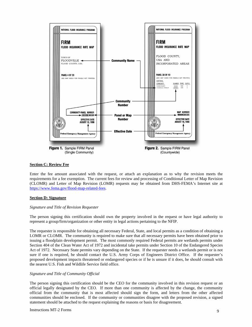