Evolution of Teamwork in Multiagent Systems Research Preparation Examination by Jacob Schrum.

INSTRUCTIONAL GEOCACHING:
AN ANALYSIS OF GPS RECEIVERS AS TOOLS FOR TECHNOLOGY INTEGRATION
INTO A MIDDLE SCHOOL CLASSROOM
By
ROBERT EDWIN MAYBEN
A DISSERTATION
Submitted in partial fulfillment of the requirements for the degree of Doctor of Philosophy in the
Department of Educational Leadership, Policy and Technology Studies
in the Graduate School of The University of Alabama
TUSCALOOSA, ALABAMA
2010

Copyright Robert Edwin Mayben 2010 ALL RIGHTS RESERVED

ii
ABSTRACT
The purpose of this study was to investigate how the instructional use of GPS through
instructional geocaching activities engages students and promotes achievement in a middle
school social studies classroom. The impact of instructional geocaching on addressing the needs
of students with various learning styles was also examined. In addition, the researcher identified
student perceptions of geocaching activities and differences between recreational geocaching and
instructional uses of geocaching.
Pretest and posttest scores were used to collect quantitative data in two phases of the
study. The experimental groups, who participated in the instructional geocaching activity to learn
the content, and control groups, who participated in a traditional classroom activity to learn the
content, were reversed in each phase. Findings revealed that the instructional geocaching activity
produced significant achievement gains in the second phase of the study. However, no
significant differences in achievement were found between students with different learning styles
in either the experimental or control groups.
In the third phase, a survey instrument was used to collect quantitative and qualitative
data on student perceptions and engagement during an instructional geocaching activity. A
significant difference in engagement during the GPS activity was found between kinesthetic and
visual learners. However, student engagement was not found to be a significant predictor for
student achievement during this study. From the survey data, three factors were determined to
represent the student perceptions of the GPS activity: fun, perception of learning, and motivation.
iii
Furthermore, the qualitative data revealed that students enjoyed the hands-on and active learning
experience that was provided by the instructional geocaching activity.
Implications for educators who plan to integrate instructional geocaching activities into
the curriculum are discussed. Recommendations for similar research with larger populations,
longer treatment periods, and other subject areas are made. Suggestions are also included for
future research on the relationship of instructional geocaching activities to other learning style
theories and critical thinking skills.

iv
DEDICATION
To Mom, the best teacher I’ve ever had. To my family, past, present, and future, you are
my inspiration, and to Jenny, my big dog.

v
ACKNOWLEDGEMENTS
First, I would like to thank my Lord and Savior, Jesus Christ, in whom are hidden all the
treasures of wisdom and knowledge. If not for the many blessings that He has provided in my
life, I would not have been able to complete this academic journey.
I would also like to thank Dr. Vivian Wright for all of the encouragement, wisdom, and
help that she has provided throughout my graduate studies. I also give thanks to her for not
giving up on me and for not letting me give up on this dissertation!
Thanks to my parents for providing me with a solid foundation and a love of learning. To
Mom, thanks for challenging me to succeed and encouraging me along the way. To Dad, thanks
for the lessons that you have taught me and for being my role model. Thanks to my family and
friends, especially my sister, grandmother, the Mintons, Wayne, Elynn, and Bro. Larry Garrard,
for believing in me.
A special thanks goes to Mr. Ken Lee for being my geocaching mentor and friend. He has
shown me the right of way when it comes to our hobby, and I am thankful for the knowledge that
he has shared with me over the past few years.
To my supervisors, Ms. Terri Boman and Dr. Jill Driver, and to my Technology in
Motion colleagues and friends, thanks for your support and encouragement in my academic and
professional endeavors.
Thanks to my excellent committee, Dr. Margaret Rice, Dr. Julia Hartman, Dr. Elizabeth
Wilson, and Dr. Timothy Lewis for their insight, encouragement, and wisdom.

vi
Finally, I would like to thank my wonderful wife, Meggin, for helping me through this
stressful time in my life. I know this academic journey would not have been complete without
her love, patience, and support. I look forward to starting the next chapter of our lives together!

vii
CONTENTS
ABSTRACT ........................................................................................................................ ii
DEDICATION ................................................................................................................... iv
ACKNOWLEDGEMENTS .................................................................................................v
LIST OF TABLES ............................................................................................................. xi
CHAPTER I: INTRODUCTION .........................................................................................1
Overview of Instructional Geocaching ....................................................................4
Statement of the Problem .........................................................................................6
Purpose of the Study ................................................................................................6
Research Questions ..................................................................................................7
Significance..............................................................................................................7
Assumptions .............................................................................................................8
Definition of Terms..................................................................................................9
Limitations .............................................................................................................11
Organization of Study ............................................................................................11
CHAPTER II: REVIEW OF THE LITERATURE ...........................................................13
Introduction ............................................................................................................13
Technology Integration in Education .....................................................................13
21st Century Learning Skills ..................................................................................14
The 21st Century Middle School Student .........................................................16
Motivating Students to Achieve with Technology ..........................................18

viii
Geocaching as an Instructional Strategy ................................................................26
An Emerging Technology Tool .......................................................................27
Recreational Geocaching .................................................................................29
Instructional Geocaching .................................................................................30
Instructional Geocaching Strategies ................................................................34
Rationale for Instructional Geocaching ...........................................................36
Impact on Learning Styles ...............................................................................38
Conclusion .......................................................................................................42
CHAPTER III: RESEARCH METHODOLOGY .............................................................43
Introduction ............................................................................................................43
Research Design.....................................................................................................43
Setting of the Study ................................................................................................44
Participants .............................................................................................................46
Instrumentation ......................................................................................................50
Data Collection ......................................................................................................52
Phase I ..............................................................................................................53
Phase II.............................................................................................................55
Phase III ...........................................................................................................57
Research Questions ................................................................................................58
Data Analysis .........................................................................................................58
Summary ................................................................................................................62
CHAPTER IV: RESULTS .................................................................................................63
Introduction ............................................................................................................63
ix
Demographic Results .............................................................................................63
Research Questions ................................................................................................65
Research Question 1 ........................................................................................65
Research Question 2 ........................................................................................67
Research Question 3 ........................................................................................68
Research Question 4 ........................................................................................69
Research Question 5 ........................................................................................72
Research Question 6 ........................................................................................73
Summary ................................................................................................................76
CHAPTER V: DISCUSSION AND RECOMMENDATIONS ........................................78
Introduction ............................................................................................................78
Demographic Findings ...........................................................................................78
Discussion ..............................................................................................................79
Research Question 1 ........................................................................................79
Research Question 2 ........................................................................................82
Research Question 3 ........................................................................................82
Research Question 4 ........................................................................................83
Research Question 5 ........................................................................................85
Research Question 6 ........................................................................................85
Implications for Educators .....................................................................................89
Limitations .............................................................................................................93
Recommendations for Future Research .................................................................94
Summary ................................................................................................................95

x
REFERENCES ..................................................................................................................96
APPENDICES .................................................................................................................107
xi
LIST OF TABLES
1. Population and Participant Demographics ...................................................................45
2. Class Period Groupings................................................................................................48
3. Number and Gender of Potential Participants per Phase .............................................49
4. Number and Percentage of Learning Styles by Class Period ......................................64
5. Shapiro-Wilk Test of Normality ..................................................................................65
6. Average Ranks of Pretest and Posttest Scores .............................................................66
7. Overall Pretest and Posttest Means and Ranks ............................................................67
8. Kruskal-Wallis Results for Experimental Groups .......................................................68
9. Kruskal-Wallis Results for Control Groups .................................................................69
10. Descriptive Statistics of Survey Items .........................................................................70

1
CHAPTER I
INTRODUCTION
In the fast-paced, information age society in which we live, new technologies seem to
emerge on a daily basis. It began with terms such as dot com, online, and e-mail and has
progressed to YouTube, Twitter, iPhone, Blackberry, “apps,” and social networks. As these new
technologies become aspects of everyday life, it is essential for educators to integrate them into
their curriculum (Solomon & Schrum, 2007). Students in the classrooms of today are digital
natives (Prensky, 2001) who rely on technology for communication, information, and
entertainment (Lenhart, Madden, & Hitlin, 2005). Students are seeking different approaches to
the teaching and learning process (Solomon, 2005). Furthermore, these teaching and learning
processes should encourage critical thinking and problem-solving skills as well as the 21st
century skills necessary to succeed in the “Digital Age” (ISTE, 2008b).
One technology that has emerged with the potential to engage the digital native student is
the Global Positioning System (GPS) receiver. GPS is a system of satellites that communicates
latitude, longitude, elevation, and velocity from any location on Earth to devices that can receive
this transmission (Lucking & Christmann, 2002). The general public was given unscrambled
access to the GPS by the US Department of Defense in May 2000, and many industries began
experimenting with the new possibilities (Gram-Hansen, 2009). Gilroy (2009) reported that a
2009 Forrester Research study revealed that 31% of adults in North America own a portable
navigation device that provides access to the global positioning system. Holzberg (2006)
described the real-world implications of GPS receivers in that the system of satellites is used by

2
“anyone who needs precise reference points for location, navigation, tracking, mapping, and
time” (p. 44). This includes occupations such as scientist, surveyor, delivery driver, fire fighter,
pilot, and farmer. Recreational enthusiasts such as hikers, hunters, fishermen, and cyclists also
quickly adopted the use of GPS because location is often key to their success in these pursuits
(Shaunessy & Page, 2006).
A method of infusing the pervasive technology of GPS into the curriculum as an
educational, informational, and entertaining tool is geocaching (Lary, 2004). This technique, also
referred to as a high-tech scavenger hunt for GPS users, is steadily growing as an international
phenomenon. The basic concept of geocaching involves a GPS user hiding a container, also
known as a geocache, and then recording the coordinates of the container with a GPS receiver.
The GPS user will then access the official geocaching web site, www.geocaching.com, to post
this location along with a description and clues about the geocache. When other GPS users
access the web site, they can download or print the coordinates and descriptions of geocaches for
which they want to search. When a GPS user finds a geocache, there are three basic rules
according to Groundspeak (2010). They are as follows: 1) if a GPS user takes something from
the cache, he or she should leave something of equal or greater value; 2) the GPS user should
sign the logbook; and 3) the GPS user should log his or her experience at www.geocaching.com.
Geocaches, or caches, vary in size and shape and may not be hidden within 528 feet of another
cache in order to prevent saturation (Groundspeak, 2010). Caches are as large as five-gallon
buckets or as small as film canisters (Schlatter & Hurd, 2005). Caches, depending on the size,
typically contain a log book for finders to sign, an instrument for writing, and trinkets to trade.
According to Groundspeak (2010), there are currently 1,092,192 active geocaches in the world,
and in the 30 days prior to the writing of this manuscript, there were over 4.1 million new logs

3
submitted about geocaching adventures to www.geocaching.com. These statistics alone indicate
that geocaching is a significant recreational activity similar to hiking, golfing, hunting, or
fishing.
While the growth in instructional uses has been slow, the activity of geocaching has
tremendous potential as a method to integrate technology into the classrooms of today (Christie,
2007). Students are increasingly exposed to GPS technology via cell phones, in automobiles, and
on television. When educators use this technology as a tool for teaching their subject, students
are exposed to both a life-long learning skill as well as the curricular content. The sport or hobby
of geocaching provides a framework for educators to follow as they develop lessons for using
GPS technology in the classroom. However, there have only been a few studies conducted
regarding instructional geocaching or geocaching in an educational setting. Most have focused
on identifying geocaching as an instructional tool and describing methods of using it with
students. According to Buck (2009), GPS receivers can be a motivating tool for teachers in many
subject areas like mathematics, science, and social studies. Broda and Baxter (2003) also
reported that lessons involving GPS receivers produce positive student attitudes. As Christie
(2007) stated, geocaching can be used to transform classrooms “from teacher-centered
environments to exciting, empowering, exploratory environments that focus on student
engagement in the learning process” (p. 1). It is for this reason, along with the pervasiveness of
GPS technology in our society, that this study was conducted.
With GPS technology involving the elements of latitude and longitude, there is a natural
relationship to geography content in education. The geography component of the seventh-grade
social studies curriculum in the state of Alabama directly addresses student knowledge of GPS.
The first course of study objective states that students should be able to “describe the world in

4
spatial terms using maps, major physical and human features, and urban and rural land-use
patterns” including “Global Positioning System (GPS)” (Alabama State Department of
Education, 2004). The National Council for the Social Studies (1994) stated that programs
should incorporate learning activities that study the relationships between science, technology,
and society. As Matherson, Wright, Inman, and Wilson (2008) suggested, geocaching is a
method to help address these standards as well as to help incorporate an innovative teaching and
learning strategy.
Overview of Instructional Geocaching
Instructional geocaching is the practice of applying the basic principles of geocaching as
a strategy to integrate technology into the curriculum as well as to engage students in the
learning process (Christie, 2007). In broader terms, instructional geocaching is an adaptation of
the sport of geocaching for educational purposes. A typical instructional geocaching activity may
take place on school grounds, during a field trip, or at any other area such as a park near the
school. The location of the instructional geocaching activity is predetermined by the educator
conducting the activity. In an instructional geocaching activity, the educator selects the topic,
creates the tasks or assignments for the caches, creates the caches, hides the caches, records the
coordinates, provides the coordinates for the students, and then allows the students to use the
GPS to find the caches and complete the tasks. The cache contents are designed to relate to the
subject or concept that the students are studying at the time of the activity. An instructional
geocache may contain questions for students to answer, tasks for students to perform, or
problems for students to solve. However, the concepts of using a GPS receiver and coordinates
to locate a hidden container are the underlying components to both instructional and recreational
geocaching.

5
There are three main characteristics that differentiate instructional geocaching from
recreational geocaching. The first is that the requirement of recreational geocaches to be placed
at least 528 feet apart does not apply to instructional geocaching due to size limitations of school
campuses. Christie (2007) suggested 100 yards as a distance requirement for separating caches
on school grounds, but the researcher has successfully designed more than 25 instructional
geocaching courses using 100 feet as a distance of separation. The distance of the caches should
be guided by the concerns of supervision and safety of students (Shaunessy & Page, 2006).
The second important difference between instructional geocaching and recreational
geocaching is that the geocaches do not have to be published on the geocaching web site.
Instructional geocaches are only for student use and are not for the general public. Shaunessy and
Page (2006) advised this for the safety of the students and the caches. However, it is also feasible
to use caches placed for recreational purposes as instructional tools as outlined in the studies of
Dixon (2007), Lary (2004), Schlatter and Hurd (2005), and Shaunessy and Page (2006).
The third difference between instructional and recreational geocaching relates directly to
the caches and their contents. In recreational geocaching, the containers are required to have at
least a log sheet, and the focus of the activity is to find the container to sign the log. However,
with instructional geocaching, one motivating factor for students is to find the container, but the
primary focus is on the content of the lesson placed inside the container rather than simply
signing the log and trading items. Instructional geocaching containers may contain any
educational element that is relevant to the topic being studied. Instructional geocaching
techniques often do not include a container at all. Instead, educators may place information on
cards and post these cards around the school campus by taping them to objects such as trees,

6
posts, or walls. In each case, the focus remains on the content that the students are learning
instead of the GPS technology or the finding of the geocaches.
Statement of the Problem
Research has demonstrated that the majority of students have a positive attitude toward
the use of technology in the learning process (Al-Mujaini, 2006; Becta, 2006; Mouza, 2006;
Ruthven, Hennessy, & Brindley, 2004; Vale & Leder, 2004). However, in the data-driven
climate of the educational system, the need for empirical evidence of the positive influence of
technology on student achievement is exceedingly evident (Kingsley & Boone, 2008; Schrum,
Thompson, Sprague, Maddux, McAnear, Bell, & Bull, 2005). More specifically, researchers
have called for further study of the influence of technology integration into the achievement of
students in the middle school classroom (Diem, 2000; Saye & Brush, 2002; Whitworth &
Berson, 2003). Geocaching presents an opportunity to implement an innovative teaching and
learning strategy. However, limited research has been conducted on the effects of geocaching on
student achievement and its instructional value in the classroom.
Purpose of Study
The purpose of this study was to investigate how the instructional use of GPS through
instructional geocaching activities engages students and promotes achievement in a middle
school social studies classroom. The impact of instructional geocaching on addressing the needs
of students with various learning styles was also examined. In addition, the researcher identified
student perceptions of geocaching activities and differences between recreational geocaching and
instructional uses of geocaching. To date, recreational geocaching has grown exponentially
among GPS users worldwide. However, the potential of instructional uses of geocaching has yet

7
to be fully explored. Therefore, this researcher also provided an overview of instructional uses of
geocaching.
Research Questions
The research questions explored in this study included:
1. Is there a significant difference in pretest and posttest scores between students who
received the instructional geocaching treatment and students who did not receive the
instructional geocaching treatment?
2. Is there a significant difference between the pretest and posttest scores of students with
different learning styles who received the geocaching treatment?
3. Is there a significant difference between the pretest and posttest scores of students with
different learning styles who did not receive the geocaching treatment?
4. Is there a significant difference in student engagement during the geocaching activity
based on learning style?
5. Is there a significant relationship between student engagement and student achievement
during the instructional geocaching treatment?
6. What are students’ perceptions toward geocaching activities for learning?
Significance
This study contributes to a body of literature that is currently lacking in how student
achievement through the use or non-use of technology is being assessed. Furthermore, this study
offers insight into student attitudes of their use of the innovative technology, geocaching, and
their understanding of the technology. Therefore, the study’s results can assist teacher educators
and current teachers improve their technology integration strategies. Other benefits of this study

8
are a better understanding of how innovative technologies can motivate and engage students to
learn.
Since the year 2000 when GPS access was given to the general public, very little has
been done in the area of using GPS in education. Activities such as geocaching, which utilize
GPS, offer educators a viable teaching method. However, very little research has assessed its
potential or impact in the classroom (Buck, 2009; Christie, 2007; Matherson et al., 2008). In fact,
the only study found to address student achievement was that of Buck (2009), in which the
effects of GPS integration on math achievement were investigated. There is no empirical data on
achievement in the subject area of social studies where GPS is specifically addressed in both
national and state courses of study.
Assumptions
The following assumptions were made in this study:
1. The participants constituted a representative sample of seventh grade students at a middle
school in a small town in Alabama.
2. Participants knew how to use a GPS receiver. This assumption was made because the
teacher routinely uses GPS activities in instruction.
3. Because the classes had the same teacher, it was assumed that the teacher engaged in the
same classroom behavior and used the same general classroom management strategies.
4. The students understood and honestly answered all items on questionnaires and tests
related to the study.
5. The teacher provided accurate documentation of student assessments.

9
Definition of Terms
Global Positioning System: According to Christie (2007), the Global Positioning System
is a network of at least twenty-four navigational satellites that broadcast location and time
information to receivers on earth. This system is maintained by the U.S. Department of Defense.
Global Positioning System (GPS) Receiver: A GPS receiver is a hand-held technology
device that receives signals from the Global Positioning Satellites to determine the exact location
of the user. The GPS receiver displays this location to the user using latitude and longitude
coordinates. Many GPS receivers also report elevation and speed.
Recreational Geocaching: According to Groundspeak (2010), the Official Geocaching
Web Site, recreational geocaching is “geocaching is a high-tech treasure hunting game played
throughout the world by adventure seekers equipped with GPS devices” (¶ 1). The basic idea is
to locate hidden containers, called geocaches, outdoors and then share your experiences online.
Geocaching is enjoyed by people from all age groups, with a strong sense of community and
support for the environment (Groundspeak, 2010).
Instructional Geocaching: Instructional geocaching is an educational adaptation of
recreational geocaching. Instructional geocaching is the practice of applying the basic principles
of geocaching as a strategy to integrate technology into the curriculum as well as to engage
students in the learning process. Lary (2004) reported that instructional geocaching provides
coordinates, clues, GPS usage, and the hunting experience similar to that of real geocaching.
Christie (2007) explained that instructional geocaching should occur on the school grounds or at
an outdoor location near the school.
Geocache or Cache: The terms geocache and cache can be used interchangeably. Either
term refers to the container that has been hidden for GPS users to locate. It is a combination of
10
the prefix geo, which relates to earth, and cache, which is a container (McNamara, 2004). Caches
in recreational geocaching contain a log sheet for finders to sign as well as items for finders to
trade. Caches used in instructional geocaching may contain items such as questions to be
answered, tasks to be performed, or problems to solve.
Waypoints: Groundspeak (2010) defines a waypoint as “a reference point for a physical
location on Earth. Waypoints are defined by a set of coordinates that typically include longitude
and latitude” (¶ 58).
Coordinates: Coordinates are the numeric representation of a GPS user’s position on
earth. The coordinates are measured in latitude and longitude and are stated in degrees, minutes,
and seconds. “The standard geographic coordinate system of the world involves latitudes north
or south of the Equator and longitudes east or west of the Prime Reference Meridian of
Greenwich” (Map, 2009, p.17).
Emerging Technology: An emerging technology is any new hardware, software, or
application that has the potential for strengthening the teaching and learning process
(Richardson, 2006; Roblyer & Edwards, 2000). Serim and Schrock (2008) stated “If it’s out of
the engineering lab, but not yet widely in use or widely known, we consider it an emerging
technology” (p.13).
Technology Integration: Technology integration consists of instructional strategies that
use technology tools to facilitate learning experiences for students in the classroom and in online
environments (ISTE, 2008a).
Traditional Classroom Activity: A traditional classroom activity is lead by the teacher.
Students in a traditional classroom environment typically listen to lectures, take notes from the

11
board or presentation software, and read textbooks to learn about a topic (Debevec, Shih, &
Kashyap, 2006).
Limitations
1. The complexity of the topics of the units in which geocaching activities were
implemented was different.
2. The classes selected were comprised of a sample of convenience, and no two groups of
students can be alike in academic ability. Therefore, external validity of the study to other
schools may not be possible.
3. This study may also be limited by the number of students in the sample of convenience.
The sample size consisted of 104 students, which comprised approximately 19% of the
student population in one small town middle school.
4. The weather may have limited the accuracy of the GPS receivers during these activities.
Cloud cover and extreme temperatures often decrease accuracy of GPS receivers, and
there was not a procedure to control for differences in environmental factors.
5. The class periods at the school were only 55 minutes in length, and with the time that it
took for the students to walk to the athletic fields from the school, only 45 minutes of
instructional time was spent on the geocaching activity.
Organization of Study
This study is organized into five chapters. Chapter I contains an introductory material, the
statement of the problem, the purpose of the study, questions for research, operational
definitions, and the significance of the study. In addition, assumptions and limitations of the
study were presented. Chapter II reviews the professional literature relevant to this study. In
Chapter III, the research design, data collection methods, and the instruments to be used for data

12
collection are described. Chapter IV presents an analysis of the data. Chapter V discusses the
results of the data analysis and presents conclusions regarding the research questions as well as
implications and recommendations for further study.

13
CHAPTER II
REVIEW OF THE LITERATURE
Introduction
This review of literature presents the theoretical framework upon which this study is
based. In this chapter, information about technology integration in education is provided,
including an overview of the connections between technological pedagogical content knowledge
(TPACK), 21st century learning skills, the 21st century middle school student, and technology
integration in the middle school classroom. This chapter also provides a discussion of
geocaching, a high-tech scavenger hunt for Global Positioning System (GPS) users, as an
instructional strategy for classroom teachers that helps to address various learning styles. This
discussion helps to establish the framework for research on the influence of technology
integration strategies such as instructional geocaching on student achievement and motivation.
Technology Integration in Education
“The goal of technology integration is to use technology seamlessly so that the
technology itself becomes a transparent and integral tool to teach core curriculum” (Digital
Learning Environments, 2008, ¶ 1). Over the past decade, the importance of technology in
education, specifically in K-12, has broadened due to national efforts such as the National
Educational Technology Standards (NETS), The Department of Education's Preparing
Tomorrow's Teachers to Use Technology (PT3), and various state initiatives (Davis, Yoo, & Pan,
2005; Finley & Hartman, 2004; ISTE, 2007; ISTE, 2008a; Taylor & Duran, 2006). These efforts
have included a revision of technology standards across the curriculum at both national and state
14
levels. The needs of professional development in the area of technology integration for teachers
and the strategies to help address these standards have also evolved with the introduction of 21st
century skills to the educational technology spectrum (Partnership for 21st Century Skills, 2006).
Several frameworks have helped guide this evolution including technological
pedagogical content knowledge (TPACK), which focuses on the importance of the interweaving
of technology, pedagogy, and content knowledge. TPACK places an emphasis on teachers
learning the technology as needed and when needed within the context of instructional design
(Mishra & Koehler, 2006). This learn-by-design model does not focus on teaching skills or step-
by-step instructions on using the technology (Mishra & Koehler, 2006). In an examination of
TPACK in the social studies curriculum, Hammond and Manfra (2009) asserted that “the
pedagogy should lead the technology, not technology lead the pedagogy” (p. 163). Furthermore,
TPACK is described as the basis of good teaching with technology (Hammond & Manfra, 2009).
TPACK connects technology, curriculum content, and pedagogical strategies to produce
effective teaching with educational technologies (Harris, Mishra, & Koehler, 2009). Mishra and
Koehler (2009) further described TPACK as a repurposing of technology for educational
purposes. They stated that technologies such as office productivity software, blogs, wikis, and
GPS systems were not created for educational purposes, and for these technologies to be
effective as educational tools, teachers must create new ways to use them.
21st Century Learning Skills
In the fast-paced, information age society in which we live, new technologies seem to
emerge on a daily basis. As these new technologies become aspects of everyday life, it is
essential for educators to integrate them into their curriculum (Solomon & Schrum, 2007; Spires,
Lee, Turner, & Johnson, 2008). Students in the classrooms of today are digital natives (Prensky,

15
2001), who rely on technology for communication, information, and entertainment (Lenhart,
Madden, & Hitlin, 2005). Students are seeking different approaches to the teaching and learning
process (Solomon, 2005). Furthermore, these teaching and learning processes should encourage
critical thinking and problem-solving skills as well as the skills necessary to succeed in the
Digital Age (ISTE, 2008b). According to the Partnership for 21st Century Skills (P21) (2008),
21st century skills are the keys to success in school, life, and work. Furthermore, the P21 suggests
that the success of the entire educational system depends on student acquisition of technological
skills due to changes in education, international competition, and workplace jobs and skills.
In 2002, the P21 was formed by education leaders and policymakers and the business
community to provide a vision for 21st century education (Ullman, 2007). The P21 (2009)
developed a framework for learning in the new century based on the critical skills that students
will need to succeed as citizens and workers in the new century. The organization stated that
there are six primary elements represented in the framework. The five student-focused elements
included learning and thinking skills (creativity and innovation, critical thinking and problem
solving); information, media, and technology skills; core subjects (English, reading, or language
arts, mathematics, science, foreign languages, civics, government, economics, arts, history, and
geography); 21st century content (global awareness, financial literacy); and life and career skills
(initiative and self-direction). The sixth element is described as 21st century assessment, which
provides a measurement of the first five elements (P21, 2009).
Many of the new tools and strategies being used to engage students with 21st century
skills include Web 2.0 tools and other emerging technologies like GPS receivers that focus on
experiential learning. Solomon and Schrum (2007) presented the argument that the use of these
emerging technology tools will provide educators with the ability to transform the learning

16
experience into one that is relevant and exciting for students who “think, work, and play
differently from previous generations” (p. 27). They further illustrated this point by stating that
students know about the potential of these new tools and are comfortable using them. These
students desire for learning at school to be more like the learning that they accomplish on their
own (Solomon & Schrum, 2007).
The 21st Century Middle School Student
As stated previously, the students of today have been described as digital natives by
Prensky (2001). These students were born into a rapidly changing technological world and are
engaged in digital lives outside of the school. Lenhart, Purcell, Smith, and Zickuhr (2010) found
that the average student owns 3.5 gadgets such as cell phones, mp3 players, computers, game
consoles, and portable gaming devices. Today’s students are “native speakers of technology,
fluent in the digital language of computers, video games, and the Internet” (Prensky, 2006, p. 9).
Prensky (2006) also stated that students are not engaged or motivated by traditional teaching and
learning processes in school. Furthermore, Prensky (2006) described three distinct types of
students in today’s classrooms: those who are self-motivated, those who are going through the
motions, and those who are tuning out the teacher. He elaborated on these three types of students
by stating that today’s schools can manage the first two types, but the third type presents an
enormous challenge. Lee and Spires (2009) suggested that for learning to become engaging and
meaningful to these students, middle school teachers must bridge the gap between student uses
of technology in and out of school. Furthermore, Lee and Spires (2009), in summarizing three
studies on middle school student attitudes toward technology in school, proposed that for
teachers to meet the challenge of today’s middle school students, they must develop creative and

17
flexible attitudes toward technology, an awareness of current technology tools and devices, and
pedagogical strategies to tap into the students’ 21st century skills.
The 21st century middle school student desires classroom activities that are actively
engaging, provide for social learning experiences, offer continuous feedback, and have real
world applications (Huffaker, 2003). Doolittle and Hicks (2003) further explained the learning
activities that engage today’s students as technology-enriched authentic and active experiences
that can be transferred to useful and real-life settings. Dede (2000) suggested that digital
technology tools such as computers, hand-held devices, and cell phones should be used for active
and community-based learning experiences. Hagevik (2003) found that middle school students
are motivated to achieve by interactive and exploratory environments. In the study by Hagevik
(2003), students participated in a geographic information system (GIS) activity that was directed
at helping the community. Students were reported to be active and engaged participants in the
learning activity that involved real-world implications as well as technology integration.
The P21 (2005) reported that schools need to “bridge the gap between how students live
and how they learn” (p. 4). Spires et al. (2008) surveyed 4,000 middle school students in North
Carolina on their technology use outside of school and discovered that 83% used digital music,
76% played computer games, and 71% used cell phones. In a report by Lenhart et al. (2010),
75% of teens from ages 12-17 were found to own cell phones. More specific data reported by
Lenhart et al. revealed as of September 2009, 58% of 12 year olds and 73% of 13 year olds, the
age groups represented in middle school, owned a cell phone. However, 86% of teens stated that
they cannot use the phones at school because either the school banned them altogether or just
banned them in the classroom. This is echoed by several studies that reported that the students of
today are often described as having to “unplug” when they are in the classroom because they are

18
prohibited from bringing technology devices to school (Dede, Korte, Nelson, Valdez, & Ward,
2005; Levy & Murnane, 2004; Spires, et al., 2008). These factors, along with studies that have
reported that students find social studies boring and irrelevant (Ciborowski, 2005; Stetson &
Williams, 2005), project a negative forecast for achievement and engagement for the middle
school social studies student. In addition, other studies (Higgins, Boone, & Lovitt, 2002;
Lounsbury, 1988; Shaughnessy & Haladyna, 1985) have revealed that social studies and history
are two of the least liked subjects in school, with English being rated the lowest.
Motivating Students to Achieve with Technology
Although today’s middle school student is typically characterized as disinterested and
disengaged at school due to being unplugged and bored (Marks, 2000), studies have shown that
proper integration of technology into classroom practice can engage and motivate students to
learn (Ullman, 2007). Spires et al. (2008), in the previously mentioned study of the perspectives
on school, technology, and engagement of middle school students in North Carolina, found that
students believed technology to be an important factor in motivating them to perform better in
school. The study further reported that students responded that learning was more fun when
technology was involved at school. When students ranked the learning activities they preferred
on a scale of one equaling least favored and six equaling most favored, Spires et al. (2008) found
the means of technology activities such as using computers (5.39) and doing research on the
internet (4.87) to be higher than the means of traditional activities such as listening to the teacher
lecture (3.71) and doing worksheets (3.23).
Spires et al. (2008) also conducted student focus group sessions with six groups across
the state of North Carolina. Each group consisted of eight to ten students who had previously
participated in the survey. From the hour-long focus group sessions, Spires et al. (2008)

19
discovered four perspectives that were most prevalent to the students. The theme “Do U Know
Us?” was described as students expressing a desire for more technology to be used in the
learning process at school. The students also described the technology that was actually being
used in school as boring because the activities were traditional such as word processing, taking
tests, or conducting research. The students revealed that they used technology for social
communication and entertainment outside of school. The theme “Engage Us” was described as
the need for students to be engaged and stimulated in school activities. Spires et al. reported that
the students in the focus groups wanted to use technology to learn new information instead of
taking a test on information that they already have studied. In the theme, “Prepare Us for Jobs of
the Future,” Spires et al. reported that students wanted the technology experiences in school to be
related to future careers and occupations. The students were described with the ability to
understand the important role that technology plays in the professional arena in which they will
be a participant in the future. The theme “Let’s Not Get Left Behind” revealed that students
would like to have more technology in their schools. Spires et al. (2008) pointed to student
concern for the out of date technological infrastructure and curriculum in their schools. In
synthesizing the study, Spires et al. (2008) described the middle school student of today as one
who is motivated by technological environments and opportunities that are relative to their
current out of school lives and their future lives in the real world.
Lee and Spires (2009), in an article that summarized the findings of Spires et al. (2008),
reported that the students want the technology experiences at school to be more like the
experiences they have outside of school in their everyday lives with technology. The students in
the study expressed an interest in using technology not just for communication and entertainment
but for creative and meaningful purposes (Lee & Spires, 2009). Lee and Spires (2009) also found

20
that students were motivated by smaller handheld and gaming devices, which were more
common outside of school, but were not being used for educational purposes by their teachers.
In a dissertation by McNew (2008), middle school students who used handheld
computers in mathematics scored significantly higher than students who did not use handheld
computers to learn mathematics. The study analyzed the raw scores, scale scores, and national
performance level scores of 286 middle school students with 154 students using handheld
computers for a semester and 132 with no access to handheld computers. For the raw test scores
on the TerraNova®, students in the experimental group had a mean score of 43.79 compared to
those in the control group who had a mean score of 38.99. For the scale test scores, students in
the experimental group had a mean score of 694.03 compared to those in the control group who
had a mean score of 676.41. On national performance level test scores, students in the
experimental group had a mean score of 69.01 compared to those in the control group who had a
mean score of 59.48. McNew (2008) used t-tests to determine statistical significance higher
means for each set of scores for the students who used handheld computers. McNew (2008)
concluded that student achievement can be increased with the creation of a technology-infused
mathematics learning environment.
Swan, van ‘t Hooft, Kratcoski, and Unger (2005) reported that the use of mobile
computing devices, which are common for 21st century learning environments and representative
of the GPS receiver genre, “may increase student motivation to learn and increase their
engagement in learning activities, which in turn could lead to an increase in time spent on
learning activities and higher quality work” (p. 110). In the study, Swan et al. (2005) examined
the effects of mobile computing devices on student motivation to learn, engagement in learning
activities, and support for the learning process in four elementary and two seventh grade science

21
classes. Teachers who were interviewed for the project reported that their students were more
motivated and engaged in learning activities, which provided increased student productivity and
a higher quality of student work. The interviews of students reported by Swan et al. (2005)
revealed that students thought the mobile computing devices made school work easier and more
fun.
The results in the area of achievement from the study by Swan et al. (2005) revealed that
mobile computing devices can increase the achievement level of regular and special needs
students. Swan et al. (2005) conducted an analysis of conceptual understanding from sample
student work. The results provided statistical evidence of increased student learning with the
ratings of conceptual understanding for the students using the mobile computing devices
averaging four points higher than students who did not use the mobile computing devices. The
interviews conducted in the study by Swan et al. (2005) also revealed that both teachers and
students perceived an increase in achievement.
Rigby, Deci, Patrick, and Ryan (1992) reported that there is a relationship between
motivation and student achievement. Their study further explained that the more students are
engaged in the topic of instruction, the more easily students understand new knowledge. Wang
and Reeves (2007) added that successfully motivating students should increase involvement in
learning tasks, and therefore, promote student achievement. Furthermore, the study by Wang and
Reeves (2007) revealed that students in a high school science class were cognitively engaged and
enthused by a technology-based unit on fossilization. The results of their study of 27 tenth-grade
students provided evidence of student perception of technology as positively influencing the
quality of the learning experience and quantity of knowledge acquired. The survey results also
indicated that the technology-based lesson increased the interest and motivation of students in

22
learning science. However, the study only measured perceptions and did not measure if the
increase in motivation due to technology integration had any effect on student achievement.
Hsieh, Cho, Liu, and Schallert (2008) found that middle school science achievement
scores increased significantly and motivational levels increased slightly in a technology-
enhanced classroom environment. This study examined changes in the self-efficacy in terms of
motivation and science achievement levels of 549 middle school students after participating in a
technology-enhanced classroom environment. Using a pretest-posttest model, the researchers
discovered that the average score in science achievement rose from 46.89 to 70.13. The average
response for students regarding motivational levels rose slightly from 3.94 to 4.06 on a scale of
five. The study also found that students’ science achievement correlated positively with students’
motivation levels on both the pretest and posttest. Hsieh et al. (2008) concluded that a
technology-rich environment can provide a positive effect on achievement and motivation of
middle school students.
In examining technology as a tool to increase science achievement in the middle school
classroom, Olsen (2007) found that special education students in technology-enriched
classrooms improved at higher percentages than those in regular classrooms. The study involved
classrooms using the Great Explorations in Math and Science Space Science Curriculum
Sequence. Software modules were used to supplement the regular classroom instruction for the
experimental group, and the control group participated in activities that did not involve
technology integration. Regular education students in a regular classroom environment showed
an 8% average gain from pretest to posttest, and special education students showed a 7%
decrease. On the other hand, regular education students in the technology-enhanced environment
averaged a 9% gain from their pretest to posttest scores, and special education students averaged
23
a 7% gain. However, the study did not report if these gains were statistically significant. Olsen
(2007) concluded that technology-enhanced instruction can benefit students with special needs.
She also reported that the teachers involved in the study found that the technology-enhanced
curriculum increased motivation and engagement in both special needs and regular middle
school students.
A study conducted by Deaney, Ruthven, and Hennessy (2003) revealed that students
perceive technology-enhanced lessons to be more relaxed yet more involved. The study also
illustrated that students perceived technology lessons to be less boring than traditional classroom
activities. Students in the eighth, tenth, and twelfth grade levels at six different schools were
interviewed, and the majority of those interviewed associated technology lessons with increased
interest and motivation. The interviews also revealed that the practical challenges and learning
opportunities provided by technology-based activities encouraged an increased work ethic and
engagement factor among the students. Deaney et al. (2003) concluded that teachers should
create lessons that harness the power of technology to meet specific learning goals and
objectives. Furthermore, they suggested that the technology should be used to create interactive
learning experiences for students that encourage critical thinking and exploration.
Tuzun, Yilmaz-Soylu, Karakus, Inal, and Kizilkaya (2009) examined the influence of a
computer gaming environment on the achievement and motivation of students in a geography
classroom in Turkey. The study used a pretest-posttest model and used an educational computer
game with a 3D environment to deliver the geography content to the students over a three-week
period of time. Tuzun et al. (2009) reported that the students made statistically significant gains
in achievement from the pretest (M = 6.2) to the posttest (M = 8.6). The study also measured
student motivation related to the gaming environment versus the traditional school context via a
24
Likert scale questionnaire. Tuzun et al. (2009) discovered the mean scores for student motivation
in the gaming environment were higher than the mean score for the traditional school context.
Interviews of the students conducted after the study revealed that students wanted to study other
topics in the gaming environment. Tuzun et al. (2009) also found that students perceived the
experiential learning experience provided by the gaming environment to be fun and engaging.
Tuzun et al. (2009) concluded that students, who explore, interact, collaborate, and immerse
themselves in technology-rich environments, experience positive gains in motivation and
achievement in learning geography.
Downes and Bishop (2009) conducted an instrumental case study to examine the effects
of a technology-rich school environment on 28 disengaged middle school students over a two-
year period. The students engaged in project-based technology activities in an environment
where each student was equipped with a laptop and had access to digital video cameras, voice
recorders, and other media production technologies. Observations and interviews were conducted
with students and teachers involved in the project. The qualitative data reported by Downes and
Bishop (2009) revealed that both students and teachers saw success and increased engagement
created from the technology-rich environment. Teachers in the study also reported increased
academic achievement from students who were previously disengaged from the academic
experience. Downes and Bishop (2009) deduced from their findings that technology-rich
environments, which include project-based learning, community connections, and authentic
experiences, can positively influence motivation and, consequently, student achievement, in
middle school students.
Kingsley and Boone (2008) investigated social studies achievement as a result of
technology integration into seventh-grade middle school history classrooms. The sample size of

25
the study consisted of 184 students from an ethnically diverse urban school district. The study
used a pretest-posttest model in which the experimental group used a multimedia-based
American history software program in addition to regular classroom instruction to study the
content, and the control group only received regular classroom instruction such as textbook
readings and lecture. The results reported by Kingsley and Boone (2008) indicate an increase in
achievement from both groups. However, the experimental group increased mean test scores by
an average of 12.2% while the control group increased mean test scores by an average of 6.1%.
This difference was reported to be statistically significant. Kingsley and Boone (2008) concluded
that there is a strong link between technology-enhanced lessons and increased student
achievement in middle school students. These results further describe the positive effect of
technology integration on student achievement.
As these studies have shown, technology has shown to be an effective strategy to engage
students in content and to increase student achievement. However, Mishra and Koehler (2006)
suggested that teaching with technology is a complex and challenging task for teachers.
According to Harris, Mishra, and Koehler (2009), the effective integration of technology requires
proficiency in pedagogy, content-knowledge, technology, and the ability to interweave each of
them into effective instruction. Students believe that technology enriches the learning process,
and they consistently adopt new and different technologies to make their lives more interesting
(Project Tomorrow, 2006). For technology integration to be effective, educators need to learn
how to use and integrate it successfully. Professional development is integral in preparing
teachers to use effective technology integration strategies, which can motivate and engage
today’s 21st century student (Digital Learning Environments, 2008). Raulston (2009)

26
summarized this concept by stating, “If educators begin to integrate technology in the classroom
and model skills for students, it can help prepare students for the 21st century” (p. 65)
Geocaching as an Instructional Strategy
Studies have displayed that technology integration can have a positive impact on student
performance in many content areas (Huang & Russell, 2006; Page, 2002; Tally & Goldenberg,
2005). However, researchers have called for further study of the influence of technology
integration into the achievement of students in the social studies classroom (Diem, 2000; Saye &
Brush, 2002; Whitworth & Berson, 2003). Tally (2007) reported that digital technologies have
not influenced change in social studies teaching and learning practices. Journell (2009) argued
that technology makes history come to life and provides a different perspective on the past for
students.
A study of 159 middle and high school students from four different schools by Tally and
Goldenberg (2005) revealed that students perceived that technology-enriched history classes
were more interesting and increased their academic performance in these classes. The students in
the study participated in online historical interpretation tasks and then completed a questionnaire
about the experiences in the activity. The results indicated that 87% of students believed that
they learned more history content in the technology-enriched class than their previous classes.
Tally and Goldenberg (2005) also found that over half of the students associated the use of
computers with a more active and interesting learning experience. Tally and Goldenberg (2005)
also concluded from their results that hands-on learning activities can be associated with
increased learning and motivation as they are in science and math classes.
Geocaching presents an opportunity to implement an innovative teaching and learning
technology integration strategy that promotes 21st century skills and reinforces student
27
perceptions of the active and hands-on learning experience. However, limited research has been
conducted on the effects of geocaching on student achievement and its instructional value in the
classroom. While the growth in instructional uses has been slow, the activity of geocaching has
tremendous potential as a tool for integrating technology into the classrooms of today (Christie,
2007). Students are increasingly exposed to GPS technology via cell phones, in automobiles, and
on television. When educators use this technology as a tool for teaching their subject, students
are exposed to both a life-long learning skill as well as the curricular content. The sport or hobby
of geocaching provides a framework for educators to follow as they develop lessons for using
GPS technology in the classroom.
Geocaching is a technology integration strategy that has emerged from a relatively new
recreational activity, and therefore, the amount of scholarly research is significantly lacking.
Christie (2007) echoed this discovery with the statement that “Since GPS receivers are emerging
technologies, and geocaching is an emerging educational strategy, there is little, if any, formal
research on these topics” (p. 3). O’Hara (2008) described much of the writing about geocaching
as journalistic with brief overviews and reports on the novelty of the hobby. Most of the
scholarly articles relating to geocaching are found in practitioner journals and focus on
introducing the concept of geocaching to teachers, providing a rationale for classroom use, or
describing instructional geocaching methods (Dixon, 2007; Lary, 2004; Matherson, et al., 2008;
Shaunessy & Page, 2006). This section of the review will synthesize that information as well as
investigate the idea that geocaching is an effective technology integration tool for educators.
An Emerging Technology Tool
It is evident that GPS and geocaching are emerging technology integration tools because
of the numerous articles defining the terms. Often cited as the first scholarly authors to define

28
geocaching, Chavez, Courtright, and Schneider (2004) defined geocaching as a scavenger-hunt
adventure game for Global Positioning System users. They further described it as a combination
of geography and hide-and-seek. This resembles the definition that Groundspeak (2010)
provided on the official site of geocaching, “Geocaching is a high-tech treasure hunting game
played throughout the world by adventure seekers equipped with GPS devices” (¶ 1). Other
articles included the high-tech, hide-and-seek, and treasure hunt elements in their definitions
(Christie, 2007; Gentry, 2006; Ihamaki, 2007; Lary, 2004; Shaunessy & Page, 2006). Sarpong
(2008) added the recently adopted slogan used by the official site of geocaching to his definition
in that participants in the game are “human search engines” (p. 26).
Another element found in the majority of articles is the history of the Global Positioning
System (GPS). Most discussed how 24 satellites are used in the Global Positioning System and
that in May 2000, the jamming signal was turned off by the United States Department of Defense
enabling civilians to gain similar accuracy to that of the military (Baker, 2001; Brown, Freeman,
& Wiseman, 2003; Cameron, 2004; Christie, 2007; Gentry, 2006; Hinkley, 2005; Sarpong, 2008;
Schlatter & Hurd, 2005; Sinicki, 2006). By including the satellite and military information in
GPS articles, the studies attempted to legitimize geocaching as a high-tech and scientific
endeavor, but this information also creates an element of mystery or gadgetry usually found only
in the entertainment industry. Most educational geocaching articles included a history of
geocaching as well. The account of engineer and internet news group user, David Ulmer, hiding
a container and publishing the coordinates on the Internet for others to find, has been treated as
legendary by some authors (Matherson, et al, 2008; Sarpong, 2008; Schlatter & Hurd, 2005;
Sinicki, 2006). However, this first cache did initiate the game of geocaching and over one
million other caches around the world (O’Hara, 2008).

29
Recreational Geocaching
With the high-tech and scavenger hunt characteristics clearly defined and origins
described, many authors attempted to specify the basic activities that comprise a geocaching
adventure. In general, geocaching involves an individual or group hiding a cache and recording
the location using the coordinates from the GPS. Sarpong (2008) added that caches are usually
hidden in public locations that would interest people because of natural beauty, unique
landscape, or historical value. The caches are usually described as waterproof containers of
varying sizes containing items for trading purposes and a log book. After the location is set and
the container is hidden, the coordinates are posted online to the official geocaching web site,
www.geocaching.com. The individual gives the cache a descriptive name and provides a
description of the location along with clues or hints to help with finding the cache. Others who
participate in this recreational activity will then be able to see the cache on the web site, and if
interested, input the coordinates into a GPS and use the clues to attempt to locate the cache
(Ihamaki, 2007; Lary, 2004; Matherson et al., 2008; O’Hara, 2008; Sarpong, 2008; Shaunessy &
Page, 2006). Once a geocacher has found a cache, there are three simple rules: “take something
from the cache, leave something in the cache, and write about it in the logbook at the cache”
(Chavez et al., 2004, p. 69). Shaunessy and Page (2006) and O’Hara (2008) further explained
that those who succeed in finding the cache should record their geocaching name along with the
date and time that they found the cache. Participants are also asked to return the cache to the
location and condition in which they found it (Chavez et al., 2004). Schlatter and Hurd (2005)
included that after one finds the cache, signs and dates the log book, and returns to a computer,
he or she should go to the web page related to the cache to write about the hunting experience. It
is noteworthy to mention that all of the scholarly articles researched for this literature review

30
failed to mention a major reason for posting logs about found geocaches to the official site. This
reason, according to Groundspeak (2010), is to document the number of official geocaches that
one has found. It is also important to note that the information posted about a cache can help
other geocachers as they plan their adventures (Sarpong, 2008).
Instructional Geocaching
As previously stated, geocaching is a recreational activity for GPS users. However, as
many of the articles indicated, this activity is also an innovative technology integration strategy
when adapted for classroom use. However, there is currently only one empirical research study
relating geocaching to student achievement. Buck (2009) found that GPS integration into the
mathematics curriculum produced small, but not statistically significant gains in student
achievement using a pretest and posttest model of research. Her study of three ninth-grade
algebra classes consisted of 75 students. The classes were divided with 44 students in the
treatment group and 31 students in the control group. The students in the treatment group
participated in four math-related GPS activities, and the students in the control group participated
in traditional math classroom activities. Buck (2009) used a pretest and posttest given through
the New Century Education (NCE) mathematics software program to assess student achievement
levels before and after the treatment. The pretest mean of students in the treatment group was
3.796, and the posttest mean was 4.193, which revealed a gain of .397. The pretest mean of
students in the control group was 3.769, and the posttest mean was 4.185, which revealed a gain
of .416. Buck (2009) reported that these results reveal that students are making progress in
mathematics achievement, but because the students in the control group outperformed the
students in the treatment group, the GPS activity was not effective in increasing student
achievement.

31
Buck (2009) also used two surveys to measure student attitude and perceptions of the
GPS activity. The first was an Attitude Toward Mathematics Inventory (ATMI), which
addressed students’ attitude toward mathematics before and after the GPS activity. The treatment
group revealed a slight gain in group mean from 3.231 to 3.243 on a scale of five. The control
group indicated a loss in mean from 3.223 to 3.050. Buck (2009) reported that this is a
significant difference in attitude toward mathematics according to the results of the F tests of
repeated measures. Buck concluded that the outcome of the treatment indicated improvement in
student attitude toward mathematics could be achieved with GPS activities. She also identified
four discrete factors associated with attitude toward mathematics during her study. These factors
were value, self-confidence, enjoyment, and motivation. Buck found that the treatment group
demonstrated greater means than the control group for three of these factors (value, enjoyment,
and motivation). However, gains in group means were reported only for the factors of enjoyment
and motivation in both groups. Buck also found that the means for value and self-confidence
were higher than those of enjoyment and motivation. From these results, she concluded that
students value mathematics, but they do not enjoy learning it. Buck also concluded that with the
most significant gains in enjoyment and motivation from pre-activity survey to post activity
survey that GPS activities may be a useful strategy for improving attitude toward mathematics.
The second survey used by Buck (2009) addressed the attitudes of male and female
students toward a mathematics-based GPS activity. This survey was designed by Buck and was
administered after the GPS activity treatment to 29 students in the treatment group. The survey
used a Likert-type rating scale with one representing strongly disagree and five representing
strongly agree. Factor analysis revealed four important attributes: using a GPS, activities,
motivation, and mathematics academics. Group means for males were higher for the factor of

32
using a GPS (3.88 to 3.63) and slightly higher for the factor of activities (4.14 to 4.08) than
female group means. Males (3.69) and females (3.68) were reported to have similar means for
mathematics academics. However, the group mean of females (4.31) for the factor of motivation
was substantially higher than the mean for the males (3.85). Buck did not report on the statistical
significance of these results. However, she concluded that because all means were 3.6 or above
on the Likert-type scale, the results indicate positive attitudes among both male and female
students toward the use of GPS activities as a teaching and learning strategy. Further conclusions
provided by Buck (2009) indicated that because the factors of activities and motivation
demonstrated the highest group means, students enjoyed doing the GPS activity and being
outside. Furthermore, she reported that students expressed a desire to do more GPS learning
activities.
Christie (2007) related geocaching activities to constructivist learning environments that
have been proven “to engage students and enhance learning” (p.3). Dixon (2007) reported that
teachers have observed increased problem-solving skills and collaboration from students
engaged in geocaching activities. Matherson et al. (2008) added that geocaching activities allow
students to use prior knowledge, which stimulates critical thinking and authentic learning
experiences.
Although not directly stated by any of the articles, there is a definite pattern revealed in
the literature about geocaching. This pattern defines geocaching on two different levels,
recreational and instructional. Recreational geocaching is what has been described in the
previous sections of this review. It is geocaching as a treasure hunt activity played by GPS users
in the general public and involves caches hidden anywhere in the world. However, a need to
differentiate between recreational geocaching and instructional geocaching is evident. Rather
33
than using caches related to the official geocaching game, instructional geocaching involves
teacher-created caches that are used to instruct students in various subject areas. Christie (2007)
explained that instructional caches should be hidden “in the vicinity of your classrooms or other
outdoor area to which the school has access” (p. 22). Dixon (2007) added that instructional
geocaching activities are also effective on school field trips to zoos or historical sites. Shaunessy
and Page (2006) suggested parks near schools as locations for geocaching activities. They added
that any area for instructional caches should have “plenty of space for hidden caches” (p. 51).
Christie (2007) suggested that instructional caches be hidden at least 100 yards apart if possible.
Shaunessy and Page (2006) provided the only specified distinction between instructional
and recreational geocaching: “It is also advisable that the teacher simulates an authentic
geocaching experience rather than search for caches already posted online, which will allow the
teacher to control the safety of the students and caches” (p. 51). Shaunessy and Page (2006) also
described the main reason for instructional caching instead of recreational caching as safety for
students, but the article also included time and feasibility as important factors for instructional
geocaching instead of recreational geocaching as a teaching strategy. Lary (2004) in the first
article to reference geocaching in the classroom stated that instructional geocaching provides
coordinates, clues, GPS usage, and the hunting experience similar to that of real geocaching.
However, the instructional geocaching experience is created only for the students and not the
general public to experience. As these articles show, although derived from the same concept,
there is a definitely a distinction between the activity of geocaching on school grounds and the
activity of geocaching as a recreational hobby.

34
Instructional Geocaching Strategies
With the emergence of geocaching as a potential technology integration tool and as a
growing recreational activity, numerous articles include lesson ideas and strategies for educators
who wish to incorporate instructional geocaching into the curriculum. Lary (2004) suggested
introducing the GPS to the students prior to geocaching activities. She also suggested
programming the coordinates into the GPS before allowing the students to hunt for the caches. In
her method, the clues are related to the subject area, and students may have to answer questions
related to the content as well. Dixon (2007) discussed a virtual geocaching approach in which
students are given coordinates and questions to answer about the location. She also suggested
activities with real world implications in which the students locate a cache that has them
participate in a ball tossing activity in order for the students to experience probability. Dixon
(2007) also provided ideas for creative writing and science experiments that incorporate
geocaching strategies. Anderson (2008) illustrated further scientific instructional uses in that
teachers can have students identify plant and animal characteristics in life science or have the
students identify soil, rocks, or landforms in earth science. Schlatter and Hurd (2005) discussed
how map skills, math skills, and historical information can be integrated with physical education
activities which involve students running to different caches on the school grounds.
Christie (2007) provided an overview of the constructivist perspective on the use of
instructional geocaching as a method for teaching and learning. She suggested that teachers
should place items in the caches that “will foster learning, raise curiosity, and encourage
discussion about the curricular area chosen” (p. 22). She stated that students should be able to
discuss the items that they find in the cache in relation to their understanding of the content. The
specific curricular example that she provided has middle school geography students find

35
information about destinations in each cache and then create a brochure about the destination.
Matherson et al. (2008) also described a constructivist learning environment for geocaching.
However, these authors required students to research a topic and use information from the
research to create a cache and clues for finding the cache. They were then allowed to hide the
cache and give the coordinates to the teacher. The teacher then distributed the coordinates in
order for other students to search for the cache. Shaunessy and Page (2006) also suggested that
allowing students to create their own caches for other students to find is an effective instructional
strategy. Shaunessy and Page (2006) further stated that this allows the students to be engaged
with the content as they construct the cache and the clues. Dixon (2007) suggested that students
use digital photography or video as they are participating in instructional geocaching activities in
order to gather data and record experiences. She stated that students can then create presentations
to further illustrate understanding of a concept.
Sinicki (2006) and Dixon (2007) stated that the recreational geocaching concept of the
travel bug can be used as an instructional tool as well. Travel bugs, according to Sinicki (2006),
are similar to military dog tags and are attached to items such as toy cars or action figures. Travel
bugs allow the owner to track where the item to which the bug is attached has travelled and the
logs that have been written about its adventures. Both authors related this to the Flat Stanley
Project that encourages discussion about other cultures, places, and people. Lary (2004) also
discussed this method as an effective way to teach geography to elementary students because
they can use maps to trace the movement of the class travel bug.
As geocaching grows as a recreational and instructional activity, the number of classroom
ideas will continue to grow. There are numerous web sites dedicated to instructional geocaching
with lesson ideas and classroom strategies like the Illinois Educational Geocaching Association
36
Portal (www.ilega.org), The University of Alabama Technology in Motion GPS/Geocaching in
the Classroom Wiki (http://uatim.wikispaces.com/gps), and the Groundspeak GPS in Education
Forum (http://forums.groundspeak.com).
Rationale for Instructional Geocaching
The ideas and concepts discussed in this review of literature are only a sampling of the
resources available for teachers who desire to integrate geocaching into the curriculum.
However, as with any emerging technology, there must be rationale for use in the classroom. The
argument for geocaching as an instructional tool was well described in the literature. As
previously mentioned, the main reason for instructional geocaching in the curriculum is that it
encourages students to exercise critical thinking and problem solving skills, which are elements
of 21st century learning (Christie, 2007; Dixon, 2007; Ihamaki, 2007; Shaunessy & Page 2006).
Anderson (2008), Christie (2007), and Dixon (2007) also illustrated that instructional geocaching
can be used for activities in all content areas. Christie (2007) and Matherson et al. (2008)
discussed how specific social studies content standards can be addressed through geocaching
activities, and Brown et al. (2003) illustrated how science standards were addressed with a GPS
scavenger hunt. Anderson (2008) stated that geocaching also closely aligns with two National
Educational Technology Standards for Students. These standards are
Communication and Collaboration: Students use digital media and environments to communicate and work collaboratively, including at a distance, to support individual learning and contribute to the learning of others. Critical Thinking, Problem Solving, and Decision Making: Students use critical thinking skills to plan and conduct research, manage projects, solve problems, and make informed decisions using appropriate digital tools and resources. (ISTE, 2007, p.1)
The critical thinking and problem solving element has already been established, but the
21st century skill of collaboration is also prevalent in the literature on geocaching. Sinicki (2006)
37
stated that geocaching encourages teamwork, and Dixon (2007) reported that teachers observed
high levels of collaboration and teamwork from students during geocaching activities. Broda
(2007) described geocaching in relation to both of the technology standards in that geocaching
activities “involve elements of teamwork and group problem-solving” (p. 133). He also stated
that students must use group processing skills in order to understand directions, input
coordinates, and look for visual clues and the cache. Shaunessy and Page (2006) associated
geocaching to making global connections and the ability to make effective decisions when
students face problems in the real world.
The standards-based argument does not stand alone in providing rationale for geocaching
as an educational tool. Broda and Baxter (2003) encouraged GPS use because it offers students a
“change of pace” (p. 159), and an opportunity to use the environment in the learning process.
Lieberman and Hoody (1998) stated that student achievement in reading, writing, mathematics,
science, and social studies can be increased by going beyond the walls of the classroom. The
report from Lieberman and Hoody (1998), based on data collected from 40 schools using the
Environment as an Integrating Context for Learning (EIC) framework, focused on students using
the environment and community around the schools to construct their own learning. Lieberman
and Hoody (1998) reported that 39 comparative analyses of data related to student achievement
were performed in 14 of the EIC schools. In 36 of these analyses involving data such as
comprehensive exams, standardized tests, and grade point averages, the students in the EIC
programs outperformed students in traditional programs. Lieberman and Hoody (1998) also
reported that data were analyzed from five schools in the areas of student behavior, attendance,
and attitudes. From these five schools, nine comparative analyses of behavioral data revealed
that students in the EIC programs perform better than those in traditional programs.

38
Schlatter and Hurd (2005) argued that geocaching offers skills to students that they can
use throughout their lives, which is another important element of the 21st century teaching and
learning process. They also introduced the concept that geocaching is an example of how
technology and physical activity can be combined. Harmon (2008) also addressed this issue
because “kids are spending about 50 percent less time outdoors than they did 10 years ago” (p.
51). She stated that geocaching is an effective way to combat the growing levels of obesity in
youth because it involves an interesting technology along with exercise outdoors. She also
indicated that there is a large body of research supporting the benefits of outdoor exercise.
Ihamaki (2007) also stated that geocaching is good for the health and fitness of students because
they are actively hunting for treasures. Lary (2004) provided more rationale in that students get
excited about the hunt and about the learning experience. Sinicki (2006) summed up the reasons
for incorporating geocaching into the curriculum by stating, “Geocaching is a fun and exciting
way to get students outside and exploring the world that surrounds them while using the
technology they love” (p. 2).
Impact on Learning Styles
Geocaching as an instructional strategy addresses various student learning styles
(Christie, 2007). Attewell (2005) described mobile technology devices as useful in supporting
different learning styles of students. Learning styles are defined as the preferred way an
individual processes and retains new information (Dunn, Dunn, & Price, 1984). Canfield (1988)
added that activities that address an individual’s preferred method of learning provide motivation
for continued pursuit of knowledge.
Many research studies have indicated that middle school students score significantly
higher on achievement tests when instruction is individualized for specific learning styles (Dunn

39
& DeBello, 1999; Minotti, 2005). In a study of English as a Foreign Language (EFL) students,
Peacock (2001) reported that teaching strategies that did not match student learning styles
negatively influenced learning, student motivation, and attitude. A case study of 12 schools
conducted by Dunn and Griggs (1988) revealed that students achieved significantly less when
instruction was not differentiated for the various learning styles. Chen, Toh, and Ismail (2005)
found that technology designed to address different learning styles engaged students and
supported learning and achievement.
In a study examining the effects of traditional instruction versus learning styles
instruction, Farkas (2003) found that seventh grade social studies students scored significantly
higher on achievement tests when instruction addressed various learning styles. Using a pretest-
posttest design, the mean achievement test score gain for the students in the learning styles
instructed classroom was 10.9 (SD = 3.9). The students in the classroom with the traditional
approach to instruction had a mean achievement test score gain of 6.4 (SD = 5.0). In the study of
105 students in an urban middle school, Farkas (2003) also found that students in the learning
styles instructed classroom had a significantly more positive attitude than the students in the
classroom with the traditional approach to instruction. Farkas (2003) used the Semantic
Differential Scale to measure student attitudes toward instructional approach. The mean score of
the learning styles group was 54.5 (SD = 4.4), and the mean score of the traditional group was
46.1 (SD = 7.2). Farkas (2003) concluded that classrooms that incorporate instruction through
learning style methods provide a better learning environment for increased student achievement
and motivation than classrooms that practice traditional methods.
Slemmer (2002) investigated the effects of specific learning styles on student
achievement within technology-integrated environments. In the meta-analysis of 48 studies,

40
Slemmer (2002) found that learning styles appeared to influence student achievement, but not at
a level of practical significance. The meta-analysis found the total mean weighted effect size to
be zr = .1341, but the significance level established for the study was zr = .16. Slemmer (2002)
added that the value was greater than the level generally considered to have a small effect (zr =
.10). Another result reported by Slemmer (2002) revealed that there was a significant difference
in student achievement between students with different learning styles when all of the students
received the same technology integrated lesson (zr = .2952). Slemmer (2002) concluded that
some technology-integrated environments produce statistically significant differences in
achievement for students with different learning styles.
Roberts (2001) also examined the relationship of learning styles instruction with student
achievement and attitude in the science classroom. The study found that students in a learning
styles instructional environment achieved statistically higher test scores and attitude toward
science scores than those in a traditional instructional environment. Roberts (2001) also found
that students retain the information significantly longer if they were instructed in the learning
styles environment. Minotti (2005) also found statistically significant gains in reading, math,
science, and social studies achievement in a study of 167 middle school students where
homework was designed to address individual learning styles of the experimental group versus
traditional homework and study strategies for the control group. The study by Minotti (2005)
used a pretest-posttest design to test students on units in reading, math, science, and social
studies. The study also found that student attitudes toward homework were significantly more
positive for those students in the experimental group than the students in the control group.
Using the Semantic Differential Scale (SDS), Minotti (2005) found that the mean attitudes of the
experimental group rose from 46.02 to 56.82, which was significant at the p < .05 level, and the
41
control group means rose only from 45.87 to 48.44, which was not statistically significant.
Minotti (2005) concluded that middle school teachers can positively influence student
achievement and motivation by using instructional strategies that address various learning styles.
There are several different theories concerning learning styles. However, geocaching as
an instructional strategy directly relates to the Visual, Auditory, and Kinesthetic (VAK) model of
learning styles. Kanar (1995) described these learning styles as physiological factors that reflect
the best method for students to learn. Visual learners are more sight oriented and learn by seeing.
They prefer to read, watch, observe, and record to gain understanding (Zapalska & Dabb, 2002).
Students who are visual learners are exposed to information that they can see and read inside of
each geocache. These students are also able to observe and record the information, which is also
a characteristic of visual learners as described by Dunn (1993). Auditory learners are more
hearing oriented and learn by listening and talking. They prefer to listen and discuss to gain
understanding (Kanar, 1995; Vincent & Ross, 2001). Instructional geocaching activities are
typically designed as cooperative learning experiences, and students who are auditory learners
may benefit from the discussion of the information inside each container as well as the dialogue
with other students throughout the activity (Dunn, 1993). Kinesthetic learners are more touch
oriented and learn by tactile sense. They prefer engaging in hands-on activities or to be
physically involved with the content to gain understanding (Kanar, 1995; Vincent & Ross, 2001).
The natural connection to learning styles with instructional geocaching is with the kinesthetic
learner. The activity of geocaching requires students to physically search for containers which
contain the information. The hands-on learning environment, where the learner can touch the
information and move around the geocaching course, may benefit the kinesthetic leaner
(McCarthy, 2005).

42
Conclusion
As this section has indicated, geocaching is an emerging recreational activity with great
potential as an instructional strategy. An activity that enables teachers to integrate content,
technology, exercise, nature, critical thinking skills, and standards into the classroom is
important to reaching and motivating the 21st century learner. Geocaching is even more useful
because it engages and excites students involved in the learning process as well as addresses
various learning styles. However, as effective as geocaching has shown to be in theory and
experience, there is still need for empirical data to support instructional geocaching as an
effective tool for student achievement. In the event that these data are provided and with the
availability of GPS receivers increasing, instructional geocaching could become as respected as
other technology integration strategies such as the PowerPoint presentation, the webquest,
educational blogging, podcasting, and digital storytelling.

43
CHAPTER III
RESEARCH METHODOLOGY
Introduction
The purpose of this study was to investigate how the instructional use of GPS through
geocaching activities engages students and promotes achievement in a middle school social
studies classroom. The impact of instructional geocaching on addressing the needs of students
with various learning styles was also examined. In addition, the researcher identified student
perceptions of geocaching activities and differences between recreational geocaching and
instructional uses of geocaching. To date, recreational geocaching has grown exponentially
among GPS users worldwide. However, the potential of instructional uses of geocaching has yet
to be fully explored. Therefore, this researcher also hopes to provide an overview of instructional
uses of geocaching.
Research Design
This chapter provides a description of the quantitative research design and procedures
that were used for the study. Student achievement data were collected through two phases of
pretests and posttests. A survey was also given to collect students’ perceptions of their
experiences and attitudes related to the instructional geocaching activities. Qualitative data were
also collected from the survey for analysis.
The overall concept of this study investigated the impact of instructional geocaching on
student achievement. There were two phases of the study involving four middle school classes.
The first phase involved all four classes taking a pretest on the culture traits of Southwest Asia to
44
assess prior knowledge. Two classes (experimental group) then participated in a GPS activity to
learn the content of the lesson, and two classes (control group) participated in a regular
classroom activity to learn the content of the lesson. All four classes then completed a posttest to
investigate if there was a significant difference in the achievement levels of students in the
experimental group versus students in the control group.
The second phase was completed in the same order, but the content of the lesson was the
essential elements of geography in Southwest Asia. The classes were also switched so that the
two experimental classes in phase one were the control group in Phase II. The control group
classes from Phase I became the experimental group in Phase II. The pretest and posttest model
was also used to examine the differences in student achievement between the control and
experimental groups. After both phases were completed, students in all four classes completed a
survey that examined their perceptions and attitudes toward learning with instructional
geocaching activities.
Setting of the Study
This study was conducted in a middle school (grades 6-8) located in a small town in a
southeastern state. According to the U.S. Census Bureau (2008), the town had an estimated
population in 2008 of approximately 7,350 people with a lower than average median salary and
educational level compared to other United States towns. Census data from 2000, as reported by
the U.S. Census Bureau (2008), revealed that the median household income for the town in
which the study occurred was $26,481. The median household income for the United States was
reported as $41,994. In the area of education, the percentage of those having college degrees in
the town was 19.1% versus 24.4% nationally (U.S. Census Bureau, 2008).

45
During the 2009-2010 school year, the average daily attendance of the middle school was
524 students out of a total enrollment of 547 students (Alabama State Department of Education,
2009). Table 1 reports the percentage relationship of the participating classes to the total school
and community population. The middle school in which the study occurred as well as the high
school to which the students progress were in a small percentage of Alabama schools where the
ethnicity consisted of almost 50% white and 50% black (Alabama State Department of
Education, 2009). The high school to which the students progress was selected as a No Child
Left Behind Blue Ribbon School in 2008 for high student achievement in a school system that is
considered to be in a high poverty area (U.S. Department of Education, 2009). The middle
school consisted of 61% of students who receive free or reduced lunches. More than 40% is
considered to be high poverty by the U.S. Department of Education (2009).
Table 1 Population and Participant Demographics Ethnicity Group White Black Hispanic Other Total Community Population 47.7% 50.9% 1.0% 1.4% 7540 Male - - - - 3385 Female - - - - 4155 Student Population 49.5% 48.4% 1.6% 0.4% 547 Male 27.2% 25.2% 0.5% 0.4% 292 Female 22.3% 23.2% 1.1% 255 Student Sample 52.9% 45.2% 0.9% 0.9% 104 Male 28.8% 26.0% 0.9% 0.9% 47 Female 24.0% 19.2% - - 47 Note. Dashes indicate that the data were not reported.

46
The middle school was also a participant in the Alabama Math, Science, and Technology
Initiative (AMSTI). According to Jolly (2008), AMSTI is a state initiative to promote a hands-on
approach to teaching mathematics, science, and technology. Furthermore, AMSTI (2009)
described the program as providing actively engaging curriculum and real-world learning
experiences. AMSTI (2009) also described that the goal of the program was to improve math and
science teaching statewide in Alabama by providing three key services to schools: professional
development, equipment and materials, and on-site support from specialists. The middle school
in this study became an AMSTI school in 2007, and the program reported that all of the math
and science teachers (grades six through eight) at the school were certified to use the AMSTI
curriculum (AMSTI, 2009).
Participants
The participants in this study consisted of a convenience sample of seventh-grade
students from four social studies classes at the aforementioned middle school. This sample
comprised 60% of the entire seventh-grade population. In the summer prior to the school year,
school administrators, who attempted to distribute the students as heterogeneously as possible in
terms of ability, assigned students to classes. With approximately 61% of the students in the
school considered to have disadvantaged backgrounds, this study also helped to further the
understanding of GPS by students who may not have the opportunity to use this type of
technology away from a school setting.
The geography component of the seventh-grade social studies curriculum in the State of
Alabama directly addresses student knowledge of GPS. The first objective states that students
should be able to “describe the world in spatial terms using maps, major physical and human

47
features, and urban and rural land-use patterns” including “Global Positioning System (GPS)”
(Alabama State Department of Education, 2004, p. 54).
Furthermore, these specific seventh-grade social studies classes were selected because
they were all taught by the same teacher, who was an experienced geocacher and frequently used
GPS receivers with her students. Another reason for the selection of the sample was because the
school had a classroom set of 25 GPS receivers that were purchased by the classroom teacher
with funds from an after school program. These GPS receivers were handheld devices, which
were specifically designed for recreational purposes as opposed to automobile use. The
classroom teacher had also attended four instructional geocaching workshops as well as
co-taught seven instructional geocaching professional development sessions over the past three
years. Although the strategies implemented by this classroom teacher were used regularly to
provide hands-on experience with latitude and longitude and as a tool for review games, the
strategy of this study using the GPS receivers for an instructional geocaching activity to expose
the students to the content was new to the students. However, with the students in her classes
having prior experience with GPS receivers, there was no novelty effect to limit the effectiveness
of the technology integration strategy that was being studied (Swan, et al., 2005). Appendix A
provides the lesson plans from the classroom teacher for this study in which both treatments
were implemented.
The students were made aware of their individual learning style through the Learning
Style Survey for Young Learners (Cohen & Oxford, 2001) administered by the classroom teacher
at the beginning of the school year. The instructional geocaching activities were designed to
address the various learning styles of the participants in the study. Visual learners were able to
read and take notes on the contents of each geocache. Auditory learners were able to discuss the
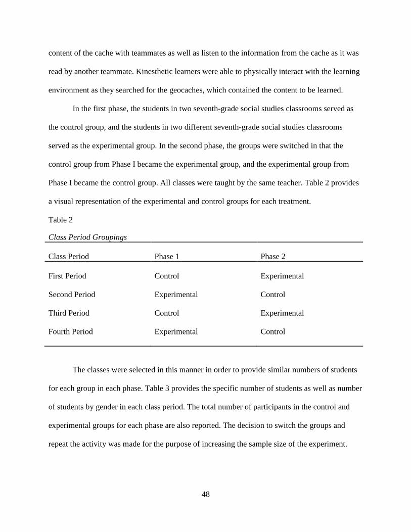
48
content of the cache with teammates as well as listen to the information from the cache as it was
read by another teammate. Kinesthetic learners were able to physically interact with the learning
environment as they searched for the geocaches, which contained the content to be learned.
In the first phase, the students in two seventh-grade social studies classrooms served as
the control group, and the students in two different seventh-grade social studies classrooms
served as the experimental group. In the second phase, the groups were switched in that the
control group from Phase I became the experimental group, and the experimental group from
Phase I became the control group. All classes were taught by the same teacher. Table 2 provides
a visual representation of the experimental and control groups for each treatment.
Table 2
Class Period Groupings Class Period
Phase 1
Phase 2
First Period
Second Period
Third Period
Fourth Period
Control
Experimental
Control
Experimental
Experimental
Control
Experimental
Control
The classes were selected in this manner in order to provide similar numbers of students
for each group in each phase. Table 3 provides the specific number of students as well as number
of students by gender in each class period. The total number of participants in the control and
experimental groups for each phase are also reported. The decision to switch the groups and
repeat the activity was made for the purpose of increasing the sample size of the experiment.

49
This helped to ensure homogeneity and also helped the researcher avoid having to control for
any differences in the different class periods.
Table 3
Number and Gender of Potential Participants per Phase Treatment/Period First Period Second Period Third Period Fourth Period Total Control 1 Male Female
29 14 15
28 18 10
57 32 25
Control 2 Male Female
30 21 9
17 6
11
47 27 20
Experimental 1 Male Female
30 21 9
17 6
11
47 27 20
Experimental 2 Male Female
29 14 15
28 18 10
57 32 25
Prior to data collection, Institutional Review Board approval was obtained (see Appendix
B). Parental consent and student assent were solicited prior to data collection. The permission
and assent forms were distributed and collected by the classroom teacher. The students who were
not given permission to participate in the study, or who did not assent to participation, completed
the GPS activity with their class. However, the scores of these students were not reported to the
researcher or included in the data analysis. Each assenting participant was assigned a number by
the classroom teacher in order to ensure anonymity as well as to ensure that each assenting
participant completed both the pretest and posttest. Participants were instructed by the teacher to
write the identification number on each test and the survey. The scores of assenting participants
who were absent on any day of the study were also not included in the results.
50
Instrumentation
Five different instruments were used to obtain data in this study: 1) a pretest for Phase I
(see Appendix C), 2) a posttest for Phase I (see Appendix C), 3) a pretest for Phase II (see
Appendix D), 4) a posttest for Phase II (see Appendix D), and 5) a GPS perceptions and
engagement survey (see Appendix E). The standards-based pretests and posttests were created
using the Examview© test creation software that accompanied the textbook used by the social
studies teacher. In the first phase, the pretests and posttests were identical and consisted of short
answer questions on the topic of the culture traits of Southwest Asia. Questions on the tests in the
first phase addressed the following Alabama Course of Study: Social Studies (2004) objective for
seventh grade geography, “Identify physical, economic, political, and cultural characteristics of
selected regions in the Eastern Hemisphere, including Europe, Asia, and Africa” (p. 54).
In the second phase, the pretests and posttests were also identical and consisted of short
answer questions on the topic of the essential elements of geography in Southwest Asia.
Questions on the tests in the second phase also addressed the following Alabama Course of
Study: Social Studies (2004) objective for seventh grade geography, “Identify physical,
economic, political, and cultural characteristics of selected regions in the Eastern Hemisphere,
including Europe, Asia, and Africa” (p. 55).
The perceptions and engagement survey instrument (see Appendix E) was developed by
the researcher after a review of relevant literature on instructional geocaching, learning styles,
student motivation, and achievement. The researcher also used information from the only other
existing instructional geocaching study (Buck, 2009) in the development of the survey.
Observations of existing GPS and geocaching classroom methods were also taken into
consideration in the survey design. After the pretest and posttest administration in the second

51
phase, all participants in the study completed this survey which was designed to assess
participants’ perceptions of and attitudes toward geocaching as an instructional activity. This
survey instrument consisted of 12 four-point Likert scale items as well as four open-ended
questions to allow students to elaborate on their experience with the instructional geocaching
activity. The open-ended questions helped to clarify student responses and provide more detail
on student engagement and motivation during the instructional geocaching activity.
There were also six instruments designed by the classroom teacher and researcher, which
were used with the procedural aspects of this study. Four of these instruments were used in the
instructional geocaching activity (two per phase). These instruments were the geocaching field
guides (see Appendix F) and geocache task sheets (see Appendix G). The geocaching field
guides consisted of the team number, the coordinates to each of the team’s three geocaches,
geography terms to be learned, spaces for note-taking and drawing conclusions, and instructions
for the activity. The geocaching field guides contained different terms for each phase with Phase
I using culture traits and Phase II consisting of essential elements of geography. These field
guides were distributed to the student teams before the activity. The geocache task sheets
consisted of information that the students needed to know about the content of the lesson. These
sheets were divided into three different geocaches for the students to find.
The other two of the six procedural instruments designed by the classroom teacher and
researcher were used with the control aspect of the study. These were the presentation notes used
by the classroom teacher to present the content to the students in the control groups (see
Appendix H). For the first phase of the study, the notes consisted of information on culture traits,
and for Phase II, the notes consisted of information on essential elements of geography. For both
phases of the study, the information contained in the presentation notes was the same as the

52
information in the geocache task sheets. This strategy was used to make the method of learning
the content the only variable in the study (a traditional instructional activity versus an
instructional geocaching activity). Each instrument was used for the purpose of applying prior
knowledge to the content of the lesson.
Data Collection
Prior to data collection, permission was obtained from the school principal and school
athletic director to use the athletic fields adjacent to the middle school for the instructional
geocaching course. This area provided the necessary space for placement of the geocaches as
well as an open area to supervise all students during each activity. The researcher and classroom
teacher then used GPS receivers to mark 30 waypoints for the instructional geocaching course.
This number of waypoints was selected because the maximum number of teams in each class
was ten, and each team would be locating three geocaches. After these waypoints were marked,
geocaches which contained the geocache task sheets were created for each waypoint. The
geocache task sheets were divided into three sections in order to be distributed in three
geocaches. Each geocache was also clearly labeled with the number of the team that was
supposed to find it. Team numbers were assigned randomly on the day of the activity through the
distribution of the geocaching field guides, which had the team number listed at the top of the
page. The geocaches were hidden in the marked locations by the researcher and the classroom
teacher on the day prior to the activity.
Also prior to data collection, the classroom teacher divided the students in all four classes
into groups of three. According to Brewster and Fager (2005), students of any ability level
benefit by heterogeneous grouping. In order to ensure heterogeneity, the teacher divided each
class into three sections based on student achievement in the last grading period. For each class,
53
the names of the top one-third of students were placed in one container. The names of the middle
one-third of students were placed in a second container, and the names of the lowest achieving
one-third of students were placed in a third container. The classroom teacher then pulled a name
from each of the containers to form a group. This process was continued until all names were
randomly drawn from each container, and all students were divided into groups of three.
There were three phases of data collection in this study. The first two phases divided the
students into control and treatment groups for the pretest, instructional activities, and posttest.
Phase III surveyed all students on perceptions of the instructional geocaching activity. The entire
study consisted of class periods for six school days in which three consecutive days were used
for Phase I and three different consecutive days were used for Phase II. The phases were
conducted over two consecutive weeks. Informal interviews with the classroom teacher were
also conducted throughout the study to gain insight into the curriculum and instruction of seventh
grade social studies.
Phase I
During day one of Phase I, all students completed a pretest on the culture traits of
Southwest Asia (see Appendix C), a topic which had not previously been taught by the
classroom teacher to these students. The students had been taught a unit on culture traits in
general, and the unit on Southwest Asia required the students to apply prior knowledge of culture
traits to the specific region that was being covered. Each student was asked to write his or her
identification number assigned by the classroom teacher on the test instead of his or her name to
ensure anonymity. The pretest lasted approximately 20 minutes and was administered, graded,
and recorded in the grade book by the classroom teacher. The tests were then stored in a locked
filing cabinet until retrieved by the researcher for data analysis.
54
On the second day of Phase I, the control group (students in class periods one and three)
participated in a traditional classroom activity (see Appendix H). This activity consisted of
content presented to the students on the white board by the teacher. Students were expected to
copy the information into their own notebooks and apply prior knowledge to match the correct
culture traits to the content as it was presented. Students were also required to provide examples
of the culture traits from previously covered regions. The classroom teacher reviewed the content
after all students completed the activity. This activity took approximately 30 minutes for the
students to complete.
Also on the second day of Phase I, the experimental group (students in class periods two
and four) participated in the instructional geocaching activity covering the same content as the
traditional classroom activity. The students were escorted to the school’s athletic fields by the
classroom teacher, and after a brief review of GPS use, the students were instructed to separate
into their predetermined cooperative learning groups of three for the activity. After instructions
for the activity were presented, each group was then presented with a geocaching field guide
which contained the team number and coordinates to the group’s three geocaches as well as the
list of culture traits with which they must match the content in the geocaches. The students then
used the GPS receivers to go to three specified locations, find their group’s geocache at each
location, and match the content of the geocache to the culture traits on the field guide using prior
knowledge of the subject. The students were also required to discuss the topics on each geocache
task sheet and provide examples of the culture traits from previously covered regions. The
students were also required to return the geocache container to its location before moving on to
the other locations. After all groups finished the activity, the classroom teacher reviewed the

55
content to ensure understanding. The instructional geocaching activity took approximately 45
minutes to complete.
On the third day of Phase I, both the experimental and control groups completed a
posttest (See Appendix C) on the culture traits of Southwest Asia. This test was the same as the
pretest in content and design and was identical for both the experimental and control groups. The
classroom teacher administered the posttest reminding the students to write their assigned
identification number on the test instead of their name. The pretest took approximately 20
minutes to complete and was graded and recorded in the grade book by the classroom teacher.
The tests were then stored in a locked filing cabinet until retrieved by the researcher for data
analysis.
Phase II
Phase II of the study was exactly the same procedurally as Phase I. However, in the
second phase, the control and experimental groups were switched. The control group consisted
of students in class periods two and four, and the experimental group consisted of students in
class periods one and three (see Table 2). The topic of study for the students had also progressed
to the essential elements of geography for Southwest Asia, a topic which had not previously been
taught by the classroom teacher to these students. However, earlier in the semester, the students
had been taught a unit on the essential elements of geography in general, and the unit on
Southwest Asia required the students to apply prior knowledge of the essential elements of
geography to the specific region being studied.
On day one of Phase II, all students (experimental and control) completed a pretest on the
essential elements of geography for Southwest Asia (see Appendix D). Each student was asked
to write his or her identification number assigned by the classroom teacher on the test instead of
56
his or her name to ensure anonymity. The pretest lasted approximately 20 minutes and was
administered, graded, and recorded in the grade book by the classroom teacher. The tests were
then stored in a locked filing cabinet until retrieved by the researcher for data analysis.
On day two of Phase II, the control group (students in class periods two and four)
participated in a traditional classroom activity (see Appendix H). This activity consisted of
content presented to the students on the white board by the teacher. Students were expected to
copy the information into their own notebooks and apply prior knowledge to match the correct
essential element of geography to the content as it was presented. Students were also required to
provide examples of essential elements of geography from previously covered regions. The
classroom teacher reviewed the content after all students completed the activity. This activity
took approximately 30 minutes for the students to complete.
Also on day two of Phase II, the experimental group (students in class periods one and
three) participated in the instructional geocaching activity covering the same content as the
traditional classroom activity. The students were escorted to the school’s athletic fields by the
classroom teacher, and after a brief review of GPS use, the students were instructed to separate
into their predetermined cooperative learning groups of three for the activity. After instructions
for the activity were presented, each group was then presented with a geocaching field guide
which contained the team number and coordinates to the group’s three geocaches as well as the
list of essential elements with which they must match the content in the geocaches. The students
then used the GPS receivers to go to three specified locations, find their group’s geocache at
each location, and match the content of the geocache to the essential elements of geography on
the field guide using prior knowledge of the subject. The students were also required to discuss
the topics on each geocache task sheet and provide examples of the essential elements of

57
geography from previously covered regions. The students were also required to return the
geocache container to its location before moving on to the other locations. After all groups
finished the activity, the classroom teacher reviewed the content to ensure understanding. The
instructional geocaching activity took approximately 45 minutes to complete.
On day three of Phase II, both the experimental and control groups completed a posttest
(see Appendix D) on the essential elements of Southwest Asia. This test was the same as the
pretest in content and design and was identical for both the experimental and control groups. The
classroom teacher administered the posttest reminding the students to write their assigned
identification number on the test instead of their name. The pretest took approximately 20
minutes to complete and was graded and recorded in the grade book by the classroom teacher.
The tests were then stored in a locked filing cabinet until retrieved by the researcher for data
analysis.
Phase III
After both phases, all assenting participants in the experiment completed the survey of
student perceptions and engagement (see Appendix E). The survey was administered by the
classroom teacher on the day after Phase II was completed. Each student was asked to write his
or her identifying number on the survey. The perceptions and engagement survey consisted of a
four-point Likert scale format to address items such as “The GPS activity helped me to learn
about geography” and “I felt motivated to learn about geography more while using the GPS than
while taking notes in class.” There were also four open-ended questions to help clarify responses
and to provide more information to the researcher on student perceptions of the GPS activity.
The survey took approximately 15 minutes to complete. The classroom teacher collected the
surveys after they were completed and returned them to the researcher for data analysis.

58
Research Questions
The research questions explored in this study were as follows:
1. Is there a significant difference in pretest and posttest scores between students who
received the instructional geocaching treatment and students who did not receive the
instructional geocaching treatment?
2. Is there a significant difference between the pretest and posttest scores of students with
different learning styles who received the geocaching treatment?
3. Is there a significant difference between the pretest and posttest scores of students with
different learning styles who did not receive the geocaching treatment?
4. Is there a significant difference in student engagement during the geocaching activity
based on learning style?
5. Is there a significant relationship between student engagement and student achievement
during the instructional geocaching treatment?
6. What are students’ perceptions toward geocaching activities for learning?
Data Analysis
After the researcher completed the three phases of the experiment, data were screened for
data entry errors, missing data, and outliers using standard procedures. Data were analyzed using
Statistical Package for the Social Sciences (SPSS) 17.0 ®. Descriptive statistics were used to
report gender, learning style, and GPS receiver use of each student. Qualitative data from the
open-ended questions on the GPS perceptions and engagement survey were used to clarify
responses and to further inform the research regarding student perceptions of geocaching.

59
Research questions and the data analysis techniques that were used are as follows:
Research Question 1: Is there a significant difference in pretest and posttest scores
between students who received the instructional geocaching treatment and students who did not
receive the instructional geocaching treatment?
Data were collected via the pretest and posttest scores. Prior to data analysis, the scores
were tested for normal distribution by observing the skewness, kurtosis, and histograms. When
the results revealed that the assumption of compound symmetry was not met, a Shapiro-Wilk test
confirmed that the distribution was not normal. Therefore, a non-parametric Mann-Whitney U
test was conducted to compare the test scores of students who participated in the instructional
geocaching activity (experimental group) and of students who participated in the traditional
classroom activity (control group) from each phase of the study. A Wilcoxon test was also
conducted to determine if there were differences in the scores of the pretests and posttests of all
students in each phase of the study.
Research Question 2: Is there a significant difference between the pretest and posttest
scores of students with different learning styles who received the geocaching treatment?
Data were collected via the pretest and posttest scores. Learning style data were collected
from the GPS perceptions and engagement survey. A non-parametric Kruskal-Wallis test was
conducted to evaluate differences among the three learning styles (visual, auditory, kinesthetic)
on median scores for the pretest and posttest of the experimental group in each phase of the
study.
Research Question 3: Is there a significant difference between the pretest and posttest
scores of students with different learning styles who did not receive the geocaching treatment?
60
Data were collected via the pretest and posttest scores. Learning style data were collected
from the GPS perceptions and engagement survey. A non-parametric Kruskal-Wallis test was
conducted to evaluate differences among the three learning styles (visual, auditory, kinesthetic)
on median scores for the pretest and posttest of the control group in each phase of the study.
Research Question 4: Is there a significant difference in student engagement during the
geocaching activity based on learning style?
Data were collected via the GPS perceptions and engagement survey. The reliability of
the survey was tested using Cronbach’s alpha. Item 10, “My learning time would have been
better spent in the classroom than outside using a GPS,” was recoded to match the scale. Items
from the survey that had item-to-total correlation below .30 were dropped. The mean results of
the remaining items were totaled to determine overall student engagement.
The survey responses were then subjected to an exploratory factor analysis using a
principal component analysis with a varimax, orthogonal rotation to provide validity evidence
for this instrument. Factor analysis also provided some of the tools needed to define the
underlying dimensions of variables in construct validity. Factors with an eigenvalue of 1.00 were
extracted, and variance was determined for the factors. An examination of the principal
components solution helped to identify the factors of student engagement.
After the factors were determined, the engagement survey results were tested for normal
distribution by observing the skewness, kurtosis, and histograms. When the results revealed that
the assumption of compound symmetry was not met, a Shapiro-Wilk test confirmed that the
distribution was not normal. Therefore, a non-parametric Kruskal-Wallis test was performed to
investigate if there was a significant difference in student engagement during the geocaching
activity based on learning style. Student engagement was computed by the total score of the 11

61
items that remained after the item-to-total correlation, and learning style was indicated on the
GPS perceptions and engagement survey. A Mann-Whitney U test was used to determine where
the differences were found. A Bonferroni correction was used to produce a stricter significance
level and prevent a Type I error. Further analysis was conducted using chi-square to determine if
there were any differences between learning styles and the individual survey items.
Research Question 5: Is there a significant relationship between student engagement
during the instructional geocaching treatment and student achievement on the posttest?
What are students’ perceptions toward geocaching activities for learning?
Data were collected via the posttest scores and GPS perceptions and engagement survey.
Pearson product-moment correlation coefficients were computed between overall student
engagement and the posttest scores in each phase. Student engagement was computed by the
total score of the 11 items that remained after the item-to-total correlation.
Research Question 6: What are students’ perceptions toward geocaching activities for
learning?
Data were collected from the GPS perceptions and engagement survey. Quantitative data
from the Likert-scale responses were subjected to an exploratory factor analysis as detailed in
Research Question 4 to determine the underlying factors of the survey. The factors were
analyzed for relationships using a Pearson product-moment correlation. A Bonferroni correction
was used to produce a stricter significance level. Qualitative data from the open-ended questions
on the survey were analyzed using constant comparative analysis by reading and re-reading the
responses, searching for common patterns and trends (Miles & Huberman, 1994).
62
Summary
The purpose of this study was to investigate how the instructional use of GPS through
geocaching activities engages students and promotes achievement in the middle school
classroom. A comparison of test scores from students who participated in an instructional
geocaching activity were compared with the test scores of students who participated in a
traditional non-technology integrated classroom activity. Student achievement data were
collected through two series of pretests and posttests. A GPS perceptions and engagement survey
was also given to collect student attitude and engagement data related to the instructional
geocaching activities that were conducted as the experimental treatments. Data were analyzed
using quantitative and qualitative methods.

63
CHAPTER IV
RESULTS
Introduction
The purpose of this study was to investigate how the instructional use of GPS through
geocaching activities engages students and promotes achievement in a middle school social
studies classroom. The relationship of instructional geocaching with addressing the needs of
students with various learning styles was also examined. The study was conducted with four
seventh grade social studies classes and in two phases. All students participated in the
geocaching treatment to learn content in one phase or the other. Student achievement was
measured by a pretest and posttest in each phase of the study. Student engagement and
perceptions of the geocaching activity were measured by a perceptions and engagement survey
given after both phases of the study were completed. Quantitative data were analyzed for
research questions one through six. Qualitative data from the open-ended questions on the
perceptions and engagement survey were used to clarify responses and to further inform the
researcher regarding student perceptions of geocaching for question six.
Demographic Results
The potential sample size for this study was 104 students from four seventh grade social
studies classes. However, data from students who did not assent to the study and from students
who were absent during any part of the study were not considered in the analysis. The resulting
number of student participants in the study was 81, or 78% of the potential sample size. Of the
sample size, 42 males (52%) and 39 females (48%) completed each phase of the study. The
students were also asked to report their learning style as indicated on the learning styles

64
inventory conducted by the teacher earlier in the school year. Forty students (49%) indicated that
their learning style was kinesthetic. Twenty-six students (32%) indicated visual as their learning
style, and 15 students (19%) indicated auditory as their learning style. Table 4 summarizes the
learning style demographic by class period. Students were also asked to report if they had used a
GPS receiver prior to participating in the activities in this class. Forty-six students (57%)
answered that they had not used a GPS receiver before, and 35 (43%) had previous experience
with a GPS receiver.
Table 4
Number and Percentage of Learning Styles by Class Period Period/Learning Style Visual Auditory Kinesthetic Total First 7 2 14 23 % of Class 30% 9% 61% 100% % of Sample 9% 2% 17% 28% Second 7 6 10 23 % of Class 30% 26% 43% 100% % of Sample 9% 7% 12% 28% Third 9 4 9 22 % of Class 41% 18% 41% 100% % of Sample 11% 5% 11% 27% Fourth 3 3 7 13 % of Class 23% 23% 54% 100% % of Sample 4% 4% 9% 16% Total 26 15 40 81 % of Sample 32% 19% 49% 100%

65
Research Questions
Research Question 1: Is there a significant difference in pretest and posttest scores
between students who received the instructional geocaching treatment and students who did not
receive the instructional geocaching treatment?
Research question one sought to examine the influence of the instructional geocaching
activity on student achievement. Prior to data analysis, the pretest and posttest scores from both
phases of data collection were tested for normal distribution. Skewness, kurtosis, and histograms
of the pretest and posttest scores revealed that the scores did not meet the assumption of
compound symmetry (Munro, 2001). A Shapiro-Wilk test confirmed that the test scores differed
from a normal distribution where p < .05 (see Table 5). For this reason, the non-parametric
Mann-Whitney U test was conducted to compare the scores on the pretests and posttests from
each phase of the study.
Table 5
Shapiro-Wilk Test of Normality
Statistic df Sig. Pretest 1 .967 81 .035
Posttest 1 .660 81 .000
Pretest 2 .872 81 .000
Posttest 2 .916 81 .000
The pretest and posttest scores were analyzed using the Mann-Whitney U test to address
Research Question 1. The experimental group consisted of students who participated in the
instructional geocaching activity, and the control group consisted of students who participated in
the traditional classroom activity. To protect against a Type I error, a Bonferroni correction was

66
used to produce a stricter significance level of p < .025, which involved dividing the desired
level of significance by the number of comparisons that were made (.05/2 = .025) (Munro,
2001). Table 6 presents the average ranks of the pretest and posttest scores for each group in
each phase of the study.
Table 6
Average Ranks of Pretest and Posttest Scores
Group Pretest Posttest
Phase I
Control
Experimental
43.23
38.21
37.74
45.07
Phase II
Control
Experimental
44.39
36.76
34.29
46.37
The results of the Mann-Whitney U test for the Phase I pretest revealed no significant
difference in achievement, z = -.961. As shown in Appendix I, Figure I1 shows the distributions
of the scores on the Phase I pretest. The results of the Mann-Whitney U test for the Phase I
posttest also revealed no significant difference in achievement, z = -1.57. Figure I2 shows the
distributions of the scores on the Phase I posttest.
The results of the Mann-Whitney U test for the Phase II pretest revealed no significant
difference in achievement, z = -1.54. Figure I3 shows the distributions of the scores on the Phase
II pretest. The results of the Mann-Whitney U test for the Phase II posttest revealed a significant
difference in achievement, z = -2.32, p < .05. Figure I4 shows the distributions of the scores on

67
the Phase II posttest, which reveal that the results were in the expected direction of higher
achievement gains for those students in the experimental group.
A Wilcoxon test was conducted to determine if there were differences in the scores of the
pretests and posttests of each phase of the study. The means and ranks of the pretest and posttest
scores for each phase of the data are reported in Table 7. The pretest comparison results
indicated a significant difference in scores, z = -6.46, p < .001. The scores for the Phase I pretest
were significantly higher than the scores for the Phase II pretest for both the experimental and
control groups. The posttest comparison results also indicated a significant difference in scores, z
= -5.98, p < .001. The scores for the Phase I posttest were significantly higher than the scores for
the Phase II posttest for both the experimental and control groups.
Table 7
Overall Pretest and Posttest Means and Ranks
Pretest
Posttest
Phase Mean SD Rank Mean SD Rank
Phase I 7.23 2.96 42.30 10.86 1.90 38.64
Phase II 4.33 1.16 18.21 8.21 2.53 26.65
Research Question 2: Is there a significant difference between the pretest and posttest
scores of students with different learning styles who received the geocaching treatment?
For both phases of the study, a Kruskal-Wallis test was conducted to evaluate differences
among the three learning styles (visual, auditory, kinesthetic) on median scores for the pretest
and posttest of the experimental group. Table 8 presents the results of the Kruskal-Wallis tests
for each phase of the study. A significance level of p < .05 was used for each test. For the
pretests in both phases of the study, the Kruskal-Wallis test, which was corrected for tied ranks,

68
revealed that there was no significant difference in pretest scores between learning styles. The
Kruskal-Wallis test also revealed that there was no significant difference in posttest scores
between learning styles in each phase of the study. Follow-up tests for each learning style in each
phase were not necessary because the overall differences were not significant (Green & Salkind,
2005).
Table 8
Kruskal-Wallis Results for Experimental Groups
Test
df
χ2 p
Phase I (n = 36)
Pretest 2 7.23 ns
Posttest 2 4.33 ns
Phase II (n = 45)
Pretest 2 7.61 ns
Posttest 2 3.92 ns
Research Question 3: Is there a significant difference between the pretest and posttest
scores of students with different learning styles who did not receive the geocaching treatment?
For both phases of the study, a Kruskal-Wallis test was conducted to evaluate differences
among the three learning styles (visual, auditory, kinesthetic) on median scores for the pretest
and posttest of the control group. Table 9 presents the results of the Kruskal-Wallis tests for each
phase of the study. A significance level of p < .05 was used for each test. For the pretests in both
phases of the study, the Kruskal-Wallis test, which was corrected for tied ranks, revealed that
there was no significant difference in pretest scores between learning styles. The Kruskal-Wallis
test also revealed that there was no significant difference in posttest scores between learning

69
styles in each phase of the study. Follow-up tests for each learning style in each phase were not
necessary because the overall differences were not significant (Green & Salkind, 2005).
Table 9
Kruskal-Wallis Results for Control Groups
Test
df
χ2 p
Phase I (n = 45)
Pretest 2 1.54 ns
Posttest 2 0.37 ns
Phase II (n = 36)
Pretest 2 0.48 ns
Posttest 2 4.14 ns
Research Question 4: Is there a significant difference in student engagement during the
geocaching activity based on learning style?
The GPS perceptions and engagement survey (see Appendix E) was used to address
Research Question 4. The original survey consisted of 12 items to be used for this study. This
survey instrument had a reliability coefficient using Cronbach’s alpha of .71 and item-to-total
correlations from .24 to .68. After dropping item 4, “I thought the GPS activity was challenging,”
which had item-to-total correlation below .30, a revised instrument was determined consisting of
11 items with a Cronbach’s alpha coefficient of .75. According to George and Mallery (2003), a
reliability coefficient of .7 or higher is acceptable. Of the 11 items remaining, the lowest item-to-
total correlation was .33 with the highest being .66. This suggested that most of the items gave a
significant contribution to the total instrument. High item-to-total correlations not only support
the reliability of the instrument, but also document validity in that the items are measuring the

70
same theoretical construct (Munro, 2001). The standard error of measurement was 1.74. The
means and standard deviations are presented in Table 10. The total variable in Table 10
represents the overall level of engagement. This variable was computed by the total score of the
11 items that remained after the item-to-total correlation.
Table 10 Descriptive Statistics of Survey Items (n=81)
Item
Description
m
sd
Total 41.56 3.46 Q1 Learning with technology 3.46 0.57 Q2 Ease of use 3.49 0.50 Q3 Enjoyment of activity 3.85 0.39 Q5 Learning with GPS 3.85 0.48 Q6 GPS helps learning 3.43 0.55 Q7 Motivated to learn 3.44 0.63 Q8 More enjoyable than notes 3.86 0.38 Q9 Understanding the lesson 3.25 0.80 Q10 Outside versus inside 3.43 0.76 Q11 Motivated in other topics 3.41 0.67 Q12 Other subjects 3.53 0.61
The survey responses were subjected to an exploratory factor analysis using a principal
component analysis with a varimax, orthogonal rotation. Factor analysis was useful in providing
validity evidence for this instrument. Factor analysis provided some of the tools needed to define
the underlying dimensions of variables in construct validity. Of the 11 factors, three factors were
extracted with an eigenvalue of 1.00 or greater. The first factor explained 31% of the variance
with three factors explaining 54% of the variance.
After examining the principal components solution, a three factor solution was retained,
which provided the best simple structure. The item loadings were all above .465, which presents
evidence to the construct validity of the instrument (Carmines & Zeller, 1979). The underlying
71
dimensions identified by each factor were as follows: (I) Fun, (II) Perception of Learning, and
(III) Motivation.
The fun factor was represented by items 2, 3, 5, and 8 from the GPS perceptions and
engagement survey (see Appendix E). These items addressed information such as, “How easy
was it to use the GPS,” “How much did you enjoy the GPS activity,” “Learning about geography
using a GPS was more fun than taking notes.”, and “The GPS activity was more enjoyable than
taking notes in class,” respectively. The perception of learning factor was represented by items 6,
7, 9, and 10. These items addressed information such as, “The GPS activity helped me to learn
about geography,” “I felt motivated to learn about geography more while using the GPS than
while taking notes in class,” and “I understood the geography lesson better by using the GPS
than by taking notes in class.” Item 10 stated, “My learning time would have been better spent in
the classroom than outside using a GPS.”, and was recoded to match the scale. The motivation
factor was represented by items 1, 11, and 12. These items address information such as, “I like
learning with technology,” “I would be more motivated to learn other topics in social studies if
we could use a GPS,” and “I would like to participate in GPS activities in other subjects,”
respectively.
To specifically address Research Question 4, which investigated if there was a significant
difference in student engagement during the geocaching activity based on learning style, a
Kruskal-Wallis test was performed using a significance level of .05. This nonparametric test was
selected after skewness, kurtosis, and histograms of the engagement survey results revealed that
student engagement did not meet the assumption of compound symmetry (Munro, 2001). A
Shapiro-Wilk test confirmed that the student engagement results differed from a normal
distribution where p < .05. Student engagement was measured by the total score of the 11 items

72
that remained after the item-to-total correlation. From the results of the engagement survey, a
significant difference was found between student engagement and learning styles, χ2 (2, n = 81)
= 6.87, p < .05. Pairwise comparisons among the three learning styles were conducted using a
Mann-Whitney U test with a Bonferroni correction to produce a stricter significance level of p <
.025, which involved dividing the desired level of significance by the number of comparisons
that were made (.05/2 = .025) (Munro, 2001). The Mann-Whitney U test found a significant
difference between the students with a visual learning style and students with a kinesthetic
learning style, z = -2.27, p < .025. In the pairwise comparison, kinesthetic learners had an
average rank of 37.79, while visual learners had an average rank of 26.90. Auditory learners did
not significantly differ from the other two learning styles. Further analysis was conducted using
chi-square to determine if there were any relationships between learning styles and the individual
items. There was a significant relationship between learning style and item 7 (χ2 (4, n = 81) =
11.95, p < .05), which stated “I felt motivated to learn about geography more while using the
GPS than while taking notes in class.”
Research Question 5: Is there a significant relationship between student engagement
during the instructional geocaching treatment and student achievement on the posttest?
To address Research Question 5, Pearson product-moment correlation coefficients were
computed between overall student engagement and the posttest scores in each phase. Student
engagement was computed by the total score of the 11 items that remained after the item-to-total
correlation. A significance level of p < .05 was used for each correlation, and no statistically
significant relationship was found between student engagement and the posttest scores in Phase I
(r = .93, n = 36) or Phase II (r = -.06, n = 45).

73
Research Question 6: What are students’ perceptions toward geocaching activities for
learning?
An examination of Research Question 6 was conducted with data from Research
Question 4. This information was obtained from the Likert-scale responses on the GPS
perceptions and engagement survey. As detailed in Research Question 4, the survey responses
were subjected to an exploratory factor analysis, which identified three underlying dimensions:
(I) Fun, (II) Perception of Learning, and (III) Motivation.
A Pearson product-moment correlation coefficient was computed to assess the
relationships between the three underlying factors for all students. To protect against a Type I
error, a Bonferroni correction was used to produce a stricter significance level of p < .008, which
involved dividing the desired level of significance by the number of comparisons that were made
(.05/6 = .008) (Munro, 2001). The results indicated that there is a significant relationship
between all factors. Moderate, positive correlations were found between fun and motivation (r =
.48, p < .001) and fun and perception of learning (r = .41, p < .001). Increases in fun correlated
with increases in motivation and perception of learning. There was also a weak, positive
correlation between motivation and perception of learning (r = .33, p < .005). Increases in
motivation have a slight correlation with increases in perception of learning.
Four open-ended questions on the GPS perceptions and engagement survey (see
Appendix E) were used to obtain qualitative data. After reading and re-reading the responses to
the open-ended questions, the following themes emerged: (1) Being Outside and Moving
Around, (2) Hands-On Experience, (3) Finding Directions, (4) Searching for and Finding Things,
and (5) Math and Science.

74
The element of not being confined to the classroom was reported as an engaging factor
for many students. The theme of being outside and moving around was indicated by 41 (51%) of
the 81 students in the study. It is important to note that of the 41 students who indicated that
being outside and moving around was important, 21 were kinesthetic learners, 11 were visual
learners, and nine were auditory learners. The element of being outside and moving around was
described by students as “being outside having fun instead of sitting inside and taking notes” and
“moving around while we learned geography was fun.”
Another prevalent theme that emerged from the responses was the engaging factor of the
hands-on experience. This theme, which is somewhat related to the moving around aspect of the
previous theme, was mentioned by 22 students, or 27%. The students perceived that the GPS
activity provided them with an experience that was better than taking notes. One student wrote,
“I liked that the GPS activity was hands-on work. It was better than just writing notes.”
Furthermore, the students indicated that they learned more by stating “I think the lesson was
more understandable because we did it hands-on with the GPS.”
Students revealed an understanding of GPS receivers as devices to provide directions and
determine their current location. The theme of finding directions was the most prevalent in the
responses and was reported by 62 (77%) of the students. This included over 32 indications of the
GPS receiver preventing students from getting lost. For example, one student said, “If I were to
get lost while I was hunting, I could mark the place where the truck was and follow the
coordinates,” and another echoed this by stating, “A GPS can help me to not get lost in the
wilderness.” Students frequently mentioned that the GPS activity helped them to learn “which
way is north, south, east and west.” References to travel and using GPS receivers to locate places

75
were also frequently found in this theme. One student noted, “I now know how to use a GPS to
locate places when I travel with my family.”
The element of the scavenger hunt was also prevalent in student responses. Of the 81
students, 34, or 42%, indicated that searching for and finding things was an engaging aspect of
the instructional geocaching activity. This theme was evidenced by comments such as “I liked
how we learned how to find the latitude and longitude and actually found something when we
found our point,” and “I liked finding the hidden containers. It was very challenging.” One
student wrote that they liked “going to that exact location and having to look high and low and
all around for the geocache.” Another student enjoyed “finding the area that your coordinates tell
you that you’re supposed to be.” Some students offered statements directly relating to scavenger
hunts such as “It was like going on a scavenger hunt with a map (GPS).” Some students thought
that this would be a fun way to study. For example, one student wrote, “The teacher could hide
the answers to study guides in different places and then give us the location to find them.”
Finally, one student would like to see teachers “put test questions in a box somewhere for us to
find and answer using a GPS.”
The second most prevalent theme that emerged from the responses was the application of
GPS activities to math and science classes. Of the 81 students surveyed, 42 of them (52%)
addressed ideas of using the GPS in these two subjects, which were different from the class in
which the activities were conducted (social studies). More specifically, 24 students mentioned
using GPS for math activities, and 18 students referenced science activities. Examples of the
math applications included, “You could use GPS in math because the coordinates can be added
and subtracted,” and “Distances between countries and states could be calculated using the
latitude and longitude.” Another student indicated that “in math, you could find some numbers

76
in the geocaches and use them to solve equations to find a prize.” A similar idea was proposed
by another student, “We could find a location and then another location and then maybe subtract
the numbers to find another location.” Science ideas provided by the students varied from
“finding the specific location where a plant or animal is located” to “helping scientists find
fossils or skeletons.” Several students indicated that science notes could be distributed in the
same way as the social studies GPS activity. One student stated, “In science, it would be more
fun to go outside and do the same thing as we did in this class.”
Summary
The findings of this study offer information about the influence of instructional
geocaching activities on student achievement, engagement, and learning styles. There were
mixed results in the area of achievement. Data from the first treatment (Phase I) did not indicate
a significant difference in posttest scores between the control and experimental groups. In the
second treatment (Phase II), data revealed a significant difference between the control and
experimental groups, which indicated that the instructional geocaching activity had a positive
influence on student achievement. No significant differences in achievement were found between
students with different learning styles whether they participated in the instructional geocaching
activity (experimental group) or the traditional classroom activity (control) in either phase of the
study. Survey data revealed a significant difference in engagement between students with a
visual learning style and a kinesthetic learning style while participating in an instructional
geocaching activity. According to the survey data, the factors of fun, learning, and motivation
were important to student engagement. However, no significant correlations between student
engagement and student achievement were found. Survey results also indicated that the students
perceived that they were more engaged in the learning process because of significant correlations

77
between each of the factors of engagement. Students revealed that an opportunity to be outside of
the classroom for a hands-on activity involving searching for and finding information was
engaging to them. Students also provided applications of instructional geocaching to real-world
and other in school settings.

78
CHAPTER V
DISCUSSION AND RECOMMENDATIONS
Introduction
The research conducted for this study investigated how the instructional use of GPS
through geocaching activities engages students and promotes achievement in a middle school
social studies classroom. In addition, the relationship of instructional geocaching with various
learning styles was examined. Student perceptions of instructional geocaching activities were
also investigated in relation to motivation and engagement in this study.
Demographic Findings
This study was conducted with a convenience sample of seventh-grade students from four
social studies classes with the same classroom teacher. Eighty-one of a potential 104 students
(78%) completed all phases of the project, which included two pretests, two posttests, and a GPS
perceptions and engagement survey. The scores of students who did not assent or who were
absent during any part of the study were not included in the results. The sample consisted of 42
males (52%) and 39 females (48%), which is consistent with the school population of 53% male
and 47% female. The responses for learning styles indicated that there were 40 kinesthetic
learners, 26 visual learners, and 15 auditory learners participating in the study. The students were
made aware of their learning style from an inventory given to them by their teacher at the
beginning of the school year.
An interesting finding from the demographics of this study was the number of students
who had not used a GPS before the activities in this social studies class. Forty-six out of the 81
did not have previous experience using a GPS receiver. This was unexpected due to the

79
popularity that GPS technology has gained in recent years. The lack of experience with a GPS
receiver could be attributed to the popularity of cell phones that include a GPS feature, but would
not be specifically considered a GPS receiver. Another possible reason could be that the school is
classified as having a high poverty population by the U.S. Department of Education (2009),
which would suggest that the families of many students might not have the financial ability to
purchase GPS receivers. By integrating the GPS activity into social studies lessons, the
classroom teacher is providing an opportunity for students to learn a technology skill that many
of them would have missed, but that is integral to the 21st century.
Discussion
Research Question 1: Is there a significant difference in pretest and posttest scores
between students who received the instructional geocaching treatment and students who did not
receive the instructional geocaching treatment?
The first research question focused on the achievement of students on pretests and
posttests in two separate phases of the study. In Phase I, students in class periods two and four
participated in an instructional geocaching activity to learn about culture traits as the
experimental group. Students in class periods one and three participated in a traditional
classroom activity as the control group. In Phase II, the groupings were reversed and content was
changed to essential elements of geography. Pretests were given to all students before the
treatments in each phase, and posttests were given after the treatments in each phase. The
pretests and posttests in each phase consisted of 12 short answer questions. This two phase
model enabled all 81 students in the sample to receive the instructional geocaching treatment in
one phase or the other.
80
The difference in pretest and posttest scores between students who received the
instructional geocaching treatment and students who did not receive the instructional geocaching
treatment was computed with a Mann-Whitney U test. In Phase I of the study, no significant
difference was found between the experimental and control group scores on either the pretest or
the posttest. In the Phase I pretest, the mean rank of the experimental group was 38.21, and the
mean rank for the control group was 43.23, which may indicate that the control group had more
prior knowledge of the first topic. In the Phase I posttest, the mean rank for the experimental
group was 45.07, and the mean rank for the control group was 37.74. This indicated that the
experimental group made a gain in achievement from pretest to posttest, but the scores were not
significantly different from the scores of the control group.
In Phase II of the study, no significant difference was found between the experimental
group and control group pretest scores. The mean rank of the control group was 36.76, and the
mean rank of the experimental group was 44.39. In the Phase II posttest, a significant difference
was found. The mean rank for the control group was 34.29, and the mean rank of the
experimental group was 46.37. This indicated a higher level of posttest scores for students in the
experimental group, and there was sufficient evidence to conclude the instructional geocaching
activity had a positive impact on student achievement.
The findings of Phase I of this study are consistent with the results obtained by Buck
(2009). In a study of the influence of GPS activities on mathematics achievement, Buck found
that students made achievement gains when participating in GPS activities, but these gains did
not represent a significant difference from the control group. However, the findings of Phase II
in this study provide evidence to the contrary of Buck’s results. Furthermore, the findings of
Phase II, in which the GPS activity produced significant gains in student achievement, support

81
the research of Hsieh et al. (2008), Kingsley and Boone (2008), McNew (2008), Swan et al.
(2005), and Tuzun et al. (2009). Each of these studies found that various technology integration
interventions produced statistically significant gains in student achievement scores. However, the
findings in this research study are the first to report statistically significant gains in achievement
based on an instructional geocaching experimental procedure.
Another important aspect of the data represented by the first research question was the
difference in the overall test scores in Phase I and Phase II. As indicated by a Wilcoxon test, the
scores on both the pretest (z = -6.46, p < .001) and posttest (z = -5.98, p < .001) in Phase II
ranked significantly lower than the scores for each test in Phase I for both the control and
experimental groups. The mean pretest score was 7.23 in Phase I with a ranking of 42.30
compared to a mean pretest score of 4.33 with a ranking of 18.21 in Phase II. The mean posttest
score was 10.86 with a ranking of 38.64 in Phase I compared to a mean pretest score of 8.21 with
a ranking of 26.65 in Phase II. This suggests that students were not as familiar with the content in
Phase II before the lesson. An informal interview with the classroom teacher indicated that the
terminology in Phase II was not as common as the terminology of the content in Phase I. She
theorized that students are more familiar with culture trait terms such as economy, government,
and religion, which were covered in Phase I. For Phase II, she explained that essential elements
of geography such as “the world in spatial terms, physical systems, and human systems” are not
part of a middle school student’s everyday language even though it is part of the curriculum. The
findings that prior knowledge of the Phase II content was lower than Phase I and the occurrence
of significant achievement gains in Phase II suggest that instructional geocaching activities may
help students learn more about topics that they do not know very well.

82
Research Question 2: Is there a significant difference between the pretest and posttest
scores of students with different learning styles who received the geocaching treatment?
The second research question related the differences between the pretest and posttest
scores of students with different learning styles while they were participants in the experimental
group. A Kruskal-Wallis test was conducted to evaluate these scores for each phase of the study.
For both phases of the study, no significant differences in pretest scores or posttest scores of
students with different learning styles were found. These results indicated that learning style is
not a significant predictor for achievement gains when students learn content using GPS
activities.
The findings of no significant difference in achievement scores between learning styles
when participating in a technology integrated lesson addressing the various learning styles
supported the findings of the meta-analysis of Slemmer (2002). However, since instructional
geocaching strategies address various learning styles, and the findings of research question one
indicated positive gains in achievement when a technology integration strategy addressing
various learning styles is implemented, the research of Chen et al. (2005) was supported. The
findings of research question one also support studies that indicated learning styles instructional
environments produce statistically higher achievement scores than traditional instructional
environments (Dunn & DeBello, 1999; Dunn & Griggs, 1988; Farkas, 2003; Minotti, 2005;
Peacock, 2001; Roberts, 2001).
Research Question 3: Is there a significant difference between the pretest and posttest
scores of students with different learning styles who did not receive the geocaching treatment?
The third research question related the differences between the pretest and posttest scores
of students with different learning styles while they were participants in the control group. The

83
control group participated in a traditional classroom environment. A Kruskal-Wallis test was
conducted to evaluate these scores for each phase of the study. For both phases of the study, no
significant differences in pretest scores or posttest scores of students with different learning
styles were found. In Phase I, visual learners dropped in mean rank from pretest to posttest, and
kinesthetic and auditory learners improved slightly, but not significantly, from pretest to posttest.
In Phase II, visual learners rose in mean rank from pretest to posttest, while kinesthetic and
auditory learners both saw decreases in mean rank. These findings suggest that learning style is
not a significant predictor of achievement gains in a traditional classroom environment. As
suggested by Dunn (1993), the traditional classroom environment tends to address the learning
styles of visual and auditory learners because of the notes being displayed on the board and read
to the students. However, the findings of this study do not support that theory with significant
statistical evidence. As noted in research question two, these results may have been limited by
the small sample sizes of each learning style in each phase with the three styles being distributed
between 45 students in Phase I and 36 students in Phase II.
Research Question 4: Is there a significant difference in student engagement during the
geocaching activity based on learning style?
Research question four was addressed using data from the 12 Likert-scale items on the
GPS perceptions and engagement survey. Based on statistical analysis, the survey was found to
be valid and reliable. The survey had a reliability coefficient Cronbach’s alpha of .75. A
coefficient above .7 is considered to be acceptable (George & Mallery, 2003). Overall student
engagement was computed by the total score of the 11 items that remained after the item-to-total
correlation.

84
A principal component factor analysis with a varimax, orthogonal rotation revealed that
the first principal component accounted for 31% of the variance with the three extracted factors
explaining 54% of the variance. The construct validity was supported in that the three factors
extracted from the survey loaded above .465. The factors were (I) Fun, (II) Perception of
Learning, and (III) Motivation.
To address research question four, which investigated if there was significant difference
in student engagement during the geocaching activity based on learning style, a Kruskal-Wallis
test found a significant difference between student engagement and learning styles, χ2 (2, n = 81)
= 6.87, p < .05. The pairwise comparison conducted with a Mann-Whitney U test found that the
significant differences were between visual learners and kinesthetic learners. This suggested that
visual learners were engaged differently than kinesthetic learners during the instructional
geocaching activity. The average rank of student engagement for kinesthetic learners (37.79) was
higher than the average rank of student engagement for visual learners (26.90), which indicated a
higher level of engagement for the kinesthetic learner. This supports the theories of Kanar
(1995), McCarthy (2005), and Vincent and Ross (2001), which described the kinesthetic learner
as performing well in hands-on environments that require physical interaction with the content.
Further analysis of research question four was performed using chi-square to determine if
there were any relationships between learning styles and individual survey questions. A
significant relationship was found between learning style and item 7 (χ2 (4, N = 81) = 11.953,
p < .05). Item seven states “I felt motivated to learn about geography more while using the GPS
than while taking notes in class.” Sixty-percent of kinesthetic learners strongly agreed with this
item compared to 46% of visual learners and 40% of auditory learners. This suggested that the
instructional geocaching activity was an important motivational factor for kinesthetic learners.

85
This result may also support the research that kinesthetic learners are more engaged by activities
that require interaction with the content rather than by sitting still in a traditional classroom
activity. However, this result may also be attributed to the validity of the engagement instrument.
Research Question 5: Is there a significant relationship between student engagement
during the instructional geocaching treatment and student achievement on the posttest?
The overall student engagement and the posttest scores were used to evaluate the
relationship between engagement and achievement. A Pearson product-moment correlation
coefficient was computed for each phase of the study. No significant relationship between
engagement and achievement was found for Phase I (r = .93, n = 36) or Phase II (r = -.06, n =
45). The results of research question five were contrary to the research findings of Rigby et al.
(1992), Swan et al. (2005), and Wang and Reeves (2007). Each of those studies reported that
increased student engagement was reflected by increases in student achievement. The small
sample size may have contributed to the lack of a significant relationship between engagement
and achievement in each phase of this study.
Research Question 6: What are students’ perceptions toward geocaching activities for
learning?
Quantitative data and qualitative data were used to determine student perceptions of
instructional geocaching activities for learning. The GPS perceptions and engagement survey
(see Appendix E) provided quantitative data from the 12 Likert-scale questions. The four open-
ended questions on the survey provided the qualitative data.
An exploratory factor analysis identified three underlying dimensions from the survey: (I)
Fun, (II) Perception of Learning, and (III) Motivation. The fun factor was comprised of questions
and items such as “How much did you enjoy the GPS activity,” “Learning about geography

86
using a GPS was more fun than taking notes,” and “How easy was it to use the GPS.” The means
of the responses to the items related to fun ranged from 3.49 to 3.86 on a scale of four. This
indicated that most students perceived the instructional geocaching activity as a fun and
enjoyable learning experience.
The perception of learning factor consisted of items such as “The GPS activity helped me
to learn about geography,” “I felt motivated to learn about geography more while using the GPS
than while taking notes in class,” and “I understood the geography lesson better by using the
GPS than by taking notes in class.” The item that stated, “My learning time would have been
better spent in the classroom than outside using a GPS.” was also included in the perception of
learning factor, but it was recoded to fit the scale. The means of the items related to perception of
learning ranged from 3.25 to 3.44 on the four-point scale. This factor suggested that students
perceived that they were learning during the instructional geocaching activity.
The motivation factor consisted of items such as “I would be more motivated to learn
other topics in social studies if we could use a GPS,” “I would like to participate in GPS
activities in other subjects,” and “I like learning with technology.” The means of the responses
related to motivation ranged from 3.41 to 3.53 on the four-point scale. This factor suggested that
students were motivated by the instructional geocaching activity.
A Pearson product-moment correlation coefficient was also computed to assess the
relationships between the three factors for all students. In research question four, the factors were
examined in relationship to posttest scores for only the experimental groups in each phase of the
study. For the purpose of addressing, research question six, the responses of all students were
examined for correlations. Significant relationships were found between all factors. A moderate,
positive correlation between fun and motivation (r = .48, p < .005) revealed that as perception of

87
fun increased, student motivation increased. A moderate, positive correlation between fun and
perception of learning (r = .41, p < .005) also revealed that as fun increased, perception of
learning increased. Finally, a weak positive correlation between motivation and perception of
learning (r = .33, p < .005) indicated that as motivation increased, perception of learning
increased slightly. The results indicate that students were having fun and were motivated to learn
while participating in the GPS activity, which supports the findings of other researchers (Buck,
2009; Christie, 2007; Matherson et al., 2008).
From the analysis of the qualitative data provided by the open-ended questions on the
survey, the student perceptions of the GPS activity were similar to the perceptions identified by
other researchers (Broda & Baxter, 2003; Buck, 2009; Christie, 2007; Matherson et al., 2008).
Students indicated an enjoyment of the activity because they were outside and moving around
while learning during the GPS activity. The theme of being outside and moving around was
referenced by over half of the students and by several students from each learning style. This
supports the idea that instructional geocaching activities address all learning styles. The students
also revealed that the hands-on aspect of the GPS activity was a motivating factor for learning.
As Christie (2007) proposed, instructional geocaching can engage students in any subject
area, and the data from this study revealed that students readily made associations to math and
science concepts even though they were participating in a social studies class. Students
frequently referenced using the coordinates for solving equations in math classes as well as
discovering the location of plants and animals for science classes in their responses to the open-
ended questions. This factor along with the hands-on aspect may have been influenced by the
presence of the AMSTI curriculum in the math and science classes at the school. The AMSTI
curriculum incorporates hands-on and real-world learning activities into the learning experience

88
(AMSTI, 2009). The students may have become accustomed to the hands-on activities in these
subjects as well as the social studies class in which the instructional geocaching activity
occurred. The informal interview with the classroom teacher indicated that assignments such as
art and digital media projects were part of her normal curriculum in social studies. The AMSTI
curriculum as well as the art and technology influenced social studies curriculum could have also
influenced the higher percentage of kinesthetic learners in the sample because of the emphasis on
projects.
The perceptions of real-world application of the GPS activity revealed that students
understood that a GPS receiver could help them find directions and places to visit. This
perception was the most prevalently mentioned item from all of the open-ended student
responses. The connection is most likely created by the increasing popularity of GPS receivers
in cars and cell phone technology. However, of the 62 students who referred to the GPS as a
directional tool, 32 mentioned that the GPS could prevent them from getting lost. Frequently, the
students wrote that it would prevent them from becoming “lost in the woods.” This finding can
most likely be attributed to the location of the town in which the school is located. The hunting
and outdoor culture is pervasive in this small southeastern town. The researcher is unaware of
any previous research of the fear of being lost in the wilderness or its prevalence in the thoughts
of middle school students as this is not the focus of this study. However, future research on the
use of GPS receivers as a tool to relieve the anxiety of being lost could be beneficial to students
with this fear.
The perception that students enjoyed and were engaged by the scavenger hunt element of
the GPS activity can be related to each of the other themes that were found in the study. The
students were outside of the classroom using technology to find content, which directly relates to

89
the theme of being outside and moving around. Many referenced the GPS receiver as a map to
take them to the hidden information. The element of searching for and then finding the
geocaches was revealed to provide the students an instant feeling of success, which supports the
findings of Huffaker (2003) on the learning process of the 21st century middle school student.
The hands-on aspect can also be related to the use of the GPS receiver to search and the finding
of the content to learn. The students expressed that finding the location and then the geocache
containing the information was an enjoyable challenge that was more interesting than just taking
notes. Many students also indicated that they would like to participate in GPS scavenger hunts in
other subjects especially math and science.
Implications for Educators
Instructional geocaching has significant potential as a technology integration strategy for
teachers. As this study and other studies (Broda & Baxter, 2003; Buck, 2009; Christie, 2007;
Matherson et al., 2008) have indicated, students are motivated and engaged by GPS activities for
learning. Furthermore, this study found that significant achievement gains can be also be attained
by students who participate in instructional geocaching activities. The significant achievement
gains were found when the students were exposed to content that was less familiar to them as
evidenced by the significantly lower pretest scores in Phase II. This supports the research that the
21st century student wants to be challenged and actively engaged by both the content and
delivery of the lesson (Lee & Spires, 2009). Students also experienced achievement gains in
Phase I, where the content was more familiar to them as evidenced by the pretest scores, but
these gains were not significantly different from the gains achieved through traditional classroom
instruction. However, in observing the scores as a whole, it is evident that instructional
geocaching activities facilitate learning in middle school students of various learning styles.
90
As Prensky (2006) noted, today’s student is not motivated by traditional teaching and
learning processes. As indicated by the survey responses, the instructional geocaching activity in
this study provided students with a hands-on and fun learning experience. This experience also
engaged and challenged the students while allowing them to be active participants in the learning
process. As Lee and Spires (2009) suggested, teachers must be creative and flexible with
technology integration pedagogical strategies in order to reach 21st century students. Instructional
geocaching provides a tool for teachers to meet standards and objectives in all subject areas
while actively involving students in the learning experience.
With the impact of instructional geocaching on achievement and engagement as a
consideration, teachers are encouraged to implement GPS activities into their teaching practice.
For social studies teachers, implementing instructional geocaching activities and other engaging
technology strategies could help change student opinion of the subject from boring and irrelevant
(Ciborowski, 2005; Stetson & Williams, 2005) to active, challenging, and fun. Real-world
implications are embedded into GPS use, and GPS use is found in most social studies courses of
study. Therefore, as Doolittle and Hicks (2003) explained, the students will be engaged by the
authentic and active learning experiences that teachers can offer with a technology-enriched
curriculum.
Of course, practice and experience with the use of GPS receivers are also encouraged
before attempting to develop an activity or GPS-infused curriculum. As Mishra and Koehler
(2006) suggested, this learning should take place in the context of TPACK, where the technology
use is driven by the pedagogy and content. Professional development in the area of instructional
geocaching practices is suggested to help teachers repurpose the activity of geocaching for their
teaching needs. However, as has been the experience of the researcher, practical experience in

91
using a GPS in recreational settings can often produce ideas that translate to educational practice
as well as an overall understanding of GPS functionality. Even still, there are several
instructional geocaching webinars and classroom activity guides endorsed by ISTE as well as
numerous web sites such as the Illinois Educational Geocaching Association Portal
(www.ilega.org), The University of Alabama Technology in Motion GPS/Geocaching in the
Classroom Wiki (http://uatim.wikispaces.com/gps), and the Groundspeak GPS in Education
Forum (http://forums.groundspeak.com) that can help teachers in the design of instructional
geocaching activities for their students.
Professional development and teacher education programs should consider including
innovative practices such as instructional geocaching into their course offerings. As emphasis on
using the technology within the framework of content and pedagogy grows, it is important that
these programs help teachers learn the technology as it relates to effective instructional design
instead of simply teaching them how to use the technology (Mishra & Kohler, 2006). Creativity
and innovation should be encouraged in these programs as well as flexibility to address the need
for today’s students to be plugged-in at school (Dede, Korte, Nelson, Valdez, & Ward, 2005;
Levy & Murnane, 2004; Spires, Lee, Turner, & Johnson, 2008).
Another implication for teachers is the potential overwhelming nature of setting up an
instructional geocaching course on a school campus. Through his career as an instructional
technology specialist, the researcher has designed, set-up, and conducted instructional
geocaching activities at approximately 30 schools in Alabama. Through these experiences, the
researcher has learned that it is advantageous for any teacher who would like to use instructional
geocaching with students to recruit a fellow teacher to help with the course set-up and design.
This makes the set-up process of recording coordinates, creating and hiding caches, and

92
designing the instructional content of the caches much easier. With two teachers involved in the
process, this also enables both teachers to be able to use the same waypoints and containers with
the same content or different instructional content. Nevertheless, if more teachers are using
instructional geocaching activities, then more students are being engaged in the learning process.
Other than the ability for teachers to learn how to use and effectively implement GPS
technology into their curriculum, the most import aspect of integration is access to the
technology. GPS receivers are not as common in most schools as laptops, projectors, digital
cameras, mini-camcorders, or classroom response systems. Teachers can reference the increase
in achievement found in this study to aid in finding the funds to purchase GPS receivers. As this
study demonstrated and the studies of Buck (2009) and Christie (2007) suggested, the most
effective ratio of students per GPS receiver is three to one. Any higher ratio of student to GPS
receiver has the potential to decrease the level of engagement and consequently, the level of
achievement of the students. The researcher has found through experience with this study and
other instructional geocaching activities, that a basic GPS receiver is sufficient for student use.
These receivers, which should cost no more than $100, enable students to locate latitude and
longitude as well as mark waypoints. Basic GPS receivers are also easier to learn and use
because of fewer features, which may appeal to teachers who are not tech-savvy, but desire to
engage their students with technology.
Finally, school administrators should encourage teachers to incorporate innovative
learning strategies in their curriculum and help them obtain the technology tools necessary for
success. They should also make sure that teachers have the opportunity for job-embedded and
sustained professional development to help them become more skilled at reaching today’s
students with technology. All of these implications may require creative spending or fundraising,

93
but as the results of this study indicate, effective technology integration strategies such as
instructional geocaching have the potential to positively affect student achievement and
motivation.
Limitations
There were some limitations of this study. The study was limited by the number of
students in the sample of convenience. The sample size consisted of 81 students, which
comprised approximately 15% of the student population in one small town middle school. The
students in the classes were distributed as heterogeneously as possible in terms of ability by the
school principal at the beginning of the school year. However, due to the small sample size, the
results cannot necessarily be generalized to other classes, schools, or regions.
Another limitation was the short duration of the study. Each phase of this study consisted
of a one week unit, and therefore, the entire study only lasted two weeks. Difference results
could potentially be found in a longer study. The length of time of the class periods at the school
was also a limitation. The class periods at the school were only 55 minutes in length, and with
the time that it took for the students to walk to the athletic fields from the school, only 45
minutes of instructional time were spent on each instructional geocaching activity.
As indicated by the mean scores on each of the tests, the complexity of the topics of the
units differed. The topic of culture traits in Phase I of the study had significantly higher mean
scores than the topic of essential elements of geography in Phase II. Unit topics that were equally
complex could potentially produce different results in the area of student achievement.
Another limitation may have been the GPS perceptions and engagement survey.
Although the instrument was determined to have content validity, this was the first time that it
94
was used in a study. Validity of the instrument can be increased by the use of the survey in future
research.
A final limitation of the study may have been the weather on the days of the geocaching
activities. The temperature variations from one class period to the next may have influenced
student perception of the activity. All activities were conducted before noon during both phases,
and therefore, the wet grass left by the dew may have also influenced student perception.
Recommendations for Future Research
Instructional geocaching activities have been found in practitioner journals since 2004,
but empirical research on the effectiveness of this technology integration strategy are just
beginning to be seen. Future research should continue to investigate the impact that instructional
geocaching activities have on student achievement in all subject areas. As the results of this
study indicated, students connect the aspects of GPS activities to other content areas especially in
the area of math. The students in this study frequently referenced math in their open-ended
responses. Studies examining motivation and achievement in math, similar to that of Buck
(2009), with larger populations are recommended. The relationship of GPS to geography in the
social studies curriculum observed in this study also encourages similar studies of longer
duration and larger student populations.
Although it was not the purpose of this study to explore this question, recent discussion
has discredited learning styles theory. As this study found no significant difference in
achievement between students with different learning styles, future research with larger
populations to validate these findings are recommended. The VAK theory of learning styles was
used for this study. Future research could also examine the relationship of other learning style
theories such as multiple intelligences to instructional geocaching activities.

95
Studies that measure the influence of instructional geocaching on critical thinking skills
and project-based learning are necessary. These studies would require longer duration of class
period and procedure to be effectively investigated. These studies could also initiate comparison
studies between instructional geocaching activities and other technology integration strategies to
measure impact on achievement and engagement. As more 21st century skills and strategies are
incorporated into classrooms, more studies examining their influence on student achievement are
necessary to determine which ones are the most effective and efficient at helping students learn.
Summary
The overall findings of this study are important in providing rationale for teachers to
repurpose the technology of GPS receivers and the hobby of geocaching for educational
purposes. Middle school students, who are labeled by the education world as difficult to reach
and disinterested, were engaged by the instructional geocaching activity. They had fun while
they were studying a subject they call boring and irrelevant. Most importantly, they learned and
achieved while participating in the instructional geocaching activity.

96
REFERENCES
Alabama Math, Science, and Technology Initiative (2009). General Info. Retrieved May 13, 2010, from http://amsti.org/About/GeneralInfo/tabid/78/Default.aspx
Alabama State Department of Education. (2004). Alabama Course of Study: Social Studies.
Montgomery, AL. Alabama State Department of Education. (2009). Enrollment by system, school, and race:
Demopolis City Schools, School year 2009-2010. Retrieved October 31, 2009, from http://www.alsde.edu/PublicDataReports/Default.aspx
Al-Mujaini, E. (2006). The integration of computer technology in an eighth-grade male social
studies classroom in the United Arab Emirates. Ph.D. dissertation, Ohio University, United States -- Ohio. Retrieved August 25, 2009, from Dissertations & Theses: Full Text. (Publication No. AAT 3240003).
Anderson, M. (2008). Geocaching for fun and learning. Multimedia & Internet @ Schools, 15(2),
32-35. Retrieved August 1, 2008, from Academic Search Premier database. Attewell, J. (2005). From research and development to mobile learning: Tools for education and
training providers and their learners. In Proceedings of mLearn 2005. Retrieved May 13, 2010, from http://www.mlearn.org.za/CD/papers/Attewell.pdf
Baker, Thomas R. (2001). Success with GPS: Handheld devices for the classroom. The Science
Teacher, 68(12), 38-43. Becta. (2006). The Becta Review 2006: Evidence on the progress of ICT in education. Coventry,
UK: Becta. Retrieved October 30, 2009, from http://publications.becta.org.uk/ download.cfm?resID=25948
Brewster, C. & Fager, J. (2000). Increasing student engagement and motivation: From time-on-
task to homework. Northwest Regional Educational Library. Retrieved January 29, 2010, from http://educationnorthwest.org/webfm_send/452
Broda, H. (2007). Schoolyard-enhanced learning: Using the outdoors as an instructional tool,
k-8. Portland, Maine: Stenhouse Publishers. Broda, H., & Baxter, R. (2003, July). Using GIS and GPS technology as an instructional tool.
Social Studies, 94(4), 158-160. Retrieved August 1, 2008, from Academic Search Premier database.

97
Brown, D., Freeman, C., & Wiseman, A. (2003, January). A gps scavenger hunt: Using performance-based instruction to meet national science education standards. Paper presented at the annual meeting of the Hawaii International Conference on Education, Honolulu, HI.
Buck, L. (2009). The motivational effects of a GPS mapping project on student attitudes toward
mathematics and mathematical achievement. Ph.D. dissertation, The University of Alabama, United States -- Alabama. Retrieved October 1, 2009, from Dissertations & Theses @ University of Alabama. (Publication No. AAT 3356452).
Cameron, L. (2004). The geocaching handbook. Guilford, CT: Globe Pequot Press. Canfield, A. (1988). Learning style inventory manual. Los Angeles: Western Psychological
Services. Carmines, E., & Zeller, R. (1979). Reliability and validity assessment. Newbury Park, CA: Sage
Publications. Chavez, D., Courtright, R., & Schneider, I. (2004). Over the river and through the woods. Parks
& Recreation, 39(4), 68-72. Chen, C., Toh, S., & Ismail, W. (2005). Are learning styles relevant to virtual reality? Journal of
Research on Technology in Education, 38(2), 123-141. Christie, A. (2007). Using GPS and geocaching engages, empowers & enlightens middle school
teachers and students. Meridian: A Middle School Computer Technologies Journal, 10 (1). Retrieved July 25, 2008, from http://ncsu.edu/meridian/win2007/gps/index.htm
Cohen, A. D. & Oxford, R. (2001). Learning style survey for young learners. Minneapolis, MN:
Center for Advanced Research on Language Acquisition, University of Minnesota. Ciborowski, J. (2005). Textbooks and the students who can’t read them. In G. Moss (Ed.),
Critical reading in the content areas (pp. 206-216). Dubuque, IA: McGraw-Hill/Dushkin. Davis, T., Yoo, S., & Pan, W. (2005). Dissecting a network-based education system. T.H.E.
Journal, 33(2), 21-24. Retrieved May 13, 2010, from ERIC database. Deaney, R., Ruthven, K., & Hennessy, S. (2003). Pupil perspectives on the contribution of
information and communication technology to teaching and learning in the secondary school. Research Papers in Education, 18(2), 141. Retrieved May 13, 2010 from Professional Development Collection database.
Debevec, K., Shih, M., & Kashyap, V. (2006). Learning strategies and performance in a
technology integrated classroom. Journal of Research on Technology in Education, 38(3), 293-307. Retrieved May 13, 2010, from ERIC database.
98
Dede, C. (2000). Emerging influences of information technology on school curriculum. Journal of Curriculum Studies, 32(2), 281-303.
Dede, C., Korte, S., Nelson, R., Valdez, G., & Ward, D. (2005). Transforming education for the
21st century: An economic imperative. Chicago: Learning Point Associates. Diem, R (2000). Can it make a difference? Technology in the social studies. Theory and
Research in Social Education: Special Issue on Technology in the Social Studies, 28(4), 493-501.
Digital Learning Environments. (2008). Technology and curriculum integration. Retrieved
August 25, 2009, from http://www.guide2digitallearning.com/integration Dixon, A. (2007). Finding your way: GPS and geocaching. Learning & Leading with
Technology, 34(8), 29-31. Doolittle, P., & Hicks, D. (2003). Constructivism as a theoretical foundation for the use of
technology in social studies. Theory and Research in Social Education, 31(1), 72-104. Retrieved January 29, 2010, from ERIC database.
Downes, J., & Bishop, P. (2009). (Re)engaging middle school learners through technology
integration. Paper presented at the American Educational Research Association Annual Conference, San Diego, April 2009. Retrieved January 29, 2010, from http://middlegradescollaborative.org
Dunn, R. (1993). Learning styles of the multiculturally diverse. Emergency Librarian, 20(4), 24-
32. Retrieved January 29, 2010, from ERIC database. Dunn, R., & DeBello, T. (Eds.) (1999). Improved test scores, attitudes, and behaviors in
America's schools: Supervisors' success stories. Westport, CT: Bergin & Garvey. Dunn, R, Dunn, K, & Price, G. (1984). Learning style inventory. Lawrence, KS: Price Systems,
Inc. Dunn, R., & Griggs, S. A. (1988). Learning Styles: Quiet revolution in American secondary
Schools. Reston, VA: National Association of Secondary Principals. Farkas, R. (2003). Effects of traditional versus learning-styles instructional methods on middle
school students. Journal of Educational Research, 97(1), 42-51. Retrieved January 29, 2010, from Professional Development Collection database.
Finley, L., & Hartman, D. (2004). Institutional change and resistance: Teacher preparatory
faculty and technology integration. Journal of Technology and Teacher Education, 12(3), 319-337. Retrieved August 25, 2010, from ERIC database.

99
Gentry, D. (2006). Mapping where we live and play with GPS technology. Journal of Family and Consumer Sciences, 98(4), 41-43.
George, G., & Mallery, P. (2003). SPSS for windows step by step: A simple guide and reference,
11.0 update. Boston, MA: Allyn & Bacon. Gilroy, A. (2009). GPS consumer penetration at 31%: Forrester. This Week in Consumer
Electronics. Retrieved October 30, 2009, from http://www.twice.com/article/ 365916-GPS_Consumer_Penetration_At_31_Forrester.php
Gram-Hansen. L. (2009). Geocaching in a persuasive perspective. In Proceedings of the 4th
International Conference on Persuasive Technology, Claremont, CA, April 26-29. New York, NY: ACM.
Green, S., & Salkind, N. (2005). Using SPSS for Windows and Macintosh (4th ed.). Upper
Saddle River, NJ: Pearson Prentice Hall. Groundspeak, Inc. (2010). Geocaching: The official global GPS cache hunt site. Retrieved
May 21, 2010, from http://www.geocaching.com Hagevik, Rita Anne (2003). The effects of online science instruction using geographic
information systems to foster inquiry learning of teachers and middle school science students. Ph.D. dissertation, North Carolina State University, United States -- North Carolina. Retrieved May 13, 2010, from Dissertations & Theses: Full Text. (Publication No. AAT 3107767).
Hammond, T., & Manfra, M. (2009). Giving, prompting, making: Aligning technology and
pedagogy within TPACK for social studies instruction. Contemporary Issues in Technology and Teacher Education, 9(2), 160-185.
Harmon, L. (2008). Get out and stay out. Parks & Recreation, 43(6), 50-55. Harris, J., Mishra, P., & Koehler, M. (2009). Teachers' technological pedagogical content
knowledge and learning activity types: Curriculum-based technology integration reframed. Journal of Research on Technology in Education, 41(4), 393-416. Retrieved August 25, 2009, from ERIC database.
Higgins, K., Boone, R., & Lovitt, T. (2002). Adapting challenging textbooks to improve content
area learning. In G. Stoner, M.R. Shinn, & H. Walker (Eds.), Interventions for achievement and behavior problems (2nd ed., pp. 755-790). Silver Spring, MD: National Association for School Psychologists.
Hinkley, J. (2005). Integrating technology into the classroom to increase higher order and
critical thinking skills: GIS/GPS in physical education for grade 6 Roxbury Central High School. Unpublished master’s thesis, Emporia State University, Emporia, Kansas.

100
Holzberg, C. (2006). Where in the World Is. Technology & Learning, 26(7), 44. Retrieved August 25, 2009, from Education Full Text database.
Hsieh, P., Cho, Y., Liu, M., & Schallert, D. (2008). Examining the interplay between middle
school students' achievement goals and self-efficacy in a technology-enhanced learning environment. American Secondary Education, 36(3), 33-50. Retrieved August 25, 2009, from Education Full Text database.
Huang, J., & Russell, S. (2006). The digital divide and academic achievement. The Electronic
Library, 24, 160-173. Huffaker, D. (2003). Reconnecting the classroom: E-learning pedagogy in U.S. public high
schools. Australian Journal of Educational Technology, 19(3), 356-370. Ihamaki, P. (2007, April). Geocaching at the Institute of Paasikivi-New ways of teaching gps
technology & basics of orientation in local geography. Paper presented at the International Conference on ICT & Accessibility, Hammamet, Tunisia.
International Society for Technology in Education (ISTE) (2007). NETS for students. Retrieved
August 1, 2008, from http://www.iste.org/Content/NavigationMenu/NETS/ForStudents/ 2007Standards/NETS_for_Students_2007.htm
International Society for Technology in Education (ISTE) (2008a). NETS for teachers. Retrieved
August 25, 2009, from http://www.iste.org/Content/NavigationMenu/NETS/ForTeachers/ 2008Standards/NETS_for_Teachers_2008.htm
International Society for Technology in Education (ISTE) (2008b). Technology and Student
Achievement-The Indelible Link. Retrieved August 25, 2009, from http://www.iste.org/Content/NavigationMenu/ Advocacy/Policy/ 59.08-PolicyBrief-F-web.pdf
Jolly, B. (2008). Are the math scores of students who are taught mathematics utilizing the
methods endorsed by the Alabama math, science, and technology initiative affected? Ph.D. dissertation, The University of Southern Mississippi, United States -- Mississippi. Retrieved May 13, 2010, from Dissertations & Theses: Full Text.(Publication No. AAT 3346535).
Journell, W. (2009). Maximizing the potential of computer-based technology in secondary social
studies education. Social Studies Research and Practice, 4, 55-70. Kanar, C. (1995). The confident student. Boston: Houghton Mifflin Company. Kingsley, K., & Boone, R. (2008). Effects of multimedia software on achievement of middle
school students in an American history class. Journal of Research on Technology in Education, 41(2), 203-221. Retrieved January 29, 2010, from ERIC database.

101
Lary, L.M. (2004). Hide and seek: GPS and geocaching in the classroom. Learning and Leading with Technology, 31(6), 14-18.
Lee, J., & Spires, H. (2009). What students think about technology and academic engagement in
school: Implications for middle grades teaching and learning. AACE Journal, 17(2), 61-81. Retrieved January 29, 2010, from ERIC database.
Lenhart, A., Madden, M., & Hitlin, P. (2005). Teens and technology: Youth are leading the
nation to a fully wired and mobile nation. Pew Internet & American Life Project. Retrieved August 25, 2009, from http://www.pewinternet.org/PPF/r/162/ report_display.asp
Lenhart, A., Purcell, K., Smith, A., & Zickuhr, K. (2010). Social media & mobile internet use
among teens and young adults. Pew Internet & American Life Project, Retrieved May 13, 2010, from http://pewinternet.org/Reports/2010/Social-Media-and-Young-Adults.aspx
Levy, F., & Murnane, R.J. (2004). The new division of labor: How computers are creating the
next job market. NY: Russell Sage Foundation. Lieberman, G., & Hoody, L. (1998). Closing the achievement gap: Using the environment as an
integrating context for learning. San Diego, CA: State Education and Environment Roundtable.
Lounsbury, J. (1988). Middle-level social studies: Points to ponder. Social Education, 52(2),
116-118. Lucking, R., & Christmann, E. (2002). Ready to navigate: classroom GPS applications. Science
Scope, 26(3), 54-7. Retrieved August 25, 2009, from Education Full Text database. Map. (2009). In Encyclopædia Britannica. Retrieved October 30, 2009, from Encyclopædia
Britannica Online: http://search.eb.com/eb/article-51781 Marks, H. (2000). Student engagement in instructional activity: Patterns in the elementary,
middle and high school years. American Educational Research Journal, 37, 153-184. Matherson, L., Wright, V., Inman, C., & Wilson, E. (2008). Get up, get out with geocaching:
Engaging technology for the social studies classroom. Social Studies Research and Practice, 3(3), 80-85. Retrieved August 9, 2009, from http://www.socstrp.org/issues/PDF/3.3.6.pdf
McCarthy, B. (2005). Teaching around the 4MAT® cycle: Designing instruction for diverse
learners with diverse learning styles. Corwin Press: CA. McNamara, J. (2004). Geocaching for dummies. Hoboken, NJ: Wiley Publishing, Inc.

102
McNew, S. (2008). The relationship of handheld computer use to student achievement in middle school mathematics. Ph.D. dissertation, The University of Toledo, United States -- Ohio. Retrieved February 22, 2010, from Dissertations & Theses: Full Text. (Publication No. AAT 3313366).
Miles, M.B., & Huberman, A.M. (1994). Qualitative data analysis: An expanded sourcebook.
(2nd ed.) Thousand Oaks, CA: Sage. Minotti, J. (2005). Effects of learning-style-based homework prescriptions on the achievement
and attitudes of middle school students. NASSP Bulletin, 89(642), 67-89. Retrieved May 13, 2010, from ERIC database.
Mishra, P. & Koehler, M. (2006). Technological pedagogical content knowledge : A new
framework for teacher knowledge. Teachers College Record, 108(6), 1017-1054. Mishra, P., & Koehler, M. (2009). Too cool for school? No way! Using the TPACK framework:
You can have your hot tools and teach with them, too. Learning & Leading with Technology, 36(7), 14-18.
Mouza, C. (2006). Learning with laptops: the impact of one-to-one computing on student
attitudes and classroom perceptions. Proceedings of the 7th international conference on Learning sciences, Bloomington, IN, June 27 – July 01 (pp. 488-494). International Society of the Learning Sciences.
Munro, B. (2001). Statistical methods for health care research (4th ed.). Philadelphia: Lippincott. National Council for the Social Studies (1994). Expectations of excellence: Curriculum
standards for social studies. Retrieved August 25, 2009, from http://www.socialstudies.org/standards
O'Hara, K. (2008). Understanding geocaching practices and motivations. In Proceedings of the
Twenty-Sixth Annual SIGCHI Conference on Human Factors in Computing Systems, Florence, Italy, April 5-10 (pp. 1177-1186). New York, NY: ACM.
Olsen, J. (2007). Impacts of technology-based differentiated instruction on special needs students
in the context of an activity-based middle school science instructional unit. Ph.D. dissertation, The University of Arizona, United States -- Arizona. Retrieved January 29, 2010, from Dissertations & Theses: Full Text. (Publication No. AAT 3259921).
Page, M. S. (2002). Technology-enriched classrooms: Effects on students of low socioeconomic
status. Journal of Research on Technology in Education, 34, 389-409. Partnership for 21st Century Skills. (2005). A report and mile guide for 21st century skills.
Washington, DC: Partnership for 21st Century Skills. Retrieved October 30, 2009, from http://www.21stcenturyskills.org/downloads/P21_Report.pdf

103
Partnership for 21st Century Skills. (2006). Professional development for the 21st century. Washington, DC: Partnership for 21st Century Skills. Retrieved October 30, 2009, from http://www.21stcenturyskills.org/documents/ProfDev.pdf
Partnership for 21st Century Skills. (2008). 21st century skills education and competiveness
guide. Washington, DC: Partnership for 21st Century Skills. Retrieved October 30, 2009, from http://www.21stcenturyskills.org/documents/ 21st_century_skills_education_and_competitiveness_guide.pdf
Partnership for 21st Century Skills (2009). Framework for 21st century learning. Tucson, AZ.
Retrieved October 30, 2009, from http://www.21stcenturyskills.org/documents/ p21_framework_definitions_052909.pdf
Peacock, M. (2001). Match or mismatch? Learning styles and teaching styles in
EFL. International Journal of Applied Linguistics, 11(1), 1-20. Retrieved May 13, 2010, from ERIC database.
Prensky, M. (2001). Digital natives, digital immigrants. On the horizon, 9(5). Retrieved August
25, 2009, from http://www.marcprensky.com/writing/default.asp Prensky, M. (2006). Listen to the natives. Educational Leadership, 63(4), 8-13. Project Tomorrow. (2006). Our voices, our future: Student and teacher views on science,
technology, & education: National report on NetDay’s 2005 Speak Up Event. Irvine, CA: Project Tomorrow.
Raulston, C. (2009). Analyses of teachers' perceptions and attitudes of a teacher laptop
initiative. Ph.D. dissertation, The University of Alabama, United States -- Alabama. Retrieved November 9, 2009, from Dissertations & Theses @ University of Alabama. (Publication No. AAT 3369782).
Richardson, W. (2006). Blogs, wikis, podcasts, and other powerful Web tools for classrooms.
Thousand Oaks, CA: Corwin Press. Rigby, C., Deci, E., Patrick, B., & Ryan, R. (1992). Beyond the intrinsic-extrinsic dichotomy:
self-determination in motivation and learning. Motivation and Emotion, 16(3), 165-185. Roberts, P. (2001). Challenging curriculum and multisensory resources: A winning curriculum.
In R. Dunn (Ed.), The art of significantly increasing science achievement test scores: Research and practical applications (pp. 67-88). New York: St. John's University's Center for the Study of Learning and Teaching Styles.
Roblyer, M., & Edwards, J. (2000). Integrating educational technology into teaching (2nd ed.).
Upper Saddle River, NJ: Prentice Hall.

104
Ruthven, K., Hennessy, S., & Brindley, S. (2004). Teacher representations of the successful use of computer-based tools and resources in secondary-school English, mathematics and science. Teaching & Teacher Education: An International Journal of Research and Studies, 20(3), 259-275. Retrieved October 13, 2009, from ERIC database.
Sarpong, D. (2008). A practice centered approach to understanding social learning and
knowledge creation in a community of practice. International Journal of Business and Management 3(4), 23-35.
Saye, J. & Brush, T. A (2002). Scaffolding critical reasoning about history and social issues in
multimedia-supported learning environments. Educational Technology Research & Development, 50(3), 77-96.
Schlatter, B. & Hurd, A. (2005). Geocaching: 21st century hide and seek. Journal of Physical
Education, Recreation, & Dance, 76(7), 28-32. Schrum, L., Thompson, A., Sprague, D., Maddux, C., McAnear, A., Bell, L., & Bull, G. (2005).
Advancing the field: Considering acceptable evidence in educational technology research. Contemporary Issues in Technology and Teacher Education [Online serial], 5(3/4). Retrieved October 30, 2009, from http://www.citejournal.org/vol5/iss3/ editorial/article1.cfm
Serim, F. & Schrock, K. (2008). Nailing digital jelly to a virtual tree: Tracking emerging
technologies for learning. Learning & Leading with Technology, 35(4), 12-16. Shaughnessy, J., & Haladyna, T. (1985). Research on student attitudes toward social studies.
Social Education, 49, 692-695. Shaunessy, E. & Page, C. (2006). Promoting inquiry in the gifted classroom through GPS and
GIS technologies. Gifted Child Today, 29(4), 42-53. Sinicki, C. (2006, December 1). GPS and learning. Educator’s eZine. Retrieved August 1, 2008,
from http://www.techlearning.com/shared/printableArticle.php?articleID=196513425 Slemmer, D. (2002). The effect of learning styles on student achievement in various hypertext,
hypermedia, and technology-enhanced learning environments: A meta-analysis. Ed.D. dissertation, Boise State University, United States -- Idaho. Retrieved May 13, 2010, from Dissertations & Theses: Full Text.(Publication No. AAT 3095975).
Solomon, G. (Ed.). (2005). 1:1 computing: A guidebook to help you make the right decisions
[Special section]. Technology and Learning, 1-44. Solomon, G. & Schrum, L. (2007). Web 2.0: new tools, new schools. Eugene, OR: International
Society for Technology in Education.

105
Spires, H. A., Lee, K. J., Turner, K. A., & Johnson, J. (2008). Having our say: Middle grade student perspectives on school, technologies and academic engagement. Journal of Research on Technology in Education, 40(4), 497-515.
Stetson, E., & Williams, R. (2005). Learning from the social studies textbooks: Why some
students succeed and others fail. In G. Moss (Ed.), Critical reading in the content areas (pp. 135-142). Dubuque, IA: McGraw-Hill/Dushkin.
Swan, K., van’t Hooft, M., Kratcoski, A., & Unger, D. (2005). Uses and effects of mobile
computing devices in K-8 classrooms. Journal of Research on Technology in Education, 38(1), 99-11.
Tally, B. (2007). Digital technology and the end of social studies education. Theory and
Research in Social Education, 35, 305-321. Tally, B., & Goldenberg, L. B. (2005). Fostering historical thinking with digitized primary
sources. Journal of Research on Technology in Education, 38, 1-21. Taylor, J., & Duran, M. (2006). Teaching social studies with technology: New research on
collaborative approaches. History Teacher, 40(1), 9-25. Retrieved June 18, 2009, from Professional Development Collection database.
Tuzun, H., Yilmaz-Soylu, M., Karakus, T., Inal, Y., & Kizilkaya, G. (2009). The effects of
computer games on primary school students' achievement and motivation in geography learning. Computers and Education, 52 (1), 68-77.
Ullman, E. (2007). Future proofing students: Preparing students to succeed in the global
workforce. Interactive Educator, 3(3), 22-27. U.S. Census Bureau. (2008). Demopolis, Alabama. Retrieved January 29, 2010, from
http://factfinder.census.gov U.S. Department of Education. (2009). Blue ribbon schools program. Retrieved January 29,
2010, from http://www2.ed.gov/programs/nclbbrs/index.html Vale, C. & Leder, G. (2004). Student views of computer-based mathematics in the middle years:
does gender make a difference? Educational Studies in Mathematics, 56, 287–312. Vincent, A., & Ross, D. (2001). Learning style awareness. Journal of Research on Computing in
Education, 33(5), 1-10. Retrieved February 22, 2010, from Academic Search Premier database.
Wang, C., & Reeves, T. (2007). Synchronous online learning experiences: The Perspectives of
International Students from Taiwan. Educational Media International, 44(4), 339-356. Retrieved February 22, 2010, from ERIC database.

106
Whitworth, S., & Berson, M. (2003). Computer technology in the social studies: An examination of the effectiveness literature (1996-2001). Contemporary Issues in Technology and Teacher Education, 2(4), 471-508.
Zapalska, A. M., & Dabb, H. (2002). Learning styles. Journal of Teaching in International
Business, 13, 77–97.

107
APPENDIX A
Classroom Teacher-Created Lesson Plans

108
Culture Traits of Southwest Asia - Phase One
Grade Level: 7th Grade
Subject(s):
• Social Studies/Geography
Duration: Three 55-minute sessions
Description: This three day lesson focuses on understanding cultures of Southwest Asia.
Goals:
1. To increase students' knowledge of the geography of Southwest Asia. 2. For students to recognize differences between cultures and why they exist.
State Objectives: 1.C. Analyzing the relationships among people, places, and the environment by mapping information about them including trade patterns, government alliances, and immigration patterns 2.B. Comparing the physical and human characteristics of various places using observational data and geographic resources.
Chapter Objectives: Students will be able to:
1. Define culture. 2. List and distinguish specific culture traits in Southwest Asia. 3. Explain what makes up a people’s culture. 4. Explain what elements make each culture unique. 5. Describe how and why cultures change.
Materials:
• Geography textbooks • Notebooks • Presentation for notes • Section Worksheets • GPS devices, caches, and answer sheets

109
Procedure:
Day One: Student will be given a pretest consisting of 12 questions to determine previous knowledge of culture traits.
Day Two: Students in classes one and three will be introduced to the information by looking at vocabulary words from the sections.
Vocabulary:
Culture Government Religion Daily Life Economy Language History Culture region Then the teacher will present a series of notes, in which case, the students will write in their notebooks. At this time, the notes will be explained in full detail. Students in classes two and four will be introduced to the information using a geocaching activity. Day Three: Students will be given a posttest to assess how well they learned the content. Assessment: Students will be assessed using the pretest (Quiz grade) and a posttest (Major test grade).

110
Essential Elements of Southwest Asia - Phase Two
Grade Level: 7th Grade
Subject(s):
• Social Studies/Geography
Duration: Three 55-minute sessions
Description: This three day lesson focuses on understanding the essential elements for Southwest Asia.
Goals:
1. To increase students' knowledge of the Geography of Southwest Asia. 2. For students to recognize differences between the essential elements and give examples
of each.
State Objectives: 1.C. Analyzing the relationships among people, places, and the environment by mapping information about them including trade patterns, government alliances, and immigration patterns 2.B. Comparing the physical and human characteristics of various places using observational data and geographic resources.
Chapter Objectives: Students will be able to:
1. Define essential elements. 2. List and distinguish specific essential elements in Southwest Asia. 3. Give specific examples of essential elements in the Southwest Asian region.
Materials:
• Geography textbooks • Notebooks • Presentation for notes • Section Worksheets • GPS devices, caches, and answer sheets

111
Procedure:
Day One: Student will be given a pretest consisting of 12 questions to determine previous knowledge of culture traits.
Day Two: Students in classes two and four will be introduced to the information by looking at vocabulary words from the sections.
Vocabulary:
Essential elements The world in spatial terms Physical systems Human systems Uses of technology Environment and society Places and regions Then the teacher will present a series of notes, in which case, the students will write in their notebooks. At this time, the notes will be explained in full detail. Students in classes one and three will be introduced to the information using a geocaching activity. Day Three: Students will be given a posttest to assess how well they learned the content. Assessment: Students will be assessed using the pretest (Quiz grade) and a posttest (Major test grade).
112
APPENDIX B
Informed Consent for Research Study

113

114
THE UNIVERSITY OF ALABAMA
Informed Consent for a Research Study
Your child is being asked to take part in a research study. This study is called Instructional Geocaching: An Analysis of GPS Receivers as Tools for Technology Integration into a Middle School Social Classroom. The study is being conducted by Robert Mayben who is a doctoral student at The University of Alabama. Mr. Mayben is being supervised by Dr. Vivian Wright who is a professor at The University of Alabama.
What is this study about?
This study is being conducted to find out if the use of GPS (Global Positioning System) receivers in the classroom promotes student achievement. The GPS receiver is a handheld technology that many teachers are incorporating into their classroom activities. The study will compare the scores of students who use the GPS activity to learn the content (experimental group) and the scores of students who learn the content using regular classroom activities such as teacher presentation and student note-taking (control group).
The Global Positioning System is a U.S. space-based navigation system that provides reliable positioning, navigation, and timing services to civilian users on a continuous worldwide basis-freely available to all. For anyone with a GPS receiver, the system provides location and time. GPS provides accurate location and time information for an unlimited number of people in all weather, day and night, anywhere in the world. The GPS is made up of three parts: satellites orbiting the Earth; control and monitoring stations on Earth; and the GPS receivers owned by users. GPS satellites broadcast signals from space that are picked up and identified by GPS receivers. Each GPS receiver then provides three-dimensional location (latitude, longitude, and altitude) plus the time.
Geocaching is an entertaining adventure game for GPS users and is often referred to as a GPS scavenger hunt. It is a combination of the words geography and cache (container). The general idea is to have individuals and organizations set up caches all over the world and share the locations of these caches on the internet. GPS users then obtain the coordinates and search for the caches. The basic idea for the use of geocaching in education is for teachers to set up caches around their school grounds and share the locations in the form of coordinates of these caches with their students. Students can then use the GPS receivers and the location coordinates to find the caches. Once found, a cache may provide the student with content in a wide variety of activities such as a critical thinking activity, worksheet, puzzle, scientific examination of the area around the cache, or creative writing activity about the area. This study will require students to apply prior knowledge of culture traits and essential elements of geography to answer the questions in the geocaches.
Why is this study important--What good will the results do?
This knowledge is useful because technology use in the classroom is a growing requirement for teachers and students. This study will reveal if the GPS receiver is an effective technology for teachers to use with their students.
115
Why has your child been asked to take part in this study?
Your child has been asked to be in this study because he or she is a student in a classroom that will be participating in activities using GPS receivers.
How many people besides my child will be in this study?
About 100 other people will be in this study.
What will my child be asked to do in this study?
If you decide to allow your child to participate in this study, he or she will be asked to do these things:
1) On the first day of week one, your child will take a pretest to assess prior knowledge of culture traits of Southwest Asia. This test will be part of regular classroom instruction and will be administered by the classroom teacher. The test will consist of short answer questions on topics such as landforms, people, places, culture, beliefs, and government in Southwest Asia. For example, your child will identify which culture trait applies to the following statement: “___________________ Jordan has a constitutional monarchy. Israel is a democratic republic.”
2) On the second day of week one, if your child is in the experimental group (2nd/4th Period), he or she will learn about the culture traits of Southwest Asia by participating in a supervised GPS scavenger hunt activity on the football field next to the school. He or she will be placed in a group with two other students. The GPS activity will involve three hidden containers which your students will locate using coordinates given to them by the teacher. When they locate the containers, your student’s team will complete the assignment inside the containers. After your student’s team has located each container and completed each assignment, they will report to a predetermined location on the field for a brief review of the information. Students will be allowed to take their assignment sheets home to study for the posttest. On the second day, if your child is in the control group (1st/3rd Period), he or she will learn about the culture traits of Southwest Asia by taking notes presented by the teacher in class. Students will be allowed to take their notes home to study for the posttest.
3) On the third day of week one, all students will complete a posttest on the culture traits of Southwest Asia. This test will be part of regular classroom instruction and will be administered by the classroom teacher. The test will consist of short answer questions on topics such as landforms, people, places, culture, beliefs, and government in Southwest Asia. It will consist of the same information as the pretest.

116
4) On the first day of week two, your child will take a pretest to assess prior knowledge of essential elements of geography for Southwest Asia. This test will be part of regular classroom instruction and will be administered by the classroom teacher. The test will consist of short answer questions on topics such as environment and society, places and regions, and the world in spatial terms for Southwest Asia. For example, your child will identify which essential element applies to the following statement: “________________________ Turkey is located west of the Caspian Sea and north of the Mediterranean Sea.
5) On the second day week two, if your child is in the experimental group (1st/3rd Period), he or she will learn about the essential elements of Southwest Asia by participating in a supervised GPS scavenger hunt activity on the football field next to the school. He or she will be placed in a group with two other students. The GPS activity will involve three hidden containers which your students will locate using coordinates given to them by the teacher. When they locate the containers, your student’s team will complete the assignment inside the containers. After your student’s team has located each container and completed each assignment, they will report to a predetermined location on the field for a brief review of the information. Students will be allowed to take their assignment sheets home to study for the posttest. On the second day of week two (2nd/4th Period), if your child is in the control group, he or she will learn about the essential elements of geography for Southwest Asia by taking notes presented by the teacher in class. Students will be allowed to take their notes home to study for the posttest.
6) On the third day of week two, all students will complete a posttest on the essential elements of geography for Southwest Asia. This test will be part of regular classroom instruction and will be administered by the classroom teacher. The test will consist of short answer questions on topics such as landforms, people, places, culture, beliefs, and government in Southwest Asia. It will consist of the same information as the pretest.
7) On the fourth day of week two, if your child has elected to participate in the study, he or she will complete a survey regarding his or her experience using the GPS.
How much time will your child spend being in this study?
Being in this study will take about 5 non-subsequent hours or parts of 3 class periods. Each test should take about 20 minutes to complete. The GPS activity should take about 45 minutes, and the survey should take about 15 minutes. Each of these activities will take place as a part of regular classroom instruction.
Will your child be paid for being in this study?
You and your child will not be paid for being in this study.
Will being in this study cost me or my child anything?
There will be no cost to you or your child except for his/her time in completing the pre-test, posttest, GPS activity, and survey.

117
Can the researcher take my child out of this study?
The researcher may take your child out of this study if he or she is absent from school during one of the days of the study without penalty.
What are the benefits (good things) that may happen to my child if he or she is in this study?
There are no direct benefits to your child from being in this study. However, your child will be receiving experience using a GPS receiver which may be beneficial to achievement and life-long learning.
What are the benefits to scientists or society?
This study will help educators learn if the GPS receiver is an effective technology tool for teachers. Society will benefit from our learning better ways to teach using technologies that have real world implications.
What are the risks (dangers or harm) to your child if he or she participates in this study?
There are no foreseeable risks for participating in this study.
How will my child’s confidentiality (privacy) be protected? What will happen to the information the study keeps on my child?
Your child’s privacy will be protected through the use of ID numbers on the pretests and posttests. His or her social studies teacher will assign the numbers. The survey given at the end of the study will also use the ID number. All documents will be secured in a locked cabinet during the study. After the pretest and posttest scores have been entered into a database, your child’s social studies teacher will file the test documents according to school procedure. Data from the perception survey will be destroyed after they have been transcribed by the researcher. Only your child’s teacher and the researcher will have access to the data at any time during the study.
What are the alternatives to being in this study? Does my child have other choices?
Students who are not part of the study will participate in all of the regular classroom activities related to the study, but their information will not be used for research purposes. The classroom activities related to the study which are required by the classroom teacher are the pretests, teacher notes presentation, GPS activity, and posttests.

118
What are my child’s rights as a participant?
Taking part in this study is voluntary—it is your free choice to allow your child to participate. You and/or your child may choose not to take part at all. If your child starts the study, he or she can stop at any time. Leaving the study will not result in any penalty or loss of any benefits your child would otherwise receive and will not affect your child’s grade. However, your child is responsible for participating in the regular classroom activities that are part of this study.
The University of Alabama Institutional Review Board (IRB) is the committee that protects the rights of people in research studies. The IRB may review study records from time to time to be sure that people in research studies are being treated fairly and that the study is being carried out as planned.
Who do I call if I have questions or problems?
If you have questions about the study right now, please ask them. If you have questions about the study later on, please call the investigator, Robert Mayben, at (205) 210-9737 or the supervising professor, Dr. Vivian Wright, at (205) 348-1401. If you have any questions about your rights as a research participant you may contact Ms. Tanta Myles, The University of Alabama Research Compliance Officer, at (205) 348-5152.
I have read this consent form. The study has been explained to me. I understand what my child will be asked to do. I freely agree to allow my child to take part in it. I will receive a copy of this consent form to keep.
________________________________________________ ____________ Signature of Research Participant Date _________________________________________________ ___________ Investigator Date

119
Informed Child Assent Statement
Dear Student:
It is being requested for you to play a part in a research study that deals with GPS (Global Positioning System) technology.
It will involve completing 2 pretests and posttests on content that your social studies teacher will present to you. While you are in the experimental group, it will involve participating in a GPS scavenger hunt activity related to the content. After the activity and tests, you will complete a survey about your experience with the GPS receiver. While you are not in the experimental group, you will complete regular classroom activities related to the content.
By helping out in this study, there will be no risks, worries, or direct benefits to you. With your help from the survey, hopefully technology instruction can be improved.
All information from you will be confidential. The pretests and posttests will have an identification number assigned by your social studies in order for you to receive credit. The survey asks for general information and your ID number. Your participation in the research study is completely voluntary, and it is your decision whether or not to participate. You may choose not to answer any questions on the survey that make you feel uncomfortable, and you may stop at any time. There will be no punishment or loss if you decide not to participate in the study, but you will have to take the pretest and posttest as part of regular classroom assessment. However, your results will not be reported to the researcher if you choose not to participate in the study.
If you have any questions about the study, you may contact Robert Mayben at 205-348-4281 or Dr. Vivian Wright at 205-348-1401. If you have any questions about your rights as a research participant, please contact Ms. Tanta Myles, Research Compliance Officer at The University of Alabama at 205-348-5152 or e-mailing [email protected].
By signing this form, you agree that you have read the above and agree to be a research participant.
I understand that I will not miss any instruction time nor will I be penalized for not completing this study.
Assent of Minor (Participant’s Name): ____________________________
Date: ____________________

120
APPENDIX C
Phase I Pretest and Posttest

121
Pretest/Posttest Culture Traits
Completion Each statement represents one of eight culture traits. Write the culture trait in the space provided that best describes the statement.
1.________________________ Many nations in southwest Asia have large oil reserves. This produces a great deal of income.
2.________________________ Most countries in Southwest Asia practice Islam. However, Christianity was born in Israel.
3.________________________ People in Southwest Asia make hand-knotted floor coverings, sometimes called Persian rugs. They become very skilled carpet-weavers.
4.________________________ Jordan has a constitutional monarchy. Israel is a democratic republic.
5.________________________ Jews originated in Israel. They were scattered by the Romans many years ago. This was called the Diaspora. In 1950, because of “the Law of Return,” Jews began to return to their ancestors homeland.
6.________________________ Most of the Southwest Asian nations speak, Turkish -Turkey, Arabic, and Farsai.
7.________________________ Turkey was once a part of the Byzantine empire. Istanbul, the capital, was once named Constantinople after the Roman Emporer Constantine.
8.________________________ Because of Israel’s location on the Mediterranean coast, the region has good farmland. This is a good source of income for Israel.
9.________________________ The Lebanese people speak Arabic and French.
10.________________________ Makkah, a holy Islamic city is located in western Saudi Arabia.
11.________________________ Falafel is a favorite in the Middle East. It consists of chickpeas or fava beans combined with spices.
12.________________________ Iran is an Islamic republic, run by Muslim religious leaders.

122
Pretest/Posttest Culture Traits Answer Section
COMPLETION
1. ANS: Economy
2. ANS: Religion
3. ANS: Daily Life
4. ANS: Government
5. ANS: History
6. ANS: Language
7. ANS: History
8. ANS: Economy
9. ANS: Language
10. ANS: Religion
11. ANS: Daily Life
12. ANS: Government

123
APPENDIX D
Phase II Pretest and Posttest

124
Pretest/Posttest Essential Elements
Completion Complete each sentence or statement.
1.________________________ Many people live in Istanbul, Turkey because it is a major trading center.
2.________________________ Southwest Asia is located north of the Indian Ocean and east of Europe.
3.________________________ Global positioning systems can be used to navigate the Hindu Kush, a mountain range in Afghanistan.
4.________________________ Some places in Turkey and Israel have a Mediterranean climate, while some places in Iraq and Iran have a desert climate.
5.________________________ Saudi Arabia uses its oil resources to boost its economy.
6.________________________ Since rain is scarce in much of Southwest Asia, there are no tornadoes.
7.________________________ Because of satellite images, scientists can see the desert without having to go there.
8.________________________ Turkey is located west of the Caspian Sea and north of the Mediterranean Sea.
9.________________________ Jews and Palestinians feud over land in Israel.
10.________________________ Iraq, Iran, and Afghanistan are also called the Middle East.
11.________________________ Many countries in Southwest Asia have witnessed sandstorms that can cover entire cities.
12.________________________ Because Afghanistan is so mountainous, terrorists use them for cover.

125
Pretest/Posttest Essential Elements Answer Section
COMPLETION
1. ANS: Human Systems
2. ANS: The World in Spatial Terms
3. ANS: Uses of Geography
4. ANS: Places and Regions
5. ANS: Environment and Society
6. ANS: Physical Systems
7. ANS: Uses of Geography
8. ANS: The World in Spatial Terms
9. ANS: Human Systems
10. ANS: Places and Regions
11. ANS: Physical Systems
12. ANS: Environment and Society

126
APPENDIX E
GPS Perceptions and Engagement Survey

127
GPS STUDENT PERCEPTION SURVEY ID: ______________________
Directions: Circle the choice that best describes you or your opinion about the activity.
I am a: Boy Girl
I learn best by: Seeing (Examples: Reading, Graphic Organizers, Notes, Videos)
Hearing (Examples: Lectures, Songs, Discussions)
Doing (Examples: Experiments, Projects, Hands-On Activities)
Have you used a GPS before the activities in this class? Yes No
1) I like learning with technology (computers, response systems, interactive whiteboards, etc.).
Strongly Agree Agree Disagree Strongly Disagree
2) How easy was it to use the GPS?
Very Easy Easy Difficult Very Difficult
3) How much did you enjoy the GPS activity?
A Lot A Little Not Much Not at all
4) I thought the GPS activity was challenging.
Strongly Agree Agree Disagree Strongly Disagree
5) Learning about geography using a GPS was more fun than taking notes in class.
Strongly Agree Agree Disagree Strongly Disagree
6) The GPS activity helped me to learn about geography.
A Lot A Little Not Much Not at all

128
7) I felt motivated to learn about geography more while using the GPS than while taking notes in class.
Strongly Agree Agree Disagree Strongly Disagree
8) The GPS activity was more enjoyable than taking notes in class.
Strongly Agree Agree Disagree Strongly Disagree
9) I understood the geography lesson better by using the GPS than by taking notes in class.
Strongly Agree Agree Disagree Strongly Disagree
10) My learning time would have been better spent in the classroom than outside using a GPS.
Strongly Agree Agree Disagree Strongly Disagree
11) I would be more motivated to learn other topics in social studies if we could use a GPS.
Strongly Agree Agree Disagree Strongly Disagree
12) I would like to participate in GPS activities in other subjects.
Strongly Agree Agree Disagree Strongly Disagree
Open-Ended Questions: Write your answers in the space provided. Please use the back of the paper if you need more room.
13) What did you like about the GPS activity?
14) What did you not like about the GPS activity?
15) How could you use GPS activities in other subjects?
16) How can the GPS activity help you in real life?
129
APPENDIX F
Geocaching Field Guides

130
Field Guide Team X (Culture Traits)
1) Each cache will have your team number on it. 2) Do not bother the other caches. 3) After you have matched each culture trait and determined an example, place
the task sheet back into the cache, and hide it back exactly where you found it.
______________________________________________________________________________
The coordinates for your 1st cache are: 32° 30.471 N Hint: Clear Box 087° 50.154 W Daily Life: ___________________________________________________________________
___________________________________________________________________
Example: ____________________________________________________
Government: _________________________________________________________________
_________________________________________________________________
Example: _____________________________________________________________
The coordinates for your 2nd cache are: 32° 30.514 N Hint: Camo Box 087° 50.172 W
Religion: __________________________________________________________________
__________________________________________________________________
Example:_____________________________________________________

131
History: __________________________________________________________________
___________________________________________________________________
Example:______________________________________________________
The coordinates for your 3rd cache are: 32° 30.544 087° 50.126 W
Hint: Small Camo Soap Dish
Economy: __________________________________________________________________
___________________________________________________________________
Example: ____________________________________________________
Language: ___________________________________________________________________
___________________________________________________________________
Example: ____________________________________________________
When you have finished finding your caches, return to the center of the field.

132
Field Guide Team X (Essential Elements) 1) Each cache will have your team number on it. 2) Do not bother the other caches. 3) After you have matched each essential element and determined an example,
place the task sheet back into the cache, and hide it back exactly where you found it. ___________________________________________________________________________
The coordinates for your 1st cache are: 32° 30.471 N Hint: Clear Box 087° 50.154 W The World in Spatial Terms:___________________________________________
___________________________________________________________________
Example: ____________________________________________________
Places & Regions: __________________________________________________
_________________________________________________________________
Example: ____________________________________________________
The coordinates for your 2nd cache are: 32° 30.514 N Hint: Camo Box 087° 50.172 W
Physical Systems: ____________________________________________________
_________________________________________________________________
Example: ____________________________________________________
133
Human Systems: ___________________________________________________
__________________________________________________________________
Example: ____________________________________________________
The coordinates for your 3rd cache are: 32° 30.544 N 087° 50.126 W
Hint: Small Camo Soap Dish
Environment & Society: _____________________________________________
_________________________________________________________________
Example: ____________________________________________________
Uses of Geography: _________________________________________________
_________________________________________________________________
Example: ____________________________________________________
When you have finished finding your caches, return to the center of the field.

134
APPENDIX G
Geocache Task Sheets

135
CACHE #1 – Culture Traits
Your Team’s Tasks:
1) Match the culture trait definitions below with the correct culture trait on your field guide.
2) Write an example of this culture trait from a country or region that you have studied this semester.
3) Put the task sheet back in the container and replace the container just as you found it when you are finished with your tasks.
Culture Trait Definition:
• The languages people speak in a country.
• Dialect, or a local form of language, might differ in the same language.
Culture Trait Definition:
• How a nation makes money or produces goods and services

136
CACHE #2 – Culture Traits
Your Team’s Tasks:
1) Match the culture trait definitions below with the correct culture trait on your field guide.
2) Write an example of this culture trait from a country or region that you have studied this semester.
3) Put the task sheet back in the container and replace the container just as you found it when you are finished with your tasks.
Culture Trait Definition:
• What people believe about a deity (God or gods).
Culture Trait Definition:
• What happened within a country in the past.

137
CACHE #3 – Culture Traits
Your Team’s Tasks:
1) Match the culture trait definitions below with the correct culture trait on your field guide.
2) Write an example of this culture trait from a country or region that you have studied this semester.
3) Put the task sheet back in the container and replace the container just as you found it when you are finished with your tasks.
Culture Trait Definition:
• How people interact socially.
• What people do on a day to day basis.
Culture Trait Definition:
• How a nation is ruled.
• Authority and administration of laws

138
CACHE #1 – Essential Elements of Geography
Your Team’s Tasks:
1) Match the essential element definitions below with the correct element on your field guide.
2) Write an example of this element from a country or region that you have studied this semester.
3) Put the task sheet back in the container and replace the container just as you found it when you are finished with your tasks.
Essential Element Definition:
• Where a place is located – location
• Maps
• Directions
Essential Element Definition:
• Describes characteristics; physical (landforms), climate, plant or animal life.
• Describes human characteristics; language, way of life.
• Specifies regions

139
CACHE #2 – Essential Elements of Geography
Your Team’s Tasks:
1) Match the essential element definitions below with the correct element on your field guide.
2) Write an example of this element from a country or region that you have studied this semester.
3) Put the task sheet back in the container and replace the container just as you found it when you are finished with your tasks.
Essential Element Definition:
• Hurricanes, volcanoes, glaciers, etc.
• Things that shape the earth’s surface.
Essential Element Definition:
• How boundaries are made or determined.
• Why people settle where they do.
• Why people move.
140
CACHE #3 – Essential Elements of Geography
Your Team’s Tasks:
1) Match the essential element definitions below with the correct element on your field guide.
2) Write an example of this element from a country or region that you have studied this semester.
3) Put the task sheet back in the container and replace the container just as you found it when you are finished with your tasks.
Essential Element Definition:
• The way people interact with the land.
• The way people use their surroundings.
Essential Element Definition:
• Using geographical tools to understand people, places, and environment.
• Examples: GPS, GIS, etc.

141
APPENDIX H
Traditional Classroom Activity Presentation Notes

142
The following content was given to the control group in Phase I using presentation software:
Slide 1 - Culture Trait Definition: Language
• The languages people speak in a country.
• Dialect, or a local form of language, might differ in the same language.
Slide 2 - Culture Trait Definition: Economy
• How a nation makes money or produces goods and services.
Slide 3 - Culture Trait Definition: Religion
• What people believe about a deity (God or gods).
Slide 4 - Culture Trait Definition: History
• What happened within a country in the past.
Slide 5 - Culture Trait Definition: Daily Life
• How people interact socially.
• What people do on a day to day basis.
Slide 6 - Culture Trait Definition: Government
• How a nation is ruled.
• Authority and administration of laws

143
The following content was given to the control group in Phase II using presentation software:
Slide 1 - Essential Element Definition: The World in Spatial Terms
• Where a place is located – location
• Maps
• Directions
Slide 2 - Essential Element Definition: Places and Regions
• Describes characteristics; physical (landforms), climate, plant or animal life.
• Describes human characteristics; language, way of life.
• Specifies regions
Slide 3 - Essential Element Definition: Physical Systems
• Hurricanes, volcanoes, glaciers, etc.
• Things that shape the earth’s surface.
Slide 4 - Essential Element Definition: Human Systems
• How boundaries are made or determined.
• Why people settle where they do.
• Why people move.
Slide 5 - Essential Element Definition: Environment and Society
• The way people interact with the land.
• The way people use their surroundings.
Slide 6 - Essential Element Definition: Uses of Geography
• Using geographical tools to understand people, places, and environment.
• Examples: GPS, GIS, etc.

144
APPENDIX I
Figures of Pretest and Posttest Average Ranks

145
Figure I1. The distributions of Phase I pretest scores for the control and experimental groups.

146
Figure I2. The distributions of Phase I posttest scores for the control and experimental groups.

147
Figure I3. The distributions of Phase II pretest scores for the control and experimental groups.
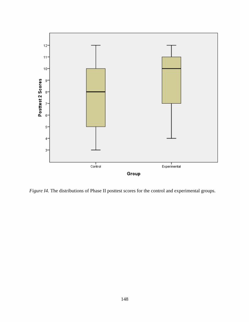
148
Figure I4. The distributions of Phase II posttest scores for the control and experimental groups.