INSPIRE standards as a framework for artificial ...
29
Nat. Hazards Earth Syst. Sci., 20, 3455–3483, 2020 https://doi.org/10.5194/nhess-20-3455-2020 © Author(s) 2020. This work is distributed under the Creative Commons Attribution 4.0 License. INSPIRE standards as a framework for artificial intelligence applications: a landslide example Gioachino Roberti 1 , Jacob McGregor, Sharon Lam, David Bigelow, Blake Boyko, Chris Ahern, Victoria Wang, Bryan Barnhart, Clinton Smyth, David Poole 1,2 , and Stephen Richard 1 1 Minerva Intelligence Inc., 301–850 West Hastings Street, Vancouver, British Columbia, Canada V6C 1E1 2 Computer Science department, University of British Columbia, Vancouver, British Columbia, Canada V6T 1Z4 Correspondence: Gioachino Roberti ([email protected]) Received: 22 April 2020 – Discussion started: 27 May 2020 Revised: 17 July 2020 – Accepted: 16 September 2020 – Published: 16 December 2020 Abstract. This study presents a landslide susceptibility map using an artificial intelligence (AI) approach based on stan- dards set by the INSPIRE (Infrastructure for Spatial Infor- mation in the European Community) framework. INSPIRE is a European Union spatial data infrastructure (SDI) ini- tiative to standardize spatial data across borders to ensure interoperability for management of cross-border infrastruc- ture and environmental issues. However, despite the theo- retical effectiveness of the SDI, few real-world applications make use of INSPIRE standards. In this study, we show how INSPIRE standards enhance the interoperability of geospa- tial data and enable deeper knowledge development for their interpretation and explainability in AI applications. We de- signed an ontology of landslides, embedded with INSPIRE vocabularies, and then aligned geology, stream network, and land cover datasets covering the Veneto region of Italy to the standards. INSPIRE was formally extended to include an ex- tensive landslide type code list, a landslide size code list, and the concept of landslide susceptibility to describe map appli- cation inputs and outputs. Using the terms in the ontology, we defined conceptual scientific models of areas likely to generate different types of landslides as well as map poly- gons representing the land surface. Both landslide models and map polygons were encoded as semantic networks and, by qualitative probabilistic comparison between the two, a similarity score was assigned. The score was then used as a proxy for landslide susceptibility and displayed in a web map application. The use of INSPIRE-standardized vocabu- laries in ontologies that express scientific models promotes the adoption of the standards across the European Union and globally. Further, this application facilitates the explanation of the generated results. We conclude that public and private organizations, within and outside the European Union, can enhance the value of their data by making them INSPIRE- compliant for use in AI applications. 1 Introduction 1.1 INSPIRE Data accessibility and interoperability are key for multina- tional cross-border applications and fundamental for eco- nomic development (European Parliament and the Council, 2007). Different countries have different languages and data standards, hindering infrastructure planning, disaster risk re- duction initiatives, and effective legislative implementation. To overcome these challenges, the European Union initiated INSPIRE (Infrastructure for Spatial Information in the Eu- ropean Community; Directive 2007/2/EC; European Parlia- ment and the Council, 2007). INSPIRE is structured in 34 spatial data themes organized in three annexes. The themes span administrative (e.g. street addresses) and environmen- tal domains (e.g. geology), and all EU countries are man- dated by law to have implemented the data framework by 2021 (European Parliament and the Council, 2014). Each theme defines a data model and has adopted a set of vo- cabularies to populate interoperable datasets based on that data model. EU countries are aligning and serving INSPIRE data at a slow pace, and currently relatively few INSPIRE- compliant datasets are available across Europe (Cho and Crompvoets, 2019). Conferences and competitions are cur- Published by Copernicus Publications on behalf of the European Geosciences Union.
Transcript of INSPIRE standards as a framework for artificial ...

Nat. Hazards Earth Syst. Sci., 20, 3455–3483, 2020https://doi.org/10.5194/nhess-20-3455-2020© Author(s) 2020. This work is distributed underthe Creative Commons Attribution 4.0 License.
INSPIRE standards as a framework for artificial intelligenceapplications: a landslide exampleGioachino Roberti1, Jacob McGregor, Sharon Lam, David Bigelow, Blake Boyko, Chris Ahern, Victoria Wang,Bryan Barnhart, Clinton Smyth, David Poole1,2, and Stephen Richard1
1Minerva Intelligence Inc., 301–850 West Hastings Street, Vancouver, British Columbia, Canada V6C 1E12Computer Science department, University of British Columbia, Vancouver, British Columbia, Canada V6T 1Z4
Correspondence: Gioachino Roberti ([email protected])
Received: 22 April 2020 – Discussion started: 27 May 2020Revised: 17 July 2020 – Accepted: 16 September 2020 – Published: 16 December 2020
Abstract. This study presents a landslide susceptibility mapusing an artificial intelligence (AI) approach based on stan-dards set by the INSPIRE (Infrastructure for Spatial Infor-mation in the European Community) framework. INSPIREis a European Union spatial data infrastructure (SDI) ini-tiative to standardize spatial data across borders to ensureinteroperability for management of cross-border infrastruc-ture and environmental issues. However, despite the theo-retical effectiveness of the SDI, few real-world applicationsmake use of INSPIRE standards. In this study, we show howINSPIRE standards enhance the interoperability of geospa-tial data and enable deeper knowledge development for theirinterpretation and explainability in AI applications. We de-signed an ontology of landslides, embedded with INSPIREvocabularies, and then aligned geology, stream network, andland cover datasets covering the Veneto region of Italy to thestandards. INSPIRE was formally extended to include an ex-tensive landslide type code list, a landslide size code list, andthe concept of landslide susceptibility to describe map appli-cation inputs and outputs. Using the terms in the ontology,we defined conceptual scientific models of areas likely togenerate different types of landslides as well as map poly-gons representing the land surface. Both landslide modelsand map polygons were encoded as semantic networks and,by qualitative probabilistic comparison between the two, asimilarity score was assigned. The score was then used asa proxy for landslide susceptibility and displayed in a webmap application. The use of INSPIRE-standardized vocabu-laries in ontologies that express scientific models promotesthe adoption of the standards across the European Union andglobally. Further, this application facilitates the explanation
of the generated results. We conclude that public and privateorganizations, within and outside the European Union, canenhance the value of their data by making them INSPIRE-compliant for use in AI applications.
1 Introduction
1.1 INSPIRE
Data accessibility and interoperability are key for multina-tional cross-border applications and fundamental for eco-nomic development (European Parliament and the Council,2007). Different countries have different languages and datastandards, hindering infrastructure planning, disaster risk re-duction initiatives, and effective legislative implementation.To overcome these challenges, the European Union initiatedINSPIRE (Infrastructure for Spatial Information in the Eu-ropean Community; Directive 2007/2/EC; European Parlia-ment and the Council, 2007). INSPIRE is structured in 34spatial data themes organized in three annexes. The themesspan administrative (e.g. street addresses) and environmen-tal domains (e.g. geology), and all EU countries are man-dated by law to have implemented the data framework by2021 (European Parliament and the Council, 2014). Eachtheme defines a data model and has adopted a set of vo-cabularies to populate interoperable datasets based on thatdata model. EU countries are aligning and serving INSPIREdata at a slow pace, and currently relatively few INSPIRE-compliant datasets are available across Europe (Cho andCrompvoets, 2019). Conferences and competitions are cur-
Published by Copernicus Publications on behalf of the European Geosciences Union.

3456 G. Roberti et al.: INSPIRE standards as a framework for artificial intelligence applications
rently being organized to promote its implementation andto show the potential impact of real-world applications builton INSPIRE datasets (European Commission, 2019). Thisproject was first presented at one of these conferences, theInspire Helsinki 2019 data challenge under the “Let’s makethe most out of INSPIRE!” topic, where the project won firstprize.
1.2 Artificial intelligence
Artificial intelligence (AI) studies “the synthesis and anal-ysis of computational agents that act intelligently” (Pooleand Mackworth, 2017). Part of acting intelligently is build-ing models of the world that make predictions. Probabilisticpredictions are the most useful ones for subsequent decisionmaking and can be learned from data (Pearl, 1988). All mod-els are based on human knowledge and data (observationsof the world). For some problem domains, society has col-lected an overwhelming number of data, and still, useful hu-man knowledge of the domain can be very vague. Machinelearning has made great progress recently for such cases, par-ticularly with deep learning (Goodfellow et al., 2016). How-ever, for domains with relatively limited data but that arestill very large in volume, human knowledge (which maybe represented in computers through the use of ontologies)can complement the data to make useful predictions (Pearl,1988). Many environmental problems do not have enoughdata (e.g. lack of extensive landslide databases) to be solvedby deep learning but do have enough data to generate usefulproducts when combined with human expertise (expressed inontologies; Poole and Mackworth, 2017). The term artificialintelligence is commonly used to indicate only the machinelearning part of the field, especially in the landslide litera-ture (e.g. Dieu and Gjermundsen, 2020). In this paper we usethe term “AI” in its broader connotation, which also includesthe ontological method used in this paper. See below for thedescription of the method and definition of ontologies.
1.3 The need for standards, ontologies, and taxonomies
Consistent, well-defined vocabularies and data standards areessential in computer science applications, especially in AI.For data to have meaning and to combine multiple datasets,vocabularies must be consistent and clearly defined. Deeplearning techniques require meanings for the inputs and theoutputs, but the internal representations do not have well-defined meanings, making the models very opaque (Marcus,2018). Other representations, such as logical and probabilis-tic representations, support internal reasoning using symbolswith well-defined meanings, which lend themselves to use inexplanations (Marcus and Davis, 2019).
Ontologies are “a specification of the meanings of thesymbols in an information system” (Poole and Mackworth,2017). In particular, an ontology defines the vocabulary forindividuals and relationships within a knowledge domain.
Individuals may be concrete entities (e.g. a rock) or ab-stract concepts (e.g. numbers); relationships are propertiesthat describe how individuals are connected. Typical exam-ples of relationships include “is-a-kind-of”, “is-part-of”, “is-superclass-of”, “has-some-property”; the ontology also de-fines axioms controlling the use of the vocabulary for logi-cal and thematic consistency (Poole and Mackworth, 2017).Given these axioms, the vocabulary can be unambiguouslyinterpreted according to the rules of symbolic logic, and im-plicit relationships between entities or instances of those en-tities can be inferred.
Vocabularies can be Aristotelian taxonomies, which arelogically consistent and multi-hierarchical. Aristotelian tax-onomies are constructed by defining concepts from theirrelation to a more general parent concept (genus) and us-ing differentiating properties (differentia) to distinguish con-cepts within the same genus (Aristotle, 350 BC). For ex-ample, “slides in soil” and “slides in rock” share the sameparent concept “slides”, and they are differentiated by theproperty dealing with the material type, “soil” and “rock”,which make them uniquely identifiable. Taxonomies basedon Aristotelian definitions support multi-hierarchical knowl-edge networks and can be used by computers to make logicalinferences (Poole et al., 2009; Smith, 2003). The term “multi-hierarchical” implies that there is more than one way to movethrough a taxonomy to arrive at a particular node or term. Forexample, the landslide taxonomy can be arranged based ondifferent properties. If the landslide types are firstly arrangedbased on the type of movement and then based on the typeof material, one path within the taxonomy would be land-slide > slides > slides in rock and slides in soil. Alternatively,if the landslide types are arranged first based on the materialtype and then on the movement type, the path of the taxon-omy would be landslide > landslides in rock > slides in rockand flows in rock. Both paths are valid, but they reach thesame concept in different ways. The natural hazard classifica-tion code list extension for landslides presented in this paperwas prepared using the open-access Aristotelian Class Ed-itor (ACE) software (Minerva Intelligence, 2019d). Knowl-edge stored in a domain-specific ontology (e.g. geohazards)can be accessed by computers, allowing for data investiga-tion through various AI techniques, including probabilisticmatching between semantic networks, the technique used inthis study.
Significant progress has been made in the development oftaxonomies for geoscience information interchange by theInternational Union of Geological Sciences (IUGS ) Com-mission for the Management and Application of GeoscienceInformation (CGI) Geoscience Terminology Working Group,which produced the GeoSciML standard along with the OpenGeospatial Consortium (OGC; CGI, 2003). However, ontol-ogy applications in earth sciences are scarce. Notable excep-tions are in economic geology (Smyth et al., 2007), geohaz-ards (Jackson Jr et al., 2008), and disaster risk reduction do-mains (Phengsuwan et al., 2019; Sermet and Demir, 2019).
Nat. Hazards Earth Syst. Sci., 20, 3455–3483, 2020 https://doi.org/10.5194/nhess-20-3455-2020

G. Roberti et al.: INSPIRE standards as a framework for artificial intelligence applications 3457
The INSPIRE framework, through its standardized vocab-ularies (code lists), provides a necessary foundation uponwhich AI applications with explainable output can be con-structed. INSPIRE application examples in landslide studiesinclude the LAND-deFeND Italian landslide database struc-ture (Napolitano et al., 2018) and a deep learning algorithmto map landslide susceptibility (Hajimoradlou et al., 2020).In the implementation of deep learning by Hajimoradlouet al. (2020), training features were labelled with INSPIRE-compliant semantics to enable reproducibility of the experi-ment by other researchers.
In this study, we present an AI-based landslide susceptibil-ity application using a natural hazard ontology. We do so bybuilding from the ontology created by Jackson Jr et al. (2008)and by embedding INSPIRE code lists wherever possible aswell as aligning input and output data to the INSPIRE datastandards.
1.4 Landslide susceptibility and hazard
Landslide susceptibility is defined as the relative spatialprobability of occurrence for a landslide based on the intrin-sic properties of a site (SafeLand, 2011). The concept of sus-ceptibility differs from hazard in that the temporal probabil-ity of occurrence, the triggering factors, and the magnitudeof the event are not considered in the definition of a suscepti-bility map (SafeLand, 2011; Van Den Eeckhaut and Hervás,2012). To produce landslide susceptibility maps, three ap-proaches are usually applied: statistical, physical, and expert-based (SafeLand, 2011). Statistical methods rely on the anal-ysis of landslide databases and their relation to landscapeproperties (see review by Reichenbach et al., 2018), physi-cal methods calculate the limit equilibrium between failure-resisting and failure-driving forces in slopes (e.g. Baum et al.,2008), and expert-based methods rely on expert opinion andthe assumption that influencing factors are known and arespecified in the models (Dai et al., 2002). The AI approachused in this study is an example of the expert-based approachas the models follow rules that represent the reasoning pro-cess of a landslide expert, providing semi-quantitative sus-ceptibility maps.
2 Methods
Figure 1 outlines the methodological workflow followed inthis study to produce explainable landslide susceptibility as-sessments in the Veneto region of Italy. We extended IN-SPIRE (Sect. 2.1); we constructed an ontology (Sect. 2.2);and we defined expert models (Sect. 2.2.1) and instances,represented by mapping polygons (Sect. 2.2.2). We thencompared the similarity of models and instances to producea matching score, which is used as a susceptibility indicator(Sect. 2.2.3). Finally, the results are delivered in an interac-tive web map (Sect. 2.2.4).
Figure 1. The workflow followed in this study and correspondingmethod sections. We extended INSPIRE, defined an ontology, ex-pert models and mapping instances. We compared models and in-stances to deliver a susceptibility map which is available online.
2.1 INSPIRE extension
Technical guideline documents outline the data structure foreach theme within the INSPIRE directive, its encoding rules,its metadata standards, and some of its use cases. Data struc-tures are formally represented using Unified Modeling Lan-guage (UML), modelling thematic entities as feature types,defining properties for each feature type, and characterizingrelationships between feature types. Where applicable, stan-dardized vocabularies are adopted for property value ranges.INSPIRE themes can be understood as an ontology (SeeSect. 2.2 below) by defining various entities and the relation-ships between them.
INSPIRE data models are implemented as Ge-ography Markup Language (GML) applicationschemas (https://inspire.ec.europa.eu/XML-Schemas/Data-Specifications/2892, last access: 26 October 2020) andserialized using Extensible Markup Language (XML). Thisenables data distribution provided as Open Geospatial Con-sortium (OGC)-compliant web services. Geospatial featuresare located using vector-based spatial data. Feature prop-erties have value types (e.g. geometry for vector datasets);properties whose value ranges are controlled vocabularieshave values implemented as code lists. Code lists incorporatevocabularies developed outside of INSPIRE (e.g. IUGS CGIrock type taxonomy). Some code lists within INSPIRE arenot extensible, some are extensible with narrower values,and some allow additional values at any level. Code listvalues, definitions, and hierarchical structures are stored inthe INSPIRE registry (https://inspire.ec.europa.eu/codelist,last access: 26 October 2020), making them accessible
https://doi.org/10.5194/nhess-20-3455-2020 Nat. Hazards Earth Syst. Sci., 20, 3455–3483, 2020

3458 G. Roberti et al.: INSPIRE standards as a framework for artificial intelligence applications
to and reusable by anyone. INSPIRE schemas can alsobe extended to include additional concepts and/or featuretypes. For this project, we worked with four INSPIREthemes: Geology, Land Cover, Hydrography, and NaturalRisk Zones. The Natural Risk Zone application schemawas not fully adequate for this application as it lackedthe “landslide susceptibility” concept and “landslide type”code lists (Tomas et al., 2015). We addressed this issue byformally extending the Natural Risk Zone schema and thenatural hazard code list.
2.2 Ontologically grounded probabilistic matching
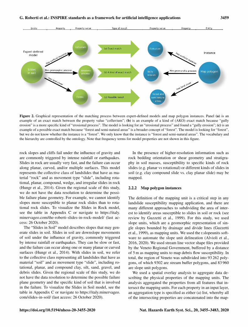
The method used to produce INSPIRE-based landslide sus-ceptibility maps, uses qualitative probabilistic reasoning thatincorporates expert knowledge, making qualitative predic-tions based on comparisons between models and instances(e.g. Sharma et al., 2010; Smyth et al., 2007; Poole andSmyth, 2005; Smyth and Poole, 2004). A model is a set ofrules defined a priori by an expert, based on the scientific lit-erature, making use of the entities and properties defined inthe ontology. These models aim to represent expert concep-tualized descriptions of a given phenomenon or entity (e.g.landslide susceptibility). The properties used in a model de-scription are concepts stored in the ontology, along with fre-quency terms (e.g. soil slide – has slope – moderately steep– always). Frequency terms used in this study are “always”,“usually”, “sometimes”, “rarely”, and “never”. These termswere chosen as they express experience-based judgementsthat geoscience practitioners may use in field assessments.The term “never” allows the system to explicitly deal withnegation (e.g. soil slide – has surficial material – bedrock –never). The properties and the frequency terms are encodedin semantic triple format (W3C Working Group, 2014), andthe resulting model is a semantic network. Semantic net-works are a graph representation of knowledge, where nodesare concepts, and edges are the semantic relation betweenconcepts (Shapiro, 1992); see Fig. 2 for example. Real-worldareas on the ground (map units – more generally referred toas “instances”) are also described by semantic networks us-ing the same properties stored in the ontology, but triples areaccompanied by Boolean qualifiers to represent presence orabsence of a specific property (e.g. polygon – has slope –steep – present). Comparisons, referred to as matches, be-tween instances and models are possible because models andinstances all use the same structured terminology, as con-trolled by the ontology.
Similarity scores are awarded based on the type of matchbetween instance and model properties, the semantic dis-tance in the taxonomy of compared property values, and themodel property frequency term (Fig. 2). Match types include“exact”, “a kind of (AKO) exact”, and “possible”. An ex-act match indicates that the property value term used in themodel is present in the instance (in Fig. 2a), in which casea full score is awarded for this component of the compared
semantic networks. An AKO exact match indicates that theproperty value term found in the instance is a kind of theproperty value term found in the model (in Fig. 2b), in whichcase a full score is also awarded. A “possible” match occurswhen the property value term in the instance is broader thanthe property value term in the model, based on the definedtaxonomies, in which case the score is divided by the seman-tic distance between the two terms. For example, “forest” isa more specific type of “forest and semi-natural areas” (inFig. 2c) and results in the score being divided by 2. The scoreis lower because the instance is only possibly the kind ofvalue that the model is looking for.
In this study, an exact match or an AKO exact matchof a property with frequency “always” scores 10 000, “usu-ally” scores 9000, “sometimes” scores 1000, “rarely” scores“100”, and “never” scores −10000; unmatched attributes areawarded −10 points. These scores are an arbitrary represen-tation of the degree of surprise that uses order-of-magnitudenumbers to distinguish qualitative measures. For an extensivereview of the probabilistic comparison method, see Smythand Poole (2004), Poole and Smyth (2005), Smyth et al.(2007), and Sharma et al. (2010). This approach has been ap-plied in economic geology to generate mineral deposit explo-ration targets (Smyth et al., 2007) and in geohazard mappingto produce landslide susceptibility maps (Jackson Jr et al.,2008).
2.2.1 Landslide models
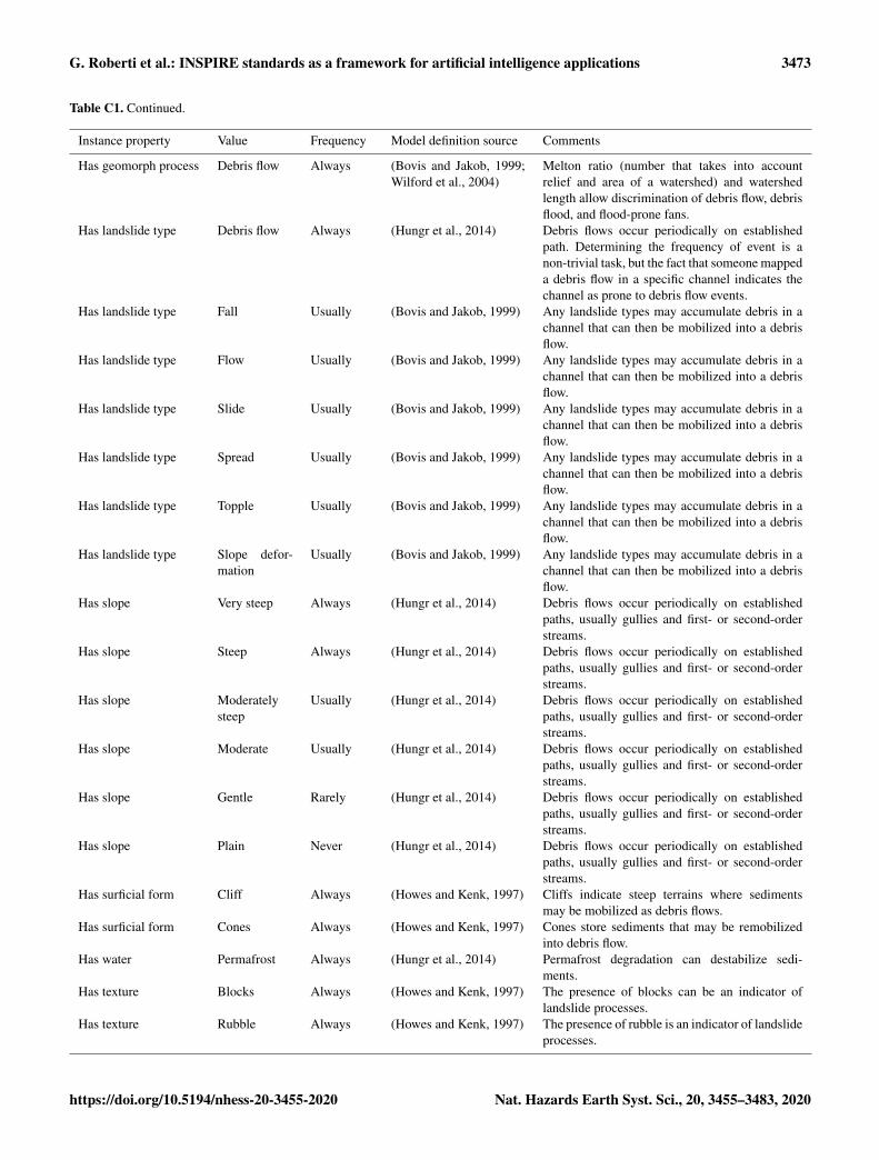
This paper presents an AI expert-based landslide susceptibil-ity map for three different landslide types: debris flows, slidesin soil, and slides in rock for the Veneto region of Italy. Thesethree landslide types are conceptualizations of landslidemodels defined using knowledge recorded in the scientificliterature. These landslide models are intended to be proofof concept of models that can be used in the semantic ap-proach proposed in this paper. In particular, some of the prop-erties used in the models are drafted from literature analysisof logging-related landslides in British Columbia, Canada(Jackson Jr, 2019). Here we briefly summarize the mod-els; detailed explanations of each property–value–frequencycombination are provided in Appendix C.
The “Debris Flow” model describes the channels that maygenerate a debris flow. Debris flows are flow-like landslidesgenerated when saturated sediments move down a steepchannel. They can be originated when a slide in soil inter-sects a flowing body of water or when saturated bed sedi-ments are mobilized and begin flowing downstream. Debrisflows are usually triggered by intense and persistent rainfall(Hungr et al., 2014). To visualize the Debris Flow model,see the table in Appendix C or navigate to https://italy.minervageo.com/debris-flow-model/ (last access: 26 Octo-ber 2020).
The “Slides in Rock” model describes slopes that maygenerate slides in rock. Slides in rock form when steep
Nat. Hazards Earth Syst. Sci., 20, 3455–3483, 2020 https://doi.org/10.5194/nhess-20-3455-2020
G. Roberti et al.: INSPIRE standards as a framework for artificial intelligence applications 3459
Figure 2. Graphical representation of the matching process between expert-defined models and map polygon instances. Panel (a) is anexample of an exact match between the property value “colluvium”; (b) is an example of a kind of (AKO) exact match because “gullyerosion” is a more specific kind of “erosional process”. The model is looking for an “erosional process” and found a “gully erosion”; (c) is anexample of a possible exact match because “forest and semi-natural areas” is a broader concept of “forest”. The model is looking for “forest”,but we do not know whether the instance is a “forest”. We only know that the instance is “forest and semi-natural areas”. The vocabulary andthe hierarchy are controlled by the ontology. Note that frequency terms for model properties are not shown in this figure.
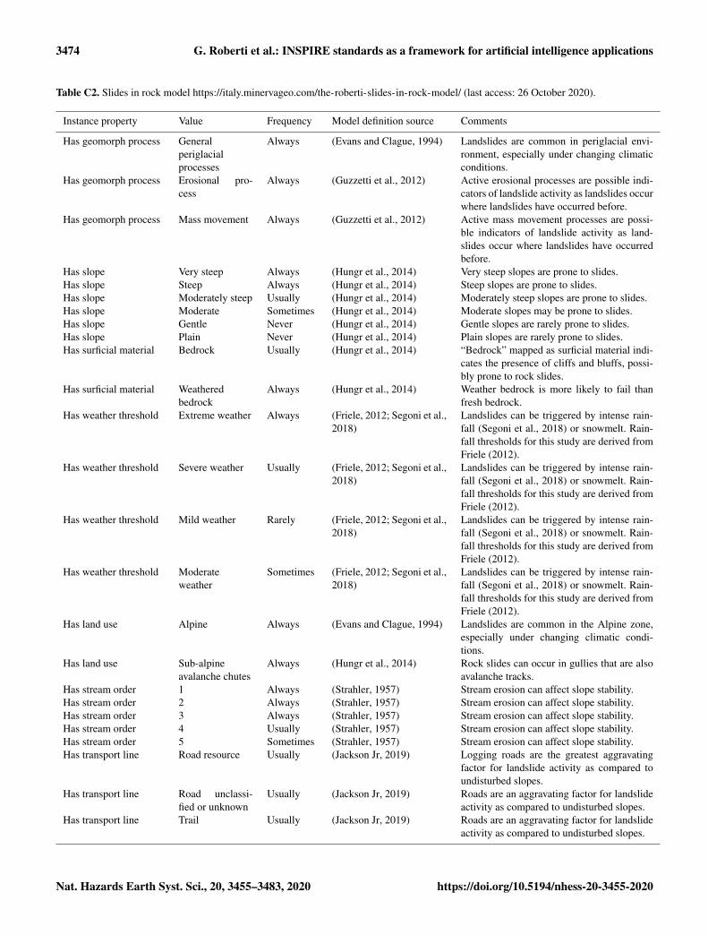
rock slopes and cliffs fail under the influence of gravity andare commonly triggered by intense rainfall or earthquakes.Slides in rock are usually very fast, and the failure can occuralong planar, curved, and/or multiple surfaces. This modelrepresents the collective class of landslides that have as ma-terial “rock” and as movement type “slide”, including rota-tional, planar, compound, wedge, and irregular slides in rock(Hungr et al., 2014). Given the regional scale of this study,we do not have the data resolution to determine the possi-ble failure plane geometry. For example, we cannot identifyslopes more susceptible to planar rock slides than to rota-tional rock slides. To visualize the Slides in Rock model,see the table in Appendix C or navigate to https://italy.minervageo.com/the-roberti-slides-in-rock-model/ (last ac-cess: 26 October 2020).
The “Slides in Soil” model describes slopes that may gen-erate slides in soil. Slides in soil are downslope movementsof soil under the influence of gravity, commonly triggeredby intense rainfall or earthquakes. They can be slow or fast,and the failure can occur along one or many planar or curvedsurfaces (Hungr et al., 2014). With slides in soil, we referto the collective class representing all landslides that have asmaterial “soil” and as movement type “slide”, including ro-tational, planar, and compound clay, silt, sand, gravel, anddebris slides. Given the regional scale of this study, we donot have the data resolution to determine the possible failureplane geometry and the specific kind of soil that is involvedin the failure. To visualize the Slides in Soil model, see thetable in Appendix C or navigate to https://italy.minervageo.com/slides-in-soil/ (last access: 26 October 2020).
In the presence of higher-resolution information such asrock bedding orientation or shear geometry and stratigra-phy in soil masses, susceptibility to specific kinds of rockslides (e.g. planar vs rotational) or different kinds of slides insoil (e.g. clay compound slide vs. clay planar slide) may bemapped.
2.2.2 Map polygon instances
The definition of the mapping unit is a critical step in anylandslide susceptibility mapping application, and there aremany different approaches to subdividing the area of inter-est to identify areas susceptible to slides in soil or rock (seereview by Guzzetti et al., 1999). For this study, we usedslope units, which are a geomorphic representation of sin-gle slopes bounded by drainage and divide lines (Guzzettiet al., 1999), as mapping units. We used the r.slopeunits soft-ware to automate the slope unit delineation (Alvioli et al.,2016, 2020). We used stream line vector shape files providedby the Veneto Regional Government, buffered by a distanceof 5 m as mapping units to map debris flow susceptibility. Intotal, the region of Veneto was subdivided into 93 262 poly-gons, of which 9302 are stream buffer polygons, and 83 960are slope unit polygons.
We used a spatial overlay analysis to aggregate data de-scribing the physical properties of the mapping units. Theanalysis aggregated the properties from all features that in-tersect the mapping units. For each property in an input layer,an aggregation type is specified as either (a) list, whereby allof the intersecting properties are concatenated into the map-
https://doi.org/10.5194/nhess-20-3455-2020 Nat. Hazards Earth Syst. Sci., 20, 3455–3483, 2020
3460 G. Roberti et al.: INSPIRE standards as a framework for artificial intelligence applications
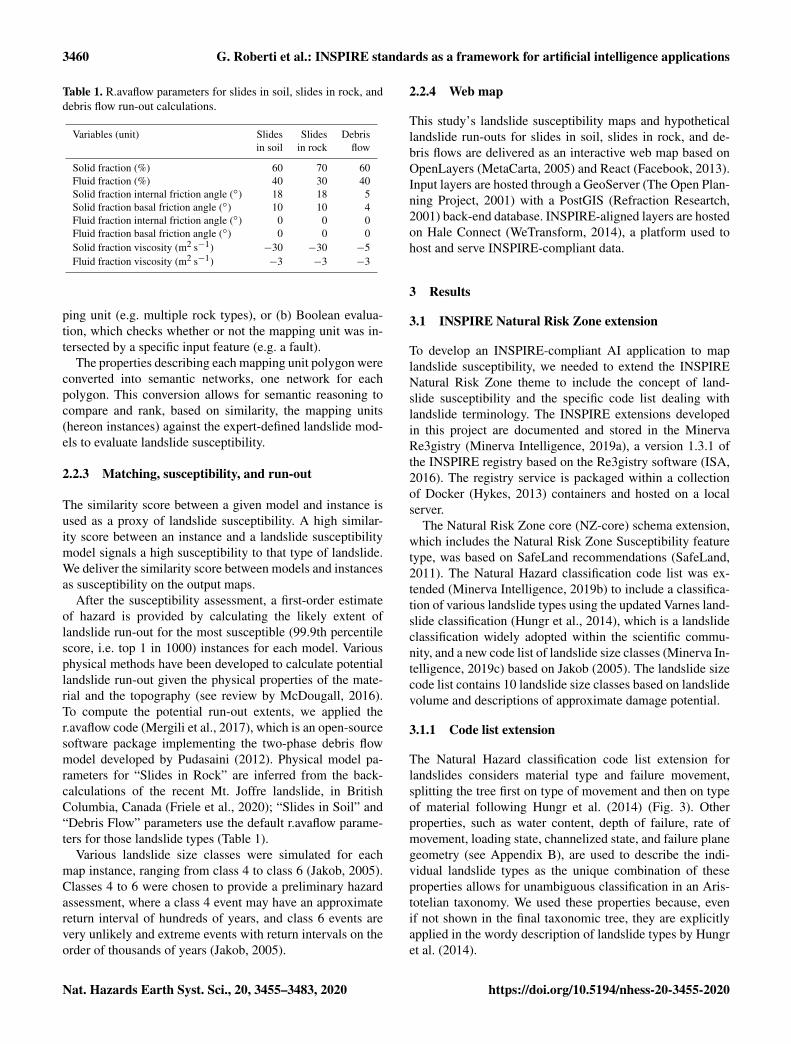
Table 1. R.avaflow parameters for slides in soil, slides in rock, anddebris flow run-out calculations.
Variables (unit) Slides Slides Debrisin soil in rock flow
Solid fraction (%) 60 70 60Fluid fraction (%) 40 30 40Solid fraction internal friction angle (◦) 18 18 5Solid fraction basal friction angle (◦) 10 10 4Fluid fraction internal friction angle (◦) 0 0 0Fluid fraction basal friction angle (◦) 0 0 0Solid fraction viscosity (m2 s−1) −30 −30 −5Fluid fraction viscosity (m2 s−1) −3 −3 −3
ping unit (e.g. multiple rock types), or (b) Boolean evalua-tion, which checks whether or not the mapping unit was in-tersected by a specific input feature (e.g. a fault).
The properties describing each mapping unit polygon wereconverted into semantic networks, one network for eachpolygon. This conversion allows for semantic reasoning tocompare and rank, based on similarity, the mapping units(hereon instances) against the expert-defined landslide mod-els to evaluate landslide susceptibility.
2.2.3 Matching, susceptibility, and run-out
The similarity score between a given model and instance isused as a proxy of landslide susceptibility. A high similar-ity score between an instance and a landslide susceptibilitymodel signals a high susceptibility to that type of landslide.We deliver the similarity score between models and instancesas susceptibility on the output maps.
After the susceptibility assessment, a first-order estimateof hazard is provided by calculating the likely extent oflandslide run-out for the most susceptible (99.9th percentilescore, i.e. top 1 in 1000) instances for each model. Variousphysical methods have been developed to calculate potentiallandslide run-out given the physical properties of the mate-rial and the topography (see review by McDougall, 2016).To compute the potential run-out extents, we applied ther.avaflow code (Mergili et al., 2017), which is an open-sourcesoftware package implementing the two-phase debris flowmodel developed by Pudasaini (2012). Physical model pa-rameters for “Slides in Rock” are inferred from the back-calculations of the recent Mt. Joffre landslide, in BritishColumbia, Canada (Friele et al., 2020); “Slides in Soil” and“Debris Flow” parameters use the default r.avaflow parame-ters for those landslide types (Table 1).
Various landslide size classes were simulated for eachmap instance, ranging from class 4 to class 6 (Jakob, 2005).Classes 4 to 6 were chosen to provide a preliminary hazardassessment, where a class 4 event may have an approximatereturn interval of hundreds of years, and class 6 events arevery unlikely and extreme events with return intervals on theorder of thousands of years (Jakob, 2005).
2.2.4 Web map
This study’s landslide susceptibility maps and hypotheticallandslide run-outs for slides in soil, slides in rock, and de-bris flows are delivered as an interactive web map based onOpenLayers (MetaCarta, 2005) and React (Facebook, 2013).Input layers are hosted through a GeoServer (The Open Plan-ning Project, 2001) with a PostGIS (Refraction Researtch,2001) back-end database. INSPIRE-aligned layers are hostedon Hale Connect (WeTransform, 2014), a platform used tohost and serve INSPIRE-compliant data.
3 Results
3.1 INSPIRE Natural Risk Zone extension
To develop an INSPIRE-compliant AI application to maplandslide susceptibility, we needed to extend the INSPIRENatural Risk Zone theme to include the concept of land-slide susceptibility and the specific code list dealing withlandslide terminology. The INSPIRE extensions developedin this project are documented and stored in the MinervaRe3gistry (Minerva Intelligence, 2019a), a version 1.3.1 ofthe INSPIRE registry based on the Re3gistry software (ISA,2016). The registry service is packaged within a collectionof Docker (Hykes, 2013) containers and hosted on a localserver.
The Natural Risk Zone core (NZ-core) schema extension,which includes the Natural Risk Zone Susceptibility featuretype, was based on SafeLand recommendations (SafeLand,2011). The Natural Hazard classification code list was ex-tended (Minerva Intelligence, 2019b) to include a classifica-tion of various landslide types using the updated Varnes land-slide classification (Hungr et al., 2014), which is a landslideclassification widely adopted within the scientific commu-nity, and a new code list of landslide size classes (Minerva In-telligence, 2019c) based on Jakob (2005). The landslide sizecode list contains 10 landslide size classes based on landslidevolume and descriptions of approximate damage potential.
3.1.1 Code list extension
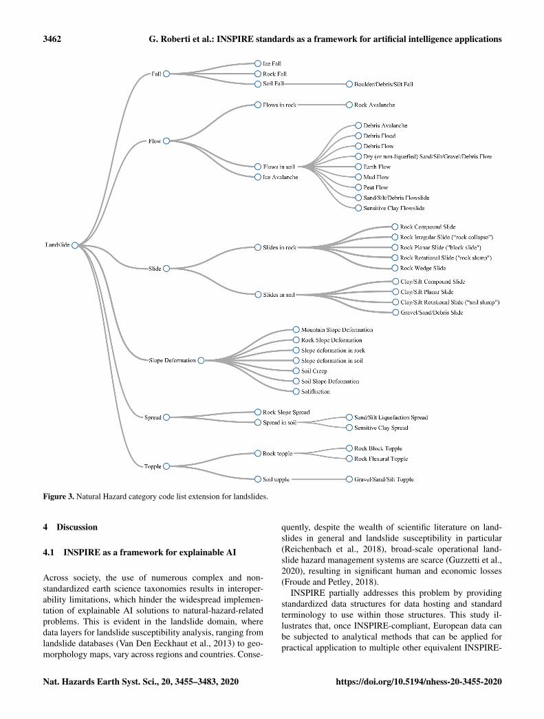
The Natural Hazard classification code list extension forlandslides considers material type and failure movement,splitting the tree first on type of movement and then on typeof material following Hungr et al. (2014) (Fig. 3). Otherproperties, such as water content, depth of failure, rate ofmovement, loading state, channelized state, and failure planegeometry (see Appendix B), are used to describe the indi-vidual landslide types as the unique combination of theseproperties allows for unambiguous classification in an Aris-totelian taxonomy. We used these properties because, evenif not shown in the final taxonomic tree, they are explicitlyapplied in the wordy description of landslide types by Hungret al. (2014).
Nat. Hazards Earth Syst. Sci., 20, 3455–3483, 2020 https://doi.org/10.5194/nhess-20-3455-2020

G. Roberti et al.: INSPIRE standards as a framework for artificial intelligence applications 3461
The formal extension registration process via the INSPIREregistry software does not enable the representation of suchmulti-hierarchical classifications. Because of this we had towork with a single tree hierarchy and consequently chose tofirst divide the classes based on type of failure followed by adivision based on the type of movement (Fig. 3).
3.1.2 Schema extension: susceptibility
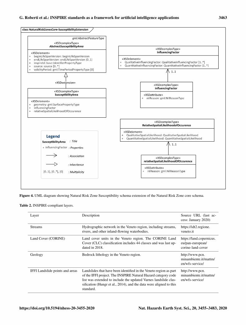
The INSPIRE Natural Risk Zone schema includes hazardand risk feature types, but the concept of susceptibility asa feature type is missing. To overcome this problem, we ex-tended the INSPIRE Natural Risk Zone core XML schema,adding a Natural Risk Zone Susceptibility schema (MinervaIntelligence, 2019e). The Natural Risk Zone Susceptibilityschema includes abstract susceptibility area and susceptibil-ity area feature types (Fig. 4). The susceptibility area featuretype is modelled following the structure of the hazard areaand risk zone feature types in the INSPIRE Natural RiskZone core schema. Susceptibility area has three elements:Geometry, Influencing Factor, and Relative Spatial Likeli-hood of Occurrence (Fig. 4). Geometry, as with all INSPIREvector datasets, is the geometric representation of the ex-tent of the feature on the earth’s surface as a spatial feature.Influencing Factors are defined as the intrinsic, preparatoryvariables which make an area susceptible to a hazard (Safe-Land, 2011). Influencing Factors are unbounded in multiplic-ity (i.e. can be as many as needed) and can be defined quali-tatively or quantitatively. Qualitative Influencing Factors areexpressed as a string, while quantitative Influencing Factorsare expressed as GML:MeasureType (Fig. 4). Whether de-fined quantitatively or qualitatively, the Influencing Factorcan also define a DataSetType attribute, such as slope or airquality. Influencing Factors are used in the calculation of Rel-ative Spatial Likelihood of Occurrence, which is an elementthat can be quantitatively or qualitatively defined (Fig. 4).The Relative Spatial Likelihood of Occurrence refers to val-ues that represent the spatial probability of occurrence of aspecific hazard type given the influencing factors present inthe area (SafeLand, 2011). The Influencing Factor elementallows end users of susceptibility area datasets to understandwhich known conditions of the specific area led to the resul-tant susceptibility.
3.2 Landslide susceptibility mapping in Veneto
3.2.1 Input data
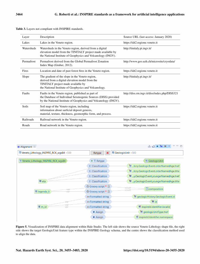
For this study, we used open-access datasets from the VenetoRegion Geoportal and other sources (Table 2 and 3). Align-ing all input datasets was beyond the scope of this project. Wedid, however, want to show the value of INSPIRE-aligneddata and therefore aligned stream network, CORINE LandCover, bedrock geology, and the Italian Landslide Inventory(IFFI; Table 2) to INSPIRE using Hale Studio (WeTrans-
form, 2008). Figure 5 shows how different tools in Hale Stu-dio are used to align properties from the source dataset to thetarget dataset. For example, the field “eta” – “age” in Italian– of the original Veneto dataset was directly mapped to fourdifferent INSPIRE fields: the olderNamedAge.href and titleand the youngerNamedAge.href and title. Note that older-NamedAge.href and youngerNamedAge.href are hyperlinksto the code list value ID, and the title is the actual codelist term from the GeochronologicEraValue code list. Thisalignment is done with many classification methods, includ-ing Groovy scripts, formatted strings, and assign-alignmenttools. For further explanation on term alignments, refer tothe documentation of Hale Studio (WeTransform, 2008).Datasets used that were not compliant with INSPIRE includelakes, watersheds, permafrost, fire, slope angle, faults, soil,roads, and railways (Table 3).
3.2.2 Web map
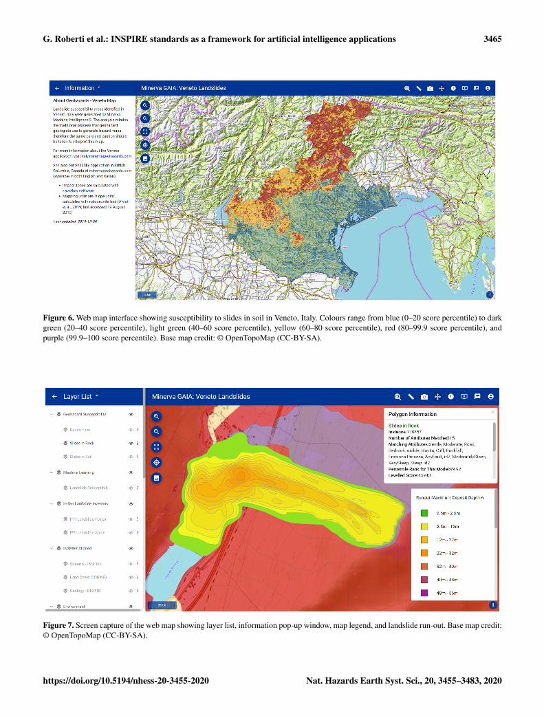
The 83 960 slope units and 9302 stream buffer instances(Fig. 6) were encoded with the available data, then trans-formed from vector files into semantic network format.Then, each polygon was matched against the expert-basedSlides in Soil, Slides in Rock, and Debris Flow models andcolour-coded according to matching-score percentile to por-tray landslide susceptibility (Fig. 6). The left-side panel ofthe web map shows the landslide model layers, the refer-ence layers, and different base maps (Fig. 7). By clickingon a polygon (instance), a pop-up window opens (Fig. 7):this window contains the name and hyperlink to the IN-SPIRE registry code list definition of the landslide type in-vestigated, the attributes that are present in the mapping unit(e.g. bedrock lithology, erosional process, etc.), the instancepercentile rank and total match score, the hyperlink to thecomparison of the instance against other landslide models(e.g. the Slides in Rock model), and (only for the 99.9th per-centile score, top 1 in 1000) buttons to turn on the display oflandslide run-out for different landslide classes as well as thehyperlink to the match report.
The match report is a detailed table showing the resultsfrom the model instance semantic matching, ensuring theexplainability of the results. Each line corresponds to aproperty–value–frequency term (e.g. has slope – moderatelysteep – always) comparison between the model and the in-stance, how they match (with a hyperlink to textual expla-nation on how the score was awarded), the numerical scorevalue (see Table 4 for example), a textual explanation on whythat attribute was chosen, and the original data value (Ta-ble 5). An “advice” button opening textual advice expressingwhich of the instance’s unmatched attributes may change thescore is available. This advice is a sort of data advice: it in-vites the user to check in the field or in some other databasesif, for example, a fault is present in that specific instance.
https://doi.org/10.5194/nhess-20-3455-2020 Nat. Hazards Earth Syst. Sci., 20, 3455–3483, 2020
3462 G. Roberti et al.: INSPIRE standards as a framework for artificial intelligence applications
Figure 3. Natural Hazard category code list extension for landslides.
4 Discussion
4.1 INSPIRE as a framework for explainable AI
Across society, the use of numerous complex and non-standardized earth science taxonomies results in interoper-ability limitations, which hinder the widespread implemen-tation of explainable AI solutions to natural-hazard-relatedproblems. This is evident in the landslide domain, wheredata layers for landslide susceptibility analysis, ranging fromlandslide databases (Van Den Eeckhaut et al., 2013) to geo-morphology maps, vary across regions and countries. Conse-
quently, despite the wealth of scientific literature on land-slides in general and landslide susceptibility in particular(Reichenbach et al., 2018), broad-scale operational land-slide hazard management systems are scarce (Guzzetti et al.,2020), resulting in significant human and economic losses(Froude and Petley, 2018).
INSPIRE partially addresses this problem by providingstandardized data structures for data hosting and standardterminology to use within those structures. This study il-lustrates that, once INSPIRE-compliant, European data canbe subjected to analytical methods that can be applied forpractical application to multiple other equivalent INSPIRE-
Nat. Hazards Earth Syst. Sci., 20, 3455–3483, 2020 https://doi.org/10.5194/nhess-20-3455-2020
G. Roberti et al.: INSPIRE standards as a framework for artificial intelligence applications 3463
Figure 4. UML diagram showing Natural Risk Zone Susceptibility schema extension of the Natural Risk Zone core schema.
Table 2. INSPIRE-compliant layers.
Layer Description Source URL (last ac-cess: January 2020)
Streams Hydrographic network in the Veneto region, including streams,rivers, and other inland-flowing waterbodies.
https://idt2.regione.veneto.it
Land Cover (CORINE) Land cover units in the Veneto region. The CORINE LandCover (CLC) classification includes 44 classes and was last up-dated in 2018.
https://land.copernicus.eu/pan-european/corine-land-cover
Geology Bedrock lithology in the Veneto region. http://www.pcn.minambiente.it/mattm/en/wfs-service/
IFFI Landslide points and areas Landslides that have been identified in the Veneto region as partof the IFFI project. The INSPIRE Natural Hazard category codelist was extended to include the updated Varnes landslide clas-sification (Hungr et al., 2014), and the data were aligned to thisstandard.
http://www.pcn.minambiente.it/mattm/en/wfs-service/
https://doi.org/10.5194/nhess-20-3455-2020 Nat. Hazards Earth Syst. Sci., 20, 3455–3483, 2020
3464 G. Roberti et al.: INSPIRE standards as a framework for artificial intelligence applications
Table 3. Layers not compliant with INSPIRE standards.
Layer Description Source URL (last access: January 2020)
Lakes Lakes in the Veneto region. https://idt2.regione.veneto.it
Watersheds Watersheds in the Veneto region, derived from a digital http://tinitaly.pi.ingv.it/elevation model from the TINITALY project made available bythe National Institute of Geophysics and Volcanology (INGV).
Permafrost Permafrost derived from the Global Permafrost Zonation http://www.geo.uzh.ch/microsite/cryodata/Index Map (Gruber, 2012).
Fires Location and date of past forest fires in the Veneto region. https://idt2.regione.veneto.it
Slope The gradient of the slope in the Veneto region, http://tinitaly.pi.ingv.it/derived from a digital elevation model from theTINITALY project made available bythe National Institute of Geophysics and Volcanology.
Faults Faults in the Veneto region, published as part of http://diss.rm.ingv.it/diss/index.php/DISS321the Database of Individual Seismogenic Sources (DISS) providedby the National Institute of Geophysics and Volcanology (INGV).
Soils Soil map of the Veneto region, including https://idt2.regione.veneto.itinformation about surficial deposit genesis,material, texture, thickness, geomorphic form, and process.
Railroads Railroad network in the Veneto region. https://idt2.regione.veneto.it
Roads Road network in the Veneto region. https://idt2.regione.veneto.it
Figure 5. Visualization of INSPIRE data alignment within Hale Studio. The left side shows the source Veneto Lithology shape file, the rightside shows the target GeologicUnit feature type within the INSPIRE Geology schema, and the centre shows the classification method usedto align the data.
Nat. Hazards Earth Syst. Sci., 20, 3455–3483, 2020 https://doi.org/10.5194/nhess-20-3455-2020
G. Roberti et al.: INSPIRE standards as a framework for artificial intelligence applications 3465
Figure 6. Web map interface showing susceptibility to slides in soil in Veneto, Italy. Colours range from blue (0–20 score percentile) to darkgreen (20–40 score percentile), light green (40–60 score percentile), yellow (60–80 score percentile), red (80–99.9 score percentile), andpurple (99.9–100 score percentile). Base map credit: © OpenTopoMap (CC-BY-SA).
Figure 7. Screen capture of the web map showing layer list, information pop-up window, map legend, and landslide run-out. Base map credit:© OpenTopoMap (CC-BY-SA).
https://doi.org/10.5194/nhess-20-3455-2020 Nat. Hazards Earth Syst. Sci., 20, 3455–3483, 2020

3466 G. Roberti et al.: INSPIRE standards as a framework for artificial intelligence applications
Table 4. Simplified match report table showing instance 117309 compared to the Slides in Soil model. The match report is accessible onlineby clicking https://spot.italy.minervageohazards.com/match_results?if_id=34434&t_id=117309 (last access: 26 October 2020).
Model Instance Results
Property Value Freq. Property Value Freq. Match type Score
Has geomorph process Erosional process Always Has geomorph process Gully erosion Present AKO match 10 000Has surficial material Colluvium Always Has surficial material Colluvium Present Exact match 10 000
Table 5. Simplified match report table showing the comment for the model property “has erosional process” matching the instance property“gully erosion”. The full match report is accessible online at https://spot.italy.minervageohazards.com/match_results?if_id=34434&t_id=117309 (last access: 26 October 2020).
Model Instance Comment Original value
Erosional process – always Gully erosion – present Active erosional processes are possibleindicators of landslide activity as land-slides occur where landslides have oc-curred before.
Rock fall, gully erosion, ero-sional process, karst.
compliant datasets. For example, the same landslide-focusedontology that uses terminology and knowledge models basedon INSPIRE code lists used in this project has been appliedin south-western British Columbia, Canada (Minerva Intelli-gence, 2019f).
By maintaining carefully curated standards, INSPIRE canplay a critical role in AI applications that seek to be “explain-able” (Gilpin et al., 2019). Its code lists can be mapped intoontology properties, enabling machines to make inferencesof semantic and hierarchic relations based on data. The ex-plainability in the application presented in this study is pro-vided in the form of a comprehensive match report, whichcan be opened via an information pop-up for each instance.The match report provides the user with complete access tothe logic that drives the AI reasoning engine, allowing in-terrogation of the results displayed on the map. By embed-ding explanations in a user-friendly interface, ontologicallybased AI can improve the understanding of complex geospa-tial problems by decision makers, insurance companies, andthe general public.
Public and private organizations, within and outside theEuropean Union, can significantly enhance the value of thedata they collect and publish by using INSPIRE-compliantstandards not only in natural hazard mapping but also in otherdomains. A comparative study of regional spatial data infras-tructure (SDI) in the context of INSPIRE implementation(Craglia and Campagna, 2010) showed that inefficient dataaccess and use at the European level results in annual eco-nomic losses in the EUR 100–200 million range. The samestudy shows that the regional SDI of Lombardy, Italy, al-lowed savings of EUR 3 million per year to companies work-ing in environmental impact assessments (EIAs) and strate-gic environmental assessments (SEAs). Savings in the same
order of magnitude can be expected by adopting INSPIREstandards in the domain of geological-hazard assessment.
4.2 INSPIRE extension and limitations
INSPIRE-compliant datasets are still rare across Europeancountries in general and in Italy in particular (Cetl et al.,2017; Mijic and Bartha, 2018; Cho and Crompvoets, 2019).Consequently, we were unable to identify a jurisdiction inEurope with INSPIRE-compliant datasets for all the inputsnecessary for this study. Therefore, instead of using already-compliant data, a region optimal for demonstrating the inter-relationship between INSPIRE and explainable AI was cho-sen, and some of the data for that region was made INSPIRE-compliant. In doing so, the study provides both a case studyof dealing with non-INSPIRE-compliant data and an illus-tration of the rewards achievable by making a coherent set ofdata INSPIRE-compliant.
The code lists and application schemas in the INSPIRENatural Risk Zone theme lacked the level of detail neces-sary for this application. This is understandable as, giventhe broad scope of the directive, schemas lack the neces-sary granularity for specific applications. INSPIRE is in-tended to be used as an overarching umbrella under whichdomain-specific applications can find their place by extend-ing it where necessary. The Natural Risk Zone theme (Tomaset al., 2015) and the extension presented in this work are anexample of using this extension facility. Within the NaturalRisk Zone theme, the Natural Hazard category value codelist includes geological and hydrological hazards, including“flood” and “landslide”, but the different subclasses of floodsand landslides are not specified. For this kind of landslidesusceptibility assessment, the clear definition of landslidetypes, landslide size classes, and susceptibility was funda-mental. For example, a debris flow, which moves rapidly
Nat. Hazards Earth Syst. Sci., 20, 3455–3483, 2020 https://doi.org/10.5194/nhess-20-3455-2020
G. Roberti et al.: INSPIRE standards as a framework for artificial intelligence applications 3467
(metres per second), and an earth flow, which may moveslowly (metres per year), present entirely different hazards;they can both destroy property, but it is unlikely for an earthflow to result in fatalities, while the opposite can be said ofdebris flows (Hungr et al., 2014). The definition of landslidesizes is also important: a size class 1 debris flow has a smallerimpact area than a size class 6 event, but, by having a higherfrequency, it may result in greater losses (Jakob, 2005).
From a data structure perspective, INSPIRE code lists can-not currently host multi-hierarchical taxonomies. This limitsthe nature of reasoning that can be brought to bear on them.We understand the technical difficulties in handling multi-hierarchical taxonomies but hope that future versions of theregistry software will be able to handle these complex knowl-edge representations.
The INSPIRE Natural Risk Zone theme also lacks the def-inition of susceptibility as a concept and feature type. Theterm susceptibility is not implemented as a feature type be-cause for most hazards (e.g. floods and earthquakes), the con-cept is embedded within the concept of hazard likelihood(Tomas et al., 2015). This does not apply in the landslide do-main, where susceptibility and hazard are distinct concepts(e.g. Van Den Eeckhaut and Hervás, 2012). In this study,we implemented the susceptibility feature type. Although weapplied this feature type in the landslide domain, it will beuseful for other natural hazard applications, when the spatiallikelihood of hazard occurrence must be expressed separatelyfrom the general concept of hazard likelihood.
The extensibility of INSPIRE allows for domain-specificapplications, like the approach presented in this paper, tofit within the INSPIRE framework. However, problems mayalso arise from the fact that INSPIRE is extensible. Extensi-bility allows greater precision in terminology and schema fora specific application, but this allows different public and pri-vate institutions to implement separate and eventually incom-patible extensions. For example, another landslide classifica-tion may be implemented by another institution: this imple-mentation may not be interoperable with the one presentedin this study but will have the same INSPIRE compliance,leading to two conflicting standards. Much work remains atthe level of thematic clusters to implement as many standard-ized vocabularies and schemas as possible. Our extension isopen and free, and we hope that other entities will adopt itfor other landslide applications.
4.3 Ontological probabilistic matching for landslidesusceptibility mapping
The semantic AI system applied in this study aimed to repli-cate the reasoning with uncertainties typical of geologicalassessments, applying the terminology that geological andgeotechnical professionals use in their daily practice (Smythet al., 2007). Since they are based on expert-defined mod-els, the landslide susceptibility maps produced in this studyare comparable to qualitative heuristic assessments (Safe-
Land, 2011). The choice of using a qualitative method forlandslide susceptibility assessment is in contrast with recentrecommendations for the application of quantitative methods(Corominas et al., 2014). However, in current professionalgeological assessments and geomorphological mapping ap-plications, expert judgement is still widely applied (e.g.Association of Professional Engineers and Geoscientists ofBritish Columbia, 2010; Guzzetti et al., 2012), and quantita-tive (statistically and physically based) methods rely on datathat are not always available or are of unknown quality. Forexample, landslide databases necessary for statistically basedsusceptibility mapping are often incomplete, inaccurate, andgeographically limited (Guzzetti et al., 2012). Further, thegeotechnical parameters necessary for running physical mod-els are usually approximated to carry out regional-scale stud-ies (e.g. Mergili et al., 2014).
The semantic AI system applied in this study can be usedin cases of data scarcity and, if coupled with numerical meth-ods, can improve the explainability of predictions. For exam-ple, by embedding the ontology concepts related to statisticalparameters (e.g. receiving operating curves, confidence inter-vals) or physical parameters (e.g. friction angles, viscosity),it will be possible for the numerical outputs of quantitativemethods to be explained in natural language, helping to re-duce the gap between scientists and decision makers (New-man et al., 2017).
The main goal of this paper is not to present the seman-tic matching approach but to show an example of how tomodify INSPIRE to make it possible to use for landslide-specific applications. By suggesting these landslide-specificschema and code list extensions, we lay the foundation forINSPIRE-compliant landslide susceptibility studies. Otherorganizations can build on top of these extensions, and fu-ture landslide susceptibility applications can be compared asthey formally refer to the same data structure and seman-tics. Note that we neither force any specific data and mod-elling variable selection nor modelling approach for a land-slide susceptibility, hazard, or risk calculation. Such an effortis beyond the scope of this paper and, to some extent, hasalready been addressed by the SafeLand project (e.g. Safe-Land, 2011); rather, we provide the data structure and se-mantics to store and share whichever method has been cho-sen by the modeller. For example, data selection for calcula-tion of landslide susceptibility is encompassed in the schemastructure under “Influencing Factor”, which is “unboundedin multiplicity and can be defined qualitatively or quantita-tively”, leaving a broad range of possibilities to the modeller.Regarding the data quality, it is discussed in the Natural RiskZone schema, and it refers to ISO standards (INSPIRE The-matic Working Group Natural Risk Zones, 2013). However,we recognize that specific code lists (semantics) dealing withdata quality and model uncertainty are missing. We hope thatthe INSPIRE thematic group will address this point.
https://doi.org/10.5194/nhess-20-3455-2020 Nat. Hazards Earth Syst. Sci., 20, 3455–3483, 2020
3468 G. Roberti et al.: INSPIRE standards as a framework for artificial intelligence applications
5 Conclusions
This study presents an AI method, based on semantic net-work comparison, to produce landslide susceptibility mapsusing an ontology and standardized taxonomies within theframework provided by the INSPIRE Natural Risk Zonetheme. This method does not need an accurate landslide in-ventory to make predictions as it uses qualitative probabilis-tic reasoning that incorporates expert knowledge. We pro-duced susceptibility maps for debris flow, slides in soil, andslides in rock for the province of Veneto, Italy. To producethe maps for specific landslide types, we extended the Natu-ral Risk Zone theme to encompass both the concept of sus-ceptibility and the different types of landslides. In particular,we registered a landslide classification extension of the Natu-ral Hazard category code list, a landslide size class code list,and susceptibility area and abstract susceptibility area fea-ture type schema extensions. After defining the extension, wealigned key input layers (geology, streams, and land cover)to INSPIRE and, by using an ontologically grounded proba-bilistic matching algorithm, we produced the landslide sus-ceptibility layers. The processing outputs were mapped to theNatural Risk Zone Susceptibility schema extension. Then,potential impact zones of landslides for multiple landslidesize classes were physically modelled for a subset of the in-stances with the highest susceptibility scores. Finally, the re-sults were presented in a user-friendly interface, embeddingplain-language explanations on how the score was assignedand advising on how to improve the matching.
We have demonstrated the value of INSPIRE complianceby showing how it enhances information and knowledge in-teroperability and allows for explainability in AI applica-tions by standardized interrogation of their inputs and out-puts. Ontologies provide the formal structure for INSPIREcode lists to run algorithms similar to that applied here. Themaps can explain the scientific results that they portray, andconsequently improve the understanding of complex geospa-tial problems not only by domain experts but also by decisionmakers and other non-specialized interested parties.
This study also illustrates that, in their current state of de-velopment, the INSPIRE standards are not sufficiently ex-pressive to support complex landslide susceptibility map-ping. We provided an example of how INSPIRE’s exten-sion capabilities may be implemented to add the requiredexpressivity. Through its Re3gistry register, this extensionframework ensures that the expressivity extensions are doc-umented and available to all interested parties for reuse. Indoing so, it sets the context for the ongoing refinement ofstandards by the INSPIRE thematic committees.
Nat. Hazards Earth Syst. Sci., 20, 3455–3483, 2020 https://doi.org/10.5194/nhess-20-3455-2020

G. Roberti et al.: INSPIRE standards as a framework for artificial intelligence applications 3469
Appendix A: Dictionary of terms
Term DescriptionCode list A dataset specifying terms for populating INSPIRE properties that require controlled vocabulary.CLC CORINE Land Cover, a classification system for land cover based on vegetation and land use.Feature type A data type representing a thematic entity in a domain of interest, typically with some geospatial location
specified by vector-based spatial data.IFFI Italian Landslide Inventory.Instance A data item that represents an individual, specific real-world entity; for this application an instance is
a spatial feature, either a slope unit polygon or a stream buffer polygon.Model A conceptualization of the entities, properties, and relationships in some domain of interest,
in this case landslides. Three landslide models were used in this project:Debris Flow, Slides in Soil, and Slides in Rock.
Ontology A formal representation of a conceptualization of the entities, properties, relationships, and rulesdescribing the relation between the entities in some domain of interest.
Semantic network A graph network of arcs and nodes that represent concepts in a domain of interest.Schema A representation of a data model describing the structure of a data theme.Slope unit A map unit polygon that is derived from the digital elevation model,
defined by hydrologic drainage and divide lines.Taxonomy Hierarchical classification scheme based on shared characteristics between entities.Triple A semantic triple is a subject–object–predicate expression that asserts a fact,
and it is the basic unit of a semantic network.
https://doi.org/10.5194/nhess-20-3455-2020 Nat. Hazards Earth Syst. Sci., 20, 3455–3483, 2020

3470 G. Roberti et al.: INSPIRE standards as a framework for artificial intelligence applications
Appendix B: Properties used for the landslideclassification
Table B1. Properties used for the definition of the Aristotelian taxonomy of landslides.
Property Property defi-nition
Property value Property value definition
Type ofmovement
Landslidemovementtypes (Hungret al., 2014)
Fall A fall starts with the detachment of soil or rock from a steep slope alonga surface on which little or no shear displacement takes place. The mate-rial then descends largely through the air by falling, saltation, or rolling(Cruden and Couture, 2011).
Topple A topple is the forward rotation of material about a point or axis belowthe centre of gravity of the displaced mass (Cruden and Couture, 2011).
Slide A slide is a downslope movement occurring dominantly on surfacesof rupture or relatively thin zones of intense shear strain (Cruden andCouture, 2011).
Spread Spread is an extension of mass combined with a general subsidenceof an upper fractured mass of material into softer underlying material(Cruden and Couture, 2011).
Flow A flow is a spatially continuous movement in which surfaces of shearare short-lived, closely spaced, and not usually preserved (Cruden andCouture, 2011).
Slope de-formation
Slow, sometimes unmeasurable deformation of slopes (Hungr et al.,2014).
Material Landslide-formingmaterial types(Hungr et al.,2014)
Ice Glacier ice or other solid water on steep slopes (Hungr et al., 2014).
Rock Intrusive, volcanic, metamorphic, strong sedimentary, (carbonatic orarenaceous), and weak sedimentary (argillaceous; Hungr et al., 2014).
Strong Rock broken with hammer (Hungr et al., 2014).Weak Rock peeled with knife (Hungr et al., 2014).
Soil Residual, colluvial, alluvial, lacustrine, marine, aeolian, glacial, vol-canic, organic, random anthropogenic fills, engineered anthropogenicfills, mine tailings, and sanitary waste (Hungr et al., 2014).
Peat Organic material (Hungr et al., 2014).Debris Low-plasticity, unsorted, and mixed material (Hungr et al., 2014).Silt, sand,gravel, andboulders
Nonplastic (or very low plasticity), granular, sorted. Silt particles cannotbe seen by eye (Hungr et al., 2014).
Partlysaturated
GW, GP, and GM unified soil classes (Hungr et al., 2014).
Saturated SW, SP, and SM unified soil classes (Hungr et al., 2014).Dry ML unified soil class (Hungr et al., 2014).
Mud Plastic, unsorted, and close-to-liquid-limit material. CL, CH, and CMunified soil classes (Hungr et al., 2014).
Clay Plastic, can be modelled into standard thread when moist, has drystrength. GC, SC, CL, MH, CH, OL, and OH unified soil classes (Hungret al., 2014).
Sensitive Sensitive or quick clay is a special type of clay prone to sudden strengthloss upon disturbance. From a relatively stiff material in the undisturbedcondition, an imposed stress can turn such clay into a liquid gel (Geert-sema, 2013).
Soft Easily molded with fingers. Point of geologic pick easily pushed intoshaft of handle. Easily penetrated several centimetres by thumb (Hungret al., 2014; USDA, 2012).
Stiff Indented by thumb with great effort. Point of geologic pick can bepushed in up to 1 cm. Very difficult to mold with fingers. Just penetratedwith hand spade (Hungr et al., 2014; USDA, 2012).
Nat. Hazards Earth Syst. Sci., 20, 3455–3483, 2020 https://doi.org/10.5194/nhess-20-3455-2020

G. Roberti et al.: INSPIRE standards as a framework for artificial intelligence applications 3471
Appendix C: Landslide models
Table C1. Debris flow model (https://italy.minervageo.com/debris-flow-model/, last access: 26 October 2020) .
Instance property Value Frequency Model definition source Comments
Has surficial form Fan(s) Always (Goudie, 2014) Fans are where debris flows deposit.Has surficial form Terrace(s) Usually (Goudie, 2014) Terraces are formed by downcutting
and lateral erosion of alluvial sedimentsby streams. Debris flows can generateterraces; hence, terraces can be indica-tors of debris flow activity.
Has surficial form Hummock(s) Always (Howes and Kenk, 1997) Hummocky topography may be indica-tor of landslide debris.
Has water River/stream Always (Howes and Kenk, 1997) Debris flows occur periodically on es-tablished paths, usually gullies andfirst- or second-order streams.
Has rainfall Extreme rainfall Always (Friele, 2012; Segoni et al.,2018)
Debris flows are triggered by intenserainfall (Segoni et al., 2018). Rainfallthresholds for this study are derivedfrom Friele (2012).
Has rainfall Severe rainfall Usually (Friele, 2012; Segoni et al.,2018)
Debris flows are triggered by intenserainfall (Segoni et al., 2018). Rainfallthresholds for this study are derivedfrom Friele (2012).
Has rainfall Moderate rainfall Sometimes (Friele, 2012; Segoni et al.,2018)
Debris flows are triggered by intenserainfall (Segoni et al., 2018). Rainfallthresholds for this study are derivedfrom Friele (2012).
Has rainfall Mild rainfall Rarely (Friele, 2012; Segoni et al.,2018)
Debris flows are triggered by intenserainfall (Segoni et al., 2018). Rainfallthresholds for this study are derivedfrom Friele (2012).
Has geomorph process Erosional process Always (Bovis and Jakob, 1999)) Streams with active erosional processesare more likely to experience debrisflows than streams with less active ero-sional processes.
Has geomorph process Mass movement Always (Guzzetti et al., 2012) Landslides are more likely to occur onslopes or valleys that have experiencedlandslides before.
Has been logged within years 5–10 years Always (Jackson Jr, 2019) Landslides are extremely likely by 5 to10 years after tree harvesting. Most oftree roots have died, and new trees aretoo small to provide anchoring effectwith their roots on the slope.
Has been logged within years 10–20 years Usually (Jackson Jr, 2019) Landslides are likely by 10 to 20 yearsafter tree harvesting as new trees arestarting to provide anchoring effect withtheir roots on the slope.
Has been logged within years 0–5 years Usually (Jackson Jr, 2019) Landslides are likely by 0 to 5 years af-ter tree harvesting as the trees are dead,but some roots are still providing an-choring effect on the slope.
Has fire within years 0–2 years Always (Jackson Jr, 2019) Debris flows are very likely for 2 yearsafter a wildfire. Water cannot infiltrate;runoff and erosion increase as the soilbecomes water-repellent and loses co-hesion because of the fire heat.
https://doi.org/10.5194/nhess-20-3455-2020 Nat. Hazards Earth Syst. Sci., 20, 3455–3483, 2020

3472 G. Roberti et al.: INSPIRE standards as a framework for artificial intelligence applications
Table C1. Continued.
Instance property Value Frequency Model definition source Comments
Has fire within years 3–5 years Usually (Jackson Jr, 2019) Debris flows are likely between 3 and 5 yearsafter a wildfire. The water-repellent soil hori-zon degrades, but the roots of dead trees arestarting to rot, and they do not support theslope with their anchoring effect anymore.
Has fire within years 5–10 years Always (Jackson Jr, 2019) Debris flows are very likely between 5 and 10years after a wildfire. Roots of dead trees de-cay, and they are not supporting the soil any-more as for the case of tree harvesting.
Has fire within years 10–20 years Usually (Jackson Jr, 2019) Debris flows are likely between 10 and 20years after a wildfire. The roots have lost an-choring effect, and the new trees are still toosmall to support the slope.
Has transport line Road resource Always (Jackson Jr, 2019) Logging roads are the greatest aggravatingfactor for landslide activity as compared toundisturbed slopes.
Has transport line Road resourcedemographic
Always (Jackson Jr, 2019) Logging roads are the greatest aggravatingfactor for landslide activity as compared toundisturbed slopes.
Has transport line Road unclassifiedor unknown
Always (Jackson Jr, 2019) The “Road Unclassified Or Unknown” in thisarea of BC represents mostly old inactive log-ging roads. This assessment has been doneby visual evaluation of the data. Loggingroads are the greatest aggravating factor forlandslide activity as compared to undisturbedslopes.
Has bed rock Volcanic igneousrock
Always (Bovis and Jakob, 1999) Quaternary volcanic rocks in BC have usu-ally weak geotechnical properties. Basins un-derlain by these weak rocks are likely toexperience frequent and large debris flowevents.
Has fire within years > 20 years Sometimes (Jackson Jr, 2019) After 20 years since a wildfire, trees have re-grown, and the wildfire effects on slope sta-bility have diminished.
Has surficial material Colluvium Usually (Bovis and Jakob, 1999) Debris flows are common in areas with easilyerodible material.
Has surficial material Morainal material(till)
Always (Bovis and Jakob, 1999) Debris flows are common in areas with easilyerodible material.
Has stream order 1 Always (Hungr et al., 2014) Debris flows occur periodically on estab-lished paths, usually gullies and first- orsecond-order streams.
Has stream order 2 Always (Hungr et al., 2014) Debris flows occur periodically on estab-lished paths, usually gullies and first- orsecond-order streams.
Has stream order 3 Rarely (Hungr et al., 2014) Debris flows occur periodically on estab-lished paths, usually gullies and first- orsecond-order streams.
Has stream order 4 Rarely (Hungr et al., 2014) Debris flows occur periodically on estab-lished paths, usually gullies and first- orsecond-order streams.
Has stream order 5 Rarely (Hungr et al., 2014) Debris flows occur periodically on estab-lished paths, usually gullies and first- orsecond-order streams.
Has been logged withinyears
> 20 years Sometimes (Jackson Jr, 2019) By 20 years since logging, trees have re-grown, and the roots are anchoring the soilagain.
Nat. Hazards Earth Syst. Sci., 20, 3455–3483, 2020 https://doi.org/10.5194/nhess-20-3455-2020
G. Roberti et al.: INSPIRE standards as a framework for artificial intelligence applications 3473
Table C1. Continued.
Instance property Value Frequency Model definition source Comments
Has geomorph process Debris flow Always (Bovis and Jakob, 1999;Wilford et al., 2004)
Melton ratio (number that takes into accountrelief and area of a watershed) and watershedlength allow discrimination of debris flow, debrisflood, and flood-prone fans.
Has landslide type Debris flow Always (Hungr et al., 2014) Debris flows occur periodically on establishedpath. Determining the frequency of event is anon-trivial task, but the fact that someone mappeda debris flow in a specific channel indicates thechannel as prone to debris flow events.
Has landslide type Fall Usually (Bovis and Jakob, 1999) Any landslide types may accumulate debris in achannel that can then be mobilized into a debrisflow.
Has landslide type Flow Usually (Bovis and Jakob, 1999) Any landslide types may accumulate debris in achannel that can then be mobilized into a debrisflow.
Has landslide type Slide Usually (Bovis and Jakob, 1999) Any landslide types may accumulate debris in achannel that can then be mobilized into a debrisflow.
Has landslide type Spread Usually (Bovis and Jakob, 1999) Any landslide types may accumulate debris in achannel that can then be mobilized into a debrisflow.
Has landslide type Topple Usually (Bovis and Jakob, 1999) Any landslide types may accumulate debris in achannel that can then be mobilized into a debrisflow.
Has landslide type Slope defor-mation
Usually (Bovis and Jakob, 1999) Any landslide types may accumulate debris in achannel that can then be mobilized into a debrisflow.
Has slope Very steep Always (Hungr et al., 2014) Debris flows occur periodically on establishedpaths, usually gullies and first- or second-orderstreams.
Has slope Steep Always (Hungr et al., 2014) Debris flows occur periodically on establishedpaths, usually gullies and first- or second-orderstreams.
Has slope Moderatelysteep
Usually (Hungr et al., 2014) Debris flows occur periodically on establishedpaths, usually gullies and first- or second-orderstreams.
Has slope Moderate Usually (Hungr et al., 2014) Debris flows occur periodically on establishedpaths, usually gullies and first- or second-orderstreams.
Has slope Gentle Rarely (Hungr et al., 2014) Debris flows occur periodically on establishedpaths, usually gullies and first- or second-orderstreams.
Has slope Plain Never (Hungr et al., 2014) Debris flows occur periodically on establishedpaths, usually gullies and first- or second-orderstreams.
Has surficial form Cliff Always (Howes and Kenk, 1997) Cliffs indicate steep terrains where sedimentsmay be mobilized as debris flows.
Has surficial form Cones Always (Howes and Kenk, 1997) Cones store sediments that may be remobilizedinto debris flow.
Has water Permafrost Always (Hungr et al., 2014) Permafrost degradation can destabilize sedi-ments.
Has texture Blocks Always (Howes and Kenk, 1997) The presence of blocks can be an indicator oflandslide processes.
Has texture Rubble Always (Howes and Kenk, 1997) The presence of rubble is an indicator of landslideprocesses.
https://doi.org/10.5194/nhess-20-3455-2020 Nat. Hazards Earth Syst. Sci., 20, 3455–3483, 2020
3474 G. Roberti et al.: INSPIRE standards as a framework for artificial intelligence applications
Table C2. Slides in rock model https://italy.minervageo.com/the-roberti-slides-in-rock-model/ (last access: 26 October 2020).
Instance property Value Frequency Model definition source Comments
Has geomorph process Generalperiglacialprocesses
Always (Evans and Clague, 1994) Landslides are common in periglacial envi-ronment, especially under changing climaticconditions.
Has geomorph process Erosional pro-cess
Always (Guzzetti et al., 2012) Active erosional processes are possible indi-cators of landslide activity as landslides occurwhere landslides have occurred before.
Has geomorph process Mass movement Always (Guzzetti et al., 2012) Active mass movement processes are possi-ble indicators of landslide activity as land-slides occur where landslides have occurredbefore.
Has slope Very steep Always (Hungr et al., 2014) Very steep slopes are prone to slides.Has slope Steep Always (Hungr et al., 2014) Steep slopes are prone to slides.Has slope Moderately steep Usually (Hungr et al., 2014) Moderately steep slopes are prone to slides.Has slope Moderate Sometimes (Hungr et al., 2014) Moderate slopes may be prone to slides.Has slope Gentle Never (Hungr et al., 2014) Gentle slopes are rarely prone to slides.Has slope Plain Never (Hungr et al., 2014) Plain slopes are rarely prone to slides.Has surficial material Bedrock Usually (Hungr et al., 2014) “Bedrock” mapped as surficial material indi-
cates the presence of cliffs and bluffs, possi-bly prone to rock slides.
Has surficial material Weatheredbedrock
Always (Hungr et al., 2014) Weather bedrock is more likely to fail thanfresh bedrock.
Has weather threshold Extreme weather Always (Friele, 2012; Segoni et al.,2018)
Landslides can be triggered by intense rain-fall (Segoni et al., 2018) or snowmelt. Rain-fall thresholds for this study are derived fromFriele (2012).
Has weather threshold Severe weather Usually (Friele, 2012; Segoni et al.,2018)
Landslides can be triggered by intense rain-fall (Segoni et al., 2018) or snowmelt. Rain-fall thresholds for this study are derived fromFriele (2012).
Has weather threshold Mild weather Rarely (Friele, 2012; Segoni et al.,2018)
Landslides can be triggered by intense rain-fall (Segoni et al., 2018) or snowmelt. Rain-fall thresholds for this study are derived fromFriele (2012).
Has weather threshold Moderateweather
Sometimes (Friele, 2012; Segoni et al.,2018)
Landslides can be triggered by intense rain-fall (Segoni et al., 2018) or snowmelt. Rain-fall thresholds for this study are derived fromFriele (2012).
Has land use Alpine Always (Evans and Clague, 1994) Landslides are common in the Alpine zone,especially under changing climatic condi-tions.
Has land use Sub-alpineavalanche chutes
Always (Hungr et al., 2014) Rock slides can occur in gullies that are alsoavalanche tracks.
Has stream order 1 Always (Strahler, 1957) Stream erosion can affect slope stability.Has stream order 2 Always (Strahler, 1957) Stream erosion can affect slope stability.Has stream order 3 Always (Strahler, 1957) Stream erosion can affect slope stability.Has stream order 4 Usually (Strahler, 1957) Stream erosion can affect slope stability.Has stream order 5 Sometimes (Strahler, 1957) Stream erosion can affect slope stability.Has transport line Road resource Usually (Jackson Jr, 2019) Logging roads are the greatest aggravating
factor for landslide activity as compared toundisturbed slopes.
Has transport line Road unclassi-fied or unknown
Usually (Jackson Jr, 2019) Roads are an aggravating factor for landslideactivity as compared to undisturbed slopes.
Has transport line Trail Usually (Jackson Jr, 2019) Roads are an aggravating factor for landslideactivity as compared to undisturbed slopes.
Nat. Hazards Earth Syst. Sci., 20, 3455–3483, 2020 https://doi.org/10.5194/nhess-20-3455-2020
G. Roberti et al.: INSPIRE standards as a framework for artificial intelligence applications 3475
Table C2. Continued.
Instance property Value Frequency Model definition source Comments
Has transport line Road recreationdemographic
Sometimes (Jackson Jr, 2019) Roads are an aggravating factor for landslideactivity as compared to undisturbed slopes.
Has water Permafrost Always (Jackson Jr, 2019) Landslides are common in periglacial envi-ronment, especially under changing climaticconditions.
Has bed rock Metamorphicrock
Always (Hungr et al., 2014) Foliated metamorphic rocks are usually weakand prone to failure.
Has CORINE LandCover
Glacier and per-petual snow
always (Evans and Clague, 1994) Landslides are common in the Alpine zone,especially under changing climatic condi-tions.
Has CORINE landcover
Bare rocks Always (Hungr et al., 2014) Rock outcrops can be steep and prone to land-slides.
Has CORINE landcover
Road and railnetworks andassociated lands
Always (Jackson Jr, 2019) Roads and rail increase landslide activity asthey are a break in slope where water can ac-cumulate.
Has fault Any fault Always (Reichenbach et al., 2018) Faults are indicator of weak rocks, and thepresence of faults is one of the main pa-rameters considered in landslide susceptibil-ity mapping.
Has landslide type Rock fall Usually (Guzzetti et al., 2012) Landslides are more likely to occur on slopesor valleys that have experienced landslidesbefore.
Has landslide type Rock slopespread
Usually (Guzzetti et al., 2012) Landslides are more likely to occur on slopesor valleys that have experienced landslidesbefore.
Has landslide type Rock topples Usually (Guzzetti et al., 2012) Landslides are more likely to occur on slopesor valleys that have experienced landslidesbefore.
Has landslide type Slides in rock Always (Guzzetti et al., 2012) Landslides are more likely to occur on slopesor valleys that have experienced landslidesbefore.
Has landslide type Slides in soil Sometimes (Guzzetti et al., 2012) Note that location must also be considered.In essence, where there is soil, it is less likelythat there will be steep slopes, but soil slidesare a sign of an unstable slope and there-fore are not explicitly negatively correlated torock slides.
Has landslide type Slope deforma-tion in rock
Usually (Guzzetti et al., 2012) Landslides are more likely to occur on slopesor valleys that have experienced landslidesbefore.
Has landslide type Flows in soil Sometimes (Guzzetti et al., 2012) Where there is soil, it is less likely that therewill be steep slopes and rock slides. But soilslides are a sign of an unstable slope andtherefore are not explicitly negatively corre-lated to rock slides.
Has landslide type Soil fall Sometimes (Guzzetti et al., 2012) Where there is soil, it is less likely that therewill be steep slopes and rock slides. But soilslides are a sign of an unstable slope andtherefore are not explicitly negatively corre-lated to rock slides.
Has landslide type Slope deforma-tion in soil
Sometimes (Guzzetti et al., 2012) Where there is soil, it is less likely that therewill be steep slopes, and rock slides. But soilslides are a sign of an unstable slope, andtherefore are not explicitly negatively corre-lated to rock slides.
https://doi.org/10.5194/nhess-20-3455-2020 Nat. Hazards Earth Syst. Sci., 20, 3455–3483, 2020

3476 G. Roberti et al.: INSPIRE standards as a framework for artificial intelligence applications
Table C2. Continued.
Instance property Value Frequency Model definition source Comments
Has landslide type Soil topple Sometimes (Guzzetti et al., 2012) Where there is soil, it is less likely that therewill be steep slopes and rock slides. But soilslides are a sign of an unstable slope andtherefore are not explicitly negatively corre-lated to rock slides.
Has surficial form Cliff Always (Hungr et al., 2014) Cliffs can generate rock slides.Has texture Rubble Always (Howes and Kenk, 1997) The presence of blocks can be an indicator of
landslide processes.Has texture Blocks Always (Howes and Kenk, 1997) The presence of rubble is an indicator of land-
slide processes.Has surficial form Cones Always (Howes and Kenk, 1997) Cones may be formed by rock slide debris;
hence they can be considered an indicator ofrockslide activity.
Nat. Hazards Earth Syst. Sci., 20, 3455–3483, 2020 https://doi.org/10.5194/nhess-20-3455-2020

G. Roberti et al.: INSPIRE standards as a framework for artificial intelligence applications 3477
Table C3. Slides in soil model https://italy.minervageo.com/slides-in-soil/ (last access: 26 October 2020).
Instance property Value Frequency Model definition source Comments
Has surficial material Morainal material(Till)
Always (Jackson Jr et al., 2008) Soil slides can be generated whenmorainal material falls from a slope.
Has surficial material Bedrock Sometimes (Jackson Jr et al., 2008) There may be some soil even when“bedrock” has been mapped as principalsurficial material.
Has surficial material Colluvium Always (Jackson Jr et al., 2008) Soil slides can be generated when collu-vium has been mapped as principal surfi-cial material.
Has geomorph process Erosional process Always (Guzzetti et al., 2012) Active erosional processes are possible in-dicators of landslide activity as landslidesoccur where landslides have occurred be-fore.
Has geomorph process Mass movement Always (Guzzetti et al., 2012) Active mass movement processes are pos-sible indicators of landslide activity aslandslides occur where landslides have oc-curred before.
Has slope Plain Rarely (Hungr et al., 2014) Soil slides rarely occur on plain slopes.Has slope Gentle Rarely (Hungr et al., 2014) Soil slides rarely occur on plain slopes.Has slope Moderate Usually (Hungr et al., 2014) Soil slides usually occur on moderate
slopes.Has slope Moderately steep Usually (Hungr et al., 2014) Soil slides usually occur on moderately
steep slopes.Has slope Steep Rarely (Hungr et al., 2014) Soil slides rarely occur on moderately
steep slopes because usually there is notmuch soil on steep slopes.
Has slope Very steep Never (Hungr et al., 2014) Soil slides rarely occur on steep slopes be-cause usually there is not much soil onsteep slopes.
Has land use Alpine Never (Hungr et al., 2014) Soil slides rarely occur in the Alpine zonebecause usually there is not much soilthere.
Has land use Sub-alpineavalanche chutes
Usually (Hungr et al., 2014) Soil slides can occur in the gullies that arealso avalanche tracks.
Has stream order 1 Always (Strahler, 1957) Stream erosion can cause soil slides.Has stream order 2 Always (Strahler, 1957) Stream erosion can cause soil slides.Has stream order 3 Usually (Strahler, 1957) Stream erosion can cause soil slides.Has stream order 4 Usually (Strahler, 1957) Stream erosion can cause soil slides.Has stream order 5 Sometimes (Strahler, 1957) Large stream erosion may cause soil
slides.Has transport line Trail skid Always (Jackson Jr, 2019) Trail skid is an aggravating factor for land-
slide activity as compared to undisturbedslopes.
Has transport line Trail Sometimes (Jackson Jr, 2019) Trails are an aggravating factor for land-slide activity as compared to undisturbedslopes.
Has transport line Road resource Always (Jackson Jr, 2019) Logging roads are the greatest aggravatingfactor for landslide activity as comparedto undisturbed slopes.
Has transport line Road unclassifiedor unknown
Always (Jackson Jr, 2019) Roads are an aggravating factor for land-slide activity as compared to undisturbedslopes.
Has transport line Highway Rarely (Jackson Jr, 2019) Roads are an aggravating factor for land-slide activity as compared to undisturbedslopes.
https://doi.org/10.5194/nhess-20-3455-2020 Nat. Hazards Earth Syst. Sci., 20, 3455–3483, 2020

3478 G. Roberti et al.: INSPIRE standards as a framework for artificial intelligence applications
Table C3. Continued.
Instance property Value Frequency Model definition source Comments
Has transport line Road recre-ation demo-graphic
Sometimes (Jackson Jr, 2019) Roads are an aggravating factor for landslideactivity as compared to undisturbed slopes.
Has thickness Blanket Always (Jackson Jr et al., 2008) Soil slides can occur when there is enoughsoil that can be mobilized on a slope.
Has thickness Mantle of vari-able thickness
Usually (Jackson Jr et al., 2008) Soil slides can occur when there is enoughsoil that can be mobilized on a slope.
Has thickness Veneer Sometimes (Jackson Jr et al., 2008) Soil slides can occur when there is enoughsoil that can be mobilized on a slope.
Has thickness Thin veneer Rarely (Jackson Jr et al., 2008) Soil slides can occur when there is enoughsoil that can be mobilized on a slope.
Has rainfall Extreme rain-fall
Always (Friele, 2012; Segoni et al.,2018)
Landslides can be triggered by intense rain-fall (Segoni et al., 2018) or snowmelt. Rain-fall thresholds for this study are derived fromFriele (2012).
Has rainfall Severe rainfall Usually (Friele, 2012; Segoni et al.,2018)
Landslides can be triggered by intense rain-fall (Segoni et al., 2018) or snowmelt. Rain-fall thresholds for this study are derived fromFriele (2012).
Has rainfall Moderate rain-fall
Sometimes (Friele, 2012; Segoni et al.,2018)
Landslides can be triggered by intense rain-fall (Segoni et al., 2018) or snowmelt. Rain-fall thresholds for this study are derived fromFriele (2012).
Has rainfall Mild rainfall Rarely (Friele, 2012; Segoni et al.,2018)
Landslides can be triggered by intense rain-fall (Segoni et al., 2018) or snowmelt. Rain-fall thresholds for this study are derived fromFriele (2012).
Has bed rock Metamorphicrock
Always (Bovis and Jakob, 1999) Metamorphic foliated rocks have usuallyweak geotechnical properties. Basins under-lain by these weak rocks are likely to experi-ence more landslides compared to basins un-derlain by stronger lithologies.
Has texture Blocks Always (Howes and Kenk, 1997) The presence of block can be an indicator ofmass movement processes.
Has texture Rubble Always (Howes and Kenk, 1997) The presence of rubble is an indicator of massmovement processes.
Has been loggedwithin years
> 20 years Sometimes (Jackson Jr, 2019) By 20 years since logging, trees have re-grown, and the roots are anchoring the soilagain.
Has been loggedwithin years
10–20 years Usually (Jackson Jr, 2019) Landslides are likely by 10 to 20 years af-ter tree harvesting as new trees are starting toprovide anchoring effect with their roots onthe slope.
Has been loggedwithin years
5–10 years Always (Jackson Jr, 2019) Landslides are extremely likely by 5 to 10years after tree harvesting. Most of tree rootshave died, and new trees are too small to pro-vide anchoring effect with their roots on theslope.
Has been loggedwithin years
0–5 years Usually (Jackson Jr, 2019) Landslides are likely by 0 to 5 years aftertree harvesting as the trees are dead, but someroots are still providing anchoring effect onthe slope.
Has fire withinyears
> 20 years Sometimes (Jackson Jr, 2019) After 20 years since a wildfire, trees have re-grown, and the wildfire effects on slope sta-bility have diminished.
Nat. Hazards Earth Syst. Sci., 20, 3455–3483, 2020 https://doi.org/10.5194/nhess-20-3455-2020

G. Roberti et al.: INSPIRE standards as a framework for artificial intelligence applications 3479
Table C3. Continued.
Instance property Value Frequency Model definition source Comments
Has fire withinyears
10–20 years Sometimes (Jackson Jr, 2019) Landslides are likely between 10 and 20 yearsafter a wildfire. The roots have lost anchoringeffect, and the new trees are still too small tosupport the slope.
Has fire withinyears
0–2 years Always (Jackson Jr, 2019) Landslides are very likely for 2 years aftera wildfire. Water cannot infiltrate; runoff anderosion increase as the soil becomes water-repellent and loses cohesion because of the fireheat.
Has fire withinyears
3–5 years Usually (Jackson Jr, 2019) Landslides are likely between 3 and 5 years af-ter a wildfire. The water-repellent soil horizondegrades, but the roots of dead trees are start-ing to rot, and they do not support the slopewith their anchoring effect anymore.
Has fault Any fault Always (Reichenbach et al.,2018)
The presence of fault is an important factor todetermine landslide susceptibility.
Has fire withinyears
5–10 years Always (Jackson Jr, 2019) Landslides are very likely between 5 and 10years after a wildfire. Roots of dead trees de-cay, and they are not supporting the soil any-more as for the case of tree harvesting.
Has landslide type Slides in soil Always (Guzzetti et al., 2012) Landslides are more likely to occur on slopesor valleys that have experienced landslides be-fore.
Has landslide type Fall in rock Sometimes (Guzzetti et al., 2012) Where there is rock, it is less likely that therewill be soil slides rather than landslides in rock.But landslides in rock are a sign of an unsta-ble slope and therefore are not explicitly nega-tively correlated to soil slides.
Has landslide type Rock topples Sometimes (Guzzetti et al., 2012) Where there is rock, it is less likely that therewill be soil slides rather than landslides in rock.But landslides in rock are a sign of an unsta-ble slope and therefore are not explicitly nega-tively correlated to soil slides.
Has landslide type Flows in rock Sometimes (Guzzetti et al., 2012) Where there is rock, it is less likely that therewill be soil slides rather than landslides in rock.But landslides in rock are a sign of an unsta-ble slope and therefore are not explicitly nega-tively correlated to soil slides.
Has landslide type Slides in rock Sometimes (Guzzetti et al., 2012) Where there is rock, it is less likely that therewill be soil slides rather than landslides in rock.But landslides in rock are a sign of an unsta-ble slope and therefore are not explicitly nega-tively correlated to soil slides.
Has landslide type Slope deforma-tion in rock
Sometimes (Guzzetti et al., 2012) Where there is rock, it is less likely that therewill be soil slides rather than landslides in rock.But landslides in rock are a sign of an unsta-ble slope and therefore are not explicitly nega-tively correlated to soil slides.
Has landslide type Spread in rock Sometimes (Guzzetti et al., 2012) Where there is rock, it is less likely that therewill be soil slides rather than landslides in rock.But landslides in rock are a sign of an unsta-ble slope and therefore are not explicitly nega-tively correlated to soil slides.
https://doi.org/10.5194/nhess-20-3455-2020 Nat. Hazards Earth Syst. Sci., 20, 3455–3483, 2020

3480 G. Roberti et al.: INSPIRE standards as a framework for artificial intelligence applications
Data availability. – The web application is available at https://map.italy.minervageohazards.com/ (Minerva Intelligence,2019g).
– The schema extension is available at https://github.com/minervaintelligence/INSPIRE-NZ-Susceptibility (Minerva In-telligence, 2019e).
– The code list extension is available at http://minerva.codes/registry (Minerva Intelligence, 2019a, b, c).
– Data from the Italian National geoportal are available under“Attribution-NonCommercial-ShareAlike 3.0 Italy (CC BY-NC-SA 3.0 IT)” license (Ministero dell’Ambiente e dellaTutela del Territorio e del Mare, 2017).
– Data from the Veneto Geoportal are available under the “ItalianOpen Data License 2.0” (Regione del Veneto, 2020).
– CORINE Land Cover data are available under EEA stan-dard reuse policy: reuse of content on the EEA website forcommercial or non-commercial purposes is permitted free ofcharge, provided that the source is acknowledged (Feranec etal., 2016).
– The Tinitaly digital elevation model (DEM) is available uponrequest by sending an email to [email protected] withthe subject of TINITALY DEM. Terms and conditions of use:data are provided for research purposes only. Data are providedsolely to the person named on this application form and shouldnot be given to third parties. Third parties who might need ac-cess to the same dataset are required to fill out their own appli-cation forms. Data from INGV are available under “CreativeCommons Attribution-ShareAlike 4.0 International (CC BY-SA 4.0)” (Tarquini et al., 2007).
– The permafrost data are available under “Attribution 3.0 Un-ported (CC BY 3.0)” licence (Gruber, 2012).
Author contributions. – GR, JM, CS, and DP wrote the paper.
– GR conceptually designed the susceptibility schema, landslideextension, and the expert-based landslide models and expandedthe geohazard ontology.
– JM implemented the INSPIRE schema and code list extensionand designed the web map application.
– DP and CS designed the qualitative probabilistic method usedto calculate susceptibility.
– SL and BB implemented and maintain the web map.
– VW implemented and maintained the geohazard ontology.
– BB and CA implemented the qualitative probabilistic algo-rithm.
– SR supported the semantic implementations and edited themanuscript.
– DB helped in the redaction of the manuscript as well as re-viewed the landslide models and the code list extensions.
Competing interests. The authors declare that they have no conflictof interest
Acknowledgements. This project was first presented at the Helsinki2019 INSPIRE data challenge and won the first prize. The authorswould like to acknowledge the conference organizer committee in-cluding the National Land Survey of Finland, the Ministry of Agri-culture, and the Joint Research Centre of the European Commissionand Spatineo. The authors would also like to acknowledge Mas-similiano Alvioli et al. for the availability of the r.slopeunit code,Martin Mergili and Shiva Pudasaini for the r.avaflow code, and We-Transform GmbH for the Hale Connect and Hale Studio softwarelicences. We would also like to thank the reviewers Ivan March-esini and Omar F. Althuwaynee for constructive feedback on themanuscript.
Financial support. This research was funded by Minerva Intelli-gence Inc.
Review statement. This paper was edited by Filippo Catani and re-viewed by Ivan Marchesini and Omar F. Althuwaynee.
References
Alvioli, M., Marchesini, I., Reichenbach, P., Rossi, M., Ardizzone,F., Fiorucci, F., and Guzzetti, F.: Automatic delineation of ge-omorphological slope units with r.slopeunits v1.0 and their op-timization for landslide susceptibility modeling, Geosci. ModelDev., 9, 3975–3991, https://doi.org/10.5194/gmd-9-3975-2016,2016.
Alvioli, M., Guzzetti, F., and Marchesini, I.: Parameter-free delineation of slope units and terrain sub-division of Italy, Geomorphology, 358, 107124,https://doi.org/10.1016/j.geomorph.2020.107124, 2020.
Aristotle: The Categories, 350 BCE.Association of Professional Engineers and Geoscientists of British
Columbia: Guidelines for Legislated Landslide Assessmentsfor proposed residencial development in BC, EGBC, Burnaby,British Columbia, Canada, Tech. Rep. May, 2010.
Baum, R. L., Savage, W. Z., and Jonathan W., G.: Trigrs – A For-tran Program for Transient Rainfall Infiltration and Grid-BasedRegional Slope-Stability Analysis, Version 2.0, USGS, Denver,Colorado, United States, Tech. rep., 2008.
Bovis, M. and Jakob, M.: The role of debris supply conditions inpredicting debris flow activity, Earth Surf. Proc. Land., 24, 1039–1054, 1999.
Cetl, V., Nunes De Lima, V., Tomas, R., Lutz, M., D’eugenio,J., Nagy, A., and Robbrecht, J.: Summary Report on Sta-tus of implementation of the INSPIRE Directive in EU,https://doi.org/10.2760/162895, 2017.
CGI: GeoSciML, available at: http://www.geosciml.org/ (last ac-cess: 26 October 2020), 2003.
Cho, G. and Crompvoets, J.: The INSPIRE directive: some obser-vations on the legal framework and implementation, Surv. Rev.,51, 310–317, https://doi.org/10.1080/00396265.2018.1454686,2019.
Corominas, J., van Westen, C., Frattini, P., Cascini, L., Malet, J. P.,Fotopoulou, S., Catani, F., Van Den Eeckhaut, M., Mavrouli, O.,Agliardi, F., Pitilakis, K., Winter, M. G., Pastor, M., Ferlisi, S.,
Nat. Hazards Earth Syst. Sci., 20, 3455–3483, 2020 https://doi.org/10.5194/nhess-20-3455-2020
G. Roberti et al.: INSPIRE standards as a framework for artificial intelligence applications 3481
Tofani, V., Hervás, J., and Smith, J. T.: Recommendations for thequantitative analysis of landslide risk, B. Eng. Geol. Environ.,73, 209–263, https://doi.org/10.1007/s10064-013-0538-8, 2014.
Craglia, M. and Campagna, M.: Advanced Regional SDI in Eu-rope: Comparative cost-benefit evaluation and impact assess-ment perspectives, International Journal of Spatial Data Infras-tructures Research, 5, 145–167, https://doi.org/10.2902/1725-0463.2010.05.art6, 2010.
Cruden, D. M. and Couture, R.: The Working Classification ofLandslides: material matters, Pan-Am CGS Geotechnical Con-ference, Toronto, Ontario, Canada, p. 7, 2011.
Dai, F. C., Lee, C. F., and Ngai, Y. Y.: Landslide risk assess-ment and management: An overview, Eng. Geol., 64, 65–87,https://doi.org/10.1016/S0013-7952(01)00093-X, 2002.
Dieu, T. B. and Gjermundsen, E. F.: Advance Geospa-tial Artificial Intelligence for Landslide Modeling, Predic-tion and Management, ISPRS Int. Geo.-Inf., Special Issue,available at: https://www.mdpi.com/journal/ijgi/special_issues/AI_landslide?listby=type&view=abstract (last access: Octo-ber 2020), 2020.
European Commission: INSPIRE Helsinki 2019, available at: https://www.inspire-helsinki-2019.fi/ (last access: October 2020),2019.
European Parliament and the Council: Directive 2007/2/EC of theEuropean Parliament and of the council of 14 March 2007 estab-lishing an Infrastructure for Spatial Information in the EuropeanCommunity (INSPIRE), Official Journal of the European Union,50, 1–14, 2007.
European Parliament and the Council: Commission Regula-tion (EU) No 1312/2014 of 10 December 2014 amend-ing Regulation (EU) No 1089/2010 implementing Direc-tive 2007/2/EC of the European Parliament and of theCouncil as regards interoperability of spatial data ser-vices, Official Journal of the European Union, 53, 13–34,https://doi.org/10.3000/17252555.L_2010.323.eng, 2014.
Evans, S. G. and Clague, J. J.: Recent climatic change andcatastrophic geomorphic processes in mountain environments,Geomorphology, 10, 107–128, https://doi.org/10.1016/0169-555X(94)90011-6, 1994.
Facebook: React, available at: https://reactjs.org/ (last access:26 October 2020), 2013.
Feranec, J., Soukup, T., Hazeu, G., and Jaffrain, G. (Eds.):European Landscape Dynamics, Boca Raton, CRC Press,https://doi.org/10.1201/9781315372860, 2016.
Friele, P., Millard, T. H., Mitchell, A., Allstadt, K. E., Menounos,B., Geertsema, M., and Clague, J. J.: Observations on the May2019 Joffre Peak landslides, British Columbia, Landslides, 17,913–930, https://doi.org/10.1007/s10346-019-01332-2, 2020.
Friele, P. A.: Volcanic Landslide Risk Management, Lillooet RiverValley, BC: Start of north and south FSRs to Meager Conflu-ence, Meager Creek and Upper Lillooet River, Metro VancouverSquamish District Ministry of Forests, Lands and Natural Re-source Operations, Vancouver, British Columbia, Canada, Tech.rep., 2012.
Froude, M. J. and Petley, D. N.: Global fatal landslide occurrencefrom 2004 to 2016, Nat. Hazards Earth Syst. Sci., 18, 2161–2181,https://doi.org/10.5194/nhess-18-2161-2018, 2018.
Geertsema, M.: Quick Clay, Springer Netherlands, Dordrecht, 803–804, in: Encyclopedia of Natural Hazards, 2013 edn., edited
by: Bobrowsky, P. T., https://doi.org/10.1007/978-1-4020-4399-4_282, 2013.
Gilpin, L. H., Bau, D., Yuan, B. Z., Bajwa, A., Specter, M.,and Kagal, L.: Explaining explanations: An overview ofinterpretability of machine learning, Proceedings – 2018IEEE 5th International Conference on Data Science andAdvanced Analytics, Turin, Italy, DSAA 2018, 80–89,https://doi.org/10.1109/DSAA.2018.00018, 2019.
Goodfellow, I., Bengio, Y., and Aaron, C.: Deep Learning, MITpress, Cambridge, Massachusetts, United States, 2016.
Goudie, A.: Alphabetical Glossary of Geomorphology, IAGPubl., p. 84, http://www.geomorph.org/wp-content/uploads/2015/06/GLOSSARY_OF_GEOMORPHOLOGY1.pdf (last ac-cess: 26 October 2020), 2014.
Gruber, S.: Derivation and analysis of a high-resolution estimateof global permafrost zonation, The Cryosphere, 6, 221–233,https://doi.org/10.5194/tc-6-221-2012, 2012.
Guzzetti, F., Carrara, A., Cardinali, M., and Reichenbach, P.: Land-slide hazard evaluation: a review of current techniques and theirapplication in a multi-scale study, Central Italy, Geomorphol-ogy, 13, 1995, https://doi.org/10.1016/S0169-555X(99)00078-1,1999.
Guzzetti, F., Mondini, A. C., Cardinali, M., Fiorucci, F., San-tangelo, M., and Chang, K. T.: Landslide inventory maps:New tools for an old problem, Earth.-Sci. Rev., 112, 42–66,https://doi.org/10.1016/j.earscirev.2012.02.001, 2012.
Guzzetti, F., Gariano, S. L., Peruccacci, S., Brunetti, M. T.,Marchesini, I., Rossi, M., and Melillo, M.: Geographical land-slide early warning systems, Earth-Sci. Rev., 200, 102973,https://doi.org/10.1016/j.earscirev.2019.102973, 2020.
Hajimoradlou, A., Roberti, G., and Poole, D.: Predicting LandslidesUsing Locally Aligned Convolutional Neural Networks, in: Pro-ceedings of the Twenty-Ninth International Joint Conference onArtificial Intelligence, {IJCAI-20}, edited by: Bessiere, C., In-ternational Joint Conferences on Artificial Intelligence Organi-zation, Yokohama, Japan, 2020.
Howes, D. E. and Kenk, E.: Terrain Classification System for BritishColumbia, Tech. Rep. Version 2, Fisheries Branch Ministry ofEnvironment and Surveys and Resource Mapping Branch Min-istry of Crown Lands Province of British Columbia, Victoria,British Columbia, Canada, 1997.
Hungr, O., Leroueil, S., and Picarelli, L.: The Varnes classifica-tion of landslide types, an update, Landslides, 11, 167–194,https://doi.org/10.1007/s10346-013-0436-y, 2014.
Hykes, S.: Docker, available at: https://www.docker.com/ (last ac-cess: 26 October 2020), 2013.
INSPIRE Thematic Working Group Natural Risk Zones:D2.8.III.12 Data Specification on Natural Risk Zones –Technical Guidelines, Tech. Rep. March 2007, EuropeanCommission Joint Research Centre, Ispra, Italy, 2013.
ISA: Re3gistry software 1.3, available at: https://ec.europa.eu/isa2/solutions/re3gistry_en (last access: 26 October 2020), 2016.
Jackson Jr, L., Smyth, C., and Poole, D.: Hazardmatch: an applica-tion of artificial intelligence to landslide susceptibility mapping,Howe Sound Area, Bristish Columbia, 4th Canadian Conferenceon Geohazards: From Causes to Management, Quebec, Canada,p. 594, 2008.
Jackson Jr, L. E.: Recommendation for adding logging, loggingroad, wildfire, and morphometric parameters to the soil-slide
https://doi.org/10.5194/nhess-20-3455-2020 Nat. Hazards Earth Syst. Sci., 20, 3455–3483, 2020

3482 G. Roberti et al.: INSPIRE standards as a framework for artificial intelligence applications
model, Tech. rep., available at: https://italy.minervageo.com/wp-content/uploads/2020/07/Minerva_Jackson2019.pdf (last ac-cess: 26 October 2020), 2019.
Jakob, M.: A size classification for debris flows, Eng. Geol., 79,151–161, https://doi.org/10.1016/j.enggeo.2005.01.006, 2005.
Marcus, G.: Deep Learning: A Critical Appraisal, 1–27, arxiv[preprint], arxiv:1801.00631, 2018.
Marcus, G. and Davis, E.: Rebooting AI: Building Artificial Intelli-gence We Can Trust, Knopf Doubleday Publishing Group, NewYork, NY, United States, 2019.
McDougall, S.: 2014 Canadian Geotechnical Colloquium: Land-slide runout analysis – current practice and challenges, Can.Geotech. J., 54, 605–620, https://doi.org/10.1139/cgj-2016-0104, 2016.
Mergili, M., Marchesini, I., Alvioli, M., Metz, M., Schneider-Muntau, B., Rossi, M., and Guzzetti, F.: A strategy for GIS-based3-D slope stability modelling over large areas, Geosci. ModelDev., 7, 2969–2982, https://doi.org/10.5194/gmd-7-2969-2014,2014.
Mergili, M., Fischer, J.-T., Krenn, J., and Pudasaini, S. P.: r.avaflowv1, an advanced open-source computational framework for thepropagation and interaction of two-phase mass flows, Geosci.Model Dev., 10, 553–569, https://doi.org/10.5194/gmd-10-553-2017, 2017.
MetaCarta: OpensLayer, available at: https://openlayers.org/ (lastaccess: 26 October 2020), 2005.
Mijic, N. and Bartha, G.: Infrastructure for Spatial Infor-mation in European Community (INSPIRE) Through theTime from 2007. Until 2017, Springer, Cham, 60, 34–42,https://doi.org/10.1007/978-3-030-02577-9_5, 2018.
Minerva Intelligence: Minerva INSPIRE registry, available at: http://minerva.codes/registry (last access: 26 October 2020), 2019a.
Minerva Intelligence: Natural Hazard Category LandslideExtension, available at: http://minerva.codes/codelist/NaturalHazardCategoryLandslideExtension (last access:26 October 2020), 2019b.
Minerva Intelligence: Landslide Size Class, available at: http://minerva.codes/codelist/LandslideSizeClass (last access: 26 Oc-tober 2020), 2019c.
Minerva Intelligence: Aristotelean Class Editor – ACE, availableat: https://ace.minervaintelligence.com/ (last access: 26 Octo-ber 2020), 2019d.
Minerva Intelligence: INSPIRE Natural Risk Zone Schema Ex-tension for Susceptibility Area, available at: https://github.com/minervaintelligence/INSPIRE-NZ-Susceptibility (last ac-cess: 26 October 2020), 2019e.
Minerva Intelligence: Sea to Sky hazards, available at: https://www.minervageohazards.com/ (last access: 26 October 2020), 2019f.
Minerva Intelligence: Minerva GAIA: Veneto Landslides, availableat: https://map.italy.minervageohazards.com/ (last access: Octo-ber 2020), 2019g.
Ministero dell’Ambiente e della Tutela del Territorio e delMare: Geoportale Nazionale, available at: http://www.pcn.minambiente.it/mattm/ (last access: 26 October 2020), 2017.
Napolitano, E., Marchesini, I., Salvati, P., Donnini, M.,Bianchi, C., and Guzzetti, F.: LAND-deFeND – An in-novative database structure for landslides and floods andtheir consequences, J. Environ. Manage., 207, 203–218,https://doi.org/10.1016/j.jenvman.2017.11.022, 2018.
Newman, J. P., Maier, H. R., Riddell, G. A., Zecchin, A. C., Daniell,J. E., Schaefer, A. M., van Delden, H., Khazai, B., O’Flaherty,M. J., and Newland, C. P.: Review of literature on decision sup-port systems for natural hazard risk reduction: Current status andfuture research directions, Environ. Modell. Softw., 96, 378–409,https://doi.org/10.1016/j.envsoft.2017.06.042, 2017.
Pearl, J.: Probabilistic reasoning in intelligent systems: networks ofplausible inference, Morgan Kaufmann, San Francisco, Califor-nia, United States, 1988.
Phengsuwan, J., Shah, T., James, P., Thakker, D., Barr, S., and Ran-jan, R.: Ontology-based discovery of time-series data sourcesfor landslide early warning system, Computing, 102, 745–763,https://doi.org/10.1007/s00607-019-00730-7, 2019.
Poole, D. and Mackworth, A.: Artificial Intelligence: foundations ofcomputational agents, Cambridge University Press, UK, secondedn., 2017.
Poole, D. and Smyth, C.: Type Uncertainty in Ontologically-Grounded Qualitative Probabilistic Matching, in: Symbolic andQuantitative Approaches to Reasoning with Uncertainty, editedby: Godo, L., 763–774, Springer Berlin Heidelberg, Berlin, Hei-delberg, 2005.
Poole, D., Smyth, C., and Sharma, R.: Ontology Design for Scien-tific Theories That Make Probabilistic Predictions, IEEE Intell.Syst., 24, 27–36, 2009.
Pudasaini, S. P.: A general two-phase debris flowmodel, J. Geophys. Res.-Earth, 117, 1–28,https://doi.org/10.1029/2011JF002186, 2012.
Refraction Researtch: PostGIS, available at: https://postgis.net/ (lastaccess: 26 October 2020), 2001.
Regione del Veneto: Geoportale, available at: https://idt2.regione.veneto.it/, last access: 26 October 2020.
Reichenbach, P., Rossi, M., Malamud, B. D., Mihir, M.,and Guzzetti, F.: A review of statistically-based land-slide susceptibility models, Earth-Sci. Rev., 180, 60–91,https://doi.org/10.1016/j.earscirev.2018.03.001, 2018.
SafeLand: Recommended procedures for validating landslide haz-ard and risk models and maps, Living with landslide risk in Eu-rope: Assessment, effects of global change, and risk managementstrategies, NGI, Oslo, Norway, p. 162, 2011.
Segoni, S., Tofani, V., Rosi, A., Catani, F., and Casagli, N.: Com-bination of Rainfall Thresholds and Susceptibility Maps for Dy-namic Landslide Hazard Assessment at Regional Scale, Front.Earth Sci., 6, p. 85, https://doi.org/10.3389/feart.2018.00085,
Sermet, Y. and Demir, I.: Towards an information centric flood on-tology for information management and communication, EarthSci. Inform., 12, 541–551, https://doi.org/10.1007/s12145-019-00398-9, 2019.
Shapiro, S. C.: Encyclopedia of Artificial Intelligence, John Wiley& Sons, Inc., New York, USA, 2nd edn., 1992.
Sharma, R., Poole, D., and Smyth, C.: A framework forontologically-grounded probabilistic matching, Int. J. Approx.Reason, 51, 240–262, https://doi.org/10.1016/j.ijar.2009.05.007,2010.
Smith, B.: Ontology, in: Blackwell Guide to the Philosophy of Com-puting and Information, edited by: Floridi, L., chap. 11, 155–166,Blackwell, Oxford, 2003.
Smyth, C. and Poole, D.: Qualitative Probabilistic Matching withHierarchical Descriptions, {KR} 2004: Principles of Knowledge
Nat. Hazards Earth Syst. Sci., 20, 3455–3483, 2020 https://doi.org/10.5194/nhess-20-3455-2020

G. Roberti et al.: INSPIRE standards as a framework for artificial intelligence applications 3483
Representation and Reasoning, AAAI Press, San Jose, Califor-nia, United States, 479–486, 2004.
Smyth, C., Poole, D., and Sharma, R.: Semantic e-Science andGeology, Association for the Advancement of Artificial Intelli-gence, Semantic e-Science AAAI Workshop, 22–26 July, Van-couver, British Columbia, Canada, 2007.
Strahler, A. N.: Quantitative Analysis of Watershed Geomorphol-ogy, Eos, Transactions American Geophysical Union, 38, 913–920, https://doi.org/10.1029/TR038i006p00913,1957.
Tarquini, S., Isola, I., Favalli, M., and Battistini, A.: TINITALY, adigital elevation model of Italy with a 10 m-cell size (Version1.0), Data set, Istituto Nazionale di Geofisica e Vulcanologia(INGV), https://doi.org/10.13127/TINITALY/1.0, 2007.
The Open Planning Project: Geoserver, available at: http://geoserver.org/ (last access: 26 October 2020), 2001.
Tomas, R., Harrison, M., Barredo, J. I., Thomas, F., LlorenteIsidro, M., Pfeiffer, M., and Cerba, O.: Towards a cross-domain interoperable framework for natural hazards and dis-aster risk reduction information, Nat. Hazards, 78, 1545–1563,https://doi.org/10.1007/s11069-015-1786-7, 2015.
USDA: Chapter 3 Engineering Classification of Earth Materi-als, Part 631 National Engineering Handbook, Washington DC,United States, p. 35, 2012.
Van Den Eeckhaut, M. and Hervás, J.: State of the art of nationallandslide databases in Europe and their potential for assessinglandslide susceptibility, hazard and risk, Geomorphology, 139-140, 545–558, https://doi.org/10.1016/j.geomorph.2011.12.006,2012.
Van Den Eeckhaut, M., Hervas, J., and Montanarella, L.: LandslideDatabases in Europe: Analysis and Recommendations for Inter-operability and Harmonisation, in: Landslide Science and Prac-tice, edited by: Margottini, C., Canuti, P., and Sassa, K., vol. 1,243–247, Springer, Berlin, Heidelberg, https://doi.org/10.1007/978-3-642-31325-7_4, 2013.
W3C Working Group: RDF 1.1 Primer, available at: https://www.w3.org/TR/rdf11-primer (last access: 26 October 2020), 2014.
WeTransform: Hale Studio, available at: https://www.wetransform.to/products/halestudio/ (last access: 26 October 2020), 2008.
WeTransform: Hale Connect, available at: https://www.wetransform.to/products/haleconnect/ (last access: 26 Oc-tober 2020), 2014.
Wilford, D. J., Sakals, M. E., Innes, J. L., Sidle, R. C., and Bergerud,W. A.: Recognition of debris flow, debris flood and flood haz-ard through watershed morphometrics, Landslides, 1, 61–66,https://doi.org/10.1007/s10346-003-0002-0, 2004.
https://doi.org/10.5194/nhess-20-3455-2020 Nat. Hazards Earth Syst. Sci., 20, 3455–3483, 2020