Insert photo of your choice - Energy.gov...• Conduct literary search of geologic, geothermal,...
20
Public Service of Colorado Ponnequin Wind Farm Geothermal Technologies Program 2013 Peer Review Recovery Act: Direct Confirmation of Commercial Geothermal Resources in Colorado using Remote Sensing and On- Site Exploration, Testing and Analysis F. Lee Robinson - PI Flint Geothermal LLC Track #1 April 23, 2013 This presentation does not contain any proprietary confidential, or otherwise restricted information. Insert photo of your choice Do not include any proprietary or confidential information. Your presentation is public and will be posted to the DOE Geothermal Technologies Program website. You must include the phrase “This presentation does not contain any proprietary, confidential, or otherwise restricted information” on this first title slide (you may put on all slides if you wish).
Transcript of Insert photo of your choice - Energy.gov...• Conduct literary search of geologic, geothermal,...

1 | US DOE Geothermal Office eere.energy.gov
Public Service of Colorado Ponnequin Wind Farm
Geothermal Technologies Program 2013 Peer Review
Recovery Act: Direct Confirmation of Commercial Geothermal Resources in Colorado using Remote Sensing and On-Site Exploration, Testing and Analysis
F. Lee Robinson - PI Flint Geothermal LLC Track #1
April 23, 2013 This presentation does not contain any proprietary confidential, or otherwise restricted information.
Insert photo of your choice Do not include any proprietary or confidential information. Your presentation is public and will be posted to the DOE Geothermal Technologies Program website. You must include the phrase “This presentation does not contain any proprietary, confidential, or otherwise restricted information” on this first title slide (you may put on all slides if you wish).

2 | US DOE Geothermal Office eere.energy.gov
• Flint Geothermal LLC – Grant Award DE-EE0002828 • – Timeline Project start date: January 29, 2010 Scheduled Project
– end date: September 30, 2013 – (extension to be requested)
Percent complete: less than 50% • – Budget Total Project Funding –
• DOE share: $4,778,234 • Flint Share: $3,007,300 • Total spent: 18%
Project Overview

3 | US DOE Geothermal Office eere.energy.gov
• Project Objectives A) Execute a Three (3) Phased Program to locate and confirm commercial geothermal resources in Colorado - Prioritize Ten (10) Megawatt Targets B) Locate Geothermal Signatures Remotely with Ground Confirmation - via Satellite Imagery - Cost Effective Lead Tool - confirm technique superior to ground measurements alone
Relevance/ Impact of Research

4 | US DOE Geothermal Office eere.energy.gov
Program innovative aspects Exploration for Geothermal Resources in Three Phases: - Phase I - Remotely Sensed Thermal Imagery Analysis - Phase II - Ground Confirmation of Thermal Signatures
- Including Thermal Gradient Wells
- Phase III – Confirmation of Resources - Deep Slim Hole Drilling & Testing
Implications of Success - Revolutionize geothermal exploration worldwide
Relevance/ Impact of Research
5 | US DOE Geothermal Office eere.energy.gov
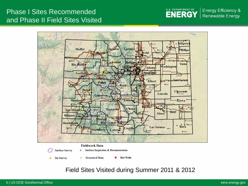
Phase I Sites Recommended and Phase II Field Sites Visited
Field Sites Visited during Summer 2011 & 2012

6 | US DOE Geothermal Office eere.energy.gov
• Initial ASTER and Landsat Signaturs – Garfield County
ASTER and Landsat Signatures Initial Phase I Interpretation Garfield County – Solar & Topo Issues

7 | US DOE Geothermal Office eere.energy.gov
Field Data Acquisition Techniques Applied • Conduct literary search of geologic, geothermal,
hydrologic, structural, alteration, heat flow, and mineral exploration data
• Detailed geologic, alteration, and structural mapping • Water sampling of nearby springs and wells • Shallow (2M) temperature surveys • Closely-spaced gravity surveys (~250 m grid) Results of Initial Phase II Confirmation • Minimal – due to Pixel Resolution, Solar Reflectance and
Topography • Fall ‘11 - Return to Phase I CIRES Model - Refinement
Initial Phase II – Field Assessments

8 | US DOE Geothermal Office eere.energy.gov
Phase I Revised – Enhanced Thematic Mapper Signatures

9 | US DOE Geothermal Office eere.energy.gov
Phase II – Application of Conventional Assessment Tools
Prospect Evaluation - Using Conventionial TechniquesGeochem
Est Reservoir Target Distance toTarget County Temps (0C) Area (sq-mi) Transmission Issues
Strawberry H.S Routt 150 2-3 2-3 Legal from Neighbors
Rico H.S Delores 142 2-3 Upgrade Taxes
Pagosa Springs Archaleta 100 2-3 local Legal from Resorts
Alamosa Alamosa/ Conejos 200 Broad 1-2 Depth & NIMBY
Lemon H.S San Miguel 150 Narrow Gorge Distant Access & Environmental
Florence - Canon City Fremont 130 4-6 1 mile Agreement in Hand to Conduct Exploration

10 | US DOE Geothermal Office eere.energy.gov
Status of Scientific/Technical Approach
Project has completed: Phase I – Results summarized in a CIRES Report dated 12/26/12 Phase II – SOPO Tasks 4.1 & 4.2: Data Base and Field Survey Complete Task 4.3 – MT Surveys – Thick Shale Conductance – Defer Project has Planned (Begin 2nd qtr): Phase II Task 5.0 – Thermal Gradient Wells NEPA Surveys being formulated Access Agreements subject to NEPA

11 | US DOE Geothermal Office eere.energy.gov
SOPO Phase II - Task 5.0 Spotting Thermal Gradient Wells Fremont County, Colorado

12 | US DOE Geothermal Office eere.energy.gov
Florence – Canon City LIDAR Hillside Showing Lineaments: Structures

13 | US DOE Geothermal Office eere.energy.gov
Accomplishments, Results and Future Directions
Describe the most important technical accomplishments and progress and their significance.
Results • Established that Remote Sensing may be useful to identify large targets
• Otherwise of limited value to locate small targets • Each pixel in an ASTER scene is 90m x 90m on the ground
• Established that in spite of Colorado’s rich mining history and people’s general support of energy efficiency and renewables, the NIMBY challenge is generally pervasive.
• Access to geothermal resources challenging.
• The need for collective political will to advance renewals is needed with $ support
• Restricted Access to Prospect Areas has delayed the Project by 12 months
Future Direction • Remain on Track to evaluate Florence Canon City. Conduct a Phase II Stage Gate Process in
the 4th quarter 2013.

14 | US DOE Geothermal Office eere.energy.gov
• Technical points of the Project have only been highlighted above due to the broad scope of the Project and the limitations of time for this presentation – Detailed technical Reports have been prepared and are supportive of the Summary statements made.
• Remote Sensing of Geothermal Resources from Satellite Platforms (Landsat & Terra) may be effective in the future if augmented by some other tools (i.e. FLIR & iTres) operating at a lower altitudes.
Mandatory Summary Statement

15 | US DOE Geothermal Office eere.energy.gov
Project Management
Timeline: PlannedStart Date
PlannedEnd Date
ActualStart Date
EstimatedEnd Date
1/29/2010 4/30/2010 6/30/2012 9/30/2013
Budget:Federal Share Cost Share Planned
Expenses to Date
ActualExpenses to
Date
% of WorkLeft to Complete
$4,778,234 $3,007,300 $7,785,534 $984,343 82%
Planned Start Date
Planned End Date
Actual Start Date
Actual /Est. End Date
1/29/2010 6/30/2012 4/30/2010 9/30/2013
Federal Share
Cost Share Planned Expenses to
Date
Actual Expenses to
Date
Est. Value of Work
Completed to Date
Funding needed to Complete
Work
$4,778,234 $3,007,300 $7,785,534 $984,343 $1,367,571 $6,801,190
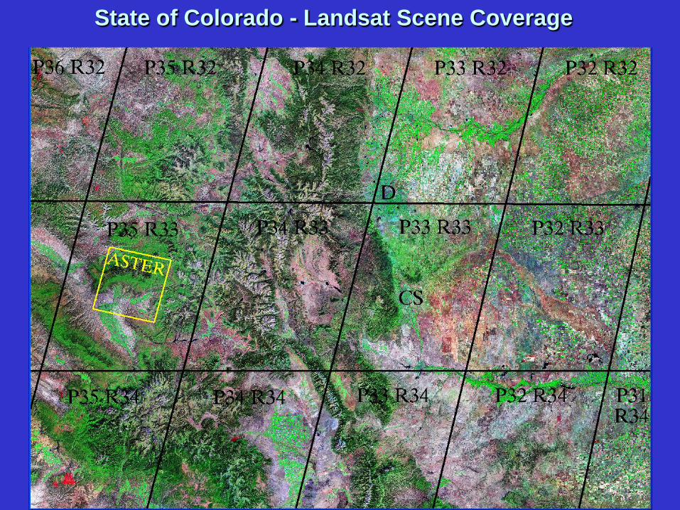
State of Colorado - Landsat Scene Coverage


Isostatic Gravity Fused with Topography & Deep-Seated Structure