INITIAL STUDY/MITIGATED NEGATIVE DECLARATION Project Title ...
100
INITIAL STUDY/MITIGATED NEGATIVE DECLARATION Project Title: Garnet Properties Cannabis Facility Case No. 5.1434 CUP & 3.4068 MAJ Assessor’s Parcel No. 666-430-001, 002, 003, 004, 005, 007, 009 and -012. Lead Agency Name and Address: City of Palm Springs 3200 E. Tahquitz Canyon Way Palm Springs, California 92262 Project Location: North of Garnet Avenue, south of Interstate 10 freeway, and west of the Indian Canyon Drive off-ramp. Project Sponsor’s Name and Address: Garnet Properties 2014, LLC. 714 Oceanhill Drive Huntington Beach, California 92648 General Plan Designation(s): Regional Business Center Zoning: M-1P-Planned Research and Development Park Zone Contact Person: Glenn Mlaker (AICP), Associate Planner City of Palm Springs 3200 E. Tahquitz Canyon Way Palm Springs, California 92262 Phone Number: 760-323-8245 Date Prepared May 2018
Transcript of INITIAL STUDY/MITIGATED NEGATIVE DECLARATION Project Title ...

INITIAL STUDY/MITIGATED NEGATIVE DECLARATION
Project Title: Garnet Properties Cannabis Facility
Case No. 5.1434 CUP & 3.4068 MAJ
Assessor’s Parcel No. 666-430-001, 002, 003, 004, 005, 007, 009 and -012.
Lead Agency Name and Address:
City of Palm Springs 3200 E. Tahquitz Canyon Way Palm Springs, California 92262
Project Location: North of Garnet Avenue, south of Interstate 10 freeway, and west of the Indian Canyon Drive off-ramp.
Project Sponsor’s Name and Address:
Garnet Properties 2014, LLC. 714 Oceanhill Drive Huntington Beach, California 92648
General Plan Designation(s): Regional Business Center
Zoning: M-1P-Planned Research and Development Park Zone
Contact Person:
Glenn Mlaker (AICP), Associate Planner City of Palm Springs 3200 E. Tahquitz Canyon Way Palm Springs, California 92262
Phone Number: 760-323-8245
Date Prepared May 2018


DRAFT Initial Study/Mitigated Negative Declaration
City of Palm Springs Garnet Properties Cannabis Facility May 2018 Initial Study/Mitigated Negative Declaration
2
Table of Contents
CHAPTER 1: INTRODUCTION AND PROJECT DESCRIPTION .......................................................................... 4 CHAPTER 2: ENVIRONMENTAL ANALYSIS AND DETERMINATION............................................................... 13
I. AESTHETICS ............................................................................................................................................. 16II. AGRICULTURAL & FORESTRY RESOURCES ......................................................................................... 27III. AIR QUALITY ............................................................................................................................................ 29IV. BIOLOGICAL RESOURCES .................................................................................................................... 34V. CULTURAL RESOURCES ......................................................................................................................... 39VI. GEOLOGY AND SOILS .......................................................................................................................... 43VII. GREENHOUSE GAS EMISSIONS ............................................................................................................ 47VIII. HAZARDS AND HAZARDOUS MATERIALS ........................................................................................... 50IX. HYDROLOGY AND WATER QUALITY ................................................................................................... 54X. LAND USE AND PLANNING .................................................................................................................. 64XI. MINERAL RESOURCES ........................................................................................................................... 66XII. NOISE ....................................................................................................................................................... 67XIII. POPULATION AND HOUSING ............................................................................................................... 72XIV. PUBLIC SERVICES ................................................................................................................................... 74XV. RECREATION ........................................................................................................................................... 77XVI. TRANSPORTATION/TRAFFIC.................................................................................................................. 78XVII. TRIBAL CULTURAL RESOURCES ............................................................................................................. 81XVIII. UTILITIES AND SERVICE SYSTEMS .......................................................................................................... 83XIX. MANDATORY FINDINGS OF SIGNIFICANCE ...................................................................................... 87
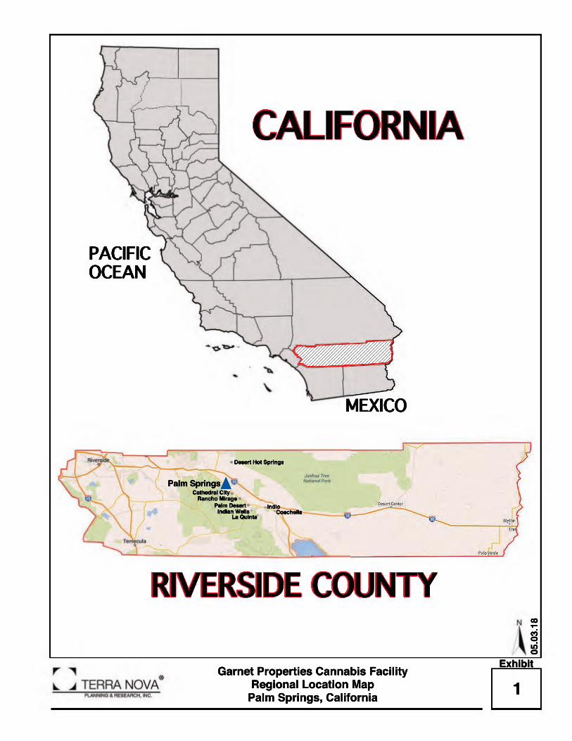
LIST OF EXHIBITS Exhibit 1 Regional Location Map ....................................................................................................................... 6Exhibit 2 Area Location Map .............................................................................................................................. 7Exhibit 3 Vicinity Map ........................................................................................................................................... 8Exhibit 4 Project Location Map .......................................................................................................................... 9 Exhibit 5 Project Site Plan ................................................................................................................................... 10Exhibit 6 Project Phasing Plan ........................................................................................................................... 11Exhibit 7 Views from the Project Site ................................................................................................................ 20Exhibit 8A Building 1 Elevations ........................................................................................................................... 21Exhibit 8B Building 2 Elevations ........................................................................................................................... 21Exhibit 8C Building 3 Elevations ........................................................................................................................... 21Exhibit 8D Building 4 Elevations ........................................................................................................................... 21Exhibit 9 3D Images of Typical Architecture .................................................................................................. 25Exhibit 10 Conceptual Landscape Design....................................................................................................... 26Exhibit 11 Drainage Plan ...................................................................................................................................... 62Exhibit 12 Preliminary Master Water and Sewer Layout................................................................................. 63

DRAFT Initial Study/Mitigated Negative Declaration
City of Palm Springs Garnet Properties Cannabis Facility May 2018 Initial Study/Mitigated Negative Declaration
3
LIST OF TABLES Table 1 Maximum Daily Construction-Related Emissions Summary (pounds per day) ....................... 31Table 2 Maximum Daily Operational-Related Emissions Summary (pounds per day)......................... 31Table 3 Projected GHG Emissions Summary................................................................................................. 49Table 4 Hazardous Material Sites within ½ miles of the Project Site ......................................................... 51Table 5 Project Trip Generation Summary .................................................................................................... 79 APPENDICES Appendix A CalEEMOD Air Quality and GHG Modeling ............................................................................ 92Appendix B Cultural Report .............................................................................................................................. 93Appendix C Bio Report....................................................................................................................................... 94Appendix D Soil Report ...................................................................................................................................... 95Appendix E Traffic Report ................................................................................................................................. 96

DRAFT Initial Study/Mitigated Negative Declaration
City of Palm Springs Garnet Properties Cannabis Facility May 2018 Initial Study/Mitigated Negative Declaration
4
CHAPTER 1: INTRODUCTION AND PROJECT DESCRIPTION
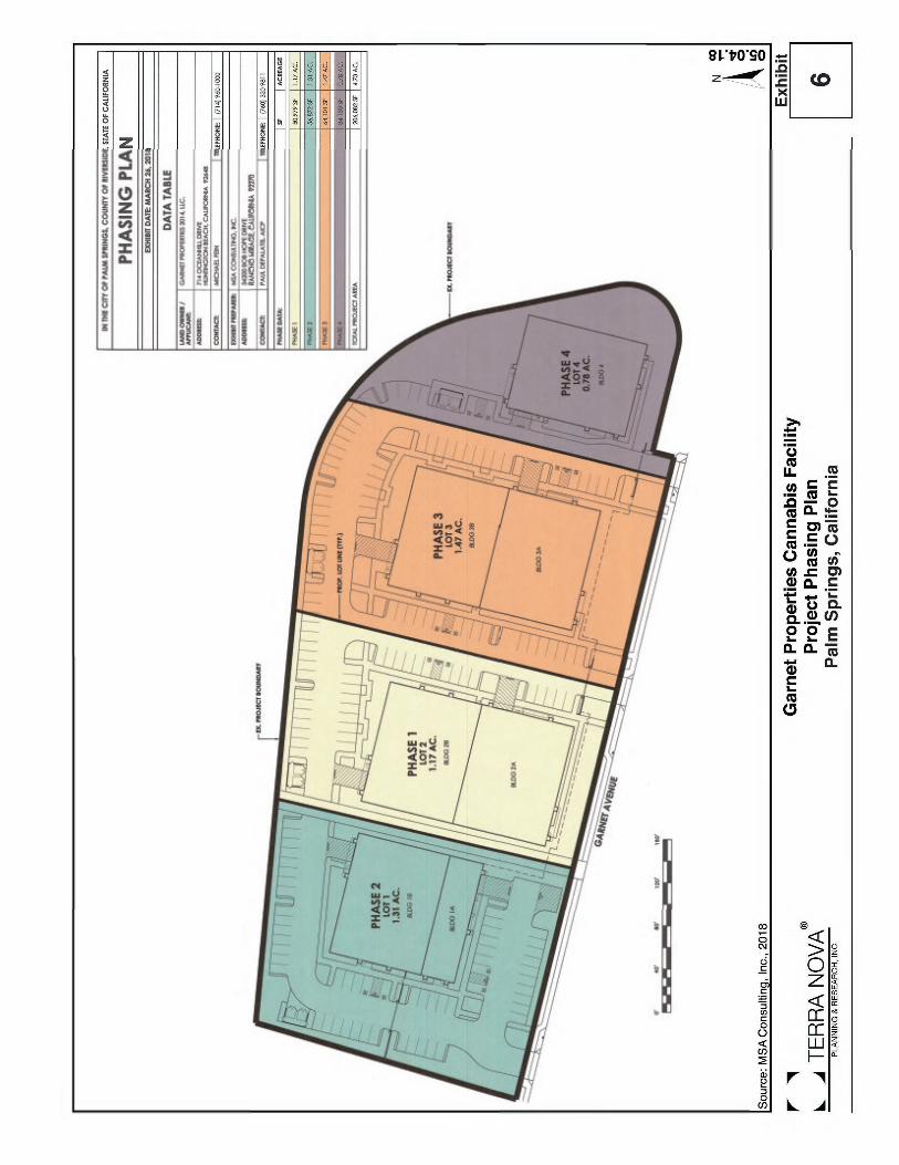
Description of the Project The proposed project will result in the development of a cannabis cultivation center and a dispensary facility to be located on 4.73 acres in the City of Palm Springs, California (Exhibit 1, 2, and 3). The subject site is currently undeveloped, disturbed open space, which is bordered by the Interstate 10 (I-10) freeway on the north, an industrial building on the west, Garnet Avenue on the south, and I-10 on and off-ramps (eastbound) on the east (Exhibit 4). The subject site consists of eight parcels, identified as APN numbers: 666-430-001, -002, -003, -004, -005, -007, -009 and -012. At build out, the project will consist of four single story buildings (building 1, 2, 3, and 4) totaling 63,650 square feet. Building 1 will total 13,650 square feet, and include 10,000 square feet of cultivation and a 3,650 square foot dispensary. Buildings 2 and 3 will consist of 20,000 square feet each for cultivation and ancillary space, including flowering rooms, vegetation rooms, storage/warehouse space, trimming rooms, a dry rack and product room and break room (Exhibit 5). Building 4 will total 10,000 square feet, and will be used for cultivation, with the same ancillary spaces as Buildings 2 and 3. All the proposed buildings will front on Garnet Avenue. Proposed site access will be from three entrances located along Garnet Avenue. Each entrance will be monitored by security cameras. The entire project site, including the three entrances, will be gated with a combination of block wall/ wrought iron fence set back twenty (20) feet from the front property line. Interior driveways will connect buildings 2, 3, and 4 within the project site. Building 1 is separated from other buildings due to the presence of a channel and seventeen (17) foot wide drainage easement on the east boundary of this parcel. The Project would provide 158 parking spaces to accommodate the proposed use (Exhibit 5). The subject site will be developed in four phases each consisting of one building, and moving from west to east. The proposed site is currently zoned for Planned Research and Development Park (M-1P) which allows industrial development. A Conditional Use Permit (CUP) is required to allow the cultivation of cannabis and associated dispensaries. This Initial Study considers that permit and the impact of build out of the project. The City will require, as a condition of approval, that full half-width improvements be constructed along the frontage of the property on Garnet Avenue. The site is configured to provide adequate parking and landscaping improvements per local development requirements. The project also proposes the extension of a 2 inch water pipe from the project site southerly on Garnet Avenue where it will connect to an existing 18 inch public water line. This component of the project will occur entirely within existing right of way, and will be constructed to City and Mission Springs Water District (MSWD) standards. Utilities and Service Providers: The following agencies and companies will provide service to the project site: 1. Sanitary Sewer: Private septic tanks, future MSWD sewer 2. Water: Mission Springs Water District (MSWD)
DRAFT Initial Study/Mitigated Negative Declaration
City of Palm Springs Garnet Properties Cannabis Facility May 2018 Initial Study/Mitigated Negative Declaration
5
3. Electricity: Southern California Edison 4. Gas: The Gas Company 5. Telephone: Frontier 6. Cable: Time Warner Cable Environmental Setting and Surrounding Land Uses: North: Interstate 10 (1-10) South: Garnet Avenue; Federal Express Facility East: I-10 on and off ramps (east-bound) to Indian Canyon Drive West: Black Hawk Logistics, LLC. Other public agencies whose approval is required. California Department of Public Health. Regional Water Quality Control Board.
1Garnet Properties Cannabis Facility
Regional Location MapPalm Springs, California
05.03.18
Exhibit
Coachella
Cathedral CityPalm Springs
Desert Hot Springs
Palm DesertRancho Mirage
La QuintaIndian Wells
Indio
CALIFORNIA
RIVERSIDE COUNTY
PACIFIC OCEAN
MEXICO


DRAFT Initial Study/Mitigated Negative Declaration
City of Palm Springs Garnet Properties Cannabis Facility May 2018 Initial Study/Mitigated Negative Declaration
12
Environmental Factors Potentially Affected: The environmental factors checked below would be potentially affected by this project, involving at least one impact that is a “Potentially Significant Impact” as indicated by the checklist on the following pages.
Aesthetics Agricultural Resources Air Quality
Biological Resources Cultural Resources Geology/Soils
Greenhouse Gas Emissions Hazards & Hazardous Materials Hydrology/Water
Quality Land Use/Planning Mineral Resources Noise
Population/Housing Public Services Recreation
Transportation/ Traffic Tribal Cultural Resources Utilities/Service
Systems
Mandatory Findings of Significance

DRAFT Initial Study/Mitigated Negative Declaration
City of Palm Springs Garnet Properties Cannabis Facility May 2018 Initial Study/Mitigated Negative Declaration
14
PURPOSE OF THIS INITIAL STUDY This Initial Study has been prepared consistent with CEQA Guidelines Section 15063, to determine if the project, as proposed, may have a significant effect upon the environment. Based upon the findings contained within this report, the Initial Study will be used in support of the preparation of a Mitigated Negative Declaration. EVALUATION OF ENVIRONMENTAL IMPACTS 1) A brief explanation is required for all answers except “No Impact” answers that are adequately
supported by the information sources a lead agency cites in the parentheses following each question. A “No Impact” answer is adequately supported if the referenced information sources show that the impact simply does not apply to projects like the one involved (e.g., the project falls outside a fault rupture zone). A “No Impact” answer should be explained where it is based on project-specific factors as well as general standards (e.g., the project will not expose sensitive receptors to pollutants, based on a project-specific screening analysis).
2) All answers must take account of the whole action involved, including off-site as well as on-site,
cumulative as well as project-level, indirect as well as direct, and construction as well as operational impacts.
3) Once the lead agency has determined that a particular physical impact may occur, then the
checklist answers must indicate whether the impact is potentially significant, less than significant with mitigation, or less than significant. “Potentially Significant Impact” is appropriate if there is substantial evidence that an effect may be significant. If there are one or more “Potentially Significant Impact” entries when the determination is made, an EIR is required.
4) “Negative Declaration: Less Than Significant With Mitigation Incorporated” applies where the
incorporation of mitigation measures has reduced an effect from “Potentially Significant Impact” to a “Less Than Significant Impact.” The lead agency must describe the mitigation measures, and briefly explain how they reduce the effect to a less than significant level (mitigation measures from “Earlier Analyses,” as described in (5) below, may be cross referenced).
5) Earlier analyses may be used where, pursuant to the tiering, program EIR, or other CEQA process,
an effect has been adequately analyzed in an earlier EIR or negative declaration. Section 15063(c)(3)(D). In this case, a brief discussion should identify the following:
a) Earlier Analysis Used. Identify and state where they are available for review. b) Impacts Adequately Addressed. Identify which effects from the above checklist were
within the scope of and adequately analyzed in an earlier document pursuant to applicable legal standards, and state whether such effects were addressed by mitigation measures based on the earlier analysis.
c) Mitigation Measures. For effects that are "Less than Significant with Mitigation Measures Incorporated," describe the mitigation measures, which were incorporated or refined from the earlier document and the extent to which they address site-specific conditions for the project.
6) Lead agencies are encouraged to incorporate into the checklist references to information
sources for potential impacts (e.g., general plans, zoning ordinances). Reference to a previously prepared or outside document should, where appropriate, include a reference to the page or pages where the statement is substantiated.

DRAFT Initial Study/Mitigated Negative Declaration
City of Palm Springs Garnet Properties Cannabis Facility May 2018 Initial Study/Mitigated Negative Declaration
15
7) Supporting Information Sources: A source list should be attached, and other sources used or individuals contacted should be cited in the discussion.
8) This is only a suggested form, and lead agencies are free to use different formats; however, lead
agencies should normally address the questions from this checklist that are relevant to a project’s environmental effects in whatever format is selected.
9) The explanation of each issue should identify:
a) The significance criteria or threshold, if any, used to evaluate each question; and b) The mitigation measure identified, if any, to reduce the impacts to less than
significance.

DRAFT Initial Study/Mitigated Negative Declaration
City of Palm Springs Garnet Properties Cannabis Facility May 2018 Initial Study/Mitigated Negative Declaration
16
I. AESTHETICS Would the project:
Potentially Significant
Impact
Less Than Significant
With Mitigation
Incorporated
Less Than Significant
Impact
No Impact
a) Have a substantial adverse effect on a scenic
vista?
b) Substantially damage scenic resources,
including, but not limited to, trees, rock outcroppings, and historic buildings within a state scenic highway?
c) Substantially degrade the existing visual
character or quality of the site and its surroundings?
d) Create a new source of substantial light or
glare which would adversely affect day or nighttime views in the area?
Setting The project site is situated in the northern region of the Coachella Valley within the City of Palm Springs, which is surrounded by the San Bernardino, San Jacinto and Santa Rosa Mountain Ranges and Garnet Hill. The San Bernardino, San Jacinto and Santa Rosa Mountain Ranges have a significant rise over the valley floor with elevations of 11,489 feet (3,502 meters), 8,716 feet (2,657 m), 10,834 feet (3,302 m), respectively. Garnet Hill rises to an elevation of 876 feet (267 m) to the southeast of the project site. The foothills of the San Jacinto Mountains extend along the westerly and southerly portion of the City, approximately 3.0 miles southwest of the subject property. The foothills of the San Bernardino Mountains extend beyond the northerly and northeasterly portions of the City, approximately 6.0 miles from the subject property. Garnet Hill occurs to the southeast of the subject property approximately at 0.37 miles. The San Bernardino, San Jacinto and Santa Rosa Mountain Ranges and Garnet Hill are of aesthetic value to the City. Therefore, the City enforces ordinances for new developments to ensure that any new projects proposed in the City do not conflict with any scenic resource programs that may be in place and preserve aesthetic resources. Ultimate development of the site will result in the construction of four industrial buildings of one story in height. The aesthetic impacts of the project are discussed below. Discussion of Impacts a) Less Than Significant Impact. The subject property is located approximately 3.0 miles northeast
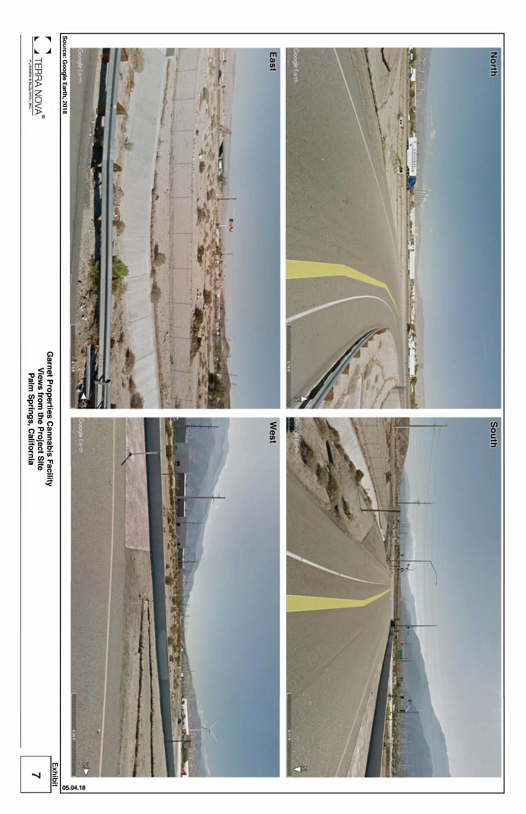
of the San Jacinto Mountain foothills and approximately 6.0 miles south of the San Bernardino Mountain foothills, which are considered a scenic vista for much of the Coachella Valley (Exhibit 1, 2, and 3). From the subject property, scenic views of the San Jacinto Mountains are to the west, south, and southwest (Exhibit 7). Views of the San Bernardino Mountains are to the north, northeast and northwest (Exhibit 7). Garnet Hill is visible to the southeast of the site

DRAFT Initial Study/Mitigated Negative Declaration
City of Palm Springs Garnet Properties Cannabis Facility May 2018 Initial Study/Mitigated Negative Declaration
17
(Exhibit 7). Views of the lower elevations of the mountains are blocked by intervening development in all directions. However, middle and upper elevations of the mountains are visible above. The subject site is located in the northern portion of the City, in a developing urban area and surrounded by sparsely distributed industrial and commercial developments, freeway and local streets.
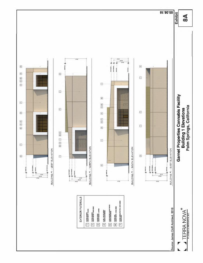
Lands immediately to the west and south are currently developed and occupied by Black Hawk Logistics, LLC. and Federal Express facilities, respectively, which extend up to one story (Exhibit 7). The mountains are visible to the north, west and south, while Garnet Hill is visible to the southeast. The subject property is bordered by the I-10 freeway and I-10 on and off-ramps (eastern bound) to the north and east, respectively. Lands immediately north of I-10 and east of the off-ramps are undeveloped, which provide views of the middle and higher elevations of the San Bernardino Mountain, visible at a great distance. Currently, the subject property is undeveloped and is surrounded by industrial and commercial developments to the west and south. Structures on these properties are consistent with other urban development in the area in scale and height (Exhibit 7). The development of the proposed project, which will consist of four one story industrial buildings, will primarily affect scenic mountain views as seen from the north and south of the subject site. Building height on the subject site could extend up to 29.6 feet (Exhibit 8A-8D). The ultimate construction of industrial buildings on the site would result in limited obstruction of views for viewers looking to the south from I-10, insofar as one story would result in short-range view blockage. However, views of the mid-range and tops of the mountains to the south would remain. Travelers on Garnet Avenue would have obstructed views of the foothills of the San Bernardino Mountains to the north, which are already blocked by the sparsely distributed industrial buildings and wind mill fans to the north and northeast of the project, but views of the peaks would remain visible. Building appearances and materials can be expected to be similar to existing structures in the area. The architectural design plan proposes industrial building heights of up to 29.6 (one story) on the subject site (Exhibit 8A-8D). The proposed project will include full site improvements, including landscaping and architecturally treated buildings to enhance the site’s appearance (Exhibit 9). Setbacks between buildings and through project driveways will allow view corridors to the north and south from I-10 and Garnet Avenue. Build-out of the proposed project would result in limited new obstruction to surrounding views. Overall, although there will be some impact from the proposed project on short-range views to the north and south, impacts to views of scenic vistas from surrounding properties will be less than significant.
b) Less Than Significant Impact. The property is not located along a state scenic highway. There
are no significant trees, rock outcroppings or other significant aesthetic resources on the subject property.
The project site is located south of I-10 and north of Garnet Avenue. I-10 is designated a Local Scenic Roadway in the City’s General Plan (Figure 9-4), requiring special landscaping and setbacks. Views from I-10 serve as windows into the communities beyond, therefore, it is important to ensure that these areas are developed in a way that makes a positive visual impression of the City. The City has established certain policies in its General Plan, for example, LU12.1 to promote the development of high quality land uses at the intersection of Gene Autry Drive and Indian Canyon Drive with I-10.

DRAFT Initial Study/Mitigated Negative Declaration
City of Palm Springs Garnet Properties Cannabis Facility May 2018 Initial Study/Mitigated Negative Declaration
18
To preserve the aesthetic quality of views from I-10, buildings proposed for the site will be required to be constructed in accordance with City’s standards, and to incorporate the high quality of design prescribed by the General Plan. These standard requirements will assure that impacts to the Local Scenic Roadway will be less than significant.
c) Less Than Significant Impact. The project site is currently vacant and undeveloped. The ultimate development of the site will result in the construction of one-story cannabis cultivation and dispensary buildings. The proposed buildings are expected to be consistent with the style of development in the area.
The site is located in an urban environment. The buildings to the west and south of the site are single story in height. For the proposed development, structure heights of up to 29.6 feet would be similar to existing building heights currently occurring to the west and south. The visual characters of I-10 and Garnet Avenue are similar to that proposed for the project, being dominated by industrial and commercial development immediately west and south of the site. The mass of the project has been reduced with the inclusion of parking lots and open spaces between the buildings. This reduction in mass will help to integrate the project into the visual environment of the area. Therefore, the project will not significantly increase the mass of the structures along I-10 and Garnet Avenue. The inclusion of view corridors and high quality architectural treatment to the structures will improve the visual character of the site along I-10 and Garnet Avenue. The impacts associated with visual character are expected to be less than significant.
d) Less Than Significant Impact. The site is located immediately south of the I-10 freeway right of
way, and currently is subjected to light from headlights on the freeway, and street lights on the adjacent ramps. The area in which the project occurs is also partially developed with industrial land uses. As a result, the site is subject to urban levels of light under current conditions. There are no sensitive receptors, in the form of residents, school children or similar groups who would be sensitive to high light levels, within a mile of the project site. Future development around the site is expected to continue to be industrial in nature. This land use is not significantly affected by headlight glare, as all activities are conducted within buildings. Short-Term (Construction-Related) Impacts The site is currently vacant and there is no lighting onsite. During the construction phase, there would be no need to add security lighting for construction areas or construction staging areas, because nighttime construction is not anticipated. Therefore, impacts related to new sources of light and glare during construction would be less than significant. Long-Term (Operations-Related) Impacts The ultimate development of industrial buildings on the site can be expected to generate increased levels of light and glare from interior and exterior building lighting, safety and security lighting, landscape lighting, and vehicles accessing the site during the day and night time, however, it would not require use of high intensity lighting. Glare can also be expected from building windows during the day and night time. However, lighting and glare levels are not expected to exceed typical levels within the surrounding urban environment with little or no light escaping upward from the site. All lighting will be regulated by the City’s lighting standards. The project will be designed according to the City’s Zoning Ordinance 93.21.00 (Outdoor lighting standards) and will properly shield light fixtures to minimize spillage onto

DRAFT Initial Study/Mitigated Negative Declaration
City of Palm Springs Garnet Properties Cannabis Facility May 2018 Initial Study/Mitigated Negative Declaration
19
adjacent properties. The Zoning Ordinance design standards will be incorporated to assure that project light and glare impacts will be less than significant.
Mitigation Measures: None required. Monitoring: None required. Sources: Palm Springs General Plan, 2007; Palm Springs Zoning Ordinance; Project materials.


DRAFT Initial Study/Mitigated Negative Declaration
City of Palm Springs Garnet Properties Cannabis Facility May 2018 Initial Study/Mitigated Negative Declaration
27
II. AGRICULTURAL & FORESTRY RESOURCES In determining whether impacts to agricultural resources are significant environmental effects, lead agencies may refer to the California Agricultural Land Evaluation and Site Assessment Model (1997) prepared by the California Dept. of Conservation as an optional model to use in assessing impacts on agriculture and farmland. In determining whether impacts to forest resources, including timberland, are significant environmental effects, lead agencies may refer to information compiled by the California Department of Forestry and Fire Protection regarding the state’s inventory of forest land, including the Forest and Range Assessment Project and the Forest Legacy Assessment project; and forest carbon measurement methodology provided in Forest Protocols adopted by the California Air Resources Board. Would the project:
Potentially Significant
Impact
Less Than Significant
With Mitigation
Incorporated
Less Than Significant
Impact
No Impact
a) Convert Prime Farmland, Unique Farmland, or
Farmland of Statewide Importance (Farmland), as shown on the maps prepared pursuant to the Farmland Mapping and Monitoring Program of the California Resources Agency, to non-agricultural use?
b) Conflict with existing zoning for agricultural
use, or a Williamson Act contract?
c) Conflict with existing zoning for, or cause
rezoning of, forest land (as defined in Public Resources Code section 12220(g)), timberland (as defined by Public Resources Code section 4526), or timberland zoned Timberland Production (as defined by Government Code section 51104(g))?
d) Result in the loss of forest land or conversion
of forest land to non-forest use?
e) Involve other changes in the existing
environment which, due to their location or nature, could result in conversion of Farmland, to non-agricultural use or conversion of forest land to non-forest use?

DRAFT Initial Study/Mitigated Negative Declaration
City of Palm Springs Garnet Properties Cannabis Facility May 2018 Initial Study/Mitigated Negative Declaration
28
Setting Although the Coachella Valley economy was historically linked to agriculture, changes in the local economy have virtually eliminated all significant agricultural production in the community. The project site is located in the City of Palm Springs where there is no agricultural activity nor are properties in the city designated by the State as agriculturally significant. The City contains no forestland or timberland. Discussion of Impacts a-e) No Impact.
Prime Farmland: No prime or unique farmland, or farmland of statewide importance exists within the project site or vicinity. The project site is not located on or near any property zoned or otherwise intended for agricultural uses. Therefore, no impact to state-designated agricultural land would occur. Williamson Act: No land on or near the project site is under Williamson Act contract. The proposed project will not conflict with zoning for agricultural uses or a Williamson Act contract. Therefore, no impact would occur. Forest Land: The project site is currently zoned as Planned Research and Development Park Zone (M-1P). The subject site does not contain forest land, timberland, or timberland zoned as Timberland Production. The proposed project will not result in the loss or conversion of forestland to non-forest use. No impacts will occur.
Mitigation Measures: None required. Monitoring: None required. Sources: Palm Springs General Plan, 2007; Zoning Map for Palm Springs; “Riverside County Important Farmland 2010 Map,” sheet 2 of 3, California Department of Conservation, published January 2012.

DRAFT Initial Study/Mitigated Negative Declaration
City of Palm Springs Garnet Properties Cannabis Facility May 2018 Initial Study/Mitigated Negative Declaration
29
III. AIR QUALITY Where available, the significance criteria established by the applicable air quality management or air pollution control district may be relied upon to make the following determinations. Would the project:
Potentially Significant
Impact
Less Than Significant With
Mitigation Incorporated
Less Than Significant
Impact
No Impact
a) Conflict with or obstruct implementation of
the applicable air quality plan?
b) Violate any air quality standard or contribute
substantially to an existing or projected air quality violation?
c) Result in a cumulatively considerable net
increase of any criteria pollutant for which the project region is non-attainment under an applicable federal or state ambient air quality standard (including releasing emissions which exceed quantitative thresholds for ozone precursors)?
d) Expose sensitive receptors to substantial
pollutant concentrations?
e) Create objectionable odors affecting a
substantial number of people?
Setting The Coachella Valley, including the project site, is located in the Salton Sea Air Basin (SSAB), which is under the jurisdiction of the South Coast Air Quality Management District (SCAQMD). The SCAQMD is one of the 35 air quality regulatory agencies in State of California and all development within the SSAB is subject to SCAQMD’s 2016 Air Quality Management Plan (2016 AQMP) and the 2003 Coachella Valley PM10 State Implementation Plan (2003 CV PM10 SIP). The SCAQMD operates and maintains regional air quality monitoring stations at numerous locations throughout its jurisdiction. The project site is located within Source Receptor Area (SRA) 30, which includes monitoring stations in Palm Springs and Indio, as well as a newly opened station in the unincorporated community of Thermal. Criteria air pollutants are contaminants for which state and federal air quality standards (i.e. California Ambient Air Quality Standards (CAAQS) and National Ambient Air Quality Standards (NAAQS)) have been established. The Salton Sea Air Basin exceeds state and federal standards for fugitive dust (PM10) and ozone (O3), and is in attainment/unclassified for PM2.5. Ambient air quality in the SSAB, including the project site, does not exceed state and federal standards for carbon monoxide, nitrogen dioxides, sulfur dioxide, lead, sulfates, hydrogen sulfide, or Vinyl Chloride. Build out of the proposed project will result in site disturbance during construction, and long-term impacts associated with operation of the project, as discussed further below.
DRAFT Initial Study/Mitigated Negative Declaration
City of Palm Springs Garnet Properties Cannabis Facility May 2018 Initial Study/Mitigated Negative Declaration
30
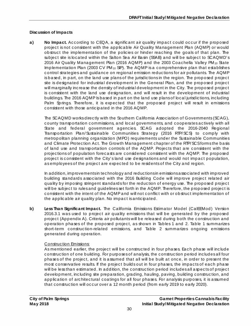
Discussion of Impacts a) No Impact. According to CEQA, a significant air quality impact could occur if the proposed
project is not consistent with the applicable Air Quality Management Plan (AQMP) or would obstruct the implementation of the policies or hinder reaching the goals of that plan. The subject site is located within the Salton Sea Air Basin (SSAB) and will be subject to SCAQMD’s 2016 Air Quality Management Plan (2016 AQMP) and the 2003 Coachella Valley PM10 State Implementation Plan (2003 CV PM10 SIP). The AQMP is a comprehensive plan that establishes control strategies and guidance on regional emission reductions for air pollutants. The AQMP is based, in part, on the land use plans of the jurisdictions in the region. The proposed project site is designated for industrial development in the General Plan, and the proposed project will marginally increase the density of industrial development in the City. The proposed project is consistent with the land use designation, and will result in the development of industrial buildings. The 2016 AQMP Is based in part on the land use plans of local jurisdictions, including Palm Springs. Therefore, it is expected that the proposed project will result in emissions consistent with those anticipated in the 2016 AQMP.
The SCAQMD works directly with the Southern California Association of Governments (SCAG), county transportation commissions, and local governments, and cooperates actively with all State and federal government agencies. SCAG adopted the 2016-2040 Regional Transportation Plan/Sustainable Communities Strategy (2016 RTP/SCS) to comply with metropolitan planning organization (MPO) requirements under the Sustainable Communities and Climate Protection Act. The Growth Management chapter of the RTP/SCS forms the basis of land use and transportation controls of the AQMP. Projects that are consistent with the projections of population forecasts are considered consistent with the AQMP. The proposed project is consistent with the City’s land use designations and would not impact population, as employees of the project are expected to be residents of the City and region. In addition, improvements in technology and reductions in emissions associated with improved building standards associated with the 2016 Building Code will improve project related air quality by imposing stringent standards for the reduction of energy use. The proposed project will be subject to rules and guidelines set forth in the AQMP. Therefore, the proposed project is consistent with the intent of the AQMP and will not conflict with or obstruct implementation of the applicable air quality plan. No impact is anticipated.
b) Less Than Significant Impact. The California Emissions Estimator Model (CalEEMod) Version
2016.3.1 was used to project air quality emissions that will be generated by the proposed project (Appendix A). Criteria air pollutants will be released during both the construction and operation phases of the proposed project, as shown in Tables 1 and 2. Table 1 summarizes short-term construction-related emissions, and Table 2 summarizes ongoing emissions generated during operation.
Construction Emissions: As mentioned earlier, the project will be constructed in four phases. Each phase will include construction of one building. For purposes of analysis, the construction period includes all four phases of the project, and it is assumed that all will be built at once, in order to present the most conservative results. If the project builds out in four phases, the impacts of each phase will be less than estimated. In addition, the construction period includes all aspects of project development, including site preparation, grading, hauling, paving, building construction, and application of architectural coatings for all four phases. For analysis purposes, it is assumed that construction will occur over a 12 month period (from early 2019 to early 2020).

DRAFT Initial Study/Mitigated Negative Declaration
City of Palm Springs Garnet Properties Cannabis Facility May 2018 Initial Study/Mitigated Negative Declaration
31
As shown in Table 1, emissions generated by construction activities will not exceed SCAQMD thresholds for any criteria pollutant during construction. The data reflect average daily unmitigated emissions over the one-year construction period, including summer and winter weather conditions. The analysis assumes that 5,973 cubic yards of material/soils will be imported to the site during grading without exporting any material/soils. Applicable standard requirements and best management practices include, but are not limited to, the implementation of a dust control and management plan in conformance with SCQAMD Rule 403, proper maintenance and limited idling of heavy equipment, phasing application of architectural coatings and the use of low-polluting architectural paint and coatings. Construction related impacts are considered less than significant.
Table 1 Maximum Daily Construction-Related Emissions Summary (pounds per day)
Construction Emissions1 CO NOx ROG SO2 PM10 PM2.5 Daily Maximum 24.57 54.39 11.67 0.06 21.24 12.36 SCAQMD Thresholds 550.00 100.00 75.00 150.00 150.00 55.00 Exceeds? No No No No No No 1 Average of winter and summer emissions. Includes implementation of fugitive dust control measures and architectural coating standards required by SCAQMD under Rule 403 and Rule 1113, respectively. Emission Source: CalEEMod model, version 2016.3.1.
Operational Emissions: Operational emissions are ongoing emissions that will occur over the life of the project. They include area source emissions, emissions from energy demand (electricity), and mobile source (vehicle) emissions.
The project site is undeveloped. Traffic generation trip rates were derived from Transportation Engineers (ITE) 10th Edition Trip Generation, an ITE Informational Report using the Nursery (Wholesale) (ITE Land Use Code 220) and Marijuana Dispensary (ITE Land Use Code 882) land use categories. Table 2 provides a summary of projected emissions during operation of the proposed project at build out of all four phases.
Table 2 Maximum Daily Operational-Related Emissions Summary
(pounds per day) Operational Emissions1 CO NOx ROG SO2 PM10 PM2.5 Daily Maximum 14.23 5.64 2.44 0.05 4.02 1.13 SCAQMD Thresholds 550.00 100.00 75.00 150.00 150.00 55.00 Exceeds? No No No No No No 1 Average of winter and summer emissions. Includes implementation of fugitive dust control measures and architectural coating standards required by SCAQMD under Rule 403 and Rule 1113, respectively. Emission Source: CalEEMod model, version 2016.3.1.
As Table 2 shows, operational emissions will not exceed SCAQMD thresholds of significance for any criteria pollutants for operations. Impacts related to operation will be less than significant. Summary: The project site will be built in four phases, and for purposes of this air quality analysis it is assumed that the whole site will be constructed and operational at the same time. As shown above, all project phases are under the SCAQMD significance thresholds, and none of the phases would violate any air quality standard or contribute substantially to an existing or projected air quality violation. Overall, impacts related to constructed and operation will be less than significant.

DRAFT Initial Study/Mitigated Negative Declaration
City of Palm Springs Garnet Properties Cannabis Facility May 2018 Initial Study/Mitigated Negative Declaration
32
c) Less Than Significant Impact. According to CEQA, a significant impact could occur if the project would add a considerable cumulative contribution to federal or State non-attainment pollutants. As stated above, the subject area is located in the Coachella Valley portion of the Salton Sea Air Basin, which is classified as a “non-attainment” area for PM10 and ozone. The 2003 Coachella Valley PM10 State Implementation Plan was adopted in order to achieve attainment. This Plan established strict standards for dust management for development proposals. The SCAQMD does not currently recommend quantified analyses of construction and/or operational emissions from multiple development projects nor provides methodologies or thresholds of significance to be used to assess the significance of cumulative emissions generated by multiple cumulative projects. However, it is recommended that a project’s potential contribution to cumulative impacts should be assessed utilizing the same significance criteria as those for project-specific impacts. Furthermore, SCAQMD states that if an individual development project generates less than significant construction or operational emissions, then the development project would not generate a cumulatively considerable increase in emissions for those pollutants for which the Basin is in nonattainment. As discussed above, the proposed project would not generate construction or operational emissions that exceed the SCAQMD’s recommended regional thresholds of significance. The proposed project would not generate a cumulatively considerable increase in emissions of the pollutants for which the Basin is in nonattainment. Impacts would be less than significant.
d) No Impact. The nearest sensitive receptor is a single-family home located approximately 1.11 miles northeast of the project site in the City of Desert Hot Springs. To determine if the proposed project has the potential to generate significant adverse localized air quality impacts, the mass rate Localized Significance Threshold (LST) Look-Up Table was used. The mass rate Localized Significance Threshold (LST) Look-Up Table allows quantification of localized emissions at a distance of up to 200-meters (0.12 miles). The nearest sensitive receptor is located more than 1,800 meters from the project site, and is separated by an interstate freeway. No potential impacts to sensitive receptors would occur.
e) Less Than Significant Impact. A significant impact could occur if objectionable odors are
generated that would adversely impact sensitive receptors. Odors are typically associated with industrial projects involving the use of chemicals, solvents, petroleum products, and other strong-smelling elements used in manufacturing processes, as well as in sewage treatment facilities and landfills. The proposed project will be developed with industrial development and plants will be grown and stored indoors. The buildings will be equipped with the proper ventilation systems and are not expected to generate significant objectionable odors at project buildout. Generally, cannabis plants have strong odors which are stronger than typical plants. To minimize that odor, the City has implemented Municipal Code Section 5.45.200 (Commercial Medical Cannabis Operating Requirements) which requires odor prevention devices and techniques, such as a ventilation system with a carbon filter at cannabis facilities to ensure that odors from plants are not detectable off site. With implementation of such devices and techniques, impacts from cannabis plants odors are expected to be less than significant. During the construction phase, short term odors associated with paving and construction activities could be generated; however, any such odors would be quickly dispersed below detectable levels as distance from the construction site increases. Impacts would be less than significant.

DRAFT Initial Study/Mitigated Negative Declaration
City of Palm Springs Garnet Properties Cannabis Facility May 2018 Initial Study/Mitigated Negative Declaration
33
Mitigation Measures: None required. Monitoring: None required. Sources: “Final 2016 Air Quality Management Plan,” prepared by South Coast Air Quality Management District, March 2017; “Final Localized Significance Threshold Methodology,” prepared by the South Coast Air Quality Management District, Revised, July 2008; “2003 Coachella Valley PM10 State Implementation Plan,” August 1, 2003; CalEEMod Version 2016.3.1; Municipal Code 5.45.200 (Commercial Medical Cannabis Operating Requirements).

DRAFT Initial Study/Mitigated Negative Declaration
City of Palm Springs Garnet Properties Cannabis Facility May 2018 Initial Study/Mitigated Negative Declaration
34
IV. BIOLOGICAL RESOURCES Would the project:
Potentially Significant
Impact
Less Than Significant With
Mitigation Incorporated
Less Than Significant
Impact
No Impact
a) Have a substantial adverse effect, either
directly or through habitat modifications, on any species identified as a candidate, sensitive, or special status species in local or regional plans, policies, or regulations, or by the California Department of Fish and Game or U.S. Fish and Wildlife Service?
b) Have a substantial adverse effect on any
riparian habitat or other sensitive natural community identified in local or regional plans, policies, regulations or by the California Department of Fish and Game or US Fish and Wildlife Service?
c) Have a substantial adverse effect on federally
protected wetlands as defined by Section 404 of the Clean Water Act (including, but not limited to, marsh, vernal pool, coastal, etc.) through direct removal, filling, hydrological interruption, or other means?
d) Interfere substantially with the movement of
any native resident or migratory fish or wildlife species or with established native resident or migratory wildlife corridors, or impede the use of native wildlife nursery sites?
e) Conflict with any local policies or ordinances
protecting biological resources, such as a tree preservation policy or ordinance?
f) Conflict with the provisions of an adopted
Habitat Conservation Plan, Natural Community Conservation Plan, or other approved local, regional, or state habitat conservation plan?
Setting The climate and natural topography of the City offer unique habitats and some of the most diverse plant communities and wildlife. According to the City’s General Plan, the City contains a wide range of significant biological resources, many of which are species of plants and animals that are highly specialized and endemic to the Valley. Due to the loss of viable habitat some of these species have been listed as threatened or endangered by the federal and state governments. The City is home to two plants (Coachella Valley milk-vetch and the triple-ribbed milk-vetch), three amphibians (arroyo southwestern toad, mountain yellow-legged frog, and California red-legged frog), two reptiles (desert

DRAFT Initial Study/Mitigated Negative Declaration
City of Palm Springs Garnet Properties Cannabis Facility May 2018 Initial Study/Mitigated Negative Declaration
35
tortoise and Coachella Valley fringe-toed lizard (CVFTL), two birds (Bell’s vireo and southwestern flycatcher) and one mammal species (Peninsular bighorn sheep) that are considered threatened or endangered by the federal government. The proposed project is within the boundaries of and subject to the provisions of the Coachella Valley Multiple Species Conservation Plan (CVMSHCP) (Recirculated Final Coachella Valley Multiple Species Habitat Conservation Plan; Figure 8-3). The CVMSHCP is a comprehensive regional plan that balances growth in the Coachella Valley with the requirements of federal and State endangered species laws. The project site is not located within or adjacent to a Conservation Area. The City of Palm Spring’s General Plan (2007), project biological resources assessment and Coachella Valley Multiple Species Habitat Conservation Plan were referenced to analyze potential impacts to biological resources associated with the proposed development, and are discussed below. Discussion of Impacts a) Less Than Significant Impact with Mitigation Incorporated. Amec Foster Wheeler prepared a
“Biological Resources Assessment and Coachella Valley Multiple Species Habitat Conservation Plan Compliance Report” for the proposed project in April, 2018 (Appendix B). The assessment included literature review and field assessment of the site, and the results are discussed below.
Existing Conditions
The site is highly disturbed and includes man-made features such as a paved driveway and a perimeter fence. The on-site vegetation community is disturbed creosote bush scrub and consists of twelve plant species common to the area. Plant species observed at the project site are shown below:
Dominant perennial plant species Annuals Non-native species
Creosote bush (Larrea tridentata) and brittlebush (Encelia farinosa).
Mediterranean schismus (Schismus barbatus), narrow leaved cryptantha (Cryptantha augustifolium), salt heliotrope (Heliotropium curassavicum), desert dandelion (Malacothrix californica var. glabrata), desert pincushion (Chaenactis fremontii), diamond cholla (Cylindropuntia ramosissima), and California croton (Croton californicus).
Russian thistle (Salsola tragus)*, coastal heron’s bill (Erodium cicutarium)*, and London rocket (Sisymbrium irio).
The biologist identified seven common species on the property, including western whiptail, desert iguana, common raven, mourning dove, black-chinner hummingbird, white-crowned sparrow and black-tailed jackrabbit. No special status species were identified on the project site. Potentially Occurring Special Status Plants Habitat within the subject property is highly disturbed, however, there is a low potential for Coachella Valley milk-vetch (federally-listed as endangered), San Bernardino Mountains linanthus (state ranked S2 – “imperiled” and CNPS ranked 1B.2 - “rare, threatened, or endangered in California, and elsewhere”), and Slender Cottonheads (unlisted plant species) to occur within the central portion of the site and/or adjacent to the site’s east boundary

DRAFT Initial Study/Mitigated Negative Declaration
City of Palm Springs Garnet Properties Cannabis Facility May 2018 Initial Study/Mitigated Negative Declaration
36
based on the presence of suitable habitat (sandy washes). Both Coachella Valley milk-vetch and San Bernardino Mountains linanthus are covered under the CVMSHCP and project-related impacts (if any) would be mitigated through payment of the MSHCP Local Development Mitigation Fee. Slender Cottonheads is not covered under the CVMSHCP. On-site habitat is highly disturbed, and lacks blown sand and/or sandy dune areas. No further analysis is required for the project because of low potential for this species to occur on site.
Potentially Occurring Reptile Species on Project Site: The project biologist found that there is a low potential for the coast horned lizard (unlisted reptile species) to occur onsite. Although the site provides marginal habitat for the species, its disturbed nature, and the site’s location on the eastern edge of the species’ range result in its potential for occurrence to be very low. Potentially Occurring Mammal on Project Site: There is a low potential for the to occur on the project site. Both the Palm Springs pocket mouse and the Coachella Valley (Palm Springs) round-tailed ground squirrel are state special concern species with modeled habitat including the project site. Both species, however, are covered by the MSHCP, and payment of the Local Development Mitigation Fee will mitigate potential impacts to the species to less than significant levels. Potential of Burrowing Owl on Project Site: No natural burrows or man-made structures suitable for the owl were observed onsite, however, small mammal burrows and drainpipes suitable for burrowing owl occupation were identified in the vicinity of the proposed project site. Burrowing owl are not covered under the CVMSHCP, and protocol compliant pre-construction surveys are required to assure that the species does not locate on the site prior to development. The pre-construction surveys required for compliance with the Migratory Bird Treaty Act, described below, will address this requirement, and reduce potential impacts to the species to less than significant levels. Migratory Bird Treaty Act: The Migratory Bird Treaty Act (MBTA) protects a broad range of migratory birds from nest disturbance during breeding season. The CVMSHCP requires compliance with the Act, and as a permittee, the City must comply with the Act. In order to avoid impacting nesting birds, either avoidance of project-related disturbance during the nesting season (generally from approximately January 15 through August 31); or the completion of pre-construction surveys conducted by a qualified ornithologist or biologist immediately prior to on-site disturbance during the nesting season has been required below. The implementation of pre-construction surveys will assure that impacts to nesting birds are reduced to less than significant levels. Summary Overall, payment of the required MSHCP Local Development Mitigation Fee will mitigate impacts to the following sensitive species: Coachella Valley milk-vetch, Little San Bernardino Mountains linanthus, slender cottonheads, Palm Springs pocket mouse, and Palm Springs round-tailed ground squirrel. In order to assure that impacts to Burrowing Owl and nesting birds are reduced to less than significant levels, mitigation measure BIO-1 is provided below.

DRAFT Initial Study/Mitigated Negative Declaration
City of Palm Springs Garnet Properties Cannabis Facility May 2018 Initial Study/Mitigated Negative Declaration
37
b, c) No Impact. The project site does not contain any streams, creek, rivers, blue-lined streams, lakes, vernal pools or ponds. No wetland, riparian or otherwise special-status vegetation communities were observed on the project site. A dry, erosional feature occurs directly east of the paved driveway, coming from a culvert under the I-10 freeway. The culvert does not convey flows from natural watercourses, and therefore is not considered under the jurisdiction of the US Army Corps of Engineers, CDFW, or State Water Resources Control Board (EPA – Waters of the U.S. Rulemaking). No jurisdictional delineation is required, and no impacts associated with streams, riparian habitat, marshes, protected wetlands, vernal pools or sensitive natural communities protected by the California Department of Fish and Wildlife or U.S. Fish and Wildlife Service is anticipated.
d) No Impact. A wildlife corridor is a link of wildlife habitat, generally containing native
vegetation, which joins two or more larger areas of similar wildlife habitat. The subject site is disturbed open space bordered on three sides by roads or development, and fenced with chain link. The site does not function as a migratory wildlife corridor or nursery site for any native resident or migratory fish or wildlife species. According to the biological assessment prepared for the project site, no wildlife corridors or biological linkages are mapped on, or adjacent to the site. No project-related impacts will occur.
e, f) No Impact. The project site does not lie within any of the CVMSHCP-designated conservation
areas. However, three conservations areas are located near the subject site. The Whitewater Floodplain Conservation Area is located approximately 792 feet (0.15 mile) south of the site. The Upper Mission Creek/Big Morongo Canyon Conservation Area is located approximately 2,904 feet (0.55 miles) northwest of the site. The Willow Hole Conservation area is located approximately 6,600 feet (1.25 miles) east of the site. Therefore, no mitigation measures or provisions are required. The project will not conflict with any local policies or ordinances that protect biological species, or any adopted habitat conservation plans or natural community conservation plans. No project-related impacts will occur.
Mitigation Measures: BIO-1 If any ground disturbance is proposed during nesting season (between January 15th and
August 31th), a qualified ornithologist or biologist shall conduct a nesting-bird survey focusing on MBTA covered species prior to on-site disturbance.
If nesting birds are found, no work would be permitted near the nest until young have fledged. The biologist shall implement protection measures as deemed necessary to assure protection of MBTA covered species, including burrowing owls.
If the initiation of ground disturbing activities is proposed outside of nesting season, this mitigation measure shall not apply.
BIO-2 The applicant shall pay the CVMSHCP Local Development Mitigation Fee prior to building
permit issuance.
DRAFT Initial Study/Mitigated Negative Declaration
City of Palm Springs Garnet Properties Cannabis Facility May 2018 Initial Study/Mitigated Negative Declaration
38
Monitoring: BIO-A The project biologist shall submit pre-construction survey reports to the City Engineer prior to
the issuance of any ground disturbing permit on the site (including grubbing). Responsible Parties: City Engineer Schedule: Between January 15th and August 31th prior to on-site disturbance. Sources: “Coachella Valley Multiple Species Habitat Conservation Plan,” 2007; Palm Springs General Plan, 2007; Biological Resources Assessment and Coachella Valley Multiple Species Habitat Conservation Plan Compliance Report,” prepared by Amec Foster Wheeler Environment & Infrastructure, Inc. in April 27, 2018.

DRAFT Initial Study/Mitigated Negative Declaration
City of Palm Springs Garnet Properties Cannabis Facility May 2018 Initial Study/Mitigated Negative Declaration
39
V. CULTURAL RESOURCES Would the project:
Potentially Significant
Impact
Less Than Significant
With Mitigation
Incorporated
Less Than Significant
Impact
No Impact
a) Cause a substantial adverse change in the
significance of a historical resource as defined in § 15064.5?
b) Cause a substantial adverse change in the
significance of an archaeological resource pursuant to § 15064.5?
c) Directly or indirectly destroy a unique
paleontological resource or site or unique geologic feature?
d) Disturb any human remains, including those
interred outside of formal cemeteries?
Setting The City of Palm Springs is located in the Coachella Valley, which is the traditional home of the Cahuilla Indians. More than 2000 years ago, the original inhabitants of the City were the Cahuilla Indians, who established their villages around the natural hot mineral springs known for their medicinal and healing capabilities. Throughout the 19th century, many explorers, colonizers, and soldiers came through the desert, but it was not until 1853 that United States Topographical Survey Engineers described the combination of palm trees and warm springs they encountered as ‘Palm Springs.’ The name became more commonly used several years later. Complex communities were developed in Palm, Murray, Andreas, Tahquitz, and Chino Canyons where the Cahuilla managed hundreds of plant resources. The Cahuilla also fashioned a network of trailways connecting them with other cultures in Southern California. The Cahuilla Indians are a Takic-speaking people consisting of hunters and gatherers who are generally divided into three groups based on their geographic setting: the Pass Cahuilla of the Beaumont/Banning area; the Mountain Cahuilla of the San Jacinto and Santa Rosa Mountains; and the Desert Cahuilla from the Coachella Valley, as far south as the Salton Sea. The Cahuilla had many villages throughout the Coachella Valley. Population estimates for the Cahuilla prior to European contact range from 3,600 to as high as 10,000 persons. During the 19th century, the Cahuilla population was decimated by European diseases (e.g. smallpox). In the mid-1850s, eight Indian villages or Rancherias, were reported within or close to the City during a United States Land Survey. Numerous roads and trails were also discovered later during surveys. The ultimate development of the site could result in ground excavation and disturbance that could affect cultural resources, and is discussed below.
DRAFT Initial Study/Mitigated Negative Declaration
City of Palm Springs Garnet Properties Cannabis Facility May 2018 Initial Study/Mitigated Negative Declaration
40
Discussion of Impacts a) No Impact. CRM TECH prepared a “Historical/Archaeological Resources Survey Report” for
the proposed project area in May 7, 2018 (Appendix C). The survey included a comprehensive records search, historical research, consultation with Native American representatives, and an on-site field survey, as discussed below.
Eastern Information Center (EIC) Records Search:
According to EIC records, the subject property has not been surveyed before. Records show a total of 37 previous cultural resources studies on various tracts of land and linear features within a one-mile radius of the subject site. Three linear surveys for pipeline projects along Garnet Avenue, two completed in 1975 and one in 2015, and a 2014 survey for the Federal Express facility across Garnet Avenue have been previously completed immediately adjacent to the proposed project. Based on these studies, nine historical/archaeological sites and five isolates have been identified within one-mile of the site. One of the isolates was of prehistoric (i.e. Native American) origin consisting of a jasper flake found roughly three-quarters of a mile northwest of the subject site. The balance of the identified resources dated to the historic period, and represented relics of early transportation, communication, irrigation, and other infrastructure features, along with some common domestic refuse items. Two insulators found approximately 1,000 feet to the west of the proposed project are the closest resources identified in the vicinity of the site.
Historical Background Research:
Based on historical data sources, surveyors reported an “Indian Trail” running roughly 1,000 feet north of the subject area and a “road” in the dry bed of the Whitewater River some 3,000 feet to the south in the mid-1850s. In 1876-1877, the Southern Pacific Railroad and the establishment of the Seven Palm Station on the railroad, less than a half-mile south of the subject site accelerated further activities in the area.
In the 1950s, the I-10 freeway was built to the north of the project site. Later, the segment of
the old highway along the project’s southern boundary became a local bypass known as Garnet Avenue today.
Meanwhile, small other commercial and industrial buildings (e.g. local post office) were
constructed. Between 2010 and 2012, the I-10 off-ramp was reconfigured to run along the northern and eastern boundaries of the project site and the refueling facility operated by Black Hawk Logistics was constructed on the western boundary.
Field Survey Results:
During the field survey of the subject site, no potential cultural resources, buildings, structures, objects, sites, features, or artifacts more than 50 years of age were observed on-site. Scattered modern refuse was observed on the site, however, none of these qualify as a historical and archaeological resource as defined in § 15064.
As discussed above, the site does not contain any significant historic resources as defined in § 15064, therefore, no impact is anticipated.
b) Less Than Significant Impact with Mitigation Incorporated. The on-site survey identified no
archaeological resources on the subject property. However, the State Native American Heritage Commission (NAHC) and associated tribes of the Coachella Valley were contacted to assure the security of the tribes and their archaeological resources pursuant to § 15064.5.

DRAFT Initial Study/Mitigated Negative Declaration
City of Palm Springs Garnet Properties Cannabis Facility May 2018 Initial Study/Mitigated Negative Declaration
41
Native American Consultation: The State Native American Heritage Commission (NAHC) was contacted on March 29, 2018
to request a record search in the Commission’s sacred lands file. In the meantime, CRM TECH notified the Agua Caliente Band of Cahuilla Indians of the upcoming archaeological fieldwork and invited tribal participation.
The NAHC recommended contacting local tribes regarding potential Native American Cultural resources on-site, although no native American cultural resources were reported within the site. Seventeen (17) tribal representatives in the region were contacted in writing on April 3rd, 2018. Furthermore, CRM TECH sent written requests for comments to thirteen (13) tribes.
Four representatives (Victoria Martin from the Augustine Band of Cahuilla Indians, Judy Stapp from the Cabazon Band of Mission Indians, Bobby Ray Esparza from the Cahuilla Band of Indians, and Raymond Huaute from the Morongo Band of Mission Indians) responded to CRM Tech’s correspondence. The Cabazon Band of Mission Indians stated that it does not have knowledge of any cultural resources within or near the project area and the site is outside their traditional use lands. Responses of other three tribes are provided below:
• The Cahuilla Band of Indians stated that although the site is outside the reservation
boundary, it is within the Cahuilla traditional land use area. The tribe requested to be notified about all updates and changes within the project moving forward;
• The Augustine Band of Cahuilla Indians have particularly requested that the applicant
be required to monitor, using a qualified Native American monitor, during the pre-construction and construction phase of the project;
• The Morongo Band of Mission Indians stated that the project site is located within the
Tribe’s aboriginal territory or in an area considered to be a traditional use area or one in which the Tribe has cultural ties. In order to further evaluate the project for potential impacts to tribal cultural resources, the tribe requested that it be provided the cultural resources report, and that it looked forward to further government to government consultation with the City.
Summary The project site does not contain any archaeological resources pursuant to § 15064.5, however, impacts to archaeological resources could occur if they are uncovered during site grading. Also, it is within the Cahuilla traditional land use area and Morongo aboriginal territory. To ensure the proper identification of potential “tribal cultural resources,” the City is currently conducting AB 52 consultation. Once responses from are received, the City will include the tribal requirements and conditions into the project. Due to the traditional land use and cultural ties of the project area, the project site is a sensitive area and potentially contains sub-surface archaeological resources. Therefore, mitigation measures and a monitoring program are included to reduce potential impacts to less than significant levels, consistent with the findings of the cultural resource investigation, and the concerns of the Cahuilla, Augustine, and Morongo bands. With implementation of these mitigation measures and a monitoring program, impacts associated with archaeological resources will be reduced to less than significant levels.

DRAFT Initial Study/Mitigated Negative Declaration
City of Palm Springs Garnet Properties Cannabis Facility May 2018 Initial Study/Mitigated Negative Declaration
42
c) No Impact. The subject site is not known to contain unique paleontological features. Also, there are no unique geological features (river, lake, hills, faults, and folds etc.) located on-site that can directly or indirectly be destroyed.
The surface soils consist of light brown, coarse alluvial sands with rocks and small boulders of Carsitas gravelly sand (CdC) and Old Alluvial gravel and sand (Qao). Recent deposits are not conducive to the location of paleontological resources. The proposed project will result in the development of a one story cannabis cultivation center and dispensary facility, which will not require deep excavation. The proposed project will not directly or indirectly destroy a unique paleontological resource or site or unique geologic feature. Therefore, no project-related impacts are anticipated.
d) No Impact. No cemeteries or human remains are known to occur on-site. It is unlikely that
human remains will be uncovered during project development. Should remains be uncovered during grading of the site, California law requires that all activity stop, that the coroner be notified, and that he or she determine the nature of the remains, and whether Native American consultation will be required. This requirement of law assures that there will be no impact to cemeteries or human remains.
Mitigation Measures: CUL-1 A qualified Tribal monitor shall be on site during pre-construction phases of the project
including all earth moving activities (i.e. including grubbing, grading, trenching and excavation). The monitor shall be empowered to stop and redirect activities, should a resource be identified. The monitor shall identify the resource, and determine whether further investigation is required, or whether earth moving can resume. Any identified resource shall be professionally treated and curated, and included in a post-monitoring report provided to the City and associated tribes including the Cahuilla, Augustine, and Morongo bands.
Monitoring: CUL-A The project archaeologist and/or Tribal monitor shall prepare a report documenting
monitoring activities. The monitoring report shall be submitted to the City within 30 days of completion of grading activities. Responsible parties: Project proponent, project archaeologist, Planning Department.
Sources: City of Palm Springs General Plan, 2007; “Historical/Archaeological Resources Survey Report,” prepared by CRM TECH on May 7, 2018.

DRAFT Initial Study/Mitigated Negative Declaration
City of Palm Springs Garnet Properties Cannabis Facility May 2018 Initial Study/Mitigated Negative Declaration
43
VI. GEOLOGY AND SOILS Would the project:
Potentially Significant
Impact
Less Than Significant
With Mitigation
Incorporated
Less Than Significant
Impact
No Impact
a) Expose people or structures to potential
substantial adverse effects, including the risk of loss, injury, or death involving:
i) Rupture of a known earthquake fault, as
delineated on the most recent Alquist-Priolo Earthquake Fault Zoning Map issued by the State Geologist for the area or based on other substantial evidence of a known fault? Refer to Division of Mines and Geology Special Publication 42.
ii) Strong seismic ground shaking? iii) Seismic-related ground failure, including
liquefaction?
iv) Landslides?
b) Result in substantial soil erosion or the loss of
topsoil?
c) Be located on a geologic unit or soil that is unstable, or that would become unstable as a result of the project, and potentially result in on-or off-site landslide, lateral spreading, subsidence, liquefaction or collapse?
d) Be located on expansive soil, as defined in Table 18-1-B of the Uniform Building Code (1994), creating substantial risks to life or property?
e) Have soils incapable of adequately supporting the use of septic tanks or alternative waste water disposal systems where sewers are not available for the disposal of waste water?
Setting The Coachella Valley is located in the northwestern portion of the Salton Trough, a tectonic depression roughly 130 miles long and 70 miles wide that extends from the San Gorgonio Pass to the Gulf of Mexico. The valley is bounded by the San Bernardino Mountains on the northwest, San Jacinto Mountains on the west, Santa Rosa Mountains on the south, and Little San Bernardino Mountains and Indio Hills on the north. The Salton Sea is located to the southeast.

DRAFT Initial Study/Mitigated Negative Declaration
City of Palm Springs Garnet Properties Cannabis Facility May 2018 Initial Study/Mitigated Negative Declaration
44
The valley’s geologic composition and seismicity is directly related to its proximity to the San Andreas Fault system, which passes through the northeasterly portion of the valley, and other active faults. The region is susceptible to a range of geologic hazards, including ground rupture, major ground shaking, slope instability, and collapsible and expansive soils. Episodic flooding of major regional drainages, including the Whitewater River, results in the deposition of sand and gravel on the valley floor. Strong sustained winds emanating from the San Gorgonio Pass cause wind erosion and transport and deposit dry, finely granulated, sandy soils on the central valley floor. Regional soils range from rocky outcrops within the mountains bordering the valley to coarse gravels of mountain canyons and recently laid fine- and medium-grained alluvial (stream deposited) and aeolian (wind deposited) sediments on the central valley floor. Discussion of Impacts a) i) No Impact. The subject property is not located within or adjacent to an Alquist-Priolo
Earthquake Fault Zone. The nearest earthquake faults are the San Andrea Fault (Coachella Section) and Garnet Hill Faults, which run approximately 1.08 and 0.40 miles northeast and southeast of the site. The Garnet Hill fault is connected to the San Andrea Fault system where northwest directed slip from the southern San Andreas Fault is transferred to the Mission Creek, Banning, and Garnet Hill fault strands in the northwestern Coachella Valley. These faults are capable of generating earthquakes of magnitude >5.0. However, fault rupture is not expected on the project site. No impact will result from implementation of the proposed project.
ii) Less Than Significant Impact. The project site is located in a seismically active region where
earthquakes originating on local and regional seismic faults can produce severe ground shaking. Buildings proposed for the site will be required to be constructed in accordance with the most recent edition of the California Building Code (CBC) and Palm Springs Municipal Code Section 8.68.170 to provide collapse-resistant design.
The City has adopted several modifications to the CBC in accordance to local geology. The Palm Springs Municipal Code provides regulations for collapse-resistant design which minimize the impact to people and property in the event of an earthquake. Project-related impacts associated with seismic ground shaking will be less than significant.
iii) No Impact. The project site is located in an area that is designated as “Low Liquefaction
Susceptibility – Fine-grained granular sediments susceptible to liquefaction, but with groundwater depth > 50 feet” (General Plan; Figure 6.1).
Onsite underlying soils consist of Carsitas gravelly sand (CdC) and of Old Alluvial gravel and sand (Qao), which could not be susceptible to liquefaction. In addition, the depth of the groundwater in the area is greater than 50 feet below the ground surface. For liquefaction to occur, groundwater levels must be within 50 feet of the ground surface. Therefore, the sand in this region is not prone to consolidation under building loads and severe ground shaking. No impact is anticipated.

DRAFT Initial Study/Mitigated Negative Declaration
City of Palm Springs Garnet Properties Cannabis Facility May 2018 Initial Study/Mitigated Negative Declaration
45
iv) No Impact. The proposed project site is on the Coachella Valley floor. It consists of sand, and is surrounded by relatively flat terrain. The nearest hillsides slope of Garnet Hill is approximately 0.37 miles southeast of the subject property. No impacts associated with landslides will occur.
b) Less Than Significant Impact. Development of the project has the potential to result in the
erosion of soils during site preparation, grading, and building construction. However, the applicant will be required to adhere to erosion control measures imposed by the City of Palm Springs through grading and building permit regulations. All grading activities would require grading permits from the Palm Springs Department of Building and Safety and would be required to comply with the standards designed to limit potential erosion impacts.
The potential for soil erosion during the ongoing operation of the project is extremely low due to the predominantly level topography and the construction of buildings, impervious parking lots and stabilized landscaped areas. Impacts would less than significant.
c) Less Than Significant Impact. Surface soils of the project site consist of sand, which is not
considered an unstable soil or geologic unit. Also, the site is not susceptible to on- or off-site landslide, lateral spreading, subsidence, liquefaction, or collapse due to the distance from mountainous slopes and foothills and depth of the groundwater.
The site is undeveloped, and grading will be conducted in compliance with City standards. For the proposed development, the City may require additional project-specific geotechnical engineering analysis, as necessary, to determine whether additional soil remediation or compaction is required. This standard requirement will be imposed by the City prior to issuance of building permits, and will assure that impacts associated with soils remain less than significant.
d) No Impact. Expansive soils typically contain large amounts of clay that expands when water
is absorbed and shrinks when they dry. As described in Section VI-a.iii, above, the site’s underlying soils consist of Carsitas gravelly sand (0 to 9 percent slopes) that is old alluvial gravel and sand (Qao), which have low shrink-swell potential (“Soil Survey of Riverside County, California, Coachella Valley Area,” U.S. Dept. of Agriculture Soil Conservation Service, 1980). Therefore, no impact associated with expansive soils will occur.
e) Less Than Significant Impact. The project site is located within the Mission Springs Water
District’s (MSWD) jurisdiction (MSWD Sewer Master Plan; Figure 2.10). MSWD provides water and sewer services to Desert Hot Springs, West Garnet, North Palm Springs, and various portions of unincorporated Riverside County. Currently, MSWD provides 6,116 wastewater treatment connections mainly to residents and non-residential customers in central Desert Hot Springs. MSWD does not have infrastructure to connect all its customers to wastewater treatment. The MSWD is working to improve its infrastructure. In areas where there are no sewer lines or wastewater collection system, customers use septic tanks. According to MSWD’s website, more than 55% of its households use individual septic systems (on-site sewage treatment systems) to treat their wastewater.
The project site is located within the area where the MSWD does not have sewer lines and wastewater collection system. Until the MSWD extends sewer lines in the project area, the proposed project will need to install and maintain septic tanks. As discussed above, onsite underlying soils consist of Carsitas gravelly sand (CdC) and sand (Qao) which are capable of adequately supporting the use of septic tanks until the project site connects to MSWD sewer lines in the future,
DRAFT Initial Study/Mitigated Negative Declaration
City of Palm Springs Garnet Properties Cannabis Facility May 2018 Initial Study/Mitigated Negative Declaration
46
The project will be required to comply with MSWD regulations related to septic tanks to minimize any potential chemical release into local water sources. In addition, installation of a septic system, including its use, sizing and placement, will be subject to a review and approval by the County of Riverside Department of Environmental Health (DEH), Regional Water Quality Control Board and City of Palm Springs. By complying with applicable regulations, the project is expected to result in no impact.
Mitigation Measures: None required. Monitoring: None required. Sources: Palm Springs General Plan, 2007; “Soil Survey of Riverside County, California, Coachella Valley Area,” U.S. Department of Agriculture Soil Conservation Service, 1980; Custom Soil Resource Report for Garnet Properties Cannabis Facility prepared by Terra Nova in April 2018; Holocene geologic slip rate for the Banning strand of the southern San Andreas Fault, southern California by Gold P. et al. (2015); State Water Resources Control Board Order WQ 2017-0023-DWQ General Waste Discharge Requirements And Waiver Of Waste Discharge Requirements For Discharges Of Waste Associated With Cannabis Cultivation Activities (2017); Communication with the City’s engineer (April 24th) and MSWD representative (April 26th).

DRAFT Initial Study/Mitigated Negative Declaration
City of Palm Springs Garnet Properties Cannabis Facility May 2018 Initial Study/Mitigated Negative Declaration
47
VII. GREENHOUSE GAS EMISSIONS Would the project:
Potentially Significant
Impact
Less Than Significant
With Mitigation
Incorporated
Less Than Significant
Impact
No Impact
a) Generate gas emissions, either directly or
indirectly, that may have a significant impact on the environment?
b) Conflict with an applicable plan, policy or
regulation adopted for the purpose of reducing the emissions of greenhouse gases?
Setting The principal Green House Gases (GHGs) include carbon dioxide (CO2), methane (CH4), nitrous oxide (N2O), Ozone (O3), and water vapor (H2O). Some GHGs, such as CO2, CH4, and N2O, occur naturally and are emitted to the atmosphere through natural processes and human activities. Of these gases, CO2 and CH4 are emitted in the greatest quantities from human activities. Emissions of CO2 are largely byproducts of fossil fuel combustion, whereas CH4 results mostly from off-gassing associated with agricultural practices and landfills. Man made GHGs, which have a much greater heat-absorption potential than CO2, include fluorinated gases, such as hydrofluorocarbons (HFCs), perfluorocarbons (PFCs), sulfur hexafluoride (SF6), and nitrogen trifluoride (NF3), which are associated with certain industrial products and processes. Greenhouse gas emissions are generated by both moving and stationary sources, including vehicles, the production of electricity and natural gas, water pumping and fertilizers. State law mandates that all cities decrease their greenhouse gas emissions to 1990 levels by the year 2020. In June 2005, Governor Schwarzenegger established California’s GHG emissions reduction targets in Executive Order S-3-05. The Executive Order established the following goals: GHG emissions should be reduced to 2000 levels by 2010; GHG emissions should be reduced to 1990 levels by 2020; and GHG emissions should be reduced to 80% below 1990 levels by 2050. In furtherance of the goals established in Executive Order S-3-05, the legislature enacted AB 32 (Núñez and Pavley), the California Global Warming Solutions Act of 2006, which Governor Schwarzenegger signed on September 27, 2006. On April 29, 2015, Governor Jerry Brown issued an Executive Order which identified an interim GHG reduction target in support of targets previously identified under S-3-05 and AB 32. Executive Order B-30-15 set an interim target goal of reducing GHG emissions to 40% below 1990 levels by 2030 to keep California on its trajectory toward meeting or exceeding the long-term goal of reducing GHG emissions to 80% below 1990 levels by 2050. More recently Senate Bill 32 (SB 32), signed into law in 2016, expands upon AB 32, requiring California to reduce greenhouse gas emissions to 40 percent below 1990 levels by 2030. The City of Palm Springs adopted a Climate Action Plan (CAP) in May 2013. Figure 1 of the CAP shows the City's emissions projections since 1990. From 1990 to 2010, the emission level dropped from 432,136 to 431,594 tonnes CO2e, a 0.1% decrease. Based on a 2010 population of 44,552, the 2010 total emissions represent a footprint of 9.7 tons per person. For Palm Springs to maintain its emissions at the statewide target of 1990 levels of CO2e by 2020, it will have to implement emissions reductions of 4,263 tonnes per year, just 1.0% of the forecasted 2020 level.

DRAFT Initial Study/Mitigated Negative Declaration
City of Palm Springs Garnet Properties Cannabis Facility May 2018 Initial Study/Mitigated Negative Declaration
48
GHG Thresholds In November 2009, during SCAQMD GHG working group meetings, SCAQMD staff proposed a variety of thresholds for GHG emissions, including a “land use” threshold that would be 3,500 MTCO2e/yr for residential projects, 1,400 MTCO2e/yr for commercial projects, and 3,000 MTCO2e/yr for mixed-use projects. However, as of April 2018, the SCAQMD Governing Board has not formally adopted the proposed interim tiered approach for evaluating GHG impacts. Development of a new a cannabis cultivation center and a dispensary facility will have no significant impacts on significant GHG emissions, and is discussed further below. Discussion of Impacts a, b) Less Than Significant Impact. The proposed project will generate GHG emissions during both
construction and operation including all four phases. As mentioned in Section III, Air Quality, above, the California Emissions Estimator Model (CalEEMod) Version 2016.3.1 was used to quantify air quality emission projections, including greenhouse gas emissions (Appendix A).
Construction
Construction activities will result in short-term GHG emissions associated with operation of construction equipment, employee commute, material hauling, and other ground disturbing activities. There are currently no construction-related GHG emission thresholds for projects of this nature, however, to determine if construction emissions will result in a cumulative considerable impact, construction-related GHG emissions were compared to the SCAQMD’s GHG threshold of 10,000 MTCO2e/yr. As shown in the table below, the GHG emissions during construction will be below the threshold of 10,000 MTCO2e/yr.
Overall, construction related greenhouse gas emissions will be temporary and below the SCAQMD’s GHG threshold and will end once the project is completed.
Operation
At buildout, there are five emission source categories that will be contributing either directly or indirectly to operational GHG emissions, including energy/electricity usage, water usage, solid waste disposal, area emissions (pavement and architectural coating off-gassing), and mobile sources.
On December 5, 2008, the SCAQMD formally adopted a greenhouse gas significance threshold of 10,000 MTCO2e/yr that only applies to stationary sources (industrial uses) where SCAQMD is the lead agency (SCAQMD Resolution No. 08-35). This threshold was adopted based upon an October 2008 staff report and draft interim guidance document that also recommended a threshold for all projects using a tiered approach.
It was recommended by SCAQMD staff that a project’s greenhouse gas emissions would be considered significant if it could not comply with at least one of the following “tiered” tests:
• Tier 1: Is there an applicable exemption? • Tier 2: Is the project compliant with a greenhouse gas reduction plan that is, at a
minimum, consistent with the goals of AB 32? • Tier 3: Is the project below an absolute threshold (10,000 MTCO2e/yr for industrial projects;
3,000 MTCO2e/yr for residential and commercial projects)? • Tier 4: Is the project below a (yet to be set) performance threshold? • Tier 5: Would the project achieve a screening level with off-site mitigation?

DRAFT Initial Study/Mitigated Negative Declaration
City of Palm Springs Garnet Properties Cannabis Facility May 2018 Initial Study/Mitigated Negative Declaration
49
The proposed project is consistent and compliant with Tier 3, in that the project is considered an industrial project with an absolute threshold below 10,000 MTCO2e/yr for industrial projects. Table 4 provides a summary of the projected short-term construction, and annual operational GHG generation associated with the potential buildings on the site. As shown in the table, the proposed project will not exceed SCAQMD thresholds for industrial land uses.
Table 3
Projected GHG Emissions Summary (Metric Tons)
Phase CO2e (MT/YR) Construction 386.72
Operational 1,066.57
SCAQMD Threshold (Industrial) 10,000.00 Emission Source: CalEEMod Version 2016.3.1
It is recognized that GHG impacts are intrinsically cumulative. All components of construction, including equipment, fuels, materials, and management practices, would be subject to current and future SCAQMD rules and regulations related to greenhouse gases. Applicable SCAQMD rules include, but are not limited to, source specific standards that reduce the greenhouse gas content in engines and limit equipment idling durations. In addition, project-related GHG emissions will not exceed established GHG thresholds for construction because there are no such thresholds established. In addition, the project will be subject to requirements set forth in the City’s Climate Action Plan and General Plan, which is qualitatively consistent with Statewide goals and policies in place for the reduction of GHG emissions. Overall, the proposed project would be consistent with local and Statewide goals and policies aimed at reducing the generation of GHGs. The proposed project’s generation of GHG emissions would not make a cumulatively considerable contribution to or conflict with an applicable plan, policy, or regulation for the purposes of reducing the emissions of greenhouse gasses. Impacts would be less than significant.
Mitigation Measures: None required. Monitoring: None required. Sources: Palm Springs Climate Action Plan (2013); California Global Warming Solutions Act; CalEEMod Version 2016.3.1; Palm Springs General Plan, 2007; Climate Action Plan.

DRAFT Initial Study/Mitigated Negative Declaration
City of Palm Springs Garnet Properties Cannabis Facility May 2018 Initial Study/Mitigated Negative Declaration
50
VIII. HAZARDS AND HAZARDOUS MATERIALS Would the project:
Potentially Significant
Impact
Less Than Significant
With Mitigation
Incorporated
Less Than Significant
Impact
No Impact
a) Create a significant hazard to the public or the
environment through the routine transport, use, or disposal of hazardous materials?
b) Create a significant hazard to the public or the
environment through reasonably foreseeable upset and accident conditions involving the release of hazardous materials into the environment?
c) Emit hazardous emissions or handle hazardous
or acutely hazardous materials, substances, or waste within one-quarter mile of an existing or proposed school?
d) Be located on a site which is included on a list
of hazardous materials sites compiled pursuant to Government Code Section 65962.5 and, as a result, would it create a significant hazard to the public or the environment?
e) For a project located within an airport land use
plan or, where such a plan has not been adopted, within two miles of a public airport or public use airport, would the project result in a safety hazard for people residing or working in the project area?
f) For a project within the vicinity of a private
airstrip, would the project result in a safety hazard for people residing or working in the project area?
g) Impair implementation of or physically interfere
with an adopted emergency response plan or emergency evacuation plan?
h) Expose people or structures to a significant risk
of loss, injury or death involving wildland fires, including where wildlands are adjacent to urbanized areas or where residences are intermixed with wildlands?

DRAFT Initial Study/Mitigated Negative Declaration
City of Palm Springs Garnet Properties Cannabis Facility May 2018 Initial Study/Mitigated Negative Declaration
51
Setting There are several identified hazardous or toxic materials sites associated with commercial, industrial, quasi-industrial, and medical operations and processes (General Plan; Figure 6-7, Hazardous Materials) within the City, which have the potential for accidental spills, purposeful illegal dumping, air emissions, and other uncontrolled discharges into the environment. Only one transporter of hazardous waste is listed by the EPA in the Palm Springs area. None of these occur on or adjacent to the project site. State Highway 111, I-10, and the Southern Pacific Railroad corridor are all used to transport hazardous materials through the City. Most of the hazardous materials generators within the City are located within five miles of the Garnet Hill and Banning faults, which have a relatively high probability of generating an earthquake in the next 30 years. Fourteen of the hazardous materials facilities have been identified as being located between the 100- and 500-year floodplain for the Whitewater River. The State Water Resources Control Board’s online database (Geo Tracker) indicates that the City of Palm Springs contains approximately 77 sites that are either listed or permitted as hazardous material sites under the California Department of Toxic Substances Control (DTSC). The majority of these sites are located along Highway 111, North Indian Canyon Drive, Ramon Road, and Palm Springs International Airport area. According to GeoTracker, there are currently one (1) permitted underground storage tank (UST) and five (5) LUST Cleanup Sites within ½ miles of the project site, shown below.
Table 4 Hazardous Material Sites within ½ miles of the Project Site
Facility Name Facility ID Status Actions Location
76 Station 5699 T0606574311 LUST Cleanup Site (Case Closed)
Leak reported on 6/4/2008 Closure on 12/10/2009
19995 Indian Ave.
Shell North Palm Springs T0606500989 LUST Cleanup Site
(Case Closed)
Leak reported on 2/22/1999 Closure on 10/21/1999
20000 N. Indian Avenue
Shell North Palm Springs T10000000876 LUST Cleanup Site
(Case Closed)
Leak Reported on 2/22/1999 File review - #RCDEH on 10/20/1999
20000 N. Indian Ave.
Namroud Investments LLC. FA0047009
Permitted Underground Storage Tank (UST)
64200 20th St.
Pilot Travel Center #307 T0606542836 LUST Cleanup Site
(Case Closed)
Leak reported on 2/15/2007 Response Requested – Other report on 8/24/2009
6605 N. Indian Ave.

DRAFT Initial Study/Mitigated Negative Declaration
City of Palm Springs Garnet Properties Cannabis Facility May 2018 Initial Study/Mitigated Negative Declaration
52
Table 4 Hazardous Material Sites within ½ miles of the Project Site
Facility Name Facility ID Status Actions Location
Pilot Travel Center #307 T0606525609 LUST Cleanup Site
(Case Closed)
Leak reported on 10/16/2002 Technical Correspondence / Assistance / Other on 12/1/2005
6605 N. Indian Ave.
Discussion of Impacts a, b) Less Than Significant Impact. The proposed project will result in the development of a cannabis
cultivation facility and dispensary at the subject site. Cleaners, solvents, fertilizers, and pesticides may be used on-site for routine cleaning and cultivation. However, none of these will be used in sufficient quantities as to pose a threat to humans or cause a foreseeable chemical release into the environment.
The construction phase of the project would involve the use of heavy equipment, which uses small amounts of oil and fuels and other potentially flammable substances. During construction, equipment would require refueling and minor maintenance on location that could lead to fuel and oil spills. The contractor will be required to identify a staging area for storing materials. The proposed project would not result in a significant risk of explosion or accidental release of hazardous substances. The use and handling of hazardous materials during construction activities would occur in accordance with applicable Federal, State, and local laws, including California Occupational Health and Safety Administration (CalOSHA) requirements. Impacts will be less than significant.
c) No Impact. The nearest school is Vista Del Monte Elementary School at 2744 North Vía
Miraleste, approximately 3.31 miles southeast of the project site. No school is located within ¼ mile of the site. The project will not emit hazardous emissions or handle hazardous or acutely hazardous materials, substances, or waste to cause danger to surrounding schools. No hazardous materials-related impacts to schools are expected.
d) No Impact. The proposed project site is not included on a list of hazardous materials sites
compiled pursuant to Government Code Section 65962.5. The proposed project will not create a significant hazard to the public or environment.
e, f) No Impact. The Palm Springs International Airport is located approximately 4.47 miles southeast
of the project site. The site is not located within the boundaries of the airport’s land use compatibility plan. The property is not located in the vicinity of a private airstrip. The project will not result in safety hazards for people living or working in the area.
g) No Impact. The project site is located north of Garnet Avenue and west of the I-10 exit ramps.
I-10 is the southernmost cross-country interstate highway in the American Interstate Highway System. Garnet Avenue is a secondary thoroughfare (4-lane undivided) (General Plan Figure 4.4).
The project’s primary transportation access point is on Garnet Avenue, which is part of the City’s established street grid system. Both I-10 and Garnet Avenue are major roadways, and will provide access to the site by emergency services, and from the site for evacuation

DRAFT Initial Study/Mitigated Negative Declaration
City of Palm Springs Garnet Properties Cannabis Facility May 2018 Initial Study/Mitigated Negative Declaration
53
purposes. Both I-10 and Garnet Avenue would also be used as regional emergency evacuation routes to and from the City. The proposed project will neither significantly alter the existing circulation pattern in the project area nor physically interfere with I-10 and/or Garnet Avenue during emergency evacuation.
Proposed parking and circulation plans will be reviewed by the Fire and Police Departments to assure that driveways and roads are adequate for emergency vehicles. The project includes an emergency access driveway around the buildings, to assure that fire trucks can access all portions of the project site. A construction plan will be required by the City to assure that the project does not interfere with emergency access during development. These standard requirements will assure that there will be no impacts associated with emergency response.
h) No Impact. The project site is not located in a wildland fire hazard zone and is not susceptible
to wildfires (General Plan Figure 6-6; Fire Hazard Severity Zones in SRA Map; Western Riverside County). Therefore, the proposed project will not expose people or structures to significant risks associated with wildfires. No impact will occur.
Mitigation Measure: None required. Monitoring: None required. Sources: Palm Springs General Plan, 2007; California Department of Toxic Substances Control, Accessed in May 2018; “Riverside County Airport Land Use Compatibility Plan Policy Document,” March 2005.

DRAFT Initial Study/Mitigated Negative Declaration
City of Palm Springs Garnet Properties Cannabis Facility May 2018 Initial Study/Mitigated Negative Declaration
54
IX. HYDROLOGY AND WATER QUALITY Would the project:
Potentially Significant
Impact
Less Than Significant
With Mitigation
Incorporated
Less Than Significant
Impact
No Impact
a) Violate any water quality standards or waste
discharge requirements?
b) Substantially deplete groundwater supplies or
interfere substantially with groundwater recharge such that there would be a net deficit in aquifer volume or a lowering of the local groundwater table level (e.g., the production rate of pre-existing nearby wells would drop to a level which would not support existing land uses or planned uses for which permits have been granted)?
c) Substantially alter the existing drainage pattern
of the site or area, including through the alteration of the course of a stream or river, in a manner which would result in substantial erosion or siltation on- or off-site?
d) Substantially alter the existing drainage pattern
of the site or area, including through the alteration of the course of a stream or river, or substantially increase the rate or amount of surface runoff in a manner which would result in flooding on- or off-site?
e) Create or contribute runoff water which would
exceed the capacity of existing or planned stormwater drainage systems or provide substantial additional sources of polluted runoff?
f) Otherwise substantially degrade water quality?
g) Place housing within a 100-year flood hazard
area as mapped on a federal Flood Hazard Boundary or Flood Insurance Rate Map or other flood hazard delineation map?
h) Place within a 100-year flood hazard area
structures which would impede or redirect flood flows?

DRAFT Initial Study/Mitigated Negative Declaration
City of Palm Springs Garnet Properties Cannabis Facility May 2018 Initial Study/Mitigated Negative Declaration
55
IX. HYDROLOGY AND WATER QUALITY Would the project:
Potentially Significant
Impact
Less Than Significant
With Mitigation
Incorporated
Less Than Significant
Impact
No Impact
i) Expose people or structures to a significant risk
of loss, injury or death involving flooding, including flooding as a result of the failure of a levee or dam?
j) Inundation by seiche, tsunami, or mudflow?
Setting Domestic Water: The project site is located within the Mission Springs Water District (MSWD) boundaries for domestic water services. The District’s water service area consists of 135 square miles including the City of Desert Hot Springs, 10 smaller communities in Riverside County, and communities in the City of Palm Springs. The District’s water supply source is 100 percent groundwater produced from District-owned and operated wells. The District provides water service to approximately 37,600 people in their water service area (Mission Springs Water District 2015 Urban Water Management Plan). The District also provides sewer service to approximately 26,000 people in Desert Hot Springs, Desert Crest Country Club and Dillon Mobile Home Park. MSWD’s water supply comes from groundwater produced from subbasins within the Coachella Valley Groundwater Basin, which underlies the District’s water service area. MSWD primarily produces groundwater from the Mission Creek Subbasin via 10 active wells. To a lesser extent, the District also produces groundwater from the San Gorgonio Pass Subbasin via four active wells; and from the Garnet Hill Subbasin via one active well. Total storage capacities of these basins are approximately 2.6, 2.2, and 1.0 million-acre feet, respectively. The existing MSWD distribution system consists of three independent water systems: 1) Desert Hot Springs and surrounding area system, 2) Palm Springs Crest System, and 3) West Palm Springs Village System. As development of the MSWD occurred, numerous storage tanks were constructed at varying elevations to provide adequate pressure to its service area. The MSWD system, inclusive of all three distribution systems, has approximately 1.26 million linear feet of pipeline with total storage capacity of 19.65 million gallons (MG) (Mission Springs Water District 2015 Urban Water Management Plan). Wastewater: MSWD provides sewer services throughout the northern portion of the Coachella Valley which includes: Desert Hot Springs, West Garnet, North Palm Springs, and various portions of unincorporated Riverside County. The project site is located within the MSWD boundaries for sewer services. MSWD’s wastewater collection system includes manholes, diversion structures, lift stations, and inverted siphons. Wastewater flow comes from varying land use types (e.g. residential, commercial and industrial) within the collection system. Flows from groundwater infiltration and wet weather inflow and infiltration also go into the collection system.

DRAFT Initial Study/Mitigated Negative Declaration
City of Palm Springs Garnet Properties Cannabis Facility May 2018 Initial Study/Mitigated Negative Declaration
56
MSWD treats and recycles wastewater at two wastewater treatment plants (Horton Wastewater Treatment Plant (HWWTP) and Desert Crest Wastewater Treatment Plant (DCWWTP)) within its service area. The Horton WWTP is located on Verbena Drive about a half mile south of Two Bunch Palms Trail, and has a capacity of 2.3 million gallons per day (mgd). The DCWWTP is located about a half mile southeast of the intersection of Dillion Road and Long Canyon Road, and has a capacity of 0.18 mgd, and serves a country club development and mobile home park. MSWD implements all requirements of the Regional Water Quality Control Board pertaining to water quality and wastewater discharge. According to the MSWD Wastewater Master Plan (2007), the district is planning to expand the HWWTP up to 3.8 mgd. MSWD is working to open a new Regional Wastewater Treatment Plant (RWWTP) in the City of Desert Hot Springs, which will be located near I-10. The I-10 and Indian area will ultimately be served by this new regional wastewater treatment facility. According to MSWD, the first phase of the plant will process about 1.5 million gallons of wastewater per day and will include the construction of an interceptor and collection system to bring flows from areas now utilizing septic tanks. The plant will also provide close access to wastewater treatment for the I-10/Indian Canyon commercial area which includes properties within the cities of Palm Springs and Desert Hot Springs. MSWD currently does not have recycled water use within their service area, however, there are plans to use recycled water for the irrigation of golf courses, parks, medians and greenbelts in the future. Currently, there is no sanitary sewer service in the project vicinity. Flood Control: The project site is located in the northern portion of the Coachella Valley. It has an average rainfall of 3 inches per year. Several watersheds drain the adjoining elevated terrain of the San Bernardino, San Jacinto Ranges and Garnet Hill towards the valley floor. The City is subject to short duration rainfall events which can generate significant amounts of surface water. To control the surface runoff during storm events, several major flood control facilities (e.g. Palm Canyon Levees, Whitewater River Levee, Baristo Channel, Tachevah Dam and outlet Drain, Tahquitz Creek Channel, Chino Canyon Levee and Cathedral Canyon Channel) are constructed within the city. The Riverside County Flood Control and Water Conservation District (RCFCWCD) build and maintain regional flood-control structures within the City. The City manages the local flood control system. The project site and areas surrounding it are subject to City requirements relating to flood control. The City implements standard requirements for the retention of storm flows and participates in the National Pollution Discharge Elimination System (NPDES) to protect surface waters from pollution. Development projects must retain the 100-year storm flow on site. Surface Water Quality: The water quality of regional surface waters is largely dependent upon land uses that affect runoff, such as agriculture, urban development, and industrial land uses. Runoff from storm water and agricultural irrigation can transport pollutants that collect on the ground surface and affect water quality of receiving streams, rivers, and channels. As discussed above, there are several local and regional flood control facilities within the City which drain into the Whitewater River and ultimately the Salton Sea.

DRAFT Initial Study/Mitigated Negative Declaration
City of Palm Springs Garnet Properties Cannabis Facility May 2018 Initial Study/Mitigated Negative Declaration
57
Discussion of Impacts a) Less Than Significant Impact. The project site is located in the Whitewater River watershed. All
water providers in the watershed are required to comply with Regional Water Quality Control Board standards for the protection of water quality, including the preparation of site-specific Water Quality Management Plans (WQMP) for surface waters.
The MSWD is required to meet water quality requirements in its production and delivery of domestic water. The proposed project will connect to an existing 18 inch public water line located in Garnet Avenue. This installation will comply to MSWD and RWQCB standards for domestic water conveyance.
As discussed above, the subject site is located within the MSWD sewer boundary, however, there is no sanitary sewer service in the project vicinity currently. The project will be connected to a public sewer system once available. Until that time, an on-site sanitary sewer system is proposed for the project site which will be consist of interlinked clarifiers, holding tanks, and connecting pipes. Clarifiers will collect flows from the floor drains. Sanitary flows will be transferred to holding tanks from where the waste will be evacuated two to three times a week. Clarifiers would be discharged to holding tanks if they meet certain standards.
The project will also be required to comply with National Pollutant Discharge Elimination System (NPDES) regulations, which minimize the pollutant load associated with urban runoff. The imposition of conditions of approval, local, state and federal standard requirements and the requirements of law will assure that the project will not violate any water quality standards or waste discharge requirements.
In addition, the project’s on-site sanitary sewer system will be subject to MSWD’s wastewater standards. The project will also be required to comply with standards of the Riverside County Department of Environmental Health, Colorado River Basin Regional Water Quality Control Board, and the City of Palm Springs. By complying with the applicable regulations, the project is expected to result in less than significant impacts.
b) Less Than Significant Impact. The proposed project will require water for cultivation and
landscape irrigation. According to the State Water Resources Control Board (SWRCB), there is no water demand factor currently established for cannabis cultivation. To help establish a water demand factor, cannabis cultivators are to maintain daily records of all water used for irrigation of cannabis. Daily records may be calculated by the use of a measuring device or, if known, by calculating the irrigation system rates and duration of time watered.
Recently approved Water Supply Assessments for cannabis cultivation projects in the MSWD service area have used a water demand factor of 4.55 acre-feet per year per acre (AFY/acre). That water consumption factor is used here to calculate the water demand of the project. Based on that factor, the cultivation component of the project has the potential to generate a demand of 19.40 acre-feet per year. In addition, the project has the potential to generate a demand of 1.83 acre-feet per year for landscaping based on the MSWD’s drought tolerant landscaping formula. Total water demand for the project would be 21.23 acre-feet per year.
The proposed project is consistent with the land use designation of the General Plan. MSWD works with the City of Palm Springs and its other jurisdictions and regularly updates its Urban Water Management Plan. According to the MSWD’s latest Urban Water Management Plan

DRAFT Initial Study/Mitigated Negative Declaration
City of Palm Springs Garnet Properties Cannabis Facility May 2018 Initial Study/Mitigated Negative Declaration
58
(2015), northern Palm Springs, including the subject site, was considered in its future water demand projections and analysis, which found that the MSWD has sufficient supply to accommodate growth now and in the future, with the implementation of a number of conservation strategies.
Approximately 5.80 million acre-feet of water is stored in the Mission Creek, San Gorgonio Pass Subbasin and Garnet Hill Subbasin, which are the main groundwater sources for the District, and the proposed project's water demand will be less than 1 percent of MSWD's groundwater supplies. Therefore, project impacts associated with domestic water demand are expected to be less than significant.
The project will connect to existing public water lines beneath Garnet Avenue. No new wells or additional water infrastructure are proposed.
The project will be required to comply with the MSWD’s water-efficiency requirements, including the use of drought-tolerant planting materials and limited landscaping irrigation. Implementation of these and other applicable requirements will assure that water-related impacts remain at less than significant levels.
c-e) Less Than Significant Impact. Topographically, the site is characterized as flat terrain with a
gradual slope toward the south.
Offsite Flood Flows and Existing On-site Drainage Channel: Although the site contains no rivers or streams, the runoff from the northern portion of the I-10, during storm events passes through the property through an existing 8.5 inches ribbon gutter and asphaltic concrete drainage channel. This drainage channel is located within an established easement constructed across the site from the northerly fenced property boundary to the north side of Garnet Avenue, and consists of a raised asphalt and concrete surface with an inverted crown, designed to carry runoff toward the central axis, where a concrete gutter can convey flows toward the Garnet Avenue. As constructed, this drainage facility is above grade compared to the undeveloped ground surface and aligns with an existing culvert outlet located north of the project (south side of Interstate 10). The outlet structure includes a concrete apron with rip-rap (energy dissipation). Approximately 20 feet east of the culvert outlet, an asphalt-lined swale is constructed on the slope of the eastbound exit ramp, built to convey street flows through a curb opening to the north side of the property. The project is designed to maintain the functionality of these drainage facilities by not introducing modifications to these features or contributing post-construction project runoff. Therefore, the project will not substantially alter that existing drainage channel to cause substantial erosion or siltation on- or off-site.
Drainage System for the Project Site: Development of the proposed project will increase impermeable surfaces on site, and therefore increase on-site storm flows. Infiltration basins are proposed throughout the project site to capture the on-site runoff.
MSA Consulting, Inc. prepared the “Preliminary Hydrology Report” for the project site in June 2017. The subject site is divided into three drainage areas (A, B, and C) from where onsite runoff will be conveyed southward into three underground storage facilities, as discussed below (Exhibit 11).

DRAFT Initial Study/Mitigated Negative Declaration
City of Palm Springs Garnet Properties Cannabis Facility May 2018 Initial Study/Mitigated Negative Declaration
59
Drainage Area A: Drainage Area “A” consists of 1.25 acres, of which 1.12 acres will be impervious surfaces consisting of two buildings for cultivation and dispensary operations, paving, and hardscape.
The design capture volume associated (VBMP) with Drainage Area A is 1,316 cubic feet, shown below. As proposed, runoff from this drainage area will be conveyed via surface and piped flows to a proposed underground retention structure on the south-end of the project. The underground retention structure consists of 36-inch perforated HDPE pipe surrounded by ¾-inch crushed rock and geotextile fabric. Drainage Area “A” will be sized to retain the incremental increase in flood volume resulting from the 100-year storm event, which is greater than the required VBMP. Runoff volume in excess of the retention structure’s capacity will be conveyed off-site toward Garnet Avenue and runoff from Drainage Area “A” will not be tributary to the existing drainage easement on this portion of the project.
Drainage Area A
Storm Event Summary Incremental Increase
Duration 1-Hour 3-Hour 6-Hour 24-Hour Effective Rain (inch) 0.29 0.81 1.09 1.63 Flood Volume (cubic feet) (acre feet)
1,312 0.03
3,694 0.03
4,959 0.11
7,393 0.17
Length of Basin (feet) 84 223 275 273
Drainage Area B: Drainage Area “B” consists of 1.38 acres, of which 1.24 acres will be impervious surfaces consisting of two buildings for cultivation and dispensary operations, paving, and hardscape, similar to Drainage Area “A”. The design capture volume associated (VBMP) with Drainage Area “B” is 1,453 cubic feet, shown below. As proposed, runoff from Drainage Area “B” will be conveyed via surface and piped flows to a proposed earthen retention basin, sized to retain the incremental increase in flood volume resulting from the 100-year storm event (7,383 cubic feet), which is greater than the required VBMP. Runoff volume in excess of the retention basin’s capacity will be conveyed off-site toward Garnet Avenue. Furthermore, runoff from this drainage area will not be conveyed to the existing drainage easement on this portion of the site.
Drainage Area B
Storm Event Summary Incremental Increase
Duration 1-Hour 3-Hour 6-Hour 24-Hour Effective Rain (inch) 0.29 0.82 0.10 1.63 Flood Volume (cubic feet) (acre feet)
1,448 0.03
4,078 0.09
5,474 0.13
8,162 0.19
Storage Provided (cubic feet) 7,383 0.17
Volume Retained (cubic feet) (acre feet)
7,518 0.17
7,854 0.18
8,266 0.19
9,715 0.22
Time to Dewater (days) (hours)
2.0 48.0
2.0 48.0
2.2 52.8
2.4 57.6
Drainage Area C: Drainage Area “C” consist of 1.99 acres, of which 1.79 acres will be impervious surfaces consisting of three buildings, paving, and hardscape. The VBMP within this drainage area is 2,095 cubic feet, shown below. As proposed, runoff from this drainage area will be conveyed via surface and piped flows to a proposed retention basin, sized to retain the incremental increase in flood volume resulting from the 100-year storm event (8,648 cubic feet), which is greater than the required VBMP. Runoff volume in excess of the retention basin’s capacity will be conveyed off-site toward the southeast. Runoff from this drainage area will not be conveyed to the existing drainage easement on this portion of the site.

DRAFT Initial Study/Mitigated Negative Declaration
City of Palm Springs Garnet Properties Cannabis Facility May 2018 Initial Study/Mitigated Negative Declaration
60
Drainage Area C
Storm Event Summary Incremental Increase
Duration 1-Hour 3-Hour 6-Hour 24-Hour Effective Rain (inch) 0.29 0.82 0.10 1.63 Flood Volume (cubic feet) (acre feet)
2,089 0.05
5,881 0.14
7,881 0.18
11,770 0.27
Storage Provided (cubic feet) 8,648 0.20
Volume Retained ( cubic feet) (acre feet)
8,970 0.21
9,712 0.22
10,671 0.24
13,270 0.30
Time to Dewater (days) (hours)
1.0 24
1.1 26.4
1.2 28.8
1.7 40.8
As discussed above, the proposed underground facilities would retain the runoff on-site during 100-year storm events. Furthermore, a “Preliminary Water Quality Management Plan” was prepared for the site to reduce the discharge of pollutants into urban runoff from the proposed development, and to assure that impacts to water quality and the 100% retention of the 100-year storm event are less than significant.
The designed drainage system will meet all standards of rainstorm protection as adopted by the City of Palm Springs. Retention facilities will be available onsite for retaining the 100-year storm event, and there will be no adverse impact to the proposed development. Implementation of applicable requirements will further assure that drainage and stormwater will not create or contribute water which would exceed the capacity of existing or planned stormwater drainage systems or provide substantial additional sources of polluted runoff. Less than significant impact is anticipated.
f) No Impact. The proposed project will be required to comply with all applicable water quality
standards, and will implement a Water Quality Management Plan approved by the City and the Regional Water Quality Control Board for both construction activities and long-term operation of the site. Adherence to the City’s standard requirements related to water quality will ensure there will be no impact to water quality.
g-h) No Impact. The project site is not located in a 100-year floodplain and will not place housing
or other structures in an area that would impede or redirect flows (General Plan 2007; Figure 6-5). According to Flood Insurance Rate Maps (FIRM) prepared by the Federal Emergency Management Agency (FEMA), the site is designated “Zone X,” which represents “areas determined to be outside the 0.2% annual chance floodplain.” (FIRM Panel No. 06065C0895G). No impact is anticipated.
As discussed under Section IX, c-e, above, an existing 8.5 inch ribbon gutter and paved drainage channel is located in the western portion of the site. During heavy flood events, it carries runoff from north of I-10 to Garnet Avenue in the project vicinity. The project will be out of its established easement. In addition, an off-site retention basin is located northeast of the site which is designed to retain over flow from the northern portion of the I-10 during heavy flood events. No impact is anticipated.
i, j) No Impact. The project site is not located in the vicinity of a water body. No hazard from dam
failure, tsunami or seiche is possible. There will be no impacts.

DRAFT Initial Study/Mitigated Negative Declaration
City of Palm Springs Garnet Properties Cannabis Facility May 2018 Initial Study/Mitigated Negative Declaration
61
Mitigation Measures: None required. Monitoring: None required. Sources: City of Palm Springs General Plan, 2007; Desert Water Agency (DWA) 2015 Urban Water Management Plan; Flood Insurance Rate Map #06065C0895G, Federal Emergency Management Agency, August 28, 2008; Draft Cannabis Cultivation Policy - Principles and Guidelines for Cannabis Cultivation, prepared by State Water Resources Control Board (July 2017); MSWD 2015 Urban Water Management Plan; MSWD website – wastewater; MSWD 2007 Wastewater System Comprehensive Master Plan; State Water Resources Control Board Order - WQ 2017-0023-DWQ (General Waste Discharge Requirements and Waiver Of Waste Discharge Requirements for Discharges of Waste Associated with Cannabis Cultivation Activities.


DRAFT Initial Study/Mitigated Negative Declaration
City of Palm Springs Garnet Properties Cannabis Facility May 2018 Initial Study/Mitigated Negative Declaration
64
X. LAND USE AND PLANNING Would the project:
Potentially Significant
Impact
Less Than Significant
With Mitigation
Incorporated
Less Than Significant
Impact
No Impact
a) Physically divide an established community?
b) Conflict with any applicable land use plan,
policy, or regulation of an agency with jurisdiction over the project (including, but not limited to the general plan, specific plan, local coastal program, or zoning ordinance) adopted for the purpose of avoiding or mitigating an environmental effect?
c) Conflict with any applicable habitat
conservation plan or natural community conservation plan?
Setting The project site is governed by the policies and land use designations of the Palm Springs General Plan and Zoning Ordinance. Currently, the site is designated as Regional Business Center and Planned Research and Development Park Zone (M-1P) in the City’s General Plan and Zoning Maps, respectively. The City of Palm Springs participates in the Coachella Valley Multiple Species Habitat Conservation Plan (CVMSHCP) and the Agua Caliente Tribal Habitat Conservation Plan, as discussed above under Biological Resources. Discussion of Impacts a) No Impact. The subject property is currently vacant and consists of ten Assessor’s Parcels. The
site is divided into two portions by an existing drainage easement. The site is located in an area that is predominantly undeveloped, with the exception of several scattered commercial/industrial land uses. These developments operate independently of the subject property and will not be physically divided by the proposed project. No impact is anticipated.
b) No Impact. The subject property occurs in an area designated as an Regional Business Center
in the General Plan. The Zoning Ordinance requires a Conditional Use Permit for the proposed indoor cannabis cultivation center and dispensary facility in the M-IP zone. The City’s requirements include prohibitions against outdoor cultivation, the elimination of odors through air filtration systems, and the payment of fees based on production at the facility. All activities will be conducted pursuant to the City’s Municipal Code requirements and standards to avoid any conflict with any land use plan, policy, or regulation. No project-related impacts are expected.

DRAFT Initial Study/Mitigated Negative Declaration
City of Palm Springs Garnet Properties Cannabis Facility May 2018 Initial Study/Mitigated Negative Declaration
65
c) No Impact. As stated in Section IV, Biological Resources, the project site is located in the Coachella Valley Multiple Species Habitat Conservation Plan (MSHCP) boundaries, but is not located within or adjacent to a conservation area. The proposed project will be required to comply with its requirements relating to the payment of fees at the issuance of building permits. No conservation plan related conflict will occur.
Mitigation Measures: None required. Monitoring: None required. Sources: Palm Springs General Plan 2007; Ordinance No. 1933 and 1935.

DRAFT Initial Study/Mitigated Negative Declaration
City of Palm Springs Garnet Properties Cannabis Facility May 2018 Initial Study/Mitigated Negative Declaration
66
XI. MINERAL RESOURCES Would the project:
Potentially Significant
Impact
Less Than Significant
With Mitigation
Incorporated
Less Than Significant
Impact
No Impact
a) Result in the loss of availability of a known
mineral resource that would be of value to the region and the residents of the state?
b) Result in the loss of availability of a locally
important mineral resource recovery site delineated on a local general plan, specific plan or other land use plan?
Setting Mineral resources in the City of Palm Springs consist primarily of sand and gravel which has been transported by wind and rain into the Valley from surrounding mountains over millennia. The City has one active sand-and-gravel mining operation (i.e. Garnet plant) within its incorporated boundaries, in the northeastern most portion of the community. That facility is run by the Massey Rock and Sand Company and the Garnet plant has been in continuous operation since 1966. Discussion of Impacts a, b) No Impact. In the General Plan (2007), the project site is designated as Mineral Zone MRZ-3,
which indicates an “area containing mineral deposits; however, the significance of these deposits cannot be evaluated from available data.” The project site occurs in an urban setting and is not designated for mineral resource land uses. The proposed project would not result in the loss of available known mineral resources.
The Garnet plant is located approximately 0.96 miles southeast of the site. Development of the proposed project will have no impact on the operations of the plant. No project-related impacts to mineral resources are anticipated.
Mitigation Measures: None required. Monitoring: None required. Sources: Palm Springs General Plan, 2007; Mineral Land Classification: Aggregate Materials in the Palm Springs Production-Consumption Region, A Special Report by California Department Of Conservation Division Of Mines And Geology (1988).

DRAFT Initial Study/Mitigated Negative Declaration
City of Palm Springs Garnet Properties Cannabis Facility May 2018 Initial Study/Mitigated Negative Declaration
67
XII. NOISE Would the project result in:
Potentially Significant
Impact
Less Than Significant
With Mitigation
Incorporated
Less Than Significant
Impact
No Impact
a) Exposure of persons to or generation of noise
levels in excess of standards established in the local general plan or noise ordinance, or applicable standards of other agencies?
b) Exposure of persons to or generation of
excessive groundborne vibration or groundborne noise levels?
c) A substantial permanent increase in ambient
noise levels in the project vicinity above levels existing without the project?
d) A substantial temporary or periodic increase in
ambient noise levels in the project vicinity above levels existing without the project?
e) For a project located within an airport land use
plan or, where such a plan has not been adopted, within two miles of a public airport or public use airport, would the project expose people residing or working in the project area to excessive noise levels?
f) For a project within the vicinity of a private
airstrip, would the project expose people residing or working in the project area to excessive noise levels?
Setting According to the United States Environmental Protection Agency (US EPA), the main sources of noise include road traffic, aircraft, railroads, construction, industry, noise in buildings, and consumer products (EPA Clean Air Act Title IV - Noise Pollution). In any city, the main sources of traffic noise are the motors and exhaust systems of autos, trucks, buses, and motorcycles. (Noise and Its Effects; Administrative Conference of the United States). Stationary noise sources include pool and spa equipment or heating, ventilating and conditioning (HVAC) units. Non-transportation-related noise can also come from the stationary operations of transport, such as railroad yards and truck depots used for loading and unloading. As these noise sources occur on private property, the associated land uses are subject to the local noise ordinance. Temporary noise sources include landscape maintenance activities, home stereo systems, and barking dogs, and are governed by the provisions of the City Noise Ordinance and Municipal Code.

DRAFT Initial Study/Mitigated Negative Declaration
City of Palm Springs Garnet Properties Cannabis Facility May 2018 Initial Study/Mitigated Negative Declaration
68
The City has established goals, policies, and programs to limit and reduce the effects of noise intrusion on sensitive land uses and to set acceptable noise levels for varying types of land uses. The project site is located on Garnet Avenue, and is adjacent to I-10 and North Indian Canyon Drive. North Indian Canyon Drive and Garnet Avenue are designated “Major Thoroughfare (4 – lane divided)” and “Secondary Thoroughfare (4 – lane undivided),” respectively in the City’s Circulation Element. Noise levels on Garnet Avenue and I-10 can be expected to be greater than would be typical of local streets. Primary sources of noise in the City include traffic, freeways, and major roadways. The City has the authority to set land use noise standards and place restrictions on private activities that generate excessive or intrusive noise. However, I-10 is under the purview of the Federal Highway Administration (FHWA). The FHWA has developed noise standards that are typically used for federally funded roadway projects or projects that require either federal or Caltrans review. As part of the development of the Noise Element of the General Plan, noise level measurements were collected at various locations throughout the City to set standards for normally acceptable, conditionally acceptable, and clearly unacceptable noise levels. Based on the future roadway noise contours, noise levels at the subject site are projected to be up to approximately 70 CNEL at General Plan buildout along Garnet Avenue and I-10 (General Plan Figure 8-4; Future Roadway Noise Contour Details (Northern Area)). Discussion of Impacts a) Less Than Significant Impact. The subject property is currently vacant and undeveloped. The
main noise source in the area is vehicular traffic on adjacent roadways (I-10 and Garnet Avenue). The surrounding area mainly consists of industrial development and the nearest sensitive receptor is a single-family home located approximately 1.11 miles northeast of the project site in the City of Desert Hot Springs.
City’s Noise Standards:
Figure 8-2 in the General Plan shows the local noise standards/thresholds. Acceptable exterior noise levels for industrial development is 75 dBA CNEL. That does not include construction related noise levels as construction activities generate temporary noise and are acceptable within certain time periods.
US Environmental Protection Agency Noise Standards for Construction The US Environmental Protection Agency (USEPA) has compiled data regarding the noise-generating characteristics of specific types of construction equipment and typical construction activities. The data and construction equipment selected for this analysis, as shown below, are common types of equipment that can be expected to occur at the project site. According to this table, the maximum noise level can reach up to 98 dB(A) at 50 feet. These noise levels would diminish rapidly with distance from the construction site at a rate of approximately 6 dB(A) per doubling of distance. For example, a noise level of 98 dB(A) Leq measured at 50 feet from the noise source to the receptor would reduce to 92 dB(A) Leq at 100 feet from the source to the receptor and reduce by another 6 dB(A) Leq to 86 dB(A) Leq at 200 feet from the source to the receptor.

DRAFT Initial Study/Mitigated Negative Declaration
City of Palm Springs Garnet Properties Cannabis Facility May 2018 Initial Study/Mitigated Negative Declaration
69
Construction Equipment Construction Equipment Noise Level in dB(A) Leq at 50 Feet
Front Loader 73-86 Truck 82-95 Saw 72-82 Jackhammer 81-98 Pump 68-72 Generator 71-83 Compressor 75-87 Concrete Mixer 75-88 Back Hoe 73-95 Tractor 77-98 Scraper/Grader 80-93 Paver 85-88 Source: US Environmental Protection Agency, Noise from Construction Equipment and Operations, Building Equipment and Home Appliances, EPA-68-04-0047 (1971).
Noise generating construction activities would include site preparation, excavation, grading, and the physical construction and finishing of the proposed buildings. The proposed project site is located more than a mile from sensitive receptors; therefore, they are unlikely to experience noise-level increases during project construction. The City has established a Municipal Section 8.04.220, which limits construction activity to between 7 a.m. to 7 p.m. on weekdays and 8 a.m. to 5 p.m. on Saturdays. No activity is permitted on Sundays and holidays. It should be noted that any increase in noise levels during construction would be temporary in nature, would occur during daytime hours, and would not generate continuously high noise levels. In addition, the construction noise during the heavier initial periods of construction (i.e., excavation and grading work) would typically be reduced in the later construction phases (i.e., interior building construction) as the physical structure would obstruct the line-of-sight noise emitting from the construction area. Therefore, impacts will be less than significant.
Impacts of the Proposed Project on Surrounding Development: The proposed project is comprised of industrial buildings. At buildout, principal project-related noise sources will include vehicular traffic accessing the site, grounds maintenance equipment, and heating, ventilation and air conditioning (HVAC) units. As discussed above, local streets, the I-10, commercial and industrial development surround the subject site, so the vehicle mix will be comparable with existing vehicles on surrounding roads. Traffic levels will not substantially increase, and will not result in an increase in noise beyond that forecast in the General Plan at build out. Noise generated by the employees and/or visitors are expected to be consistent with noise levels at any industrial development, and will not exceed City standards. These noise levels will be within the City’s General Plan noise standards (General Plan; Figure 8-2).

DRAFT Initial Study/Mitigated Negative Declaration
City of Palm Springs Garnet Properties Cannabis Facility May 2018 Initial Study/Mitigated Negative Declaration
70
Overall, the proposed industrial development will be compatible with surrounding land uses, and operational noise impacts are not expected to exceed acceptable industrial noise standards.
Impacts of Off-Site Noise Sources on the Proposed Project: The project site is currently designated for “Regional Business Center” development in the
General Plan, which considers acceptable a 75 dBA CNEL noise level. The proposed project will be a cultivation center. As mentioned above, the project site is located between Garnet Avenue and I-10 where the noise level could reach up to 70 CNEL. The project site will be developed as an industrial land use where the acceptable noise level is up to 75 CNEL (General Plan; Figure 8-2). Therefore, noise levels at the project site at General Plan build out will be less than the City’s established acceptable noise levels for industrial development. Development of the proposed project is consistent with both the General Plan designation for the site and surrounding land uses, and therefore will not result in unacceptably high noise levels requiring mitigation. The City requires that all projects conform to its General Plan noise standards, and will include noise attenuation strategies in its review of the project-specific design. Project-related impacts will be less than significant.
b) Less Than Significant Impact. Ground-borne vibration and/or ground-borne noise would be
generated during construction of the proposed project, which could be felt by adjacent land uses. Lands surrounding the proposed project are currently developed as commercial and industrial developments and roadways. The primary source of ground-borne vibration will be operation of heavy equipment, such as bulldozers; however the impacts will be temporary and will end once construction is complete. The Municipal Code exempts construction activities from short-term, short-duration noise standards when they are conducted during permitted time frames. The City will require that construction activity comply with Section 8.04.220 of the Municipal Code, which limits construction activity to the less sensitive daylight hours. These requirements will reduce noise impacts to less sensitive daytime hours and assure that short-term construction noise impacts will be less than significant. Long-term operation of the project is not expected to generate ground-borne vibrations or noise. Impacts will be less than significant.
c) Less Than Significant Impact. As described above (XII.a), the primary permanent noise sources
will be vehicles traveling to and from the site, HVAC units, and grounds maintenance equipment. The proposed project is not expected to result in a substantial permanent increase in ambient noise levels in the project vicinity above levels existing without the project. Project-related vehicles will be consistent with vehicles already using area roadways. Less than significant impacts are expected.
d) Less Than Significant Impact. During the construction phase of the proposed project, noise will
be generated by heavy construction machinery and equipment, such as bulldozers, loaders, scrapers, and dump trucks. Short-term impacts could temporarily exceed acceptable noise thresholds. No sensitive receptors occur within 200 meters of the proposed project site and these impacts will be short-lived and temporary.
The City will require that construction activity comply with Section 8.04.220 of the Municipal Code, which limits construction activity to between 7 a.m. to 7 p.m. on weekdays and 8 a.m. to 5 p.m. on Saturdays. No activity is permitted on Sundays and holidays. These requirements will reduce noise impacts to less sensitive daytime hours and assure that short-term construction noise impacts will be less than significant.

DRAFT Initial Study/Mitigated Negative Declaration
City of Palm Springs Garnet Properties Cannabis Facility May 2018 Initial Study/Mitigated Negative Declaration
71
e, f) No Impact. The proposed project is not located within noise contour boundaries of the Palm Springs International Airport (General Plan; Figure 8-6) and therefore will not expose future employees/visitors to excessive airport related noise levels. There are no private airstrips in Palm Springs so the project will not expose people living or working in the area to excessive noise levels.
Mitigation Measures: None required. Monitoring: None required. Sources: Palm Springs General Plan 2007.

DRAFT Initial Study/Mitigated Negative Declaration
City of Palm Springs Garnet Properties Cannabis Facility May 2018 Initial Study/Mitigated Negative Declaration
72
XIII. POPULATION AND HOUSING Would the project:
Potentially Significant
Impact
Less Than Significant
With Mitigation
Incorporated
Less Than Significant
Impact
No Impact
a) Induce substantial population growth in an
area, either directly (for example, by proposing new homes and businesses) or indirectly (for example, through extension of roads or other infrastructure)?
b) Displace substantial numbers of existing
housing, necessitating the construction of replacement housing elsewhere?
c) Displace substantial numbers of people,
necessitating the construction of replacement housing elsewhere?
Setting The population of the City of Palm Springs was 47,379 in 2017, with an average household size of 2.08 persons for single-family units and 1.78 for multi-family units. The City is composed of a mix of single-family and multi-family development, but the majority (54%) of housing units are single-family homes. Discussion of Impacts a) No Impact. The proposed project would have no impact on population growth within the City
of Palm Springs since the project would not allow new residences. The proposed cannabis facility will result in a need for employees for each phase of development. New jobs are likely to be filled by existing residents, or new residents to the area who will move based on employment and housing opportunities. The Southern California Association of Governments (SCAG) estimates that the City will have a total population of 56,900 in 2040. The anticipated population growth will be considerably greater than that needed to supply employees to the facility. The project will benefit from anticipated population growth, and is not expected to induce it.
A public sewer main is proposed along the Garnet Avenue which will be built in future to facilitate the proposed project and other development. The proposed project will be required to improve Garnet Avenue to its ultimate half-width; however, it will not result in the extension of infrastructure that will generate new development, particularly since Garnet Avenue is currently sub-standard. The area surrounding the proposed project is sparsely developed, with high opportunities for growth. The General Plan anticipated the development of industrial projects on Garnet Avenue, and the project is consistent with those plans. Overall, no impact is anticipated.
b, c) No Impact. The project site is composed of vacant land. No structures or housing will be
eliminated as a result of the project, and no persons will be displaced. No impact is anticipated.

DRAFT Initial Study/Mitigated Negative Declaration
City of Palm Springs Garnet Properties Cannabis Facility May 2018 Initial Study/Mitigated Negative Declaration
73
Mitigation Measures: None required. Monitoring: None required. Sources: Palm Springs General Plan 2007; Project’s Preliminary Master Water and Sewer Layout; 2016-2040 RTP SCS by Southern California Association of Governments (Appendix – Demographics and Growth Forecast).

DRAFT Initial Study/Mitigated Negative Declaration
City of Palm Springs Garnet Properties Cannabis Facility May 2018 Initial Study/Mitigated Negative Declaration
74
XIV. PUBLIC SERVICES Would the project result in:
Potentially Significant
Impact
Less Than Significant
With Mitigation
Incorporated
Less Than Significant
Impact
No Impact
Would the project result in substantial adverse physical impacts associated with the provision of new or physically altered governmental facilities, need for new or physically altered governmental facilities, the construction of which could cause significant environmental impacts, in order to maintain acceptable service ratios, response times or other performance objectives for any of the public services:
a) Fire protection?
b) Police protection?
c) Schools?
d) Parks?
e) Other public facilities?
Setting Fire Protection: The Palm Springs Fire Department provides fire, paramedic, and emergency services to its residents. The Fire Department is authorized and directed to enforce the provisions of the Fire Code throughout the City. Its responsibilities also include plan reviews for new construction and additions, coordination for disaster preparedness programs, weed abatement, inspections, and the Hazardous Materials Business Program. The nearest fire station is Fire Station 3 at 590 E Racquet Club Road, approximately 3.54 miles southeast of the project site, whose primary response area is from the western City’s limit to Gene Autry Trail and northern City’s limit to Tachevah Drive. For cannabis facilities, the City has established “Fire Code Requirements - Cannabis Related Occupancies” to meet fire department and fire prevention bureau requirements. The project will be subject to those fire codes. Police Protection: The Palm Springs Police Department offers response service, criminal investigation, traffic enforcement, and preventive patrol for the City. The nearest police station is Palm Springs Police Department at 200 South Civic Drive, approximately 6.03 miles southeast of the project site within the City’s boundaries. The Palm Springs Police Department’s two divisions, Operations and Services, employ 88 sworn and 59 nonsworn personnel. Operations include patrol, jail, and airport operations. Services include investigation, records, animal control, and communications. There are six patrol beats serving the City. The average response time for the highest priority emergency calls is 4.6 minutes.

DRAFT Initial Study/Mitigated Negative Declaration
City of Palm Springs Garnet Properties Cannabis Facility May 2018 Initial Study/Mitigated Negative Declaration
75
Schools: The City of Palm Spring is located within the boundaries of the Palm Springs Unified School District (PSUSD). PSUSD currently operates several elementary schools (i.e. Agua Caliente Elementary School, Bella Vista Elementary School, Bubbling Wells Elementary School, Cabot Yerxa Elementary School, Cahuilla Elementary School, Cathedral City Elementary School, Della Lindley Elementary School, Julius Corsini Elementary School, Katherine Finchy Elementary School, Landau Elementary School, Rancho Mirage Elementary School, Rio Vista Elementary School, Sunny Sands Elementary School, Two Bunch Palms Elementary School, and Vista Del Monte Elementary School), high schools (Cathedral City High School, Desert Hot Springs High School, Mount San Jacinto High School, and Palm Springs High School), one charter school (Cielo Vista Charter), and two education centers (Edward L. Wenzlaff Education Center and Desert Learning Academy). The nearest school is Vista Del Monte Elementary School at 2744 North Vía Miraleste, approximately 3.31 miles southeast of the project site. Parks: In the City of Palm Springs, a total of 1,517 acres are dedicated for open space (General Plan; Table 2-2). The four types of parks serving the Palm Spring area are local, specialty, neighborhood, and community parks. The nearest parks to the project site are Mt San Jacinto State Park and Victoria Park located approximately 2.90 and 3.37 miles southwest and southeast of the project site. Discussion of Impacts a) Less Than Significant Impact. The ultimate development of the project site will result in the
addition of buildings to a vacant site that could marginally increase the demand on fire service in the City. The City of Palm Springs Fire Department has a staff of about 18 firefighting personnel available during each 24-hour period, which should accommodate the marginal increase in the service demand. Fire personnel will be able to reach the site within the target five-minute response time. Emergency access will be provided to the property via the existing public roadway network.
The project proponent will be required to pay the City’s development impact fees for fire facilities and apparatus. This fee is designed to allow new development to pay its fair share of future facilities. The Fire Department will review the project site plan to ensure it meets applicable fire standards and regulations. No construction of new or expanded fire services or facilities are required for the proposed project. Project-related fire protection impacts will be less than significant.
b) Less Than Significant Impact. The ultimate development of the site will result in a marginal
increase in demand for police services. Police personnel will be able to access the site using Indian Canyon Drive, I-10, and Garnet Avenue. The project will be required to comply with all Police Department regulations and procedures. Project related impacts are expected to be less than significant.
c) No Impact. The proposed project is a stand-alone cannabis cultivation center and a
dispensary facility that will not increase the City’s student population. The proposed project will not require the construction of a new school facility. To offset increases in student population associated with the employees at the facility, the proposed project will be required to pay the mandated school development impact fees. The PSUSD developer impact fee for industrial/commercial development will be $.61 per square foot after June 2018. These fees are designed to mitigate impacts to schools. No impact is anticipated.

DRAFT Initial Study/Mitigated Negative Declaration
City of Palm Springs Garnet Properties Cannabis Facility May 2018 Initial Study/Mitigated Negative Declaration
76
d), e) No Impact. The proposed project would not result in an increase in population that would require the provision of additional public services or facilities in the City of Palm Springs. The demand for public services would be the same as under existing conditions after the construction of the proposed project. No impact is anticipated.
Mitigation Measures: None required. Monitoring: None required. Sources: Palm Springs Fire Department; “Palm Springs Fire Department Service Report, 2013”: Tables 5-1 and 5-3, Palm Springs General Plan, 2007; “Palm Springs Parks and Recreation Master Plan Draft,” March 2014; Palm Springs Unified School District representative conservation regarding the Impact Fee (#760-883-2700); Cannabis Facility General Fire Code Requirements, http://www.palmspringsca.gov/government/departments/fire-department/fire-prevention/fire-department-regulations, Accessed April 2018.

DRAFT Initial Study/Mitigated Negative Declaration
City of Palm Springs Garnet Properties Cannabis Facility May 2018 Initial Study/Mitigated Negative Declaration
77
XV. RECREATION Would the project:
Potentially Significant
Impact
Less Than Significant
With Mitigation
Incorporated
Less Than Significant
Impact
No Impact
a) Would the project increase the use of existing
neighborhood and regional parks or other recreational facilities such that substantial physical deterioration of the facility would occur or be accelerated?
b) Does the project include recreational facilities
or require the construction or expansion of recreational facilities which might have an adverse physical effect on the environment?
Setting The City owns and maintains 156 acres of developed parkland, 160 acres of City-owned golf courses open to the public, as well as miles of developed greenbelts along major thoroughfares throughout the City. The City is also home to privately owned golf courses, many of which are also open to the public. These parks and recreational areas contain an array of amenities. The Whitewater Wilderness Study Area and the Murray, Andreas, and Palm Canyon recreation areas, which are operated by the Agua Caliente Band of Cahuilla Indians, are also located within city limits. Discussion of Impacts a, b) No Impact. The proposed project will result in the development of an indoor cannabis
cultivation center and a dispensary facility. As the project will not generate population growth in the area, it would also not increase the use of existing neighborhood or regional parks or other recreational facilities such that the facilities would be substantially degraded, nor will it require the construction or expansion of recreational facilities. No impact is anticipated.
Mitigation Measures: None required. Monitoring: None required. Sources: Palm Springs General Plan 2007.
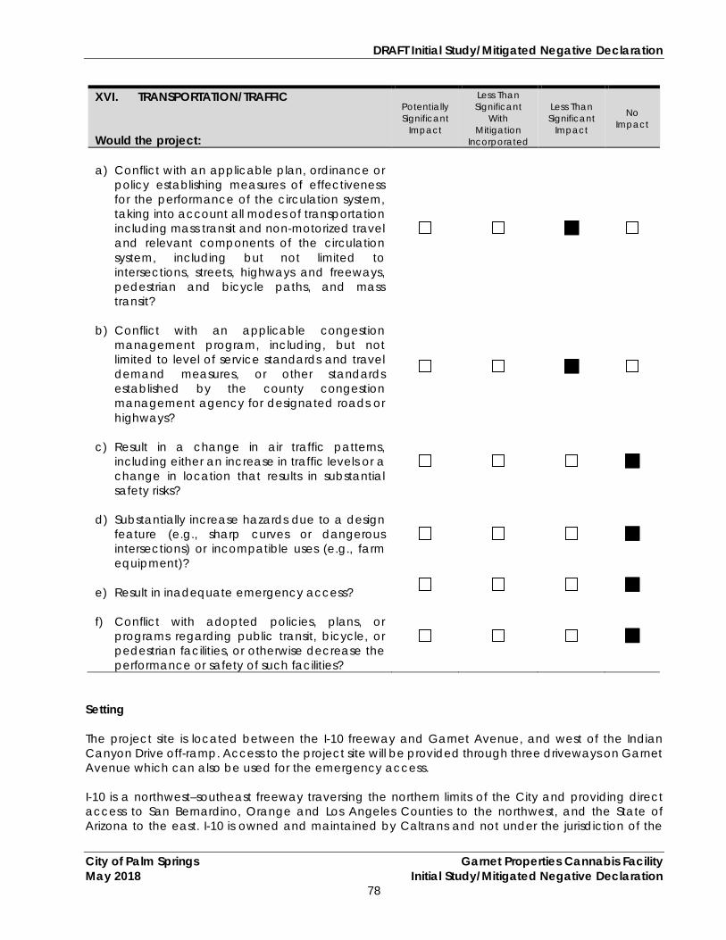
DRAFT Initial Study/Mitigated Negative Declaration
City of Palm Springs Garnet Properties Cannabis Facility May 2018 Initial Study/Mitigated Negative Declaration
78
XVI. TRANSPORTATION/TRAFFIC Would the project:
Potentially Significant
Impact
Less Than Significant
With Mitigation
Incorporated
Less Than Significant
Impact
No Impact
a) Conflict with an applicable plan, ordinance or
policy establishing measures of effectiveness for the performance of the circulation system, taking into account all modes of transportation including mass transit and non-motorized travel and relevant components of the circulation system, including but not limited to intersections, streets, highways and freeways, pedestrian and bicycle paths, and mass transit?
b) Conflict with an applicable congestion
management program, including, but not limited to level of service standards and travel demand measures, or other standards established by the county congestion management agency for designated roads or highways?
c) Result in a change in air traffic patterns,
including either an increase in traffic levels or a change in location that results in substantial safety risks?
d) Substantially increase hazards due to a design
feature (e.g., sharp curves or dangerous intersections) or incompatible uses (e.g., farm equipment)?
e) Result in inadequate emergency access?
f) Conflict with adopted policies, plans, or
programs regarding public transit, bicycle, or pedestrian facilities, or otherwise decrease the performance or safety of such facilities?
Setting The project site is located between the I-10 freeway and Garnet Avenue, and west of the Indian Canyon Drive off-ramp. Access to the project site will be provided through three driveways on Garnet Avenue which can also be used for the emergency access. I-10 is a northwest–southeast freeway traversing the northern limits of the City and providing direct access to San Bernardino, Orange and Los Angeles Counties to the northwest, and the State of Arizona to the east. I-10 is owned and maintained by Caltrans and not under the jurisdiction of the

DRAFT Initial Study/Mitigated Negative Declaration
City of Palm Springs Garnet Properties Cannabis Facility May 2018 Initial Study/Mitigated Negative Declaration
79
City. I-10 is comprised of four general-purpose lanes in each direction for its entire length through the City, approximately seven miles. I-10 has four interchanges within the City limits, at SR-111, Whitewater Canyon Road, Indian Canyon Drive, and Gene Autry Trail. Access is strictly controlled at grade-separated crossings to assure uninterrupted traffic flow. North Indian Canyon Drive and Garnet Avenue are designated “Major Thoroughfare (4 – lane divided)” and “Secondary Thoroughfare (4 – lane undivided),” respectively in the City’s Circulation Element. The City has established a goal for Garnet Avenue and North Indian Canyon Drive intersection operations of Level of Service (LOS) D or better, and roadway link segment operations of LOS C or better. Urban Crossroads prepared a “Garnet Properties Project Trip Generation Evaluation” for the proposed project in April 2018. The traffic analysis was based upon a variety of sources, including the General Plan Circulation Element, the Institute of Transportation Engineers’ 10th Edition Trip Generation Manual (2017), existing and proposed Land Use Trip Generation scenarios, and is discussed below. Discussion of Impacts a, b) Less Than Significant Impact.
Existing Traffic Conditions The site is currently undeveloped. Existing roadways in the vicinity of the project site include Garnet Avenue and North Indian Canyon Drive. Indian Canyon Drive (south of I-10) is predicted to carry 25,800 (avg.) vehicles per day.
Project Trip Generation Vehicle trip rates were derived from the Institute of Transportation Engineers (ITE) 10th Edition Trip Generation, an ITE Informational Report. For analysis purposes, the Nursery (Wholesale) (ITE Land Use Code 220) and Marijuana Dispensary (ITE Land Use Code 882) trip rates are used to define the proposed project which is anticipated to generate a net total of 1,014 trip-ends per day which includes 40 AM peak hour trips and 82 PM peak hour trips. The proposed project is anticipated to generate less than 100 trips during either AM or PM peak hours as shown below.
Table 5
Project Trip Generation Summary Land Use ITE Units AM Peak Hour PM Peak Hour Daily
In Out Total In Out Total Project Trip Generation Rates
Nursery (Wholesale)
818 AC 0.13 0.13 0.26 0.23 0.22 0.45 19.50
Marijuana Dispensary
882 TSF 5.85 4.59 10.44 10.92 10.92 21.83 252.70
Land Use Quantity Units AM Peak Hour PM Peak Hour Daily
In Out Total In Out Total Project Trip Generation
Cultivation Center
4.73 AC 1 1 2 1 1 2 92
Dispensary 3.650 TSF 21 17 38 40 40 80 922 22 18 40 41 41 82 1,014
Overall, the proposed project is expected to have less than significant impacts on traffic flows and Level of Service ratings.

DRAFT Initial Study/Mitigated Negative Declaration
City of Palm Springs Garnet Properties Cannabis Facility May 2018 Initial Study/Mitigated Negative Declaration
80
c) No Impact. The Palm Springs International Airport is located approximately 4.47 miles southeast of the subject property. The development of the proposed project will have no impact on the facilities or operations of regional airports, and will not result in a change in air traffic patterns, including an increase in traffic levels. It will also not create substantial safety risks. No project related impact is anticipated.
d) No Impact. The project site will be accessed through three main entrances on Garnet Avenue
which will be designed and developed in accordance with City design guidelines and will not increase hazards due to a design feature. The project’s access points have been designed with adequate sight distances. No impact is anticipated.
e) No Impact. Access to the project site will be provided through Garnet Avenue. Regional
access to the project site will be provided via the1-10 freeway, major arterials, secondary arterials and a variety of local roads.
Prior to construction, both the Fire Department and Police Department will review the project site plan to ensure safety measures are addressed, including emergency access. Therefore, the proposed project will not result in inadequate emergency access.
f) No Impact. Based on the Active Transportation Plan, prepared by the Coachella Valley
Association of Governments (CVAG), bike lanes or any other facilities do not exist along Garnet Avenue. However, bicycle facilities are proposed along Garnet Avenue in CVAG’s Active Transportation Plan.
SunLine Transit Agency provides bus transit services to the Coachella Valley, including the City of Palm Springs. The northern portion of the City including the project site is not currently served by SunLine. The nearest bus stop (Stop ID: 411) is approximately 2.89 miles southeast of the site which runs along North Indian Canyon Drive. The project area is not currently served by SunLine along Garnet Avenue or I-10. Therefore, future employees and/or visitors would have no access to SunLine bus service close to the project site.
The proposed project will not conflict with adopted policies, plans, or programs regarding public transit, bicycle, or pedestrian facilities, or otherwise decrease the performance or safety of such facilities. No project related impact is anticipated.
Mitigation Measures: None required. Monitoring: None required. Sources: Palm Springs General Plan 2007; “Garnet Properties Project Trip Generation Evaluation,” prepared by URBAN Crossroads in April 2018; Active Transportation Plan (ATP) 2016 by CVAG.

DRAFT Initial Study/Mitigated Negative Declaration
City of Palm Springs Garnet Properties Cannabis Facility May 2018 Initial Study/Mitigated Negative Declaration
81
XVII. TRIBAL CULTURAL RESOURCES Would the project cause a substantial adverse change in the significance of a tribal cultural resource, defined in Public Resources Code section 21074 as either a site, feature, place, cultural landscape that is geographically defined in terms of the size and scope of the landscape, sacred place, or object with cultural value to a California Native American tribe, and that is:
Potentially Significant
Impact
Less Than Significant
With Mitigation
Incorporated
Less Than Significant
Impact
No Impact
a) Listed or eligible for listing in the California
Register of Historical Resources, or in a local register of historical resources as defined in Public Resources Code section 5020.1(k), or
b) A resource determined by the lead agency, in
its discretion and supported by substantial evidence, to be significant pursuant to criteria set forth in subdivision (c) of Public Resources Code Section 5024.1. In applying the criteria set forth in subdivision (c) of Public Resources Code Section 5024.1, the lead agency shall consider the significance of the resource to a California Native American tribe.
Setting The proposed project is located in the Coachella Valley which is the traditional home of the Cahuilla Indians. The Cahuilla Indians lived in the valley for centuries and they had many villages throughout the Valley. Today, Cahuilla Indians have various reservations throughout the valley and Native Americans of Pass or Desert Cahuilla heritage are mostly affiliated with one or more of the Indian reservations in and near the Coachella Valley, including the Agua Caliente Band, Cahuilla Band, Morongo Band, Augustine Band, and Twenty-Nine Palms Band. Discussion of Impacts a, b) Less Than Significant Impact. As described in Section V, Cultural Resources, based on the
historical data sources, the earliest development activities in or near the project area occurred since 1850. No man-made features of any kind were known to be present on the project site.
As recommended by the Native American Heritage Commission (NAHC), CRM TECH
contacted seventeen (17) tribal representatives in the region in writing on April 3rd, 2018. Furthermore, CRM TECH sent written requests for comments to thirteen (13) tribes. Till date, only four representatives (Victoria Martin from the Augustine Band of Cahuilla Indians, Judy Stapp from the Cabazon Band of Mission Indians, Bobby Ray Esparza from the Cahuilla Band of Indians, and Raymond Huaute from the Morongo Band of Mission Indians) responded to CRM Tech’s correspondence in writing. Three tribes (Cahuilla Band of Indians, Augustine Band of Cahuilla Indians, and Morongo Band of Mission Indians) have mentioned their concerns due to the presence of Cahuilla traditional land use area Morongo traditional use area and their responses are summarized in the Section V (Cultural Resource) above in this document.
DRAFT Initial Study/Mitigated Negative Declaration
City of Palm Springs Garnet Properties Cannabis Facility May 2018 Initial Study/Mitigated Negative Declaration
82
Overall, based on the EIC records search, historical background research, field survey, and consultation responses, no historical or archaeological resources were identified on the project sites that would be listed or eligible for listing in the California Register of Historical Resources, or in a local register of historical resources as defined in Public Resources Code section 5020.1(k). However, due to the traditional land use and cultural ties of the project area, the project site is a sensitive area and potentially contains sub-surface archaeological resources.
To ensure the proper identification of potential “tribal cultural resources,” the City is currently conducting AB 52 consultation. Once responses are received, the City will include the tribal requirements and conditions in the project. In addition, mitigation measures and a monitoring program are included in the Cultural Resource Section, above, to mitigate the potential impacts to less than significant levels, consistent with the findings of the cultural resource investigation, and the concerns of the Cahuilla, Augustine, and Morongo bands. With implementation of these mitigation measures, impacts associated with archaeological resources will be reduced to less than significant levels.
Mitigation Measures: See Section V, Cultural Resources. Monitoring: See Section V, Cultural Resources Sources: City of Palm Springs General Plan, 2007; “Historical/Archaeological Resources Survey Report,” prepared by CRM TECH on May 7, 2018.

DRAFT Initial Study/Mitigated Negative Declaration
City of Palm Springs Garnet Properties Cannabis Facility May 2018 Initial Study/Mitigated Negative Declaration
83
XVIII. UTILITIES AND SERVICE SYSTEMS Would the project:
Potentially Significant
Impact
Less Than Significant
With Mitigation
Incorporated
Less Than Significant
Impact
No Impact
a) Exceed wastewater treatment requirements of
the applicable Regional Water Quality Control Board?
b) Require or result in the construction of new
water or wastewater treatment facilities or expansion of existing facilities, the construction of which could cause significant environmental effects?
c) Require or result in the construction of new
storm water drainage facilities or expansion of existing facilities, the construction of which could cause significant environmental effects?
d) Have sufficient water supplies available to
serve the project from existing entitlements and resources, or are new or expanded entitlements needed?
e) Result in a determination by the wastewater
treatment provider which serves or may serve the project that it has adequate capacity to serve the project’s projected demand in addition to the provider’s existing commitments?
f) Be served by a landfill with sufficient permitted
capacity to accommodate the project’s solid waste disposal needs?
g) Comply with federal, state, and local statutes
and regulations related to solid waste?
Setting Wastewater Treatment Mission Springs Water District (MSWD) provides water and sewer services throughout the northern portion of the Coachella Valley which includes Desert Hot Springs, West Garnet, North Palm Springs, and various portions of unincorporated Riverside County. The subject site is located within the MSWD sewer boundary (MSWD Wastewater Master Plan; Figure 2.10 Proposed Interceptors and Existing Pipe Replacement). Currently, there is not sanitary sewer services in the project vicinity and the City and MSWD do not have any plan to extend the sewer services in that area in immediate future.

DRAFT Initial Study/Mitigated Negative Declaration
City of Palm Springs Garnet Properties Cannabis Facility May 2018 Initial Study/Mitigated Negative Declaration
84
Domestic Water The project site is located within the MSWD boundaries for domestic water services. Its primary source of water is local groundwater extracted by deep wells from the Upper Coachella Valley groundwater basin. The reliability of the MSWD’s water supply is dependent on the reliability of groundwater supplies, supplemented by imported surface water used for groundwater replenishment and the planned implementation of recycled water supply. MSWD as an urban water supplier, is required to prepare an “Urban Water Management Plan (UWMP)” every five years in response to the requirements of the Urban Water Management Planning Act (UWMP Act), California Water Code Sections 10610 through 10656. MSWD’s UWMP is a planning tool that documents actions in support of long-term water resources planning and ensures adequate water supplies are available to meet existing and future urban water demands. In addition to its UWMP, MSWD provides water conservation measures and ordinances to reduce water consumption. The proposed project will be required to implement all water conservation measures imposed by MSWD under both normal and drought conditions over the life of the project. The proposed project will tie into existing 18" public water lines beneath Garnet Avenue. No new wells or additional water infrastructure or entitlements will be required. Flood Management The City is susceptible to flash flooding, since the local mountains are very steep and consist of rock types that are fairly impervious. Portions of the City are susceptible to storm-induced flooding of the Whitewater River and other drainages that extend across the City. In 1982, the “Palm Spring Master Drainage Plan” was prepared to better manage the storm water runoff in the City. Currently, there are several major flood control facilities (e.g. Palm Canyon Levees, Whitewater River Levee, Baristo Channel, Tachevah Dam and outlet Drain, Tahquitz Creek Channel, Chino Canyon Levee and Cathedral Canyon Channel) within the city. The Riverside County Flood Control and Water Conservation District (RCFCWCD) build and maintain regional flood-control structures within the City. The City is responsible for local facilities. The City requires on-site detention and/or retention basins for all new developments to manage surface water flows and reduce runoff from sources such as stormwater and landscape irrigation. A “Preliminary Hydrology Report” and “Preliminary Water Quality Management Plan” were prepared for the subject site in June 2017. Solid Waste Solid waste disposal is provided in the City by Palm Springs Disposal Service (PSDS) under a franchise agreement with the City. PSDS collects solid waste and transports it to the Edom Hill Transfer Station, located in the City of Cathedral City. From Edom Hill, waste is trucked to Lamb Canyon Sanitary Landfill in Beaumont or Badlands Landfill in Moreno Valley. These landfills are owned and operated by Riverside County. These landfills have a combined capacity of up to 66,601,993 cubic yards. Discussion of Impacts a), e) Less Than Significant Impact. As discussed above, the subjects site is located in northern Palm
Springs which is served by Mission Springs Water District (MSWD). The MSWD treats and recycles wastewater at two wastewater treatment plants (Horton Wastewater Treatment Plant (HWWTP) and Desert Crest Wastewater Treatment Plant (DCWWTP) within its service area. The
DRAFT Initial Study/Mitigated Negative Declaration
City of Palm Springs Garnet Properties Cannabis Facility May 2018 Initial Study/Mitigated Negative Declaration
85
Horton Wastewater Treatment Plant (Horton WWTP), located on Verbena Drive about a half mile south of Two Bunch Palms Trail, has a capacity of 2.3 million gallons per day (mgd). The Desert Crest Wastewater Treatment Plant, located about a half mile southeast of the intersection of Dillion Road and Long Canyon Road, has a capacity of 0.18 mgd and serves a country club development and mobile home park. According to the MSWD Wastewater Master Plan (2007), the district is planning to expand the HWWTP up to 3.8 mgd.
MSWD is working to open a new Regional Wastewater Treatment Plant (RWWTP) in the City of Desert Hot Springs, which will be located near I-10. The I-10 and Indian area will ultimately be served by this new regional wastewater treatment facility. According to MSWD, the first phase of the plant will process about 1.5 million gallons of wastewater per day and will include the construction of an interceptor and collection system to bring flows from areas now utilizing septic tanks. The plant will also provide close access to wastewater treatment for the I-10/Indian Canyon commercial area which includes properties within the cities of Palm Springs and Desert Hot Springs.
There is no sanitary sewer services in the project vicinity currently. The project will be connected to a public sewer system once available. Until that time an on-site sanitary sewer system is proposed for the project site, which will consist of interlinked clarifiers, holding tanks, and connecting pipes. Clarifiers will collect flows from the floor drains. Sanitary sewer will be transferred to holding tanks from where the waste will be evacuated two to three times a week. Clarifiers would be discharged to holding tanks if they meet certain standards.
The project’s sanitary sewer system will be subject to MSWD’s wastewater standards. Generally, waste discharges from cultivation sites include sediment, irrigation runoff, fertilizers, pesticides/herbicides, petroleum, agricultural related chemicals, cultivation related waste, refuse, and human waste. To protect subsurface water reservoirs from potential contamination, water Code section 13149 required the State Water Board to adopt principles and guidelines for diversion and use of water for cannabis cultivation in areas where cannabis cultivation may have the potential to substantially affect instream flows (directly or indirectly). All indoor and outdoor cannabis activities that discharge all their industrial wastewater generated to a community sewer system or discharge irrigation tailwater or hydroponic wastewater to an on-site wastewater treatment system must obtain regulatory authorization for the wastewater discharge.
According to the State Water Resources Control Board Order WQ 2017-0023-DWQ, installation of a septic system, including its use, sizing and placement, will be subject to review and approval by the County of Riverside Department of Environmental Health (DEH), Regional Water Quality Control Board, and City of Palm Springs in addition to MSWD standards.
As the project will be required to comply with the regulations mentioned above, the project is expected to result in less than significant impact related to the septic tank installation, application, and other maintenance activities.
b, d) Less Than Significant Impact. The proposed project will require water for cultivation and
landscape irrigation for the project. As discussed in Section IX, Hydrology and Water Quality, the total water demand for the project would be 21.23 acre-feet per year. According to MSWD’s latest Urban Water Management Plan (2015), approximately 5.80 million acre-feet of water is stored in the Mission Creek, San Gorgonio Pass Subbasin, Garnet Hill Subbasin which are the main groundwater sources for the District, and the proposed project's water demand will be less than 1% of MSWD's groundwater supplies. Therefore, project impacts associated with domestic water demand are expected to be less than significant.

DRAFT Initial Study/Mitigated Negative Declaration
City of Palm Springs Garnet Properties Cannabis Facility May 2018 Initial Study/Mitigated Negative Declaration
86
The proposed project will be required to implement all water conservation measures imposed by MSWD under both normal and drought conditions over the life of the project.
The proposed project will tie into existing domestic water lines beneath Garnet Avenue. No new wells or additional water infrastructure or entitlements will be required.
c) Less Than Significant Impact.
Offsite Flood Flows and Existing Drainages: The subject site is located south of I-10 freeway within the boundaries of the City of Palm Springs. During storm event, runoff from the north of I-10, Mission Creek, Long Canyon, and West Wide Canyon flows to form Morongo Wash. The wash flows due south and crosses I-10 and the railroad right of way, through three bridges and some small culverts, where most of the flows join the Whitewater River.
Although the project site is not located within the flood zone, offsite flood flows from the north side of I-10 and runoff from the eastbound lanes of I-10 pass through the subject property through an existing ribbon gutter and paved drainage channel. The drainage channel is located in the western portion of the site, between parcels 666-430-002 and -005 and -004 and -012, starts from the I-10 westbound lanes and drains into an existing storm drain catch basin, located south of parcel 666-430-001 along Garnet Avenue. A triangle shaped retention basin is also constructed between the two I-10 on and off ramps to catch runoff from I-10.
At buildout, offsite flood flows from the north side of I-10 and runoff from the eastbound lanes of I-10 will be allowed to pass through the project site, utilizing the existing drainage easement that runs through the project on the west side of the on and off-ramps, as they do in the current condition.
On-Site Flows: The proposed project will be required to contain the 100-year storm on-site, as required by City standards. The site is divided into three drainage areas. The drainage system will be designed to drain into three on-site underground storage facilities which will have sufficient capacity to accommodate on-site runoff. Please also see Section IX., Hydrology and Water Resources for a comprehensive description of the drainage system for the site. The drainage system will be reviewed and approved by the City Engineer to assure that it meets City standards. These standards and requirements will assure that impacts associated with storm water management will be less than significant.
f, g) Less Than Significant Impact. Palm Springs Disposal Service (PSDS) provides solid waste disposal services to the City including the project site. PSDS collects solid waste from its service area and transfers it to the Edom Hill Transfer Station (Cathedral City). Edom Hill is permitted to receive 2,600 tons of waste per day as a transfer station. From Edom Hill, waste is trucked to Lamb Canyon Sanitary Landfill in Beaumont or Badlands Landfill in Moreno Valley. These landfills are owned and operated by Riverside County. These landfills have a combined capacity of up to 66,601,993 cubic yards which is enough to accommodate project’s solid waste.
PSDS is also required to comply with local, regional and state requirements associated with solid waste disposal. Impacts will be less than significant.
Mitigation Measures: None required.
Monitoring: None required. Sources: Palm Springs General Plan 2007; Palm Springs Disposal Website.

DRAFT Initial Study/Mitigated Negative Declaration
City of Palm Springs Garnet Properties Cannabis Facility May 2018 Initial Study/Mitigated Negative Declaration
87
XIX. MANDATORY FINDINGS OF SIGNIFICANCE NOTE: If there are significant environmental impacts which cannot be mitigated and no feasible project alternatives are available, then complete the mandatory findings of significance and attach to this initial study as an appendix. This is the first step for starting the environmental impact report (EIR) process.
Does the project:
Potentially Significant
Impact
Less Than Significant
With Mitigation
Incorporated
Less Than Significant
Impact
No Impact
a) Does the project have the potential to
degrade the quality of the environment, substantially reduce the habitat of a fish or wildlife species, cause a fish or wildlife population to drop below self-sustaining levels, threaten to eliminate a plant or animal community, reduce the number or restrict the range of a rare or endangered plant or animal or eliminate important examples of the major periods of California history or prehistory?
b) Does the project have impacts that are
individually limited, but cumulatively considerable? (“Cumulatively considerable” means that the incremental effects of a project are considerable when viewed in connection with the effects of past projects, the effects of other current projects, and the effects of probable future projects)?
c) Does the project have environmental effects,
which will cause substantial adverse effects on human beings, either directly or indirectly?
a) Less Than Significant Impact with Mitigation Incorporated:
Biological Resources The project site is not located within the boundaries of a CVMSHCP-designated conservation area and does not contain any wildlife corridors or biological linkage areas. However, onsite vegetation on the project site could provide habitat for nesting birds, therefore, a pre-construction survey will be required to avoid impacts to nesting birds covered by the MBTA. In addition, the site is subject to payment of the Development Mitigation Fee to mitigate potential impacts to covered species under the CVMSHCP.
The proposed project will not significantly reduce fish or wildlife habitat or otherwise adversely impact a fish or wildlife species. The construction of the project has the potential to impact nesting birds, but the mitigation measures included in this document will reduce those impacts to less than significant levels.

DRAFT Initial Study/Mitigated Negative Declaration
City of Palm Springs Garnet Properties Cannabis Facility May 2018 Initial Study/Mitigated Negative Declaration
88
Cultural Resources The project site lies within the traditional land use area of local Native American tribes, but has a low probability of containing archaeological resources. There are no historic structures on site which represent a major period of California history or prehistory. The potential exists that resources could be uncovered during site grading, which could result in a significant impact to archaeological resources. The mitigation measures in this document, however, will reduce these impacts to less than significant levels.
b) Less Than Significant Impact. A significant impact could occur if the proposed project, in
conjunction with related projects, would result in impacts that would be less than significant when viewed separately, but would be significant when viewed together. The impacts of the proposed project are individually limited and not cumulatively considerable. All environmental impacts that could occur as a result of the proposed project would be less than significant, and when viewed in conjunction with other closely related past, present or reasonably foreseeable future projects, would not be significant.
c) Less Than Significant Impact. The proposed project will not have environmental effects which
will cause substantial adverse effects on human beings, either directly or indirectly, with the implementation of the City’s Municipal Code contained in this report to attenuate construction noise. All potential impacts are expected to remain at less than significant levels.

DRAFT Initial Study/Mitigated Negative Declaration
City of Palm Springs Garnet Properties Cannabis Facility May 2018 Initial Study/Mitigated Negative Declaration
89
References I. AESTHETICS Source: Palm Springs General Plan, 2007; Palm Springs Zoning Ordinance; Project materials. II. AGRICULTURE RESOURCES Source: Palm Springs General Plan, 2007; Zoning Map for the Palm Springs; “Riverside County Important Farmland 2010 Map,” sheet 2 of 3, California Department of Conservation, published January 2012. III. AIR QUALITY Source: “Final 2016 Air Quality Management Plan,” prepared by South Coast Air Quality Management District, March 2017; “Final Localized Significance Threshold Methodology,” prepared by the South Coast Air Quality Management District, Revised, July 2008; “2003 Coachella Valley PM10 State Implementation Plan,” August 1, 2003; CalEEMod Version 2016.3.1; Municipal Code 5.45.200 (Commercial Medical Cannabis Operating Requirements). IV. BIOLOGICAL RESOURCES Source: “Coachella Valley Multiple Species Habitat Conservation Plan,” 2007; Palm Springs General Plan, 2007; Biological Resources Assessment and Coachella Valley Multiple Species Habitat Conservation Plan Compliance Report,” prepared by Amec Foster Wheeler Environment & Infrastructure, Inc. in April 27, 2018. V. CULTURAL RESOURCES Source: City of Palm Springs General Plan, 2007; “Historical/Archaeological Resources Survey Report,” prepared by CRM TECH on May 7, 2018. VI. GEOLOGY AND SOILS Source: Palm Springs General Plan, 2007; “Soil Survey of Riverside County, California, Coachella Valley Area,” U.S. Department of Agriculture Soil Conservation Service, 1980; Custom Soil Resource Report for Garnet Properties Cannabis Facility prepared by Terra Nova in April 2018; Holocene geologic slip rate for the Banning strand of the southern San Andreas Fault, southern California by Gold P. et al. (2015); State Water Resources Control Board Order WQ 2017-0023-DWQ General Waste Discharge Requirements And Waiver Of Waste Discharge Requirements For Discharges Of Waste Associated With Cannabis Cultivation Activities (2017); Communication with the City’s engineer (April 24th) and MSWD representative (April 26th). VII. GREENHOUSE GAS EMISSIONS Source: Palm Springs Climate Action Plan (2013); California Global Warming Solutions Act; CalEEMod Version 2016.3.1; Palm Springs General Plan, 2007; Climate Action Plan.

DRAFT Initial Study/Mitigated Negative Declaration
City of Palm Springs Garnet Properties Cannabis Facility May 2018 Initial Study/Mitigated Negative Declaration
90
VIII. HAZARDS AND HAZARDOUS MATERIALS Source: Palm Springs General Plan, 2007; California Department of Toxic Substances Control, Accessed in May 2018; “Riverside County Airport Land Use Compatibility Plan Policy Document,” March 2005. IX. HYDROLOGY AND WATER QUALITY Source: City of Palm Springs General Plan, 2007; Desert Water Agency (DWA) 2015 Urban Water Management Plan; Flood Insurance Rate Map #06065C0895G, Federal Emergency Management Agency, August 28, 2008; Draft Cannabis Cultivation Policy - Principles and Guidelines for Cannabis Cultivation, prepared by State Water Resources Control Board (July 2017); MSWD 2015 Urban Water Management Plan; MSWD website – wastewater; MSWD 2007 Wastewater System Comprehensive Master Plan; State Water Resources Control Board Order - WQ 2017-0023-DWQ (General Waste Discharge Requirements and Waiver Of Waste Discharge Requirements for Discharges of Waste Associated with Cannabis Cultivation Activities. X. LAND USE AND PLANNING Source: Palm Springs General Plan 2007; Ordinance No. 1933 and 1935. XI. MINERAL RESOURCES Source: Palm Springs General Plan, 2007. XII. NOISE Source: Palm Springs General Plan, 2007. XIII. POPULATION AND HOUSING Source: Palm Springs General Plan 2007; Project’s Preliminary Master Water and Sewer Layout; 2016-2040 RTP SCS by Southern California Association of Governments (Appendix – Demographics and Growth Forecast). XIV. PUBLIC SERVICES Source: Palm Springs Fire Department; “Palm Springs Fire Department Service Report, 2013”: Tables 5-1 and 5-3, Palm Springs General Plan, 2007; “Palm Springs Parks and Recreation Master Plan Draft,” March 2014; Palm Springs Unified School District representative conservation regarding the Impact Fee (#760-883-2700); Cannabis Facility General Fire Code Requirements, http://www.palmspringsca.gov/government/departments/fire-department/fire-prevention/fire-department-regulations, Accessed April 2018. XV. RECREATION Source: Palm Springs General Plan, 2007.

DRAFT Initial Study/Mitigated Negative Declaration
City of Palm Springs Garnet Properties Cannabis Facility May 2018 Initial Study/Mitigated Negative Declaration
91
XVI. TRANSPORTATION/TRAFFIC Source: Palm Springs General Plan 2007; “Garnet Properties Project Trip Generation Evaluation,” prepared by URBAN Crossroads in April 2018; Active Transportation Plan (ATP) 2016 by CVAG. XVII. TRIBAL CULTURAL RESOURCES Source: City of Palm Springs General Plan, 2007; “Historical/Archaeological Resources Survey Report,” prepared by CRM TECH on May 7, 2018. XVIII. UTILITIES AND SERVICE SYSTEMS Source: Palm Springs General Plan 2007; Palm Springs Disposal Website.

DRAFT Initial Study/Mitigated Negative Declaration
City of Palm Springs Garnet Properties Cannabis Facility May 2018 Initial Study/Mitigated Negative Declaration
92
Appendix A
CalEEMOD Air Quality and GHG Modeling (Available for review at City Hall)

DRAFT Initial Study/Mitigated Negative Declaration
City of Palm Springs Garnet Properties Cannabis Facility May 2018 Initial Study/Mitigated Negative Declaration
93
Appendix B Cultural Report
(Available for review at City Hall)

DRAFT Initial Study/Mitigated Negative Declaration
City of Palm Springs Garnet Properties Cannabis Facility May 2018 Initial Study/Mitigated Negative Declaration
94
Appendix C Bio Report
(Available for review at City Hall)

DRAFT Initial Study/Mitigated Negative Declaration
City of Palm Springs Garnet Properties Cannabis Facility May 2018 Initial Study/Mitigated Negative Declaration
95
Appendix D Soil Report
(Available for review at City Hall)

DRAFT Initial Study/Mitigated Negative Declaration
City of Palm Springs Garnet Properties Cannabis Facility May 2018 Initial Study/Mitigated Negative Declaration
96
Appendix E Traffic Report
(Available for review at City Hall)