INITIAL STUDY / MITIGATED NEGATIVE DECLARATION · PDF filestate water resources control board...
53
STATE WATER RESOURCES CONTROL BOARD DIVISION OF WATER RIGHTS P.O. BOX 2000 SACRAMENTO, CA 95812-2000 INITIAL STUDY / MITIGATED NEGATIVE DECLARATION I. BACKGROUND PROJECT TITLE: Cakebread Vineyards Water Right Project APPLICATION: 31133 APPLICANT: Cakebread Vineyards, LLC c/o Bruce Cakebread P.O. Box 216 Rutherford, CA 94573 APPLICANT’S CONTACT PERSON: Paula Whealen Wagner & Bonsignore 444 North Third Street, Suite 325 Sacramento, CA 95811 GENERAL PLAN DESIGNATION: Agricultural Lands ZONING: Agricultural District Introduction The Cakebread Vineyards property (project site) consists of 62 acres immediately north of Boonville off Highway 128 in Mendocino County, California (Figure 1). The project site is located within Section 2, Township 13N, Range 14W of the “Boonville, California” U.S. Geological Survey (USGS) 7.5 minute topographic quadrangle (Figure 2). Water Right Application 31133 was filed with the State Water Resources Control Board (State Water Board), Division of Water Rights (Division) on January 30, 2001. Application 31133 proposes the diversion to storage of 49 acre-feet per annum (afa). Project Description Application 31133 proposes to divert 49 acre-feet (af) of water from December 15 to March 31. Water would be diverted from Anderson Creek, a tributary to the Navarro River, via an offset well at a rate of up to 2.9 cubic feet per second (cfs) (Table 1, Table 2 and Figure 3). Water would be stored in an existing offstream pit-type reservoir with a capacity of 49 af. Water would be used for purposes of irrigation, frost protection, and heat control of 47 acres of existing vineyard (Table 3), as well as fire protection and incidental recreational use at the reservoir. A copy of the water right Application is on file with the Division.
Transcript of INITIAL STUDY / MITIGATED NEGATIVE DECLARATION · PDF filestate water resources control board...
STATE WATER RESOURCES CONTROL BOARD DIVISION OF WATER RIGHTS
P.O. BOX 2000 SACRAMENTO, CA 95812-2000
INITIAL STUDY /
MITIGATED NEGATIVE DECLARATION
I. BACKGROUND PROJECT TITLE: Cakebread Vineyards Water Right Project APPLICATION: 31133 APPLICANT: Cakebread Vineyards, LLC
c/o Bruce Cakebread P.O. Box 216 Rutherford, CA 94573
APPLICANT’S CONTACT PERSON: Paula Whealen Wagner & Bonsignore 444 North Third Street, Suite 325 Sacramento, CA 95811 GENERAL PLAN DESIGNATION: Agricultural Lands ZONING: Agricultural District
Introduction The Cakebread Vineyards property (project site) consists of 62 acres immediately north of Boonville off Highway 128 in Mendocino County, California (Figure 1). The project site is located within Section 2, Township 13N, Range 14W of the “Boonville, California” U.S. Geological Survey (USGS) 7.5 minute topographic quadrangle (Figure 2). Water Right Application 31133 was filed with the State Water Resources Control Board (State Water Board), Division of Water Rights (Division) on January 30, 2001. Application 31133 proposes the diversion to storage of 49 acre-feet per annum (afa).
Project Description
Application 31133 proposes to divert 49 acre-feet (af) of water from December 15 to March 31. Water would be diverted from Anderson Creek, a tributary to the Navarro River, via an offset well at a rate of up to 2.9 cubic feet per second (cfs) (Table 1, Table 2 and Figure 3). Water would be stored in an existing offstream pit-type reservoir with a capacity of 49 af. Water would be used for purposes of irrigation, frost protection, and heat control of 47 acres of existing vineyard (Table 3), as well as fire protection and incidental recreational use at the reservoir. A copy of the water right Application is on file with the Division.

Cakebread Vineyards Water Right Application 31133 / 203509
Figure 1Regional Location
SOURCE: Microsoft Street & Trips, 2004; AES, 2007
PROJECT SITE
MENDOCINOCOUNTY
SCALE
NORTH
0 3mi 6mi
PROJECTSITE

128
Cakebread Vineyards Water Right Application 31133 / 203509
Figure 2Site and Vicinity
SOURCE: "Boonville, CA" and "Philo, CA" USGS 7.5 Minute Quadrangle, Section 2, T13N, R14W, Section 2, Mt. Diablo Baseline & Meridian; AES 208
0 750 1,500
Feet
SCALE
PROPERTYBOUNDARY

128
ANDERSON CREEK
DO
NELLY C
REE
K
Cakebread Vineyards Water Right Application 31133 / 203509
Figure 3Project Components
SOURCE: GlobeExplorer, 2004; AES, 2007
0 175 350
Feet
LEGEND
Property Boundary
Point of Diversion
Buried Pipe
Existing Reservoir
Propsed Place of Use, Existing Vineyard
Class I, Perennial Stream
Class I, Intermittent Stream

January 2009 5 Cakebread Vineyards Water Right Application 31133 Initial Study/Mitigated Negative Declaration
TABLE 1 - PROPOSED PROJECT1
Application Diversion Diversion Amount (acre-feet)
Diversion Season Purposes of Use
Proposed Place of Use
(acres)
31133 To Storage 49 December 15 to March 31
Irrigation, frost protection, heat control, fire
protection and incidental recreation
47
TABLE 2 - POINT OF DIVERSION2
POD Location Within Section Township Range B & M
1 Anderson Creek tributary to the Navarro River SW ¼ of NE ¼ 2 13N 14W MD
TABLE 3 - PROPOSED PLACE OF USE3
Use Within Section Township Range B & M Acres NE ¼ of SW ¼ 2 13N 14W MD 1 NW ¼ of NE ¼ 2 13N 14W MD 12 SW ¼ of NE ¼ 2 13N 14W MD 30 SE ¼ of NW ¼ 2 13N 14W MD 4
Total: 47
Project Background and Environmental Setting For over 50 years the project site was cultivated as an apple orchard. The reservoir was built on the northern portion of the project site in Spring 2001. The 47 acres of vineyard identified as the proposed place of use (POU) were developed in 2002 on land that had been previously developed in orchard. The offset well at the proposed point of diversion (POD) on Anderson Creek and the buried pipeline to the reservoir were also constructed in 2002. A pump has yet to be installed in the offset well, and no water has been diverted from Anderson Creek at the POD. Historically, the orchard was irrigated primarily in the summer months from riparian diversions on Anderson Creek and a groundwater well. The vineyard is currently irrigated with water from the reservoir, which collects water from a sheet-flow and shallow groundwater collection system. Water diverted under Application 31133 is being sought as a supplemental source, which would provide additional operational flexibility for irrigation, frost protection, and heat control of the vineyard. Application 31133 originally proposed a 43-acre POU, which was increased to 47 acres (detailed in Table 3) in an amendment dated July 5, 2001. Application 31133 was noticed for public review on March 7, 2003. Protests were submitted by Jess Jackson, Daniel Myers, Friends of the Navarro Watershed, California Department of Fish and Game (DFG), and National Marine Fisheries Service (NMFS). The protest filed by Jess Jackson was resolved with the Applicant agreeing to a permit term recognizing Mr. Jackson’s prior rights. The four remaining protests have not been resolved. The California Environmental Quality Act (CEQA) baseline for this project is considered to be the conditions that existed on or about January 30, 2001, the date the application to appropriate water was filed with the Division. Figure 4 shows the project site in 1993 and evidence of existing agricultural development (orchards) at this time, well before the CEQA baseline date. Based on Figure 4 and the project history, none of the current project components were

128
ANDERSON CRE EK
DO
NELLY C
RE
EK
Cakebread Vineyards Water Right Application 31133 / 203509
Figure 41993 Aerial
SOURCE: USGS Aerial Photograph, 1993; AES, 2007
LEGEND
0 175 350
Feet
Property Boundary
Point of Diversion
Buried Pipe
Class I, Perennial Stream
Class I, Intermittent Stream
Undeveloped Reservoir
Proposed Place of Use, Orchard

January 2009 7 Cakebread Vineyards Water Right Application 31133 Initial Study/Mitigated Negative Declaration
developed at the CEQA baseline date. This Initial Study/Mitigated Negative Declaration (IS/MND) assesses impacts involved with: the previous conversion of 47 acres of former orchard land to vineyard; the construction of the 49 af capacity offstream reservoir; construction of the offset well and associated pipeline for the POD; the diversion to storage of 49 afa from Anderson Creek; and use of this water on the 47-acre proposed POU. Table 4 provides an overview of project components in relation to the CEQA baseline date.
TABLE 4 - CEQA BASELINE AND PROJECT COMPONENTS Existing Project Components
at CEQA Baseline CEQA Baseline Date Project Components Evaluated in this
IS/MND � Previously farmed land in
the POU (former orchard) January 30, 2001 � 47 acres of existing vineyard
� Existing 49 af offstream reservoir � Existing POD and associated pipeline � Diversion of 49 afa from Anderson Creek
� Use of water on 47-acre proposed POU Review of the project site topography in Figure 2 and land uses in Figure 3 and Figure 4 indicates that development of the vineyard and reservoir involved the conversion of relatively flat former orchard areas; the POD consists of an offset well constructed in a riparian and mixed oak woodland area away from the Anderson Creek channel; and the buried pipe extends from the POD to the reservoir. Elevation at the project site is approximately 400 feet above mean sea level (msl). The project site is located in the North Coast Ranges region of the California Floristic Province on the border between the Outer North Coast Range and Inner North Coast Range subregions, within the California Coast Range geomorphic province. The Outer North Coast Range generally has high rainfall and is dominated by forest habitat. The Inner North Coast Range has relatively low rainfall and typical vegetation communities include chaparral and pine or oak woodlands4. Characteristic vegetation communities occurring in the region include vineyard, annual grassland, California bay forest, oak woodland, mixed evergreen forest, and riparian woodland. Aquatic habitats in the region include the Navarro River and tributary perennial drainages, seasonal drainages, seasonal wetlands, wetland swales, and man-made reservoirs. Environmental information provided with the application indicates that at the time of filing (CEQA baseline), the project site consisted of land previously farmed as orchard, annual grassland, and oak woodland areas. During a 2007 field survey by Analytical Environmental Services (AES) biologists, the project site was determined to consist of vineyard and oak woodland habitats, and ruderal/disturbed areas. Anderson Creek, a perennial stream, and Donelly Creek, an intermittent stream, both flow along the southern portion of the project site. The climate in the area is relatively mild, a result of being moderated by the Pacific Ocean. In Ukiah, approximately 15 miles northeast of the project site, the average low temperature in the winter is 36.4 degrees Fahrenheit, while the average high temperature in the summer is 90.0 degrees Fahrenheit. In Philo, approximately five miles northwest of the project site, precipitation averages about 40.4 inches per year with about 63 percent occurring between December 15 and March 315. The project site is located within the Navarro River watershed, which has been utilized for timber production, livestock grazing, and other agricultural activities since the mid 1800’s. The Navarro River is considered by the U.S. Environmental Protection Agency (USEPA) to be impaired by effects of excessive sediment and high temperatures6. Historically, the Navarro

January 2009 8 Cakebread Vineyards Water Right Application 31133 Initial Study/Mitigated Negative Declaration
River watershed was considered to have high quality and extensive anadromous fish habitat supporting a productive coho salmon and steelhead trout fishery. The sustainability of anadromous fishes in the Navarro River and its tributaries depends upon a variety of factors including habitat conditions, water temperature, gravel substrate, water quality, migration corridors, and habitat availability.
Regulatory Environment The State Water Board is the lead agency under CEQA with the primary authority for project approval. In addition, the following responsible and trustee agencies may have jurisdiction over some or the entire proposed project:
o U. S. Army Corps of Engineers (USACE) – Clean Water Act (CWA) Section 404
Compliance
o U.S. Fish and Wildlife Service (USFWS) – Federal Endangered Species Act (ESA) Compliance
o National Marine Fisheries Service (NMFS) – Federal ESA Compliance
o California Department of Fish and Game (DFG) – California Endangered Species Act (CESA) Compliance, Streambed Alteration Agreement
o North Coast Regional Water Quality Control Board (RWQCB) – Waste Discharge Requirements
II. ENVIRONMENTAL IMPACTS The environmental factors checked below could be potentially affected by this project. See the checklist on the following pages for more details. � Land Use and Planning � Transportation and Circulation � Public Services
� Population and Housing � Biological Resources � Utilities and Service Systems
� Geology and Soils � Mineral Resources � Aesthetics
� Hydrology and Water Quality � Hazards � Cultural Resources
� Air Quality � Noise � Recreation
� Agriculture Resources � Mandatory Findings of Significance
Potentially Significant
Impact
Less Than Significant
With Mitigation
Incorporated
Less Than Significant
Impact
No Impact
1. Geology and Soils. Would the project: a) Expose people or structures to potential substantial
adverse effects, including the risk of loss, injury, or death involving:
� � �
�

January 2009 9 Cakebread Vineyards Water Right Application 31133 Initial Study/Mitigated Negative Declaration
i) Rupture of a known earthquake fault, as delineated in the most recent Alquist-Priolo Earthquake Fault Zoning Map issued by the State Geologist for the area or based on other substantial evidence of a known fault? Refer to Division of Mines & Geology Special Publication 42.
� � � �
ii) Strong seismic ground shaking? � � � � iii) Seismic-related ground failure, including
liquefaction? �
�
�
�
iv) Landslides? � � � � b) Result in substantial soil erosion or the loss of
topsoil? � � � �
c) Be located on a geologic unit or soil that is unstable, or that would become unstable as a result of the project, and potentially result in on- or off-site landslide, lateral spreading, subsidence, liquefaction, or collapse?
� � � �
d) Be located on expansive soils, as defined in Table 18-1-B of the Uniform Building Code (1994), creating substantial risks to life or property?
� � � �
e) Have soils incapable of adequately supporting the use of septic tanks or alternate wastewater disposal systems where sewers are not available for the disposal of wastewater?
� � � �
Mendocino County is located within the California Coast Range geomorphic province. The predominant geologic unit in this area is the Franciscan assemblage, which is highly fractured and deformed by folding, faulting, and metamorphism. This province is one of the more geologically and seismically active portions of the State of California. According to the Mendocino County Soil Survey7, which covers the western portion of the County, the project site contains the following soils and respective characteristics: Boontling loam, 2 to 9 percent slopes (109) This soil is found on stream terraces, and is
somewhat poorly drained with high surface water runoff and a slight erosion hazard.
Cole loam, 0 to 5 percent slopes (127) This soil is found on stream terraces, and is somewhat poorly drained with high surface water runoff and a slight erosion hazard.
Feliz loam, 0 to 5 percent slopes (140) This soil is found on stream terraces, and is well drained with low surface water runoff and a slight erosion hazard.
Pinole loam, 2 to 9 percent slopes (193) This soil is found on stream terraces, and is well drained with high surface water runoff and a slight erosion hazard.
Riverwash (197) This soil is found in channels. Therefore, it is characteristic of the hydrology of the particular

January 2009 10 Cakebread Vineyards Water Right Application 31133 Initial Study/Mitigated Negative Declaration
stream/drainage it is found in.
Talmage gravelly loam, 0 to 2 percent slopes (193)
This soil is found on stream terraces, and is somewhat excessively drained with very low surface water runoff and a slight erosion hazard.
The San Andreas Fault poses the most serious hazard in Mendocino County from fault rupture along its trace and its potential to generate severe ground shaking throughout many portions of the County. This fault line is capable of an estimated magnitude 8.3 earthquake. The recently discovered Maacama Fault may pose a hazard to Mendocino County as serious as the San Andreas Fault because of its location along populated centers from Ukiah to Willits. Estimates of the Maacama Fault’s earthquake capability range from a low of magnitude 6.5 to a high of 8.18. The project site is located in close proximity to the Maacama Fault. The project site is not located within an Alquist-Priolo Earthquake Fault Rupture Hazard Zone9. There are numerous inactive faults throughout the Franciscan Assemblage rocks. Inactive faults typically present no particular geologic or seismic hazards, except for weakened nature of rocks located along these inactive fault traces10. Landslides are extremely common in the hills of Mendocino County. While some landslides have resulted from earthquakes, they primarily result from the saturation of the steep unstable slopes of the Franciscan Assemblage. Landslides should be considered a factor in any hillside grading or development where slopes are 20 percent or greater. The proposed project is located in an area designated as medium hazard potential for landslides11. Liquefaction can also increase damage from groundshaking. However, the proposed project is located in an area designated as low hazard potential for liquefaction12. Question A The project site is not located within an Alquist-Priolo Earthquake Fault Rupture Hazard Zone, but could be affected by groundshaking from local active faults. The proposed project involves the diversion to storage of 49 af of water and the use of this water on 47 acres of existing vineyard. The proposed project does not include components that would place people or structures at risk from the effects of groundshaking. Impacts from geologic hazards such as landslides or ground failures are expected to be less than significant. Question B Components of the proposed project constructed after the CEQA baseline date included the development of the reservoir, offset well and associated pipeline, and conversion of 47 acres of previously cultivated land to vineyard. As discussed in the Project Background and Environmental Setting section, the development of these components occurred on relatively flat orchard areas. Construction is expected to have resulted in temporary soil disturbance and potentially erosion; however, due to the lack of steep slopes and conversion to vineyard from a similar land use, erosion is not expected to have been substantial. No further construction activities are required for the proposed project. During operation of the proposed project, water would be diverted using an offset well at the POD, and conveyed to the reservoir using an existing buried pipeline. Drip lines and sprinklers would be used for irrigation, frost protection, and heat control of the vineyard. The vineyard areas are relatively flat with slopes ranging from zero to nine percent. The proposed project would have a maximum application rate (irrigation, frost protection, and heat control) of slightly more than one af per

January 2009 11 Cakebread Vineyards Water Right Application 31133 Initial Study/Mitigated Negative Declaration
acre (49 af/47 acres). Substantial erosion, runoff, or loss of topsoil is not expected to occur due to the relatively low water use, and because water would be applied to relatively level terrain. Questions C-E Construction of the proposed project after the CEQA baseline date is not expected to have substantially altered the geology and soils at the project site, since this development involved conversion from existing orchard areas. The proposed project does not include components that would place people or structures at risk to expansive soils. No septic tanks or wastewater disposal systems are proposed as part of the project. Findings Impacts to geology and soils as a result of the proposed project are considered less than significant.
Potentially Significant
Impact
Less Than Significant
With Mitigation
Incorporated
Less Than Significant
Impact
No Impact
2. Air Quality. Where available, the significance criteria established by the applicable air quality management or air pollution control district may be relied upon to make the following determinations. Would the project:
a) Conflict with or obstruct implementation of the applicable air quality plan?
� � � �
b) Violate any air quality standard or contribute substantially to an existing or projected air quality violation?
� � � �
c) Expose sensitive receptors to substantial pollutant concentrations?
� � � �
d) Result in a cumulatively considerable net increase of any criteria pollutant for which the project region is non-attainment under an applicable federal or state ambient air quality standard (including releasing emissions that exceed quantitative thresholds for ozone precursors)?
�
�
�
�
e) Create objectionable odors affecting a substantial number of people?
� � � �
Mendocino County is located within the North Coast Air Basin and is under the jurisdiction of the Mendocino County Air Quality Management District. Air quality in the project area is a function of the criteria air pollutants emitted locally, the existing regional ambient air quality, and the meteorological and topographic factors that influence the intrusion of pollutants into the area from sources outside the immediate vicinity. The climate of the region may be considered transitional, with climates varying from those found in the coastal and interior areas. The climate may be coastal in character part of the day, or week or month. The climate may also be dominated for various periods by air masses characteristic of the interior areas, including dry and warm summers13.

January 2009 12 Cakebread Vineyards Water Right Application 31133 Initial Study/Mitigated Negative Declaration
Regulations The 1977 federal Clean Air Act (CAA) required the USEPA to identify National Ambient Air Quality Standards (NAAQS) to protect public health and welfare. NAAQS have been established for six “criteria” air pollutants, including respirable particulate matter (PM10). Pursuant to the 1990 Clean Air Act Amendments (CAAA), the USEPA has classified air basins (or portions thereof) as either “attainment” or “non-attainment” for each criteria air pollutant, based on whether or not the NAAQS have been achieved. Mendocino County is designated as either attainment or unclassified for all criteria air pollutants14. The California Air Resources Board (CARB) regulates mobile emissions sources and oversees the activities of County Air Pollution Control Districts (APCDs) and regional Air Quality Management Districts (AQMDs). CARB regulates local air quality indirectly by State Ambient Air Quality Standards (SAAQS) and vehicle emission standards by conducting research activities, and through its planning and coordinating activities. California has adopted ambient standards that are more stringent than the federal standards for the criteria air pollutants. Under the California Clean Air Act (CCAA), patterned after the federal CAA, areas have been designated as attainment or non-attainment with respect to SAAQS. Mendocino County is designated as nonattainment for PM10, and attainment or unclassified for ozone, carbon monoxide, nitrogen dioxide, sulfur dioxide and lead15. Table 5 shows state standards for PM10.
TABLE 5 - STATE AMBIENT AIR QUALITY STANDARDS16 Pollutant Averaging Time SAAQSa
Respirable Particulate Matter 24 hour 50 �g/m3b Annual 20 �g/m3
Notes: a SAAQS (i.e., California standards) for ozone and respirable particulate matter are values that are not to be exceeded.
b ppm = parts per million by volume; �g/m3 = micrograms per cubic meter.
Respirable Particulate Matter (PM10) Respirable particulate matter consists of particulate matter ten microns (one micron is one one-millionth of a meter) or less in diameter, which can be inhaled. Relatively small particles of certain substances (e.g., sulfates and nitrates) can cause lung damage directly, or can contain adsorbed gases (e.g., chlorine or ammonia) that may be injurious to health. The amount of particulate matter and PM10 generated is dependent on the soil type and the soil moisture content. Traffic generates particulate matter and PM10 emissions through entrainment of dust and dirt particles that settle onto roadways and parking lots. Other sources of PM10 include burning of wood in residential wood stoves and fireplaces and open agricultural burning. Questions A-E The duration of previous construction activities for the proposed project after the CEQA baseline date with the potential to increase emissions is not considered to have been substantial. No further construction activities are required for the proposed project. During operation of the proposed project water would be diverted using a proposed pump to be installed in the existing offset well at the POD and conveyed using the existing pipeline. Drip lines and sprinklers would be used for irrigation, frost protection and heat control of the vineyard. No new substantial emissions or odors would be generated. Findings Impacts to air quality as a result of the proposed project are considered less than significant.

January 2009 13 Cakebread Vineyards Water Right Application 31133 Initial Study/Mitigated Negative Declaration
Potentially Significant
Impact
Less Than Significant
With Mitigation
Incorporated
Less Than Significant
Impact
No Impact
3. Hydrology and Water Quality. Would the project: a) Violate any water quality standards or waste
discharge requirements? � � � �
b) Substantially deplete groundwater supplies or interfere substantially with groundwater recharge such that there would be a net deficit in aquifer volume or a lowering of the local groundwater table level (e.g., the production rate of pre-existing nearby wells would drop to a level which would not support existing land uses or planned uses for which permits have been granted)?
�
�
�
�
c) Substantially alter the existing drainage pattern of the site, including through alteration of the course of a stream or river, or substantially increase the rate or volume of surface runoff in a manner that would:
i) result in flooding on- or off-site � � � � ii) create or contribute runoff water that would
exceed the capacity of existing or planned stormwater discharge
� � � �
iii) provide substantial additional sources of polluted runoff
� � � �
iv) result in substantial erosion or siltation on-or off-site?
� � � �
d) Otherwise substantially degrade water quality? � � � � e) Place housing or other structures which would
impede or re-direct flood flows within a 100-yr. flood hazard area as mapped on a federal Flood Hazard Boundary or Flood Insurance Rate Map or other flood hazard delineation map?
� � � �
f) Expose people or structures to a significant risk of loss, injury, or death involving flooding:
i) as a result of the failure of a dam or levee? � � � � ii) from inundation by seiche, tsunami, or
mudflow? � � � �
g) Would the change in the water volume and/or the pattern of seasonal flows in the affected watercourse result in:
i) a significant cumulative reduction in the water supply downstream of the diversion?
� � � �
ii) a significant reduction in water supply, either on an annual or seasonal basis, to senior water right holders downstream of the diversion?
� � � �
iii) a significant reduction in the available aquatic habitat or riparian habitat for native species of plants and animals?
� � � �

January 2009 14 Cakebread Vineyards Water Right Application 31133 Initial Study/Mitigated Negative Declaration
iv) a significant change in seasonal water temperatures due to changes in the patterns of water flow in the stream?
� � � �
v) a substantial increase or threat from invasive, non-native plants and wildlife
� � � �
The Navarro River watershed drains an area of about 315 square miles. Anderson Creek is a perennial stream that flows through the southwest portion of the project site, and Donelly Creek is an intermittent stream that flows through the southeast corner of the project site before flowing into Anderson Creek. Portions of the project site adjacent to Anderson Creek are subject to flooding from 100- and/or 500-year storm events17. Questions A, C (iii and iv) and D The Navarro River and its tributaries, including Anderson Creek, are listed on the State Water Board’s 303(d) list of impaired water bodies due to sedimentation and increased stream temperature. Sources of the impairment include agriculture, hydro-modification, water diversion, and removal of riparian vegetation, among others. Construction of the proposed project after the CEQA baseline date would have resulted in temporary soil disturbance. Irrigation of vineyard and stormwater runoff from vineyards has the potential to introduce sediment and agricultural chemicals into Anderson Creek. Water withdrawal has the potential to exacerbate temperature conditions by reducing the creek’s ability to assimilate heat18. Additionally, removal of riparian vegetation could exacerbate temperature conditions by decreasing streamside shading. A Total Maximum Daily Load (TMDL) addressing the sediment and temperature impairment was established by the USEPA in December 2000. The TMDL sets sediment load allocations for vineyard erosion equal to 11 tons/miles2/year19. According to the TMDL, this represents an 80 percent reduction in the historical sediment yield from vineyards throughout the Navarro River Watershed. The state water quality objectives pertinent to the Anderson Creek Watershed that are related to temperature and sediment control are presented in Table 6.
TABLE 6 - REGIONAL BOARD WATER QUALITY OBJECTIVES FOR SEDIMENT AND TEMPERATURE PERTINENT TO THE ANDERSON CREEK WATERSHED20
Parameter Water Quality Objective Suspended Material
Waters shall not contain suspended material in concentrations that cause nuisance or adversely affect beneficial uses.
Settleable Material
Waters shall not contain substances in concentrations that result in deposition of material that causes nuisance or adversely affect beneficial uses.
Sediment The suspended sediment load and suspended sediment discharge rate of surface water shall not be altered in such a manner as to cause nuisance or adversely affect beneficial uses
Turbidity Turbidity shall not be increased more than 20 percent above naturally occurring background levels
Temperature The natural receiving water temperature of intrastate waters shall not be altered unless it can be demonstrated to the satisfaction of the Regional Water Board that such alteration in temperature does not adversely affect beneficial uses. At no time or place shall the temperature of any cold freshwater habitat be increased by more than five degrees Fahrenheit above natural receiving water temperature.
Conversion of the place of use from orchard to vineyard is not expected to result in an appreciable change in long-term sediment loading. Moreover, a dense riparian buffer zone exists between the vineyard boundaries and Anderson and Donelly Creeks. Riparian buffers can act to remove land derived solids by the following three primary mechanisms: (1) deposition

January 2009 15 Cakebread Vineyards Water Right Application 31133 Initial Study/Mitigated Negative Declaration
of bedload material; (2) trapping suspended sediment in the litter layer; and (3) trapping suspended material that moves into the soil as a result of infiltration21. As described in the Biological Resources section, the riparian buffer will be maintained through implementation of permit terms requiring a minimum 75-foot stream setback. A series of historical studies documenting the sediment removal effectiveness of riparian buffers was compiled in the report entitled “Protection of Riparian Ecosystems: A Review of Best Available Science” that was prepared by Jefferson County in Washington State22. Sediment removal rates ranged from 50 to 98 percent for the 13 studies for which efficacy was reported as a percent removal rate. However, buffer widths for these studies ranged from five to 262 meters (16 to 829 feet). Nonetheless, the maintenance of the 75-foot stream setback is expected to significantly decrease sediment delivery from the vineyard to Anderson and Donelly Creeks. The North Coast Regional Water Quality Control Board (Regional Board) reports that temperature measurements from nine sites in Anderson Creek indicate that conditions are generally poor/unsuitable when compared to salmonid growth and survival metrics23. The TMDLs source analysis indicates that shade and flow both affect temperature conditions in the Navarro River Watershed. Data and information presented by the Regional Board suggests that increased temperatures primarily occur spring through fall and temperatures peak during the summer months when streamflow is low and solar radiation is high. As part of the TMDL, the USEPA established the following target for flow and temperature:
The quantity of flow diverted from the Navarro in the summer is not increased, unless it can be shown that such an increase does not adversely affect beneficial uses.
The proposed project would only divert water between December 15 and March 31, therefore impacts to summer water temperatures will not occur as a result of diversion. Temperature Load Allocations in the TMDL are expressed as effective shade curves. The requirement to maintain a 75-foot streamside buffer will prevent impacts to the existing riparian corridor, which in turn will maintain and enhance stream shading. During operation of the proposed project water would be diverted using a pump and existing offset well, and conveyed by underground pipeline to an offstream reservoir. In addition to implementation of a 75-foot buffer, permit terms will be added to any permit issued pursuant Application 31133 requiring the applicant to 1) obtain a waste discharge requirement (if required by the Regional Board); 2) prevent sediment from entering any watercourses; and 3) comply with a December 15 through March 31 season of diversion (refer to Question G of this section). Impacts to water quality are considered less than significant with mitigation incorporated. Question B Construction of the proposed project after the CEQA baseline date included development of the reservoir, POD, pipeline, and the conversion of 47 acres of former orchard land to vineyard. Since the vineyard areas were converted from a similar land use, effects to groundwater recharge are expected to be minimal, if any at all. The project site is located within the Anderson Valley Groundwater Basin. The useable groundwater storage capacity for this basin has been estimated to be approximately 47,000 af24. Given the relatively small water demand of the project, potentially significant impacts to groundwater supplies available to the greater area are not expected. Historically, the orchard was irrigated from riparian diversions from Anderson Creek, and a groundwater well was available. These sources were used primarily in the summer months to meet the irrigation demand of the orchard. Approval of Application 31133 would result in

January 2009 16 Cakebread Vineyards Water Right Application 31133 Initial Study/Mitigated Negative Declaration
decreased dependence on groundwater since surface water would be made available for irrigation. Accordingly, potential impacts to groundwater resources are considered to be less than significant. Question C (i and ii) Construction of the proposed project after the CEQA baseline date involved the construction of a sheetflow and shallow groundwater collection system in the POU. The collection of such water to storage in the reservoir reduces potential flood flows and hence the project will not contribute to flooding on- or off-site, and will result in smaller storm water discharges from the site. Question E The proposed project does not involve the construction of housing or other structures that would expose people to flood hazards within the 100-year flood zone. No impact would occur. Question F The reservoir stores 49 af of water and has a dam height of 22 feet. The reservoir is not under jurisdiction of the Division of Safety of Dams as it is offstream and used for agricultural purposes. Photos included in a May 23, 2001 Water Right Application Pre-Notice Site Inspection Form show that the reservoir is a pit style reservoir25. Therefore, the project site would not be susceptible to flooding from the failure of the reservoir. The proposed project would not result in any inundation due to a tsunami or a seiche since the project site is not located within a potentially affected coastal area, or located near a large body of water. The proposed project is located in an area designated as low tsunami hazard potential26. The proposed project is not located within an area associated with hazardous mudflow events. Potential impacts are considered less than significant. Question G A comprehensive Water Availability Analysis (WAA) has been prepared for the proposed project and for ten other pending water right applications in the Anderson Creek watershed. The initial WAA was completed by Napa Valley Vineyard Engineering (NVVE)27 based on Points of Interest (POI) selected by DFG. The calculation of the Cumulative Flow Impairment Index (CFII) for POIs 1 through 22 (located on the Navarro River from Anderson Creek to Floodgate Creek, and on Anderson Creek from POD 1 for Application 31250 to its confluence with the Navarro River) was completed by NVVE, and results showed that the CFII at each POI was less than five percent (Table 7)28. POI 20 is located immediately downstream of the POD for Application 31133.
TABLE 7 - SUMMARY OF WATER AVAILABILITY ANALYSIS RESULTS POI Description CFII (%)
1 The point on the Navarro River immediately below the confluence with Floodgate Creek. 1.9 2 The point on the Navarro River immediately below the confluence with Mill Creek. 1.9 3 The point on the Navarro River immediately below the confluence with Lazy Creek. 1.7 4 The point on the Navarro River immediately below the POD for A029910 and A029911. 1.2 5 The point on the Navarro River immediately below the confluence with Indian Creek. 1.1 6 The point on Anderson Creek immediately above the confluence with the Navarro River. 3.2
7 The point on Anderson Creek immediately below the confluence with the Unnamed Stream with the POD for A028904. 3.3
8 The point on Anderson Creek immediately above the confluence with the Unnamed Stream 3.4

January 2009 17 Cakebread Vineyards Water Right Application 31133 Initial Study/Mitigated Negative Declaration
with the POD for A028904. 9 The point on Anderson Creek immediately below the POD for S015290. 3.4
10 The point on Anderson Creek immediately below the confluence with Con Creek. 2.1 11 The point on Anderson Creek immediately below the confluence with Witherell Creek. 2.2 12 The point on Anderson Creek immediately below the confluence with Graveyard Creek. 2.1
13 The point on Anderson Creek immediately above the confluence with the Unnamed Stream with the POD for A030479. 1.8
14 The point on Anderson Creek immediately below the confluence with Robinson Creek. 1.7 15 The point on Anderson Creek immediately below the confluence with Donelly Creek. 1.7 16 The point on Anderson Creek immediately above the confluence with Donelly Creek. 1.4 17 The point on Anderson Creek immediately below POD 2 for A031135. 3.4 18 The point on Anderson Creek immediately below POD 2 for A031135. 3.2 19 The point on Anderson Creek immediately below POD 1 for A031135. 2.8 20 The point on Anderson Creek immediately below the POD for A031133. 1.8 21 The point on Anderson Creek immediately below the POD for A030722 and A031434. 1.4 22 The point on Anderson Creek immediately below POD 1 for A031250. 0.6
According to the Draft Guidelines for Maintaining Instream Flows to Protect Fisheries Resources Downstream of Water Diversions in Mid-California Coastal Streams (DFG-NMFS Draft Guidelines)29, if the CFII at a POI is less than five percent, it is considered that no appreciable diminishment of unimpaired flows would occur and “there is little chance of significant cumulative impacts due to the diversion and the project does not require additional studies to assess these impacts” provided that other provisions of the DFG-NMFS Draft Guidelines are adhered to (i.e., limited season of diversion, implementation of a February median flow (FMF) bypass). The comprehensive WAA for the Anderson Creek watershed included a daily hydrologic analysis reckoned at a point immediately downstream of the confluence with Con Creek and was prepared by Wagner and Bonsignore Consulting Civil Engineers. This hydrologic analysis was approved by the Division by letter dated September 16, 2008. The analysis involved a daily operational study of the 11 pending water right applications in the Anderson Creek watershed in the vicinity of the town of Boonville, including Application 31133. The purpose of the hydrologic analysis was to evaluate the availability of water to satisfy these water right applications and to investigate potential changes in streamflows attributable to the diversions. The analysis included all existing and proposed water rights of record within the Anderson Creek watershed. Diversions were simulated for the period of October 1 through May 31, which encompasses all storage rights and anticipated direct diversions for frost protection and refills for frost protection and irrigation. The analysis shows that there is sufficient water available to satisfy Application 31133 in most water years, even after accounting for a FMF bypass. Sample output (hydrographs) from the daily operations study for a normal year and a dry year are provided in Figures 5 and 6, respectively. In determining the amount of water available for diversion, the Division must take into account, whenever it is in the public interest, the amounts of water required to maintain instream beneficial uses such as fish and wildlife resources. The DFG-NMFS Draft Guidelines provide recommendations for preserving a level of flow that ensures that anadromous salmonids will not be adversely impacted by diversions. According to the DFG-NMFS Draft Guidelines, for new

AC
GF0
19.x
ls, 7
2poi
#20
FIG
UR
E 39
And
erso
n C
reek
Wat
ersh
ed -
Wat
er A
vaila
bilit
y A
naly
sis
Estim
ated
Flo
ws
at P
OI #
20D
ry W
ater
Yea
r
020406080100
120
140
160
180
10/1
/197
111
/1/1
971
12/1
/197
11/
1/19
722/
1/19
723/
1/19
724/
1/19
725/
1/19
72
Flow (cfs)
Impa
ired
Uni
mpa
ired
FMF
Cak
ebre
ad V
iney
ards
Wat
er R
ight
App
licat
ion
3113
3 / 2
0350
9
Figu
re 5
POI 2
0 D
ry Y
ear H
ydro
grap
h
SOU
RC
E: W
agne
r & B
onsi
gnor
e, 2
008;
AES
, 200
8

AC
GF0
19.x
ls, 5
4poi
#20
FIG
UR
E 22
And
erso
n C
reek
Wat
ersh
ed -
Wat
er A
vaila
bilit
y A
naly
sis
Estim
ated
Flo
ws
at P
OI #
20N
orm
al W
ater
Yea
r
0
200
400
600
800
1000
1200
1400
1600 10
/1/1
953
11/1
/195
312
/1/1
953
1/1/
1954
2/1/
1954
3/1/
1954
4/1/
1954
5/1/
1954
Flow (cfs)
Impa
ired
Uni
mpa
ired
FMF
Cak
ebre
ad V
iney
ards
Wat
er R
ight
App
licat
ion
3113
3 / 2
0350
9
Figu
re 6
POI 2
0 N
orm
al Y
ear H
ydro
grap
h
SOU
RC
E: W
agne
r & B
onsi
gnor
e, 2
008;
AES
, 200
8

January 2009 20 Cakebread Vineyards Water Right Application 31133 Initial Study/Mitigated Negative Declaration
diversions in mid-California watersheds that are, or contribute flows to anadromous streams, a minimum bypass equivalent to the FMF and a diversion season of December 15 through March 31 are recommended. Application 31133 proposes a season of diversion from December 15 to March 31, which is consistent with the DFG-NMFS Draft Guidelines. At POI 20 the FMF is estimated to be 46.5 cfs. In order to conform to the DFG-NMFS Draft Guidelines, streamflows should be monitored so that diversions do not occur during the periods when flow is less than 46.5 cfs at the POD. Additional assessment of the proposed project’s potential impacts to instream resources is provided in the Biological Resources section of this document. To ensure that water is diverted and used in accordance with the project description and to minimize the project’s potential to cause impacts to hydrology and water quality, the following permit terms, substantially as follows, shall be included in any permit or license issued pursuant to Application 31133:
� In order to prevent degradation of the quality of water during and after construction of the project, prior to commencement of construction, Permittee shall file a report pursuant to Water Code section 13260 and shall comply with all waste discharge requirements imposed by the California North Coast Regional Water Quality Control Board or by the State Water Resources Control Board.
� Permittee shall prevent any debris, soil, silt, cement that has not set, oil, or other such foreign substance from entering into or being placed where it may be washed by rainfall runoff into the waters of the State.
� The water appropriated shall be limited to the quantity which can be beneficially used and shall not exceed a total of 49 afa to be collected from December 15 of each year to March 31 of the succeeding year.
� The maximum rate of diversion to offstream storage shall not exceed 2.9 cubic feet per second.
� The capacity of the reservoir covered under this permit shall not exceed 49 acre-feet.
� Before storing water in the reservoir, Permittee shall install a staff gage in the reservoir, satisfactory to the Chief of the Division of Water Rights, for the purpose of determining water levels in the reservoir. This staff gage must be maintained in operating condition as long as water is being diverted or used under this permit.
Permittee shall record the staff gage readings on the last day of each month and on December 15 annually. Permittee shall record the maximum and minimum water surface elevations and the dates that these water levels occur each water-year between October 1 and September 30. Permittee shall maintain a record of all staff gage readings and shall submit these records with annual progress reports, and whenever requested by the Division.
The State Water Board may require the release of water that cannot be verified as
having been collected under a valid basis of right.

January 2009 21 Cakebread Vineyards Water Right Application 31133 Initial Study/Mitigated Negative Declaration
� Prior to diversion or use of water under this permit, Permittee shall install an in-line flow meter, satisfactory to the Chief of the Division of Water Rights that measures the instantaneous rate and the cumulative amount of water diverted from Anderson Creek. This in-line flow meter must be maintained in operating condition as long as water is being diverted or used under this permit. Permittee shall maintain a record of the end- of-the-month meter readings and of the days of actual diversion, and shall submit these records with annual progress reports, and whenever requested by the Division.
� For the protection of fish and wildlife, under all bases of right, Permittee shall during the period from December 15 through March 31 bypass a minimum of 46.5 cubic feet per second (cfs). Under all bases of right, Permittee shall bypass the total streamflow from April 1 through December 14. The total streamflow shall be bypassed whenever it is less than 46.5 cfs.
� Prior to the start of construction, or diversion or use of water under this permit, the Permittee shall submit a Compliance Plan for approval by the Chief of the Division of Water Rights that will demonstrate compliance with the flow bypass terms specified in this permit. The Compliance Plan shall include the following:
a. A description of the physical facilities (i.e., outlet pipes, siphons, pipelines, bypass ditches, splitter boxes, etc.) that will be constructed or have been constructed at the project site and will be used to bypass flow.
b. A description of the gages and monitoring devices that will be installed or have been installed to measure stream flow and/or reservoir storage capacity, including any necessary calibration.
c. A time schedule for the installation and rating of these facilities. d. A description of the frequency of data collection and the methods for recording
bypass flows and storage levels. e. An operation and maintenance plan that will be used to maintain all facilities in
good condition. f. A description of the events that will trigger recalibration of the monitoring devices,
and the process that will be used to recalibrate.
The Permittee shall be responsible for all costs associated with developing the Compliance Plan, and installing and maintaining all flow bypass and monitoring facilities described in the Compliance Plan.
Permittee shall maintain all measurements and other monitoring required by this
condition. Permittee shall provide measuring and monitoring records to the Chief of the Division of Water Rights within 15 days upon request by the State Water Resources Control Board, the Division Chief, or other authorized designees of the State Water Resources Control Board.
Diversion or use of water prior to approval of the Compliance Plan, and the installation of
facilities specified in the Compliance Plan, is not authorized.
� No information is contained in the Division’s files indicating riparian water has been used on the place of use. Diversion of water is not authorized under this permit if in the future the Permittee diverts water under riparian right. With the Chief of the Division's approval, Permittee may use water under basis of riparian right on the authorized place

January 2009 22 Cakebread Vineyards Water Right Application 31133 Initial Study/Mitigated Negative Declaration
of use, provided that Permittee submits reliable evidence to the Chief of the Division quantifying the amount of water that Permittee likely would have used under the basis of riparian right absent the appropriation authorized by this permit. The Chief of the Division is hereby authorized to approve or reject any proposal by Permittee to use water under the basis of riparian right on the place of use authorized by this permit.
� Permittee shall report any non-compliance with the terms of the permit to the Chief of the Division of Water Rights within three days of identification of the violation.
Findings After the implementation of the permit terms outlined above, impacts to hydrology and water quality as a result of the proposed project are considered less than significant.
Potentially Significant
Impact
Less Than Significant
With Mitigation
Incorporated
Less Than Significant
Impact
No Impact
4. Biological Resources. Would the project: a) Have a substantial adverse effect, either directly or
through habitat modifications, on any species identified as a candidate, sensitive, or special status species in local or regional plans, policies, or regulations, or by the CDFG or USFWS?
�
�
�
�
b) Have a substantial adverse effect on any riparian habitat or other sensitive natural community identified in local or regional plans, policies, regulations or by the CDFG or USFWS?
�
�
-
�
�
c) Have a substantial adverse effect on federally-protected wetlands as defined by Section 404 of the federal Clean Water Act (including, but not limited to, marsh, vernal pool, coastal, etc.) through direct removal, filling, hydrological interruption or other means?
�
�
�
�
d) Interfere substantially with the movement of any native resident or migratory fish or wildlife species or with established native resident or migratory corridors, or impede the use of native wildlife nursery sites?
� � � �
e) Conflict with any local policies or ordinances protecting biological resources, such as a tree preservation policy or ordinance?
� � � �
f) Conflict with the provisions of an adopted Habitat Conservation Plan, Natural Community Conservation Plan, or other approved local, regional, or state habitat conservation plan?
� � � �
Mendocino County has a highly variable climate that ranges from a coastal environment in the west to a Mediterranean climate in the east. The project site is located in Anderson Valley, which is located within the North Coast Mountains and has a strong influence from the coastal environment. The average annual temperature for the valley is highly variable and ranges from approximately 37 to 90 degrees Fahrenheit. This region is within climate Zone 16, “Coastal Climates Northern and Central California,” characterized as a coastal thermal belt. Average annual precipitation in the project area is approximately 40.4 inches, and the prevailing wind is from the west. The project site is located within the Outer North Coast Range geographic

January 2009 23 Cakebread Vineyards Water Right Application 31133 Initial Study/Mitigated Negative Declaration
subdivision, which is characterized by redwood, mixed-evergreen, and mixed-hardwood forests and high levels of rainfall. This region occurs within the Northwestern California sub-region and within the larger California Floristic Province30. Land use in the vicinity of the project site is predominately vineyard cultivation and rural housing. Kjeldsen Biological Consulting conducted a biological resources assessment of the project site on March 30 and April 22, 2001, after reservoir construction and prior to vineyard development, and completed an associated Biological Resources Report in August 200131. AES conducted a supplemental reconnaissance biological survey of the project site on June 11, 2007. This survey was intended to update the biological work by determining the presence/absence of special-status species with potential to occur on the project site and that were not included in the 2001 work. AES also classified the vegetation communities within the project site during the supplemental field survey, prepared a map showing the habitat types on the project site (Figure 7), and completed an associated Supplemental Biological Survey Report32. Habitats Types Three terrestrial vegetation communities were identified within the project site, including vineyard, mixed oak woodland, and ruderal/disturbed areas. Aquatic habitats identified within the project site include an existing reservoir, Anderson Creek (a perennial stream), and Donelly Creek (an intermittent stream) (Figure 7). Vineyard The project site is predominantly planted in vineyard, which consists of a single species of cultivated grape (Vitus vinifera) planted in rows and supported on wood and wire trellises. Limited amounts of weedy vegetation occur between the planted rows and are permitted to persist as a means of protecting, improving, and preserving the soil conditions. Several of the plant species observed within these weedy margins include: curly dock (Rumex cripus), scarlet pimpernel (Anagallis arvensis), rose clover (Trifolium hirtum), wild radish (Raphanus raphanistrum), and non-native annual grasses (Bromus sp., Lolium multiflorum, and Briza sp.). Mixed Oak Woodland Mixed oak woodland vegetation occurs in the southern portion of the project site. The dominant species of trees within the overstory of this community are coast live oak (Quercus agrifolia), canyon live oak (Quercus chrysolepis), California bay (Umbellularia californica), and madrone (Arbutus menziesii). Plant species observed within the shrub/vine layer of this community include: coyote brush (Baccharis pilularis), toyon (Heteromeles arbutifolia), California buckeye (Aesculus californica), poison oak (Toxicodendron diversilobum), honeysuckle (Lonicera sp.), and Himalayan blackberry (Rubus armeniacus). Plant species observed within the understory of this community include: wild oat (Avena fatua), hedgehog dogtail grass (Cynosurus echinatus), bull thistle (Cirsium vulgare), and goose grass (Galium sp.). Ruderal/Disturbed Ruderal/disturbed habitat occurs along the western boundary of the project site within the vicinity of an existing structure and within the southeastern portion of the project site. This habitat type includes developed areas within the project site, which are composed primarily of non-native, weedy species. Several of the plant species observed within this community include: ripgut brome (Bromus diandrus), soft chess (Bromus hordeaceus), ryegrass, Harding grass (Phalaris aquatica), prickly ox-tongue (Picrus echioides), wild radish, black mustard (Brassica nigra), California poppy (Eschscholzia californica), and English plantain (Plantago lanceolata).

128
ANDERSON CREE K
DONELLY CREEK
Cakebread Vineyards Water Right Application 31133 / 203509
Figure 7Habitat Map
SOURCE: GlobeExplorer, 2004; AES, 2007
HABITAT TYPE
Vineyard
Ruderal / Disturbed
Mixed Oak Woodland
Reservoir
0 175 350
Feet
LEGEND
Property Boundary
Point of Diversion
Buried Pipe
Class 1, Perennial Stream
Class 2, Intermittent Stream
Proposed Place of Use

January 2009 25 Cakebread Vineyards Water Right Application 31133 Initial Study/Mitigated Negative Declaration
Waters of the U.S. The term “waters of the U.S.” is defined as:
o All waters which are currently used, or were used in the past, or may be susceptible to
use in interstate or foreign commerce, including all waters which are subject to the ebb and flow of the tide;
o All interstate waters including interstate wetlands; or o All other waters such as intrastate lakes, rivers, streams (including intermittent streams),
mudflats, sandflats, wetlands, sloughs, prairie potholes, wet meadows, playa lakes, or natural ponds, the use or degradation of which could affect interstate or foreign commerce including any such waters.
“Wetlands” are defined as:
Lands that are inundated or saturated by surface or groundwater at a frequency and duration sufficient to support, and under normal circumstances do support, a prevalence of vegetation typically adapted for life in saturated soil conditions. Wetlands that meet these criteria during only a portion of the growing season are classified as seasonal wetlands.
The three aquatic features that were identified during the field surveys have the potential to be considered jurisdictional waters of the U.S. and could be subject to permitting by the USACE, USEPA and/or State Water Board regulation under Section 404 and 401 of the CWA, and/or DFG regulation under Section 1600 of the California Fish and Game Code. Project development activities such as infilling or dredging of these jurisdictional water features could trigger the need to obtain permits or other approvals from these agencies. Wildlife The following wildlife species were observed on the project site during the 2001 and 2007 site surveys: fence lizard (Sceloporus occidentalis), turkey vulture (Cathartes aura), common raven (Corvus corax), American crow (Corvus brachyrhynchos), California quail (Callipepla californica), red-tail hawk (Buteo jamaicensis), pocket gopher (Thomomys bottae), black-tailed deer (Odocoileus hemionus), and coyote (Canis latrans). Special-Status Species For the purposes of this assessment, “special-status species” are defined as species that are of management concern to state and federal resource agencies, and include those species that are:
o Listed as endangered, threatened, or candidate for listing under the FESA; o Listed as endangered, threatened, rare, or proposed for listing, under the CESA; o Designated as endangered or rare, pursuant to California Fish and Game Code
(Section 1901); o Designated as fully protected, pursuant to California Fish and Game Code
(Section 3511, Section 4700, or Section 5050); o Designated as species of special concern by DFG; o Plants or animals that meet the definitions of rare or endangered under CEQA; o Plants listed as rare under the California Native Plant Protection Act; or o Plants considered by the California Native Plant Society (CNPS) to be “rare, threatened,
or endangered in California” (Lists 1B and 2).

January 2009 26 Cakebread Vineyards Water Right Application 31133 Initial Study/Mitigated Negative Declaration
A list of regionally occurring special-status plant and wildlife species for the project site was compiled. The list was generated from the results of scientific database queries including: the California Natural Diversity Data Base (CNDDB) query for the “Boonville, California” USGS 7.5-minute topographic quadrangle and the eight surrounding quadrangles, the CNPS database query for the “Boonville, California” USGS 7.5-minute topographic quadrangle and the eight surrounding quadrangles, and the USFWS query for the “Boonville, California” USGS 7.5-minute topographic quadrangle. The habitat requirements of regionally occurring special-status species was compared to the habitat types that exist within the project site to determine which special-status species have potential to occur onsite. Based upon the review of regionally occurring special-status species and their habitat requirements, and the results of the field assessment, the project site has potential to support four special-status plant species and eight special-status animal species. The name, regulatory status, habitat requirements, and period of identification for these potentially occurring special-status species are identified in Table 8 below.
TABLE 8 - POTENTIALLY OCCURRING SPECIAL-STATUS SPECIES33
Scientific Name Common name
StatusFederal/
State/CNPS or Other
Habitat Requirements Period of Identification
PLANTS Erigeron bioletti streamside daisy
--/--/3 Occurs in broadleaf upland forest, cismontane woodland, and North Coast coniferous forest/rocky, mesic. Elevations: 30-1,100 meters.
June-September
Erythronium revolutum coast fawn lily
--/--/2 Occurs in bogs and fens, broadleaf upland forest, and North Coast coniferous forest/mesic, stream banks. Elevations: 0-1,065 meters.
March-July (August)
Hemizonia congesta ssp. leucocephala Hayfield tarplant
--/--/3 Coastal Scrub and Valley and foothill grasslands. Sometimes roadsides. Elevations: 25-455 meters.
April-October
Pleuropogon hooverianus North Coast semaphore grass
--/CT/1B Occurs in broadleaf upland forest, meadows and seeps, and North Coast coniferous forest. Elevations: 10-671 meters.
April-August
ANIMALS Fish Oncorhynchus mykiss steelhead Central California coast
FT/--/-- Spawning: streams with pool and riffle complexes. Successful breeding requires cold-water temperatures and gravelly steam beds.
Consult Agency
Oncorhynchus mykiss steelhead Northern California
FT/CSC/-- Occurs in cool, clear, fast-moving permanent streams and rivers with riffles and ample cover from riparian vegetation or overhanging banks.
Consult Agency
Oncorhynchus tshawytscha Chinook salmon California coastal
FT/--/-- Spawning: streams with pool and riffle complexes. Successful breeding requires cold-water temperatures and gravelly steam beds.
Consult Agency

January 2009 27 Cakebread Vineyards Water Right Application 31133 Initial Study/Mitigated Negative Declaration
Scientific Name Common name
StatusFederal/
State/CNPS or Other
Habitat Requirements Period of Identification
Amphibians Rana boylii foothill yellow-legged frog
--/CSC/-- Inhabits rocky streams in a variety of habitats including woodlands, riparian, coastal scrub, chaparral, and wet meadows. Rarely encountered far from permanent water sources.
March-May
Reptiles Actinemys marmorata marmorata northwestern pond turtle
--/CSC/-- Occurs in ponds, marshes, rivers, streams, and irrigation ditches with aquatic vegetation. Requires basking sites and suitable upland habitat for egg laying. Nest sites most often characterized as having gentle slopes (�15 percent) with little vegetation or sandy banks. Elevations: 0-1,525 meters.
March-October
Birds Accipiter gentiles northern goshawk
--/CSC/-- Forages in wooded areas, generally coniferous forests with large snags and riparian habitats. Nests in mature, dense, coniferous forests near water.
Year Round
Falco peregrinus anatum American peregrine falcon
FD/CE/FP/-- Breeds near wetlands, lakes, rivers, or other water on high cliffs, banks, dunes, and mounds. Will also nest on human-made structures. Occurs mostly in woodland, forest, coastal habitats, riparian areas, and inland wetlands.
Year Round
Mammals Arboriumus pomo Sonoma tree vole
--/CSC/-- Occurs along the coast and inland within mixed evergreen, Douglas-fir, and coastal forests along the fog belt.
Year Round
STATUS CODES FEDERAL: U.S. Fish and Wildlife Service and Marine Fisheries Service FT Listed as Threatened by the Federal Government FD Federally Delisted STATE: California Department of Fish and Game CE Listed as Endangered by the State of California CT Listed as Threatened by the State of California CSC California Species of Special Concern FP California Fully Protected Species CNPS: California Native Plant Society List 1B Plants rare or endangered in California and elsewhere List 2 Plants rare or endangered in California, but more common elsewhere List 3 Plant about which more information is needed () Months in parentheses are uncommon. Special-Status Plants Streamside Daisy (Erigeron biolettii) Sunflower Family (Asteraceae) Federal Status – None State Status – None Other – CNPS List 3 Streamside daisy is a perennial herb that occurs in broadleaf upland forest, cismontane woodland, and North Coast coniferous forest habitats within rocky or mesic areas at elevations that range from 30 to 1,100 meters above msl. This species blooms from June through

January 2009 28 Cakebread Vineyards Water Right Application 31133 Initial Study/Mitigated Negative Declaration
September. The range of streamside daisy includes Humboldt, Mendocino, Marin, Napa, Solano, and Sonoma counties. This species is noted for having densely glandular phyllaries and herbage, narrowly oblanceolate leaves, and flat-topped discoid heads that are approximately 12 to 15 millimeters (mm) in diameter. This species is not documented within the CNDDB because it is not listed pursuant to the CEQA review process.* However, other local and/or regional ordinances or constraints may consider this species. The mixed oak woodland habitat onsite is suitable for this species. Streamside daisy was not observed within the project site during the June 2007 field survey. This survey period corresponded with the bloom season of this species. Coast Fawn Lily (Erythronium revolutum) Lily Family (Liliaceae) Federal Status – None State Status – None Other – CNPS List 2 Coast fawn lily is a bulbous perennial that occurs in bogs and fens, broadleaf upland forest, and North Coast coniferous forest habitats within mesic areas and along streambanks at elevations of zero to 1,065 meters above msl. This species blooms from March through July and occasionally through August. The range of coast fawn lily includes Del Norte, Humboldt, Mendocino, Siskiyou, Sonoma, Tehama, and Trinity counties. It also occurs in Oregon and Washington. This species is noted for having mottled leaves, filaments that are flattened at the base, and pink petals that are yellow at the base. The nearest documented occurrence of coast fawn lily is located approximately four miles northwest of the project site. Mesic areas within the mixed oak woodland habitat onsite and the streambanks of Anderson and Donelly Creeks are suitable for this species. Coast fawn lily was not observed within the project site during the June 2007 field survey. This survey corresponded with the bloom season of this species. Hayfield Tarplant (Hemizonia congesta ssp. leucocephala) Sunflower Family (Asteraceae) Federal Status – None State Status – None Other – CNPS List 3 Hayfield tarplant is an annual herb that occurs in coastal scrub, valley and foothill grassland, and occasionally along roadsides, at elevations that range from 25 to 455 meters above msl. This species blooms from April through October. The range of hayfield tarplant includes Marin, Mendocino, and Sonoma counties. This species is noted for having ray achenes that are beakless, white corollas, phyllary tips that are much greater than the phyllary bodies, and clustered, slightly overtopped heads. This species is not documented within the CNDDB because it is not listed pursuant to the CEQA review process.* However, other local and/or regional ordinances or constraints may consider this species. The grassland habitat onsite is suitable for this species. Hayfield tarplant was not observed within the project site during the June 2007 field survey. This survey corresponded with the bloom season of this species.
* DFG requires that all CNPS List 1B and 2 plant species be addressed for CEQA projects. Though it is
not required for the CEQA review process, CNPS recommends that List 3 and List 4 plant species also be considered. CNPS List 3 and 4 species were considered during the June 2007 survey.

January 2009 29 Cakebread Vineyards Water Right Application 31133 Initial Study/Mitigated Negative Declaration
North Coast Semaphore Grass (Pleuropogon hooverianus) Grass Family (Poaceae) Federal Status – None State Status – Threatened Other – CNPS List 1B North Coast semaphore grass is a perennial that occurs in broadleaf upland forest, meadows and seeps, and North Coast coniferous forest habitats at elevations that range from ten to 671 meters above msl. This species blooms from April through August. The range of North Coast semaphore grass includes Marin, Mendocino, and Sonoma counties. This species is noted because the lemma on the lowest floret is approximately eight to ten mm long, it has an evident rhizome, its awns are one to four mm long, and its spikelets are ascending. The nearest documented occurrence of this species is located approximately eight miles northeast of the project site, within the “Elledge Peak, California” USGS 7.5-minute topographic quadrangle. The mixed oak woodland habitat onsite is suitable for this species. North Coast semaphore grass was not observed within the project site during the June 2007 field survey. This survey corresponded with the bloom season of this species. Special-Status Fish Steelhead (Oncorhynchus mykiss) Central California Coast ESU Federal Status – Threatened State Status – None Other – None Steelhead are the anadromous form of rainbow trout. As such, this species hatches in freshwater, migrates to marine waters, and returns to freshwater habitats for spawning. Unlike other types of salmonoids, steelhead are capable of spawning more than once and not all of them die immediately after spawning. The Central California Coast ESU is a winter-run species, meaning that it has reached sexual maturity within the marine environment prior to the onset of the freshwater migration. Winter-run steelhead begin migrating between November and April and spawn shortly after they arrive in spawning habitats. Juveniles remain in the freshwater environment for one to two years. This species has an average lifespan of six to seven years. The range of the Central California Coast steelhead ESU includes all naturally spawned populations of steelhead in coastal streams from the Russian River to Aptos Creek, and the drainages of San Francisco, San Pablo, and Suisun Bays eastward to Chipps Island at the confluence of the Sacramento and San Joaquin Rivers; and tributary streams to Suisun Marsh including Suisun Creek, Green Valley Creek, and an unnamed tributary to Cordelia Slough (often referred to as Red Top Creek), exclusive of the Sacramento-San Joaquin River Basin of the California Central Valley, and two additional artificial propagation programs. The range includes portions of Alameda, Contra Costa, Marin, Mendocino, Napa, San Francisco, San Mateo, Santa Clara, Santa Cruz, Solano, and Sonoma counties. Critical habitat has been designated for Central California Coast steelhead ESU (September 2, 2005; Federal Register 70:52488). The project site is not located within designated critical habitat for this species, as the critical habitat designation only includes the portions of the Russian River within Mendocino County. The project site is located west of the designated critical habitat territory. A recovery plan has not been completed for the Central California Coast steelhead ESU, though a final plan is forthcoming. NMFS has prepared a document titled 2007 Federal Recovery Outline for the Distinct Population Segment of Central California Coast Steelhead that has been finalized. Anderson and Donelly Creeks are considered suitable habitat for the Central California Coast steelhead ESU.

January 2009 30 Cakebread Vineyards Water Right Application 31133 Initial Study/Mitigated Negative Declaration
Steelhead (Oncorhynchus mykiss) Northern California ESU Federal Status – Threatened State Status – CSC Other – None The Northern California ESU is unique because it includes both summer and winter-run steelhead and a third life-history form called a ‘half-pounder.’ As mentioned above, winter-run steelhead begin migrating between November and April and spawn shortly after they arrive in spawning habitats. Juveniles remain in the freshwater environment for one to two years. Summer-run steelhead migrate between late April and June and spend the summer months within deep pools in canyons, eventually spawning from December through April. The two are distinguished from one another by the time of migration, the maturation state of the gonads at migration, and the location of spawning areas. Attempts to differentiate winter and summer-run juveniles are highly complicated and only partially successful. The third type, the ‘half-pounder,’ returns to the freshwater environment in an immature state after a brief two to three month period in the marine environment. These steelhead over winter in the freshwater environment, then return to the ocean during the spring. This life-history cycle has only been observed within a few runs of the Northern California ESU range. The range of the Northern California ESU includes all naturally spawned populations of steelhead in California coastal river basins from Redwood Creek (inclusive) southward to the Russian River (exclusive) and two artificial propagation programs. The range includes portions of Del Norte, Humboldt, Mendocino, Siskiyou, Sonoma, and Trinity counties. Critical habitat has been designated for Central California Coast steelhead ESU (September 2, 2005; Federal Register 70:52488). The portions of Anderson and Donelly Creeks within the project site are designated as critical habitat for this steelhead ESU. A document titled 2007 Federal Recovery Outline for the Distinct Population Segment of Northern California steelhead has been completed by NMFS, but a definitive recovery plan has not been finalized. Chinook Salmon (Oncorhynchus tshawytscha) California Coast ESU Federal Status – Threatened State Status – None Other – None The California Coast Chinook ESU is a fall-run salmon throughout its range in California. Some spring-run salmon within this ESU occur in southern Oregon. California Coast Chinook typically move up from the marine environment during late summer and early fall in mature condition. They normally spawn within a few days or weeks of arrival in the freshwater environment. Juveniles emerge in the spring and migrate short distances downstream to mainstem rivers and estuaries. After rearing for a few months, the young Chinook return to the sea. The range of the California Coast Chinook ESU includes all naturally spawned populations of Chinook salmon from rivers and streams south of the Klamath River (exclusive) to the Russian River (inclusive) and seven artificial propagation programs. The range includes portions of Humboldt, Mendocino, and Sonoma counties. Critical habitat has been designated for Central California Coast steelhead ESU (September 2, 2005; Federal Register 70:52488). However, the project site does not fall within the designated critical habitat territory because the Navarro River has been excluded from the designation and Anderson Creek is tributary to the Navarro. This exclusion does not indicate that Chinook do not occur in the Navarro River watershed, it simply means that this region was excluded from the critical habitat designation. The project site is located within EFH for Chinook pursuant to the Magnuson-Stevens Act. A document titled

January 2009 31 Cakebread Vineyards Water Right Application 31133 Initial Study/Mitigated Negative Declaration
2007 Federal Recovery Outline for the ESU of California Coast Chinook Salmon has been completed by NMFS, but a definitive recovery plan has not been finalized. Anderson and Donelly Creeks are considered suitable habitat for the California Coast Chinook salmon ESU. Special-Status Amphibians Foothill Yellow-legged Frog (Rana boylii) Federal Status – None State Status – CSC Other – None The foothill yellow-legged frog occurs in and near rocky streams within a variety of habitats including woodlands, forests, riparian, coastal scrub, chaparral, and wet meadows at elevations that range from zero to 1,830 meters above msl. This species typically breeds and lays its eggs during March through May, depending on the amount of rainfall and current hydrologic conditions. Eggs hatch within five to seven days and tadpoles reach maturity within three to four months. Foothill yellow-legged frogs may be active throughout the entire year in the warmest regions of its range, though this species generally becomes inactive and/or hibernates for some part of the year in colder regions. This species is rarely encountered far from permanent water sources. The nearest documented occurrence of foothill yellow-legged frog is located approximately 15 meters east of the project site, where Highway 128 crosses Anderson Creek, just outside the southwestern project boundary. Anderson and Donelly Creeks are considered suitable habitat for this species. Special-Status Reptiles Northwestern Pond Turtle (Actinemys marmorata marmorata) Federal Status – None State Status – CSC Other – None The northwestern pond turtle occurs in a variety of permanent to semi-permanent aquatic features including ponds, marshes, rivers, streams, and irrigation ditches within many different habitat types. It requires basking sites such as rocks, partially submerged logs, mats of vegetation, or sand bars and mud banks. Northwestern pond turtle also requires suitable upland habitat for nesting and egg laying, which generally consists of sandy banks, hilly banks, and grazed pastures within a variety of soil types. Eggs typically hatch within two to three months and individuals reach sexual maturity at around eight years of age. This species is known to occur at elevations that range from approximately zero to 1,830 meters above msl. The nearest documented occurrence of northwestern pond turtle is located approximately 11 miles northeast of the project site, within the “Elledge Peak, California” USGS 7.5-minute topographic quadrangle. Anderson and Donelly Creeks and the reservoir onsite are considered suitable habitat for this species. This species was not observed within the project site during the field surveys. Special-Status Birds Northern Goshawk (Accipiter gentiles) Federal Status – None State Status – CSC Other – None The northern goshawk is a raptor that occurs in coniferous forest habitats throughout northern and eastern California. This species usually nests on north facing slopes, near water, in the

January 2009 32 Cakebread Vineyards Water Right Application 31133 Initial Study/Mitigated Negative Declaration
densest portions of tall, old conifer stands. Northern goshawk forages throughout wooded areas, typically coniferous forests with large snags, and less frequently in riparian habitats. This species is occasionally observed along the North Coast, throughout the foothills, and in northern deserts. Northern goshawk nests from June through August. This species may use the oak woodland and riparian forest habitats within the project site for foraging. However, suitable nesting habitat for northern goshawk does not occur onsite. This species was not observed within the project site during the field surveys. American Peregrine Falcon (Falco peregrinus anatum) Federal Status – Delisted State Status – Endangered Other – None The American peregrine falcon is a raptor that occurs in a variety of habitats throughout most of California except for the Mojave Desert region. This species nests primarily in woodland, forest, and coastal habitats that are near wetlands, lakes, rivers, or other larger bodies of water on high cliffs, banks, dunes, or mounds. It may also nest on human-made structures, in tree snags, or in nests that other raptor species have abandon. The American peregrine falcon nesting season occurs from March to August. Active nesting sites have been observed along the coast north of Santa Barbara and in mountainous regions of northern California. This species may use the habitats within the project site for foraging habitat, especially the reservoir. However, suitable nesting habitat for American peregrine falcon does not occur onsite. This species was not observed within the project site during the field surveys. Special-Status Mammals Sonoma Tree Vole (Arborimus pomo) Federal Status – None State Status – CSC Other – None The Sonoma tree vole is primarily an arboreal mammal, but exhibits limited terrestrial activity. It occurs in coastal forests within the fog belt north of the San Francisco Bay in Marin County north to the Klamath Mountains. The Sonoma tree vole is most often associated with old-growth Douglas-fir forest stands, but it can also occur in other mixed conifer and evergreen stands (including grand fir, hemlock, or spruce). The nearest documented occurrence of this species is located approximately half a mile northwest of the project site, within the “Philo, California” USGS 7.5-minute topographic quadrangle. There are four other documented occurrences of Sonoma tree vole within less than five miles of the project site. The mixed oak woodland is considered suitable habitat for this species, though it seems unlikely that it would occur within this habitat type because conifers are not a dominant tree species within the habitat onsite. However, occurrence of this species within the project site should not be ruled out due to the abundance of documented occurrences within the immediate vicinity and the presence of pine trees (Pinus sp.) within the oak woodland community. This species was not observed within the project site during the field surveys. Questions A and D Previous construction of the proposed project after the CEQA baseline date included the development of the reservoir, POD, pipeline, and the conversion of 47 acres to vineyard. As discussed in the Project Background and Environmental Setting section, development of the vineyard areas and reservoir involved conversion from relatively flat orchard areas, and is not expected to have modified sensitive habitat or affected special-status species.

January 2009 33 Cakebread Vineyards Water Right Application 31133 Initial Study/Mitigated Negative Declaration
No further construction is required for the proposed project; therefore, substantial habitat modification would not occur. No special-status plant and/or animal species were observed within the project site during the biological field surveys. For the protection of special-status species, the following permit term, substantially as follows, shall be included in any permit or license issued pursuant to Application 31133:
� This permit does not authorize any act that results in the taking of a threatened, endangered, or candidate species or any act that is now prohibited, or becomes prohibited in the future, under either the California Endangered Species Act (Fish & Game Code, §§ 205- 2097) or the federal Endangered Species Act (16 U.S.C.A. §§ 1531 - 1544). If a "take" will result from any act authorized under this water right, the Permittee shall obtain authorization for an incidental take prior to construction or operation of the project. Permittee shall be responsible for meeting all requirements of the applicable Endangered Species Act for the project authorized under this permit.
The proposed project would also include the diversion of 49 af from Anderson Creek during the wet season (December 15 to March 31). Anderson Creek is considered to be capable of supporting a number of sensitive aquatic species, including steelhead trout, Chinook salmon, foothill yellow-legged frogs, and northwestern pond turtles. In 2002, NMFS and DFG jointly developed Draft Guidelines for Maintaining Instream Flows to Protect Fisheries Resources Downstream of Water Diversions in Mid-California Coastal Streams (DFG-NMFS Draft Guidelines), dated June 17, 2002. The DFG-NMFS Draft Guidelines were recommended for use by permitting agencies (including the State Water Board), planning agencies, and water resources development interests when evaluating proposals to divert and use water from northern California coastal streams. The DFG-NMFS Draft Guidelines apply to projects located in the geographic area of Sonoma, Napa, Mendocino, and Marin counties, and portions of Humboldt County. The DFG-NMFS Draft Guidelines recommend that terms and conditions be included in new water right permits for small diversions to protect fishery resources in the absence of site-specific biologic and hydrologic assessments. The DFG-NMFS Draft Guidelines, in large part, recommend:
1. Assessing the cumulative impacts of multiple diversion projects on downstream fisheries habitat by calculating the CFII to estimate the cumulative effects of existing and pending projects in a watershed of interest;
2. Limiting new water right permits to diversions during the winter period (December 15 through March 31) when stream flows are generally high;
3. Providing a minimum bypass flow downstream of diversions not less than the FMF as calculated from a POD;
4. That new storage ponds should be constructed offstream and that permitting of new or existing onstream storage ponds be avoided, with the exception of special circumstances on Class III streams; and
5. Where appropriate, water diversions should be screened in accordance with NMFS and DFG screening criteria.
The results of the WAA reports prepared for the proposed project are summarized in Question G of the Hydrology and Water Quality section (Table 7) of this document. The proposed project includes an offstream reservoir and will not result in cumulative flow reduction that exceeds the recommendations contained in the DFG-NMFS Draft Guidelines. Additionally,

January 2009 34 Cakebread Vineyards Water Right Application 31133 Initial Study/Mitigated Negative Declaration
the season of diversion comports with the DFG-NMFS Draft Guidelines recommendations. A minimum bypass flow equal to the FMF will be imposed as a term in any permit or license issued for Application 31133. The project proposes the use of an offset well and will not create the potential to entrain fish at the POD. Implementation of the permit terms outlined in Question G of the Hydrology and Water Quality section will ensure that the project operates within these parameters. Approval of the project will therefore be consistent with the DFG-NMFS Draft Guidelines and significant flow related impacts to anadromous fish are not expected to occur as result of diversion. Implementation of the permit terms for fisheries resources will also serve to maintain the existing quality of habitat for and conditions suitable to the life cycles of special-status amphibian species. Specifically, the limited diversion season and bypass requirements would ensure that an adequate amount of water remains in the stream channel. Additionally, implementation of stream setbacks (described in Question B of this section) will eliminate the potential for physical alteration of aquatic habitat caused by ongoing project operation. For these reasons the proposed project is not expected to result in potentially significant impacts to species identified as a candidate, sensitive, or special-status species. Question B Construction of the POD after the CEQA baseline date involved installation of an offset well, located in oak woodland habitat in a riparian area, and an associated buried pipeline extending from this well to the reservoir (Figure 7). Special-status species known to occur in riparian and/or mixed oak woodland habitats include streamside daisy, coast fawn lily, and North Coast semaphore grass. Riparian and/or mixed oak woodland habitat may have been directly impacted during the development and installation of these components; however, it is not expected that development of the POD resulted in substantial effects to riparian or mixed oak woodland habitat, since the well has a small footprint and construction activities are expected to have been limited in duration. Riparian vegetation along streams provides essential habitat between terrestrial and aquatic environments for native plant and wildlife species, including several special-status species, and creates corridors for animal movement and plant dispersal across the landscape. In addition, riparian habitats provide important ecological services and benefits to water quality including: water temperature regulation via canopy cover and shade, bed and bank stabilization and erosion control, filtration of sediments and pollutants, nutrient cycling, maintenance of channel form and character, and moderation of hydrologic peaks during the wet season. Due to the essential habitat and ecological function that riparian habitats provide, restrictions on the proximity of ground-disturbing activities are often employed (i.e., stream setbacks/buffers) as a means of protecting existing riparian vegetation and promoting regeneration of riparian vegetation after disturbance. Determination of the appropriate buffer size is difficult because standard agency guidelines have not been established. Likewise, the body of scientific literature associated with riparian buffers and stream setbacks is quite large, with recommendations varying depending on the specific objectives of the research (e.g., focal species, ecosystem function parameters and endpoints, etc.). Additionally, a wide range of physical factors influences local site sensitivity, including soil type, topography, precipitation and channel morphology. Consequently, recommended stream setbacks associated with mitigation are derived from the existing scientific literature, relevant guidance and professional judgment. Establishment of appropriate and effective stream setbacks and riparian buffers for the proposed project is based upon the guidance provided in Report of the Scientific Review Panel on California Forest Practice Rules and Salmonid Habitat34, which was prepared for DFG and

January 2009 35 Cakebread Vineyards Water Right Application 31133 Initial Study/Mitigated Negative Declaration
NMFS. This document was selected because it was developed by an independent panel of scientists, included public participation, is specific to the geographic area, and is generally accepted by NMFS and the State Resources Agency. Protection of salmonid habitat relies on a set of ecological functions (e.g., sediment and nutrient filtration, water temperature moderation, maintenance of geomorphic processes, channel and habitat complexity, and forage) in combination with protection of appropriate stream flows. The analysis in this document utilizes the California Department of Forestry’s (CDF) stream classification system in combination with slope classes (less than 30 percent slope, 30 to 50 percent slope, and greater than 50 percent slope) and recommends appropriate stream setbacks based on the slope class and stream classification. As shown in Table 9, the recommended stream setback width varies from 25 to 150 feet depending on stream classification (setbacks from Class III streams are not as wide as setbacks from Class I streams) and slope class (setbacks in relatively flat areas are not as wide as setbacks in areas with steep slopes):
TABLE 9 – CDF STREAM CLASSIFICATIONS AND SETBACK REQUIREMENTS
Stream Classification Description Slope Range Recommended Setback
Class I Watercourses that are inhabited by fish seasonally or annually, or if domestic supplies are onsite or within 100 feet downstream.
Less than 30% 75 feet
30% to 50% 100 feet
Greater than 50% 150 feet
Class II Watercourses where fish may not be present onsite, but may be found within 1,000 feet downstream and/or provide habitat for non-fish aquatic species.
Less than 30% 50 feet
30% to 50% 75 feet
Greater than 50% 100 feet
Class III Watercourses that have the capability of transporting sediment downstream to Class I or II waters and where no aquatic life is present.
Less than 30% 25 feet
Greater than 30% 50 feet
Operation of the proposed project would occur in proximity to Anderson and Donelly Creeks (Figure 3). Steelhead have been documented in Anderson Creek; because Anderson Creek contains steelhead spawning areas and juvenile steelhead have been documented throughout the winter, spring, and early summer, the stream is a Class I watercourse. The habitat value of Donelly Creek for steelhead is less defined; however, for the purposes of this IS/MND, Donelly Creek is considered to be a fish bearing stream and therefore considered a Class I watercourse. The Mendocino County Soil Survey35 indicates that slopes throughout the project site are less than 30 percent. Based on these classifications, Anderson and Donelly Creeks require minimum setbacks of 75-feet (Table 9). The setbacks are measured from the top of the bank and apply to both sides of the streams. In order to protect the water quality and habitat values, any portions of the existing riparian corridor (defined by extant riparian vegetation) that exceed the minimum 75-foot setback should be maintained. Specifically, the outer dripline of existing trees and shrubs along Anderson and Donelly Creeks shall define the minimum stream setback when riparian vegetation exceeds the minimum stream setbacks. Proposed stream setbacks incorporate relevant guidance provided by scientific literature, as well as professional assessment of the project area. The resulting minimum 75-foot buffers will protect all existing riparian vegetation and promote the natural regeneration of riparian vegetation in the future (Figure 8).

128
ANDERSON CREEK
DONELLY CREEK
Cakebread Vineyards Water Right Application 31133 / 203509
Figure 8Cakebread Vineyards Setback Map
SOURCE: GlobeExplorer, 2004; AES, 2007
Boontling loam
Riverwash
Pinole loam
Feliz loamPinole loam
Property Boundary
Point of Diversion
Buried Pipe
Class I, Perennial Stream
Class I, Intermittent Stream
Existing Reservoir
Propsed Place of Use, Existing Vineyard
Soil Type Boundary
Slope < 30% (based on soil type)
75-foot Setback
0 175 350
Feet
LEGEND
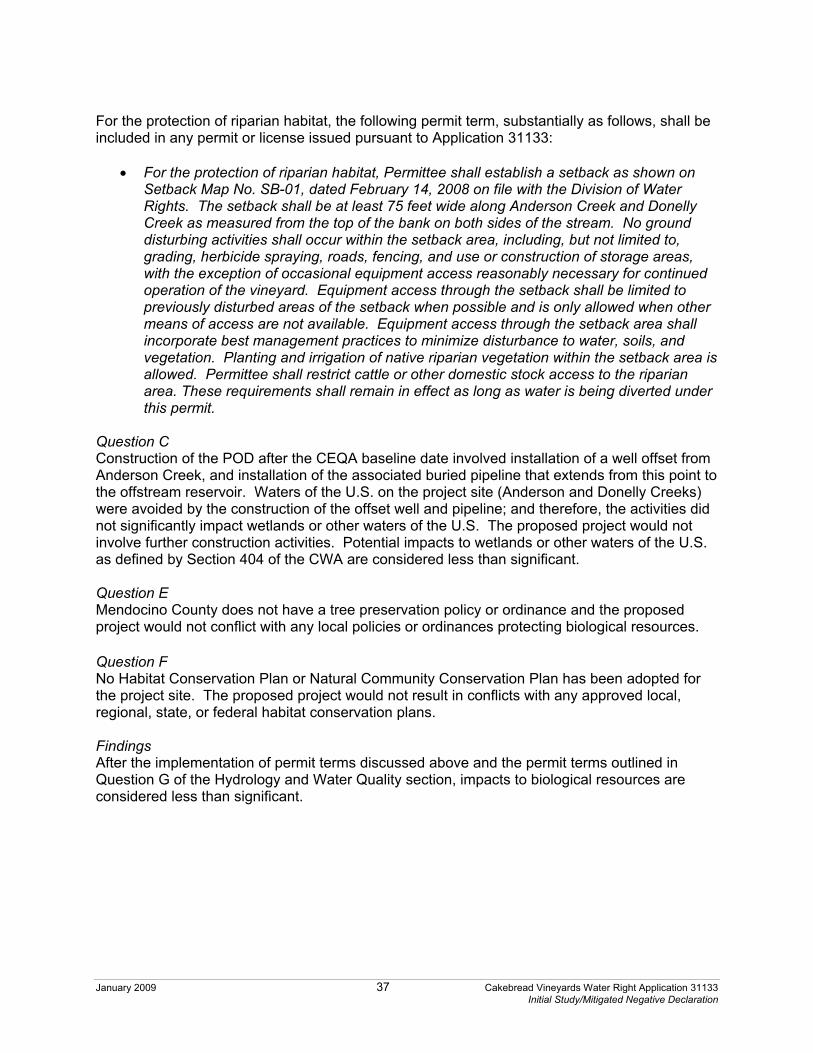
January 2009 37 Cakebread Vineyards Water Right Application 31133 Initial Study/Mitigated Negative Declaration
For the protection of riparian habitat, the following permit term, substantially as follows, shall be included in any permit or license issued pursuant to Application 31133:
� For the protection of riparian habitat, Permittee shall establish a setback as shown on Setback Map No. SB-01, dated February 14, 2008 on file with the Division of Water Rights. The setback shall be at least 75 feet wide along Anderson Creek and Donelly Creek as measured from the top of the bank on both sides of the stream. No ground disturbing activities shall occur within the setback area, including, but not limited to, grading, herbicide spraying, roads, fencing, and use or construction of storage areas, with the exception of occasional equipment access reasonably necessary for continued operation of the vineyard. Equipment access through the setback shall be limited to previously disturbed areas of the setback when possible and is only allowed when other means of access are not available. Equipment access through the setback area shall incorporate best management practices to minimize disturbance to water, soils, and vegetation. Planting and irrigation of native riparian vegetation within the setback area is allowed. Permittee shall restrict cattle or other domestic stock access to the riparian area. These requirements shall remain in effect as long as water is being diverted under this permit.
Question C Construction of the POD after the CEQA baseline date involved installation of a well offset from Anderson Creek, and installation of the associated buried pipeline that extends from this point to the offstream reservoir. Waters of the U.S. on the project site (Anderson and Donelly Creeks) were avoided by the construction of the offset well and pipeline; and therefore, the activities did not significantly impact wetlands or other waters of the U.S. The proposed project would not involve further construction activities. Potential impacts to wetlands or other waters of the U.S. as defined by Section 404 of the CWA are considered less than significant. Question E Mendocino County does not have a tree preservation policy or ordinance and the proposed project would not conflict with any local policies or ordinances protecting biological resources. Question F No Habitat Conservation Plan or Natural Community Conservation Plan has been adopted for the project site. The proposed project would not result in conflicts with any approved local, regional, state, or federal habitat conservation plans. Findings After the implementation of permit terms discussed above and the permit terms outlined in Question G of the Hydrology and Water Quality section, impacts to biological resources are considered less than significant.

January 2009 38 Cakebread Vineyards Water Right Application 31133 Initial Study/Mitigated Negative Declaration
Potentially Significant
Impact
Less Than Significant
With Mitigation
Incorporated
Less Than Significant
Impact
No Impact
5. Agricultural Resources. In determining whether impacts to agricultural resources are significant environmental impacts, lead agencies may refer to the California Agricultural Land Evaluation and Site Assessment Model (1997) prepared by the California Department of conservation as an optional model to use in assessing impacts on agriculture and farmland. Would the project:
a) Convert Prime Farmland, Unique Farmland, or Farmland of Statewide Importance (Farmland), as shown on the maps prepared pursuant to the Farmland Mapping & Monitoring Program of the California Resources Agency, to non-agricultural uses?
�
�
�
�
b) Conflict with existing zoning for agricultural use, or a Williamson Act contract?
� � � �
c) Involve other changes in the existing environment which, due to their location or nature, could result in conversion of Farmland to non-agricultural use?
� � � �
The project site is zoned Agricultural District (A-G) which includes the following uses36.
1. Residential Use Types: single family residential 2. Civic Use Types: community recreation, essential services, fire and police
protection services, minor impact utilities 3. Commercial Use Types (subject to a Minor Use Permit): animal sales and
services--horse stables, kennels, stockyards 4. Agricultural Use Types: animal raising, forest production and processing,
horticulture; limited winery packing and processing, row and field crops, tree crops
Agriculture and agricultural production are valued land uses in Mendocino County. Agricultural goals outlined in the Agriculture section of the Land Use Element, Mendocino County General Plan include37:
Goal Number 1: The County shall protect and maintain prime agricultural land and prime rangeland.
Goal Number 2: The County shall seek to minimize the conflicts between agricultural operations and other land and resource uses.
Goal Number 3: The County shall constantly strive to create and promote those policies and conditions that will enable Mendocino County ranchers, farmers, and homesteaders to maintain economically sound and profitable operations.
Goal Number 4: The County shall maintain prime rangeland in units sufficient to provide for an economic management base.
Questions A-C The property is zoned Agricultural District, which includes agricultural land uses. Under the proposed project, the project site would continue to be used for agricultural purposes. Findings No impacts would occur to agricultural resources as a result of the proposed project.

January 2009 39 Cakebread Vineyards Water Right Application 31133 Initial Study/Mitigated Negative Declaration
Potentially Significant
Impact
Less Than Significant
With Mitigation
Incorporated
Less Than Significant
Impact
No Impact
6. Noise. Would the project result in: a) Exposure of persons to, or generation of, noise
levels in excess of standards established in the local general plan or noise ordinance, or applicable standards of other agencies?
� � � �
b) Exposure of persons to, or generation of, excessive groundborne vibration or groundborne noise levels?
� � � �
c) A substantial permanent increase in ambient noise levels in the project vicinity above levels existing without the project?
� � � �
d) A substantial temporary or periodic increase in ambient noise levels in the project vicinity above levels existing without the project?
� � � �
e) For a project located within an airport land use plan or, where such a plan has not been adopted, within two miles of a public airport or public use airport, would the project expose people residing in or working in the project area to excessive noise levels?
� � � �
f) For a project within the vicinity of a private airstrip, would the project expose people residing in or working in the project area to excessive noise levels?
� � � �
Potentially significant sources of noise within Mendocino County include: highways and freeways; primary arterials and major local streets; passenger and freight on-line railroad operations and ground rapid transit systems; commercial, general aviation, heliport, helistop, and military airport operations, aircraft over-flights, jet engine test stands, and all other ground facilities and maintenance functions related to airport operation; and local industrial plants, including, but not limited to, railroad classification yards. The circulation system within Mendocino County is one of the major sources of continuous noise38. Noise sensitive areas identified within Mendocino County include areas containing schools, hospitals, rest homes, long-term medical or mental care facilities, or any other land use areas deemed noise sensitive by the local jurisdiction. Anderson Valley Elementary School is located approximately 1.5 miles northwest of the property. Questions A-D Potential sources of noise generated at the project site would result from routine agricultural activities and would be similar to existing activities in the area. This is considered a less-than-significant impact. Questions E and F The project site is located less than one mile east of the Boonville Airport. This airport has the potential to expose people residing or working in the project area to noises from the airport’s

January 2009 40 Cakebread Vineyards Water Right Application 31133 Initial Study/Mitigated Negative Declaration
activities; however, given the size of the airport, exposure to noise is not expected to be substantial. This is considered a less-than-significant impact. Findings Impacts to noise as a result of the proposed project are considered less than significant.
Potentially Significant
Impact
Less Than Significant
With Mitigation
Incorporated
Less Than Significant
Impact
No Impact
7. Land Use and Planning. Would the project: a) Physically divide an established community? � � � � b) Conflict with any applicable land use plan, policy, or
regulation of an agency with jurisdiction over the project (including, but not limited to, the general plan, specific plan, local coastal program, or zoning ordinance) adopted for the purpose of avoiding or mitigating an environmental effect?
�
�
�
�
c) Conflict with any applicable habitat conservation plan or natural community conservation plan?
� � � �
The project site is located in Mendocino County immediately north of the community of Boonville. The Mendocino County General Plan (General Plan) Land Use Element and its policies guide growth and the development and use of land in Mendocino County. The Land Use Element of the General Plan designates the project area as “Agricultural Lands”39. Permitted land uses within this category include:
o Residential uses o Agricultural uses o Utility installations o Cottage industries o Uses determined to be related to and
compatible with agriculture
o Processing and development of natural resources
o Residential clustering o Conservation
The Mendocino County Zoning Ordinance designates the project site as Agricultural District, “A-G”. The Ordinance outlines the intent of the designation as:
To create and preserve areas for the raising of crops and animals. Processing of products produced on the premises would be permitted, as would certain commercial activities associated with crop and animal raising.
Agricultural uses allowed within the Agricultural District without a permit include40:
o Animal raising o Tree crops o Limited forest production and
processing
o Horticulture o Limited winery packing and
processing o Row and field crops
Question A The project site is currently developed with agricultural uses. The proposed project would not result in physical barriers that would divide an established community.

January 2009 41 Cakebread Vineyards Water Right Application 31133 Initial Study/Mitigated Negative Declaration
Question B The proposed project includes the use of water from an existing offstream reservoir to irrigate 47 acres of existing vineyard. This use is consistent with the area’s General Plan and zoning designations. Question C No Habitat Conservation Plan or Natural Community Conservation Plan currently exists for the project site or immediate vicinity. The proposed project would not have the potential to conflict with any existing habitat conservation plans or natural community conservation plans. Findings Impacts to land use as a result of this project are considered less than significant.
Potentially Significant
Impact
Less Than Significant
With Mitigation
Incorporated
Less Than Significant
Impact
No Impact
8. Mineral Resources. Would the project: a) Result in the loss of availability of a known mineral
resource that would be of future value to the region and the residents of the State?
� � � �
b) Result in the loss of availability of a locally-important mineral resource recovery site delineated on a local general plan, specific plan, or other land use plan?
� � � �
Various minerals have been found in Mendocino County, including: asbestos, carbon dioxide, chromite, coal, copper, feldspar, gold, jade, limestone, magnesite, manganese, methane gas, mineral springs, natural gas, nickel, petroleum, phosphate, platinum, quicksilver, sand and gravel, and sulfur. The project site is not located in an area containing mineral resource deposits41.
Questions A and B No mineral resources are located near the project site as mapped by the County of Mendocino General Plan. Findings No impacts would occur to mineral resources as a result of the proposed project.
Potentially Significant
Impact
Less Than Significant
With Mitigation
Incorporated
Less Than Significant
Impact
No Impact
9. Hazards and Hazardous Materials. Would the project: a) Create a significant hazard to the public or the
environment through the routine transport, use, or disposal of hazardous materials?
� � � �
b) Create a significant hazard to the public or the environment through reasonably foreseeable upset and accident conditions involving the release of hazardous materials into the environment?
� � � �

January 2009 42 Cakebread Vineyards Water Right Application 31133 Initial Study/Mitigated Negative Declaration
c) Emit hazardous emissions or handle hazardous or acutely hazardous materials, substances, or waste within ¼ mile of an existing or proposed school?
� � � �
d) Be located on a site which is included on a list of hazardous materials sites compiled pursuant to Government Code §65962.5 and, as a result, would it create a significant hazard to the public or to the environment?
� � � �
e) For a project located within an airport land use plan or, where such a plan has not been adopted, within two miles of a public airport or a public use airport, would the project result in a safety hazard for people residing or working in the project area?
� � � �
f) For a project within the vicinity of a private airstrip, would the project result in a safety hazard for people residing or working in the project area?
�
�
�
�
g) Impair implementation of or physically interfere with an adopted emergency response plan or emergency evacuation plan?
�
�
�
�
h) Expose people or structures to a significant risk of loss, injury, or death involving wildland fires, including where wildlands are adjacent to urbanized areas or where residences are intermixed with wildlands?
�
�
�
�
Database searches42 were conducted for records of known sites of hazardous materials generation, storage, or contamination, as well as known storage tank sites on the project site and within the immediate vicinity. Databases were searched for sites and listings up to one-mile from a point roughly equivalent to the center of the subject property. A summary of this one-mile search and a list of the databases accessed can be found on file with the Division. The project site was not listed on any database as having previous and/or current generation, storage, and/or use of hazardous materials. The database also identifies any known hazardous materials sites within a one-mile radius of the project area. Eight sites within a one-mile radius of the project area were identified and are summarized below.
o The Chevron #9-6221 site is located at 14125 Highway 128, Boonville CA, approximately 0.35 miles south of the project area. The site is listed on the state Leaking Underground Storage tank (LUST) database and the state Cortese Hazardous Waste and Substances site list (CORTESE). Leaking underground storage tanks were discovered on the property in 1989. The database did not list any other information for the Chevron site. Since the Chevron site is located at a down gradient position with respect to the anticipated groundwater flow direction it is not likely to impact the planned use of the project area.
o The Partners Building site is located at 14111 Highway 128, Boonville CA, approximately 0.30 miles south of the project area. The site is listed on the state LUST database and the state CORTESE. The database lists this site as requiring no remedial action; therefore, it is not likely to impact the planned use of the project area.
o The Anderson Vineyards, Inc. site is located approximately 0.05 miles northwest of the project area at 17601 Fitch Lane, Boonville CA. The site is listed on the state LUST database as having leaking tanks that were discovered in 1999. As a result the site was approved for a remediation plan and has been listed as a closed case since 2002. The site is also listed on the Hazardous Waste Information System (HAZNET) and the state
January 2009 43 Cakebread Vineyards Water Right Application 31133 Initial Study/Mitigated Negative Declaration
CORTESE as generating two tons per year of empty containers with a capacity of 30 gallons or more in size. The database did not report any spills associated with the Anderson Vineyards, Inc. site. Due to the distance of the Anderson Vineyards, Inc. site in relation to the project area, and the fact that it is a closed site on the LUST database, it is not likely to affect the planned use of the project area.
o The CDOT Boonville site is located at 14001 Highway 128, Boonville CA, approximately 0.28 miles south of the project area. The site is listed on the state LUST database and the state CORTESE, but has been listed as a closed case since 1996. The database lists this site as requiring no remedial action; therefore, it is not likely to impact the planned use of the project area.
o The Jeff Chevron site is located at 14289 Highway 128, Boonville CA, approximately 0.52 miles south of the project area. The site is listed on the state LUST database and the state CORTESE. Leaking underground storage tanks were discovered on the site in 1994. The site is currently under a remediation plan and regulatory review. Since the site is located at a down gradient position with respect to the anticipated groundwater flow direction it is not likely to impact the planned use of the project area.
o The Gavin Gracey site is located at 12651 Anderson Valley Way, Boonville CA, approximately 0.70 miles northwest of the project area. The site is listed on the state LUST database and the state CORTESE, but has been listed as a closed case since 1993. The database lists this site as requiring no remedial action; therefore, it is not likely to impact the planned use of the project area.
o The MCDPW Boonville Road Yard site is located at 14000 Highway 128, Boonville CA, approximately 0.32 miles southwest of the project area. The site is listed on the state LUST database and the state CORTESE. Leaking underground storage tanks were discovered on the site in 1997. The site is currently under regulatory review. Since the site is in a down gradient position with respect to the anticipated groundwater flow direction, it is not likely to impact the planned use of the project area.
o The Redwood Drive-In site is located at 13980 Highway 128, Boonville CA, approximately 0.31 miles southwest of the project area. The site is listed on the state LUST database and the state CORTESE, but has been listed as a closed case since 2007. The database lists this site as requiring no remedial action; therefore, it is not likely to impact the planned use of the project area.
Questions A-H Hazardous materials that would be used during operation of the proposed project would be limited to common petroleum and agricultural products. When properly used, these products do not present a significant hazard. The proposed project is not located within quarter mile of any existing or proposed schools. A search of government environmental records did not reveal any known hazardous materials sites within the project site. The project site is located less than one mile east of Boonville Airport, but the proposed project would not present a safety hazard to persons in the project area. The proposed project does not include components that would interfere with an adopted emergency plan. The proposed project is located in an area that contains fuels (e.g. grasses, shrubs, trees) that are susceptible to wildland fire; however, the proposed project does not involve any further construction. Findings Impacts to hazards and hazardous materials as a result of this project are considered less than significant.

January 2009 44 Cakebread Vineyards Water Right Application 31133 Initial Study/Mitigated Negative Declaration
Potentially Significant
Impact
Less Than Significant
With Mitigation
Incorporated
Less Than Significant
Impact
No Impact
10. Population and Housing. Would the project: a) Induce substantial population growth in an area
either directly (e.g., by proposing new homes and businesses) or indirectly (e.g., through extension of roads or other infrastructure)?
� � � �
b) Displace substantial numbers of existing housing, necessitating the construction of replacement housing elsewhere?
� � � �
c) Displace substantial numbers of people, necessitating the construction of replacement housing elsewhere?
� � � �
The project site is located immediately north of the town of Boonville in Mendocino County. As discussed above, the project site is currently developed with agricultural uses. Questions A-C The proposed project does not involve the development of any homes or businesses. The proposed project would not generate commercial activities substantial enough to induce substantial growth in the project area. The proposed project does not involve the displacement of people or housing. Findings Impacts to population and housing as a result of this project are considered less than significant.
Potentially Significant
Impact
Less Than Significant
With Mitigation
Incorporated
Less Than Significant
Impact
No Impact
11. Transportation and Circulation. Would the project: a) Cause an increase in traffic that is substantial in
relation to the existing traffic load and capacity of the street system (i.e., result in a substantial increase in either the number of vehicle trips, the volume-to-capacity ratio on roads, or congestion at intersections)?
�
�
�
�
b) Substantially increase hazards due to a design feature (e.g., sharp curves or dangerous intersections) or incompatible uses (e.g., farm equipment)?
� � � �
c) Result in inadequate emergency access? � � � � d) Result in inadequate parking capacity? � � � � e) Exceed, either individually or cumulatively, a level-
of-service standard established by the county congestion management agency for designated roads or highways?
� � � �

January 2009 45 Cakebread Vineyards Water Right Application 31133 Initial Study/Mitigated Negative Declaration
f) Conflict with adopted policies supporting alternative transportation (e.g., bus turnouts, bicycle racks)?
� � � �
g) Result in a change in air traffic patterns, including either an increase in traffic levels or a change in location that results in substantial safety risks?
� � � �
Vehicular access to the project site is provided by State Highway 128, a two-lane highway that traverses the southern portion of Mendocino County, from the coast between Albion and Elk southeasterly to Cloverdale in Sonoma County. Questions A-G The proposed project is not anticipated to increase traffic in the project area. No substantial new impediments to emergency access or incompatible uses are anticipated. The proposed project is not expected to result in inadequate parking capacity, or conflict with adopted alternative transportation policies, plans, or programs. Potential impacts are considered less than significant. Findings Impacts to transportation and circulation as a result of the proposed project are considered less than significant.
Potentially Significant
Impact
Less Than Significant
With Mitigation
Incorporated
Less Than Significant
Impact
No Impact
12. Public Services. Would the project result in substantial adverse physical impacts associated with the provision of new or physically altered governmental facilities, the construction of which could cause significant environmental impacts, in order to maintain acceptable service rations, response times or other performance objectives for any of the public services:
a) Fire protection? � � � � b) Police protection? � � � � c) Schools? � � � � d) Parks? � � � � e) Other public facilities? � � � �
Public services include fire and police protection, schools, parks, and other public facilities. The Anderson Valley Fire Department provides fire protection in the project area. Police protection is provided by the Mendocino County Sheriff’s Department. Anderson Valley Unified School District provides K-12 grade education in the project area. Questions A-E The proposed project would result in the continued use of the project site for agricultural purposes and therefore would not generate additional demand for government facilities or services.
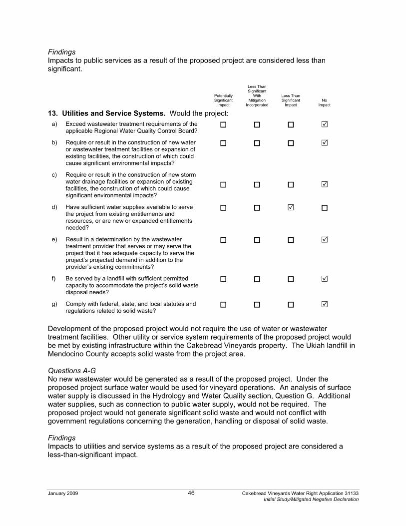
January 2009 46 Cakebread Vineyards Water Right Application 31133 Initial Study/Mitigated Negative Declaration
Findings Impacts to public services as a result of the proposed project are considered less than significant.
Potentially Significant
Impact
Less Than Significant
With Mitigation
Incorporated
Less Than Significant
Impact
No Impact
13. Utilities and Service Systems. Would the project: a) Exceed wastewater treatment requirements of the
applicable Regional Water Quality Control Board? � � � �
b) Require or result in the construction of new water or wastewater treatment facilities or expansion of existing facilities, the construction of which could cause significant environmental impacts?
� � � �
c) Require or result in the construction of new storm water drainage facilities or expansion of existing facilities, the construction of which could cause significant environmental impacts?
�
�
�
�
d) Have sufficient water supplies available to serve the project from existing entitlements and resources, or are new or expanded entitlements needed?
� � � �
e) Result in a determination by the wastewater treatment provider that serves or may serve the project that it has adequate capacity to serve the project’s projected demand in addition to the provider’s existing commitments?
� � � �
f) Be served by a landfill with sufficient permitted capacity to accommodate the project’s solid waste disposal needs?
� � � �
g) Comply with federal, state, and local statutes and regulations related to solid waste?
� � � �
Development of the proposed project would not require the use of water or wastewater treatment facilities. Other utility or service system requirements of the proposed project would be met by existing infrastructure within the Cakebread Vineyards property. The Ukiah landfill in Mendocino County accepts solid waste from the project area. Questions A-G No new wastewater would be generated as a result of the proposed project. Under the proposed project surface water would be used for vineyard operations. An analysis of surface water supply is discussed in the Hydrology and Water Quality section, Question G. Additional water supplies, such as connection to public water supply, would not be required. The proposed project would not generate significant solid waste and would not conflict with government regulations concerning the generation, handling or disposal of solid waste. Findings Impacts to utilities and service systems as a result of the proposed project are considered a less-than-significant impact.

January 2009 47 Cakebread Vineyards Water Right Application 31133 Initial Study/Mitigated Negative Declaration
Potentially Significant
Impact
Less Than Significant
With Mitigation
Incorporated
Less Than Significant
Impact
No Impact
14. Aesthetics. Would the project: a) Have a substantial adverse effect on a scenic
vista? � � � �
b) Substantially damage scenic resources, including, but not limited to, trees, rock outcroppings, and historic buildings within a state scenic highway?
� � � �
c) Substantially degrade the existing visual character or quality of the site and its surroundings?
� � � �
d) Create a new source of substantial light or glare that would adversely affect day or nighttime views in the area?
� � � �
The project area contains scenic resources characteristic of Mendocino County in general, including mountainous landscapes, agricultural and pastoral settings, and riparian areas. The existing agricultural use of the project site is consistent with the rural aesthetic quality of the project area. Questions A-D Construction of the proposed project after the CEQA baseline date included the development of 47 acres of vineyard on previous orchard land, the offstream reservoir, an offset well (POD), and the associated buried pipeline. Development of these project components did not have a substantial adverse effect on a scenic vista or substantially degrade scenic resources. The proposed project does not involve the construction of any new structures or sources of light or glare. The proposed project would result in the continued agricultural use of the project site. This use is consistent with the rural aesthetic quality of the project area. Findings No impacts would occur to aesthetics as a result of the proposed project.
Potentially Significant
Impact
Less Than Significant
With Mitigation
Incorporated
Less Than Significant
Impact
No Impact
15. Cultural Resources. Would the project: a) Cause a substantial adverse change in the
significance of a historical resource as defined in §15064.5?
� � � �
b) Cause a substantial adverse change in the significance of an archaeological resource as defined in §15064.5?
� � � �
c) Directly or indirectly destroy a unique paleontological resource or site or unique geologic feature?
� � � �
d) Disturb any human remains, including those interred outside of formal cemeteries?
� � � �
January 2009 48 Cakebread Vineyards Water Right Application 31133 Initial Study/Mitigated Negative Declaration
Under CEQA, historical resources are considered part of the environment (Public Resources Code, §§ 21060.5, 21084.1). A “‘historical resource’ includes, but is not limited to, any object, building, structure, site, area, place, record, or manuscript which is historically or archaeologically significant, or is significant in the architectural, engineering, scientific, economic, agricultural, educational, social, political, military, or cultural annals of California (Public Resources Code, §§ 21084.1, 5020.1, subd. (j)).” In 1992, the Public Resources Code was amended as it affects historical resources. The amendments included creation of the California Register of Historic Resources (California Register) (Public Resources Code, § 5024.1.). The State Historical Resources Commission administers the California Register and adopted implementing regulations effective January 1, 1998 (Cal. Code Regs., tit. 14, § 4850 et seq.). The California Register includes historical resources that are listed automatically by virtue of their appearance on, or eligibility for, certain other lists of important resources. The California Register incorporates historical resources that have been nominated by application and listed after public hearing. Also included are historical resources listed as a result of the State Historical Resources Commission’s evaluation in accordance with specific criteria and procedures. CEQA requires consideration of potential impacts to resources that are listed or qualify for listing on the California Register, as well as resources that are significant but may not qualify for listing. An intensive-level cultural resources field survey of the project site was conducted on July 31, 2000, by Archaeological Resource Service. A cultural resources study prepared on August 7, 2000 characterizes past uses of the project area, summarizes the results of the field survey and archival records results, and provides resource treatment recommendations43. The field survey did not identify any prehistoric or historic archaeological sites within the vineyard, reservoir, or POD sites. A review was also conducted of ethnographic literature and maps, including archival research at the Northwest Information Center, Sonoma State University (00-621), and a review of the State of California Native American Heritage Commission Sacred Lands File. This review found that there are no recorded cultural resources, sacred lands sites, or ethnographic sites reported within the study area. Questions A-D There is the possibility that subsurface archeological deposits or human remains could be present and accidental discovery could occur through vineyard operation and maintenance activities. As such, the following permit term, substantially as follows, shall be included in any water right permit or license issued pursuant to Application 31133:
� Should any buried archaeological materials be uncovered during project activities, such activities shall cease within 100 feet of the find. Prehistoric archeological indicators include: obsidian and chert flakes and chipped stone tools; bedrock outcrops and boulders with mortar cups; ground stone implements (grinding slabs, mortars and pestles) and locally darkened midden soils containing some of the previously listed items plus fragments of glass, ceramic and metal objects; milled and split lumber; and structure and feature remains such as building foundations, privy pits, wells and dumps; and old trails. The Chief of the Division of Water Rights shall be notified of the discovery, and a professional archeologist shall be retained by the Permittee to evaluate the find and recommend appropriate mitigation measures. Proposed mitigation measures shall be submitted to the Chief of the Division of Water Rights for approval. Project-related activities shall not resume within 100 feet of the find until all approved

January 2009 49 Cakebread Vineyards Water Right Application 31133 Initial Study/Mitigated Negative Declaration
mitigation measures have been completed to the satisfaction of the Chief of the Division of Water Rights.
There is also the possibility that an unanticipated discovery of human remains could occur. The following permit term, substantially as follows, shall be included in any water right permit or license issued pursuant to Application 31133:
� If human remains are encountered, then the Permittee shall comply with Section 15064.5 (e) (1) of the CEQA Guidelines and the Public Resources Code Section 7050.5. All project-related ground disturbance within 100 feet of the find shall be halted until the county coroner has been notified. If the coroner determines that the remains are Native American, the coroner will notify the Native American Heritage Commission to identify the most-likely descendants of the deceased Native Americans. Project-related ground disturbance in the vicinity of the find shall not resume until the process detailed under Section 15064.5 (e) has been completed and evidence of completion has been submitted to the Chief of the Division of Water Rights.
Findings After the implementation of the permit terms outlined above, impacts to cultural resources as a result of the proposed project are considered less than significant.
Potentially Significant
Impact
Less Than Significant
With Mitigation
Incorporated
Less Than Significant
Impact
No Impact
16. Recreation. Would the project: a) Increase the use of existing neighborhood and
regional parks or other recreational facilities such that substantial physical deterioration of the facility would occur or be accelerated?
� � � �
b) Include recreational facilities or require the construction or expansion of recreational facilities that might have an adverse physical effect on the environment?
� � � �
Mendocino County has various types of parklands, including Federal Recreation Areas and State Parks, regional parks, county parks and neighborhood parks. Recreational opportunities include fishing, camping, swimming, picnicking, horseback riding, bicycling, and hiking or walking. Questions A and B The proposed project would result in the continued agricultural use of the project site. No new demand would be generated for the use of existing neighborhood and regional parks or other recreational facilities. The proposed project does not include recreation facilities or require the construction or expansion of recreational facilities that might have an adverse physical effect on the environment. Findings No impacts would occur to recreation as a result of this project.

January 2009 50 Cakebread Vineyards Water Right Application 31133 Initial Study/Mitigated Negative Declaration
Potentially Significant
Impact
Less Than Significant
With Mitigation
Incorporated
Less Than Significant
Impact
No Impact
17. Mandatory Findings of Significance a) Does the project have the potential to degrade the
quality of the environment, substantially reduce the habitat of a fish or wildlife species, cause a fish or wildlife population to drop below self-sustaining levels, threaten to eliminate a plant or animal community, reduce the number or restrict the range of a rare or endangered plant or animal or eliminate important examples of the major periods of California history or prehistory?
�
�
�
�
b) Does the project have impacts that are individually limited, but cumulatively considerable? ("Cumulatively considerable" means that the incremental effects of a project are considerable when viewed in connection with the effects of past projects, the effects of other current projects, and the effects of probable future projects)
�
�
�
�
c) Does the project have environmental effects that will cause substantial adverse effects on human beings, either directly or indirectly?
� � � �
Questions A-C As discussed in the preceding sections, the proposed project has a potential to degrade the quality of the environment by adversely impacting hydrology and water quality, biological resources, and cultural resources. However, with implementation of the identified permit terms, potential impacts would be reduced to a less-than-significant level. Potential adverse environmental impacts in combination with the impacts of other past, present, and future projects, could contribute to cumulatively significant effects on the environment. However, with implementation of the identified permit terms, the proposed project would avoid or minimize potential impacts and would not result in cumulatively considerable environmental impacts. No potentially significant adverse affects to humans have been identified.

January 2009 51 Cakebread Vineyards Water Right Application 31133 Initial Study/Mitigated Negative Declaration
III. DETERMINATION On the basis of this initial evaluation
I find that the proposed project COULD NOT have a significant effect on the environment, and a NEGATIVE DECLARATION will be prepared.
�
I find that although the proposed project could have a significant effect on the environment, there will not be a significant effect in this case because revisions in the project have been made by or agreed to by the project proponent. A NEGATIVE DECLARATION will be prepared.
�
I find that the proposed project MAY have a significant effect on the environment, and an ENVIRONMENTAL IMPACT REPORT is required.
�
I find that the proposed project MAY have a “potentially significant impact” or “potentially significant unless mitigated” impact on the environment, but at least one effect 1) has been adequately analyzed in an earlier document pursuant to applicable legal standards, and 2) has been addressed by mitigation measures based on the earlier analysis as described on attached sheets. An ENVIRONMENTAL IMPACT REPORT is required, but it must analyze only the effects that remain to be addressed.
�
I find that although the proposed project could have a significant effect on the environment, because all potentially significant effects (a) have been analyzed adequately in an earlier EIR or NEGATIVE DECLARATION pursuant to applicable standards, and (b) have been avoided or mitigated pursuant to that earlier EIR or NEGATIVE DECLARATION, including revisions or mitigation measures that are imposed upon the proposed project, nothing further is required.
�
Prepared By: ________________________________________________________________ David Zweig Date Analytical Environmental Services Reviewed By: ________________________________________________________________ Aaron Miller Date Water Resource Control Engineer ________________________________________________________________ Eric Oppenheimer Date Chief, Watershed Unit 2 ________________________________________________________________ Steven Herrera, Chief Date Water Rights Permitting Section (Form updated 3/28/00) -------------------------------------------------------------------------------------------------------------------
Authority: Public Resources Code Sections 21083, 21084, 21084.1, and 21087. Reference: Public Resources Code Sections 21080(c), 21080.1, 21080.3, 21082.1, 21083, 21083.1 through 21083.3,
21083.6 through 21083.9, 21084.1, 21093, 21094, 21151; Sundstrom v. County of Mendocino, 202 Cal. App. 3d 296 (1988); Leonoff v. Monterey Board of Supervisors, 222 Cal. App. 3d 1337 (1990).
January 2009 52 Cakebread Vineyards Water Right Application 31133 Initial Study/Mitigated Negative Declaration
IV. INFORMATION SOURCES 1 Application 31133 to Appropriate Water, 2001. 2 Ibid. 3 Ibid. 4 Hickman, J. C., 1993. The Jepson Manual, Higher Plants of California. University of California
Press, Berkeley, California. 5 Division of Water Rights. 1998. “Report of Investigation on the Navarro River Watershed
Complaint in Mendocino County”. State Water Resources Control Board. 6 Navarro River Watershed Status. North Coast Regional Water Quality Control Board.
Accessed on January 2, 2008 from http://www.swrcb.ca.gov/rwqcb1/programs/tmdl/navarro/navarro.html.
7 Soil Survey of Mendocino County, California- Western Part. U.S. Department of Agriculture. 1965.
8 Mendocino County General Plan. September 24, 1981. Accessed on September 3, 2003 from http://www.co.mendocino.ca.us/planning/GenPlan/GPContents.htm.
9 Fault Rupture Hazard Zones in California. Special Publication 42. California Division of Mines and Geology. Revised 1997. Accessed on October 24, 2003 from http://www.consrv.ca.gov/CGS/rghm/ap/index.htm.
10 Mendocino County General Plan. September 24, 1981. Accessed on September 3, 2003 from http://www.co.mendocino.ca.us/planning/GenPlan/GPContents.htm.
11 Ibid. 12 Ibid. 13 Area Designations. California Air Resources Board. Accessed on October 24, 2003 from
http://www.arb.ca.gov/desig/desig.htm. 14 Ibid. 15 Ibid. 16 Ibid. 17 Flood Insurance Rate Map. Federal Emergency Management Agency. 1996. Map for
Mendocino County, California. 18 North Coast Regional Water Quality Control Board, Navarro River Watershed Technical
Support Document for Sediment and Temperature. Page 52. Available at: http://www.swrcb.ca.gov/northcoast/water_issues/programs/tmdls/navarro_river/navarrotsd.pdf.
19 U.S. Environmental Protection Agency Region IX, Navarro River Total Maximum Daily Loads for Temperature and Sediment. Page 32. Accessed on December 23, 2008 from http://www.epa.gov/region09/water/tmdl/navarro/navarro.pdf.
20 Water Quality Control Plan for the North Coast Region, North Coast Regional Water Quality Control Board.
21 Haan, C.T., Barfield, B.J., and J.C. Hayes. 1994. Design Hydrology and Sedimentology for Small Catchments. New York: Academic Press. 22 Christensen, D. 2000. Protection of Riparian Ecosystems: A Review of the Best Available
Science. Jefferson County Natural Resources Division, Port Townsend, WA. 23 North Coast Regional Water Quality Control Board, Navarro River Watershed Technical Support
Document for Sediment and Temperature. Page 70. Accessed on December 23, 2008 from http://www.swrcb.ca.gov/northcoast/water_issues/programs/tmdls/navarro_river/navarrotsd.pdf.
24 California’s Groundwater Bulletin 118. North Coast Hydrologic Region, Anderson Valley Groundwater Basin. Last update: February 27, 2004. Accessed on December 23, 2008 from

January 2009 53 Cakebread Vineyards Water Right Application 31133 Initial Study/Mitigated Negative Declaration
http://www.dpla2.water.ca.gov/publications/groundwater/bulletin118/basins/pdfs_desc/1-19.pdf.
25 State Water Resource Control Board (SWRCB), 2001. Water Right Application Pre-Notice Site Inspection Form, Application No. 31133. May 23, 2001. Division of Water Rights.
26 Mendocino County General Plan. September 24, 1981. Accessed on September 3, 2003 from http://www.co.mendocino.ca.us/planning/GenPlan/GPContents.htm.
27 Cumulative Flow Impairment Index Appropriative Applications 30794, 31434, 31080, 30533, 30718, 31003, 30479, 31133, 31135, 31250, 30994. Napa Valley Vineyard Engineering, Inc., August 16, 2007. Revised July 9, 2008.
28 Ibid. 29 Guidelines for Maintaining Instream Flows to Protect Fisheries Resources Downstream of
Water Diversions in Mid-California Coastal Stream. California Department of Fish and Game and the National Marine Fisheries Service. June 17, 2002.
30 Hickman, James C., (ed.). 1993. The Jepson Manual: Higher Plants of California. University of California Press. Berkeley, California.
31 Biological Resources Report. Cakebread Vineyards. Kjeldsen Biological Consultants. August, 2001.
32 Cakebread Vineyards Water Right Application 31133, Supplemental Biological Survey Report of Findings. Analytical Environmental Services. July 2007.
33 Species Information, Threatened and Endangered Plants and Animals. United States Fish and Wildlife Service. June, 2007. Accessed on June 29, 2007 from http://sacramento.fws.gov/es/spp_lists/auto_list_form.cfm.
Inventory of Rare and Endangered Plants (online edition, v6-05c). California Native Plant Society. June, 2007. Sacramento, California. Accessed on June 20, 2007 from http://www.cnps.org/inventory.
California Natural Diversity Database. California Department of Fish and Game. Selected Elements by Scientific Name. June, 2007.
34 Ligon, F., A. Rich, G. Rynearson, D. Thornburg, and W. Thrush. 1999. Report of the Scientific Review Panel on California Forest Practice Rules and Salmonid Habitat. Prepared for the Resources Agency of California and National Marine Fisheries Service, Sacramento, CA.
35 Soil Survey of Mendocino County, California- Western Part. U.S. Department of Agriculture. 1965.
36 Mendocino County Mendocino County Inland Zoning Code. Adopted 1987. Accessed on September 9, 2003 from http://www.co.mendocino.ca.us/planning/Zoning/ZOInlandIndex.htm.
37 Mendocino County General Plan. September 24, 1981. Accessed on September 3, 2003 from http://www.co.mendocino.ca.us/planning/GenPlan/GPContents.htm.
38 Ibid. 39 Ibid. 40 Mendocino County Mendocino County Inland Zoning Code, 1987. Adopted 1987. Accessed
on September 9, 2003 from http://www.co.mendocino.ca.us/planning/Zoning/ZOInlandIndex.htm.
41 Mendocino County General Plan. September 24, 1981. Accessed on September 3, 2003 from http://www.co.mendocino.ca.us/planning/GenPlan/GPContents.htm.
42 State Water Resources Control Board. GeoTracker. Accessed on January 30, 2008 from http://geotracker.swrcb.ca.gov/.
43 A Cultural Resources Evaluation of the Cakebread Cellars Property Located in Boonville, Mendocino County, California. Report on file, Northwest Information Center, Rohnert Park, California. Chattan, C. Archaeological Resource Service. 2000.