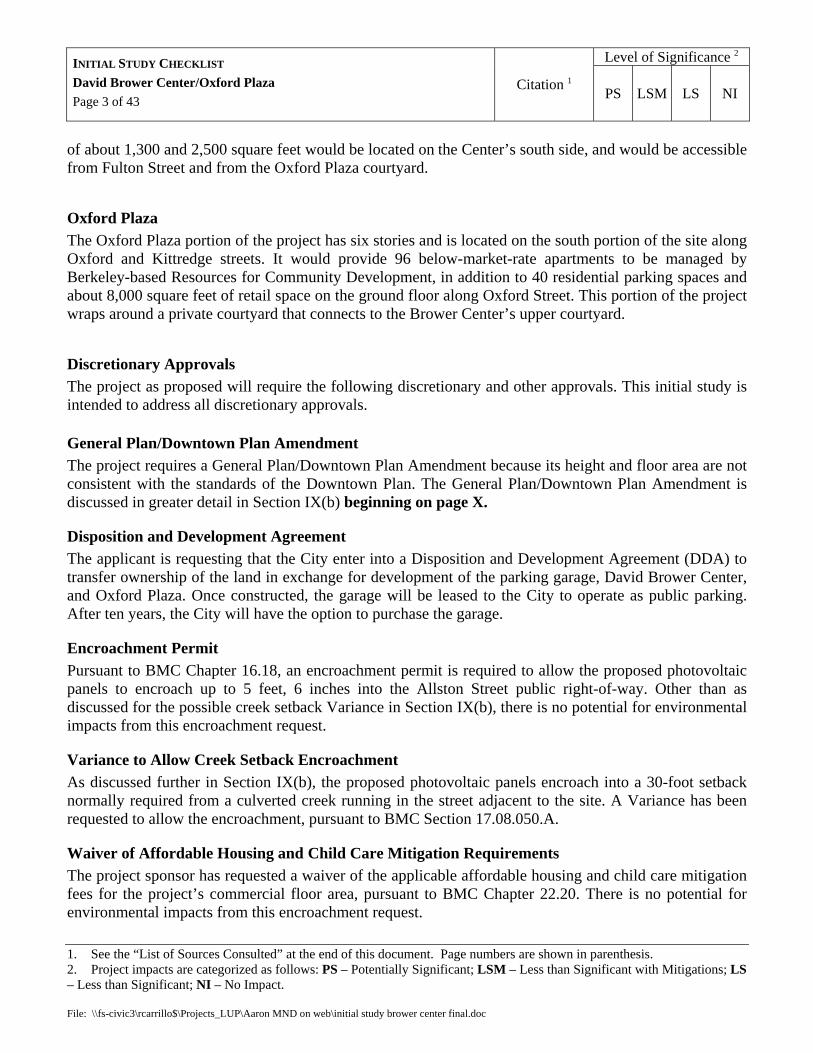
Initial Study Checklist David Brower Center/Oxford Plazanew_site... · The David Brower Center...
43
Initial Study Checklist David Brower Center/Oxford Plaza June 2005 Planning and Development Department Land Use Planning Division File: \\fs-civic3\rcarrillo$\Projects_LUP\Aaron MND on web\initial study brower center final.doc Project Name David Brower Center/Oxford Plaza Project Sponsor Oxford Street Development, LLC P.O. Box 29585, San Francisco, CA 94129 Project Location 2200 Oxford Street, Berkeley, County of Alameda Assessor Parcel Number 057-2035-003-02 Site Description The project site is located in downtown Berkeley (see map, Figure 1), on the west side of Oxford Street between Allston Way and Kittredge Street, immediately across the street from the UC-Berkeley campus (more specifically, Edwards Stadium and the former University Extension building). Shattuck Avenue and the Downtown Berkeley BART station are located one block to the west. The site has an area of about 1.06 acres (46,300 square feet) and is developed with a City-owned parking lot with approximately 122 public parking spaces and vehicular ingress and egress located on Kittredge Street. Figure 1: Project Vicinity Map
Transcript of Initial Study Checklist David Brower Center/Oxford Plazanew_site... · The David Brower Center...

Initial Study Checklist
David Brower Center/Oxford Plaza
June 2005 Planning and Development Department Land Use Planning Division
File: \\fs-civic3\rcarrillo$\Projects_LUP\Aaron MND on web\initial study brower center final.doc
Project Name David Brower Center/Oxford Plaza
Project Sponsor Oxford Street Development, LLC P.O. Box 29585, San Francisco, CA 94129
Project Location 2200 Oxford Street, Berkeley, County of Alameda Assessor Parcel Number 057-2035-003-02
Site Description The project site is located in downtown Berkeley (see map, Figure 1), on the west side of Oxford Street between Allston Way and Kittredge Street, immediately across the street from the UC-Berkeley campus (more specifically, Edwards Stadium and the former University Extension building). Shattuck Avenue and the Downtown Berkeley BART station are located one block to the west. The site has an area of about 1.06 acres (46,300 square feet) and is developed with a City-owned parking lot with approximately 122 public parking spaces and vehicular ingress and egress located on Kittredge Street.
Figure 1: Project Vicinity Map

Level of Significance 2 INITIAL STUDY CHECKLIST David Brower Center/Oxford Plaza Page 2 of 43
Citation 1 PS LSM LS NI
1. See the “List of Sources Consulted” at the end of this document. Page numbers are shown in parenthesis. 2. Project impacts are categorized as follows: PS – Potentially Significant; LSM – Less than Significant with Mitigations; LS – Less than Significant; NI – No Impact. File: \\fs-civic3\rcarrillo$\Projects_LUP\Aaron MND on web\initial study brower center final.doc
Project Description For CEQA purposes, the proposed “project” includes both a physical development project (i.e., the David Brower Center/Oxford Plaza), and all discretionary approvals required to allow that project. The following description first addresses the development project, and second the required discretionary approvals.
Development Project The proposed development project would include three main components: (1) an underground parking garage, (2) an office and conference facility called the David Brower Center, and (3) an affordable housing facility with ground-floor retail called Oxford Plaza. Because the David Brower Center and Oxford Plaza would both be located above the garage in two separate but adjoining volumes, these components along with the garage would constitute a single mixed-use building. The project components are described in greater detail below.
Underground Parking Garage The proposed garage would have either one level with 105 spaces, or two levels with 206 spaces. Because the size of the garage has not been determined at this time, this initial study addresses the “worst-case” impacts of both scenarios. The single-level design would reduce the amount of public parking on the site by 17 spaces, and would not provide any dedicated parking for the project’s non-residential uses. The two-level design would replace all of the existing parking and provide enough additional parking to satisfy the project’s non-residential parking demand (although most of the additional spaces would likely be available to the public). The potential impacts of these two scenarios are discussed in Section XV(f).
David Brower Center The David Brower Center would be located in a four-story portion of the project on the north side of the site along Allston Way. The Center would contain about 33,000 square feet of office space and a conference center with 200-seat lecture hall, 1,300-square-foot gallery, and 3,000-square-foot restaurant. The Center is envisioned as a “home for the 21st century environmental movement” that will build on the ideas and accomplishments of David Brower (1912-2000), the lifelong Berkeley resident, first Executive Director of the Sierra Club, and world-renowned conservationist. The proposed office space would be leased primarily to Bay Area environmental organizations, including Earth Island Institute (founded by Brower in 1982), Center for Ecoliteracy, Rainforest Action Network, and others.
Consistent with the mission of its occupants and namesake, the Brower Center is intended to be a model of sustainable building design, and the applicants will be seeking a LEED platinum rating from the US Green Building Council1. Solar energy would provide a substantial portion of the Center’s lighting and heating, both through light-directing windows and reflective panels, and photovoltaic panels on the roof. The Center would also utilize cisterns for collecting and recycling rainwater. Upper and lower courtyards
1 Platinum is the highest award in the US Green Building Council’s LEED (Leadership in Environmental Design) certification system. As of this writing, only six buildings in the country have obtained a LEED platinum rating.
Level of Significance 2 INITIAL STUDY CHECKLIST David Brower Center/Oxford Plaza Page 3 of 43
Citation 1 PS LSM LS NI
1. See the “List of Sources Consulted” at the end of this document. Page numbers are shown in parenthesis. 2. Project impacts are categorized as follows: PS – Potentially Significant; LSM – Less than Significant with Mitigations; LS – Less than Significant; NI – No Impact. File: \\fs-civic3\rcarrillo$\Projects_LUP\Aaron MND on web\initial study brower center final.doc
of about 1,300 and 2,500 square feet would be located on the Center’s south side, and would be accessible from Fulton Street and from the Oxford Plaza courtyard.
Oxford Plaza The Oxford Plaza portion of the project has six stories and is located on the south portion of the site along Oxford and Kittredge streets. It would provide 96 below-market-rate apartments to be managed by Berkeley-based Resources for Community Development, in addition to 40 residential parking spaces and about 8,000 square feet of retail space on the ground floor along Oxford Street. This portion of the project wraps around a private courtyard that connects to the Brower Center’s upper courtyard.
Discretionary Approvals The project as proposed will require the following discretionary and other approvals. This initial study is intended to address all discretionary approvals.
General Plan/Downtown Plan Amendment The project requires a General Plan/Downtown Plan Amendment because its height and floor area are not consistent with the standards of the Downtown Plan. The General Plan/Downtown Plan Amendment is discussed in greater detail in Section IX(b) beginning on page X.
Disposition and Development Agreement The applicant is requesting that the City enter into a Disposition and Development Agreement (DDA) to transfer ownership of the land in exchange for development of the parking garage, David Brower Center, and Oxford Plaza. Once constructed, the garage will be leased to the City to operate as public parking. After ten years, the City will have the option to purchase the garage.
Encroachment Permit Pursuant to BMC Chapter 16.18, an encroachment permit is required to allow the proposed photovoltaic panels to encroach up to 5 feet, 6 inches into the Allston Street public right-of-way. Other than as discussed for the possible creek setback Variance in Section IX(b), there is no potential for environmental impacts from this encroachment request.
Variance to Allow Creek Setback Encroachment As discussed further in Section IX(b), the proposed photovoltaic panels encroach into a 30-foot setback normally required from a culverted creek running in the street adjacent to the site. A Variance has been requested to allow the encroachment, pursuant to BMC Section 17.08.050.A.
Waiver of Affordable Housing and Child Care Mitigation Requirements The project sponsor has requested a waiver of the applicable affordable housing and child care mitigation fees for the project’s commercial floor area, pursuant to BMC Chapter 22.20. There is no potential for environmental impacts from this encroachment request.

Level of Significance 2 INITIAL STUDY CHECKLIST David Brower Center/Oxford Plaza Page 4 of 43
Citation 1 PS LSM LS NI
1. See the “List of Sources Consulted” at the end of this document. Page numbers are shown in parenthesis. 2. Project impacts are categorized as follows: PS – Potentially Significant; LSM – Less than Significant with Mitigations; LS – Less than Significant; NI – No Impact. File: \\fs-civic3\rcarrillo$\Projects_LUP\Aaron MND on web\initial study brower center final.doc
Permits Required Under Zoning Ordinance • Use Permit to construct a Mixed Use Development (Section 23E.68.030) • Use Permit to establish Full Service Restaurant within 200 feet of residential district (UC campus
is zoned R-5; Section 23E.68.030) • Use Permit to allow incidental Alcoholic Beverage Service in proposed restaurant (Section
23E.68.030) • Use Permit to create more than 10,000 square feet of floor area (Section 23E.68.050.A) • Use Permit to create a net new floor area ratio (FAR) of more than 2 (Section 23E.68.050.B) • Use Permit to waive yard requirements along Allston, Oxford and Kittredge (yards are required
due to residential zoning on confronting UC property; Sections 23E.68.070.C and 23E.04.050) • Use Permit to modify off-street parking requirement in a Mixed Use building (Section
23E.68.070.D)—Note: total parking for project not yet determined; this permit may not be required, or amount of parking waiver may be reduced, if parking garage includes second level.
• Use Permit to modify useable open space requirement in a Mixed Use building (Section 23E.68.070.D)
• Use Permit to allow on-site parking (Section 23E.68.080.B.4) • Administrative Use Permit to allow mechanical penthouses to project above maximum building
height (Section 23E.04.020)
Environmental Factors Potentially Affected: The environmental factors checked below would be potentially affected by this project, involving at least one impact that is a "Potentially Significant Impact" as indicated by the checklist on the following pages.
Aesthetics Agriculture Resources Air Quality
Biological Resources Cultural Resources Geology /Soils
Hazards & Hazardous Materials
Hydrology / Water Quality Land Use / Planning
Mineral Resources Noise Population / Housing
Public Services Recreation Transportation/Traffic
Utilities / Service Systems
Mandatory Findings of Significance
Determination: On the basis of this initial evaluation: I find that the proposed project COULD NOT have a significant effect on the environment, and a NEGATIVE DECLARATION will be prepared.
I find that although the proposed project could have a significant effect on the environment, there will not be a significant effect in this case because revisions in the project have been made by or

Level of Significance 2 INITIAL STUDY CHECKLIST David Brower Center/Oxford Plaza Page 5 of 43
Citation 1 PS LSM LS NI
1. See the “List of Sources Consulted” at the end of this document. Page numbers are shown in parenthesis. 2. Project impacts are categorized as follows: PS – Potentially Significant; LSM – Less than Significant with Mitigations; LS – Less than Significant; NI – No Impact. File: \\fs-civic3\rcarrillo$\Projects_LUP\Aaron MND on web\initial study brower center final.doc
agreed to by the project proponent. A MITIGATED NEGATIVE DECLARATION will be prepared. I find that the proposed project MAY have a significant effect on the environment, and an ENVIRONMENTAL IMPACT REPORT is required.
I find that the proposed project MAY have a “potentially significant impact” or “potentially significant unless mitigated” impact on the environment, but at least one effect 1) has been adequately analyzed in an earlier document pursuant to applicable legal standards, and 2) has been addressed by mitigation measures based on the earlier analysis as described on attached sheets. An ENVIRONMENTAL IMPACT REPORT is required, but it must analyze only the effects that remain to be addressed.
I find that although the proposed project could have a significant effect on the environment, because all potentially significant effects (a) have been analyzed adequately in an earlier EIR or NEGATIVE DECLARATION pursuant to applicable standards, and (b) have been avoided or mitigated pursuant to that earlier EIR or NEGATIVE DECLARATION, including revisions or mitigation measures that are imposed upon the proposed project, nothing further is required.
Signature: Date: I. AESTHETICS -- Would the project:
a) Have a substantial adverse effect on a scenic vista? DTP (150), GP (UD-2), LRDP, SV
Although the City has not formally adopted a definition of “substantial adverse effect on a scenic vista” for the purposes of environmental review, the General Plan, Downtown Plan, and Zoning Ordinance provide some guidance on this issue. General Plan Policy UD-31 states that “construction should avoid blocking significant views, especially ones toward the Bay, hills, and significant landmarks such as the Campanile, Golden Gate Bridge, and Alcatraz Island. Whenever possible, new buildings should enhance a vista or punctuate or clarify the urban pattern.” Similarly, the Downtown Plan calls for “infill [of] the existing gaps along the Oxford Edge to consolidate the Downtown edge, while maintaining a sense of openness and visual access to the hills and campus to the east.” Section 23F.04.010 of the Zoning Ordinance defines “view corridor” as “a significant view of the Berkeley Hills, San Francisco Bay, Mt. Tamalpais, or a significant landmark such as the Campanile, Golden Gate Bridge, and Alcatraz Island or any other significant vista that substantially enhances the value and enjoyment of real property.”
Views of the Berkeley hills, the Campanile and significant tree groves on the UC campus are available from several points in the Downtown looking east along the east-west running streets, particularly along Center Street and Addison Street (one block north of Center Street). These views provide people in the Downtown with a sense of connection to nature and to the University, as well as a pleasant visual juxtaposition that signals the edge of the city. As indicated in the Downtown Plan citation above, the

Level of Significance 2 INITIAL STUDY CHECKLIST David Brower Center/Oxford Plaza Page 6 of 43
Citation 1 PS LSM LS NI
1. See the “List of Sources Consulted” at the end of this document. Page numbers are shown in parenthesis. 2. Project impacts are categorized as follows: PS – Potentially Significant; LSM – Less than Significant with Mitigations; LS – Less than Significant; NI – No Impact. File: \\fs-civic3\rcarrillo$\Projects_LUP\Aaron MND on web\initial study brower center final.doc
current development standards of the Oxford Edge sub-area (see map in Section IX) are intended to help preserve these views by requiring lower buildings (up to 5 stories) along the eastern boundary of the Downtown than in its core (up to 7 stories). A project that exceeded the Oxford Edge development standards and substantially affected such views would have the potential to cause a significant impact.
The project is located immediately west of the UC-Berkeley campus, and more specifically, Edwards Track Stadium and the former University Extension building (2200 Fulton Street). Edwards Stadium is a designated national and City landmark built in 1932 along the east side of Oxford and Fulton streets. At over 40 feet in height and 450 feet in length, the stadium combined with the five-story Extension building blocks virtually all street-level views along Kittredge Street to the campus and hills beyond. The presence of these two buildings distinguishes the project site from the rest of the Oxford Edge, most of which adjoins large campus open spaces that allow views of other campus landmarks (e.g., the Campanile) and the hills beyond. Although the project will block some private views of the hills and campus from the lower floors of the adjacent Gaia Building (a 9-story apartment building at 2216 Allston Way), this is not a significant impact given the City’s overall land use policies encouraging relatively dense infill development within the Downtown.
The proposed project would not substantially affect any important public eastward vista for two reasons. First, the portion of the project along Allston Way does not exceed the maximum Oxford Edge height standard of 5 stories, and is therefore consistent with the amount of view impact envisioned at this location by the development standards set forth in the Downtown Plan. (It should be noted that along Allston Way the hills are visible, but not the Campanile or significant campus trees.) Second, although the project has 6 stories along Kittredge Street, there are no significant views of the hills and other portions of the campus along Kittredge Street due to the presence of Edwards Stadium and the University Extension building immediately east of the project site.
As stated in the policies cited above, views of significant landmarks can also considered significant. The project will partially block some existing public views of Edwards Stadium, an attractive art-deco structure and designated national and City landmark, looking from Allston Way and Kittredge Street across the existing parking lot. However, this is not a significant impact because the stadium is a large structure that will continue to be visible from several other locations in the vicinity, particularly along Oxford/Fulton Street. In addition, because the City’s Downtown Design Guidelines encourage new buildings to be built to the sidewalk in order to define the street edge, virtually any new building on the site would have the same impacts on views of the stadium, since it is the lack of buildings on the site that makes the views available.
b) Substantially damage scenic resources, including, but not limited to, trees, rock outcroppings, and historic buildings within a state scenic highway?
GP
The project is not located within a state scenic highway.

Level of Significance 2 INITIAL STUDY CHECKLIST David Brower Center/Oxford Plaza Page 7 of 43
Citation 1 PS LSM LS NI
1. See the “List of Sources Consulted” at the end of this document. Page numbers are shown in parenthesis. 2. Project impacts are categorized as follows: PS – Potentially Significant; LSM – Less than Significant with Mitigations; LS – Less than Significant; NI – No Impact. File: \\fs-civic3\rcarrillo$\Projects_LUP\Aaron MND on web\initial study brower center final.doc
c) Substantially degrade the existing visual character or quality of the site and its surroundings?
PF, SV As discussed in I(a) above, the General Plan and Downtown Plan call for construction which “clarifies” or “consolidates” the surrounding urban pattern. The existing parking lot detracts from the visual character of the site and its surroundings by interrupting what should be a well-defined edge at a critical juncture between the park like campus and the urban Downtown. The project will address this problem by establishing an urban edge in a manner that is compatible with the scale and character of surrounding buildings and the height permitted in the Downtown Plan for projects with bonuses. The project’s scale and height has been deemed generally appropriate by the City’s Design Review Committee, which reviewed the project for consistency with the Downtown Design Guidelines. See Section V(a) below for discussion of the project’s relationship to historic buildings in the vicinity. As such, the project will enhance, and not degrade, the visual character of the site and its surroundings.
d) Create a new source of substantial light or glare which would adversely affect day or nighttime views in the area?
PF
The project will be subject to standard conditions of approval requiring all light sources to be shielded and directed away from adjacent properties, requiring windows to use low-reflective glass. The proposed exterior lighting would be consistent with the type of lighting used on surrounding buildings, and therefore the additional light from the project will not be substantial in the context of existing light from the surrounding urban environment. Daytime glare will not be substantial because the proposed windows would have low-reflectivity glass.
II. AGRICULTURE RESOURCES: Would the project:
a) Convert Prime Farmland, Unique Farmland, or Farmland of Statewide Importance (Farmland), as shown on the maps prepared pursuant to the Farmland Mapping and Monitoring Program of the California Resources Agency, to non-agricultural use?
GP (LU-27)
b) Conflict with existing zoning for agricultural use, or a Williamson Act contract?
GP (LU-27), ZO
c) Involves other changes in the existing environment which, due to their location or nature, could result in conversion of Farmland, to non-agricultural use?
GP, EIR
There is no farmland within the City of Berkeley, and there are no foreseeable impacts on farmland outside the City from the project.

Level of Significance 2 INITIAL STUDY CHECKLIST David Brower Center/Oxford Plaza Page 8 of 43
Citation 1 PS LSM LS NI
1. See the “List of Sources Consulted” at the end of this document. Page numbers are shown in parenthesis. 2. Project impacts are categorized as follows: PS – Potentially Significant; LSM – Less than Significant with Mitigations; LS – Less than Significant; NI – No Impact. File: \\fs-civic3\rcarrillo$\Projects_LUP\Aaron MND on web\initial study brower center final.doc
III. AIR QUALITY -- Where available, the significance criteria established by the applicable air quality management or air pollution control district may be relied upon to make the following determinations. Would the project:
a) Conflict with or obstruct implementation of the applicable air quality plan?
EIR (250) b) Violate any air quality standard or contribute
substantially to an existing or projected air quality violation?
EIR (250)
c) Result in a cumulatively considerable net increase of any criteria pollutant for which the project region is non- attainment under an applicable federal or state ambient air quality standard (including releasing emissions which exceed quantitative thresholds for ozone precursors)?
EIR (250)
The project is consistent with the General Plan, and the air quality impacts of development foreseen under the General Plan have been analyzed and mitigation measures adopted. Therefore, the project’s impacts in these areas are considered less than significant.
d) Expose sensitive receptors to substantial pollutant concentrations?
AQ (15), PF Sensitive receptors are defined by the Bay Area Air Quality Management District (BAAQMD) as facilities where population groups that are sensitive to air pollutants (e.g., children, the elderly, and the acutely or chronically ill) are likely to be located. These facilities can include residences, schools, playgrounds, childcare centers, retirement homes, convalescent homes, hospitals and medical clinics. The closest possible sensitive receptors to the project are the apartments at 2116 Allston Way and 2140 Oxford Street.
The proposed construction activities, especially excavation and grading, could generate substantial dust and other airborne debris if not properly controlled. However, the City requires BAAQMD’s “Basic Control Measures” for minimizing construction-related air quality impacts as standard conditions on all projects subject to discretionary approval. These measures include regular watering of active construction areas, covering piles of soil and other fine materials, and sweeping soil from adjacent gutters and streets. Implementation of the basic control measures is considered by BAAQMD to have a less-than-significant impact on air quality. The project’s site area does not exceed BAAQMD’s threshold of four acres for “Enhanced Control Measures.” Given the basic controls that will be required, the project will not generate substantial pollutant concentrations during construction. After construction and building occupancy, the day-to-day operations of the project are not likely to generate substantial pollutant concentrations given that they are typical commercial and residential uses widely occurring in the surrounding area.
Level of Significance 2 INITIAL STUDY CHECKLIST David Brower Center/Oxford Plaza Page 9 of 43
Citation 1 PS LSM LS NI
1. See the “List of Sources Consulted” at the end of this document. Page numbers are shown in parenthesis. 2. Project impacts are categorized as follows: PS – Potentially Significant; LSM – Less than Significant with Mitigations; LS – Less than Significant; NI – No Impact. File: \\fs-civic3\rcarrillo$\Projects_LUP\Aaron MND on web\initial study brower center final.doc
e) Create objectionable odors affecting a substantial number of people?
PF The project does not involve any activities or materials that produce substantial objectionable odors. The proposed restaurant will be subject to a standard condition of approval requiring adequate ventilation and filtering of cooking exhaust so as to prevent complaints from surrounding uses. The adjacent existing restaurants to the west are also subject to this condition, and will be required to improve their ventilation and filtering equipment as necessary to address any complaints from the new occupants of the site.
IV. BIOLOGICAL RESOURCES -- Would the project:
a) Have a substantial adverse effect, either directly or through habitat modifications, on any species identified as a candidate, sensitive, or special status species in local or regional plans, policies, or regulations, or by the California Department of Fish and Game or U.S. Fish and Wildlife Service?
EIR (227), SV
b) Have a substantial adverse effect on any riparian habitat or other sensitive natural community identified in local or regional plans, policies, regulations or by the California Department of Fish and Game or US Fish and Wildlife Service?
EIR (227), SV
The site is almost entirely paved, surrounded by urban development, and does not contain any sensitive or riparian species, or habitat for such species.
c) Have a substantial adverse effect on federally protected wetlands as defined by Section 404 of the Clean Water Act (including, but not limited to, marsh, vernal pool, coastal, etc.) through direct removal, filling, hydrological interruption, or other means?
EIR (227),
SV
There are no wetlands on or adjacent to the site.
d) Interfere substantially with the movement of any native resident or migratory fish or wildlife species or with established native resident or migratory wildlife corridors, or impede the use of native wildlife nursery sites?
EIR (227),
SV
See IV(a) and (b) above.

Level of Significance 2 INITIAL STUDY CHECKLIST David Brower Center/Oxford Plaza Page 10 of 43
Citation 1 PS LSM LS NI
1. See the “List of Sources Consulted” at the end of this document. Page numbers are shown in parenthesis. 2. Project impacts are categorized as follows: PS – Potentially Significant; LSM – Less than Significant with Mitigations; LS – Less than Significant; NI – No Impact. File: \\fs-civic3\rcarrillo$\Projects_LUP\Aaron MND on web\initial study brower center final.doc
e) Conflict with any local policies or ordinances protecting biological resources, such as a tree preservation policy or ordinance?
PF, SV
There are no such policies or ordinances that affect the site. The City has an ordinance prohibiting the removal of coast live oak trees (quercus agrifolia), but none of the trees on the site are coast live oaks.
f) Conflict with the provisions of an adopted Habitat Con-servation Plan, Natural Community Conservation Plan, or other approved local, regional, or state habitat conservation plan?
EIR (227)
There are no adopted habitat conservation plans that affect the site.
V. CULTURAL RESOURCES -- Would the project:
a) Cause a substantial adverse change in the significance of an historical resource as defined in Section 15064.5 of the CEQA Guidelines?
LM, HR,
SHRI
Background
The CEQA Guidelines define a “substantial adverse change in the significance of an historical resource” as “physical demolition, destruction, relocation, or alteration of the resource or its immediate surroundings such that the significance of the resource would be materially impaired.” The Guidelines further state that “the significance of an historical resource is materially impaired when a project demolishes or materially alters in an adverse manner those physical characteristics of an historical resource that convey its historical significance and that justify its inclusion in, or eligibility for, inclusion in the California Register of Historical Resources . . . [or] in a local register of historical resources.”
The site is covered entirely by parking and contains no designated or potential historical resources. However, the site abuts two designated City landmarks to the west: the A.H. Broad House at 2117 Kittredge Street, and the former YWCA building at 2134 Allston Way (also known as Roberts Studio) Although the project will not alter the landmarks themselves, it will alter their setting by constructing a new building of substantially greater height and mass, and blocking views of the east sides of the buildings that are currently available across the parking lot. Using the above definitions from the CEQA Guidelines, these changes would be potentially significant if they adversely altered features of the landmarks or their surroundings which were important factors in determining their eligibility for City landmark status. Following is a brief discussion of the significant features identified in the designation decisions and applications for the two adjacent landmarks, and how these features relate to the proposed project.

Level of Significance 2 INITIAL STUDY CHECKLIST David Brower Center/Oxford Plaza Page 11 of 43
Citation 1 PS LSM LS NI
1. See the “List of Sources Consulted” at the end of this document. Page numbers are shown in parenthesis. 2. Project impacts are categorized as follows: PS – Potentially Significant; LSM – Less than Significant with Mitigations; LS – Less than Significant; NI – No Impact. File: \\fs-civic3\rcarrillo$\Projects_LUP\Aaron MND on web\initial study brower center final.doc
A.H. Broad House (2117 Kittredge Street)
Background:
This building was built as a residence in 1894 by A.H. Broad, an architect, builder, carpenter and painter who was elected in 1878 to the City’s first Board of Town Trustees, had several other important civic roles, and built several City landmarks. Broad lived in the building from 1907 until his death in 1930. In 1928, Broad added two commercial spaces at the front of the building (see photo, Figure X). Another addition at the rear of the building, much more recent than the first, was specifically excluded in the 2001 designation by the Landmarks Preservation Commission (LPC).
Figure X: A.H. Broad House (east side)
Figure X: A.H. Broad House (west side)

Level of Significance 2 INITIAL STUDY CHECKLIST David Brower Center/Oxford Plaza Page 12 of 43
Citation 1 PS LSM LS NI
1. See the “List of Sources Consulted” at the end of this document. Page numbers are shown in parenthesis. 2. Project impacts are categorized as follows: PS – Potentially Significant; LSM – Less than Significant with Mitigations; LS – Less than Significant; NI – No Impact. File: \\fs-civic3\rcarrillo$\Projects_LUP\Aaron MND on web\initial study brower center final.doc
Significant Characteristics:
The LPC’s designation identifies the following as being important to the building’s historic significance:
• One of a handful of remaining wood, residential structures from the 19th century in the Downtown • Good example of transitional period between Queen Anne and Shingle styles • Successive “layering” of commercial uses on top of residential, telling the story of Downtown’s
evolution (two other house/storefronts on the opposite side of Kittredge Street are cited) • Tribute to A.H. Broad, an important early Berkeley resident and civic figure
The designation specifically requires preservation of the following building features:
• Queen Anne style details (e.g., asymmetrical façade, varied shingle types, circular decorations on gable boards)
• Shingle style features (e.g., shingled walls at corners, multi-level eaves, square tower) • Canopy over residential entry • Cornice above front clerestory windows • Storefront configuration
Relationship to Proposed Project:
The Broad House abuts the southwest portion of the project site, where Oxford Plaza will be located. At the Kittredge Street frontage, the west wall of Oxford Plaza will be located 1 foot from the east wall of the commercial portion of the Broad House, and will rise to a height of about 72 feet, while the Broad House is about 30 feet at its highest point. About 29 feet north of the Kittredge Street frontage, the west wall of Oxford Plaza floors 2 through 6 will jog to the east by 5 feet, away from the A.H. Broad House, while the west wall of the ground floor will continue northward at 1 foot from the property line. North of this jog, floors 2 through 6 will be 8 feet, 6 inches from the the original Broad House, while the ground floor will be 3 feet, 6 inches from the house.
In order to harmonize architecturally with the Broad House, the base of the project’s Kittredge Street façade will be articulated to reflect the height and scale of the Broad House storefronts, primarily by using a darker color and horizontal tile bands to distinguish the base of the façade from the upper portions at about the same height as the Broad House storefronts.
Project Effects on Landmark:
Currently, the east side of the original Broad House is easily visible from several public vantage points, including Kittredge and Oxford streets, because there are no buildings immediately to the east. The construction of a six-story wall 1 foot from the front portion of the Broad House would significantly reduce the visibility of the east side of the house from these public areas. While the upper portion of the east gable may still be visible looking over the front wall of the building from the opposite side of Kittredge Street, most of the notable features on the east wall, including the circular decorations on the

Level of Significance 2 INITIAL STUDY CHECKLIST David Brower Center/Oxford Plaza Page 13 of 43
Citation 1 PS LSM LS NI
1. See the “List of Sources Consulted” at the end of this document. Page numbers are shown in parenthesis. 2. Project impacts are categorized as follows: PS – Potentially Significant; LSM – Less than Significant with Mitigations; LS – Less than Significant; NI – No Impact. File: \\fs-civic3\rcarrillo$\Projects_LUP\Aaron MND on web\initial study brower center final.doc
gable boards, the saw-tooth shingles, and the windows with multi-lighted upper sashes, will probably not be high enough to be seen from that vantage point.
This is not considered a significant impact under CEQA because all of the significant features on the east side of the Broad House are duplicated on the west side, which will continue to be visible from Kittredge Street (see photo, Figure X), and therefore the project will not adversely alter any type of feature by obscuring it completely from public view. There are no other significant features in the landmark designation that would appear to be affected by the project. Although the designation refers to two nearby buildings consisting of houses with added storefronts, the relevance of these other buildings to the Broad House’s significance appears to be more in their history of “layering” commercial uses on residential than in their relatively small size. Thus it does not appear that the height and bulk of the project would materially impair any of the significant features of the Broad House’s setting.
Roberts Studio/YWCA Building (2134 Allston Way)
Background:
This two-story commercial building, built in 1930, was designed by Edwin Lewis Snyder for Alice and C.R. Roberts. Notable tenants include photographer Mike Roberts, who utilized the building from 1943 to 1946 in “pioneer[ing] the present-day natural color postcard,” and the YWCA, which occupied the building from 1948 to around 1977. The building is currently occupied by Cancun Taqueria, one of the Downtown’s busiest restaurants.
Figure X: Roberts Studio/YWCA Building
Significant Characteristics:
The LPC designation notice for the building is very brief, stating that the building was designated a landmark “because of its picturesque 1930’s Mediterranean design by Edwin Lewis Snyder and its unique

Level of Significance 2 INITIAL STUDY CHECKLIST David Brower Center/Oxford Plaza Page 14 of 43
Citation 1 PS LSM LS NI
1. See the “List of Sources Consulted” at the end of this document. Page numbers are shown in parenthesis. 2. Project impacts are categorized as follows: PS – Potentially Significant; LSM – Less than Significant with Mitigations; LS – Less than Significant; NI – No Impact. File: \\fs-civic3\rcarrillo$\Projects_LUP\Aaron MND on web\initial study brower center final.doc
downtown setting.” No specific building features are called out as significant in the designation notice. The landmark application and an attached newspaper article, which the LPC presumably relied on in making its decision, call attention to the following features of the building:
• “Deceptively house-like Mediterranean/Spanish façade” • “Imitation of two attached structures or wings with gabled roofs around a small patio” • “Monterey Revival porch” with wrought iron railings and classical column supporting roof • “Parabolic window dramatically set into 4-foot-thick walls” • Details such as wrought iron railings, window bars and door hardware, metal casement windows,
and ornamental eave brackets • Red tile roof sloping forward
The application briefly mentions a small rear addition and the windowless east wall (formerly painted with a YWCA sign), but does not point out any important qualities of these features or relate them to the building’s overall design, as it does for the features listed above.
Relationship to Proposed Project:
Roberts Studio abuts the northwest portion of the project site, where the David Brower Center will be located. The west wall of the Brower Center will be located 2 feet or less from the east wall of Roberts Studio, except at the northwest and southwest corners of the main four-story portion, which will each be set back 9 feet from Roberts Studio. The Brower Center’s west wall will rise to a height of about 62 feet, while the Roberts Studio is about 26 feet at its highest point.
In order to harmonize architecturally with Roberts Studio, the Brower Center will include metal awnings similar in slope and color to the studio’s tile roof, recessed massing at the northwest corner, and recessed landscaped areas reminiscent of the studio’s front court.
Project Effects on Landmark:
Currently, the east side of Roberts Studio is easily visible from Allston Way and from the project site, because there are no buildings immediately to the east. The rear portion of the building is currently visible from Kittredge Street and from the project site. The construction of a four-story wall in such close proximity to the east side of the Roberts Studio will obscure these portions of the landmark from public view. However, this is not considered a significant impact under CEQA because the portions that will be obscured were not identified as contributing to the historical significance of the building.
There are no other significant features noted in the landmark designation that would appear to be adversely affected by the project. Although the designation refers to the building’s “unique downtown setting,” this remark is too vague to offer any guidance as to the features of the building’s setting that contribute to the building’s historical significance. Thus it does not appear that the much greater height and bulk of the project would materially impair any of the significant features of the Broad House’s setting.
Level of Significance 2 INITIAL STUDY CHECKLIST David Brower Center/Oxford Plaza Page 15 of 43
Citation 1 PS LSM LS NI
1. See the “List of Sources Consulted” at the end of this document. Page numbers are shown in parenthesis. 2. Project impacts are categorized as follows: PS – Potentially Significant; LSM – Less than Significant with Mitigations; LS – Less than Significant; NI – No Impact. File: \\fs-civic3\rcarrillo$\Projects_LUP\Aaron MND on web\initial study brower center final.doc
Project Relationship to Surrounding Context
The project sponsor has retained historic resource consultants Page & Turnbull to assess the project’s impacts on historic resources for purposes of CEQA, and also on other resources within a wider “Area of Potential Effects” identified for purposes of Section 106 review, which is required due to the project’s use of federal funds. Page & Turnbull’s report states that “although the proposed project is greater in height and massing than many of the historic resources [in the vicinity], downtown Berkeley is characterized by juxtapositions of height and massing.” The adjacent Gaia Building (2116 Allston Way) and the California Theater at 2119 Kittredge Street are examples of such juxtaposition in their relationship to the much smaller landmarks at 2134 Allston Way and 2117 Kittredge Street.
In evaluating the project’s impacts on the general context and setting of historic resources in the surrounding area, it should be noted that Robert’s Studio, the A.H. Broad House are currently located adjacent to or across from a parking lot, which before the 1950s was developed with structures along the former alignment of Fulton Street, which used to run directly north through the site. Because this portion of the urban setting that was at one time part of the context of the surrounding historic structures is no longer present, the existing setting is compromised. As the historic resource report states, “it is difficult to determine whether this contrast [between the size of the project and the adjacent landmarks] will detract from their integrity any more than the existing parking lot does.” The proposed development of the site will restore an urban context for the adjacent structures, and the design mitigations suggested by the applicant and incorporated below, will assist in establishing reasonable transitions and help to in highlight the two adjacent buildings, in the context of a downtown setting which, as has been noted, is characterized by such juxtapositions. It should be noted that no Downtown historic district has been created.
LPC/BAHA Consultations
On April 4 and May 9, 2005, the City’s Landmarks Preservation Commission (LPC) reviewed the project and Page & Turnbull’s report, and requested additional analysis of several nearby buildings and an expansion of the Area of Potential Effects. The report has been amended and the project design modified in response to some of the LPC’s comments. As of this writing the LPC has not made a formal determination as to its opinion of the project’s impacts on the historic resources in the vicinity. The Section 106 report is still underway, with a consultation with the Berkeley Architectural Heritage Association pending.
Mitigation Measure V.1 (Design): Drawings submitted for building permit shall incorporate the design features that have been incorporated to harmonize the project with the adjacent historic structures, including, but not limited, to recessed massing along the west property line and awnings, arcades, and other features which articulate the base of the building, as shown on the project drawings dated May 10, 2005.
While the height and design of the project should not have substantial adverse impacts on nearby historic resources, excavation at the property line has the potential to undermine adjacent resources if there is not

Level of Significance 2 INITIAL STUDY CHECKLIST David Brower Center/Oxford Plaza Page 16 of 43
Citation 1 PS LSM LS NI
1. See the “List of Sources Consulted” at the end of this document. Page numbers are shown in parenthesis. 2. Project impacts are categorized as follows: PS – Potentially Significant; LSM – Less than Significant with Mitigations; LS – Less than Significant; NI – No Impact. File: \\fs-civic3\rcarrillo$\Projects_LUP\Aaron MND on web\initial study brower center final.doc
adequate shoring. Implementation of the following mitigation measure will prevent such damage from occurring to the buildings at 2134 Allston Way and 2117 Kittredge Street:
Mitigation Measure V.2 (Shoring Plan): Before any excavation in the areas of the site adjacent to 2134 Allston Way or 2117 Kittredge Street, the project sponsor shall prepare a shoring plan showing how the integrity of soils on adjacent properties and rights-of-way will be maintained. This plan shall be subject to the approval of the Building and Safety Division and the Public Works Department.
b) Cause a substantial adverse change in the significance of an archaeological resource pursuant to 15064.5?
CRK, EIR (168), HR (15), LRDP
According to Page & Turnbull’s report, the California Historical Resources Information System (CHRIS) Northwest Information Center (the regional repository for cultural and archaeological resource information) has concluded that “there is a low possibility of identifying Native American and historic-period cultural resources in the project area, therefore, no further archival and field study by an archaeologist is recommended at this time.”
However, the center’s conclusion is based on part on the tendency for Native American sites to be located near fresh water, and Strawberry Creek flowed along Allston Way adjacent to the site up to 1911. In addition, according to the UC Berkeley LRDP EIR, two archeological resources (burial and habitation site) were identified on the campus near the south fork of Strawberry Creek during construction of the Faculty Club. The LRDP EIR also says that a human burial was uncovered in adjacent blocks west of the campus near Strawberry Creek in the 1950s. Disturbance of archeological resources discovered during excavation at the site would be a potentially significant impact. Because the possibility of buried archeological resources cannot be ruled out, and given the large amount of excavation required for the project, the following mitigations are suggested to reduce this impact to a less than significant level:
Mitigation Measure V.3 (Archaeological Resources): Prior to building permit issuance, the project sponsor shall contract with a qualified consultant to develop an excavation monitoring plan and provide such monitoring in order to ensure that the site does not contain any buried artifacts, humain remains, or paleontological resources. The plan shall include recommendations for the depth of soil within which such resources may be located, appropriate means of monitoring excavation, and procedures for handling discovered resources. Prior to beginning excavation, a copy of the contract and monitoring plan shall be provided for the Zoning Officer’s approval.
c) Directly or indirectly destroy a unique paleontological resource or site or unique geologic feature?
GI (5), LRDP
According to the UC Berkeley LRDP EIR, no paleontological resources are known to exist on the main campus. However, excavations within areas containing Quaternary alluvium could encounter limited fossils. According to the project’s geotechnical study, the area of the site is mapped as Quaternary alluvial

Level of Significance 2 INITIAL STUDY CHECKLIST David Brower Center/Oxford Plaza Page 17 of 43
Citation 1 PS LSM LS NI
1. See the “List of Sources Consulted” at the end of this document. Page numbers are shown in parenthesis. 2. Project impacts are categorized as follows: PS – Potentially Significant; LSM – Less than Significant with Mitigations; LS – Less than Significant; NI – No Impact. File: \\fs-civic3\rcarrillo$\Projects_LUP\Aaron MND on web\initial study brower center final.doc
fan deposits. Implementation of the following mitigation would reduce the potential for destruction of paleontological resources to a less than significant level:
Mitigation V.4 (Paleontological Resources): In the event that evidence of paleontological resources is identified during project construction, the work shall stop immediately and the find protected until its significance can be determined. This mitigation shall be printed in the general notes of the construction drawings that are distributed to contractors working on the project.
d) Disturb any human remains, including those interred outside of formal cemeteries?
Impact addressed under V(b) above.
VI. GEOLOGY AND SOILS -- Would the project:
a) Expose people or structures to potential substantial adverse effects, including the risk of loss, injury, or death involving:
i) Rupture of a known earthquake fault, as delineated on the most recent Alquist-Priolo Earthquake Fault Zoning Map issued by the State Geologist for the area or based on other substantial evidence of a known fault? Refer to Division of Mines and Geology Special Publication 42.
SH
ii) Strong seismic ground shaking? iii) Seismic-related ground failure, including
liquefaction? GI, SH, PR
iv) Landslides? EIR (196), GI, SH
The project site is not located in an Alquist-Priolo Earthquake Fault Zone, as defined by the California Geological Survey (CGS), and no active or potentially active faults exist on or in the immediate vicinity of the site. The nearest active faults are the Hayward fault, located approximately 1.0 miles northeast of the site; the Rodger’s Creek fault, located 12 miles northeast; the San Andreas fault, located 18 miles southwest; and the Concord-Green Valley faults, located 14 miles east. Because the site is not located on or near an active or potentially active fault, the potential for surface fault rupture is low and the impact is considered less than significant.
There are no slides mapped on, or within the general vicinity of, the site. Furthermore, the site is not mapped within a landslide hazard area on the maps prepared by the California Geological Survey pursuant to the Seismic Hazards Mapping Act.

Level of Significance 2 INITIAL STUDY CHECKLIST David Brower Center/Oxford Plaza Page 18 of 43
Citation 1 PS LSM LS NI
1. See the “List of Sources Consulted” at the end of this document. Page numbers are shown in parenthesis. 2. Project impacts are categorized as follows: PS – Potentially Significant; LSM – Less than Significant with Mitigations; LS – Less than Significant; NI – No Impact. File: \\fs-civic3\rcarrillo$\Projects_LUP\Aaron MND on web\initial study brower center final.doc
The site is located within a CGS liquefaction hazard area corresponding to the historic alignment of Strawberry Creek. The project sponsor has submitted a geotechnical report that analyzed soil samples from the site and concluded that the soils “consist predominantly of dense to very dense sands and gravels and very stiff to hard clays and have sufficient density or cohesion to not be prone to liquefaction.” Pursuant to the Department of Conversation’s Special Publication 117, a peer reviewer retained by the City has reviewed this report and concluded that it satisfies the requirements of the Seismic Hazards Mapping Act and that the potential liquefaction is low. Therefore, this impact is deemed less than significant.
b) Result in substantial soil erosion or the loss of topsoil? PF Because the site is essentially flat (i.e., less than five percent slope), and already paved, substantial erosion is unlikely. The project will be subject to the City’s standard condition of approval requiring approval of an erosion control plan for excavation during the rainy reason.
c) Be located on a geologic unit or soil that is unstable, or that would become unstable as a result of the project, and potentially result in on- or off-site landslide, lateral spreading, subsidence, liquefaction or collapse?
GI
As discussed in VI(a) above, there are no landslide or liquefaction hazards at the site. Lateral spreading and subsidence are unlikely given the flatness of the site, and were not identified as potential hazards in the geotechnical investigation.
d) Be located on expansive soil, as defined in Table 18- 1-B of the Uniform Building Code (1994), creating substantial risks to life or property?
A soils report is required as part of the standard building permit review process, and building engineering must properly account for soil properties prior to permit issuance. Therefore no mitigation is required.
e) Have soils incapable of adequately supporting the use of septic tanks or alternative waste water disposal systems where sewers are not available for the disposal of waste water?
Not applicable; sewers are available.

Level of Significance 2 INITIAL STUDY CHECKLIST David Brower Center/Oxford Plaza Page 19 of 43
Citation 1 PS LSM LS NI
1. See the “List of Sources Consulted” at the end of this document. Page numbers are shown in parenthesis. 2. Project impacts are categorized as follows: PS – Potentially Significant; LSM – Less than Significant with Mitigations; LS – Less than Significant; NI – No Impact. File: \\fs-civic3\rcarrillo$\Projects_LUP\Aaron MND on web\initial study brower center final.doc
VII. HAZARDS AND HAZARDOUS MATERIALS – Would the project:
a) Create a significant hazard to the public or the environment through the routine transport, use, or disposal of hazardous materials?
PF
Other than cleaners and other household products in amounts below permitting thresholds of the City’s Toxics Management Division, no hazardous substances will be stored or used at the site.
b) Create a significant hazard to the public or the environment through reasonably foreseeable upset and accident conditions involving the release of hazardous materials into the environment?
PI
According to historic documents gathered during a Phase I environmental site assessment, two service stations were located on portions of the site from the late 1920s until the mid to late 1950s, when the existing parking lot was created. A Phase II assessment was conducted with nine soil borings to determine whether any environmental impacts had resulted from these uses.. The assessment found low to non-detected concentrations of contaminants, and concluded that these concentrations do not warrant regulatory concern. The assessment also reviewed regulatory agency records and considered surrounding uses, and found no information suggesting a possible impact to the site.
The City’s Toxic Management Division (TMD) has reviewed the assessments and accepted their findings. The site is within the City’s Environmental Management Area (EMA), which was established to create enhanced building plan review by TMD staff in areas with higher likelihood of residual contaminants. Although not required to mitigate a significant impact based on the site assessments, pursuant to the EMA review TMD and the Public Works Department will apply a standard condition of approval requiring a dewatering plan to ensure that groundwater removed during excavation is properly disposed of and any significant contamination is reported.
According to the site assessments, it is not known for certain whether the tanks associated with the service stations have been removed. Implementation of the following mitigation would reduce any impacts associated with undiscovered tanks to a less than significant level:
Mitigation VII.1: Prior to building permit issuance, the project sponsor shall retain a qualified professional to conduct a geophysical survey of the site to determine whether any underground tanks remain at the site. Any tanks identified by the survey shall be noted on the building permit drawings and removed in accordance with TMD instructions and requirements during excavation.
c) Emit hazardous emissions or handle hazardous or acutely hazardous materials, substances, or waste within one-quarter mile of an existing or proposed school?
PF
The site is located within one-quarter mile of Berkeley High School. However, as discussed above, the project will not involve hazardous emissions, materials, substances or waste.

Level of Significance 2 INITIAL STUDY CHECKLIST David Brower Center/Oxford Plaza Page 20 of 43
Citation 1 PS LSM LS NI
1. See the “List of Sources Consulted” at the end of this document. Page numbers are shown in parenthesis. 2. Project impacts are categorized as follows: PS – Potentially Significant; LSM – Less than Significant with Mitigations; LS – Less than Significant; NI – No Impact. File: \\fs-civic3\rcarrillo$\Projects_LUP\Aaron MND on web\initial study brower center final.doc
d) Be located on a site which is included on a list of hazardous materials sites compiled pursuant to Government Code Section 65962.5 and, as a result, would it create a significant hazard to the public or the environment?
HW
As of May 31, 2005, the site is not listed on the “Hazardous Waste and Substances Site List” posted on the State Department of Toxic Substance Control’s website.
e) For a project located within an airport land use plan or, where such a plan has not been adopted, within two miles of a public airport or public use airport, would the project result in a safety hazard for people residing or working in the project area?
GP (LU-28)
The project is not located within an airport land use plan or two miles of a public airport.
f) For a project within the vicinity of a private airstrip, would the project result in a safety hazard for people residing or working in the project area?
GP (LU-27)
The project is not in the vicinity of a private airstrip.
g) Impair implementation of or physically interfere with an adopted emergency response plan or emergency evacuation plan?
PF
The project does not affect emergency access routes nor impair emergency response or evacuation.
h) Expose people or structures to a significant risk of loss, injury or death involving wildland fires, including where wildlands are adjacent to urbanized areas or where residences are intermixed with wildlands?
GP (LU-27)
The project site is in a dense urban area and is not adjacent to wildlands.
VIII. HYDROLOGY AND WATER QUALITY – Would the project:
a) Violate any water quality standards or waste discharge requirements?
PF As noted above, the Toxics Management Division and the Public Works Department will apply a standard condition of approval requiring a dewatering plan to ensure that groundwater removed during excavation is properly disposed of and any significant contamination is reported. According to the City’s Public Works Department, sewers adjoining the site have adequate capacity for the project. The project will also

Level of Significance 2 INITIAL STUDY CHECKLIST David Brower Center/Oxford Plaza Page 21 of 43
Citation 1 PS LSM LS NI
1. See the “List of Sources Consulted” at the end of this document. Page numbers are shown in parenthesis. 2. Project impacts are categorized as follows: PS – Potentially Significant; LSM – Less than Significant with Mitigations; LS – Less than Significant; NI – No Impact. File: \\fs-civic3\rcarrillo$\Projects_LUP\Aaron MND on web\initial study brower center final.doc
be subject to the requirements of the City’s National Pollution Discharge Elimination System (NPDES) permit, which will be enforced during building permit review.
b) Substantially deplete groundwater supplies or interfere substantially with groundwater recharge such that there would be a net deficit in aquifer volume or a lowering of the local groundwater table level (e.g., the production rate of pre-existing nearby wells would drop to a level which would not support existing land uses or planned uses for which permits have been granted)?
SV
Because the project will not be served by local groundwater, and the site is already paved, the project will not adversely affect groundwater supplies or recharge.
c) Substantially alter the existing drainage pattern of the site or area, including through the alteration of the course of a stream or river, in a manner which would result in substantial erosion or siltation on- or off-site?
PF, SV
Other than reducing runoff by creating cisterns for storage and re-use of rainwater, the project will not alter drainage patterns of the site or area.
d) Create or contribute runoff water which would exceed the capacity of existing or planned stormwater drainage systems or provide substantial additional sources of polluted runoff?
PF, SV
The site is almost entirely paved. The project will reduce runoff from current levels by creating cisterns for storage and re-use of rainwater.
e) Otherwise substantially degrade water quality? PF There are no other foreseeable water quality impacts from the project.
f) Place housing within a 100-year flood hazard area as mapped on a federal Flood Hazard Boundary or Flood Insurance Rate Map or other flood hazard delineation map?
EIR (216)
g) Place within a 100-year flood hazard area structures which would impede or redirect flood flows?
EIR (216) h) Expose people or structures to a significant risk of loss,
injury or death involving flooding, including flooding as a result of the failure of a levee or dam?
EIR (217)
The site is not mapped in any flood hazard area or in the inundation area of any levee or dam.

Level of Significance 2 INITIAL STUDY CHECKLIST David Brower Center/Oxford Plaza Page 22 of 43
Citation 1 PS LSM LS NI
1. See the “List of Sources Consulted” at the end of this document. Page numbers are shown in parenthesis. 2. Project impacts are categorized as follows: PS – Potentially Significant; LSM – Less than Significant with Mitigations; LS – Less than Significant; NI – No Impact. File: \\fs-civic3\rcarrillo$\Projects_LUP\Aaron MND on web\initial study brower center final.doc
i) Inundation by seiche, tsunami, or mudflow? EIR The Draft General Plan EIR did not identify these as significant hazards for the site.
IX. LAND USE AND PLANNING – Would the project:
a) Physically divide an established community? PF The project is located entirely within an existing parcel of land and does not alter vehicular or pedestrian circulation routes in the surrounding neighborhood.
b) Conflict with any applicable land use plan, policy, or regulation of an agency with jurisdiction over the project (including, but not limited to the general plan, specific plan, local coastal program, or zoning ordinance) adopted for the purpose of avoiding or mitigating an environmental effect?
CRK, GP (EM-15), PF
General Plan Amendment The project requires a General Plan Amendment2 to modify the Downtown Plan height and floor area standards that apply to the site. The following discussion summarizes these standards and explains how the project does not conform to them.
Existing Downtown Plan Standards The Downtown Plan, adopted in 1990, designates several “sub-areas” with different development standards for each. The project site is located almost entirely in the “Oxford Edge” sub-area, shown in Figure 2 below.3
Figure 2: Downtown Plan Sub-Areas (site hatched)
2 No amendments to the text of the General Plan are proposed. Amendments to the Downtown Plan are considered General Plan amendments because the Downtown Plan is incorporated into the General Plan by reference (see General Plan, page I-2). 3 A small portion of the site is located in the “Core” sub-area. The portions of the project within the “Core” area are consistent with the “Core” development standards and no amendment of these standards is required.
Level of Significance 2 INITIAL STUDY CHECKLIST David Brower Center/Oxford Plaza Page 23 of 43
Citation 1 PS LSM LS NI
1. See the “List of Sources Consulted” at the end of this document. Page numbers are shown in parenthesis. 2. Project impacts are categorized as follows: PS – Potentially Significant; LSM – Less than Significant with Mitigations; LS – Less than Significant; NI – No Impact. File: \\fs-civic3\rcarrillo$\Projects_LUP\Aaron MND on web\initial study brower center final.doc
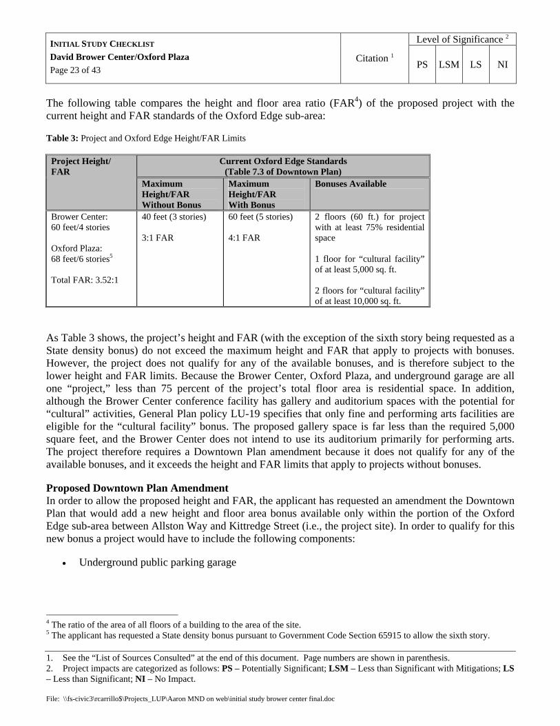
The following table compares the height and floor area ratio (FAR4) of the proposed project with the current height and FAR standards of the Oxford Edge sub-area:
Table 3: Project and Oxford Edge Height/FAR Limits
Current Oxford Edge Standards (Table 7.3 of Downtown Plan)
Project Height/ FAR
Maximum Height/FAR Without Bonus
Maximum Height/FAR With Bonus
Bonuses Available
Brower Center: 60 feet/4 stories Oxford Plaza: 68 feet/6 stories5
Total FAR: 3.52:1
40 feet (3 stories) 3:1 FAR
60 feet (5 stories) 4:1 FAR
2 floors (60 ft.) for project with at least 75% residential space 1 floor for “cultural facility” of at least 5,000 sq. ft. 2 floors for “cultural facility” of at least 10,000 sq. ft.
As Table 3 shows, the project’s height and FAR (with the exception of the sixth story being requested as a State density bonus) do not exceed the maximum height and FAR that apply to projects with bonuses. However, the project does not qualify for any of the available bonuses, and is therefore subject to the lower height and FAR limits. Because the Brower Center, Oxford Plaza, and underground garage are all one “project,” less than 75 percent of the project’s total floor area is residential space. In addition, although the Brower Center conference facility has gallery and auditorium spaces with the potential for “cultural” activities, General Plan policy LU-19 specifies that only fine and performing arts facilities are eligible for the “cultural facility” bonus. The proposed gallery space is far less than the required 5,000 square feet, and the Brower Center does not intend to use its auditorium primarily for performing arts. The project therefore requires a Downtown Plan amendment because it does not qualify for any of the available bonuses, and it exceeds the height and FAR limits that apply to projects without bonuses.
Proposed Downtown Plan Amendment In order to allow the proposed height and FAR, the applicant has requested an amendment the Downtown Plan that would add a new height and floor area bonus available only within the portion of the Oxford Edge sub-area between Allston Way and Kittredge Street (i.e., the project site). In order to qualify for this new bonus a project would have to include the following components:
• Underground public parking garage
4 The ratio of the area of all floors of a building to the area of the site. 5 The applicant has requested a State density bonus pursuant to Government Code Section 65915 to allow the sixth story.

Level of Significance 2 INITIAL STUDY CHECKLIST David Brower Center/Oxford Plaza Page 24 of 43
Citation 1 PS LSM LS NI
1. See the “List of Sources Consulted” at the end of this document. Page numbers are shown in parenthesis. 2. Project impacts are categorized as follows: PS – Potentially Significant; LSM – Less than Significant with Mitigations; LS – Less than Significant; NI – No Impact. File: \\fs-civic3\rcarrillo$\Projects_LUP\Aaron MND on web\initial study brower center final.doc
• Dwelling units comprising at least 60 percent of project’s total floor area, with at least 50 percent of the units to be rented at rates affordable to households earning less than 60 percent of area median income
• Office facility designed to qualify for LEED silver rating or higher
• Conference facility with auditorium, meeting rooms, and gallery space
A project with these components would qualify for the following bonus:
• 2 additional floors allowed (for a total of five)
• Maximum building height of 60 feet
• Maximum FAR of 3.55:1
Under State density bonus law (Government Code Section 65915), the proposed affordability levels of the the project’s residential units would allow it to exceed the “otherwise maximum allowable residential density” by at least 35 percent. The applicant has requested that this density bonus be granted in the form of an additional story over the height limits of the new bonus.
Variance to Allow Creek Setback Encroachment Background: Strawberry Creek flows westward from the UC campus into a 10-foot by 10-foot culvert that runs beneath Allston Way adjacent to the site, following the original course of the creek and passing within 30 feet of the northwest corner of the site. BMC Chapter 17.08 (“Preservation and Restoration of Natural Watercourses”) prohibits construction of “any structure having a roof supported by columns or walls, including dwellings, garages, other accessory buildings and commercial buildings, within 30 feet of the center line of any creek.” Under this ordinance, culverted creeks are still considered creeks so long as the culverted portion is located in the historic creek location, as it is in this location, and construction within a required setback is only allowed through the issuance of a Variance. Proposed Encroachments: The only elements of the project which will be located within 30 feet of the Strawberry Creek culvert are (1) a 35-foot-long section of the photovoltaic panels on the north side of the Brower Center, and the metal awning which supports the panels; and (2) the westernmost street-level awning on the north façade. The photovoltaic panels encroach up to 7 feet, 6 inches into the setback, while the street-level awning encroaches up to 2 feet. The amount of encroachment varies for both elements because the culvert is at an angle to the northern boundary of the site.

Level of Significance 2 INITIAL STUDY CHECKLIST David Brower Center/Oxford Plaza Page 25 of 43
Citation 1 PS LSM LS NI
1. See the “List of Sources Consulted” at the end of this document. Page numbers are shown in parenthesis. 2. Project impacts are categorized as follows: PS – Potentially Significant; LSM – Less than Significant with Mitigations; LS – Less than Significant; NI – No Impact. File: \\fs-civic3\rcarrillo$\Projects_LUP\Aaron MND on web\initial study brower center final.doc
Because the encroaching elements are not part of the building’s roof, or enclosed within the building’s exterior walls or columns, they are likely not subject to the setback for new construction under the Creeks Ordinance. Although it could be argued that the setback should apply to anything attached to a roofed structure, the City’s practice has been to allow similar features such as decks and uncovered (i.e., non-roofed) porches that are attached to roofed structures to encroach into the creek setback without a Variance. Relevant Zoning Ordinance Provisions Neither Chapter 17.08 nor the Zoning Ordinance definitions (Chapter 23F.04) include a definition of “roof,” “column” or “wall.” However, the Zoning Ordinance definition of “building” is identical to the language in 17.08.050.A: “Any enclosed structure having a roof and supported by columns or walls.” In residential districts, the Zoning Ordinance requires buildings to be set back from property lines mainly to maintain light and air between buildings. However, the Ordinance allows certain building features which are not roofed or enclosed by columns or walls to project into these required setbacks, including the following:
• Uncovered porches, decks, stairs, landings, etc. • Canopies, awnings, and similar architectural features • Solar energy equipment (requires AUP in R districts)
Although the Zoning Ordinance treats setback encroachments for solar energy equipment differently than for uncovered porches and decks, the interest it seeks to protect is different than the interest protected by the Creeks Ordinance. For example, the Zoning Ordinance seeks to maintain setbacks in residential districts due to aesthetic concerns as well concerns regarding light and air. In contrast, the Creeks Ordinance seeks to maintain setbacks from culverted creeks due to future daylighting concerns. Therefore, the Zoning Ordinance’s distinction between setback encroachment of uncovered porches and decks and setback encroachment of solar equipment in residential districts is irrelevant to the issue of whether solar equipment encroachment should be treated differently than the City’s current approach to setback encroachments of decks and uncovered porches under the Creeks Ordinance. Additionally, there is no cause to consider the awning encroachment to have any greater impact on the preservation of setbacks for future daylighting than would a deck or uncovered porch. Analysis: While it is likely that construction of the encroaching elements would not violate the Creeks Ordinance6, even if a Variance is required, no significant environmental impact would result because potential
6 The City Council will be asked to determine whether a Variance is required prior to issuance of the required permits for this project.
Level of Significance 2 INITIAL STUDY CHECKLIST David Brower Center/Oxford Plaza Page 26 of 43
Citation 1 PS LSM LS NI
1. See the “List of Sources Consulted” at the end of this document. Page numbers are shown in parenthesis. 2. Project impacts are categorized as follows: PS – Potentially Significant; LSM – Less than Significant with Mitigations; LS – Less than Significant; NI – No Impact. File: \\fs-civic3\rcarrillo$\Projects_LUP\Aaron MND on web\initial study brower center final.doc
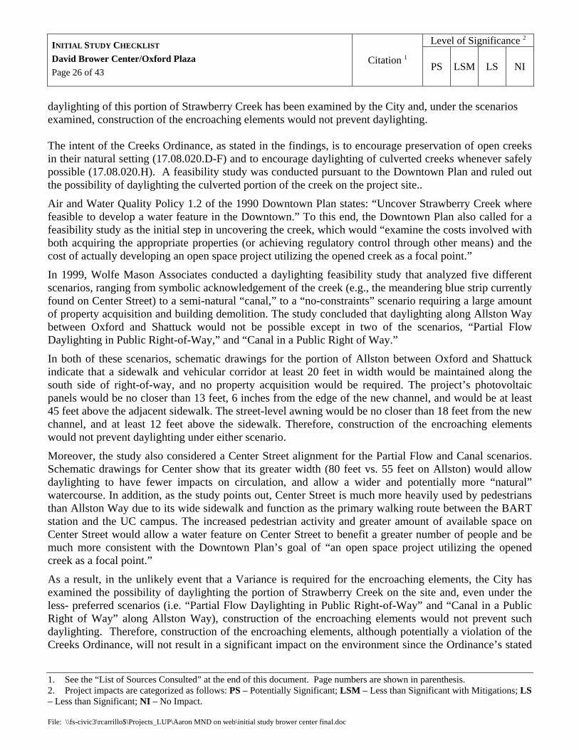
daylighting of this portion of Strawberry Creek has been examined by the City and, under the scenarios examined, construction of the encroaching elements would not prevent daylighting. The intent of the Creeks Ordinance, as stated in the findings, is to encourage preservation of open creeks in their natural setting (17.08.020.D-F) and to encourage daylighting of culverted creeks whenever safely possible (17.08.020.H). A feasibility study was conducted pursuant to the Downtown Plan and ruled out the possibility of daylighting the culverted portion of the creek on the project site..
Air and Water Quality Policy 1.2 of the 1990 Downtown Plan states: “Uncover Strawberry Creek where feasible to develop a water feature in the Downtown.” To this end, the Downtown Plan also called for a feasibility study as the initial step in uncovering the creek, which would “examine the costs involved with both acquiring the appropriate properties (or achieving regulatory control through other means) and the cost of actually developing an open space project utilizing the opened creek as a focal point.”
In 1999, Wolfe Mason Associates conducted a daylighting feasibility study that analyzed five different scenarios, ranging from symbolic acknowledgement of the creek (e.g., the meandering blue strip currently found on Center Street) to a semi-natural “canal,” to a “no-constraints” scenario requiring a large amount of property acquisition and building demolition. The study concluded that daylighting along Allston Way between Oxford and Shattuck would not be possible except in two of the scenarios, “Partial Flow Daylighting in Public Right-of-Way,” and “Canal in a Public Right of Way.”
In both of these scenarios, schematic drawings for the portion of Allston between Oxford and Shattuck indicate that a sidewalk and vehicular corridor at least 20 feet in width would be maintained along the south side of right-of-way, and no property acquisition would be required. The project’s photovoltaic panels would be no closer than 13 feet, 6 inches from the edge of the new channel, and would be at least 45 feet above the adjacent sidewalk. The street-level awning would be no closer than 18 feet from the new channel, and at least 12 feet above the sidewalk. Therefore, construction of the encroaching elements would not prevent daylighting under either scenario.
Moreover, the study also considered a Center Street alignment for the Partial Flow and Canal scenarios. Schematic drawings for Center show that its greater width (80 feet vs. 55 feet on Allston) would allow daylighting to have fewer impacts on circulation, and allow a wider and potentially more “natural” watercourse. In addition, as the study points out, Center Street is much more heavily used by pedestrians than Allston Way due to its wide sidewalk and function as the primary walking route between the BART station and the UC campus. The increased pedestrian activity and greater amount of available space on Center Street would allow a water feature on Center Street to benefit a greater number of people and be much more consistent with the Downtown Plan’s goal of “an open space project utilizing the opened creek as a focal point.”
As a result, in the unlikely event that a Variance is required for the encroaching elements, the City has examined the possibility of daylighting the portion of Strawberry Creek on the site and, even under the less- preferred scenarios (i.e. “Partial Flow Daylighting in Public Right-of-Way” and “Canal in a Public Right of Way” along Allston Way), construction of the encroaching elements would not prevent such daylighting. Therefore, construction of the encroaching elements, although potentially a violation of the Creeks Ordinance, will not result in a significant impact on the environment since the Ordinance’s stated

Level of Significance 2 INITIAL STUDY CHECKLIST David Brower Center/Oxford Plaza Page 27 of 43
Citation 1 PS LSM LS NI
1. See the “List of Sources Consulted” at the end of this document. Page numbers are shown in parenthesis. 2. Project impacts are categorized as follows: PS – Potentially Significant; LSM – Less than Significant with Mitigations; LS – Less than Significant; NI – No Impact. File: \\fs-civic3\rcarrillo$\Projects_LUP\Aaron MND on web\initial study brower center final.doc
purpose of maintaining setbacks from a culverted creek is to encourage daylighting where feasible and the feasibility of daylighting the creek on this site was studied the results of which demonstrate that, under multiple scenarios, daylighting would be possible despite the construction of the encroaching elements.
c) Conflict with any applicable habitat conservation plan or natural community conservation plan?
EIR There are no applicable conservation plans.
X. MINERAL RESOURCES – Would the project:
a) Result in the loss of availability of a known mineral resource that would be of value to the region and the residents of the state?
EIR
No mineral resources of regional value are known to exist at this site.
b) Result in the loss of availability of a locally-important mineral resource recovery site delineated on a local general plan, specific plan or other land use plan?
GP (LU-27)
The site is not a delineated mineral resource recovery site.
XI. NOISE – Would the project result in:
a) Exposure of persons to or generation of noise levels in excess of standards established in the local general plan or noise ordinance, or applicable standards of other agencies?
GP (EM-6)
Construction Noise: Chapter 13.40 of the Berkeley Municipal Code regulates construction noise as follows: Activities creating a “noise disturbance” are prohibited from 7 p.m. to 7 a.m. on weekdays, and 8 p.m. to 9 a.m. on weekends and holidays. During other hours, construction activities must conform to noise levels of 80 dBA on weekdays and 70 dBA on weekends and legal holidays, unless it is not technically and economically feasible to do so. Therefore, for the purposes of this initial study, a significant impact would occur when these levels are exceeded even when it would be technically and economically feasible to meet them. The Municipal Code does not define “technically and economically feasible.”
The project will require the use of construction equipment such as backhoes, bulldozers, jack hammers, and air compressors, which generate noise ranging from 77 to 90 dBA. The project will therefore generate short-term noise in excess of the noise standards for construction, a potentially significant impact. Implementation of the following mitigations would reduce this impact to a less than significant level by reducing noise to the maximum extent feasible, providing advance notice to nearby residents of

Level of Significance 2 INITIAL STUDY CHECKLIST David Brower Center/Oxford Plaza Page 28 of 43
Citation 1 PS LSM LS NI
1. See the “List of Sources Consulted” at the end of this document. Page numbers are shown in parenthesis. 2. Project impacts are categorized as follows: PS – Potentially Significant; LSM – Less than Significant with Mitigations; LS – Less than Significant; NI – No Impact. File: \\fs-civic3\rcarrillo$\Projects_LUP\Aaron MND on web\initial study brower center final.doc
construction, and by reducing the hours of construction otherwise permitted under the noise ordinance to be more consistent with the expectations of surrounding residents (e.g., no construction on Sundays).
Mitigation XI.1 (Construction Noise Controls): Prior to building permit issuance, the applicant shall submit a noise management plan prepared by a qualified acoustic consultant for approval by the Zoning Officer, which reduces the construction noise from the project to the maximum extent feasible. Whenever feasible, the plan shall include the best available noise controls, including but not limited to the following:
• Noise barrier at site boundary, per recommendations of acoustic consultant.
• Vehicle engines and equipment motors shall be properly maintained and equipped with mufflers achieving the greatest feasible noise reduction.
• Rather than impact equipment, quieter procedures such as drilling shall be used.
• Where unavoidable, impact tools (e.g., demolition hammers) shall be hydraulic or electric rather than pneumatic to avoid noise from compressed air exhaust. Where use of pneumatic tools is unavoidable, air exhaust mufflers shall be used (these can reduce exhaust noise by up to 10 dB).
• External jackets on tools shall be used whenever feasible (these can reduce noise by up to 4 dB).
• Stationary noise sources (e.g., air compressors, generators) shall be located to minimize noise transmission over a property line, equipped with adequate mufflers, and enclosed within insulated sheds.
The Zoning Officer shall have authority to require additional noise controls and/or limitations on construction activities in the event of significant noise impacts on surrounding properties.
Mitigation XI.2 (Construction Notification): The applicant shall notify businesses and residents within 300 feet of the project at least two weeks prior to beginning construction, and provide a copy of the notice to the Zoning Officer.
Mitigation XI.3 (Construction Hours): Construction activity shall be limited to between the hours of 8:00 a.m. and 6:00 p.m. on Monday through Friday, and between 9:00 a.m. and noon on Saturday. No construction-related activity shall occur on Sunday.
Post-construction Noise: The proposed land uses are commonly found in the Downtown and are unlikely to generate excessive noise. However, according to the General Plan the average day-night ambient noise level at the site ranges from 70 to 75 Ldn, a level that is “normally unacceptable” for multi-family housing. Pursuant to General Plan Policy EM-47, multi-family housing development “should not be undertaken unless all feasible noise mitigation options have been analyzed and appropriate mitigations

Level of Significance 2 INITIAL STUDY CHECKLIST David Brower Center/Oxford Plaza Page 29 of 43
Citation 1 PS LSM LS NI
1. See the “List of Sources Consulted” at the end of this document. Page numbers are shown in parenthesis. 2. Project impacts are categorized as follows: PS – Potentially Significant; LSM – Less than Significant with Mitigations; LS – Less than Significant; NI – No Impact. File: \\fs-civic3\rcarrillo$\Projects_LUP\Aaron MND on web\initial study brower center final.doc
incorporated into the project to reduce the exposure of people to unacceptable noise levels.” Implementation of the following mitigation would reduce this impact to a less than significant level.
Mitigation XI.4 (Internal Noise Levels): Prior to building permit issuance, the applicant shall submit a report to the Building and Safety Division and the Zoning Officer by a qualified acoustic engineer certifying that the interior residential portions of the project will achieve interior noise levels of no more than 45 Ldn (Average Day-Night Levels).
b) Exposure of persons to or generation of excessive groundborne vibration or groundborne noise levels?
The proposed project does not involve any construction activities that would be expected to generate significant groundborne vibration (such as pile driving)..
c) A substantial permanent increase in ambient noise levels in the project vicinity above levels existing without the project?
TIA
Based on the traffic analysis in section XV below, the project is not expected to generate enough traffic to cause a noise increase of more 3 dBA, the amount of additional noise that is perceptible to the average person.
d) A substantial temporary or periodic increase in ambient noise levels in the project vicinity above levels existing without the project?
Impact discussed under XI(a), above.
e) For a project located within an airport land use plan or, where such a plan has not been adopted, within two miles of a public airport or public use airport, would the project expose people residing or working in the project area to excessive noise levels?
GP (LU-27)
The site is not located with an airport land use plan or within two miles of an airport.
f) For a project within the vicinity of a private airstrip, would the project expose people residing or working in the project area to excessive noise levels?
GP (LU-27)
The site is not within the vicinity of a private airstrip.
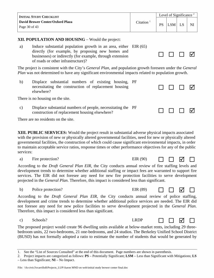
Level of Significance 2 INITIAL STUDY CHECKLIST David Brower Center/Oxford Plaza Page 30 of 43
Citation 1 PS LSM LS NI
1. See the “List of Sources Consulted” at the end of this document. Page numbers are shown in parenthesis. 2. Project impacts are categorized as follows: PS – Potentially Significant; LSM – Less than Significant with Mitigations; LS – Less than Significant; NI – No Impact. File: \\fs-civic3\rcarrillo$\Projects_LUP\Aaron MND on web\initial study brower center final.doc
XII. POPULATION AND HOUSING – Would the project:
a) Induce substantial population growth in an area, either directly (for example, by proposing new homes and businesses) or indirectly (for example, through extension of roads or other infrastructure)?
EIR (65)
The project is consistent with the City’s General Plan, and population growth foreseen under the General Plan was not determined to have any significant environmental impacts related to population growth.
b) Displace substantial numbers of existing housing, necessitating the construction of replacement housing elsewhere?
PF
There is no housing on the site.
c) Displace substantial numbers of people, necessitating the construction of replacement housing elsewhere?
PF There are no residents on the site.
XIII. PUBLIC SERVICES: Would the project result in substantial adverse physical impacts associated with the provision of new or physically altered governmental facilities, need for new or physically altered governmental facilities, the construction of which could cause significant environmental impacts, in order to maintain acceptable service ratios, response times or other performance objectives for any of the public services:
a) Fire protection? EIR (90) According to the Draft General Plan EIR, the City conducts annual review of fire staffing levels and development trends to determine whether additional staffing or impact fees are warranted to support fire services. The EIR did not foresee any need for new fire protection facilities to serve development projected in the General Plan. Therefore, this impact is considered less than significant.
b) Police protection? EIR (89) According to the Draft General Plan EIR, the City conducts annual review of police staffing, development and crime trends to determine whether additional police services are needed. The EIR did not foresee any need for new police facilities to serve development projected in the General Plan. Therefore, this impact is considered less than significant.
c) Schools? LRDP The proposed project would create 96 dwelling units available at below-market rents, including 29 three-bedroom units, 22 two-bedrooms, 21 one-bedrooms, and 24 studios. The Berkeley Unified School District (BUSD) has not formally adopted a ratio to estimate the number of students that would be generated by

Level of Significance 2 INITIAL STUDY CHECKLIST David Brower Center/Oxford Plaza Page 31 of 43
Citation 1 PS LSM LS NI
1. See the “List of Sources Consulted” at the end of this document. Page numbers are shown in parenthesis. 2. Project impacts are categorized as follows: PS – Potentially Significant; LSM – Less than Significant with Mitigations; LS – Less than Significant; NI – No Impact. File: \\fs-civic3\rcarrillo$\Projects_LUP\Aaron MND on web\initial study brower center final.doc
housing units within the City.7 However, BUSD has indicated that a ratio of 0.5 students per housing unit8 would be an appropriate generation rate for planning purposes. It should be noted that this rate would be conservative for the proposed project, given its downtown location and the fact that 63 of the proposed units are two bedrooms or smaller, and therefore less likely to attract households with children than larger units. Using this rate, the proposed project would generate approximately 48 students. The UC Berkeley 2020 LRDP EIR documented the capacity vs. enrollment of schools within the BUSD. Table 4.11-1A on page 4.11-19 of the Draft EIR indicates an enrollment capacity of 11,904 and an enrollment of 9,439 during the 2001-2002 school year. Therefore, the available capacity in the District was approximately 2,466 at that time. According to Planning Department records, approximately 500 new dwelling units have been built since 1999, which would generate about 250 students using the above rate of 0.5 students per unit. Without accounting for the new units that were built between 1999 and 2002, and thus factored into the above enrollment figures, the current District capacity appears to be at least 2,000. Therefore, there would be adequate capacity to accommodate additional students generated by this project.
d) Parks? EIR (193) According to the Draft General Plan EIR, the City has sufficient parks and open space to maintain the adopted standard of 2.0 acres per 1,000 persons after development projected in the General Plan. Therefore this impact is considered less than significant.
e) Other public facilities? EIR The project is consistent with the General Plan, and impacts of development under the General Plan have been analyzed and mitigation measures adopted. Therefore, any impact to other public facilities related to this project is considered less than significant.
XIV. RECREATION – Would the project:
a) Would the project increase the use of existing neighborhood and regional parks or other recreational facilities such that substantial physical deterioration of the facility would occur or be accelerated?
EIR (193)
According to the Draft General Plan EIR, the City has sufficient parks and open space to maintain the adopted standard of 2.0 acres per 1,000 persons after development projected in the General Plan. Therefore the proposed project will not increase use of parks and recreational facilities to a degree sufficient to cause substantial deterioration, and the impact of this project is considered less than significant.
7 Jones, Lew, Director, BUSD Facilities Department, 2005. Personal communication with Steven Ross, May 25. 8 0.5 students per housing unit is the same rate used by the West Contra Costa Unified School District for the Kensington area, as indicated in the UC Berkeley 2020 LRDP Draft EIR.

Level of Significance 2 INITIAL STUDY CHECKLIST David Brower Center/Oxford Plaza Page 32 of 43
Citation 1 PS LSM LS NI
1. See the “List of Sources Consulted” at the end of this document. Page numbers are shown in parenthesis. 2. Project impacts are categorized as follows: PS – Potentially Significant; LSM – Less than Significant with Mitigations; LS – Less than Significant; NI – No Impact. File: \\fs-civic3\rcarrillo$\Projects_LUP\Aaron MND on web\initial study brower center final.doc
b) Does the project include recreational facilities or require the construction or expansion of recreational facilities which might have an adverse physical effect on the environment?
PF
The project does not include recreational facilities.
XV. TRANSPORTATION/TRAFFIC – Would the project:
a) Cause an increase in traffic which is substantial in relation to the existing traffic load and capacity of the street system (i.e., result in a substantial increase in either the number of vehicle trips, the volume to capacity ratio on roads, or congestion at intersections)?
TIA, SD
Operational (Post-Construction) Traffic Impacts
A traffic impact analysis (TIA) for the project was prepared by IBI Group and reviewed by the Planning Department and Office of Transportation. According to the TIA, the project would generate approximately 64 automobile trips during the AM peak period and 68 trips during the PM peak period. This estimate is based on trip generation numbers from the Institute of Traffic Engineers (ITE) and commute mode data from the Alameda County traffic model and US Census. It should be noted that the traffic model includes areas that are further from the Downtown BART station than the project site, and thus yields a higher drive-alone rate (50 percent) for inbound work trips than is likely to occur for the project. (By comparison, the 2001 Southside/Downtown transportation study (see p. 2-3) indicated a drive-alone rate of 46 percent.)
It should also be noted that the TIA’s trip estimate does not account for any transportation demand management measures (TDMs) or parking shortfall that would further reduce peak-hour automobile trips. The trip estimate does not include trips from the proposed conference center, since events at the center are anticipated to occur mainly during off-peak and evening hours. The estimate also does not include any trips attributed specifically to the possible second level of public parking, which again would occur mainly during off-peak and evening hours (mainly theater and restaurant patrons) and would not significantly affect traffic congestion.
According to the TIA, all of the intersections in the study area are currently operating at acceptable levels of service, and will continue to do so in the “future with project” scenario (2008), except for the one at Fulton and Kittredge streets. At this intersection, peak-hour trips generated by the project would substantially increase congestion on the eastbound approach, which is unsignalized with a stop sign on Kittredge. With the existing one-lane approach, the estimated average delay increases from 243 seconds with no project to 811 seconds with the project. According to the Office of Transportation, calculations are unreliable when volumes exceed capacity at a stop-sign approach, but the relative values of delays with and without project volumes are suggestive of the impacts that might occur. The TIA also identifies significant existing congestion at the Oxford/Allston intersection, but this is primarily for vehicles

Level of Significance 2 INITIAL STUDY CHECKLIST David Brower Center/Oxford Plaza Page 33 of 43
Citation 1 PS LSM LS NI
1. See the “List of Sources Consulted” at the end of this document. Page numbers are shown in parenthesis. 2. Project impacts are categorized as follows: PS – Potentially Significant; LSM – Less than Significant with Mitigations; LS – Less than Significant; NI – No Impact. File: \\fs-civic3\rcarrillo$\Projects_LUP\Aaron MND on web\initial study brower center final.doc
attempting to turn onto Oxford from Allston, and the project would not generate any such trips because garage access is proposed on Kittredge. Therefore, significant impacts are only expected at the Fulton/Kittredge intersection.
Three potential mitigations for this intersection were identified in the TIA and considered by City staff. A traffic signal would resolve the congestion, but might take several years to install given that the City could only require a portion of the signal to be funded by the project sponsor. Two less expensive mitigations would also reduce the average delay for project conditions on the eastbound approach to acceptable levels. Creating a two-lane eastbound approach approximately 100 feet long would enable right-turn vehicles to bypass the left-turn queue, thereby significantly reducing their average delays. This mitigation measure would reduce the average delay on the approach to 191 seconds. As this value is less than the “No Project” value, it represents an acceptable mitigation measure. In addition, a sign prohibiting left turns during the PM peak period for exiting traffic (4:00 to 6:00 p.m.) could be installed and would reduce the average delay even further. If all vehicles desiring to make a left turn instead traveled westbound on Kittredge, the average delay would be reduced to 24 seconds. These vehicles would instead pass through other intersections, beginning with Shattuck Avenue, but these other intersections will be operating at sufficiently high levels of service in the “Further with Project” scenario so as not to be significantly impacted by the re-routed trips. Implementation of the following mitigations will reduce the project’s impacts on traffic congestion to a less than significant level:
Mitigation XV.1 (Street Signage and Striping): Prior to building occupancy, the applicant shall pay the City the estimated cost for signage and striping costs for the following measures at the Fulton/Kittredge intersection: (a) prohibiting left turns from 4:00-6:00 p.m. on weekdays, and (b) creating separate left and right turn lanes of at least 100 ft. on the eastbound approach. Within six months after occupancy, the Office of Transportation shall monitor traffic flow and implement one or both of the measures as determined necessary.
As noted above, automobile trips generated by the proposed conference center were not included in the analysis of peak-hour traffic impacts for several reasons. First, unlike the day-to-day activities of the other project uses, conference center events are expected to be occasional. Second, the events can more easily be scheduled so as to avoid starting or ending near peak traffic periods. In consideration of these factors, implementation of the following mitigation would avoid any significant traffic impact from conference center events:
Mitigation XV.2 (Conference Event Notices): Notices, registration forms, world wide web postings, and other communications regarding conference center events shall notify attendees of the difficulty of parking near the conference center, and shall provide information on alternative modes of transportation and information about outlying parking lots that are likely to have spaces available at the time of the event. Samples of these communications shall be provided for the Zoning Officer’s approval prior to the first event.
Mitigation XV.3 (Conference Event Monitoring): During the first six months of building occupancy, the applicant shall notify the Office of Transportation in advance of any conference

Level of Significance 2 INITIAL STUDY CHECKLIST David Brower Center/Oxford Plaza Page 34 of 43
Citation 1 PS LSM LS NI
1. See the “List of Sources Consulted” at the end of this document. Page numbers are shown in parenthesis. 2. Project impacts are categorized as follows: PS – Potentially Significant; LSM – Less than Significant with Mitigations; LS – Less than Significant; NI – No Impact. File: \\fs-civic3\rcarrillo$\Projects_LUP\Aaron MND on web\initial study brower center final.doc
events with more than 100 attendees that begin and/or end within 30 minutes of peak weekday traffic periods (8:00 to 9:00 a.m. and 4:00 to 6:00 p.m.). The applicant shall also survey attendees at such events to determine their commute mode, and provide copies of such surveys to the Zoning Officer and the Office of Transportation. The Office of Transportation shall monitor traffic in the site vicinity from selected events in order to determine whether they are causing any significant impacts on traffic congestion. If any significant impacts are identified, the Zoning Officer shall be authorized to impose additional restrictions on event times and/or require conference center TDMs identified in the traffic analysis by IBI Group dated June 2, 2005.
If not properly controlled, construction activities such as material deliveries, vehicle parking, and use of inadequate streets by large trucks and equipment could have significant impacts on the circulation of vehicles, bicycles and pedestrians in the vicinity by blocking streets and sidewalks without proper control or notice. Approval and implementation of a construction management plan to address procedures and timing for these activities will reduce these impacts to a less than significant level:
Mitigation XV.4 (Construction Traffic Management Plan): Prior to building permit issuance, a construction management plan shall be submitted for approval by the Office of Transportation, Public Works Department, and Planning Department. This plan shall indicate locations of pedestrian walkways and bike lanes adjacent to the site, directional signage, material and equipment storage, trailers, and worker parking, and shall include a schedule of site operations that may block traffic, and provisions for traffic control. The City Zoning Officer and/or Traffic Engineer may limit off-site parking of construction-related vehicles to protect the health, safety, or convenience of the surrounding neighborhood. Transportation of materials on or off site, and unnecessary road closures, shall be prohibited during the AM and PM peak traffic periods. If any encroachment into the Fulton/Oxford right-of-way is necessary for construction staging, the bicycle lane along this street shall be temporarily restriped within the same right-of-way as directed by the Office of Transportation.
Mitigation XV.5 (Construction Vehicle Route): The approved approach route to the site for all construction-related vehicles shall be Interstate 80 to University Avenue to Oxford Street to Kittredge Street. The approved departure route from the site shall be Kittredge Street to Shattuck Avenue to University Avenue to Interstate 80. Construction-related vehicles shall be prohibited from using other streets, unless specifically authorized by the Office of Transportation. The applicant shall make all contractors aware of this mitigation before they begin work at the site.
b) Exceed, either individually or cumulatively, a level of service standard established by the county congestion management agency for designated roads or highways?
EIR (135)
The TIA does not identify any significant impacts on the Alameda County Congestion Management Agency's road network that are triggered solely by the project. The project is consistent with development forecasts in the Draft General Plan EIR, and the EIR contains analysis and mitigations pertaining to impacts of this development on the CMA network. The project has no significant impact in this area for the purposes of this initial study.

Level of Significance 2 INITIAL STUDY CHECKLIST David Brower Center/Oxford Plaza Page 35 of 43
Citation 1 PS LSM LS NI
1. See the “List of Sources Consulted” at the end of this document. Page numbers are shown in parenthesis. 2. Project impacts are categorized as follows: PS – Potentially Significant; LSM – Less than Significant with Mitigations; LS – Less than Significant; NI – No Impact. File: \\fs-civic3\rcarrillo$\Projects_LUP\Aaron MND on web\initial study brower center final.doc
c) Result in a change in air traffic patterns, including either an increase in traffic levels or a change in location that results in substantial safety risks?
PF, ZO,
GP (LU-27) The project is not in the vicinity of an airport.
d) Substantially increase hazards due to a design feature (e.g., sharp curves or dangerous intersections) or incompatible uses (e.g., farm equipment)?
PF, TIA
The TIA notes that five auto-pedestrian accidents were reported at the Oxford/Allston intersection between 1995 and 1999, indicating potential design flaws in the intersection that might be exacerbated by increased pedestrian and vehicle traffic caused by the project. Implementation of the following mitigation would reduce this impact to a less than significant level:
Mitigation XV.6 (Improved Pedestrian Crossing): Prior to issuance of an occupancy permit, the applicant shall install an improved pedestrian crossing and “island” at the southwest corner of the Oxford Street/Allston Way intersection, according to a design approved by the Office of Transportation and Public Works Department, and in accordance with all applicable accessibility requirements.
e) Result in inadequate emergency access? The Fire Department has conducted a preliminary review of the project and did not identify any barriers to emergency access that would require major changes to the project project. As with all construction projects, the project will undergo a detailed review for emergency access during the building permit plan check process.
f) Result in inadequate parking capacity? PF, TIA Lack of parking, in and of itself, is not a significant impact for the purposes of CEQA unless it results in significant impacts in other areas, such as traffic congestion resulting from vehicles searching from parking. In determining whether a proposed parking shortfall is acceptable or requires parking demand management, the City may consider other factors linked to parking supply such as economic vitality, customer convenience, and employee recruitment and retention, but these factors need not be addressed through CEQA mitigations because they are not environmental impacts. Accordingly, the following analysis is focused on whether the “worst-case” on-site parking supply scenario, the single-level garage, creates enough unmet parking demand so as to significantly increase traffic congestion through “parking search” during the peak traffic periods (8:00 to 9:00 a.m., and 4:00 to 6:00 p.m.).
Existing Parking Demand at Site
The existing parking lot on the project site contains 122 public parking spaces. (Another 10 spaces are reserved for City fleet vehicles and are not included in this analysis.) Based on occupancy counts during April 2005, current utilization of the lot is as follows:

Level of Significance 2 INITIAL STUDY CHECKLIST David Brower Center/Oxford Plaza Page 36 of 43
Citation 1 PS LSM LS NI
1. See the “List of Sources Consulted” at the end of this document. Page numbers are shown in parenthesis. 2. Project impacts are categorized as follows: PS – Potentially Significant; LSM – Less than Significant with Mitigations; LS – Less than Significant; NI – No Impact. File: \\fs-civic3\rcarrillo$\Projects_LUP\Aaron MND on web\initial study brower center final.doc
Hour Occupancy 7:00 AM 0 8:00 AM 15 9:00 AM 42 10:00 AM 57 11:00 AM 67 12:00 PM 83 1:00 PM 82 2:00 PM 73 3:00 PM 65 4:00 PM 59 5:00 PM 70 6:00 PM 106 7:00 PM 105 8:00 PM 85 9:00 PM 59 10:00 PM 31 11:00 PM 22 12:00 AM 43
Vehicle Occupancy at Oxford Parking LotTuesday - Thursday Average in April, 2005
0
20
40
60
80
100
120
7:00 A
M
9:00 A
M
11:00
AM
1:00 P
M
3:00 P
M
5:00 P
M
7:00 P
M
9:00 P
M
11:00
PM
Time of Day
Vehi
cle
Occ
upan
cy
Based on this data, the average parking demand at the site during the morning peak traffic period (8:00 to 9:00 a.m.) ranges from about 15 to 42 spaces. During the evening peak traffic period (5:00 to 6:00 p.m.), the average demand ranges from 70 to 106 spaces. The two periods of highest demand, 11:00 a.m. to 1:00 p.m. and 6:00 p.m. to 8:00 p.m., both occur outside of the peak traffic periods.
Parking Utilization at Other Garages
According to City data cited in the applicant’s traffic analysis, several garages in the project vicinity have significant amounts of parking available at various times of day:
Table 1: Parking Utilization at Selected Downtown Garages
Spaces Available Parking Facility Total Supply
Weekday Mornings
Weekday Afternoons
Weekday Evenings
Allston Way Garage 610 165 98 384
Center Street Garage 410 8 49 201
Promenade Garage (1936 Addison St.)
120 52 No data 84
Total 1,140 225 147+ 669

Level of Significance 2 INITIAL STUDY CHECKLIST David Brower Center/Oxford Plaza Page 37 of 43
Citation 1 PS LSM LS NI
1. See the “List of Sources Consulted” at the end of this document. Page numbers are shown in parenthesis. 2. Project impacts are categorized as follows: PS – Potentially Significant; LSM – Less than Significant with Mitigations; LS – Less than Significant; NI – No Impact. File: \\fs-civic3\rcarrillo$\Projects_LUP\Aaron MND on web\initial study brower center final.doc
Obviously, total public parking supply in the Downtown is higher than represented in this table, which does not include numerous smaller garages and surface lots or metered parking. Furthermore, the total supply will be increased by 147 spaces upon completion of the Library Gardens project (2020 Kittredge Street), probably within the next 12 months.
Project Parking Demand—Residential
As noted in the project description, it has not been determined whether the proposed garage will have one level (105 spaces) or two (206 spaces). However, in both scenarios, 40 residential parking spaces will be provided in a separate street-level garage. These spaces will meet the project’s residential parking demand based on low car ownership rates in the Downtown, household incomes associated with the proposed affordable units, and comparable parking ratios approved for other recent Downtown projects (e.g., Gaia Building with 41 spaces for 91 units). The applicant intends to implement TDMs such as residential bicycle parking (at least 50 spaces), unbundling parking spaces from apartment leases, providing one or more CarShare spaces in the residential garage, and paying residents’ initial CarShare membership fees. These TDMs should be adequate to reduce residential parking demand below the proposed number of parking spaces.
It is important to note that the City’s zoning requirement for strictly residential projects (as opposed to the residential portion of mixed-use projects) is only 1 space per 3 units in this area, which the proposed residential parking would exceed by 8 spaces. In addition, in the unlikely event that residents who wish to obtain parking at the site are unable to do so, they would be unlikely to own cars because monthly parking in the Downtown is expensive and generally not accessible 24 hours, and the nearest on-street parking not subject to Residential Parking Permit (RPP) restrictions is about 0.6 miles from the site (Shattuck and Carleton).
Project Parking Demand—Non-Residential
For the purposes of this analysis, it is assumed that the project’s parking demand will not be affected by lack of parking at the site. In other words, even if the project does not satisfy its own parking demand, all vehicle trips generated by the project will still come to the site rather than searching for parking elsewhere or switching to other transportation modes. This is a conservative assumption, and parking demand may in reality be reduced as project employees and visitors become more aware of the lower parking supply at the site. As noted in the discussion of trip generation above, the mode split data used in the applicant’s traffic analysis are conservative because they are based on data from areas more than ¼-mile from the Downtown BART station, where automobile use tends to be higher. In addition, the applicant has agreed to implement certain transportation demand measures that would further reduce parking demand (see Table 6.4 of applicant’s analysis), as discussed below.
The TIA estimates that parking demand generated by the project’s non-residential uses will range from 55 vehicles at 9:00 a.m., to 73 at 12:00 noon, to 35 at 6:00 p.m. For the retail and restaurant uses, office

Level of Significance 2 INITIAL STUDY CHECKLIST David Brower Center/Oxford Plaza Page 38 of 43
Citation 1 PS LSM LS NI
1. See the “List of Sources Consulted” at the end of this document. Page numbers are shown in parenthesis. 2. Project impacts are categorized as follows: PS – Potentially Significant; LSM – Less than Significant with Mitigations; LS – Less than Significant; NI – No Impact. File: \\fs-civic3\rcarrillo$\Projects_LUP\Aaron MND on web\initial study brower center final.doc
visitors, and employees in a portion of the office space (10,000 square feet), parking demand was based on Institute of Traffic Engineers (ITE) parking generation data and regional mode split data. For the remaining 23,000 square feet of office space, estimated parking demand was based on a commute mode survey of employees of the environmental groups who intend to occupy this space.
Two of the groups in the survey, Earth Island Institute and Rainforest Action Network, have a single-occupant vehicle (SOV) commute rate of five percent, which is much lower than the SOV rate of 54 percent for the area. However, this low rate cannot be guaranteed over the long term through the DDA or Use Permit conditions, and so the parking demand has been adjusted upward using the same parking generation rate for the generic office space in order to more accurately portray a “worst-case” scenario. This adjustment results in a demand of about 82 vehicles at 9:00 a.m., 97 at 12:00 noon, and 35 at 6:00 p.m. The adjustment does not affect evening parking demand because office employees generally leave work by 6:00 p.m.
The TIA also includes a discussion of TDMs which the applicant intends to implement, including bicycle storage for the David Brower Center (18 spaces), participation in the Guaranteed Ride Home program, monthly transit or rideshare allowances, and reduced parking fees for employee carpools and vanpools. With the same upward adjustment maintained, these measures would lower the project’s non-residential parking demand to about 53 vehicles at 9:00 a.m., 63 vehicles at 12 noon, and 21 vehicles at 6:00 p.m.
Traffic Impacts of Unmet Parking Demand
At 9:00 a.m, the end of the morning peak traffic period, the proposed parking demand of 82 vehicles without TDM measures, combined with the existing demand of 42 vehicles, results in a total of 124 vehicles. This exceeds the capacity of the proposed single-level garage by 19 vehicles. Implementation of TDM measures would reduce the total demand to about 95 vehicles, which would not exceed the single-level garage capacity.
Vehicles that are unable to park at the site would reenter the roadway network and travel to another parking facility, passing through nearby intersections and adding to the traffic at those intersections. Based on the trip distribution patterns in the applicant’s traffic analysis, most of the vehicles would be coming from Shattuck Avenue, and would therefore continue eastward to the Fulton/Kittredge intersection. With implementation of Mitigation XV.1, congestion at the Fulton/Kittredge intersection would be sufficiently reduced such that no significant congestion would result from the 19 additional vehicles in the worst-case demand scenario without any effect from TDMs. All of the other intersections that vehicles might use in searching for alternate parking are operating at LOS C or higher, and will not be significantly affected by the relatively small number of search vehicles during the morning peak period.
If monthly parking were not provided at the proposed single-level garage, and the City continued to set long-term parking prices so as to discourage all-day parking, project employees would be unlikely to park at the site. However, this would not result in any significant parking search impacts because these employees would most likely be aware of the lack of monthly parking before starting employment at the site, or they would become aware shortly thereafter. Parking search impacts would be unlikely in this case
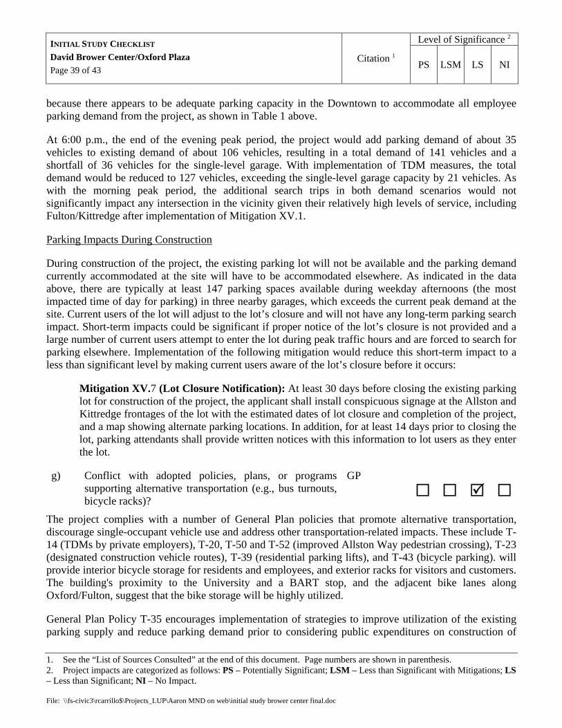
Level of Significance 2 INITIAL STUDY CHECKLIST David Brower Center/Oxford Plaza Page 39 of 43
Citation 1 PS LSM LS NI
1. See the “List of Sources Consulted” at the end of this document. Page numbers are shown in parenthesis. 2. Project impacts are categorized as follows: PS – Potentially Significant; LSM – Less than Significant with Mitigations; LS – Less than Significant; NI – No Impact. File: \\fs-civic3\rcarrillo$\Projects_LUP\Aaron MND on web\initial study brower center final.doc
because there appears to be adequate parking capacity in the Downtown to accommodate all employee parking demand from the project, as shown in Table 1 above.
At 6:00 p.m., the end of the evening peak period, the project would add parking demand of about 35 vehicles to existing demand of about 106 vehicles, resulting in a total demand of 141 vehicles and a shortfall of 36 vehicles for the single-level garage. With implementation of TDM measures, the total demand would be reduced to 127 vehicles, exceeding the single-level garage capacity by 21 vehicles. As with the morning peak period, the additional search trips in both demand scenarios would not significantly impact any intersection in the vicinity given their relatively high levels of service, including Fulton/Kittredge after implementation of Mitigation XV.1.
Parking Impacts During Construction
During construction of the project, the existing parking lot will not be available and the parking demand currently accommodated at the site will have to be accommodated elsewhere. As indicated in the data above, there are typically at least 147 parking spaces available during weekday afternoons (the most impacted time of day for parking) in three nearby garages, which exceeds the current peak demand at the site. Current users of the lot will adjust to the lot’s closure and will not have any long-term parking search impact. Short-term impacts could be significant if proper notice of the lot’s closure is not provided and a large number of current users attempt to enter the lot during peak traffic hours and are forced to search for parking elsewhere. Implementation of the following mitigation would reduce this short-term impact to a less than significant level by making current users aware of the lot’s closure before it occurs:
Mitigation XV.7 (Lot Closure Notification): At least 30 days before closing the existing parking lot for construction of the project, the applicant shall install conspicuous signage at the Allston and Kittredge frontages of the lot with the estimated dates of lot closure and completion of the project, and a map showing alternate parking locations. In addition, for at least 14 days prior to closing the lot, parking attendants shall provide written notices with this information to lot users as they enter the lot.
g) Conflict with adopted policies, plans, or programs supporting alternative transportation (e.g., bus turnouts, bicycle racks)?
GP
The project complies with a number of General Plan policies that promote alternative transportation, discourage single-occupant vehicle use and address other transportation-related impacts. These include T-14 (TDMs by private employers), T-20, T-50 and T-52 (improved Allston Way pedestrian crossing), T-23 (designated construction vehicle routes), T-39 (residential parking lifts), and T-43 (bicycle parking). will provide interior bicycle storage for residents and employees, and exterior racks for visitors and customers. The building's proximity to the University and a BART stop, and the adjacent bike lanes along Oxford/Fulton, suggest that the bike storage will be highly utilized.
General Plan Policy T-35 encourages implementation of strategies to improve utilization of the existing parking supply and reduce parking demand prior to considering public expenditures on construction of

Level of Significance 2 INITIAL STUDY CHECKLIST David Brower Center/Oxford Plaza Page 40 of 43
Citation 1 PS LSM LS NI
1. See the “List of Sources Consulted” at the end of this document. Page numbers are shown in parenthesis. 2. Project impacts are categorized as follows: PS – Potentially Significant; LSM – Less than Significant with Mitigations; LS – Less than Significant; NI – No Impact. File: \\fs-civic3\rcarrillo$\Projects_LUP\Aaron MND on web\initial study brower center final.doc
additional City-owned public parking spaces in the Downtown. The single-level garage would be consistent with Policy T-35 because it does not create additional City-owned parking spaces, but merely replaces City-owned spaces in the existing parking lot. The two-level garage would also be consistent with Policy T-35 because the second level, if built, will not rely on any financial assistance from the City.
XVI. UTILITIES AND SERVICE SYSTEMS – Would the project:
a) Exceed wastewater treatment requirements of the applicable Regional Water Quality Control Board?
PF The project involves typical residential and commercial uses and will not exceed any applicable wastewater treatment requirements.
b) Require or result in the construction of new water or wastewater treatment facilities or expansion of existing facilities, the construction of which could cause significant environmental effects?
EIR(149-52)
The project is consistent with the City’s General Plan, and there are adequate treatment facilities to serve development projected under the General Plan.
c) Require or result in the construction of new storm water drainage facilities or expansion of existing facilities, the construction of which could cause significant environmental effects?
PF
Because the project does not increase impervious coverage at the site, new or expanded drainage facilities will not be necessary to serve the project.
d) Have sufficient water supplies available to serve the project from existing entitlements and resources, or are new or expanded entitlements needed?
EIR (152)
The project is consistent with the City’s General Plan, and there are adequate water supplies to serve development projected under the General Plan.
e) Result in a determination by the wastewater treatment provider which serves or may serve the project that it has adequate capacity to serve the project's projected demand in addition to the provider’s existing commitments?
See XVI (b) above.

Level of Significance 2 INITIAL STUDY CHECKLIST David Brower Center/Oxford Plaza Page 41 of 43
Citation 1 PS LSM LS NI
1. See the “List of Sources Consulted” at the end of this document. Page numbers are shown in parenthesis. 2. Project impacts are categorized as follows: PS – Potentially Significant; LSM – Less than Significant with Mitigations; LS – Less than Significant; NI – No Impact. File: \\fs-civic3\rcarrillo$\Projects_LUP\Aaron MND on web\initial study brower center final.doc
f) Be served by a landfill with sufficient permitted capacity to accommodate the project’s solid waste disposal needs?
EIR (87)
The project is consistent with the City’s General Plan, and there is adequate landfill capacity to serve development foreseen under the General Plan.
g) Comply with federal, state, and local statutes and regulations related to solid waste?
The proposed land uses do not typically generate substantial or unusual solid waste, and will be required to comply with all applicable solid waste regulations. The project will also be subject to a standard condition of approval requiring submittal of a construction and demolition recycling plan.
XVII. MANDATORY FINDINGS OF SIGNIFICANCE –
a) Does the project have the potential to degrade the quality of the environment, substantially reduce the habitat of a fish or wildlife species, cause a fish or wildlife population to drop below self-sustaining levels, threaten to eliminate a plant or animal community, reduce the number or restrict the range of a rare or endangered plant or animal or eliminate important examples of the major periods of California history or prehistory?
EIR, SV
No sensitive biological or historical resources have been identified on the project site, and there is no evidence that the project will degrade these aspects of the environment.
b) Does the project have impacts that are individually limited, but cumulatively considerable? (Cumulatively considerable) means that the incremental effects of a project are considerable when viewed in connection with the effects of past projects, the effects of other current projects, and the effects of probable future projects)?
EIR
The project is consistent with the City’s General Plan, and the Draft General Plan EIR did not identify any cumulatively considerable impacts related to this project, except as discussed in III(a-c) and XV(b) above.
c) Does the project have environmental effects which will cause substantial adverse effects on human beings, either directly or indirectly?
Other than the impacts identified and mitigated above, the project has no foreseeable substantial effects on human beings.

Level of Significance 2 INITIAL STUDY CHECKLIST David Brower Center/Oxford Plaza Page 42 of 43
Citation 1 PS LSM LS NI
1. See the “List of Sources Consulted” at the end of this document. Page numbers are shown in parenthesis. 2. Project impacts are categorized as follows: PS – Potentially Significant; LSM – Less than Significant with Mitigations; LS – Less than Significant; NI – No Impact. File: \\fs-civic3\rcarrillo$\Projects_LUP\Aaron MND on web\initial study brower center final.doc
LIST OF SOURCES CONSULTED
(Note: the following documents are available online as noted below or at the Permit Service Center, 2120 Milvia Street, Berkeley)
AQ Bay Area Air Quality Management District, CEQA Guidelines, December 1999
CRK City of Berkeley, map of “BMC 17.08 Creeks and Parcels with Setback Effects from these Creeks,” April 8, 2005 (www.ci.berkeley.ca.us/maproom)
DTP City of Berkeley, Planning Department, Berkeley Downtown Plan, October 1990 (www.ci.berkeley.ca.us/planning/landuse)
EIR LSA Associates for City of Berkeley, Draft General Plan Environmental Impact Report, 2001
GI Fugro West, Inc., “Geotechnical Study, Brower Center,” Project No. 1683.001, February 2005
GP City of Berkeley, Berkeley General Plan, 2002 (www.ci.berkeley.ca.us/planning/landuse)
HR Page and Turnbull, Inc., “David Brower Center/Oxford Plaza Section 106 & CEQA Analysis,” April 2005
HW State of California, Department of Toxic Substances Control, “Hazardous Waste and Substances Site List,” www.dtsc.ca.gov/database/Calsites/Cortese_List.cfm
LM City of Berkeley, “Designated Landmarks, Structures of Merit and Historical Districts” revised October 13, 2004 (map available at www.ci.berkeley.ca.us/maproom)
LRDP University of California at Berkeley, Long Range Development Plan and EIR, 2005 (lrdp.berkeley.edu)
PF City of Berkeley, Land Use Planning Division, project files for Use Permit 04-10000114
PR Cotton, Shires & Associates, Inc., letter to Aaron Sage, May 13, 2005
PI Gribi Associates, “Oxford Street Parking Lot Phase I and Phase II Environmental Site Assessment,” June 2001
SC Wolfe Mason Associates for City of Berkeley, “Strawberry Creek Downtown: A Data Collection Study to Daylight Strawberry Creek,” June 1999
SD Nelson/Nygaard Associates for City of Berkeley and UC Berkeley, “Southside/Downtown Transportation Demand Management Study,” March 2001
SH City of Berkeley, “CGS Hazard Study Zones by Berkeley Parcel,” July 9, 2003 (www.ci.berkeley.ca.us/maproom)
SHRI Berkeley Architectural Heritage Association, “Buildings Included in State Historic Resources Inventory, 1977-79”, no date
SV Observations from site visits conducted by Aaron Sage, January to May, 2005
Level of Significance 2 INITIAL STUDY CHECKLIST David Brower Center/Oxford Plaza Page 43 of 43
Citation 1 PS LSM LS NI
1. See the “List of Sources Consulted” at the end of this document. Page numbers are shown in parenthesis. 2. Project impacts are categorized as follows: PS – Potentially Significant; LSM – Less than Significant with Mitigations; LS – Less than Significant; NI – No Impact. File: \\fs-civic3\rcarrillo$\Projects_LUP\Aaron MND on web\initial study brower center final.doc
TIA IBI Group, “Traffic Impact Analysis and Parking Study, Oxford Plaza and the David Brower Center,” April 7, 2005
ZO City of Berkeley, Zoning Ordinance, Ord. 6478-NS, 1999 (www.ci.berkeley.ca.us/bmc)


![UNIVERSITY OF ARIZONA POETRY CENTER · PDF fileCredo for the earth / David R. Brower. [San Francisco] : One Heart Press, 2004. ... Buckner, Sally. The work of dreams / by Sally Buckner.](https://static.fdocuments.us/doc/165x107/5aaeb43a7f8b9a5d0a8c7c90/university-of-arizona-poetry-center-for-the-earth-david-r-brower-san-francisco.jpg)