INITIAL SITE INVESTIGATION REPORT - Vermont · INITIAL SITE INVESTIGATION REPORT Lacillade...
58
2113 Stony Brook Road Northfield, Vermont 05663 (802) 485-9466 INITIAL SITE INVESTIGATION REPORT Lacillade Residence 139 Seasame Street Braintree, Vermont Latitude: 043° 55’ 52.46” N Longitude: 072°42’ 7.28” W February 24, 2006 Prepared for: Ms. Ethyl Lacillade Mailing Address: 139 Seasame Street Randolph, Vermont 05060 Prepared by: Applied GeoSolutions, LLC Contact: Eric J. Swiech, P.G. Principal Hydrogeologist
Transcript of INITIAL SITE INVESTIGATION REPORT - Vermont · INITIAL SITE INVESTIGATION REPORT Lacillade...
2113 Stony Brook Road Northfield, Vermont 05663
(802) 485-9466
INITIAL SITE INVESTIGATION
REPORT
Lacillade Residence 139 Seasame Street Braintree, Vermont
Latitude: 043° 55’ 52.46” N
Longitude: 072°42’ 7.28” W
February 24, 2006
Prepared for:
Ms. Ethyl Lacillade Mailing Address: 139 Seasame Street
Randolph, Vermont 05060
Prepared by:
Applied GeoSolutions, LLC
Contact: Eric J. Swiech, P.G.
Principal Hydrogeologist
TABLE OF CONTENTS Page EXECUTIVE SUMMARY i 1.0 INTRODUCTION ....................................................................................................... 1 2.0 BACKGROUND ......................................................................................................... 1 2.1 Site Description and Physical Setting................................................ 1 2.2 Kerosene Release – Initial response................................................... 2 3.0 WORK COMPLETED ................................................................................................. 3 3.1 Soil Borings / Sampling....................................................................... 3 3.2 Vapor Well Installation ........................................................................ 6 3.3 Indoor Air Screening ............................................................................ 6 4.0 RESULTS….. .................................................................................................................. 6 4.1 Geology/Hydrogeology ...................................................................... 6 4.2 Contaminant Distribution.................................................................... 7 4.2.1 Soil ................................................................................................. 7 4.2.1.1 PID Screening Results ....................................................... 7 4.2.1.2 Laboratory Analytical Results.......................................... 8 4.2.1.2.1 VOCs........................................................................... 8 4.2.1.2.2 PAHs........................................................................... 9 4.2.1.2.3 TPH ............................................................................. 9 4.2.2 Indoor Air..................................................................................... 9 5.0 CONCEPTUAL SITE MODEL ............................................................................. 10 6.0 SENSITIVE RECEPTOR SURVEY ...................................................................... 11 7.0 CONCLUSIONS AND RECOMMENDATIONS ............................................. 13 8.0 RECOMMENDATIONS ....................................................................................... 14 FIGURES Figure 1 Site Location Map Figure 2 Contaminant Distribution Map TABLES Table 1 Summary of Soil Analytical Results APPENDIX A: Photographs APPENDIX B: Field Notes APPENDIX C: Soil Boring Logs APPENDIX D: Laboratory Reports

EXECUTIVE SUMMARY
Applied GeoSolutions, LLC (AGS) was retained to complete an Initial Site Investigation (ISI) at the residence of Ms. Ethyl Lacillade located at 139 Seasame Street, in Braintree, Vermont (Site). The purpose of the ISI was to characterize the magnitude and extent of petroleum contamination associated with a release of kerosene from an existing 275-gallon aboveground storage tank (AST) system, and to evaluate the risk that the release posed to sensitive receptors. An estimated 230 to 235 gallons of kerosene were released to the subsurface from the AST system at the Site between December 21 and 31, 2005.
The degree and extent of the kerosene release has been reasonably defined. At this time, it appears that the vertical extent of the kerosene impact is limited to unsaturated soils within about 17 feet below ground surface (bgs), with the bulk of contaminant mass present between ground surface and about 9 feet bgs. The lateral extent of impacted soils exhibiting PID readings greater than 10 ppmv comprises an area of about 120 to 130 square feet. Sensitive receptors either currently impacted by the kerosene release or at risk include indoor air, shallow soils, and ground water. Elevated PID readings have been detected in the breathing zone of the mobile home, and several volatile organic compounds (VOCs) were detected in soils at concentrations that exceed either the PRGs for “Direct Contact” or the Soil Screening Levels for “Migration to Ground Water”. Elevated PID readings detected within the mobile home is not conclusive evidence that VOCs from the kerosene release impacted indoor air quality, as the PID is only a screening tool that does not measure specific compounds, and the instrument can be affected by environmental factors such as temperature and humidity. Also, the PID would detect other VOCs that may have been present within the home related to common household items (e.g. cleaners, hairspray etc.). Compound-specific air testing to speciate the VOCs was not completed during the ISI. Given the impact and risk to sensitive receptors, corrective action appears warranted to mitigate the contaminant impact. A screening of potential remedial alternatives suggests that short-term Soil Vapor Extraction (SVE), followed by either active or passive Bioventing is the most technically viable and cost-effective strategy for addressing the impacted soils and protecting human health and the environment. SVE would remove the lighter, more mobile target VOCs and promptly mitigate potential VOC impact to indoor air and the risk to ground water. Bioventing (via air injection) would provide oxygen to the impacted soils to facilitate the natural biodegradation of hydrocarbons by indigenous microorganisms. These technologies are proven effective for kerosene contamination and sandy soils, which are present at the Site.
Lacillade Residence, Braintree, VT Applied GeoSolutions, LLC Initial Site Investigation Page 1
1.0 INTRODUCTION This Initial Site Investigation (ISI) report for the Lacillade Residence at 139 Seasame Street, in Braintree, Vermont (Site), was prepared by Applied GeoSolutions, LLC (AGS) on behalf of the property owner, Ms. Ethyl Lacillade. The purpose of the ISI was to characterize the magnitude and extent of petroleum contamination associated with a release of kerosene from an existing 275-gallon aboveground storage tank (AST) system, and to evaluate the risk that the release posed to sensitive receptors. The ISI was completed in general accordance with a work plan and cost estimate prepared by AGS, dated January 6, 2005. This work plan and cost estimate, with the exception of proposed indoor air testing by EPA Method TO-15, was approved by Mr. Marc Roy of the Vermont Department of Environmental Conservation (VT DEC) via electronic mail. This work plan and cost estimate was approved in its entirety by Mr. Jim Barr, of Barr Environmental, during a telephone conversation with Mr. Eric J. Swiech of AGS on January 11, 2006. Mr. Barr is providing third-party oversight of the project on behalf of Ms. Lacillade’s insurance provider, Foremost Insurance. This ISI complies with the requirements set forth in the VT DEC’s Site Investigation Procedure document, effective June 2005. 2.0 BACKGROUND
2.1 Site Description and Physical Setting The property is located in the Mobile Acres Mobile Home Park at 139 Seasame Street, in Braintree, Vermont, at an approximate latitude of 043° 55’ 52.46” N and longitude 072°42’ 7.28” W (Figure 1). A 12’ x 48’ mobile home and detached storage shed are present on the parcel leased by Ms. Lacillade. Ms. Lacillade apparently owns the mobile home and storage shed; the land itself is owned by Vermont State Housing Authority (VSHA), which also maintains the facilities. The 275-gallon kerosene AST is located adjacent to the mobile home, on the south side. Drinking water is apparently provided to the residence, and other residences in the mobile home park, by a drilled community well, located about 1,000 feet northwest of the AST. Sewage for the mobile home park is apparently treated via a septic system; the location of the septic leachfield(s) is currently not known.
Lacillade Residence, Braintree, VT Applied GeoSolutions, LLC Initial Site Investigation Page 2
The Lacillade parcel is bound by other mobile homes to the east and west. Seasame Street borders the Lacillade parcel on the north. A campground borders the Lacillade parcel to the south. The topography of the property is generally flat in the area of the Lacillade mobile home and AST. A relatively steep embankment (about 20 feet change in elevation) is located about 20-25 feet south of the AST, which slopes down to the campground. Ground cover in the area of the AST is comprised primarily of grass.
An underground electric line enters the mobile home on the east side of the home, north of the AST. Shallow underground cable and telephone lines are present south of the mobile home, in the vicinity of the AST. No other underground utilities are currently known to be located in vicinity of the AST. 2.2 Kerosene Release – Initial Response On January 3, 2006, AGS received a telephone call from Mr. Marc Roy of the Vermont Waste Management Division (WMD) requesting that AGS perform a preliminary site evaluation regarding a suspected release of kerosene from a 275-gallon AST at the Site. Eric J. Swiech, P.G. of AGS visited the Site later that same day.
The AST was reportedly filled with 160 gallons of kerosene on December 21, 2005. On December 31, 2005, the furnace to the home shut down. Rick Lacillade, Ethyl’s son, investigated the incident and noticed that the AST contained only about 4 inches of kerosene (estimated at about 15 gallons). According to the fuel provider, Mr. Bob Townsend of Ferriter Oil Company, located in Randolph, Vermont, only about 2.5 to 3 gallons of fuel per day would normally be required to sufficiently heat the residence during the winter months, depending on the outdoor temperature, which would account for about 25 to 30 gallons of normal kerosene consumption during the 10-day period. If the AST was filled to capacity on December 21, 2005, about 230 to 235 gallons of kerosene cannot be accounted for, and apparently was released to the subsurface.
AGS visited with Ms. Laccilade and her son to obtain their account of the situation. AGS then investigated the suspected release area by making visual observations and screening soil samples and indoor air with a Photovac model 2020 photoionization detector (PID), which is equipped with a 10.6 eV ultraviolet lamp. The PID was calibrated to a benzene reference prior to arriving at the Site. A summary of the results of the initial response are as follows:

Lacillade Residence, Braintree, VT Applied GeoSolutions, LLC Initial Site Investigation Page 3
• The suspected cause of the release is through a fitting on the bottom of the AST associated with the former fuel line.
• Soils beneath the southern end of the mobile home appear to have been impacted
by kerosene based on visual, olfactory, and PID evidence. The lateral extent of impact beneath the mobile home appears to be limited to about a 42 square foot area (about 6 feet by 7 feet). The vertical extent of the impact could not be determined during the Site visit.
• Frost had beset the soils in the vicinity of the AST, on the exterior of the mobile
home, which prevented soil sampling in this area without mechanical means. • PID readings on the headspace of surface soil samples collected beneath the
mobile home ranged from 2.3 parts per million volume (ppmv) on the periphery of the impact area to 142 ppmv near the AST.
• On January 3, 2006, PID readings of the ambient air throughout the interior of the
mobile home ranged from 3.5 to 3.9 ppmv above the background concentration outdoors, which was 0.0 ppmv. On this date, a small, opened container of kerosene (less than about 4 ounces) was present within the interior of the mobile home adjacent to the furnace, which was residual from bleeding the fuel pump to the furnace. On January 4, 2006, with the open container of kerosene removed from the mobile home interior, the ambient air PID reading within the mobile home was 3.9 ppmv. AGS did not observe a kerosene odor within the home, and Ethyl and Rick Lacillade have not observed a kerosene odor indoors since the apparent release.
• The PID readings from the space beneath the mobile home, with the skirt in
place, ranged from 3.6 to 6.5 ppmv.
3.0 WORK COMPLETED Photographs of the Site obtained during the ISI are provided in Appendix A. Copies of field notes for the project are provided in Appendix B.
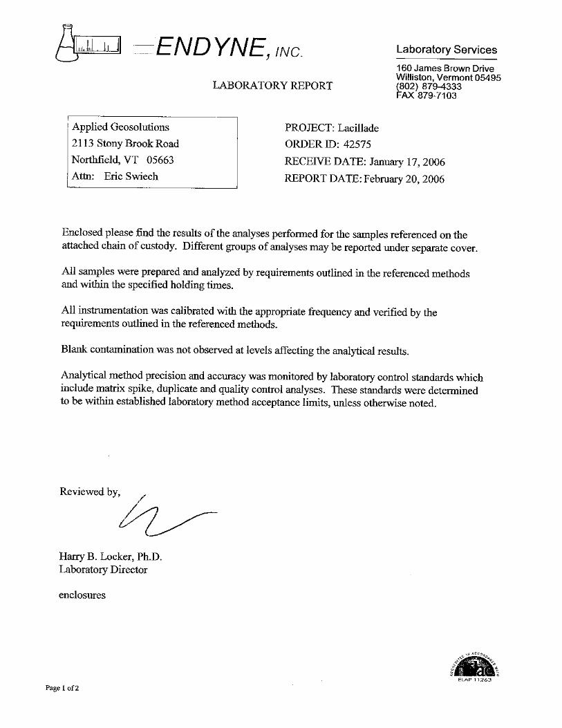
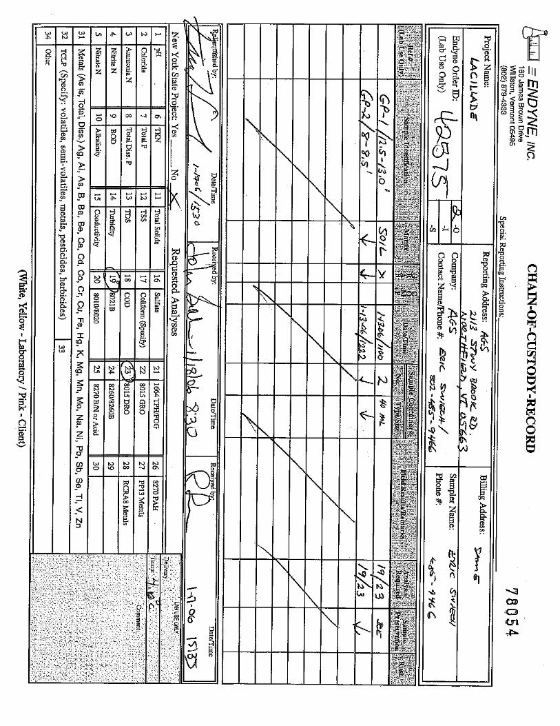
3.1 Soil Borings / Sampling On January 13 and January 20, 2006, AGS conducted a soil boring / soil sampling program at the Site to determine the degree and extent of kerosene impact to the subsurface. A total of eight soil borings were completed. Three soil samples

Lacillade Residence, Braintree, VT Applied GeoSolutions, LLC Initial Site Investigation Page 4
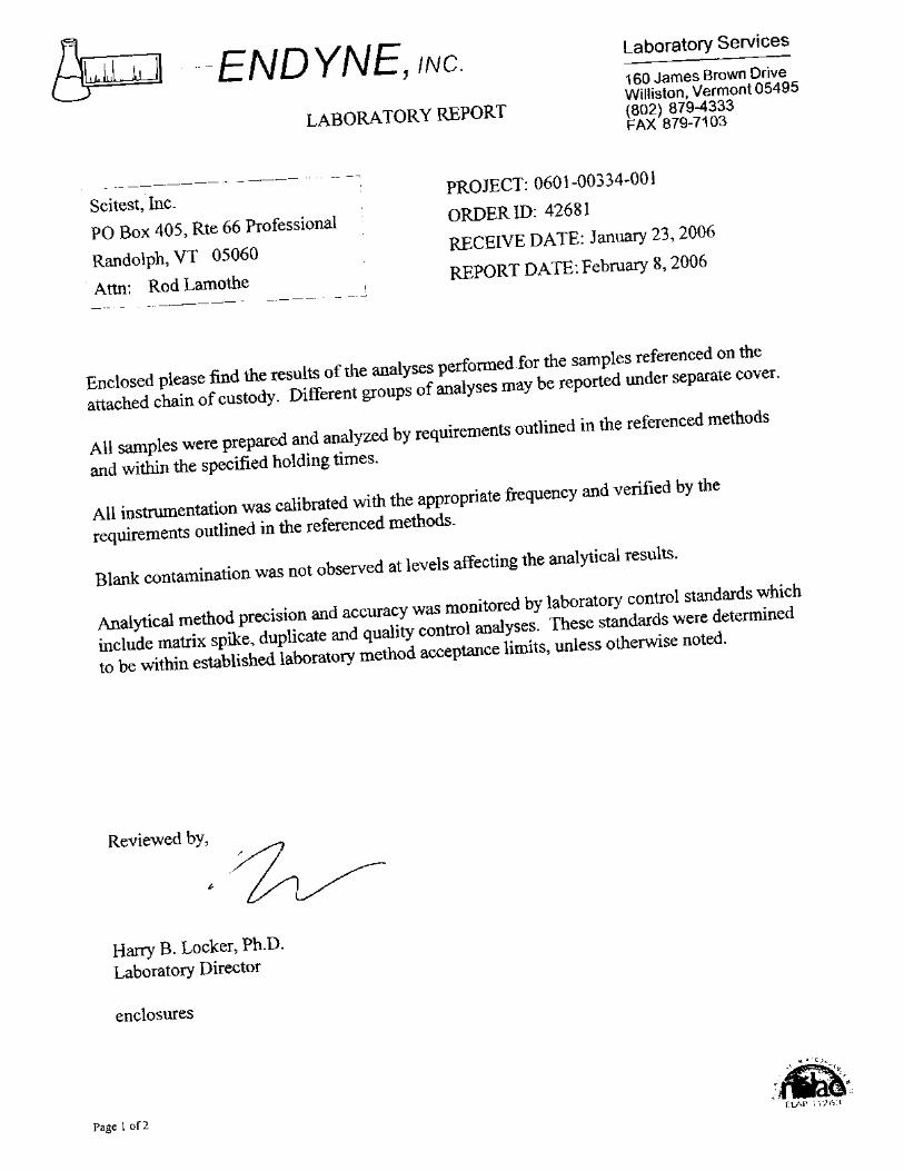
were collected and analyzed by Endyne, Inc. of Williston, Vermont for volatile organic compounds (VOCs) and total petroleum hydrocarbons (TPH) (for diesel range organics), and one soil sample was collected and analyzed for polycyclic aromatic hydrocarbons (PAHs). Sampling locations are provided on Figure 2. Soil boring logs are provided in Appendix C. Soil borings were advanced by Stone Environmental, Inc. (SEI) using a track-mounted Geoprobe® unit (model 6610 DT), under the supervision of AGS. Soil samples were collected in four or five-foot intervals, using macrocore sampling liners and dual casing sampling technology. Soil samples were logged by AGS for texture and screened for the possible presence of VOCs using a portable PID (Photovac model 2020), with a 10.6 eV lamp. The PID was calibrated on-Site using 100 ppmv isobutylene to a benzene reference (with a 0.5 response factor).
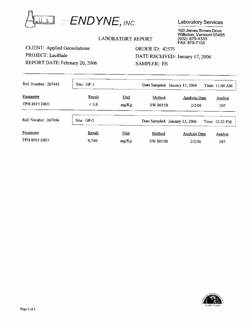
No evidence of ground water was encountered in any of the soil borings. Soil boring GP-1 was completed immediately adjacent to east side of the 275-gallon kerosene AST. The boring was advanced 17 feet at about a 20-25 degree angle from vertical, beneath the south end of the mobile home. Fine, well sorted sands were encountered throughout the boring, with a one-inch thick silty-sand layer present at about 8.5 feet bgs. Strong olfactory evidence of kerosene contamination was apparent on soils from ground surface to about 9 feet bgs. Soil sample GP-1/12.5-13’ was collected at about 12.5 to 13 feet bgs to define the vertical extent of contamination. This sample was submitted for laboratory analysis of VOCs by EPA Method 8260 and TPH by EPA Method 8015 (DRO). Soil boring GP-2 was completed about 2 feet south of the fuel-line fitting for the 275-gallon kerosene AST. The boring was advanced 20 feet bgs. Fine, well sorted sands were encountered throughout the boring, with a one-inch thick silty-sand layer present at about 8.5 feet bgs, and interbedded silt lenses present about 19.5 to 20 feet bgs. Strong olfactory evidence of kerosene contamination was apparent on soils from ground surface to about 10 feet bgs. Soil sample GP-2/8-8.5’ was collected at about 8 to 8.5 feet bgs to evaluate contaminant concentrations directly above the silt layer. This sample was submitted for laboratory analysis of VOCs by EPA Method 8260 and TPH by EPA Method 8015 (DRO). Soil boring GP-3 was completed about 7 feet east of the fuel-line fitting for the 275-gallon kerosene AST. The boring was advanced 13 feet bgs. Fine, well sorted sands were encountered throughout the boring. No olfactory evidence of
Lacillade Residence, Braintree, VT Applied GeoSolutions, LLC Initial Site Investigation Page 5
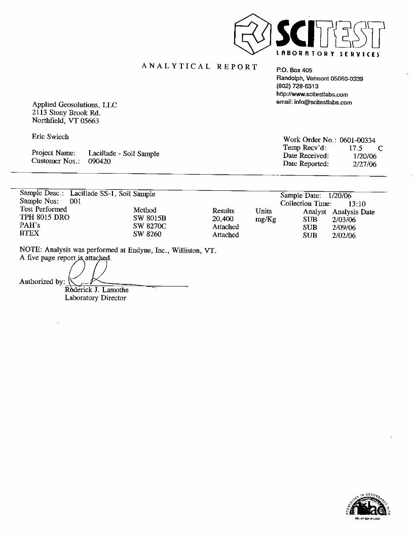
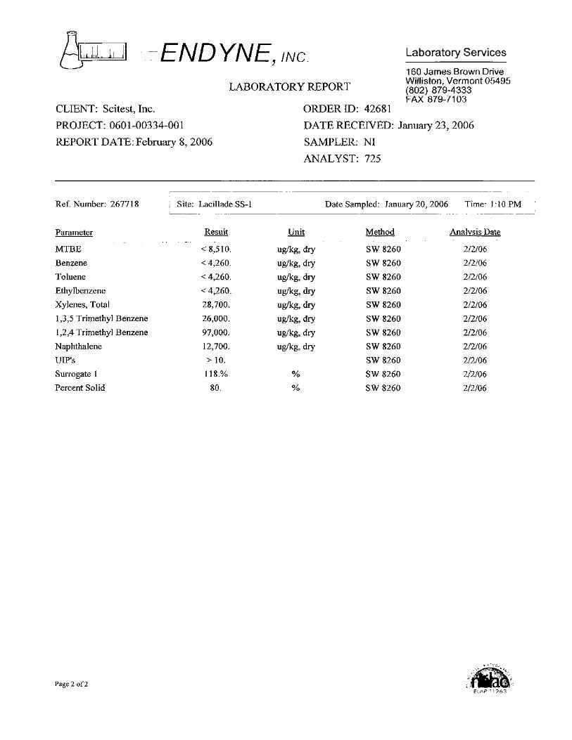
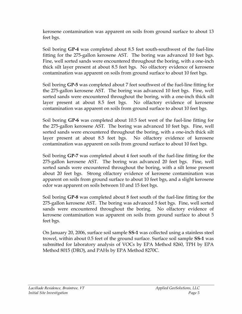
kerosene contamination was apparent on soils from ground surface to about 13 feet bgs. Soil boring GP-4 was completed about 8.5 feet south-southwest of the fuel-line fitting for the 275-gallon kerosene AST. The boring was advanced 10 feet bgs. Fine, well sorted sands were encountered throughout the boring, with a one-inch thick silt layer present at about 8.5 feet bgs. No olfactory evidence of kerosene contamination was apparent on soils from ground surface to about 10 feet bgs. Soil boring GP-5 was completed about 7 feet southwest of the fuel-line fitting for the 275-gallon kerosene AST. The boring was advanced 10 feet bgs. Fine, well sorted sands were encountered throughout the boring, with a one-inch thick silt layer present at about 8.5 feet bgs. No olfactory evidence of kerosene contamination was apparent on soils from ground surface to about 10 feet bgs. Soil boring GP-6 was completed about 10.5 feet west of the fuel-line fitting for the 275-gallon kerosene AST. The boring was advanced 10 feet bgs. Fine, well sorted sands were encountered throughout the boring, with a one-inch thick silt layer present at about 8.5 feet bgs. No olfactory evidence of kerosene contamination was apparent on soils from ground surface to about 10 feet bgs. Soil boring GP-7 was completed about 4 feet south of the fuel-line fitting for the 275-gallon kerosene AST. The boring was advanced 20 feet bgs. Fine, well sorted sands were encountered throughout the boring, with a silt lense present about 20 feet bgs. Strong olfactory evidence of kerosene contamination was apparent on soils from ground surface to about 10 feet bgs, and a slight kerosene odor was apparent on soils between 10 and 15 feet bgs. Soil boring GP-8 was completed about 8 feet south of the fuel-line fitting for the 275-gallon kerosene AST. The boring was advanced 5 feet bgs. Fine, well sorted sands were encountered throughout the boring. No olfactory evidence of kerosene contamination was apparent on soils from ground surface to about 5 feet bgs. On January 20, 2006, surface soil sample SS-1 was collected using a stainless steel trowel, within about 0.5 feet of the ground surface. Surface soil sample SS-1 was submitted for laboratory analysis of VOCs by EPA Method 8260, TPH by EPA Method 8015 (DRO), and PAHs by EPA Method 8270C.

Lacillade Residence, Braintree, VT Applied GeoSolutions, LLC Initial Site Investigation Page 6
3.2 Vapor Well Installation
A vapor well (VE-1) was installed within soil boring GP-2 to facilitate possible future vapor monitoring or vapor extraction. The location of the vapor well, relative to Site features, is presented on Figure 2.
Vapor well VE-1 was constructed to a depth of about 12 feet bgs using two-inch-diameter schedule 40 poly-vinyl chloride (PVC) with flush-threaded joints. Ten feet of factory-slotted 0.020” screen was used. A section of PVC riser was added to extend the top of the casing to approximately 2 feet above ground. The borehole annulus was backfilled with sand pack to about 1.5 feet bgs. A bentonite-chip seal was set within the annulus from about 1.5 feet bgs to ground surface. The well casing was topped with a water-tight expansion cap. 3.3 Indoor Air Screening AGS screened the ambient air within the Lacillade mobile home on three occasions: January 3rd, January 4th, and January 20th,2006. During each event, the breathing zone of the mobile home within the living room /kitchen was screened for the possible presence of VOCs using a portable PID (Photovac model 2020), with a 10.6 eV lamp. On January 3, 2006, AGS also screened the air within the breathing zone and along the floor within the bedrooms and bathroom. The PID was calibrated before use with 100 ppmv isobutylene to a benzene reference (with a 0.5 response factor). On January 20th, AGS installed a 4-mil plastic vapor barrier on top of soils impacted by kerosene beneath the mobile home.
4.0 INVESTIGATION RESULTS
4.1 Geology/Hydrogeology The Site is located on a terrace of glacial outwash deposits within the White River valley, which trends northwest-southeast in the general vicinity of the Site. Uplands are present to the west of the Site, across the White River, and also to the east of the Site across Route 12A.
Lacillade Residence, Braintree, VT Applied GeoSolutions, LLC Initial Site Investigation Page 7
Native soils encountered during the soil boring program consisted primarily of well sorted fine sands. A thin silt layer, typically about one inch in thickness, was generally observed in the soil borings at about 8 to 8.5 feet bgs. Bedrock was not observed during the boring program to the maximum boring depth of about 20 feet bgs. No ground water was encountered within the soil borings to the maximum boring depth of about 20 feet bgs. Based on the elevation of the White River, located about 400 feet southwest of the AST area at its closest point, the water table beneath the AST area is likely present about 25 to 30 feet bgs. Given the surface topography, ground water flow in the unconfined aquifer in the vicinity of the Site, if present, would likely be to the south towards the White River.
4.2 Contaminant Distribution 4.2.1 Soil
4.2.1.1 Field PID Screening Field PID readings for soil samples were compared to the guidance document titled “Agency Guidelines for Petroleum Contaminated Soil and Debris”, effective August 1996, prepared by the VT DEC Waste Management Division (WMD). This document provides soil guideline thresholds to assist in decision making regarding the handling and treatment of petroleum-contaminated soils. A synopsis of these thresholds, as they pertain to fuel oils (e.g. kerosene) and this Site, is as follows:
• PID readings < 10 ppmv: these soils may remain in place provided that a sensitive receptor is not immediately threatened by the soil.
• PID readings from 10-40 ppmv: these soils require treatment either on-site or off-site.
• PID readings from 40-400 ppmv: these soils require treatment on-site. • PID readings >400 ppmv (or soils saturated with free-phase product):
These soils require treatment in-situ, or in cases where soils are excavated, the soils must be handled as hazardous waste in accordance with the Vermont Hazardous Waste Management Regulations (VHWMR).
The highest PID readings were obtained from soil samples collected from soil borings GP-1, GP-2, and GP-7. At these borings, PID readings greater than 200 ppmv were recorded on several soil samples between ground surface and about

Lacillade Residence, Braintree, VT Applied GeoSolutions, LLC Initial Site Investigation Page 8
8-8.5 feet bgs. PID readings decreased to less than 10 ppmv in GP-1, GP-2, and GP-7 at about 12, 15, and 17 feet bgs, respectively. In addition to soil borings GP-1, GP-2, and GP-7, PID readings greater than 10 ppmv were recorded on surface soil samples S-1, S-2, S-3, S-6, S-7, and S-9, and one or more soil samples from soil borings GP-3 and GP-8 collected between ground surface and five feet bgs. PID readings were less than 10 ppmv for surface soil samples S-4, S-5, S-8, and S-10, and on all soil samples collected from soil borings GP-4, GP-5, and GP-6.
Field PID screening results are provided on the soil boring logs (Appendix C), and on the Contaminant Distribution map (Figure 2).
4.2.1.2 Laboratory Analytical Results Soil analytical results were compared to the Preliminary Remediation Goals (PRGs) (for direct contact exposure pathways at residential settings), and Soil Screening Levels for migration to ground water, that have been established by United States Environmental Protection Agency (US EPA) Region 9. The VT DEC does not currently have soil cleanup standards of its own, and prefers to default to US EPA Region 9 PRGs for soil cleanup guidelines. Laboratory analytical results are presented on Table 1 and Figure 2. Laboratory reports are provided in Appendix D.
4.2.1.2.1 VOCs No VOCs were detected above laboratory reporting limits in soil sample GP-1, collected about 12.5 to 13 feet bgs. Total target VOCs (by EPA method 8021B) were detected in soil sample GP-2 /8-8.5’ and surface soil sample SS-1 at concentrations of 166,510 micrograms per Kilogram (µg/Kg) and 164,400 µg/Kg, respectively. Total target VOCs include methyl tert-butyl ether (MTBE), benzene, toluene, ethylbenzene, total xylenes, 1,3,5 trimethylbenzene, 1,2,4 trimethylbenzene, and naphthalene. Total xylenes, 1,3,5 trimethylbenzene, 1,2,4 trimethylbenzene, and naphthalene were detected at concentrations above either the respective PRG or Soil Screening Level in soil samples GP-2 and SS-1.
Lacillade Residence, Braintree, VT Applied GeoSolutions, LLC Initial Site Investigation Page 9
Toluene and ethylbenzene were detected at concentrations above either the respective PRG or Soil Screening Level in soil sample GP-2.
Benzene was not detected above reporting limits in soil samples GP-1 or SS-1; however, the reporting limits exceeded the PRG and/or Soil Screening Levels for benzene.
4.2.1.2.2 PAHs Surface soil sample SS-1 was analyzed for PAHs by EPA Method 8270C. 1-methylnaphthalene and 2-methylnaphthalene were detected at concentrations of 17,700 µg/Kg and 25,800 µg/Kg, respectively. Currently, no PRGs or Soil Screening Levels are established for these compounds. No other PAHs were detected above the respective laboratory reporting limits of 1,524 µg/Kg. However, this detection limit was above either the PRG or Soil Screening Level for the following compounds: benzo(a)anthracene, benzo(b & k)fluoranthene, benzo(a)pyrene, dibenz(a,h)anthracene, and indeno(1,2,3-cd)pyrene. 4.2.1.2.3 TPH TPH was not detected above the laboratory reporting limit of 5.0 milligrams per Kilogram (mg/Kg) in soil sample GP-1/12.5-13. TPH was detected in soil sample GP-2/8-8.5 and SS-1 at concentrations of 9,740 mg/Kg and 20,400 mg/Kg, respectively. Currently, no PRG or Soil Screening Level is established for TPH.
4.2.2 Indoor Air AGS used a PID to screen the ambient air within the Lacillade mobile home on three occasions: January 3rd, January 4th, and January 20th, 2006. On January 3, 2006, a constant PID reading of 3.8 ppmv was detected in the breathing zone throughout the mobile home, including the living room, bathroom, bedrooms, and kitchen. PID readings along the floor within these rooms ranged from 3.5 to 3.7 ppmv. The PID reading on ambient air outside of the trailer was 0.0 ppmv. The PID readings within the space beneath the trailer,

Lacillade Residence, Braintree, VT Applied GeoSolutions, LLC Initial Site Investigation Page 10
in the vicinity of the kerosene release, ranged from 3.6 ppmv to 6.5 ppmv. On this date, the skirt around the mobile home was in place. On January 4, 2006, a PID reading of 3.9 ppmv was detected in the breathing zone of the mobile home. The PID reading within the space beneath the trailer, in the vicinity of the kerosene release, was 4.5 ppmv. On this date, the skirt around the mobile home was in place. On January 20, 2006, a PID reading of 1.6 ppmv was detected in the breathing zone of the mobile home. The PID reading within the space beneath the trailer, in the vicinity of the kerosene release, was 0.1 ppmv. On this date, the skirt around the mobile home was partially removed to allow venting beneath the mobile home.
5.0 CONCEPTUAL SITE MODEL An estimated 230 to 235 gallons of kerosene were released to the subsurface from the AST system at the Site between December 21 and 31, 2005.
Once released to the subsurface, the petroleum hydrocarbons likely partitioned into four phases: 1) vapor (i.e. soil gas), 2) aqueous (dissolved in pore water), 3) residual (sorbed to soil minerals and organic matter), and 4) remained as non-aqueous phase liquid (NAPL). The phase partitioning and migration of petroleum hydrocarbons, once released to the subsurface, depends on several factors, including: the volume of the release, the physical and chemical properties of the individual hydrocarbon compounds, and the physical and chemical properties of the media that the hydrocarbons were released into. The kerosene appears to have migrated radially from the release area. Petroleum hydrocarbons likely migrated downward through the soil column under the influence of gravity as NAPL, and via infiltrating rain water (by partitioning into the dissolved phase) on the exterior of the mobile home. As the hydrocarbons migrated downward, residual hydrocarbons were left behind in the soil. Petroleum vapors appear to have initially accumulated within the space beneath the mobile home. These vapors could have potentially been drawn into the mobile home via the heating system. Venting beneath the mobile home and installation of a vapor barrier appear to have mitigated the impact of VOCs within the space beneath the mobile home and the mobile home itself.
Lacillade Residence, Braintree, VT Applied GeoSolutions, LLC Initial Site Investigation Page 11
The magnitude and extent of kerosene impact to soils was reasonably characterized during the ISI. Data indicate the retention capacity of the soil was sufficient to limit the downward migration of the bulk of hydrocarbons to within about 9 feet bgs. A 1-inch thick silt layer, present about 8-8.5 feet bgs, appears to have significantly impeded the downward migration of kerosene, although evidence of lower-level hydrocarbon impact (i.e. PID readings >10 ppmv) was observed down to approximately 17 feet bgs. Kerosene is comprised of hundreds of individual compounds. These compounds are typically readily sorbed to soil, are not highly volatile, have a relatively low aqueous solubility, and are biodegradable. As such, these constituents generally are not highly mobile in the subsurface. Lighter, relatively more mobile hydrocarbons, such as benzene, toluene, ethylbenzene, and total xylenes, may be present within kerosene, but typically at relatively low concentrations. At this Site, target VOCs represented only 1.7 and 0.8 percent of the TPH concentrations for soil samples GP-2/8-8.5 and SS-1, respectively. 6.0 SENSITIVE RECEPTOR SURVEY Several potential sensitive receptors were identified during the ISI. These receptors, and a quantitative and/or qualitative evaluation of their risk of impact by contamination associated with the kerosene release, are discussed below.
• On-Site Water Supply – An on-Site community supply well is located about 300
feet northeast of the kerosene release. This sensitive receptor is not likely at significant risk of impact by the kerosene release because the release appears to currently be confined to unsaturated soils, and the well is likely located hydraulically cross gradient of the release. However, if the residual contamination is not addressed, either via treatment or the placement of an impermeable cap over the impacted soils, there is the potential that the more mobile constituents could further migrate downward through the soil column via infiltrating rain water (by partitioning into the dissolved phase), and potentially impact ground water. If this were to occur, a ground water study would need to be conducted to better characterize the risk to water supplies.
• Off-Site Water Supplies – A search of the VT Agency of Natural Resources’
internet mapping website identified three private bedrock supply wells within about 1,000 feet of the kerosene release, with the closest well being located about 600 feet east of the release. These wells do not currently appear to be at significant risk of impact for the same reasons discussed above.
Lacillade Residence, Braintree, VT Applied GeoSolutions, LLC Initial Site Investigation Page 12
• Unconfined Shallow Aquifer – Ground water was not encountered during the soil boring program to a depth of 20 feet bgs, and does not appear to currently be impacted. At this time, it appears that the vertical extent of the kerosene release is limited to unsaturated soils within about 17 feet bgs, with the bulk of contaminant mass present between ground surface and about 9 feet bgs.
As discussed above, if corrective measures are not taken to address the residual soil contamination, the shallow unconfined aquifer, if present beneath the Site, may be at risk of impact. Toluene, ethylbenzene, total xylenes, and naphthalene concentrations in soil were above Soil Screening Levels for “Migration to Ground Water”. Soil Screening levels are not established for 1,3,5 trimethylbenzene and 1,2,4 trimethylbenzene; however, these compounds were detected in soils at relatively high concentrations, and their respective Vermont Groundwater Enforcement Standards (VGESs) of 4 micrograms per Liter (µg/L) and 5 µg/L are relatively low. As such, if 1,3,5 trimethylbenzene and 1,2,4 trimethylbenzene were to migrate downward to the water table, these compounds may impact ground water at concentrations that exceed the VGESs.
• Surface Water – The White River is located about 400 feet south of the kerosene
release area at its closest point. Ground water does not appear to have been impacted by the kerosene release at this time. Since ground water would be the transport pathway for discharge of contaminants to the surface water, the risk for impact to the White River appears to be relatively low.
• Soil – 1,3,5 trimethylbenzene and 1,2,4 trimethylbenzene were detected in a
surface soil sample at concentrations that exceed respective PRGs for “Direct Contact Exposure Pathways”. Benzene and several PAHs were not detected above reporting limits in surface soil samples SS-1; however, the laboratory reporting limits exceeded the PRGs for these compounds.
• Indoor Air – Elevated PID readings of 3.8 ppmv and 3.9 ppmv were detected in the breathing zone of the mobile home on January 3 and 4, 2006. On January 20th, after installing a vapor barrier and ventilating the air space beneath the mobile home, the PID reading within the breathing zone of the mobile home was 1.6 ppmv.
These data suggest the indoor air quality of the mobile home may have been impacted by VOCs from the kerosene release, and that the vapor barrier and ventilation have had a mitigating effect on the impact. However, the PID is a screening instrument that does not measure specific compounds, and the
Lacillade Residence, Braintree, VT Applied GeoSolutions, LLC Initial Site Investigation Page 13
readings can be affected by environmental factors such as temperature and humidity. Also, the PID would detect other VOCs that may have been present within the home related to common household items (e.g. cleaners, hairspray etc.). Compound-specific air testing to speciate the VOCs was not completed during the ISI, as directed by VT DEC.
Ms. Lacillade has not observed kerosene odors within the mobile home since the kerosene release.
7.0 CONCLUSIONS Based on the results of the ISI, AGS has drawn the following conclusions:
• An estimated 230 to 235 gallons of kerosene were released to the subsurface from the AST system at the Site between December 21 and 31, 2005.
• The degree and extent of the kerosene release has been reasonably defined. At
this time, it appears that the vertical extent of the kerosene impact is limited to unsaturated soils within about 17 feet bgs, with the bulk of contaminant mass present between ground surface and about 9 feet bgs. The lateral extent of impacted soils exhibiting PID readings greater than 10 ppmv comprises an area of about 120 to 130 square feet.
• Sensitive receptors either currently impacted by the kerosene release or at risk
include indoor air, shallow soils, and ground water. Elevated PID readings have been detected in the breathing zone of the mobile home, and several VOCs were detected in soils at concentrations that exceed either the PRGs for “Direct Contact” or the Soil Screening Levels for “Migration to Ground Water”. Elevated PID readings detected within the mobile home is not conclusive evidence that VOCs from the kerosene release impacted indoor air quality, as the PID is only a screening tool that does not measure specific compounds, and the instrument can be affected by environmental factors such as temperature and humidity. Also, the PID would detect other VOCs that may have been present within the home related to common household items (e.g. cleaners, hairspray etc.). Compound-specific air testing to speciate the VOCs was not completed during the ISI.
• Given the impact and risk to sensitive receptors, corrective action appears
warranted to mitigate the contaminant impact.

Lacillade Residence, Braintree, VT Applied GeoSolutions, LLC Initial Site Investigation Page 14
• A screening of potential remedial alternatives suggests that short-term Soil Vapor Extraction (SVE), followed by either active or passive Bioventing is the most technically viable and cost-effective strategy for addressing the impacted soils and protecting human health and the environment. SVE would remove the lighter, more mobile, target VOCs and promptly mitigate potential VOC impact to indoor air and the risk to ground water. Bioventing (via air injection) would provide oxygen to the impacted soils to facilitate the natural biodegradation of hydrocarbons by indigenous microorganisms. These technologies are proven effective for kerosene contamination and sandy soils, which are present at the Site.
• Soils removal with off-Site treatment/disposal, although highly effective, does
not appear to be a favorable remedial alternative at this time due to difficulty with implementation (e.g. underground utilities, limited space for equipment and soils staging, shoring requirements for soils removal beneath the mobile home and next to the shed, etc.), and cost.
8.0 RECOMMENDATIONS Given the above conclusions, AGS makes the following recommendations:
• SVE should be implemented for a two to four week period. During this period, the bulk of the volatile fraction of contamination would likely be removed. Existing vapor extraction well VE-1, which is centrally located within the release area and screened across the majority of the contaminant zone, should be sufficient as the sole SVE well. A small blower (about 0.5 horsepower) would be used to provide the vacuum and induce subsurface airflow. Extracted vapors would be treated via granular activated carbon (GAC).
• Following SVE operation, a respiration test should be completed on vapor
extraction well VE-1 to determine oxygen utilization rates in support of biodegradation. These data would be used to select an appropriate air injection rate. At that juncture, an active (using a blower) or passive (using wind-driven ventilation or natural barometric pressure changes) bioventing program should be implemented to address remaining organic compounds.

FIGURES

Copyright (C) 2002, Maptech, Inc.
Name: RANDOLPHDate: 2/22/2006Scale: 1 inch equals 1000 feet
Location: 043° 55' 56.56" N 072° 42' 01.88" WCaption: Figure 1. Site Location Map
Lacillade Residence 139 Seasame Street Braintree, VT
15° W


TABLES

TABLE 1. SUMMARY OF SOIL ANALYTICAL RESULTS
Lacillade Residence 139 Seasame StreetBraintree, Vermont
Sample ID:Sample Collection Date:Approximate Sample Depth Interval (ft bgs):
PRGs
Residential Soil DAF 20 DAF 1VOCs (EPA Method 8021B)MTBE 32,000 -- -- ND< 20.0 ND< 638 ND< 8,510Benzene 640 30 2 ND< 10.0 ND< 319 ND< 4,260Toluene 520,000 12,000 600 ND< 10.0 ND< 4,260Ethylbenzene 400,000 13,000 700 ND< 10.0 ND< 4,260Total Xylenes 270,000 210,000 10,000 ND< 20.01,3,5 Trimethylbenzene 21,000 -- -- ND< 10.01,2,4 Trimethylbenzene 52,000 -- -- ND< 10.0Naphthalene 56,000 84,000 4,000 ND< 20.0
Total VOCs -- -- --PAHs (EPA Method 8270C)Acenaphthene 3,700,000 570,000 29,000 ND< 1,524Acenaphthylene -- -- -- ND< 1,524Anthracene 22,000,000 12,000,000 590,000 ND< 1,524Benzo(a)anthracene 620 2,000 80 ND< 1,524Benzo(b & k)fluoranthene 620/6,200 5,000/49,000 200/2,000 ND< 1,524Benzo(a)pyrene 62 8,000 400 ND< 1,524Benzo(g,h,i)perylene -- -- -- ND< 1,524Chrysene 62,000 160,000 8,000 ND< 1,524Dibenz(a,h)anthracene 62 2,000 80 ND< 1,524Fluoranthene 2,300,000 4,300,000 210,000 ND< 1,524Fluorene 2,700,000 560,000 28,000 ND< 1,524Indeno(1,2,3-cd)pyrene 620 14,000 700 ND< 1,5241-Methylnaphthalene -- -- --2-Methylnaphthalene -- -- --Naphthalene 56,000 84,000 4,000 ND< 1,524Phenanthrene -- -- -- ND< 1,524Pyrene 2,300,000 4,200,000 210,000 ND< 1,524TPH (EPA Method 8015 DRO)Total Petroleum Hydrocarbons -- -- -- ND< 5.0
Notes:PRGs = Preliminary Remediation Goals (EPA Region 9), for "Direct Contact Exposure Pathways".Soil Screening Levels set by EPA Region 9.DAF = Dilution Attenuation FactorShaded values exceed either the respective PRG or one or more Soil Screening Level.All concentration reported in micrograms per Kilogram, except TPH, which is reported in milligrams per Kilogram.VOCs = Volatile Organic CompoundsPAHs = Polycyclic Aromatic HydrocarbonsTPH = Total Petroleum HydrocarbonsNA = Not Analyzed
NA
17,70025,800
NANANANA
NA
NA
Soil Screening Levels "Migration to Ground Water"
NA
NA
NANANA
NANANANA
NANANANA
NANANANA
ND 166,510 164,400
NA NA
12.5-13 8-8.5 0-0.51/13/2006 1/13/2006 1/20/2006
GP-1 GP-2 SS-1
Analyte
3,5707,640
48,00024,400
28,70026,000
9,740 20,400
71,10011,800
NANANANA
NANA
NANA
97,00012,700
Applied GeoSolutions, LLC

APPENDIX A PHOTOGRAPHS

Photo #1. Kerosene release area (1/3/06)
Photo # 2. Facing West. Geoprobe conducting angled boring for GP-1 (1/13/06) .
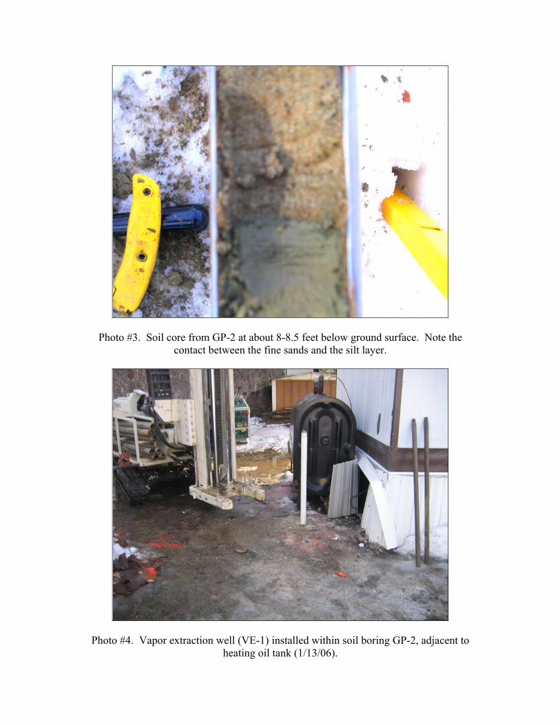
Photo #3. Soil core from GP-2 at about 8-8.5 feet below ground surface. Note the contact between the fine sands and the silt layer.
Photo #4. Vapor extraction well (VE-1) installed within soil boring GP-2, adjacent to heating oil tank (1/13/06).

APPENDIX B FIELD NOTES


APPENDIX C SOIL BORING LOGS
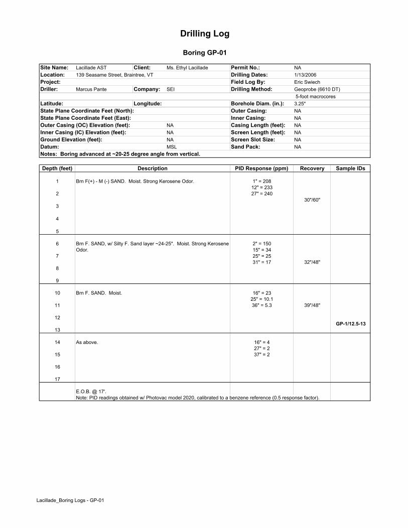
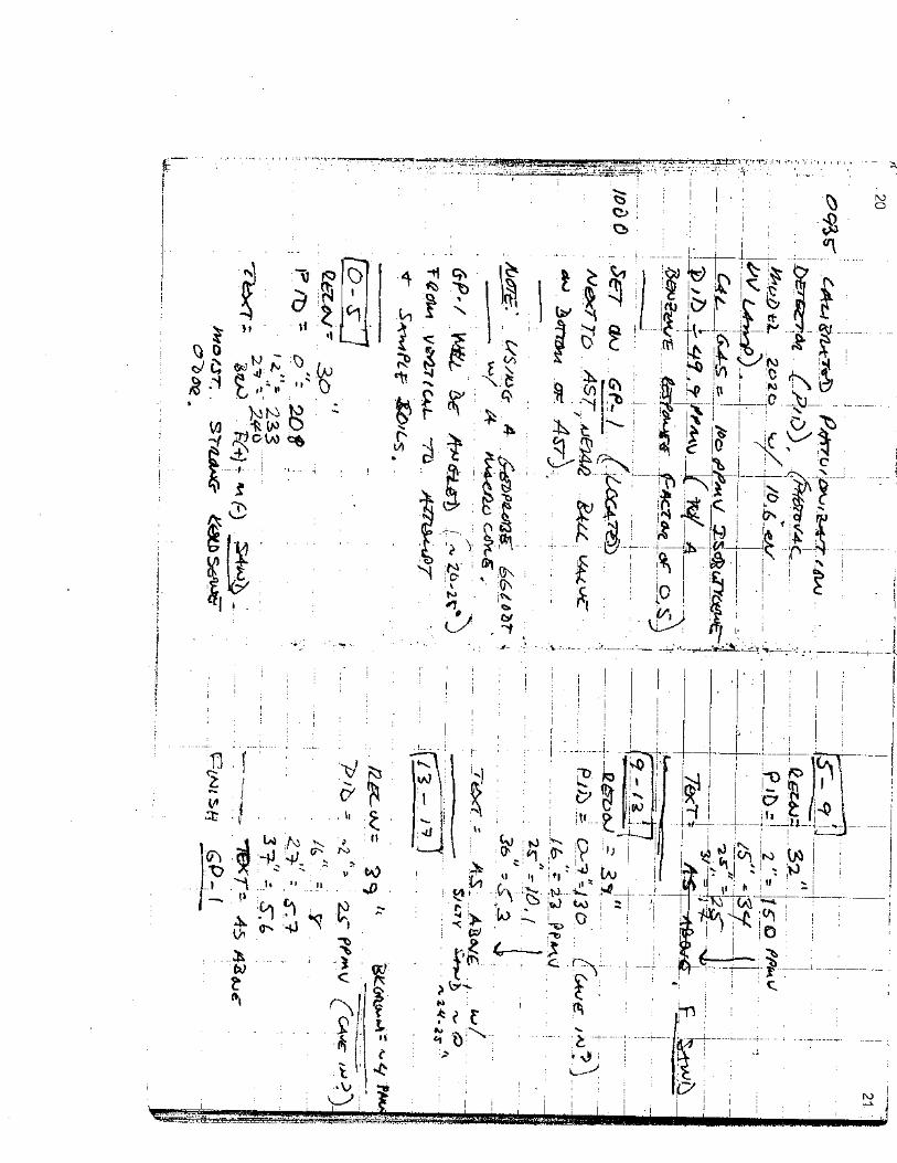
Site Name: Lacillade AST Client: Ms. Ethyl Lacillade Permit No.: NALocation: 139 Seasame Street, Braintree, VT Drilling Dates: 1/13/2006Project: Field Log By: Eric SwiechDriller: Marcus Pante Company: SEI Drilling Method: Geoprobe (6610 DT)
5-foot macrocoresLatitude: Longitude: Borehole Diam. (in.): 3.25"State Plane Coordinate Feet (North): Outer Casing: NAState Plane Coordinate Feet (East): Inner Casing: NAOuter Casing (OC) Elevation (feet): NA Casing Length (feet): NAInner Casing (IC) Elevation (feet): NA Screen Length (feet): NAGround Elevation (feet): NA Screen Slot Size: NADatum: MSL Sand Pack: NANotes: Boring advanced at ~20-25 degree angle from vertical.
Depth (feet) PID Response (ppm) Recovery Sample IDs
1 Brn F(+) - M (-) SAND. Moist. Strong Kerosene Odor. 1" = 20812" = 233
2 27" = 24030"/60"
3
4
5
6 2" = 15015" = 34
7 25" = 2531" = 17 32"/48"
8
9
10 Brn F. SAND. Moist. 16" = 2325" = 10.1
11 36" = 5.3 39"/48"
12GP-1/12.5-13
13
14 As above. 16" = 427" = 2
15 37" = 2
16
17
E.O.B. @ 17'.Note: PID readings obtained w/ Photovac model 2020, calibrated to a benzene reference (0.5 response factor).
Drilling Log
Boring GP-01
Description
Brn F. SAND, w/ Silty F. Sand layer ~24-25". Moist. Strong Kerosene Odor.
Lacillade_Boring Logs - GP-01
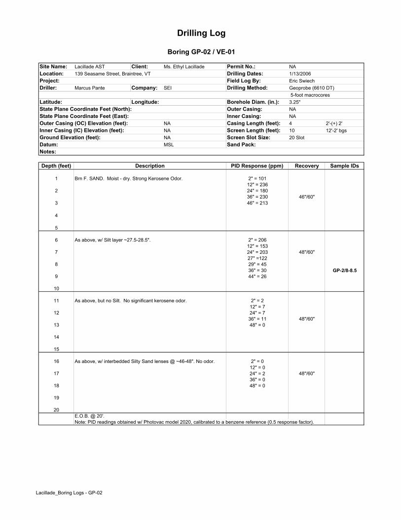
Site Name: Lacillade AST Client: Ms. Ethyl Lacillade Permit No.: NALocation: 139 Seasame Street, Braintree, VT Drilling Dates: 1/13/2006Project: Field Log By: Eric SwiechDriller: Marcus Pante Company: SEI Drilling Method: Geoprobe (6610 DT)
5-foot macrocoresLatitude: Longitude: Borehole Diam. (in.): 3.25"State Plane Coordinate Feet (North): Outer Casing: NAState Plane Coordinate Feet (East): Inner Casing: NAOuter Casing (OC) Elevation (feet): NA Casing Length (feet): 4 2'-(+) 2'Inner Casing (IC) Elevation (feet): NA Screen Length (feet): 10 12'-2' bgsGround Elevation (feet): NA Screen Slot Size: 20 SlotDatum: MSL Sand Pack:Notes:
Depth (feet) PID Response (ppm) Recovery Sample IDs
1 Brn F. SAND. Moist - dry. Strong Kerosene Odor. 2" = 10112" = 236
2 24" = 18036" = 230 46"/60"
3 46" = 213
4
5
6 As above, w/ Silt layer ~27.5-28.5". 2" = 20612" = 153
7 24" = 203 48"/60"27" =122
8 29" = 4536" = 30 GP-2/8-8.5
9 44" = 26
10
11 As above, but no Silt. No significant kerosene odor. 2" = 212" = 7
12 24" = 736" = 11 48"/60"
13 48" = 0
14
15
16 As above, w/ interbedded Silty Sand lenses @ ~46-48". No odor. 2" = 012" = 0
17 24" = 2 48"/60"36" = 0
18 48" = 0
19
20E.O.B. @ 20'.Note: PID readings obtained w/ Photovac model 2020, calibrated to a benzene reference (0.5 response factor).
Drilling Log
Boring GP-02 / VE-01
Description
Lacillade_Boring Logs - GP-02

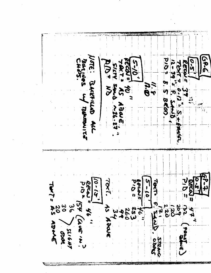
Site Name: Lacillade AST Client: Ms. Ethyl Lacillade Permit No.: NALocation: 139 Seasame Street, Braintree, VT Drilling Dates: 1/13/2006Project: Field Log By: Eric SwiechDriller: Marcus Pante Company: SEI Drilling Method: Geoprobe (6610 DT)
5-foot macrocoresLatitude: Longitude: Borehole Diam. (in.): 3.25"State Plane Coordinate Feet (North): Outer Casing: NAState Plane Coordinate Feet (East): Inner Casing: NAOuter Casing (OC) Elevation (feet): NA Casing Length (feet): NAInner Casing (IC) Elevation (feet): NA Screen Length (feet): NAGround Elevation (feet): NA Screen Slot Size: NADatum: MSL Sand Pack: NANotes: Backfilled boring w/ bentonite chips
Depth (feet) PID Response (ppm) Recovery Sample IDs
1 0-13" = Sand and Gravel.13-36" = Brn F. SAND. No odor. Dry. 12" = 0
2 24" = 6 36"/60"36" = 10
3
4
5
6 As above. No odor. 12" = 524" = 6
7 32" = 4 32"/48"
8
9
10 As above. No odor. 12" = 524" = 1
11 36" = 0 37"/48"
12
13
E.O.B. @ 13'.Note: PID readings obtained w/ Photovac model 2020, calibrated to a benzene reference (0.5 response factor).
Drilling Log
Boring GP-03
Description
Lacillade_Boring Logs - GP-03
Site Name: Lacillade AST Client: Ms. Ethyl Lacillade Permit No.: NALocation: 139 Seasame Street, Braintree, VT Drilling Dates: 1/13/2006Project: Field Log By: Eric SwiechDriller: Marcus Pante Company: SEI Drilling Method: Geoprobe (6610 DT)
5-foot macrocoresLatitude: Longitude: Borehole Diam. (in.): 3.25"State Plane Coordinate Feet (North): Outer Casing: NAState Plane Coordinate Feet (East): Inner Casing: NAOuter Casing (OC) Elevation (feet): NA Casing Length (feet): NAInner Casing (IC) Elevation (feet): NA Screen Length (feet): NAGround Elevation (feet): NA Screen Slot Size: NADatum: MSL Sand Pack: NANotes: Backfilled boring w/ bentonite chips
Depth (feet) PID Response (ppm) Recovery Sample IDs
1 0-12" = Sand and Gravel 12" = 212-44" = Brn F. SAND. 24" = 2
2 36" = 2 44"/60"44" = 3
3
4
5
6 As above, with Silt layer @ ~25-26". 12" = 124" = 2
7 36" = 3 38"/60"
8
9
10E.O.B. @ 10'.Note: PID readings obtained w/ Photovac model 2020, calibrated to a benzene reference (0.5 response factor).
Drilling Log
Boring GP-04
Description
Lacillade_Boring Logs - GP-04
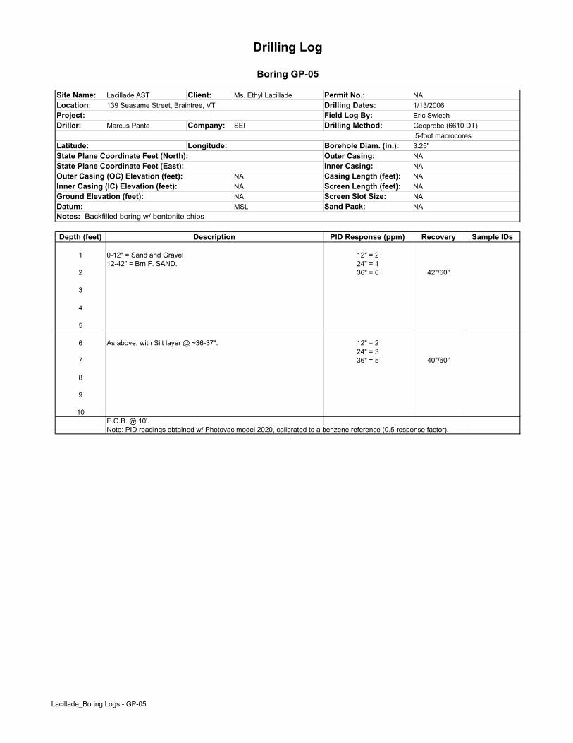
Site Name: Lacillade AST Client: Ms. Ethyl Lacillade Permit No.: NALocation: 139 Seasame Street, Braintree, VT Drilling Dates: 1/13/2006Project: Field Log By: Eric SwiechDriller: Marcus Pante Company: SEI Drilling Method: Geoprobe (6610 DT)
5-foot macrocoresLatitude: Longitude: Borehole Diam. (in.): 3.25"State Plane Coordinate Feet (North): Outer Casing: NAState Plane Coordinate Feet (East): Inner Casing: NAOuter Casing (OC) Elevation (feet): NA Casing Length (feet): NAInner Casing (IC) Elevation (feet): NA Screen Length (feet): NAGround Elevation (feet): NA Screen Slot Size: NADatum: MSL Sand Pack: NANotes: Backfilled boring w/ bentonite chips
Depth (feet) PID Response (ppm) Recovery Sample IDs
1 0-12" = Sand and Gravel 12" = 212-42" = Brn F. SAND. 24" = 1
2 36" = 6 42"/60"
3
4
5
6 As above, with Silt layer @ ~36-37". 12" = 224" = 3
7 36" = 5 40"/60"
8
9
10E.O.B. @ 10'.Note: PID readings obtained w/ Photovac model 2020, calibrated to a benzene reference (0.5 response factor).
Drilling Log
Boring GP-05
Description
Lacillade_Boring Logs - GP-05

Site Name: Lacillade AST Client: Ms. Ethyl Lacillade Permit No.: NALocation: 139 Seasame Street, Braintree, VT Drilling Dates: 1/13/2006Project: Field Log By: Eric SwiechDriller: Marcus Pante Company: SEI Drilling Method: Geoprobe (6610 DT)
5-foot macrocoresLatitude: Longitude: Borehole Diam. (in.): 3.25"State Plane Coordinate Feet (North): Outer Casing: NAState Plane Coordinate Feet (East): Inner Casing: NAOuter Casing (OC) Elevation (feet): NA Casing Length (feet): NAInner Casing (IC) Elevation (feet): NA Screen Length (feet): NAGround Elevation (feet): NA Screen Slot Size: NADatum: MSL Sand Pack: NANotes: Backfilled boring w/ bentonite chips
Depth (feet) PID Response (ppm) Recovery Sample IDs
1 0-12" = Sand and Gravel 12" = 312-39" = Brn F. SAND.
2 36" = 4 39"/60"
3
4
5
6 As above, with Silty Sand layer @ ~26-27". 0.0 Throughout
7 40"/60"
8
9
10E.O.B. @ 10'.Note: PID readings obtained w/ Photovac model 2020, calibrated to a benzene reference (0.5 response factor).
Drilling Log
Boring GP-06
Description
Lacillade_Boring Logs - GP-06
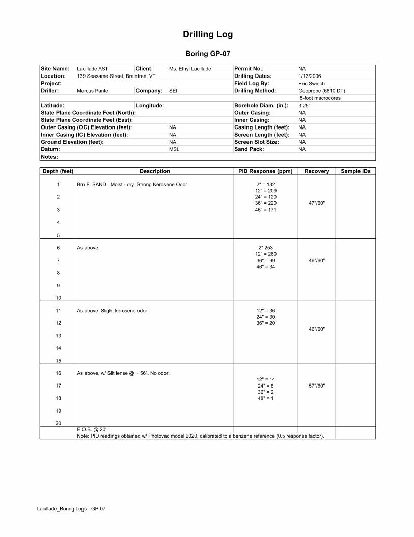
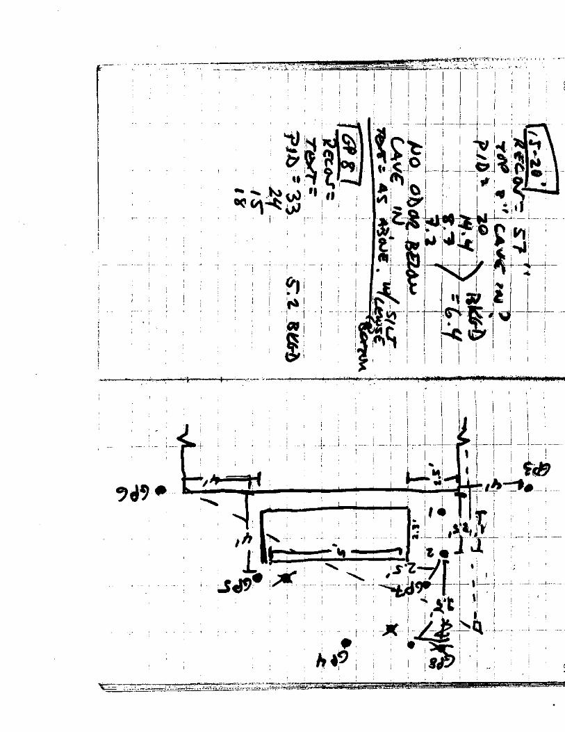
Site Name: Lacillade AST Client: Ms. Ethyl Lacillade Permit No.: NALocation: 139 Seasame Street, Braintree, VT Drilling Dates: 1/13/2006Project: Field Log By: Eric SwiechDriller: Marcus Pante Company: SEI Drilling Method: Geoprobe (6610 DT)
5-foot macrocoresLatitude: Longitude: Borehole Diam. (in.): 3.25"State Plane Coordinate Feet (North): Outer Casing: NAState Plane Coordinate Feet (East): Inner Casing: NAOuter Casing (OC) Elevation (feet): NA Casing Length (feet): NAInner Casing (IC) Elevation (feet): NA Screen Length (feet): NAGround Elevation (feet): NA Screen Slot Size: NADatum: MSL Sand Pack: NANotes:
Depth (feet) PID Response (ppm) Recovery Sample IDs
1 Brn F. SAND. Moist - dry. Strong Kerosene Odor. 2" = 13212" = 209
2 24" = 12036" = 220 47"/60"
3 46" = 171
4
5
6 As above. 2" 25312" = 260
7 36" = 99 46"/60"46" = 34
8
9
10
11 As above. Slight kerosene odor. 12" = 3624" = 30
12 36" = 2046"/60"
13
14
15
16 As above, w/ Silt lense @ ~ 56". No odor.12" = 14
17 24" = 8 57"/60"36" = 2
18 48" = 1
19
20E.O.B. @ 20'.Note: PID readings obtained w/ Photovac model 2020, calibrated to a benzene reference (0.5 response factor).
Drilling Log
Boring GP-07
Description
Lacillade_Boring Logs - GP-07

Site Name: Lacillade AST Client: Ms. Ethyl Lacillade Permit No.: NALocation: 139 Seasame Street, Braintree, VT Drilling Dates: 1/13/2006Project: Field Log By: Eric SwiechDriller: Marcus Pante Company: SEI Drilling Method: Geoprobe (6610 DT)
5-foot macrocoresLatitude: Longitude: Borehole Diam. (in.): 3.25"State Plane Coordinate Feet (North): Outer Casing: NAState Plane Coordinate Feet (East): Inner Casing: NAOuter Casing (OC) Elevation (feet): NA Casing Length (feet): NAInner Casing (IC) Elevation (feet): NA Screen Length (feet): NAGround Elevation (feet): NA Screen Slot Size: NADatum: MSL Sand Pack: NANotes: Backfilled boring w/ bentonite chips
Depth (feet) PID Response (ppm) Recovery Sample IDs
1 Sand and Gravel overlying Brn F. SAND. 2819
2 1013
3
4
5E.O.B. @ 5'.Note: PID readings obtained w/ Photovac model 2020, calibrated to a benzene reference (0.5 response factor).
Drilling Log
Boring GP-08
Description
Lacillade_Boring Logs - GP-08

APPENDIX D
LABORATORY REPORTS