Initial JORC Code Compliant Resource of 686,000 oz at
14
Exploration Office P.O. Box 57 Chewton Victoria 3451 Telephone: (03) 5472 3411 Facsimile (03) 5472 3002 Web: www.cgt.net.au Email: [email protected] ASX ANNOUNCEMENT – 2 June 2008 Initial JORC Code Compliant Resource of 686,000 oz at Castlemaine. Highlights ¾ Inferred Mineral Resource of 2.1 million tonnes at a grade of 8.3 g/t Au amounting to 574,000 ounces at the Chewton Deposit. ¾ The Chewton Deposit is unconstrained both to the north and south. ¾ An additional 610,000 tonnes of Inferred Mineral Resource at a grade of 5.7 g/t Au for 112,000 ounces in remnant areas of the adjacent Wattle Gully gold mine. ¾ Potential for further discovery beneath Wattle Gully. ¾ Chewton Discovery cost of just over $4/oz. ¾ Evidence of the multi-million ounce potential of the Castlemaine goldfield. Castlemaine Goldfields Limited (ASX Code: CGT) is pleased to announce results of the inaugural estimation of Mineral Resources for gold mineralisation at the Chewton Deposit within the Castlemaine goldfield in Central Victoria. The resource estimate was jointly undertaken by CGT and independent consultants, Snowden Mining Industry Consultants Limited (“Snowden”), to be compliant with the 2004 JORC Code for reporting mineral resources. CGT has taken a strong geological approach to estimation based on experience gained from the Wattle Gully Mine and expertise of the Competent Persons. The process has also incorporated the knowledge of other geological and mineral resource experts with substantial experience. The Competent Persons and other experts have an 80 year plus track record within Victoria’s gold sector, including work in the Bendigo, Tarnagulla, Wattle Gully and Ballarat goldfields. The Managing Director & CEO, Mr. Gary Scanlan said “The release of this Chewton Deposit resource estimate places us firmly on track to meet our first objective of discovering at least 2 million ounces of resource within the Castlemaine goldfield. Drilling on the Chewton Deposit and at other prospects along the central corridor clearly evidences that our geological modelling has brought a new understanding to this under-explored and under-developed, yet historically prolific goldfield. We will now move forward to drill define other prospects to ascertain our quickest route to an initial cash flow. Particular focus with be on the northern part of the goldfield where gold has been discovered within 14m from surface in the Pine Plantation”. The announcement of this initial resource, combined with the highly promising drilling results released to the market on 22 April on other prospects along the central corridor, provides clear evidence to support the strongly held conviction that Castlemaine will again be a multi-million ounce goldfield.
Transcript of Initial JORC Code Compliant Resource of 686,000 oz at

Exploration Office P.O. Box 57 Chewton Victoria 3451
Telephone: (03) 5472 3411 Facsimile (03) 5472 3002 Web: www.cgt.net.au Email: [email protected]
ASX ANNOUNCEMENT – 2 June 2008
Initial JORC Code Compliant Resource of 686,000 oz at Castlemaine.
Highlights Inferred Mineral Resource of 2.1 million tonnes at a grade of 8.3 g/t Au
amounting to 574,000 ounces at the Chewton Deposit. The Chewton Deposit is unconstrained both to the north and south. An additional 610,000 tonnes of Inferred Mineral Resource at a grade of 5.7
g/t Au for 112,000 ounces in remnant areas of the adjacent Wattle Gully gold mine.
Potential for further discovery beneath Wattle Gully. Chewton Discovery cost of just over $4/oz. Evidence of the multi-million ounce potential of the Castlemaine goldfield.
Castlemaine Goldfields Limited (ASX Code: CGT) is pleased to announce results of the inaugural estimation of Mineral Resources for gold mineralisation at the Chewton Deposit within the Castlemaine goldfield in Central Victoria. The resource estimate was jointly undertaken by CGT and independent consultants, Snowden Mining Industry Consultants Limited (“Snowden”), to be compliant with the 2004 JORC Code for reporting mineral resources. CGT has taken a strong geological approach to estimation based on experience gained from the Wattle Gully Mine and expertise of the Competent Persons. The process has also incorporated the knowledge of other geological and mineral resource experts with substantial experience. The Competent Persons and other experts have an 80 year plus track record within Victoria’s gold sector, including work in the Bendigo, Tarnagulla, Wattle Gully and Ballarat goldfields. The Managing Director & CEO, Mr. Gary Scanlan said “The release of this Chewton Deposit resource estimate places us firmly on track to meet our first objective of discovering at least 2 million ounces of resource within the Castlemaine goldfield. Drilling on the Chewton Deposit and at other prospects along the central corridor clearly evidences that our geological modelling has brought a new understanding to this under-explored and under-developed, yet historically prolific goldfield. We will now move forward to drill define other prospects to ascertain our quickest route to an initial cash flow. Particular focus with be on the northern part of the goldfield where gold has been discovered within 14m from surface in the Pine Plantation”. The announcement of this initial resource, combined with the highly promising drilling results released to the market on 22 April on other prospects along the central corridor, provides clear evidence to support the strongly held conviction that Castlemaine will again be a multi-million ounce goldfield.

CASTLEMAINE GOLDFIELDS LIMITED 686,000 oz gold JORC Inferred Resource at Castlemaine – 2008
Geology and Mineralisation Information gained from drilling at the Chewton Deposit has shown the Cemetery Fault Zone to comprise a significant set of major west-dipping structures with strike continuity of at least 700 m. The Cemetery Fault Zone consists of a stacked set of closely spaced mineralised faults in the east limb of the Chewton anticline, similar to those mined on the nearby 600m long Wattle Gully Fault Zone where historical gold production exceeded 400,000 ounces. Gold mineralisation occurs as free grains in massive or laminated quartz reef on west dipping faults, or as bedding discordant spur quartz veins. Mineralised quartz exhibits stylolitic ‘laminated’ textures with pyrite, arsenopyrite, base metal sulphides and numerous incidents of visible gold. The fault structures, similar to Wattle Gully, converge towards the north with the eastern limb of the Chewton anticline fold becoming narrower in that direction. A number of west dipping linking faults are suggested from structural measurements as are east dipping faults and quartz veins. Key to the generation of the quartz reefs and surrounding spur stockwork is the development of a parasitic fold towards the north on the western limb of the anticline. This parasitic fold takes off mid-way along the resource at a section of high structural complexity and is known from the shallow Wattle Gully South #3 mine to cause a flattening of the fold nose and change in plunge to the fold axis.
Sampling confirms the Chewton Deposit is a typical Central Victorian coarse gold bearing reef system. The distribution of gold particles is likely to be erratic and leads to a high “Nugget Effect” in drill core samples. This is similar to Wattle Gully where profitable mining included small tonnages of extremely high gold grades.
Wattle Gully Mine Studies The main period of production was between 1934 and 1969 with total recorded hardrock production of 1.1 million tonnes for a recovered grade of 10.3 g/t Au or 375,346 ounces. This does not include shallow production from the Phillips Reef which is the upward continuation of the Wattle Gully Fault Zone. Reprocessing of mine tailings in the 1980-90’s allows estimation that the head grade from the mine was probably 12 g/t Au or greater. The Chewton Deposit resource estimate has been made from knowledge gained of the grade distribution and coarse gold behaviour at the adjacent Wattle Gully gold mine for which detailed underground mining, survey and assay data have been modelled and analysed. Analysis has shown how drill hole grades severely under-estimate the true grades when compared to mill reconciled or weighted average truck samples grades which were taken on a daily basis during mining. There is robust evidence that the smaller volume diamond drill samples under estimate gold grades by up to six times that of the truck grades and the mine’s head grades. The Wattle Gully gold mine was never drilled from surface for resource estimation purposes, nor did it ever have a resource and reserve calculation performed during the early production years. Miners would use quartz textures, sulphide contents and previous gold occurrences within a reef to make mining decisions and allocate ore and waste. Underground diamond drilling was done primarily to explore for new lodes or locate existing ones ahead of mining. Often the diamond core was not assayed regardless of the quartz found. For modelling purposes, the Wattle Gully Fault Zone has been subdivided into 7 west dipping reef lodes each associated with individual faults that show continuity from section to section and level to level. The Wattle Gully fault lodes were a mixture of reef (65% by volume) and spur (35% by volume) quartz. A 3D
CASTLEMAINE GOLDFIELDS LIMITED 686,000 oz gold JORC Inferred Resource at Castlemaine – 2008
model of these lodes was then constructed and the tonnage and grade estimated for each using a combination of underground drill hole and truck sampling data. Trucking assay data from stopes is available for 29% of the total mined tonnes. Analysis of this stope assay data details how, from level to level, it was typical that less than 10% of the mined tonnes contained 50% or more of the gold produced. This provides key evidence that approximately 50% of the gold inventory is contained within bonanza zones of grades potentially around 2 ounces per tonne (~60 g/t Au). Analysis of the coarse fraction of assayed samples from the Chewton diamond core suggests that this “nuggetty” distribution to the gold grades will be very similar to Wattle Gully. Wireframe modelling of all lodes in the Wattle Gully Fault Zone, which is restricted to the upper faults of the greater Wattle Gully fault system (see Figure 1), has estimated the pre-mining in-situ gold inventory of 3.0 million tonnes at 5.2 g/t Au using the known mine production, estimated remnant resource and a grade of approximately 0.5 g/t for the undefined mineralisation between the remnant resource areas and that mined. The total in-situ gold mineralisation at Wattle Gully is estimated to have been 500,000 ounces.
Remnant Gold Resources in Wattle Gully Mine In 1992 the previous operator of Wattle Gully completed an estimate of the remnant gold resource located within and adjacent to the dormant mine. The estimate was completed by a geologist with over 14 year’s experience of the Wattle Gully Mine (Potter, 1992). The estimate was based on experience gained from mill reconciliation and observation of quartz vein textures, alteration and indicator minerals such as sphalerite and galena to estimate grade into a series of ranges. Tonnages and grade ranges compiled in 1992 have been reviewed and validated against the original mine data currently available to CGT and the competent persons. This data is considered a valid base from which to estimate the remnant mineralisation and produce a JORC Code compliant resource. Portions within 100m from surface (within the Castlemaine Diggings National Heritage Park) have been removed as un-minable. In addition portions previously classified as Indicated Mineral Resources have been downgraded to Inferred Mineral Resources due to higher uncertainty related to the data and since the Wattle Gully mine is flooded. Any mining or bulk sampling at the Chewton Deposit which is deeper than the old Wattle Gully mine will involve infrastructure establishment and de-watering of the Wattle Gully mine. This is likely to make remnant resources more economic. The accessible remnant Inferred Mineral Resource is estimated as 610,000 tonnes at 5.7 g/t Au for 112,000 ounces of gold. The expected grade variability in this estimate is in the range 4 to 7 g/t Au (see Table 2). A density of 2.65 g/cm3 was used to estimate this tonnage, based on rock density measurements taken from diamond core at the Chewton Deposit.
Chewton Deposit Drilling Data The Chewton Deposit resource estimate is based on information from diamond drilling completed between 2005 and 2008 and comprises 17 holes in total across a strike length of 700m. Spacing between drill sections is nominally 100m. Quartz reef and spur intervals were sampled using half cut core with analysis for gold using screen fire assay (SFA), fire assay and Leachwell accelerated cyanide leach methods. All assay techniques, quality control assurances and sample collection methods are of suitable standard for estimation purposes. Quality control standard and blank samples were used to assess laboratory performance. Other measures such as duplicate sampling of half cut core, pulp repeat umpire analysis, multiple fire assay to extinction and multiple screen-size SFA assays were used to further confirm assay

CASTLEMAINE GOLDFIELDS LIMITED 686,000 oz gold JORC Inferred Resource at Castlemaine – 2008
quality. CGT recognises however, that drilling, sampling and assaying within a high-nugget coarse-gold environment is challenging and generally leads to an understatement of gold grade. This issue has been addressed during the following resource estimation process. All diamond core was consistently logged by one geologist, Ms Meagan Andrea (MAIG) using detailed sequence stratigraphic logging techniques used to correlate marker sequences across fault and fold structures. Fold limb width at surface is taken from published GeoScience Victoria maps. The inter-limb distances beneath the Cemetery Fault Zone are assumed to be of similar distance. Rock density (specific gravity or ‘SG’) measurements were obtained from whole core samples using a water immersion method. Average SG values for sediments and quartz are 2.69 g/cm3 and 2.63 g/cm3 respectively. An SG of 2.65 g/cm3 was used for tonnages at the Chewton Deposit.
Resource Estimation The resource model is based on the interpretation that the Chewton Deposit is the structural analogue of the Wattle Gully fault system with the two gold bearing systems forming a pair of deposits with syngenetic gold timing and fault histories. The method used by mine geologists at Wattle Gully to estimate gold grade has been used in this estimate. It involves using textural and geochemical proxies to estimate a grade range for an interval of quartz veining. This includes dilution of the quartz vein by low grade or barren wallrock sediments. Proxies used from diamond core logging are; intensity of stylolitic texture (indicates over-pressurising by gold-bearing fluids of the quartz and multiple vein reactivation and gold precipitation), proportion of coarse gold to total gold, volume of quartz, and the presence of sphalerite and galena sulphide minerals in the quartz. The definition of such ‘indicators’ or ‘proxies’ has been used previously in the Central Victorian Goldfields and in other high nugget systems worldwide to provide support to the definition of likely reef gold grade. The high nugget effect of such systems results in drill core assays being unreliable. An experienced based classification tool permits a more effective definition of reef grade potential. Assay data was used to detect the presence of gold and assess the degree of coarse gold in the quartz intersections. Coarse gold is defined as samples with >10% of the total gold present being larger than 150 microns in size. The current drill spacing is insufficient to resolve local grade continuity, which reflects the relatively small tonnages of bonanza grade reefs that are likely to occur in the Chewton Deposit, but does define the global geological continuity of the system. The number of coarse gold particles found in the diamond core samples, along with accessory sphalerite and galena sulphides does indicate that similar bonanza grade areas will be present in the Chewton Deposit.
The grade ranges that were applied at the Wattle Gully mine for the remnant resource estimate were also adopted for the Chewton estimate (see Table 4). Each quartz lode intersection was allocated a grade range based on the gold proxy information and this was used to length weight the grade of each lode. Lodes were separated into either “reef” or “spur set” depending on the quartz vein type present. Each was then wireframe modelled as independent lodes associated with its respective fault structure.
Estimates of low, mean and high grade outcomes have been made (Refer Table 3). The difficulty of grade estimation from drilling means that the Chewton Deposit is unlikely to be upgraded to a higher JORC category of Mineral Resource with additional diamond drilling. The true grade of the lodes will only be known from underground bulk sampling and/or trial mining.
A total of 6 fault reef lodes and 10 spur lodes were modelled within the 700m of known fault structures. Tonnages were estimated for each lode as was the length weighted grade range of each lode’s drill

CASTLEMAINE GOLDFIELDS LIMITED 686,000 oz gold JORC Inferred Resource at Castlemaine – 2008
intersection. Cumulatively this resulted in a total lode tonnage of 7Mt which, at the average estimated grade for each lode, contains approximately 937,000 ounces at 4.1g/t Au. This total mineralisation tonnage was then cut to 5 g/t Au which was a historically discriminated cut off level used in the Wattle Gully mine. This is a payability factor of 30% which is very similar to the 34% for the Wattle Gully mine.
Using a 5g/t Au cut off has the effect of removing all spur lodes and two of the hangingwall reef lodes. As a measure of the sensitivity to grade ranges the higher and lower grade outcomes were also estimated and are reported in Table 3. The Chewton resource contains approximately 74,000 more ounces than the Wattle Gully deposit despite the elimination of all of the spur material by the 5 g/t Au cut-off. This is a reflection of the greater dimensions of the Chewton system. These resources have been discovered at a cost of just over $4/oz comprising all expenditure on the Chewton anticline prospect since the listing of the company in 2005.
Additional Potential With underground exploration, bulk sampling and further drill information, potential exists to include extensive areas of spur vein and spur stockwork lodes into the gold resource inventory. These areas have been broadly quantified during the resource estimation process, but cannot be included in the current resource due to uncertainty in geological continuity.
It is noteworthy that the mineralisation is open to both the north and the south. The last hole drilled on the Chewton Deposit (Hole CGT_027) returned very positive gold results with a 12.7m down hole intersection of the footwall fault lode which suggests strong potential for extended mineralisation to the north. Similarly to the south, holes CGT_017 and CGT_019 have intersected two faults which are developing shallower, stronger reef and spur quartz veins towards the south. In addition, the recognition of the Chewton Deposit as the structural twin to the Wattle Gully mineralisation also offers considerable potential for increased resources between the two major controlling faults and a continuum of gold bearing faults between the two systems. This understanding of the geology beneath Wattle Gully indicates the lower faults beneath the bottom of the mine have been under explored.
Conclusions In summary
• The Chewton Deposit has a gold inventory of similar character to the Wattle Gully mine with overall greater resource dimensions and contained gold which has a reasonable expectation to be mined.
• An inaugural JORC Code compliant Inferred Mineral Resource of 2.1 million tonnes at a grade of 8.3 g/t Au amounting to 574,000 ounces of gold has been estimated for the Chewton Deposit.
• There is an additional 610,000 tonnes of JORC Code compliant Inferred Mineral Resource at a grade of 5.7 g/t for 112,000 ounces in remnant areas of the adjacent Wattle Gully gold mine.
• Knowledge of the grade distribution, high-grade gold proxies and structure at Wattle Gully has provided the basis for resource estimation of the Chewton Deposit.
• Substantial potential exists to expand the resource from :- o The possible inclusion of Spur material, o Extension of the fault reef systems, both north and south, and/or

CASTLEMAINE GOLDFIELDS LIMITED 686,000 oz gold JORC Inferred Resource at Castlemaine – 2008
o Successful exploration between Wattle Gully mine and the Chewton Deposit. The Competent Persons believe that the Chewton Inferred Mineral Resource has reasonable prospects for economic extraction, but are unable to quantify the likely level of conversion to Ore Reserves. There is some risk that part or parts of the deposit may not ultimately be mineable. The report complies with the requirements of the JORC Code (2004 edition) and as such determines Mineral Resources suitable for release to the Australian Stock Exchange by the “Competent Persons” –
• Mr Brian W. Cuffley MAusIMM MAIG, Senior Consultant Geologist, Castlemaine Goldfields Limited
• Dr Simon C. Dominy FAusIMM(CP) MAIG, General Manager & Principal Geological Engineer, Snowden Mining Industry Consultants Limited
• Mr Wessley B. Edgar MAusIMM, Exploration Manager, Castlemaine Goldfields Limited.
Gary Scanlan Managing Director and Chief Executive Officer For further details contact Gary Scanlan, Managing Director & Chief Executive Officer on 0417 115 022 or [email protected]

CASTLEMAINE GOLDFIELDS LIMITED 686,000 oz gold JORC Inferred Resource at Castlemaine – 2008
Resource Statement
Chewton Deposit, Castlemaine Project, Victoria Castlemaine Goldfields Limited ABN 63 106 760 025
2/06/2008 A total Inferred Mineral Resource of 2,760,000 tonnes at 7.7 g/t gold for 686,000 ounces is estimated for the Castlemaine Gold Project. This comprises an Inferred Mineral Resource of approximately 2,150,000 tonnes at 8.3 g/t Au for 574,000 ounces for the Chewton Deposit mineralisation (grade sensitivity range is estimated to be between 6 g/t Au and 9 g/t Au) and a further Inferred Mineral Resource of approximately 610,000 t at 5.7 g/t Au for 112,000 ounces from remnant gold resources within the old Wattle Gully mine (grade sensitivity range is estimated to be between 4 and 7 g/t Au). Details of the resource classification are given in Table 1 with sensitivity to grade range outcomes given in Table 2 and Table 3. The Chewton Deposit is located 1.7 km south of the Chewton Post Office and 5 km south-east of the Castlemaine township. It lies wholly within granted Exploration Licence EL3242 held by Castlemaine Goldfields Limited. The remnant resource within the Wattle Gully Mine is within abutting Mining Licence MIN4470. This is the inaugural estimate for the Chewton Deposit. It is the result of diamond drilling completed since October 2005, which has defined the geological continuity of the Chewton Deposit. The remnant resource estimate for the adjacent Wattle Gully mine is based on data for a previous estimate performed by the mine geologist upon closure of the mine in 1992. Although the data was compiled in 1992, all information used was available and has been rigorously validated by CGT geologists and the three Competent Persons. These remnant areas alone would not constitute sufficient resources for a stand alone mining operation, but become a viable mining option with the Chewton Deposit lying underneath the remnant areas. Both resources are typical mesothermal, nuggetty gold, quartz reef type. Mineralisation is hosted by an en echelon set of closely spaced, west-dipping quartz veins (‘reefs’) in the east limb of an anticline. The host rocks are Ordovician ‘slate belt’ type turbidite sediments. The resource model includes estimation of the spurry gold bearing quartz vein stockworks which typically surround the fault hosted reef quartz. There is high degree of confidence in the geological model giving reasonable confidence in global geological continuity. The Chewton Deposit estimate has been made using assumptions based on the grade distribution and coarse gold behaviour at the adjacent Wattle Gully gold mine for which detailed underground mining, survey and assay data have been modelled and analysed. Geological information about the quartz reef and spurs systems provided from diamond drill core were used to estimate the resource tonnage. A geologically constrained wireframe was constructed to provide the tonnage of each Reef and Spur lode. Intersection grade was estimated by experience based measures using; quartz volume, diamond core assays, presence and intensity of stylolitic quartz textures, presence and degree of coarse gold assessed as gold >150 micron, presence and amount of base metal sulphides especially sphalerite and galena which are known to be intimate with high grade gold in the Wattle Gully mine. Length weighted average grades were used to estimate the grade of each quartz lode. Data sourced from diamond core logging and samples were used. Sample location, analysis, surveys, sample recovery and analytical performance are to appropriate standards. Further work is recommended, however this work is unlikely to materially affect the estimate as it is described in the report. Sampling, geological and estimation results have been validated by both CGT and Snowden staff. Dr Dominy of Snowden has visited the Chewton property on a number of occasions during 2007 and 2008. During his visits, Dr Dominy viewed drill core and discussed matters of sampling, assaying, geology, etc with CGT staff. Table 1. Inferred Mineral Resources - May 2008.

CASTLEMAINE GOLDFIELDS LIMITED 686,000 oz gold JORC Inferred Resource at Castlemaine – 2008
Tonnage Gold Grade
Contained Gold
JORC Class1
Lode Type
(t) (g/t Au) (ozs Au) Chewton Deposit Fault Reef 2,150,000 8.3 574,000 Remnant Wattle Gully 610,000 5.7 112,000
Inferred
Total Gold Resources 2,760,000 7.7 686,000 Rounding differences may occur. Bulk Density: 2.65 g/cm3 1 Australasian Code for Reporting of Mineral Resources and Ore Reserves, Prepared by the Joint Ore Reserves Committee of
the Australasian Institute of Mining and Metallurgy, Australian Institute of Geoscientists and Minerals Council of Australia (JORC), 2004.
Grade estimation methodology was endorsed by experienced Wattle Gully mine geologist Mr Terry Potter who also verified the geological and mineralisation similarities between Wattle Gully and the Chewton Deposit. Mr Potter is a Consultant Geologist who was employed by CGT to provide advice regarding the mineralisation and mining at Wattle Gully where he worked, when operational, for over 14 years. The experience-based approach is also reliant on a number of other geological and mineral resource experts, who along with the Competent Persons have extensive Victorian gold experience.
Table 2 Grade sensitivity for remnant gold resource within Wattle Gully mine
Grade case Contained
Gold (oz Au) Gold Grade
(g/t Au) Low grade 81,000 4.1 Mean grade 112,000 5.7 High grade 142,000 7.2
Table 3 Grade sensitivity for inferred gold resources at the Chewton Deposit
Grade case
Tonnage Mt
Gold Grade
(g/t Au)
Contained Gold
(oz Au) Low grade 2.15 6.0 413,000 Mean grade 2.15 8.3 574,000 High grade 3.11 9.1 907,000
Increased tonnes at the high grade outcome for the Chewton Deposit are due to inclusion of spur and reef lodes now above the 5 g/t Au cut off.
Information in this Report which relates to the drill sampling and data, geology and resource estimation of the Chewton Deposit and Wattle Gully mineralisation and resource estimation, which are both within the Castlemaine Goldfield, Central Victoria, is based on information compiled by Dr S. C. Dominy and Messrs, B. W. Cuffley and W. B. Edgar.
Mr B. W. Cuffley is a Member of the Australasian Institute of Mining and Metallurgy and the Australian Institute of Geoscientists. Mr Cuffley is a Consulting Geologist employed by CGT with over 40 years experience in gold and 25 years experience in Victorian gold deposits.
Dr S. C. Dominy, General Manager & Principal Geological Engineer, Snowden Mining Industry Consultants Limited, who is a Chartered Professional Geologist (CPGeo) and Fellow of the Australasian Institute of Mining and Metallurgy. Dr Dominy is an Independent Mining Consultant with over 20 years experience engaged by CGT.

CASTLEMAINE GOLDFIELDS LIMITED 686,000 oz gold JORC Inferred Resource at Castlemaine – 2008
Mr W. B. Edgar, with 18 years industry experience is a Member of the Australasian Institute of Mining and Metallurgy and Society of Economic Geologists. Mr Edgar is a full time employee of CGT as Exploration Manager.
Messrs Cuffley, Dominy and Edgar have each given, and has not withdrawn prior to lodgement, their written consent to be named in this Report and to the inclusion of this statement in the Report, in the form and context in which it appears. Each has more than 5 years relevant experience as a competent person, as defined in the Australasian Code for Reporting of exploration results, identified mineral resources and ore reserves in relation to the mineralisation being reported on.
Messrs Cuffley, Dominy and Edgar have read and understood the requirements of the 2004 Edition of the Australasian Code for Reporting of Exploration Results, Mineral Resources and Ore Reserves (“2004 JORC Code”), plus relevant Australian Stock Exchange (ASX) Companies Updates.
Figure 1. Cross section showing comparison of the Chewton and Wattle Gully fault systems. Mining of Wattle Gully was restricted to the upper faults and reefs only. CGT believes that substantial potential exists in the lower faults of the Wattle Gully system.
3Mt @ 5.2g/t (500,000ozs) Pre-mining mineralisation
1.1Mt @ 10.3g/t (375,000ozs) Mined (1934-89)
0.6Mt @ 5.7g/t (112,000ozs) Remnant Inferred Res.
2.1Mt @ 8.3g/t (574,000ozs) Inferred Resource
within a 7Mt reef & spur mineralised envelope
Phillips Reef
40,000ozs mind
Pre-1900’s
Basal Fault mineralisation not included in
previous mining or resource estimates –
high exploration potential
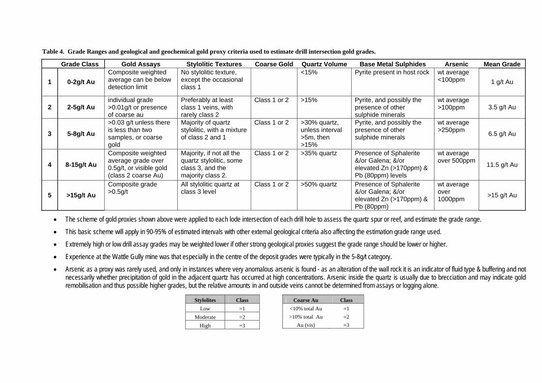
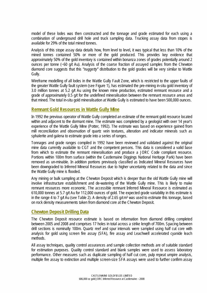
Table 4. Grade Ranges and geological and geochemical gold proxy criteria used to estimate drill intersection gold grades.
Grade Class Gold Assays Stylolitic Textures Coarse Gold Quartz Volume Base Metal Sulphides Arsenic Mean Grade
1 0-2g/t Au Composite weighted average can be below detection limit
No stylolitic texture, except the occasional class 1
<15% Pyrite present in host rock wt average <100ppm 1 g/t Au
2 2-5g/t Au individual grade >0.01g/t or presence of coarse au
Preferably at least class 1 veins, with rarely class 2
Class 1 or 2 >15% Pyrite, and possibly the presence of other sulphide minerals
wt average >100ppm 3.5 g/t Au
3 5-8g/t Au
>0.03 g/t unless there is less than two samples, or coarse gold
Majority of quartz stylolitic, with a mixture of class 2 and 1
Class 1 or 2 >30% quartz, unless interval >5m, then >15%
Pyrite, and possibly the presence of other sulphide minerals
wt average >250ppm 6.5 g/t Au
4 8-15g/t Au
Composite weighted average grade over 0.5g/t, or visible gold (class 2 coarse Au)
Majority, if not all the quartz stylolitic, some class 3, and the majority class 2.
Class 1 or 2 >35% quartz Presence of Sphalerite &/or Galena; &/or elevated Zn (>170ppm) & Pb (80ppm) levels
wt average over 500ppm 11.5 g/t Au
5 >15g/t Au Composite grade >0.5g/t
All stylolitic quartz at class 3 level
Class 1 or 2 >50% quartz Presence of Sphalerite &/or Galena; &/or elevated Zn (>170ppm) & Pb (80ppm)
wt average over 1000ppm >15 g/t Au
• The scheme of gold proxies shown above were applied to each lode intersection of each drill hole to assess the quartz spur or reef, and estimate the grade range.
• This basic scheme will apply in 90-95% of estimated intervals with other external geological criteria also affecting the estimation grade range used.
• Extremely high or low drill assay grades may be weighted lower if other strong geological proxies suggest the grade range should be lower or higher.
• Experience at the Wattle Gully mine was that especially in the centre of the deposit grades were typically in the 5-8g/t category.
• Arsenic as a proxy was rarely used, and only in instances where very anomalous arsenic is found - as an alteration of the wall rock it is an indicator of fluid type & buffering and not necessarily whether precipitation of gold in the adjacent quartz has occurred at high concentrations. Arsenic inside the quartz is usually due to brecciation and may indicate gold remobilisation and thus possible higher grades, but the relative amounts in and outside veins cannot be determined from assays or logging alone.
Stylolites Class Low =1
Moderate =2 High =3
Coarse Au Class <10% total Au =1 >10% total Au =2
Au (vis) =3

Grade Range Estimation Example Photos: Range 2 – 5 g/t Au
• Weighted Stylolites = 1
• Coarse Gold = 0
• Weighted Drill Assay = <0.1 g/t Au (Max 0.08g/t – contained coarse gold)
• Base metal sulphides = 0 (pyrite only)
• Arsenic wt % = 12 ppm
• Quartz volume is = Low (26.2 wt%)
• Visible gold = rarely observed
Range 5 – 8 g/t Au
• Weighted Stylolites = 2
• Coarse Gold = 0
• Weighted Drill Assay = >0.1 to 0.5 g/t Au (Max 0.54g/t)
• Base metal sulphides = 0 (pyrite)
• Arsenic wt % = 42 ppm
• Quartz volume is = High (82.9 wt%)
• Visible gold = sometimes observed
Range 8 – 15 g/t Au
• Weighted Stylolites = 2
• Coarse Gold = 2
• Weighted Drill Assay = >0.3 g/t Au to 10 g/t Au
• Base metal sulphides = 1.3 (Galena, Sphalerite, Pyrite, Gold)
• Arsenic wt % = 1852 ppm
• Quartz volume = Moderate (64.0 wt%)
• Visible gold = sometimes seen as isolated particle or as clusters to 2 mm in size

Project Background The Castlemaine project comprises five granted tenements - MIN 4470, MIN 5378, EL 3242, EL 4235 and EL 4372 that cover virtually all the historical Castlemaine goldfield that produced 5.6 million ounces of gold. Central to the project area, to the south of the township of Chewton, is the Company’s only office and the old Wattle Gully underground gold mine. This mine produced 415,000 oz of gold at a recovered grade of 10.5g/t, to a depth of 325m. Wattle Gully was mined from 1934-1989 and is a source of high quality geological information and modern assay data. Drilling occurred in two significant phases over the course of the 2007 year. A structural drilling campaign that commenced in the December quarter of 2006 carried over into the first half of the 2007 year. This drilling followed on from the completion of the 3D structural model of the Castlemaine field in 2006. The first hole of this program was also the first deep hole into the Chewton Anticline prospect (CHEW_0819). The highly encouraging results to that hole announced to the market in November 2006 set in train an extensive exploration program on this specific prospect. Structural drilling resumed in the March Quarter upon the northern central corridor of the goldfield. The detailed compilation of historical mining and geological data, mineralisation model research and development and generation of a goldfield scale 3D exploration model provided the preparation to embark on rigorous drill testing of this under-explored, high potential goldfield. The scale and breadth of drilling in the second phase which commenced in October 2007 has not been seen in past exploration upon the goldfield. At least 2 drilling rigs have been in continuous operation across the Castlemaine goldfield. Earlier structural drilling had successfully validated the 3D model assumptions. Broad structural analysis using the mineralisation model for the field generated at least 33 prominent linear fault reef targets of various strike lengths that accumulate to over 57km of prospective targets. A prioritization process was undertaken to rank all identified targets against geological and economic criteria. The minimum amount of holes required to test each target to a first decision point was then determined. This became the minimum amount of new drilling information required to determine if the target has the potential to be at least “Wattle Gully size”, a threshold of 0.5 million ounces. A budget was formulated and the necessary funds were raised. The program entails some 16,000 m of diamond drilling that includes the necessary amount of drilling to support the first inferred resource estimation for the Chewton Deposit together with extensive drilling extending from the far north of the exploration licences at Specimen Gully, where gold was first discovered in 1851, to Fryerstown in the south where in excess of 100,000 ounces was won from numerous old mines. The exploration strategy was subjected to 2 external reviews between these 2 phases of drilling. These external reviews supported the exploration approach thus far and provided further confidence in the exploration strategy that the company has adopted. The most comprehensive of the reviews, undertaken by Snowden Mining Industry Consultants Limited in July 2007, concluded that the company was, at that time, on track to produce a resource estimate at the Chewton Anticline prospect and that it had the right capacities to achieve the goal of building a new multi-million ounce goldfield. These capacities, both as geological experience and the proven mineralisation model for the field, were recognised as a milestone towards the company’s goal.
CASTLEMAINE GOLDFIELDS LIMITED 686,000 oz gold JORC Inferred Resource at Castlemaine – 2008
Figure 2. Castlemaine Project tenement outline with Chewton Deposit and Wattle Gully Mine location relative to other areas being explored by CGT. Chewton Anticline Diamond Drilling The first hole drilled in the 2007 year was CGT_007 at the Chewton Anticline prospect. The very encouraging results from hole CHEW_0819 demanded follow-up drilling on this target. Drilling throughout 2007 resulted in 9 intersections (CGT_007 to CGT_014 plus wedges) of the mineralised Cemetery Reef Fault system, over a strike length of 400 m. This drilling campaign continued into the 2008 year and has now proven the continuity of the Cemetery Fault system over a strike length of 700m. Information from these holes determined where changes in either azimuth or plunge of the fold and Cemetery Fault mineralisation occur. Changes to the fold geometry can significantly influence the location of high grade gold, as seen in the fold plunge reversal within the Wattle Gully system.

CASTLEMAINE GOLDFIELDS LIMITED 686,000 oz gold JORC Inferred Resource at Castlemaine – 2008
Structural analysis, the intensity of wall-rock alteration, the presence of visible nuggetty gold and ‘gold indicator’ accessory minerals and assay results from the Cemetery Fault system strongly supports the comparison with that of Wattle Gully. Assay results are typically erratic; however the presence of visible gold along strike and up and down dip is a critical indicator of the economic significance of a mineralised fault. Ahead of the resource estimate, a program of gold grade characterisation and quality control was performed using drill core samples and pulps. This study, along with gold grain sizes and textures, confirmed that a high nugget effect is present in the Chewton Anticline system, identical to the old Wattle Gully deposit.