INFORMATION ON WEATHER AND SEA …riscurisicatastrofe.reviste.ubbcluj.ro/Volume/XV_Nr_19_2...27...
10
23 RiscuRi şi catastRofe, an Xv, vol. 19, nR. 2/2016 INFORMATION ON WEATHER AND SEA CONDITIONS ONBOARD POLAR CRUISE SHIPS BRÂNDUŞA CHIOTOROIU 1 , E. ȘEMȘEDIN 2 ABSTRACT. – Information on weather and sea conditions onboard polar cruise ships. The arctic and Antarctic regions are difficult to navigate because of their severe maritime conditions. Weather forecast, forecast of the sea ice and icebergs dynamics are extremely important when planning ships routes and tourism activities including embarkation/disembarkation from boats or landing operations. New meteorological services have been created in the arctic region for broadcast purposes. The information provided by these services and received onboard ships is presented in this paper. A risk assessment should be considered for Polar Water operations such as maneuvering in ice covered waters, anchoring, shore landings etc. Key-words: polar cruise ships, tourism activities, hydrometeorological information, risk assessment 1. INTRODUCTION Mass tourism in the Arctic developed beginning with the mid-1800’s when steamships and railroads expanded their transportation networks providing access to numerous destinations throughout the Arctic. Antarctic tourism began in 1957 with visits by Argentinean and Chilean naval transports, which accommodated tourists. During his expedition cruising from 1966 to the Antarctic, Lindblad used zodiacs* to land passengers at different sites. *the term Zodiac is used in this paper to cover all forms of inflatable boats, including Rigid-hull Inflatable Boats (RIBs). The expedition ships transport nowadays a larger number of passengers; there are expanding numbers of attractions, recreational activities, international destinations, and visitor accommodations. Ship technologies and marine charts also improved and this allowed the increase of cruise ship travel. The recent tourist offers include also air transport in all of its forms (Tourism in the Polar Regions, UNEP 2007). Tourism revenues may provide resources for the conservation of polar environments by creating greater economic opportunities and choices for local 1 Chiotoroiu Brânduşa, Assoc.Prof. PhD, Constanta Maritime University, Dept. of Naviga- tion, 900664 Constanta, Romania, [email protected] 2 Semsedin E., Second Officer, Cruise Management International
Transcript of INFORMATION ON WEATHER AND SEA …riscurisicatastrofe.reviste.ubbcluj.ro/Volume/XV_Nr_19_2...27...

23
RiscuRi şi catastRofe, an Xv, vol. 19, nR. 2/2016
INFORMATION ON WEATHER AND SEA CONDITIONS ONbOARD POLAR CRUISE SHIPS
BRÂNDUŞA CHIOTOROIU1, E. ȘEMȘEDIN2
AbSTRACT. – Information on weather and sea conditions onboard polar cruise ships. The arctic and Antarctic regions are difficult to navigate because of their severe maritime conditions. Weather forecast, forecast of the sea ice and icebergs dynamics are extremely important when planning ships routes and tourism activities including embarkation/disembarkation from boats or landing operations. New meteorological services have been created in the arctic region for broadcast purposes. The information provided by these services and received onboard ships is presented in this paper. A risk assessment should be considered for Polar Water operations such as maneuvering in ice covered waters, anchoring, shore landings etc.
Key-words: polar cruise ships, tourism activities, hydrometeorological information, risk assessment
1. INTRODUCTION
Mass tourism in the Arctic developed beginning with the mid-1800’s when steamships and railroads expanded their transportation networks providing access to numerous destinations throughout the Arctic. Antarctic tourism began in 1957 with visits by Argentinean and Chilean naval transports, which accommodated tourists. During his expedition cruising from 1966 to the Antarctic, Lindblad used zodiacs* to land passengers at different sites.
*the term Zodiac is used in this paper to cover all forms of inflatable boats, including Rigid-hull Inflatable Boats (RIBs).
The expedition ships transport nowadays a larger number of passengers; there are expanding numbers of attractions, recreational activities, international destinations, and visitor accommodations.
Ship technologies and marine charts also improved and this allowed the increase of cruise ship travel. The recent tourist offers include also air transport in all of its forms (Tourism in the Polar Regions, UNEP 2007).
Tourism revenues may provide resources for the conservation of polar environments by creating greater economic opportunities and choices for local
1Chiotoroiu Brânduşa, Assoc.Prof. PhD, Constanta Maritime University, Dept. of Naviga-tion, 900664 Constanta, Romania, [email protected] Semsedin E., Second Officer, Cruise Management International

24
Brânduşa Chiotoroiu, E. ȘEmşEdin
people. However most of the studies on polar tourism refer to the vulnerabilities of these environments that may be compromised by the number of visitors and the activities undertaken.
The arctic and Antarctic regions have severe maritime conditions. In extreme situations in which accidents occurred, boats capsized after being hit by waves and cruisers died or have been injured.
In this paper we refer to the main types of information on weather and sea conditions received onboard in an arctic region: ice charts, meteorological bulletins and synoptic charts.
2. PASSENGER SHIPS CHARACTERISTICS.
Vessel operators are members of the International Association of Antarctic Tour Operators and of the Association of Arctic Expedition Cruise Operators and consequently have to follow the international maritime regulations, including special rules for travel to Antarctica and the Arctic regions.
Passenger ships do not enter the Arctic and Antarctic environments all times of the year. Trips are scheduled especially from October to March in Antarctica and from June to October in the Arctic regions, which are the summer months in the respective hemispheres and when the ice starts to melt.
According to the IAATO statistics, the number of tourists increased in 2015-2016 comparing to 2011 for all types of tourist activities: seaborne tourism with/no landings, air and cruise combination with landings, air and land tourism Antarctic interior and overflights, no landing (www.iaato.org/tourism-statistics).
The regions visited in the Arctic are: Svalbard, Jan Mayen, Greenland, Canada and the national park “Russian Arctic” (Franz Josef Land and northern Novaya Zemlya) and in the Antarctic: the Paradise Bay (west side of Antarctica), King George’s island, McMurdo station, South Shetland islands, Adelaide isl., South Georgia isl. and Falkland isl. (Quark Expeditions website).
The tourists come for sightseeing, sport fishing and hunting or they seek to observe wildlife species in their natural habitats. They also want to experience personal interaction with the lives and traditions of native people and learn more about a historical topic that interests them.
Hazards are numerous during a cruise ship travel, mainly due to the severe weather and sea/maritime conditions. For every cruise, the environmental conditions must be taken into account before every voyage. Polar water operation may impose additional demands on ships, their systems and operation, beyond the existing requirements.
The new Polar Code has been developed to supplement the existing International Maritime Organization instruments in order to increase the safety of

25
InformatIon on weather and sea condItIons onboard polar cruIse shIps
ships’ operation. According to the Polar Code, “an assessment of the ship and its equipment shall be carried out”, taking into consideration the anticipated range of operating and environmental conditions, such as: “operation in low air temperature; operation in ice; operation in high latitude; and potential for abandonment onto ice or land”.
The ship assessment should also consider hazards such as: “ice, as it may affect hull structure, stability characteristics etc.; topside icing, with potential reduction of stability and equipment functionality; low temperature, as it affects the working environment and human performance etc., […] performance of safety equipment and systems; […] the quality of ice imagery information; remoteness and possible lack of accurate and complete hydrographic data and information, reduced availability of navigational aids, […] limited communications capability, with the potential to affect incident response; rapidly changing and severe weather conditions, with the potential for escalation of incidents […]”.
Because of the limitations for ships planned operations, a system of Polar Classes has been developed to designate different levels of capability. A set of Unified Requirements has been developed which, in addition to general classification society rules, address essential aspects of construction for ships of Polar Class (Requirements concerning Polar Class, IACS Req. 2016).
Polar cruise ships have all the facilities and additional immersion suits.For example the Ocean Nova vessel is built to sail in ice waters has an ice-
strengthen hull and a capacity for 68 passengers and also a fleet of 7 Zodiacs (inflatable boats) for disembarking (fig. 1).
Figure 1. Polar cruise ship Ocean Nova (http://www.antarcticaxxi.com/our-craft/ocean-nova/)
2.1. Hydrometeorological information onboard. Cruise ships routes between the arctic cruise ports such as Tromso (Norway) and
Longyearbyen (Svalbard islands) are inside Metarea* XIX. Starting with 2011 the Norwegian Meteorological Institute took the responsibility as preparing and issuing

26
Brânduşa Chiotoroiu, E. ȘEmşEdin
institute for Maritime Safety Information in METAREA XIX (fig. 2). GMDSS** Maritime Safety Information (MSI) messages for METAREA XIX have been prepared and issued twice daily.
*For the purpose of the preparation and issuing of meteorological warnings and of weather and sea bulletins, the oceans and seas are divided into areas (Metareas) for which National Meteorological Services (NMSs) assume responsibility. New METAREA(s) in fig. 2.
**GMDSS – Global Maritime Distress and Safety System
Figure 2. Limits of the new METAREAS (List of Radio signals, UK Hydrographic Office)
Fully reliable sets of marine charts and hydrographic information are not yet available for these regions. Information received via Navtex and Inmarsat C and the ice charts is therefore extremely important.
For cruise ships approaching Greenland for example, the charts issued by the Norwegian Meteorological Institute can be very useful because they include the distribution of different categories of ice and sea surface temperatures.
Ice concentration can change quickly in 48 hours near the coast (as shown in the example below): ice conditions at the entrance in the fjord changed from the 15th to the 17th of August 2016. The area coloured in blue in the Scoresbysund fjord corresponds to open water (sea ice is present but its concentration is small). It extended the 17 August comparing to the previous two days, the sea ice being present also along the coast.

27
InformatIon on weather and sea condItIons onboard polar cruIse shIps
The route of the Ocean Nova cruise ship in August 2016 was from the Svalbard islands to eastern Greenland. The destination was the Scoresbysund fjord, indicated with a black point on the charts in figs. 3 a and 3 b.
Several days later, after the reception of updated ice charts and the assessment of the weather and sea conditions, the zodiacs have been used for the transport of tourists along the fjord (fig. 4).
Figure 3 a. Chart received onboard Ocean Nova on 15.08.2016 (polarview.met.no).
Figure 3 b. Chart received onboard Ocean Nova on 17.08.2016 (polarview.met.no).

28
Brânduşa Chiotoroiu, E. ȘEmşEdin
Figure 4. Tourists transport with a Zodiac boat along the Scoresbysund fjord, 2016(E. Semsedin personal photos)
Cruise ships sailing near east Greenland coasts can receive detailed ice charts also from the Danish Meteorological Institute (not shown in this paper).
The main types of information on weather, received onboard are the meteorological warnings and routine weather and sea bulletins (Chiotoroiu, 2010). For areas not covered by NAVTEX, they are sent by the International SafetyNET Service. SafetyNET works similarly to NAVTEX in areas outside NAVTEX coverage (mainly coastal areas).
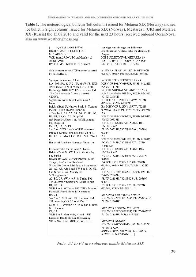
The meteorological bulletin sent by the Norwegian Meteorological Institute the 15th of August 2016 is presented in the table below. It includes information on the synoptic conditions and forecast for the next 24 hours of the significant waves’ height, wind direction and force (on the Beaufort scale), weather phenomena (such as fog, rain or snow), visibility (by descriptive terms). The meteorological information is followed by the information on ice extent (the limits indicated by coordinates). The ice edge representation in the forecasts was established through coordination between Canada, Norway and Russia (www.weather.gmdss.org). Norway and Russia are exchanging the ice edge coordinates in METAREAs XIX and XX on a regular base to ensure the consistence in ice conditions on the border between the areas. Also Norway and UK agreed that ice edge coordinates for METAREA I (under the responsibility of UK) are produced by MET Norway and distributed (information for Metareas I and XX in italics in table I).
29
InformatIon on weather and sea condItIons onboard polar cruIse shIps
Table 1. The meteorological bulletin (left column) issued for Metarea XIX (Norway) and sea ice bulletin (right column) issued for Metarea XIX (Norway), Meatarea I (UK) and Metarea XX (Russia) the 15.08.2016 and valid for the next 23 hours (received onboard OceanNova, also on www.weather.gmdss.org).
Note: A1 to F4 are subareas inside Metarea XIX
30
Brânduşa Chiotoroiu, E. ȘEmşEdin
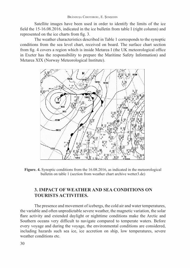
Satellite images have been used in order to identify the limits of the ice field the 15-16.08.2016, indicated in the ice bulletin from table I (right column) and represented on the ice charts from fig. 3.
The weather characteristics described in Table 1 corresponds to the synoptic conditions from the sea level chart, received on board. The surface chart section from fig. 4 covers a region which is inside Metarea I (the UK meteorological office in Exeter has the responsibility to prepare the Maritime Safety Information) and Metarea XIX (Norway Meteorological Institute).
Figure. 4. Synoptic conditions from the 16.08.2016, as indicated in the meteorological bulletin on table 1 (section from weather chart archive wetter3.de)
3. IMPACT OF WEATHER AND SEA CONDITIONS ON TOURISTS ACTIVITIES.
The presence and movement of icebergs, the cold air and water temperatures, the variable and often unpredictable severe weather, the magnetic variation, the solar flare activity and extended daylight or nighttime conditions make the Arctic and Southern oceans very difficult to navigate compared to temperate waters. Before every voyage and during the voyage, the environmental conditions are considered, including hazards such sea ice, ice accretion on ship, low temperatures, severe weather conditions etc.
31
InformatIon on weather and sea condItIons onboard polar cruIse shIps
Tourists are first informed by the travel agency about the possible risks during activities onboard polar ships or zodiacs or during landings. Once onboard, they follow several other sessions of training.
A risk situation may be when zodiacs are too close to small icebergs, because they can be unstable. The underside of bergy bits and growlers can sometimes melt faster than the exposed portion, especially in very cold weather, as they drift into warmer waters. As the mass of the submerged portion deteriorates, the berg becomes increasingly unstable, and it may eventually roll over. Unseen cracks can cause icebergs to split in two or calve off large pieces that can cause the formation of waves, large enough to overturn a boat (Bowditch, 2002).
Other risks refer to embarkation/disembarkation operations when there is wind, swell or wind waves. In planning zodiac operations, “the expedition leader, the chief officer and the captain are to consider […] the impact that a (weather) change might have on Zodiac operations” (Ocean Nova Zodiac Operations Manual). There are specific maneuvers to be done, for example when approaching the platform for embarkation and also contingency plans in place to allow passengers to be evacuated back onboard or stabilized ashore.
CONCLUSIONS
The arctic and Antarctic regions are difficult to navigate because of their severe maritime conditions: variable and often unpredictable severe weather, the presence and movement of icebergs, cold air and water temperatures etc. Weather and sea conditions forecast are extremely important when planning ships routes and tourism activities.
New meteorological services have been created in the arctic region for broadcast purposes. Besides the meteorological bulletins and warnings sent through Navtex and Inmarsat C SafetyNet and the weather charts, cruise ships also receive ice charts, which are also very useful for Zodiac operations. A risk assessment should be considered for Polar Water operations such as maneuvering in ice covered waters, anchoring, shore landings etc. (Jorgensen, 2014).
The increasing levels of shipping and polar tourism in the arctic and Antarctic regions demand additional hydrometeorological observations and safety services. They will be part of extended networks within the Global Integrated Polar Prediction System (2013-2022) created by the World Meteorological Organization. (www.wmo.int/pages/prog/WIGOS_6_EC_PORS).
32
Brânduşa Chiotoroiu, E. ȘEmşEdin
R E F E R E N C E S
1. Bowditch N. (2002), The American Practical Navigator - bicentennial edition, prepared and published by the National imagery and mapping agency Bethesda, Maryland, USA, chapter
2. Chiotoroiu B.C., (2010), Marine meteorology and hydrology II (Reader), Constanta Maritime University Library.
3. Jørgensen F., (2014), Arctic shipborne tourism, Workshop on Safe Ship Operations in the Arctic Ocean, Association of Arctic Expedition Cruise Operators, www.imo.org.
4. ***Guidelines for ships operating in polar waters, 2010 edition, IMO http://www.imo.org/en/Publications
5. List of Radio signals, Maritime Safety Information Service 283 (1), vol.3 (2015-2016), UK Hydrographic Office
6. ***The Polar Code, http://www.imo.org/en/MediaCentre/7. ***Tourism in the Polar Regions. The sustainability challenge (2007), UNEP
(United Nations Environment Programme) and The International Ecotourism Society8. ***Requirements concerning Polar Class, IACS Req. (2016), http://www.iacs.org.
uk/document/public/Publications/Unified_requirements/PDF/UR_I_pdf410.pdf9. ***Ocean Nova Zodiac Operations Manual10. ***www.iaato.org/tourism-statistics11. ***polarview.met.no12. ***www.quarkexpeditions.com13. ***http://www.antarcticaxxi.com/our-craft/ocean-nova/14. ***www.weather.gmdss.org15. ***www.wmo.int/pages/prog/WIGOS_6_EC_PORS.