Influence of ice supersaturation, temperature and dynamics on cirrus occurrence near the tropopause...
17
Influence of ice supersaturation, temperature and dynamics on cirrus occurrence near the tropopause N. Lamquin (1), C.J. Stubenrauch (1), P.-H. Wang (2) Vienna, European Geophysical Union 16 April 2007 (1) CNRS/IPSL Laboratoire de Météorologie Dynamique, Ecole Polytechnique, Palaiseau, France (2) Science and Technology Corporation, Hampton, VA 23666, USA
-
Upload
madison-norton -
Category
Documents
-
view
225 -
download
1
Transcript of Influence of ice supersaturation, temperature and dynamics on cirrus occurrence near the tropopause...
Influence of ice supersaturation, temperature and dynamics on cirrus occurrence near the
tropopause
N. Lamquin (1), C.J. Stubenrauch (1), P.-H. Wang (2)
Vienna, European Geophysical Union16 April 2007
(1) CNRS/IPSL Laboratoire de Météorologie Dynamique, Ecole Polytechnique, Palaiseau, France
(2) Science and Technology Corporation, Hampton, VA 23666, USA
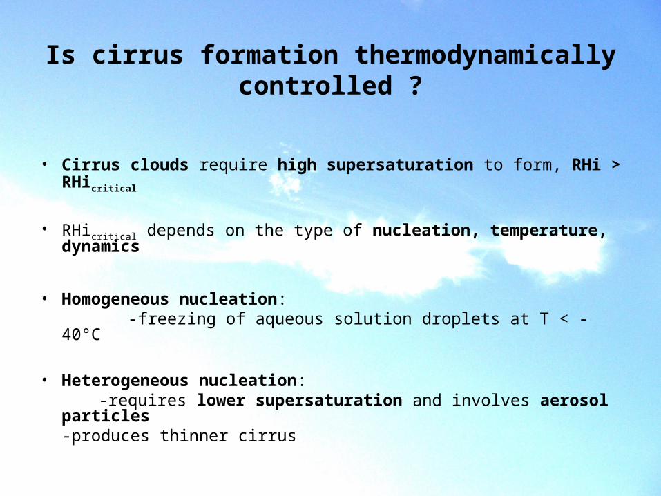
• Cirrus clouds require high supersaturation to form, RHi > RHicritical
• RHicritical depends on the type of nucleation, temperature, dynamics
• Homogeneous nucleation: -freezing of aqueous solution droplets at T < -40°C
• Heterogeneous nucleation: -requires lower supersaturation and involves aerosol particles
-produces thinner cirrus
Is cirrus formation thermodynamically controlled ?
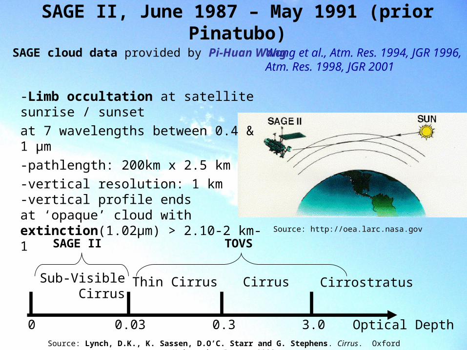
SAGE II, June 1987 – May 1991 (prior Pinatubo)
Source: http://oea.larc.nasa.gov
-Limb occultation at satellite sunrise / sunset
at 7 wavelengths between 0.4 & 1 μm
-pathlength: 200km x 2.5 km
-vertical resolution: 1 km-vertical profile ends at ‘opaque’ cloud with extinction(1.02μm) > 2.10-2 km-1
Wang et al., Atm. Res. 1994, JGR 1996,Atm. Res. 1998, JGR 2001
SAGE cloud data provided by Pi-Huan Wang
0 0.03 0.3 3.0 Optical Depth
Sub-Visible Cirrus
Thin Cirrus Cirrus Cirrostratus
SAGE II TOVS
Source: Lynch, D.K., K. Sassen, D.O’C. Starr and G. Stephens. Cirrus. Oxford University Press, 2002
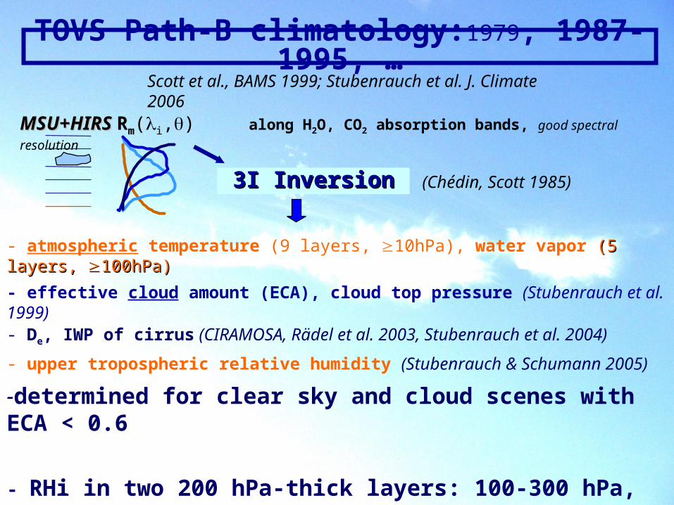
TOVS Path-B climatology:1979, 1987- 1995, …Scott et al., BAMS 1999; Stubenrauch et al. J. Climate 2006
- atmospheric temperature (9 layers, 10hPa), water vapor (5 layers, (5 layers, 100hPa)100hPa)
- effective cloud amount (ECA), cloud top pressure (Stubenrauch et al. 1999)
MSU+HIRS MSU+HIRS Rm(i,) along H2O, CO2 absorption bands, good spectral resolution
3I Inversion3I Inversion (Chédin, Scott 1985)
- De, IWP of cirrus (CIRAMOSA, Rädel et al. 2003, Stubenrauch et al. 2004)
- upper tropospheric relative humidity (Stubenrauch & Schumann 2005)
-determined for clear sky and cloud scenes with ECA < 0.6
- RHi in two 200 hPa-thick layers: 100-300 hPa, 300-500 hPa
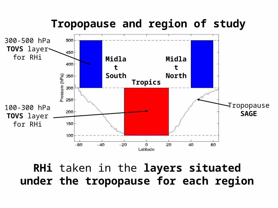
TropopauseSAGE
300-500 hPaTOVS layer
for RHi
100-300 hPaTOVS layer
for RHi
Tropics
MidlatSouth
MidlatNorth
Tropopause and region of study
RHi taken in the layers situated under the tropopause for each region
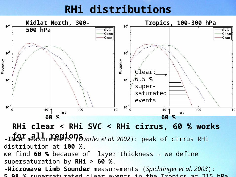
RHi distributions
-INCA measurements (Ovarlez et al. 2002): peak of cirrus RHi distribution at 100 %,we find 60 % because of layer thickness → we define supersaturation by RHi > 60 %.-Microwave Limb Sounder measurements (Spichtinger et al. 2003): 5.98 % supersaturated clear events in the Tropics at 215 hPa while we find 6.5 % in a 200 hPa-thick layer centered around 200 hPa.
Tropics, 100-300 hPaMidlat North, 300-500 hPa
60 %60 %
Clear:6.5 %super-saturatedevents
RHi clear < RHi SVC < RHi cirrus, 60 % works for all regions
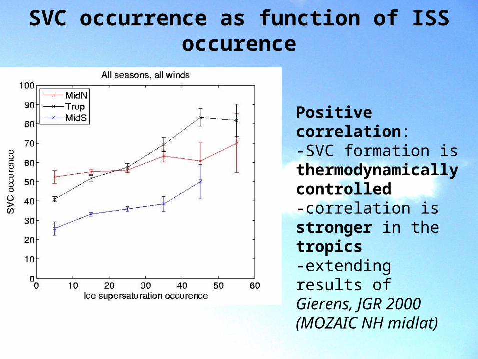
SVC occurrence as function of ISS occurence
Positive correlation:-SVC formation is thermodynamically controlled -correlation is stronger in the tropics-extending results ofGierens, JGR 2000 (MOZAIC NH midlat)
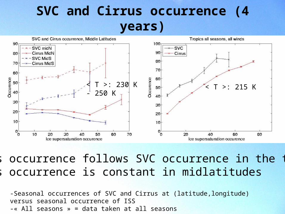
SVC and Cirrus occurrence (4 years)
-Seasonal occurrences of SVC and Cirrus at (latitude,longitude) versus seasonal occurrence of ISS-« All seasons » = data taken at all seasons
-Cirrus occurrence follows SVC occurrence in the tropics-Cirrus occurrence is constant in midlatitudes
< T >: 215 K< T >: 230 K- 250 K
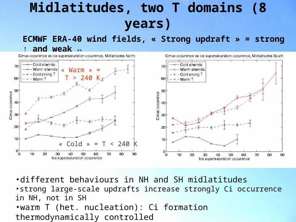
Midlatitudes, two T domains (8 years)
ECMWF ERA-40 wind fields, « Strong updraft » = strong ↑ and weak ↔
•different behaviours in NH and SH midlatitudes•strong large-scale updrafts increase strongly Ci occurrence in NH, not in SH•warm T (het. nucleation): Ci formation thermodynamically controlled •cold T: on average constant Ci occurrence
« Warm » = T > 240 K
« Cold » = T < 240 K

Tropics, influence of dynamics (8 years)
« Weak » = all winds are weak« Strong » = one is strong, the other is weak
Strong large-scale updraft increases already Ci occurrence at low ISS occurrence
In situations with strong horizontal winds (may diffuse moisture): less Ci
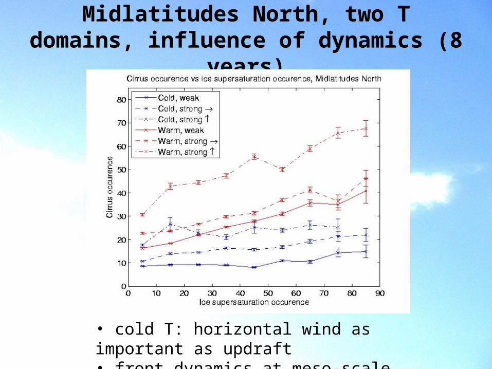
Midlatitudes North, two T domains, influence of dynamics (8 years)
• cold T: horizontal wind as important as updraft• front dynamics at meso-scale
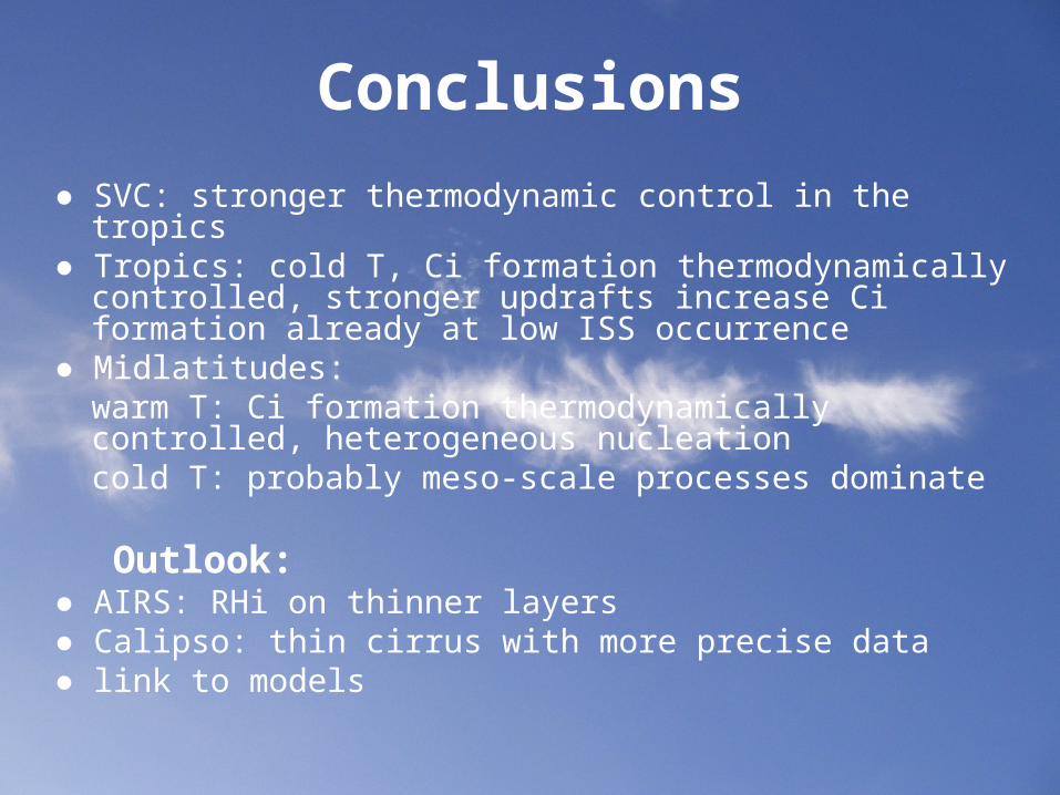
Conclusions
● SVC: stronger thermodynamic control in the tropics● Tropics: cold T, Ci formation thermodynamically controlled,
stronger updrafts increase Ci formation already at low ISS occurrence
● Midlatitudes: warm T: Ci formation thermodynamically controlled, heterogeneous nucleation cold T: probably meso-scale processes dominate
Outlook:● AIRS: RHi on thinner layers● Calipso: thin cirrus with more precise data● link to models
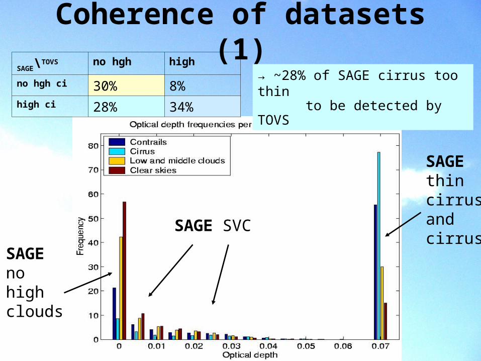
Coherence of datasets (1)
SAGEthin cirrusandcirrus
SAGEnohighclouds
SAGE SVC
SAGE\TOVS no hgh high
no hgh ci 30% 8%high ci 28% 34%
→ ~28% of SAGE cirrus too thinto be detected by TOVS
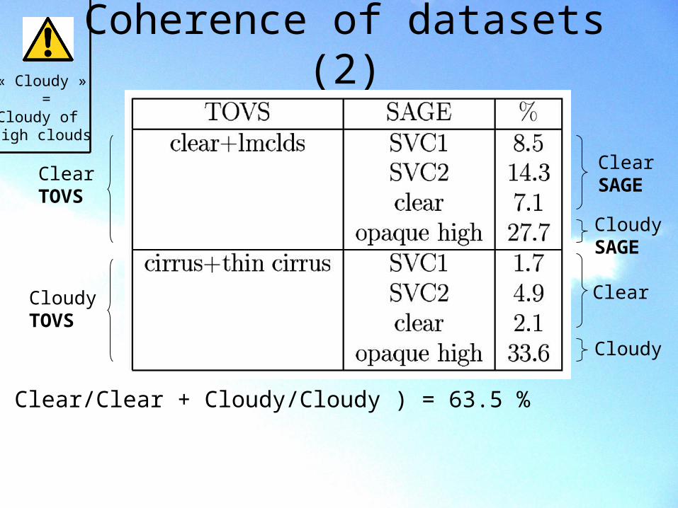
Coherence of datasets (2)
CloudySAGE
ClearSAGE
CloudyTOVS
ClearTOVS
Cloudy
Clear
Sum ( Clear/Clear + Cloudy/Cloudy ) = 63.5 %but…
« Cloudy » =
Cloudy of high clouds
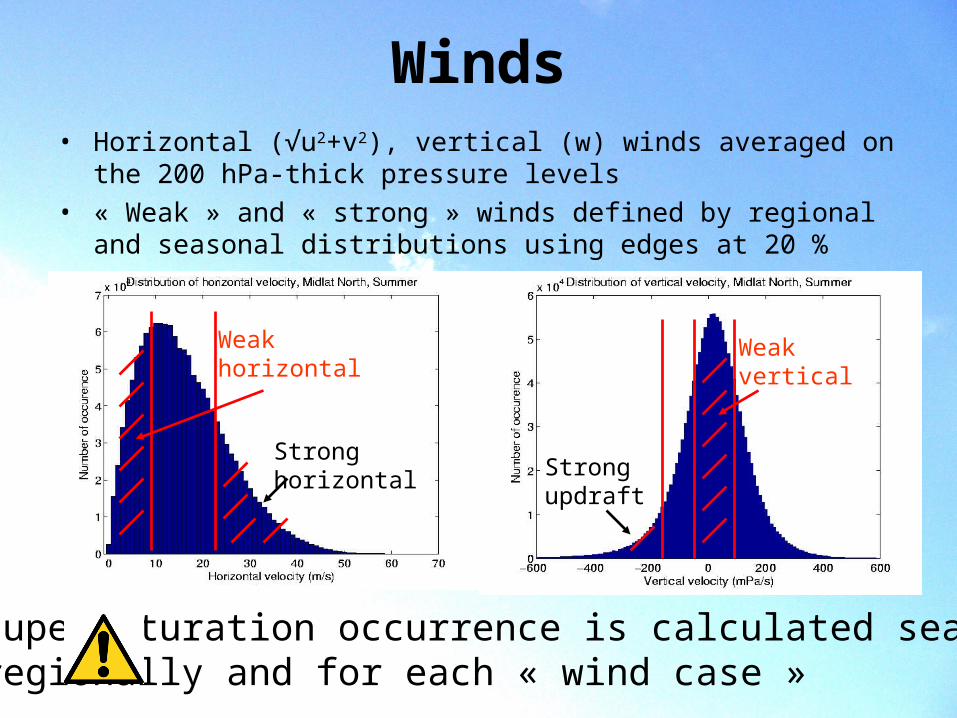
Winds• Horizontal (√u2+v2), vertical (w) winds averaged on the 200 hPa-thick
pressure levels
• « Weak » and « strong » winds defined by regional and seasonal distributions using edges at 20 %
Strongupdraft
Weakvertical
Stronghorizontal
Weakhorizontal
Supersaturation occurrence is calculated seasonally,regionally and for each « wind case »
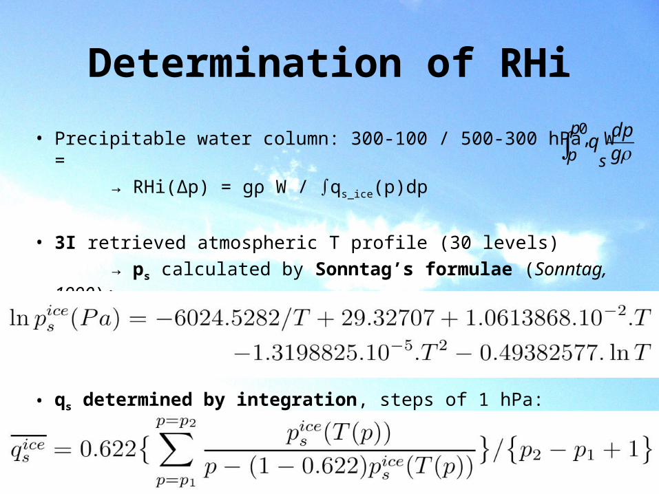
Determination of RHi
• Precipitable water column: 300-100 / 500-300 hPa, W =
→ RHi(Δp) = gρ W / qs_ice(p)dp
• 3I retrieved atmospheric T profile (30 levels)
→ ps calculated by Sonntag’s formulae (Sonntag, 1990):
• qs determined by integration, steps of 1 hPa:
gdp
qs
p
p0