Industrial Heritage Analysis - UNESCO World Heritage
112
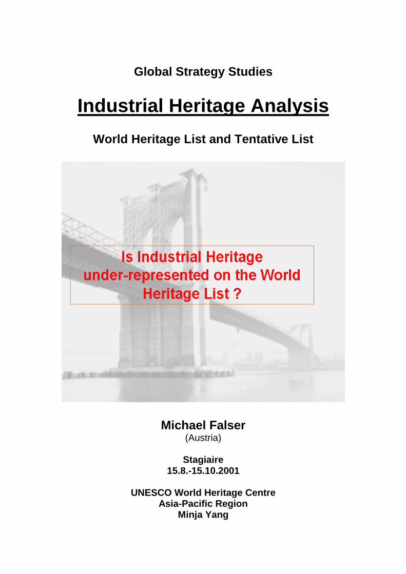
Global Strategy Studies Industrial Heritage Analysis World Heritage List and Tentative List Michael Falser (Austria) Stagiaire 15.8.-15.10.2001 UNESCO World Heritage Centre Asia-Pacific Region Minja Yang
Transcript of Industrial Heritage Analysis - UNESCO World Heritage
Global Strategy Studies
Industrial Heritage Analysis
World Heritage List and Tentative List
Michael Falser (Austria)
Stagiaire
15.8.-15.10.2001
UNESCO World Heritage Centre Asia-Pacific Region
Minja Yang
2
Table of Contents 0. Overview - Aim of Work 4 1. The UNESCO World Heritage 4 1.1. Convention, World Heritage Committee, Advisory Bodies, World Heritage List and Tentative List 4 1.2. The UNESCO World Heritage Centre and its Mandate 5 2. The World Heritage List and Global Strategy 6 2.1. The World Heritage List and Global Strategy 6 2.2. Trends, Analysis, Issues, Lacuna to address 6 3. Industrial Heritage 9 3.1. Definition 9 3.2. Industrial Heritage on the World Heritage List 9 3.3. Proposed Classification System (HEAR) 13 3.4. Classification and Introduction of the Industrial World Heritage Sites 14 4. Analysis of the Tentative List 16 4.1. Definition of the Tentative List and The Operational Guidelines 16 4.2. Classification of Industrial Heritage on the Tentative List 16 4.3. Classification by Region 17 4.3.1. Africa Region 17 4.3.1.1. Table and Map - Description 17 4.3.1.2. Trends 18 4.3.1.3. Highlights 18 4.3.2. Arab States Region 19 4.3.2.1. Table and Map - Description 19 4.3.2.2. Trends 19 4.3.2.3. Highlights 20
3
4.3.3. Asia / Pacific Region 21 4.3.3.1. Table and Map - Description 21 4.3.3.2. Trends 22 4.3.3.3. Highlights 22 4.3.4. Europe / North America Region 23 4.3.4.1. Table and Map - Description 23 4.3.4.2. Trends 24 4.3.4.3. Highlights 24 4.3.5. Latin America / Caribbean Region 26 4.3.4.1. Table and Map - Description 26 4.3.4.2. Trends 26 4.3.4.3. Highlights 27 4.4. Global Classification of Industrial Heritage 28 4.4.1. Trends 28
4.4.2. Global Classification List and Global Map 30 4.4.3. Example of Application 31
5. Work for the Future - a Martix System 33 6. Appendices 34 6.1. HAER Industrial Classification System 6.2. Industrial Classification List of Industrial Heritage Sites with photos 6.3. Africa Tentative list analysis and description 6.4. Africa Tentative Industrial Heritage Classification 6.5. Arab States Tentative list analysis and description 6.6. Arab States Tentative Industrial Heritage Classification 6.7. Asia / Pacific Tentative list analysis and description 6.8. Asia / Pacific Tentative Industrial Heritage Classification 6.9. Europe / North America Tentative list analysis and description 6.10. Europe / North America Tentative Industrial Heritage Classification 6.11. Latin America / Caribbean Tentative list analysis and description 6.12. Latin America / Caribbean Tentative Industrial Heritage Classification 6.13. Global Tentative Industrial Heritage list Classification 6.14. Powerpoint presentation
4
Industrial World Heritage and Global Strategy Acknoledgement I want to thank Ms. Minja Yang for accepting me for this internship at the UNESCO World Heritage Centre and for giving me a lot of space for developing my ideas for this analysis. I want to thank Bernd Paulowitz for his help in generating many of the maps in this presentation, and all members of the World Heritage Centre who had an open ear to me and helped me to find my way through the UNESCO infrastructure. My special thanks goes to Peter Stott who was a magnificant help in my work, a restless promoter of my interests in Industrial Heritage, and a great friend. I want to thank as well Eric DeLony of the Historic American Engineering Record of the U.S. National Park Service, who provided an excellent classification system as a key instrument for this work. 0. Overview The following analysis has been develped during an internship at the World Heritage Center of UNESCO by Michael Falser, an Austrian architect and art historian, in autumn 2001 under the supervision of Minja Yang and Junko Taniguchi. Being a major task for the World Heritage Center, this analysis is a contribution to the "Global Strategy" - studies for a harmonisation of the World Heritage List and for the identification of under-represented categories. Aim of Work After a short introduction of the UNESCO World Heritage structure, its instruments and units, the present state of the World Heritage List and the tentative list with special focus on Industrial Heritage will be discussed. The main idea of this work is not only to identify Industrial Heritage sites on the tentative list, but to introduce a classification system in order to build sub-themes. Such a system could avoid repetitive nominations for the future and could be an example for other categories such as the heritage of the 20th century. It will show the vast variety of industrial sites around the world. 1. The UNESCO World Heritage 1.1. The Convention, World Heritage Committee, Advisory Bodies,
World Heritage List and Tentative List The UNESCO World Heritage Convention is one of a group of environmental treaties adopted after the 1972 United Nations Conference on the Human
5
Environment, held in Stockholm, Sweden. It brought together the conservation of cultural and natural heritage under a single legal instrument. It provides for the protection of those cultural and natural properties considered being of exceptional interest and outstanding universal value. The Convention defines the kind of natural or cultural sites which can be considered for the inscription in the World Heritage List, and sets out the duties of States Parties in identifying potential sites and their role in protecting and preserving them. Every State Party shall submit an inventory of property forming part of the heritage in its territory as a State Party’s Tentative List. Sites suitable for inclusion in the World Heritage List are transmitted to the Committee as nominations. The World Heritage Committee, which consists of representatives from 21 of the States Parties to the Convention, meets once a year and examines the States Parties nominations on the basis of technical evaluations. These independent evaluations of proposed cultural and natural sites are provided by two advisory bodies, the International Council on Monuments and Sites (ICOMOS) and the World Conservation Union (IUCN), respectively. The third advisory body, the International Centre for Study of the Preservation and Restoration of Cultural Property (ICCROM), provides expert advice on restoring monuments and organises training courses. To be included in the World Heritage List, sites must satisfy the selection criteria. These criteria are explained in the Operational Guidelines for the Implementation of the World Heritage Convention, which, besides the text of the Convention, is the main working document on World Heritage. The criteria are different for cultural and natural sites and mixed sites (with both outstanding natural and cultural values) and have been revised regularly by the Committee to match the evolution of the World Heritage itself. Equally important are authenticity, integrity, protection and management of the site. 1.2. The UNESCO World Heritage Centre and its Mandate The UNESCO World Heritage Centre was set up in 1992 by the Director-General to assure the day-to-day management of the Convention. It organizes the annual sessions of the World Heritage Bureau and the Committee, provides advice to States Parties in the preparation of site nominations, organizes technical assistance upon request, co-ordinates both the reporting on the condition of sites and the emergency action undertaken when a site is threatened. It is also responsible for the administration of the World Heritage Fund. The mandate of the World Heritage Centre is not about freezing heritage, but to integrate heritage conservation management and preservation with the overall development process and to promote a better understanding and tolerance of cultural diversity.
6
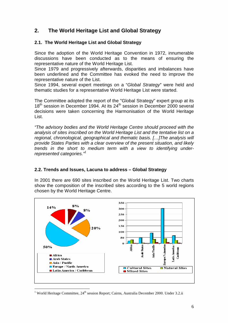
2. The World Heritage List and Global Strategy 2.1. The World Heritage List and Global Strategy Since the adoption of the World Heritage Convention in 1972, innumerable discussions have been conducted as to the means of ensuring the representative nature of the World Heritage List. Since 1979 and progressively afterwards, disparities and imbalances have been underlined and the Committee has evoked the need to improve the representative nature of the List. Since 1994, several expert meetings on a “Global Strategy” were held and thematic studies for a representative World Heritage List were started. The Committee adopted the report of the "Global Strategy" expert group at its 18th session in December 1994. At its 24th session in December 2000 several decisions were taken concerning the Harmonisation of the World Heritage List. “The advisory bodies and the World Heritage Centre should proceed with the analysis of sites inscribed on the World Heritage List and the tentative list on a regional, chronological, geographical and thematic basis. […]The analysis will provide States Parties with a clear overview of the present situation, and likely trends in the short to medium term with a view to identifying under-represented categories.”1 2.2. Trends and Issues, Lacuna to address – Global Strategy In 2001 there are 690 sites inscribed on the World Heritage List. Two charts show the composition of the inscribed sites according to the 5 world regions chosen by the World Heritage Centre.
1 World Heritage Committee, 24th session Report; Cairns, Australia December 2000. Under 3.2.ii
7
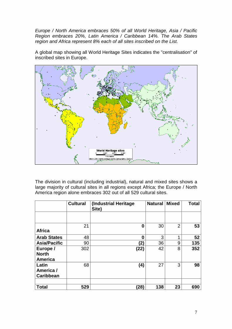
Europe / North America embraces 50% of all World Heritage, Asia / Pacific Region embraces 20%, Latin America / Caribbean 14%. The Arab States region and Africa represent 8% each of all sites inscribed on the List. A global map showing all World Heritage Sites indicates the "centralisation" of inscribed sites in Europe.
The division in cultural (including industrial), natural and mixed sites shows a large majority of cultural sites in all regions except Africa; the Europe / North America region alone embraces 302 out of all 529 cultural sites. Cultural (Industrial Heritage
Site) Natural Mixed Total
Africa 21 0 30 2 53
Arab States 48 0 3 1 52Asia/Pacific 90 (2) 36 9 135Europe / North America
302 (22) 42 8 352
Latin America / Caribbean
68 (4) 27 3 98
Total 529 (28) 138 23 690
8
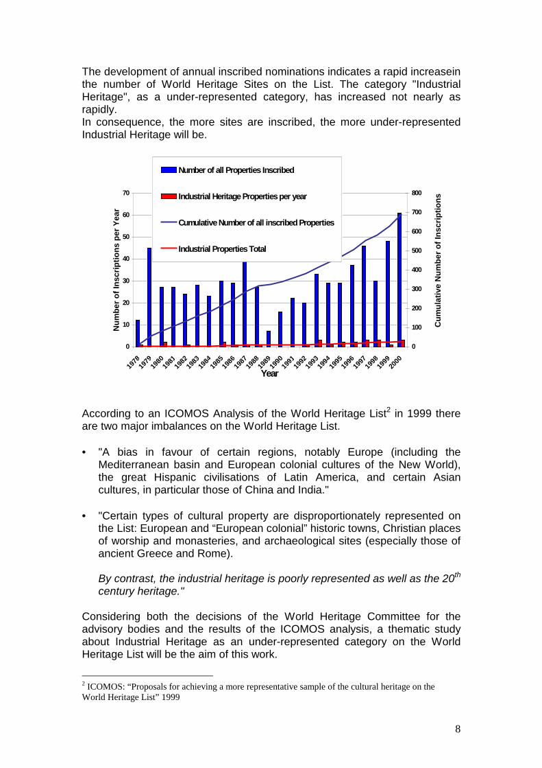
The development of annual inscribed nominations indicates a rapid increasein the number of World Heritage Sites on the List. The category "Industrial Heritage", as a under-represented category, has increased not nearly as rapidly. In consequence, the more sites are inscribed, the more under-represented Industrial Heritage will be.
0
10
20
30
40
50
60
70
1978
1979
1980
1981
1982
1983
1984
1985
1986
1987
1988
1989
1990
1991
1992
1993
1994
1995
1996
1997
1998
1999
2000
Year
Num
ber o
f Ins
crip
tions
per
Yea
r
0
100
200
300
400
500
600
700
800
Cum
ulat
ive
Num
ber o
f Ins
crip
tions
Number of all Properties Inscribed
Industrial Heritage Properties per year
Cumulative Number of all inscribed Properties
Industrial Properties Total
According to an ICOMOS Analysis of the World Heritage List2 in 1999 there are two major imbalances on the World Heritage List. • = "A bias in favour of certain regions, notably Europe (including the
Mediterranean basin and European colonial cultures of the New World), the great Hispanic civilisations of Latin America, and certain Asian cultures, in particular those of China and India."
• = "Certain types of cultural property are disproportionately represented on
the List: European and “European colonial” historic towns, Christian places of worship and monasteries, and archaeological sites (especially those of ancient Greece and Rome).
By contrast, the industrial heritage is poorly represented as well as the 20th century heritage."
Considering both the decisions of the World Heritage Committee for the advisory bodies and the results of the ICOMOS analysis, a thematic study about Industrial Heritage as an under-represented category on the World Heritage List will be the aim of this work.
2 ICOMOS: “Proposals for achieving a more representative sample of the cultural heritage on the World Heritage List” 1999
9
3. Industrial Heritage 3.1. Definition The Industrial Revolution profoundly modified landscapes and life styles. The massive means employed to extract raw materials and exploit the minerals and agricultural products resulted in great achievements and grandiose constructions, testifying to the creative genius of humankind. Guardians of the past, industrial sites testify to the ordeals and exploits of those who worked in them. Industrial sites are important milestones in the history of humanity, marking humanity's dual power of destruction and creation that engenders both nuisances and progress. They embody the hope of a better life, and the ever-greater power over matter. The last 30 years have brought increased awareness of the importance of industrial history in understanding heritage. The new discipline of industrial archaeology celebrates the artefacts of the workplace that have as much meaning in our history as the religious and domestic artefacts and architecture to which more attention has been paid throughout the years. Our industrial heritage includes not only the mill and factory, but the social and engineering triumphs spawned by the new technologies: Neolithic flint mines, Roman aqueducts, company towns, canals, railways, bridges and other forms of transportation and power engineering. It is importatnt to note that Industrial Heritage exists in all phases of human development. Therefore it is not only found in the 19th and 20th centuries, but as well for example in prehistoric, medieval times. 3.2. Industrial Heritage on the World Heritage List Rapid technological advances and the striping of certain deposits have rendered most industrial sites obsolete. To save them from abandonment or destruction, a number of mines, factories, forges and manufactures have been inscribed on the World Heritage List. Out of the 690 inscribed sites there are 28 sites that are considered "Industrial Heritage."3 Industrial Heritage embraces 5.3% of all cultural sites and 4% of all World Heritage Sites. The composition of cultural (including industrial) heritage is very different in each region. Pie charts below give a short overview of the regional differences.
3 This classification of World Heritage sites was initially prepared in 1999 by the World Heritage Centre in collaboration with ICOMOS for a World Heritage poster series that included "Industrial Heritage".
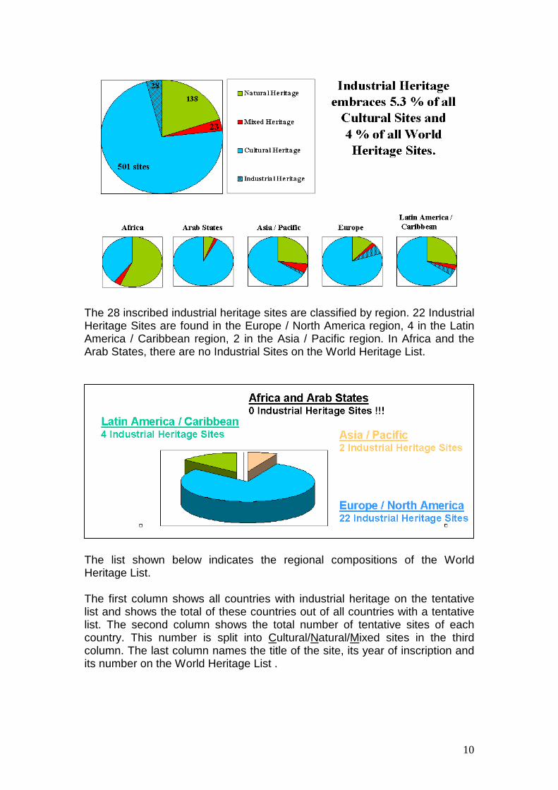
10
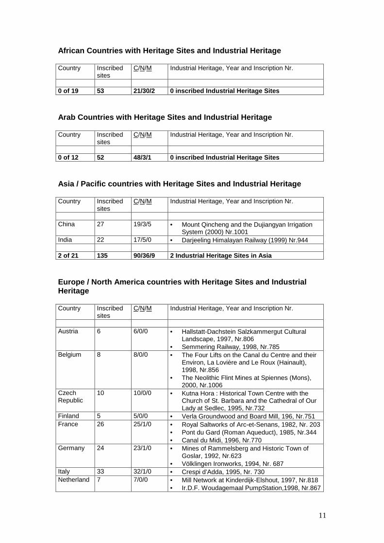
The 28 inscribed industrial heritage sites are classified by region. 22 Industrial Heritage Sites are found in the Europe / North America region, 4 in the Latin America / Caribbean region, 2 in the Asia / Pacific region. In Africa and the Arab States, there are no Industrial Sites on the World Heritage List.
The list shown below indicates the regional compositions of the World Heritage List. The first column shows all countries with industrial heritage on the tentative list and shows the total of these countries out of all countries with a tentative list. The second column shows the total number of tentative sites of each country. This number is split into Cultural/Natural/Mixed sites in the third column. The last column names the title of the site, its year of inscription and its number on the World Heritage List .
11
African Countries with Heritage Sites and Industrial Heritage Country Inscribed
sites C/N/M Industrial Heritage, Year and Inscription Nr.
0 of 19 53 21/30/2 0 inscribed Industrial Heritage Sites Arab Countries with Heritage Sites and Industrial Heritage Country Inscribed
sites C/N/M Industrial Heritage, Year and Inscription Nr.
0 of 12 52 48/3/1 0 inscribed Industrial Heritage Sites Asia / Pacific countries with Heritage Sites and Industrial Heritage Country Inscribed
sites C/N/M Industrial Heritage, Year and Inscription Nr.
China 27 19/3/5 • = Mount Qincheng and the Dujiangyan Irrigation
System (2000) Nr.1001 India 22 17/5/0 • = Darjeeling Himalayan Railway (1999) Nr.944 2 of 21 135 90/36/9 2 Industrial Heritage Sites in Asia Europe / North America countries with Heritage Sites and Industrial Heritage Country Inscribed
sites C/N/M Industrial Heritage, Year and Inscription Nr.
Austria 6 6/0/0 • = Hallstatt-Dachstein Salzkammergut Cultural
Landscape, 1997, Nr.806 • = Semmering Railway, 1998, Nr.785
Belgium 8 8/0/0 • = The Four Lifts on the Canal du Centre and their Environ, La Lovière and Le Roux (Hainault), 1998, Nr.856
• = The Neolithic Flint Mines at Spiennes (Mons), 2000, Nr.1006
Czech Republic
10 10/0/0 • = Kutna Hora : Historical Town Centre with the Church of St. Barbara and the Cathedral of Our Lady at Sedlec, 1995, Nr.732
Finland 5 5/0/0 • = Verla Groundwood and Board Mill, 196, Nr.751 France 26 25/1/0 • = Royal Saltworks of Arc-et-Senans, 1982, Nr. 203
• = Pont du Gard (Roman Aqueduct), 1985, Nr.344 • = Canal du Midi, 1996, Nr.770
Germany 24 23/1/0 • = Mines of Rammelsberg and Historic Town of Goslar, 1992, Nr.623
• = Völklingen Ironworks, 1994, Nr. 687 Italy 33 32/1/0 • = Crespi d’Adda, 1995, Nr. 730 Netherland 7 7/0/0 • = Mill Network at Kinderdijk-Elshout, 1997, Nr.818
• = Ir.D.F. Woudagemaal PumpStation,1998, Nr.867
12
Norway 4 4/0/0 • = Roros, 1980, Nr.55 Poland 8 8/0/0 • = Wieliczka Salt Mine, 1980, Nr.32 Slovakia 4 4/0/0 • = Banska Stiavnica, 1993, Nr.618 Spain 35 32/2/1 • = Old Town of Segovia and its Aqueducts, 1985,
Nr.311 • = Las Médulas, 1997, Nr.1997
Sweden 11 9/1/1 • = Engelsberg Ironworks, 1993, Nr.556 UK 20 16/4/0 • = Ironbridge Gorge, 1986, Nr.371
• = Blaenavon Industrial Landscape, 2000, Nr.984 14 / 43 Total 352 302/42/8 22 inscribed Industrial Heritage Sites Latin American / Caribbean countries with Heritage Sites and Industrial Heritage Country Inscribed
sites C/N/M Industrial Heritage, Year and Inscription Nr.
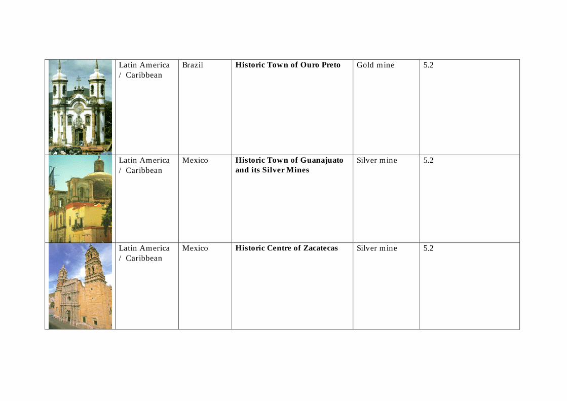
Bolivia 6 5/1/0 • = City of Potosi, 1987, Nr.420 Brazil 13 8/5/0 • = Historic Town of Ouro Preto, 1980, Nr.124 Mexico 21 19/2/0 • = Historic Town of Guanajuato and Adjacent Mine,
1988, Nr.482 • = Historic Centre of Zacatecas, 1993, Nr.676
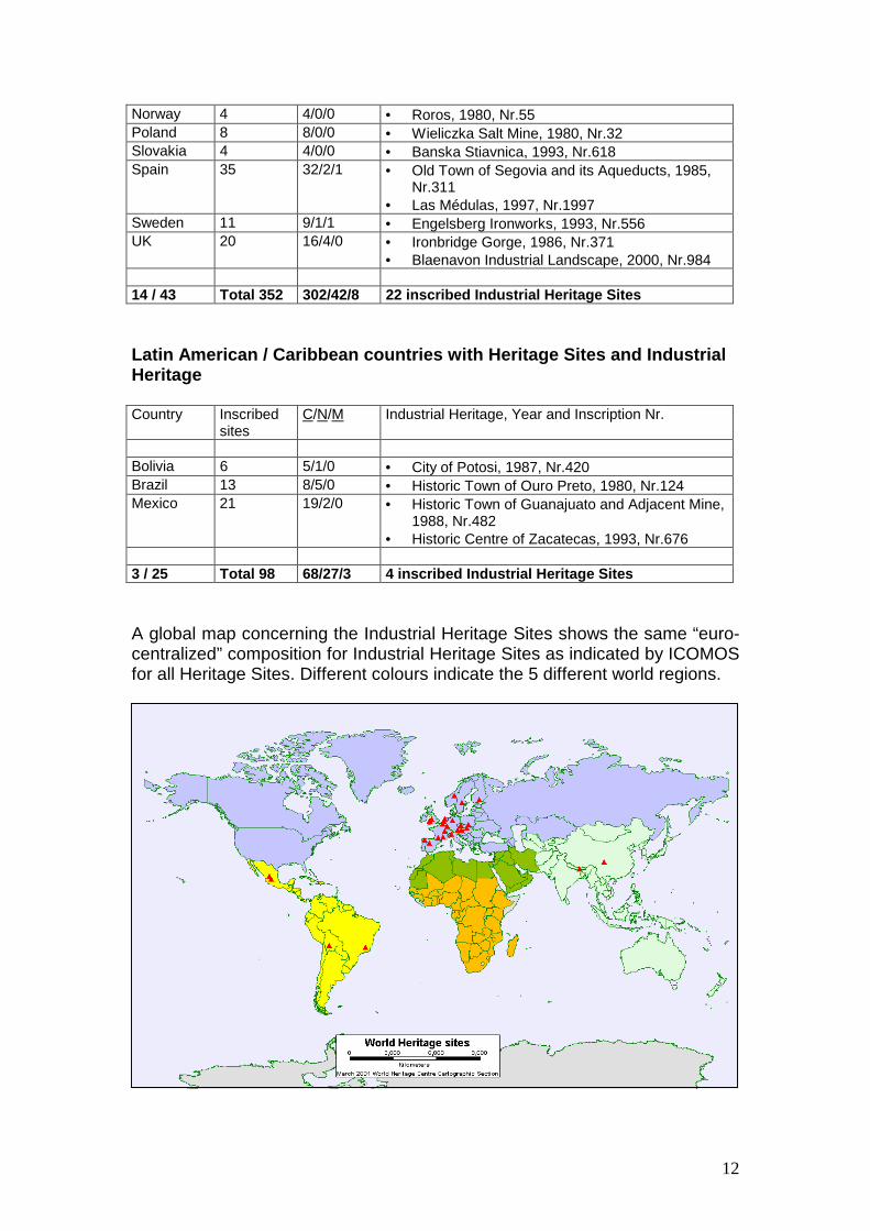
3 / 25 Total 98 68/27/3 4 inscribed Industrial Heritage Sites A global map concerning the Industrial Heritage Sites shows the same “euro-centralized” composition for Industrial Heritage Sites as indicated by ICOMOS for all Heritage Sites. Different colours indicate the 5 different world regions.
13
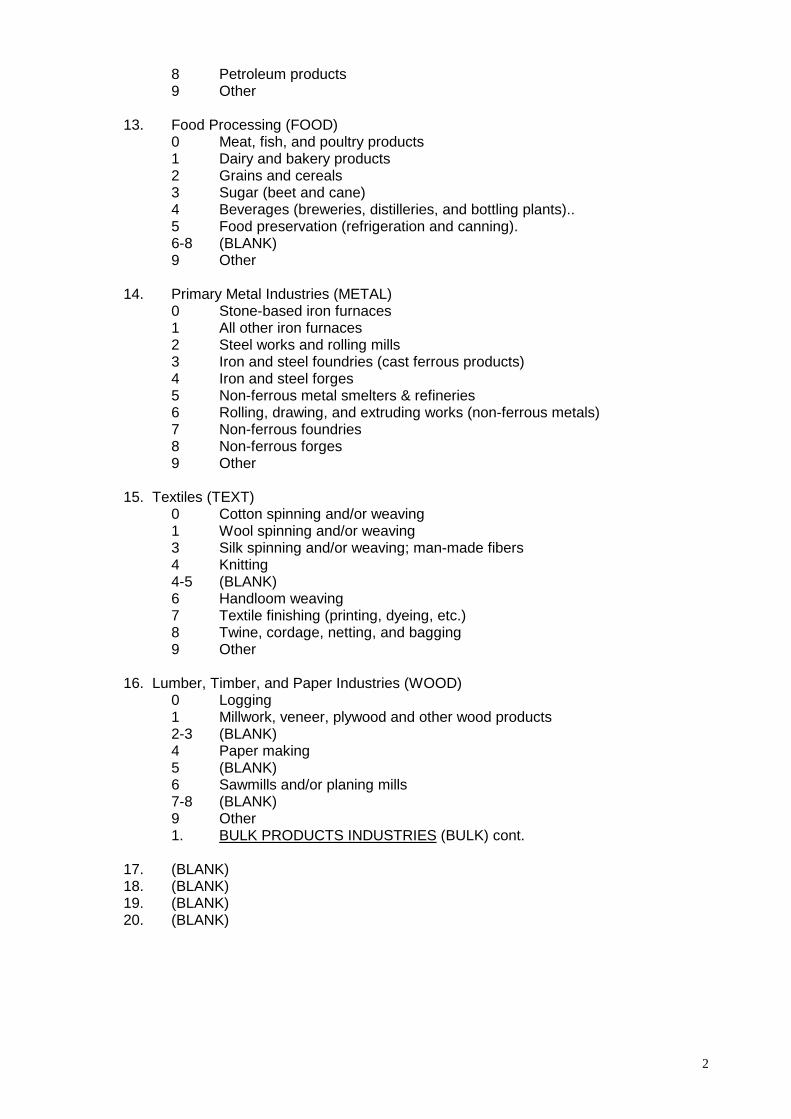
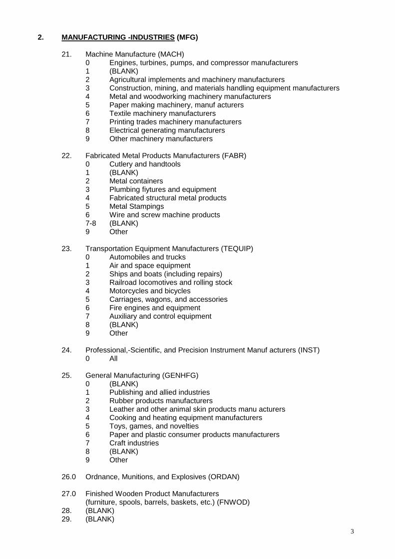
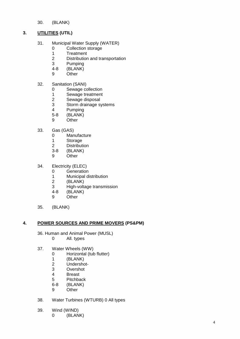
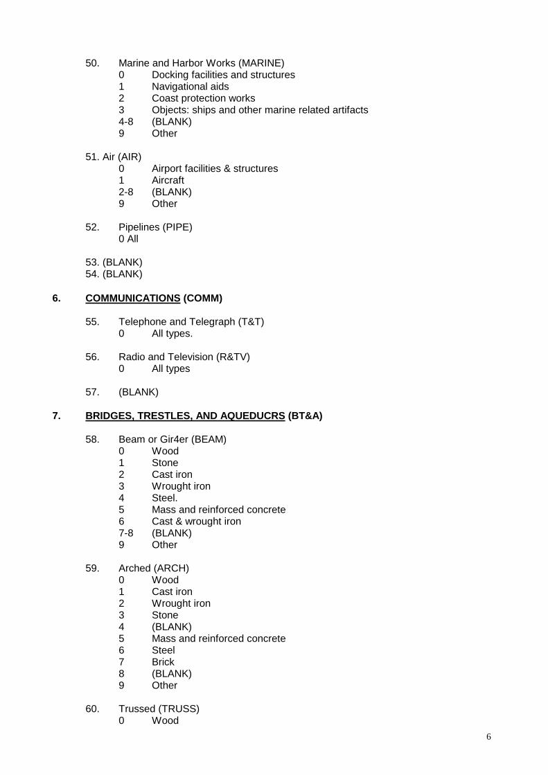
3.3. Categories, Sub-themes, Proposed Classification system (HEAR) In order to find sub-themes of Industrial Heritage there is a very detailed classification system developed by the Historic American Engineering Record (HAER), a sub-division of the Unites States National Park Service. This system will be used for this analysis. The Industrial Structures Classification System shows 10 sub-categories: 0. Extractive Industries (e.g. Ore- or Gold-mining) 1. Bulk Products Industries (e.g. Primary Metal Industries) 2. Manufacturing Industries (e.g. Machine Manufacture) 3. Utilities (e.g. Water Supply, Electricity) 4. Power Sources and Prime Movers (e.g. Water wheels, Steam turbines) 5. Transportation (e.g. Railroads, Cannels, Harbour) 6. Communication (e.g. Radio, Telephone) 7. Bridges, Trestles, Aqueducts 8. Building Technology ( Roof systems, Fenestration) 9. Specialized Structures / Objects (e.g. Dams, Tunnels, Hydraulic works) (see complete list: “HAER” classification system, Appendix 6.1)
14
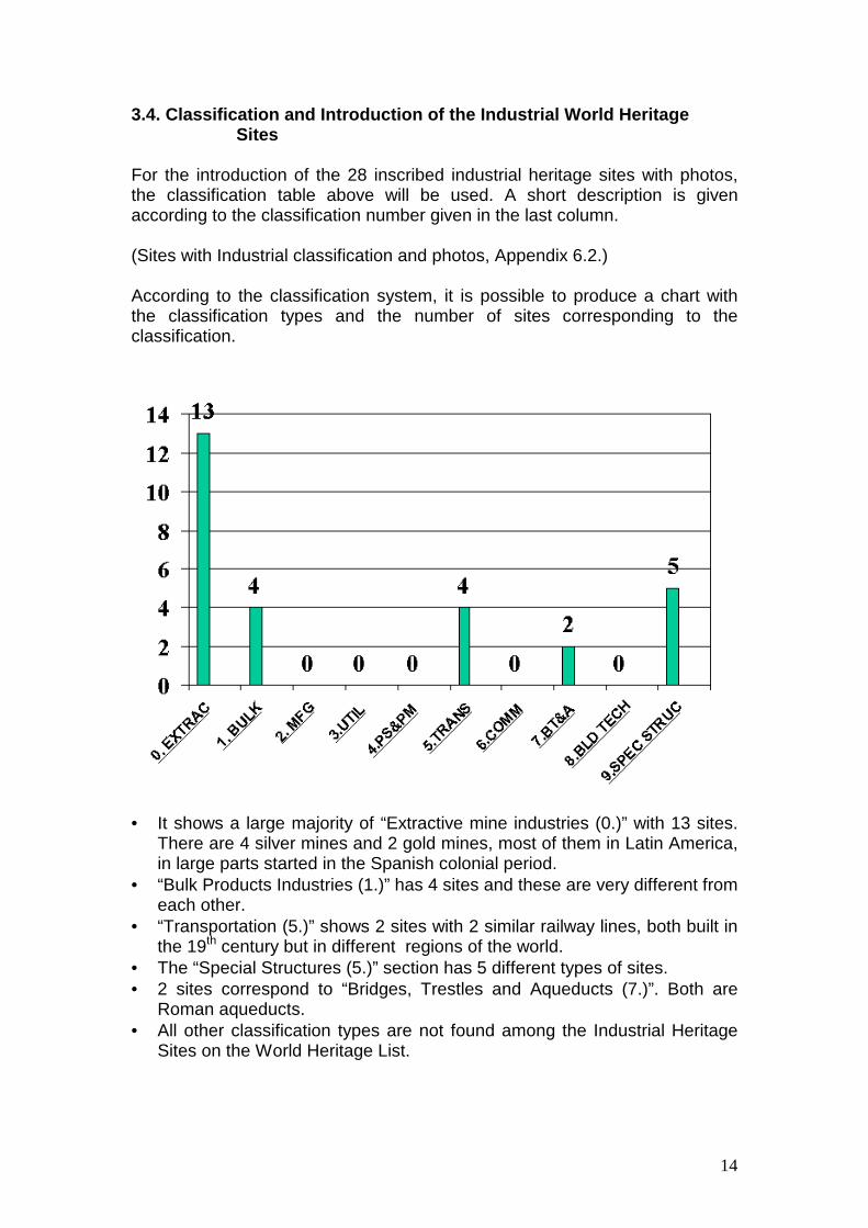
3.4. Classification and Introduction of the Industrial World Heritage Sites For the introduction of the 28 inscribed industrial heritage sites with photos, the classification table above will be used. A short description is given according to the classification number given in the last column. (Sites with Industrial classification and photos, Appendix 6.2.) According to the classification system, it is possible to produce a chart with the classification types and the number of sites corresponding to the classification.
• = It shows a large majority of “Extractive mine industries (0.)” with 13 sites.
There are 4 silver mines and 2 gold mines, most of them in Latin America, in large parts started in the Spanish colonial period.
• = “Bulk Products Industries (1.)” has 4 sites and these are very different from each other.
• = “Transportation (5.)” shows 2 sites with 2 similar railway lines, both built in the 19th century but in different regions of the world.
• = The “Special Structures (5.)” section has 5 different types of sites. • = 2 sites correspond to “Bridges, Trestles and Aqueducts (7.)”. Both are
Roman aqueducts. • = All other classification types are not found among the Industrial Heritage
Sites on the World Heritage List.
15
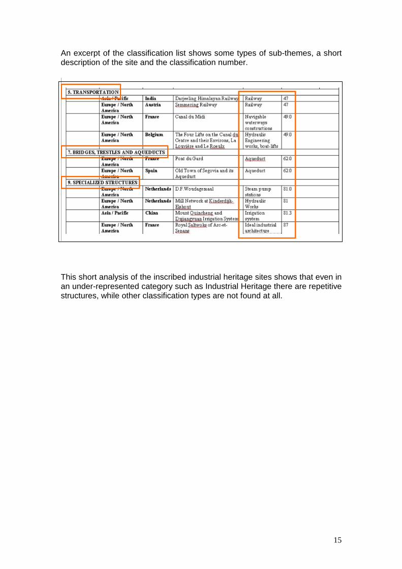
An excerpt of the classification list shows some types of sub-themes, a short description of the site and the classification number.
This short analysis of the inscribed industrial heritage sites shows that even in an under-represented category such as Industrial Heritage there are repetitive structures, while other classification types are not found at all.
16
4. Analysis of the Tentative List 4.1. Definition of the Tentative List and the Operational Guidelines As noted above, every State Party shall submit, according to the Operational Guidelines, an inventory of property forming part of the heritage in its territory as a State Party’s Tentative List. Sites suitable for inclusion in the World Heritage List are transmitted to the Committee as nominations. The tentative list should be an indicator for nomination trends in each region. The 24th session of the World Heritage Committee asked the World Heritage Centre and advisory bodies to communicate the results of their analyses to the Committee for examination and should be conveyed to States Parties. This will allow them to prepare, revise and/or harmonise their tentative list, taking into account, where appropriate, regional considerations. 4.2. Classification of Industrial Heritage on the Tentative List In the following section the tentative lists of all State Parties will be analyzed and all potential Industrial Heritage will be classified according to the classification system. To classify Industrial Heritage two levels of sites are analyzed.
1. Tentative sites with stated Industrial World Heritage Value These sites are by the title of the nomination Industrial Heritage, e.g. “Tonglushan ancient copper mine sites” in China.
2. Tentative sites with associated industrial value
These sites are not industrial heritage by title, but show a significant amount of industrial heritage in the descriptions of the site by the State Party. These sites are particularly interesting for regional comparative studies and potential cluster nominations, e.g. aqueduct structures in Near East archaeological sites.
Both types of sites will be listed separately in the regional lists of industrial heritage attached.
17
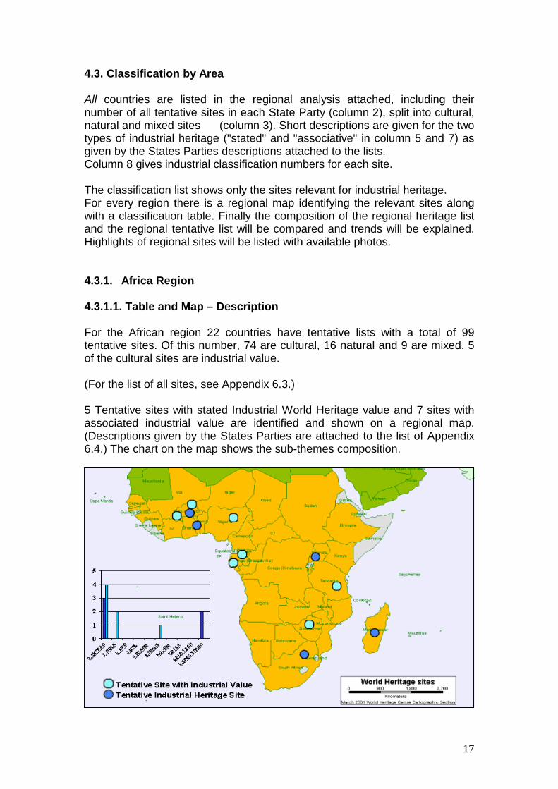
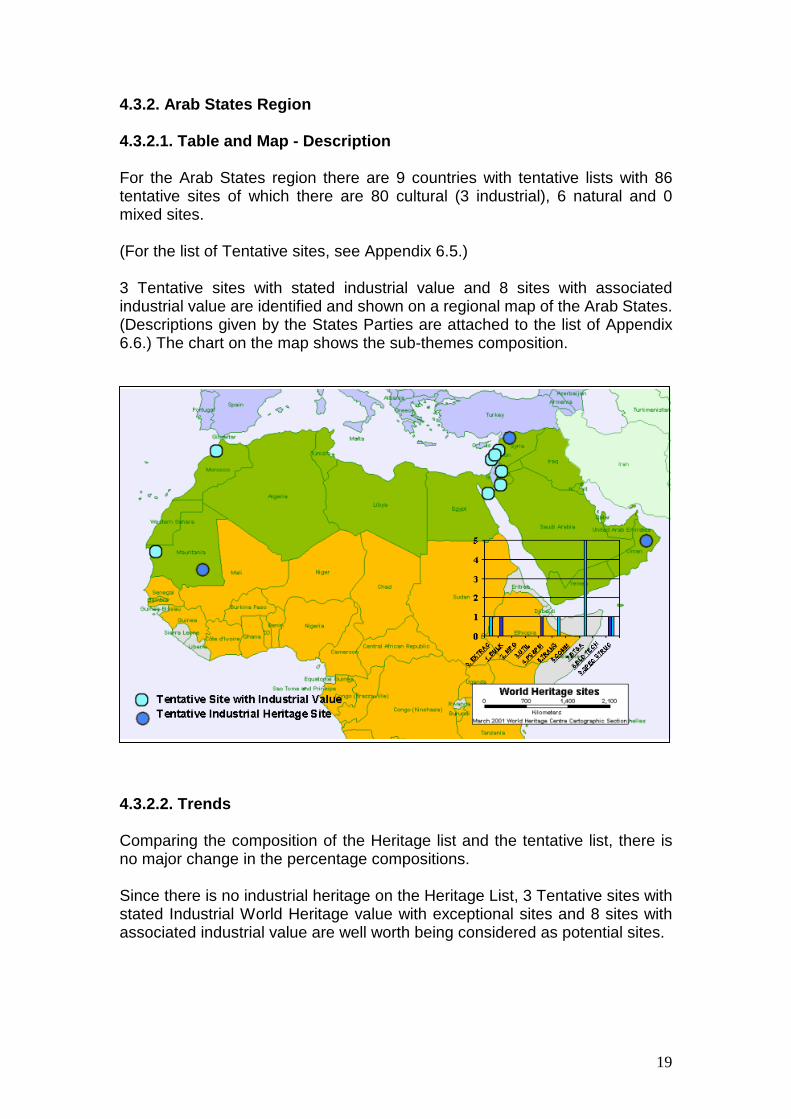
4.3. Classification by Area All countries are listed in the regional analysis attached, including their number of all tentative sites in each State Party (column 2), split into cultural, natural and mixed sites (column 3). Short descriptions are given for the two types of industrial heritage ("stated" and "associative" in column 5 and 7) as given by the States Parties descriptions attached to the lists. Column 8 gives industrial classification numbers for each site. The classification list shows only the sites relevant for industrial heritage. For every region there is a regional map identifying the relevant sites along with a classification table. Finally the composition of the regional heritage list and the regional tentative list will be compared and trends will be explained. Highlights of regional sites will be listed with available photos. 4.3.1. Africa Region 4.3.1.1. Table and Map – Description For the African region 22 countries have tentative lists with a total of 99 tentative sites. Of this number, 74 are cultural, 16 natural and 9 are mixed. 5 of the cultural sites are industrial value. (For the list of all sites, see Appendix 6.3.) 5 Tentative sites with stated Industrial World Heritage value and 7 sites with associated industrial value are identified and shown on a regional map. (Descriptions given by the States Parties are attached to the list of Appendix 6.4.) The chart on the map shows the sub-themes composition.
18
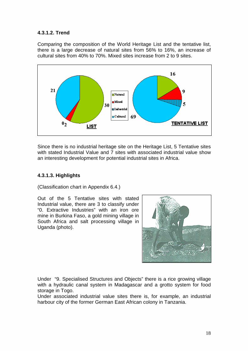
4.3.1.2. Trend Comparing the composition of the World Heritage List and the tentative list, there is a large decrease of natural sites from 56% to 16%, an increase of cultural sites from 40% to 70%. Mixed sites increase from 2 to 9 sites.
Since there is no industrial heritage site on the Heritage List, 5 Tentative sites with stated Industrial Value and 7 sites with associated industrial value show an interesting development for potential industrial sites in Africa. 4.3.1.3. Highlights (Classification chart in Appendix 6.4.) Out of the 5 Tentative sites with stated Industrial value, there are 3 to classify under “0. Extractive Industries” with an iron ore mine in Burkina Faso, a gold mining village in South Africa and salt processing village in Uganda (photo).
Under “9. Specialised Structures and Objects” there is a rice growing village with a hydraulic canal system in Madagascar and a grotto system for food storage in Togo. Under associated industrial value sites there is, for example, an industrial harbour city of the former German East African colony in Tanzania.
19
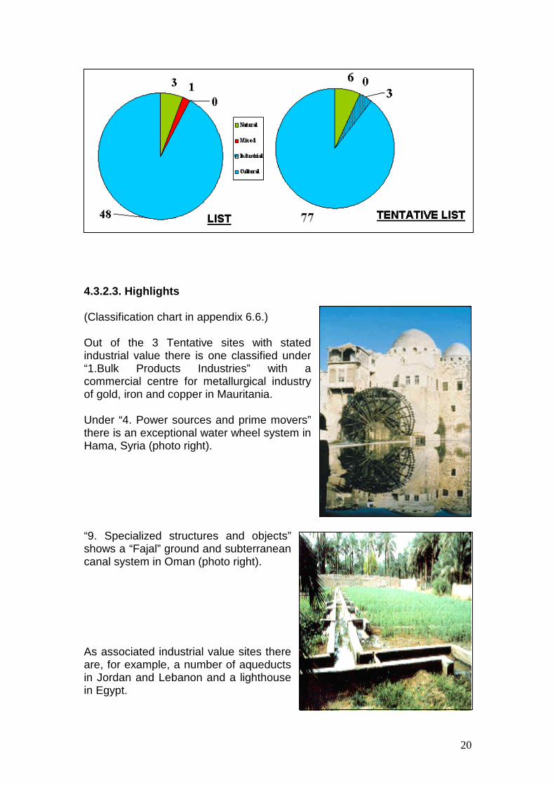
4.3.2. Arab States Region 4.3.2.1. Table and Map - Description For the Arab States region there are 9 countries with tentative lists with 86 tentative sites of which there are 80 cultural (3 industrial), 6 natural and 0 mixed sites. (For the list of Tentative sites, see Appendix 6.5.) 3 Tentative sites with stated industrial value and 8 sites with associated industrial value are identified and shown on a regional map of the Arab States. (Descriptions given by the States Parties are attached to the list of Appendix 6.6.) The chart on the map shows the sub-themes composition.
4.3.2.2. Trends Comparing the composition of the Heritage list and the tentative list, there is no major change in the percentage compositions. Since there is no industrial heritage on the Heritage List, 3 Tentative sites with stated Industrial World Heritage value with exceptional sites and 8 sites with associated industrial value are well worth being considered as potential sites.
20
4.3.2.3. Highlights (Classification chart in appendix 6.6.) Out of the 3 Tentative sites with stated industrial value there is one classified under “1.Bulk Products Industries” with a commercial centre for metallurgical industry of gold, iron and copper in Mauritania. Under “4. Power sources and prime movers” there is an exceptional water wheel system in Hama, Syria (photo right). “9. Specialized structures and objects” shows a “Fajal” ground and subterranean canal system in Oman (photo right).
As associated industrial value sites there are, for example, a number of aqueducts in Jordan and Lebanon and a lighthouse in Egypt.

21
4.3.3. Asia / Pacific Region 4.3.3.1. Table and Map For the Asia / Pacific region there are 23 countries with tentative lists with 218 tentative sites of which 182 are cultural (7 industrial), 21 natural and 15 mixed sites. (For the list of Tentative sites, see Appendix 6.7.) There are 2 Industrial World Heritage sites inscribed in the Asia/Pacific region. 7 Tentative sites with stated industrial value and 1 site with associated industrial value are identified and shown on a regional map of Asia / Pacific. (Descriptions given by the States Parties are attached to the list of Appendix 6.8.) The chart on the map shows the sub-themes composition.
22
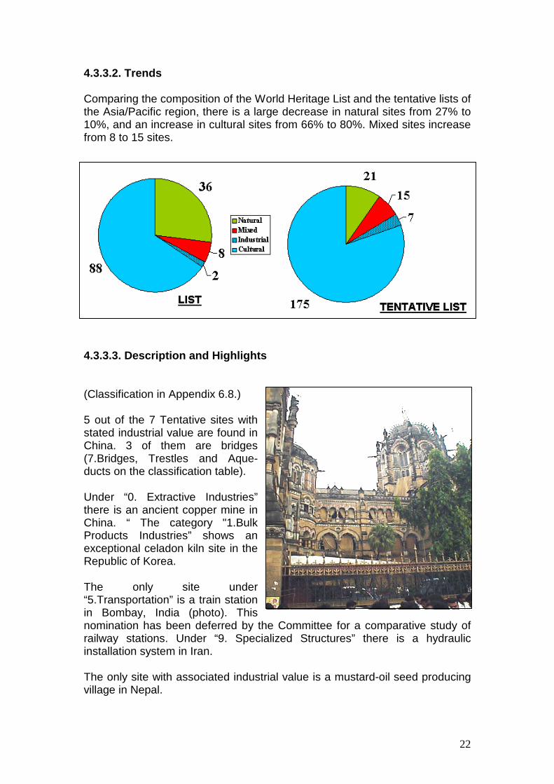
4.3.3.2. Trends Comparing the composition of the World Heritage List and the tentative lists of the Asia/Pacific region, there is a large decrease in natural sites from 27% to 10%, and an increase in cultural sites from 66% to 80%. Mixed sites increase from 8 to 15 sites.
4.3.3.3. Description and Highlights (Classification in Appendix 6.8.) 5 out of the 7 Tentative sites with stated industrial value are found in China. 3 of them are bridges (7.Bridges, Trestles and Aque-ducts on the classification table). Under “0. Extractive Industries” there is an ancient copper mine in China. “ The category "1.Bulk Products Industries” shows an exceptional celadon kiln site in the Republic of Korea. The only site under “5.Transportation” is a train station in Bombay, India (photo). This nomination has been deferred by the Committee for a comparative study of railway stations. Under “9. Specialized Structures” there is a hydraulic installation system in Iran. The only site with associated industrial value is a mustard-oil seed producing village in Nepal.
23
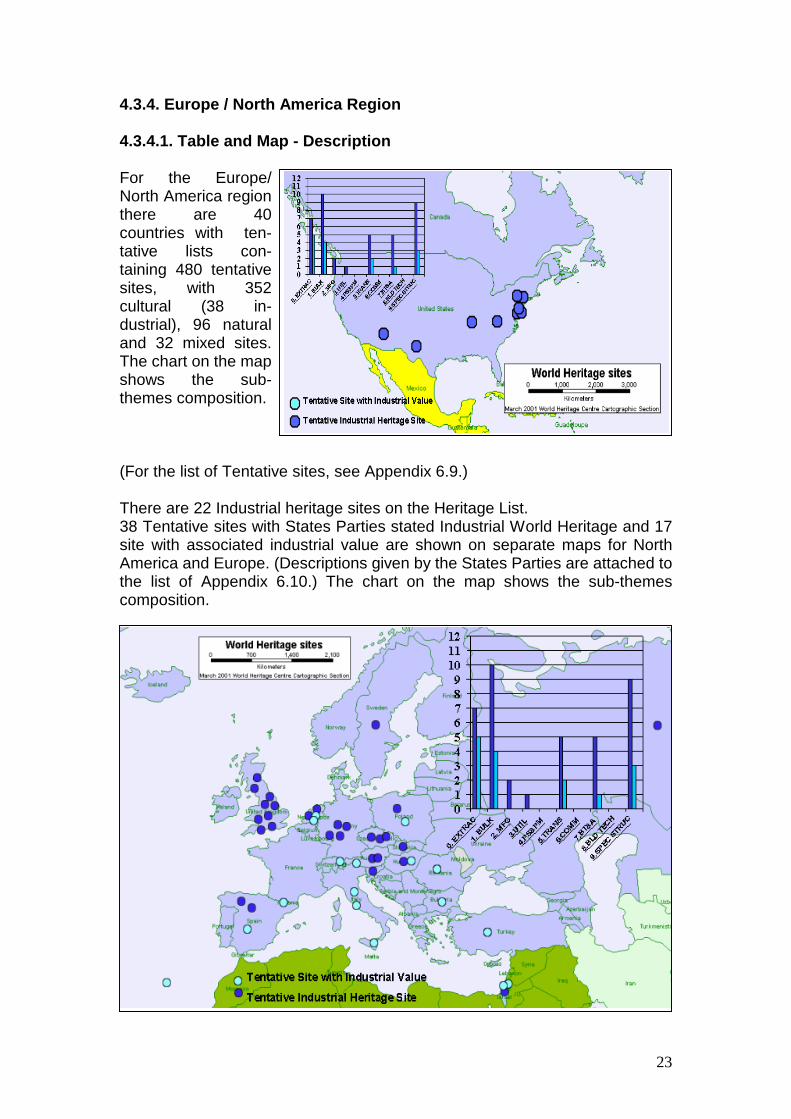
4.3.4. Europe / North America Region 4.3.4.1. Table and Map - Description For the Europe/ North America region there are 40 countries with ten-tative lists con-taining 480 tentative sites, with 352 cultural (38 in-dustrial), 96 natural and 32 mixed sites. The chart on the map shows the sub-themes composition. (For the list of Tentative sites, see Appendix 6.9.) There are 22 Industrial heritage sites on the Heritage List. 38 Tentative sites with States Parties stated Industrial World Heritage and 17 site with associated industrial value are shown on separate maps for North America and Europe. (Descriptions given by the States Parties are attached to the list of Appendix 6.10.) The chart on the map shows the sub-themes composition.
24
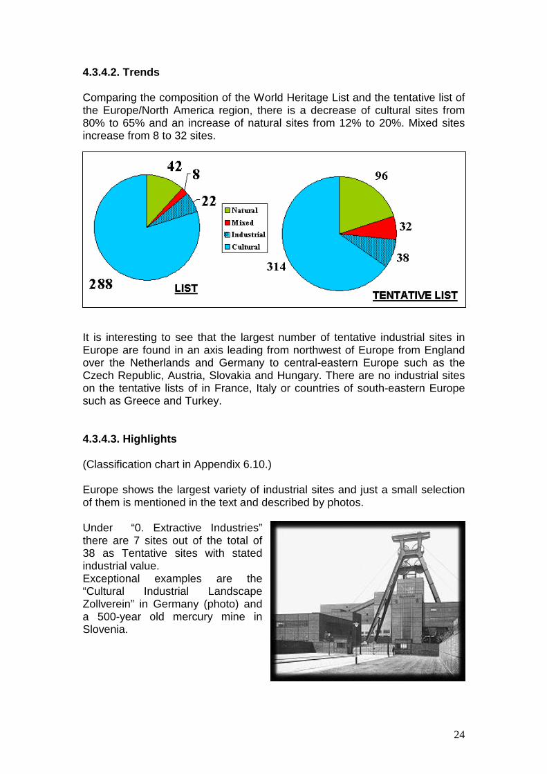
4.3.4.2. Trends Comparing the composition of the World Heritage List and the tentative list of the Europe/North America region, there is a decrease of cultural sites from 80% to 65% and an increase of natural sites from 12% to 20%. Mixed sites increase from 8 to 32 sites.
It is interesting to see that the largest number of tentative industrial sites in Europe are found in an axis leading from northwest of Europe from England over the Netherlands and Germany to central-eastern Europe such as the Czech Republic, Austria, Slovakia and Hungary. There are no industrial sites on the tentative lists of in France, Italy or countries of south-eastern Europe such as Greece and Turkey. 4.3.4.3. Highlights (Classification chart in Appendix 6.10.) Europe shows the largest variety of industrial sites and just a small selection of them is mentioned in the text and described by photos. Under “0. Extractive Industries” there are 7 sites out of the total of 38 as Tentative sites with stated industrial value. Exceptional examples are the “Cultural Industrial Landscape Zollverein” in Germany (photo) and a 500-year old mercury mine in Slovenia.
25
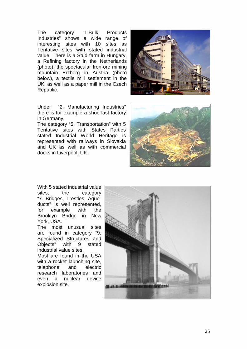
The category “1.Bulk Products Industries” shows a wide range of interesting sites with 10 sites as Tentative sites with stated industrial value. There is a Stud farm in Hungary, a Refining factory in the Netherlands (photo), the spectacular Iron-ore mining mountain Erzberg in Austria (photo below), a textile mill settlement in the UK, as well as a paper mill in the Czech Republic. Under “2. Manufacturing Industries” there is for example a shoe last factory in Germany. The category “5. Transportation” with 5 Tentative sites with States Parties stated Industrial World Heritage is represented with railways in Slovakia and UK as well as with commercial docks in Liverpool, UK.
With 5 stated industrial value sites, the category “7. Bridges, Trestles, Aque-ducts” is well represented, for example with the Brooklyn Bridge in New York, USA. The most unusual sites are found in category “9. Specialized Structures and Objects” with 9 stated industrial value sites. Most are found in the USA with a rocket launching site, telephone and electric research laboratories and even a nuclear device explosion site.

26
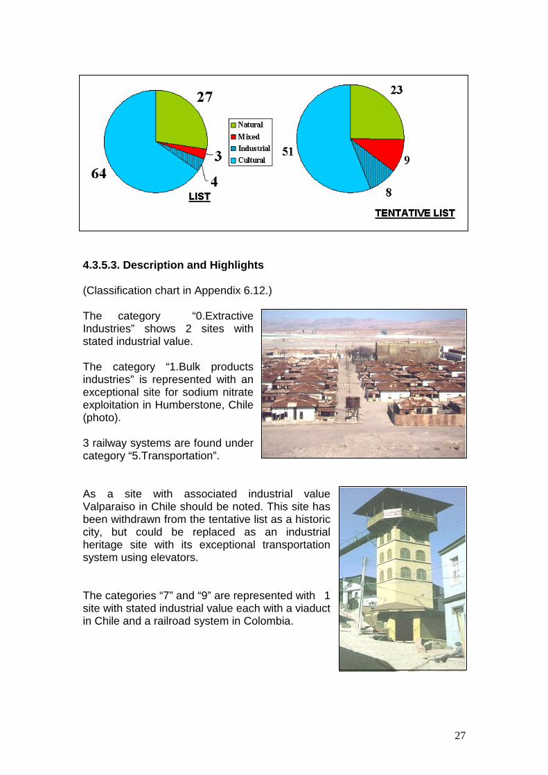
4.3.5. Latin America / Caribbean Region 4.3.5.1. Table and Map For the Latin America/Caribbean region there are 18 countries with tentative lists, with 91 tentative sites of which 59 sites are cultural (8 industrial), 23 natural and 9 mixed sites. (For the list of Tentative sites, see Appendix 6.11.) There are 4 Industrial heritage sites on the Heritage List, 8 tentative sites with stated industrial value and 4 sites with associated industrial value identified and shown on a regional map of Latin America / Caribbean. (Descriptions given by the States Parties are attached to the list of Appendix 6.12.) The chart on the map shows the sub-themes composition.
4.3.5.2. Trends Comparing the composition of the Heritage list and the tentative list of the Latin America/Caribbean region, there is a decrease of cultural sites from 65% to 56%, mixed sites increase from 3 to 9 sites. There are 4 Industrial heritage sites on the World Heritage List and 8 Tentative sites with stated industrial value on the tentative list.
27
4.3.5.3. Description and Highlights (Classification chart in Appendix 6.12.) The category “0.Extractive Industries” shows 2 sites with stated industrial value. The category “1.Bulk products industries” is represented with an exceptional site for sodium nitrate exploitation in Humberstone, Chile (photo). 3 railway systems are found under category “5.Transportation”. As a site with associated industrial value Valparaiso in Chile should be noted. This site has been withdrawn from the tentative list as a historic city, but could be replaced as an industrial heritage site with its exceptional transportation system using elevators. The categories “7” and “9” are represented with 1 site with stated industrial value each with a viaduct in Chile and a railroad system in Colombia.
28
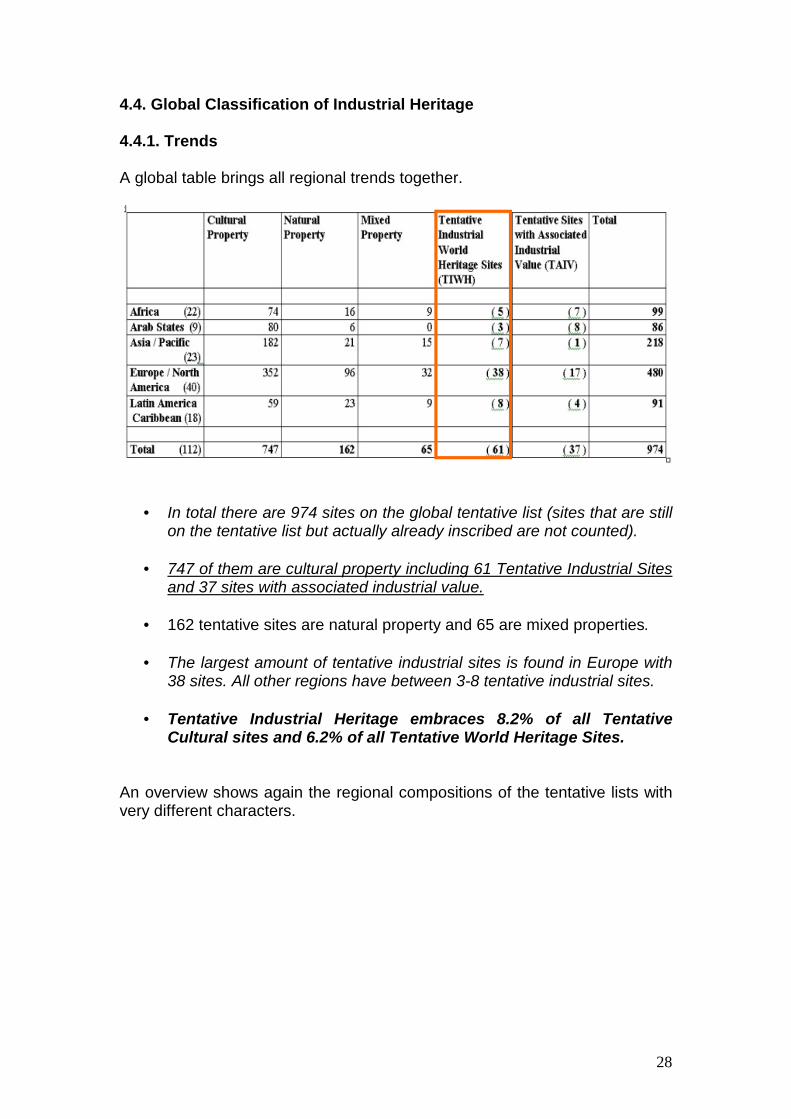
4.4. Global Classification of Industrial Heritage 4.4.1. Trends A global table brings all regional trends together.
• = In total there are 974 sites on the global tentative list (sites that are still on the tentative list but actually already inscribed are not counted).
• = 747 of them are cultural property including 61 Tentative Industrial Sites
and 37 sites with associated industrial value.
• = 162 tentative sites are natural property and 65 are mixed properties.
• = The largest amount of tentative industrial sites is found in Europe with 38 sites. All other regions have between 3-8 tentative industrial sites.
• = Tentative Industrial Heritage embraces 8.2% of all Tentative
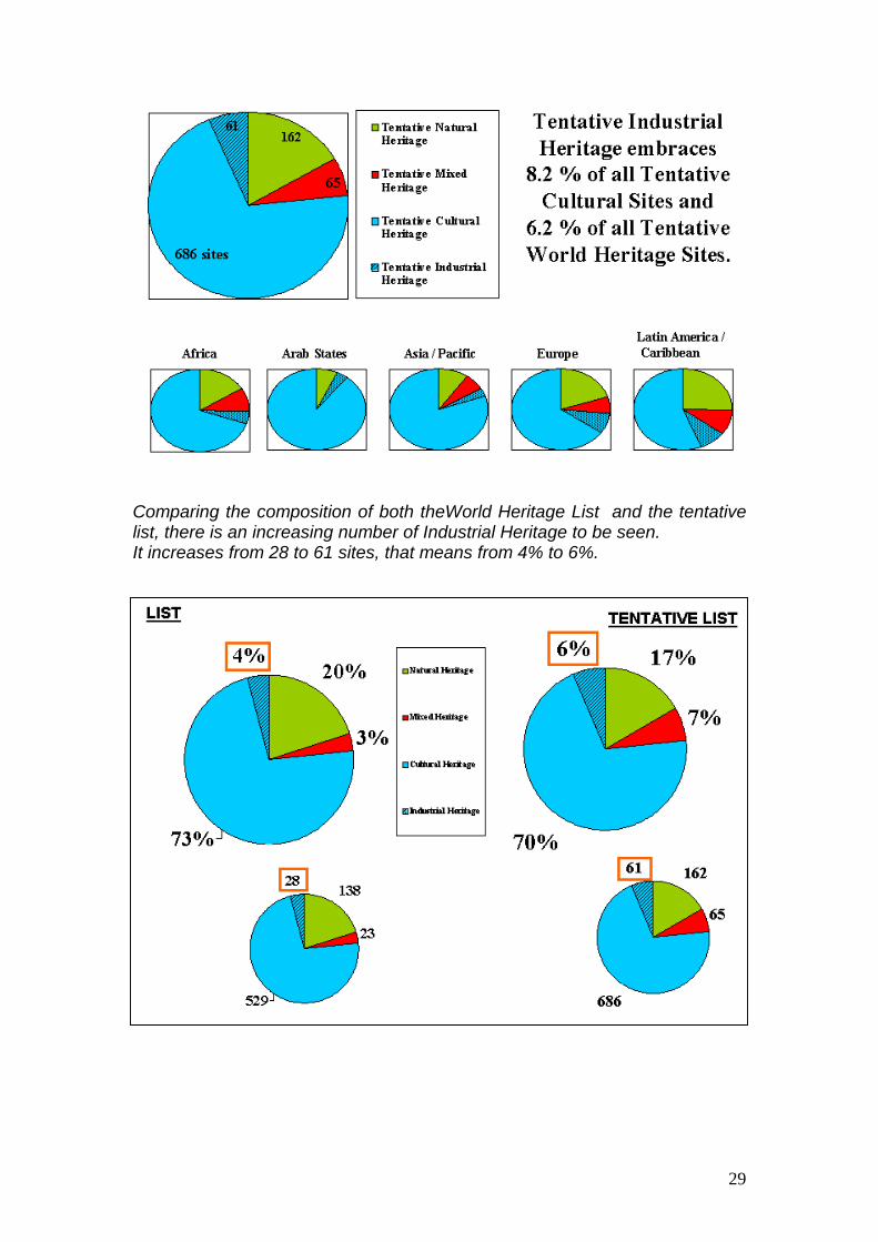
Cultural sites and 6.2% of all Tentative World Heritage Sites. An overview shows again the regional compositions of the tentative lists with very different characters.
29
Comparing the composition of both theWorld Heritage List and the tentative list, there is an increasing number of Industrial Heritage to be seen. It increases from 28 to 61 sites, that means from 4% to 6%.

30
4.4.2. Global Classification List and Global Map Two maps (one for non-European regions and one with exclusively Europe) include only sites with stated industrial value on the tentative list and already inscribed on the World Heritage List.
The "Europe-concentrated" trend of inscribed sites can be seen as well for Industrial Heritage, but in the thematical search of under-represented sub-themes, there are very important and unique structures of Industrial Heritage in Europe. It can be clearly seen, that there are a lot of industrial sites on the tentative list that could be selected to harmonize the global net of industrial heritage. Water wheel systems in Syria, celadon kiln sites in Korea, a rocket launching site in North America and sodium nitrate offices in Chile could be exceptional industrial heritage sites of regional and global importance.

31
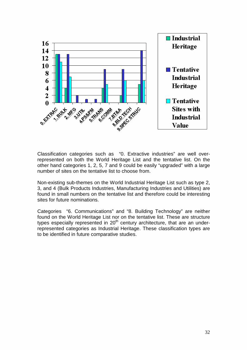
4.4.3. Example of application of the global industrial tentative list The total global list of industrial heritage on all States Parties tentative lists is an indicator of future sites that may be selected. (See Global Tentative Industrial Heritage Classification List in Appendix 6.13.) The classification charts of all regional tentative lists combined with the classification chart of the World Heritage List of Industrial Heritage help to identify over- and under-represented sites according to the classified sub-themes.
32
Classification categories such as “0. Extractive industries” are well over-represented on both the World Heritage List and the tentative list. On the other hand categories 1, 2, 5, 7 and 9 could be easily “upgraded” with a large number of sites on the tentative list to choose from. Non-existing sub-themes on the World Industrial Heritage List such as type 2, 3, and 4 (Bulk Products Industries, Manufacturing Industries and Utilities) are found in small numbers on the tentative list and therefore could be interesting sites for future nominations. Categories “6. Communications” and “8. Building Technology” are neither found on the World Heritage List nor on the tentative list. These are structure types especially represented in 20th century architecture, that are an under-represented categories as Industrial Heritage. These classification types are to be identified in future comparative studies.
33
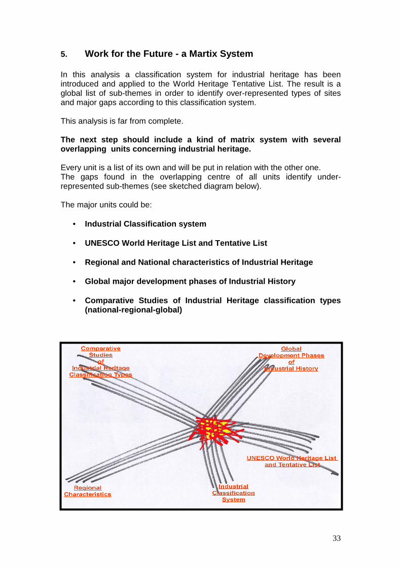
5. Work for the Future - a Martix System In this analysis a classification system for industrial heritage has been introduced and applied to the World Heritage Tentative List. The result is a global list of sub-themes in order to identify over-represented types of sites and major gaps according to this classification system. This analysis is far from complete. The next step should include a kind of matrix system with several overlapping units concerning industrial heritage. Every unit is a list of its own and will be put in relation with the other one. The gaps found in the overlapping centre of all units identify under-represented sub-themes (see sketched diagram below). The major units could be:
• = Industrial Classification system
• = UNESCO World Heritage List and Tentative List
• = Regional and National characteristics of Industrial Heritage
• = Global major development phases of Industrial History
• = Comparative Studies of Industrial Heritage classification types (national-regional-global)
34
6. Appendices 6.1. HAER Industrial Classification System 6.2. Industrial Classification List of Industrial Heritage Sites with photos 6.3. Africa Tentative list analysis and description 6.4. Africa Tentative Industrial Heritage Classification 6.5. Arab States Tentative list analysis and description 6.6. Arab States Tentative Industrial Heritage Classification 6.7. Asia / Pacific Tentative list analysis and description 6.8. Asia / Pacific Tentative Industrial Heritage Classification 6.9. Europe / Nortn America Tentative list analysis and description 6.10. Europe / Nortn America Tentative Industrial Heritage Classification 6.11. Latin America / Caribbean Tentative list analysis and description 6.12. Latin America / Caribbean Tentative Industrial Heritage Classification 6.13. Global Tentative Industrial Heritage list Classification

35
6.1. HAER Industrial Classification System
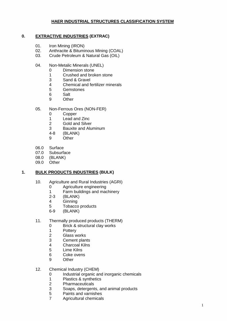
1
HAER INDUSTRIAL STRUCTURES CLASSIFICATION SYSTEM 0. EXTRACTIVE INDUSTRIES (EXTRAC) 01. Iron Mining (IRON) 02. Anthracite & Bituminous Mining (COAL) 03. Crude Petroleum & Natural Gas (OIL) 04. Non-Metalic Minerals (UNEL) 0 Dimension stone 1 Crushed and broken stone 3 Sand & Gravel 4 Chemical and fertilizer minerals 5 Gemstones 6 Salt 9 Other 05. Non-Ferrous Ores (NON-FER) 0 Copper 1 Lead and Zinc 2 Gold and Silver 3 Bauxite and Aluminum 4-8 (BLANK) 9 Other 06.0 Surface 07.0 Subsurface 08.0 (BLANK) 09.0 Other 1. BULK PRODUCTS INDUSTRIES (BULK) 10. Agriculture and Rural Industries (AGRI) 0 Agriculture engineering 1 Farm buildings and machinery 2-3 (BLANK) 4 Ginning 5 Tobacco products 6-9 (BLANK) 11. Thermally produced products (THERM) 0 Brick & structural clay works 1 Pottery 2 Glass works 3 Cement plants 4 Charcoal Kilns 5 Lime Kilns 6 Coke ovens 9 Other 12. Chemical Industry (CHEM) 0 Industrial organic and inorganic chemicals 1 Plastics & synthetics 2 Pharmaceuticals 3 Soaps, detergents, and animal products 5 Paints and varnishes 7 Agricultural chemicals
2
8 Petroleum products 9 Other 13. Food Processing (FOOD) 0 Meat, fish, and poultry products 1 Dairy and bakery products 2 Grains and cereals 3 Sugar (beet and cane) 4 Beverages (breweries, distilleries, and bottling plants).. 5 Food preservation (refrigeration and canning). 6-8 (BLANK) 9 Other 14. Primary Metal Industries (METAL) 0 Stone-based iron furnaces 1 All other iron furnaces 2 Steel works and rolling mills 3 Iron and steel foundries (cast ferrous products) 4 Iron and steel forges 5 Non-ferrous metal smelters & refineries 6 Rolling, drawing, and extruding works (non-ferrous metals) 7 Non-ferrous foundries 8 Non-ferrous forges 9 Other 15. Textiles (TEXT) 0 Cotton spinning and/or weaving 1 Wool spinning and/or weaving 3 Silk spinning and/or weaving; man-made fibers 4 Knitting 4-5 (BLANK) 6 Handloom weaving 7 Textile finishing (printing, dyeing, etc.) 8 Twine, cordage, netting, and bagging 9 Other 16. Lumber, Timber, and Paper Industries (WOOD) 0 Logging 1 Millwork, veneer, plywood and other wood products 2-3 (BLANK) 4 Paper making 5 (BLANK) 6 Sawmills and/or planing mills 7-8 (BLANK) 9 Other 1. BULK PRODUCTS INDUSTRIES (BULK) cont. 17. (BLANK) 18. (BLANK) 19. (BLANK) 20. (BLANK)
3
2. MANUFACTURING -INDUSTRIES (MFG) 21. Machine Manufacture (MACH) 0 Engines, turbines, pumps, and compressor manufacturers 1 (BLANK) 2 Agricultural implements and machinery manufacturers 3 Construction, mining, and materials handling equipment manufacturers 4 Metal and woodworking machinery manufacturers 5 Paper making machinery, manuf acturers 6 Textile machinery manufacturers 7 Printing trades machinery manufacturers 8 Electrical generating manufacturers 9 Other machinery manufacturers 22. Fabricated Metal Products Manufacturers (FABR) 0 Cutlery and handtools 1 (BLANK) 2 Metal containers 3 Plumbing fiytures and equipment 4 Fabricated structural metal products 5 Metal Stampings 6 Wire and screw machine products 7-8 (BLANK) 9 Other 23. Transportation Equipment Manufacturers (TEQUIP) 0 Automobiles and trucks 1 Air and space equipment 2 Ships and boats (including repairs) 3 Railroad locomotives and rolling stock 4 Motorcycles and bicycles 5 Carriages, wagons, and accessories 6 Fire engines and equipment 7 Auxiliary and control equipment 8 (BLANK) 9 Other 24. Professional,-Scientific, and Precision Instrument Manuf acturers (INST) 0 All 25. General Manufacturing (GENHFG) 0 (BLANK) 1 Publishing and allied industries 2 Rubber products manufacturers 3 Leather and other animal skin products manu acturers 4 Cooking and heating equipment manufacturers 5 Toys, games, and novelties 6 Paper and plastic consumer products manufacturers 7 Craft industries 8 (BLANK) 9 Other 26.0 Ordnance, Munitions, and Explosives (ORDAN) 27.0 Finished Wooden Product Manufacturers (furniture, spools, barrels, baskets, etc.) (FNWOD) 28. (BLANK) 29. (BLANK)
4
30. (BLANK) 3. UTILITIES (UTIL) 31. Municipal Water Supply (WATER) 0 Collection storage 1 Treatment 2 Distribution and transportation 3 Pumping 4-8 (BLANK) 9 Other 32. Sanitation (SANI) 0 Sewage collection 1 Sewage treatment 2 Sewage disposal 3 Storm drainage systems 4 Pumping 5-8 (BLANK) 9 Other 33. Gas (GAS) 0 Manufacture 1 Storage 2 Distribution 3-8 (BLANK) 9 Other 34. Electricity (ELEC) 0 Generation 1 Municipal distribution 2 (BLANK) 3 High-voltage transmission 4-8 (BLANK) 9 Other 35. (BLANK) 4. POWER SOURCES AND PRIME MOVERS (PS&PM) 36. Human and Animal Power (MUSL) 0 All. types 37. Water Wheels (WW) 0 Horizontal (tub flutter) 1 (BLANK) 2 Undershot- 3 Overshot 4 Breast 5 Pitchback 6-8 (BLANK) 9 Other 38. Water Turbines (WTURB) 0 All types 39. Wind (WIND) 0 (BLANK)
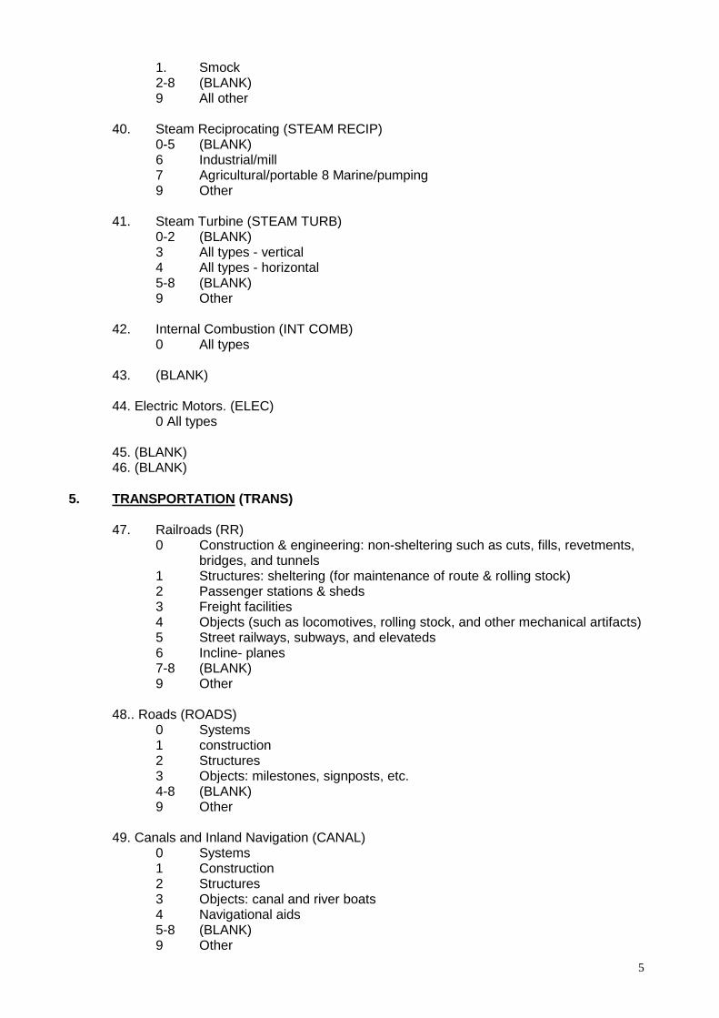
5
1. Smock 2-8 (BLANK) 9 All other 40. Steam Reciprocating (STEAM RECIP) 0-5 (BLANK) 6 Industrial/mill 7 Agricultural/portable 8 Marine/pumping 9 Other 41. Steam Turbine (STEAM TURB) 0-2 (BLANK) 3 All types - vertical 4 All types - horizontal 5-8 (BLANK) 9 Other 42. Internal Combustion (INT COMB) 0 All types 43. (BLANK) 44. Electric Motors. (ELEC) 0 All types 45. (BLANK) 46. (BLANK) 5. TRANSPORTATION (TRANS) 47. Railroads (RR) 0 Construction & engineering: non-sheltering such as cuts, fills, revetments, bridges, and tunnels 1 Structures: sheltering (for maintenance of route & rolling stock) 2 Passenger stations & sheds 3 Freight facilities 4 Objects (such as locomotives, rolling stock, and other mechanical artifacts) 5 Street railways, subways, and elevateds 6 Incline- planes 7-8 (BLANK) 9 Other 48.. Roads (ROADS) 0 Systems 1 construction 2 Structures 3 Objects: milestones, signposts, etc. 4-8 (BLANK) 9 Other 49. Canals and Inland Navigation (CANAL) 0 Systems 1 Construction 2 Structures 3 Objects: canal and river boats 4 Navigational aids 5-8 (BLANK) 9 Other
6
50. Marine and Harbor Works (MARINE) 0 Docking facilities and structures 1 Navigational aids 2 Coast protection works 3 Objects: ships and other marine related artifacts 4-8 (BLANK) 9 Other 51. Air (AIR) 0 Airport facilities & structures 1 Aircraft 2-8 (BLANK) 9 Other 52. Pipelines (PIPE) 0 All 53. (BLANK) 54. (BLANK) 6. COMMUNICATIONS (COMM) 55. Telephone and Telegraph (T&T) 0 All types. 56. Radio and Television (R&TV) 0 All types 57. (BLANK) 7. BRIDGES, TRESTLES, AND AQUEDUCRS (BT&A) 58. Beam or Gir4er (BEAM) 0 Wood 1 Stone 2 Cast iron 3 Wrought iron 4 Steel. 5 Mass and reinforced concrete 6 Cast & wrought iron 7-8 (BLANK) 9 Other 59. Arched (ARCH) 0 Wood 1 Cast iron 2 Wrought iron 3 Stone 4 (BLANK) 5 Mass and reinforced concrete 6 Steel 7 Brick 8 (BLANK) 9 Other 60. Trussed (TRUSS) 0 Wood

7
1 Cast iron 2 Wrought iron 3 Steel 4 Covered 5 Cast & wrought iron 6-8 (BLANK) 9 Other 61. 0 Suspension 62. 0 Aqueducts 63. Viaducts and Trestles (VIAD or TRES) 0 All types 64. Cantilever (CANT) 0 All types 65. Movable Bridges (MOVE) 0 Bascule 1 (BLANK) 2 Swing 3 Vertical lift 4-8 (BLANK) 9 Other 66. (BLANK) 67. (BLANK) 68. Miscellaneous (MSC) 0 Pontoon 8. BUILDING TECHNOLOGY (BLD TECH) 69. Foundations (FOUND) 0 All 70. Framed Superstructures (FRAME) 0 Wood 1 Cast iron 2 Wrought iron and steel 3 Stone and brick 4 Mass and reinforced concrete 5 Ferro-vitreous 71. Floor Systems (FLOOR) 0 All 72. Roof Systems (ROOF) 0 All 73. Fenestration (FENES) 0 Cast-iron facades 74. Mechanical and Electrical Systems (IECH)
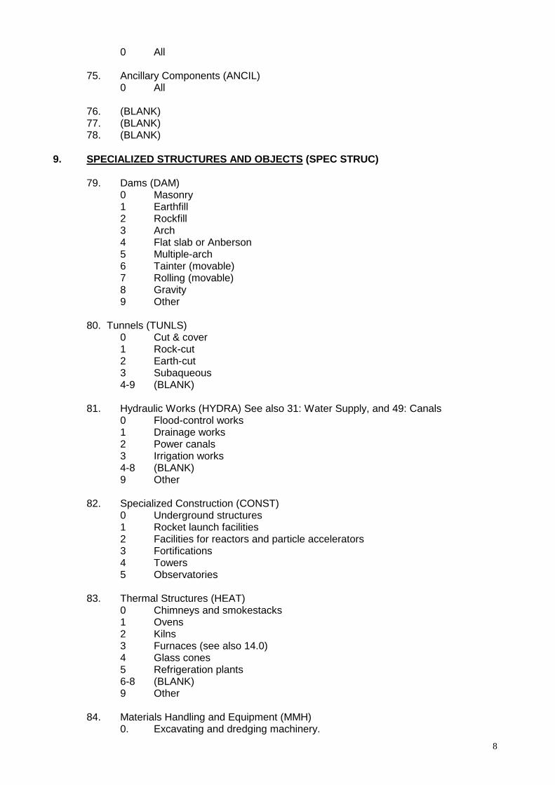
8
0 All 75. Ancillary Components (ANCIL) 0 All 76. (BLANK) 77. (BLANK) 78. (BLANK) 9. SPECIALIZED STRUCTURES AND OBJECTS (SPEC STRUC) 79. Dams (DAM) 0 Masonry 1 Earthfill 2 Rockfill 3 Arch 4 Flat slab or Anberson 5 Multiple-arch 6 Tainter (movable) 7 Rolling (movable) 8 Gravity 9 Other 80. Tunnels (TUNLS) 0 Cut & cover 1 Rock-cut 2 Earth-cut 3 Subaqueous 4-9 (BLANK) 81. Hydraulic Works (HYDRA) See also 31: Water Supply, and 49: Canals 0 Flood-control works 1 Drainage works 2 Power canals 3 Irrigation works 4-8 (BLANK) 9 Other 82. Specialized Construction (CONST) 0 Underground structures 1 Rocket launch facilities 2 Facilities for reactors and particle accelerators 3 Fortifications 4 Towers 5 Observatories 83. Thermal Structures (HEAT) 0 Chimneys and smokestacks 1 Ovens 2 Kilns 3 Furnaces (see also 14.0) 4 Glass cones 5 Refrigeration plants 6-8 (BLANK) 9 Other 84. Materials Handling and Equipment (MMH) 0. Excavating and dredging machinery.
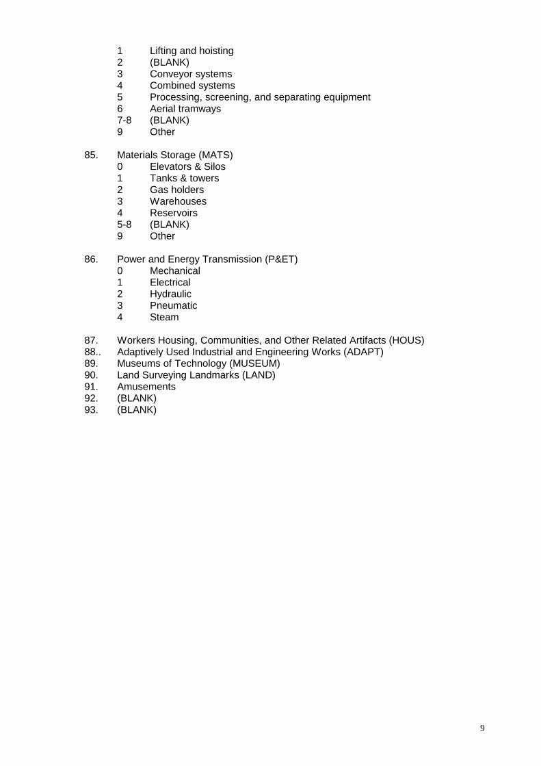
9
1 Lifting and hoisting 2 (BLANK) 3 Conveyor systems 4 Combined systems 5 Processing, screening, and separating equipment 6 Aerial tramways 7-8 (BLANK) 9 Other 85. Materials Storage (MATS) 0 Elevators & Silos 1 Tanks & towers 2 Gas holders 3 Warehouses 4 Reservoirs 5-8 (BLANK) 9 Other 86. Power and Energy Transmission (P&ET) 0 Mechanical 1 Electrical 2 Hydraulic 3 Pneumatic 4 Steam 87. Workers Housing, Communities, and Other Related Artifacts (HOUS) 88.. Adaptively Used Industrial and Engineering Works (ADAPT) 89. Museums of Technology (MUSEUM) 90. Land Surveying Landmarks (LAND) 91. Amusements 92. (BLANK) 93. (BLANK)

36
6.2. Industrial World Heritage Sites with Industrial classification and Photos

Industrial World Heritage Sites -
Industrial Classification
Photos Area Country Industrial World Heritage Site Description Industrial Classification 0. EXRACTIVE INDUSTRIES
Europe / North America
Germany Mines of Rammelsberg and Historic Centre of Goslar
Metallic ore mines
1
Europe / North America
Slovakia Banska Stiavnica Ore-Mining, Settlement
1.0 87
Europe / North America
UK Blaenavon Industrial landscape
coal and ore mines, quarries, a primitive railway system, furnaces, settlement
1 87
Europe / North America
Austria Hallstatt-Dachstein Salzkammergut
Salt deposit exploitation
4.6

Europe / North America
Poland Wieliczka Salt Mine Salt mine 4.6
Europe / North America
Belgium Neolithic Flint Mines at Spiennes (Mons)
Flint Mines 4.9
Europe / North America
Norway Roros Copper mines 5.0
Europe / North America
Czech Republic
Kutna Hora Silver mines 5.2
Europe / North America
Spain Las Medulas Gold Mining 5.2
Latin America / Caribbean
Bolivia City of Potosi Silver mine 5.2
Latin America / Caribbean
Brazil Historic Town of Ouro Preto Gold mine 5.2
Latin America / Caribbean
Mexico Historic Town of Guanajuato and its Silver Mines
Silver mine 5.2
Latin America / Caribbean
Mexico Historic Centre of Zacatecas Silver mine 5.2
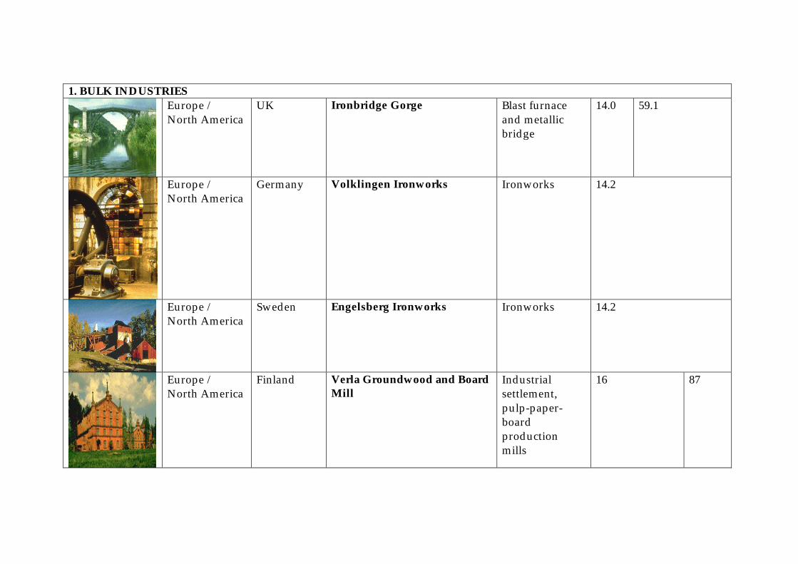
1. BULK INDUSTRIES
Europe / North America
UK Ironbridge Gorge Blast furnace and metallic bridge
14.0 59.1
Europe / North America
Germany Volklingen Ironworks Ironworks 14.2
Europe / North America
Sweden Engelsberg Ironworks Ironworks 14.2
Europe / North America
Finland Verla Groundwood and Board Mill
Industrial settlement, pulp-paper-board production mills
16 87
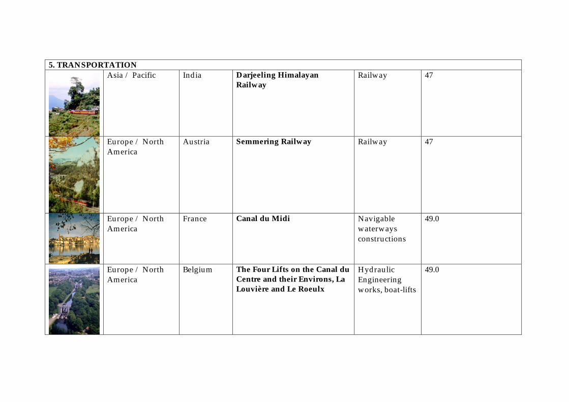
5. TRANSPORTATION
Asia / Pacific India Darjeeling Himalayan Railway
Railway 47
Europe / North America
Austria Semmering Railway Railway 47
Europe / North America
France Canal du Midi Navigable waterways constructions
49.0
Europe / North America
Belgium The Four Lifts on the Canal du Centre and their Environs, La Louvière and Le Roeulx
Hydraulic Engineering works, boat-lifts
49.0
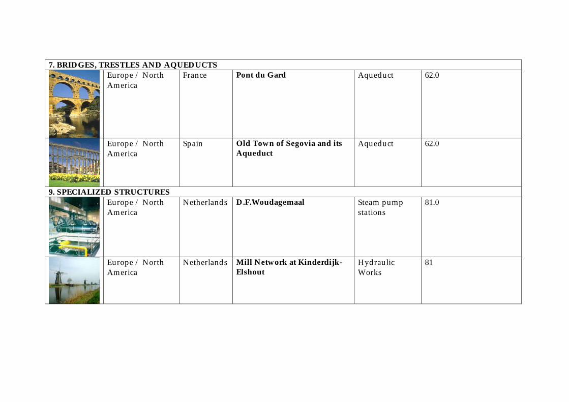
7. BRIDGES, TRESTLES AND AQUEDUCTS
Europe / North America
France Pont du Gard Aqueduct 62.0
Europe / North America
Spain Old Town of Segovia and its Aqueduct
Aqueduct 62.0
9. SPECIALIZED STRUCTURES
Europe / North America
Netherlands D.F.Woudagemaal Steam pump stations
81.0
Europe / North America
Netherlands Mill Network at Kinderdijk-Elshout
Hydraulic Works
81
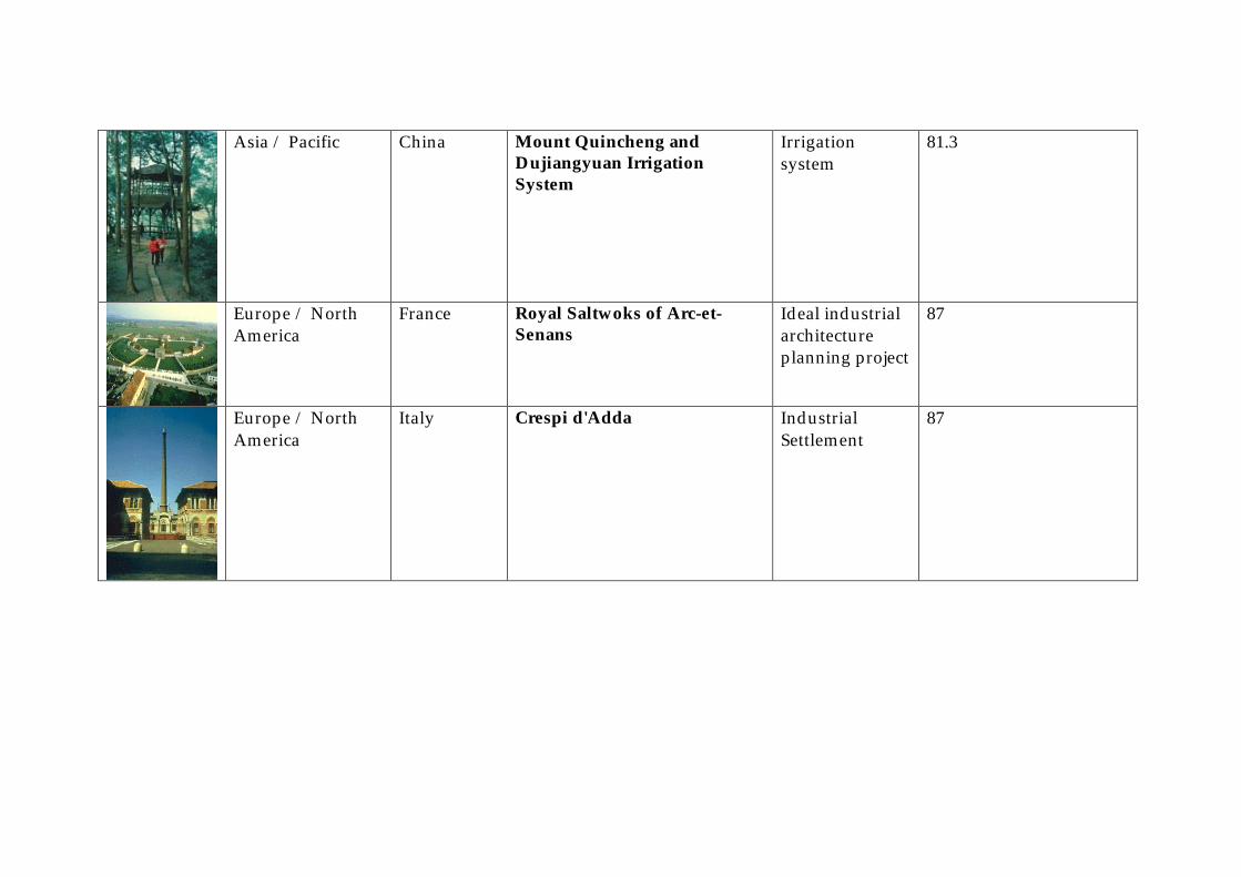
Asia / Pacific China Mount Quincheng and Dujiangyuan Irrigation System
Irrigation system
81.3
Europe / North America
France Royal Saltwoks of Arc-et-Senans
Ideal industrial architecture planning project
87
Europe / North America
Italy Crespi d'Adda Industrial Settlement
87

6.3. Africa Tentative list analysis and description
African Countries with Tentative Lists
– Analysis of Industrial World Heritage Values
Country Pot.
Sites C/N/M Site name with stated
Industrial WH Description Site name with
Assoc. Industr. Value Description Industrial
Classification
Angola 11 11/0/0 0 0
Benin 5 4/1/0 0 0
Botswana 5 5/0/0 0 0
Burkina Faso
4 4/0/0 Les gravures rupestres de Pobe-Mengao
Rock art drawings in metallurgical iron extraction ruins with furnace ruins, necropolis
1
Les necropoles de Bourzanga 2 different necropolis types, partly in metallurgical ruin sites
1
Les sites d’extraction de fer Kindiba
4 metallurgical sites with furnaces and mines of the Dogons and the Moagas
1
Dem. Rep. of Congo
3 0/0/3 Grottes de Dimba et Ngovo Ca. 18000 BC, stone age grottoes with archaeological finds of early food production
13
Grottes de Matupi Ca. 40000 BC, one of oldest stone industry sites
4.0
Ethiopia 2 1/0/1 0 0
Gambia 3 3/0/0 0 0
Ghana 6 4/2/0 0 0
Kenia 7 4/3/0 0 0
Madagaskar
6 2/0/4 Paysage culturel rizicole et hydraulique de Betafo
Rice growing village surroundings with complexe hydraulical net with canals
81.3
Malawi 3 1/1/1 0 0
Mali 4 4/0/0 0 0
Mozambiqu 3 3/0/0 0 0
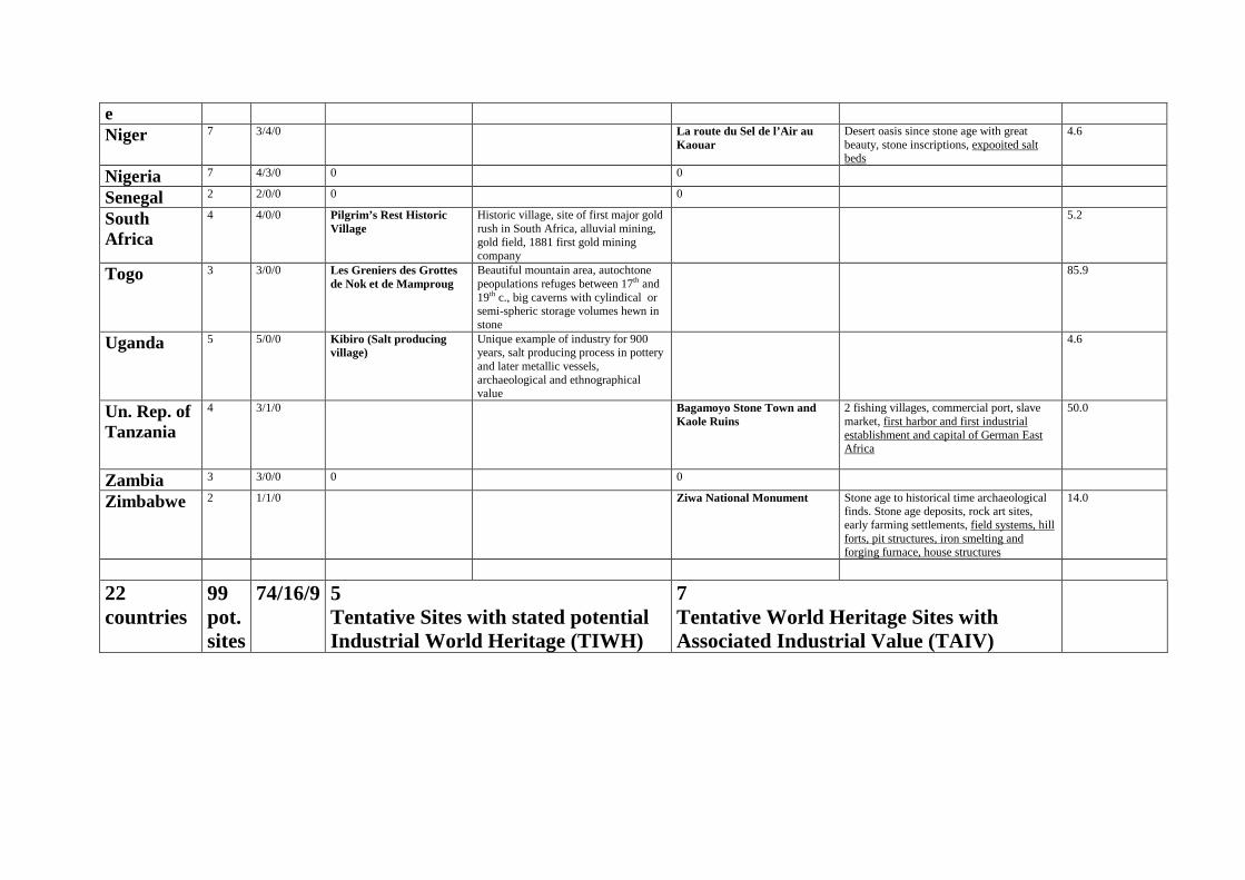
e Niger 7 3/4/0 La route du Sel de l’Air au
Kaouar Desert oasis since stone age with great beauty, stone inscriptions, expooited salt beds
4.6
Nigeria 7 4/3/0 0 0
Senegal 2 2/0/0 0 0
South Africa
4 4/0/0 Pilgrim’s Rest Historic Village
Historic village, site of first major gold rush in South Africa, alluvial mining, gold field, 1881 first gold mining company
5.2
Togo 3 3/0/0 Les Greniers des Grottes de Nok et de Mamproug
Beautiful mountain area, autochtone peopulations refuges between 17th and 19th c., big caverns with cylindical or semi-spheric storage volumes hewn in stone
85.9
Uganda 5 5/0/0 Kibiro (Salt producing village)
Unique example of industry for 900 years, salt producing process in pottery and later metallic vessels, archaeological and ethnographical value
4.6
Un. Rep. of Tanzania
4 3/1/0 Bagamoyo Stone Town and Kaole Ruins
2 fishing villages, commercial port, slave market, first harbor and first industrial establishment and capital of German East Africa
50.0
Zambia 3 3/0/0 0 0
Zimbabwe 2 1/1/0 Ziwa National Monument Stone age to historical time archaeological finds. Stone age deposits, rock art sites, early farming settlements, field systems, hill forts, pit structures, iron smelting and forging furnace, house structures
14.0
22 countries
99 pot.sites
74/16/9 5 Tentative Sites with stated potential Industrial World Heritage (TIWH)
7 Tentative World Heritage Sites with Associated Industrial Value (TAIV)
African Countries Tentative List
Tentative Industrial World Heritage Sites (TIWH)
And
Tentative Sites with Associated Industrial Value (TAIV)
–
Brief description on the sites Burkina Faso
Les gravures rupestres de Département de Pobe Mengao (i)(ii)(iii)(vi) C Pobe-Mengao (#) (Province du Soum)
Le site de Pobé, presente une association de plusieurs types de vestiges. Les plus spectaculaires sont les gravures rupestres auxquelles sont associées des buttes anthropiques, des vestiges métallurgiques, des nécropoles, des meules dormantes et mobiles, des jeux de "walé" et de l'industrie lithique. La region offre un paysage de domes granitiques qui ont servi de support à la réalisation des gravures. Parmi ces domes, le "rocher principal", long de 7,20m et haut de 2,70m, presente "les gravures les plus spectaculaires". Sept autres rochers dans un axe Nord-Sud portent des gravures ou des cupules et meules dormantes. C'est entre ces domes et notament au sud du "rocher principal" que l'on rencontre les buttes anthropiques et les restes de réduction du fer, tandisque les tumuli connaissent une plus forte concentration vers le nord. Les gravures ont été obtenues par "une même technique de frottement et de martelage, qui a permis d'aboutir à un relief en creux correspondant aux formes représentées... Partout les gravures sont patinées mais elles apparaissent encore plus claires que le ganite constituant la roche support.. En general le contours manquent de precision et cela rend très difficile les relevés. Le travail de l'artiste a été parfois géné par les nombreuses vénules de quartz qui sillonent le granite. Executées sur les pentes et parfois sur le sommet, les gravures ne répondent pas à une orientation particuliere et le style est tres scematisé. Cinq types de représentations peuvent etre identifiées. "Des cavaliers, des hommes à pied avec ou sans armes, des chevaux sans cavaliers, des animaux (sauvages),des figures géométriques". Les cavaliers sont les plus abondants et on en distingue deux groupes. Les grands, présents surtout sur le rocher principal atteignent 20cm de haut et 25cm de long. Ces dimensions sont respectivement de 10cm et 15cm pour les plus petits et les plus nombreux. Les buttes anthropiques au nombre de 16 se concentrent surtout dans la partie sud du site. Elles sont de dimensions modestes et souvent très arrasées. Les principaux vestiges qu'on y rencontre en surface sont la ceramique et de l'industrie lithique et parfois des scories de fer. La production métallurgique est également attesté par la presence "d'une base de fourneau équipée de 10 tuyères et de ferrières, dans une depression au sud-ouest du "Rocher principal". Sans présager d'une contemporaneité stricte entre tous ces élément, ils temoignent icontestablement d'une dynalmique d'occupation de l'espace qui en attendant d'etre mieux étudiée, mérite d'etre protegée des aggressions de la nature et des hommes.
Les necropoles de Bourzanga Bourzanga, Département dudit / (iii)(vi) C province du Bam L'ensemble que constitue les nécropoles de Bourzanga comprend deux groupes de site appartenant chacun à un groupe de population: les nécropoles à jarre dogon et la nécropole royale à stèles kurumba. I - Les nécropoles à jarres - cercueils dogon Les matériels archéologiques sur les sites comprend la céramique et du matériel lithique. La céramique est la plus abondante, la plus visible et la plus présente. On distingue la céramique domestique caractérisée par la présence de fragments de cruches, de bols, de couvercles, etc. La céramique funéraire est composée de jarres funéraires plus ou moins fragmentées. L'érosion et l'action des hommes ont mis à jour deux types de jarres - cercueils à Bourzanga: les jarres-cercueils en position verticale et celles en position horizontale. I.1) Les types de jarres - cercueils de Bourzanga Les deux types sont en associations sur les deux nécropoles. 1.1.a) Les jarres - cercueils verticales.Elles se présentent de la façon suivante: une jarre est posée verticalement sur son fond et reçoit le corps replié sur lui-même. Une seconde jarre servant de couvercle est utilisée pour recouvrir l'ensemble. La deuxième jarre est plus grande et ses bords se retrouvent sur la panse de la jarre «réceptrice». Des moellons de latérite sont utilisés pour le blocage de la partie externe du fond de jarre principale. I.1.b) Les cercueils - jarres horizontales Les sépultures horizontales sont constituées de deux jarres accolées par les bords dont la principale reçoit le corps. La deuxième jarre servant de couvercle.

I.l.c) Les caractéristiques des jarres funéraires de Bourzanga. On note très souvent la combinaison de jarres ovo~des et de terrines ou de jarres sphéroides et de terrines. Les dimensions des jarres - cerc~ueils horizontales sont sensiblement égales. L’examen des fragments permet de distinguer les décors créant un effet de relief et ceux de couleur réalisés avant, pendant ou après cuisson. Les décors créant un effet de relief sont réalisés par impression ou par modelage. L'engobe et le trempage ont été les modes de production d'effets de couleur sur les poteries. Les différents procédés de décoration ont été très souvent combinés. La céramique de Bourzanga présente un décor très riche qui se traduit par une combinaison de motifs en figures géométriques plus ou moins complexes et distinctes. I.2) L'environnement des jarres - cercueils A Bourzanga il existe bien d'autres nécropoles à jarres ffinéraires. Ces nécropoles sont associées à d'autres vestiges archéologiques tels que les buttes anthropiques et les sites métallurgiques. Les buttes anthropiques sont des éminences relativement modestes d'une hauteur n'excédant pas 0,50 m et de forme circulaire ou ovale. Il est pour le moment diff~cile de différencier les buttes d'habitats et les buttes funéraires. Aux nécropoles et aux buttes sont associées des vestiges d'une activité métallurgique importante. On repère les sites de production métallurgique aux scories éparses, aux morceaux de tuyères et aux bases de fourneaux. 1.3) Les jarres funéraires en Afrique sub-saharienne L'usage de la jarre dans les rites funéraires est très répandu en Afrique au sud du Sahara Le phénomène comporte des variances: - les jarres couvercles qui ont servi simplement à fermer l'ouverture de la tombe (absence à Bourzanga)- les jarres - cercueils verticales ou horizontales - les urnes cinéraires. En Afrique sub-saharienne la zone d'usage de jarres funéraires s'étend dans la bande soudano-sahélienne, du Mali au Tchad et comprend trois grands ensembles: - le complexe de la plaine péri tchadienne. - le complexe du delta intérieur - et le complexe voltaique auquel appartient les nécropoles de Bourzanga. Au Burkina Faso le complexe voltaique couvre les provinces du Yatenga, du Soum, du Sanmatenga et du Bam. 1.4) Contenu des nécropoles dogon de Bourzanga Nécropole I Elle est située à 200 m au Sud-ouest de la mission catholique et à proximité d'une concesslon. Elle est peu étendue avec environ l80 m2 de superficie, orientee est-ouest suivant sa longueur, et se présente sous la forme de butte arasée reposant sur une cuirasse latéritique. Elle est transformée en carrière de brique par la population. On a noté sur le site: - des tessons de 13 paires de jarres; - une jarre sans couvercle - une jarre à fond détruit - de gros fragments issus de la fracture de différentes jarres. L'orientation des jarres se présente comme suit: - 7 sépultures en position verticale - 8 paires de jarres-cercueils en position horizontale. Nécropole II Etle est située entre le lac et le village à 200 m du dispensaire. Le site est marqué par un bosquet de balanites aegyptiaca et d'autres épineux. Son étendu est d'environ 225 m~ orientée nord-sud dans le sens de la longueur. On y a retrouvé: - 6 sépultures horizontales - 10 sépultures verticales La concentration des jarres verticales est plus lâche côté Est. II) La Nécropole à stèles kurumba 1) Identification .La nécropole est située en hauteur par rapport au niveau général du village, sur l'une des collines de l'ère birrimienne. Elle est orientée Nord-Est-Sud-Ouest avec des dimensions de 51 m $ 53 m. Le couvert végétal se compose d'arbustes. Les vestiges funéraires rencontrées sont la céramique et le matériel lithique. La cérarnique composée de tessons des objets utilisés pour l'évacuation de la terre des fosses. Le matériel lithique comprend les moellons de latérite ayant servi à délimiter les tombes et à caler les stèles. II.2) Caractéristiques des stèles Les stèles sont imposantes en nombre et en taille sur le plus haut niveau de la colline; elles deviennent lâches sur la partie intermédiaire et rares et éparpillées au bas. Les stèles sont au nombre de 109, de taille, de matière et de forme variables. La plus grande a 1,51 m de hauteur. Elles sont en granite porphyroïde à gros grains sauf deux stèles qui sont en cuirasse latéritique. Les stèles de Bourzanga sont sans inscription ni représentation anthropomorphe ou zoomorphe. Elles sont en forme de dalle ou de plaque avec des épaisseurs variables de 5 à 20 cm. Les formes sont très irrégulières et vont du trapezoïdedale au quadrangulaire mais sans précision. Si elles n'ont pas été sculptées, elles ont cependant subi des aménagements pour permettre leur transport. C'est ce qui explique la présence sur certaines stèles, des traces de coups dans le but d'émousser les parties tranchantes ou pointues. Et pour des raisons esthétiques, on a poussé l'amènagement de façon à arrondir les angles et à homogénéiser les formes. Elles sont en majorité blanches mais certains ont jauni; les noires sont au nombre de quatre. Elles ont été toutes initialement dressées sans orientation précise. Elles sont plantées seules, doublées, triplées ou même quadruplées pour répondre à un besoin de résistance aux intempéries. II.3) Utilisation de l'espace constitué par la nécropole Dans le village comme sur la nécropole rien n'est laissé au hasard. Sur la nécropole la partie la plus élevée est réservée aux chefs, à tous ceux qui ont régné à Bourzanga. Chaque quartier a un côté de la colline où ses chefs et dignitaires sont enterrés. Il n'y a pas de délimitation visible et précise des aires. II.4) Environnement de la nécropole Au pied de la colline, à ses côtés Sud et Nord, sont disposées des tombes dites musulmanes qui s'orientent Nord-Sud.L'usage des stèles à Bourzanga est liée à la pratique des hypogées. Les stèles sont fixées sur des tombes de ceux qui ont droit à la "tombe royale" ou hypogée. A Bourzanga l'hypogée est de forme quadrangulaire avec trois niveaux. Le premier constitué d'une fosse rectangulaire d'environ deux mètres de profondeur. Deux couloirs circulaires creusés sur l'une des longueurs constituent le deuxième niveau. Ces couloirs débouchent sur le troisième niveau qui est en fait la chambre mortuaire de forme rectangulaire et assez grande. Tous les notables et tous les chefs enterrés sur la colline ont bénéficié de ce type de tombe et une stèle plantée sur chaque tertre de recouvrement. En Afrique sub-saharienne l'aire des hypogées se localise dans la savane arbustive avec de hautes herbes, des baobabs, des kapokiers, etc. (Mali, Guinée, Burkina Faso). Elle correspond à la zone comprise entre les isohyètes 600 mm et 1350 mm. Au Burkina Faso on rencontre cette pratique depuis le nord du pays jusqu'aux frontières méridionales. Elle est donc très largement répandue.
Les sites d'extraction de fer de Kindiba, départment de Tougo, (iii)(v) C Kindiba (#) Province du Yatenga
Le site métallurgique de Kindiba se décompose en quatre ensembles dont trois rapprochés: il s'agit de l'aire des trois fourneaux dogon encore debout au milieu des scories, de la mine dogon et de l'espace des fourneaux moose dont un seul est assez bien conservé. Le quatrème ensemble est la mine moaga, contemporaine et éloignée du village du coté Est. ce quatrieme élément n'est pas proposé au classement. Les trois fourneaux dogon occupent la partie Nord du site. Ils ont été édifiés dans une dépression bordée par des collines au nord-est et au Sud. Celle du nord-est est un lieu de culte où officient les pretres dogon. Les trois fourneaux de forme tronconique, ont environ deux mètres de hauteur et un mètre de diametre à la base où on compte cinq larges ouvertures. Ils ont construits en argile et à mi-hauteur une petite ouverture est décelable du coté Ouest. L'interieur de deux xes trois fourneaux est occupé par des termitières encore vivantes. Cela contribue à leur préservation. le troisieme est menacé par un Balanites Aegyptiaca. Des scories émiettées ou en gros blocs parsèment l'espace autour des fourneaux. Elles ont du etre remaniées car la dépression a jadis porté des champs de cultures. Trois cent mètres au sud des fourneaux dogon se trouve la mine qui s'etend dans un quadrilatère d'environ 50 metre de coté. On y dénombre une dizaine de puits circulaires d'environ un metre de diametre et dont les profondeurs actuelles ne depassent pas 2,50 metres. Ils ont été partiellement comblés. Des amorces de galeries sont visibles sous le niveau de la cuirasse épaisse de plus d'un metre. Des encoches dans les parois permettent une circulation entre l'extérieur et le fond des puits. Aujourd'hui, puits et galeries sont des repaires d'hyènes, de porcs-épics et de serpents. L'atelier des metallurgistes moose s'étend cinq cent metres au Sud de la mine. A son extrémité méridionale s'élance sur 3,50m le dernier des fourneaux moose de Kindiba construit avant la derniere guerre mondiale. De forme tronconique comme les fourneaux moose dogon, il s'en distingue par sa taille, le nombre et la forme en U des ouvertures à la base. Démoli sur près de 2m de hauteur coté Est ce fourneau est en danger de disparition. Suite à une visite de sensibilisation de la secrétaire d'Etat à la culture en 1989, les forgerons l'avaient restauré avec du torchis. Mais le matériau n'ayant pas subi de cuisson s'est détaché de la vieille paroi dès les premières pluies d'hivernage. Il convient donc d'imaginer un autre mode de conservation avant qu'il ne soit trop tard.
DEMOCRATIC REPUBLIC OF THE CONGO
Grottes de Dimba et Ngovo Province du Congo Central (not specified) DIMBA La grotte de Dimba a livré la plus longue séquence archéologique du Bas-Congo (exBas-Zaïre). Les dépôts à l'entrée ont été datés de 18.000 ans avant notre ère: 18.050 ~ 650 bc (Hv 6255). Des restes de faune et un outillage lithique de l'Age de la Pierre Récent sont associés à cette datation par radiocarbone. Le sondage qui a livré ces résultats a été interrompu à une profondeur de -3,2 m, mais il existe la possibilité de niveaux archeologiques encore plus anciens au-delà. Les niveaux supérieurs de l'entrée et un grand talus situé à plus d'un kilomètre de l'entrée ont livré une abondante céramique dite du Groupe Vl ou Groupe de Ngovo, caractéristique de la période de transition qui, à la fin de l'Age de la Pierre, voit apparaître les débuts de la production de nourriture. Des outils polis ont également été découverts associés à cette céramique qui est datée à Dimba du dernier siècle avant notre ère (85 - 130 bc - Hv 6257). Dans l'entrée, en surface et sur les premiers 15 cm, on trouve mêlés de nombreux fragments de poterie de l'Age du Fer, remontant principalement aux 16è - 17è siècles. NGOVO Un dépôt archéologique de 2 à 15 cm situé à quelque 210 m de l'entrée a livré en abondance de la poterie dite du Groupe VI ou Groupe de Ngovo, ainsi que des outils polis. Daté des deux derniers siècles avant notre ère (Hv 5258: 195 :t 45 bc, Hv 6258: 85 ~ 65 bc), ce site archéologique est le site type de l'industrie de transition entre l'Age de la Pierre et l'Age du Fer qui s'étendait sur une bonne partie du Bas-Congo
Grottes de Matupi Province Orientale (not specified) La grotte de Matupi est un des sites archéologiques majeurs de l'Afrique subsaharienne. Il a livré une séquence d'occupation s'étendant sur plus de 40.000 ans. Les niveaux les plus profonds sont datés entre 32.000 et > 40.700 avant le présent. Ils ont fourni une des plus vieilles industries microlithiques du monde. Les niveaux inférieurs (entre c. 140-185 cm) sont relativement pauvres en vestiges lithiques. Ils sont datés entre 21.000 et 32.000 avant le présent. Les niveaux moyens (entre c. 65-140 cm) sont datés entre 12.000 et 21.000 avant le présent. Très riches en matériel lithique, ils ont aussi livré une pierre percée "Kwé" décorée. Les niveaux supérieurs livrent une industrie microlithique de l'Age de la Pierre Récent daté de 3.000 à 12.000 avant le présent, surmonté par des niveaux de l'Age du Fer.
MADAGASCAR Paysage culturel rizicole et La région de Betafo est situse C (iii)(iv)(v) hydraulique de Betafo dans la partie centrale du pays, dénommoe Vakinankaratra, plus précisément à 25 km à l'ouest de la villE d'Antsirabe sur la route de Morondava
La zone proposée est la campagne de la petite ville de Betato mar-quée par un paysage rizicole et hydraulique original et d'une grande beauté. Il s'agit d'un paysage comprenant une vallée rizicole (I), des versants de collines occupés par des rizières en terrasses (II) et un réseau hydraulique complexe (III), fruit d'un savoir-faire séculaire transmis de genération en génération, d'un équilibre social délicat et où se lit l'harmonie entre l'homme et l'environnement. (I) La vallée rizicole située en amont et en aval de la localité d'Ambohiambo s'insère entre deux chainons montagneux et exploite aux moir dres details la topographie du terrain tout en béneficiant d'un système d'irrigation bien conçu. (II) Dans certains secteurs et particulièrement de part et d'autre d'une rivière encaissée existent de nombreuses rizières en terrasses épousant les courbes de niveau. (III) Le réseau hydraulique complexe desservant la vallée et les ver-sants est un témoin de la don~estication de l'eau sur sa réglementation pour un partage équitable vers toutes les rizières, d'abord entre les lignages, ensuite entre les familles. Le réseau comprend entre autres des prises traditionnelles par barrages assez lâches de pierres sèches des canaux parallèles et superposés creusés sur les flancs nord des gorges de la rivière encaissée, une bonne douzaine de canaux dériYeurs paralleles pour les lignages et de petits canaux pour les familles ave des répartiteurs en pierres volcaniques. Ces derniers canaux peuvent etre souterrains - passant sous des rizières - lorsque l'espace manque.
NIGER La Route du Sel de l'Air au Kaouar Lat. 18°00 - 20°00 N Long. (ii)(iii)(iv) C 12°20' - 14° E 1300 km au nord-est de Niamey, dans le dept. d'Agadez, arrondiss. de Bilma.
Le Kaouar est une zone de falaises alignées nord-sud, faisant la jonction entre l'immense zone sableuse du Ténéré a l'ouest et le grand erg de Bilma a l'est. Cette region a ete habitée, depuis le Neolithique, et conserve des inscriptions rupestres. Elle est actuellement le siege de petites oasis qui sont parmi les plus isolées du Sahara. Elles survivent de facon traditionnelle grace au maintien d'une activité caravaniere. Le site abrite des gisements de sel, objet principal du commerce. D'importantes étendues d'eau douce et saumatre naturelles determinent des milieux biologiques (faune et flore) exceptionnels au Sahara. C'est aussi une des regions que l'addax est susceptible d'utiliser au cours de sa nomadisation. La beauté des paysages de cette region est universellement connue. SOUTH AFRICA Pilgrim's Rest Historic Village 24° 54' S, 30° 45' E C (ii) (iv)
The historic village of Pilgrim's Rest is situated on the eastem escarpment of the Transvaal Drakensberg on Portion 42 of of plants and animals which were present at the time it was inhabited by the San people. The Drakensberg is part _of the Ponieskrantz 543, Registration Division KT Transvaal. Great Escarpment which is the most prominent physiographic feature on the southern African sub-continent. It is a most outstanding and spectacular example of an escarpment mountain differing from other escarpment mountains found Size of propety: 4393, 8278 h elsewhere in the world in terms of the geomorphological processes by which it was formed. The Drakensberg is the only place where one can view the concordant Karoo geological sequences in situ from the oldest Beaufort Group In 1873 rich gold deposits were discovered in the Pilgrirn's Creek, a tributary of the Blyde River, close to where the village sandstones of the Triassic (about 258 Ma) to the basalts of the late Jurassic (after 190 to 140 Ma). of Pilgrim's Rest was established. The news of this rich strike triggered the first major gold rush in South Africa. Pilgrim's Rest was declared a gold field on 22 September 1873 and by the end of that year there were some 1500diggers working 4000 claims in and around Pilgrim's Rest. It is estimated that R2 million worth of gold was mined during the first seven years of alluvial mining in the Pilgrim's Rest valley. This gold field cannot be was the first of its kind in Africa. By 1875 Pilgrim's Rest had become the social and commercial centre of the diggings and gradually more permanently buildings
were replacing the diggers' tents. By the 1880's alluvial gold deposits began to dwindle and diggers were steadily leaving to prospect elsewhere. In 1881 the first gold rnining company amalgamated with several other smaller companies to form the Transvaal Gold Mining Estates (TGME) which became the sole owners of Pilgrim's Rest and the farrn Ponieskrantz on which it is situated until 1972. The history of this company and Pilgrim's Rest were inseparably linked as both shared the fluctuating fortunes of the mines.
TOGO
Les Greniers des Grottes de Nok et de Mamproug N 10° 39, 613’; E 0° 8,836’
C (iv)(v)(vi) Dans la région des Savanes, et plus précisément dans la Préfecture de Tandjouaré à une trentaine de kilomètres de la ville de Dapaong
De hautes falaises, dont les parois sont orientées au nord, dominent de leur à-pic la savane de cette partie septentrionale du Togo. Elles sont les derniers reliefs élevés avant cette immense étendue de savane qui se prolonge au Burkina. Cette formation appelée communément grès de Boumbouaka présente des escarpements de falaises d’âge protérozoïque supérieur d’une rare beauté avec à la base une alternance de pellites (argilites) et de psammites, l’ensemble reposant sur un socle cristallin daté du Birrimien. Des anfractuosités horizontales s’ouvrent au dernier quart supérieur de leur hauteur ; d’accès difficile, elles ont servi, de très longue date, d’abri et de refuge aux populations autochtones lors des périodes d’insécurités diverses qui ont sévi dans la région du XVIIe au XIXe siècle. Ces cavernes contiennent des greniers : cent trente-quatre à ?ôk, cent treize à Mamproug et soixante-dix à Bopak et dans les autres grottes périphériques. De forme cylindrique, oblongue ou semi-sphérique, ils s’ouvrent vers le haut ; leur hauteur est généralement de deux mètres et demi, leur diamètre de trois mètres. Avant que ces grottes n’aient été pillées, des armes traditionnelles telles que des arcs, des flèches et leurs carquois, y ont été trouvées. Les greniers, taillés dans le même style architectural traditionnel à partir des matériaux locaux (pierres, argile et paille) contenaient les récoltes et les grottes offraient un refuge aux populations menacées. Elles y avaient des vivres, de l’eau et leurs fétiches . Elles pouvaient donc y soutenir un véritable siège. Dans cette région de migrations et d’affrontements divers, les Konkomba, les Moba, les Mamprussi se combattirent, puis s’installèrent. Ils sont encore aujourd’hui les habitants de la région et furent, semble-t-il, les bâtisseurs des greniers. Sur le trajet d’un grand axe commercial dit Route de la cola, les populations du nord du Togo étaient assujetties à des ethnies dominantes telles les Anufom auxquelles ils versaient tribut. Devant l’alourdissement des charges et la répétition des exactions, ils organisèrent leur résistance et se réfugièrent dans les grottes de ?ôk et de Mamproug. Du moins le récit qu’en font les habitants actuels.
UGANDA Kibiro (Salt producing village) Kigorobya sub-county, Hoima C (i)(iii)(iv)(v) District Lat. 1°41' N ; Long. 31°15' E Kibiro salt producing village demonstrates a unique example of an industry which has sustained its people for eight to nine hundred years ago and continues to do so perhaps for posterity from fishing on Lake Albert, the people of Kibiro have depended on the production of ash salt which is obtained by recycling residual earth with fresh soil which is spread on salt gardens for the salty water to get absorbed by capillary system. Through repeated scraping, spreading and heaping of the salty soil over a seven days period, it is leached and the scam is boilt to crystallisation point to produce the ash salt. The residual soil from leaching is then mixed with fresh soil to repeat the salt production process. Salt production was and is a female hereditary occupation. Before the introduction of metallic vessels, pottery ware was used during the leaching and boiling processes and this is evidenced by the rich archaeological depositions of potsherds throughout the village going as deep as 4 metres and dating to between eight and nine hundred years to the present. Kibiro village is a sandy beach along Lake Albert where food does not grow. The Kibiro population therefore have depended for its livehood on the exchange of salt and fish for food through time with farming communities on the platea above the Ugandan side of the Western Rift Valley. The village therefore forms an important cultural site which has combined both archaeology and ethnography through time in the production of ash salt.
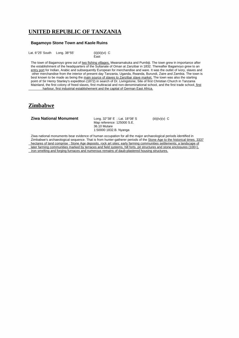
UNITED REPUBLIC OF TANZANIA Bagamoyo Stone Town and Kaole Ruins
Lat. 6°25' South Long. 38°55' (ii)(iii)(vi) C East The town of Bagamoyo grew out of two fishing villages, Mwanamakuka and Pumbiji. The town grew in importance after the establishment of the headquarters of the Sultanate of Oman at Zanzibar in 1832. Thereafter Bagamoyo grew to an entry port for Indian, Arabic and subsequently European for merchandise and ware. It was the outlet of ivory, slaves and other merchandise from the interior of present day Tanzania, Uganda, Rwanda, Burundi, Zaire and Zambia. The town is best known to be made as being the main source of slaves to Zanzibar slave market. The town was also the starting point of Sir Henry Stanley's expedition (1872) in search of Dr. Livingstone; Site of first Christian Church in Tanzania Mainland, the first colony of freed slaves, first multiracial and non-denominational school, and the first trade school, first harbour, first industrial establishement and the capital of German East Africa.
Zimbabwe
Ziwa National Monument Long. 32°38' E ; Lat. 18°08' S (iii)(iv)(v) C Map reference: 125000 S.E. 36.10 Mutare 1:50000 1832.B. Nyanga Ziwa national monuments bear evidence of human occupation for all the major archaeological periods identified in Zimbabwe's archaeological sequence. That is from hunter-gatherer periods of the Stone Age to the historical times. 3337 hectares of land comprise : Stone Age deposits, rock art sites; early farming communities settlements; a landscape of later farming communities marked by terraces and field systems, hill forts, pit structures and stone enclosures (100+), iron smelting and forging furnaces and numerous remains of daub-plastered housing structures.

6.4. Africa Tentative Industrial Heritage Classification
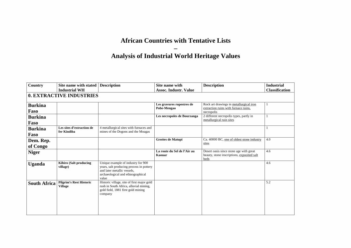
African Countries with Tentative Lists
– Analysis of Industrial World Heritage Values
Country Site name with stated Industrial WH
Description Site name with Assoc. Industr. Value
Description Industrial Classification
0. EXTRACTIVE INDUSTRIES
Burkina Faso
Les gravures rupestres de Pobe-Mengao
Rock art drawings in metallurgical iron extraction ruins with furnace ruins, necropolis
1
Burkina Faso
Les necropoles de Bourzanga 2 different necropolis types, partly in metallurgical ruin sites
1
Burkina Faso
Les sites d’extraction de fer Kindiba
4 metallurgical sites with furnaces and mines of the Dogons and the Moagas
1
Dem. Rep. of Congo
Grottes de Matupi Ca. 40000 BC, one of oldest stone industry sites
4.0
Niger La route du Sel de l’Air au Kaouar
Desert oasis since stone age with great beauty, stone inscriptions, expooited salt beds
4.6
Uganda Kibiro (Salt producing village)
Unique example of industry for 900 years, salt producing process in pottery and later metallic vessels, archaeological and ethnographical value
4.6
South Africa Pilgrim’s Rest Historic Village
Historic village, site of first major gold rush in South Africa, alluvial mining, gold field, 1881 first gold mining company
5.2
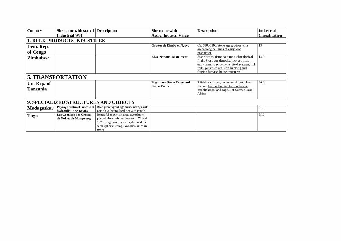
Country Site name with stated Industrial WH
Description Site name with Assoc. Industr. Value
Description Industrial Classification
1. BULK PRODUCTS INDUSTRIES Dem. Rep. of Congo
Grottes de Dimba et Ngovo Ca. 18000 BC, stone age grottoes with archaeological finds of early food production
13
Zimbabwe Ziwa National Monument Stone age to historical time archaeological finds. Stone age deposits, rock art sites, early farming settlements, field systems, hill forts, pit structures, iron smelting and forging furnace, house structures
14.0
5. TRANSPORTATION Un. Rep. of Tanzania
Bagamoyo Stone Town and Kaole Ruins
2 fishing villages, commercial port, slave market, first harbor and first industrial establishment and capital of German East Africa
50.0
9. SPECIALIZED STRUCTURES AND OBJECTS Madagaskar Paysage culturel rizicole et
hydraulique de Betafo Rice growing village surroundings with complexe hydraulical net with canals
81.3
Togo Les Greniers des Grottes de Nok et de Mamproug
Beautiful mountain area, autochtone peopulations refuges between 17th and 19th c., big caverns with cylindical or semi-spheric storage volumes hewn in stone
85.9

6.5. Arab States Tentative list analysis and description
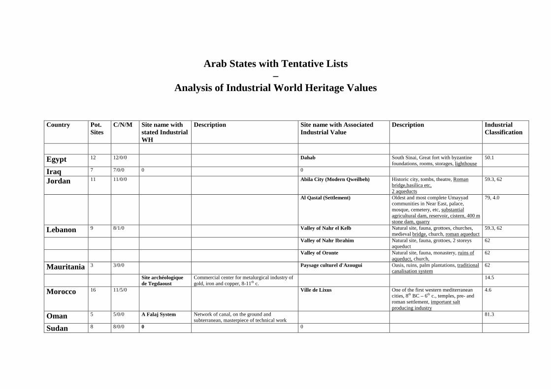
Arab States with Tentative Lists
– Analysis of Industrial World Heritage Values
Country Pot.
Sites C/N/M Site name with
stated Industrial WH
Description Site name with Associated Industrial Value
Description Industrial Classification
Egypt 12 12/0/0 Dahab
South Sinai, Great fort with byzantine foundations, rooms, storages, lighthouse
50.1
Iraq 7 7/0/0 0 0
Jordan 11 11/0/0 Abila City (Modern Qweilbeh) Historic city, tombs, theatre, Roman bridge,basilica etc, 2 aqueducts
59.3, 62
Al Qastal (Settlement) Oldest and most complete Umayyad communities in Near East, palace, mosque, cemetery, etc, substantial agricultural dam, reservoir, cistern, 400 m stone dam, quarry
79, 4.0
Lebanon 9 8/1/0 Valley of Nahr el Kelb Natural site, fauna, grottoes, churches, medieval bridge, church, roman aqueduct
59.3, 62
Valley of Nahr Ibrahim Natural site, fauna, grottoes, 2 storeys aqueduct
62
Valley of Oronte Natural site, fauna, monastery, ruins of aqueduct, church,
62
Mauritania 3 3/0/0 Paysage culturel d'Azougui Oasis, ruins, palm plantations, traditional canalisation system
62
Site archéologique de Tegdaoust
Commercial center for metalurgical industry of gold, iron and copper, 8-11th c.
14.5
Morocco 16 11/5/0 Ville de Lixus One of the first western mediterranean cities, 8th BC – 6th c., temples, pre- and roman settlement, important salt producing industry
4.6
Oman 5 5/0/0 A Falaj System Network of canal, on the ground and subterranean, masterpiece of technical work
81.3
Sudan 8 8/0/0 0 0
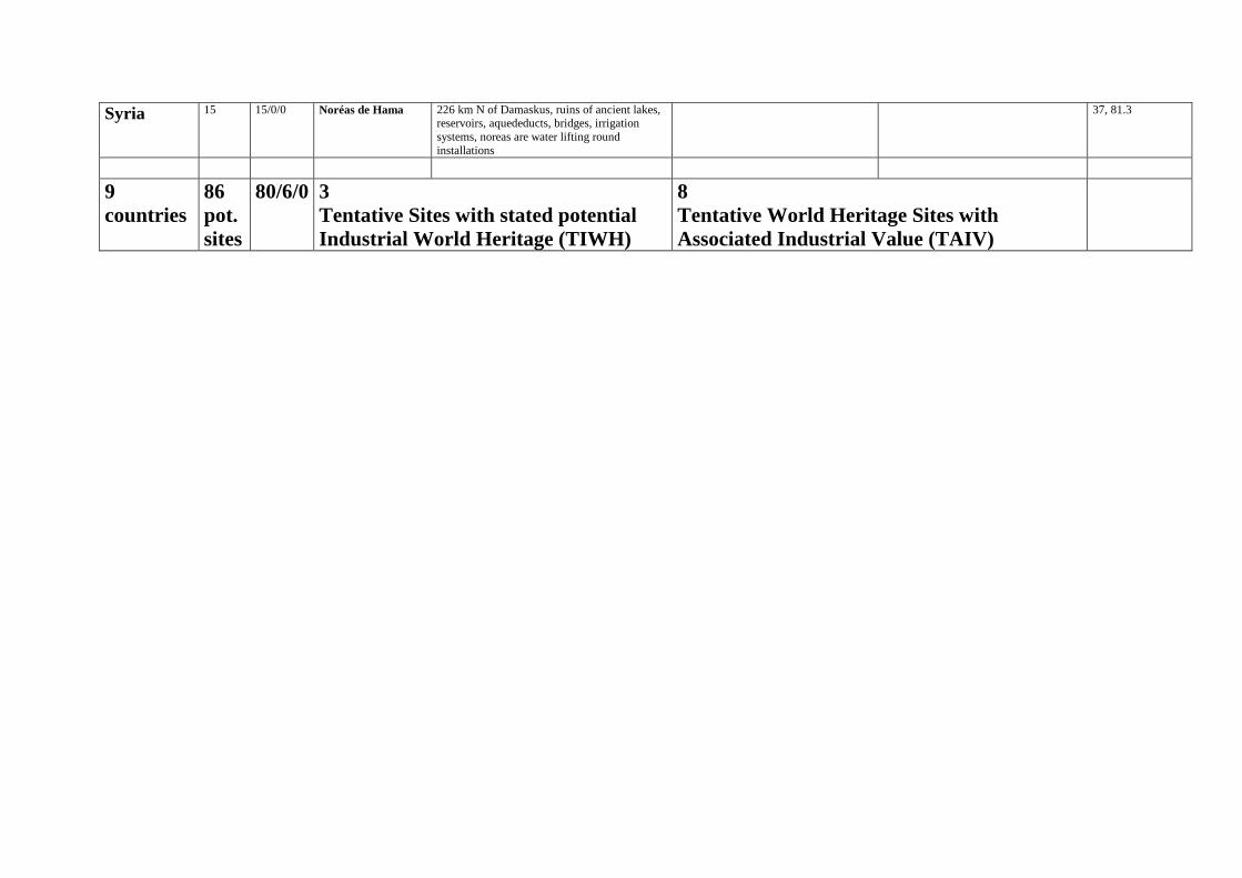
Syria 15 15/0/0 Noréas de Hama 226 km N of Damaskus, ruins of ancient lakes, reservoirs, aquededucts, bridges, irrigation systems, noreas are water lifting round installations
37, 81.3
9 countries
86 pot. sites
80/6/0 3 Tentative Sites with stated potential Industrial World Heritage (TIWH)
8 Tentative World Heritage Sites with Associated Industrial Value (TAIV)
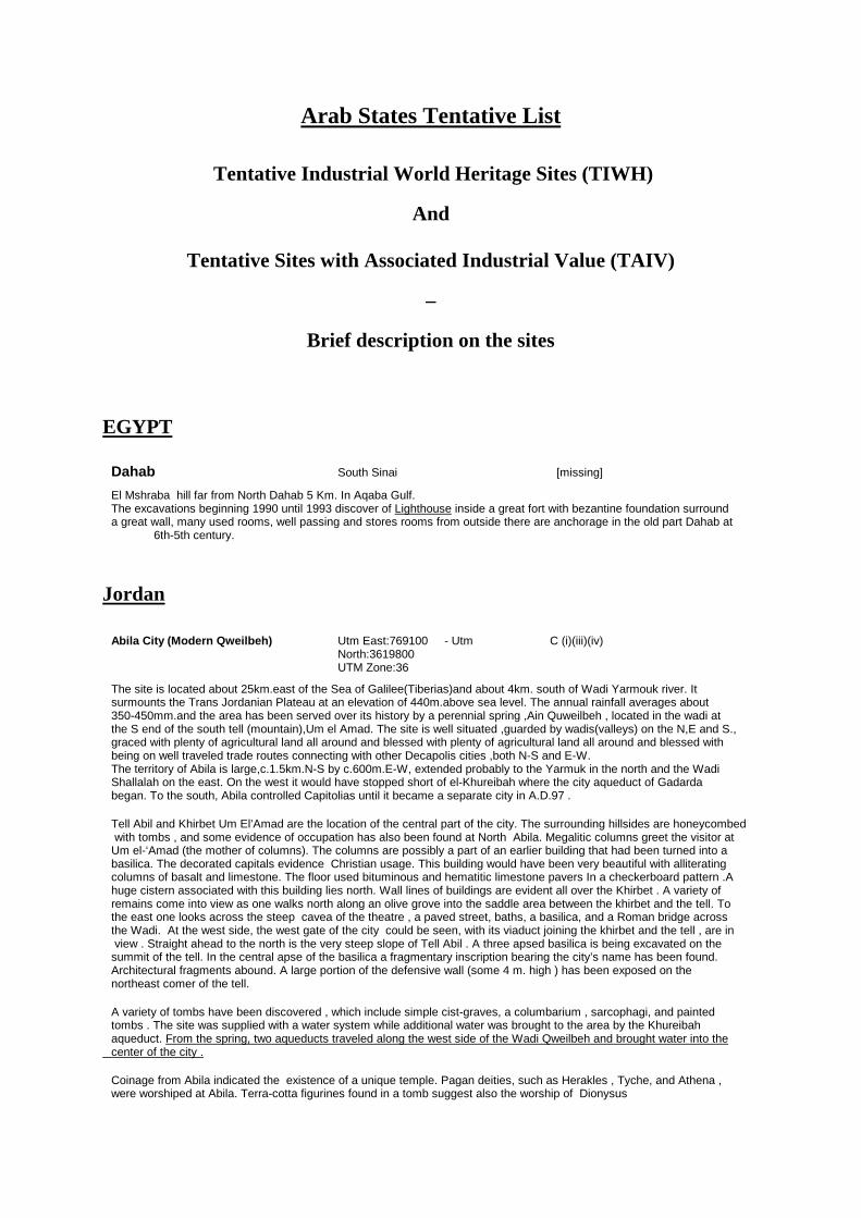
Arab States Tentative List
Tentative Industrial World Heritage Sites (TIWH)
And
Tentative Sites with Associated Industrial Value (TAIV)
–
Brief description on the sites EGYPT
Dahab South Sinai [missing] El Mshraba hill far from North Dahab 5 Km. In Aqaba Gulf. The excavations beginning 1990 until 1993 discover of Lighthouse inside a great fort with bezantine foundation surround a great wall, many used rooms, well passing and stores rooms from outside there are anchorage in the old part Dahab at 6th-5th century.
Jordan
Abila City (Modern Qweilbeh) Utm East:769100 - Utm C (i)(iii)(iv) North:3619800 UTM Zone:36 The site is located about 25km.east of the Sea of Galilee(Tiberias)and about 4km. south of Wadi Yarmouk river. It surmounts the Trans Jordanian Plateau at an elevation of 440m.above sea level. The annual rainfall averages about 350-450mm.and the area has been served over its history by a perennial spring ,Ain Quweilbeh , located in the wadi at the S end of the south tell (mountain),Um el Amad. The site is well situated ,guarded by wadis(valleys) on the N,E and S., graced with plenty of agricultural land all around and blessed with plenty of agricultural land all around and blessed with being on well traveled trade routes connecting with other Decapolis cities ,both N-S and E-W. The territory of Abila is large,c.1.5km.N-S by c.600m.E-W, extended probably to the Yarmuk in the north and the Wadi Shallalah on the east. On the west it would have stopped short of el-Khureibah where the city aqueduct of Gadarda began. To the south, Abila controlled Capitolias until it became a separate city in A.D.97 . Tell Abil and Khirbet Um El’Amad are the location of the central part of the city. The surrounding hillsides are honeycombed with tombs , and some evidence of occupation has also been found at North Abila. Megalitic columns greet the visitor at Um el-‘Amad (the mother of columns). The columns are possibly a part of an earlier building that had been turned into a basilica. The decorated capitals evidence Christian usage. This building would have been very beautiful with alliterating columns of basalt and limestone. The floor used bituminous and hematitic limestone pavers In a checkerboard pattern .A huge cistern associated with this building lies north. Wall lines of buildings are evident all over the Khirbet . A variety of remains come into view as one walks north along an olive grove into the saddle area between the khirbet and the tell. To the east one looks across the steep cavea of the theatre , a paved street, baths, a basilica, and a Roman bridge across the Wadi. At the west side, the west gate of the city could be seen, with its viaduct joining the khirbet and the tell , are in view . Straight ahead to the north is the very steep slope of Tell Abil . A three apsed basilica is being excavated on the summit of the tell. In the central apse of the basilica a fragmentary inscription bearing the city’s name has been found. Architectural fragments abound. A large portion of the defensive wall (some 4 m. high ) has been exposed on the northeast comer of the tell. A variety of tombs have been discovered , which include simple cist-graves, a columbarium , sarcophagi, and painted tombs . The site was supplied with a water system while additional water was brought to the area by the Khureibah aqueduct. From the spring, two aqueducts traveled along the west side of the Wadi Qweilbeh and brought water into the center of the city . Coinage from Abila indicated the existence of a unique temple. Pagan deities, such as Herakles , Tyche, and Athena , were worshiped at Abila. Terra-cotta figurines found in a tomb suggest also the worship of Dionysus
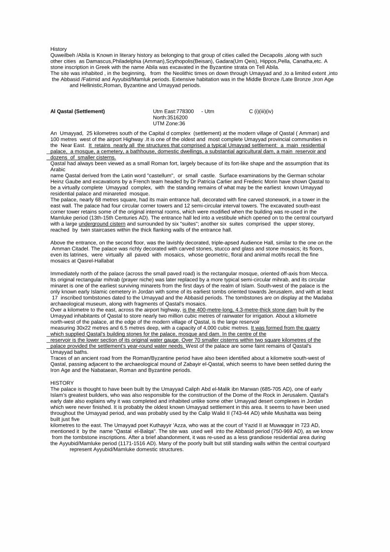
History Quweilbeh /Abila is Known in literary history as belonging to that group of cities called the Decapolis ,along with such other cities as Damascus,Philadelphia (Amman),Scythopolis(Beisan), Gadara(Um Qeis), Hippos,Pella, Canatha,etc. A stone inscription in Greek with the name Abila was excavated in the Byzantine strata on Tell Abila. The site was inhabited , in the beginning, from the Neolithic times on down through Umayyad and ,to a limited extent ,into the Abbasid /Fatimid and Ayyubid/Mamluk periods. Extensive habitation was in the Middle Bronze /Late Bronze ,Iron Age and Hellinistic,Roman, Byzantine and Umayyad periods.
Al Qastal (Settlement) Utm East:778300 - Utm C (i)(iii)(iv) North:3516200 UTM Zone:36 An Umayyad, 25 kilometres south of the Capital d complex (settlement) at the modern village of Qastal ( Amman) and 100 metres west of the airport Highway .It is one of the oldest and most complete Umayyad provincial communities in the Near East. It retains nearly all the structures that comprised a typical Umayyad settlement: a main residential palace, a mosque, a cemetery, a bathhouse, domestic dwellings, a substantial agricultural dam, a main reservoir and dozens of smaller cisterns. Qastal had always been viewed as a small Roman fort, largely because of its fort-like shape and the assumption that its Arabic name Qastal derived from the Latin word "castellum", or small castle. Surface examinations by the German scholar Heinz Gaube and excavations by a French team headed by Dr Patricia Carlier and Frederic Morin have shown Qastal to be a virtually complete Umayyad complex, with the standing remains of what may be the earliest known Umayyad residential palace and minareted mosque. The palace, nearly 68 metres square, had its main entrance hall, decorated with fine carved stonework, in a tower in the east wall. The palace had four circular corner towers and 12 semi-circular interval towers. The excavated south-east corner tower retains some of the original internal rooms, which were modified when the building was re-used in the Mamluke period (13th-15th Centuries AD). The entrance hall led into a vestibule which opened on to the central courtyard with a large underground cistern and surrounded by six "suites"; another six suites comprised the upper storey, reached by twin staircases within the thick flanking walls of the entrance hall. Above the entrance, on the second floor, was the lavishly decorated, triple-apsed Audience Hall, similar to the one on the Amman Citadel. The palace was richly decorated with carved stones, stucco and glass and stone mosaics; its floors, even its latrines, were virtually all paved with mosaics, whose geometric, floral and animal motifs recall the fine mosaics at Qasrel-Hallabat Immediately north of the palace (across the small paved road) is the rectangular mosque, oriented off-axis from Mecca. Its original rectangular mihrab (prayer niche) was later replaced by a more typical semi-circular mihrab, and its circular minaret is one of the earliest surviving minarets from the first days of the realm of Islam. South-west of the palace is the only known early Islamic cemetery in Jordan with some of its earliest tombs oriented towards Jerusalem, and with at least 17 inscribed tombstones dated to the Umayyad and the Abbasid periods. The tombstones are on display at the Madaba archaeological museum, along with fragments of Qastal's mosaics. Over a kilometre to the east, across the airport highway, is the 400-metre-long, 4.3-metre-thick stone dam built by the Umayyad inhabitants of Qastal to store nearly two million cubic metres of rainwater for irrigation. About a kilometre north-west of the palace, at the edge of the modern village of Qastal, is the large reservoir measuring 30x22 metres and 6.5 metres deep, with a capacity of 4,000 cubic metres. It was formed from the quarry which supplied Qastal's building stones for the palace, mosque and dam. In the centre of the reservoir is the lower section of its original water gauge. Over 70 smaller cisterns within two square kilometres of the palace provided the settlement's year-round water needs. West of the palace are some faint remains of Qastal's Umayyad baths. Traces of an ancient road from the Roman/Byzantine period have also been identified about a kilometre south-west of Qastal, passing adjacent to the archaeological mound of Zabayir el-Qastal, which seems to have been settled during the Iron Age and the Nabataean, Roman and Byzantine periods. HISTORY The palace is thought to have been built by the Umayyad Caliph Abd el-Malik ibn Marwan (685-705 AD), one of early Islam's greatest builders, who was also responsible for the construction of the Dome of the Rock in Jerusalem. Qastal's early date also explains why it was completed and inhabited unlike some other Umayyad desert complexes in Jordan which were never finished. It is probably the oldest known Umayyad settlement in this area. It seems to have been used throughout the Umayyad period, and was probably used by the Calip Walid II (743-44 AD) while Mushatta was being built just five kilometres to the east. The Umayyad poet Kuthayyir 'Azza, who was at the court of Yazid II at Muwaqqar in 723 AD, mentioned it by the name "Qastal el-Balqa". The site was used well into the Abbasid period (750-969 AD), as we know from the tombstone inscriptions. After a brief abandonment, it was re-used as a less grandiose residential area during the Ayyubid/Mamluke period (1171-1516 AD). Many of the poorly built but still standing walls within the central courtyard represent Ayyubid/Mamluke domestic structures.
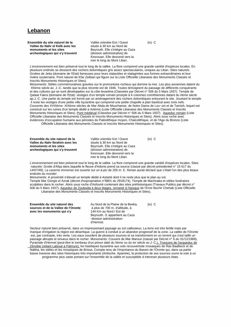
Lebanon
Ensemble du site naturel de la Vallée orientée Est / Ouest (iv) C Vallee du Nahr el Kelb avec les située à 30 km au Nord de monuments et les sites Beyrouth. Elle s'intègre au Caza archeologiques qui s'y trouvent (division administrative) de Kesrouan. Elle descend vers la mer le long du Mont Liban.
L'environnement est bien préservé tout le long de la vallée. La flore comprend une grande variété d'espèces locales. En plusieurs endroits se dressent des rochers dolomitiques gris assez spectaculaires, uniques au Liban. Sites naturels: Grottes de Jeita (domaine de l'Etat) fameuses pour leurs stalactites et stalagmites aux formes extraordinaires et leur rivière souterraine. Pont naturel de Kfar Zeibian qui figure sur la Liste Officielle Libanaise des Monuments Classés et Inscrits Monuments Historiques et Sites). Monuments: Stèles commémoratives gravées sur le promontoire rocheux qui domine la mer. Les plus anciennes datent du XIIème siècle av. J.-C. tandis que la plus récente est de 1946. Toutes témoignent du passage de différents conquérants et des cultures qui se sont développées sur la côte levantine.(Classées par Décret n° 506 du 5 Mars 1937). Temple de Qalaat Fakra (domaine de l'Etat): vestiges d'un temple romain prostyle à 6 colonnes corinthiennes datant du IIème siècle ap.J.-C. Une partie du temple est formé par un aménagement des rochers dolomitiques entourant le site. Jouxtant le temple il reste les vestiges d'une petite ville byzantine qui comprend une petite chapelle à plan basilical avec trois nefs. Couvents des XVIIIème -XIXème siècles de Mar Abda de Mouchamar, de Notre Dame de Lou~zei et de Tamish, lequel est construit sur les ruines d'un temple dédié à Artémis (Liste Officielle Libanaise des Monuments Classés et Inscrits Monuments Historiques et Sites). Pont médiéval (Classées par Décret n° 506 du 5 Mars 1937). Aqueduc romain (Liste Officielle Libanaise des Monuments Classés et Inscrits Monuments Historiques et Sites). Abris sous roche avec évidences d'occupation humaine aux périodes du Paléolithique moyen, Chalcolithique, et de l'Age du Bronze (Liste Officielle Libanaise des Monuments Classés et Inscrits Monuments Historiques et Sites).
Ensemble du site naturel de la Vallée orientée Est / Ouest (iv) C Vallee du Nahr Ibrahim avec les située à 30 km au Nord de monuments et les sites Beyrouth. Elle s'intègre au Caza archeologiques qui s'y trouvent (division administrative) de Kesrouan. Elle descend vers la mer le long du Mont Liban.
L'environnement est bien préservé tout le long de la vallée. La flore comprend une grande variété d'espèces locales. Sites naturels: Grotte d'Afqa dans laquelle le fleuve d'Adonis prend sa source (classé par décret présidentiel n° 15 617 du 14/07/49). La caverne immense est ouverte sur un à-pic de 200 m. E. Renan aurait déclaré que c'était l'un des plus beaux endroits du monde! Monuments: A proximité s'élevait un temple dédié à Astarté dont il ne reste plus que le plan au sol. Temple Mar Giorgis el Azrak (décret d'expropriation n°8801 du 2918174), Temple de Machnaka et stèles funéraires sculptées dans le rocher, Abris sous roche d'Asfourié contenant des sites préhistoriques (Travaux Publics par décret n° 506 du 5 Mars 1937), Aqueduc de Zouboida à deux étages, remanié à l'époque de l'Emir Bechir Chehab (Liste Officielle Libanaise des Monuments Classés et Inscrits Monuments Historiques et Sites).
Ensemble du site naturel des Au Nord de la Plaine de la Beeka, (iv) C sources et de la Vallee de l'Oronte à plus de 700 m. d'altitude, à avec les monuments qui s'y 144 Km au Nord / Est de Beyrouth. I1 appartient au Caza -division administrative- d'Hermel.
Secteur naturel bien préservé, dans un impressionant paysage au sol caillouteux. La terre est très fertile mais par manque d'irrigation la région est désertique. La guerre à conduit à un abandon progressif de la zone. La vallée de l'Oronte est, par contraste, très verte. Les eaux sourdent de plusieurs sources et se transforment en un torrent qui s'est taillé un passage abrupte et sinueux dans le rocher. Monuments: Couvent de Mar Maroun (classé par Décret n° 6 du 31/12/1969), Pyramide d'Hermel (peut-être le tombeau d'un prince daté du IIème ou du Ier siècle av.J.-C.). Tronçons de l'acqueduc de Zénobie (reliant Laboué à Palmyre), les basiliques byzantine aux sols recouvertsde mosaiques de Ras Baalbeck et de Nabha, les stèles et les mosaïques de Brissa. Compte tenu de l'importance du Bassin de l'Oronte qui, dans sa partie basse traverse des sites historiques très importants (Antioche, Apamée), la protection de ses sources ouvre la voie à un programme plus vaste portant sur l'ensemble de la vallée et susceptible d intereser plusieurs états.
MAURITANIA
Paysage culturel d'Azougui Adrar (environ 450 km au nord C (iii)(iv)(v)(vi) de Nouakchott) Le paysage culturel d'Azougui se compose de plusieurs structures culturelles dont l'existence est étroitement liée au milieu, et ce dernier est également soit une production culturelle soit un phénomène naturel qui porte maintenant les empreintes de toutes les valeurs culturelles qu'il abrite. Les composantes essentielles de ce paysage sont: L'Oasis L'apparition du phénomène des Oasis est étroitement lié à la création d'Azougui, dont les vestiges témoignent de ce passé florissant, dans un milieu de plus en plus désertique n'acceptant plus les autres formes d'agriculture. Cette activité économique est devenue rapidement une forme culturelle de la vie quotidienne des populations ; ces dernières ont crée autour de l'oasis l'essentiel de leur mythes et légendes qu'ils continent d'enraciner dans leur mémoire collective et de vivre sous forme de festivités liées à la saison annuelle des dattes. Cette palmeraie, la plus ancienne de la région, compte maintenant plus de vingt mille palmiers et conserve encore le système traditionnel de canalisation et d'exploitation. Ce dernier constitue un véritable métier traditionnel qui risque de disparaître sous l'effet de la modernisation. Le site archéologique Le site archéologique d'Azougui : Première capitale des Almoravides, c'est une forteresse construite en pierre sèche comportant un mur d'enceinte et plusieurs concessions. Cette forteresse a été agrandie au fil des temps, ce qui se justifie par l'urbanisation à l'intérieur du mur de l'enceinte sur un périmètre de plusieurs kilomètres. Le site a été signalé en 1068 par El Bekry et plusieurs autres chroniqueurs arabes l'ont mentionné, nous citons à titre d'exemple Ibn Said, El Kalakshandy et Ibn Khaldoun. Le Mouvement almoravide est une formation politique très importante qui naquit au sein des tribus Sanhaja de Lemtouna et Guedala en Adrar Mauritanien, sous l'autorité d'un chef spirituel d'une rigueur religieuse extraordinaire, Abdullah Ibn Yassin. Ce mouvement a pu unifier l'Afrique occidentale, le Maghreb et la Péninsule Ibérique pendant plusieurs siècles, après avoir investis l'Empire du Ghana, les Idrissides et le royaume de Bourghouata. En 1860, Azougui a été reconnu par Vincent et en 1922 Modat le visite mais c'était TH. Monod (1 948) qui a établit un premier plan du site qui sera détaillé par Mauny plus tard. Les fouilles du site commencèrent en 1979 et se poursuivent actuellement, permettant ainsi de dégager plusieurs concessions et le mur d'enceinte. Les objets archéologiques exhumés fournissent une information éloquente sur le rôle que jouait le site dans le'commerce transsaharien à travers la céramique et le verre, tous importés d'horizons différents, notamment le Maghreb, la Péninsule Ibérique et le proche Orient. En outre la tradition orale fournit des témoignages cohérents et concordants sur le rôle de l'Imam El Mejdhoub, personnalité mythique et religieuse d'envergure et son adepte l'Imam El Hadramy El Morady dont la tombe se situe au coeur du site et dont l'oeuvre manuscrite « El Ichara-Vy Tadbiri El Imara » fut la première en politique dans la région. La falaise est, en effet, un élément naturel important qui a favorisé l'installation humaine dans ce paysage. Elle forme un îlot quasi fermé dont les passages sont contrôlables, permettant ainsi aux populations de se maintenir à l'abri des invasions éventuelles, phénomène très répandu dans l'histoire de la région. Ce milieu fermé a pu être prospère à la vie humaine grâce à la sécurité qu'assure la falaise et à l'oued fertile qui l'entoure et qui traverse le paysage en question.
Site archéologique de Tegdaoust Environ 750 km à l'est de C (iii)(v) Nouakchott Tegdaoust fut une étape incontournable du commerce et de l'industrie métallurgique de l'or, le fer et le cuivre ; elle était certainement la première étape sur la route liant le Maghreb et le pays soudanais. Cette cité a connu un commerce florissant de l'or et des activités socio-économiques très aisées pendant plusieurs sièccles. Le site archéologique date du 8è,e siècle, mais il a connu plusieurs périodes d'occupation qui perdurent dans le temps jusqu'au 13 è,e siècle. Entre 1050 et 1070, le site, qui jusqu'à cette date était sous l'autorité de l'Empire du Ghana, a été conquis par les Almoravides. Les fouilles du sites ont montré l'évolution de l'architecture et de la vie humaine dans un milieu qui connaît une croissance de l'aridité et, elles ont dégagé des objets très significatifs dans le commerce et l'industrie de l'or, dont une balance vraisemblablement la plus ancienne de la région.
MOROCCO
Ville de Lixus Environs de Larache (ii) (iii) (iv) C La ville de Lixus est d’après de nombreux auteurs anciens l'une des premières cites de l'occident méditerranéen. Elle est située à l'embouchure de l'oued Lukkos, en face de la ville moderne de Larache. Les fouilles qui y ont été entreprises ont montré que le site a été occupé depuis le VIIIème siècle avant J.C jusqu'au XIV4me siècle après J.C. Les secteurs fouillés ont touché un quartier religieux constitué de nombreux temples, un quartier d'habitat préroman et romain, un complexe industriel de salaisons (l'un des plus importants du bassin méditerranéen)... La stratigraphie du site comprend 5 grandes phases: phénicienne, punique, mauritanienne, romaine et post-romaine et une dernière phase islamique.
Oman
A Falaj System (not specified) The term -falaj- (plur. aflaj) is used to describe any type of canal, on the ground or subterranean. Underground falaj networks are of paramount importance in the agricultural settlements of Oman, and can certainly be considered as masterpieces of technical work. Several of them are still active all around the country. They have only been partly surveyed (Costa and Wilkinson 1987) and the Ministry of National Heritage and Culture will select the most representative and best preserved example of these systems.
SYRIAN ARAB REPUBLIC
Noréas de Hama Hama à 226 km au Nord de C (i)(iv) Damas sur la riviere Oronte. La rivière Oronte, de son nom assyrien « Aranton », conserve de part et d'autre de son parcours à partir de la région montagneuse de Baalbek au Liban où elle prend naissance jusqu'à la Méditerranée à 30 km en aval de la ville de Latakié, les vestiges d'un nombre considérable d'anciens petits lacs, retenues d'eau, barrages canaux, acqueducs, ponts, terres irriguées, cités disparues ou encore vivantes et noréas dont seule la ville de Hama. traversée par la rivière détient encore quelques importants spécimens (au nombre de dix sept) qui font desormais partie intégrante de son paysage urbain et qui consacrent sa renommée mondiale. Le nom arabe de l'Oronte « El- c Assi » qui signifie « le rebelle » est expliqué au XlIle siècle par Yaqut al-Hamoui ( de Hama) du fait que cette rivière,contrairement à la plupart des rivières, circule dans le sens Sud-Nord et par Abu'l Fida du XIV e siècle par l'usage de la roue pour faire monter l'eau a rebelle » et la distribuer dans la ville et la campagne. Dans la campagne, sur les deux rives de l'Oronte, se trouvent en effet les a Azwar », terres très fertiles plantées de divers arbres fruitiers et irriguées jadis par le système des noréas, une, deux ou plus pour chaque a zùr » selon la superficie du terrain et les besoins en eau. Malheureusement, il ne reste plus grand chose des noréas des Azwar, ce qui ajoute à la valeur de celles de Hamas qui demeurent uniques, pas seulement sur l'Oronte et en Syrie, mais probablement dans le tout monde. La noréa est en effet un mécanisme qui permet d'élever l'eau de la rivière grâce à une roue en bois plus ou moins grande installée au bord de la rivière et dôtée de caissons en bois qui se remplissent d'eau chaque fois que la roue s'enfonce dans le liquide et qui se vident quand ils se trouvent au sommet, en déversant leur contenu dans un bassin ou un acqueduc qui véhicule l'eau aux endroits désirés. A Hama les noréas ont un diamètre qui varie entre 10 et 12 mètres; certaines peuvent atteindre les 22 mètres. On leur attribue souvent des origines médiévales arabes (en arabe na' ùra), mais il est aujourd'huicertainqu'ellesontexisté bien avant comme l'atteste une mosa~que de 469 J.C. trouvée à Apamée sur laquelle est dessinée une noréa dont la ressemblance est des plus frappantes avec celles de Hama. Mue par la puissance hydraulique du cours d'eau, les noréasde Hama se distinguent de celles qu'on voit encore dans plusieurs régions du monde où la force de rotation est soit animale ( boeuf, chameau...) soit humaine, et où les godets en terre cuite ou en cuir remplacent les caissons en bois; elle se distinguent surtout par leur qinantisme et par le complexe système hydraulique qu'elles ennendrent: bassins. aqueducs, canaux d'irrination souterraines, barranes. ponts... Les noréas de Hama continuent à fonctionner d'une manière saisonnière (elles s'arrêtent pendant la saison sèche quand la rivière est au plus bas de son niveau).Plusieurs sont datées et attribuées à des princes ou des gouverneurs qui les ont aménagées pour l'irrigation de leurs propriétés ou pour l'approvisionnement des palais,demeures, mosquées, hammams, caravansérails... Celle appelée la Ma ~muréyya est datée de 1453, a un diamètre de 21 mètres et porte sur son extrados 120 caissons en bois. Elle était destinée à alimenter plusieurs jardins et parcs, neuf mosquées, quatre hammams et cent puits. La Muhammadia est la plus anciennement datée (elle date de 1361), et la plus grande de Hama (22 mètres). Elle

était destinée à alimenter la Grande Mosquée, le hammam ad-dhahab, des jardins et des habitations du quartier. Le mot dùlab ( roue) remplace parfois celui de na' ùra dans certaines inscriptions de fondation.

6.6. Arab States Tentative Industrial Heritage Classification
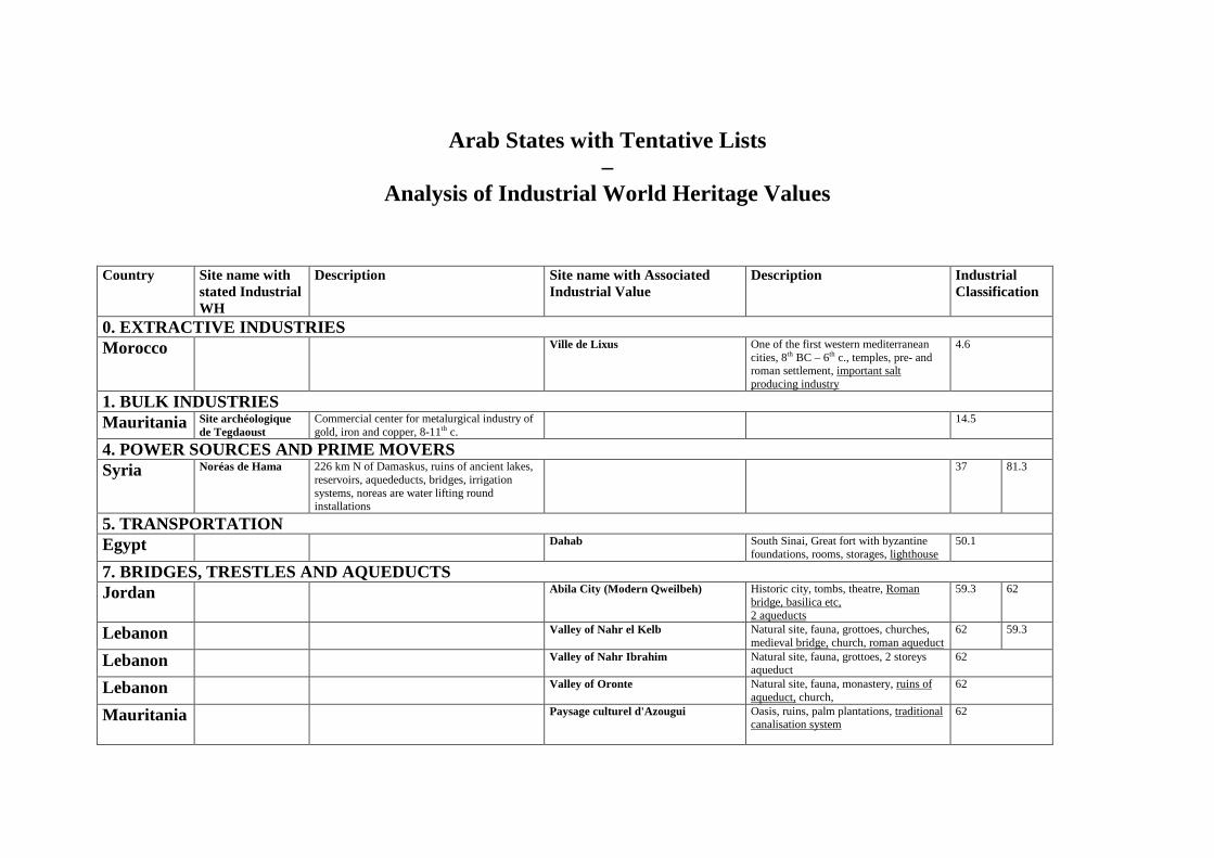
Arab States with Tentative Lists
– Analysis of Industrial World Heritage Values
Country Site name with
stated Industrial WH
Description Site name with Associated Industrial Value
Description Industrial Classification
0. EXTRACTIVE INDUSTRIES Morocco Ville de Lixus One of the first western mediterranean
cities, 8th BC – 6th c., temples, pre- and roman settlement, important salt producing industry
4.6
1. BULK INDUSTRIES Mauritania Site archéologique
de Tegdaoust Commercial center for metalurgical industry of gold, iron and copper, 8-11th c.
14.5
4. POWER SOURCES AND PRIME MOVERS Syria Noréas de Hama 226 km N of Damaskus, ruins of ancient lakes,
reservoirs, aquededucts, bridges, irrigation systems, noreas are water lifting round installations
37 81.3
5. TRANSPORTATION Egypt Dahab
South Sinai, Great fort with byzantine foundations, rooms, storages, lighthouse
50.1
7. BRIDGES, TRESTLES AND AQUEDUCTS Jordan Abila City (Modern Qweilbeh) Historic city, tombs, theatre, Roman
bridge, basilica etc, 2 aqueducts
59.3 62
Lebanon Valley of Nahr el Kelb Natural site, fauna, grottoes, churches, medieval bridge, church, roman aqueduct
62 59.3
Lebanon Valley of Nahr Ibrahim Natural site, fauna, grottoes, 2 storeys aqueduct
62
Lebanon Valley of Oronte Natural site, fauna, monastery, ruins of aqueduct, church,
62
Mauritania Paysage culturel d'Azougui Oasis, ruins, palm plantations, traditional canalisation system
62

9. SPECIALIZED STRUCTURES AND OBJECTS Jordan Al Qastal (Settlement) Oldest and most complete Umayyad
communities in Near East, palace, mosque, cemetery, etc, substantial agricultural dam, reservoir, cistern, 400 m stone dam, quarry
79 4.0
Oman A Falaj System Network of canal, on the ground and subterranean, masterpiece of technical work
81.3

41
6.7. Asia / Pacific Tentative list analysis and description
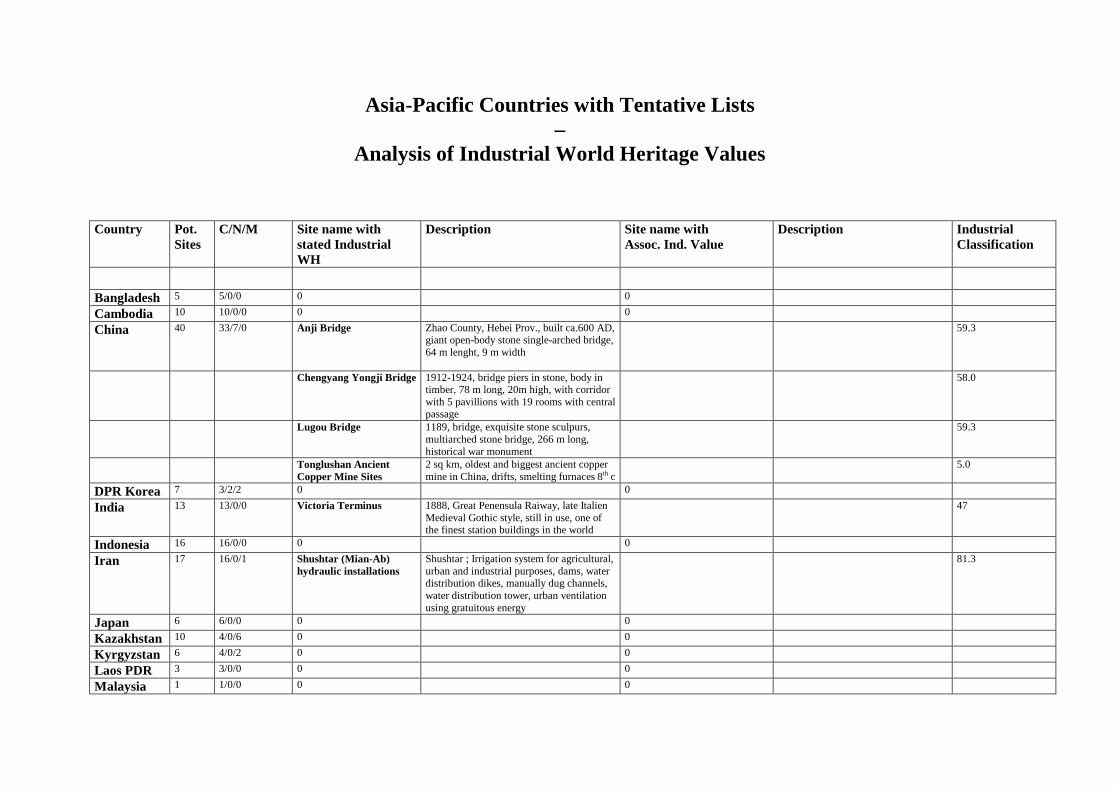
Asia-Pacific Countries with Tentative Lists –
Analysis of Industrial World Heritage Values Country Pot.
Sites C/N/M Site name with
stated Industrial WH
Description Site name with Assoc. Ind. Value
Description Industrial Classification
Bangladesh 5 5/0/0 0 0
Cambodia 10 10/0/0 0 0
China 40 33/7/0 Anji Bridge
Zhao County, Hebei Prov., built ca.600 AD, giant open-body stone single-arched bridge, 64 m lenght, 9 m width
59.3
Chengyang Yongji Bridge 1912-1924, bridge piers in stone, body in timber, 78 m long, 20m high, with corridor with 5 pavillions with 19 rooms with central passage
58.0
Lugou Bridge 1189, bridge, exquisite stone sculpurs, multiarched stone bridge, 266 m long, historical war monument
59.3
Tonglushan Ancient Copper Mine Sites
2 sq km, oldest and biggest ancient copper mine in China, drifts, smelting furnaces 8th c
5.0
DPR Korea 7 3/2/2 0 0
India 13 13/0/0 Victoria Terminus 1888, Great Penensula Raiway, late Italien Medieval Gothic style, still in use, one of the finest station buildings in the world
47
Indonesia 16 16/0/0 0 0
Iran 17 16/0/1 Shushtar (Mian-Ab) hydraulic installations
Shushtar ; Irrigation system for agricultural, urban and industrial purposes, dams, water distribution dikes, manually dug channels, water distribution tower, urban ventilation using gratuitous energy
81.3
Japan 6 6/0/0 0 0
Kazakhstan 10 4/0/6 0 0
Kyrgyzstan 6 4/0/2 0 0
Laos PDR 3 3/0/0 0 0
Malaysia 1 1/0/0 0 0
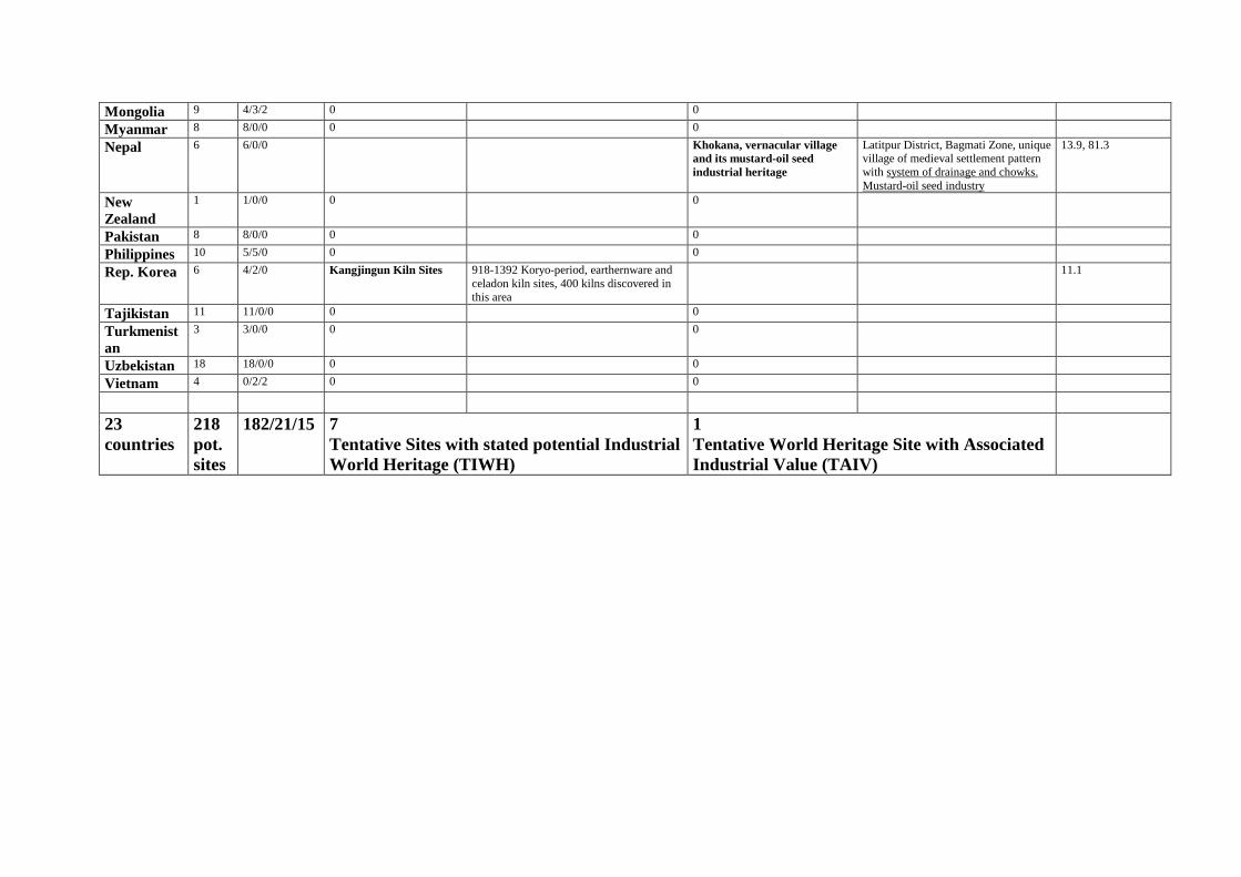
Mongolia 9 4/3/2 0 0
Myanmar 8 8/0/0 0 0
Nepal 6 6/0/0 Khokana, vernacular village and its mustard-oil seed industrial heritage
Latitpur District, Bagmati Zone, unique village of medieval settlement pattern with system of drainage and chowks. Mustard-oil seed industry
13.9, 81.3
New Zealand
1 1/0/0 0 0
Pakistan 8 8/0/0 0 0
Philippines 10 5/5/0 0 0
Rep. Korea 6 4/2/0 Kangjingun Kiln Sites 918-1392 Koryo-period, earthernware and celadon kiln sites, 400 kilns discovered in this area
11.1
Tajikistan 11 11/0/0 0 0
Turkmenistan
3 3/0/0 0 0
Uzbekistan 18 18/0/0 0 0
Vietnam 4 0/2/2 0 0
23 countries
218 pot. sites
182/21/15 7 Tentative Sites with stated potential Industrial World Heritage (TIWH)
1 Tentative World Heritage Site with Associated Industrial Value (TAIV)
Asia-Pacific Countries Tentative List
Tentative Industrial World Heritage Sites (TIWH)
And
Tentative Sites with Associated Industrial Value (TAIV)
–
Brief description on the sites China
Anji Bridge Zhao County, Hebei Province (i)(ii)(iii)(iv) C Long. 115°10' East Lat. 37°40' North Zhaozhou Bridge is another name of Anji Bridge. Anji Bridge was designed by Lichun, a craftsman in Sui Dynasty, and built from the later period of Kaihuang to the early days of Daye (593 - 605 A.D.), so the bridge has a history of 1400 years. Anji Bridge is a giant open-body stone single-arched bridge. with 64,6 meters in lenght, 9 meters in breadth, 37,02 meters in net main-arched span and 7,23 meters in height; it is constructed with 28 arches side by side. There are 2 smaller built separately on both side of the main arch. Anji Bridge initiates the structure of the open-body arch bridge and occupies a very important place in the world bridge building history.
Chengyang Yongji Bridge Long. 109°38' East (i)(ii)(iii)(iv)(v) C Lat. 24°54' North Yongji Bridge was built by the Dong people of Bazhai Village between 1912 and 1924. The piers of the bridge is made of stone and the body of bridge is made of timber. The Bridge is 77,76 meters long, 3,75 meters wide and 20 meters high. There are five piers sustaining the bridge and the span of the four openings is 14 meters. On the bridge there is a corridor with five pavilions, each of which has three layers. The corridor contains nineteen rooms with a central passage through the bridge. On both sides there are timber benches and banisters. The five pavilions are linked by the corridor, and all these make the bridge a well-formed architecture. In addition, the eaves are decorated with all sorts of traditional designs of Dong nationality, and the top of pavilions and corridor are decorated with vermilion calabashes.
Lugou Bridge Long. 116°03' East (i)(iii)(iv) C Lat. 39°52' North Lugou Bridge was built in the Dading period of Jin Dynasty (1189). Lugou Bridge is a representative bridge work in ancient China. The exquisite stone sculptures of Lugou Bridge are well known thoughout the world. It is a multiarched stone bridge which is 266;5 metres long and 7.5 metres wide. It has 11 arches. The span of the biggest arch is 13.42 metres. The bridge has 279 parapet stone slabs and 281 sculptured balusters on its both sides with a stone lion figure carved atop each one. There are 492 lions carved elegantly and vividly in various poseurs. On July 7,1937, the Japanese army shelled Lugou Bridge and Wanpin town to the east of the Lugou Bridge, the Chinese garrison rose in self defense. Lugou Bridge is a precious historical monument.
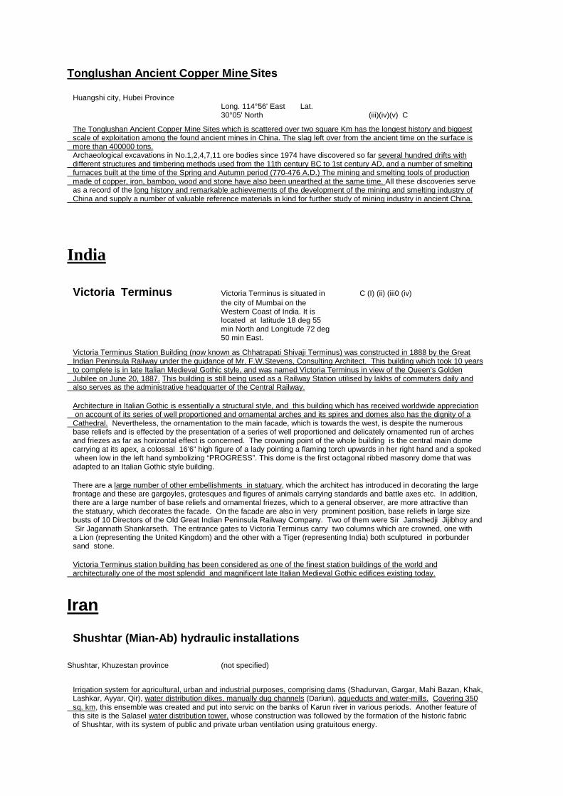
Tonglushan Ancient Copper Mine Sites
Huangshi city, Hubei Province Long. 114°56' East Lat. 30°05' North (iii)(iv)(v) C The Tonglushan Ancient Copper Mine Sites which is scattered over two square Km has the longest history and biggest scale of exploitation among the found ancient mines in China. The slag left over from the ancient time on the surface is more than 400000 tons. Archaeological excavations in No.1,2,4,7,11 ore bodies since 1974 have discovered so far several hundred drifts with different structures and timbering methods used from the 11th century BC to 1st century AD, and a number of smelting furnaces built at the time of the Spring and Autumn period (770-476 A.D.) The mining and smelting tools of production made of copper, iron, bamboo, wood and stone have also been unearthed at the same time. All these discoveries serve as a record of the long history and remarkable achievements of the development of the mining and smelting industry of China and supply a number of valuable reference materials in kind for further study of mining industry in ancient China.
India
Victoria Terminus Victoria Terminus is situated in C (I) (ii) (iii0 (iv) the city of Mumbai on the Western Coast of India. It is located at latitude 18 deg 55 min North and Longitude 72 deg 50 min East.
Victoria Terminus Station Building (now known as Chhatrapati Shivaji Terminus) was constructed in 1888 by the Great Indian Peninsula Railway under the guidance of Mr. F.W.Stevens, Consulting Architect. This building which took 10 years to complete is in late Italian Medieval Gothic style, and was named Victoria Terminus in view of the Queen’s Golden Jubilee on June 20, 1887. This building is still being used as a Railway Station utilised by lakhs of commuters daily and also serves as the administrative headquarter of the Central Railway. Architecture in Italian Gothic is essentially a structural style, and this building which has received worldwide appreciation on account of its series of well proportioned and ornamental arches and its spires and domes also has the dignity of a Cathedral. Nevertheless, the ornamentation to the main facade, which is towards the west, is despite the numerous base reliefs and is effected by the presentation of a series of well proportioned and delicately ornamented run of arches and friezes as far as horizontal effect is concerned. The crowning point of the whole building is the central main dome carrying at its apex, a colossal 16’6” high figure of a lady pointing a flaming torch upwards in her right hand and a spoked wheen low in the left hand symbolizing “PROGRESS”. This dome is the first octagonal ribbed masonry dome that was adapted to an Italian Gothic style building. There are a large number of other embellishments in statuary, which the architect has introduced in decorating the large frontage and these are gargoyles, grotesques and figures of animals carrying standards and battle axes etc. In addition, there are a large number of base reliefs and ornamental friezes, which to a general observer, are more attractive than the statuary, which decorates the facade. On the facade are also in very prominent position, base reliefs in large size busts of 10 Directors of the Old Great Indian Peninsula Railway Company. Two of them were Sir Jamshedji Jijibhoy and Sir Jagannath Shankarseth. The entrance gates to Victoria Terminus carry two columns which are crowned, one with a Lion (representing the United Kingdom) and the other with a Tiger (representing India) both sculptured in porbunder sand stone. Victoria Terminus station building has been considered as one of the finest station buildings of the world and architecturally one of the most splendid and magnificent late Italian Medieval Gothic edifices existing today.
Iran
Shushtar (Mian-Ab) hydraulic installations
Shushtar, Khuzestan province (not specified) Irrigation system for agricultural, urban and industrial purposes, comprising dams (Shadurvan, Gargar, Mahi Bazan, Khak, Lashkar, Ayyar, Qir), water distribution dikes, manually dug channels (Dariun), aqueducts and water-mills. Covering 350 sq. km, this ensemble was created and put into servic on the banks of Karun river in various periods. Another feature of this site is the Salasel water distribution tower, whose construction was followed by the formation of the historic fabric of Shushtar, with its system of public and private urban ventilation using gratuitous energy.
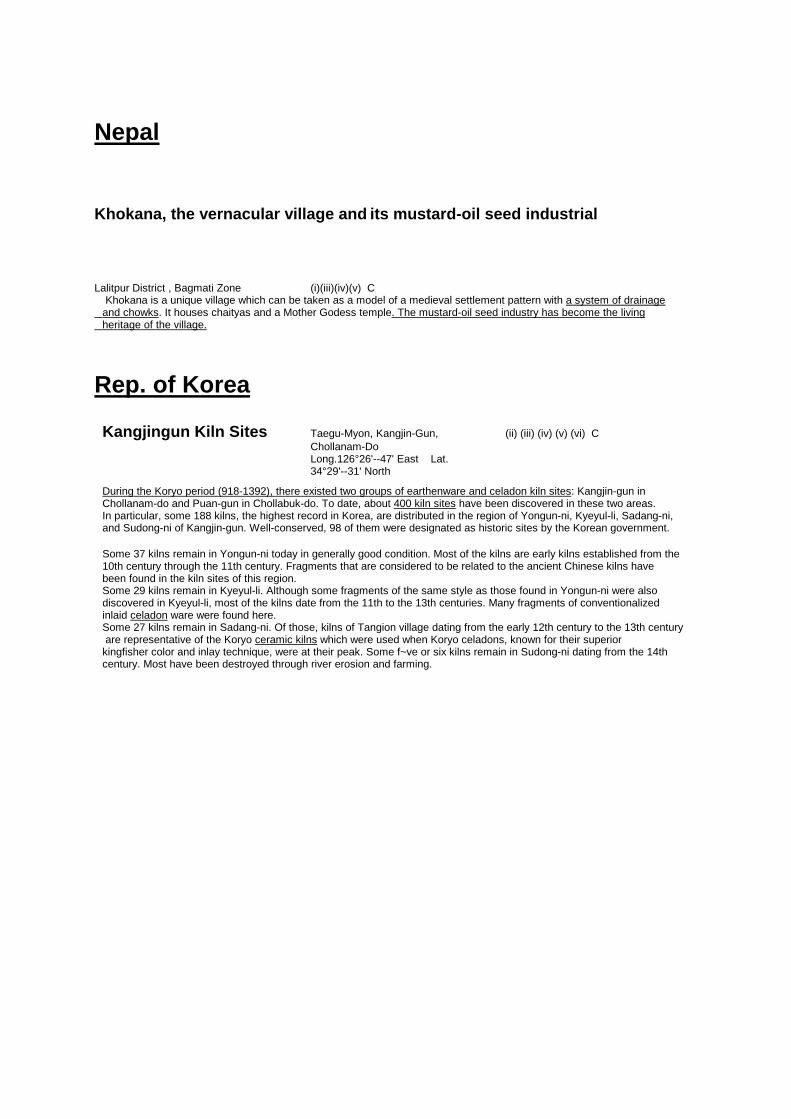
Nepal
Khokana, the vernacular village and its mustard-oil seed industrial
Lalitpur District , Bagmati Zone (i)(iii)(iv)(v) C Khokana is a unique village which can be taken as a model of a medieval settlement pattern with a system of drainage and chowks. It houses chaityas and a Mother Godess temple. The mustard-oil seed industry has become the living heritage of the village.
Rep. of Korea
Kangjingun Kiln Sites Taegu-Myon, Kangjin-Gun, (ii) (iii) (iv) (v) (vi) C Chollanam-Do Long.126°26'--47' East Lat. 34°29'--31' North During the Koryo period (918-1392), there existed two groups of earthenware and celadon kiln sites: Kangjin-gun in Chollanam-do and Puan-gun in Chollabuk-do. To date, about 400 kiln sites have been discovered in these two areas. In particular, some 188 kilns, the highest record in Korea, are distributed in the region of Yongun-ni, Kyeyul-li, Sadang-ni, and Sudong-ni of Kangjin-gun. Well-conserved, 98 of them were designated as historic sites by the Korean government. Some 37 kilns remain in Yongun-ni today in generally good condition. Most of the kilns are early kilns established from the 10th century through the 11th century. Fragments that are considered to be related to the ancient Chinese kilns have been found in the kiln sites of this region. Some 29 kilns remain in Kyeyul-li. Although some fragments of the same style as those found in Yongun-ni were also discovered in Kyeyul-li, most of the kilns date from the 11th to the 13th centuries. Many fragments of conventionalized inlaid celadon ware were found here. Some 27 kilns remain in Sadang-ni. Of those, kilns of Tangion village dating from the early 12th century to the 13th century are representative of the Koryo ceramic kilns which were used when Koryo celadons, known for their superior kingfisher color and inlay technique, were at their peak. Some f~ve or six kilns remain in Sudong-ni dating from the 14th century. Most have been destroyed through river erosion and farming.

42
6.8. Asia / Pacific Tentative Industrial Heritage Classification
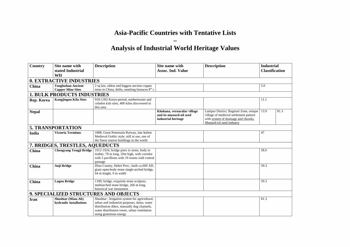
Asia-Pacific Countries with Tentative Lists –
Analysis of Industrial World Heritage Values Country Site name with
stated Industrial WH
Description Site name with Assoc. Ind. Value
Description Industrial Classification
0. EXTRACTIVE INDUSTRIES China Tonglushan Ancient
Copper Mine Sites 2 sq km, oldest and biggest ancient copper mine in China, drifts, smelting furnaces 8th c
5.0
1. BULK PRODUCTS INDUSTRIES Rep. Korea Kangjingun Kiln Sites 918-1392 Koryo-period, earthernware and
celadon kiln sites, 400 kilns discovered in this area
11.1
Nepal Khokana, vernacular village and its mustard-oil seed industrial heritage
Latitpur District, Bagmati Zone, unique village of medieval settlement pattern with system of drainage and chowks. Mustard-oil seed industry
13.9 81.3
5. TRANSPORTATION India Victoria Terminus 1888, Great Penensula Raiway, late Italien
Medieval Gothic style, still in use, one of the finest station buildings in the world
47
7. BRIDGES, TRESTLES, AQUEDUCTS China Chengyang Yongji Bridge 1912-1924, bridge piers in stone, body in
timber, 78 m long, 20m high, with corridor with 5 pavillions with 19 rooms with central passage
58.0
China Anji Bridge
Zhao County, Hebei Prov., built ca.600 AD, giant open-body stone single-arched bridge, 64 m lenght, 9 m width
59.3
China Lugou Bridge 1189, bridge, exquisite stone sculpurs, multiarched stone bridge, 266 m long, historical war monument
59.3
9. SPECIALIZED STRUCTURES AND OBJECTS Iran Shushtar (Mian-Ab)
hydraulic installations Shushtar ; Irrigation system for agricultural, urban and industrial purposes, dams, water distribution dikes, manually dug channels, water distribution tower, urban ventilation using gratuitous energy
81.3

43
6.9. Europe / North America Tentative list analysis and description
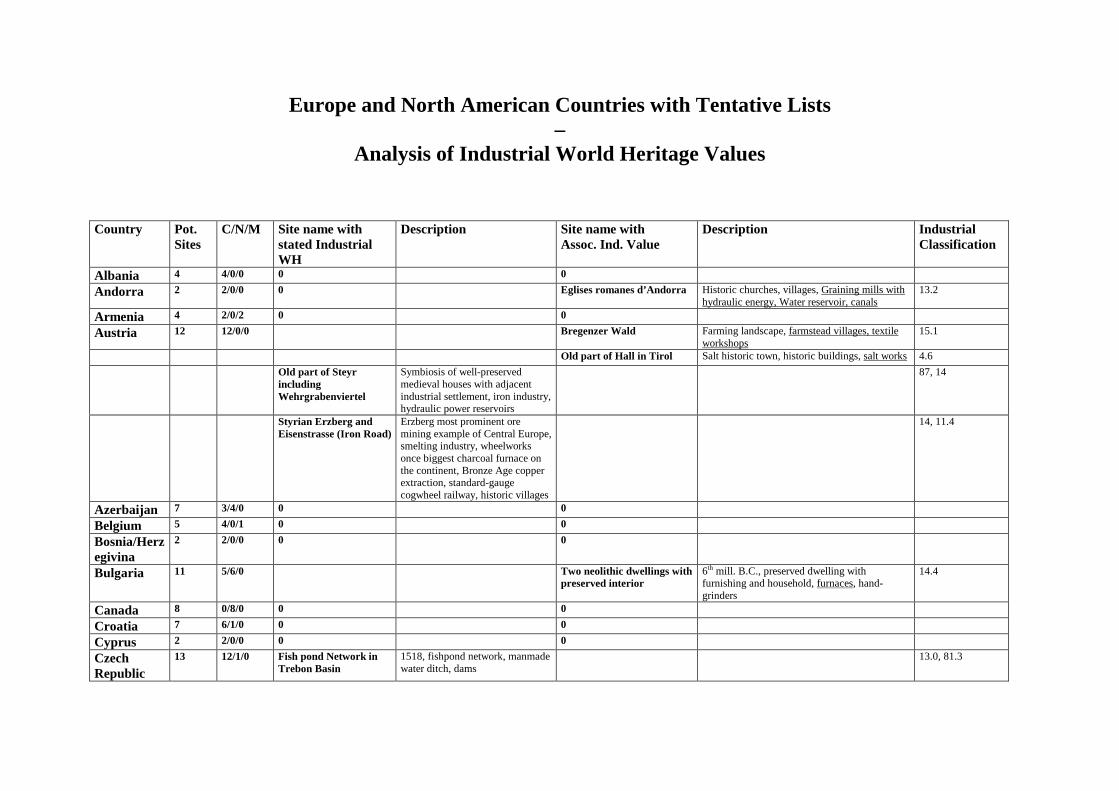
Europe and North American Countries with Tentative Lists –
Analysis of Industrial World Heritage Values Country Pot.
Sites C/N/M Site name with
stated Industrial WH
Description Site name with Assoc. Ind. Value
Description Industrial Classification
Albania 4 4/0/0 0 0
Andorra 2 2/0/0 0 Eglises romanes d’Andorra Historic churches, villages, Graining mills with hydraulic energy, Water reservoir, canals
13.2
Armenia 4 2/0/2 0 0
Austria 12 12/0/0 Bregenzer Wald Farming landscape, farmstead villages, textile workshops
15.1
Old part of Hall in Tirol Salt historic town, historic buildings, salt works 4.6
Old part of Steyr including Wehrgrabenviertel
Symbiosis of well-preserved medieval houses with adjacent industrial settlement, iron industry, hydraulic power reservoirs
87, 14
Styrian Erzberg and Eisenstrasse (Iron Road)
Erzberg most prominent ore mining example of Central Europe, smelting industry, wheelworks once biggest charcoal furnace on the continent, Bronze Age copper extraction, standard-gauge cogwheel railway, historic villages
14, 11.4
Azerbaijan 7 3/4/0 0 0
Belgium 5 4/0/1 0 0
Bosnia/Herzegivina
2 2/0/0 0 0
Bulgaria 11 5/6/0 Two neolithic dwellings with preserved interior
6th mill. B.C., preserved dwelling with furnishing and household, furnaces, hand-grinders
14.4
Canada 8 0/8/0 0 0
Croatia 7 6/1/0 0 0
Cyprus 2 2/0/0 0 0
Czech Republic
13 12/1/0 Fish pond Network in Trebon Basin
1518, fishpond network, manmade water ditch, dams
13.0, 81.3
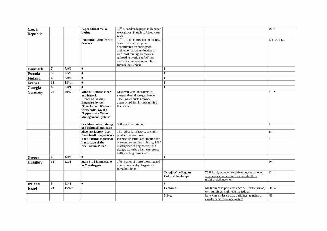
Czech Republic
Paper Mill at Velké Losiny
16th c. handmade paper mill, paper work shops, Francis turbine, water wheel
16.4
Industrial Complexes at Ostrava
19th c., Coal mines, coking plants, blast furnaces, complete concentrated technology of anthracite-based production of iron, coal mining, ironworks, railroad network, shaft 671m, electrification machines, blast furnace, settlement
2, 11.6, 14.2
Denmark 7 7/0/0 0 0
Estonia 5 0/5/0 0 0
Finland 6 6/0/0 0 0
France 16 11/4/1 0 0
Georgia 6 5/0/1 0 0
Germany 21 20/0/1 Mine of Rammelsberg and historic town of Goslar - Extension by the "Oberharzer Wasser-wirtschaft", i.e. the "Upper Harz Water Management System"
Medieval water management system, dam, drainage channel 1150, water ducts network, aqueduct 953m, historic mining landscape
81, 2
Ore Mountains: mining and cultural landscape
800 years ore mining 1
Shoe last factory Carl Benscheidt, Fagus-Werk
1914 Shoe last factory, sawmill, production machines
21
The Cultural Industrial Landscape of the "Zollverein Mine"
Biggest industrial conurbation for one century, mining industry, 1930 masterpiece of engineering and design, workshop hall, compressor halls, cooling towers, etc
2
Greece 4 4/0/0 0 0
Hungary 12 9/2/1 State Stud-farm Estate in Mezöhegyes
1784 center of horse-breeding and animal husbandry, large-scale farm, buildings
10
Tokaji Wine Region Cultural landscape
7248 km2, grape vine cultivation, settlements, vine houses and vaulted or carved cellars, multileveled, network
13.4
Ireland 8 3/3/2 0 0
Israel 23 15/1/7 Caesarea Mediterranean port city since hellenistic period, city buildings, high-level aqueduct,
50, 62
Shivta Late Roman desert city, buildings, remains of canals, dams, drainage system
81
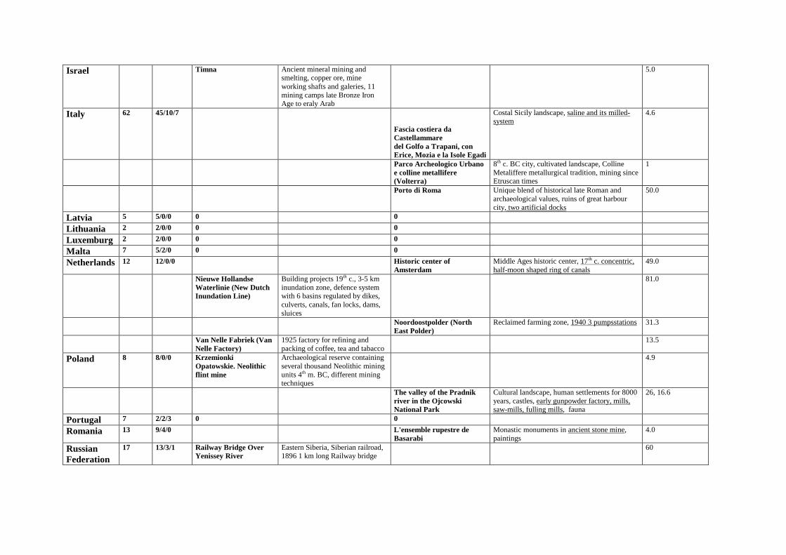
Israel Timna Ancient mineral mining and smelting, copper ore, mine working shafts and galeries, 11 mining camps late Bronze Iron Age to eraly Arab
5.0
Italy 62 45/10/7
Fascia costiera da Castellammare del Golfo a Trapani, con Erice, Mozia e la Isole Egadi
Costal Sicily landscape, saline and its milled-system
4.6
Parco Archeologico Urbano e colline metallifere (Volterra)
8th c. BC city, cultivated landscape, Colline Metaliffere metallurgical tradition, mining since Etruscan times
1
Porto di Roma Unique blend of historical late Roman and archaeological values, ruins of great harbour city, two artificial docks
50.0
Latvia 5 5/0/0 0 0
Lithuania 2 2/0/0 0 0
Luxemburg 2 2/0/0 0 0
Malta 7 5/2/0 0 0
Netherlands 12 12/0/0 Historic center of Amsterdam
Middle Ages historic center, 17th c. concentric, half-moon shaped ring of canals
49.0
Nieuwe Hollandse Waterlinie (New Dutch Inundation Line)
Building projects 19th c., 3-5 km inundation zone, defence system with 6 basins regulated by dikes, culverts, canals, fan locks, dams, sluices
81.0
Noordoostpolder (North East Polder)
Reclaimed farming zone, 1940 3 pumpsstations 31.3
Van Nelle Fabriek (Van Nelle Factory)
1925 factory for refining and packing of coffee, tea and tabacco
13.5
Poland 8 8/0/0 Krzemionki Opatowskie. Neolithic flint mine
Archaeological reserve containing several thousand Neolithic mining units 4th m. BC, different mining techniques
4.9
The valley of the Pradnik river in the Ojcowski National Park
Cultural landscape, human settlements for 8000 years, castles, early gunpowder factory, mills, saw-mills, fulling mills, fauna
26, 16.6
Portugal 7 2/2/3 0 0
Romania 13 9/4/0 L'ensemble rupestre de Basarabi
Monastic monuments in ancient stone mine, paintings
4.0
Russian Federation
17 13/3/1 Railway Bridge Over Yenissey River
Eastern Siberia, Siberian railroad, 1896 1 km long Railway bridge
60
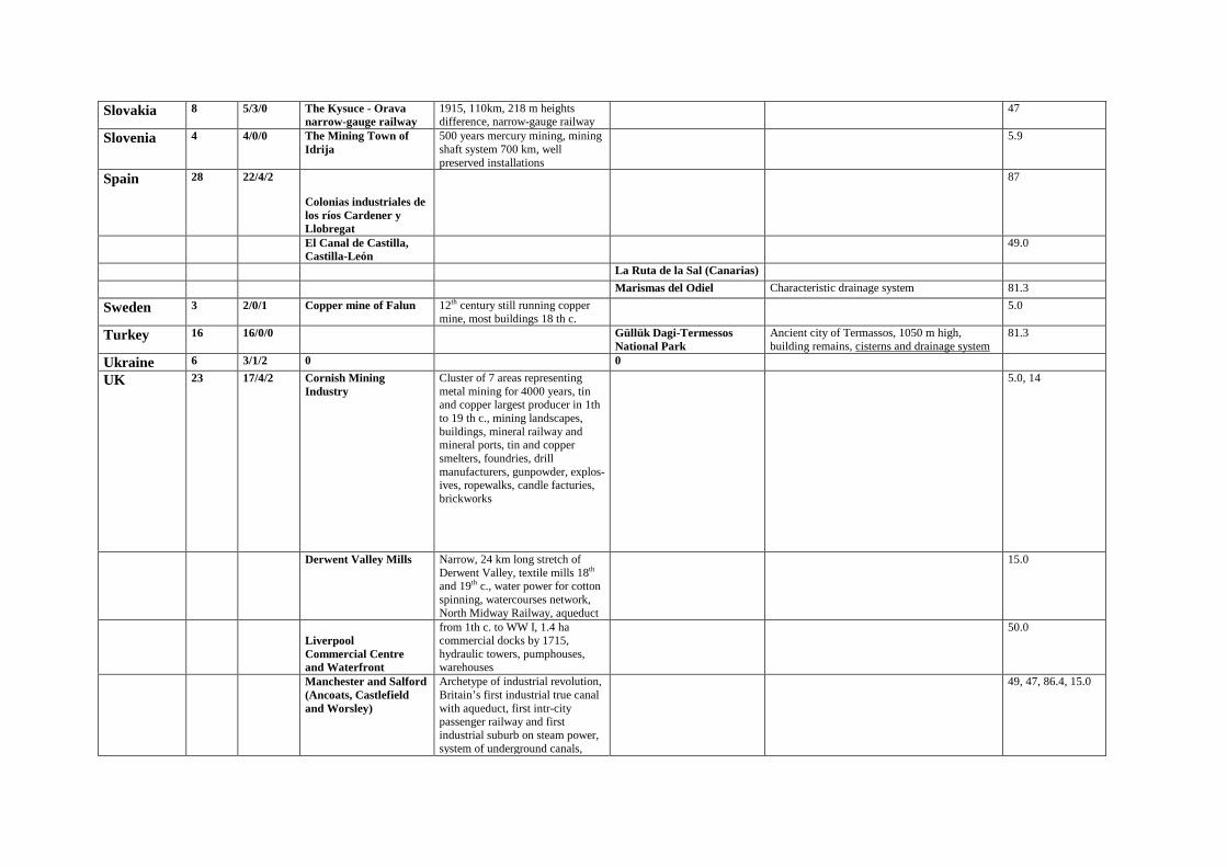
Slovakia 8 5/3/0 The Kysuce - Orava narrow-gauge railway
1915, 110km, 218 m heights difference, narrow-gauge railway
47
Slovenia 4 4/0/0 The Mining Town of Idrija
500 years mercury mining, mining shaft system 700 km, well preserved installations
5.9
Spain 28 22/4/2
Colonias industriales de los ríos Cardener y Llobregat
87
El Canal de Castilla, Castilla-León
49.0
La Ruta de la Sal (Canarias)
Marismas del Odiel Characteristic drainage system 81.3
Sweden 3 2/0/1 Copper mine of Falun 12th century still running copper mine, most buildings 18 th c.
5.0
Turkey 16 16/0/0 Güllük Dagi-Termessos National Park
Ancient city of Termassos, 1050 m high, building remains, cisterns and drainage system
81.3
Ukraine 6 3/1/2 0 0
UK 23 17/4/2 Cornish Mining Industry
Cluster of 7 areas representing metal mining for 4000 years, tin and copper largest producer in 1th to 19 th c., mining landscapes, buildings, mineral railway and mineral ports, tin and copper smelters, foundries, drill manufacturers, gunpowder, explos-ives, ropewalks, candle facturies, brickworks
5.0, 14
Derwent Valley Mills Narrow, 24 km long stretch of Derwent Valley, textile mills 18th and 19th c., water power for cotton spinning, watercourses network, North Midway Railway, aqueduct
15.0
Liverpool Commercial Centre and Waterfront
from 1th c. to WW I, 1.4 ha commercial docks by 1715, hydraulic towers, pumphouses, warehouses
50.0
Manchester and Salford (Ancoats, Castlefield and Worsley)
Archetype of industrial revolution, Britain’s first industrial true canal with aqueduct, first intr-city passenger railway and first industrial suburb on steam power, system of underground canals,
49, 47, 86.4, 15.0
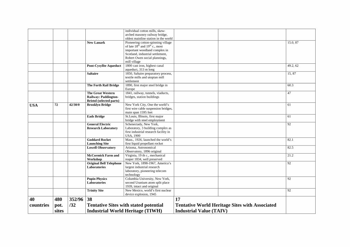
individual cotton mills, skew-arched masonry railway bridge, oldest mainline station in the world
New Lanark Pioneering cotton-spinning village of late 18th and 19th c., most important woodland complex in Scotland, industrial settlement, Robert Owen social plannings, mill village
15.0, 87
Pont-Cysyllte Aqueduct 1800 cast iron, highest canal aqueduct, 313 m long
49.2, 62
Saltaire 1850, Saltaire preparatory process, textile mills and utopian mill settlement
15, 87
The Forth Rail Bridge 1890, first major steel bridge in Europe
60.3
The Great Western Railway: Paddington-Bristol (selected parts)
1841, railway, tunnels, viaducts, bridges, station buildings
47
USA 72 42/30/0 Brooklyn Bridge New York City, One the world’s first wire cable suspension bridges, main span 1595 feet
61
Eads Bridge St.Louis, Illinois, first major bridge with steel employment
61
General Electric Research Laboratory
Schenectady, New York, Laboratory, 3 building complex as first industrial research facility in USA, 1900
92
Goddard Rocket Launching Site
Mass., 1926, launched the world’s first liquid propellant rocket
82.1
Lowell Observatory Arizona, Astronomical Observatory, 1896 original
82.5
McCormick Farm and Workshop
Virginia, 19 th c., mechanical reaper 1834, well preserved
21.2
Original Bell Telephone Laboratories
New York, 1898-1967, America’s largest industrial research laboratory, pioneering telecom technology
92
Pupin Physics Laboratories
Columbia University, New York, second Uranium atom split place 1939, intact and original
92
Trinity Site New Mexico, world’s first nuclear device explosion, 1945
92
40 countries
480 pot. sites
352/96/32
38 Tentative Sites with stated potential Industrial World Heritage (TIWH)
17 Tentative World Heritage Sites with Associated Industrial Value (TAIV)
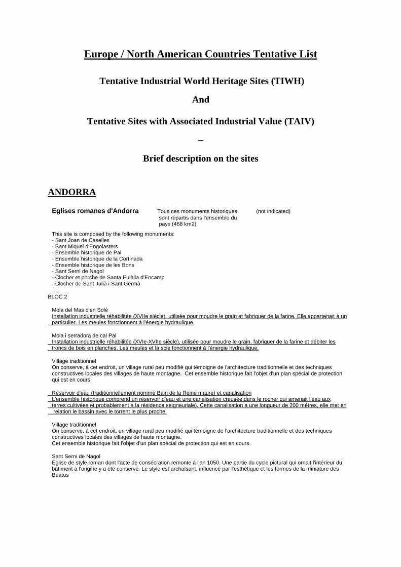
Europe / North American Countries Tentative List
Tentative Industrial World Heritage Sites (TIWH)
And
Tentative Sites with Associated Industrial Value (TAIV)
–
Brief description on the sites ANDORRA
Eglises romanes d'Andorra Tous ces monuments historiques (not indicated) sont répartis dans l'ensemble du pays (468 km2) This site is composed by the following monuments: - Sant Joan de Caselles - Sant Miquel d'Engolasters - Ensemble historique de Pal - Ensemble historique de la Cortinada - Ensemble historique de les Bons - Sant Serni de Nagol - Clocher et porche de Santa Eulàlia d'Encamp - Clocher de Sant Julià i Sant Germà …. BLOC 2 Mola del Mas d'en Solé Installation industrielle réhabilitée (XVIIe siècle), utilisée pour moudre le grain et fabriquer de la farine. Elle appartenait à un particulier. Les meules fonctionnent à l'énergie hydraulique. Mola i serradora de cal Pal Installation industrielle réhabilitée (XVIe-XVIIe siècle), utilisée pour moudre le grain, fabriquer de la farine et débiter les troncs de bois en planches. Les meules et la scie fonctionnent à l'énergie hydraulique. Village traditionnel On conserve, à cet endroit, un village rural peu modifié qui témoigne de l'architecture traditionnelle et des techniques constructives locales des villages de haute montagne. Cet ensemble historique fait l'objet d'un plan spécial de protection qui est en cours. Réservoir d'eau (traditionnellement nommé Bain de la Reine maure) et canalisation L'ensemble historique comprend un réservoir d'eau et une canalisation creusée dans le rocher qui amenait l'eau aux terres cultivées et probablement à la résidence seigneuriale). Cette canalisation a une longueur de 200 mètres, elle met en relation le bassin avec le torrent le plus proche. Village traditionnel On conserve, à cet endroit, un village rural peu modifié qui témoigne de l'architecture traditionnelle et des techniques constructives locales des villages de haute montagne. Cet ensemble historique fait l'objet d'un plan spécial de protection qui est en cours. Sant Serni de Nagol Eglise de style roman dont l'acte de consécration remonte à l'an 1050. Une partie du cycle pictural qui ornait l'intérieur du bâtiment à l'origine y a été conservé. Le style est archaïsant, influencé par l'esthétique et les formes de la miniature des Beatus

Austria
Bregenzerwald (Bregenz Forest) Vorarlberg (iv)(v) C ; (i) N An impressive landscape on the north side of the Alps, the Bregenzerwald has largely maintained its traditional farming structure including the specific types of farmstead buildings. In the long-stretched linear or nucleated villages many of the characteristic Bregenzerwald farmsteads of the 18th and 19th centuries have been conserved. They reflect in their shapes and styles the economic history of the country, the regional agricultural conditions, but also the early onset of industrial development in Vorarlberg which is embodied in the rural architecture of the time. Many small textile processing workshops in the farming milieu are a testimony to this development. A number of villages, such as Thal, Schwarzenberg, or Schoppernau, still have some fine examples of original "Walderhauser" (Forest Houses) to illustrate this largest and most uniform housing landscape of Vorarlberg. The wooden buildings covered by characteristic shingle roofing determine the appearance of the cultural landscape, and their various types and shapes document the economic and cultural development of the region.
Old part of Hall in Tirol Tirol (i)(iii)(iv) C ; (i) N As indicated by its German name, the town has been closely linked with salt production since medieval times. Great merchants and ship masters, townsmen and craftsmen lived from it. Seat of the sovereign's mint, Hall at times outdid today's provincial capital Innsbruck. The former riches are illustrated by the preserved secular (Castle Hasegg, salt works,hospital,town hall,private houses) and ecclesiastical (parish church, religious institution for ladies) building substance. The original design of the town has hardly been spoiled and is clearly separated from the remaining settlement area by the town wall. A special feature of the old town are the topographically separate entities of an upper and a lower town, each having its own town square. Also notable the revitalised former spa, which is situated to the north of the told town and dates from the times between the wars. It is now used for meetings and events. Hall was one of the first towns to benefit from the facade restoration action. In over 20 building phases it has restored the street zones of almost the entire old town in an exemplary manner.
Old part of Steyr including Upper Austria (i)(ii)(iii)(iv) C ; (i) N Wehrgrabenviertel The old town of Steyr and the Wehrgrabenviertel, or moat quarters, form a unique symbiosis of well-preserved medieval houses with adjacent industrial settlement ("Steyrdorf" merging into the rural suburbs). Situated at the confluence of the Enns and Steyr rivers the castle and the surrounding city, which controlled the river crossings, originate in 990. The rivers served both as trafic routes and as hydraulic power reservoirs for the iron industry fluorishing since medieval times owing to the rich ore deposit in the hinterland. Steyr is one of the most significant historic industrial towns in Austria. In the 20th century, the economic importance of the Wehrgrabenviertel declined, a fact that helped preserve the quarter in its entire substance. Since the Middle Ages a number of outstanding Renaissance and Baroque buildings were added to the old town which has maintained its prospect of a complete ensemble to date: a large main square is lined with magnificent houses and dominated by the beautiful Late Gothic parish church on the hill above.
Styrian Erzberg and Eisenstraße Styria (iii)(iv) C ; (i) N (Iron Road) The Erzberg/Eisenstraße region between the towns of Leoben and Hieflau in Styria has been coined in terms of architecture and landscape by its iron mining, smelting and trading activities since the Middle Ages. The Erzberg represents the most prominent ore mining example in Central Europe. The formerly preferred and now exclusive open pit mining process with its imposing worked terraces has resulted in a stepped shape of the entire mountainside. The former ore smelting industry in Eissenerz featured 19 ironworks dating back to the 16th century. In Vordernberg, there were 14 so-called "wheelworks". Essential parts of these three works, which were renewed in the 19th century, have been preserved, especially in the latter town; the large roasting plant near the medieval Laurenzikirche, the wheelwork IV of 1846 complete with all its technical equipment, parts of the wheelworks I,III,X,XI and XIV, a hammer mill and the former mining school (1840-49, today the mining university in Leoben), as well as numerous miners houses in both Eisenerz and Vordemberg. Leoben's townscape is characterised by the houses of rich iron merchants. The same applies to Trofaiach where you also find the remains of the once biggest charcoal furnace on the continent. Radmer still shows traces of Bronze Age copper extraction, as well as remains of later copper production and ore mining done until recently, 1çth century Hieflau, too,had a furnace plus the large "timber rake" in the Enns river with the adjacent "charcoal burning ground" where the timber transported by the river was charred to become charcoal to be delivered to Eisenerz. Of the former haulage systems the most notable are the roadside structure of the former rail line from Erzberg to Vordernberg, the water ton lift at the Erzberg mountain and the standard-gauge cogwheel railway over the Prabichl mountain opened in 1891. A number of other auxiliary facilities of the once exclusive ore mining and smelting region complement its appearance, 700 years of extensive industrial activity have shaped the area into an exceptional and impressive cultural landscape.

Bulgaria
Two neolithic dwellings with their interior and household furnishings and utensils completely preserved.
City of Stara Zagora, in the district of the Higher Institute of Medicine (iii)(iv) C
They are located in the city of Stara Zagora, in the district of the Higher Institute of Medicine.The two dwellings stand side by side. They date back to the 6th millennium before our era. They were discovered in the course of excavations. By a rare chance, all the furnishings and household utensils have been preserved intact since discovery. At present, they are the best preserved dwellings of that period found in Bulgaria or in any other country. The furnaces, hand-grinders, the numerous ceramic vessels, stone implements, ornaments and the like are in very good condition. The dwellings offer a complete idea of the life of a neo--lithic family - its number, economic life and everyday occupations, the nature of home furnishings and utensils, the manner of building, maintenance, the preparation of food, etc. The neo-lithic dwellings of Stara Zagora are a unique monument of culture in Europe and Hither Asia from that early era. They have been declared monuments of culture. All findings have been preserved and conserved in the exact position in which they were discovered. A special museum has been built above them. The public has access to the archaeological monument through a roundabout corridor. An exhibition room and other rooms attached to the museum, have been built as well.
CZECH REPUBLIC Fishpond Network in the Trebon 49°00'10" N / 14°45'52" E C (i)(ii)(iii)(iv)(v) Basin The Trebon Basin is a world?famous area of Southern Bohemia. Its marvelous nature and landscape arising from sophisticated man's waterworks are multiplied by numerous cnd topquality cultural monuments. There, we can also still admire important historical technical works that transformed the originally forbidding forests and marshland into a prosperous region. The advanced fish farming, which had developed from the Middle Ages, culminated in works of Renaissance masters ? fish?pond builders ? $tepanek Netolickjr, Ruthard of Male§sov, and Jakub Krcin of Jelcany. The most important technical works in the region of Tfeboh include fish ponds of the Rozmberk fish?pond system along the so?called Golden Canal and the New River ? man?made rivers built in the 16th century. Predominant in the fishpond network are two ponds. The Rozmberk Pond, currently the largest fish?pond in the Czech Republic, and the Svet Pond that, being part of the historical entrenchments of the town of Trebon, is still an important monument of both historical and technical significance. The name of the region derives from its natural administration and economic center ? the town of Tfebon, which had developed since the 12th century along the trade link between the towns of Jindrichuv Hradec and Ceske Budejovice. Prosperity of the town started after 1366 when the town was acquired by the dynasty of Rozmberk, one of the most powerful Czech royal family of the high Middle Ages. It was just the dynasty of Rozmberk that went in for fish?farming, supported the building of fish?ponds and systems of fish?ponds. The town of Tfeboh experienced its rise in the 16th and early 17th centuries and that period is still characteristic for the development of the historical downtown. Close to the town of Trebon, the two largest fish ponds of the region were built ? Svet (the World) Pond and the Rozmberk Pond. The Golden Canal (Zlata, stoka) ? the work of fish?pond builder ttepanek Netolicky ? is a man?made water ditch that was designed to supply the system of fish ponds with fresh flowing water, which is necessary for fish?farming. The Golden Canal does not go through fish ponds; water is supplied to fish ponds by short races. Water from partial fish pond systems then flows off to the "mother river" of Luznice. The work concept was created in 1506 and the complete ditch finished in 1518. The ditch used to be for along time the longest man?made line waterworks in Central Europe. We can still admire the sophisticated design of the technical work, which reaches with its length of almost forty?five kilometers the total gradient of mere 31 meters, Le. less than 0.7 meters per kilometer of length. Part of the Golden Canal was also connected to the entrenchment system of the town of Trebon, in the picture of which it still appears. The New River (Nova reka) is a unique waterworks deflecting part of the Luznice River to the Nezarka River. The New River was designed to secure the dam of the largest fish pond in the region ? Rozmberk ? against seasonal torrential rain. This other Renaissance canal was not only a canal with utility function, but due to the sensitive laying out it is an actual river, the riverbed of which is perfectly integrated in the landscape. Water from the original Luznice River is separated by a cross dam with weirs and a sluice dividing it as necessary either to the original riverbed or to the New River. The Roimberk Pond is in fact a historical reservoir on the Luznice River. Its dam is an exceptional piece of technical work built in 1585 through 1589. The dam long 2.5 kilometers is wide almost 50 meters at the foundations, 13.5 meters at the crest and almost 10 meters at the main outlet. The dam top is reinforced with four rows of oak trees. Some of them are considered to be original trees. The pretentious construction of the fish pond was the zenith of work of fish?pond master Jakub Krdin of Jelcany, administrator of Rozmberk's estate of Tfebon. At that time the Rozmberk pond was the largest fish pond in the Czech Kingdom and entire Central Europe, and still today it is a functional work with esthetic, historical and use values. The Svet Pond was established in the suburbs of Tfeboh and, in addition to its fish?farming function, it became part of the town defense system. Its builder Jakub Krdin did not hesitate to relay for the sake of his concept one of Tfeboh suburbs, partially modify the course of the Golden Ditch and transform the town defense system. The liberally founded dam has outlasted for centuries and even today it is a respected axis, protected as a technical monument within the broader

Ro2mberk system of fish ponds, as well as by the townplanning protection of the town of Trebon. The unique network of Tfeboh Basin fish ponds, still functional due to their ingenious line works ? the Golden Canal and the New River ? features the character of a natural lakeland, although it is the outcome of the technical genius of fish?pond masters in the 16th century.
Paper Mill at Velké Losiny 50°01'43" N / 17°02'05" E C (ii)(iv) Being still a functional historical set of buildings associated with the manufacture of paper from the late 16th century up to the present, the handmade paper mill at Velke Losiny is a unique technical monument. The paper mill is situated in the broad valley of the Desna River near the main road passing through the North Moravian town of Velke Losiny. According to archive sources, the paper workshop was founded there after 1591. The present premises of the paper mill consist of eight buildings, most of which are interconnected as required by the technical operation. The oldest part of the plant is the water mill?race, since the paper mill was reconstructed from an older corn mill. The main historical building is a rectangular two?storied object with vaulted rooms in the first floor. Its present form is from the period of the most extensive building reconstruction of the paper mill after 1823. Facades are articulated by a molding dividing storeys, the ground floor walls are decorated with a plaster stripping. Windows in the second floor are stressed with a massive plaster voussoir dividing the chambranle in the middle of the lintel The main building feature is the high mansard roof with four rows of continuous ventilating louvre openings. The openings provided for ventilation of the loft where sheets of handmade paper were dried. The main building is joined with a lower object of the plant proper, the southernmost bay of which is arched above by the mill?race. The layout of the plant contains premises with hollanders ? the driving device for the entire technique. This object is also roofed by a stepped mansard structure with ventilating windows. The other related objects contain additional production functions; these have a simple, rather service character. Their appearance corresponds to the period following the largest building adaptation and development of the premises in the first part of the 19th century. Late in the 19th century, a heating?room was erected in front of the entrance to the paper mill proper, the high stack of which became since that time another characteristic dominant of the entire production area. The heating?room was used for steam?heating. A Francis turbine was installed in 1911 in place of the original water wheel and all paper mill machinery started to be driven by a central transmission. The generator was expanded in 1913 and the paper mill started to supply electricity also to part of households at Velka Losiny. After the WWII the paper mill went through a difficult period when a liquidation of the enterprise was even considered. Thanks to the interest of its employees of that time and support from important visual artists, production of handmade paper at Velke Losiny managed to be maintained. The stressed historical and cultural significance of the paper mill that was included in 1974 in the list of cultural monuments protected by the state was a considerable contribution. Commencing from 1987 part of the plant houses the Museum of the Paper ? an only museum with such specialization in the Czech Republic.
The Industrial Complexes at Ostrava
Anselm Mine: 48°52'09" N / C (i)(iv)(v) 18°15'55" E Michal Mine: 49°50'25" N / 18°20'45" E Hlubina Mine:49°50'39" N / 18°16'53" E Vrbice V.Shaft: 49°52'32" / 18°18'21" E
The industriel complexes in Ostrava are quite unique in the international contexte since they comprise, in a single locality, coal mines, coking plants and blast furnaces, thus representing the complete and concentrated technology of anthracite-based production of iron. The Ostrava industriel heritage is an integral part of the picture of this regional administrative centre. It is a historic document of the economic development of Ostrava which, in the course of the lgth and 20th century, has turned from a stagnating town with a ring of satellite villages and emerging mining colonies into a large industriel city. For decades, the Ostrava-Karvinà Coal Mining District had been one of the most important centres of coal mining and heavy industry in Europe. The industriel complexes had become its symbol and even at present they are a dominant element of the city. The original impulse for the building of the industriel complexes was the intention to supplément the mines also with ironworks which would produce rails for the developing railroad network of the former Austrio-Hungarian Monarchy. The combination of a rich fuel base and an efficient transport system allowed the development of mining, metallurgy, related branches of chemical industry, and, later, power engineering. The unusually rapid growth of production calied for new labour force, and the increase in labour force subsequently gave birth to typical working class colonies and, at the end of the 19th century also to progressive urbanist concepts accompanied by well thought-out welfare programmes. On the territory of Ostrava there is a wide variety of preserved technological heritage documenting methods of mining and metallurgy, as weil as chemical and power engineering industry and including coherent urban complexes whose origin was directly connected with the industriel development of the area. The nominations for putting in the World Heritage List include the most characteristic complexes documenting the various development stages of mining and metallurgical industry from the late 19th century, up to recent times. The AnseirniEduard Urx Mine and the remains of the first coal extraction in its immédiate environment are connected with the beginnings of mining in the Hluêin part of the coal district. In the area of the former mine, over the confluence of Ostravice and Odra rivers, there are outcrops of carbon seams in several places. In the neighbourhood, on the Landek hill, one can find traces of the deliberate human use of coal in the fireplace of the primeval man which date from the

period of approximately 23 000 years ago. The oldest phase of human use of coal is presented and commented on by the educational boards placed along the tourist track. The beginnings of the sinking of the vertical shaft and the related complex of mine works date approximately from 1830. The name Anselm which the mine eventually acquired is derived from the name of Anselm Salomon Rotschild who, in 1855, took the mine over after his father, the Viennese banker Salomon Mayer Rotschild, who bought it together with the Vitkovice ironworks in 1843. The present appearance of the surface structures dates from the period of the late 19th and early 20th century when the whole complex was rebuilt. The buildings are characterized by a plastic articulation of the facing brickwork. The architecturally most interesting etement is the engine house of the mining machine situated on a steep slope. It was built during World War 1 in the spirit of the geometric pre-modern style wîth a segmented front in the shape of a roof truss. The complex of the Anselm/Eduard Urx mine is presented to the visitors as a museum. The core of the exhibition consists of the surface structures of the mine and the original tunnels in the Albert and Franti@ek seams which are accessible from the basement of the former engine hall. The Museum of Mining includes also simulated mining sites with the démonstration of manual and mechanized mining. The purpose of the museum is to lead the visitors along the same route and take them through the same routine as was that of the miners coming to work, including the lowering of the cage to the seam level of the mine. The MichaliPetr Cingr Mine in Ostrava-Michàlkovice bears the name of a counsellor Michael Laier who had significantly contributed to the development of coal mîning in Austrian Monarchy. The mine was founded in 1843 and in 1856 it was bought by the Exclusively Privileged Society of Emperor Ferdinand's Northern Railway in whose ownership it remained until the 1945 nationalisation. The mining activities were terminated in 1993 and in the year 2000 the complex was opened to the public. The mine had gone through graduai technological and constructional development. Between the years 1913 and 1915, its surface was rebuilt with the aim to concentrate in the same location also the work going on in the nearby smaller mines Jan, Josef a Petr and Pavel, including the préparation and distribution processes. The reconstruction, carried out under the project of the prominent architect Franti@ek Fiala, was based on complete électrification of all surface engines, which were concentrated in a single large abundantly glazed engine hall. The concentration of the local mining industry was reflected aiso in the large number of employées for whose comfort the mine was provided with dressing rooms and bathrooms. The maximum achieved depth of the shaft was 671 m. Till the termination of its opération in 1993, the whole complexe including technical facilities, had not undergone any substantiel changes and it now represents a unique series of electrical haulage machines and compressons, mostly by the Siemens-Schuckert company, which were manufactured in the pioneering times of électrification and are conserved in the original place of their opération. The exceptionally well-preserved surface structures of the mine (dressing rooms, the check room and the engine hall) were presented to the public in the same condition in which they functioned till the last working day. The educational tour around the cômplex, extraordinarily weli-conserved from the architectural viewpoint, enables the visitors to expérience an authentic work environment. For greater authenticity it is possible to put into opération electrical piston compresser and electrical converter. With regard to the exceptional technological and historic significance of the heritage, the overall architectonic quality of the complex and the authentic préservation of the objects and technical facilities, the Michai Mine was granted the status of a national cultural monument. The Hlubina Mine, the coking plant and the blast furnaces of Vitkovice lronworks mak e up the characteristic industriel panorama of Ostrava. In 1836, first coke blast furnace in the Austrian Monarchy was put into opération here, and in 1852 the sinking of the Hlubina shaft started in its neighbourhood. The complex thus included, in its immédiate order of succession, the whole technological process of coal mining and préparation, coke production, ironworks and rater also electricity production. The unique spatial coherence of the whole technological process and the one hundred and fifty years of the continuons production of iron on the basis of stone coal thus places the Hlubina mine locality with the blast furnaces of Vitkovice Ironworks side by side with the most important industriel complexes preserved in Europe. The complex of the coal mine, coking plants and blast furnaces documents in a coherent form and at a single place the whole technology of the production of iron on the basis of stone coal. The authenticity and compactness of the whole area is enhanced by the preserved stacks, technical bridges and pipelines from various periods, as well as individuel pieces of technical equipment and other single objects. The most significant and valuable pieces of equipment from the historic point of view are the vertical-tube boilers of the Garbe system from the period between 1914 and 1916, a turbo-compressor from 1922, a @koda mining engine, the gas-driven blowers of the blast furnaces, the shaft station with tub circulation and the so-called old miners' bathrooms. The Vrbice ventilation shaft was built by the Exclusively Privileged Society of the Emperor Ferdinand's Northern Railway after a project from 1911 as a représentative complex situated directly next to the main railway from Vienna to Cracow. The shaft building with ventilation rooms and a head frame therefore did not serve only utilitarian purposes, but it was also a visually impressive object. The shaft ensured the draught degasification of the mine field.
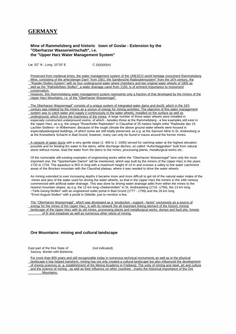
GERMANY Mine of Rammelsberg and historic town of Goslar - Extension by the "Oberharzer Wasserwirtschaft", i.e. the "Upper Harz Water Management System"
Lat. 52° N ; Long. 10°20' E C (i)(ii)(iii)(iv)
Preserved from medieval times, the water management system of the UNESCO world heritage monument Rammelsberg Mine, consisting of the aHerzberger Dam" from 1561, the Sandersche Radstubensystem" from the 16'h century, the "Roeder-Stollen-System” with its four underground water wheel chambers and two original water wheels of 1805 as well as the "Rathstiefsten Stollen", a water drainage canel from 1150, is of eminent importance to monument conservation. However, this Rammelsberg water management system represents only a fraction of that developed by the miners of the Upper Harz Mountains, i.e. of the "Oberharzer Wasserregal". The Oberharzer Wasserregal" consists of a unique system of integrated water dams and duct5; which in the 16'h century was initiatod by the miners as a source of energy for mining activities. The objective of this water management system was to catch water and supply it continuously to the water wheels, installed on the surface as well as underground, which drove the machinery of the mines. A large number of these water wheels were installed in especiaily constructed underpround rooms, of which - besides those at the Rammelsberg - a few examples still exist in the Upper Harz, as e.g. the unique "Rosenhofer Radstuben" in Clausthal of 25 meters height orthe "Radstube des 19 Lachter-Stollens~ in Wilbemann. Because of the rough climate the above ground water wheels were housed in especiallyadesigned buildings, of which some are still totally preserved, as e.g. at the Samson Mine in St. Andrevéerg or at the Knesebeck Schacht in Bad Grund, however, many can only be found in traces around the former mines. A network of water ducts with a very gentle slope (1: 400 to 1: 1000) served for catching water at the highest elevation possible and for feeding thc water to the dams, while discharge ditches, so called "Aufschlaggraben" built from natural stone without mortar, lead the water from the dams to the mines, processing plants, metallurgical works etc.. Of the numerable still existing examples of engineering works within the "Oberharzer Wasserregal" here only the most important one, the "Sperberhaier Damm" will be mentioned, which was built by the miners of the Upper Harz in the years 1732 to 1734. The aqueduct is 953 m long with a maximum height of 14 m and crosses a valley to link water catchment areas of the Brocken mountain with the Clausthal plateau, where it was needed to drive the water wheels. As mining extended to ever increasing depths it became more and more diffcult to get rid of the natural water intake of the mines and also of the water used for driving the water wheels, so that in the Upper Harz the miners in the 14th century commenced with artificial water drainage. This was done by driving water drainage adits from within the mines to the nearest mountain slopes, as e.g. the 12 km long «Sieberstollen" in St. Andreasberg (1716 -1756), the 13 km long ~Tiefe-Georg-Stollen" with an engineered outlet portal in Bad Grund (1777 - 1799) and the 26 km long "Ernst-August-Stollen" with a portal in Gittelde, just to mention a few. The "Oberharzer Wasserregal", which was developed as a "production - support - factor" exclusively as a source of energy for the mines of the Upper Harz, is with its network the all important linking element of the historic mining landscape of the Upper Harz with its old mines, processing plants and metallurgical works, dumps and fault pits, forests of fir and meadows as well as numerous other relicts of mining.
Ore Mountains: mining and cultural landscape
East part of the free State of (not indicated) Saxony. Border with Bohemia. For more than 800 years and still recognizable today in numerous technical monuments as well as in the physical landscape it has helped transform, mining has not only created a cultural landscape but also influenced the development of mining sciences (e. g. establishment of the Mining Academy in Freiberg). The unity of mining and steel, art and culture and the science of mining - as well as their influence on other countries - marks the historical importance of the Ore Mountains.
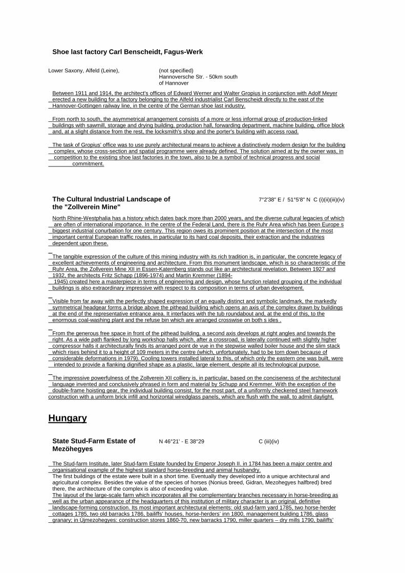
Shoe last factory Carl Benscheidt, Fagus-Werk
Lower Saxony, Alfeld (Leine), (not specified) Hannoversche Str. - 50km south of Hannover Between 1911 and 1914, the architect's offices of Edward Werner and Walter Gropius in conjunction with Adolf Meyer erected a new building for a factory belonging to the Alfeld industrialist Carl Benscheidt directly to the east of the Hannover-Gottingen railway line, in the centre of the German shoe last industry. From north to south, the asymmetrical arrangement consists of a more or less informal group of production-linked buildings with sawmill, storage and drying building, production hall, forwarding department, machine building, office block and, at a slight distance from the rest, the locksmith's shop and the porter's building with access road. The task of Gropius' office was to use purely architectural means to achieve a distinctively modern design for the building complex, whose cross-section and spatial programme were already defined. The solution aimed at by the owner was, in competition to the existing shoe last factories in the town, also to be a symbol of technical progress and social commitment.
The Cultural Industrial Landscape of 7°2'38" E / 51°5'8" N C (i)(ii)(iii)(iv) the "Zollverein Mine" North Rhine-Westphalia has a history which dates back more than 2000 years, and the diverse cultural legacies of which are often of international importance. In the centre of the Federal Land, there is the Ruhr Area which has been Europe s biggest industrial conurbation for one century. This region owes its prominent position at the intersection of the most important central European traffic routes, in particular to its hard coal deposits, their extraction and the industries dependent upon these. The tangible expression of the culture of this mining industry with its rich tradition is, in particular, the concrete legacy of excellent achievements of engineering and architecture. From this monument landscape, which is so characteristic of the Ruhr Area, the Zollverein Mine XII in Essen-Katernberg stands out like an architectural revelation. Between 1927 and 1932, the architects Fritz Schapp (1896-1974) and Martin Kremmer (1894- 1945) created here a masterpiece in terms of engineering and design, whose function related grouping of the individual buildings is also extraordinary impressive with respect to its composition in terms of urban development. Visible from far away with the perfectly shaped expression of an equally distinct and symbolic landmark, the markedly symmetrical headgear forms a bridge above the pithead building which opens an axis of the complex drawn by buildings at the end of the representative entrance area. It interfaces with the tub roundabout and, at the end of this, to the enormous coal-washing plant and the refuse bin which are arranged crosswise on both s ides . From the generous free space in front of the pithead building, a second axis develops at right angles and towards the right. As a wide path flanked by long workshop halls which, after a crossroad, is laterally continued with slightly higher compressor halls it architecturally finds its arranged point de vue in the stepwise walled boiler house and the slim stack which rises behind it to a height of 109 meters in the centre (which, unfortunately, had to be torn down because of considerable deformations in 1979). Cooling towers installed lateral to this, of which only the eastern one was built, were intended to provide a flanking dignified shape as a plastic, large element, despite all its technological purpose. The impressive powerfulness of the Zollverein XII colliery is, in particular, based on the conciseness of the architectural language invented and conclusively phrased in form and material by Schupp and Kremmer. With the exception of the double-frame hoisting gear, the individual building consist, for the most part, of a uniformly checkered steel framework construction with a uniform brick infill and horizontal wiredglass panels, which are flush with the wall, to admit daylight.
Hungary
State Stud-Farm Estate of N 46°21' - E 38°29 C (iii)(iv) Mezöhegyes The Stud-farm Institute, later Stud-farm Estate founded by Emperor Joseph II. in 1784 has been a major centre and organisational example of the highest standard horse-breeding and animal husbandry. The first buildings of the estate were built in a short time. Eventually they developed into a unique architectural and agricultural complex. Besides the value of the species of horses (Nonius breed, Gidran, Mezohegyes halfbred) bred there, the architecture of the complex is also of exceeding value. The layout of the large-scale farm which incorporates all the complementary branches necessary in horse-breeding as well as the urban appearance of the headquarters of this institution of military character is an original, definitive landscape-forming construction. Its most important architectural elements: old stud-farm yard 1785, two horse-herder cottages 1785, two old barracks 1786, bailiffs’ houses, horse-herders’ inn 1800, management building 1786, glass granary; in Újmezohegyes: construction stores 1860-70, new barracks 1790, miller quarters – dry mills 1790, bailiffs’
house. Three stud yards, headquarters of commander, covered riding-hall, North and South arches, gates, fence posts, animal hospital, oat storage towers, granaries, barns and several more buildings and structures. The landscape has been reshaped by forest plantations and farm buildings.
Tokaji Wine Region Cultural Region: Borsod-Abaúj-Zemplén C (iii)(v) + CL (ii) Landscape County N 48°4'11"-48°16'32" ; E 21°10'20"-21°28'23" The proposed property and its buffer zone are located in the northeastern corner of Hungary, in the area, of Borsod?Abauj?Zemplen County. The chief?town of the county is Miskolc. The buffer zone borders upon the Slovakian Republic in a short distance. The area of the county is 7248 square kilometres, the population is 735000. Geological, relief and hydrographic characteristics Geographical borders of the nominated property and buffer zone: inner areas of Zempleni Mountains in the north, Hungarain?Slovakian border and the River Bodrog in the east, a short part of the River Tisza and Taktakoz in the south and Hemad?valley in the west. The eastern part of the area under investigation is situated on the Szerencsi hills. Its surface is composed of ridges of a hill in an approximately north?south oriented strike, the average height of which is 250 metres above sea level. The average value of the relative relief is 70 metres per square?kilometre. More than 80% of the surface is covered by sarmatian rhyolite tuff. Its elevations are bare rhyolite and riodacite cones. Its precious mineral substances are zeolite, kaolin, hydroquartzite and bentonite. At the foot of the hills, in a south?southeastern direction from the Tokaj mountain, we can find a 150 metres deposit layer of gravel, sand, warp and fresh water burden. In the upper layers the soil is composed of brown soil developed on lymph?like clay, while in the lower layers it is characterised by chemozem with patches of lime. The core of the Tokaj hill, which constitutes the southern peak of the Zemplen mountains, is made up of andesite, rhyolite and rhyolite tuff. The foothill slope is covered by loess up to the height of 250 metres in a cone?like way. At lower parts its thickness can reach up to 30?40 metres. The average relative relief of the hill is 117 metres per square?kilometre. Its natural substances are andesite and rhyolite tuff. Its determining soil type is the acidic brown soil developed on lymph?like clay. The average height of the slope ranges exposed to the southeast, north and westnorthwest direction from the Tokaj hill is 514 metres above sea level. More than 80% of the surface is endangered by soil erosion. The degree of the annual erosion reaches 1 to 3 centimetres. Under the surface the product of the volcanic postactivities can be found, the surface is covered by solifluctional deposit or at some places by loess. Among the natural substances zeoloite, kaoline and bentonite are substantial. It is also possible to find andesite, flint and hydroquartzite here. 55% of the soil is brown forest soil developed by clay infiltration and 34% is brown soil. The proportion of the barren stony areas is only 4%. Bodrogkoz is situated between the wave band of the Bodrog and Tisza, beneath the above mentioned slope range. The little region is a flat area between 95 and 128 metres high above the sea level. The average relative relief is 4 metres per square?kilometre. The 90% of the surface is dominated by Neoholocene casting formations, such as meadow clay and marshy deposits. Its soil is mainly determined by chemozem as well as marsh soil and to a smaller extent sodic soil. The most significant water resources are the Bodrog and the Tisza rivers as well as the backwaters and oxbows created after their regulation. The water reservoir at Tiszalok made the Bodrog navigable, too. Other significant, but smaller water flows in the area are the Szerencs brook, the Gilip brook (dammed to a 39 hectare water surface next to Monok), the Tatka channel, the Fennsik channel (created by the confluence of Furdo and Madi?brook), and the Ronyva, Hercegkuti, Szarkakuti, Tolcsvai and Benyei brooks, respectively, flowing into the Bodrog. Most of them are seasonal or abate during the summer. Local climatic characteristics Higher areas are situated at the border of the moderately wet zone, the lower areas belong to the moderately hot and dry climate. The amount of sunshine is around 1900?2000 hours per year, in summer the average is between 750 and 790 hours, while in winter it is 200 hours on average. The annual mean temperature is between 9.6 and 9.9 °C, during the vegetation season it is around 16.3?16.9 °C. The daily mean temperature is over 10 °C over about 184 days a year, namely between 14th April and 14' October. On average the daily mean temperature does not go below freezing for 180 days but on the southern slopes this period may last longer that 190 days. Between 20th April and 15th October the temperature is above freezing. The mean of the highest degrees within a year is 33°C and the lowest is ?16°C. The annual amount of rain is around 600?620 mm out of which 370?390 mm arrive in the vegetation season. Its climate makes it possible to grow cultivated plants that require hotter climate. The Tokaji Wine Region is perfect for cultivating grapevines, while the flatter areas provide perfect conditions for growing plants on tillage and at places with high subsoil water level grazing and grassland farming would be preferable. Flora and fauna The area according to plant geography classification can be ranked among Tokajense flora locality of the larger North?Hungarian mountains flora area (Matricum) within the Hungarian flora land (Pannonicum). Hornbeam and Turkey oaks (Querco petreae?Carpinetum, Querco petreae?cerris) form the climatic associations on the less typical slopes exposed to the north and in the more fresh valleys. On the south?facing slopes the thermofil oak (Corno?Quercetum pubescenti?petreae) is peculiar. Corpus mas (Cornelian cherry), Crataegus monogyna (singleseed hawthorn), Viburnum lantana (Wayfaring tree) and Amygdalus nana (dwarf almond), which can be found in large number in some places, are the most remarkable among the shrubs. Mostly in warmer location it is more frequent to find soft?stalked plants such as Iris variegata, iris graminea ssp. pseudocyperus, Aster cinereus, Lathyrus pisiformis and Stipa stenophylla. 17 species of orchid live on Kopasz mountain. . Forests mostly consist of non?native pine? and locust?trees. The damaging effect of the former one is changing the chemical properties of the soil: the fallen pine needles sour the soil strongly. The latter one consumes the nutritives of the soil, practically exploiting it, while forming an ineradicable polycormon colony. Both have the effect of totally thinning out their undergrowth because of the deep shadow (pine) and allelopathical features (locust), and they do away with the territory of valuable soft?stalked populations. The most typical cultivated plant of this area is grape?vine, but in southern locations there is also peach, plum, and rarely

almond. The most typical ploughland grain is wheat, but we can also mention maize, rye and sunflower. Regarding the animal population, the regions of Tokaj?Bodrogzug Landscape Protection Area has the most important role. It is a significant nestling and brooding place for birds and rich in fish. The most tipycal and precious species are the night heron, spoonbill, common heron, cormorant, white stork, Short?toed Eagle, Imperial Eagle, Lesser Spotted Eagle. Two of the seven or eight pairs of stock owl known in Hungary live on Nagy?Kopasz. In the stock of game there are big populations of rabbit, deer and wild boar living in the forests above vine?lands and meadows. Animal keeping is not considerable. Tokaj?Bodrogzug Landscape Protection Area is quite prominent among nature conservation territories, and also the examined parts of the Landscape Protection Area of Zemplen, but we can mention some nature conservation areas with local importance protecting the same value and the individually, protected species of different plant and animal. Areas of protected nature: Tokaj?Bodrogzug (District of landscape protection; partly covering the property only), Bodrogszegi Varhegy (Protected area), Tallyai Patocshegy (Protected area), Zempleni District (District of landscape protection; partly covering the property only), Erdobenye woody pasture (Protected area) (see map 4. in Annex), Cultural property Settlement?related and architectural values The settlement system and the settlement forms of the Tokaj Wine Region are inseparable from the morphological and hydrographical features of the area. One of the frames of the interrelationships between settlements and of the settlement system of the region is the Bodrog, and the other one is the Stream Szerencs and the River Hernad at the western border. There is a chain of settlements along the Bodrog. These. settlements are located on the right bank of the river meandering at the foot of the Zemplen mountain range. Bodrog is one of the water?catchment rivers of the mountain range, and there are further settlements to be found in the valleys of the smaller streams falling into the Bodrog. The Bodrog is emptying into the Tisza at Tokaj, marking one of those ancient passing?places which provide the settlements between the two banks of the Tisza with connection. The Szerencs is falling into the Takta through a broad mouth, having settlements on its both sides. The extremely valuable capabilities of the area, and its aptitude for being a good place to settle down had already been recognised by the first Magyar settlers of Hungary. The name Tokaj itself, coming into Hungarian as an Armenian loanword meaning `grape' at around the 10th century, is an evidence for the early origin of the settlement, its system of ethnical relationships and the fact that viticulture was known at that time. The changing of the area into wine region deeply influenced the thinking and culture of the local population. However, by the conversion of the area into wine region, we do not only mean regal regulations, but rather the uniformed environmental culture typical of Tokaji Wine Region, that can be identified even these days. In the built environment of the region, the architectural cultures of many centuries are intertwining in a unique way: there can be found Catholic churches of medieval origin, Orthodox churches from the 18th?19th century, monuments of the and Jewish sacral architecture, documentaries of the princely architecture of castles, castles and mansions of the aristocracy as well as dwelling?houses, wine houses and cellars of the people. An important monument of the early settlement of the area is the Roman style Catholic church in Bodrogolaszi from the 12' century, situated in the buffer zone. In every settlement of the nominated property there can be found a gothic RomanCatholic church from the Middle Ages. In Tokaj and in Tallya, there are ruins of castles from the 14th century, and among settlements in the buffer zone, it is Monok, Sarospatak and Szerencs where there are Medieval castles. The noble castles and mansions are the emblems of the wealth gained from viticulture, from which four of them are standing in Tarcal, and another nine are in the buffer zone. These buildings were built in the 18th?19th century, in the glory of the Tokaj Wine Region. The synagogues and other sacral buildings in Tarcal, Tokaj and Mad, the Orthodox and Roman?Catholic churches of Tokaj, and the Orthodox churches of Abaujszanto, Bodrogkeresztur, Bodrogolaszi, Sarospatak, Satoraljaujhely and Szerencs, all protected by the Ancient Monument Act were also built at this time. The density of monuments is marked by the protected areas of monuments, of which one happens to be in Tokaj and the other one in Tallya, and another ten are situated in the settlements of the buffer zone. The most typical establishments of Tokaj are the cellars. The cellar of King Kalman in Tarcal was already mentioned in 1110. The two basic cellar types preferred in Tokaj were the vaulted and the carved varieties. The vaulted was basically a space underneath a residential building, both with an identical floor plan. The cellar was usually dug when the house itself was built, and mainly accessed from the porch. In this set?up, the grapes were processed in a room to the rear of the house, just above the cellar. The other version, the carved cellar was not directly linked with the building. On the surface level, only a stonework entryway with a latticed gate made from wood or steel was visible. The cellars carved in volcanic tuff did not need to be reinforced with vaults because the rock was strong enough to support the ceiling. In Tokaj, 80?85 percent of all the cellars were made this way. The most interesting type is the multi?level cellar labyrinth with a jumbled floor plan. Created over the centuries by horizontally and vertically linking cellars carved near each other, these mazes appeared in the commercial centers of the Foothills of the Tokaji Wine Region, in Erdobenye, Mad, Tallya and the town of Tokaj. Their most famous example is the cellar network in the Ungvari district of Satoraljaujhely, which evolved through, interconnecting 27 separate cellars side by side and one on top of another. This labyrinth has the capacity to hold 13000 casks of the Gonc and Szerednye type. This cellar labyrinth, the Ungvar Cellar in Satoraljaujhely is part of the nomination. The historically unique and attractive Rakoczi Cellar in Sarospatak, that has several kilometres long ways, is also part of the nominated property. Within the nominated property, there are several similar and valuable cellars like that. Archaeological values A geological?archaeological celebrity is the Vitis Tokaiensis that is one of the finds that date back to the Miocene flora and was found here, in Erdoberenye. This ancient grape?leaf, which can be regarded as the ancestor of each and every grapetype, proves that the grape is a pre?historic endemic plant in Tokaj. The two basic cellar types preferred in Tokaj were the vaulted and the carved varieties. The vaulted was basically a space underneath a residential building, both with an identical floor plan. The cellar was usually dug when the house
between minus 0.5 metres Mean Sea Level (N A.P.) in the east and minus 4.5 metres Mean Sea Level in the west (N.A.P.). The Noordoostpolder covers approximately 48,000 hectares, 24x20 kilometres, of which 37,000 hectares was reserved for agriculture and pasture-land, 2,000 hectares for forestation (between Lemmer and Kuinre and near De Voorst), 2,300 hectares for fruit and vegetable culture (near Marknesse, Luttelgeest and Kraggenburg) and 200 hectares for bulb-growing and cultivation under glass (near Ens). A distribution plan was drawn up in 1947 for establishing approximately 1,500 farms. Standard parcel size: 24 hectares (800x300 metres) with a derivative size of business of 12, 24, 36 hectares; minimum size 12 hectares; average size 25 hectares. A typical feature is farms located in groups of 2 to 4 with windbreaks. The polder is triangular of shape, the structure of which is extended into the star-shaped route of the canals running from the middle of the polder to the pumping stations. It can be reached from the 'old land' - the Provinces of Overijssel and Friesland - and from Flevoland via six towns (Ketelbrug, Rampspol, Vollenhove, Blokzijl, Kruinre, Lemmer). Based on sociographical research, it was decided at the time of land settlement to establish 10 settlements, all within cycling distance of each other, counting 2,000 future residents, with Emmeloord as its capital (1941-1947 plans, Granpré Molière, Verhagen and Kok agency, later plans by Ir. J.C. Pouderoyen) around which the villages of Ens (started 1948), Marknesse (started 1943, final plan 1949), Kraggenburg (started 1948), Bant, Luttelgeest and Creil (founded 1950/1951), Tollebeek (finished 1954-1957), Espel (building started 1957) were projected. The town planning and architecture of these villages are traditional of structure ('Delft School'). The initial settlement plans were drawn up by the Granpré Molière, Verhagen and Kok agency and later detailed by Ir. P. Verhagen (1882-1950). The town planning of the village centres is typified by an intersection of roads and waterways, a through road with an open central space, a 'village green' (grass, trees, bordered by shops, public buildings, houses, opened up by a separate service road) with nonparallel walls, by scattered elements such as churches and schools which sets the scene, and by the absence of straight angles and parallel alignments. When the village of Nagele was built (1954) a group of architects ('De Acht' (The Eight) and 'De Opbouw' (The Structure)) stood out and contributed (theoretically) to the 7th CIAM (Congrès Internationaux d'Architecture Moderne) in Bergamo (1949). This group included Gerrit Rietveld, Mart Stam, Aldo van Eyck, Mien Ruys. A cultivate on plan for the reclaime d land was drawn up in the early 1940 s , according to which the main roads (coordinate system Lemmer-Ramspol and Urk-De Voorst) as well as the ring-road connecting the villages, are planted in two rows. The general plan is that the countryside will overgrow behind the ring-road towards the IJsselmocr and that the landscape will be more open on the inner side of the ringroad. The former island of Schokland is accentuated by a screen of trees; the island of Urk is emphasised by the afforested Urkerbos. Because of a modification of the planting plan (1960), the western part of the Noordoostpolder mainly has linear planting, while in the eastern part a gradual transition to the 'old land' has been made. At the time, planting schemes for the layout of back gardens, for corner lots, for green belts, for the choice of hedges, trees, bushes and village woods were designed for the villages, with the exception of Nagele, as well as for the farm lots. The increasing mobility is changing the infrastructure vis-à-vis the original planning. New highways, fitting in the polder plan, are being laid, existing roads are being widened and separate cycle tracks are being laid.
Van Nelle Fabriek (Van Nelle Factory)
Van Nelleweg 1, 3044 BC (ii) (iv) (vi) C Rotterdam Land registry location : Rotterdam: AC, 179 The Van Nelle Factory, built in 1925-31 for the refining and packing processes of coffee, tea and tobacco, is the result of a thorough analysis of technical functions of this specific factory (raw products were taken to the top floor of the factory buildings to move down a floor after each stage of processing) and of improving the social aspects ('human element') of working in a factory and also of an intensive co-operation between the principal (C.H. van der Leeuw, a confirmed theosophist) and the architects J.A. Brinkman (1902-1949) & L.C. van der Vlugt (1894-1936), assisted by architect Mart Stam (18991986) and contractor J.G. Wiebenga (1886-1974), all dedicated to the 'Nieuwe Bouwen' (the Dutch branch of the international Modern Movement). The block of buildings consists of a curved office block, a descending factory building (eight levels for the tobacco section, crowned by a circular tearoom (a reception room) and expanded at the back by a shed-roofed warehouse; five levels with a double-height entresol for the coffee section; three levels for the teasection), linked by glazed elevated transport bridges, diagonally crossing over the factory street, with expedition and warehouse buildings opposite; an L-shaped workshops/garage-building; a boilerhouse with an almost freestanding, profiled chimney. All buildings are constructed of reinforced concrete, steel and glass. Typical technical features are mushroom-shaped columns with the floors without beams, the curtain wall of steel-framed glass and the (originally mobile) glazed elevated transport bridges. Most of the original functionalism furnishing and parts of the original outdoor sporting and leisure facilities for the workers still exist.
Poland
Krzemionki Opatowskie. Neolithic C (iii)(v) flint mine Ostrów Swietokrzyski administrative district (powiat) Swietokrzyski vojevodship. Archaeological reserve containing several thousand Neolithic mining units. From the second half of the fourth millennium BC, the scene of the exploitation of decorative banded flint from which the polished flint blades of axes was manufactured. Several different mining techniques were in use: simple pit shafts, open shafts with niches, mines with underground chambers (the latter the most characteristic and best documented). The area of the reserve retains in many places the original prehistoric structure, including the above-ground traces: mine spoilheaps, flintknapping workshops, the remains of camps and mining facilities, communication tracts.
The valley of the Pradnik river in the The Cracow administrative C (iv)(v) Ojcowski National Park district (powiat), Malopolskie vojevodship, 20km north of Cracow The valley of the Pradnik is one of the most valuable areas of cultural landscape in central Europe. It is a unique example of the continuity of layers of human settlement going back 80000 years, and developing in harmony with unique forms of the living and non-living environment. In the local landscape, which is characterised by remains of nearly all geological and paleontological epochs, traces of historic human utilisation of the landscape, from agriculture, through defensive constructions, industry, and also use as a health resort and tourist attraction. In the restricted area of the 17 km of the length of the valley, there is a high concentration of unique geological forms (including some 200 caves) and many unusual karstic formations of the limestone rocks. The cultural landscape contains two Early medieval strongholds, two Medieval and Renaissance castles, a hermitage, a health resort, an early gunpowder factory, mills, saw-mills and fulling-mills. The protected fauna and flora includes 1000 species of plants (including many relict ones), about 1200 species of fungi. The protected fauna includes 2645 species, including many species of bats. The valley of the Pradnik, an especially effectively protected area on a micro and macro-scale, forms the centre of the Ojcowski National Park covering 1400ha.
ROMANIA L'ensemble rupestre de Basarabi Dobroudja (not specified) Ensemble des monuments rupestres situe une ancienne carriere de " craie du IXe-Xe siecle, amenagee comme etablissement monastique (Xe-XIIe siecle). Une eglise principale avec trois nefs soutenue par des colonnes; une autre eglise avec la division rituelle specifique ortodoxe, couverte d'une coupole semicilindrique, le sanctuaire avec abside semicirculaire couvert d'une semicalotte; deux paraklession, diverses chambres annexes, galleries et chambres funeraires composent l'ensemble. Des representations figuratives chretiennes et d'autres motifs symboliques stylises, incises : dragons qui se tordent, le labyrinthe, l'arbre de la vie, le pigeon, le chevalier, aussi que divers animaux et navires. Inscriptions en plusieurs langues et ecritures grecque, runique, glagolithique, cyrillique - y compris une glosse roumaine du Xe siecle.
Russian Federation
Railway Bridge Over Yenissey River
Long. 92° 20'00"/ Lat. 55° 38'00" C (i)(ii)(iv) The city of Krasnoyarsk, administrative center of the Krasno yarskiy Region, the biggest industrial and cultural center of the Eastern Siberia. Through the city of Krasnoyarsk lie s the Trans siberian Railroad, which construction started in 1891 and on the 6th of December 1895 to Krasnoyarsk arrived the first train from the West. But here, on the bank of the Yenissey river, rails ended. Steam-engines and cars had to be ferried across the Great Siberian river. On the 30~ of August 1896 the foundation-stone ceremony of the railroad bridge across Yenissey took place. The project of the upper construction of the Bridge has been carried out by pro£ L.Proskuryakov, and the piers and the methods of stone and caisson constructions has been elaborated in the Middlesiberian Railroad Department. The length ofthe Bridge - 1000 m, width - 7,5 m, height of trusses - 20 m, width of trusses - 8 m. Length of bigger spans - 137 m., smaller - 20 m. The principal manager of the construction was appointed engineer prof. E.Knorre, who for the first time in the world used the wooden
caissons. The Bridge was put into operation in the beginning of 1899. The model of the Bridge with 7,32 m. in length and 1,83 m. in width and the model of wooden caisson were exposed at the Paris exhibition in 1890, where the Bridge was awarded a golden medal as a recognition of high level engineer and technological innovation, originality of construction. By putting the Railway Bridge across the Yenissey river into operation the Eastern and Western parts of the Siberian railroad were connected, which was recognized as the World's outstanding event after discovery of America and construction of the Suez Canal. Noting the historic and economic role of Transsiberian Railroad the Paris exhibition also awarded Grand Prix to the S iberian Railro ad C ommittee and the Russian Mini stry of Railro ad Communication . During the Bridge construction the best Italian specialists in granite methods of treatment and other foreign experts took part, this is why the Bridge appears to be the multinational human creation. It is supposed to fit out the Bridge for organizing a Museum of Transsiberian Railroad with a rolling-stock, used on Transsiberian Railroad, as well as exposition of photo documents, schemes of construction of Transsiberian Railroad and the Bridge over the Yenissey river.
SLOVAKIA
The Kysuce - Orava narrow-gauge railway
Central Slovakia, regions of (i) (iii) C Kysuce and Orava
A forest narrow-gauge railway built in 1915-18 in a very pretentious terrain. The central connecting part built in 1926 overcomes the difference between the lowest and the highest points - 218 m by means of dead centres/ deflected bends. On the main line the max length in 1927 was almost 110 km steam engines were used. One section was in 1969, 1972 declared a state technical monument and the part with dead centres 8 km has been preserved.
The Mining Town of Idrija The town is situated in the west (i) (ii) (iii) (iv) C of Slovenia at an altitude of 331 m above sea level, at a Long. 14° Est - Lat. 46° North, it is 38 km away from the capital Ljubljana
A mining town for over 500 years with extremely well preserved monurnental technical installations and machinery which have passed on early industrial procedures to the present civilisation in a compact urban centre surrounded by an exceptionally well preserved cultural landscape with various natural sights and a diversified technical heritage related to mining, forestry and log driving. Mercury mining in Idrija dates back to 1490 and was first mentioned in written records in 1494. Amid a geologically diversified hilly landscape the mining industry has been preserved to the present day and at the same time with exceptional technical skill unique systems of working methods, equipment, machines and devices have developed. A number of technical devices have also been preserved, including some which are unique or very rare, and because of their dimensions, outstanding examples. The mining shaft system was developed to a depth of 400 m below sea level and the length of the entire system amounts to over 700 km. When mining was at its peak special types of water power were developed; and a special system of log driving on the Idrijca, Belca, Zala and Ovcjak or Klavzarica with the aid of water barriers called "klavze". With the continuous modemisation of machinery, miners with a high degree of awareness for the preservation of tradition managed to save many machines from decay . These mach ines have been restored or are be in a orenared for restoration . The mine has gradually been closing down since l 978. therefore even greater care has been taken to preserve the outstanding mining tradition Planned conservation of older machines and equipment has an outstandingly long tradition in Idrija - over ninety years. Systematic legal protection was introduced in 1952. Today the conservation of the technical heritage is included in the planned development of the town and this makes it possible to hand down a tradition dating back centuries to the new generation. Mining in Idrija was of outstanding universal significance due to the rarity of mercury. The technical procedure for the extraction of ore has always been at the height of mining technology. Important individuals working in Idrija made major contributions to the development of European natural sciences. Their activity was reflected in the early development of schools, culture, natural sciences, etc. Mining in the region influenced the development of the unique culture of the inhabitants, contributed to the development of forestry, introduced a special type of building tradition, and influenced the development of quality lace-making which used to be an important supplementary economic activity of the local women. The former rich economic activity of the mine, the level of technical knewledge, tradition and genuine new ideas successfully continue in the form of numerous activities, some of which again rank among the best in the world.
Spain
Colonias industriales de los ríos Cardener y Llobregat
El Canal de Castilla, Castilla-León
La Ruta de la Sal (Canarias)
Marismas del Odiel Huelva (not specified) Paysage de marais au bord de la mer, a l'embouchure des fleuves Tinto et Odiel, doté d'un réseau de drainage caractéristique qui a donné lieu à une activité économique traditionnelle, de grande valeur ethnographique et culturelle
Sweden
Copper mine of Falun Province of Västmanland. (iii) (iv) C Dalarna X6720 Y1490 This is an industrial site with mining starting in the 12th century and still running. The mining area has several preserved buildings mostly from the 18th century. The mine passages are kept intact by pumps. The mine and the museum connected to it are both open to the public. The Falu Copper Mine is a monument of international value. Legal protection acccording to the Cultural Heritage Act is under consideration.
TURKEY
Güllük Dagi-Termessos National 37°00' N – 30°30' E N (ii)(iii)(iv) C Park Located within the provincial (ii)(iii)(v) boundaries of Antalya. Gulluk Dagi National Park is located within the province of Antalya in a valley hidden between mountains. There is the ancient fortified city of Termessos rising 1050 m above the sea level. The ancient city of Termessos was found by the Solims who lived in the Psidia Region. Although there are nofacts available about Termessos and Solims, they are natured by Homer in the Iliad in connection with the legend of Bellerophon. The most significant remains of the site are the city walls, Towers, King's Road, Hadrian's Gate, Gymnasium, Agora, Theatre, Odeon, Richly, Decorated Tombs, cisterns and drainage system. Other features of the Natural Park are the step rocks of Gulluk Dagi and the Mecine Canyon with its 600 m high walls along with the typical Mediterranean vegetation sheltering such endangered wild creatures as Mountain Goats, Fallow Deer and Golden Eagle.
UNITED KINGDOM
Cornish Mining Industry long. 4°43'21" W / Lat. 50°28'22" (ii)(iii)(iv)(v) C N Cornwall and Devon, England The proposed World Heritage Site is a cluster of seven detached areas which collectively represent the many facets of metal mining in the south western peninsula of England and have a significance far beyond Britain itself. For substantial periods over the last 4,000 years this area was the principal source of tin and copper in the western world, while during the 1sth and 19th century it was, for a time, the world's greatest producer of tin and copper. Whilst the mining area of the Cornubian orefield covers West Devon, the major technical innovations and the overwhelming preponderance of mines were in Cornwall. The proposal is therefore termed 'Cornish Mining'. This term would have been well understood throughout the mining world in the l9th century. The proposed Site includes all those mine sites and relict mining landscapes where there is exceptional survival of the physical remains. These are largely late 18th century, 19th century and, in a few instances, pre-1914 mining remains. The relict mining landscapes defined do not include those widespread areas of tin streaming that survive in Cornwall and
West Devon, associated with a pre-Industrial Revolution technology and therefore not considered representative of the 19th century boom years. In the 150 years after 1760, the economy and society in the region developed from being largely agricultural to that of (between 1800-1850) complete dominance of the hard rock mining world. By l900, and more definitively, by the First World War, the shattered remains of this truly massive industry lay almost totally abandoned. The mining economy virtually ceased to exist, and a substantial percentage of the mining population (perhaps two thirds) emigrated to all corners of the mining world. The twin disadvantages of peripherality from national centres of population and the geological based nature of the mineral resource, helped ensure that no significant industry replaced mining and its related industries in Cornwall and West Devon. The physical remains of the mining boom are therefore largely with us today. The case for World Heritage Site status is based upon five characteristics: The extraordinary suite of minerals in the Cornubian orefield, with 440 species out of a worldwide total of some ssoo. The crucial part played by Cornish miners, adventurers, and Cornish engineers between 1800 and 1860 in the development of steam technology and mining technology throughout the world, including Trevithick's steam engines, the use of coal gas for lighting, Davy's safety lamp and Bickford's mining safety fuse. The outstanding survival of the mining landscape and its associated industrial concerns, urban development, rural settlements and miners' smallholdings, great houses, parks and gardens, mineral railways and mineral ports. The comprehensive character of the statutory protection, conservation and long term management measures covering this wider historic mining landscape now in place or presently in progress. The existence still, of a well documented Cornish mining diaspora of mining sites (physically so similar to mine sites in the region) and Cornish people. This is particularly well represented today in South Australia, and the United States of America. In addition there are particularly well preserved mining sites in Mexico, the Virgin Islands and Spain. Throughout the mining districts of Cornwall and West Devon there are large pre-Industrial Revolution relict landscapes of tin streaming works, and 19th century mine sites with the ruined engine houses, arsenic works and associated buildings. The mining towns and villages with their characteristic terraced miners' houses, mining institutes, technical schools and Methodist chapels are a reminder of past activity. Significant remains of closely associated and related industries such as tin and copper smelters, foundries, drill manufacturers, gunpowder, explosives, and fuseworks, ropewalks, candle factories and brickworks survive today. Almost all the mineral ports, and the mineral railways and tramways that served them, can be seen today. Of great significance is the good survival of the great houses, parks and gardens of the great mining and industrial families of Cornwall and Devon, as well as the widespread pattern of miners' agricultural smallholdings taken out of moorland in the first half of the 19th century. Mining was reflected in the shaping of a distinctive social and cultural identity in Cornwall of which Methodism was a central element. The spread of nonconformist religion and the creation of an inter national Cornish identity were both results of the mass emigrations in the 1ôth century. The history of a region at the forefront of the Industrial Revolution, known throughout the mining world, has left a permanent cultural legacy in the hearts and minds of Cornish people. Boundaries Seven areas have been identified as best representing the many different facets of Cornish Mining. The areas differ greatly from one another in character but each has a core area that is quite distinct and complements the other core areas. Camborne/Redruth Focused on the Great Flat Lode and its adjacent settlements, this is the archetypal Cornish landscape of engine houses and mine complexes served by urban settlements of terraced houses, with chapels, mining exchanges, engineering works, fuse factories etc. The Ordnance Survey maps of 1907 define the historic topography which is essentially 19th century. The area includes several preserved steam engines and the core area of the Mineral Tramway Project. Caradon This south east corner of Bodmin Moor is the most impressive upland mining landscape in the region. Centred on the settlement of Minions and bounded to the south and east by the road from Crows Nest to Upton Cross, it contains the remains of the Phoenix Mines to the north, the Marke Valley mines to the east and the Caradon Hill mines to the south. Godolphin/Tregonning This area, encompassing Tregonning and Godolphin Hills and Wheal Vor, represents the earliest phase of the Cornish Mining technological spectrum. The Godolphin estate benefited greatly from mining revenues in the 16th and 17th centuries and the area, notably Wheal Vor, pioneered the introduction of steam pumping in the 1 8th century. It is possible that the first mining use of a Newcomen engine occurred in this area circa 1710, and certainly there were several such engines in use by the end of the century. It is probable that the overgrown area of disused mine workings around Carleen contains the foundations of these engine houses and is therefore of great significance archaeologically. Godolphin House and its parkland represent an important cultural element of Cornish Mining landscape as, in common with other grand houses in the region, it is founded on the fortunes made out of mining. St Agnes This area of coastal mining stretches from Porthtowan in the south to Cligga in the north. It encompasses both dramatic headlands and steep sided valleys each with their very different type of mining remains.