INDIAN RESIDENTIAL SCHLS HISTR AND DIALGUE … · SIGNED AT VANCOUVER, B.C. THIS DAY OF ... UBC...
102
DEVELOPMENT PERMIT APPLICATION SUBMISSION JANUARY 7th, 2016 INDIAN RESIDENTIAL SCHOOLS HISTORY AND DIALOGUE CENTRE UBC, VANCOUVER, B.C. F O R M L I N E A R C H I T E C T U R E 1103- 945 Marine Drive West Vancouver, BC V7T 1A8 p 604.912.0203 www.formline.ca
Transcript of INDIAN RESIDENTIAL SCHLS HISTR AND DIALGUE … · SIGNED AT VANCOUVER, B.C. THIS DAY OF ... UBC...

DEVELOPMENT PERMIT APPLICATION SUBMISSION JANUARY 7th, 2016
INDIAN RESIDENTIAL SCHOOLS HISTORY AND DIALOGUE CENTREUBC, VANCOUVER, B.C.
F O R M L I N E A R C H I T E C T U R E 1103- 945 Marine Drive West Vancouver, BC V7T 1A8 p 604.912.0203 www.formline.ca

DEVELOPMENT PERMIT APPL ICATONUBC INDIAN RES IDENT IAL SCHOOLS H ISTORY AND DIALOGUE CENTRE
1F O R M L I N E A R C H I T E C T U R E
TABLE OF CONTENTS
Please contact us at any time formore detailed information:
F O R M L I N E ARCHITECTURE
1103-945 Marine DriveWest Vancouver, BC
V7T 1A8T: 604 912 0203
1 DEVELOPMENT PERMIT APPLICATION FORM 2
2 WRITTEN DESCRIPTION 4
3 DESIGN POLICY COMPLIANCE 6
APPENDIX• LAND TITLE• GEOTECHNICAL REPORT• SITE PROFILE• TREE SURVEY
Page

T H E U NI VE R SI T Y O F B RI T I SH CO L UM BI A Campus and Community Planning
2210 West Mall Vancouver, B.C. V6T 1Z4 604.822.8228 604.822.6119
Revised August 2015 1/5
DP #
Development Permit Application Form Complete application form and prepare associated materials prior to scheduling an application intake meeting with the UBC Manager, Development Services. Project Address and Building Name: Description of Area: Description of Project:
Applicant (authorized agent): Contact name:
Mailing address: Email:
City: Postal Code: Phone:
Architect: Contact name:
Mailing address: Email:
City: Postal Code: Phone:
Landscape Architect: Contact name:
Mailing address: Email:
City: Postal Code: Phone:
I, THE AUTHORIZIED AGENT, GIVE CONSENT FOR CAMPUS & COMMUNITY PLANNING TO POST DIGITAL DRAWINGS AND SUPPORTING TEXT FOR PUBLIC VIEWING ON THEIR WEBSITE.
I HEREBY AGREE THAT I WILL COMPLY WITH ALL RULES, BYLAWS, REGULATIONS AND POLICIES OF THE UNIVERSITY OF BRITISH COLUMBIA AND ALL OTHER STATUTES, RULES, BYLAWS, POLICIES AND REGULATIONS OF OTHER AUTHORITIES IN FORCE AT THE UNIVERSITY OF BRITISH COLUMBIA RELATING TO THE WORK, UNDERTAKING OR PERMISSION IN RESPECT OF WHICH THIS APPLICATION IS MADE AND THAT I WILL INDEMNIFY AND SAVE HARMLESS THE UNIVERSITY OF BRITISH COLUMBIA, ITS OFFICIALS, EMPLOYEES AND AGENTS FROM ALL CLAIMS, LIABILITIES, JUDGEMENTS, COSTS OR EXPENSES OF EVERY KIND, INCLUDING NEGLIGENCE, IN RESPECT OF ANYTHING DONE OR NOT DONE IN CONSEQUENCE OF ANY PERMISSION, PERMIT OR LICENSE ISSUED AS A RESULT OF THE APPLICATION OR THE FAILURE TO OBSERVE COMPLETELY ALL STATUTES, RULES, BYLAWS, POLICIES AND REGULATIONS RELATING TO ANY WORK OR UNDERTAKING IN RESPECT OF WHICH THIS APPLICATION IS MADE.
SIGNED AT VANCOUVER, B.C. THIS DAY OF 20
SIGNATURE OF AUTHORIZED AGENT:
Please continue application on reverse
DEVELOPMENT PERMIT APPL ICATONUBC INDIAN RES IDENT IAL SCHOOLS H ISTORY AND DIALOGUE CENTRE
2F O R M L I N E A R C H I T E C T U R E
Indian Residential School History and Dialogue Centre
The project is an addition to the Sedgewick Library and consists of a 224sm (2,411sft) renovation and a 396sm (4,262 sft) addition for a total gross area of 620sm (6,673sft).
This 2 level facility will that will provide exhibitory and program space to promote learning and dialogue concerning Indian Residential School and its place in Canadian History.
Alfred Waugh
1103, 945 Marine Drive [email protected]
West Vancouver V7T 1A8 604.912.0203 ext 221
Formline Architecture
Alfred Waugh
1103, 945 Marine Drive [email protected]
West Vancouver V7T 1A8 604.912.0203 ext 221
Chris Phillips
1777 West 3rd Avenue [email protected]
Vancouver V6J 1K7 604.736.5168
PFS Studio
T H E U NI VE R SI T Y O F B RI T I SH CO L UM BI A Campus and Community Planning
2210 West Mall Vancouver, B.C. V6T 1Z4 604.822.8228 604.822.6119
Revised August 2015 2/5
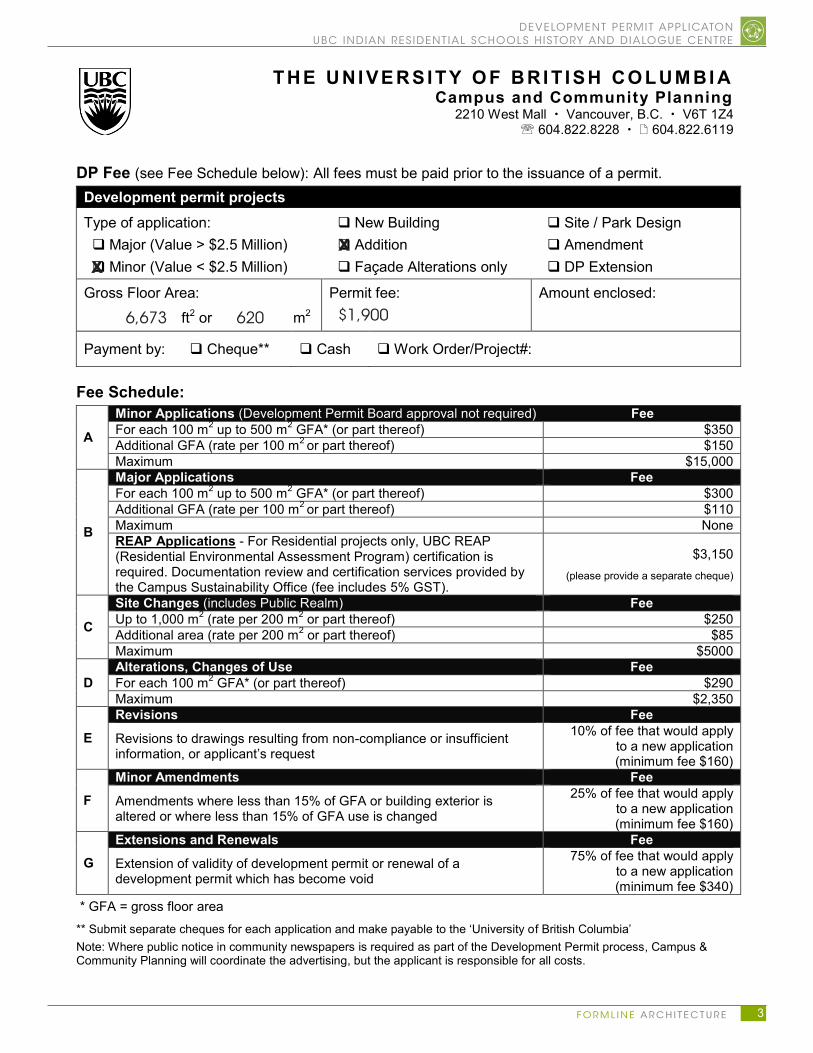
DP Fee (see Fee Schedule below): All fees must be paid prior to the issuance of a permit. Development permit projects Type of application: Major (Value > $2.5 Million) Minor (Value < $2.5 Million)
New Building Addition Façade Alterations only
Site / Park Design Amendment DP Extension
Gross Floor Area: ft2 or m2
Permit fee: Amount enclosed:
Payment by: Cheque** Cash Work Order/Project#:
Fee Schedule:
A
Minor Applications (Development Permit Board approval not required) Fee For each 100 m2 up to 500 m2 GFA* (or part thereof) $350 Additional GFA (rate per 100 m2 or part thereof) $150 Maximum $15,000
B
Major Applications Fee For each 100 m2 up to 500 m2 GFA* (or part thereof) $300 Additional GFA (rate per 100 m2 or part thereof) $110 Maximum None REAP Applications - For Residential projects only, UBC REAP (Residential Environmental Assessment Program) certification is required. Documentation review and certification services provided by the Campus Sustainability Office (fee includes 5% GST).
$3,150 (please provide a separate cheque)
C
Site Changes (includes Public Realm) Fee Up to 1,000 m2 (rate per 200 m2 or part thereof) $250 Additional area (rate per 200 m2 or part thereof) $85 Maximum $5000
D Alterations, Changes of Use Fee For each 100 m2 GFA* (or part thereof) $290 Maximum $2,350
E Revisions Fee
Revisions to drawings resulting from non-compliance or insufficient information, or applicant’s request
10% of fee that would apply to a new application (minimum fee $160)
F Minor Amendments Fee
Amendments where less than 15% of GFA or building exterior is altered or where less than 15% of GFA use is changed
25% of fee that would apply to a new application (minimum fee $160)
G Extensions and Renewals Fee
Extension of validity of development permit or renewal of a development permit which has become void
75% of fee that would apply to a new application (minimum fee $340)
* GFA = gross floor area ** Submit separate cheques for each application and make payable to the ‘University of British Columbia’ Note: Where public notice in community newspapers is required as part of the Development Permit process, Campus & Community Planning will coordinate the advertising, but the applicant is responsible for all costs.
DEVELOPMENT PERMIT APPL ICATONUBC INDIAN RES IDENT IAL SCHOOLS H ISTORY AND DIALOGUE CENTRE
3F O R M L I N E A R C H I T E C T U R E
XX
6,673 620 $1,900

DEVELOPMENT PERMIT APPL ICATONUBC INDIAN RES IDENT IAL SCHOOLS H ISTORY AND DIALOGUE CENTRE
4F O R M L I N E A R C H I T E C T U R E
2 WRITTEN DESCRIPTION
The Indian Residential School History and Dialogue Centre (IRSHDC) is a 620sm (6,673sft) facility which will have a program split between two levels.
The lower level at the bottom of the landscape bowl will house a digital exhibit space that will also be used for public programming, teaching, and interaction with community visitors. This space will be suitable for university classes, visiting groups of primary and secondary students, community members and other visitors.
The upper level will provide meeting, research, and administrative spaces accessible located at the mid level plaza.
DESIGN CHALLENGES
The site is located in a landscape bowl with the main exhibit space at the bottom. There is a 9 m elevation change between the bottom and the main plaza. The existing space is accessible to Koerner however due to security reasons public will not be able to access the facility through the library. The Client wants the main entrance to be at the bottom and use the landscape as a calming relief for entering and exiting the main exhibit space. The following challenges arise out of this requirement.
· How to get visitors from upper level of the bowel down to the exhibit space addressing accessibility.
· The mid level plaza is 2m below the Irving Barber Learning Centre and 4m below the Main Plaza.
· How do you define a legible public entrance giving this vertical challenge?
The following is a list of other challenges
· Establishing a fluid relationship with the surrounding landscape currently being redesigned
· Integrate outdoor programming for educational purposes· Developing a building form that will be pleasing to look at from varying vertical
vantage points. · Developing an identity that embodies First Nations Culture without making specific
Cultural references. · How will the building maximize the interface with the Library Gardens· How will it be responsive to environmental influences· The existing pre-cast structure of Koerner Building was not designed to take
another storey at the mid level plaza. Building directly over the space will require costly upgrade of substructure.
· Plumbing at the lower level will be difficult as excessive excavation will be required and tying into Koerner will require trenching through the existing concrete slab.
A design concept was developed that reinforces an edge to the landscape bowl and preserves the visual access between the Koerner and Irving Barber Libraries. The buildings north face descends following the stepped landscape animating the building and engaging the landscape. The following is a summary of the main design principals
Legible entrance - It was decided the main entrance will be from the East which is culturally important to most first First Nations groups. This is also the direction which traffic from Learners walk will have the easiest access into the site. There is a 2m drop to the mid level plaza which can be navigated by stairs and accessible ramps. This main entry point is clearly legible and provides an entrance to the landscape as well as the building. From this entry point one can continue on the main floor to the upper program or descend along the landscape to the reception for the exhibit hall below.
Expression of dark and Light- The exhibit space is at the lower level and is in a

DEVELOPMENT PERMIT APPL ICATONUBC INDIAN RES IDENT IAL SCHOOLS H ISTORY AND DIALOGUE CENTRE
5F O R M L I N E A R C H I T E C T U R E
dark space with relief to the garden. The content of this space will contain the memory of the past and the realities of residential school. To counterpoint this space the pavilion above will be light and airy to provide relief and promote optimism toward the future. This will be a place of discussion, education and growth.
Reaching into the Landscape- All program spaces engage the landscape reinforcing First Nations connection with nature as well providing relief for the heavy content. The abundant glazing makes the building a beacon to the adjacent landscape and enhances the CPTED strategy. As soon as one enters the building they are looking out to the terraced landscape which circles the bowl and penetrates the building forming a gentle terraced stair to below. The Exhibit Space is a multifunction space with sliding windows that completely opens the room to a plaza with a storm water feature in the distant. The board room, offices and elders room all have views of the landscape bowl or the forest to the south.
Form and Interest- The pavilion form is defined by a folding plane of cross laminated timber (CLT) panels supported by a CLT structure. The roof is clad in a copper foil membrane directing all rain water l to one point celebrating water which references our rainy climate and its significance to the Coast Salish People. As the roof is seen from many vantage points it provides a layer of interest amongst the landscape. The roof form provides broad overhangs to offer protection to visitors that may choose to descend the landscape without entering the upper level. Abundant glazing is provided to allow natural light to flood the upper level and engage the landscape outside. The glazing facing the garden can be a canvas for a frit pattern or colour to animate the facade.

DEVELOPMENT PERMIT APPL ICATONUBC INDIAN RES IDENT IAL SCHOOLS H ISTORY AND DIALOGUE CENTRE
6F O R M L I N E A R C H I T E C T U R E
3 DESIGN POLICY COMPLIANCEThe IRSHDC is located in the Campus Core Area between the Koerner and the Irving Barber Building. The new addition is a small building of with a foot print of 3,200 sft. It is set in a landscape bowl connected to the Sedgewick library.
The building respects the Campus core architectural principles with the following features.
• The building is carefully designed with the PFS Studio to enforce a strong interplay between landscape and building.
• Respecting the International style of modernism the building is a low horizontal rectangular mass that is heavily glazed at the ground plane.
• The copper clad tilted roof provides a sculptural element within a rectilinear composition.
• The long rectangular building reinforces a strong edge to the landscape bowl defining a sunken courtyard.
• The siting of the building respects the existing Sequoia Tree and is set below it not to interfere with sight lines of the Millennium Pavilion.
• The low set building does not interfere with the site lines between the Koerner and Irving Barber Library.
The building respects the Campus core Material Palette with the following features:
• The building exterior enclosure is predominantly glass which will incorporate a fritted silk screen pattern on some of the extensive planes. This is indicative of the legacy of international style architecture.
• Complimenting this material are walls clad in charred western red cedar. This is a reference to the Coast Salish Peoples in the local area. The technique of charing the wood surface is a Japanese technique called “Shou Sugi Ban” wraps the wood in a layer of carbon protecting it from mould, insects and water. This will reduce the maintenance usually associated with wood products.
• The renovated area in Sedgewick will include an concrete planter to match the existing planter using architectural concrete. Architectural concrete will also be used for the entrance portal.
• A copper foil roof and copper panels will clad the roof and the water feature bringing an accent material contextually connected to the First Nations House of Learning. This noble material is upheld in the Coast Salish Culture as well adorns some of the older buildings on campus.
DEVELOPMENT PERMIT APPL ICATONUBC INDIAN RES IDENT IAL SCHOOLS H ISTORY AND DIALOGUE CENTRE
7F O R M L I N E A R C H I T E C T U R E
APPENDIX
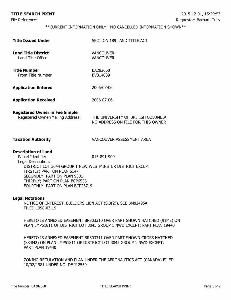
**CURRENT INFORMATION ONLY - NO CANCELLED INFORMATION SHOWN**
Title Issued Under SECTION 189 LAND TITLE ACT
Land Title District VANCOUVERLand Title Office VANCOUVER
Title Number BA282668From Title Number BV314089
Application Entered 2006-07-06
Application Received 2006-07-06
Registered Owner in Fee SimpleRegistered Owner/Mailing Address: THE UNIVERSITY OF BRITISH COLUMBIA
NO ADDRESS ON FILE FOR THIS OWNER
Taxation Authority VANCOUVER ASSESSMENT AREA
Description of LandParcel Identifier: 015-891-909Legal Description:
DISTRICT LOT 3044 GROUP 1 NEW WESTMINSTER DISTRICT EXCEPTFIRSTLY; PART ON PLAN 6147SECONDLY: PART ON PLAN 9301THIRDLY; PART ON PLAN BCP6556FOURTHLY: PART ON PLAN BCP23719
Legal NotationsNOTICE OF INTEREST, BUILDERS LIEN ACT (S.3(2)), SEE BM82495AFILED 1998-03-19
HERETO IS ANNEXED EASEMENT BR303310 OVER PART SHOWN HATCHED (91M2) ONPLAN LMP51811 OF DISTRICT LOT 3045 GROUP 1 NWD EXCEPT: PART PLAN 19440
HERETO IS ANNEXED EASEMENT BR303311 OVER PART SHOWN CROSS HATCHED(884M2) ON PLAN LMP51811 OF DISTRICT LOT 3045 GROUP 1 NWD EXCEPT:PART PLAN 19440
ZONING REGULATION AND PLAN UNDER THE AERONAUTICS ACT (CANADA) FILED10/02/1981 UNDER NO. DF J12559
TITLE SEARCH PRINT 2015-12-01, 15:29:53File Reference: Requestor: Barbara Tully
Title Number: BA282668 TITLE SEARCH PRINT Page 1 of 2
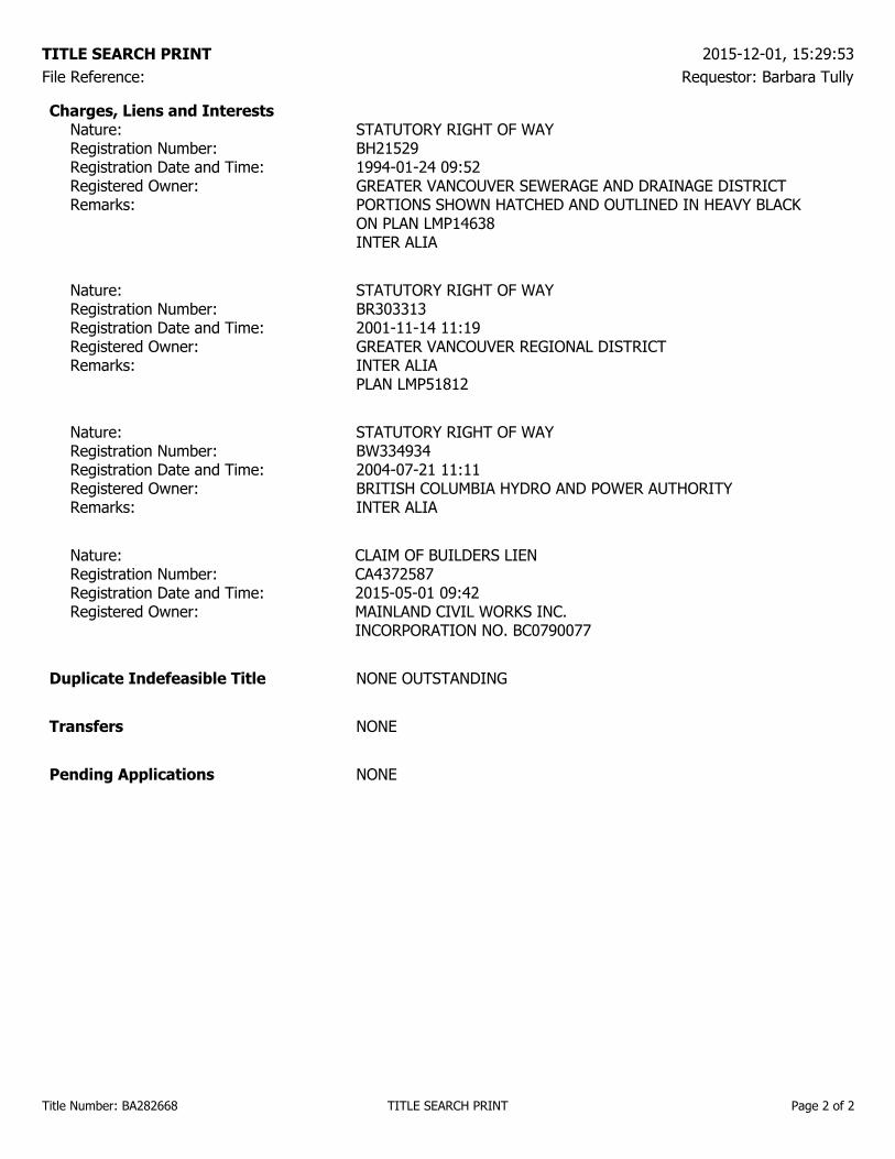
Charges, Liens and InterestsNature: STATUTORY RIGHT OF WAYRegistration Number: BH21529Registration Date and Time: 1994-01-24 09:52Registered Owner: GREATER VANCOUVER SEWERAGE AND DRAINAGE DISTRICTRemarks: PORTIONS SHOWN HATCHED AND OUTLINED IN HEAVY BLACK
ON PLAN LMP14638INTER ALIA
Nature: STATUTORY RIGHT OF WAYRegistration Number: BR303313Registration Date and Time: 2001-11-14 11:19Registered Owner: GREATER VANCOUVER REGIONAL DISTRICTRemarks: INTER ALIA
PLAN LMP51812
Nature: STATUTORY RIGHT OF WAYRegistration Number: BW334934Registration Date and Time: 2004-07-21 11:11Registered Owner: BRITISH COLUMBIA HYDRO AND POWER AUTHORITYRemarks: INTER ALIA
Nature: CLAIM OF BUILDERS LIENRegistration Number: CA4372587Registration Date and Time: 2015-05-01 09:42Registered Owner: MAINLAND CIVIL WORKS INC.
INCORPORATION NO. BC0790077
Duplicate Indefeasible Title NONE OUTSTANDING
Transfers NONE
Pending Applications NONE
TITLE SEARCH PRINT 2015-12-01, 15:29:53File Reference: Requestor: Barbara Tully
Title Number: BA282668 TITLE SEARCH PRINT Page 2 of 2
File: 13377 Indian Residential Dialogue Centre - UBC Campus Page 1
215 - 1200 West 73 Avenue
Vancouver, BC V6P 6G5
604-439-0922
UBC Properties Trust December 21, 2015 200 – 3313 Shrum Lane File: 13377 Vancouver, BC V6S 0C8 Attention: Dave Poettcker Re: Geotechnical Investigation Report, Indian Residential School Dialogue Centre, Main Mall, UBC Campus 1.0 INTRODUCTION As requested, GeoPacific has carried out a geotechnical site investigation for the proposed Indian Residential School Dialogue Centre which is to be located on the UBC campus. We have been provided with preliminary architectural drawings prepared by Formline Architecture dated October 11, 2015, for reference. The project is conceptual at this time and therefore structural drawings are not yet available. The proposed building is to be constructed near site grades and is to be built into the sloping grades such that a portion of the building will be below grade. This report presents the results of our geotechnical investigation of the site and makes geotechnical recommendations for the design and construction of the proposed structure. This report has been prepared exclusively for UBC Properties Trust and for the use of others on their design and construction team, although it remains the property of GeoPacific Consultants Ltd. 2.0 SITE DESCRIPTION The site is bounded by the Walter C. Koerner Library to the northwest, the Irvin K. Barber Learning Centre to the northeast and landscaping on the other sides. The proposed building is rectangular and is to be 27.5 m in length and 14.5 m in width. The site gradually slopes from east to west with an elevation differential of about 2 m. The site is currently undeveloped and covered with grass and bushes. 3.0 FIELD INVESTIGATION
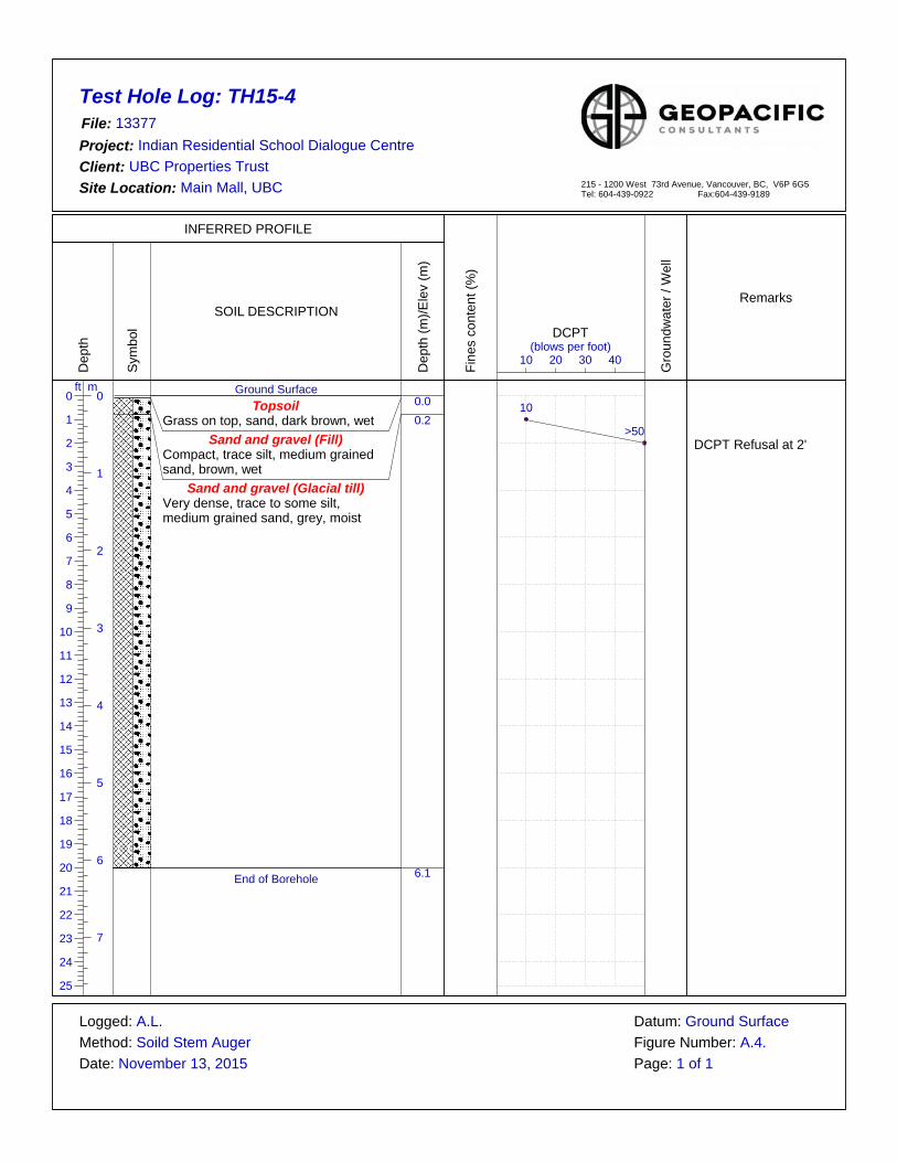
GeoPacific investigated the site on November 13, 2015. The investigation consisted of a review of geological maps, visual inspection, and augered test holes supplemented with dynamic cone penetration test (DCPT) soundings. A drill permit from UBC Campus & Community Planning department was obtained confirming the proposed test hole locations were acceptable to them. A third party utility locating company was hired to help ensure that the test holes were clear of any underground services and utilities.

File: 13377 Indian Residential Dialogue Centre- UBC Campus Page 2
Six test holes were advanced using the subcontracted drilling services of On Track Drilling of Coquitlam, BC. The test holes were advanced to depths ranging from 4.6 to 6.1 m below grade. Two of the test holes were supplemented with DCPT soundings to help characterize the in-situ density of the soil. The test hole locations are shown on our Drawing No. 13377-1 included with this report. 3.1 Subsurface Conditions The general geology of the region under investigation is described as Vashon glacial drift, overlying Quadra fluvial deposits with reference to the Geological Survey of Canada’s map 1484A. The glacial drift is characterized as lodgement and minor flow till with lenses and interbeds of substratified glaciofluvial sand and gravel, including lenses and interbeds of glaciolacusterine stony silt. The Quadra fluvial deposits consist of channel fill and floodplain deposits; crossbedded sand with minor silt and gravel lenses. A general description of the soils encountered at our test hole locations is given below.
Topsoil The majority of the site is overlain by grass and topsoil. Sand and Gravel (Fill)
The topsoil is underlain by sand and gravel fill materials with trace silt ranging in depths of 0.2 m to 0.3 m below existing site grades. Based on our observations and DCPT soundings the fill materials are compact.
Sand and Gravel (Glacial Till) The fill materials are underlain by glacial till comprised of sand and gravel with trace to some silt; some cobbles and occasional boulders are expected within this deposit. DCPT testing and drill observations indicate that this stratum is very dense. These deposits were found to extend to the full depth of our investigation.
Detailed soil descriptions are included on the test hole logs in Appendix A. 3.2 Groundwater Conditions The groundwater table was not identified in our investigation and is expected to be well below development grades. Perched groundwater may be encountered overlying the dense native soils within the fill materials or from more permeable zones within the glacial till. 4.0 DISCUSSION 4.1 General Comments We understand that the proposed development includes of at-grade two-level pavilion and a sitting podium with various landscape features. The new building is to be constructed on the northeast side of the Walter C. Koerner Library. The proposed sitting podium is to be constructed along the east side of the site,

File: 13377 Indian Residential Dialogue Centre- UBC Campus Page 3
extending from the main building to the north. Structural drawings are not yet available, however, we expect that the building loads will be relatively light. A portion of the foundations for the new building will be constructed adjacent to the Walter C. Koerner Library`s foundations and are likely to impose additional earth pressure on the existing foundations. Where foundations for the new building are at a higher elevation than the adjacent existing foundations and 1H:1V slope measured downward or outward from the underside of the foundations should be maintained. If footings are immediately adjacent to one another the new foundation should be lowered to the same elevation of the existing ones. We confirm that from a geotechnical point of view that the proposed development is feasible provided the following recommendations are implemented in the design and construction of the development. 5.0 DESIGN RECOMMENDATIONS 5.1 Site Stripping for Foundations and Grade Supported Slabs Site preparation associated with foundations and grade supported slabs includes removing any organic topsoil, variable fill materials and any other material considered to compromise the design recommendations stated herein. Any soft, loose or disturbed material should be removed in order to allow for construction on the proposed subgrade in its natural undisturbed state. 5.2 Grade Reinstatement If necessary, any required grade reinstatement beneath foundations should be carried out with lean mix concrete having a minimum compressive strength of 5 MPa. Any grade reinstatement beneath grade supported slabs, stairs and other landscape features should be done with “engineered fill”. In the context of this report any “engineered fill” is defined as clean sand to sand and gravel fill, compacted in 300 mm loose lifts to a minimum standard of 95% of its Modified Proctor Maximum Dry Density (ASTM D1557) while at moisture content that is within 2% of its optimum for compaction. 5.3 Foundations We envision that the new structure will be founded on conventional spread foundations supported on undisturbed very dense glacial till. Foundation supported on dense glacial till can be designed based on a service limit state (SLS) bearing pressure of 400 kPa and a factored Ultimate Limit States (ULS) of 800 kpa. Post construction settlement of foundations designed as recommended should be less than 25 mm total with differential settlement of less than 20 mm over a 10 metre span. Footings should not be less than 450 and 600 mm in width for strip footings and pads respectively. Foundations should be located at least 0.45 m below finished grades for frost protection.

File: 13377 Indian Residential Dialogue Centre- UBC Campus Page 4
5.4 Seismic Considerations We have considered a design earthquake with a 2% probability of exceedance over a 50 year period which equates to an earthquake with a return period of 1 in 2475 years. Accordingly, we have considered an earthquake having a peak horizontal ground acceleration of 0.46g for this site (Ref. National Resources Canada, Site Coordinates: 49.25096 North, 123.23348 West). The soils at this site are not considered susceptible to liquefaction triggering or strain softening in consideration of the seismic hazard defined in the 2012 British Columbia Building Code (BCBC). This site qualifies as “Site Class C” as defined in Table 4.1.8.4.A of the 2012 British Columbia Building Code (2012 BCBC). Site Class C sites are defined as very dense soil sites where the average properties in the top 30 metres have an average penetration resistance (Ñ60) greater than 50 for coarse grained soils, or an undrained shear strength (Su) greater than 100 kPa for fine grained soils. We recommend that the structural design be based on the acceleration- and velocity-based site coefficients for “Site Class C” as specified in the 2012 BCBC. 5.5 Grade Supported Concrete Slabs We recommend that any fill placed under the slab should conform to our recommendation for engineered fill in Section 5.2 above. The floor slab should be directly underlain by a polyethylene moisture barrier and a minimum of 150 mm of 19 mm clear crushed gravel fill to inhibit upward migration of moisture beneath the slab.
5.6 Earth Pressures on Foundation Walls A portion of the building is expected to be below grade and therefore earth pressure can be expected to develop against the buried foundation walls. Earth pressures on foundation walls depend on a number of factors including wall rigidity, backfill materials and their degree of compaction, surcharge loads, backfill slope, the drainage conditions and the method and sequence of construction. For this project we anticipate that river sand backfill will be used and will be compacted in place using light hand operated compaction equipment and that the backfill will be fully drained. Based on these assumptions we recommend that the below grade foundation walls be designed for service earth pressures of 5.0 x H kPa (where H is the wall height in metres) with a triangular pressure distribution. The walls should be designed to withstand an addition seismic earth pressure of 5.0 x H kPa with an inverted triangular pressure distribution. These earth pressures should be reviewed in light of the shoring and excavation design once it is available. 5.7 Site and Foundation Drainage A passive mechanical perimeter drainage system should be included to ensure that hydrostatic pressure does not develop against the foundation wall or beneath the slab-on-grade. Hydraulic connectivity should be maintained between the under-slab fill and the outside of foundation wall using weep holes.

File: 13377 Indian Residential Dialogue Centre- UBC Campus Page 5
5.8 Utility Installation Site utilities will be required beneath the grade supported slab. The design of these systems must consider the location and of the depth of the foundations. The service trenches and excavations required for the installation of underground vaults and/or manholes should be outside of a 1H:1V slope measured downward and outward from the underside of foundations. Backfilling of trenches and excavations should be done with 19 mm clear crush gravel following the required pipe bedding. All excavations and trenches must conform to the latest Occupational Health and Safety Regulation supplied by the Workers Compensation Board of British Columbia. 6.0 FIELD REVIEWS As required for Municipal “Letters of Assurance”, GeoPacific Consultants Ltd. will carry out sufficient field reviews during construction to ensure that the Geotechnical Design recommendations contained within this report have been adequately communicated to the design team and to the contractors implementing the design. These field reviews are not carried out for the benefit of the contractors and therefore do not in any way effect the contractors obligations to perform under the terms of his/her contract. It is the contractors’ responsibility to advise GeoPacific Consultants Ltd. (a minimum of 24 hours in advance) that a field review is required. Field reviews are normally required at the time of the following activities: 1. Stripping – Review of stripping 2. Foundations – Review of subgrade for foundations 3. Slab-on-grade – Review of the slab-on-grade preparation 4. Compaction – Review of any engineered fill, placement and compaction 5. Backfill – Review of backfill materials, placement and compaction It is critical that these reviews are carried out to ensure that our intentions have been adequately communicated. It is also critical that contractors working on the site view this document in advance of any work being carried out so that they become familiar with the sensitive aspects of the works proposed. It is the responsibility of the developer to notify GeoPacific Consultants Ltd. when conditions or situations not outlined within this document are encountered.

File: 13377 Indian Residential Dialogue Centre- UBC Campus Page 6
7.0 CLOSURE
This report is prepared solely for used by our client’s Design Team for this project as described to the general standards of similar work for similar projects in this area and no other warranty of any kind is expressed or implied. GeoPacific Consultants Ltd. accepts no responsibility for any other use of this report. We are pleased to assist you with this project and we trust this information is helpful and sufficient for your purposes at this time. However, please do not hesitate to call the undersigned if you should require any clarification or additional details.
For: GeoPacific Consultants Ltd. Reviewed by:
ORIGINAL SIGNED ORIGINAL SIGNED Arye Lipshitz Steven Fofonoff, M. Eng. P.Eng. Engineering Technician Senior Geotechnical Engineer


APPENDIX A
TEST HOLE LOGS

TH15-113377
Indian Residential School Dialogue CentreUBC Properties Trust
Main Mall, UBC
Ground SurfaceTopsoil
Grass on top, sand, dark brown, wetSand and gravel (Fill)
Compact, trace silt, medium grained sand, brown, wet
Sand and gravel (Glacial till)Very dense, trace to some silt, medium to coarse grained sand, sub-angular gravel, grey to brown, moist to wet
1'-7' some silt, moist
7'-15 trace silt, coarse grained sand, brown
End of Borehole
0.0
0.3
4.6
10 20 30 40(blows per foot)
DCPT
12
>50DCPT refusal at 2'
A.L.Soild Stem Auger
November 13, 2015
Ground SurfaceA.1.
Test Hole Log:File:Project:Client:Site Location:
Logged:Method:Date:
Datum:
Page: 1 of 1Figure Number:
215 - 1200 West 73rd Avenue, Vancouver, BC, V6P 6G5Tel: 604-439-0922 Fax:604-439-9189
INFERRED PROFILE
Dep
th
0 0ft m
1
1
2
2
3
3
4
4
5
5
6
6
7
7
8
9
10
11
12
13
14
15
16
17
18
19
20
21
22
23
24
25
Sym
bol
SOIL DESCRIPTION
Dep
th (m
)/Ele
v (m
)
Fine
s co
nten
t (%
)
Gro
undw
ater
/ W
ell
Remarks

TH15-213377
Indian Residential School Dialogue CentreUBC Properties Trust
Main Mall, UBC
Ground SurfaceTopsoil
Grass on top, sand, dark brown, wetSand and gravel (Fill)
Compact, trace silt, medium grained sand, brown, wet
Sand and gravel (Glacial till)Very dense, trace to some silt, medium to coarse grained sand, sub-angular gravel, grey to brown, moist to wet
1'-7' some silt, moist
7'-15 trace silt, coarse grained sand, brown
End of Borehole
0.0
0.3
4.6
10 20 30 40(blows per foot)
DCPT
A.L.Soild Stem Auger
November 13, 2015
Ground SurfaceA.2.
Test Hole Log:File:Project:Client:Site Location:
Logged:Method:Date:
Datum:
Page: 1 of 1Figure Number:
215 - 1200 West 73rd Avenue, Vancouver, BC, V6P 6G5Tel: 604-439-0922 Fax:604-439-9189
INFERRED PROFILE
Dep
th
0 0ft m
1
1
2
2
3
3
4
4
5
5
6
6
7
7
8
9
10
11
12
13
14
15
16
17
18
19
20
21
22
23
24
25
Sym
bol
SOIL DESCRIPTION
Dep
th (m
)/Ele
v (m
)
Fine
s co
nten
t (%
)
Gro
undw
ater
/ W
ell
Remarks

TH15-313377
Indian Residential School Dialogue CentreUBC Properties Trust
Main Mall, UBC
Ground SurfaceTopsoil
Grass on top, sand, dark brown, wetSand and gravel (Fill)
Compact, trace silt, medium grained sand, brown, wet
Sand and gravel (Glacial till)Very dense, trace to some silt, medium to coarse grained sand, sub-angular gravel, grey to brown, moist to wet
1'-8' some silt, moist
8'-15 trace silt, coarse grained sand, brown
End of Borehole
0.0
0.3
4.6
10 20 30 40(blows per foot)
DCPT
A.L.Soild Stem Auger
November 13, 2015
Ground SurfaceA.3.
Test Hole Log:File:Project:Client:Site Location:
Logged:Method:Date:
Datum:
Page: 1 of 1Figure Number:
215 - 1200 West 73rd Avenue, Vancouver, BC, V6P 6G5Tel: 604-439-0922 Fax:604-439-9189
INFERRED PROFILE
Dep
th
0 0ft m
1
1
2
2
3
3
4
4
5
5
6
6
7
7
8
9
10
11
12
13
14
15
16
17
18
19
20
21
22
23
24
25
Sym
bol
SOIL DESCRIPTION
Dep
th (m
)/Ele
v (m
)
Fine
s co
nten
t (%
)
Gro
undw
ater
/ W
ell
Remarks

TH15-413377
Indian Residential School Dialogue CentreUBC Properties Trust
Main Mall, UBC
Ground SurfaceTopsoil
Grass on top, sand, dark brown, wetSand and gravel (Fill)
Compact, trace silt, medium grained sand, brown, wet
Sand and gravel (Glacial till)Very dense, trace to some silt, medium grained sand, grey, moist
End of Borehole
0.0
0.3
4.6
10 20 30 40(blows per foot)
DCPT
A.L.Soild Stem Auger
November 13, 2015
Ground SurfaceA.4.
Test Hole Log:File:Project:Client:Site Location:
Logged:Method:Date:
Datum:
Page: 1 of 1Figure Number:
215 - 1200 West 73rd Avenue, Vancouver, BC, V6P 6G5Tel: 604-439-0922 Fax:604-439-9189
INFERRED PROFILE
Dep
th
0 0ft m
1
1
2
2
3
3
4
4
5
5
6
6
7
7
8
9
10
11
12
13
14
15
16
17
18
19
20
21
22
23
24
25
Sym
bol
SOIL DESCRIPTION
Dep
th (m
)/Ele
v (m
)
Fine
s co
nten
t (%
)
Gro
undw
ater
/ W
ell
Remarks
TH15-413377
Indian Residential School Dialogue CentreUBC Properties Trust
Main Mall, UBC
Ground SurfaceTopsoil
Grass on top, sand, dark brown, wetSand and gravel (Fill)
Compact, trace silt, medium grained sand, brown, wet
Sand and gravel (Glacial till)Very dense, trace to some silt, medium grained sand, grey, moist
End of Borehole
0.00.2
6.1
10 20 30 40(blows per foot)
DCPT
10
>50DCPT Refusal at 2'
A.L.Soild Stem Auger
November 13, 2015
Ground SurfaceA.4.
Test Hole Log:File:Project:Client:Site Location:
Logged:Method:Date:
Datum:
Page: 1 of 1Figure Number:
215 - 1200 West 73rd Avenue, Vancouver, BC, V6P 6G5Tel: 604-439-0922 Fax:604-439-9189
INFERRED PROFILE
Dep
th
0 0ft m
1
1
2
2
3
3
4
4
5
5
6
6
7
7
8
9
10
11
12
13
14
15
16
17
18
19
20
21
22
23
24
25
Sym
bol
SOIL DESCRIPTION
Dep
th (m
)/Ele
v (m
)
Fine
s co
nten
t (%
)
Gro
undw
ater
/ W
ell
Remarks

TH15-613377
Indian Residential School Dialogue CentreUBC Properties Trust
Main Mall, UBC
Ground SurfaceTopsoil
Grass on top, sand, dark brown, wetSand and gravel (Fill)
Compact, trace silt, medium grained sand, brown, wet
Sand and gravel (Glacial till)Very dense, trace to some silt, medium grained sand, grey, moist
End of Borehole
0.0
0.3
6.1
10 20 30 40(blows per foot)
DCPT
A.L.Soild Stem Auger
November 13, 2015
Ground SurfaceA.6.
Test Hole Log:File:Project:Client:Site Location:
Logged:Method:Date:
Datum:
Page: 1 of 1Figure Number:
215 - 1200 West 73rd Avenue, Vancouver, BC, V6P 6G5Tel: 604-439-0922 Fax:604-439-9189
INFERRED PROFILE
Dep
th
0 0ft m
1
1
2
2
3
3
4
4
5
5
6
6
7
7
8
9
10
11
12
13
14
15
16
17
18
19
20
21
22
23
24
25
Sym
bol
SOIL DESCRIPTION
Dep
th (m
)/Ele
v (m
)
Fine
s co
nten
t (%
)
Gro
undw
ater
/ W
ell
Remarks

PRELIMINARY SITE INVESTIGATION STAGE I ENVIRONMENTAL
SITE ASSESSMENT
OF
Indian Residential School History and Dialogue Centre Project
REPORT PREPARED FOR:
UBC Properties Trust 200 - 3313 Shrum Lane
Vancouver, BC V6S 0B9
REPORT PREPARED BY:
A.C.M. Environmental Corporation 217 - 2323 Quebec Street
Vancouver, BC V5T 4S7
January 5, 2016

Indian Residential School History Stage I January 5, 2016
and Dialogue Centre Project Preliminary Site Investigation 1899-44
Vancouver, BC |
Page i of iv A.C.M. Environmental Corporation
EXECUTIVE SUMMARY
A.C.M. Environmental Corporation (ACM) was retained by UBC Properties Trust (the Client) to conduct a Stage I Preliminary Site Investigation (PSI) for the property site known as the Indian Residential School History and Dialogue Centre (IRSHDC) Project located at the University of British Columbia in Vancouver, BC (the Site). The Site is a proposed two-level development: a repurposing of several rooms located at the southeast corner of the Walter C. Koerner library below ground and a building addition to be located above these corner rooms. No road access is available to the Site due to pedestrian only designation for the surrounding roadways, though the nearest road access to the Site is from Main Mall or Agricultural Road. A summary of relevant details with reference to the Site is provided as follows:
Civic Address N/A
Legal Description
District Lot 3044, Group 1, NWD Except
Firstly; Part On Plan 6147
Secondly: Part On Plan 9301
Thirdly; Part On Plan BCP6556
Fourthly: Part On Plan BCP23719
Parcel Identifier Number 015-891-909
Current Zoning Institutional
Latitude / Longitude 49°16'0.71"N / 123°15'14.34"W
Registered Site Owners The University of British Columbia
Total Lot Area 250 square metres (approximately)
The objective of this PSI was to determine the environmental liability posed by the subject site and its surrounding properties. The investigation was undertaken in accordance with the requirements as set forth by the British Columbia (BC) Ministry of Environment (MOE) (1997), Contaminated Sites Regulation and included relevant steps, documents and suggestions as outlined in the MOE Guidance Document 10 (2005), Checklist for Reviewing a Preliminary Site Investigation, the CSA Standard Z768-01 Phase I Environmental Site Assessments and the American Society of Testing Materials (ASTM) Standard Practice for Environmental Site Assessments E-1527-05.

Indian Residential School History Stage I January 5, 2016
and Dialogue Centre Project Preliminary Site Investigation 1899-44
Vancouver, BC |
Page ii of iv A.C.M. Environmental Corporation
The table below summarizes the areas of potential environmental concern (APECs) at the Site as well as the evaluation of environmental risk posed by each potential source.
Location Current
Land Use Potential Sources
PCoCs Evaluation of Risk and Associated Potential Environmental Concerns
Library Garden
(Onsite and Adjacent Area of the Site)
Institutional Fill Soil / USTs
Metals, LEPH / HEPH
Low
All areas are landscaped and sloped.
Mix of different soil types observed around the Site.
No signs of staining indicating potential contamination.
No historical records of USTs within the area.
No visual indications of USTs.
Walter C. Koerner Library and Irving K.
Barber Learning Centre
(Buildings West and East of the Site)
Institutional USTs Metals, LEPH / HEPH
Low
No historical operations or activities identified as environmental concerns.
No visual indications of USTs.
No signs of stains/spills.
Based on the information collected during this investigation, it is considered that a low potential exists for soil, groundwater and/or soil vapour contamination to be present at the Site. This low potential of contamination may be generated from identified onsite or offsite sources. Activities relating to onsite operations are not considered to present a considerable risk of contamination. Please note that an assessment of potential hazardous building materials was not conducted during the investigation. Hazardous building materials may exist within the building onsite in the form of asbestos, lead, polychlorinated biphenyl (PCBs), mercury, etc. All hazardous materials must be properly removed in accordance with WorkSafeBC regulations prior to the start of renovation or demolition activities that may impact these materials.

Indian Residential School History Stage I January 5, 2016
and Dialogue Centre Project Preliminary Site Investigation 1899-44
Vancouver, BC |
Page iii of iv A.C.M. Environmental Corporation
TABLE OF CONTENTS
EXECUTIVE SUMMARY 1
1.0 INTRODUCTION 5
1.1 Objective 5
1.2 Scope 5
2.0 SITE DESCRIPTION 7
2.1 Site Description and Location 7
2.2 Site Physical Setting 8 2.2.1 Topography 8 2.2.2 Site Drainage 8 2.2.3 Site Geology 8
2.3 Site Hydrogeology 8
2.4 Nearest Ecologically Sensitive Areas 9
2.5 Annual Precipitation Records 9 2.5.1 Infiltration of Precipitation 9
3.0 SITE HISTORY 10
3.1 Aerial Photographs 10
3.2 Land Title Search 11
3.3 Document Review 11
3.4 Historical Directory Search 11
3.5 Fire Insurance Maps And Campus Maps 12
3.6 MoE Site Registry Search 12
3.7 Natural Gas Records 12
3.8 Prior Investigations 12
4.0 SITE INSPECTION 13
4.1 Current Site Conditions 13 4.1.1 Fuel/Chemical Handling and Storage 13 4.1.2 Waste Materials 13 4.1.3 Spill and Stain Areas 13

Indian Residential School History Stage I January 5, 2016
and Dialogue Centre Project Preliminary Site Investigation 1899-44
Vancouver, BC |
Page iv of iv A.C.M. Environmental Corporation
4.1.4 Wastewater Discharges 13 4.1.5 Air Discharges 13 4.1.6 Polychlorinated Biphenyls (PCBs) 13 4.1.7 Asbestos 14 4.1.8 Urea Formaldehyde Foam Insulation (UFFI) 14 4.1.9 Lead 14 4.1.10 Ozone Depleting Substances (ODSs) 14 4.1.11 Radon 15 4.1.12 Electromagnetic Fields (EMFs) 15 4.1.13 Noise and Vibration 15 4.1.14 Mercury 15 4.1.15 Mould 15 4.1.16 Radioactive Materials 15
4.2 Current Adjacent Land Uses 15
4.3 Interviews 16
5.0 AREAS OF POTENTIAL ENVIRONMENTAL CONCERN 17
5.1 Potential Onsite APECs 17
5.2 Potential Offsite APECs 17
6.0 CONCLUSION AND RECOMMENDATIONS 18
7.0 REFERENCES 19
8.0 STATEMENT OF LIMITATIONS 20
9.0 QUALIFICATIONS OF ASSESSOR 21
REPORT TABLES
TABLE 1: SITE LEGAL DESCRIPTION DETAILS ............................................................................................................................. 5 TABLE 2: SITE DETAILS ......................................................................................................................................................... 7 TABLE 3: MONTHLY AND ANNUAL AVERAGE PRECIPITATION (MM) .............................................................................................. 9 TABLE 4: AERIAL PHOTOGRAPH INTERPRETATION ................................................................................................................... 10 TABLE 5: AREAS OF POTENTIAL ENVIRONMENTAL CONCERN ..................................................................................................... 17
FIGURES
FIGURE 1: SITE LOCATION .................................................................................................................................................. 23 FIGURE 2: SITE PLAN ......................................................................................................................................................... 24 FIGURE 3: CONTOUR AND WATER WELL MAP ....................................................................................................................... 25 FIGURE 4: SURROUNDING LAND USE .................................................................................................................................... 26
APPENDICES
APPENDIX A AERIAL PHOTOGRAPHS APPENDIX B TITLE SEARCH APPENDIX C HISTORIAL DIRECTORY SEARCH APPENDIX D FIRE INSURANCE MAPS AND UBC CAMPUS MAPS APPENDIX E SITE REGISTRY SEARCH APPENDIX F SITE PHOTOGRAPHS
Indian Residential School History Stage I January 5, 2016
and Dialogue Centre Project Preliminary Site Investigation 1899-44
Vancouver, BC |
Page 5 of 58 A.C.M. Environmental Corporation
1.0 INTRODUCTION
A.C.M. Environmental Corporation (ACM) was retained by UBC Properties Trust (the Client) to conduct a Stage I Preliminary Site Investigation (PSI) for the property site known as the Indian Residential School History and Dialogue Centre (IRSHDC) Project located at the University of British Columbia in Vancouver, BC (the Site). The Site is a proposed two-level development: a repurposing of several rooms located at the southeast corner of the Walter C. Koerner Library below ground and a building addition to be located above these corner rooms. No road access is available to the Site due to pedestrian only designation for the surrounding roadways, though the nearest road access to the Site is from Main Mall or Agricultural Road. The legal description details for the Site are provided in Table 1 as follows: Table 1: Site Legal Description Details
Civic Address N/A
Legal Description
District Lot 3044, Group 1, NWD Except
Firstly; Part On Plan 6147
Secondly: Part On Plan 9301
Thirdly; Part On Plan BCP6556
Fourthly: Part On Plan BCP23719
Parcel Identifier Number 015-891-909
1.1 OBJECTIVE
The objective of the Stage I PSI was to determine the environmental liability posed by the Site by identifying any onsite and offsite areas of potential environmental concern (APECs) and the risk level of the APECs that may adversely impact (i.e. contaminate) the soil, groundwater and vapour underlying the Site. This investigation will follow the requirements as set forth by the British Columbia (BC) Ministry of Environment (MoE), 1997 Contaminated Sites Regulation (CSR), with all current amendments. The investigation will reference the MoE Technical Guidance Document 10 on Contaminated Sites (2005), Checklist for Reviewing a Preliminary Site Investigation and other relevant MoE technical guidance documents, policies, procedures and protocols.
1.2 SCOPE
The scope of this Stage I PSI will include a site visual inspection and records review. The visual inspection will be completed by a qualified environmental consultant and will include an inspection of the Site and surrounding properties for evidence of potential environmental risk.

Indian Residential School History Stage I January 5, 2016
and Dialogue Centre Project Preliminary Site Investigation 1899-44
Vancouver, BC |
Page 6 of 58 A.C.M. Environmental Corporation
The records review will include the following current and historical sources:
Relevant local and regional topography, geology and hydrogeology maps;
Surrounding groundwater well locations;
Aerial photographs;
Site plans, zoning maps and building permits;
Historical fire insurance maps;
Certificates of title; and
Historical directory records. Interviews may also be conducted with the Site owner and any other persons with knowledge of the current and recent land use activities at the Site. Please note that no intrusive environmental media samples will be collected or analysed as part of this investigation.

Indian Residential School History Stage I January 5, 2016
and Dialogue Centre Project Preliminary Site Investigation 1899-44
Vancouver, BC |
Page 7 of 58 A.C.M. Environmental Corporation
2.0 SITE DESCRIPTION
2.1 SITE DESCRIPTION AND LOCATION
The Site is a proposed two-level development: a repurposing of several rooms located at the southeast corner of the Walter C. Koerner Library below ground and a building addition to be located above these corner rooms. No road access is available to the Site due to pedestrian only designation for the surrounding roadways, though the nearest road access to the Site is from Main Mall or Agricultural Road. The Site is made up of a single lot. The lot is square in shape with a gross parcel area of approximately 250 square metres. The Site is a section of a paved walkway and existing rooms located within the library garden and the library itself. The surrounding areas of the Site consist of paved roads/walkways and academic buildings: Memorial Road and the Buchanan (Arts) academic buildings to the north, the Irving K. Barber Learning Centre to the east, Agricultural Road and the Sciences academic buildings to the south, and Main Mall and the Walter C. Koerner Library to the west. A location map of the Site is presented in Figure 1. A site plan of the Site is presented in Figure 2. A summary of relevant details with reference to the Site is provided in Table 2 below. Table 2: Site Details
Civic Address N/A
Legal Description
District Lot 3044, Group 1, NWD Except
Firstly; Part On Plan 6147
Secondly: Part On Plan 9301
Thirdly; Part On Plan BCP6556
Fourthly: Part On Plan BCP23719
Parcel Identifier Number 015-891-909
Current Zoning Institutional
Latitude / Longitude 49°16'0.71"N / 123°15'14.34"W
Registered Site Owners The University of British Columbia
Total Lot Area 250 square metres (approximately)

Indian Residential School History Stage I January 5, 2016
and Dialogue Centre Project Preliminary Site Investigation 1899-44
Vancouver, BC |
Page 8 of 58 A.C.M. Environmental Corporation
2.2 SITE PHYSICAL SETTING
2.2.1 Topography
According to the topographic map available from the land survey branch, the Site is situated at approximately 83-84 metres (m) above sea level. The overall topography of the surrounding area slopes to the west. A contour map of the Site is presented in Figure 3.
2.2.2 Site Drainage
The Site is comprised of impervious ground surfaces paved for pedestrian use. As such, any water runoff originating from the Site is expected to infiltrate directly into any unpaved grounds or catch basins on the Site or adjacent walkways.
2.2.3 Site Geology
The 1979 Surficial Geology map (1486A Vancouver) shows that the surficial geology of the Site consists of Vashon Drift and Capilano Sediments. Glacial drift including: lodgment and minor flow till, lenses and interbeds of substratified glaciofluvial sand to gravel, and lenses and interbed of glaciolacustrine laminated stony silt; up to 25m thick; overlain by glaciomarine and marine deposits similar to marine and glaciomarine stony to stoneless silt loam to clay loam with minor sand and silt, normally less than 3m but in places up to 10m thick. Marine derived lag gravel normally less than 1m thick containing marine shell casts has been found mantling till and glaciomarine deposits up to 175m above sea level; above 175m till is mantled by boulder gravel that may be in part ablation till, in part colluviums, and in part marine. Bedrock is more than 10m below surface.
2.3 SITE HYDROGEOLOGY
The inferred groundwater flow direction is to the west toward the Strait of Georgia, based on the topography of the area. However, site specific hydraulic conditions may differ from those inferred and can be confirmed after intrusive onsite works only. A search of the Ministry of Environment (MoE) water well database within a 500m radius of the Site was conducted utilizing the online MoE BC Water Resources Atlas service. The search revealed four (4) wells within 500m from the Site. The nearest well that may be impacted by the Site is located approximately 430 m northwest of the Site. The other 3 wells are located north of the Site, but are not expected to be impacted by the Site due to the inferred groundwater flow direction of the Site. See Figure 3 for the locations of the water wells within 500m from the Site. Drinking water for the Site and the surrounding area in much of Metro Vancouver is provided by a municipal piped water distribution network. The sources for this potable drinking water supply originate in the North Shore mountains.

Indian Residential School History Stage I January 5, 2016
and Dialogue Centre Project Preliminary Site Investigation 1899-44
Vancouver, BC |
Page 9 of 58 A.C.M. Environmental Corporation
Should further work be recommended for the Site, the applicability of the Contaminated Sites Regulation (CSR) Drinking Water standards may need to be further assessed.
2.4 NEAREST ECOLOGICALLY SENSITIVE AREAS
No ecologically sensitive areas are known to exist within or adjacent to the Site.
2.5 ANNUAL PRECIPITATION RECORDS
Annual precipitation records were obtained from the Environment Canada National Climate Data and Information Archive. The average annual precipitation for the nearest weather station, Vancouver UBC station (Climate ID: 1108487) with sufficient annual precipitation data was used to represent the approximate annual precipitation at the Site. Annual precipitation records from 1958 to 1994 are presented in Table 3 below:
Table 3: Monthly and Annual Average Precipitation (mm)
January February March April May June
171.62 134.28 115.78 82.74 64.09 50.08
July August September October November December
37.08 48.68 65.70 128.03 185.94 190.93
Total annual precipitation: 1274.94 mm Average monthly precipitation: 106.25 mm
2.5.1 Infiltration of Precipitation
As the Site is covered with impervious surfaces, direct infiltration of surface water runoff into the subsurface is expected to be low.

Indian Residential School History Stage I January 5, 2016
and Dialogue Centre Project Preliminary Site Investigation 1899-44
Vancouver, BC |
Page 10 of 58 A.C.M. Environmental Corporation
3.0 SITE HISTORY
3.1 AERIAL PHOTOGRAPHS
Historical aerial photographs of the Site and surrounding area were obtained from the UBC Geographic Information Centre Library. Aerial photographs from 1938 to 2002 were examined using a magnification stereoscope to assess changes to onsite and offsite conditions over time. The historical aerial photographs are presented in Appendix A and visible descriptions summarized in Table 4 as follows: Table 4: Aerial Photograph Interpretation
Date Aerial Interpretation
1938
The Site appears to be part of an open field with no visible structures onsite.
All adjacent areas are part of the open field with some paved pathways to the north. A roadway, currently known as Main Mall, is located west of the Site. The surrounding areas further from the Site are visibly occupied by large buildings.
1949
No significant changes to the Site visible.
No significant changes to the adjacent areas of the Site visible. Building additions visible to a building, previously known as the Main Library, located further east from the Site.
1954
No significant changes to the Site visible.
Adjacent areas around the Site remain as part of an open field, though there are visible ground disturbances. No significant changes to the surrounding areas further from the Site visible.
1963
No significant changes to the Site visible.
Adjacent areas around the Site remain as part of an open field, though an addition walkway going north to south was added. The Main Library now appears to have more building additions. Additional buildings are also visible further south of the Site, currently known as the Chemistry academic buildings area. Additional buildings occupy the areas further north of the Site.
1969 No significant changes to the Site visible.
No significant changes to the adjacent and surrounding areas of the Site visible.
1977
The Site now appears to be part of a paved walkway that is currently known to be above a building section of the Walter C. Koerner Library.
Adjacent areas to the south and east of the Site remain as part of an open field, though are now partially landscaped. The adjacent area west of the Site is part of the paved walkway of the Site leading to Main Mall. The adjacent area north of the Site appears to drop below ground level and is part of another small landscaped field. A section of Main Mall west of the Site appears to be widened and now blocked from public traffic.

Indian Residential School History Stage I January 5, 2016
and Dialogue Centre Project Preliminary Site Investigation 1899-44
Vancouver, BC |
Page 11 of 58 A.C.M. Environmental Corporation
Date Aerial Interpretation
1984 No significant changes to the Site visible.
No significant changes to the adjacent and surrounding areas of the Site visible.
1997 No significant changes to the Site visible.
A section of Main Mall west of the Site appears to be further widened.
2002 No significant changes to the Site visible.
No significant changes to the adjacent and surrounding areas of the Site visible.
3.2 LAND TITLE SEARCH
The Land Title and Survey Authority of British Columbia was engaged to conduct a search of current and cancelled titles with reference to the Site. The detailed results of the title search records are presented in Appendix B. The current title for the Site is registered under The University of British Columbia. PID 015-891-909 had been registered with the owner since 2006. The search of the current and historical title records has revealed no environmental concerns on the Site due to previous site use.
3.3 DOCUMENT REVIEW
No drawings or permits for the Site were found relating to the presence of underground storage tanks or any other potential contaminant sources.
3.4 HISTORICAL DIRECTORY SEARCH
Historical directory records are known to be available for the Site dating back to 1925. The Site had historically been kept an open area to present day as a portion of a garden area between the current buildings known as Walter C. Koerner Library located west of the Site and the Irving K. Barber Learning Centre located east of the Site. These buildings had undergone multiple renovations and repurposing throughout history, though the buildings remained as either a library or learning centre. Over the directory search period, the libraries and learning centre are not considered to have potential environmental impact on the Site, as no major activities or environmental concerns were observed on the aerial photographs. Surrounding areas remained in use for academic purposes and are not considered to have potential environmental impacts on the Site. However, due to the age of the Walter C. Koerner Library, building materials within the lower level of the Site is likely to contain hazardous building materials. Detailed results of the directories search are presented in Appendix C.
Indian Residential School History Stage I January 5, 2016
and Dialogue Centre Project Preliminary Site Investigation 1899-44
Vancouver, BC |
Page 12 of 58 A.C.M. Environmental Corporation
3.5 FIRE INSURANCE MAPS AND CAMPUS MAPS
Fire insurance maps from 1962 are known to be available for the Site. However, the maps reveal only an open area on the Site. Surrounding buildings near the Site were all shown to be academic in use. No environmental concerns were identified on the Site and surrounding areas by the fire insurance maps. UBC campus maps from 1925 to 1968 were available for the Site. The maps revealed the Site and adjacent areas were historically used for academic purposes as a library, learning centre, and Arts area. The Site has remained an open area since 1925. Therefore, activities on the Site and surrounding areas are not considered to be of environmental concerns to the Site. Fire insurance maps and Campus Maps are presented in Appendix D.
3.6 MOE SITE REGISTRY SEARCH
A 0.5 kilometre (km) area search of the Site Registry database at BC Online was conducted utilizing the latitude and longitude geographic coordinates of the Site. The purpose of this search was to identify sites listed by the MoE which have been reported under the Site Registry provisions of the CSR. Results of the Site Registry search are presented in Appendix E. As of December 13, 2015, the Site Registry database revealed a nil search, indicating no site registered properties were found within a 0.5 km radius from the Site. Therefore, no potential environmental concerns was revealed through the site registry search.
3.7 NATURAL GAS RECORDS
Natural gas connection records are no longer provided to the public by the natural gas utility, Fortis. No Site natural gas connection records were obtained for this investigation.
3.8 PRIOR INVESTIGATIONS
No prior environmental investigations were known to have been completed for the Site.

Indian Residential School History Stage I January 5, 2016
and Dialogue Centre Project Preliminary Site Investigation 1899-44
Vancouver, BC |
Page 13 of 58 A.C.M. Environmental Corporation
4.0 SITE INSPECTION
An inspection of the Site was conducted by Tony Lai of ACM on December 29, 2015. A site plan showing the current land uses of the Site is presented in Figure 4. Photographs taken during the site inspection are presented in Appendix F.
4.1 CURRENT SITE CONDITIONS
The Site currently consists of several rooms of the Walter C. Koerner Library located below garden at the southeast corner of the library and a paved walkway above these rooms. Both areas are located below ground level with nearby stairways leading into the area from ground level. The paved area is an open area with a single seating bench. No access was available to the library rooms, though were observed to be used for storage. A location map of the Site is presented in Figure 1. A site plan of the Site is presented in Figure 2. The following is a detailed discussion of the site inspection findings in accordance with the CSA standard for Phase I ESAs.
4.1.1 Fuel/Chemical Handling and Storage
No visual evidence of underground storage tanks (USTs) were observed to be on the Site.
4.1.2 Waste Materials
No hazardous waste generation or storage was observed. No unidentified wastes and debris, hazardous or non-hazardous, were observed throughout the Site.
4.1.3 Spill and Stain Areas
No evidence of major spills or stains was observed.
4.1.4 Wastewater Discharges
No wastewater discharges are expected to occur at the Site. No oil/water separator or other potential sources of contamination related to wastewater discharge were observed.
4.1.5 Air Discharges
No sources of air emissions, suspected to result in contamination to the near surface of the Site, were observed.
4.1.6 Polychlorinated Biphenyls (PCBs)
The past use of PCBs in electrical equipment such as transformers, fluorescent lamp ballasts and capacitors was common. The federal Environmental Contaminants Act, 1976, prohibited the use of PCBs in heat transfer and electrical equipment installed

Indian Residential School History Stage I January 5, 2016
and Dialogue Centre Project Preliminary Site Investigation 1899-44
Vancouver, BC |
Page 14 of 58 A.C.M. Environmental Corporation
after September 1, 1977, and in transformers and capacitors installed after July 1, 1980. In addition, storage and disposal of PCBs is regulated. Fluorescent lamp fixtures were observed within the southeast corner rooms of the Walter C. Koerner Library. Therefore, PCB ballasts may be present.
4.1.7 Asbestos
The common use of potential friable asbestos containing materials (ACMs) such as pipe/boiler insulation and fireproofing in building construction generally ceased voluntarily in the mid-1970s. However, asbestos is known to be present in buildings constructed as late as the mid-1980s. Given the age of the Walter C. Koerner Library and therefore the lower portion of the Site, ACMs are likely to be present. During site inspection, suspect ACMs were observed in the form of asbestos flooring and window glazing putty. Other hidden ACMs such as piping insulation may be present.
4.1.8 Urea Formaldehyde Foam Insulation (UFFI)
The sale and installation of UFFI as thermal insulation began in approximately 1970 and continued until 1980 when UFFI was banned under the federal Hazardous Products Act. UFFI was installed in both new and existing buildings during this period. UFFI was primarily installed in residential single family dwellings in the 1970s. Given the age of the Walter C. Koerner Library and therefore the lower portion of the Site, UFFI may be present.
4.1.9 Lead
In 1976, the lead content in interior paint products was limited to 0.5% by weight under the federal Hazardous Products Act. Lead is also associated with plumbing solder and old pipes as well as other lead based products such as wall shielding (x-ray rooms). Given the age of the Walter C. Koerner Library and therefore the lower portion of the Site, lead paints and other lead containing materials are likely to be present.
4.1.10 Ozone Depleting Substances (ODSs)
In 1994, the federal government filed the Ozone-depleting Substances Regulations to amend controls on production and consumption of chlorofluorocarbons (CFCs), halons, carbon tetrachloride and methyl chloroform. As the lower portion of the Site is currently in use, refrigeration equipment may be present and therefore may contain ODSs.

Indian Residential School History Stage I January 5, 2016
and Dialogue Centre Project Preliminary Site Investigation 1899-44
Vancouver, BC |
Page 15 of 58 A.C.M. Environmental Corporation
4.1.11 Radon
Radon gas is a product of the decay series that begins with uranium. Radon is produced directly from radium which can be commonly found in bedrock that contains black shale and/or granite. Radon gas can migrate through the ground and enter buildings through porous concrete or fractures. Radon tends to accumulate in poorly ventilated basements. No testing for radon gas at the Site has come to our attention. However, based on information contained on regional geological maps, radon gas is not expected to be an issue in the Lower Mainland area.
4.1.12 Electromagnetic Fields (EMFs)
No high tension hydro transmission lines or electrical substations which could generate significant EMFs were identified on or adjacent to the Site.
4.1.13 Noise and Vibration
No major sources of noise or vibration on or adjacent to the Site were identified.
4.1.14 Mercury
Mercury may be found in thermostats switches or fluorescent light tubes. Given that the lower portion of the Site of the Walter C. Koerner Library contains fluorescent light fixtures, mercury is likely to be present within the building. Mercury thermostats may also be present due to the age of the building.
4.1.15 Mould
Mould can be present, for example in buildings where water leaks have occurred and affected damaged building materials still remain in place in poorly ventilated and moist interior environments. Visible water stains were observed within the lower portion of the Site, though no signs of mould were found. However, inspections of the potential presence of mould were beyond the scope of this investigation.
4.1.16 Radioactive Materials
No radioactive substances requiring licensing are known to be present or to have been located at the Site.
4.2 CURRENT ADJACENT LAND USES
A visual assessment of the adjacent and neighbouring properties was also conducted during the site inspection to identify any potential offsite sources of contamination which may affect or adversely impact the Site.
Indian Residential School History Stage I January 5, 2016
and Dialogue Centre Project Preliminary Site Investigation 1899-44
Vancouver, BC |
Page 16 of 58 A.C.M. Environmental Corporation
The lower portion of the Site was observed to be adjacent to a sunken garden and other connected areas of the Walter C. Koerner Library. The portion of the Site above these rooms was observed to be adjacent to other open and landscaped areas of the library garden. The majority of the adjacent landscaped areas, starting from the sunken garden, are leveled and/or sloped to ground level of the surrounding areas. Buildings within the surrounding areas remain as academic buildings of the UBC campus. A surrounding land use map is presented in Figure 4. No groundwater monitoring wells or other indications of previous environmental work were observed adjacent to the Site. See Section 4.3 for further information.
4.3 INTERVIEWS
No personnel were available for interview during the site visit. Guy Champagne of the UBC Risk Management Services was contacted for this investigation. Mr. Champagne informed ACM that asbestos containing materials (ACMs) exist underground beneath the Site in the form of asbestos cement pipes. In addition, the library room to be repurposed for the IRSHDC project contains existing ACMs in the form of floor tiles, window glazing putty, duct mastic, elbows and fittings, and drywall. Noga Levit of the UBC Risk Management Services department was questioned through email on identifying potential sources of contamination which may adversely impact the Site. Ms. Levit indicated that no underground storage tanks or spills had occurred on or adjacent to the Site. The gathering of anecdotal evidence from interviews highlighted potential environmental concerns in the form of ACMs on the Site. No other potential environmental concerns was revealed through interviews with respect to the current and past use of the Site.

Indian Residential School History Stage I January 5, 2016
and Dialogue Centre Project Preliminary Site Investigation 1899-44
Vancouver, BC |
Page 17 of 58 A.C.M. Environmental Corporation
5.0 AREAS OF POTENTIAL ENVIRONMENTAL CONCERN
The objective of this Stage 1 PSI is to determine the environmental liability posed by the Site by identifying any areas of potential environmental concern (APECs) along with the associated potential contaminants of concern (PCoCs) that may impact soil and groundwater beneath the Site. The APECs and PCoCs are summarised in Table 5 and detailed below. Table 5: Areas of Potential Environmental Concern
Location Current
Land Use Potential Sources
PCoCs Evaluation of Risk and Associated Potential Environmental Concerns
Library Garden
(Onsite and Adjacent Area of the Site)
Institutional Fill Soil / USTs
Metals, LEPH / HEPH
Low
All areas are landscaped and sloped.
Mix of different soil types observed around the Site.
No signs of staining indicating potential contamination.
No historical records of USTs within the area.
No visual indications of USTs.
Walter C. Koerner Library and Irving K.
Barber Learning Centre
(Buildings West and East of the Site)
Institutional USTs Metals, LEPH / HEPH
Low
No historical operations or activities identified as environmental concerns.
No visual indications of USTs.
No signs of stains/spills.
5.1 POTENTIAL ONSITE APECS
Historical records indicate that the Site has been used as part of the library garden or library rooms since its development. No evidence of vent or fill pipes indicating the possible presences of underground storage tanks (USTs) were observed. No evidence of chemical storage infrastructure was observed during the Site inspection. As such, activities relating to onsite operations are not considered to be potential sources of contamination.
5.2 POTENTIAL OFFSITE APECS
In addition to any evidence of onsite sources of contamination, potential offsite sources of contamination were assessed as part of the investigation. No evidence of vent or fill pipes indicating the possible presence of underground storage tanks (USTs) were observed. No evidence of chemical storage infrastructure was observed in the area of the Site. Therefore, activities relating to adjacent operations are not considered to be potential sources of contamination.

Indian Residential School History Stage I January 5, 2016
and Dialogue Centre Project Preliminary Site Investigation 1899-44
Vancouver, BC |
Page 18 of 58 A.C.M. Environmental Corporation
6.0 CONCLUSION AND RECOMMENDATIONS
A.C.M. Environmental Corporation (ACM) was retained by UBC Properties Trust (the Client) to conduct a Stage I Preliminary Site Investigation (PSI) for the property located at IRSHDC Project in Vancouver, BC (the Site). The scope of this Stage I PSI was limited to a desktop records review, visual inspection of the Site and interviews with persons knowledgeable of the current use and recent history of the Site. Based on the information collected during this investigation, it is considered that a low potential exists for soil, groundwater and/or soil vapour contamination to be present at the Site. This low potential of contamination may be generated from identified onsite or offsite sources. Activities relating to onsite operations are not considered to present a considerable risk of contamination. Please note that an assessment of potential hazardous building materials was not conducted during the investigation. Hazardous building materials may exist within the building onsite in the form of asbestos, lead, polychlorinated biphenyl (PCBs), mercury, etc. All hazardous materials must be properly removed in accordance with WorkSafeBC regulations prior to the start of renovation or demolition activities that may impact these materials.

Indian Residential School History Stage I January 5, 2016
and Dialogue Centre Project Preliminary Site Investigation 1899-44
Vancouver, BC |
Page 19 of 58 A.C.M. Environmental Corporation
7.0 REFERENCES
British Columbia Ministry of Environment (MoE) (1997), Contaminated Sites Regulation, as amended with Stage 8 Amendments, dated January 2013. British Columbia Ministry of Environment (MoE) (2005), Technical Guidance Document 10 on Contaminated Sites – Checklist for Reviewing a Preliminary Site Investigation. American Society of Testing Materials (ASTM), Standard Practice for Environmental Site Assessments E-1527-00. Canadian Standards Association, CSA Standard Z768-01 - Environmental Site Assessments. WorkSafeBC, Occupational Health and Safety (OH&S) Regulations and Guidelines. BC Online, Site Registry Database. British Columbia (BC) Ministry of Environment (MoE) Water Resources Atlas website. Environment Canada, National Climate Data and Information Archive. Google Earth (Version 7.1.2.2041). Natural Resources Canada, Canada Centre for Mapping and Earth Observation (1979), Map – Surficial Geology, Vancouver, British Columbia. City of Vancouver, VanMap website.
Indian Residential School History Stage I January 5, 2016
and Dialogue Centre Project Preliminary Site Investigation 1899-44
Vancouver, BC |
Page 20 of 58 A.C.M. Environmental Corporation
8.0 STATEMENT OF LIMITATIONS
The information in this report is prepared solely for the use of the Client and is based on public and private records obtained by A.C.M. Environmental Corporation (ACM). ACM has made all reasonable attempts to locate documents pertaining to relevant information for this site and shall not be responsible for matters over which it has no control, including, but not limited to such matters as access to complete records, ability to enter private dwellings or on site buildings, and availability of complete documentation. The ACM report is intended to direct the Client's attention to recognized environmental conditions and to potential sources of environmental contamination. The findings and conclusion regarding contamination of the Site are based solely on the extent of observations and information gathered during the Stage I PSI. Nothing in the report is intended to express any legal opinion upon environmental liabilities relating to the Site or whether operations legally conformed to relevant legislative requirements. Furthermore, it must be understood that changing circumstances in the physical environment, the use of the Site, as well in changes in any substances stored, used, handled at the Site, and could radically alter the conclusions and information contained in this report. Therefore, it is important that the Site is periodically re-evaluated and the client kept informed as to developments, which may impact the Site. Unless an accidental release has been caused by our negligence, our Client agrees to hold harmless and to indemnify and defend ACM, its directors, officers, servants, agents, employees, workmen, contractors, subcontractors, and sub-consultants from, and against, any and all claims, losses, damages, demands, disputes, liability, and legal and investigative costs, for the defence of any proceedings resulting from all accidental releases which may occur in the course of our retainer. This indemnification shall extend to all claims brought or threatened against ACM under any federal or provincial statute or municipal bylaw. Our Client further agrees that it will assert no claims against ACM (except for our own negligence) for accidental releases, which may occur in the course of our retainer. Information from this report is for the sole use of UBC Properties Trust and is their intellectual property. The Ministry of Environment may rely on the information contained in this report. This report is subject to copyright and shall not be reproduced in whole or part without the express written consent of ACM. Copies can be obtained upon request from ACM if permission for disclosure is received from UBC Properties Trust.

Indian Residential School History Stage I January 5, 2016
and Dialogue Centre Project Preliminary Site Investigation 1899-44
Vancouver, BC |
Page 21 of 58 A.C.M. Environmental Corporation
9.0 QUALIFICATIONS OF ASSESSOR
Tony Lai has a diploma in Occupational Health and Safety from the British Columbia Institute of Technology in 2008, where he is currently completing the Environmental Engineering Technology degree program. Jim Williams has a diploma in Environmental Engineering Technology from the British Columbia Institute of Technology in 1998. Jim has practiced environmental consulting in the province of British Columbia for the past fifteen years.
A.C.M. ENVIRONMENTAL CORPORATION
Tony Lai, Dipl. Tech., ABI Environmental Technologist
Reviewed by:
Jim Williams, Dipl. Tech., ABI Sr. Environmental Assessment Manager

FIGURES
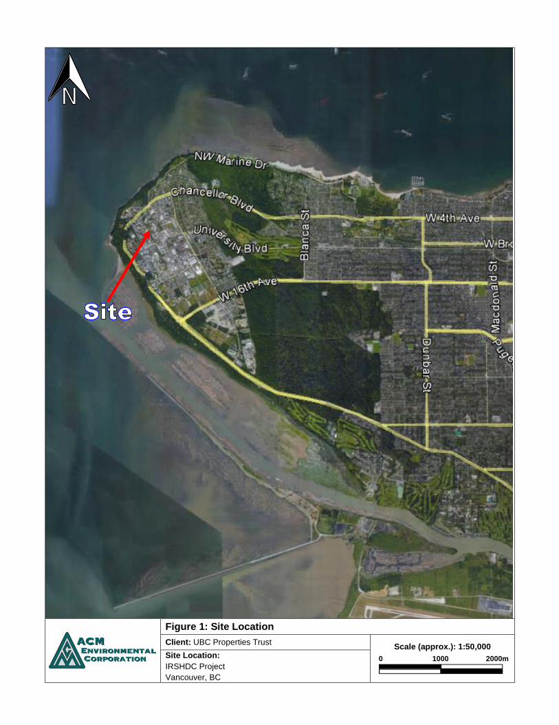
Figure 1: Site Location
Client: UBC Properties Trust
Scale (approx.): 1:50,000
0 1000 2000m
Site Location:
IRSHDC Project
Vancouver, BC

Figure 2: Site Plan
Client: UBC Properties Trust
Scale (approx.): 1:500
0 10 20m
Site Location:
IRSHDC Project
Vancouver, BC

Figure 3: Contour and Water Well Map
Client: UBC Properties Trust
Scale (approx.): 1:13,000
0 300 600m
Site Location:
IRSHDC Project
Vancouver, BC

Figure 4: Surrounding Land Use
Client: UBC Properties Trust
Scale (approx.): 1:2,500
0 60 120m
Site Location:
IRSHDC Project
Vancouver, BC

APPENDICES
APPENDIX A
AERIAL PHOTOGRAPHS

Aerial Photo: 1938
Client: UBC Properties Trust
Scale (approx.): 1:2,300
0 55 110m
Site Location:
IRSHDC Project
Vancouver, BC
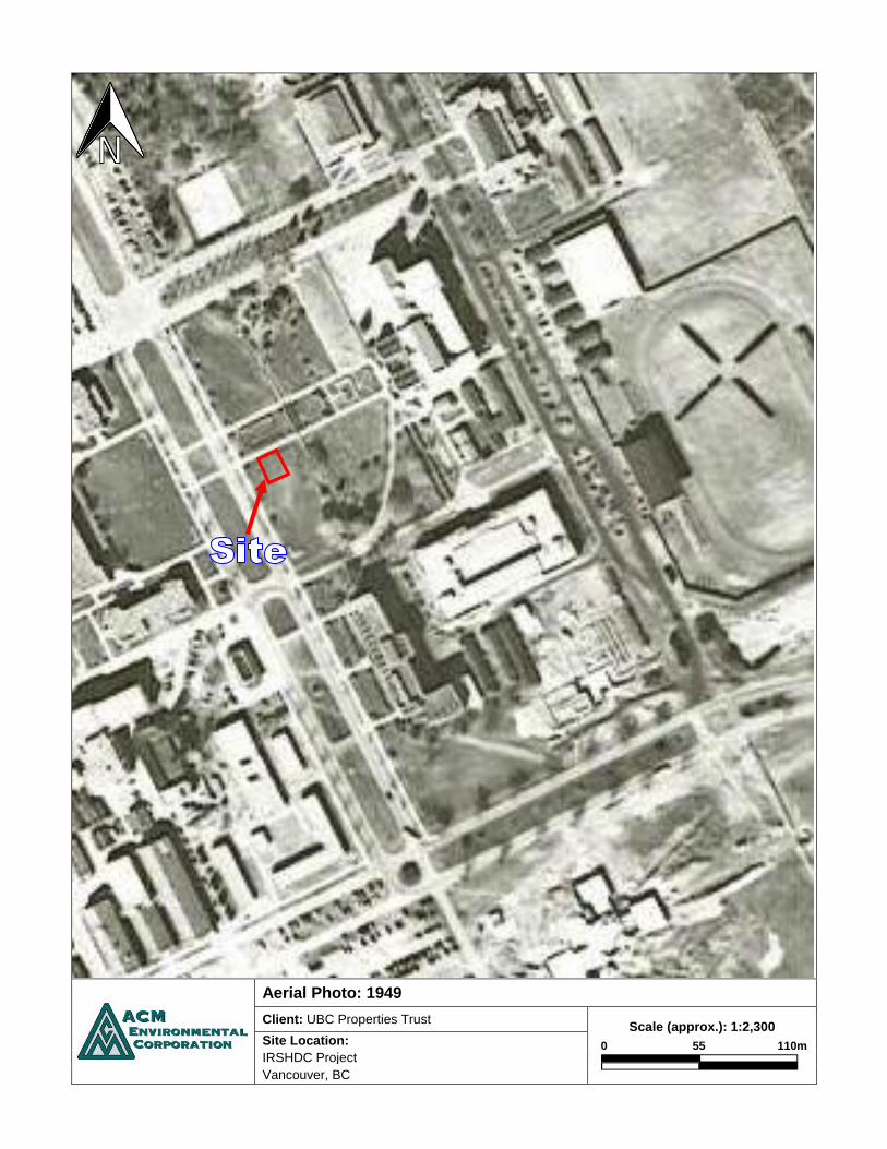
Aerial Photo: 1949
Client: UBC Properties Trust
Scale (approx.): 1:2,300
0 55 110m
Site Location:
IRSHDC Project
Vancouver, BC

Aerial Photo: 1954
Client: UBC Properties Trust
Scale (approx.): 1:2,300
0 55 110m
Site Location:
IRSHDC Project
Vancouver, BC

Aerial Photo: 1963
Client: UBC Properties Trust
Scale (approx.): 1:2,300
0 55 110m
Site Location:
IRSHDC Project
Vancouver, BC

Aerial Photo: 1969
Client: UBC Properties Trust
Scale (approx.): 1:2,300
0 55 110m
Site Location:
IRSHDC Project
Vancouver, BC

Aerial Photo: 1977
Client: UBC Properties Trust
Scale (approx.): 1:2,100
0 50 100m
Site Location:
IRSHDC Project
Vancouver, BC

Aerial Photo: 1984
Client: UBC Properties Trust
Scale (approx.): 1:2,100
0 50 100m
Site Location:
IRSHDC Project
Vancouver, BC
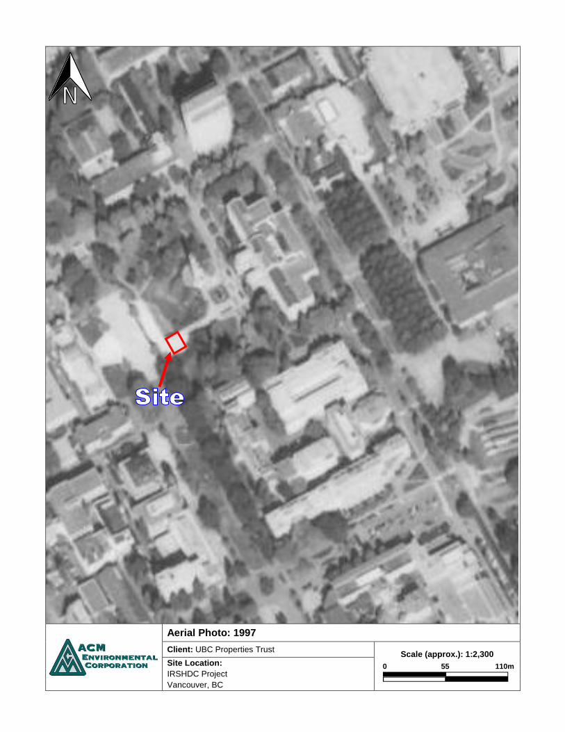
Aerial Photo: 1997
Client: UBC Properties Trust
Scale (approx.): 1:2,300
0 55 110m
Site Location:
IRSHDC Project
Vancouver, BC
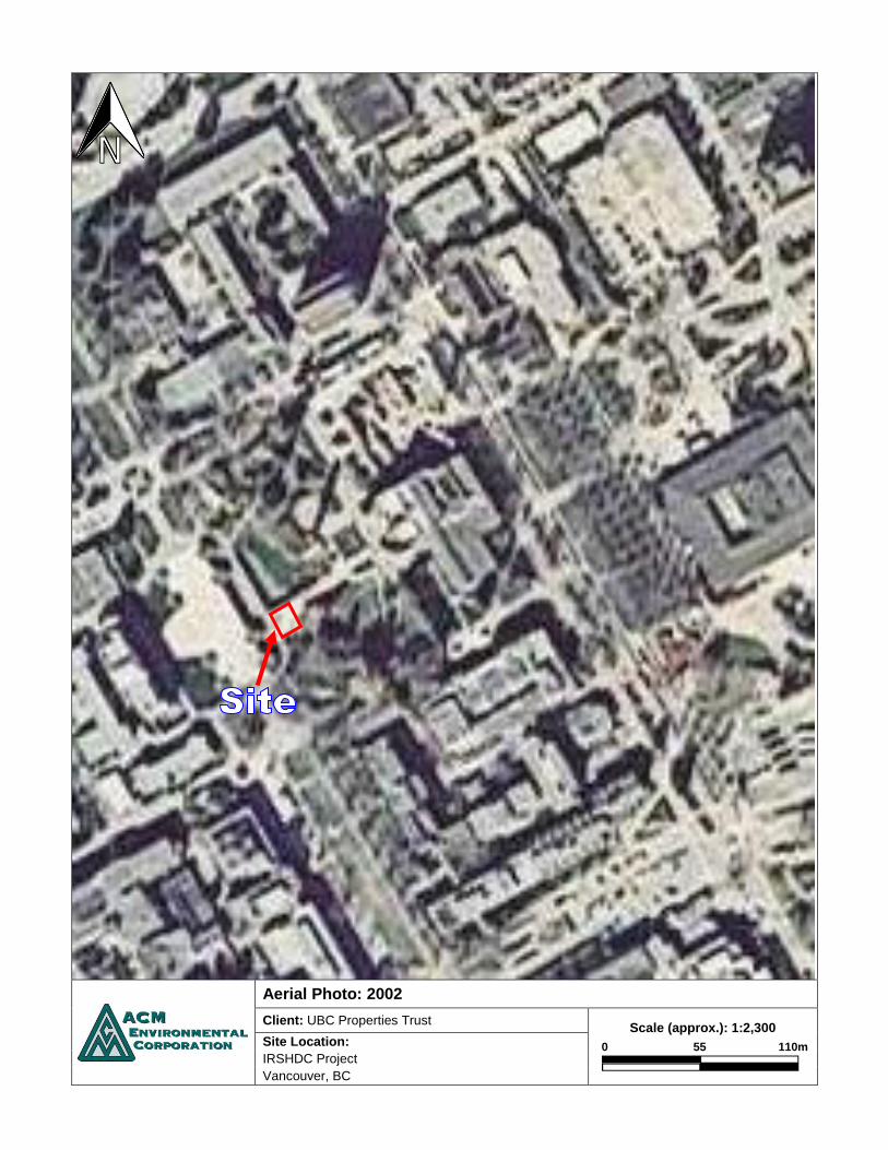
Aerial Photo: 2002
Client: UBC Properties Trust
Scale (approx.): 1:2,300
0 55 110m
Site Location:
IRSHDC Project
Vancouver, BC

APPENDIX B
TITLE SEARCH


APPENDIX C
HISTORIAL DIRECTORY SEARCH

Historical Directories – IRSHDC Project, Vancouver, BC
The above site located near the corner of Main Mall and Agricultural Road is located in the sunken garden area between Koerner Library and the Irving K. Barber Learning Centre. Prior to its major renovation in 1996, Koerner Library was known as Sedgewick Library, an almost completely underground structure. The Indian Residential School History & Dialogue Centre will be built adjacent to the underground portion of the Koerner Library, which was formerly Sedgewick Library. The Irving K. Barber Learning Centre was previously known as Main Library prior to its major renovation and addition in 2005/2008.
Directory listings for the University of British Columbia are very limited and incomplete, appearing in only one or two of the more directories over the University’s history. This site does not appear in the directories. Details of Koerner Library and the IK Barber Learning Centre follow:
Walter C. Koerner Library 1958 Main Mall Renovation/addition to Sedgewick Library: 1995/96 Notes: This building contains 7,000 square metres of new construction, and 10,200 square metres of renovated space from the former Sedgewick Library. Sedgewick Library 1958 Main Mall Constructed: 1973 Notes: This building was located almost entirely below ground level, in order to preserve the main mall, its oak trees and the traditional “library garden” that formed the central hub of the arts campus. Irving K. Barber Learning Centre 1961 East Mall Renovation/addition to Main Library: 2005/2008 Notes: The renovation to the Main Library included the addition of two massive wings to either side of the original core building. The original centre block was substantially upgraded to current fire and earthquake standards. Main Library 1956 Main Mall Constructed: 1925, additions in 1948 and 1960

APPENDIX D
FIRE INSURANCE MAPS AND UBC CAMPUS MAPS
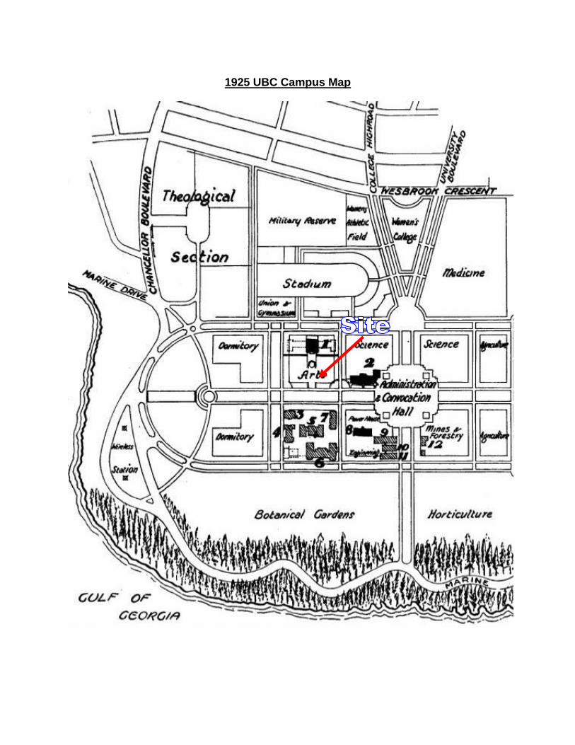
1925 UBC Campus Map

1931 UBC Campus Map
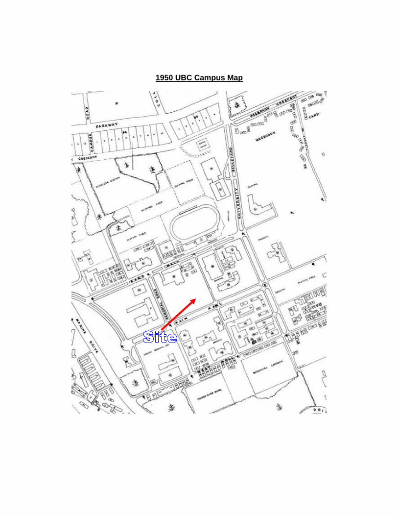
1950 UBC Campus Map

1958 UBC Campus Map

19
62
Fir
e I
ns
ura
nc
e M
ap

19
62
Fir
e I
ns
ura
nc
e M
ap
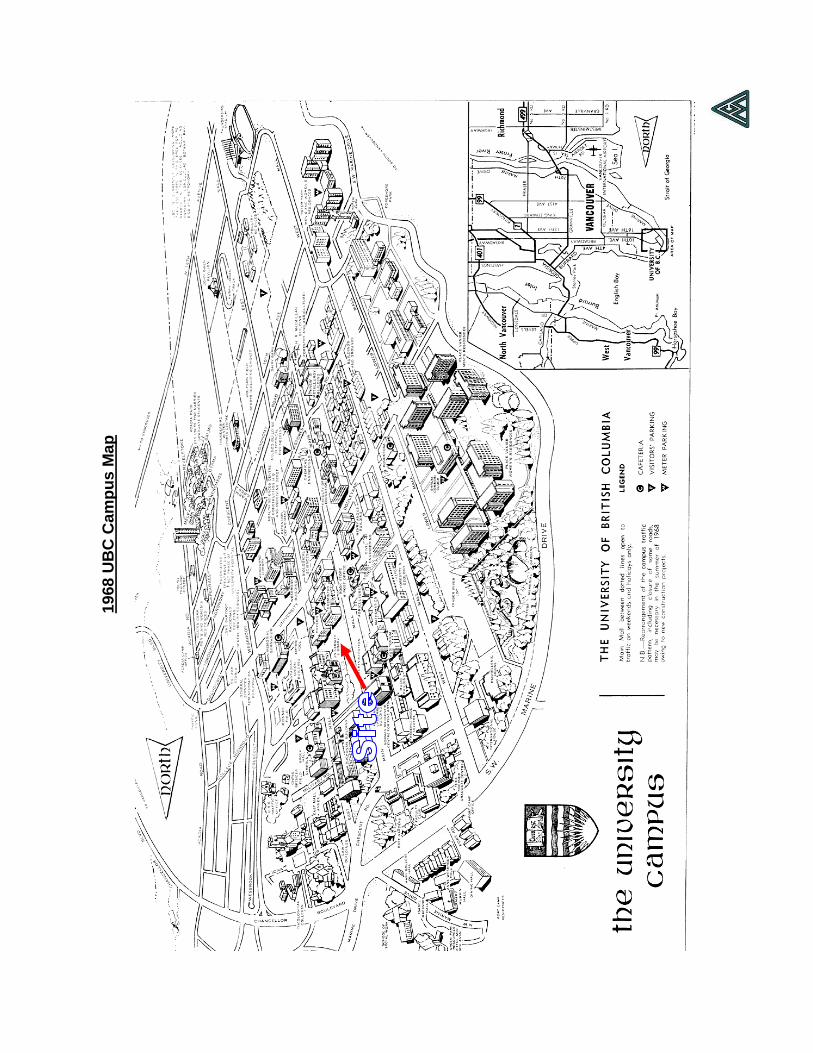
19
68
UB
C C
am
pu
s M
ap

APPENDIX E
SITE REGISTRY SEARCH


APPENDIX F
SITE PHOTOGRAPHS

Photo 1: Upper portion of the Site viewed from the west.
Irving K. Barber Learning Centre visible further east of the Site.
Photo 2: Upper portion of the Site viewed from the east.
Walter C. Koerner Library visible adjacent west and below the Site.
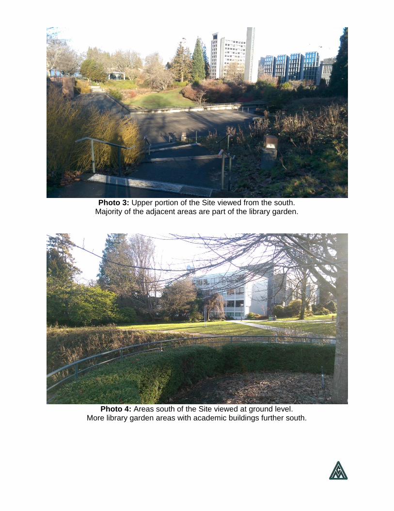
Photo 3: Upper portion of the Site viewed from the south.
Majority of the adjacent areas are part of the library garden.
Photo 4: Areas south of the Site viewed at ground level.
More library garden areas with academic buildings further south.

Photo 5: Below portion of the Site. The area consists of
several rooms of the Walter C. Koerner Library.
Photo 6: Inside view of the library room of the Site. The room appears to be used for storage purposes.

Photo 7: View of the below portion of the Site
and the adjacent sunken garden from the above level.
Photo 8: Below portion of the Site viewed from the north.

ENV 003 REV 2012/10/12 PAGE 1 OF 6
Site Profile
Schedule 1 Contaminated Sites Regulation
Mail, Fax or Courier: Director of Waste Management c/o Site Profile Administration Ministry of Environment #200 - 10470 - 152nd Street Surrey BC V3R 0Y3 Fax: (604) 584-9751
This form may be sent to the Ministry of Environment by paper mail, fax, or courier. It may also be scanned and e-mailed with the applicable attachments (such as maps) to [email protected].
For further information, please e-mail us at [email protected], or contact us by phone at (250) 387-4441.
Introduction Under section 40 of the Environmental Management Act, a person who knows or reasonably should know that a site has been used or is used for industrial or commercial purposes or activities must in certain circumstances provide a site profile. Schedule 2 of the Contaminated Sites Regulation sets out the types of industrial or commercial purposes or activities to which site profile requirements apply. If section 40 of the Environmental Management Act applies to you and you know or reasonably should know that the site has been used or is used for one of the purposes or activities found in Schedule 2 of the Contaminated Sites Regulation, you may be required to complete the attached site profile. Instructions
Persons preparing a site profile must complete Section I, II and III, answer all questions in sections IV through IX, and sign section XI. If the site profile is not satisfactorily completed, it will not be processed under the Environmental Management Act and the Contaminated Sites Regulation. Failure to complete the site profile satisfactorily may result in delays in approval of relevant applications and in the postponement of decisions respecting the property. The person completing this site profile is responsible for the accuracy of the answers. Questions must be answered to the best of your knowledge. Section 27 (1) of the Freedom of Information and Protection of Privacy Act requires that provision of personal information concerning an individual must be authorized by that individual. Persons completing the site profile on behalf of the site owner must be authorized by the site owner. One (1) site profile may be completed for a site comprised of more than one titled or untitled parcel, but individual parcels must be identified. The latitude and longitude (accurate to 0.5 of a second using North American Datum established in 1983) of the centre of the site must be provided. Also, please attach an accurate map, containing latitude, longitude and datum references, which shows the boundaries of the site in question. Please use the largest scale map available. If the property is legally surveyed, titled and registered, then all PID numbers (Parcel Identifiers - Land Title Registry system) must be provided for each parcel as well as the appropriate legal description. If the property is untitled Crown land (no PID number), then the appropriate PIN numbers (Parcel Identification Numbers - Crown Land registry system) for each parcel with the appropriate land description should be supplied. If available, the Crown Land File Number for the site should also be supplied. Anything submitted in relation to this site profile will become part of the public record and may be made available to the public through the Site Registry as established under the Environmental Management Act. Under section 43 of the Environmental Management Act, corporate and personal information contained in the site profile may be made available to the public through the Site Registry. If you have questions concerning the collection of this information, contact the Site Registrar, at [email protected]. For questions on site profiles, please send a message to [email protected].
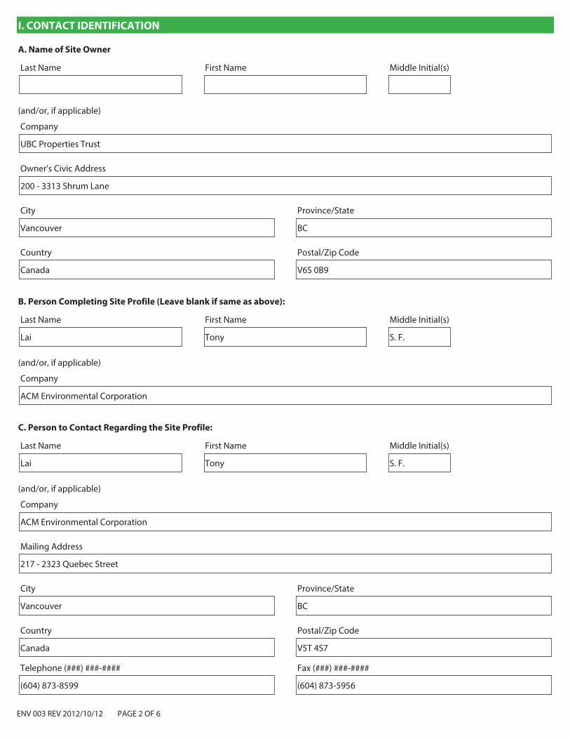
ENV 003 REV 2012/10/12 PAGE 2 OF 6
I. CONTACT IDENTIFICATION
A. Name of Site Owner
First NameLast Name Middle Initial(s)
Company
UBC Properties Trust
(and/or, if applicable)
Owner's Civic Address
200 - 3313 Shrum Lane
City
Vancouver
Province/State
BC
Country
Canada
Postal/Zip Code
V6S 0B9
B. Person Completing Site Profile (Leave blank if same as above):
First Name
Tony
Last Name
Lai
Middle Initial(s)
S. F.
Company
ACM Environmental Corporation
(and/or, if applicable)
C. Person to Contact Regarding the Site Profile:
First Name
Tony
Last Name
Lai
Middle Initial(s)
S. F.
Company
ACM Environmental Corporation
(and/or, if applicable)
Mailing Address
217 - 2323 Quebec Street
City
Vancouver
Province/State
BC
Country
Canada
Postal/Zip Code
V5T 4S7
Fax (###) ###-####
(604) 873-5956
Telephone (###) ###-####
(604) 873-8599

ENV 003 REV 2012/10/12 PAGE 3 OF 6
II. SITE IDENTIFICATION
Please attach a site map with your application
All Property
Coordinates (using the North American Datum 1983 convention) for the centre of the site:
Degrees 49 Minutes 16 Seconds 0.71Latitude
Degrees 123 Minutes 15 Seconds 14.34Longitude
Please attach a map of appropriate scale showing the boundaries of the site.
For Legally Titled, Registered Property
Postal CodeCity
Vancouver
Site Address (if applicable)
PID numbers and associated legal descriptions.
PID Legal Description Add Delete
015-891-909 District Lot 3044, Group 1, NWD Except + -
Firstly; Part On Plan 6147 + -
Secondly: Part On Plan 9301 + -
Thirdly; Part On Plan BCP6556 + -
Fourthly: Part On Plan BCP23719 + -
Total number of titled parcels represented by this site profile
1
For Untitled Crown Land
PIN numbers and associated Land Description (if applicable).
PIN Land Description Add Delete
+ -
Total number of untitled crown land parcels represented by this site profile
(and, if available)
Crown Land File Numbers (comma separated)

ENV 003 REV 2012/10/12 PAGE 4 OF 6
III. COMMERCIAL AND INDUSTRIAL PURPOSES OR ACTIVITIES
Please indicate below, in the format of the example provided, which of the industrial and commercial purposes and activities from Schedule 2 have occurred or are occurring on this site.
EXAMPLE
Schedule 2 Reference Description
E1 appliance, equipment or engine repair, reconditioning, cleaning or salvage
F10 solvent manufacturing or wholesale bulk storage
Schedule 2 Reference Description Add Delete
None N/A + -
IV. AREAS OF POTENTIAL CONCERN
Is there currently or to the best of your knowledge has there previously been on the site any (please mark the appropriate column opposite the question): YES NO
A. Petroleum, solvent or other polluting substance spills to the environment greater than 100 litres? ✔
B.Residue left after removal of piled materials such as chemicals, coal, ore, smelter slag, air quality control system baghouse dust? ✔
C. Discarded barrels, drums or tanks? ✔
D. Contamination resulting from migration of substances from other properties? ✔
V. FILL MATERIALS
Is there currently or to the best of your knowledge has there previously been on the site any deposit of (please mark the appropriate column opposite the question): YES NO
A.Fill dirt, soil, gravel, sand or like materials from a contaminated site or from a source used for any of the activities listed under Schedule 2? ✔
B.Discarded or waste granular materials such as sand blasting grit, asphalt paving or roofing material, spent foundry casting sands, mine ore, waste rock or float? ✔
C.Dredged sediments, or sediments and debris materials originating from locations adjacent to foreshore industrial activities, or municipal sanitary or stormwater discharges? ✔

ENV 003 REV 2012/10/12 PAGE 5 OF 6
VI. WASTE DISPOSAL
Is there currently or to the best of your knowledge has there previously been on the site any landfilling, deposit,
spillage or dumping of the following materials (please mark the appropriate column opposite the question): YES NO
A. Materials such as household garbage, mixed municipal refuse, or demolition debris? ✔
B.Waste or byproducts such as tank bottoms, residues, sludge, or flocculation precipitates from industrial processes or wastewater treatment? ✔
C.Waste products from smelting or mining activities, such as smelter slag, mine tailings, or cull materials from coal processing? ✔
D. Waste products from natural gas and oil well drilling activities, such as drilling fluids and muds? ✔
E.
Waste products from photographic developing or finishing laboratories; asphalt tar manufacturing; boilers, incinerators or other thermal facilities (e.g. ash); appliance, small equipment or engine repair or salvage; dry cleaning operations (e.g. solvents); or from the cleaning or repair of parts of boats, ships, barges, automobiles or trucks, including sandblasting grit or paint scrapings?
✔
VII. TANKS OR CONTAINERS USED OR STORED, OTHER THAN TANKS USED FOR RESIDENTIAL HEATING FUEL
Are there currently or to the best of your knowledge have there been previously on the site any (please mark the appropriate column opposite the question): YES NO
A. Underground fuel or chemical storage tanks other than storage tanks for compressed gases? ✔
B. Above ground fuel or chemical storage tanks other than storage tanks for compressed gases? ✔
VIII. HAZARDOUS WASTES OR HAZARDOUS SUBSTANCES
Are there currently or to the best of your knowledge have there been previously on the site any (please mark the appropriate column opposite the question): YES NO
A.PCB-containing electrical transformers or capacitors either at grade, attached above ground to poles, located within buildings, or stored? ✔
B.Waste asbestos or asbestos containing materials such as pipe wrapping, blown-in insulation or panelling buried? ✔
C.Paints, solvents, mineral spirits or waste pest control products or pest control product containers stored in volumes greater than 205 litres? ✔
IX. LEGAL OR REGULATORY ACTIONS OR CONSTRAINTS
To the best of your knowledge are there currently any of the following pertaining to the site (please mark the appropriate column opposite the question): YES NO
A.Government orders or other notifications pertaining to environmental conditions or quality of soil, water, groundwater or other environmental media? ✔
B.Liens to recover costs, restrictive covenants on land use, or other charges or encumbrances, stemming from contaminants or wastes remaining onsite or from other environmental conditions? ✔
C.Government notifications relating to past or recurring environmental violations at the site or any facility located on the site? ✔
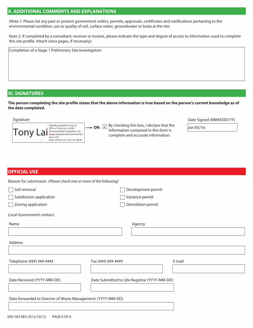
ENV 003 REV 2012/10/12 PAGE 6 OF 6
X. ADDITIONAL COMMENTS AND EXPLANATIONS
(Note 1: Please list any past or present government orders, permits, approvals, certificates and notifications pertaining to the environmental condition, use or quality of soil, surface water, groundwater or biota at the site. Note 2: If completed by a consultant, receiver or trustee, please indicate the type and degree of access to information used to complete this site profile. Attach extra pages, if necessary):
Completion of a Stage 1 Preliminary Site Investigation
XI. SIGNATURES
Signature
OR: ✔ By checking this box, I declare that the information contained in this form is complete and accurate information.
The person completing the site profile states that the above information is true based on the person's current knowledge as of
the date completed.
Date Signed (MMM/DD/YY)
Jan/05/16
OFFICIAL USE
Reason for submission (Please check one or more of the following)
Soil removal
Subdivision application
Zoning application
Development permit
Variance permit
Demolition permit
Local Government contact:
AgencyName
Address
Telephone (###) ###-#### Fax (###) ###-#### E-mail
Date Received (YYYY-MM-DD) Date Submitted to Site Registrar (YYYY-MM-DD)
Date forwarded to Director of Waste Management: (YYYY-MM-DD)
Tony LaiDigitally signed by Tony Lai DN: cn=Tony Lai, o=ACM Environmental Corporation, ou, [email protected], c=CA Date: 2016.01.05 15:01:34 -08'00'

Figure 1: Site Location
Client: UBC Properties Trust
Scale (approx.): 1:50,000
0 1000 2000m
Site Location:
IRSHDC Project
Vancouver, BC
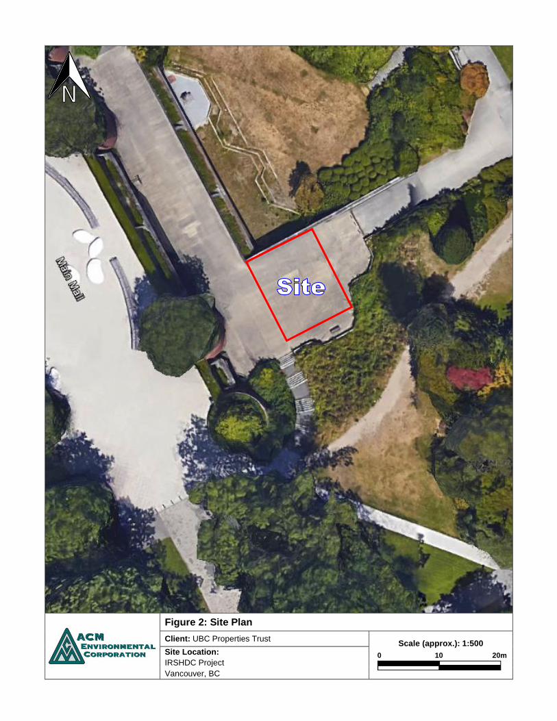
Figure 2: Site Plan
Client: UBC Properties Trust
Scale (approx.): 1:500
0 10 20m
Site Location:
IRSHDC Project
Vancouver, BC

November 23, 2015 UBC Properties Trust 200-3313 Shrum Lane Vancouver, British Columbia
Re: UBC Library Gardens Tree Inventory, 1900 Main Mall Diamond Head Consulting was engaged by UBC Properties Trust, to provide an inventory of the trees in the UBC Library Gardens. Eighty-four trees were assessed at the site on November 19, 2015.
Assignment Provide a tree inventory and location plan for those trees located within the subject area (see attached map).
Limits of Assignment • Our investigation is based solely on our visual inspection of the trees on November 18 & 19,
2015. • This report does not provide any estimates to implement the proposed recommendations
provided in this report.

Arb
oris
t Mem
o –
UB
C li
brar
y G
arde
ns T
ree
Ass
essm
ent,
1900
Mai
n M
all
2
Tree
Inve
ntor
y:
Tag
Com
mon
N
ame
Bota
nica
l N
ame
DBH
(cm
) He
ight
(m
) O
vera
ll Co
nditi
on
Com
men
ts
RPZ
(m)
2967
Re
d O
ak
Que
rcus
rubr
a 44
18
N
orm
al
Plan
ted
in 1
0 m
dia
met
er c
oncr
ete
plan
ter;
open
gro
wn
crow
n 2.
6 29
68
Red
Map
le
Acer
rubr
um
2 3
Poor
Pr
evio
us d
omin
ant s
tem
was
cut
and
now
has
dec
ay,
New
do
min
ate
stem
has
cre
ated
poo
r ste
m fo
rmat
ion
2.0
2969
Rh
odod
endr
on
sp.
Rhod
oden
dron
sp
. 18
7
Poor
O
ld p
runi
ng w
ound
s with
min
or d
ecay
; gro
win
g on
top
of
boul
der r
etai
ning
wal
l 2.
0
2970
Po
rtug
uese
La
urel
Pr
unus
lu
sitan
ica
44
8 Po
or
2 st
ems f
rom
bas
e, l
ower
stem
pru
ned
2.6
2971
Ca
mpe
rdow
n El
m
Ulm
us
'Cam
perd
owni
i' 46
12
Po
or
Bact
eria
l gro
wth
on
limbs
, hig
hly
unus
ual c
row
n pa
tter
n.
2.8
2972
Po
rtug
uese
La
urel
Pr
unus
lu
sitan
ica
120
12
Poor
M
ultip
le st
ems f
rom
bas
e; 6
stem
s with
an
aver
age
dbh
20cm
; m
oder
ate
rot i
n pr
unin
g w
ound
s 7.
2
2974
Az
alea
sp.
Azal
ea sp
. 54
4
Poor
M
ultip
le st
ems f
rom
bas
e; p
runi
ng w
ound
s with
min
or ro
t 3.
2 29
75
Euro
pean
Be
ech
Fagu
s syl
vatic
a 16
7
Very
poo
r Po
ssib
le D
awyc
k cu
ltiva
r; Po
ssib
le d
efec
t roo
t gra
ft c
ausin
g na
rrow
root
col
lar
2.0
2976
Rh
odod
endr
on
sp.
Rhod
oden
dron
sp
. 18
3
Poor
Bl
ight
in s
ome
leav
es a
nd fl
ower
2.
0
2977
M
aide
nhai
r Tr
ee
Gink
go -
G.bi
loba
9
5 N
orm
al
Sapl
ing,
kin
k in
stem
oth
erw
ise n
o vi
sible
def
ects
2.
0
2978
Ja
pane
se
Map
le
Acer
pal
mat
um
38
12
Dead
/dyi
ng
3 st
ems a
t uni
on, 1
dea
d, a
noth
er li
mb
dyin
g; m
ajor
rot i
n ba
se
2.3
2979
Po
rtug
uese
La
urel
Pr
unus
lu
sitan
ica
280
Mul
ti St
ems
10
Poor
M
ultip
le st
ems f
rom
bas
e ,1
4 st
ems w
ith a
n av
erag
e db
h 20
cm
; 1 d
ead/
dyin
g lim
b an
d pr
unin
g w
ound
s with
mod
erat
e ro
t 16
.8

Arb
oris
t Mem
o –
UB
C li
brar
y G
arde
ns T
ree
Ass
essm
ent,
1900
Mai
n M
all
3
Tag
Com
mon
N
ame
Bota
nica
l N
ame
DBH
(cm
) He
ight
(m
) O
vera
ll Co
nditi
on
Com
men
ts
RPZ
(m)
2980
Po
rtug
uese
La
urel
Pr
unus
lu
sitan
ica
176
Mul
ti St
ems
10
Very
poo
r M
ultip
le st
ems s
harin
g ro
ot sy
stem
; 8 st
ems w
ith a
n av
erag
e db
h 22
cm
; dyi
ng li
mbs
with
maj
or d
ecay
10
.6
2981
Re
d O
ak
Que
rcus
rubr
a 22
12
Po
or
Plan
ted
in 1
0m d
iam
eter
con
cret
e pl
ante
r; to
p 3
m o
f ste
m is
be
nt
2.0
2983
Rh
odod
endr
on
sp.
Rhod
oden
dron
sp
. 20
3
Poor
M
ultip
le st
ems f
rom
bas
e; A
ppea
rs to
hav
e Ba
cter
ial b
light
in
fect
ion.
2.
0
2984
Pa
cific
Yew
Ta
xus
brev
ifolia
34
15
Po
or
Grow
ing
on to
ps o
f roc
ks.
2.0
2986
Si
beria
n Sp
ruce
Pi
cea
omor
ica
20
9 Po
or
Swee
p in
stem
, unu
sual
stem
form
due
to sw
eep
and
singl
e st
em g
row
ing
out o
ppos
ite o
f ste
m le
an; i
n sh
rub
bed
2.
0
2987
Re
d Al
der
Alnu
s rub
ra
20
5 Po
or
3 st
ems g
row
ing
from
bas
e, g
row
ing
in m
ugo
pine
bus
h 2.
0 29
88
Gian
t Re
dwoo
d Se
quoi
a gi
gant
eum
82
25
N
orm
al
Slig
htly
asy
mm
etric
al lo
wer
cro
wn
due
phot
otro
pic
grow
th a
nd
neig
hbor
ing
tree
s; p
lant
ed o
n ed
ge o
f slo
pe. H
as o
ne e
xpos
ed
(sur
face
) str
uctu
ral r
oot.
4.9
2989
Ch
erry
Pr
unus
sp.
59
10
Very
poo
r St
em g
raft
ed a
t 2 m
with
stem
s spr
eadi
ng o
utw
ard
in to
wid
e an
d fla
t cro
wn.
Maj
or ro
t in
one
of th
e lim
bs li
kely
cau
sed
by
prun
ing
olds
. S
tem
cov
ered
in iv
y. G
row
ing
in sh
rub
bed.
3.5
2990
Re
d O
ak
Que
rcus
rubr
a 16
18
N
orm
al
Wid
e op
en g
row
n cr
own;
pla
nted
in 1
0m d
iam
eter
con
cret
e pl
ante
r box
.
2.0
2991
En
glish
Oak
Q
uerc
us ro
bur
44
18
Nor
mal
Si
ngle
stra
ight
dom
inan
t ste
m; o
pen
grow
n, m
inor
pru
ning
w
ound
s 2.
6
2992
Re
d O
ak
Que
rcus
rubr
a 11
7 20
Po
or
Larg
e cr
own
with
8 m
ajor
lim
bs; c
rack
s in
bark
som
e w
ith
min
or ro
t; ol
d pr
unin
g w
ound
s 7.
0
2993
Ho
lly
Ilex
aqui
foliu
m
20
8 N
orm
al
Grou
p of
hol
ly w
ith d
bh b
etw
een
25-8
cm; c
over
s 5x5
m
tria
ngle
by
stai
rs
2.0

Arb
oris
t Mem
o –
UB
C li
brar
y G
arde
ns T
ree
Ass
essm
ent,
1900
Mai
n M
all
4
Tag
Com
mon
N
ame
Bota
nica
l N
ame
DBH
(cm
) He
ight
(m
) O
vera
ll Co
nditi
on
Com
men
ts
RPZ
(m)
2994
Ja
pane
se
Map
le
Acer
pal
mat
um
97
5 Po
or
Mul
tiple
stem
s fro
m b
ase,
12
stem
s with
an
aver
age
9cm
dbh
w
ith in
clus
ion
scar
ing
arou
nd b
ase;
seve
ral w
ound
s; p
revi
ous
prun
ing
and
som
e de
adw
ood
5.8
2995
Ju
nipe
r Ju
nipe
rus
scop
ulor
um
18
7 Po
or
Swee
p in
stem
from
supp
ress
ion
and
phot
otro
pic
grow
th; i
n de
nse
scru
b be
d 2.
0
2996
Ju
nipe
r Ju
nipe
rus
scop
ulor
um
16
7 Po
or
Swee
p in
stem
from
supp
ress
ion
and
phot
otro
pic
grow
th; i
n de
nse
scru
b be
d 2.
0
2997
Th
read
Lea
f Cy
pres
s Ch
amae
cypa
ris
pisif
era
'Fili
fera
'
42
8 Po
or
Supp
ress
ed c
ausin
g po
or st
em fo
rm, i
n ed
ge o
f shr
ub b
ed.
2.5
5755
W
eepi
ng
Will
ow
Salix
ba
bylo
nica
22
87
Po
or
30cm
pru
ning
wou
nd w
ith m
ajor
rot;
stem
s tw
isted
in c
row
n.
2.0
5756
N
orw
ay M
aple
Ac
er
plat
anoi
des
50
16
Poor
As
ymm
etric
al c
row
n du
e to
nei
ghbo
ring
tree
; bac
teria
can
ker
at b
ase
and
on st
em.
3.0
5757
N
orw
ay M
aple
Ac
er
plat
anoi
des
48
16
Poor
Po
or st
em fr
om; l
ong
narr
ow c
row
n du
e to
nei
ghbo
ring
tree
s on
opp
osite
side
s. 2.
9
5758
N
orw
ay M
aple
Ac
er
plat
anoi
des
42
16
Poor
Se
vera
l cod
omin
ant s
tem
s with
min
or d
eadw
ood
in c
row
n.
2.5
5761
W
este
rn
Redc
edar
Th
uja
plic
ata
105
29
Nor
mal
O
pen
grow
n fo
rm; 1
m fr
om c
oncr
ete
pool
; lar
ge ro
cks n
ear
base
. 6.
3
5763
Ja
pane
se
Map
le
Acer
pal
mat
um
123
10
Poor
Th
ere
are
seve
ral h
istor
ic p
runi
ng w
ound
s, w
ith o
ne p
ossib
le
bact
eria
l can
ker g
row
th; 7
stem
s joi
n at
the
base
; wid
e op
en
crow
n.
7.4
5764
W
eepi
ng
Will
ow
Salix
ba
bylo
nica
88
20
Ve
ry p
oor
Num
erou
s pru
ning
wou
nds w
ith m
oder
ate
to m
ajor
dec
ay;
bact
eria
gro
wth
, thi
n cr
own;
Loc
ated
in sc
rub
bed
part
of a
n el
evat
ed ro
ck g
arde
n
5.3
5765
La
wso
n Cy
pres
s Ch
amae
cypa
ris
law
soni
ana
13
6 Po
or
Swee
p in
stem
due
to su
ppre
ssio
n an
d ph
otot
ropi
c gr
owth
; in
shru
b be
d 2.
0

Arb
oris
t Mem
o –
UB
C li
brar
y G
arde
ns T
ree
Ass
essm
ent,
1900
Mai
n M
all
5
Tag
Com
mon
N
ame
Bota
nica
l N
ame
DBH
(cm
) He
ight
(m
) O
vera
ll Co
nditi
on
Com
men
ts
RPZ
(m)
5765
Th
read
Lea
f Cy
pres
s Ch
amae
cypa
ris
pisif
era
'Fili
fera
'
101
15
Poor
M
ultip
le st
ems f
rom
bas
e w
ith c
onne
cted
root
s sys
tem
and
fo
rked
tops
. Asy
mm
etric
al c
row
n du
e to
nei
ghbo
ring
tree
. So
me
evid
ence
of p
runi
ng.
6.1
5766
Ja
pane
se
Map
le
Acer
pal
mat
um
160
16
Poor
M
ultip
le st
ems f
rom
bas
e, n
umer
ous i
nclu
sion
scar
s; c
rack
ar
ound
tag
with
min
or ro
t; on
gar
den
mou
nd w
ith n
umer
ous
boul
ders
. App
ly a
6m
root
pro
tect
ion
zone
.
6.0
5769
La
wso
n Cy
pres
s Ch
amae
cypa
ris
law
soni
ana
106
25
Poor
2
stem
s fro
m b
ase,
6 c
odom
inan
t ste
ms p
ast d
bh w
ith lo
ng
incl
usio
n sc
ars;
gro
win
g in
shru
b be
d 6.
4
5770
Th
read
Lea
f Cy
pres
s Ch
amae
cypa
ris
pisif
era
'Fili
fera
'
240
9 Po
or
12 st
em g
roup
ing
with
an
aver
age
dbh
of 2
0cm
; pru
ning
scar
s,
shru
b be
d, p
oor s
tem
s do
to c
ompe
titio
n fr
om d
ense
spac
ing.
Ap
ply
a 6m
root
pro
tect
ion
zone
.
6.0
5808
La
wso
n Cy
pres
s Ch
amae
cypa
ris
law
soni
ana
71
23
Poor
M
ultip
le st
ems f
rom
dbh
with
larg
e in
clus
ion
scar
s; se
vera
l w
eepi
ng w
ound
s fro
m p
ossib
le sp
ace
in st
em in
clus
ion;
in
shru
b be
d, c
able
s in
stem
for n
eigh
borin
g tr
ee
4.3
5809
Ju
das T
ree
Cerc
is sil
iqua
stru
m
52
7 De
ad/d
ying
Se
vere
lean
, hel
d up
with
cab
le to
pre
vent
failu
re; b
acte
ria
grow
ths o
n st
em
3.1
5810
La
wso
n Cy
pres
s Ch
amae
cypa
ris
law
soni
ana
69
23
Poor
M
ultip
le st
ems f
rom
dbh
with
larg
e in
clus
ion
scar
s; se
vera
l w
eepi
ng w
ound
s fro
m p
ossib
le sp
ace
in st
em in
clus
ion;
gr
owin
g in
shru
b be
d
4.1
5811
Ch
ines
e Fi
r Cu
nnin
gham
ia
lanc
eola
ta
108
22
Poor
2
stem
s fro
m b
ase
with
larg
e in
clus
ion
scar
and
smal
ler
prev
ious
cut
stem
in c
entr
e of
incl
usio
n; 2
asy
mm
etric
al
crow
ns
6.5
5813
Ta
rtan
Map
le
Acer
Tar
taria
n 12
0 11
Po
or
Mul
tiple
stem
s fro
m b
ase
with
incl
usio
n sc
ars;
Old
pru
ning
w
ound
s, D
BH e
stim
ate
due
to d
ata
colle
ctio
n er
ror
7.2
5814
Ta
rtan
Map
le
Acer
Tar
taria
n 52
10
Ve
ry p
oor
Onl
y re
tain
with
tree
581
3; o
ld p
runi
ng w
ound
with
mod
erat
e ro
t; m
ultip
le st
ems f
rom
bas
e w
ith se
vere
incl
usio
n sc
ar a
nd
phot
otro
pic
lean
3.1
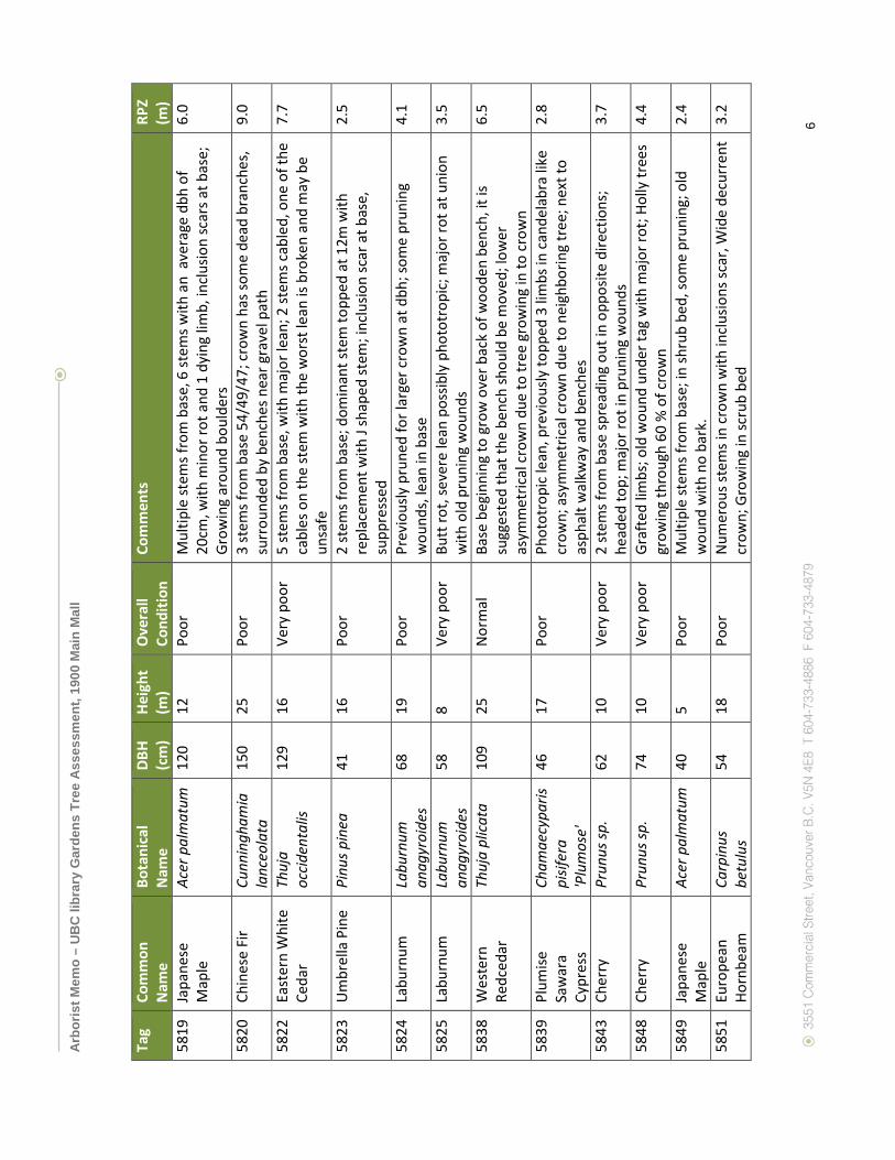
Arb
oris
t Mem
o –
UB
C li
brar
y G
arde
ns T
ree
Ass
essm
ent,
1900
Mai
n M
all
6
Tag
Com
mon
N
ame
Bota
nica
l N
ame
DBH
(cm
) He
ight
(m
) O
vera
ll Co
nditi
on
Com
men
ts
RPZ
(m)
5819
Ja
pane
se
Map
le
Acer
pal
mat
um
120
12
Poor
M
ultip
le st
ems f
rom
bas
e, 6
stem
s with
an
ave
rage
dbh
of
20cm
, with
min
or ro
t and
1 d
ying
lim
b, in
clus
ion
scar
s at b
ase;
Gr
owin
g ar
ound
bou
lder
s
6.0
5820
Ch
ines
e Fi
r Cu
nnin
gham
ia
lanc
eola
ta
150
25
Poor
3
stem
s fro
m b
ase
54/4
9/47
; cro
wn
has s
ome
dead
bra
nche
s,
surr
ound
ed b
y be
nche
s nea
r gra
vel p
ath
9.0
5822
Ea
ster
n W
hite
Ce
dar
Thuj
a oc
cide
ntal
is 12
9 16
Ve
ry p
oor
5 st
ems f
rom
bas
e, w
ith m
ajor
lean
; 2 st
ems c
able
d, o
ne o
f the
ca
bles
on
the
stem
with
the
wor
st le
an is
bro
ken
and
may
be
unsa
fe
7.7
5823
U
mbr
ella
Pin
e Pi
nus p
inea
41
16
Po
or
2 st
ems f
rom
bas
e; d
omin
ant s
tem
topp
ed a
t 12m
with
re
plac
emen
t with
J sh
aped
stem
; inc
lusio
n sc
ar a
t bas
e,
supp
ress
ed
2.5
5824
La
burn
um
Labu
rnum
an
agyr
oide
s 68
19
Po
or
Prev
ious
ly p
rune
d fo
r lar
ger c
row
n at
dbh
; som
e pr
unin
g w
ound
s, le
an in
bas
e 4.
1
5825
La
burn
um
Labu
rnum
an
agyr
oide
s 58
8
Very
poo
r Bu
tt ro
t, se
vere
lean
pos
sibly
pho
totr
opic
; maj
or ro
t at u
nion
w
ith o
ld p
runi
ng w
ound
s 3.
5
5838
W
este
rn
Redc
edar
Th
uja
plic
ata
109
25
Nor
mal
Ba
se b
egin
ning
to g
row
ove
r bac
k of
woo
den
benc
h, it
is
sugg
este
d th
at th
e be
nch
shou
ld b
e m
oved
; low
er
asym
met
rical
cro
wn
due
to tr
ee g
row
ing
in to
cro
wn
6.5
5839
Pl
umise
Sa
war
a Cy
pres
s
Cham
aecy
paris
pi
sifer
a 'P
lum
ose'
46
17
Poor
Ph
otot
ropi
c le
an, p
revi
ously
topp
ed 3
lim
bs in
can
dela
bra
like
crow
n; a
sym
met
rical
cro
wn
due
to n
eigh
borin
g tr
ee; n
ext t
o as
phal
t wal
kway
and
ben
ches
2.8
5843
Ch
erry
Pr
unus
sp.
62
10
Very
poo
r 2
stem
s fro
m b
ase
spre
adin
g ou
t in
oppo
site
dire
ctio
ns;
head
ed to
p; m
ajor
rot i
n pr
unin
g w
ound
s 3.
7
5848
Ch
erry
Pr
unus
sp.
74
10
Very
poo
r Gr
afte
d lim
bs; o
ld w
ound
und
er ta
g w
ith m
ajor
rot;
Holly
tree
s gr
owin
g th
roug
h 60
% o
f cro
wn
4.4
5849
Ja
pane
se
Map
le
Acer
pal
mat
um
40
5 Po
or
Mul
tiple
stem
s fro
m b
ase;
in sh
rub
bed,
som
e pr
unin
g; o
ld
wou
nd w
ith n
o ba
rk.
2.4
5851
Eu
rope
an
Horn
beam
Ca
rpin
us
betu
lus
54
18
Poor
N
umer
ous s
tem
s in
crow
n w
ith in
clus
ions
scar
, Wid
e de
curr
ent
crow
n; G
row
ing
in sc
rub
bed
3.2
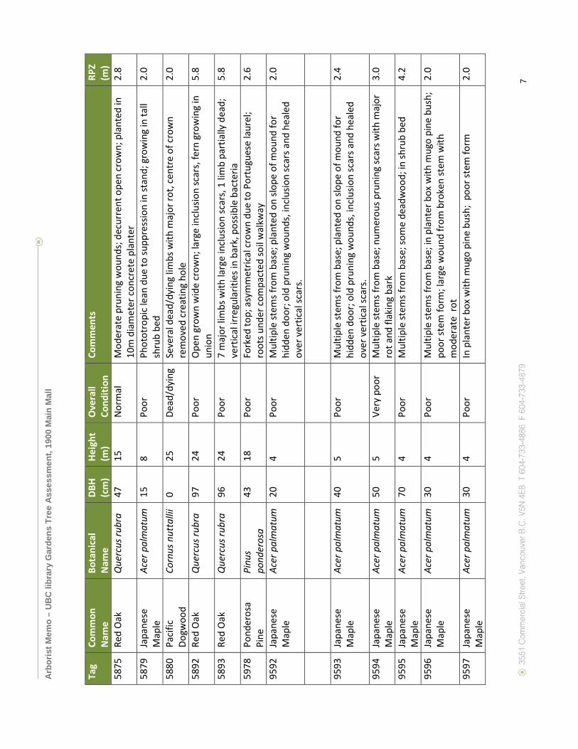
Arb
oris
t Mem
o –
UB
C li
brar
y G
arde
ns T
ree
Ass
essm
ent,
1900
Mai
n M
all
7
Tag
Com
mon
N
ame
Bota
nica
l N
ame
DBH
(cm
) He
ight
(m
) O
vera
ll Co
nditi
on
Com
men
ts
RPZ
(m)
5875
Re
d O
ak
Que
rcus
rubr
a 47
15
N
orm
al
Mod
erat
e pr
unin
g w
ound
s; d
ecur
rent
ope
n cr
own;
pla
nted
in
10m
dia
met
er c
oncr
ete
plan
ter
2.8
5879
Ja
pane
se
Map
le
Acer
pal
mat
um
15
8 Po
or
Phot
otro
pic
lean
due
to su
ppre
ssio
n in
stan
d; g
row
ing
in ta
ll sh
rub
bed
2.0
5880
Pa
cific
Do
gwoo
d Co
rnus
nut
talli
i 0
25
Dead
/dyi
ng
Seve
ral d
ead/
dyin
g lim
bs w
ith m
ajor
rot,
cent
re o
f cro
wn
rem
oved
cre
atin
g ho
le
2.0
5892
Re
d O
ak
Que
rcus
rubr
a 97
24
Po
or
Ope
n gr
own
wid
e cr
own;
larg
e in
clus
ion
scar
s, fe
rn g
row
ing
in
unio
n 5.
8
5893
Re
d O
ak
Que
rcus
rubr
a 96
24
Po
or
7 m
ajor
lim
bs w
ith la
rge
incl
usio
n sc
ars,
1 li
mb
part
ially
dea
d;
vert
ical
irre
gula
ritie
s in
bark
, pos
sible
bac
teria
5.
8
5978
Po
nder
osa
Pine
Pi
nus
pond
eros
a 43
18
Po
or
Fork
ed to
p; a
sym
met
rical
crow
n du
e to
Por
tugu
ese
laur
el;
root
s und
er c
ompa
cted
soil
wal
kway
2.
6
9592
Ja
pane
se
Map
le
Acer
pal
mat
um
20
4 Po
or
Mul
tiple
stem
s fro
m b
ase;
pla
nted
on
slope
of m
ound
for
hidd
en d
oor;
old
prun
ing
wou
nds,
incl
usio
n sc
ars a
nd h
eale
d ov
er v
ertic
al sc
ars.
2.0
9593
Ja
pane
se
Map
le
Acer
pal
mat
um
40
5 Po
or
Mul
tiple
stem
s fro
m b
ase;
pla
nted
on
slope
of m
ound
for
hidd
en d
oor;
old
prun
ing
wou
nds,
incl
usio
n sc
ars a
nd h
eale
d ov
er v
ertic
al sc
ars.
2.4
9594
Ja
pane
se
Map
le
Acer
pal
mat
um
50
5 Ve
ry p
oor
Mul
tiple
stem
s fro
m b
ase;
num
erou
s pru
ning
scar
s with
maj
or
rot a
nd fl
akin
g ba
rk
3.0
9595
Ja
pane
se
Map
le
Acer
pal
mat
um
70
4 Po
or
Mul
tiple
stem
s fro
m b
ase;
som
e de
adw
ood;
in sh
rub
bed
4.2
9596
Ja
pane
se
Map
le
Acer
pal
mat
um
30
4 Po
or
Mul
tiple
stem
s fro
m b
ase;
in p
lant
er b
ox w
ith m
ugo
pine
bus
h;
poor
stem
form
; lar
ge w
ound
from
bro
ken
stem
with
m
oder
ate
rot
2.0
9597
Ja
pane
se
Map
le
Acer
pal
mat
um
30
4 Po
or
In p
lant
er b
ox w
ith m
ugo
pine
bus
h; p
oor s
tem
form
2.
0

Arb
oris
t Mem
o –
UB
C li
brar
y G
arde
ns T
ree
Ass
essm
ent,
1900
Mai
n M
all
8
Tag
Com
mon
N
ame
Bota
nica
l N
ame
DBH
(cm
) He
ight
(m
) O
vera
ll Co
nditi
on
Com
men
ts
RPZ
(m)
9598
Ja
pane
se
Map
le
Acer
pal
mat
um
40
4 Po
or
Mul
tiple
stem
s fro
m b
ase;
in p
lant
er b
ox w
ith m
ugo
pine
bus
h;
stun
ted
poor
stem
form
2.
4
9599
Gi
ant
Redw
ood
Sequ
oia
giga
nteu
m
64
20
Nor
mal
N
ear s
lope
edg
e/dr
op o
ff, g
row
ing
next
to sh
rub
gard
en; f
ull
crow
n op
en g
row
n w
ith so
me
low
er a
sym
met
rical
pho
totr
opic
gr
owth
.
3.8
9601
Ja
pane
se
Map
le
Acer
pal
mat
um
10
7 Po
or
Supp
ress
ed in
stan
d, g
row
ing
arou
nd b
ould
ers
2.0
9602
Ja
pane
se
Map
le
Acer
pal
mat
um
18
7 Po
or
Supp
ress
ed in
stan
d, g
row
ing
arou
nd b
ould
ers;
2 st
ems a
t dbh
2.
0
9603
La
wso
n Cy
pres
s Ch
amae
cypa
ris
law
soni
ana
40
7 Po
or
Mul
tiple
stem
s fro
m b
ase;
gro
win
g ar
ound
bou
lder
s and
nex
t to
rock
y po
ol; p
runi
ng sc
ars
2.4
9604
La
wso
n Cy
pres
s Ch
amae
cypa
ris
law
soni
ana
13
7 Po
or
Grow
ing
arou
nd b
ould
ers c
ausin
g a
twist
at t
he b
ase;
topp
ed
stem
2.
0
9605
Ja
pane
se
Map
le
Acer
pal
mat
um
10
7 Po
or
Supp
ress
ed in
stan
d, g
row
ing
arou
nd b
ould
ers
2.0
9606
Th
read
Lea
f Cy
pres
s Ch
amae
cypa
ris
pisif
era
'Fili
fera
'
40
7 Po
or
Mul
tiple
stem
s fro
m d
bh g
row
ing
arou
nd b
ould
ers a
nd n
ext t
o ro
cky
pool
; pru
ning
scar
s 2.
4
9607
Th
read
Lea
f Cy
pres
s Ch
amae
cypa
ris
pisif
era
'Fili
fera
'
52
7 Po
or
Mul
tiple
stem
s fro
m b
ase;
gro
win
g ar
ound
bou
lder
s and
nex
t to
rock
y po
ol; p
runi
ng sc
ars
3.1
9608
Th
read
Lea
f Cy
pres
s Ch
amae
cypa
ris
pisif
era
'Fili
fera
'
51
7 Po
or
Mul
tiple
stem
s fro
m b
ase,
one
stem
topp
ed a
t 4m
; gro
win
g ar
ound
bou
lder
s and
nex
t to
rock
y po
ol; p
runi
ng sc
ars
3.1
9609
Th
read
Lea
f Cy
pres
s Ch
amae
cypa
ris
pisif
era
'Fili
fera
'
15
7 Po
or
2 st
ems s
harin
g ro
ot sy
stem
; gro
win
g ar
ound
bou
lder
s and
ne
xt to
rock
y po
ol; p
runi
ng sc
ars
2.0
9611
La
wso
n Cy
pres
s Ch
amae
cypa
ris
law
soni
ana
26
7 Po
or
2 st
ems s
harin
g ro
ot sy
stem
; gro
win
g ar
ound
bou
lder
s and
ne
xt to
rock
y po
ol; p
runi
ng sc
ars
2.0

Arb
oris
t Mem
o –
UB
C li
brar
y G
arde
ns T
ree
Ass
essm
ent,
1900
Mai
n M
all
9
Tag
Com
mon
N
ame
Bota
nica
l N
ame
DBH
(cm
) He
ight
(m
) O
vera
ll Co
nditi
on
Com
men
ts
RPZ
(m)
9612
Ja
pane
se
Map
le
Acer
pal
mat
um
12
2 Po
or
Youn
g an
d su
ppre
ssed
und
er m
atur
e w
este
rn re
d ce
dar;
the
base
of t
he tr
ee h
as g
row
n ne
ar b
ould
ers
2.0
9613
Pl
umos
e Sa
war
a Cy
pres
s
Cham
aecy
paris
pi
sifer
a 'P
lum
ose'
10
8 Po
or
Swee
p in
but
t; ph
otot
ropi
c le
an a
nd a
n as
ymm
etric
al c
row
n du
e su
ppre
ssio
n
2.0