INDEX OF FIELD FORMS - POWELL COUNTY I BOOK I -...
60
INDEX OF FIELD FORMS - POWELL COUNTY I BOOK I ^ Plat No. Name of Owner Name of Operator Twp-Rge j 20 A. C. M. Same 15N-11W ..; 1 23 A, C. M. Same — 14N-12W ; 37 A. C, M. Lager K. Anderson (sec 33) 11N-11W ! 42 A. C. M. Same 10N-11W ! 60 F. H. Aibee Same 7N-9W.' > 53 Donald Allen Same 9N.-6W • j 46 Blanche Anderson Robert Lea-buying 10N-7W ; 37 Erick Anderson — Lager K. Anderson • 11N-11W : | 42 Erick Anderson Lager K. Anderson 10N-11W : 42 Lager K. Anderson Same 10N-11W 46 Thomas C. Anderson Robert Lea-buying 10N-7W 18 Fred Baird — Same — 15N-13W J Marion Barnard - See •• J- F. Hendrix 18 Edward Bandy — Same -- 15N-13W 16 Harold Bandy — - Game - 16N-13W : 18 Thomas E. Barbour Fame 15N-13W 20 Eola G. Bauer John Gearv (son) 15N-11W ;' 19 „ L. M. Beard, et al Same - 15N-12W ; 56 Emma Beaumont — Walter Hansen-leasing • 8N-9W., I I 56 A. J . and Sam Beck Same 8N-9W •-> B 60 Albert Beck - Same 7N-9W ,: 64 Albert Beck Same 6N-9W i. 65 Albert N. Beck Samp : 6N-8W i 50 Andrew A. Beck '• Same 9N-9W '- 56 Andrew A, Beck 8N-9W ' ' • 4 : 57 Andrew A. Beck A. J . Beck 8N-8W • 60 Andrew A. Beck. Same . 7N-9W 44 Andrew J. Beck - Same 10N-yW j 60 Chas. E. Beck = 7N-9W ] 50 Laurence Beck Same 9N-9W | 64 Melvin Beck Same • ---• 6N-9W ~ 28 ~* Peter L. Beck Charles Beck 13N-11W :; 50 Samuel R. Beck Same 9N-9W "1 50 Soren Beck : Laurence Beck-buying 9N-9W • 34 Soren N. Beck Same 12N-9W 45 Soren N. Beck — Same 10N-8W 64 Walter P.. Beck Melvin Beck 6N-9W 64 -— H. J. & S. H. Bennett Same 6N-9W £3 Sylvan Bennett Same • 6N-10W - ^ 44 — Rruce & Dale Benson Ssrnc 10N-9W " ' 45 Bruce & Dale Benson Bruce 8, Fred Benson — 10N-8W '£ 49 Anna Bentick Same 9N-1CW j 19 Vernei Bertelsen Same .— ,.15N-12W •" 63 Hedley Best . ' 6N-10W ! 52 H. R. Best Same • — i 9Nv'"R|f 33 Andrew & Wesley Bierman Same * —-_ 12N-10W ' 28 Laura Bignell ——'—»,.. 13W-HW <'. 27 — Sam Bignell Same •— r — r »-_ 13N-12W f < 44 Sam B i g n e l l Same •——» • • 10N-9W 28 • M. D. Blankenship ' — — • « :-. — ; ~ 13N-11W i • ; • • • • i
Transcript of INDEX OF FIELD FORMS - POWELL COUNTY I BOOK I -...

INDEX OF FIELD FORMS - POWELL COUNTY I
BOOK I ^
P l a t No. Name of Owner Name of O p e r a t o r Twp-Rge j
20 A. C. M. Same 15N-11W ..;
123 A, C. M. Same — 14N-12W ;
37 A. C, M. Lager K. Anderson ( sec 33) 11N-11W !42 A. C. M. Same 10N-11W !60 F. H. Aibee Same 7N-9W.' >53 Donald Allen Same 9N.-6W • j4 6 Blanche Anderson Robert Lea-buying 10N-7W ;37 Erick Anderson — Lager K. Anderson • 11N-11W :|42 Erick Anderson Lager K. Anderson 10N-11W :
42 Lager K. Anderson Same 10N-11W46 Thomas C. Anderson Robert Lea-buying 10N-7W18 Fred Baird — Same — 15N-13W J
Marion Barnard - See •• J- F . Hendrix18 Edward Bandy — Same - - 15N-13W16 Harold Bandy — - Game - 16N-13W :
18 Thomas E. Barbour Fame 15N-13W20 Eola G. Bauer John Gearv ( s o n ) 15N-11W ;'19 „ L. M. Beard, e t a l Same - 15N-12W ;56 Emma Beaumont — Walter Hansen - l eas ing • 8N-9W., I I56 A. J . and Sam Beck Same 8N-9W •-> B60 Albe r t Beck - Same 7N-9W ,:64 A lbe r t Beck Same 6N-9W i.65 Albe r t N. Beck Samp : 6N-8W i50 Andrew A. Beck '• Same 9N-9W '-56 Andrew A, Beck 8N-9W ' ' • 4:
57 Andrew A. Beck A. J . Beck 8N-8W •60 Andrew A. Beck. Same . 7N-9W44 Andrew J . Beck - Same 10N-yW j60 Chas. E. Beck = 7N-9W ]50 Laurence Beck Same 9N-9W |64 Melvin Beck Same • ---• 6N-9W ~28 ~* Peter L. Beck Charles Beck 13N-11W :;50 Samuel R. Beck Same 9N-9W "150 Soren Beck : Laurence Beck-buying 9N-9W •34 Soren N. Beck Same 12N-9W45 Soren N. Beck — Same 10N-8W64 Walter P.. Beck Melvin Beck 6N-9W64 -— H. J . & S. H. Bennett Same 6N-9W£3 Sylvan Bennett Same • 6N-10W - ^44 — Rruce & Dale Benson Ssrnc 10N-9W " '45 Bruce & Dale Benson Bruce 8, Fred Benson — 10N-8W '£49 Anna Bentick Same 9N-1CW j19 Vernei Ber te lsen Same . — ,.15N-12W •"63 Hedley Best . ' 6N-10W !
52 H. R. Best Same • — i9Nv'"R|f33 Andrew & Wesley Bierman Same * —-_ 12N-10W '28 Laura Bignel l ——'—»,.. 13W-HW <'.27 — Sam Bignel l Same •— r — r » - _ 13N-12W f<44 Sam Bignel l Same •——» • • 10N-9W28 • M. D. Blankenship ' — — • « :-. — ; ~ 13N-11W i• ; • • • • i

__ T — _ _ _ _ _ ^ . — _ — _ r^^**arn
H Index of Field Forms - Powell County - Page 2 f 1
S P la t No. Name of Owner Name of Operator Twp-Rge 1
• 33 M. D. Blankenship Same 12N-10W f• 53 Glenn C. & Ada Bone Glenn Bone • 9N-6W \B 18 Minnie Boyd. et al State Fish S. Game Commfssifn-Luying ;H Irvin Moore-operating farmland 15N-13W ;I 48 August Brand Same - 9N-11W ; IB 43 W. T. Briggeman Same 10N-10W i |H 25 E. Br ise t te 14N-10W jH 16 Mary Byron & Neil B. Ric:? T. J . Farley 16N-13W :• 42 — G. R. Christensen Same 10N-11W \B 61 Christofferson Bros. Ed 8, Alms Christofferson 7N-8W •B 56 Alma Chris tofferson Ed 8. Alma Chr is tof ferson 8N-9W i• 56 Ed Chr i s to f fe r son , e t a l Ed & Alma Chr is tof ferson 8N-9W ;• 56 Frank, Mary & P. W. iB Christofferson Same • GN-9W :B 17 - Ruth Clark T. R. F a r l e y - - 16N-12W :B 52 ~ J . Henry C l i n t o n - • Same - 9N-7W '• 53 j . Henry Clinton — Same - 9N-6Wfl 19 Agnes (Hanzel) Coburn Same 15N-12W IB 29 J . E. Cochran • 13N-10W ! IH 19 - - Ned Colby - - — - — Same — 15N-12W ; UM 25 George C. Cook, e t a l - • 14N-10W : Ira 60 Max G. Cook Same 7N-9W ; IR 20 v E. W. Copenhaver » Hugh E. & Eva F . Copenhaver-buying '.— 15N-11W IH 24 E. W. Copenhaver Hugh E. & Eva F. Copenhaver-buying — 14N-11W ; 1R 20 M. H. Copenhaver Copenhaver Eros . 15N-11WB 21 Richard W. Copenhaver Copenhaver Bros. 15N-1OW . ,ffl 24 W. T. Cot ter — - 14N-11W !U 28 W. T. Cot te r Same - 13N-11W ;
m 27 David C. Coughlin Same 13N-12W iS 27 Herman & Emma Coughlin D. C. Coughlin 13N-12W |9 29 Kate C. Coughlin — - Same — 13N-10W jH 24 Kathleen Coughlin 14N-11W \• 28 Kathleen Coughlin Charles Beck — — 13N-11W \• 24 Walter J . Coughlin Same - 14N-11W . iB 21 W. Coughlin, e t a l — - 15N-10W :H 25 W. C. Coughlin, et a l 14N-10W i• 24 William, Maurice & Robert IR Coughlin Maurice & William Coughlin 14N-11W {H 28 William, Maurice & Robert I IB Coughlin Maurice Coughlin 13N-11W ] 1
6i Lloyd Cowan Same 7N-8W :H I50 Loren Dana Same — 9N-9W | I46 G e o . Davis Same 10N-7W ' S34 George V. Davis — Same 12N-9W35 George V. Davis • Same • 12N-8W39 George V. Davis Same 11N-9W ;40 George V. Davis Same • 11N-8W ;_44 George V. Davis Same — 10N-9W45 George V. Davis Same 10N-8W '
• 48 ~ Kenneth Davis Same — 9N-11WB 56 Deer Lodge, Ci ty of 8N-9W1 60 Deer Lodge, City of 7N-9W :• 64 Alfred & Amelia Donich — Same 6N-9W

WU- ^''•..[^•^^:^.i>^/yi!ii--,^,,:;;i;-.i^,-~]::yp^:y.,\.:.^,.. . ....... ..... ...-..••-;...........-I-'"-- .-A.-.-- --. •• •> i^^iV^wM^^^ I- *" * f1' *<P^~ "
I C 0 .. . . IB : Index of Field Forms - Powell County - Page 3 :
• Plat No. Name of Owner Name of Operator Twp-Rge ;
H 52 Justina S. Dougherty Same —— 9N-7W ;42 Cory D. Dutton David Dutton — '• 10N-11W43 Cory D. Dutton David Dutton 1ON-1OW37 David Dutton, et ux Same — 11N-11W •43 David Dutton • Same 1ON-1OW j
• i
i
i
i
• !
• . ' ' j
• • !
' . • I "
' • . • : • } • •
• • ' • • • ' ' • • ' . . . ; | • . ' . '
• • . ' • . . ' " • '• - ' : \ ; •
• • • • • ' • • ' ' • • • • . ' ' ' , | • • ' ' • .
" • ' • ' • • ' . : ' • • : • • [ ' • ' '
• • . . • • • ' . ' . ' . • : . - : " : ' • . ' • : ! • • :
• . . ' . . . . . . . . . . ••; ' . ' . . • ; ' . ; • . ; • ; y V j . ' •
• - . • • . " • . : . . • • • • . " "• ' . • • • ; : ' ; . , ; r - ' . ' H ; - : i ; ^ ;'• ;
• • ' . ' • . ' • ' • • • . ' • . - ' • • . • ,;
-:
• ' • • V ' " -1
' ' ' " .1
' • ' . " ' • ' " r t ' - " '
. - • . • . . . • • • • • . • • . . ' • ' , • • • : ; " " : - . • • • ' . . : , : v - o . v ; ~ ; ^ : : - £ ' . . ' /
i . . • ' • • . ' - . ' • : • ' • • . ' • •• "•••• • • . , - • • • • • • • • • : . ; • ; ' ; ; . ; , . - • ^ ? ; : - ' : ' V - / v ^ ^ : ^ : ^ i ! ? S f - ^ •
. ' ' • • ' ; : " ? - - — - • ; • • • — - - - - " : : • • • • ; • • • . • • ; • . - • :;-7-:';';:'-v;r-;:;:v<^*^'^^g;t--:;:-:
' • • : • " ' • . • . • • . ' . . . ' • ' • . • . • ' ' • : ' • . ' . • • • • • • ' • . • • ' • . . ' . ' " : • • • . . ' - • • • • • • • ' " . • . . • ' ' - . ' • . ' ; . : \ - / \ ' y ' ' ' • ' • ^ ! ' i ; ' ; & - ^ ' % : A > ' - ' i & i - •
\ m - . • j : _ ^ _ i _ . . . ' _ • • • : , ' . . . ' • • : . . " . . " ' . • • ' ' • . ' , • • • • ' • ' ' : ' • . . ' ' • • ' ' • • • " • • • . • • w ' ; - • - ' . ' v ' r ' : '

• INDEX OF FIELD FORMS - POWELL COUNTY I
• BOOK II f
I Plat No. Name of Owner Name of Operator Twp-Rge \
9 •• 19 Clare A. Eaton - Same — • — 15N-12W I jB 27 Jane Eder Samuel Bignell 13N-12W i• 25 Jane & Michal Eder - — — — 14N-10W }• 24 Otto Eder Same . — — 14N-11W ;• 25 Otto Eder •-- 14N-10W ;• 28 Otto Eder -- Same 13N-11W ;• 21 Thomas A. Edwards Copenhaver Bros. • — 15N-10W •• 20 Thomas H. Edwards Ccpenhaver Bros. 1.5N-11W i
56 William Elberson, et ux Same 8N-9W !64 Harvey Eliason — 6N-9W60 Harvey F. Eliason Same 7N-9W i64 Leonard Eliason Same 6N-9W :64 •— Rob&rt Eliason Harvey Eliason — 6N-9W ;24 Asa Ellsworth 14N-11W :29 Asa Ellsworth Same - -- 13N-10W ;54 Hilda Evans Bob Evans 6N-9W ;21 Vern L. Evans - 15N-10W ;18 T, R. Farley — Omar Clark 15N-13W .:19 - -- T. R. Farley O.mar Clark < 15N-12W '21 Esther N. Fergusen Copenhaver Bros. 15N-10W60 Earl Flannigan Paul Eiberson-buying 7N-9W !63 Peter Fleming • Kenneth Fleming 6N-10W i64 Peter Fleming Kenneth Fleming • 6N-9W i63 W. J. Foxley State Prison \
State of Montana-buying 6N-10W ]49 W. J. Foxley, Inc. State Prison j
State of Montana-buying • 9N-10W i55 W. J. Foxley, Inc. Slate Prison j
State of Montana-buying 8N-10W ;59 W. J. Foxley, Inc. State cf Montana-buying 7N-10W i60 W. J. Foxley, Inc. - State Prison-buying 7N -9W \31 Marie Frazer -: Brosz —- 12N-12W !64 Joseph Gabelhei Same 6N-9W \65 Joseph F. Gabelhei Same 6N-8W :20 Edward D. Geary — Same — — 15N-11W i28 Kate Geary 13N-11W i24 Patrick J. Geary — » 14N-11W I28 Patrick J. Geary ~ 13N-11W ;23 Thomas 8. Michael Geary Same 14N-12W |24 Thomas & Micnael Geary 14N-11W j28 Thomas & Michael Geary 13N-11W j49 Vernon Gilman Same • 9N-10W j49 Vernon Gilman Dale Harrod 9N-10W j17 Emmett Glore Same -— 16N-12W !48 Gold Bug (Unpatented) j
(Montana Gold Corp) jRogers Homestead Joe 3eck > 9N-11W J
42 Milton Gordon, et al W. W. Smith ION-llW J
- • \ : - " • ; • _ • . - . ' • •
• ' ' . , • ' • . . ' • / ' • •
H " . " . • • ' - • • - '

I [ •'•• - • • • • • — — ^ •••• • ^ /
fl Index of Field Forms - Powell County - Page 2 I
I •B Plat No. Name of Owner Name of Operator Twp-Rqe ;B 48 Frank Gough David Dutton : 9N-11W i• Graveley Bros. - See - Sandy Reierson •• 40 Graveley Eros. Cliff & Wm. C. Graveley 11N-8W ;B 45 Arnold Graveley Wm. C. & Cliff Graveley 10N-8W ';• 40 Clifford Graveley Same - 11N-8W ;• 45 Dan M. Graveley Same • 10N-8W :• 45 William Graveley Same — 10N-8W9 20 William Hagstaz Edward Geary ----• 15N-11W :• 27 Philip D. Hamilton John Hamilton 13N-12W• 19 Harry Hampton — Same 15N-12W ;• 60 •• Tim Hannifan Otis Beard-buying 7N-9WB 64 Frank Hansen Frank Jensen-buying 6N-9W ;• 56 Walter Hansen — —- — Same — 8N-9W :B Yens Hansen - See- Jos. Kiernan '.B 52 Yens Hsnsen Jos. Kiernan and Yens Hansen 9N-7WB 57A Yens Hansen Jos. Kiernan and Yens Hansen 8N-7W• 64 Alfrieda Hanson George & Alfrieda Hanson 6N-9W •B 60 •- Rial Havens Same 7W-9WH 60 Rial & Media Havens Same — 7N-9W ;• 56 Anns, Heltborg Same 8N-9W :
B 50 Otto & Anna Heltborg Same 9N-9W ';H - 24 Robert E. Henderson - - Same 14N-11W :• 2A Wallace E. Henderson — Same 14N-11W• 18 J. F. Hendrix &• Marion Barnard Geo. 0. Dreyer-buying 15N-13W ;B 16 J. Jv & Elsie May Hendrix George 0. Dreyer-buying 16N-13W• 19 Weldon A. Hiatt Same 15N-12W ;• 47 A. T. Hibbard — Same --- 1ON-6WR 42 Gerald & Dave Hogan Same 10N-11W :
B 43 Gerald 8. David Hogan Same 9N-11W •S 20 Wessley Hofland — John Weaver-leasing — 15N-11W [• 42 Richard J. Hollenbeck Same - 10N-11W i• 42 Chester Hoover Chas. Fisk-buying 10N-11W• 56 Mabel Hoskyn - Same 8N-9W ;• 25 Chas. Hughes — 14N-10W ; 1H 49 — Henry Hukili Chas. R. Thomas - — 9N-10W : 1B 63 Henry G. Huot - Same 6N-10W i I•8 46 A. G. Jackson Robert Lea-buying 10N-7W \ I1 52 - G. A. Jackson -- Same ~ - 9N-7W : im 20 Annie Jacobsen Harold Jacobsen-buying • 15N-11W :• 24 Annie Jacobsen 14N-11W ;
• 19 Edna & Alfred Jacobsen 15N-12N \g 19 Herman Jacobsen Same 15N-12W \m 23 Herman Jacobsen Same 14N-12W i8 24 Klara H. Jacobsen Herman Jacobsen 14N-11W !• 23 A. J. & Annie Jacobson 14N-12W !• 64 Fred 0. Jacobson Same 6N-9W 'B 31 Paul Jacobson Same :— 12N-12W• 19 Anita James J. E. James 15N-12W : .!• 18 David E. James Same 15N-13W !I 16 • D. E. James Same — — 16N-13W ;1 !9 J,, E. James Same 15N-12W ]

B Index of Field Forms - Fowell County - Page 3 ' \
B Plat No. Name of Owner Name of Operator Twp-Rge [
B 63 Joseph S. Jette — — Same — — 6'i-lOW• 60 — — Allen E. Johnson — — Same 7N-9W jBj 64 Allen E. Johnson Same '• 6N-9W ;• 50 Callie Johnson Same — — — •?-— 7N-9W )• 64 Ed J. Johnson — Same - 6N-9W :B 60 Helmer Johnson Bill Johnson 7N-9W •B 60 Lewis Johnson Same 7N-9W ;• 64 Lewis F. Johnson Same —• 6N-9W : ,• 64 Raymond Johnson Same 6N-9W j• 46 Rufus Johnson #2 Robert Lea 10N-7W ,. . \I 64 Vonnie Johnson Raymond Johnson 6N-9W '• 64 William J. Johnson — Same 6N-9W ;H 39 . Alex D. Jones Same - 11N-9WB 63 Elmer Jones J. B. Jones-buying 6N-10W :
B 64 Elmer Jones J. B. Jones-buying 6N-9W
• • • • • • ' • ' . . - ' ' '
\ • .._..., •.. ............ • J,K1^J^.,l
• : . • • ' • • . • . - • • . ' • ' • . • . . • • : ' • - • : • • - / • • ' • •

INDEX OF FIELD FORMS - POWELL COUNTY I
BOOK III I
Plat No. Namo of Owner Name of Operator Twp-Rqe i
35 Keiley Ranch Co. Keiley Bros. — — 12N-8W •34 E. B. Keiley Ranch Co. Keiley Bros. - 12N-9W (33 May Keiley • J. P. Keiley — 12N-10W |34 May C. Keiley J. P. Keiley 12N-9W [63 Jack K e i l e y — - Same 6N-1OW \63 — Ray c. Keiley — Same - •• - 6N-10W60 - A. R. Kelson - Same 7N-9W \51 Emm Kerttulla T. J. Kerttulla -- - 9N-8W ;45 - T. J. Kerttulla Same — — 10N-8W i46 Jos. Kiernan and :
Yens Ha risen Same 10N-7W \18 Lewis E. Kimball Same 15N-13W :45 Earl Knight Same -— 10N-8W45 Frank Knight Same 10N-8W :40 Frank J. Knight Mrs. Frank J. Knight 11N-8W50 - Henry Knight -- Same 9N-9W ';45 •£• Henry & Mollie Knight Ernest £ Earl Knight 10N-8W I46 i- John E. Knight Ernest Knight 10N-7W ;49 William J. Knop Same - •-— 9N-1CW :
, 18 Horace H. Koessler Claude Reinoehl 15N-3.3W ;64 j o e j/i. Kramer Same 6N-9W i20 - - Roy C. Krutar - • Same 15N-11W :24 Roy C. Krutar — -- Same — 14N-11W ]
19 Fred Kuester - —- Same 15N-12W ]50 Ed C. Lahman Same 9N-9W j49 Edward Lahman Same 9N-10W '60 A. T. Larsen Same 7N-9W ';52 H. Lauri Same 9N-7W \21 Chas. A. Lea Copenhaver Bros. 15N-10W |21 Gertrude N. LeFebure Same 15N-10W31 . carl A. Lienau - — Jack Peterson - 12N-12W32 Carl A. Lienau Jack Peterson 12N-11W . •48 Charles Lingenfelter Same T 9N-11W I48 W. T. Lingenfelter Bill Lingenfelter — 9N-11W \24 Frank Lockwood John Jacobsen-leasing 14N-31W ;
24 Nellie Lockwood John Jacobsen-leasing 14N-11W ••60 Frank Love 11 Same 7N-9W !60 Gerald Lowery Same 7N-9W ;60 Vincent Lowery Same 7N-9W \64 Vincent Lowery Same 6N-9W [24 T. J. Lynch 14N-11W \52 J. L. Mackey 9N-7W . I°,1 Clifford Manley John Manley 12N-12W j9 C. H. Mannix Same • .-. 13N-10W 1
32 C. N. Mannix Same 12N-11W j33 C. N. Mannix Same 12N-1OW |
• 34 Nettie C. Mannix Francis Mannix 12N-9W !34 Ralph Mannix Same 12N-9W .'•[18 Walter Mannix Same _ — — 15N-13W j34 w. w. Mannix 12N-9W I20 L. E. Marsden Norman Jorgenson —~ •— 15N-11W i
• • t

Index of Field Forms - Powell County - Page 2 }
Plat No. Name of Owner Name of Operator Twp-Rqe [
50 Conrad Martinez Same 9N-9W ;52 Pete Martinz - R. C. Tyler - - 9N-7W |27 David Matti Same - 13N-12W I28 McCormick Bros. 13N-11W ;29 John P. McCormick - — 13N-10W i2Q *, Mary A. McCormick Jack McCormick 13N-11W j24 Michael McCormick Bill McCormick — 14N-11W 128 M. McCormick Est. - Same 13N-11W :24 Thomas J. McCormick 14N-11W :45 Archie McDonald • His son 10N-8W i46 Archie McDonald — 10N-7W I40 Archie D. McDonald Earl McDonald 11N-8W49 Geo. McGillis — Same 9N-10W :
49 Kate McGillis Geo. McGillis 9N-1OW45 _- Hattie Mclntosh W. L. McTntosh 10N-8W40 Hattie E. Mclntosh W. L. Mclntosh -- — 11N-8W ':53 Win. Mclntosh — - Same 9N-6W •••40 Wm. L. Mclntosh Same 11N-8W ;45 Wm. L. Mclntosh Same - 10N-8W i46 -.- Wm. L. Mclntosh — Same -- - - 10N-7W :60 E-. A. McKee Same 7N-9W ;54; Rachel Meagher Melvin Beck-leasing 6N-9W i53 _„ Katherine & Myles Meyer - - 9N-6W \60 Donald E. Mickelson F. B. Wisner-buying 7N-9W ;60 — August MiddeRon Same 7N-9W29 Robert Midtlying Sam Bignell - 13N-10W19 Leonard J. Miller C. C. Granger 15N-12W ;23 Leonard J. Miller C. C. Granger 14N-12W \49 Edward Mollenberg Same 9N-1OW ;48 Montana Gold Corp — Joe Beck 9N-11W !20 - Montana, State of - 15N-11W !24 Montana, State of Hugh F. Copenhaver-leasing 14N-11W ;31 Montana, State of Paul Jacobsor. 12N-12W34 Montana, State of Francis Mannix 12N-9W :40 Montana, State of W. L. Mclntosh 11N-8W ;45 Montana, State of Kathryn Senecal-leasing 10N-8W55 Montana, State of W. J. Foxley Inc. (sec. 22) 8N-10W ;56 Montana, State of Prison (Sec. 16) 8N-9W ;59 „ Montana, State of W. J. Foxley (Prison Farm) 7N-10W \60 Montana, State of Same 7N-9W '• !63 Montana, State of Tom Ryan 6N-10W >60 Montana State Prison Farm 7N-9W I60 Max Moore Same 7N-gw |21 — Chauncy Moslander 15N-10W i60 Gladys Motell • 1/telvin Reistad 7N-9W \24 Katie Mullen Bill McCormick •— 14N-11W j23 Joseph Murphy Same 14N-12W j19 Joseph B. Murphy Same 15N-12W ;45 Donald P. Murray Same 10N-8W :35 Ray P. Murray 12N-8W j55 National Forest — 8N-10W •';!
' • ' • • ' • . ' • •
• " ' • . ' • ' • • l

L l f - v . - ; " ; •'•\- ••• . ' V . ' . ' •' . • •. "•• •' -.. •• •••••••/.••'•": - W ^ V -;; h ^ f - M ^
; : • • • • i' ' ' ( '• • ' • . • " • • " ' . • • • • " • * .
: ' ' ' • . ' ' • ' .:.-•:•'. ^ ' : '4 •
• t ••
Index of Field Forms - Powell County - Page 3 \• • . f
; Plat No. Name of Owner Name of Operator Twp-Rqe [ .• ' • . i
46 Carl Nelson Same • 10N-7W 150 George Nelson Same • 9N-9W j49 E, A. Norman — 9N-10W i47 N. p. R. R. Co. A. T. Hibbard 10N-6W !49 N . p . R . R . 9N-10W !
Robert Olson - See - Agnes Staffanson j24 Chas. P. Oxford John Weaver 14N-11W I
• I
I
I
I
• }
I|. • i
: i
• . i
• • i
•' " i ; •
' : . •••:•••• : ' f
:.. . .'•••v:ik• • ' • • • . - - . ; . . " , i ;
• • • ' " • • : • • • : ' • - • ' • ' . ' • - • • , / \ - ; ' - y : ^ 1 ; : ; ) ^ . ' /
' '' • " • - . . , ' ' • ' . " • ' • • " . • ' • • . " V - " . 1 ;••' . " • ; • . . ; ' ' . ' . . : ; . i . • ' • : . . •
' • ' " ' • • • • . • • • • • . ' - ' • ' • - . - ' ' " • • • ' • • ' ' - ' 7 . ' • ' ' ' • • ' • • - • ' ' ; / / ' • . " • ; • ' : ' - • - ' I ' - ' - - ' ' - - . " ' ' :
: " • ' ' - ' " ' . . " ' • • . ' . • • • ' . ' • • ' • • • " ' • ' • ' . • • " • ' - . : - • - • - ' • " • . - ' • • ' ' • ' • ' ' " ' l ; ' ' - i - " :! l
~ '• '
; • •• '• • • • •" • • • • ' "... •'•/•.'••:: •• / ^ v J / ^ : - ' i : | - M l - ' i S l S f t ^
1 - • : - • • • - ^ - . . - . - . . ; . . „ . , . . , . . , „ . . , . -,{-.,..* - - i — ••••;- • • • • ; - : • ' - - - • • • • • ; ' • • - • - v — " • • --.-.-.—..-*..•-.v,-.. ..-~^..^^^:^,i>:f.^^^yv ; ^ '
' b . ' * . . . • ' . . • . . • . • . ' • . . ' : " " • ; • • ' . . -. • . • • • ' . , . • " • ' ' • • • • ' , - • ^ " v : . ; ; , ' ' . * * ' ; : ® : : ' ^ ^ . ) ; ^ '

•r ' '' . ;vi , '•
H INDEX OF FIELD FORMS - POWELL COUNTY j
I i• BOOK IV |H ' ]
• Plat No. Name of Owner Name of Operator Twp-Rqe i• 45 Howard Parker Mrs. Howard Parker 10N-8W j• 39 S. J, Pauly Same 11N-9W |• 46 S. J. Pauly Same 10N-7W |• 50 - - S. J. Pauly Same 9N-9W '• 51 S. J. Pauly Same - 9N-8W :• 52 S. J. Pauly - 9N-7W \• 55 _ „ S. J. Pauly — 8N-10W ;• 56 s, J. Pauly Same 8N-9W •• 5! j e n s Pedersen r - 8N-8W j• 63 — ~ — Donald C. Perkins Clifford Perkins - - — 6N-10W ;• 63 J. F. Perkins - Same 6N-10W :• 59 Jonn E. Perkins Same - ~ 7N-1CW :
I ft-"'"-- ^^fcr--"":"'"--:-.-: same r-_-------~-----r-r----~-~-r~ p^feg j• 54 Louis E7 Peterson Same 6N-9W ;• 31 paul Peterson, Jr. - - 12N-12W• 64 - Wendell Peterson - Same - - 6N-9W [• 28 William Peterson - — Same 13N-11W ;I 32 William Peterson - - Same 12N-11W ;• 60 I. W. Pierce Same -- 7N-9W• 33 Sanford Placer -- — -- 12N-10W ;• 24 Frank Pope John Jacobsen-leasing 14N-11W :I 23 R. C. & Crawford Potter ':ft (Potter Bros.) — Same - 14N-12W <• 28 Francis & Geo. Potts Same — 13N-11W \• 56 Powell Realty Co. Don Valiton-buying 8N-9W j• 64 Wm. Powell Joseph Gabelhei 6N-9W ;I 24 Louise Praast Terrance J. Smith-leasing 14N-11W \• 40 Katheryn Price Howard & Katheryn Price 11N-8W ;• 39 Kenneth Price Same - • 11N-9W ]I 39 Mary Jean Price Kenneth Price 11N-9W I• 50 Mary Jean Price Kenneth Price 9N-9W ;• 40 Clifford Quigley Same - 11N-8W j• 48 Howard Rabel Same - 9N-11W i I• 64 Paul Rainville Same 6N-9W \ I• 23 Newman Raymond Same 14N-12W ; II -1? Sandy Reierson and ! I
C. H. Gravely Bros. — — 10N-6W46 Sandy 0. Reierson Same 10N-7W ;60 Melvin Reistad - Same 7N-9W :
Neil B. Rice - See - Mary Byron60 Walter Riley -— Same . 7N-9W ,,....!49 A. E. Rippengale Same 9N-10W j48 - - John Rogers Same •• 9N-11W j33 Alfred Rossin Lewis G. Ferguson 12N-1CW i
147 R. v. Ranch Co. Same 10N-6W ' !
53 R. v. Ranch Co. Same — 9N-6W . \63 Tom Ryan Same — 6N-1CW 1
' ' • • • • • • !
• • ' ' v .•"" •. ' ., •#
. . . " • • ' . • : . • • . • . / • ' ; • •
: • ' • • • » "
Index of Field Forms - Powell County - Page 2 |
Plat No. Name of Owner Name of Operator Twp-Rqe |
56 Carl Salmonson 8N-9W |47 - Ludwig Schatz Same 6N-10W ';60 Walter R. Schurch Same 7N-9W ;45 j. j. Senecal -- Same - -- 10N-8W !46 John J. Senecal Same 10N-7W !45 Kathryn Senecal Same 10N-8W ;46 - Kathryn Senecal - W. T. Janke 10N-7W ;47 Kathryn Senecal — 10N-6W :53 Kathryn Senecal - — 9N-6W :
20 - Elmer Smith Same 15N-11W !24 Elmer Smith Same 14N-11W \56 Kenneth C Smith Same 8N-QW ' \60 Tony Sneberger William Thompson 7N-9W27 Herman Spieker John Hamilton 13N-12W25 Neil Spieker Same - 14N-10W28 Neil Spieker Same 13N-11W29 Neil Spieker Same — — 13N-10W ;20 Neil Spiekler — 15N-11W ;64 Agnes Staffanson Frank & Agnes Staffanson 6N-9W i56 Agnes Staffanson and :
Robert Olson Robert Olson 8N-9W :
60 Geo. Staffanson Frank Lovell-buying 7N-9W25 W. S. & Fannie Steele Fannie Steele 14N-1CW63 Harold Stern Gus Stern 6N-1OW :64 Archie Strickland Same 6N-9W ;21 Walter Thisted - 15N-10W I49 Chas. R. Thomas Same 9N-1OW I45 Willard Thomas Same 10N-8W ;51 Ernest Thornfelt, et al -- 9N-8W i23 F. G. Ticc - - Same 14N-12W !49 Harry D» & Helen M. Tomlinson — Same 9N-1OW j24 W. C. Toy Erick Erickson 14N-11W ;42- Trbovich, Inc. Farmer Bean 10N-11W ;48 Trbovich. Inc. Farmer Bean 9N-11W |60 Carl Ulver Same : 7N-9W \35 U. s. A. - Keiley Bros. 12N-8W ;37 u# s. A. 11N-11W i4 8 U. S# A. __ _ 9N-11W I53 U, s. A. — — 9N-6W •54 u# S. A. — - 8N-11W ;63 Vanisko Bros. Same 6N-10W i64 Vanisko Bros. Same • 6N-9VJ ;
23 Wales Bros. 14N-12W27 Wales Bros. Same 13N-12W |23 Margaret Wales -i Same 14N-12W \48 William Wallace Same 9N-11W j
i•. i
• ' • • ! •
i
• • ' • • • ! .
• . •.• •••'•• I
. ' < • ' " ' - • • • • ' . •
f

Index of Field Forms - Powell County - Page 3 |
Plat No. Name of Owner Name of Operator Twp-Rqe \
42 William H. Wallace Same - 10N-11W \56 C. K. Warren — Same — r 8N-9W j61 Conrad K. Warren Same 7N-8W !60 John Weidenfeller Same 7N-9W \53 Sam White Same ~ 9N-6W \27 P. A. B. Widener —- Same 13N-12W i28 - P. A. B. Widener — - Same 13N-11W i32 - P. A. B. Widener Same — — - 12N-11W j49 Williams & Tavenner Same 9N-10W . j50 Wmiams 8. Tavenner Same 9N-9W !55 Wil l iams & Tavenner Same 8N-1OW i56 —, Williams 8. Tavenner Same 8N-9W '57 Williams & Tavenner Same 8N-8W i60 Frank Wisner Same 7N-9W I56 Frank B. Wisner Waltpr Hansen-buying 8N-9W !•48 — Clause & Richard Wohlers Same — 9N-11W :48 Richard Wohlers Same 9N-11W :60 The-,. Woodward Chas. E. Beck 7N-9W ,61 Clara Zosel - Zosel Sisters 7N-8W ;
• |
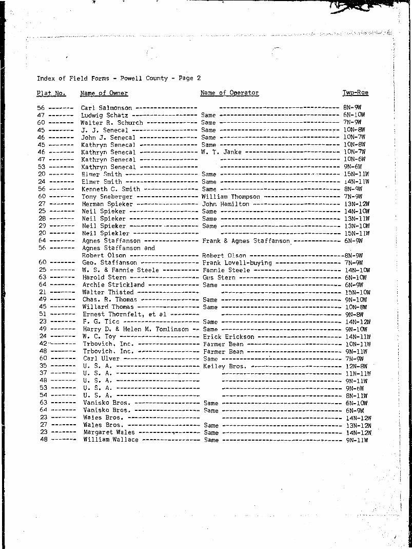
H clly ...ixmV?••;; . . .._ STATE QF MQNTANA T._16N_.R..1M.. Plat No..-** I 1BHj Farm Checked: I>ateL.2::.i:.>.-S. STATE ENGINEERS OFFICE Photo No ±±11 j ! 1IH Water Resources Survey > j 1
• By *-•—" • |iH H B , Legal Land Owner i.lj. .o.l.'.L.J.'AiT.'.iy Address ....._Qy3.njia.1...Mati.tan& ' IH W i $ '•• _ i I•H ' Operator 53!?.S Address ;: 1mHffl Water is deliverd by: X 1. Privalo Syslam; 2. Ditch Company; 3. Slats Project; 4. Federal Project; 5. Irrigation District : I
BOH II under Ditch Company, Irrigation District, or Govornmont Project, state the numb or o! shares or inches, acre loot, as the case may be in said system ' IHHS App. No. NAME OF APPHOPfflATOB I NSMF np <;TKP«IM Date App. Minor's . „ NAME OF DITCH B / p p / r / q PreBonl Irrigable IBHU Decrao No. TO WHOM DECREED 1 K A M E 0 F ars£:a* Dnt6 priority Inches fa "°° (Water DeUvered By) No. H / F P / G / S fa. Acrea Acroa I
| ^ H Condition of System ....None Topography ...JMtom River Basin .....?9.?-.y!R5?H...§l.Y.Sr 1| H B '^'Adequate Supply: Yes No..X Explain ...J.la..?...9n.l.y....Uooci....water _ IQ H H Remarks I
HH Also in: Plat No Tvrp Rge J Plat No Twp Rge 11 Plat No Twp Rge. I ^formation From: 1H | Plat No T-wp Rge |Plat No Tvrp Rge .|Plat No T-wp Rge Haiold Bandy I

******+%i • • - . - • . . . . .
I ;.'."" ./ ] ; 'l : _ • :; ' ;'. [• ... ^ , r^,. ' \
; " f . •;.- \\'
LiJ ! 144 L4...4J I U...J I I ! ! I Li^i-1 1i i f i : T u :"""3 t r t f Hi""" . \\
1 i I T l " ,~T1 1 1 1 i P f T . | : |..„....]._ [.._....] 1 1 i I i_ 1 j_j I L I „„.... "v - I l
! I ! M l , I I ! I I I h! nt : i ,.,,,.Q,,,i, l. -,..,«,A——Jt ..iti..i-» U..-.1A..-...^ _..,' .....I.fl s . ' . XO ™.i. = • •
i T ! \\ V \J[ I 10 ] ' } ll \" I *f 1 . •'1 1 i 1 ! s i " ! m 1 n n 1 . !
__ 1 i i j . r.....M 1 14......_4J |_'44_L "0 :
— l £ i ™,-~l(f I , — 1 ^ ] L._i^....4.... I -jjj.—j -{—-IS—4.
I ! !...... .....I __i 1 j_J_J ! J....-....S I t..._.U .i l l i : i I ! J t i l l 1 : I
1 1 1 i ; i l l • 1 i 1 1 1 ; j j
I I I f I "l I I i™ I i ! I !" ! t™1 4 ! I--4 !• 21- i ! 22 1 ! 2|> ! 1 4 | # .I i i I i I j 1 1 ! _ [ i i i i t !"i 1 1 1 r 1 H rn 1 1 r 1 rri 1 I ! i I 1 i i i i l l i I i
i I 1 1. 1 1 L.....L L j J ! 1 i [._...
t \ \ I i 1 i i i L I i i i i i i ••• :'•Sf) ! -1 2j» \ \ 2f$~"t ~~t-& 'I "> -2|8 i--2&--f-— :
: : ! ! • \ \ \ i i f : i . | : : ; f ••:.-.-
i i i i i i i i i i i i i ^ ^i H| i | i i j I i j 1 i i I i j j ;
I i j I j j ; ; "~~j j \~ ' j i j j I j •! i ! i I i i i i i ! s I
! \ ! I" "t I i I ' ! f " ! ' n . ;•••••-•j 3 f | sf j j 3 f | ; 3 f | | sf [ | «p |~
! ! i — | " i f I j- | r r ! -•[ i p -j t t*—I ' •• '• ' ' L_J L_i i L J i s i_J i i • I ' >• i I ^ - ; .J 3 0 - C . . . . . ^

I Colty Powell STATE OF MONTANA T J J H - R . J 3 S L Plat No... 16 1 I
I Farm Checked: Date Zl1-?™^ S T A T E ENGINEERS OFFICE P h o t o N o 4472 S; I• Water Resources Survey !. I• By S....J... .Peter -g^ [ | |
• _,. Legal Land Owner '^n..$I™P.A2\?lLl:..3}.'?.5. Address fivanuo | I
I ' v Operator !;..A.:...?.<g.lSy. Address I II Water is deliverd by: 1. Private System; 2. Ditch Company; 3. Slate Project; 4. Federal Project; 5. Irrigation District •; 1
B If under Ditch Company. Irrigation District, or Government Project, stato the number oi sharos or inches, acre leet. aB the case may be in said systom I
8 App. No. NAME OF APPROPRIATOR NAMF OP QTBFnM Uale App. I Miner's , „ NAME OF DITCH I R / P P / G / S PreBont Irrigable I• Decree Ho. TO WHOM DECREED NAME OF STREAM D g l o ? r i o t t l v fachea 1° ""•> (Weter Dfllivered By) No. R / F p / b / ! > Irr. Acres Acres IB A-J.794 Mary B. Rice Shoup Lake 7-15-40 10 No !._:'_:'• I
I NO IRRIGATION I
B NOTE: R ^Denotes Regular Irrigation. F—Flood litigation. P—Water divortod by means ol pumping. G—Water divertod by gravity. S—Stored Water. •
B Condition ol System Topography River Basin .GQlymbJ.?....3iv.e.S Ifl ', ..v,. Adequate Supply: Yes No Explain - I
I Also in: Plat No Twp Rge Plat No Twp Rge I Plat No Twp Rge Information From: II • Plat No Twp Rge Plat No Twp Rge | Plat No Twp Rge Thos. Barbour I

m v ,v _
I ' | : i li.1 I * 1 i l l j i •• j i
I | | j , ^ | |^_ j | |^..|-.- |j
1 ! i L I 1 L. i_J 1 L I .! ...i 1 L_._ ! •a i i i j i i I i i i i i i i ! • ito ! i I i I I ' : (I j j J [ J _..!„... |-_j-J- ]. j. I J | _ | I....4 L ; i
I 1 l, .1 . M M ! I j I I M j ! 1 II Lj j j 444. J....14 1 1.4 M L4..4 ' ^ ;I ii:tihHz:i:ii:d • •I I 1 j i l l I \ ' ' i j I . I [ j j
I I H I \ H ! f+i I I HI 1 1 i ; rtt f t i ! t1 T i ri :G) ;•I i l l 1 ! 1 . 1 1 1 i i M I i iI I I ! Hi........ I H H LLJ [ i ! L LLI I ! I ! i I i I I ! I 1 I 1 ! I •I i «j» ! - 2i> \ 1 2s-- | r-ai? i \ n 1 r - 2 | } - -4 - - -I ' i I I i J i ! I i 1 i ! i I i i i ; ; - - j •
j I i ] i [•-•• r -] - j n j i f r - T r c •.I I I I M ' I I i M I N Il r i .4.1 i....8f j ; [ '? i i T i n s rI 1 i 1 1 11 s 1 i f 1 s 1 n r r i I rn ril rI .3fi.,B ^ ;
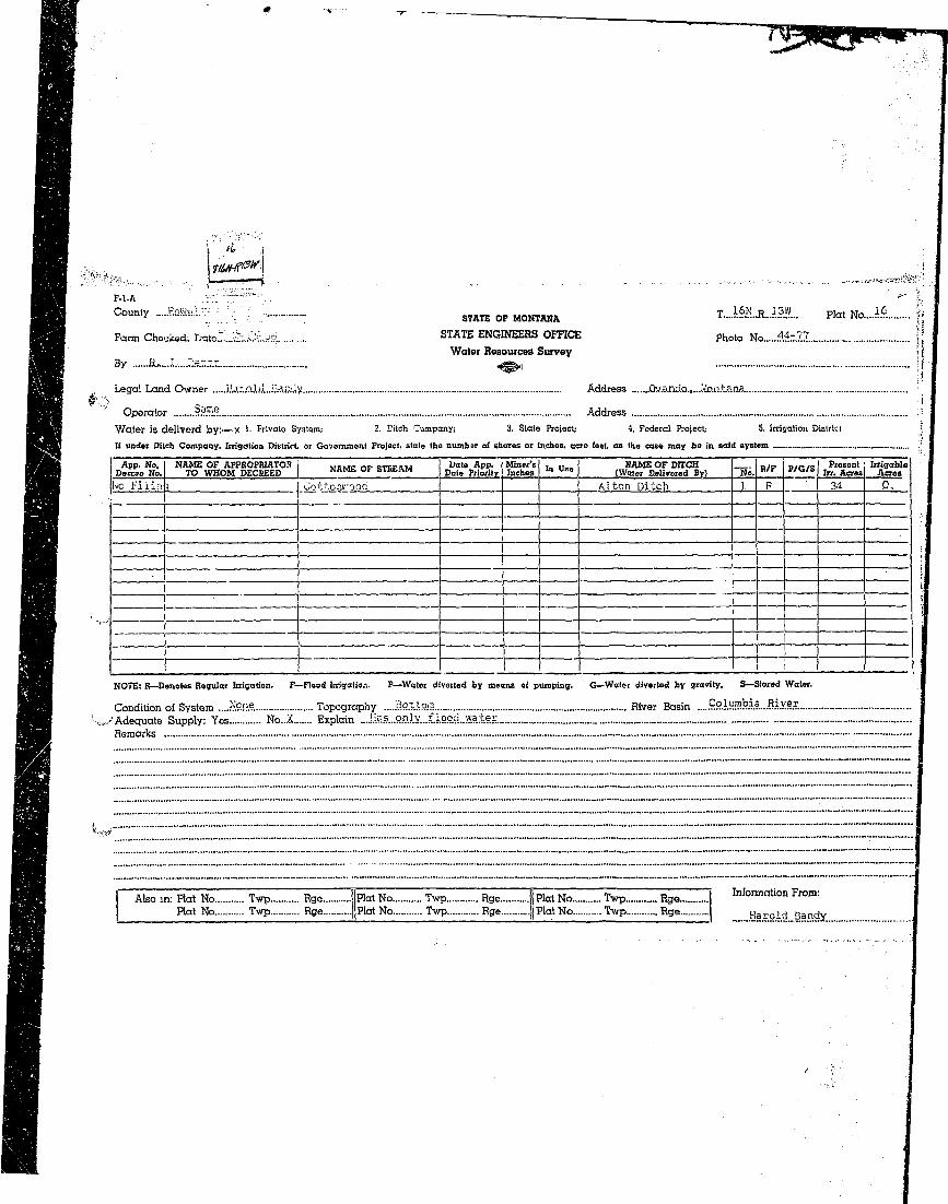
I CotyJ^H STATE. OF MONTANA T__4_J__3L Hat No 16 j
I Farm Checked: Dale .7.-11-5?. S T A T E ENGINEERS OFFICE P h o l o N o 44-7&.S....44.-75. i1 , Water Resources Survey ' *I By ?.°^?ri ??ter ^_ . !
• J * **• " i HI A ., Legal Land Owner .•?..•...J-...^..E.l.?.ie..M%y...Hendri.x AddressI Operator Gner.g£..O.....Drayershuy.ing Address .....QvandOj..MontanaI Water is deliverd by:—x 1. Private System; 2. Ditch Company; 3. State Project; 4. Federal Project; 5. Irrigation District
B It under Ditch Company, Irrigation District, or Government Project, state the numbor ol sharoB or inches, acre ieot. as the case may be in said system * ;
I App. No. NAME OF APPROPRIATOR NBMP np <STHPAM Date App, Minors . „ NAJ—TOFDITCH I B . P I ~,,r/v. Prosont Irrigable ';I Docrae No. TO WHOM DECREED NAME OF STREAM D a t e P r i o r i l y I n c h B 8 In Use ( W a t e r D a l i T e r e d B y > M o - R/F \ P/G/S faj A c r M A c r e < ;
I D-^Q^ John M. PPPTS N. Fk. Shanlpy C.r. 5-1-R4 6fifi I
I "" ) 1/3 YRS .. :I D-256) James & John ; ,i Manning N. Fk. Shanley Cr. ; jI (Cottonwood ) 5-1-84 1333 :I l/3 Yes Manning-Peer Ditch 1 B, 3_6 Q
I NOTE: R—Donotos Regular Irrigation. F—Flood Irrigation. P—Water divorlod by moans of pumping. G—Water diverted by gravity. S—Stored Water.
I .. Condition of System .Go.o.d ,. Topography ..Batijam. River Basin .Cpl«mbia..Rlv.er.R ~" Adequate Supply: Yes..X No Explain -• Remarks •
I I Also m: Plat No Twp Rge Ill'lat No Twp Rge |Plat No Twp Rge.__ WormaUon From:I I Plat No Twp Rge |]Piat No Tvp Rge .|piat No T-wp Rge 5e?. rS? ?_?X?F.
I T1 t ilxnrrjiLri'it ifitiiiJiiir iI — j « j — f «* * < - • • • - • ^ - <* •• * - : i
i r"i I j n rr s ri i \ f IT."" O !m j j | ' i i i i i i \ \ j | | -
g ! i ! I ! I I i i I 1 I I I I i
• n t '-tti ri i m ! tt i"tiI i [ i , m rr i m i i I l I rI M ! T i | " ! l I " n " ! l [ l l T T T 1
I j"~"i | """i | r T j t "j ""I i i j ' "T j' \ |
I I a* -1 1 2p \- -j-^H- ] «M ! 4 1 1 4 1 :CI I j j I j j I,, ,t j... ,j J.. » I | | _j ;. j i i_ . :
i s I r i I M iTnTTl r n i i i !I I SO I — j - - 2 > \ y~"2& 1 - [••—\~'1& ! f -20- <r t ~ 2 S ™ T ,,... j
I ! I ! ! ! I i ' 1 ! ! I ! j I ! ! • • W-* iI i i j ~i j f""]'"" j r~r i "T i f i i I i
qqqmiiil^j-fH 44 4444--m ! o i "7'——"~» jv > •• • •• ^sr~-r- • ^s i oo I - S o f1 i l l 5 i I I •, J i ; | ! ; j i i l lI i i _.l 5 i L~.l — - ! i I ;. i \ ; i. .I i ' • ! = I ! « i • : ! \ •• ; ;
I I I i L i « i » » j ^ 1 J w i « i ~ J I i 1 I I i I I I S s ! I Q:
I ..,.'^r.?..»...?§"?.?....?.?"i«...y-*» .??"*? .?!-•?. • • "

" . • • ; • ; . - '
i• \
" ' " " ' - " • • ' ' ' • • " - " • - • • • • • " - - - - " - " ' " " ' ™ ^
c °« n * S w s i ^ STATE OF main* T . ^ Rl3tv H a t No....i6
Farm Checked: Date..J.Tlfc5§ STATE ENGINEERS OFFICE p h r ) t o N o 44-77Water Resources Survey
By ....B.,...J.....P.eter - ^ , ] .4.4-7.6.
Legal Land Owner ...D.t...!i-...J.arn.es Address .Qy.an.dg
Operator Sams Address
Water is deliverd by:—X 1. Private System: 2. Ditch Company; 3. State Project; 4. Federal Project; 5. Irrigation District
It under Ditch Company. Irrigation District, or Govornment Project, state the number oi shares or inches, acre ieot. as the case may bo in said system
App. No. NAME OF APPHOPRIATOH NAMF tip <!TUFAM Date App. I Minor's . „ NAME OF DITCH I _ « . . , _ . . Presont IrrigableDecree No. TO WHOM DECREED NAME OF STREAM D g t e p r i o r i t v I n c h a B In Use (Water Delivered By) No. B / F P / G / S Irr. Acres AcresD-255) John Fitzpatrick. • I N. Fk. Shanley Cr. 11-28-90 I 500 No Fitzpatrick D. 1 R 0- 122
i • P-260) iVilliam M. Pear N. Fk. Shanley Cr. 19-1-01 500 ito 'A-690) i-ialph C. Davis & John Creek 11-4-90 150 No "' .
Job:i Fitzpatrick
NOTE: R— Denotes Hegular Irrigation. F—Flood Irrigation. P—Water divorted by means of pumping. G—Wator divertod by gravity. S—Stored Water.
Condition of System ....&oo;A Topography ....Bottom River Basin .....Cffilyfflb.ia...B.i.y.e.r. ,...;..'.:..Adequate Supply: Yes L... No Explain —
"*"' Remarks ... !. ..EL ...§!l?.Gi?.Y...i.?...fi£S.?.§GLi.X...9.?.. .?. .........
t " ~''ft*S „ ..„
Also in: Plat No Twp Rge | Hat No Twp Rge jlPlaiNo Twp Rge Information From:Plat No Twp Rge ||Plat No Twp Rge |Plat No Twp Rge D> E . Jaro.es

I . •
r i_ r | j | I _u: • i i ] i I i i j I [ ~ i
I i _ l j ' • i I i l l • „ !i"TT TTTI r~ ,TT , n i i M " - ~
i I I i | i j I ] i ! j j j ••••!
n I IT] mriiL ttL'iijT tilr i:i:lj :.....JL± Li...... ilj i4-i 'J--1 -
I \ j \ 1 ! i _ J _ ! 1 I i j I I i l li i ! i l l ! 1 j " ! ! 1 i ! ~> i i I 4 ^ ;
i i ! i i i | I I ! ! i 1 ! i l l %«••'
~1 i I T T T t 1 T i T"l i !" t~TT~"! i • i . l i -...i—i i !•- ''• •• i ' — - I - . .L I...-.L
i i i ~i r r "! j i i i i i i r j - j - pnipIIIUl.UJ jJli LJ U XE4T :I I ! ! i i ! I I i l l ...
*f | i 2? 1 2 f " | T 1 ! 2f ! ! 2P 1 » I"1 i i i i i r 1 11 in i" m !
j ,U.IIIINI| n irti " " • " ! "— ' { j ( j • i i I } j i ( > ;
i IA B\ 1 1 1 i l l ! | I I !
-U i -4-L- 444-44.4 44-4 4~*4- !i j _.j [ j LJ _LJ_J i ! L i__i e^
n J . l I 1 I I i " I I I i l l i l l ' ' w i! I j I" I I I M I | l i i I !i ! i j I I ! i i i 1
Mi M I i ! ! 1 i I I I I i_ :i s ; j .- i i i 1 i i 1 n i 1 f I \ 1 i r r i , :29 :B, 30-A _ ^" '

I * •* ' - • zr— — —
I \i~
I F-l-A •••• "\ ' "" !
I C o u n * Z™n • ^ , , SIATE QF M0NTANfl T...16N..R..12W.. P la t N o , 1 7 I
I Farm Checked: Date .7.-24-58 STATE ENGINEERS OFFICE p h o t o N o . V ^ i v e y ? ! Are? j
I Water Resources Surrey iI By ....B.-....J.r...?.eter . . . ^ g .
I . - ^,I Legal Land Owner ...Ruth Clark Address OvandoI " Operator h..3..:.2?jlSl Address i
I Water is deliverd by:— 1. Private System; 2. Ditch Company; 3. Stale Project; 4. Federal Project; 5. Irrigation District
• If under Ditch Company. Irrigation District, or Government Project, state the numbor of shares or inches, acre feet, as tho case may be in said system .I App. No. NAME OF APPHOPHIATOR I NAMF OF <?TBFAM Dato App. Miner's , „ NAME OF DITCH I B / - p . r / s Ptesont IrrigableI Dacrae No. TO WHOM DECREED " A M b o t a l M f c A M Dale Priority Inches '" u ° e (Water Deliverod By) No. H / F F / w ° In. Acres AcresI A-493 " Ruth Clark ~~j Dunham Creek 7-15-40 100 NoI ( .- A-8C1A Katherine Eyron Monture Creek 8-19-44 200 I No ~ I
I Condition of System Topography River Basin ...Columljia..fi? ver jI ',^/Adequate Supply: Yes No Explain I1 Remarks ••
I ' "T"I™7ZZ™I ZZ13IIZrZZZZZZZZZZZZZZZZ^IZZZZZZIZZZZI"ZZI'ZZIZZ^I ZZ!Z"Z!ZZZZZZ'Z!"ZZ~Z!Z!ZZ"ZZZZZ!"!!ZZZ!!!ZZZZZ!Z!!IZ~ZI~
I *wZZZZZZZZIZ!ZZIZZZZZZZZZZZZZZZZZZZZZZZZZZZIZI™ZZZZZZZZZZ^^^
Also in: Plat No Twp Rge Plat No Twp Rge II Plat No Twp Rao Information From:Plat No Twp Rge Plat No.. Twp Rge jPlat No Twp Rge 0^ c l a r k

I ~ ~ - • • - • • - • • • • - • . - • • • • : . ] r r ^ , ^ , ^ ^ ^ ^ !
I I I j ! I F~] I I I I I I M i l 7 • ; ; : j " ~ ] i
I i r _ ., ._ii 1 j. I;; \1 T • • ;I "i s i ( i i ": n " i i i \ \ ~ ~ iI i j L...] L Li J __|J | L.L.....L w :
I Ti I " 1 \ "T-f 4 ;-f I J 4 H-f" :I ...Li ! 11 L L L i ! : j . . . : . _ M I <•> iI " "I ! M i ' L I M l M " M T'" \I • ^""•••i " -"f ""if—j -i -ip | j -if i | a.-ii |_ |__i^—|. ;
I I i I I ! I I ! I |_ i I j ! i i I i
H i i i i i i i i i s j i j i s s i | :
| i | | 4 i I r4___| :.......L..j [ | „ |_4_ I
t "i I \ ti~; TTT "-f-tT 1 1 r rt~t~• | I I ! I ! I I i I j 1 J I j i |
I I I i t " T H~i~ ht""f 1 f I r~t~tHI Ml. . J J J .1...!...... J l _ L . i i I. L i l l T \
I CV \ i l l i'[ I " 'I M M 1 1 TT" . ^I ..! 1A | j LIJ LJ i I. L M iI -^j t j i 1 18f I T ! " 8f t mrI ...3.1nA U

•» " — * — — 7 . , . » ~ ™ _ _ ^ ^ _
, . . . . . . . . . . .••:.- ••••••.••• ::.:-'.i- ;- ^ / ^ 5 / ^ : | ^ t l S : M ^ i i i ; i i " i
1 ^ U . J & S i i :....M..:: STATE OF MONTANA T. . . .1M.R. . . I?1 ' ' Plat No.... 1.7_
• Farm Checked: Date....7-?l-5.8 STATE ENGINEERS OFFICE Photo No t±JlI Water Resources SurveyB By ....?.:....-?.-..p.?.ter _ ^ -
I / , Logal Land Owner 5H?.££.i?i.°:F.S Address .Missoy.Uj. Jontana
I Operator .S_3jj)e. AddressI Water is deliverd by:— 1- Private System; 2. Ditch Company; 3. State Project; 4. Federal Project; 5. Irrigation District
H If under Ditch Company' Irrigation District or Government Project, stato tho numbor ol shares or inches, acre feet, as the case may be in said system . ~
I App. No. NAME OF APPHOPBIATOH MBMF <-IP CTHFAM Uato App.' \ Miner's ,„ „ . . NAME OF DITCH I - . p o , r / < . Present Irrigable I• Decrao No. TO WHOM DECREED MAMfc. Or bTHfcAM D a ( a p r i o r i l v . ig&aB "» "»° (Water Dolivared By) No. H / t " t o / i > In. Acres Acres I
I NO IRRIGATION ~ ". ~ ' ~
I A-1660A Emmett Glore [ Unnamed Spring 10-1-55 2000') No• A-1660B Emmett Glorq Unnamed Spring 10-1-55 600 No
H NOTE: R—Denotes Regular Irrigation. F—Flood Irrigation. P—Water diverted by means of pumping. G—Water divertod by gravity. S—Stored Water.
I ^ Condition ol System ,. Topography River Basin Colymbiajiver• Adequate Supply: Yes No Explain^1 Rsincirks ..................................I...........— .......~.................................................... ...........'..,.................................."—.—-•—••--•"—*'*••—•••-•---*...•••...—
I Also in: Plat No Twp Rge |PlalNo Twp Rge I Plat No Twp __Hge._ Information From:• Plat No Twp Rge ||Plat No Twp Rge. Plat No Twp %e Field Survey, David James,I ' TfiosT'Barb'ouT ""'"."'." '

I I J_ M M l I _J_I_.. ._J_U_LJI _ a_J 444.- _ J_ _ u ,_ 4—i—1
~i 1 1 n " T i 1 1 1 r 1T" ni ! LLL J IJJ I I L! Lr 1 1 1 1 i i i i 1 ' ' 1 1 1
m ! 1 j _|_. J j _ 1 __J_i L.J L...J _L
J44 i-U- 4-i— l i t 4-U- -i-U- '-"I I ! I I I IS
I i 1 i i........| _.4__4- I _.i \ ..! _| I ;.._...! I
i l l I I 1 i j I I 1 I I ! j \ I 1i l l i j ! I 1 i l l M I i !I I - j I - {-•••{ i I t--i I ! 1 1 !•--"!—::i:±::: ::i:!tL: ±t:t: :i± r :±t ±: :r f t:j i f i l 1 j i j 1 i I ! I ! I l l
I i'K3 1.11 : L J L...1...1 i 1 1 L.LJ~ ^ ! 1 r 1 1 1 " i i i 1 1 1 1 1 r ~
«H-J i f f r t ] ^ 1 l f rT"^~ r -gj 1 " 1 r 1 n rr 1 n r I rrr ^
» ~ ~ r ~ j . . 1 1 11 1 1 i 1 1 i
I _J I I _ j 1 ! I ! j _ ! ! I ! ! ! !__[_
30^A
•-,,,•_,... j;/j*rir/3v|
F - 1 - A : . • : • • : • ' • ' - 1 : i
C ° U n t y E n H £ i l ; STATE OF MONTANA T.15H R..13W... Ho, N a _ 1 8 ,
Farm Checked: Date..7-2.2-o8 STATE ENGINEERS OFFICE p h t ) t o N o 43-72Water Resources Survey
By Hx...J.,...P.?.tS.r. ^ . , 4.3=5.1
Legal Land Owner Er.ed..Bai£f! Address G.reenough
Operator .?.?.™r. AddressWater is deliverd by:—X 1. Private System; 2. Ditch Company; 3. State Project; 4. Federal Project; b. Irrigation DistrictIf under Ditch Company. litigation District, or Government Project, state tho number ol shares or inches, acre feet, as the case may bo in said system _ |
App. No. NAME OF APPHOPRIATOR NAMF OF <?THEAM Date App. Miner's . „ NAME OF DITCH I B / p p / G / q Presont Irrigable IDecree No. TO WHOM PECBEED KAMh Ol: bIHt.AM Dato Priority Inches l n u*e (Water Delivered By) No. H / F f / w & Irr. Acres Acres !A-i i3Q^ James Burk Shanley Creek 5-1-S8 240 Yes Delaney-Burk D. L__B .§i :2 [
' .. A-1144) .Tnhn T. F.vr.rs Shanlev Creek 7-2-96 1200 Yes ~ !A-U52 Chancy E. Yfoodworth Shanley Creek (Burk) 10-26-8° ?000 Mo Burk Ditch !__B ° 8^ !
— - - |
NOTE: R—Donotos Regular Irrigation. F—Flood Irrigation. P—Water diverted by means oi pumping. G—Water diverted by gravity. S—Stored Water.
Condition oi System .Qao.d Topography D.O.ii.Qm..&...B,.e.nc..h. River Basin .....C»lumbia...Rivei.._ Adequate Supply: Yes X..... No Explain
Remarks Cla.i.aa..a...S.O.O.O.!'...Jililii.irjht...-..A'o ap.p.....f.o.viad...tQ...cav.ex.
Also in: Plat No Twp Rge II Plat No Twp Rge I'Plat No Twp Rge Information From:Plat No Twp Rge jJFlat No Twp Rge.... Plat No Twp Rge F r e d B a i r d
. .^i .SKi' .riK'rJiw-.-^v*;.: ' ' . . , , . - - . ; , -- . . . . . . . . . , . . ;• •' K. • - . ; • • -..«• . . - , . . ,;,.. , • j
... '••••'i-'-K'':-r.-".'-. . . i
I I i LJ L I I L L I I I I I i TT1 ;!'••"••] ~"" ~| ~ n ] t '""1 j "~'i j
, I i I I . , 1 I I ( i I ! I j I / « ,j i L...L L I J ...I f . i _ ! . . i
i I | l l l | | | | ! I | "1 1 - 1 t -- ~ i h-1?- r *f I M p — • . ;
i j l , i I i l I ' ! i • ! i > ;
"1 i i r r p " .T I , i n n r \5 j M „ j I j M j i L I LLL ^ i
I l l i 1 M I ! I i i l l*~" J \ to ! T I t i J,'7 * i IT l j XI* I - .«-* «•—.-jy-......-. j
I ! \ .-4 ..L . _4. L - - .. J \ I. I ii i i i i i ' i I" i i " r \") j rr! 1 ! „ [ i 1 L I. i... I........!... J. I [
i i i " i j ! : i i i i " T "••"• ., :| i ! ) | | I I j | I I II : *"'
n i [F IB r.n ~"rn i i i T I \ ,.. I J I I !4J 1 1 LLL.1 1.1 1 LI i . :" '! ! M M ! I l l I ! F !
.... ! L.l _LJ I L l LJ J J LI i f: ?
f; i J_I_L ' M I i l I" i 1 11 r . • • ;l | | t I I ! I I I I ! ! M l !
• - - 31 \ 3 ? { S3 r •••! 3a i Sp •; — • -SjS"—?
I [.. j i j I I i._ I J I j _j ..] !. J | I.___I I i I i I I 1 I i 1 i I I i i I I 1 i I i i M ,-._
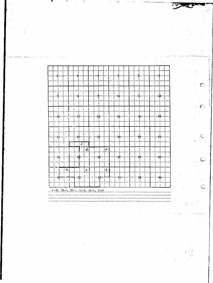
I 9 B , 20B, 29A *•—'

1 ^ ^ ^ ? i f t r « ^ - . ^ . ^ - - v . , , . . . . . . , . . . . . . . . , . - • . . . . - - . - - - • - - - . . . . . - . ^ 3
I SU ESKSii STATE OF MONTANA T..i5!i..R..i5L. Hat No...!?.
I Farm Checked: Date .7.-17.::M STATE ENGINEERS OFFICE p h o t o No...'?4-54.,...44-55,..43-73,....
• Water Resources Survey
I By a>..J-..P.s.ta.r. ^ , , Ms.56*. 43-74
H Legal Land Owner Edward..Bandy Address .9 .1°. I
H • Operator Sams Address '•
I Water is deliverd by:— x 1- Privato System; 2. Ditch Company; 3. State Project; 4. Federal Project; 5. Irrigation Distrk': jH II under Ditch Company, Irrigation District, or Government Project, state the number of sharos or inches, aero ieet, as the case may be in said system .
• App. No. NAME OF APPROPRIATOR NBMF OF «;THFAM Dato App. Minor's . „ NAME OF DITCH I „._ „,,,,<. Trssont Irrigable ]• Decrfle No. TO WHOM DECREED NAME OF STREAM D g | e p r i o r i l y ^.-h,,. In Use (Water Duliverad By) No. H / F P ' G / S Irr. AcrM .. Acres i• A-1147) .lam^ A. Hanawait. Shanlpy Creek 3-].°i-S6 300 Yes llanawalt Ditch 1 R 1SS - .:• 0• ' A-1146) J. A. Hanawalt a ;
• C. A. Jackways Shanley Creek 9-23-95 600 Yer. . - • • ;
I A-U^)3 H. j. Faust & ' _ _ J [• Chas. Jackways E. Fk. Chanlav Cr. 5-5-9S 300 Yes Hanawalt Ditch 1 R 200 • Q- I
H NOTE: R—Denotes Regular Irrigation. F—Flood Irrigation. P—Water diverted by moans ol pumping. G—Water divorlod by gravity. S—Stored Water.
•• Condition of System .GB.P.d Toprjraphy .....§P.ttom Siver Basin .....Gfti93Sfeia..Ri.ye.rB l ,„. Adequate Supply: Yes X No Explain• Remarks - ,|H _ ____ , .... . . . . ..... . ...•...........................«..........—......,....._.......
H ' ~Z """TIZZTZ'T"I IZIZZZZIZZZTZZZIIIZZIZZIZZZZIZZ^^^ ~I "' "."" TT,.•I Z!ZIIIIIZIIIZIZZIIIZ11..ZIZZZZZZZIIZIZZZI Also in: Plat No Twp Rge i1 Plat No Twp Rge II Plat No.. Twp Rge Information From:
I | Plat No Twp Rge |Plat No Twp Rge Plat No Twp Rge Edward Bandy

•V
H~TT M l i 1 1 1 r.T~T|6l 1 M 1 Nzrlii i]it 11 Jiliiff j J.. Jitlzi zlzzt
M l I 1 i | L-r'l i M i M i r ,
I! j I L L Z l i C r ' - _ . i I J J i 1 i I
~T i i i ; & cp^+r i i i r~ i
::.| ].: | \ r Lj i! : 1.4..: zpLi : 1™i i~i • •"""! r T ~t" I M ~i • 1 M~""
I i .. i !..„ „„] 1 I...,...,.] . I _t
I l l i l l 1 1 1 _ 1 J I i I I Ii l l I I I | | I I i I i ~ n1 ; j l i t . . 1 «_ A i . i J™. ' - I f i i1 \tt ' .... -, '—...oft - -•>•••« *.....OS>—•—i-— •• 1 n n . « _i „ „ { „ , no 1 •- a fi'A i. /"—'«
1a? 1 1 2 f r * f 1 1 2 f 1 1 2 f i r T r °i 1 ! 1 n - iT'i ~TTI i I r Ti r' ! I J ! U....I M..J LJ i L..LL :
1 1 i l l 111 Mi1 3p j • 15/ r i 2S 1 —j—r r — -j ~t'-2p 1 j—2p—j
1 1 1 "j " """"["I j I j 1 f \ |"-"{-"f""" ^ •I ! ! rv i" I I H i I t ! h h h
- • - ! 3i I -f -32 - !—3S ! " ! 3U—i ~i 3S r r-B8 f -
j ] ! I J I ! ! ! |_J_ J I i ! I MI s I i I ! . i i I i i 1 I i ; 1 I i I i I j 1 1 I
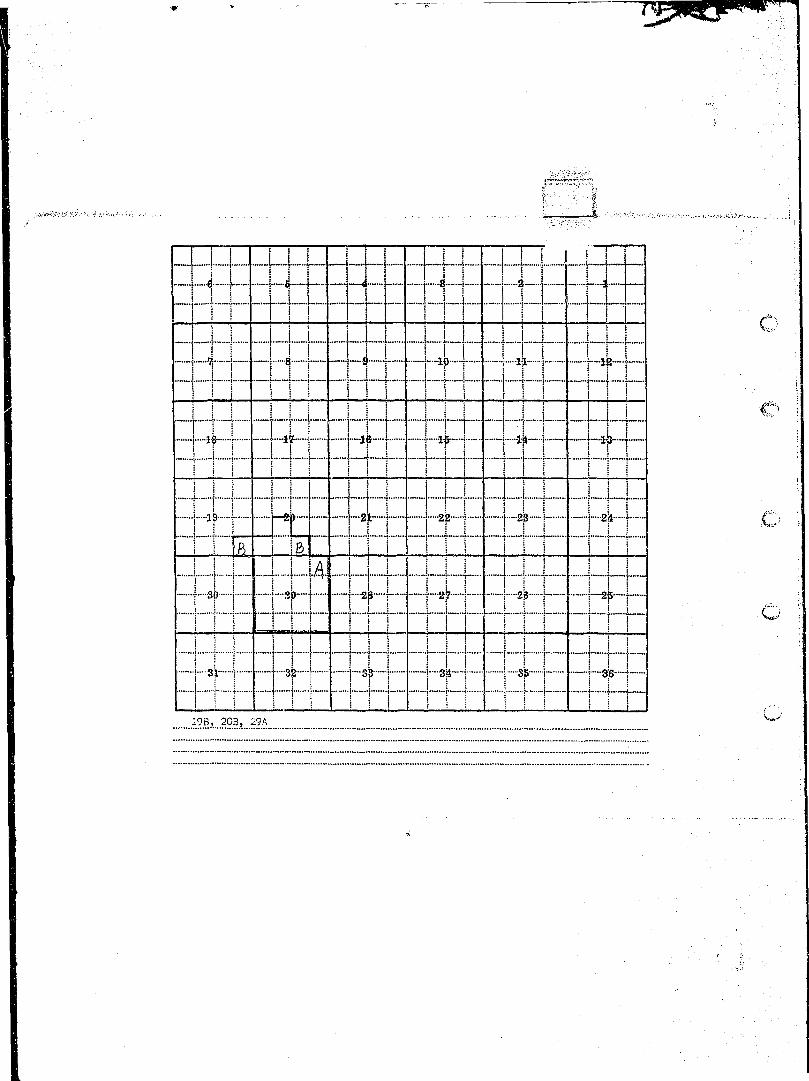
3B-3A»..4B.>..JAJ..2B»..10CJ...15BJ...16B ^ " ' ' '
f 'i
I County P o w * n T 3 5 N R 1 3 W D I . M 1 8 'm uouniy ., s m E o p M 0 N I A N A T R Plat No ••I Farm Checked: Date .?-i7_-5§. STATE ENGINEERS OFFICE p h o t o N o M.^z f
• BY Robert Peter Water Resources Sum,y j
I ^ ;• f•"*•* Legal Land Owner XI).01!!?.?.. E..*....?ar!?.?.y.:F. Address .Qy?n.d°i MonJ?B3 . i lI • j• Operator SSJBS. Address
R Water is deliverd b y : — x 1. Privata System; 2. Ditch Company; 3. State Project; 4. Federal Project; 5. Irrigation District
M It undor Ditch Company, Irrigation Diatrict. or Government Project, state the numbor oi shares or inches, acre ieet, as the case may be in said system j
I App. No. NAME OF APPROPHIATOR M»MF DP qTBF«M Uato App. Miner's , „„„ NAME OF DITCH I n / P „ ._ , , , Present Irrigable• Decree No. TO WHOM DECREED I W A M E Oi S T R E A M Date Priority Inches to U s e (Water Delivered By) No, H / F P / G / S Irr. Acres Ages• " n-7O^ Mi 1 1 Hnne-i:f)f7 Dunham ry^fV ._.;... .
H ) 1 - .(i« r.y. ; : ^ t j T c r,.n?y) A-1-Q7 150 I ZZIfZZ !• ) Qf I iB ) 12000 Part. :• D-80) John I.. Naff Dunhar; C.re-°k fW. Fk. }' ;9 ) l.'.or.Wre Crpnk) 6-1-q7 7000 ;1 ). Z! LESS. , LI ) • 150 Part Naff-Hnnstnt? l i i t rh L- S ?11 -18B n-l 1 9 qa-ra QnnnreT .B Wai TOT ^p° n rer
9 ••— Gertrude Vanco 8, 11 Mattio M v r p h y McCabe Crefk 3.0-1-86 80 I Yes I1 '"''"' 5-1-94 100 I Yes Spencer Ditch .1 R .44 0
I NOTE: R—Dono .ea Segulor Irrigation. F—Flood Irrigation. P—V/ater diverted by moans oi pumping. G—Water divortod by gravity. S—Stored Water.
• :., ..Condition of System .^,9°d Topography E.Qt.t.P!n..&..B.en.ch River Basin Calumbda.JUv.er.I ' Adequate Supply: Yes...» No Explain• Remarks -
I r~™'zrizziziii11 zzzzzz^^^^^ .:..:..I " "I 7 ZZ_ LI1 " • ;• " "I ] Also in: Plat No Twp Rge IIPlat No Twp Rge | Plat No Twp Rge..._ formation From:
I Plat No Twp Rge [[Plat No Twp Rge |jPlat No Twp Rge Thos. E. Barbour

UP * , _ _ l _ _ _ _ „
i j 11 I i L i J m i i i i r n i i-. \ [ f-[ -J-j j H • \ - U-- . .. , if 1 1 11 r ""." i 1 IT [ j I j - j " o ;
I I t .!.......[ 1 U . . . J Li Jj J 1 1* LI A' r I i i i : 1 i j i i i / i i i
\ j j J __j _..[ J_____L_ ].. .!..„] LJ i I L• i I I j ! I i j 1 I . j i I I I •/<"••
i l l | I I ! ! { i l l - \S | / j I ! I - Y K:"""1 ! i Tt"t f n I rt" "t" i "i~i~T"—j f i I if T ~'"j~~if ] i if—"! * t i -•••}"--if j-
j j s j i i I I j I i I i j j j j i I
! ! ! J [ L...'i._a ! LJ 1 | J . .1. I J. . :
] I l I L i I ! J L I I I J I I !M M I 1 1 M l - 1 1 1 M l S i i
1 ! ! ! ! [ 1 I I i M I I I I I I I ....! i j j i i i "i j r r i j i r ; i [ .. ..-•
i i ! i i I ! M ! I j i i i i 1 i (..,/i i I p r i i r\"\ rTTri I T ITT
.\..\ i I j i i i i i i i i... i i r"I "! ! I I I I I I I I ! ! " i
••—••{ 33; I -| 3?- f j""8? j j 3jt--j ™"j 3& | p.gg.—j.
I . i j ^ 1 I i j I 1 i ! I i ! j I j j i | 1 I j (V
J.l.rA*...12rA.»..13.T.ft*..lA=B_,...].ArA

• • : ' i 5 * « ( r r S ^ W J S s , . , , v ^ ~ V . i . . ' . . - : . • • ; • • • > • . . , - -. . . . . • : • . • . • . - • • : . • • • : • • • • . . . . . - , . . . , . . . - , . . . . - . . - ,:^.-i-iiifi
County ....Powgl.] STATE OF MONTANA T.i_5N RlSSL- Plat No..i§. !
Farm Checked: Date Z:l±.^. S T A T E ENGINEERS OFFICE p h o t o N o 43-72;...43-73 i |Water Resources Survey '
By S..-...J.-...Petgr ^ . , ..4i.-fj6i...44-57i..43-7.1
Legal Land Owner Minni.e....?oxd>..at..a.l Address :...,....• '.
•' Operator .5tats...Fisb...S...Ganig...C.p.tDnii.5LSiQa..lfiuy.iag) AddressWater is deliverd by:-—X 1.'Private Syotim; 2. Ditch Company; 3. Stale Project; 4. Federal Project; 5. Irrigation District
If under Ditch Company. Irrigation District, or Government Project, state the number o! pharos or inches, acre loot, as the caso may be in f.aid system
App. No. NAME OF APPHOPHIATOR NAMF OF STBFAM Date App. Miner's , n U M NAME OF DITCH I „._ I p , r / c . Presont IrrigablsDecrao No. TO WHOM DECREED n«Mfc Or bfBt.Ar-1 O g l o pr ior i tY incheB " "'" (Water Dolivorod By) N°; _ _ _ _ _ _ _ 1". Acres AcresA-1134 IVm. Bovd & j
; ." Samuel Van Alstine Shanley Creek 5-1-^0 1000 No Van Alstine D. 1 • 0 0 •" A-1135 William Royri Shanley Creek 7-10-11 400 Yes | Rovd P. ] a 179 0(A-1136) R. J. nradshaw Shan ley Creek 5-1-87 300 Yes I .
T A - 1 1 3 7 ) R. .7. Rrarishaw ft Rvadshaw Hit.r.her, 1 B 306 ?. {J. T. Manninn Shanley Creek f^-15-05 ^00 Yes I >
U^I13e) R. J. Bradshaw Shanlwy Creek q~l-°5 ?,0n Ves . •,A - . U 4 0 J a s . Burl-: & , . .•-':-•.':.;. .'.. . __... : !" !____: i
Som Van Al s t ine Shanley Hrppk 4-1-Q4 lono Yns Bnrk-Van Alg-Hr.o n, l B CO n ,;A-1.143 MiKo De laney Shanley Creek 11-4-90 500 Yes Delaney - Burlc D. 1 R 127 0 i
' I T I 4X2= \
NOTE: R—Denotes Regular Irrigation. F—Flood Irrigation. P—Water diverted by means of pumping. C3—Water diverted by gravity. S—Stored Water. >.
Condition ot System Topography River Basin S.?.l.^J3..My:.?I.
I. Adequate Supply: Yes No Explain _..Remarks - -
r ~ W s o in: Plat No Twp Rge II Plat No...*. Tvrp Rge II Plat No Twp Rge Information From:Hat No Twp Rge Plat No Twp Rge Plat No Twp Rge , , „
' n i • • ! i • • • ! • ! i IM • ii • • i i • ii i i i ^ M i i • i i •!!• i n ii — — — - — . .. , ^ , , , , , M , , , , , • • • ! ii • • • • • • • 11 • ! • ! • • • • • • M » « ^ n » Y a n < A * . i * v r t n n * ^ > « i » * a • , . < • « < • • > • »*i»» f • • • - • •
Jack Havr Dave StonenousefG Employees

I I i ..L..j I j | ' i | is : i.......| j L ....... J. i
H 1 1 r ~" r h ~ I" H \ r : H T ~ ,- \
I . I _!_. i i l l I I I . M • w i
J 1 r M _ j J M l I I 1 1 1:WH4+i-3Pz--H-:zflF4l-h Ci ij I i . i i 1 ! ! i ! S i I ;i i i T T i -1" r i r n i n rrr \i i L....L i L J _ \A 4-j. J i i i pzpz !
I! j i I I | i 1 j i 1 i . !
j i K ; ^ j * „..,« . ^...H •.< ..-..OS—..—*.—..— •-« A A >j ........ . «.» OB..... i i... O>l •••- X iH 1 1 -•-Li""""; t"f" ~~f T f t~1 I i H rT ~ M i i L \.\AA L I J J . i i T l 1•"" ' i "1 1 7 i ' i ' i i "" I ' I ~ \"~J ' "
-Sp [ - | - -2 f t - - - T \-48r-f- --2? 1 i 2p- - ~-25~-j
1 1 1 I f j I i l l M l M l ' :•"•-; i ; | | i.i..U-l. 1 I l I I j i j j! ! i I i ! I I I I I' I
•••-! 33; i "-" 3k 33 i ~$Sr~ r —i 8& r i SB t-
j i I M l l M M i i I J I !_
I I i I i m c\ i n l rr ! 1 i n I i n 1 . ,-.7B,...8CA_J.6A,.J.7A,},__ 18A_,__ 20A,_.21A.3._2SA ^

* ~ ~* — • ^ - ~ — ™ — — _ _ _ ^ _ _ _ _ _ „ , _ _ m m m m „ _ _ ^ _ _ ^ ^ _ _ = . ^ ^ _ _ ^ _ _ _ _
f. • ' . . : - ' • - ':• ' ^ ; i j . ;
M-A iC ° U n t y E 5 W £ U • STATE OF MONTANA T....15N.R....13W.. p k r t N o 19 !
Farm Checked: Date....!7.2±-J>8 S T A T E ENGINEERS OFFICE p h o t o N o 44-52 ;
By ?.°b.er!: . P . e t e r Water Resource Survey i
/•-* Legal Land Owner l:..3.:..J.?llH. Address ...^)>I°}-^j.J^S}?^^J^oxJ?A^ i I
Operator .Qffiar.C.l.ark Address ...Qy.aridO.i...HoataaaWater is deliverd by:— ' 1. Private System; 2. Ditch Company; 3. State Project; 4. Federal Project; 5. Irrigation District
II under Ditch Company, Irrigation District or Government Project, state the number ol shares or inches, acre ieet. as the cano may be in said system
App. No. NAME OF APPROPR1ATOR NAMF m c ™ S M Uate App. Minor's| , „ ' ilAME OF DITCH I n / P „._,«. Prosont 'irrigablp •Decroe No. TO WHOM DECREED NAME OF STREAM D a t e Priority Inches I to " 8 e (Water Dfllivored By) No, R / F P / G / S to. Acres Aires
Dr.?9) . W i l l HOPP1'0±Z Dunham Crap If (W. FV • : , :. ;) l.-.nr.turp r>PBk1 ...6-1-97 150-- ') Of) ^nnn _Hax±
D-80) John T.. Nflff Dunham r.-reeVlVI. Fk • , jtiV.nt-llTP Cyr.i»V) 6 = 1 = 2 2 ^ 2 0 0 0 I
; iso Part 'farlev(Naff-Koqstotz)1 uitch 1 R | 40 0 i
No filing Pothole I Farley Ditch l.._F_L 32__. 0 :'•-•• A-707 John M. Shoup Unnamed Fk. ;
Lightning Creek ' 5-1-96 ' 500 ? ] j '
NOTE: R—Denotes Regular Irrigation. F—Hood Irrigation. P—Water divartod by means oi pumping. G—Water divortod by gravity. S—Stored Water.
.Condition oi System £°°d . Topography Bench Riv e r Basin .Cj?l.U0Ma...Riy.ffX'" Adequate Supply: Yes...X No Explain
Also in: Plat No...AL Twp...i5". Rge. i .? l |p ia t No Twp Rge ll Flat No Twp Rge Information From:Plat No Twp Rge | Plat No Twp Rge ||PlatNo Twp Rge Omar Clark
I I I I I I I I I i L L I [ I I I I I H H 7 I""""••• ; j r ("""] [ rj" [" ~Ti I T ;; ~, r\ i i ! j i l l ! i ! i
n i I rrr T i i i i i p y " • c !i 1 1 Li [ L _L i Li i I I . __.l_t !
•" ] ! | ! l i i I I I ' ! I I" I . , -I I I i I ! I i i ! ! i ! I 1 I !i j i T T T " I T m ~ r i t rrr • ,.. \I i i i . i i L I i i i " rr i ! ; •L"
• 1 1 1 7 l i V\ 1 1 D 1 1 "TTT" :I i I I i M l II I - II I III
I j j i l ; 1 1 1 j I 1 M ; '• j •_ _ _ _ _ _ _ _ _ _ _ _ _ _ _ _ _ _ _ _ _ _ i j i ———————-—_——
! ! ! M i J . . J 4 L.I . . . I l l I I I| M I ! ' M 1 ! i l l I M '""
. I |__! I L] I \_ _l_J_j_ -J- _!.. I _L! I.I l l Ml I I I M . I I i Mi :
' I i j ! i : I... L i L . I I I M l •...: ,II II I j I [ I ! I I •' ' i ! I-"" ••-•••••••
;• oU [ • ^ v ] _ Q i \ £f \ i _p j ] ap - ]"- • • - .>.. ;
j j I li I H ittj j j 1 rti" •'••:•,.'". ' ji l l I I I i ! ! j i l l j | i ii i i T""1 i I i i | i i r r r j \ i
•--• \ 3JL- I j 3_" f 33 ] j 3jt~"j - j Sf |~ •-f"-3jiJ |- . j
1 1 l 1 hri i 1 1 1 l r M f 1 1 t ri I r t i .o !....lrA._I2.r.B. I

F-I-A ,, . . ICounty PoWRll „ 15N „ 13W. p , _ , M o 18 |
O U n y STATE OF MONTANA [..... R Plat No !Farm Checked: Date L-J&39 STATE ENGINEEBS OFFICE P h o l o N o ^ ± i
o T _ . Water Resources Survey iBy ..3:..J.:..1?1?I. ^ •
Legal Land Owner i:. J . : . . ^ 1 F 1 1 A . 1 ? £ } . ? L . ? H I 1 . ? . . ^ . Address .'.
Operator G.eo...p.,..p.re.y.Gr..-..buv.i.na Address .Q.V.ando.
Water is deliverd b y : — X 1. Private System; 2. Ditch Company; 3. Slate Project; 4. Federal Froject; 5. Irrigation District
It under Ditch Company, Irrigation District, or Government Froject, slate the number o! shares or inches, aero foet. as the case may be in said system !
App. No. NAME OF APPROPR1ATOR NAMF C P OTBFJM ! b o l ° APP- Minor's ,„ ,,„„ NAME OF DITCH I B / P I o / r / e Present Irrigable iDecree No. TO WHOM DECREED t>AME OF STREAM [ D a l a Pr ior i lY ^ , , In Use (Water Delivered By) ^ f o . R / F P / G / S . hr. Acres Acres I
**• D~259) John M. Peers N. Fk. Shanlfey Cr. I 5-1-8* 6 6 1,3 Yes "Manning-Peer Ditch - • 1 R ~ "73 ~TT~ ,J-2^6) James S, John Manning W. Fk. Shanley Cf. 5-X-84 1333 ./3 Ye; __ZZ ~. ' •A-1557 Jas. T. Manning Unnamed Stream 9-21-89 ibO Yes Manning Ditch i__ji ! 35 ~T) ''A-1703 Jas. T. Manning Unnamed Spring 9-20-89 500 Yes Manning Ditch 1 F 46 0 '
~.., — • ~ i
INOTE: R—Denotes Regular Irrigation. F—Flood Irrigation. P—Water divorted by means of pumping. G—Water diverted by gravity, S—Stored Wator.
*t Condition of System .5.9°! , Topography Bottom Rjver Basin C.0.1umfaia..Bivar |
""Adequate Supply: Yes L... No Explain _ I
Remarks
Also in: Plat No Twp Rge Hat No Twp Rge II Plat No Twp R g e Ink tmcrSon From:Plat No Twp Rge Plat No Twp Rge Plat No Twp Rge G e 0 . Dreyer
• " " ' • " ' • ' : ; : ' • • • • " • • • • • - • • • • ' •• ;:••.:••-•:"•:'•.•• v . ; ; . - ; ; ' v ' ' ' - ' ' ^ : > v ^ t - - i ^ % i : a : V i H ; ; ^ j , ^ i ? | g ^ ; , «

[I l"]'!.IL.bL_..l4----l. L J.l 1 I-I I 1 - Lj „ U „ _ I • 8. T . ;: 'i...J j _ _
. , ^ | ^ [ ^ _ | r | j ^ ^ ..„; ^ ,i I i i l ! I i i i "" I i l
.. „. ,j _....L.J. : i _ I . . . .L L I .. ! i L...I'" I | i I T I i T i M l "7 I 1 ri-~t--"t |-f *f rti •
~i i i TTi PI rn r m : .zipi__L| L ....~..r ;......| 144 i | • _|_uj_ p1
4 \ hri ^ 1 1 4 1 h4 1 i+r! i i rn ; T 1 ^JJ^IEIJ ' I i rr
r T j j i l l ] | i | _ i i f f j | ji ! l i ! ""1 ! ~1"~t 1 i ! ! I I l~ c -
II i i ! | I M l M li i . j i j j i n M i i i I i
=^=444 4J-f fH 44-444-i i i i j i n I i i i I i i r t ~ t " ~
: i i i i t L i i L i i i i : i i iM i l I 1 | I I I I I I I
1 3r i h 2 3f i i sr ; ! f i mj ! ! - t - 1 t i ! T - - t ~ T ! I -f I i <—r •"""•
I ! j i I j j i 1 M M i i M i ! i I i i j J i."5A
i

• Jff. % r - •• - - — ,, .
. . . • . , • • , ' • • - • • • • • - , • , • . . . • , • . . „ . - • - ^ . . . . - • • . • . ; . • • , - • • • - • • . . ~ ; . . : . ~ ~ .- . . . . . . „ - • • • . . - • • - . -••••'. ' . • l i . ; . , . : - - - , . . . - . . ~ . . v - - , . l - - . . - - • ^ • ' .> I - V - , - - ( ( . . • , • . S - * - » l ^ : ' l - r ^ > '1
^ " f W
F-I-A • "" iC 0 U n ' y E ^ STATE OF MONTANA T WlOSSL Plat N0....IS........
Farm Checked: Date..?-16-.5.B STATE ENGINEEBS OFFICE ' Photo No .41-5.3.Water Resources Surrey
By fi....J....P.e.ter. " ^sgv. . Mr.5.2
Legal Land Owner Dav.i.d..£A..JsJ3)i3.s Address .Qva.nd.0.
Operator .§2!?.5 AddressWater is deliverd by:—x '• Private System; 2. Ditch Company; 3. State Project; 4. Federal Project; 5. Irrigation District I
Ii under Ditch Company, Irrigation District, or Government Project, state the number oi sharos or inches, acre loot as the case may bo in said system
App. No. NAME OF APPROPRIATOR I NAMF OP <;THFAM U a t 0 APP- Miner's , „ NAME OF DITCaa B / P »/r/c; Presont irrigableDectfle No. TO WHOM Dr.CREED I K A M E O F h T H E A M Date Priority | Inches " u c " | (Water Delivered By) No. ^ 1 _ | _ _ _ '"• A " ° ° Acre«
D-79 Will HooKL-ot.: Dunham Cr. —ilSP.' JP:L_) ."| i (W. Fk. i/,on!we C r . ) . 6-1-97 7000 | ) t
D-80 John L. jfeff Dunhomj;^ 2000 lof )ir nf P000 I j' (Yi. F'". i.ionUirp- C r . ) 6-1-97 ' VBSS ) 1 R 263 I p- •
I ) LJLSO__J '.
= j -=j h-=t T^=En=i= \= = -=qz=^^z: E=B=z±=: \
-• : \2 "I ;
NOTE: Fi—Denotes Regular Irrigation. F—Flood Irrigation. P—Water divorted by moans ol pumping. G—Water divortod by gravity. S—Stored Water.
Condition of System 5.9.SA Topography Be.nch River Basin C.ftl.U'J)Ma...RJ.ye.r IAdequate Supply: Yes.....X No Explain _Remarks »
A ) 3 0 i m piat N o Twp Rge llPlat No Twp Rge II Plat No Twp Rge Infomcrtion From:Plat No Twp Rge :.. Plat No Twp Rge Plat No Twp Rge n c TamQ=
t il II , ....itfl?....S.*....r.S.1i!J:.r.
I
: f • # ' ; • • '
• ' ' • • ' ' ' !

i '
I | j 1 | I t | -- | - | - I I | [" VUj 1 .1 ' \"**• *"'tj***""™"*f^** ••"*"'""•"• J •••••""• "•-••••• "..—•«• •——^ ......... .•,» „ J .n H n H^ „ , ••£•.- - .. j.,^.»«. ........... , . . •».* . .
.1 1 j , I j ..„[.....„ I „.. Ii l l i l l l j 1 . 1 ! !__. 1 ^ I ^ I
........I I L i L - - 1 . . . U I.M....I L - ° II I I ! ! | I ^ I !n i t 8 i :H;i rn T r? - ii i i Tj IT""!" [TlT- n n r
I ! ! i i i l l I 1" ! • I f i rj | j __{____! I ___ j_j_ j _. ! _.j „[_..! _ !.._....[._..
| | | _r | t |_4 | [_ |........| | _|__|_4-I If I -"4 h-"} -j 2|t—j- | 22 | Sp- I J--2* | Q
~~ i i "T""T'"""r"i FT" "'""" n r 1 1 r i [ i • :
I ! i i i | ! 1 J . i i i l l i i _L_I | ! P i ' j f )' |. V ' l l "I I i p - j - j ~
*j» ! ~T--2r-f 1 2j5"~i~ T H M ? n I- Hp-t—
1 H r -h-Hi f f 1-rt f f - -Hi- • • o.M i M I I I I I | i I M I :
I ! f I ! i ! ! i I ! ! l !j ! i i j ! I j i I 1 ! ! I I j iI j | ] 1 p I r i s r i j j r ~T~ i . i
: 1 i :~J i : ! i i 1 ^
m,...iAJ..i.lB>...1.5A .

I Cn'untv Powel l T 15N „ 13W ™ . M n 18 II C0Ut l t y • STATE OF MONTANA T : R P l a t N o . II Farm Checked: Date Z.-?.?".?.?. S T A T E ENGINEERS OFFICE Photo No .f.t.'Q'J.t??. \ II . Water Resources Survey ' II By ..?..: .i:...p.?A?r. ^asta • I
1 Legal Land Owner h™lL3.:..M!$?l! Address Pj«d .gna.,..Califprnia 1
5 Operator .S.affie Address ...I Water is deliverd b y : — X 1. Private System; 2. Ditch Company; 3. State Project; 4. Federal Project; 5. Irrigation District
R If under Ditch Company. Irrigation District, or Government Project, state the number oi sharos or inches, aero feet, as the case may be in said system ... :
• , . . ;— :• App. No. NAME OF APPROPHIAYOR M B M t . n P ernpaiui U a l ° APP- Miner's ,„ „ „ NAME OF DITCH _ _ „ « , p / r / n Present IrrigableI Dense No. TO WHOM DECREED NAME OF STREAM D g ( a pr ior i tY I o c h e a In Use (Water Delivered By) No. H/F
r P / G / S In. Acres Acre.
I •*- A-263 Joseph Barr ChambeTlain Creek 10-10-U 200 Yes Barr Ditch V R £2 1 £ .•I ^-265 S. R. A. Ho-ne ", Chamberlain Creek ~10-20-02 500 VPS Horrm Diti;h J R I 69. D _ 11 A-1613 Joseph Barr Unnamed Spring in-O-11 3?0 No Rarr Mtr.h J B I fl I ». I
I ——H' "I |— | —|—- IM 1— *
I r i I I I 1 ~ ~ " T ~ I i" l lI NOTE: H—Denotes Regular Irrigation. F—Flood Irrigation. P—Water diverted by means ol pumping. G—Water diverted by gravity. S—Stored Water.
I •.. Condition ol System £°?.d Topography ??:.™h River Basin Columbia...Bivej.I " A d e q u a t e Supply: Yes t.... No Explain • •D Remarks •H . .
• r.rizr.rzizi!"irzizzzr.rr.i ^ ^ ^ ^
I Also m: Plat No Tw? Rge Plat No Twp Rge I Plat No Twp Hge Information.-I Plat No Twp- Rge Plat No Twp Rge | Plat No Twp Rge Lewis Kimbail

; n~~ r ' LLLJJ 11 J 111. n nn i
r i i jj r ' • ! iii r ^ 1:: :i:i::z|:i:b zzidi: :±t j:: ::::t j:: ziztt • ]___i i _i...._...L.j~ -......]-.....{—.}..- j_J .......| _ j ~ _ L ~ . . **•-.- i? I - | i4—I —I—ife-~i - . - i ^ -4 - -I i4-4- —i—ik—j—
I I 1 I ! Li...i ..J_J I. ........! I...... L.i I i I T T 1 I i 1 ! I ! I I i l l
.; | ! i _| | ; j . i |._ i i i 4S 19 ! 20~™t"~ r - 21 - - - | - 2J2™ ~ \ 2B- -••! U !»•-•• ^I i ! I ! ' ! * _ _ 1 1 J' i i i
H i i i i i ~ ITI i n " rrrII | | I | | u i.44 UJ J 1 L L44... . ,' "
! ! ! _ L L j J.....J L....L.J L ; ! L_L_J •; V .w-^ :1 1 1 1 1 1 ! I l l M S 1 I .1 ' . .•.••--.•• ;;! I i "~""~" [" i j j I i i j ; I I j ! • • •
. ~j"j~tg" ~"ri7\ I r I I T I I f f r i r| r-3S—j - 3k f j 3? -j -1---34- I i 8& i f-'Sp f
I j ! I j 1 I _i ! I ! i I ; j
I I s 1 m r:l 1 r\ n 1 1 1 r 1 n r r j . o31-B, 32-B

1. . . . . . . . . . . ••. : :•:•;•.-•..-••'•••:•••: •^::-tfri!M0'-^^f^S, I
. . . , ; • . - : • - ' . • " ; - • , - . • . • • • . • • • • • • , • . ' - , - . - i \ . ' - - J - ' T - ' - ^ . • ' , • - , . • < • . •- • . . . . . •• ' ' • - - ' ' ' • . " ' • • • , . . . • • • • • • • • • " • • . : • ' • • ' . ' • • ; ' / : • • • ] • . - , , . . ; - • . : • : • - • ' . . "\',-.\, 1 3 * j ) ; •
y STATE OF MONTANA ^ : ^ ^ a l ^° '- 1
Farm Checked: Date l&l™ STATE ENGINEERS OFFICE photo Na J ^ £ [ J ^ l J ^ J a L yWater Resources Survey
nv Robert Peter , „~ Legal Land Owner H.?ra?..e_H.!...!?.?.i:.?.5i§r. Address !*i.?.5.?.yi?..'_..?i?.!]H.n.?.
Operator .Claud,e..Ite±n.o.ebl Address .Qy.and.a....Mp.ntana
Water i s deliverd b y : — x 1. Privala System; 2. Ditch Company,- 3. State Projoct; 4. Federal Project; 5. Irrigation District
If under Ditch Company, Irrigation District* or Government Frojocl* state the nuxnbor ot shares or inches* aero ioet, as the case may be in said system .—.„ _.„__, —. .-._~~App. No. NAME OF APPHOPBIATOR NAMF O F ^TRPUM Date App. Miner's . ,. NAME OF DITCH I _.-. i „ , _ , , , Present Irrigable
Decree No. TO WHOM DECREED NAME OF STREAM D a l e p r i o r i w UAm la ^se (Water Delivered By) ^Jo. R / j P / G / S Irr. Acres Acresft-64A) Horace H. Koessler Big Blackfoot River 8-2-51 3C00 ~Yes j
. A-Q^l ) Brown Bro's Pierson Creek . 3-5-12 500 Yes Koessler Ditch 1 R P 351 21 I
A-264 ) Brown Bros. Chamberlain Creek Tb-9-11 ~1000" Part ~ T .A-9ft(' 1 Chas. Stpvua-rt Chamberlain Crppk (-,- -95 300 Part :
A-1620^ Brown Bros. Unnamed Spring 3-5-12 25 Yes Brown Ditch J E &J 0 ;A-64B Horace H. Koessler Monture Creek S-2-51 1000 No Pijmp ; J__J £2 LQ1_A-1517' Charles Stewart. Woodworth Creek 6- -Q.5 300 ? IA-1.562 R.'C. Davis | . \ |
H. L. Pearson Unnamed Stream Q-1-S2 500 ? I ;
NOTE: R—Denotes Regular Irrigation. F—Flood Irrigation. P—Water divorted by means of pumping. G—Water diverted by gravity, S—Storod Water.
-Condition of System fip.od Topography Beach. River Basin C.o.lumtaia..Riy.er.Adequate Supply: Yes...5f No Explain „ _Remarks - * • I
' " ' ' ' I~ .""71."™ 71. ... .7. I
Also in: Plat No Twp Rge | Plat No Twp Rge | Plat No Twp Rge..-. InformaUon Prom:Plat No Twp Rge p l a t No Twp Rge |j Plat No Twp Rge Claude Reinoehl

• W ~ ^ -> ~ . « ^
.. . . . - . . . . . . . . . . . . . , . . . . ;.,v,-i.-r---.—•••::ir.!'i-'fVi1 •
^ _ ' !
_..._._ _ 4. _J , 1 1 j _ 1 L-C -.. t t .. !1 i f 1 1 —
•***"* C *'"••"•" J* •»»••» ' >"J •»•*«« w «•..»., '^ ••" "I - •"• •...«.. «•...• -Q.««..-- M - ^ «. > W > I W ] •«*••*•• « - - • -
"~Y 1 1 ""T1 Hi " 1 T\ ' 1 , "TT" oI 1 LLi _ LJ 1 7ILIJI I !.. .i ! M I i i 1 1 1 1 r r • •] I r i t """ "TT 4f i 1 1 t r?T
T n H r 1 "," rn S r fr"i" : IJ_ .1 1 I ...L JJ. ! ! _LJ 1.XIXE ^ ;
is 1 1 r I i i t ! ! i j 11 1 I I I I I I I I I i ! i
1 1 1 rn ~"H~ 1 rn r i i 1 T . . - .] ! I I L. ILJJ L. r....| L PX :] I I j t i : j j I j . _ y •••• x
^ 1 2P -1" p " 2 1 - - | 22--] - 8JJ-—-r-£ p~«4- i '•«••' ;.
j j I i I • _ ' I • ! ! i
n i 1 r n r'T" f 1 'i "1'Ilir W r~ 1rn i 1 1.....1 1 1 jzczt ! 1 L I I I I L L ^ I I .•..-.. i
I I I I I • I I 1 ! 1 I I I 1 i j ;;! 2f 1 1 Ti r2f i T*M rizf ! r2f t' o 11 • i 1 1 r I n ; rn ^fi \ rrr \M i I I ^x1\L. i 1 1 I M I 1 1 . :
- - j Si I "~| 32- \ SJS p j- 3^--] —! 3& r |~-as t1 ; ! j j [ j j . j i l I _J I ! i i f'-i
1 j » 1 i . 1 h i m . i n l . h •! 1 i t 1 I • , I I—mi ' • - — '• • 1 1 i 1 1—» V * *
23-C, 2£-C,__2S-A,i..^-^,^?-^, 33-B,_ • 3£-A,__35-A

; ) . • • • • - • • ' ;
. . . . . . . . .. _ . • . - • I-,'-.-'.'--...-... • - • •t.'i-r ••:.--.•,- ^ / • ^ > - V ^ - - ' - - ! ! ^ . : ' ^ ^ ' X ^. , * - . ' .
1. U ' ^ J W ' t . : [ - . r l J a - - i ~ k ^ ' . f - . i - J c n . , V ; ' i > i ' i : ' . . ' . ' • • • • - - . • • - , . , - . . . . „ . . . . - • • - • • " • • • • ' • ' . • ' •• ' • ' • ' ' • • • • * • . . . . ; - •<
F-l-A . jCounty ...Smell STATE o p M 0 N T A N A T.15N R..13W... p i a t N o 18 j
Farm Checked: Date Zr_U5=J58 STATE ENGINEERS OFFICE Photo No 4.4-5.6 '. IWater Resources Survey 44-55 j
By a»..J*...EatBJ. ' ^ . , 04=34 !
Legal Land Owner Jaialtex..Mannijc Address .Q;!3.0.d.a |
Operator S™.?. Address
Water is deliverd by:— X 1. Private System; 2. Ditch Company; 3. State Project; 4. Federal Project; 5. Irrigation District
II under Ditch Company, Irrigation District or Government Project state the number ol shares or inches, acre foot. aB the case may be in said system
App. No. NAME OF APPROPRIATOR MBMT O F <STHFAM Date App. Minor's Tn „ ~ NAME OF DITCH I _._ I o / r / Q Fresont IrrigabioDecroo No. TO WHOM DECBEED NAME OF STREAM Date Priority Inches fa » " (Water Delivered By) No. BJF P / G / S Irr. Acres Acres
A-I55T~TewTs A. Wells rUnriamed~Ri.v°r~ .. 6-U.-86 AU y e s ~ " Wells Ditch ~ - - j — R - 3 1 ..QA-1150n Lewis A. Wells Shanlev Cr." 3~lt'-S6 '<!50 Yes ) . ' - .•'•T"i.- ' :
A-,11511 Lewis A. Wells Shanlev Cr. 11-10-85_300_ Yes ) Wells Ditch 1 R 41 | 0 •• ~• A-11^,) Lfewis A. Wells E. Fk. Shan lev Cr. _ 11-11-85 _ ^ i 0 . Ye-., ) : . ' - : : .:
Mo Filifv] Lost Creek > Wells 'Ditch 1 R ±1 5___
1 I i • "EEzzF- PHzziiiz ~H i 1 - jNOTE: R—Denotes Regular Irrigation. F—Flood Irrigation. P—Water diverted by means o£ pumping. G—Wator diverted by gravity. S—Stored Water.
Condition of System Goad Topography .....Bo.tto;r, Bivev Basin .....G.Q.lUJJlfeia..£iY£X
I.--'Adequate Supply: Yes ~ No Explain :
Remarks
Also in: Plat No '. ,.. Twp ,V .-Rge..l/- - - Plat No Twp Rge llplcrtNo Twp Rge Information From:Plat No Twp Rge flPlat No Twp Rgo [[plat No Twp Rge fi&Jtier Mannix
1
I i j j I r x j i jA-ifiLLi. I i—| I ....f--i
"" 1 n i ~ i ^-frrx^T^^n iAi^ P ^ U-4-
! | S i j l l | _ |_| _J__1 1
"111 j_[ i ZJ-\. x j - L -44 1-...' '4-l-i- • •4±i:zH:t:::liJ:z :
"tti rrii LLi L..1 L i i r ip •I j | ; | i t i l I ' 1 I I y-.
I *(> ! ~fi [ rti | ti'i i T'l i—| -j j—pf \T~\ 1 j j M j | 1 j j .
| sp I -| st—(• &~~\ "-t""4 1 1 *\ i i~"2f '"i"""" %iHiii ;i;j;:r j ii " r r t l~ j \ rp t " « -w j
I i i i I I i I i \ i i " 1 i ! t [•••••••-•-i n i - =+ t 1 3s 1 hf i i t j ! T"i :I I I I I I I i I I I I i I 1 I i I I I i l i I . . Q..3BJ..4A5...8RJ...2Ai..lCA

City Pow.1.1 STATE OF MONTANA T...15N ..R..12W... p , a t N o . . .19 f
Farm Checked: Date .7.-24~.5£ STATE ENGINEERS OFFICE Photo No 43-7.8. |Water Resources Survey f
By JS-.J S&tsx :.. ^ , , I
Legal Land Owner l.i.JL...3§3.X&s..e£..a.l Address .Qy.ando [.;•"•"'-• I
•- Operator SSXHS. Address i
Water is deliverd by:— 1. Private System; 2. Ditch Company; 3. State Projea; 4. Federal Project; 5. Irrigation District
Ii under DUch Company, Irrigation District or Government Project, state the number ol shares or inches, acre ioet, as the case may be in said system ;
App. Mo] NAME OF APPROPRIATOR vflMF OF STBFUM I Dato App. Miner's , „ NAME OF DITCH I B / p p / r / e Present Irrigable :Docrgo No. TO WHOM DECREED NAME OF STREAM | pat.. Priority Inches l n U b P (Water Delivered By) No. B / F P / G / S In-. Acres Ages
••-•. A - J 6 ? . ' G o t t l i e b p.runner ,• . ' . . - : • ' . '" .; • ,.'. .^ ^ _ : _ . . : .'•• „ . > fl . G. ;,iur.hmore Unnamed S p r i n n 4-24-95 500 No .
H-APf* r .nt i l i at-, F<riinnpi- ninlf C.rpa.V ^.-?0-9b 600 N9 I
I : SHR-1RRTG&XED ; . .
B NOTE: R—Denotes Regular Irriaation. F—Flood Irrigation. p—Water divorted by means ol pumping. G—Wator diverted by gravity. S—Stored Wator.
1 Condition oi System Topography River Basin S.9i.yfflbia.. River ;I 'ia,f» Adequate Supply: Yes No ExplainH Remarks - -
I Also in: Plat No Twp Rge llPlal No Twp Rge IjPlcrt No Twp Rge......Z I n f o r m a t i o n F r a m :
• Plat No Twp Rge Plcrt No Twp Rge Plcrt No Twp Rge 7 .. D , t• I H ]' ....U»...Ji1#...Jns».Xh!1...*.., -
i • ' / ; . . v ; ' • • • . • '• •,. $ [
'••' _ _ _ _ _ _ _ _ _ s i
I I I _ U- 1.444.4 ! 1 1 -14-LLJ IIi ' j j • i '
ii i ! H T TI l i i j ~: I r ^T o li-! j I l i ....... _ _L ]J_J - 1_1__ " !;
" s i "f "I"' i ' i l l I • I H
! r "i~Tt j ~ iTi i"t"r1 ' ~Tt~ • ^ttfpippz] r.u LL44.TF^~H- ~m \
4 1 p1? t -T-fi m rt T ^• i i i rrtj ~ T i m |T" "i rrr
| ! | B I I I I ' i J J j j i { ;••" I I ""f \ I" ~i ™ I 1 I 1 1 I " I
I ! I I I ' ! i i i -i-j -19 | j 20- h •j--2i--j- 2 2 - - | — j 2B- l~ - - • { - • 2 4 " - - i - - - - 'Q)
-"I r I i i [ n rn pi r f~YT~! f I I H" I""""! 1 " [""T't I t i -)--!—f~"I ! !. I..! L.......J ... i .......].._ J....... 1 i_._L.....l.. CJ :/:
! i I ! [ i I I ' M ' i M I ! ! '• Wi i i i l l i i i i ! " I ! i ! I; | | __]_ j | i_ i ! ! j J i__ | ! !_
"1 ! I ~| j "| I I ['"""[ | "] F f~i I"" '--} 3^ j - j 3& \ --sp i - ]—«ft—| [ tf f 1—»p—T iI i I I li 1 1 1 1 rM"ti 1 1 li i I t hi fc. |.J7A,...20B ^ 5
• • • • • • • • ' • • • • • • ' " - ' • • • • " • • ; " - - i > ! * 4 ^ i i ^ ; ;

r ~T]• County F o w e U
T 15N R 12W P1_, N n 19 ••;••• uoumy _ gTATE Q F M 0 N T H ,R T....... R Plat No •I Farm Checked: Date Z2*** STATE ENGINEERS OFFICE ; P h o l o N o 43-78^ 43-79 3 1• R. J . Peter Water Resources Survey • I• y ^ ' ; I• ,—-, Legal Land Owner I*™5lJ?5l?l!.?.:?. Address 9?.™?.° ; IH Operator .?.?!?.?. Address 9• j Water is deliverd by:— !• Private System: 2. Ditch Company; 3. State Project; 4. Federal Project; ! 0. Irrigation District •
H •Hf U under Ditch Company. Irrigation District or Govornment Project state the number oi shares or inches, aero ieel. as the case may bo in said system .... HH App. No. NAME OF APPHOPRIATOR « « M F O P <?TBFAM Uate flpp. Miner's , v NAME OF DITCH I B / p v/a,e Present Irrigable I• Docrae No. TO WHOM DECREED MAME OF STREAM D a ( e prioritY I n e h a B fa Use (Waler DsUTered By) . No. B / F P / G / S , Irr. Acres Reres •H -•• A-1615A Verner L. Bartelsen Unnamed Spring 8-1-47 220. Yss Bertelspn Ditches 1 R ___J2S 0 I
• 1 1 "I r r I """1 1 I I I I^B NOTE: R Donotoa Regular Irrigation* F—Flood Irrigation. P—Water diverted by moans oi pumping. G—Wator diverted by gravity. S—Stored Wtr er. •
• . Condition of System C°°.t ,. Topography SS."™ River Basin CsJAjmblaJtiar , I• '"•' Adequate Supply: Yes No Explain flH Remarks : »- —- - •-• I
H ~ ~.""."™".™T.™...'™~1' • •• •
• ' ~ " ' ".T~.".".".TT~IB ' „."•"""•_" I
H " ' 1H , ". " - . . . - - - . . . . . . . . . ~ — •• ••••••••• • • - • *
H -^ ••"• . . I
8 Also in: Plat No Twp Rge Plat No Twp Rge | Plat No Twp Rge Information From: |H Plat No Twp Rge Plat No Twp Rge Plat No Twp Rgs Vexner Bertels^n •

pp...] ] I. ! ...j _ , L. I _|4_| I __| _| | I _ 4__•...»>. „,..... . .-^.."p-« ««.« 0..nnl... »„ " " •-•••^ .«-•«•• «••« .... J ....... .£..•.. »»4<» ( - « » .*»»• j *..»••• •&...>*«
I j I J „ J_J_ ! ; ^J___, I i L J i . i I L , !"""*" I ) #$I i 1 u i I T I r \ I M i l
T~ | f ~ " "" ~T I i |--r--r-".!,_„„« _,; . - .—. . I -~Q „...!.„.„.... ™—..««...€,.»..—..... L.....1A..H ~...i .i.*! i. L.....rt.£>.~......1~«......
i 1 r, rt " * " Hi i£tt ijitt; I j M j_ -4 ' U L L -TXT €*"
! ! i 1 I ! ! i i iI j .Lui „ S LJ I X-i r- 1—ui ! I i I ! I i i I ! I I • i ii 1 I i ! j i__l I 1 ! I ! ! j 1 j
I ! ! J i , L J . 4 LJ i ! ! L...L11 4 1 hf--1 Hp7-f+-| + I hf I m
h 1 1 n " T hi TI 1" rrr: ! i | i j x LIIJ I i | |4_L.! ! J J i j ^. L !_ I. J I j i • t£fr
I i I i i n " ' ! ! M » i '" i l r r.J..I i _, i L LI ! ! ! .1 i l li ! i M I M i i r i T r
In n r~i rrrrrm rl i t r| rrn «21-?Ji....?2-Cjl..27-C

County . . . P o w e l l STATE OF MONTANA -T.i5fLj.jaL Plat No....l.9. j
Farm Checked: Date 1"?^±! STATE ENGINEERS OFFICE Photo Nol?.:!^...!?.:!!... [
- Robert Peter • W a l e r H e s a u r c e s Survey jSy . ***».. .. f
* * * ^5P^ t
Legal Land Owner bT}}l.S^^}lS^I^. Address j
Operator Same Address ..Q.Y.an.da,...ltaatana.... 'Water is deliverd by:—* I- Private System; 2. Ditch Company; 3. State Project; 4. Federal Project; 5. Irrigation District :II undor Ditch Company. Irrigation District, or Government Project, state the number oi sharoo or inches, aero !oet as the case may be in said system .. ,
App. No. NAME OF APPHOPHIATOR VHMV O F <!TBFBM Uato App. ' Miner's . _ NAME OF DITCH I B / p D / r / Q Present Irrigable <Decrao Ko. TO WHOM DECREED " A M E Q F S T R E A M | Date Priority Inches fa P a e (Wotor Dflliverad By) Tfa . ? / F . . P / ° / S Irr. Acres Acres |
A-428 ) A. D. Goodfgllow Dick Crpe.k fi_?p.Q9 cinn_ y o c ; !A-1605) Arthur A. Good Ft»llow ..vjndry Rprinog ' i-i O-RPi snn yoC :A-1824) John D. Forsyt.h l!nr..-3m°H ^lppnv-c R, ;
) Svamps....____-.._..- 4-1-OR A H _Yes l
A-1825) A. 0 . Goodfellow ' "*~ ~ ~) _ R. F, McLean Unnamrri ^ I w n h i S ; I) Sw2j__''_,__.• c.-2f,-97 500 I Y r ~ Goodfellow Di tch _1 R _? 0
A-1060 Ovando Hoyt <______£ <s-.9g1-.07 A^U •/<?<=•* —
NOTE: R—Douoten Begular Irrigation. F—Flood Irrigation. P—Water diverted by means o£ pumping. G—Wator divertod by gravity. S—stored Water.
. Condition of System IHl. v Topography River Basin .9-?iSl!i.?-?.i.Y.?I. '.—' Adequate Supply: Yes....-3? No.X Explain ...D.i.tc!_e.s...ias.u££i_-.jont..±.Q..-:ax.i:y...watsr-. - • - •
Remarks ...*X?.r.d....?.D.d...t|.9U5.e.>
Also in: Plot No Twp Rge Plat No Twp Rge II Hat No Twp Rge Information From:Plat No Twp Rge Plat No Twp Rge |;P!atNo Twp Rge Earl Coburn
I LLJ j I l_i|_j_i |_i_l_C' 1. i I U__,_|
-tti±bi±:iz1±-l Lt Itr. I ' l l I 'M l I I ! I ' , i : 1 •••'•• • • • • - • &j _ | [....I L i i 4...... „ L..J • j : L 1 L •
! n j . _ „ .. a L _ ! ___..*i . j ! . i n . . - . . .1 . . 1 1 ; -••> :
:i 1 i : l.j Li Llj :::.; 1::.:TTJZ ; ••M l M 1 i s i I i M i r ... •M i I I I I I I I I ! i ' 1 ! ^
j-*f j -j t y ; tti :fti: ;t!f rtt "1 1 1 1 i i UI..44...J i. 14-J I I.4...J : LjZfZ :
! *f j |"""2P I 21- j - 1 22- • "I j 2p I - - j -24 1 %/J ;
! i I ' i I P i.4al i d l t i .1 1 L IT i in .-;. 1I I M i I 1 1 M l j ! I \
'30 ! "" 20"" 2 $ f"' j 2? i j' 'ip j~ j—2j>'—|-—•• •;
1 1 L ...J LJ i L I I L . . . . . . L . . . . . L . - . •-•••• V O I
\ I 1 1 j 1 1 1 1 M l M i I M v •••••••.•• •-•••;' M \
""'"I ! i r~t t ["I ; H I ! i I r r t ~ ' ' i,...— q A i —.« QO- v I Qt>—"«-i «• —~ i !>i*—....'1 —•! OK- i A fOVS- — i .... I
I i _ 1 i j 1.. 1. .111 i l l MI . . .. iM i l l i 1 I 1 I 1 M 1 M 1 M T t" Ml M M $ !
27rAA...2gb& •

I z r ~ "''"" '" "~ " "~ " ~" iAi"riI C°U n 'y R ( a « " STATE OF MONTANA T.^1§NH-.1JL Plat No.... 19....... | 1
I ' Farm Checked: Date B-15.--5S S ™ T E ENGINEERS OFFICE P h o t o No.i?:.^!..4!:?.? |g{ Water Resources Survey tilH By ....Robert..Petsr ^ > 1 S|
« Stk L e ^^ L a n d Owner !fed.Colby Address ...Qv.a.nd.a.,...Mo.n.tana. !
II Operator .S.&BS. Address jH Water is deliverd b y : — x !• Private System; 2. Ditch Company; 3. State Project; 4. Federal Project; 5. Irrigation District !
• II under Ditc'n Company, Irrigation District, or Government Freject, slate the number oi shares ot inches, acre foot, as the ca.uo may be in said system f
• App. No. I NAME OF APPROPBIATOR NSMF OF ITHPIM Date App. Miners , „ NAME OF BITCH I R / p ' p / r / « ; Present Irrigable jH Docrae No. | TO WHOM DECREED NAME OF STREAM D a l e P r , o g l y I n c h e , In Use (Water D.allv««cl By) 1 No. B / F P / G / S fa. Acres Acres j• 'Mf v-in-7\ \ Rohprt n. Pixon & ; I Z L ;.H •"• ) John Gammon Springs ) 6-1-8S 60 Yes ;H P-30a) John Gamr.on Warren Crpsk & )• . Springs ) 5-31-87 100 Yes• ) 5-31-80 40 Y<;s ; j• A-183Q C. E. Holland fippnanp. "in-,t° S. ) ;H p ra in' • ^_jj I ± 1• : . •: ) 8-30-17 All Yes Pierson Gammon Ditch . 1. _B 72 0 fl
S NOTE: R—Denotos Rogular Irrigation. F—Flood Irrigation. P—Water diverted by means oi pumping. G—Water diverted by gravity. S—Stored Water.
I ^Condi t ion of System ?.?.H Topography .¥15. River Basin Cclw.bia.Riyer• "• Adequate Supply: Yes...?. No Explain -H Revnarks - « •
I m : ."ZT7 7~ 7". Z •••""" "ZZ~~II~~1J g VI ,? . . . . . . . . . • • - . • - • . . .» • • • - • " • • • • " - • " - • - . . . • ^ . . . . . . . . ' . . . . . ............................................................................................. .................. .. . .
1 Also in: Plat No Twp Rge Plat No Twp Rge I Plat No Twp Rge Information From: • II Plat No Tvrp...'. Rge Plat No Twp Rge j Plat No Twp Rge Ned Colby S

m W ' *" • — ^ • - - — _
r i i I i F T ! i i ! i i i i ! i i . i" " • I I I ! 1 i 1 I
j I i i j i
_ |. i M _JJ 1 ! 1 1 1—
1 ,11 M l l l , i l l 1 j i I f 1 C'L j | Li [ J U-..-J ] i i Li-.I Jl U i __!_- Ll...! . . j 1 1 ! ,U........ ;
•• r i i * r i " ! f i i t i "• r i '!•• ••• ii i . i i l " „ i i ... U ... . i . ; ! ! • ! . „
i " i i i i ' i ' i " i I • • i 'i I r 1 . l
! ! T~ " i ! i \~T1 TT~1 1 I • I . " T 1 • <£>1 | j _ j . !.._....; i ] I .| i j _..j j J I
! i ! i l l I I I i I i i i ' i i! | j [ I ! |_i- | _ L...4 1... !...„.! ! ...j „.„
I i i i i i i i i i i i i i i i i i
i i i i ! I i j ! ! I j | I I S I ! I Ij I j ~ i | j~ | "1 ~"j | j j "j---j- |—|—I -jI is j - f 2b \- |..-2i--4- - j ak—-! ! 2B i ~i~-2it I ^ |I ! I I i 1 J ! i.L.i U . . 1 ! II . i II \ I I i 1 S • 1 ! ! , 1 i 1 M l I t s ;
M i l | | | I | I ! "| T ~ i ; j i i ; i I : I
|
i « I N I i i i l l i i i I I -
T t i : trf r n i r nHTT ^~rv •- • , #i l l j 1 r l , 1 i i I I I .1. M 1 ..-:\ \ \ I i I I i M M i i | !! ! i J J t r i r n r ! f s i i i •. •. .•
--j n I —f-ff I |--3? 1 i Zf j - - sp I f ^ s — f . . . . ;.;.••i i i . . . .!._..! i I I i i i i i i i. i l l . .j " • ; I ' ] ] ' | | | j " j j I [ j 1 ]—V— _.^ ;
28-C^...32nB „

.:Hi%^,. . .... ............ ,..,.,;...,.,..... ,,„,..:,,,,-.-^^i^ifeF-l-A , "County ..Powell ^ QFKQmmA .. T _ 1 5 N . . B 12W P I a t No . . . .19.
Farm Checked: Date...!"?.?".?.? . .STATE ENGINEERS OFFKE . . . . . . ' . . : .. ihotp No 43-79
B y R. J . P e t e r Water Resource? Survey i . ; •;
^ Legal Land Owner ...9A1T.?...*:....??.!?.1?. .„ Address :......^aMSj_-Montana
Operator ,..?.?.!P.S : Address I ;Water is deliverd by:— 1. Private System; 2. Ditch Company; 3. State Project; 4. Federal Project; ' 5. Irrigation District
li under Ditch Company, Irrigation District or Government Project, state the number of shares or inches, acre leet as the* case may be' in said system .
App. No. NAME OF APPROPBIATOH | NAMF OF •5TRFAM Dale App. Miner's , . „ . . NAME OF DITCH |_^_ | H / p „ ,_ ,„ Prosont irrigableDecree No. TO WHOM DECREED I N A M E O F SiREAM Date Priority i Inches "'• "»" (Water Delivered By) No. H / F P / G / S Irr. Acres Acres
fjuej, -&=2M1L - l are Eaton . ilnnarr.Cr) .'•inri.nf,.'?^.,-..,- .9-1-51 . :40 No . •
A-1526 R. F. Mr.Tpan I '.nnampH Qinnnht ft I" ' ' ' '• ' ~~~_J
| cwamp^ ,±±j_^__, iZ.:._ Jzt2L— .JdL. Jl : 1
• " S U B IRRIGATED ~ .-• - • ~~ - . . . . . . . . . - — ., -
<N - I ; ; , —-i |- Ii _..i • i
T n • • • • - • ! i - i
~" \ r T : r~~'1 ~ iNOTE: R—Denotes Rogular Irrigation. F—Flood Irrigation. P—Water divertod. by roo^ns oi pumping. G—Water diverted by gravity, S—Stored Water.
j ^ . Condition of System , Topography .'. „.... River Basin .C.P.l.unib.ia..B.i«.elCwwU' Adequate Supply: Yes No Explain .: _ : ......
Remarks - '.
a u j ^ t . % M _*SSl»
Also in: Plat No Twp Rge IIPlat No Twp Rge ||picrtNo Twp '. Rge... Information From:, Plat No Twp Rge ||Plat No Twp Rge |Plat No Twp Rge Verner Ber te lsen
t ' I1.
~" I'"" TT ~ — I " - - ; ••••••-i~:-i-- - j - j — - —p-z j i |J J! A— 5J 1 * 1 . 1 I ''
I i " "i •"""" " IT ;~~ n . p "~ iiirI I I r iTi I I j . i i p . c-
— -7-—I -•—L-8 j. 4—i— L..n).-..i....- _ ....1.3.— L _ J ^ _ _ ^ _
j I i ! ' 1 I - I j j - — ! • • • ' • • I
I TT TT M~t "1'"?rr in ~~ir~pr , ,j j j _J__LJ. l_j i j.... i L.J.... L_l _... *M l I I I •! - I . 1 • i !
—r--4$ i—~ | - - i7 - -4— j...~i^...-..|... _ —ife™, ::. j....-id- —*—ift-H—
j I ! _LJL_l _ ] — } . j . — 1—4 J — i .......J I i ; !
. i l l 1 i i I 1 i i T | J 1 i l l i. j i ; ir ! ! i i i i i i i — ^ n i i ! i i r ~ ; i
i ' . . . . —.L. t I ~J i ...4 i . •? I i ...I. ! ' ...' . . . . : • •:1 19 1 -20- | - j — 2 i — | '—SB—I"- j 28- | -..}-...2ji---|- . .. i%; ' •I i I i [ II |_ 1 ' i I 1 1 1 ! :•
p I I , H ."TT"T1 1 1 r I FIT" . !i I I ! I [. I ' . . . 1 1 I I I I I L i . I- J •..•| ! ! 1 1 i"~'""""l i F T " F •"•""! i : H T !"' • r y-! j I _| L [ I _.....) L.L..i.._ L..i..._,..L. __4___L_4__ -. ...,v^*.j j : I I j I j j j j i I ; p:1 II ! i " 1 i " r f i hi I i I !"" |--f--i--- ;
-— '• 3 i ~i - ' 3k- f i"~33 1 - ! 3*—j'~ "•••-•! 3& r - f—SS—TI I | . .„.[ J . . . L L |._J I 1 I. i i | -l i ! • ;
. | - n | | | , | | | - - ( | | n - | - | n - r |~ O T H . . . . ^ •15-B, 22-B.....

- . . _ :,::•&$.:;
F-l-A
; C O U ^ ~ — STATE OF MONTANA T...15N..R iSL Eta Ne-.1SFarm Checked: Date ll2.!:.?.? S T A T E ENGINEERS OFFICE p h o l o N o f.£-5L?..£4-50
_ . . r, . Water Resources SurveyBy Robert Peter ^^_
* •—— ^ y ^ H
g^ Legal Land Owner !:J!:.J.?*L?y.. Address .AVffiPxa4,...m.LUQ.is:..r....BQx..a4.a
Operator .Qm?.r...ci.ar.k. Address ..Qv.andQ.,...tAo.n.taaaWater is deliverd by:—* 1. Private System; 2, Dilch Company; 3. State Project; 4. Federal Project; 5. Irrigation DistrictII under Ditch Company, Irrigation District, or Govommont Projoct* state the number oi sharos or inchos. acre loot, as the case may bo in said system
App. No. NAME OF APPROPRIATOR NAMF ov STUFAM " a l 8 APP- Miner's , n „„. NAME OF DITCH I n / P I „, , -„. Presont Irrigable IDecrao No. TO WHOM DECREED NAME Or STREAM _ g , 0 p r i o r i ,y I n c h e g In Use ( W g l M D j | i T e r e g B y ) N o B/F P/G/S fa- A<_M A c K 8 |
f••."} 1-70^ W i l l Hngctflr? Dunham r.-ruay fi-1 -07 ISO: J : - of J :_ _ J ;:00C part3-80; John I.. Naff Dunham Creek 6-1-97 2000 : .
I less I '_150 PartLTJTaff-Hoqstotz) [
, I I F?rley Ditch L__E 77 0D-lll- F. M. Camp Sr. McCabe Creek 5-15-92 1 65 Yes Camp Ditch __L-._R LZ2 2.D-112 C. H. Mayo "McCabe Creek 6-1-01 j 40_ Yes I I. I L_5rI^Pi i 5 Yes I
®.rj> I j '_ 6-l-jO~~l 30 Yes ;. 6-1-12 100 Yes .Mayo Ditch JE 65 0
D-114 Al Stewart McCabe Creek 4-15-94 1 65 Yes Stewart Ditch 1 5? 0A-707 John M. Shoup Unnamed Fk. Lightning •• ; .
I v 1 fCreek \ 5-1-96 ~| 500 | ? I I I I I T ~NOTE: R—Denotes Regular Irrigation. 'F—ftood Irrigation. P—Water diverted by means of pumping. G—Water divor'.od by gravity. S—Stored Water.
$KJ Condition of System §°M , Topography .8g.nc.h. Kver Basin C.0.1uiDhia...Riv_x*' Adequate Supply: Yes...*. No Explain
Remarks ••—
^ '" '
*•'>•!£? " —....—.. ~ .............—•• . . . . . . . . . . . . . . . . . . . . . . .
Also in: Plat N0....I8.. Tvrp.IM. Rge.l3W..|p!at No Twp Rge IIPlat No Twp Rge Information From:Plat No Twp Rge Plat No Twp RgB jjpiat No Twp Rge Omar Clark
1 '•

Hi . . ' is? «0i*\v i3£»__ s ^ " ' ^
. . . . . . i
; ' •• " "•• ' - • — - • • • ;;r^q
i I Ml 131 I , l l . l i l i . i l j j , I " ! ; '3j ™ [ " T [ I ~i " T " ~ i ~ | f i •'.. ;
I l_ \ _ j........L | _•'__]_ L - L - L i1
m 1 "" ~~ "" .""r"." T I 1 '" I ' l l I i r ' r > 'j—J— -I ••-• ! i - L-4- ~4 L ^-4-4— . : I........|......7 j L_4 1 L~9 -L-- J i|> |~ ...j ait L-ib—L . , •., :!
• , I J ! 1 , — I — L _ _ — i — j !__i~__L_ f ; S j
j j i j i I i 1 I S ! ' ! i • '< w
I i i l l L i '' ! i l l Mi i i i ! I 1 * ' ' I
j ! i 1 i -: 1 ! i i ! 1 i I i ii 1 ! 1 1 • ! ; j i i • j ! i • !
! ! I ! i ! i i I *'--1& | [-20 ...2l.—i._ -..,. ......22--i j- -28 ! --•> 24- i ! %«•'
' j [ i t I > I - 1 i l l i I 1" i i TT~I r " T TIT n r i'TT"in ! 1 1 1 j '.....! - L i I ( I I " L.J.J I .. :
ok... • ~ 1 .. >ft...«..L -..I. , , 0 0 '..»-. -.B.«.,i-.«*th .! — • ...M:O i ':—. o'iz. *•
i i. I „! i L J. I J L_LJ I J :i. ! 1 I • • ' • • • • C i • • • ' :
j i M i I N 1 1 1 " i l l i n ,:•'T i I I 1 i I i 1 i I I I
! ! ! i 1 I • ! I i ! i i • i ! I
i L i _j ; 1 1 1 j ...j j 1 1 i. 1 ! .}_j ., . .. ,1 I i f I 1 1 i I 1 I 1 1 1 i i I i 1 • 1 I i I" T 1 ; : : : . Q. . . . .§.T.?A...6~.AJ...8-B :
t '••''

H ' :-^feui~1~''">ii**f*J-'-'' ' '.•:' '•/'••I1*-'" ; 1
I VoLyl?™}}. STATE OF MONTANA T.. . .^LR AM Plat N6...1.9. J
I Farm Checked: Date S T A T E ENGINEERS OFFICE Photo No f8 Watef Resources Survey ';• By .. ufifc.i - 71
I ^ * • . .; nI . . . . Legal Land Owner .I«..5.,...Bule.y....(.CDr.i.LnuedL...Ea.ge...2 Address j1
I Operator Address
I Water is deliverd by: 1- Private System; 2. Ditch Company; 3. State Project; 4. Federal Project; 5. Irrigation District
• If undor Ditch Company, Irrigation District, or Government Project, state tho nvmbor oi &haros or inches, acre ieet, OB the case may be in Baid system .
I App. No. NAME OF APPBOPBIATOB NAMP OP "5THFAM I U c l ° A?P- Minor's I n U M I NAME OF DITCH ' I _ . - | P / G , - Present Irriaablo :
• Docr»e No. TO WHOM DECREED | N A M E O F ST«EAM B g . e p , , ^ ^ lachea In Use | ( W a ( e r D J U T e t n d B y ) Mo. B / f • „ ' G / S Irr. Aetna AcresI $""" A-1706 C. H. Mayo I Unnamed Spring(*n»l»; I I ]
I ' -"' HiliTiliuiawawit) 5-29-20 ^0 No IH——\=i I ; pi— M=F^F'I ^ ^ ^ ^ - ^ - v ^ ^ ^ K V ^ V > - '
fl NOTE: R—Denotes Regular Irrigation. F—Flood Irrigation. P—Water divortod by raoann oJ pumping. G—Wator diverted by gravity, S—Stored Watflr,
I ^ i Condition of System ,. Topography '. River BasinI ; ' A d e q u a t e Supply: Yes No Explain :• Remarks . . ... . . . . . . . . ... •
I ZZZZZZZZZZZZZZZZZZZZZZIZZZZZZZZZZZZZ^ j
8 Also m: Plat No Twp Rge I Plat No Twp Rge | Plat No Twp Rge Information From: jI Pint No Tv)p Rge Plat No Twp Rge |Plat No Twp Rge
i • • • ; • • • . " . - • ' • • ' ' • ; _ ; ^ ' ; '
County .EflHftU STATE OF MONTANA T _ J £ K _ H ! 2 W _ Plat No.. . l? \
Farm Checked: Date....7-.23.-58. S T A T E ENGINEERS OFFICE P h o t o N o . . 43-78 IWater Resources Survey i
By fi...JJ._.Batfix ^ . , | :
Legal Land Owner Harry...Ham£ton. Address Qyando . ]
Operator .Same Address
Water is deliverd by:—X 1. Private System; 1. Ditch Company; 3. State Project; 4. Federal Project; 5. Irrigation District
If under Ditch Company. Irrigation District or Government Project stato the number ol shares or inches, acre feet as the case may bo in said systom
App. No. NAME OF APPHOPKiAVOH I NAMF D P <?THFAM Date App. Miner's . _ NAME OF DITCH I B / F i p » r / c Presont Irrigable :
Decree No. TO WHOM DECREED I W A M E O F STBEAM D g , e p ^ ^ y UcheB te Use (Water Delivered By) No. H / F P / G / S Irr. Acres Aero. :... .No Filirp Dugout (Dick) Creek [ Coutjhlin D. 1 F 69. :9__ j*•• VJ No Filin 3 Spring Creek Treqilor. 0. 1_ —E 2 ^0_ !
f i |
NOTE: R—Donotes Regular Irrigation. F—Flood Irrigation. P—Water diverted by menns of pumping. G—Wator diverted by gravity. S—Stored Water.
Condition oi System fiop..;! Topography Bench. River Basic1. ...C.O.iumbia...rtiv.PX '%%? Adequate Supply: Yes...K No Explain _ ;
Remarks , •;
Also in: Plat. No Twp Rge Plat No 1Vp Rge ..II Plai No Twp Rge Information From:j Plat No Tvrp Rge [Plat No Twp Rge ||Plat No Twp Rge Harry Hampton
' " " ' ' •••••••••••••••• - - • • - -••• •'•'•''"-•-:'--<"'-i^}iM?&0iS:»¥:i'^S;.:'':
i f rt r TT ri " 1 f~""i~ ! ~! •" v—* ! 1 f ~ ! 1" " I '
| | ! j | j j I ! I I , I j • - ^" 1 P I L L _ L J j L i ! [ . . ........ i l l .T ; i :L '] i"' JL+JI .... ux.... i.u. ..." x: L :
! i _....„i. ]__L .. L-i. ! ....-..!_.i - i I .1 r;v i r , i m i i \T\ . , i
i I ! ! I i~T~ I i I I I I I I ! # iTT1 " "1 r T IT I n I I r "TT ;
•) 1$ ' - --if—i i—16—\ r—ljj—-j— J.......J.A.—j J ._ . .J§ . . , . ^ .! i i • I i ' ! ' i ' ' ! I • '
1 1 ! "'"!" I" r ""'] ' I ""1 I I T i~ 7 I ;I i I i l l _„ I „, ;„ I ! I i l l ' j I
•~ ! 1 ! ~t i [ ~ i J I ; 1 i h r ! Ij • ! I 1 I j • i • i j I ! ..
-j ID ! - SO—j- ~ --21—i 22"-~i j 2B- ''• - 2 S — t fy111 I I i ! 1 i 1 ••: I I I :
"I i i " i rit:n~"rrr"i i r rrrI | | | | LITL- L.1.J |..J | .X UUL
- I «|) j ~j 2j>--j ~i 2^™j —\~'4 \ —1 2Jj j I—sb—|— .j | I ~j j I""" I"""'"] j" " I 1 j j j j- --••~j~--j~ |— • •• • O
_ i ; i ).„! ! I.......! _ _ I _ _ L I _ l ! t _| 1 _ L _I I I i l l I 1 I I | I I 1 I I j 1 i 1 • ...._
21A ; ^

!j
:':Wsm»*-,, -. • . . . , . . . . . . . , . , . . , • . . . . . > . . . . . . . .......™ ..,.-,^^'F-l-A
: County ,...Ro;ven STATE OF MONTANA T . i5N ._ f l . l 2 JL Hat No_.i.?.
Farm Checked: Date.. . l-a-S8 STATE ENGINEERS OFFICE P h o t o N o 4 3 . J f l
Waier Rosourcas SurveyBy .tk.J.;...P.eter ... -«•_
Legci Land Owner . We.i.<Aon...A.. .Hpatt. • Addres .Cvandp.
' ' Operator Same. AddressWater is deliverd by:—X 1. Private System; 2. Ditch Company; 3. Statu Pinjoct; 4. Federal Project; 5. Irrigation District
H undOk Ditch Company, Irrigation District, or Government Project, state the number ol shares or inches, acre foot, as the case may be in said system
App. No. NAME OF APPROPRIATOH ' NAMF O P STBFAM U a t e APP- I M h W in uBO NAME OF DITcS I _ „ ' p / r / s Presant IrrigableDecree Wo. TO WHOM DECREED NAME OF STBEftM Date Privity I Inches to U*° (Water Delivered By) No, R / F P / G / S Irr. Acres ACTOH
&'• ii A-125b Treailgus. Jno W. Spring Creek 6-29-92 500 Yes Triqelous D, L__g 13 _-_0^Vi' A-491 _B. F. Atkinson 1. Dug Out C::eek 5-10-89 160 [ No | I "
A-491-A . John VJ. Translgn's- . Dug Cut Creek 6-8-92 _2C_Q__t_ISs.__ I
$>..;, ZZZZZ ~ " ~ ~~~ ~ '_ ~.
i
NOTE: B—Denotes Regular 1 ;•.•:;/;•:•'.. F—Flood Irrigat.on. P—Wuter diverted by means of pumping. G—Water divertod by gravity, S—Stored Water.
Condition ol System 3°.9i1 Topography .....Bottom Hiver Basin C.Qlunibia..Hiv.er.'•'w* Adequate Supply: Yes £.... No Explain _
Remarks
Also m: Plat No Twp Rge Flat No Twp Rge || Plat No Twp Rge Information From:Plat No Twp Rge Plat No Twp Rge Plat No Twp Rge Weldon Hia t t
r ':' •'
• • ' ) • . •>