IND: Madhya Pradesh District Connectivity Sector Project
121
Initial Environmental Examination July 2014 IND: Madhya Pradesh District Connectivity Sector Project Dabra-Bhiterwar-Harsi Road Prepared by Madhya Pradesh Road Development Corporation for the Asian Development Bank.
Transcript of IND: Madhya Pradesh District Connectivity Sector Project
Initial Environmental Examination July 2014
IND: Madhya Pradesh District Connectivity Sector Project
Dabra-Bhiterwar-Harsi Road Prepared by Madhya Pradesh Road Development Corporation for the Asian Development Bank.
CURRENCY EQUIVALENTS (as of 24 May 2014)
Currency unit = Indian rupee (INR) INR1.00 = $ 0.01708 $1.00 = INR 58.525
ABBREVIATIONS
AAQ – ambient air quality AAQM – ambient air quality monitoring ADB – Asian Development Bank APHA – American Public Health Association BGL – below ground level BOD – biological oxygen demand BOQ – bill of quantity CO – carbon monoxide COD – chemical oxygen demand CPCB – Central Pollution Control Board CSC – construction supervision consultant MPRDC – Madhya Pradesh Road Development Corporation DG – diesel generating set DO – dissolved oxygen DPR – detailed project report E&S – environment and social EA – executing agency EAC – Expert Appraisal Committee EIA – environmental impact assessment EMP – environmental management plan EMOP – environmental monitoring plan GHG – greenhouse gas GIS – geographical information system GOM – Government of Madhya Pradesh GRC – grievance redress committee GRM – grievance redress mechanism HFL – highest flood level IEE – initial environmental examination IMD – Indian Meteorological Department IRC – Indian Road Congress LHS – left hand side LPG – liquefied petroleum gas Max – Maximum Min – Minimum MJB – major bridge MNB – minor bridge MORT&H – Ministry of Road Transport and Highways MOEF – Ministry of Environment and Forests MPRSD – Master Plan Road Sector Development N, S, E, W, – Wind Directions ( North, South, East, West NE, SW, NW or combination of two directions like South West, North West) DBRH – Dabra-Bhitarwar-Harsi Road NGO – nongovernmental organization
NH – national highway NIC – National Information Centre NOC – No Objection Certificate NOx – oxides of nitrogen OBC – other backward classes PCC – Portland Cement Concrete PCU – Passenger Car Units PD – Project Director PFR – project feasibility report PIU – project implementation unit PPE – personal protective equipment PPT – parts per trillion PWD – Public Works Department RCC – reinforced cement concrete REA – rapid environmental assessment RHS – right hand side ROW – right of way RSPM – respiratory suspended particulate matter SH – state highway SOI – Survey of India SO2 – Sulphur Dioxide SPCB – State Pollution Control Board SPL – sound pressure level SPM – suspended particulate matter SPS – ADB Safeguard Policy Statement, 2009 TA – technical assistance UT – Union Territories WHC – Water holding capacity
WEIGHTS AND MEASURES dB (A) – A-weighted decibel ha – Hectare km – Kilometer km2 – square kilometer KWA – kilowatt ampere Leq – equivalent continuous noise level µg – Microgram m – Meter MW – Megawatt PM 2.5 or 10 – Particulate Matter of 2.5 micron or 10 micron size This initial environmental examination is a document of the borrower. The views expressed herein do not necessarily represent those of ADB's Board of Directors, Management, or staff, and may be preliminary in nature. Your attention is directed to the “terms of use” section of this website. In preparing any country program or strategy, financing any project, or by making any designation of or reference to a particular territory or geographic area in this document, the Asian Development Bank does not intend to make any judgments as to the legal or other status of any territory or area.

TABLE OF CONTENTS EXECUTIVE SUMMARY ............................................................................................................ I
A. Introduction ..................................................................................................................... i B. Description of the Project ................................................................................................ i C. Description of Environment ............................................................................................. i D. Anticipated Environmental Impacts and Mitigation Measures ......................................... ii E. Public Consultation and Information Disclosures ........................................................... iv F. Environmental Management Plan and Grievance Redress Mechanism ........................ iv G. Conclusion and Recommendations ................................................................................ v
I. INTRODUCTION ................................................................................................................ 1 A. Project Background ....................................................................................................... 1 B. Nature, Size and Location of the Project ....................................................................... 3 C. Purpose and Scope of the Study ................................................................................... 3 D. Methodology ................................................................................................................. 4 E. Organizational Setting of Implementing Agency ............................................................ 5
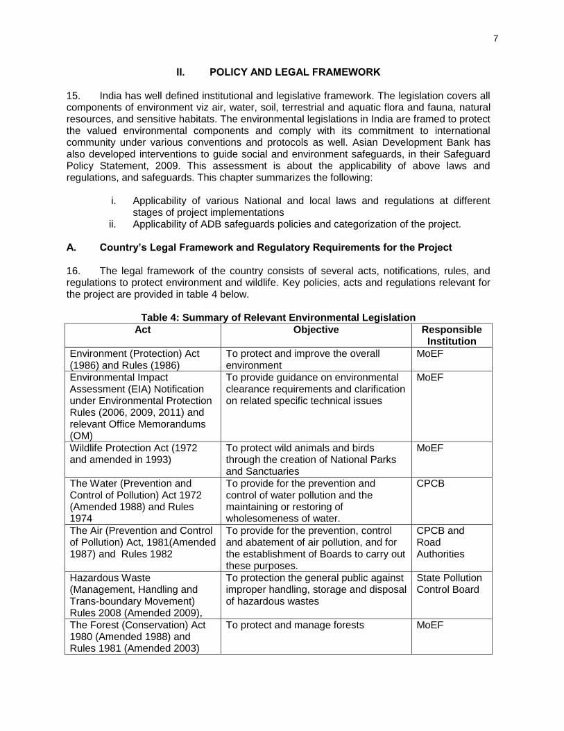
II. POLICY AND LEGAL FRAMEWORK ................................................................................. 7 A. Country’s Legal Framework and Regulatory Requirements for the Project .................... 7 B. International Agreements .............................................................................................10 C. Asian Development Bank Safeguard Policies ..............................................................10 D. Category of the Project as per SPS ..............................................................................10
III. PROJECT DESCRIPTION .................................................................................................12 A. Project Setting..............................................................................................................12 B. Current and Projected Daily Traffic ..............................................................................12 C. Proposed Improvement ................................................................................................13 D. Borrow and Quarry Materials Sourcing ........................................................................18 E. Water for Construction .................................................................................................18 F. Construction Camps.....................................................................................................18 G. Construction Schedule .................................................................................................18
IV. DESCRIPTION OF THE ENVIRONMENT .........................................................................19 A. Introduction ..................................................................................................................19 B. Physical Environment ...................................................................................................19 C. Ecological Resources...................................................................................................27 D. Economic Development and Social and Cultural Resources ........................................31
V. ANTICIPATED ENVIRONMENTAL IMPACTS AND MITIGATION MEASURES ................35 A. Impact on Physical Environment Design Stage ............................................................35 B. Construction Stage ......................................................................................................35 C. Impacts during operation stage ....................................................................................45 D. Climate Change Impacts and Risks .............................................................................47 E. Cumulative and Induced Impacts .................................................................................51
VI. PUBLIC CONSULTATION AND INFORMATION DISCLOSURE .......................................52 A. Objectives of the Public Consultation ...........................................................................52 B. Methodology for Consultations .....................................................................................52 C. Results of Consultation with Local People ....................................................................55 D. Conclusion and Recommendation................................................................................56
VII. ENVIRONMENTAL MANAGEMENT PLAN AND GRIEVANCE REDRESS MECHANISM .58 A. Environmental Management Plan ................................................................................58 B. EMP Implementation Schedule ....................................................................................58 C. Emergency Response Plan ..........................................................................................58 D. Environmental Monitoring Plan (EMoP)........................................................................58 E. Institutional Setting and Proposed Implementation Arrangement .................................60
F. Institutional Capacity Building ......................................................................................64 G. Grievance Redress Mechanism ...................................................................................65 H. Cost for Environmental Management Plan, Training and Environmental Monitoring ....67
VIII. CONCLUSIONS AND RECOMMENDATIONS...................................................................69 A. Environmental Gains Due to Proposed Work Justifying Implementation ......................69 B. Potential Impacts and Mitigation ..................................................................................69 C. Irreplaceable Resources ..............................................................................................70 D. Post IEE Surveillance and Monitoring ..........................................................................70 E. Public Consultations ....................................................................................................70 F. Recommendations .......................................................................................................70
APPENDIX 1: RAPID ENVIRONMENTAL ASSESSMENT CHECKLIST ...................................71 APPENDIX 2: GUIDELINES FOR BORROW AREAS MANAGEMENT.....................................75 APPENDIX 3: ENVIRONMENTAL MANAGEMENT PLAN FOR DABRA – BHITARWAR-HARSI ROAD ...........................................................................................................................78 APPENDIX 4: ENVIRONMENTAL MONITORING PROGRAMME ............................................97 APPENDIX 5: NATIONAL AMBIENT AIR QUALITY STANDARDS ...........................................99 APPENDIX 6: INDIAN STANDARD DRINKING WATER SPECIFICATION-IS 10500:1991 .... 100 APPENDIX 7: AMBIENT AIR QUALITY STANDARDS IN RESPECT OF NOISE ................... 101 APPENDIX 8: DETAILS OF PARTICIPANTS AND PUBLIC CONSULTATION PHOTOGRAPHS ........................................................................................................................................ 102 APPENDIX 9: GRM PROCEDURES IN HINDI........................................................................ 106
i
EXECUTIVE SUMMARY A. Introduction 1. The Madhya Pradesh District Connectivity Sector Project will improve transport connectivity in the state by rehabilitating and upgrading Major District Roads (MDRs). The Project constitutes (i) rehabilitating and upgrading about 1600 km of MDRs (ii) improving road maintenance and asset management and (iii) developing an efficient accident response system. MPRDC specifically targets MDRs to form key linkage between rural, semi urban and urban areas and complete the state roads connectivity. 2. Madhya Pradesh Road Development Corporation Ltd (MPRDC), the Government of Madhya Pradesh, has started the improvements of State highway and Major District Roads network for meeting the supply demand gap of the traffic in near future. As a part of this strategy MPRDC has taken up the upgrading of Dabra-Bhitarwar-Harsi (DBH) Road. 3. The main objectives are to improve the regional as well as inter- and intra-state transport flows to improve access to services and making the State attractive to developers and investors. To fulfil the above objectives and due considerations to environmental feasibility of above road section, this initial environmental examination (IEE) was carried out for this section. 4. Since the project is following the sector loan modality four subprojects were selected as sample roads .The present report pertains to DBH Road sub-project, which is one of the sample roads. This subproject is categorized as Category “B” and hence, an initial environmental examination (IEE) has been undertaken. The IEE is carried out in accordance applicable laws and regulations of the Government of India and the ADB’s Safeguard Policy Statement (SPS), 2009. The report is also consistent with the requirements of the Environment Assessment and Review Framework (EARF) which was prepared for the sector loan. Since the project road will be upgraded within existing available RoW, no Environmental Clearance is required for the proposed road widening project as per EIA Notification 2006. B. Description of the Project 5. The DBH road with a length of 62.4 kms starts at km 00.000 near Dabra and ends at Narwar at km 62.400. It starts from Dabra and passes through Bhitarwar, Harsi & terminates at Narwar. At present the road is in bad condition and needs up-gradation. There is very little congestion along the junctions. Improvement of this road section will connect the interior rural areas and thereby bring people nearer to district headquarters. 6. The project involves widening & strengthening of existing roads within available ROW to in 4-lane carriageway (7.25 m wide either side with 2.50m paved shoulder, 2-lane carriageway (7.0 m wide with 3.5 m width of each lane and 2.5m paved shoulder either side) & Intermediate lane (5.50m wide with 2.25m paved shoulder both side). The total length of the project road is 62.40 km. This road will provide better connectivity to Dabra, Bhitarwar and Harsi. C. Description of Environment 7. The proposed project road between Dabra-Bhitarwar-Harsi Road (SH-6) situated on the central plateau & hill region agro climate zone and forms gird sub-group. The soil type in the area is mainly medium black alluvial. The land use pattern in the project section is agricultural with intermittent semi urban/rural stretches.
ii
8. Study area has a sub-tropical climate with hot summers from late March to early July, the humid monsoon season from late June to early October, and a cool dry winter from early November to late February. The highest recorded temperature was 48 °C and the lowest was −1 °C. 9. Baseline data on ambient air quality was found to meet the national air quality standards for rural and residential area along the project road. Similarly measured noise levels were found to be below the noise limit stipulated for residential and commercial areas. 10. There is no forest land involved in the project road. The project road does not pass through any protected area, such as, wildlife sanctuary, national park or bio-reserve neither it is located within 10 km from the project road. Approximately 60 trees may need to be cut within ROW for up-gradation of the project road. No rare or endangered species found in the area along the project road. 11. There is no mining activity along the project road. Water quality along the project is good and meeting the standards of drinking water quality as per IS 10500. 12. No archaeological and historical monument is located along the project road. However, small religious structures are located within the existing RoW, of which, only few religious structures will be affected during widening of the project road. D. Anticipated Environmental Impacts and Mitigation Measures
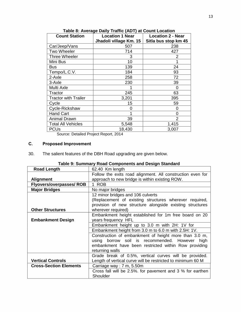
1. Design and Construction Phase
a. Impact on Physiography and Topography 13. Since proposed project is only widening of existing road within available ROW without any land acquisition, impact on the physiography of the area is not significant. The design will consider the improvement of roadside drainage conditions through the improvement of cross-drainage structures. Design of the cross drainage structures will follow IRC Guidelines (IRC, 1995).
b. Potential Environmental Impacts on Soil 14. Loss of Productive Soil. All activities will occur within the available RoW, no adverse environmental impact is anticipated on the productive soil. Lands taken on lease for access road and for construction camp will be restored its original land use. 15. Soil Erosion. Land clearing and grubbing will remove vegetation and soil cover which may cause some soil erosion during monsoon. Excavations in borrow pits may lead to loss of top soil and soil erosion. The risks of stream and river bank erosion near bridges and cross drainage works are significant. To avoid or minimize erosion, land clearing and grubbing will be conducted during dry season, productive top soils from borrow pits will be stored and reused in road embankment slope protection. Erosion control measures like silt screens will be installed along rivers and nallahs. 16. Contamination of Soil. There is the risk of contamination of soil from construction material and oil spills. Contractors are required to ensure proper handling materials and able to
iii
implement spills containment. Oil contaminated waste will be properly collected, stored disposed through 3rd party service providers. All fuel and lubricant storage and handling areas will be located at least 500 meters from the nearest water body and provided with perimeter interceptor drains.
c. Impact on Water Resources and Drainage 17. Deterioration of water quality may occur near the construction camp and active construction camps. This will be minimized by timing land clearing and earthmoving during the dry season; proper handling of materials including oil, and lubricants; prohibiting the disposal of untreated sewage; and proper erosion control near rivers and nallahs.
d. Impact on Ambient Air Quality 18. Significant amount of dust will be generated during project construction. The following mitigation measures will also be undertaken:
i. Asphalt and hot-mix plants will be located at least 1 km away from any inhabited urban and rural stretches along the road with the clearance from MP Pollution Control Board.
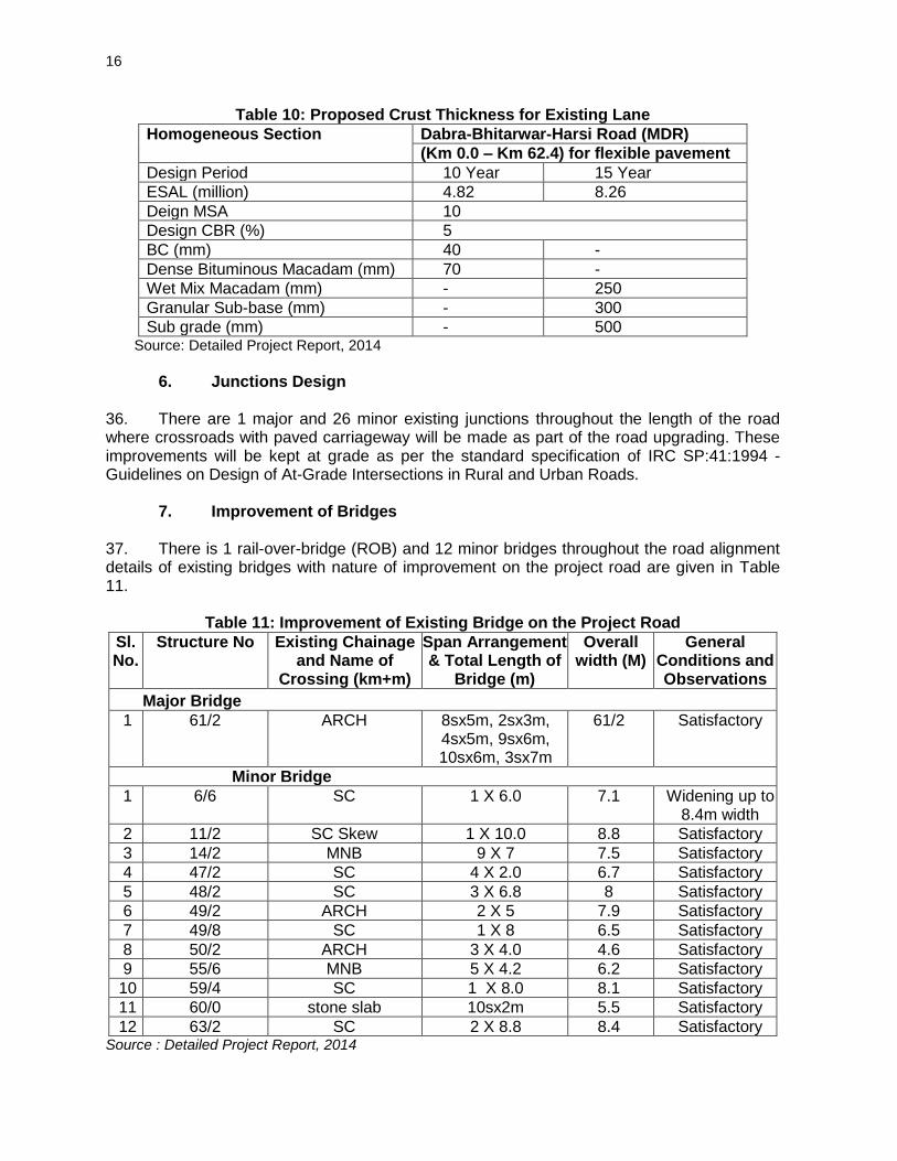
ii. Sprinkling of water on the active construction fronts and construction yard. iii. Regular maintenance of machinery and equipment.
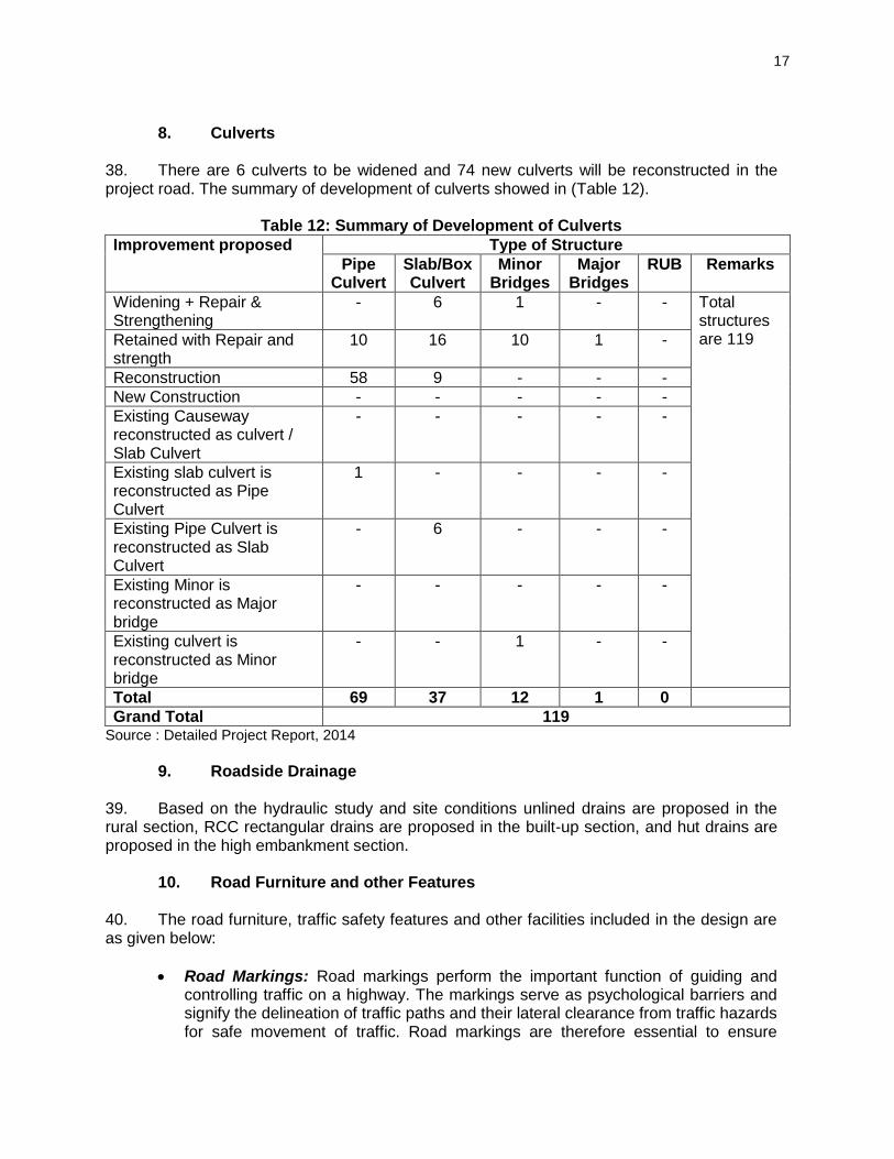
19. Substantial noise will be generated from the use of heavy equipment and processing of rocks and asphalt. Adequate distance separating the rock crusher and hotmix plants will be required and the sourcing of “ready made” gravel and asphalt will be promoted to avoid the establishment of these plants. Along the road particularly near sensitive sites like schools and hospitals, the use of less noisy equipment, scheduling of noisy activities, and provision of noise barriers will be implemented by the contractor to minimize disturbance
e. Flora, Fauna and Ecosystem 20. Clearing and grubbing activities will result to the removal of shrubs, grasses, and 60 trees along the RoW. All cut trees will be compensated at the rate of 1:10 with preference to fast growing local species that are more efficient in absorbing carbon emissions.
f. Construction Workers’ Camp 21. As the Contrator are required to source labor from the local communities along the subproject road, the size of the construction camps will be relatively small. It is the contractual responsibility of the Contractors to maintain a hygienic camp with adequate water and electric supply; toilet facilities located away from the water bodies and wells; proper disposal of domestic refuse; temporary medical facilities; pest control; clean and adequate food; and security.
g. Impacts on Social Environment 22. Construction and operation phases of project road will have some beneficial impact on social environment. Some increase in income of local people is expected as local unskilled, semiskilled and skilled persons may gain direct or indirect employment during construction phase. Since the immigration of work force during construction phase is likely to be very small,
iv
the social impacts on literacy, health care, transport facilities and cultural aspects are expected to be insignificant.
2. Operation Phase
a. Impacts on Soil 23. Increase in vehicular emissions, noise level, road crashes due to higher speed vehicular speed, and oil contaminated road surface runoff will occur during project operation phase. The impact on air quality is not expected to be significant given the low projected traffic. Community safety is enhanced through the crash barriers, speed brakes, traffic signs, and pavement markers. Oil contamination will occur but expected to be in trace amounts based on the low level vehicular traffic. To control the anticipated increase in noise level the following measures will be implemented; good road surface will reduce the road-tire noise, prohibition of horns along sensitive areas, road widening will increase capacity and decrease congestion of vehicles, and compensatory tree plantation will be located near sensitive areas E. Public Consultation and Information Disclosures 24. Public consultations have been carried out in the project area during the feasibility as well as detailed design stage. Key issues raised during the consultations were on:
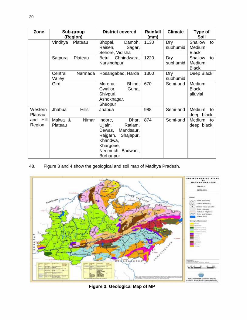
• Provision of suitable drainage in the settlements areas • Provisions of safety measures in school and settlement areas • Suitable mitigation measures to address air and noise pollution • Provision of safety signage near school. • Avoid sourcing water for construction from public water sources. • Minimize the cutting of trees. • Construction labour camps should not be located near settlements area. • Avoid borrow of earth near settlement and schools. • Start tree plantation during construction phase.
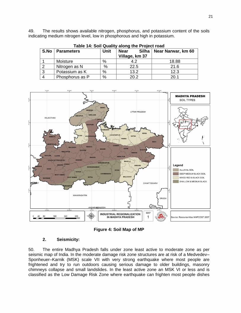
F. Environmental Management Plan and Grievance Redress Mechanism
1. Environmental Management Plan 25. The DBH Road specific Environment Management Plan has been formulated which consists mitigation and monitoring measures, and clear definition of roles and responsibilities. 26. The project will have one grievance redress mechanism for social and environment issues comprising a village level and district level committee. The nodal officer under the PIU will be the key person to coordinate the receiving of complaints and addressing them.
2. Environmental Monitoring Program (EMoP) 27. A comprehensive monitoring plan has been prepared for all stages of the project. This includes parameters to be measured, methods to be used, sampling locations, frequency of measurements, detection limits, cost and responsibility for implementation and supervision. Construction Stage Monitoring to be carried out by contractor under supervision of construction supervision consultant (CSC).
v
28. Monitoring will focus on air, water, noise, soil erosion, drainage congestion and compensatory tree plantation. For tree plantation, the 75% survival rate of re-plantation shall be monitored for three years of the operation phase.
3. Institutional Arrangement and Capacity Building 29. The implementation arrangements basically follow the ongoing MPSRSP-II with the following improvements: i) expansion of the Environmental and Social cell (ESC) staff from 1 to 4 with the recruitment of two social safeguard and one environmental safeguard officers; ii) MPRDC ten division offices acting as Project Implementation Units (PIUs) will appoint a social and environment safeguards focal person; and iii) Construction Supervision Consultant’s environmental specialist from the CSC will provide technical support to MPRDC and the PIU for implementation of environment safeguards. 30. To enable MPRDC officials to implement for environmental safeguard requirements effectively, a training programme will be conducted for the EA and IA of the sector loan to improve environmental awareness, construction practices, legislative compliance requirements, EMP and EMoP implementation requirements, and roles and responsibilities. G. Conclusion and Recommendations 31. The findings of the IEE show that overall the project has limited and short term environmental impacts. Effective EMP implementation will ensure elimination and minimisation of identified adverse impacts. MPRDC shall ensure that EMP and EMoP is included in Bill of Quantity (BOQ) and forms part of bid document and civil works contract. If there is any change in the project design the EMP and EMOP will accordingly .MPRDC needs capacity building and practical exposure. Adequate training shall be imparted as proposed under environmental management plan to enhance the capability of concerned EA and IA officials.

1
I. INTRODUCTION A. Project Background 1. The Madhya Pradesh District Connectivity Sector Project (MPDCSP) will improve transport connectivity in the state by rehabilitating and upgrading Major District Roads (MDRs). The Project constitutes (i) rehabilitating and upgrading about 1600 km of MDRs (ii) improving road maintenance and asset management and (iii) developing an efficient accident response system. MPRDC specifically targets MDRs to form key linkage between rural, semi urban and urban areas and complete the state roads connectivity. A consulting service will be provided to supervise the implementation of civil works and a piggy-backed technical assistance (TA) will support the development of an accident response system and a computerized road asset management system (RAMS). A sector lending modality is preferred considering the large number of distributed MDRs and MPRDC has the requisite institutional capacity to prepare and implement a sector development plan and prepare the individual road packages. 2. Government of Madhya Pradesh (GoMP) has been using a combination of budgetary, PPP, and ADB financing, to improve state highways. Rural roads are specifically addressed through MPRRDA and funds are made available from the Pradhan Mantri Gram Sadak Yojana (PMGSY) which is the national rural roads plan. ADB’s funds are made available to the rural roads in the state through past loans to the central line ministry. However, the intermediate tier – the major district roads or MDRs – have not been specifically targeted for improvement. MDRs form the key linkage between rural, semi urban and urban areas and needs to be developed to complete state road connectivity. The GoMP is now proposing to improve the MDRs through the plan indicated in Table 1.
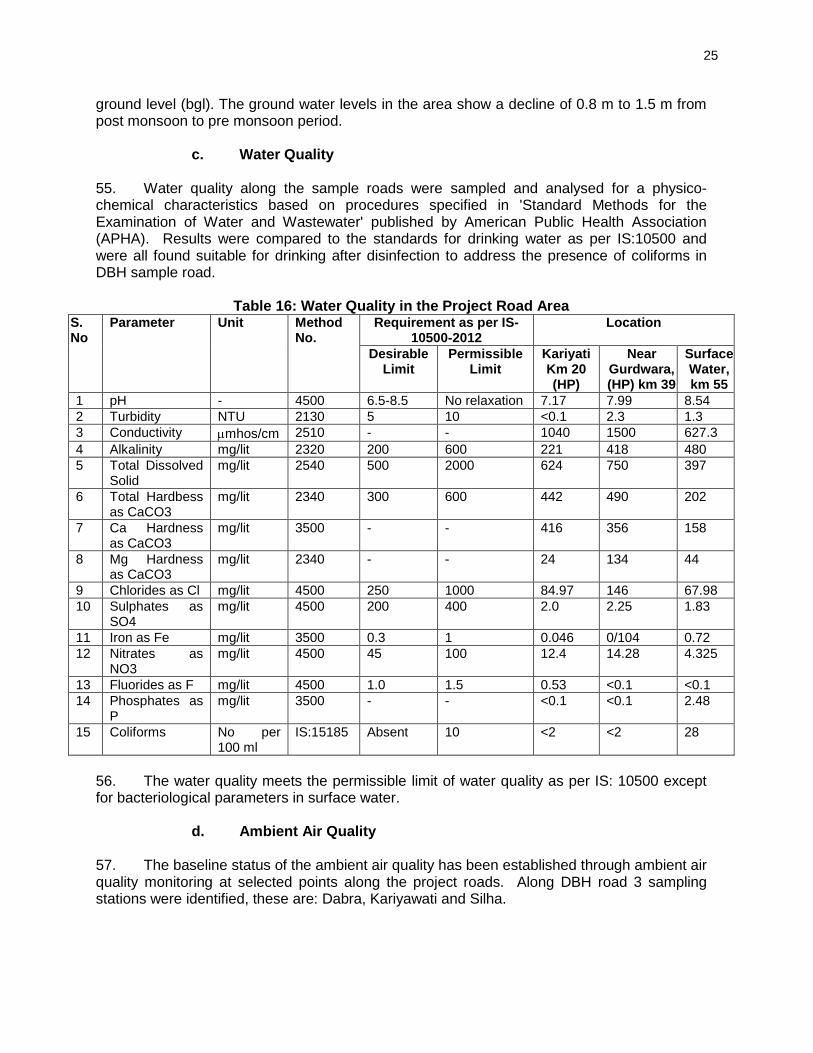
Table 1: Proposed Improvement Plan for MDRs
Total MDRs in Madhya Pradesh (Km) 19,574
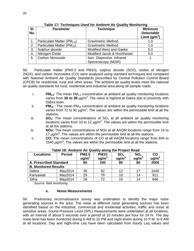
Under construction by MPPWD (Under Central Road Fund Scheme)
5,398
(Under Major District Roads Scheme) 1,134
Under Construction by MPRDC (Under build operate transfer (BOT) Toll + Annuity & Annuity Scheme)
1,992
Total Under Construction 8,524
Balance to be constructed 11,050
Proposed under the Project a 1600 a The actual estimates will depend on the assessment from the DPRs.
Source: MPRDC
3. Since the project will follow a sector loan modality, the following four sample MDRs were selected to screen significance of potential impacts and determine the environmental assessment required to address the safeguard issues, and needed disclosure and consultation requirements. These sample roads were selected to reflect the widest geographical dispersion of roads across the state to capture the range of environmental settings and anticipate the environmental impacts of the succeeding subprojects under the sector loan.
Table 2: Selected Sample Road Projects Under the MPDCSP
Roads District Surrounding Environment Length(Km)
Chitrangi- Kasar Singrauli The entire length of the project road 39.9
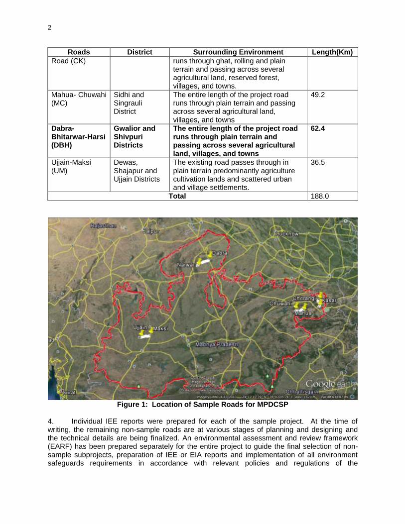
2
Roads District Surrounding Environment Length(Km)
Road (CK) runs through ghat, rolling and plain terrain and passing across several agricultural land, reserved forest, villages, and towns.
Mahua- Chuwahi (MC)
Sidhi and Singrauli District
The entire length of the project road runs through plain terrain and passing across several agricultural land, villages, and towns
49.2
Dabra- Bhitarwar-Harsi (DBH)
Gwalior and Shivpuri Districts
The entire length of the project road runs through plain terrain and passing across several agricultural land, villages, and towns
62.4
Ujjain-Maksi (UM)
Dewas, Shajapur and Ujjain Districts
The existing road passes through in plain terrain predominantly agriculture cultivation lands and scattered urban and village settlements.
36.5
Total 188.0
Figure 1: Location of Sample Roads for MPDCSP
4. Individual IEE reports were prepared for each of the sample project. At the time of writing, the remaining non-sample roads are at various stages of planning and designing and the technical details are being finalized. An environmental assessment and review framework (EARF) has been prepared separately for the entire project to guide the final selection of non-sample subprojects, preparation of IEE or EIA reports and implementation of all environment safeguards requirements in accordance with relevant policies and regulations of the

3
Government of India, SGoMP, and the ADB Safeguard Policy Statement 2009 (SPS). These IEE reports and the EARF are disclosed in the MPRDC and ADB websites. 5. This report focuses on the Dabra-Bhitarwar-Harsi (DBH) road. B. Nature, Size and Location of the Project 6. The project activities involve widening of existing road within available ROW. The length of DBH Road is 62.40 km long for which widening and up-gradation have been proposed. The road widening activities primarily will comprise of raising the embankment at certain locations and its stabilization including construction of retaining wall if required especially near water bodies overlay on the existing carriageway, junction improvement, and construction of minor bridges, culvert and RCC drain in built-up section. The location of state road networks, sector roads and DBH road is shown in Figure 1. 7. All MDRs to be upgraded under the MPDCSP will follow the existing road alignment1 and limited to the designed right-of-way (RoW) of 25m and 15m for open and built-up areas, respectively. The proposed sample roads will have standard carriageway width of 7.0 m with each lane of 3.5 m and earthen shoulder of 2.5m width either side. In built-up stretches where considerable commercial activity is noticed, 1.0 m wide footpath is proposed on both sides. The side drain in such stretches will be accommodated under the footpath. Minimum width of utility corridor will be 2.0 m. The provision of retaining wall is made where water pond is located next to road to minimize the requirement of ROW as well impact on water pond. All road embankments will have at least 1m freeboard designed from a 20-year high flood level (HFL). All bridges having less than 30m length will have at least 0.60m freeboard at 50-year HFL and those with more than 30m length will have at least 0.9m at 100-year HFL. C. Purpose and Scope of the Study 8. This IEE report documents the environmental assessment of the DBH Road subproject and identifies the environmental issues to be considered in the project planning and design stages. In this report, the different activities that are likely to take place to achieve the project objectives have been analyzed and the potential impacts that may accompany them have been identified, assessed for significance, and concomitant avoidance, mitigation, and compensation measures were prepared in consultation with stakeholders to be incorporated on the engineering design and project implementation. The IEE addresses the environmental management requirements of the Government of India (GOI) and Asian Development Bank (ADB). Specifically, this report:
provides information about the baseline environmental setting of the subproject;
provides information on potential environmental impacts of the proposed subproject activities with its magnitude, distribution and duration.
provides information on required mitigation measures with cost to minimize the impacts.
analyses the alternatives options considering alternative locations, designs, management approaches for selection of most feasible and environmental acceptable options.
provides details of stakeholder’s consultations.
1 Minor geometric realignments will occur to comply with horizontal design requirements and minimize or
avoid shifting of utilities, community properties and tree cutting
4
designs an environmental management and monitoring plan with institutional measures for effective implementation of mitigates measures proposed and addressing grievances.
9. The IEE was based on proposed road alignment and key construction activities such as site clearing, removal of trees, excavation, filling, grading and embankment formation, excavation for utility trenches, subgrade preparation, base course and asphalt overlay, shoulder, and construction of permanent structures like retaining walls, culverts and drains. The IEE also covered ancillary activities like camp site establishment and maintenance, sourcing of materials, and operation of equipment like rock crusher and hot mix plant. The corridor of impact is taken as 10 meters either side of the alignment. However, the study area impact zone is considered up to 5 km on both sides of road alignment to allow for coverage of indirect and induced impacts and a larger analysis of land use and other environmental features. Assessment is carried out on the following environment components: terrestrial and aquatic ecology, soil, water, air, noise, and socio economic aspects. 10. This IEE report is presented in eight chapters as follow:
Chapter 1 - Introduction Chapter 2 - Policy, Legal and Administrative Framework Chapter 3 - Description of Project Chapter 4 - Description of Environment Chapter 5 - Anticipated Impacts and Mitigation Measures Chapter 6 - Information Disclosure, Consultation, and Participation Chapter 7 - Environment Management Plan and Grievance Redress Mechanism Chapter 8 - Conclusion and Recommendation
D. Methodology 11. The methodology for IEE adopted complies with the ADB Safeguard Policy Statement (SPS) 2009 and environmental guidelines. The study was carried out using reconnaissance survey, field visits, consultation with stakeholders, review of existing data, identification of adverse impacts and preparation of environmental management and monitoring plans. The stepwise activities carried out include:
Review of legal requirements Review of feasibility study Reconnaissance survey for identification of key issues data requirement and
preliminary consultation Primary and secondary data collection Consultation with stakeholders Identification of impacts and mitigation measures
1. Data Collection
12. Primary and secondary data on the physical, ecological, and socio-economic resources were collected to provide baseline conditions to be used in impact assessment and monitoring plan design. The type and source of information compiled in this IEE are below:
5
Table 3: Primary and Secondary Information Sources
Information Sources
Technical information on existing road features and proposed Rehabilitation work. Inventorisation of road features; viz. water bodies community structures, environmental sensitive location areas, congested locations, etc.
MPRDC Design Consultant Ground physical surveys and graphics consultants
Climatic Condition Indian Meteorological Department, ENVIS Website, NIC, primary data collection
Geology, Seismicity, Soil and Topography Geological survey of India, SOI Toposheets, Primary data collection
Land Use/ Land Cover Survey of India (SoI) Topo-sheet, Observation during survey.
Drainage Pattern Survey of India Toposheet and field observation
Status of forest areas, Compensatory afforestation norms etc.
Divisional Forest Office, Gwalior District.
Status of Fishing Activity District Fisheries Offices at Gwalior District
Air quality Noise, Soil and Water Onsite monitoring and Analysis of Field samples during field visit
Borrow Areas, Quarries and other construction material source
River geo-morphology, hydrology, drainage, flood patterns
Feasibility report, field observations
Socioeconomic Environment Primary Census Abstract of Gwalior District 2001. Official websites maintained by state Govt., and Public Consultation during the Field survey
2. Public Consultation 13. Extensive consultations were held during different stages (reconnaissance, detailed design and design review) with key stakeholders that includes local and beneficiary population, government departments/agencies, road users, and project-affected persons. These consultations allowed the interaction between the stakeholders and road designers to identify road features and construction methods that will enhance road upgrading and minimize potential impacts. Information gathered were integrated in the project design and formulating mitigation measures and environmental management plan. Detailed description of public consultation is presented in Chapter VI. E. Organizational Setting of Implementing Agency 14. The Madhya Pradesh Road Development Corporation (MPRDC) is mandated for construction and maintenance of roads in behalf of the Government of Madhya Pradesh. MPRDC is the executing agency (EA) for this project and a PIU is created within MPRDC at headquarter which is responsible for the proper implementation of all ADB funded road projects. The EA capability for effective implementation of Environmental Management Plan (EMP) has been assessed and presented in Chapter VII.
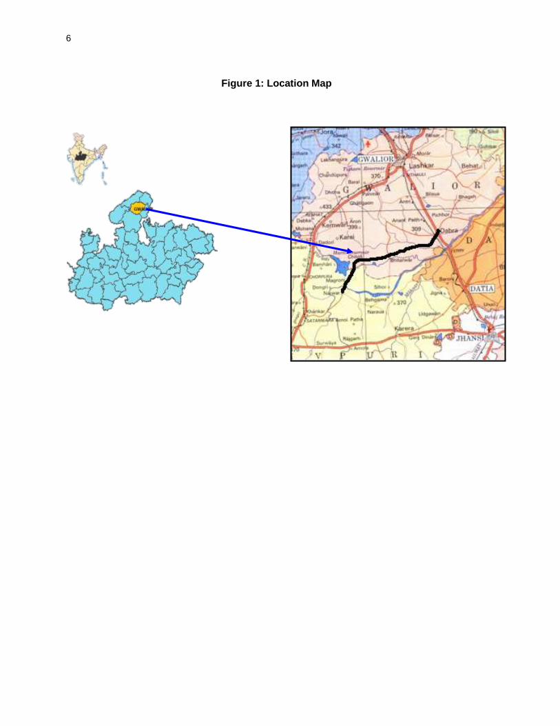
6
Figure 1: Location Map
7
II. POLICY AND LEGAL FRAMEWORK 15. India has well defined institutional and legislative framework. The legislation covers all components of environment viz air, water, soil, terrestrial and aquatic flora and fauna, natural resources, and sensitive habitats. The environmental legislations in India are framed to protect the valued environmental components and comply with its commitment to international community under various conventions and protocols as well. Asian Development Bank has also developed interventions to guide social and environment safeguards, in their Safeguard Policy Statement, 2009. This assessment is about the applicability of above laws and regulations, and safeguards. This chapter summarizes the following:
i. Applicability of various National and local laws and regulations at different stages of project implementations
ii. Applicability of ADB safeguards policies and categorization of the project. A. Country’s Legal Framework and Regulatory Requirements for the Project 16. The legal framework of the country consists of several acts, notifications, rules, and regulations to protect environment and wildlife. Key policies, acts and regulations relevant for the project are provided in table 4 below.
Table 4: Summary of Relevant Environmental Legislation
Act Objective Responsible Institution
Environment (Protection) Act (1986) and Rules (1986)
To protect and improve the overall environment
MoEF
Environmental Impact Assessment (EIA) Notification under Environmental Protection Rules (2006, 2009, 2011) and relevant Office Memorandums (OM)
To provide guidance on environmental clearance requirements and clarification on related specific technical issues
MoEF
Wildlife Protection Act (1972 and amended in 1993)
To protect wild animals and birds through the creation of National Parks and Sanctuaries
MoEF
The Water (Prevention and Control of Pollution) Act 1972 (Amended 1988) and Rules 1974
To provide for the prevention and control of water pollution and the maintaining or restoring of wholesomeness of water.
CPCB
The Air (Prevention and Control of Pollution) Act, 1981(Amended 1987) and Rules 1982
To provide for the prevention, control and abatement of air pollution, and for the establishment of Boards to carry out these purposes.
CPCB and Road Authorities
Hazardous Waste (Management, Handling and Trans-boundary Movement) Rules 2008 (Amended 2009),
To protection the general public against improper handling, storage and disposal of hazardous wastes
State Pollution Control Board
The Forest (Conservation) Act 1980 (Amended 1988) and Rules 1981 (Amended 2003)
To protect and manage forests MoEF
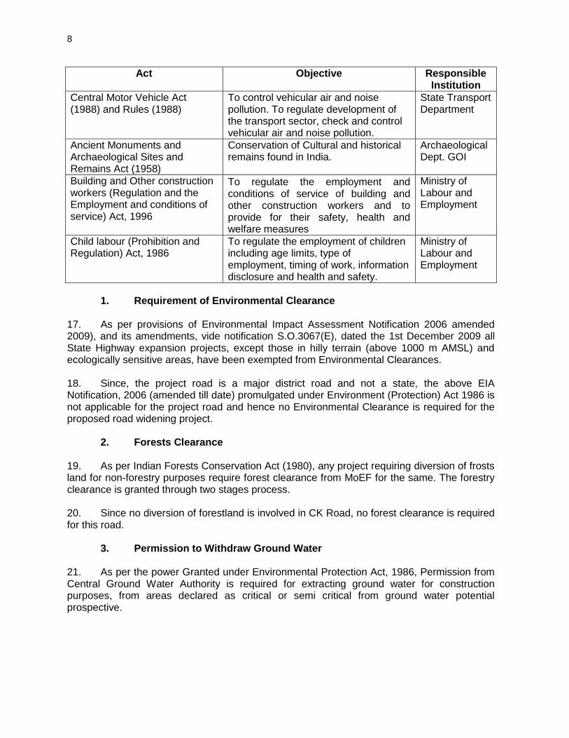
8
Act Objective Responsible Institution
Central Motor Vehicle Act (1988) and Rules (1988)
To control vehicular air and noise pollution. To regulate development of the transport sector, check and control vehicular air and noise pollution.
State Transport Department
Ancient Monuments and Archaeological Sites and Remains Act (1958)
Conservation of Cultural and historical remains found in India.
Archaeological Dept. GOI
Building and Other construction workers (Regulation and the Employment and conditions of service) Act, 1996
To regulate the employment and conditions of service of building and other construction workers and to provide for their safety, health and welfare measures
Ministry of Labour and Employment
Child labour (Prohibition and Regulation) Act, 1986
To regulate the employment of children including age limits, type of employment, timing of work, information disclosure and health and safety.
Ministry of Labour and Employment
1. Requirement of Environmental Clearance
17. As per provisions of Environmental Impact Assessment Notification 2006 amended 2009), and its amendments, vide notification S.O.3067(E), dated the 1st December 2009 all State Highway expansion projects, except those in hilly terrain (above 1000 m AMSL) and ecologically sensitive areas, have been exempted from Environmental Clearances. 18. Since, the project road is a major district road and not a state, the above EIA Notification, 2006 (amended till date) promulgated under Environment (Protection) Act 1986 is not applicable for the project road and hence no Environmental Clearance is required for the proposed road widening project.
2. Forests Clearance 19. As per Indian Forests Conservation Act (1980), any project requiring diversion of frosts land for non-forestry purposes require forest clearance from MoEF for the same. The forestry clearance is granted through two stages process. 20. Since no diversion of forestland is involved in CK Road, no forest clearance is required for this road.
3. Permission to Withdraw Ground Water 21. As per the power Granted under Environmental Protection Act, 1986, Permission from Central Ground Water Authority is required for extracting ground water for construction purposes, from areas declared as critical or semi critical from ground water potential prospective.

9
4. Required Clearances/Permissions 22. For up-gradation of the project road, required clearances/ permissions related to environment has been summarized in Table 5.
Table 5: Permissions/Clearances Required for the Subproject Sl.No. Permissions/
Clearances Acts/ Rules/
Notifications/Guidelines Concerned
Agency Responsibility
A. Pre-construction Stage 1 Permission for cutting of
trees Forest Conservation Act (1980) Procedural Guidelines developed by the Department of Environment, Government of M. P. under the orders of the Honorable High Court Tree removal will be guided as per state government rules.
District Forest Office/State Forest Department for trees felling in forest areas and District Authorities in non-forests Areas (Compensatory tree plantation to be made 1:10 as per the permission granted)
MPRDC
B. Implementation Stage
2 Consent to operate hot mix plant, Crushers, Batching plant
Air (Prevention and Control Pollution) Act of 1981
M.P. State Pollution Control Board (To be obtained before installation)
Contractor
3 Authorization for Disposal of hazardous waste
Hazardous Waste (Management and Handling) Rules 1989
M.P. State Pollution Control Board (To be obtained before generation)
Contractor
4 Consent for Disposal of sewage from labor camps
Water (Prevention and Control of Pollution) Act 1974
M.P. State Pollution Control Board (Before setting up the camp)
Contractor
5 Pollution Under Control Certificate
Central Motor and Vehicle Act 1988
Department of Transport, Government of M. P. authorized testing centers
Contractor
6 Employing Labour/Workers
The Building and Other Construction Workers (Regulation and Employment Conditions of Service) Act, 1996
District Labour Commissioner
Contractor
10
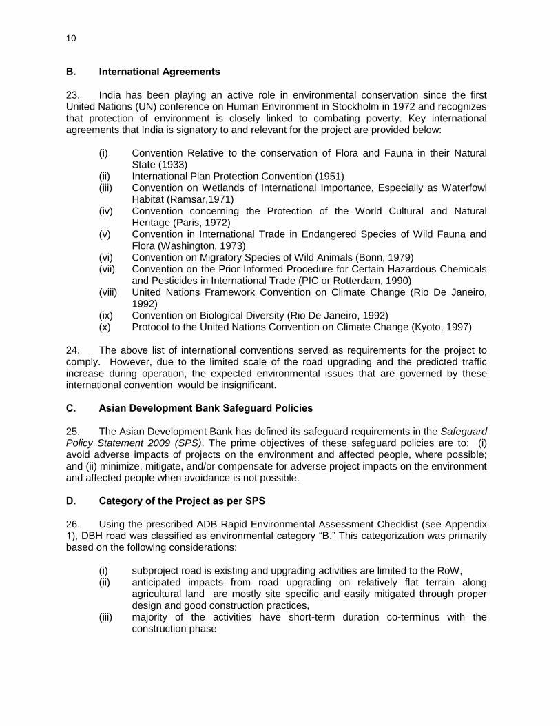
B. International Agreements 23. India has been playing an active role in environmental conservation since the first United Nations (UN) conference on Human Environment in Stockholm in 1972 and recognizes that protection of environment is closely linked to combating poverty. Key international agreements that India is signatory to and relevant for the project are provided below:
(i) Convention Relative to the conservation of Flora and Fauna in their Natural State (1933)
(ii) International Plan Protection Convention (1951) (iii) Convention on Wetlands of International Importance, Especially as Waterfowl
Habitat (Ramsar,1971) (iv) Convention concerning the Protection of the World Cultural and Natural
Heritage (Paris, 1972) (v) Convention in International Trade in Endangered Species of Wild Fauna and
Flora (Washington, 1973) (vi) Convention on Migratory Species of Wild Animals (Bonn, 1979) (vii) Convention on the Prior Informed Procedure for Certain Hazardous Chemicals
and Pesticides in International Trade (PIC or Rotterdam, 1990) (viii) United Nations Framework Convention on Climate Change (Rio De Janeiro,
1992) (ix) Convention on Biological Diversity (Rio De Janeiro, 1992) (x) Protocol to the United Nations Convention on Climate Change (Kyoto, 1997)
24. The above list of international conventions served as requirements for the project to comply. However, due to the limited scale of the road upgrading and the predicted traffic increase during operation, the expected environmental issues that are governed by these international convention would be insignificant. C. Asian Development Bank Safeguard Policies 25. The Asian Development Bank has defined its safeguard requirements in the Safeguard Policy Statement 2009 (SPS). The prime objectives of these safeguard policies are to: (i) avoid adverse impacts of projects on the environment and affected people, where possible; and (ii) minimize, mitigate, and/or compensate for adverse project impacts on the environment and affected people when avoidance is not possible. D. Category of the Project as per SPS
26. Using the prescribed ADB Rapid Environmental Assessment Checklist (see Appendix 1), DBH road was classified as environmental category “B.” This categorization was primarily based on the following considerations:
(i) subproject road is existing and upgrading activities are limited to the RoW, (ii) anticipated impacts from road upgrading on relatively flat terrain along
agricultural land are mostly site specific and easily mitigated through proper design and good construction practices,
(iii) majority of the activities have short-term duration co-terminus with the construction phase

11
(iv) subproject road does not pass through or located within 10 km from any wildlife sanctuary, national park, or any other environmentally sensitive or protected areas.
12
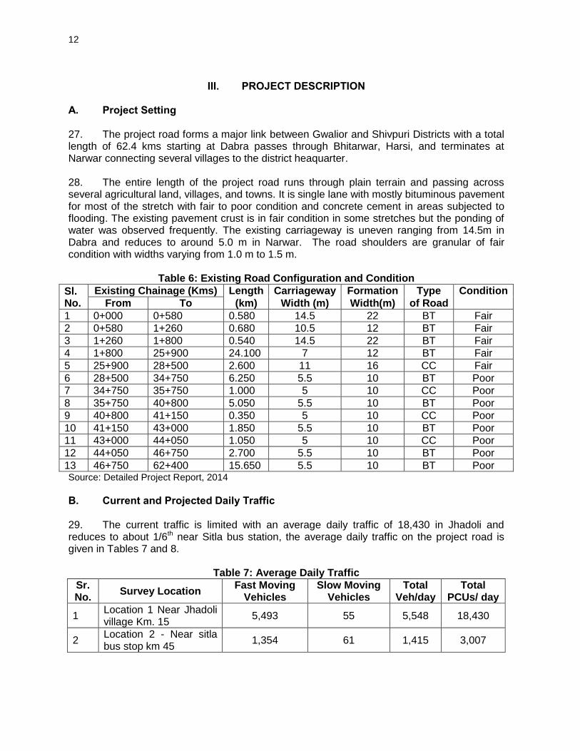
III. PROJECT DESCRIPTION
A. Project Setting 27. The project road forms a major link between Gwalior and Shivpuri Districts with a total length of 62.4 kms starting at Dabra passes through Bhitarwar, Harsi, and terminates at Narwar connecting several villages to the district heaquarter. 28. The entire length of the project road runs through plain terrain and passing across several agricultural land, villages, and towns. It is single lane with mostly bituminous pavement for most of the stretch with fair to poor condition and concrete cement in areas subjected to flooding. The existing pavement crust is in fair condition in some stretches but the ponding of water was observed frequently. The existing carriageway is uneven ranging from 14.5m in Dabra and reduces to around 5.0 m in Narwar. The road shoulders are granular of fair condition with widths varying from 1.0 m to 1.5 m.
Table 6: Existing Road Configuration and Condition
Sl. No.
Existing Chainage (Kms) Length Carriageway Formation Type Condition
From To (km) Width (m) Width(m) of Road 1 0+000 0+580 0.580 14.5 22 BT Fair
2 0+580 1+260 0.680 10.5 12 BT Fair
3 1+260 1+800 0.540 14.5 22 BT Fair
4 1+800 25+900 24.100 7 12 BT Fair
5 25+900 28+500 2.600 11 16 CC Fair
6 28+500 34+750 6.250 5.5 10 BT Poor
7 34+750 35+750 1.000 5 10 CC Poor
8 35+750 40+800 5.050 5.5 10 BT Poor
9 40+800 41+150 0.350 5 10 CC Poor
10 41+150 43+000 1.850 5.5 10 BT Poor
11 43+000 44+050 1.050 5 10 CC Poor
12 44+050 46+750 2.700 5.5 10 BT Poor
13 46+750 62+400 15.650 5.5 10 BT Poor Source: Detailed Project Report, 2014
B. Current and Projected Daily Traffic 29. The current traffic is limited with an average daily traffic of 18,430 in Jhadoli and reduces to about 1/6th near Sitla bus station, the average daily traffic on the project road is given in Tables 7 and 8.
Table 7: Average Daily Traffic
Sr. No.
Survey Location Fast Moving
Vehicles Slow Moving
Vehicles Total
Veh/day Total
PCUs/ day
1 Location 1 Near Jhadoli village Km. 15
5,493 55 5,548 18,430
2 Location 2 - Near sitla bus stop km 45
1,354 61 1,415 3,007
13
Table 8: Average Daily Traffic (ADT) at Count Location
Count Station Location 1 Near Jhadoli village Km. 15
Location 2 - Near Sitla bus stop km 45
Car/Jeep/Vans 507 238
Two Wheeler 714 427
Three Wheeler 3 2
Mini Bus 10 1
Bus 139 24
Tempo/L.C.V. 184 93
2-Axle 258 72
3-Axle 230 39
Multi Axle 1 0
Tractor 245 63
Tractor with Trailer 3,201 395
Cycle 15 59
Cycle-Rickshaw 0 0
Hand Cart 1 0
Animal Drawn 39 2
Total All Vehicles 5,548 1,415
PCUs 18,430 3,007 Source: Detailed Project Report, 2014
C. Proposed Improvement 30. The salient features of the DBH Road upgrading are given below.
Table 9: Summary Road Components and Design Standard
Road Length 62.40 Km length
Alignment Follow the exits road alignment. All construction even for approach to new bridge is within existing ROW.
Flyovers/overpasses/ ROB 1 ROB
Major Bridges No major bridges
Other Structures
12 minor bridges and 106 culverts (Replacement of existing structures wherever required, provision of new structure alongside existing structures wherever required)
Embankment Design Embankment height established for 1m free board on 20 years frequency HFL
Embankment height up to 3.0 m with 2H: 1V for
Embankment height from 3.0 m to 6.0 m with 2.5H: 1V.
Construction of embankment of height more than 3.0 m, using borrow soil is recommended. However high embankment have been restricted within Row providing returning walls
Vertical Controls Grade break of 0.5%, vertical curves will be provided. Length of vertical curve will be restricted to minimum 60 M
Cross-Section Elements Carriage way : 7 m, 5.50m
Cross fall will be 2.5%. for pavement and 3 % for earthen Shoulder
14
Speed 80Km/hr / Permissible 50Km/hr
Horizontal Controls As per IRC: 38 / IRC SP-48
Maximum value of 5% for super elevation and 15% for side friction factor, the minimum radius for horizontal curves 15 m.
Design Speed: 20 km/h
Structural design standards As per IRC Codes and MORSTH Guidelines.
Vertical Clearance
0.60 m above HFL for bridges up to 30 m length
0.90m above HFL for bridges above 30 m length
The discharges for which the bridge has been designed are maximum flood discharge on record for a period of100 years for major bridges and 50 years for minor bridges.
Source: Detailed Project Report, 2014
1. Alignment and Geometry
31. The entire length of the project road runs through plain terrain cutting across several agricultural land, villages and towns and the existing horizontal alignment has number of sub-standard curves. These curves will be improved following standards to the extent possible within the available ROW and maximizing the use of exiting pavement in rural stretches. Vertical alignment has been designed to correct the existing road conditions in compliance to road standards.
2. Proposed ROW 32. The available RoW is largely 24m in rural stretches and about 20-22 m in built-up areas which are more than adequate to accommodate the proposed road upgrading.
3. Cross Sectional Details 33. The proposed road will have sections with a 4-lane divided carriageway with 2-lane standard carriageway width of 7.0 m and each lane having 3.50m and hard shoulder of 2.5m width on either side. Along intermediate sections, a 5.50m carriageway with 2.25m hard shoulder will be provided. Along the 4-lane stretches, a median traffic separator will be provided. In built-up stretches where considerable commercial activity is present, a 1.0 m wide footpath will be constructed on both sides of the road under which side drain will be accommodated. Minimum width of utility corridor will be 2.0 m. The provision of retaining wall is made where water pond is located next to road to minimize the requirement of ROW as well impacts on water pond. The typical cross section (TCS) in built-up area, rural areas, near water pond locations, and high embankment locations are shown in Figure 2.
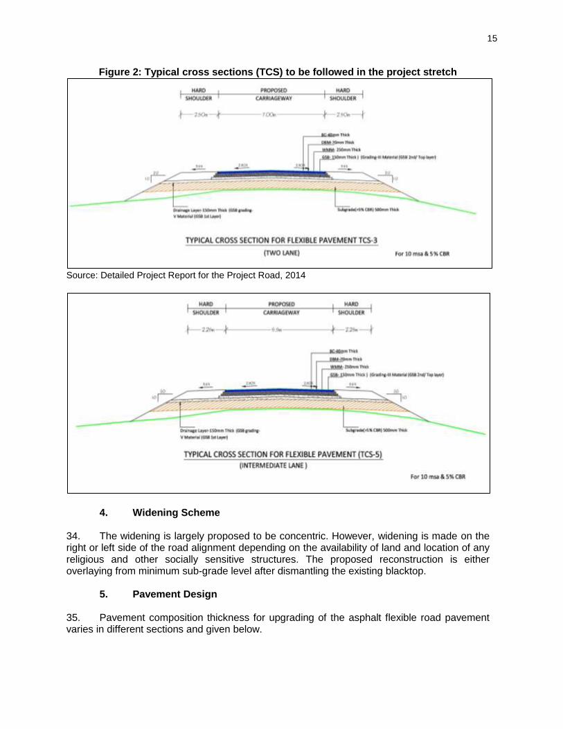
15
Figure 2: Typical cross sections (TCS) to be followed in the project stretch
Source: Detailed Project Report for the Project Road, 2014
4. Widening Scheme 34. The widening is largely proposed to be concentric. However, widening is made on the right or left side of the road alignment depending on the availability of land and location of any religious and other socially sensitive structures. The proposed reconstruction is either overlaying from minimum sub-grade level after dismantling the existing blacktop.
5. Pavement Design 35. Pavement composition thickness for upgrading of the asphalt flexible road pavement varies in different sections and given below.
16
Table 10: Proposed Crust Thickness for Existing Lane
Homogeneous Section Dabra-Bhitarwar-Harsi Road (MDR)
(Km 0.0 – Km 62.4) for flexible pavement
Design Period 10 Year 15 Year
ESAL (million) 4.82 8.26
Deign MSA 10
Design CBR (%) 5
BC (mm) 40 -
Dense Bituminous Macadam (mm) 70 -
Wet Mix Macadam (mm) - 250
Granular Sub-base (mm) - 300
Sub grade (mm) - 500 Source: Detailed Project Report, 2014
6. Junctions Design
36. There are 1 major and 26 minor existing junctions throughout the length of the road where crossroads with paved carriageway will be made as part of the road upgrading. These improvements will be kept at grade as per the standard specification of IRC SP:41:1994 - Guidelines on Design of At-Grade Intersections in Rural and Urban Roads.
7. Improvement of Bridges 37. There is 1 rail-over-bridge (ROB) and 12 minor bridges throughout the road alignment details of existing bridges with nature of improvement on the project road are given in Table 11.
Table 11: Improvement of Existing Bridge on the Project Road
Sl. No.
Structure No Existing Chainage and Name of
Crossing (km+m)
Span Arrangement & Total Length of
Bridge (m)
Overall width (M)
General Conditions and Observations
Major Bridge
1 61/2 ARCH 8sx5m, 2sx3m, 4sx5m, 9sx6m, 10sx6m, 3sx7m
61/2 Satisfactory
Minor Bridge
1 6/6 SC 1 X 6.0 7.1 Widening up to 8.4m width
2 11/2 SC Skew 1 X 10.0 8.8 Satisfactory
3 14/2 MNB 9 X 7 7.5 Satisfactory
4 47/2 SC 4 X 2.0 6.7 Satisfactory
5 48/2 SC 3 X 6.8 8 Satisfactory
6 49/2 ARCH 2 X 5 7.9 Satisfactory
7 49/8 SC 1 X 8 6.5 Satisfactory
8 50/2 ARCH 3 X 4.0 4.6 Satisfactory
9 55/6 MNB 5 X 4.2 6.2 Satisfactory
10 59/4 SC 1 X 8.0 8.1 Satisfactory
11 60/0 stone slab 10sx2m 5.5 Satisfactory
12 63/2 SC 2 X 8.8 8.4 Satisfactory Source : Detailed Project Report, 2014
17
8. Culverts
38. There are 6 culverts to be widened and 74 new culverts will be reconstructed in the project road. The summary of development of culverts showed in (Table 12).
Table 12: Summary of Development of Culverts
Improvement proposed Type of Structure
Pipe Culvert
Slab/Box Culvert
Minor Bridges
Major Bridges
RUB Remarks
Widening + Repair & Strengthening
- 6 1 - - Total structures are 119 Retained with Repair and
strength 10 16 10 1 -
Reconstruction 58 9 - - -
New Construction - - - - -
Existing Causeway reconstructed as culvert / Slab Culvert
- - - - -
Existing slab culvert is reconstructed as Pipe Culvert
1 - - - -
Existing Pipe Culvert is reconstructed as Slab Culvert
- 6 - - -
Existing Minor is reconstructed as Major bridge
- - - - -
Existing culvert is reconstructed as Minor bridge
- - 1 - -
Total 69 37 12 1 0
Grand Total 119 Source : Detailed Project Report, 2014
9. Roadside Drainage
39. Based on the hydraulic study and site conditions unlined drains are proposed in the rural section, RCC rectangular drains are proposed in the built-up section, and hut drains are proposed in the high embankment section.
10. Road Furniture and other Features 40. The road furniture, traffic safety features and other facilities included in the design are as given below:
Road Markings: Road markings perform the important function of guiding and controlling traffic on a highway. The markings serve as psychological barriers and signify the delineation of traffic paths and their lateral clearance from traffic hazards for safe movement of traffic. Road markings are therefore essential to ensure
18
smooth and orderly flow of traffic and to promote road safety. The Code of Practice for Road Markings, IRC: 35-1997 has been used in the study as the design basis. The location and type of marking lines, material and colour is followed using IRC: 35-1997 – “Code of Practice for Road Markings”. The road markings were carefully planned on carriageways, intersections and bridge locations.
Cautionary, Mandatory and Informatory Signs: Cautionary, mandatory and informatory signs have been provided depending on the situation and function they perform in accordance with the IRC: 67-2001 guidelines for Road Signs.
Crash Barrier: Metal Beam Crash Barrier is proposed at locations where the embankment height is more than 3.0m, at horizontal curves of radius less than 161m and also at major bridge approaches.
Road Humps and Rumble Strips: The Road Humps are formed by providing rounded hump of 3.7m width (17m radius) and 0.10m height for the preferred advisory crossing speed of 25 kmph for general traffic as per the IRC: 99–1988 guidelines. The basic material for construction is bituminous concrete formed to required shape. Road humps are located at T-intersections (and cross road intersections) on minor roads or perpendicular arms about 25 m away from the inner edge of the carriageway. Proper signs boards and markings are provided to advise the drivers in advance of the situation. Road humps are extended across carriageway up to the edge of paved shoulder. Rumble Strips are formed by a sequence of transverse strips laid across a carriageway. Maximum permitted height of 15mm, provided no vertical face exceeds 6mm. These rumble device produce audible and vibratory effects to alert drivers to take greater care and do not normally reduce traffic speeds in themselves. Proper signboards and marking are proposed to advise the drivers in advance of the situation.
D. Borrow and Quarry Materials Sourcing 41. Potential sources of earth for the construction of embankment and subgrade have been identified immediately along the DBH Road. The borrow earth, sand, and quarry materials will be sourced locally within a distance of about 25-30 Km from the road. (Guidelines for Borrow Area Management are given in Appendix 2) E. Water for Construction 42. Water for construction of the project road will be taken from ground water and surface water sources after obtaining necessary permissions. No public water sources will be used for road construction. F. Construction Camps 43. One construction camp will be set up by the contractor at a suitable location along the project corridor which in consultation with the Project Director and M. P. State Pollution Control Board. G. Construction Schedule 44. The road upgrading is planned to be completed within 24 months from the start of the construction.
19
IV. DESCRIPTION OF THE ENVIRONMENT A. Introduction 45. The collection of baseline information on biophysical, social and economic aspects of the project area is the most important reference for conducting Initial Environmental Examination (IEE) study. The description of environmental settings includes the characteristic of area in which the activity of the project road would occur and cover area affected by all impacts. The existing baseline line conditions has been analysed based on primary data collection with regard to air quality, water quality, noise, soil, biodiversity and socio- economic aspects and secondary data collection from published source and various government agencies.. Efforts have been made to collect the latest information both at regional as well as local level especially along the project roads alignment. The primary survey for water, air, noise and soil was carried out during May 2014. The sampling has been done along the project alignment. The existing baseline data and analysis around DBH Road is presented in the following sections. B. Physical Environment
1. Topography, Geology, and Soil 46. Madhya Pradesh nicknamed the "heart of India" due to its geographical location in India is bordered by Uttar Pradesh to the northeast, Chhattisgarh to the southeast, Maharashtra to the south, Gujarat to the west, and Rajasthan to the northwest. Madhya Pradesh the second largest state of the country has a geographic area of 30.82 million hectare, which constitutes 9.37% of the land area of the country. Geologically the State is divided in two zones; Central Plateau and Hill Region, and the Western Plateau and Hill Region. The Central Plateau and Hill Region is further divided into 7 sub-regions, namely: Bundelkhand, Madhya Pradesh Hills, Keymore Plateau and Satpura Hills, Vindhya Plateau, Satpura Plateau, Central Narmada Valley, and Gird. The Western Plateau and Hill Region has 2 sub-regions: Jhabua Hills, and Malwa and Nimar Plateau. 47. The soils of state are rich and fertile with texture ranging from rich clayey to gravely. The major groups of soils found in the state can be divided in to following four categories i.e. alluvial, medium and deep black; shallow and medium black; and mixed red and black. The DBH road is located in the Gird sub-region and underlain by rich alluvial soils.
Table 13: Geological features of the State
Zone Sub-group (Region)
District covered Rainfall (mm)
Climate Type of Soil
Central Plateau and Hill Region
Bundelkhand Chatterpur, Datia, Tikamgarh
700 Dry sub humid
Mixed red & Black
Madhya Pradesh Hills
Mandla, Dindori 1570 Moist sub humid
Red & Yellow
Keymore Plateau & Satpura Hills
Jabalpur, Panna, Satna, Rewa, Sidhi, Seoni, Katni, Balaghat, Shahdol, Anooppur, Umariya
1100 Dry sub humid
Medium Black
20
Zone Sub-group (Region)
District covered Rainfall (mm)
Climate Type of Soil
Vindhya Plateau Bhopal, Damoh, Raisen, Sagar, Sehore, Vidisha
1130 Dry subhumid
Shallow to Medium Black
Satpura Plateau Betul, Chhindwara, Narsinghpur
1220 Dry subhumid
Shallow to Medium Black
Central Narmada Valley
Hosangabad, Harda 1300 Dry subhumid
Deep Black
Gird Morena, Bhind, Gwalior, Guna, Shivpuri, Ashoknagar, Sheopur
670 Semi-arid Medium Black alluvial
Western Plateau and Hill Region
Jhabua Hills Jhabua 988 Semi-arid Medium to deep black
Malwa & Nimar Plateau
Indore, Dhar, Ujjain, Ratlam, Dewas, Mandsaur, Rajgarh, Shajapur, Khandwa, Khargone, Neemuch, Badwani, Burhanpur
874 Semi-arid Medium to deep black
48. Figure 3 and 4 show the geological and soil map of Madhya Pradesh.
Figure 3: Geological Map of MP
21
49. The results shows available nitrogen, phosphorus, and potassium content of the soils indicating medium nitrogen level, low in phosphorous and high in potassium.
Table 14: Soil Quality along the Project road
S.No Parameters Unit Near Silha Village, km 37
Near Narwar, km 60
1 Moisture % 4.2 18.88
2 Nitrogen as N % 22.5 21.6
3 Potassium as K % 13.2 12.3
4 Phosphorus as P % 20.2 20.1
Figure 4: Soil Map of MP
2. Seismicity:
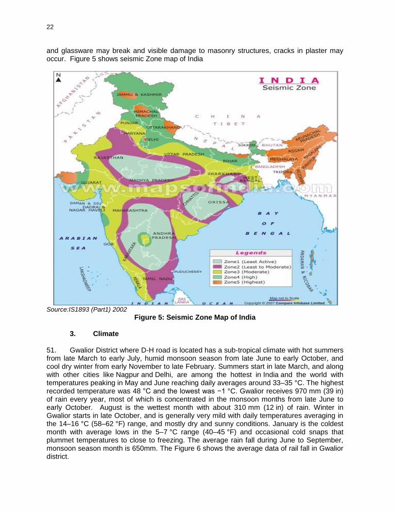
50. The entire Madhya Pradesh falls under zone least active to moderate zone as per seismic map of India. In the moderate damage risk zone structures are at risk of a Medvedev–Sponheuer–Karnik (MSK) scale VII with very strong earthquake where most people are frightened and try to run outdoors causing serious damage to older buildings, masonry chimneys collapse and small landslides. In the least active zone an MSK VI or less and is classified as the Low Damage Risk Zone where earthquake can frighten most people dishes
22
and glassware may break and visible damage to masonry structures, cracks in plaster may occur. Figure 5 shows seismic Zone map of India
Source:IS1893 (Part1) 2002
Figure 5: Seismic Zone Map of India
3. Climate
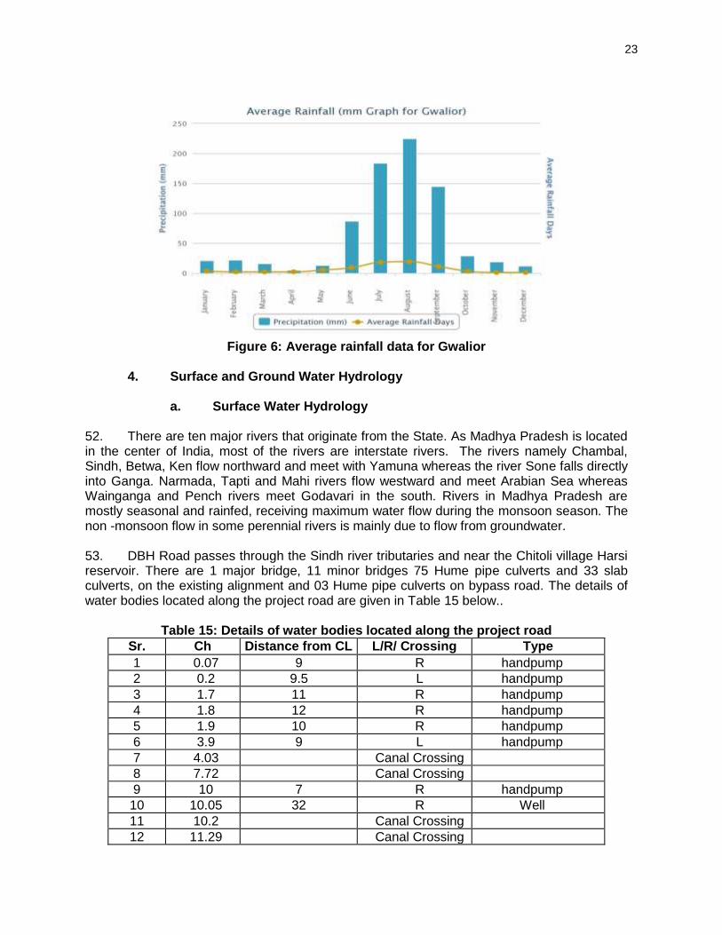
51. Gwalior District where D-H road is located has a sub-tropical climate with hot summers from late March to early July, humid monsoon season from late June to early October, and cool dry winter from early November to late February. Summers start in late March, and along with other cities like Nagpur and Delhi, are among the hottest in India and the world with temperatures peaking in May and June reaching daily averages around 33–35 °C. The highest recorded temperature was 48 °C and the lowest was −1 °C. Gwalior receives 970 mm (39 in) of rain every year, most of which is concentrated in the monsoon months from late June to early October. August is the wettest month with about 310 mm (12 in) of rain. Winter in Gwalior starts in late October, and is generally very mild with daily temperatures averaging in the 14–16 °C (58–62 °F) range, and mostly dry and sunny conditions. January is the coldest month with average lows in the 5–7 °C range (40–45 °F) and occasional cold snaps that plummet temperatures to close to freezing. The average rain fall during June to September, monsoon season month is 650mm. The Figure 6 shows the average data of rail fall in Gwalior district.
23
Figure 6: Average rainfall data for Gwalior
4. Surface and Ground Water Hydrology
a. Surface Water Hydrology
52. There are ten major rivers that originate from the State. As Madhya Pradesh is located in the center of India, most of the rivers are interstate rivers. The rivers namely Chambal, Sindh, Betwa, Ken flow northward and meet with Yamuna whereas the river Sone falls directly into Ganga. Narmada, Tapti and Mahi rivers flow westward and meet Arabian Sea whereas Wainganga and Pench rivers meet Godavari in the south. Rivers in Madhya Pradesh are mostly seasonal and rainfed, receiving maximum water flow during the monsoon season. The non -monsoon flow in some perennial rivers is mainly due to flow from groundwater. 53. DBH Road passes through the Sindh river tributaries and near the Chitoli village Harsi reservoir. There are 1 major bridge, 11 minor bridges 75 Hume pipe culverts and 33 slab culverts, on the existing alignment and 03 Hume pipe culverts on bypass road. The details of water bodies located along the project road are given in Table 15 below..
Table 15: Details of water bodies located along the project road
Sr. Ch Distance from CL L/R/ Crossing Type
1 0.07 9 R handpump
2 0.2 9.5 L handpump
3 1.7 11 R handpump
4 1.8 12 R handpump
5 1.9 10 R handpump
6 3.9 9 L handpump
7 4.03 Canal Crossing
8 7.72 Canal Crossing
9 10 7 R handpump
10 10.05 32 R Well
11 10.2 Canal Crossing
12 11.29 Canal Crossing
24
Sr. Ch Distance from CL L/R/ Crossing Type
13 12.2 12 L Well
14 12.31 Canal Crossing
15 12.64 13 R Well
16 13.03 River Crossing
17 16.4 3.5 L handpump
18 17.24 Canal Crossing
19 19.9 5 L handpump
20 23.4 8.5 R handpump
21 23.9 7 L handpump
22 23.95 Canal Crossing
23 24 8 L handpump
24 25.7 5.5 R handpump
25 26.9 5 L handpump
26 31.3 7 L handpump
27 35.07 Canal Crossing
28 35.5 8 L handpump
29 37.1 8 R handpump
30 40.5 6 R handpump
31 41.1 7.5 L Well
32 41.8 5.5 R handpump
33 41.85 31.5 L Well
34 43.24 Canal Crossing
35 44.65 5 R Well
36 45.18 Canal Crossing
37 47.02 Canal Crossing
38 50.9 19.8 L Well
39 51 9 R handpump
40 52.5 7 R handpump
41 52.6 9 R handpump
42 52.6 16 R Well
43 54.51 River Crossing
44 55.75 12 L Well
45 56.3 26 L Well
46 56.45 12.6 L Well
47 57.6 8.5 L Well
48 58.19 Canal Crossing
49 59.98 River Crossing
50 62.06 Canal Crossing
51 62.3 7 L handpump
b. Ground Water Hydrology 54. Ground water is the major water source in the area for drinking purpose. The source of recharging of ground water is mostly from rainfall and canals. Hand pumps are commonly used to draw the water from ground in the villages. Static water levels vary along the stretch of the sample roads. First or upper ground water aquifer lies in the range of 9 to 18 m below
25
ground level (bgl). The ground water levels in the area show a decline of 0.8 m to 1.5 m from post monsoon to pre monsoon period.
c. Water Quality 55. Water quality along the sample roads were sampled and analysed for a physico-chemical characteristics based on procedures specified in 'Standard Methods for the Examination of Water and Wastewater' published by American Public Health Association (APHA). Results were compared to the standards for drinking water as per IS:10500 and were all found suitable for drinking after disinfection to address the presence of coliforms in DBH sample road.
Table 16: Water Quality in the Project Road Area
S. No
Parameter Unit Method No.
Requirement as per IS-10500-2012
Location
Desirable Limit
Permissible Limit
Kariyati Km 20 (HP)
Near Gurdwara, (HP) km 39
Surface Water, km 55
1 pH - 4500 6.5-8.5 No relaxation 7.17 7.99 8.54
2 Turbidity NTU 2130 5 10 <0.1 2.3 1.3
3 Conductivity mhos/cm 2510 - - 1040 1500 627.3
4 Alkalinity mg/lit 2320 200 600 221 418 480
5 Total Dissolved Solid
mg/lit 2540 500 2000 624 750 397
6 Total Hardbess as CaCO3
mg/lit 2340 300 600 442 490 202
7 Ca Hardness as CaCO3
mg/lit 3500 - - 416 356 158
8 Mg Hardness as CaCO3
mg/lit 2340 - - 24 134 44
9 Chlorides as Cl mg/lit 4500 250 1000 84.97 146 67.98
10 Sulphates as SO4
mg/lit 4500 200 400 2.0 2.25 1.83
11 Iron as Fe mg/lit 3500 0.3 1 0.046 0/104 0.72
12 Nitrates as NO3
mg/lit 4500 45 100 12.4 14.28 4.325
13 Fluorides as F mg/lit 4500 1.0 1.5 0.53 <0.1 <0.1
14 Phosphates as P
mg/lit 3500 - - <0.1 <0.1 2.48
15 Coliforms No per 100 ml
IS:15185 Absent 10 <2 <2 28
56. The water quality meets the permissible limit of water quality as per IS: 10500 except for bacteriological parameters in surface water.
d. Ambient Air Quality 57. The baseline status of the ambient air quality has been established through ambient air quality monitoring at selected points along the project roads. Along DBH road 3 sampling stations were identified, these are: Dabra, Kariyawati and Silha.
26
Table 17: Techniques Used for Ambient Air Quality Monitoring
Sl. No.
Parameter Technique Minimum Detectable Limit (g/m3)
1. Particulate Matter (PM2.5) Gravimetric Method 1.0
2. Particulate Matter (PM10) Gravimetric Method 1.0
3. Sulphur dioxide Modified West and Gaeke 5.0
4. Nitrogen Oxide Modified Jacob & Hochheiser 5.0
5. Carbon Monoxide Non Dispersive Infrared Spectroscopy (NDIR)
1
58. Particulate matter (PM2.5 and PM10), sulphur dioxide (SO2), oxides of nitrogen (NOX), and carbon monoxides (CO) were analyzed using standard techniques and compared with National Ambient Air Quality Standards prescribed by Central Pollution Control Board (CPCB) for residential, rural and other areas. The ambient air quality levels meet the national air quality standards for rural, residential and industrial area along all sample roads.
i. PM2.5: The mean PM2.5 concentration at ambient air quality monitoring locations varies from 26 to 38 µg/m3. The value is highest at Dabra due to proximity with Dabra town.
ii. PM10 : The mean PM10 concentration at ambient air quality monitoring locations varies from 72 to 92 µg/m3. The values are within the permissible limit at all the stations.
iii. SO2: The mean concentrations of SO2 at all ambient air quality monitoring locations varies from 10 to 12 µg/m3. The values are within the permissible limit at all the stations.
iv. NOx: The mean concentrations of NOx at all AAQM locations range from 14 to 17 µg/m3. The values are within the permissible limit at all the stations.
v. CO: The mean concentrations of CO at all AAQM locations range from 846 to 1640 µg/m3. The values are within the permissible limit at all the stations.
Table 18: Ambient Air Quality along the Project Road
Locations Period PM2.5 ug/m3
PM10 ug/m3
SO2 ug/m3
NOx ug/m3
CO ug/m3
A. Prescribed Standard 60 100 80 80 2000
B. Monitored Results
Dabra May2014 38 92 12 17 1640
Kariyawati May2014 29 78 10 14 911
Silha May2014 26 72 10 14 846 Source: field monitoring
e. Noise Measurements
59. Preliminary reconnaissance survey was undertaken to identify the major noise generating sources in the area. The noise at different noise generating sources has been identified based on the industrial, commercial and residential activities, traffic and noise at sensitive areas. Sound Pressure Level (SPL) measurements were undertaken at all locations, with an interval of about 5 seconds over a period of 10 minutes per hour for 24 hr. The day noise level has been monitored during 6 AM to 10 PM and night levels during 10 P.M. to 6 AM at all locations. Day and night-time Leq have been calculated from hourly Leq values and

27
compared with standards and for D-B sample road, measured Leq noise levels are within the limit stipulated for residential area at all the locations except at Dabra which may exceed in day time due to various commercial activities along the project road.
Table 19: Day and Night Time Leq in the Area
Day Time Night Time Prescribed Standards dB(A)
Locations dB(A) dB(A) Day Time Night Time
Dabra 64.2 43.7 55 45
Kariyawati 54.3 42.1 55 45
Silha 52.6 40.7 55 45 Source:Monitoring,May 2014 C. Ecological Resources
1. Forest 60. There is no forest land involved in the project road.
2. Trees Along the Project Road 61. Trees exist within the RoW and some of them are likely to be cleared during road upgrading. Approximately 155 trees are within ROW of project road of which 60 trees will be cleared (Table 20 and 21). Majority of the trees to be cleared belong to these species: Babul (Acacia nilotica), Neem (Azadirachita indica), Palas (Butea monosperma), Shisham (Dalbergia sissoo), Aam (Mangifera indica), Pipal (Ficus religiosa). Babul also known as Black Piquant, Cassie, or Gum Arabica tree; Palas english names are Bastard Teak or Flame of the Forest; Shisham is also known as Indian Rosewood; and Pipal is Wonderboon Fig. Not one of these trees is classified as threatened. However, 3 Albizia lebbeck, a vulnerable species according to IUCN, are identified to be cleared.
Table 20: Details of tree inventory list S. No
Chainage (Km) Distance from BT Edge of
the Road
Local Name
of Tree
Botanical Name of tree
Grith size of tree *1.37m above G.L.)
Condition of tree
(D&G*)
Approx Height of tree
(m)
No. of Trees
From To Left side
Right side
1 0.600 0.800 5.56 Pipal Ficus religiosa G6 G 10 1 -
2 1.400 1.600 5.30 Bargad Ficus benghalensis
G8 G 16 1 -
3 1.600 1.800 6.00 Babul Acacia nilotica G3 D 6 - 1
4 2.800 3.000 5.80 Babul Acacia nilotica G4 G 10 3 -
5 3.000 3.200 5.75 Babul Acacia nilotica G4 G 10 - 1
6 3.600 3.800 6.00 Neem Azadirachata indica
G3 G 8 1 -
- - 5.90 Babul Acacia nilotica G4 G 9 1 -
7 4.200 4.400 5.56 Babul Acacia nilotica G3 G 7 3 -
8 4.400 4.600 4.77 Babul Acacia nilotica G3 G 6 2 -
- - 6.00 Reuja - G4 G 7 1 -
9 5.200 5.400 6.20 Babul Acacia nilotica G3 G 7 1 -
10 5.400 5.600 4.75 Babul Acacia nilotica G4 G 9 1 -
- - 5.90 Babul Acacia nilotica G4 G 9 - 1
11 5.600 5.800 6.00 Reuja - G3 G 6 1 -
12 5.800 6.000 4.80 Babul Acacia nilotica G4 G 10 1 -
- - 5.65 Reuja - G4 G 6 1 -

28
S. No
Chainage (Km) Distance from BT Edge of
the Road
Local Name
of Tree
Botanical Name of tree
Grith size of tree *1.37m above G.L.)
Condition of tree
(D&G*)
Approx Height of tree
(m)
No. of Trees
From To Left side
Right side
13 6.000 6.200 5.90 Reuja - G3 G 5 2 -
- - 5.80 Babul Acacia nilotica G3 G 7 1 -
14 6.200 6.400 6.00 Babul Acacia nilotica G4 G 9 - 1
15 6.400 6.600 4.75 Babul Acacia nilotica G5 D 10 1 -
16 6.600 6.800 6.00 Babul Acacia nilotica G4 G 10 1 -
17 7.000 7.200 6.00 Babul Acacia nilotica G4 G 10 - 1
18 7.200 7.400 5.90 Neem Azadirachata indica
G3 G 8 1 -
- - 5.80 Babul Acacia nilotica G4 G 9 - 1
19 7.400 7.600 6.00 Babul Acacia nilotica G4 G 11 - 2
20 7.600 7.800 5.60 Babul Acacia nilotica G3 G 6 2 -
- - 4.80 Babul Acacia nilotica G3 G 8 2 -
21 7.800 8.000 6.00 Reuja - G5 G 7 2 -
22 8.000 8.200 5.20 Babul Acacia nilotica G4 G 10 1 1
- - 4.90 Neem Azadirachata indica
G5 G 10 - 1
23 8.200 8.400 6.00 Shisam Dalbergil sissoo G4 G 12 1 -
- - 5.65 Babul Acacia nilotica G3 G 8 - 1
24 8.600 8.800 5.75 Neem Azadirachata indica
G4 G 9 1 -
25 9.000 9.200 6.00 Babul Acacia nilotica G4 G 9 3 4
26 9.200 9.400 4.80 Babul Acacia nilotica G3 G 6 4 -
27 9.400 9.600 5.60 Babul Acacia nilotica G3 G 7 2 5
28 9.600 9.800 5.20 Babul Acacia nilotica G3 G 6 - 1
29 10.000 10.200 6.00 Reuja - G4 G 6 2 -
30 10.600 10.800 4.70 Reuja - G3 G 5 - 1
31 11.000 11.200 5.75 Palash Butea monosperma
G5 G 6 1 -
32 11.400 11.600 4.75 Palash Butea monosperma
G5 D 6 2 -
33 12.800 13.000 6.00 Jamun Syzygium cumini
G5 G 12 - 1
34 13.000 13.200 5.80 Babul Acacia nilotica G4 G 9 6 -
35 13.200 13.400 5.90 Babul Acacia nilotica G4 G 11 2 -
36 13.600 13.800 6.00 Babul Acacia nilotica G3 G 6 2 -
37 14.000 14.200 4.75 Neem Azadirachata indica
G5 G 10 1 -
- - 5.60 Reuja - G4 G 7 2 -
38 14.600 14.800 6.00 Babul Acacia nilotica G5 G 12 - 2
39 15.200 15.400 4.80 Babul Acacia nilotica G3 G 8 - 3
40 15.400 15.600 5.60 Babul Acacia nilotica G4 G 9 - 2
- - 5.70 Bargad Ficus benghalensis
G8 G 15 - 1
41 15.600 15.800 5.75 Bargad Ficus benghalensis
G9 D 18 - 1
42 15.800 16.000 6.00 Pipal Ficus religiosa G9 G 15 - 1
- - 5.80 Babul Acacia nilotica G4 G 10 - 2
43 16.200 16.400 6.00 Babul Acacia nilotica G3 G 6 - 3
44 17.000 17.200 5.60 Babul Acacia nilotica G3 G 7 2 -
45 17.200 17.400 6.50 Babul Acacia nilotica G4 G 10 2 -
46 17.800 18.000 6.00 Babul Acacia nilotica G5 D 10 1 -
47 18.000 18.200 6.20 Babul Acacia nilotica G4 G 9 - 2
48 18.800 19.000 5.65 Babul Acacia nilotica G4 G 10 - 1
49 19.000 19.200 6.00 Babul Acacia nilotica G3 G 8 - 1
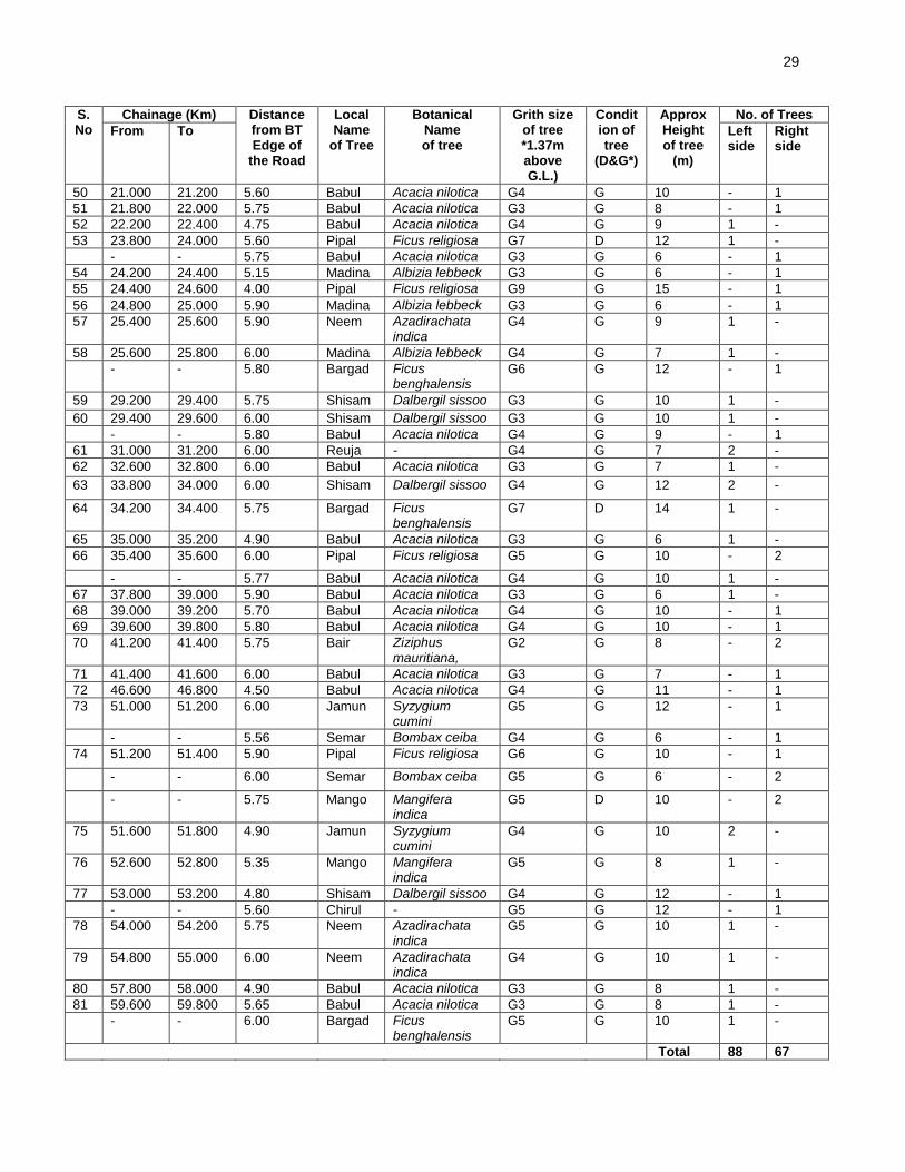
29
S. No
Chainage (Km) Distance from BT Edge of
the Road
Local Name
of Tree
Botanical Name of tree
Grith size of tree *1.37m above G.L.)
Condition of tree
(D&G*)
Approx Height of tree
(m)
No. of Trees
From To Left side
Right side
50 21.000 21.200 5.60 Babul Acacia nilotica G4 G 10 - 1
51 21.800 22.000 5.75 Babul Acacia nilotica G3 G 8 - 1
52 22.200 22.400 4.75 Babul Acacia nilotica G4 G 9 1 -
53 23.800 24.000 5.60 Pipal Ficus religiosa G7 D 12 1 -
- - 5.75 Babul Acacia nilotica G3 G 6 - 1
54 24.200 24.400 5.15 Madina Albizia lebbeck G3 G 6 - 1
55 24.400 24.600 4.00 Pipal Ficus religiosa G9 G 15 - 1
56 24.800 25.000 5.90 Madina Albizia lebbeck G3 G 6 - 1
57 25.400 25.600 5.90 Neem Azadirachata indica
G4 G 9 1 -
58 25.600 25.800 6.00 Madina Albizia lebbeck G4 G 7 1 -
- - 5.80 Bargad Ficus benghalensis
G6 G 12 - 1
59 29.200 29.400 5.75 Shisam Dalbergil sissoo G3 G 10 1 -
60 29.400 29.600 6.00 Shisam Dalbergil sissoo G3 G 10 1 -
- - 5.80 Babul Acacia nilotica G4 G 9 - 1
61 31.000 31.200 6.00 Reuja - G4 G 7 2 -
62 32.600 32.800 6.00 Babul Acacia nilotica G3 G 7 1 -
63 33.800 34.000 6.00 Shisam Dalbergil sissoo G4 G 12 2 -
64 34.200 34.400 5.75 Bargad Ficus benghalensis
G7 D 14 1 -
65 35.000 35.200 4.90 Babul Acacia nilotica G3 G 6 1 -
66 35.400 35.600 6.00 Pipal Ficus religiosa G5 G 10 - 2
- - 5.77 Babul Acacia nilotica G4 G 10 1 -
67 37.800 39.000 5.90 Babul Acacia nilotica G3 G 6 1 -
68 39.000 39.200 5.70 Babul Acacia nilotica G4 G 10 - 1
69 39.600 39.800 5.80 Babul Acacia nilotica G4 G 10 - 1
70 41.200 41.400 5.75 Bair Ziziphus mauritiana,
G2 G 8 - 2
71 41.400 41.600 6.00 Babul Acacia nilotica G3 G 7 - 1
72 46.600 46.800 4.50 Babul Acacia nilotica G4 G 11 - 1
73 51.000 51.200 6.00 Jamun Syzygium cumini
G5 G 12 - 1
- - 5.56 Semar Bombax ceiba G4 G 6 - 1
74 51.200 51.400 5.90 Pipal Ficus religiosa G6 G 10 - 1
- - 6.00 Semar Bombax ceiba G5 G 6 - 2
- - 5.75 Mango Mangifera indica
G5 D 10 - 2
75 51.600 51.800 4.90 Jamun Syzygium cumini
G4 G 10 2 -
76 52.600 52.800 5.35 Mango Mangifera indica
G5 G 8 1 -
77 53.000 53.200 4.80 Shisam Dalbergil sissoo G4 G 12 - 1
- - 5.60 Chirul - G5 G 12 - 1
78 54.000 54.200 5.75 Neem Azadirachata indica
G5 G 10 1 -
79 54.800 55.000 6.00 Neem Azadirachata indica
G4 G 10 1 -
80 57.800 58.000 4.90 Babul Acacia nilotica G3 G 8 1 -
81 59.600 59.800 5.65 Babul Acacia nilotica G3 G 8 1 -
- - 6.00 Bargad Ficus benghalensis
G5 G 10 1 -
Total 88 67
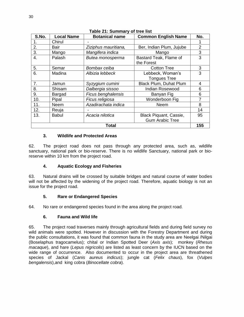
30
Table 21: Summary of tree list
S.No. Local Name Botanical name Common English Name No.
1. Chirul - 1
2. Bair Ziziphus mauritiana, Ber, Indian Plum, Jujube 2
3. Mango Mangifera indica Mango 3
4. Palash Butea monosperma Bastard Teak, Flame of the Forest
3
5. Semar Bombax ceiba Cotton Tree 3
6. Madina Albizia lebbeck Lebbeck, Woman’s Tongues Tree
3
7. Jamun Syzygium cumini Black Plum, Duhat Plum 4
8. Shisam Dalbergia sissoo Indian Rosewood 6
9. Bargad Ficus benghalensis Banyan Fig 6
10. Pipal Ficus religiosa Wonderboon Fig 7
11. Neem Azadirachata indica Neem 8
12. Reuja - 14
13. Babul Acacia nilotica Black Piquant, Cassie, Gum Arabic Tree
95
Total 155
3. Wildlife and Protected Areas
62. The project road does not pass through any protected area, such as, wildlife sanctuary, national park or bio-reserve. There is no wildlife Sanctuary, national park or bio-reserve within 10 km from the project road.
4. Aquatic Ecology and Fisheries 63. Natural drains will be crossed by suitable bridges and natural course of water bodies will not be affected by the widening of the project road. Therefore, aquatic biology is not an issue for the project road.
5. Rare or Endangered Species 64. No rare or endangered species found in the area along the project road.
6. Fauna and Wild life 65. The project road traverses mainly through agricultural fields and during field survey no wild animals were spotted. However in discussion with the Forestry Department and during the public consultations, it was found that common fauna in the study area are Neelgai /Nilgai (Boselaphus tragocamelus); chital or Indian Spotted Deer (Axis axis); monkey (Rhesus macaque), and hare (Lepus nigricolis) are listed as least concern by the IUCN based on the wide range of occurrence. Also documented to occur in the project area are threathened species of Jackal (Canis aureus indicus); jungle cat (Felix chaus), fox (Vulpes bengalensis),and king cobra (Binocellate cobra).
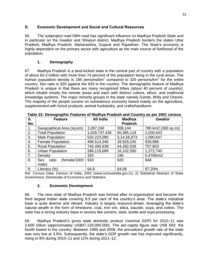
31
D. Economic Development and Social and Cultural Resources 66. The subproject road DBH road has significant influence on Madhya Pradesh State and in particular on the Gwalior and Shivpuri district. Madhya Pradesh borders the states Uttar Pradesh, Madhya Pradesh, Maharashtra, Gujarat and Rajasthan. The State's economy is highly dependent on the primary sector with agriculture as the main source of livelihood of the population. 1. Demography 67. Madhya Pradesh is a land-locked state in the central part of country with a population of about 60.3 million with more than 74 percent of the population living in the rural areas. The human population density is 196 persons/km2 compared to 325 persons/km2 for the entire country. Sex ratio is 920 against the 933 in the country. The demographic feature of Madhya Pradesh is unique in that there are many recognized tribes (about 40 percent of country), which inhabit mostly the remote areas and each with distinct culture, ethos, and traditional knowledge systems. The major minority groups in the state namely Gonds, Bhils and Oraons. The majority of the people survive on subsistence economy based mainly on the agriculture, supplemented with forest products, animal husbandry, and crafts/handloom.
Table 22: Demographic Features of Madhya Pradesh and Country as per 2001 census
S. No.
Feature All India Madhya Pradesh
Gwalior
1. Geographical Area (sq.km) 3,287,240 308,144 780 km2 (300 sq mi)
2. Total Population 1,028,737,436 60,385,118 2,030,543
3. Male Population 532,223,090 3,14,56,873 1,090,647
4. Female Population 496,514,346 28,928,245 939,896
5. Rural Population 742,490,639 44,282,528 757,803
6. Urban Population 286,119,689 16,102,590 1,272,740
7. Density 325 196 5,478/km2
8. Sex ratio (female/1000 male)
933 920 948
9. Literacy (%) 64.8 64.08 87.20% Ref. Census Data, Census of India, 2001 (www.censusindia.gov.in), 2) Statistical Abstract of State Government, Directorate of Economics and Statistics
2. Economic Development 68. The new state of Madhya Pradesh was formed after re-organisation and became the third largest Indian state covering 9.5 per cent of the country’s area. The state’s industrial base is quite diverse and vibrant. Industry is largely resource-driven, leveraging the state’s natural wealth in the form of limestone, coal, iron ore, silica, bauxite, soya, and cotton. The state has a strong industry base in sectors like cement, steel, textile and soya processing. 69. Madhya Pradesh's gross state domestic product (nominal GDP) for 2010–11 was 2,600 billion (approximately US$47,120,000,000). The per-capita figure was US$ 583: the fourth lowest in the country. Between 1999 and 2008, the annualized growth rate of the state was very low at 3.5%. Subsequently, the state's GDP growth rate has improved significantly, rising to 8% during 2010–11 and 12% during 2011–12.
32
70. The state has an agrarian economy. The major crops of Madhya Pradesh are wheat, soybean, gram, sugarcane, rice, maize, cotton, rapeseed, mustard, and arhar. Minor forest produce (MFP), such as tendu leaves used to roll beedi, sal seed, teak seed, and lak also contribute to state's rural economy. 71. Madhya Pradesh has 5 Special Economic Zones (SEZs) comprised of 3 IT/ITeS (Indore, Gwalior), 1 mineral-based (Jabalpur) and 1 agro-based (Jabalpur). In October 2011, approval was given to 14 proposed SEZs, out of which 10 were IT/ITeS-based. Indore is the major commercial center of the state. Because of the state's central location, a number of consumer goods companies have established manufacturing bases in MP. 72. Madhya Pradesh has 6 Ordnance Factories, 4 of which are located at Jabalpur (Vehicle Factory, Grey Iron Foundry, Gun Carriage Factory, Ordnance Factory Khamaria) and one each at Katni and Itarsi. The factories are run by the Ordnance Factories Board, and manufacture a variety of products for the Indian Armed Forces. 73. The state's tourism industry is growing, fuelled by wildlife tourism and a number of places of historical and religious significance. Sanchi and Khajuraho are frequently visited by tourists. Besides the major cities, Bhedaghat, Bhimbetka, Bhojpur, Maheshwar, Mandu, Orchha, Pachmarchi, Kanha, and Ujjain are also popular tourist destinations. 3. Agriculture 74. Agriculture is the mainstay of the State's economy and 74.73% of the people are rural. As much as 49% of the land area is cultivable. The main food crops are jowar (sorghum), wheat, rice and coarse millets such as kondo and kutki. Pulses (beans, lentils and peas) and groundnuts (peanuts). Rice is preferred in the east where water is abundant while wheat is the staple in the drier regions of western Madhya Pradesh which touch the great Thar Desert. Madhya Pradesh is the largest producer of soybean in India. Although overall productivity of agriculture is quite low, oilseeds (linseed and sesame), cotton and sugarcane are also grown here. Madhya Pradesh has plenty of forest reserves, which are logged for teak, sal, bamboo and salai which yields a resin used for incense and medicines. 4. Industry and Minerals 75. Madhya Pradesh has entered the era of high-tech industries such as electronics, telecommunications, automobiles etc. The state is producing optical fibre for telecommunication needs. A large number of automobile industries have been established at Pithampur near Indore. Prominent industries in the public sector in the state are Bharat Heavy Electricals Ltd. At Bhopal, Security Paper Mill at Hoshangabad, Bank Note Press at Dewas, Newsprint Factory at Nepanagar and Alkaloid Factory at Neemuch. Over 81.13 million metre cloth in the handloom sector and 131.59 million meter cloth by power loom was manufactured. The cement production touched 11.24 million metric tonne during the period. An air cargo Complex, Indo-German Tool Room and an Inland Container Depot are being established at Pithampur. The Government of India has proposed setting up of Special Economic Zone at Indore. 76. Aditya Birla group had developed a thermal power plant (Bina Power Supply Company Limited BPSCL), which is taken over by Jaiprakash Associates Limited. This 1000 MW (500 MW each) producing power plant has brought about a revolution in social and economic condition of the area. Along with the power plant Bina refinery is being induced by Bharat
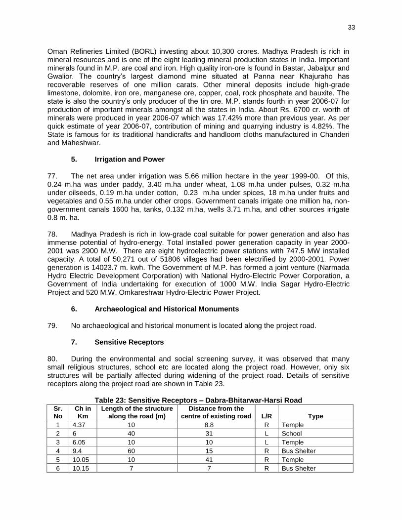
33
Oman Refineries Limited (BORL) investing about 10,300 crores. Madhya Pradesh is rich in mineral resources and is one of the eight leading mineral production states in India. Important minerals found in M.P. are coal and iron. High quality iron-ore is found in Bastar, Jabalpur and Gwalior. The country’s largest diamond mine situated at Panna near Khajuraho has recoverable reserves of one million carats. Other mineral deposits include high-grade limestone, dolomite, iron ore, manganese ore, copper, coal, rock phosphate and bauxite. The state is also the country’s only producer of the tin ore. M.P. stands fourth in year 2006-07 for production of important minerals amongst all the states in India. About Rs. 6700 cr. worth of minerals were produced in year 2006-07 which was 17.42% more than previous year. As per quick estimate of year 2006-07, contribution of mining and quarrying industry is 4.82%. The State is famous for its traditional handicrafts and handloom cloths manufactured in Chanderi and Maheshwar. 5. Irrigation and Power 77. The net area under irrigation was 5.66 million hectare in the year 1999-00. Of this, 0.24 m.ha was under paddy, 3.40 m.ha under wheat, 1.08 m.ha under pulses, 0.32 m.ha under oilseeds, 0.19 m.ha under cotton, 0.23 m.ha under spices, 18 m.ha under fruits and vegetables and 0.55 m.ha under other crops. Government canals irrigate one million ha, non-government canals 1600 ha, tanks, 0.132 m.ha, wells 3.71 m.ha, and other sources irrigate 0.8 m. ha. 78. Madhya Pradesh is rich in low-grade coal suitable for power generation and also has immense potential of hydro-energy. Total installed power generation capacity in year 2000-2001 was 2900 M.W. There are eight hydroelectric power stations with 747.5 MW installed capacity. A total of 50,271 out of 51806 villages had been electrified by 2000-2001. Power generation is 14023.7 m. kwh. The Government of M.P. has formed a joint venture (Narmada Hydro Electric Development Corporation) with National Hydro-Electric Power Corporation, a Government of India undertaking for execution of 1000 M.W. India Sagar Hydro-Electric Project and 520 M.W. Omkareshwar Hydro-Electric Power Project. 6. Archaeological and Historical Monuments 79. No archaeological and historical monument is located along the project road. 7. Sensitive Receptors 80. During the environmental and social screening survey, it was observed that many small religious structures, school etc are located along the project road. However, only six structures will be partially affected during widening of the project road. Details of sensitive receptors along the project road are shown in Table 23.
Table 23: Sensitive Receptors – Dabra-Bhitarwar-Harsi Road
Sr. No
Ch in Km
Length of the structure along the road (m)
Distance from the centre of existing road L/R Type
1 4.37 10 8.8 R Temple
2 6 40 31 L School
3 6.05 10 10 L Temple
4 9.4 60 15 R Bus Shelter
5 10.05 10 41 R Temple
6 10.15 7 7 R Bus Shelter
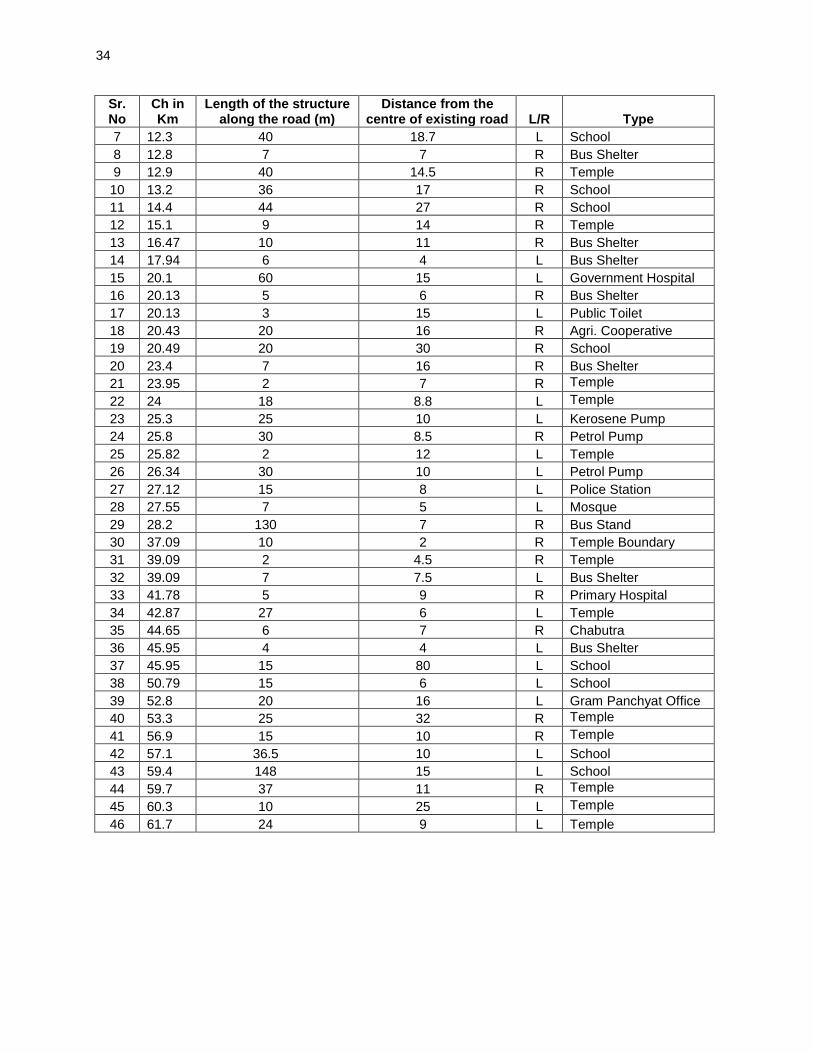
34
Sr. No
Ch in Km
Length of the structure along the road (m)
Distance from the centre of existing road L/R Type
7 12.3 40 18.7 L School
8 12.8 7 7 R Bus Shelter
9 12.9 40 14.5 R Temple
10 13.2 36 17 R School
11 14.4 44 27 R School
12 15.1 9 14 R Temple
13 16.47 10 11 R Bus Shelter
14 17.94 6 4 L Bus Shelter
15 20.1 60 15 L Government Hospital
16 20.13 5 6 R Bus Shelter
17 20.13 3 15 L Public Toilet
18 20.43 20 16 R Agri. Cooperative
19 20.49 20 30 R School
20 23.4 7 16 R Bus Shelter
21 23.95 2 7 R Temple
22 24 18 8.8 L Temple
23 25.3 25 10 L Kerosene Pump
24 25.8 30 8.5 R Petrol Pump
25 25.82 2 12 L Temple
26 26.34 30 10 L Petrol Pump
27 27.12 15 8 L Police Station
28 27.55 7 5 L Mosque
29 28.2 130 7 R Bus Stand
30 37.09 10 2 R Temple Boundary
31 39.09 2 4.5 R Temple
32 39.09 7 7.5 L Bus Shelter
33 41.78 5 9 R Primary Hospital
34 42.87 27 6 L Temple
35 44.65 6 7 R Chabutra
36 45.95 4 4 L Bus Shelter
37 45.95 15 80 L School
38 50.79 15 6 L School
39 52.8 20 16 L Gram Panchyat Office
40 53.3 25 32 R Temple
41 56.9 15 10 R Temple
42 57.1 36.5 10 L School
43 59.4 148 15 L School
44 59.7 37 11 R Temple
45 60.3 10 25 L Temple
46 61.7 24 9 L Temple
35
V. ANTICIPATED ENVIRONMENTAL IMPACTS AND MITIGATION MEASURES 81. Environmental impacts have been assessed considering present environmental setting of the project area, nature, and extent of the proposed activities. Suitable approach and methodology was adopted to ascertain likely impacts both during design and construction and operation stage. Valued Environmental Components were identified during initial site visit followed by its detailed investigation during later stage of the study. A. Impact on Physical Environment Design Stage
1. Natural Hazard 82. The entire Madhya Pradesh falls under zone least active to moderate zone as per seismic map of India and therefore the risk of damage to the project road due to earthquake is minimal. Nonetheless, relevant IS codes were adopted in the design the civil structures.
2. Road Widening, Utilities shifting and Safety Planning 83. The entire road section has enough available ROW to accommodate the proposed road improvement works and will be undertaken along the existing alignment. Road widening will result to shifting of utilities and encroaching structures. Poor coordination with local authorities and communities will increase the risk of accidental damage to drainage canals and temporary disruption of water and electric supplies along active construction fronts. The further contraction of the useable carriageway during construction will exacerbate traffic and will hinder direct access across the road by residents along the road. Temporary detention of sewage on depressed areas during the reconstruction of drainage canals may occur. 84. Road formation widening will be made on the basis of minimizing tree cutting, utility shifting, and damage to community properties. Road design has incorporates the drainage system to avoid accumulation of sewage and surface run-off. Temporary pits will constructed side- and cross drains to collect sewage from demolished or damage drainage canals which will either be hauled for off-site treatment through septic tanks prior to disposal or land application. 85. Adequate safety provisions like crash barriers on accident prone areas, rumble strips in community areas to regulate speed, retro-reflective warning sign boards near school, hospital, and religious places are incorporated in the design. All utilities requiring shifting shall be largely made before start of construction. Prior to shifting, the Contractor will coordinate with the concerned agencies regarding the time and extent of shifting and community affected will be informed of potential service disruption at least 1 week in advance. 3. Terrestrial Ecology 86. There are no national parks, wildlife sanctuaries or similar eco-sensitive areas within 10 km distance of the subproject road alignment. 87. A total of 60 trees are likely to be cleared along the RoW to accommodate the road widening. Compensatory plantation of 1:10 will be undertaken to address this impact. B. Construction Stage
36
1. Air Quality 88. The potential sources of air emission during the construction phase of the project are: (i) dust re-suspension from earthworks including materials loading and unloading; (ii) quarrying and rock crushing; (iii) operation of construction equipment and machines; (iv) fugitive emissions from unpaved road travel; and (v) combustion of fuels from equipment, machineries, and vehicles. Particulate matter, comprising the majority from road construction, Particle size distribution from road construction is dominantly large, with 85.5% > 10um and 55% > 20 um2 which can settle within close proximity of the source.Hot mix plant will generate carbon monoxide (CO), un-burnt hydrocarbon, sulphur dioxide, particulate matters, and nitrogen oxides (NOx) emissions. This may affect the air quality of nearby areas especially due to emission discharge from low height stack. The deterioration of the air quality within the immediate vicinity of the road construction activities will be significant but temporary. 89. Mitigation Measures. Following measures are proposed to minimize the dust and emission generation:
Vehicles delivering loose and fine materials like sand and aggregates shall be covered.
Loading and unloading of construction materials in project area or provisions of water fogging around these locations.
Storage areas should be located downwind of the habitation area.
Water shall be sprayed on earthworks and unpaved haulage roads Regularly.
Regular maintenance of machinery and equipment. Vehicular pollution check shall be made mandatory.
Mixing plants and asphalt (hot mix) plants shall be located at least 1 km downwind of the human settlements. The asphalt plants, crushers and the batching plants shall be sited at least 500m in the downwind direction from the nearest settlement and after securing a No-Objection Certificate (NOC) from the SPCB. Hot mix plant shall be fitted with stack of adequate height as may be prescribed by SPCB to ensure enough dispersion of exit gases.
Only crushers licensed by PCB shall be used.
LPG should be used as fuel source in construction camps instead of wood. Tree cutting shall be restricted.
Mask and other PPE shall be provided to the construction workers.
Diesel Generating (DG) sets shall be fitted with adequate height as per
regulations (Height of stack = height of the building + 0.2 KVA.
Low sulphur diesel shall be used in DG sets as well as machineries.
Air quality monitoring should be carried out during construction phase. If monitored parameters are above the prescribed limit, suitable control measures must be taken.
2. Noise 90. The scale of the construction necessary to upgrade the road and the corresponding slight increase in traffic are not expected to generate adverse impacts. Ambient noise level
2 (undated) W.R. Reed and J.A. Organiscak. Evaluation of dust exposure to truck drivers following the
lead haul truck. http://www.cdc.gov/niosh/mining/userfiles/works/pdfs/eodet.pdf
37
may increase temporarily in the close vicinity of various construction activities, maintenance workshops and vehicles and earthmoving equipment. These construction activities are expected to generate noise levels in the range of 80 – 95 dB(A) at a distance of about 5 m from the source. 91. Although this level of noise is higher than the permissible limit for ambient noise level for residential/commercial levels but will occur only intermittently and temporary. This noise level will attenuate with increase in distance from noise source, decreasing by 10dB at a distance of about 55m and 20 dB at 180 meters. Impact due to noise during construction activities will be minimal to communities as construction camps are located at least 50 meters from community areas. 92. Along the project road, a number of noise sensitive places are located which includes schools and temples. Noise impacts during project construction will be significant and temporary. 93. Mitigation Measures. Since the baseline noise levels already exceed prescribed standards the target for the operational stage monitoring will be to ensure that the noise levels do not exceed baseline levels. 94. All equipment shall be fitted with silencers and will be properly maintained to minimize its operational noise. Noise level will be one of the considerations in equipment selection, which will favor lower sound power levels. Stationary noise making equipment shall be placed along uninhabited stretches. 95. In addition to preferring less noise generating equipment, the timing of operation can be scheduled to avoid disruption of activities like school and prayer times. Finally, provision of temporary noise barriers will be made near identified sensitive locations or near the noise source during construction. 96. To protect workers operating in noisy environment, ear plugs or ear muffs will be provided by the Contractor to the workers and occupational exposure limits will be strictly implemented 3. Impact on Land and Soil
a. Loss of Productive Soil and Change in Land Use 97. Borrow areas may lose its productivity if top soil is not preserved. Similarly, land area used for locating construction camp may lose its productivity, if it is not restored to its original stage after disbanding the construction camp. 98. Mitigation Measures. The top soil from the productive land shall be preserved and reused for plantation purposes. It shall also be used as top cover of embankment slope for growing vegetation to protect soil erosion. It shall be ensured that the land taken on lease for access road and construction camp is restored back to its original land use before handing it over back to land owner.
38
b. Soil Erosion 99. Soil erosion may take place at locations of sharp bend near bridge construction locations, along steep and uncompact embankment slope, and wherever vegetation is cleared. Soil erosion may have cumulative effect viz. siltation, embankment damage, and drainage problem. Loss of soil due to run off from earth stock-piles may also lead to siltation of nearby water bodies. The intensity of soil erosion at different locations will be influenced by the lithology, topography, soil type and climatic condition (mainly rainfall) and drainage pattern. 100. Mitigation Measures. Following mitigation measures are proposed for prevention of soil erosion:
Bank protection measures shall be taken at erosion prone areas to include the use of geo-textiles matting and turfing
Provision of side drain to guide the water to natural outfalls.
Stone pitching wherever necessary.
When soil is spread on slopes for permanent disposal, it shall be buttressed at the toe by retaining walls.
Side slopes of the embankment shall not be steeper than 2H:1V and turfing of embankment slopes shall be done along the stretch.
Shrubs shall be planted in loose soil area.
In rural stretches, longitudinal side drains shall be intercepted by drains serving as outlet channels to reduce the erosion.
IRC: 56 -1974 recommended practice for treatment of embankment slopes for erosion control shall be taken into consideration.
Soil erosion shall be visually checked on slopes and high embankment areas. In case soil erosion is found, suitable measures shall be taken to control the soil erosion further including bio-turfing.
While planning or executing excavations, the Contractor will take all adequate precautions against soil erosion as per MoRTH 306.
The earth stockpiles to be located downwind and provided with gentle slopes to prevent soil erosion
4. Borrow Areas and Quarries 101. The project area is flat terrain. Farmers are willing to provide earth from their field up to certain depth on adequate compensation, it is recommended that borrowing from agricultural land shall be minimized to the extent possible. 102. Borrow areas if left un-rehabilitated may pose risk to people, particularly children and animals of accidentally falling into it as well as become potential breeding ground for mosquitoes and vector born disease 103. Illegal quarrying may lead to unstable soil condition; destroy the landscape of the terrain, air and noise pollution. Opening of new quarries is not envisaged due to the proposed project. Quarry material will be sourced from existing nearby quarries. 104. Mitigation Measures. Borrow pits shall be selected from barren land/wasteland to the extent possible. Borrow areas should not be located on cultivable lands except in the
39
situations where land owners desires to level the land. The top soil shall be preserved and depth shall be restricted to the desired level. 105. Borrow areas should be excavated as per the intended end use by the owner. The Indian Road Congress (IRC):10-1961 guideline should be used for selection of borrow pits and amount that can be borrowed. 106. The depths in borrow pits to be regulated so that the sides shall not be steeper than 25%. To the extent possible, borrow areas shall be sited away from inhabited areas. Borrow areas shall be leveled with salvaged material or other filling materials which do not pose contamination of soil. In addition, it shall be converted into fishpond in consultation with fishery department and if desired by land owner/community. The borrow shall be rehabilitated following the broad guidelines given at Appendix 2. 107. Aggregates will be sourced from existing licensed quarries. Copies of consent/ approval / rehabilitation plan for a new quarry or use of existing source will be submitted to EO, PIU. The contractor will develop a Quarry Redevelopment plan, as per the Mining Rules of the state and submit a copy of the approval to EA if new quarries are opened.
5. Compaction and Contamination of Soil 108. Soil in the adjoining productive lands beyond the ROW, haulage roads, and construction camp area may be compacted due to movement of construction vehicles, machineries and equipment, and due to sitting of construction camps and workshops. Approach road either paved or unpaved is available for most the bridge approaches. However, for some bridges approach road has to be constructed. 109. Soil may be contaminated due to inappropriate disposal of liquid waste, (lubricating oil and fuel spills, waste oil and lubricant and vehicle/equipment washing effluent) and solid waste (fuel filters, oily rags) likely to be generated from repair and maintenance of transport vehicles, construction equipment and machinery. Soil may be contaminated due to inappropriate disposal of domestic solid waste and sewage from construction camps. 110. Mitigation Measures. Fuel and lubricants shall be stored at the predefined storage location and away from drainage channels. The storage area shall be paved with gentle slope to a corner and connected with a chamber to collect any spills of the oils. Construction vehicles and equipment will be maintained and refueled in such a fashion that oil/diesel spillage does not contaminate the soil. 111. All efforts shall be made to minimize the waste generation. Unavoidable waste shall be stored at the designated place prior to disposal. To avoid soil contamination at the wash-down and re-fuelling areas, oil interceptors shall be provided. Oil and grease spill and oil soaked materials are to be collected and stored in labeled containers (Labeled: WASTE OIL; and hazardous sign be displayed) and sold off to SPCB/ MoEF authorized Waste Oil Recycler. 112. To prevent soil compaction in the adjoining productive lands beyond the ROW, the movement of construction vehicles, machinery and equipment shall be restricted to the designated haulage route.
Approach roads shall be designed along the barren and hard soil area to reduce the compaction induced impact on soil.
40
The productive land shall be reclaimed after construction activity.
Septic tank or mobile toilets fitted with anaerobic treatment facility shall be provided at construction camp.
Domestic solid waste at construction camp shall be segregated into biodegradable and non-biodegradable waste. The non-biodegradable and recyclable waste shall be sold off.
Efforts shall be made that biodegradable waste shall be composted in the mechanized and movable composter by the contractor. Non bio-degradable and non-saleable waste shall be disposed off to authorized land fill site. Non-bituminous wastes to be dumped in borrow pits with the concurrence of landowner and covered with a layer of topsoil conserved from opening the pit.
Bituminous wastes will be disposed off in an identified dumping site approved by the State Pollution Control Board
113. Construction waste constitutes debris, which are generated due to dismantling of pavement (though involved only for few kilometers in DBH Road), quarry dust and unused iron bars or damaged support structures. Uncontrolled disposal of these wastes may affect soil and even receiving water bodies may cause contamination of soil, and landscape of the area. 114. Mitigation Measures. Construction waste shall be disposed of in environmentally acceptable manner. Some of the measures are as follows:
The existing bitumen surface can be utilized for paving of cross roads, access roads, and paving works in construction sites and camps, temporary traffic diversions, and haulage routes. All excavated materials from roadway, shoulders, drains, cross drainage should be used for backfilling embankments, filling pits, and landscaping. Unusable debris material should be suitably disposed off at pre designated disposal locations, with approval of the concerned authority.
The bituminous wastes shall be disposed in secure landfill sites only in environmentally accepted manner. For removal of debris, wastes and its disposal MoRTH guidelines should be followed.
The locations of dumping sites should be selected with following considerations.
Unproductive/wastelands shall be selected for dumping sites.
Away from residential areas and located at least 1000 m downwind side of these locations,
Dumping sites do not contaminate any water sources
Dumping sites have adequate capacity equal to the amount of debris generated.
Public perception and consent from the village Panchayats about the location of debris disposal site shall be obtained before finalizing the location.
6. Groundwater 115. Contamination of groundwater is not envisaged since construction camps will have septic tanks or mobile toilets depending on the number of workers in each camp. 116. Mitigation Measures. Requisite permission as applicable shall be obtained for abstraction of groundwater. The contractor shall make arrangements for water required for
41
construction in such a way that the water availability and supply to nearby communities remain unaffected. Water intensive activities shall not be undertaken during summer season. 7. Surface Water Bodies 117. Temporary pollution of water bodies may occur due to spillage of chemicals and oil at construction sites and disposal of waste from construction camps. Installation of a haul road or temporary access across the river/nala maybe required while construction work is ongoing in the existing minor bridges and culverts. This may cause sedimentation and other disturbances to the water body. 118. Mitigation Measures. To prevent siltation of road side ponds, provision of retaining wall is made along the road for the ponds located next to the road. As enhancement measures, efforts shall be made to increase the water holding capacity of the ponds (other than those affected) in the region by using the bed material as borrow earth. Following measures shall be followed additionally:
Bridge construction activity including piling is recommended during non-monsoon (October to End of May) period.
Check dams must be created during construction to catch the silt or debris generated from construction activities across the water channels
All chemicals and oil shall be stored away from water and concreted platform with catchment pit for spills collection.
All equipment operators, drivers, and warehouse personnel will be trained in immediate response for spill containment and eventual clean-up.
Readily available, simple to understand and preferably written in the local language emergency response procedure, including reporting, will be provided by the contractors.
Silt fencing and/or brush barrier shall be installed along drainage path, erosion prone areas for collecting sediments before letting them into the water body. Silt/sediment should be collected and stockpiled for possible reuse as surfacing of slopes where they have to be re-vegetated.
All wastes arising from the construction should be disposed in an environmentally accepted manner so as not to block the flow of water in the channels. The wastes should be collected, stored and transported to the approved disposal sites.
No vehicles or equipment should be parked or refueled near water bodies, so as to avoid contamination from fuel and lubricants
Substructure construction should be limited to the dry season.
Construction camps shall be located away from habitation ( at least 1 Km Away) and water bodies. Sewage from labour camps will be treated through septic tanks. No untreated/treated sanitary wastewater shall be discharged into surface water bodies as these are used for bathing and washing purpose.
The borrow areas may also be converted into ponds with the concurrence of the land owners. Fisheries activity can be encouraged in such ponds through institutional support from concerned department
42
8. Hydrology and Drainage 119. Construction material and waste may contaminate or clog the small drains if stored or disposed close to water body. 120. Mitigation Measures. Adequate cross drainage structures shall be provided. Additional balancing culverts shall be provided in flood prone areas. The embankment height shall be designed consistent with the existing topography of the region and shall be higher than the HFL. Elaborate drainage system shall be provided to drain the storm water from the roadway and embankment and to ensure minimum disturbance to natural drainage of surface and subsurface water of the area. 121. The design of drainage system such as surface and sub-surface drainage shall be carried out as per IRC: SP: 42 and IRC: SP: 50. Surface runoff from the main highway, embankment slopes and the service roads shall be discharged through longitudinal drains, designed for adequate cross section, bed slopes, invert levels and the outfalls. If necessary, the walls of the drains shall be designed to retain the adjoining earth. 122. IRC: 34-1970: Recommendations for road construction in waterlogged area and IRC: 75 and MORT&H guidelines for Design of High Embankments shall be referred. 123. No construction material will be stored or disposed near any water body except for reusing it for enhancement measures such as embankment raising. 9. Impact on Biological Environment
a. Terrestrial Ecology 124. There is no national park, wildlife sanctuaries or any other similar eco-sensitive areas within 10 km distance of the project area. However, some trees are likely to be affected. The impact and mitigation due to tree cutting has been discussed in following paragraphs. 125. One month before the construction starts, clearing and grubbing will be performed by the contractor. All trees within the ROW with 300 mm diameter at 1m above the ground will be cut, including the removal of stumps. A total of 60 trees are likely to be affected due to the proposed project. The cutting of trees will have minor to negligible impact on local environment. 126. Mitigation Measures. Requisite permission from Forest Department shall be obtained for cutting of roadside trees located in forest land otherwise; permission will be taken from district commissioner. 127. The project envisages plantation of approximately 600 trees along both sides of road as per IRC SP: 21 specifications. This will include the compensatory plantation as per prevailing guidelines of States forest department on 1:10 basis replacement rate or as per permission granted by district authorities for cutting of tree located on non-forest land, which vary 1;10. Besides, additional plantation shall be done on banks of water bodies near bridge sites to enhance the aesthetics and check soil erosion. All tree plantations will be carried out through forest department, local community or the civil works contractor. Tree species selected for plantation must be suitable for local climatic conditions and be equal to or better in sequestering carbon than the the trees removed/be good for sequestering carbon (only for
43
roads where there is no tree cutting). Necessary advise maybe sought from the local Forestry office in the selection of tree species. 128. A range of 10-15 m centre-to-centre is recommended for spacing of trees (parallel to the road). Setback distance of trees in different situations shall be based on IRC: SP: 21 and IRC: 66. The distance between the kerb, if any, and the nearest edge of tree trunk shall be at least 2 m. The plantation in median shall comprise shrubs whose height would normally not exceed 1 - 1.5 m and shall be as per IRC SP: 21. 129. For safe traffic operation, vertical clearance between the crown of the carriageway and lowest part of overhang of the tree available across the roadway shall conform to the standards laid down in IRC: SP: 21. The pit size, fencing, watering, and manuring requirements shall also conform to the above standard. The use of pesticides shall be avoided or minimized to the extent possible. Planting shall be such that it does not obstruct the visibility of traffic from any side and shall be pleasing in appearance.
b. Aquatic Ecology 130. Temporary sedimentation and water quality deterioration is expected from the project during the construction stage. Accidental spill of materials, chemicals, and fuels may also deteriorate receiving water quality and hence the aquatic ecology. 131. Mitigation Measures. It is proposed to undertake construction activities near water bodies during summer season when most of water bodies are practically dry. Best construction practices shall be adopted to prevent increase in siltation level of the water. All precautionary efforts shall be taken as given under surface water section to prevent accidental damage of water quality. 10. Socio-Economic Impact 132. DBH Road project will have both positive and negative impact on socioeconomic aspects as narrated below.
a. Positive Impacts 133. Economic activities supporting transport like fuel stations, automotive repair shops, lodging, and restaurants are expected to increase with increase of traffic and induced development of the area. The improved road will provide better connectivity which will result in (i) Reduction in travel time (ii) better mode and frequency of transport (iii) access to quality health care facilities, educational and other infrastructural facilities (iv) enhanced tourism activities in the area and state which in many terms will boost the local economy (v) better investment climate for industries creating more employment opportunities to local people.
b. Anticipated Negative Impacts 134. The other impacts are expected due to sitting and operation of construction camp during construction.
44
11. Labor and Construction Camp 135. Construction workers expected to be about 150 per day per package are likely to be employed during construction. Most of the workers will be employed locally. However, some may be from nearby areas. This will cause additional burden on local resources. However, this impact will be temporary and will not have the potential for changes in the demographic scenarios of the area. The outside workers will be housed at the construction camp, which is expected to one per package. Poor sitting and improper management of construction camp may lead to several adverse impacts on environment viz. (i) loss of vegetation due to use of wood as fuel source for cooking (ii) deterioration in nearby surface water bodies‟ quality (iii) compaction and contamination of soil due to uncontrolled disposal of solid waste (iv) Poor sanitation may result to transmission of communicable diseases among the workers and the host communities. This includes the possible spread of sexually transmitted disease, diseases from improper handling and supply of foodstuffs, poor water supply, and insect-borne diseases. 136. Mitigation Measures. Construction camp shall be sited at such locations so as to utilize the existing infrastructure. No productive land should be utilized for construction camp. All sites must be graded, ditched and rendered free from depressions to avoid water stagnation. Accommodation and ancillary facilities including recreational facility for workers shall be erected and maintained to standards and scales approved by the resident engineer. All camps should maintain minimum distance of 1000 m from habitation and water bodies. 137. All construction camps shall be provided sanitary latrines and urinals with provision of septic tanks attached with soak pits or mobile toilets fitted with anaerobic digestion system. Storm water drains shall be provided for the flow of used water outside the camp. Drains and ditches shall be treated with bleaching powder on a regular basis. Garbage bins must be provided in the camp and regularly emptied and disposed of in a hygienic manner. LPG cylinders shall be provided as fuel source for cooking to avoid any tree cutting. 138. The Contractor will ensure the following:
The good health and hygiene of all workers to prevent sickness and epidemics. These include the HIV/AIDS prevention program to reduce the risk and transfer of HIV virus between and among the workers and community, promote early diagnosis and assist affected individuals. Activities under the program include monthly information, education, and consultation communication campaigns to workers, drivers, delivery crew, and communities on the risk, dangers, and impacts of STD and HIV/AIDS. Contractor will also provide first aid facilities at the camp and organize regular health check-up camps as well.
Availability of safe drinking water and sufficient supply of suitable and hygienically prepared food at reasonable price is available to the workers.
Adoption of all precautions to protect the workers from insect and pest to reduce the risk to health. This includes the use of insecticides, which should comply with local regulations.
Prohibition on supply or availability of alcoholic liquor or prohibited drugs at the camp.
Regular health check-up and immunization camps shall also be organized for the workers and nearby population.
45
12. Safety 139. The road construction activities may create various unsafe situations. This will require attention to the following safety aspects viz. (i) safety of construction workers, (ii) safety of road users including pedestrians and cyclists (iii) safety to cattle; (iv) safety of local community (iv) unsafe/ hazardous traffic conditions due to construction vehicle movement need to be considered during design and construction stage and (v) conduct of safety audit. 140. Mitigation measures. During the construction phase, contractors shall be required to adopt and maintain safe working practices. Internationally accepted and widely used safety procedures should be followed during (i) road works (ii) handling of large construction equipment and machineries, (iii) handling of chemicals and hazardous materials and inflammable substances (iii) welding and (iv) electrical works. Contractor shall also arrange required PPEs for workers, first aid and firefighting equipment at construction sites. Contractor will also prepare an emergency preparedness plan, which shall be duly approved by EA to respond to any emergency and unsafe conditions. To avoid disruption of the existing traffic due to construction activities, comprehensive traffic management plan shall be drawn up by the contractor. Retro- 141. Reflectorized traffic caution signs shall be used during construction. Regular safety audit or periodic review shall be made to assess the effectiveness of safety measures adopted during construction. 142. Adequate caution signage near school, sensitive locations, speed control, caution notes shall be fixed at appropriate locations. These shall be preferably of PCC with Retro-reflective paints. Steel base signage shall be avoided to prevent theft of the same. Crash barrier shall also be installed at appropriate locations particularly near school to provide safety to school children. Provision of sped breakers shall be made near schools and religious places. C. Impacts during operation stage 143. The subproject road is located in vast open agricultural land, which will provide adequate dispersion of gaseous emission from vehicle. Further, proposed plantation will ameliorate/enhance the micro climate. No adverse climatic changes/impacts are anticipated during operation stage other than GHG (CO2) emission due to increased traffic, which would be largely offset with better fuel efficiency and reduced vehicle idling due to improved road conditions.
1. Air Quality 144. Vehicular emissions will be the principle source of pollution during operation stage. The subproject road is mostly located in vast open agricultural land, which will provide adequate dispersion dynamics of gaseous pollutants. Moreover, majority of the traffic on the subproject will be diverted traffic from the existing highways. 145. Mitigation Measures. Plantation is one of the preferred solutions to check air pollution. Plants serve as a sink for pollutants, reduce the spread of dust. Tree plantation along roadsides and other places shall include pollution absorbent species. Awareness
46
signboards shall be installed at prominent location to educate drivers for good driving and vehicle maintenance practices. 2. Noise 146. During the operational Stage, movement of traffic will be the prime source of noise. Traffic congestion and pedestrian interferences increase the use of horns. This may result in increased noise levels at nearby schools and religious places. 147. Mitigation Measures. Effective traffic management and good riding conditions shall be maintained to reduce the noise level throughout the stretch. Speed limitation and honking restrictions may be enforced near sensitive locations. Increased plantation along the road and boundary wall will also work as noise barrier. Since most of the schools buildings are away from the road, therefore impact of noise is expected to be insignificant. Since improved road conditions and multi-layered plantation will be helpful in attenuation of noise levels, the effectiveness of the these measures shall be monitored. If noise levels are still found higher than the prescribed ambient noise standards at these sensitive receptors, adequate noise barrier shall be fixed. 3. Land and Soil 148. The better access can lead to conversion of agriculture land for residential and commercial purposes close to roads and especially in rural and urban area. 149. Mitigation Measures. The EA may explore the feasibility of restricting about 30 m area either side of the road as no development zone on the line restriction are imposed for National Highways authority of India. 4. Soil Erosion 150. No impact on soil is anticipated during operation phase of the project except bridge approaches where unexpected rainfall may erode the embankment formation and deterioration of borrow areas if not rehabilitated properly. 151. Mitigation measures. Embankment stabilization shall be check periodically during operation stage and suitable stabilization measures shall be taken wherever any erosion is identified. Borrow areas will also be rehabilitated following the guidelines given at Appendix 2. 5. Groundwater 152. No impact is anticipated on groundwater due to the project during operation phase of the project hence, no specific mitigation measure is proposed. 6. Surface Water Bodies 153. No major or long-term impact is anticipated during the operation phase on the surface water bodies due to the project implementation activities. Oil contaminated runoff from the road during monsoon will have minimal impacts considering their low concentration.
47
7. Hydrology and Drainage 154. Regular removal/cleaning of deposited silt shall be done from drainage channels and outlet points before the monsoon season. Rejuvenation of the drainage system by removing encroachments/ congestions will be regularly conducted. 8. Impact on Biological Environment a. Terrestrial ecology 155. Positive impacts on terrestrial ecology are expected during the project operation stage due to the increase in vegetation and landscaping along the road. The project will coordinate with the local communities to maintain and enhance the trees planted along the state road. ”No adverse impact is anticipated during operation stage except accidental damages or absence of proper tree management. 156. Mitigation Measures. Arrangement shall be made to ensure survivability of the tree plantation. The tree survivability audit shall also be conducted at least once in a year to assess the effectiveness of the programme. b. Aquatic Ecology 157. No impact is envisaged during operation phase of the project and hence no mitigation proposed. However, periodic surveillance shall be conducted to check erosion and siltation in major water bodies. 10. Community Health and Safety 158. During operation phase, the projected increase in the number of motorized road users traveling at higher speeds also increases the chances of injuries and fatalities from road crashes. 159. Mitigation Measures. Adequate caution signage near school, sensitive locations, speed control, caution notes shall be fixed at appropriate locations. These shall be preferably of PCC with Retro-reflective paints. Steel base signage shall be avoided to prevent theft of the same. Crash barrier shall also be installed at appropriate locations particularly near school to provide safety to school children. Provision of speed breakers shall be made near schools and religious places. D. Climate Change Impacts and Risks
1. Climate Change Mitigation
160. The Transport Emissions Evaluation Model for Projects (TEEMP)3 developed by Clean Air Asia4 was utilized to assess the CO2 gross emissions with and without the project
3 TEEMP is an excel-based, free-of-charge spreadsheet models to evaluate emissions impacts of
transport projects. 4 A network of 250 organizations in 31 countries established by the Asian Development Bank, World
Bank, and USAID to promote better air quality and livable cities by translating knowledge to policies and
48
improvements. The main improvement from the project that was considered for the model is better surface roughness which was translated into impacts on traffic speed and hence fuel consumption. The model also allows for the inclusion of impacts related to traffic congestion with and without project through provisions for inserting data on the traffic numbers, lane width, number of lanes and volume/capacity saturation limit. 161. Information that was fed into the model for projecting the CO2 emissions were:
(i) The road will rehabilitate 62.4 km of major district roads; (ii) The existing road having 1.5 to 2 lane with a 3m carriageway width will be
improved to a 1.5 to 2 lane road with 3.5m carriageway width with asphalt concrete surface;
(iii) Road roughness will decrease from the general condition of 16 m/km to 2.5 m/km;
(iv) Construction will take place over a period of 12 months in 2015 and road operations will begin in 2016.
(v) The design life of the road is 20 years. Hence the midpoint of the design life is after 10 years or 2025.
(vi) Other improvements include the repair or reconstruction of damaged culverts, introduction of lined longitudinal and cross drains for the road and removal of irregularities on the existing vertical profile and road safety appurtenances.
162. The traffic forecast data was taken from the traffic studies and economic analysis for the road disaggregated into vehicle types and annual average daily traffic. Key vehicle categories considered for the road and the annual average daily traffic in 2014 (baseline scenario) without project and in 2025 with the project is given in the table below.
Table 24: Annual Average Daily Traffic for different vehicle categories
Vehicle category 2014 (without project) 2035 (with project)
2-wheeler 1713 4012
3-wheeler/autorickshaw 9 13
Car/jeep/taxi/van 847 2015
Heavy commercial vehicle (HCV) 315 707
Minibus and standard bus 75 189
Light Commercial Vehicle (LCV) 170 429 TOTAL 818 1262.33
163. The volume/capacity saturation limit was taken at 2.0 or twice the designed road capacity and beyond which traffic congestion will result to less than optimum travel speed and increase in fuel consumption. Emission factors were taken from the CBCP/MOEF (2008) Draft Report on Emission Factor Development for Indian Vehicles, the Automotive Research Association of India, and C. Reynolds et.al (2011)Climate and Health Relevant Emissions from in-Use Indian for three-wheelers rickshaw as follows:
Table 25: CO2 Emission Factors
Vehicle Type Gas/Petrol Diesel
2-Wheel 2.28 kg/l
actions that reduce air pollution and greenhouse gas emissions from transport, energy and other sectors.
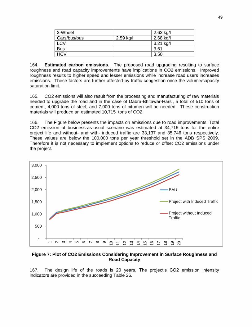
49
3-Wheel 2.63 kg/l
Cars/bus/bus 2.59 kg/l 2.68 kg/l
LCV 3.21 kg/l
Bus 3.61
HCV 3.50
164. Estimated carbon emissions. The proposed road upgrading resulting to surface roughness and road capacity improvements have implications in CO2 emissions. Improved roughness results to higher speed and lesser emissions while increase road users increases emissions. These factors are further affected by traffic congestion once the volume/capacity saturation limit. 165. CO2 emissions will also result from the processing and manufacturing of raw materials needed to upgrade the road and in the case of Dabra-Bhitawar-Harsi, a total of 510 tons of cement, 4,000 tons of steel, and 7,000 tons of bitumen will be needed. These construction materials will produce an estimated 10,715 tons of CO2.
166. The Figure below presents the impacts on emissions due to road improvements. Total CO2 emission at business-as-usual scenario was estimated at 34,716 tons for the entire project life and without- and with- induced traffic are 33,137 and 35,746 tons respectively. These values are below the 100,000 tons per year threshold set in the ADB SPS 2009. Therefore it is not necessary to implement options to reduce or offset CO2 emissions under the project.
Figure 7: Plot of CO2 Emissions Considering Improvement in Surface Roughness and Road Capacity
167. The design life of the roads is 20 years. The project’s CO2 emission intensity indicators are provided in the succeeding Table 26.
-
500
1,000
1,500
2,000
2,500
3,000
1 2 3 4 5 6 7 8 9
10
11
12
13
14
15
16
17
18
19
20
BAU
Project with Induced Traffic
Project without InducedTraffic
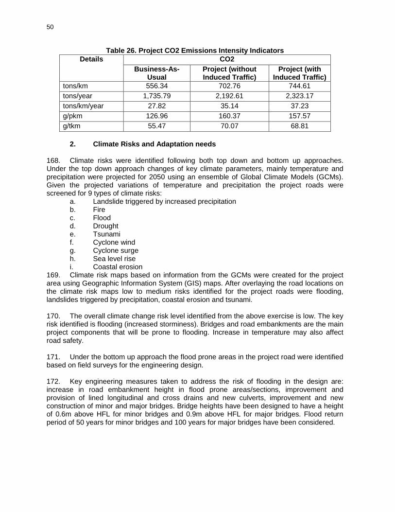
50
Table 26. Project CO2 Emissions Intensity Indicators
Details CO2
Business-As-Usual
Project (without Induced Traffic)
Project (with Induced Traffic)
tons/km 556.34 702.76 744.61
tons/year 1,735.79 2,192.61 2,323.17
tons/km/year 27.82 35.14 37.23
g/pkm 126.96 160.37 157.57
g/tkm 55.47 70.07 68.81
2. Climate Risks and Adaptation needs
168. Climate risks were identified following both top down and bottom up approaches. Under the top down approach changes of key climate parameters, mainly temperature and precipitation were projected for 2050 using an ensemble of Global Climate Models (GCMs). Given the projected variations of temperature and precipitation the project roads were screened for 9 types of climate risks:
a. Landslide triggered by increased precipitation b. Fire c. Flood d. Drought e. Tsunami f. Cyclone wind g. Cyclone surge h. Sea level rise i. Coastal erosion
169. Climate risk maps based on information from the GCMs were created for the project area using Geographic Information System (GIS) maps. After overlaying the road locations on the climate risk maps low to medium risks identified for the project roads were flooding, landslides triggered by precipitation, coastal erosion and tsunami. 170. The overall climate change risk level identified from the above exercise is low. The key risk identified is flooding (increased storminess). Bridges and road embankments are the main project components that will be prone to flooding. Increase in temperature may also affect road safety. 171. Under the bottom up approach the flood prone areas in the project road were identified based on field surveys for the engineering design.
172. Key engineering measures taken to address the risk of flooding in the design are: increase in road embankment height in flood prone areas/sections, improvement and provision of lined longitudinal and cross drains and new culverts, improvement and new construction of minor and major bridges. Bridge heights have been designed to have a height of 0.6m above HFL for minor bridges and 0.9m above HFL for major bridges. Flood return period of 50 years for minor bridges and 100 years for major bridges have been considered.
51
E. Cumulative and Induced Impacts
173. According to the ADB Environment Safeguards Sourcebook5 cumulative impact is described as: “The combination of multiple impacts from existing projects, the proposed project, and anticipated future projects that may result in significant adverse and/or beneficial impacts that cannot be expected in the case of a stand-alone project.” The sourcebook also describes induced impacts as: “Adverse and/or beneficial impacts on areas and communities from unintended but predictable developments caused by a project, which may occur at later or at a different location. 174. Economic activities supporting transport like fuel stations, automotive repair shops, lodging, and restaurants are expected to increase with increase of traffic and induce development in the project area. The improved road will provide better connectivity and result in (i) Reduction in travel time (ii) better mode and frequency of transport (iii) access to quality health care facilities, educational and other infrastructural facilities (iv) enhanced tourism activities in the area and state which in many terms will boost the local economy (v) better investment climate for industries creating more employment opportunities to local people. 175. In terms of environment safeguard issues the improved road surface is expected to result in less dust and noise due to traffic plying on the damaged roads. However, the increased traffic due to the improved road will generate more air pollution due to vehicle exhaust and noise. The smoother road conditions will also result in increase of traffic speeds, hence creating more risks for accidents amongst traffic users as well as the local communities in the project area.
176. For addressing the impacts of air pollution and noise, regular maintenance of the road surface, maintenance and monitoring of newly planted trees and installation of noise barriers where necessary have been included in the EMP for implementation during operation stage. For addressing safety related impacts, regular maintenance of the road furniture include safety related furniture, enforcing rules against encroachment of structures and sensitive structures (schools, temples etc.) inside the ROW and implementation of the emergency response system has been included in the EMP for implementation during operation stage,
177. Information on future development projects along the project road was not available. Hence, it is difficult to assess cumulative impacts from other projects which may get implemented in the project area.
5 Environment Safeguards, A Good Practice Sourcebook, Draft Working Document, December 2012
52
VI. PUBLIC CONSULTATION AND INFORMATION DISCLOSURE 178. Meaningful consultations were held early and throughout the project development stage to allow the incorporation of relevant views of the stakeholders in the final project design, mitigation measures, implementation issues, and enhance the distribution of benefits. All the five principles of information dissemination, information solicitation, integration, co-ordination, and engagement into dialogue were incorporated in the consultation process. The analysis of environmental impacts likely from the project was strengthened and modified based on opinions of all those consulted, especially in the micro level by setting up dialogues with the village people from whom information on site facts and prevailing conditions were collected. The requirement of public consultation during the implementation of the project has been proposed as part of the mitigation plan. A. Objectives of the Public Consultation 179. Stakeholder’s consultations were held with intent to understand their concerns, apprehensions, overall opinion and solicit recommendations to improve project design and implementation. Informal meetings, interviews were organized covering the entire project design stage. Consultations provide affected people a platform to ensure incorporation of their concerns in the decision making process and foster co-operation among officers of MPRDC, the community and the stakeholders to achieve a cordial working relationship for smooth implementation of the project. It inculcates the sense of belongingness in the public about the project. 180. The discussions were designed to receive maximum inputs from the participants regarding their acceptability and environmental concerns arising out of the sub-project. They were given the brief outline of the project to which their opinions was required particularly in identifying and mitigating any potential adverse impact. B. Methodology for Consultations 181. Consultation with the stakeholders, beneficiaries, and community leaders were carried out using standard structured questionnaires as well as unstructured questionnaires. Questionnaire survey/ discussions were designed to obtain background information and details of general environmental issues that concern people in the project area. In addition, environmental issues were discussed with relevant organizations, government officials, beneficiaries, community leaders and experts. In addition, personal discussions with officials, on site discussion with affected stakeholders, and reconnaissance visits have also been made to the project area. Public consultations have been carried out at three locations during initial surveys as shown in table 24. The total numbers of participants in the consultations are 37 out of which 12 or 32% are women.
Table 27: List of Public consultation and Date
Sr. No.
Village/Town Name
Date of Consultation
No of participants
M F T
1 Kariawati 30/04/2014 11 - 11
2 Devri 01/05/2014 - 12 12
3 Belgada 01/05/2014 14 - 14
25 12 37
53
1. Project Stakeholders 182. All types of stakeholders were identified to ensure as wide coverage as possible.
Residents, shopkeepers and businesspeople who live and work along the road specially the project affected persons
All type of road users/commuters
Executing Agency, Construction Supervision Consultant and Implementing NGOs
Other government institutions whose remit includes areas or issues affected by the project (state environment and forest department, Pollution Control Board (PCB), Irrigation Department, Public Health Engineering (PHED) Department
The beneficiary community in general 2. Consultation with Government Departments 183. Various officials consulted during IEE preparation included PWD Officials, State pollution control board for Air, Noise and Water quality information, IMD for the climatic data, statistical officer for Population and demographic profile, Panchyat department for village level information, Survey of India for the toposheet requirement, Revenue department for the land record information, PHQ officers for hand pump relocation and quality assessment, MPSEB offices for electric pole shifting etc. 184. These departments helped to provide various project related data and information which helped preparation of reports and data analysis. 3. Consultation with Local People and Beneficiaries 185. The informal consultation generally started with explaining the project, followed by an explanation to potential impacts. Participant’s views were gathered with regard to all aspects of the environment which may have direct or indirect impact on local people. Key Issues discussed are:
Awareness and extent of the project and development components;
Benefits of the project for the economic and social upliftment of community;
Labour availability in the project area or requirement of outside labour involvement;
Local disturbances due to project construction work;
Necessity of tree felling etc. at project sites;
Impact on water bodies, water logging and drainage problem if any;
Environment and health
Flora and fauna of the project area
Socio-economic standing of the local people 186. The project has immense acceptability among the local people. They perceive that in addition to providing all weather connectivity, the subproject road will bring positive socioeconomic changes in the area. Local people mainly discussed on the issues related to flooding, rehabilitation, resettlement, and road safety issues. The list of participants views, and outcome of the consultations have been summarised in Table 25.
54
187. The Details of Participants and Public Consultation photographs are attached in Appendix 8. In addition information on the GRM procedures and formats in local language i.e. Hindi was shared with the local people as provided in Appendix-9.
Table 28: Outcome of the Consultations
Sr. No.
Date and Location
Issues Discussed Measures Taken Participants
1 Date: 30/04/2014 Village: Kariyawati
People are facing acute problem related to poor condition of the road as in some section BT top is completely absent.
Air & Noise pollution is high due to bad condition of road.
Tree cutting and plantation.
Where the road passing through the settlements there should be provision of Speed breakers
Suggestion viz. (i) design shall take into hydrological aspects into consideration (ii) minimal loss of structures (iii) adequate resettlement and rehabilitation measures including provision of jobs to land losers
Local people informed that present road in some sections of this area submerges during normal rainfall also. Adequate measures shall be taken to avoid water logging during normal rainfall.
They suggested that existing alignment shall also be improved and maintained properly.
Suggestion viz.,
Proposed widening and strengthening of the road will provide better level of services in terms of improved riding quality and smooth traffic flow.
There will be considerable reduction in the number of accident and level of pollution.
Accessibility to social health and educational infrastructure will increase through all-weather road.
Generation of employment during construction phase of the road.
The discussion generate considerable awareness of the project
As the proposed road shall be an widened one, it shall provide an efficient public transportation system besides ensuring reduction in congestion level
The non -title holders shall also be compensated as per ADB guidelines.
Drainage system is mention in built-up area and drainage for rural area.
Road safety features like traffic signs, Overhead Sign Boards, Road Illumination, Delineators, pavement marking, pedestrian path and rumble strips has been included in the design
Proper Rehabilitation measures will be taken and compensation will be as per market rate.
Total Participants-11
2 Date: 1/05/2014 Village: Davri
Total Participants-12
3 Date: 1/05/2014 Village: Belgada
Total Participants-14

55
Sr. No.
Date and Location
Issues Discussed Measures Taken Participants
Minimal loss of tree ,structures, Adequate rehabilitation and resettlement ,measures
Stress was put by the community on adequate safety provisions to be made along the road particularly at locations of school, s, provision of bus stop and provision of green belt development
Compensation should be as per market value.
188. Most of the people interviewed were well aware of the environmental conditions in and around their villages. A major percentage was ignorant about any deterioration in the air and noise quality due to expansion of existing highway. However, their major concern was related to the loss of fertile agricultural land. The villagers are quite enthusiastic about the proposed project as it will give fillip to rural economy and present them many employment opportunities during construction of project road. Overall positive approach towards the project is observed. C. Results of Consultation with Local People 189. Most of the people interviewed strongly support the project. The people living in the entire project area expect the different project elements to facilitate transport, employment, tourism, boost economic development and thereby provide direct, or indirect, benefits to them. In order to access the existing environment and likely impacts on surrounding population, an interview survey was carried out. A sample of the population was interviewed through a designed questionnaire. Precaution has been exercised during the survey to ensure that the sample interviewed is truly representative of the affected groups and the questions are worded so as not to generate a bias response. 190. It is observed from the interview survey that there is increased environmental awareness among the people. It can also be seen from Table 26 that about most of the persons are in the opinion that an environmental condition of the area is not good due to bad conditions of road specifically for air & noise. Poor road condition and vehicular emissions are the major sources they feel responsible for this. People are not fully aware about presence of archaeological, historical and cultural sites. There is no major history of natural disasters in the region and local people have mixed response about natural disasters. Overall, the general environmental awareness in the region are good and people have increased environmental awareness. Table 26 shows the result of public opinion survey carried out in the region.

56
Table 29 : Peoples’ Perception about Environmental Scenario
Sr. No.
Question asked about No. of people
interviewed
Positive response
(%)
Negative response
(%)
No response
(%)
1 Water quality of rivers, ponds, wells, and canals
37 80 10 10
2 Noise quality of the area 37 50 40 10
3 Air quality of the area 37 45 50 5
4 Archaeological sites 37 60 10 30
5 Natural disaster 37 60 20 20
6 Rare species of animals and birds found
37 10 85 5
7 Cultural sites i.e. market, melas
37 77 13 10
Note: Positive response shows that the people have awareness regarding environmental scenario.
D. Conclusion and Recommendation 191. Overall, most of the people interviewed strongly support the project. The people living in the entire project area expect the different project elements to facilitate transport, employment, tourism, boost economic development and thereby provide direct, or indirect, benefits to them. Construction camps may, however, put stress on local resources and the infrastructure in nearby communities. In addition, local people raised construction-process related grievances with the workers. This sometimes leads to aggression between residents and migrant workers. To prevent such problems, the contractor should provide the construction camps with facilities such as proper housing, health care clinics, proper drinking water and timely payment. The use of local laborers during the construction will, of course, increase benefits to local peoples and minimize these problems. Wherever possible, such people should be employed. 192. The following are the Consultants’ initial findings in regard to likely positive and negative impacts. Positive Impacts:
The improved road: will reduce travel times, fuel consumption and emissions from base traffic volumes
Drainage conditions will be considerably improved: this because of the provision of improved side drains, culverts and causeways;
Economic development and access will be stimulated Health, Agricultural and Education facility will improve
Negative Impacts
Few tree loss which reduce the green cover but simultaneously plantation will take place to improve the green cover.
Minor deteriorations in the present minimum levels of air, water and noise quality may be expected during construction- but this should be short-term and localized – in order to minimize the impacts, the mitigation measures recommended
During construction the traffic will slow and messy.

57
193. On the basis of available information, field visits over the entire length of the project road, discussions with the project authorities; other discussions amongst the project team, NGOs, local people and various governmental officials, it has been concluded that overall:
All elements of the projects will be beneficial;
All negative impacts, during and post construction, including those deemed “significant” can be properly mitigated; and
No comprehensive, broad, diverse or irreversible adverse impacts have been identified.
58
VII. ENVIRONMENTAL MANAGEMENT PLAN AND GRIEVANCE REDRESS MECHANISM
194. The environmental impacts associated with any development project are eliminated or minimized to an acceptable level through development of appropriate mitigation measures based on most suitable techno-economic options. The Environmental Management Plan (EMP) is a well-established tool to ensure effective implementation of the recommended mitigations measures throughout the subsequent project development stages. The EMP also ensures that the positive impacts are conserved and enhanced. An EMP provides location and time specific actions to be taken with defined responsibility. It also provides measures for institutional strengthening and effectiveness assessment through defined monitoring plan, reporting and corrective & preventive action planning. A. Environmental Management Plan 195. The DBH Road specific Environment Management Plan has been formulated which consists of a set of mitigation; monitoring and institutional measures applicable to design, construction and operation stages of the project (Appendix 3). The components of this EMP includes (i) mitigation of potentially adverse impacts (ii) monitoring of impacts and mitigation measures during project implementation and operation (iii) institutional capacity building and training (iii) compliance to statutory requirements (iv) integration of EMP with project planning, design, construction and operation. B. EMP Implementation Schedule 196. The EMP provided in Appendix 3 provides measures. However, specific mention is made for location specific measures. The package specific EMP costs are separately assessed. These EMP will form part of bidding document as well. The construction period for DBH Road is considered as 24 months from the date of start of construction. C. Emergency Response Plan 197. Assessment of nature, type and extent of project activities establishes that this project may have only one environmental emergency i.e. accidents on paved roads and consequent spillage due to damage of oil tank of the vehicle. It is suggested to develop a communication and response system to minimize the response time. The project authorities shall be prepared to counteract against such emergency either by developing in-house capabilities or by associating with any competent agency. D. Environmental Monitoring Plan (EMoP) 198. The purpose of the environmental monitoring program is to ensure that the envisaged objectives of the project are achieved and result in desired benefits. To ensure the effective implementation of the mitigation measures and Environmental Management Plan (EMP), it is essential that an effective monitoring program be designed and carried out. The board objectives of environmental monitoring plan are:
To evaluate the performance of mitigation measure proposed in the EMP
To evaluate the adequacy of Environmental Assessment
To suggest improvements in management plan, if required
To assess change in environmental quality
59
199. A comprehensive monitoring plan has been prepared for all stages of the project and provided as Appendix 4. This includes parameters to be measured, methods to be used, sampling locations, frequency of measurements, detection limits, cost and responsibility for implementation and supervision. The monitoring programme is designed for monitoring during construction and operation stages with details on budget and responsible agencies:
Construction Stage: (three years of construction period)
Monitoring to be carried out by construction supervision consultant (CSC). The costs to form part of CSC budget.
Six Monthly monitoring by external agency to be arranged by PIU ADB from Project cost budget. This report will be directly submitted by agency to MPRDC.
200. Monitoring Programme and schedule for Key Performance Indicators (Physical, biological and environmental management components identified as of particular significance) are given in the following section:
1. Ambient Air Quality (AAQ) Monitoring 201. Ambient air quality parameters recommended for road transportation developments are Fine Particular Matter (PM2.5), Respirable Particular Matter (PM10), Carbon Monoxide (CO), Oxide of Nitrogen (NOx) and Sulphur Dioxide (SO2). These are to be monitored at designated locations starting from the commencement of construction activities. Data should be generated twice in a week at all identified locations in accordance to the National Ambient Air Quantity Standards (Appendix 5). The locations and environmental parameters to be monitored are detailed out in the Environmental Monitoring Plan (Appendix 4).
2. Water Quality Monitoring 202. The physical and chemical parameters recommended for analysis of water quality relevant to road development project are pH, total solids, total dissolved solids, total suspended solids, and oil & grease. The monitoring of the water quality is to be carried out at all identified locations in accordance to the Indian Standard Drinking Water Specification – IS 10500 (Appendix 6). The locations, duration and the pollution parameters to be monitored are detailed in the Environmental Monitoring Plan (Appendix 4).
3. Noise Levels Monitoring 203. The measurements for monitoring noise levels would be carried out at designated locations in accordance to the ambient Noise Standards formulated by Ministry of Environment and Forests (MoEF) as given (Appendix 7). Noise level would be monitored on a twenty-four hours basis. Noise should be recorded at “A” weighted frequency using a slow time response mode of the measuring instrument. The measurement location, duration and the noise pollution parameters to be monitored and the responsible institutional arrangements are detailed in the Environmental Monitoring Plan (Appendix 4).
4. Tree Plantation 204. The 75% survival rate of re-plantation shall be monitored for three years of the operation phase. If the survival rate is found below 75%, additional compensatory plantation shall be carried out by agency responsible for plantation and maintenance. The survival rate monitoring shall be again taken up after 1 year again. This cycle should continue until the 75%
60
survival rate is achieved. Since tree plantation would be made through forest department, monitoring would be carried out through MPRDC.
5. Soil Erosion and Drainage Congestion 205. No significant soil erosion problem is anticipated due to the project either in the construction phase or in the operation phase. However, in the construction phase, some localized soil erosion may be noticed owing to construction activities. However, if soil erosion is noticed during construction and operation phase, the corrective action shall be initiated and frequency of check be increased to assess the tendency of occurrence. E. Institutional Setting and Proposed Implementation Arrangement 206. The Executing Agency for the project will be GoMP through MPRDC. MPRDC is wholly owned by GoMP and has been equipped with adequate capacity to implement the project. The implementation arrangements basically follow the ongoing MPSRSP-II. A General Manager (GM) at MPRDC headquarter has been designated as person in charge for project implementation. The Environmental and Social cell (ESC) at MPRDC headquarters, reporting to the General Manager, will be responsible for ensuring compliance with environmental and social safeguards of project roads. This cell currently has only one officer to cover both social and environment safeguards. To support this officer, two more social safeguard officers and one environmental safeguard officer will be appointed or recruited. This will allow the ESC to have a total of four officers, 2 for social safeguards and 2 for environment safeguards. 207. MPRDC has ten division offices (Bhopal, Jabalpur, Sagar, Gwalior I, Gwalior 2, Ujjain , Indore I, Indore II, Rewa I, and Rewa II) acting as Project Implementation Units (PIUs). Each PIU is headed by a Divisional Manager (Tech.) who is responsible for project implementation at the field level. Each PIU will be responsible for one to two contracts depending on the location of the sub projects, and one project manager will be assigned for each contract package. The project manager will be delegated adequate technical and administrative authority for expeditious project implementation. In each PIU one of the Assistant Engineers or Managers under the Divisional Manager will be appointed as the social and environment safeguards focal person. MPRDC will engage Construction Supervision Consultants to act as the engineer for the construction contracts. An environmental specialist from the CSC will provide technical support to MPRDC and the PIU for implementation of environment safeguards under the project. The engineer will be responsible for approving plans, engineering drawings, release of payments to contractor etc. while the CSC environmental specialist or environmental officer will be responsible for providing recommendations to “the engineer” for approving activities specific to environment safeguards. Environmental awareness and EMP implementation training will be held for MPRDC staff, contractors and CSC. 208. Six monthly monitoring reports will be prepared by the CSC environmental specialist to report on compliance with construction contracts, effectiveness of mitigation measures, and complaints (also known as project performance monitoring), and the state and health of nearby environmental resources (also known as ambient environmental monitoring). 209. Monitoring during operation shall be conducted for five years (once a year basis) as part of CSC contract and budget as this project will have a five year performance based maintenance works to be implemented by the contractor. Thereafter it will be done on an as-needed basis depending on the design or change in project activity.
61
210. The detailed responsibilities of MPRDC, PIUs, CSC, Contractor, and ADB are provided:
a. MPRDC’s Responsibilities
Ensure that Project complies with ADB's SPS and GOI’s laws and regulation
Ensure that the project complies with all environment safeguard requirements as given in this EARF
Prepare IEE reports including EMP as may be required and hire an environmental consultant as required
Prepare the Rapid Environmental Assessment screening checklist and forward this checklist to ADB for evaluation and confirmation of the project category;
Based on the confirmation of the environmental categorization of the subprojects, prepare TORs to conduct IEE studies including preparation of EMP and Environmental Monitoring Plan in accordance with the environmental policy principles and safeguard requirements under the ADB SPS;
Ensure that the preparation of environmental studies will be completed with meaningful consultations with affected people and other concerned stakeholders, including civil society throughout the project preparation stages as required by the ADB SPS
Undertake initial review of the IEE and EMP reports to ensure its compliance with the Government’s and ADB’s requirement;
Review the budgetary needs for complying with the Government’s and ADB’s requirements on environment safeguards
Obtain necessary consents or permissions (e.g. environment permission, forest clearance) from relevant Government Agencies to minimize risks to the environment and mitigate environmental impacts associated. Also ensure that all necessary regulatory clearances will be obtained prior to commencing any civil work of the subproject;
Submit to ADB the final IEE including EMP reports with consent letter for disclosure of the report on the ADB website
Ensure that the EMP which includes required mitigation measures and monitoring requirements forms part of bidding document after seeking concurrence from ADB. EMP items may be included in the Bill of Quantities (BOQ) as necessary. For example if a subproject is required to construct noise barriers, the costs will need to be included in the BOQ;
Ensure that contractors have access to the IEE report including EMP of the subprojects;
Organize training and awareness programs on implementation of environment safeguards for relevant staff of MPRDC, PIU, CSC and contractors
Ensure that contractors understand their responsibilities to mitigate environmental problems associated with their construction activities
Ensure and Monitor that the EMP including Environmental Monitoring Plan will be properly implemented;
In case of unanticipated environmental impacts during project implementation stage arrange to prepare and implement an updated EMP to account for such impacts after seeking concurrence from ADB. The updating shall be carried out after due consultation with the stake holders;
62
In case during project implementation a subproject needs to be realigned, review the environmental classification and revise accordingly, and identify whether supplementary IEE study is required. If it is required, prepare the TOR for undertaking supplementary IEE and hire an environment consultant to carry out the study;
Ensure that construction workers work under safe and healthy working environment in accordance with the World Bank EHS guidelines relating to occupational health and safety;
Ensure effective implementation of Grievance Redress Mechanism to address affected people’s concerns and complaints, promptly, using understandable and transparent process that is gender responsive, culturally appropriate, and readily accessible to all segments of the affected people;
Submit semi-annual monitoring reports for all sub-projects on the implementation of EMPs to ADB for disclosure on the ADB website.
Ensure proper implementation of corrective action plan if identified in the monitoring report; and
Disclose information as defined in this EARF.
b. PIU Responsibilities
Ensure that Project complies with ADB's SPS and GOI’s laws and regulations
Ensure that the project complies with all environment safeguard requirements as given in this EARF
Obtain necessary consents or permissions (e.g. forest clearance, no objection certificate) from relevant Government Agencies. Also ensure that all necessary regulatory clearances will be obtained prior to commencing any civil work of the subproject;
Ensure that contractors have access to the IEE report including EMP of the subprojects;
Ensure that contractors understand their responsibilities to mitigate environmental problems associated with their construction activities
Participate in training and awareness programs on implementation of environment safeguards and organize further on the job or subject specific training for the contractor during project implementation as necessary with the support of the CSC environmental specialist
Conduct regular on site monitoring to ensure proper implementation of the EMP including Environmental Monitoring Plan;
Verify and approve monitoring checklists and/or reports that will be prepared and submitted by the CSC
In case of unanticipated environmental impacts during project implementation stage, identify the need to prepare and implement an updated EMP to account for such impacts after seeking concurrence from ADB.
Ensure that construction workers work under safe and healthy working environment in accordance with the World Bank EHS guidelines relating to occupational health and safety;
Ensure effective implementation of Grievance Redress Mechanism in accordance with the steps given in figure 1 to address affected people’s concerns and complaints, promptly, using an understandable and transparent process that is gender responsive, culturally appropriate, and readily accessible to all segments of the affected people;
63
Ensure timely submission of semi-annual monitoring reports for all sub-projects on the implementation of EMPs to MPRDC for further submission to ADB for disclosure on the ADB website; and
Ensure proper implementation of corrective action plan if identified in the monitoring report
c. CSC Responsibilities
Ensure that Project complies with ADB's SPS and GOI’s laws and regulations
Ensure that the project complies with all environment safeguard requirements as given in this EARF
Provide necessary technical advice and support to the PIU and/or contractor to obtain consents or permissions (e.g. forest clearance, no objection certificate) from relevant Government Agencies. Also ensure that all necessary regulatory clearances will be obtained prior to commencing any civil work of the subproject;
Ensure that contractors have access to the IEE report including EMP of the subprojects;
Ensure that contractors understand their responsibilities to mitigate environmental problems associated with their construction activities
Closely coordinate and communicate with the contractor to facilitate implementation of all mitigation measures identified in EMP
Conduct training and awareness programs on implementation of environment safeguards for MPRDC, PIU and the contractors during the pre-construction stage and further organize on the job or subject specific training for the contractor during project implementation as necessary
Conduct regular on site monitoring to ensure proper implementation of the EMP including Environmental Monitoring Plan;
Prepare monitoring checklists and/or reports based on the site monitoring and submit them to the PIU for approval
In case of unanticipated environmental impacts during project implementation stage, upon the advice from the PIU and/or MPRDC prepare an updated EMP to account for such impacts after seeking concurrence from ADB.
Ensure that construction workers work under safe and healthy working environment;
Facilitate effective implementation of the Grievance Redress Mechanism in accordance with the steps given in figure 1 to address affected people’s concerns and complaints, promptly, using an understandable and transparent process that is gender responsive, culturally appropriate, and readily accessible to all segments of the affected people;
Prepare semi-annual monitoring reports for all sub-projects on the implementation of EMPs for submission to PIU and MPRDC and further submission to ADB for disclosure on the ADB website
d. Contractor’s Responsibilities
Ensure that adequate budget provisions are made for implementing all mitigation measures specified in the EMP
Participate in training and awareness programs on implementation of environment safeguards
64
Identify further needs for conduction of on the job or subject specific training during project implementation by the CSC or MPRDC or PIU
Obtain necessary environmental permisson etc. from relevant agencies as specified by EARF for project road works, quarries, hot-mix plant etc. prior to commencement of civil works contracts
Implement all mitigation measures as given in the EMP in the contract documents
Ensure that all workers, site agents, including site supervisors and management participate in training sessions organized by the PIU, MPRDC or CSC.
Ensure compliance with environmental statutory requirements and contractual obligations
Respond promptly to grievances raised by the local community or any stakeholder and implement environmental corrective actions or additional environmental mitigation measures as necessary.
Based on the results of EMP monitoring, cooperate with the PIU and CSC to implement environmental corrective actions and corrective action plans, as necessary.
e. ADB’s Responsibilities
Review REA checklist and endorse or modify the project classification proposed by the MPRDC;
Review IEE reports, including this environmental assessment and review framework, and disclose draft and final reports through ADB’s website as required;
Issue subproject’s approval based on the respective IEE reports;
Monitor implementation of environment safeguard requirements under the project through due diligence missions;
Provide assistance to MPRDC, if required, in carrying out its responsibilities for implementing environment safeguards and for building capacity for safeguard compliance;
Review and approve semi-annual environmental monitoring reports submitted by MPRDC and disclose them on the ADB website
Monitor MPRDC’s commitments under EARF F. Institutional Capacity Building 211. To ensure that all parties clearly understand their role and responsibilities for implementing environment safeguards under the project, the following training and awareness programme is proposed:
Awareness programme on environmental issues associated with construction and improvement of road projects and legislative compliance requirements.
Target audience: designated engineers from field units, contractor’s Faculty: Environmental Expert and Environment Expert of CSC. No of Programmes: Minimum one per contract package
EMP and EMoP implementation requirements, its benefits and roles of different level and functions.
65
Target audience: designated engineers from field units, contractor’s officials, and key workers, other officials of MPRDC associated for the project.
Faculty: EE and Environment Expert of CSC. No of Programmes : Minimum one per contract package
G. Grievance Redress Mechanism 212. Grievances related to the implementation of the project, particularly regarding the environmental management plan will be acknowledged, evaluated, and responded to the complainant with corrective action proposed. The outcome shall also form part of six monthly compliances report to ADB. Complaints maybe lodged verbally directly to the contractor or CSC or PIU at the site level. To the extent possible efforts will be made by the contractor, CSC or PIU to address these complaints immediately on site. Only those complaints that cannot be addressed immediately at the site level will be submitted to the Grievance Redress Committee (GRC). Necessary assistance for completing the complaint form or lodging a written complaint will be made to illiterate complainants by the respective receiver of the complaint. Grievance Redress Committee (GRCs) should be established at the MPRDC state level and PIU level to assure accessibility for APs .The GRCs are expected to resolve the grievances of the eligible persons within a stipulated time. The decision of the GRCs is binding, unless vacated by the court of law. The GRC will be constituted at MPRDC level and at the PIU level. 213. The State level GRC will comprise of the :
i. General Manager, MPRDC, Bhopal ii. Superintended Engineer, PWD, Bhopal iii. DGM, MPRDC, Bhopal iv. Manager (Environment & Social), MPRDC, Bhopal
214. The PIU level GRC will comprise of the:
i. Divisional Manager ii. A representative from local NGOs or a local person of repute and standing in
the society, elected representative from Zila Parisad /District Council. iii. Two representatives of affected persons including vulnerable groups and
women in the committee. 215. The GRC will continue to function, for the benefit of the APs, during the entire life of the project including the five year maintenance period. The following flow chart defines the process of GRM. The details of GRM, procedures and formats in local language i.e. Hindi are provided in Appendix-9.
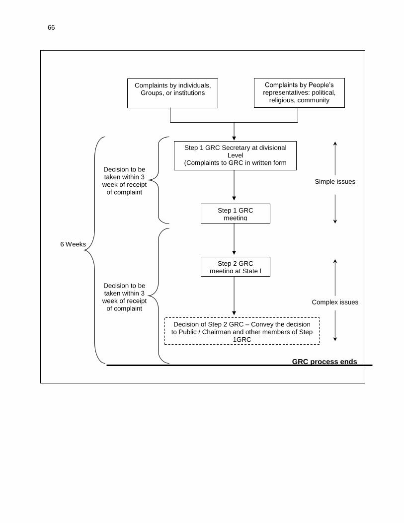
66
Complaints by individuals, Groups, or institutions
Complaints by People’s representatives: political,
religious, community
Step 1 GRC Secretary at divisional Level
(Complaints to GRC in written form
Step 1 GRC meeting
Step 2 GRC meeting at State l
Level
Decision of Step 2 GRC – Convey the decision to Public / Chairman and other members of Step
1GRC
Decision to be taken within 3
week of receipt of complaint
Decision to be taken within 3
week of receipt of complaint
GRC process ends
Simple issues
Complex issues
6 Weeks
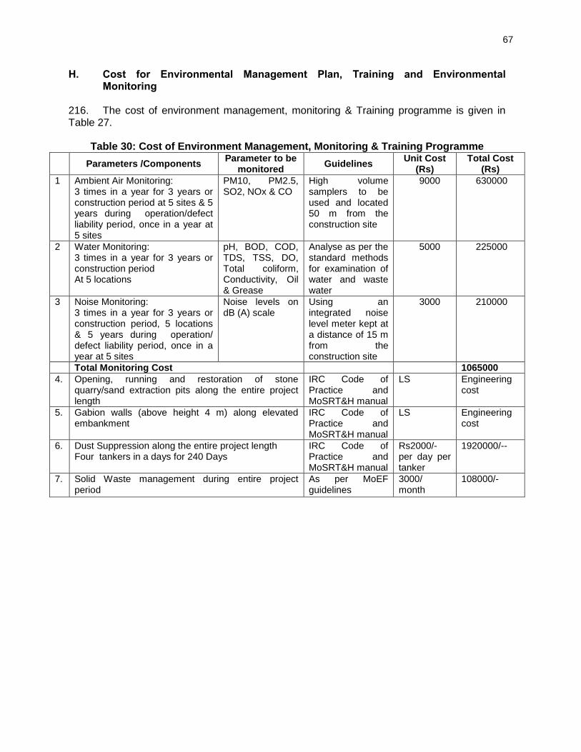
67
H. Cost for Environmental Management Plan, Training and Environmental Monitoring
216. The cost of environment management, monitoring & Training programme is given in Table 27.
Table 30: Cost of Environment Management, Monitoring & Training Programme
Parameters /Components Parameter to be
monitored Guidelines
Unit Cost (Rs)
Total Cost (Rs)
1 Ambient Air Monitoring: 3 times in a year for 3 years or construction period at 5 sites & 5 years during operation/defect liability period, once in a year at 5 sites
PM10, PM2.5, SO2, NOx & CO
High volume samplers to be used and located 50 m from the construction site
9000 630000
2 Water Monitoring: 3 times in a year for 3 years or construction period At 5 locations
pH, BOD, COD, TDS, TSS, DO, Total coliform, Conductivity, Oil & Grease
Analyse as per the standard methods for examination of water and waste water
5000 225000
3 Noise Monitoring: 3 times in a year for 3 years or construction period, 5 locations & 5 years during operation/ defect liability period, once in a year at 5 sites
Noise levels on dB (A) scale
Using an integrated noise level meter kept at a distance of 15 m from the construction site
3000 210000
Total Monitoring Cost 1065000
4. Opening, running and restoration of stone quarry/sand extraction pits along the entire project length
IRC Code of Practice and MoSRT&H manual
LS Engineering cost
5. Gabion walls (above height 4 m) along elevated embankment
IRC Code of Practice and MoSRT&H manual
LS Engineering cost
6. Dust Suppression along the entire project length Four tankers in a days for 240 Days
IRC Code of Practice and MoSRT&H manual
Rs2000/- per day per tanker
1920000/--
7. Solid Waste management during entire project period
As per MoEF guidelines
3000/ month
108000/-
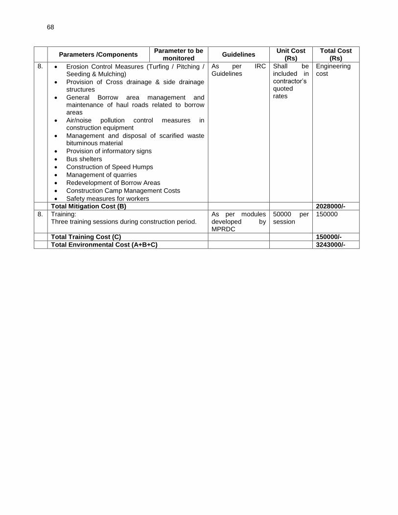
68
Parameters /Components Parameter to be
monitored Guidelines
Unit Cost (Rs)
Total Cost (Rs)
8. Erosion Control Measures (Turfing / Pitching / Seeding & Mulching)
Provision of Cross drainage & side drainage structures
General Borrow area management and maintenance of haul roads related to borrow areas
Air/noise pollution control measures in construction equipment
Management and disposal of scarified waste bituminous material
Provision of informatory signs
Bus shelters
Construction of Speed Humps
Management of quarries
Redevelopment of Borrow Areas
Construction Camp Management Costs
Safety measures for workers
As per IRC Guidelines
Shall be included in contractor’s quoted rates
Engineering cost
Total Mitigation Cost (B) 2028000/-
8. Training: Three training sessions during construction period.
As per modules developed by MPRDC
50000 per session
150000
Total Training Cost (C) 150000/-
Total Environmental Cost (A+B+C) 3243000/-
69
VIII. CONCLUSIONS AND RECOMMENDATIONS 217. The assessment of environment impacts for the sub-project shows that there are no significant, long term impacts. Most impacts are short term and limited to the construction stage. Key conclusions on the environmental implications of the project are given in the paras below. A. Environmental Gains Due to Proposed Work Justifying Implementation 218. The project entails various impacts on the project setting. There are many impacts bearing benefits to the area against the limited number and magnitude of negative impacts. These include the following: (i) the project will substantially improve the transport efficiency on the roads. (iii) the project once implemented will improve the overall environmental conditions with better roads, fuel efficiency and environmental protection measures (iv) will reduce traffic congestion particularly at junctions hence, air pollution due to idling of the vehicles. B. Potential Impacts and Mitigation 219. The finding of IEE indicates that project is unlikely to cause any significant adverse environmental impacts. While some of the impacts are negative, there are many bearing benefits to the area. Most of the impacts are likely to occur during construction stage and are temporary in nature. Anticipated minor impacts will be mitigated through the implementation of mitigation measures summarized in the Environmental Management Plan. 220. Factors contributing to minimal impacts include, widening of the project road confined within the available RoW, presence of no sensitive environmental issue like wildlife sanctuary, national park, bio reserve, with 10 km from the project road and most of water body crossed by the road are non-perennial in nature except one which is already bridged. However, some of the impacts are unavoidable. These impacts with mitigation measures are indicated below:
About 60 trees will need be cut with prior permission of district or forest authorities. Compensatory Tree plantation on the basis of 1:10 will be made to compensate this loss. Preventive measures shall be taken into consideration during construction phase especially in rainy months, to prevent soil erosion because of tree cutting and alteration of ground flora.
Air Pollution due to construction activities and operation of hot mix plant will be controlled through adoption of dust suppression measures and provision of high stack for good dispersion of gaseous emission from hot mix plant.
Noise levels may increase during the construction phase due to operation of construction machineries. All the construction equipment and DG set will be well maintained and fitted with silencers.
Waste materials generated during construction phase may contaminate soil, surface and ground water resources. Waste shall be segregated and reused or disposed of in environmentally acceptable manner.
Along the project stretch, few religious structures are located. Appropriate design options are exercised to minimize the loss of such structures.
The social issues are addressed through Social Safeguards, Due Diligence reports prepared as per SPS of ADB.
70
C. Irreplaceable Resources 221. The project does not pass through any protected areas, or eco sensitive areas. The construction material will also be sourced from identified and approved sources. As such, there are no environmental sensitive resources found in the project area, which is likely to be affected due to the project. D. Post IEE Surveillance and Monitoring 222. While an IEE is meant to provide a comprehensive understanding of the environment status of the area under the study, post IEE surveillance is the means to ensure that the significant impacts identified are adequately mitigated as per the proposed mitigation plan. A detailed monitoring plan has been provided as part of the Environmental Management Plan. Air, water quality, noise, soil erosion, and tree survival rate monitoring and reporting along with the follow up actions in case of deviation from the norms have been detailed out. The frequency has been set in consideration of the likely impacts. E. Public Consultations 223. The project received support and consent from most of local people. The local people did not perceive any adverse impact due to the proposed project. Environmental awareness and likewise concern were found generally low. People, however expressed the desire of minimising the tree cutting. F. Recommendations 224. Effective EMP implementation is essential for elimination or minimization of the identified impacts. The MPRDC shall ensure that EMP and EMoP is included in Bill of Quantity (BOQ) and forms part of bid document and civil works contract. The same shall be revised if necessary during project implementation or if there is any change in the project design. 225. MPRDC needs capacity building and practical exposure. Adequate training shall be imparted as proposed under environmental management plan to enhance the capability of concerned EA officials.
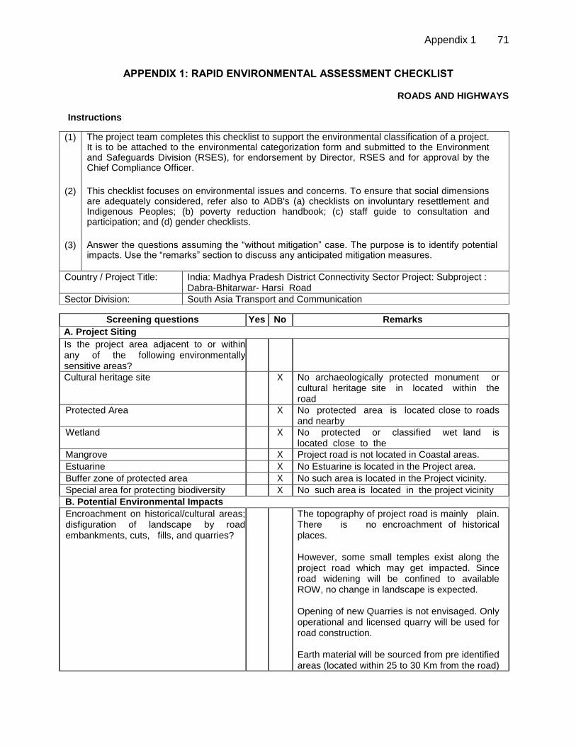
Appendix 1 71
APPENDIX 1: RAPID ENVIRONMENTAL ASSESSMENT CHECKLIST
ROADS AND HIGHWAYS
Instructions
Screening questions Yes No Remarks
A. Project Siting
Is the project area adjacent to or within any of the following environmentally sensitive areas?
Cultural heritage site X No archaeologically protected monument or cultural heritage site in located within the road
Protected Area X No protected area is located close to roads and nearby
Wetland X No protected or classified wet land is located close to the
Mangrove X Project road is not located in Coastal areas.
Estuarine X No Estuarine is located in the Project area.
Buffer zone of protected area X No such area is located in the Project vicinity.
Special area for protecting biodiversity X No such area is located in the project vicinity
B. Potential Environmental Impacts
Encroachment on historical/cultural areas; disfiguration of landscape by road embankments, cuts, fills, and quarries?
The topography of project road is mainly plain. There is no encroachment of historical places. However, some small temples exist along the project road which may get impacted. Since road widening will be confined to available ROW, no change in landscape is expected. Opening of new Quarries is not envisaged. Only operational and licensed quarry will be used for road construction. Earth material will be sourced from pre identified areas (located within 25 to 30 Km from the road)
(1)
(2)
(3)
The project team completes this checklist to support the environmental classification of a project. It is to be attached to the environmental categorization form and submitted to the Environment and Safeguards Division (RSES), for endorsement by Director, RSES and for approval by the Chief Compliance Officer.
This checklist focuses on environmental issues and concerns. To ensure that social dimensions are adequately considered, refer also to ADB's (a) checklists on involuntary resettlement and Indigenous Peoples; (b) poverty reduction handbook; (c) staff guide to consultation and participation; and (d) gender checklists.
Answer the questions assuming the “without mitigation” case. The purpose is to identify potential impacts. Use the “remarks” section to discuss any anticipated mitigation measures.
Country / Project Title: India: Madhya Pradesh District Connectivity Sector Project: Subproject : Dabra-Bhitarwar- Harsi Road
Sector Division: South Asia Transport and Communication
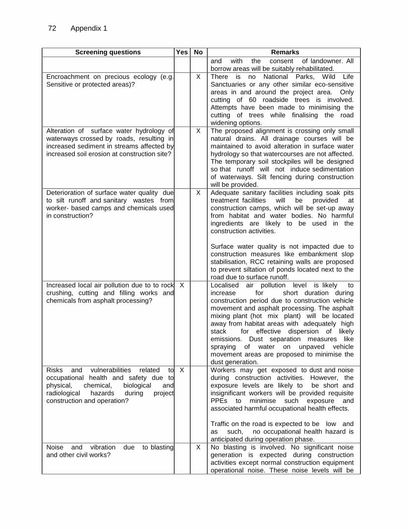
72 Appendix 1
Screening questions Yes No Remarks
and with the consent of landowner. All borrow areas will be suitably rehabilitated.
Encroachment on precious ecology (e.g. Sensitive or protected areas)?
X There is no National Parks, Wild Life Sanctuaries or any other similar eco-sensitive areas in and around the project area. Only cutting of 60 roadside trees is involved. Attempts have been made to minimising the cutting of trees while finalising the road widening options.
Alteration of surface water hydrology of waterways crossed by roads, resulting in increased sediment in streams affected by increased soil erosion at construction site?
X The proposed alignment is crossing only small natural drains. All drainage courses will be maintained to avoid alteration in surface water hydrology so that watercourses are not affected. The temporary soil stockpiles will be designed so that runoff will not induce sedimentation of waterways. Silt fencing during construction will be provided.
Deterioration of surface water quality due to silt runoff and sanitary wastes from worker- based camps and chemicals used in construction?
X Adequate sanitary facilities including soak pits treatment facilities will be provided at construction camps, which will be set-up away from habitat and water bodies. No harmful ingredients are likely to be used in the construction activities. Surface water quality is not impacted due to construction measures like embankment slop stabilisation, RCC retaining walls are proposed to prevent siltation of ponds located next to the road due to surface runoff.
Increased local air pollution due to to rock crushing, cutting and filling works and chemicals from asphalt processing?
X Localised air pollution level is likely to increase for short duration during construction period due to construction vehicle movement and asphalt processing. The asphalt mixing plant (hot mix plant) will be located away from habitat areas with adequately high stack for effective dispersion of likely emissions. Dust separation measures like spraying of water on unpaved vehicle movement areas are proposed to minimise the dust generation.
Risks and vulnerabilities related to occupational health and safety due to physical, chemical, biological and radiological hazards during project construction and operation?
X Workers may get exposed to dust and noise during construction activities. However, the exposure levels are likely to be short and insignificant workers will be provided requisite PPEs to minimise such exposure and associated harmful occupational health effects. Traffic on the road is expected to be low and as such, no occupational health hazard is anticipated during operation phase.
Noise and vibration due to blasting and other civil works?
X No blasting is involved. No significant noise generation is expected during construction activities except normal construction equipment operational noise. These noise levels will be
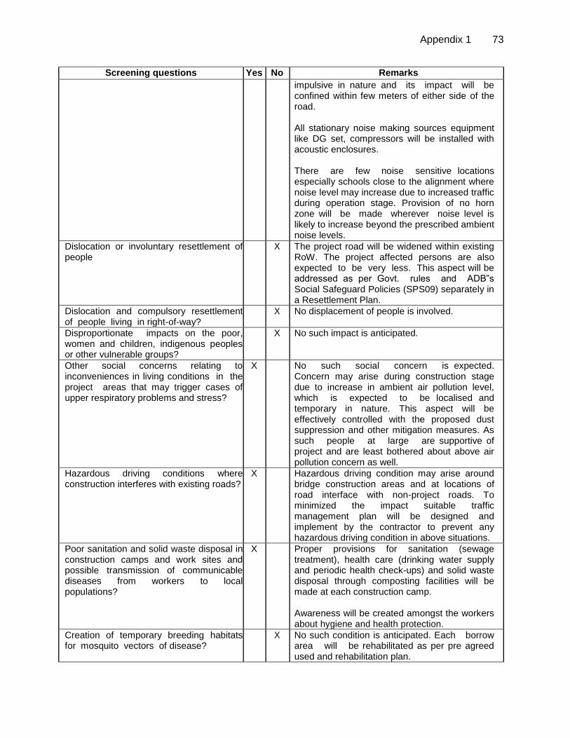
Appendix 1 73
Screening questions Yes No Remarks
impulsive in nature and its impact will be confined within few meters of either side of the road. All stationary noise making sources equipment like DG set, compressors will be installed with acoustic enclosures. There are few noise sensitive locations especially schools close to the alignment where noise level may increase due to increased traffic during operation stage. Provision of no horn zone will be made wherever noise level is likely to increase beyond the prescribed ambient noise levels.
Dislocation or involuntary resettlement of people
X The project road will be widened within existing RoW. The project affected persons are also expected to be very less. This aspect will be addressed as per Govt. rules and ADB‟s Social Safeguard Policies (SPS09) separately in a Resettlement Plan.
Dislocation and compulsory resettlement of people living in right-of-way?
X No displacement of people is involved.
Disproportionate impacts on the poor, women and children, indigenous peoples or other vulnerable groups?
X No such impact is anticipated.
Other social concerns relating to inconveniences in living conditions in the project areas that may trigger cases of upper respiratory problems and stress?
X No such social concern is expected. Concern may arise during construction stage due to increase in ambient air pollution level, which is expected to be localised and temporary in nature. This aspect will be effectively controlled with the proposed dust suppression and other mitigation measures. As such people at large are supportive of project and are least bothered about above air pollution concern as well.
Hazardous driving conditions where construction interferes with existing roads?
X Hazardous driving condition may arise around bridge construction areas and at locations of road interface with non-project roads. To minimized the impact suitable traffic management plan will be designed and implement by the contractor to prevent any hazardous driving condition in above situations.
Poor sanitation and solid waste disposal in construction camps and work sites and possible transmission of communicable diseases from workers to local populations?
X Proper provisions for sanitation (sewage treatment), health care (drinking water supply and periodic health check-ups) and solid waste disposal through composting facilities will be made at each construction camp. Awareness will be created amongst the workers about hygiene and health protection.
Creation of temporary breeding habitats for mosquito vectors of disease?
X No such condition is anticipated. Each borrow area will be rehabilitated as per pre agreed used and rehabilitation plan.
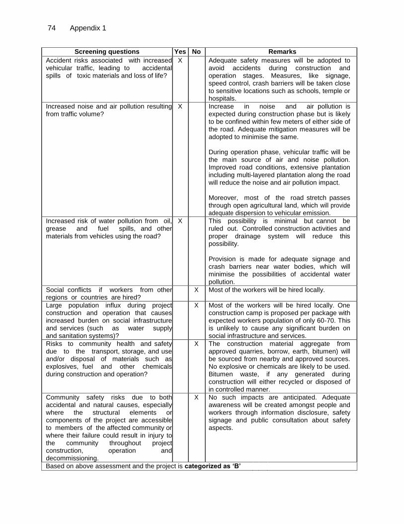
74 Appendix 1
Screening questions Yes No Remarks
Accident risks associated with increased vehicular traffic, leading to accidental spills of toxic materials and loss of life?
X Adequate safety measures will be adopted to avoid accidents during construction and operation stages. Measures, like signage, speed control, crash barriers will be taken close to sensitive locations such as schools, temple or hospitals.
Increased noise and air pollution resulting from traffic volume?
X Increase in noise and air pollution is expected during construction phase but is likely to be confined within few meters of either side of the road. Adequate mitigation measures will be adopted to minimise the same. During operation phase, vehicular traffic will be the main source of air and noise pollution. Improved road conditions, extensive plantation including multi-layered plantation along the road will reduce the noise and air pollution impact. Moreover, most of the road stretch passes through open agricultural land, which will provide adequate dispersion to vehicular emission.
Increased risk of water pollution from oil, grease and fuel spills, and other materials from vehicles using the road?
X This possibility is minimal but cannot be ruled out. Controlled construction activities and proper drainage system will reduce this possibility. Provision is made for adequate signage and crash barriers near water bodies, which will minimise the possibilities of accidental water pollution.
Social conflicts if workers from other regions or countries are hired?
X Most of the workers will be hired locally.
Large population influx during project construction and operation that causes increased burden on social infrastructure and services (such as water supply and sanitation systems)?
X Most of the workers will be hired locally. One construction camp is proposed per package with expected workers population of only 60-70. This is unlikely to cause any significant burden on social infrastructure and services.
Risks to community health and safety due to the transport, storage, and use and/or disposal of materials such as explosives, fuel and other chemicals during construction and operation?
X The construction material aggregate from approved quarries, borrow, earth, bitumen) will be sourced from nearby and approved sources. No explosive or chemicals are likely to be used. Bitumen waste, if any generated during construction will either recycled or disposed of in controlled manner.
Community safety risks due to both accidental and natural causes, especially where the structural elements or components of the project are accessible to members of the affected community or where their failure could result in injury to the community throughout project construction, operation and decommissioning.
X No such impacts are anticipated. Adequate awareness will be created amongst people and workers through information disclosure, safety signage and public consultation about safety aspects.
Based on above assessment and the project is categorized as ‘B’
Appendix 2 75
APPENDIX 2: GUIDELINES FOR BORROW AREAS MANAGEMENT
A. Selection of Borrow Areas
1. Location of borrow areas shall be finalized as per IRC: 10-1961 guidelines. The finalization of locations in case of borrows areas identified in private land shall depend upon the formal agreement between landowners and contractor. If, agreement is not reached between the contractor and landowners for the identified borrow areas sites, arrangement for locating the source of supply of material for embankment and sub-grade as well as compliance to environment requirements in respect of excavation and borrow areas as stipulated from time to time by the Ministry of Environment and Forests, Government of India, and local bodies, as applicable shall be the sole responsibility of the contractor. The contractor in addition to the established practices, rules and regulation will also consider following criteria before finalizing the locations.
a. The borrow area should not be located in agriculture field unless unavoidable i.e.
barren land is not available.
b. The borrow pits preferably should not be located along the roads.
c. The loss of productive and agriculture soil should be minimum.
d. The loss of vegetation is almost nil or minimum.
e. The Contractor will ensure that suitable earth is available.
B. Contractor’s Responsibility 2. The Contractor shall obtain representative samples from each of the identified borrow areas and have these tested at the site laboratory following a testing programme approved by the Engineer. It shall be ensured that the sub-grade material when compacted to the density requirements shall yield the design CBR value of the sub-grade. Contractor shall begin operations keeping in mind following;
a. Haulage of material to embankments or other areas of fill shall proceed only when sufficient spreading and compaction plants is operating at the place of deposition.
b. No excavated acceptable material other than surplus to requirements of the Contract shall be removed from the site. Contractor should be permitted to remove acceptable material from the site to suit his operational procedure, then shall make consequent deficit of material arising there from.
c. Where the excavation reveals a combination of acceptable and unacceptable materials, the Contractor shall, unless otherwise agreed by the Engineer, carry out the excavation in such a manner that the acceptable materials are excavated separately for use in the permanent works without contamination by the un-acceptable materials. The acceptable material shall be stockpiled separately.
d. The Contractor shall ensure that he does not adversely affect the stability of excavation or fills by the methods of stockpiling materials, use of plants are siting of temporary buildings or structures.
C. Borrowing From Different Land-Forms
1. Borrow Areas located in Agricultural Lands
a. The preservation of topsoil will be carried out in stockpile.
76 Appendix 2
b. A 15 cm topsoil will be stripped off from the borrow pit and this will be stored in stockpiles in a designated area for height not exceeding 2m and side slopes not steeper than 1:2 (Vertical: Horizontal).
c. Borrowing of earth will be carried out up to a depth of 1.5m from the existing ground level.
d. Borrowing of earth will not be done continuously throughout the stretch. e. Ridges of not less than 8m widths will be left at intervals not exceeding 300m. f. Small drains will be cut through the ridges, if necessary, to facilitate drainage. g. The slope of the edges will be maintained not steeper than 1:4 (vertical:
Horizontal). h. The depth of borrow pits will not be more than 30 cm after stripping the 15 cm
topsoil aside.
2. Borrow Areas located in Elevated Lands
a. The preservation of topsoil will be carried out in stockpile. b. A 15 cm topsoil will be stripped off from the borrow pit and this will be stored in
stockpiles in a designated area for height not exceeding 2m and side slopes not steeper than 1:2 (Vertical: Horizontal).
c. At location where private owners desire their fields to be levelled, the borrowing shall be done to a depth of not more than 1.5m or up to the level of surrounding fields
3. Borrow Areas near River Side
a. The preservation of topsoil will be carried out in stockpile. b. A 15 cm topsoil will be stripped off from the borrow pit and this will be stored in
stockpiles in a designated area for height not exceeding 2m and side slopes not steeper than 1:2 (Vertical: Horizontal).
c. Borrow area near to any surface water body will be at least at a distance of 15m from the toe of the bank or high flood level, whichever is maximum.
4. Borrow Areas near Settlements
a. The preservation of topsoil will be carried out in stockpile. b. A 15 cm topsoil will be stripped off from the borrow pit and this will be stored in
stockpiles in a designated area for height not exceeding 2m and side slopes not steeper than 1:2 (Vertical: Horizontal).
c. Borrow pit location will be located at least 0.75 km from villages and settlements. If un-avoidable, the pit will not be dug for more than 30 cm and drains will be cut to facilitate drainage.
d. Borrow pits located in such location will be re-developed immediately after borrowing is completed. If spoils are dumped, that will be covered with a layers of stockpiled topsoil in accordance with compliance requirements with respect MOEF/SPCB guideline
5. Borrow Pits along the Road 3. Borrow pits along the road shall be discouraged and if deemed necessary and permitted by the Engineer; following precautions are recommended
Appendix 2 77
a. The preservation of topsoil will be carried out in stockpile. b. A 15 cm topsoil will be stripped off from the borrow pit and this will be stored in
stockpiles in a designated area for height not exceeding 2m and side slopes not steeper than 1:2 (Vertical: Horizontal).
c. Ridges of not less than 8m widths should be left at intervals not exceeding 300m. d. Small drains shall be cut through the ridges of facilitate drainage. e. The depth of the pits shall be so regulated that there bottom does not cut an
imaginary line having a slope of 1 vertical to 4 horizontal projected from the edge of the final section of bank, the maximum depth of any case being limited to 1.5m.
f. Also, no pit shall be dug within the offset width from the toe of the embankment required as per the consideration of stability with a minimum width of 10m.
6. Rehabilitation of Borrow Areas
a. The objective of the rehabilitation programme is to return the borrow pit sites to a
safe and secure area, which the general public should be able to safely enter and enjoy. Securing borrow pits in a stable condition is fundamental requirement of the rehabilitation process. This could be achieved by filling the borrow pit floor to approximately the access road level.
b. Re-development plan shall be prepared by the Contractor before the start of work in line with the owners will require and to the satisfaction of owner. The Borrow Areas shall be rehabilitated as per following;
c. Borrow pits shall be backfilled with rejected construction wastes and will be given a vegetative cover. If this is not possible, then excavation sloped will be smoothed and depression will be filled in such a way that it looks more or less like the original round surface
d. Borrow areas might be used for aquaculture in case landowner wants such development. In that case, such borrow area will be photographed after their post use restoration and Environment Expert of Supervision Consultant will certify the post use redevelopment.
e. The Contractor will keep record of photographs of various stages i.e., before using materials from the location (pre-project), for the period borrowing activities (construction Phase) and after rehabilitation (post development), to ascertain the pre and post borrowing status of the area.
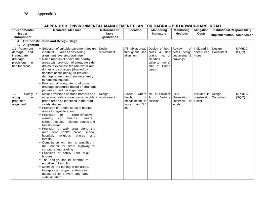
78 Appendix 3
APPENDIX 3: ENVIRONMENTAL MANAGEMENT PLAN FOR DABRA – BHITARWAR-HARSI ROAD Environmental
Issue/ Component
Remedial Measure
Reference to laws
/guidelines
Location Monitoring indicators
Monitoring Methods
Mitigation Costs
Institutional Responsibility
Implementation Supervision
A. Pre-construction and Design Stage
1. Alignment
1.1 Pavement damage and inadequate drainage provisions in habitat areas
Selection of suitable pavement design inhabitat areas considering alignment level and drainage
Raise road level above the nearby areas with provision of adequate side drains to evacuate the rain water and domestic discharges (drained by habitats occasionally) to prevent damage to road and rain water entry to habitats’ houses.
Provision of adequate no of cross drainage structures based on drainage pattern around the alignment
Design requirement
All habitat areas throughout the alignment
Design of both cross & side drains ,no. of slab/box culverts ,no & size of Hume pipes
Review of detail design documents & drawings
Included in construction cost
Design Consultant
MPRDC (SQC)
1.2 Safety along the proposed alignment
Make provisions of crash barriers and other road safety measures at accident prone areas as identified in the road safety studies
Provision of rumble strips in habitat areas to regulate speed.
Provision of retro-reflective warning sign boards nears school, hospital, religious places and forests areas
Provision of walk area along the road near habitat areas, school, hospital, religious places and forests
Compliance with norms specified in IRC codes for state highway for curvature and grading
Provision of safety kerb at all bridges
The design should attempt to equalize cut and fill.
Minimize the cutting in hill areas. Incorporate slope stabilization measures to prevent any land slide situation.
Design requirement
Places where height of embankment is more than 3.0 m.
No. of accident & Vehicle collision
Field observation ,interview of locals
Included in construction cost
Design Consultant
MPRDC (SQC)
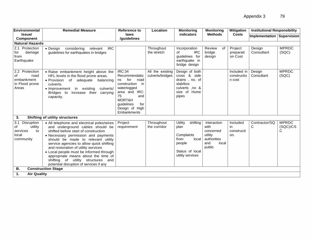
Appendix 3 79
Environmental Issue/
Component
Remedial Measure
Reference to laws
/guidelines
Location Monitoring indicators
Monitoring Methods
Mitigation Costs
Institutional Responsibility
Implementation Supervision
2. Natural Hazards
2.1 Protection for damage from Earthquake
Design considering relevant IRC guidelines for earthquakes in bridges
Throughout the stretch
Incorporation of IRC guidelines for earthquake in bridge design
Review of bridge design
Project preparation Cost
Design Consultant
MPRDC (SQC)
2.2 Protection of road embankment in Flood prone Areas
Raise embankment height above the HFL levels in the flood prone areas.
Provision of adequate balancing culverts.
Improvement in existing culverts/ Bridges to increase their carrying capacity.
IRC:34 Recommendations for road construction in waterlogged area and IRC: 75 and MORT&H guidelines for Design of High Embankments
All the existing culverts/bridges
Design of both cross & side drains , no. of slab/box culverts ,no & size of Hume pipes
Included in construction cost
Design Consultant
MPRDC (SQC)
3. Shifting of utility structures
3.1 Disruption of utility services to local community
All telephone and electrical poles/wires and underground cables should be shifted before start of construction
Necessary permission and payments should be made to relevant utility service agencies to allow quick shifting and restoration of utility services
Local people must be informed through appropriate means about the time of shifting of utility structures and potential disruption of services if any
Project requirement
Throughout the corridor
Utility shifting plan Complaints from local people Status of local utility services
Interaction with concerned utility authorities and local public
Included in construction.
Contractor/SQ C
MPRDC (SQC)/CSC
B. Construction Stage
1. Air Quality
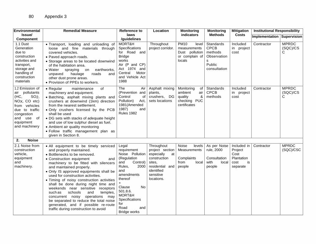
80 Appendix 3
Environmental Issue/
Component
Remedial Measure
Reference to laws
/guidelines
Location Monitoring indicators
Monitoring Methods
Mitigation Costs
Institutional Responsibility
Implementation Supervision
1.1 Dust Generation due to construction activities and transport, storage and handling of construction materials
Transport, loading and unloading of loose and fine materials through covered vehicles.
Paved approach roads.
Storage areas to be located downwind of the habitation area.
Water spraying on earthworks, unpaved haulage roads and other dust prone areas.
Provision of PPEs to workers.
MORT&H Specifications for Road and Bridge works Air (P and CP) Act 1974 and Central Motor and Vehicle Act 1988
Throughout project corridor.
PM10 level measurements Dust pollution or complain of locals
Standards CPCB methods Observations Public consultation
Included in project cost
Contractor
MPRDC (SQC)/CSC
1.2 Emission of air pollutants (HC, SO2,
NOX, CO etc)
from vehicles due to traffic congestion and use of equipment and machinery
Regular maintenance of machinery and equipment.
Batching, asphalt mixing plants and crushers at downwind (1km) direction from the nearest settlement.
Only crushers licensed by the PCB shall be used
DG sets with stacks of adequate height and use of low sulphur diesel as fuel.
Ambient air quality monitoring
Follow traffic management plan as given in Section 8.
The Air (Prevention and Control of Pollution) Act, 1981(Amended 1987) and Rules 1982
Asphalt mixing plants, crushers, DG sets locations
Monitoring of ambient air quality & checking PUC certificates
Standards CPCB methods
Included in project cost
Contractor
MPRDC (SQC)/CSC
2. Noise
2.1 Noise from construction vehicle, equipment and machinery.
All equipment to be timely serviced and properly maintained.
Bottlenecks to be removed.
Construction equipment and machinery to be fitted with silencers and maintained properly.
Only IS approved equipments shall be used for construction activities.
Timing of noisy construction activities shall be done during night time and weekends near sensitive receptors such as schools and temples, concurrent noisy operations may be separated to reduce the total noise generated, and if possible re-route traffic during construction to avoid
Legal requirement Noise Pollution (Regulation and Control) Rules, 2000 and amendments thereof + Clause No 501.8.6. MORT&H Specifications for Road and Bridge works
Throughout project section especially at construction sites, residential and identified sensitive locations.
Noise levels Measurements Complaints from local people
As per Noise rule, 2000 Consultation with local people
Included in Project Cost Plantation cost is separate
Contractor
MPRDC (SQC)/CSC
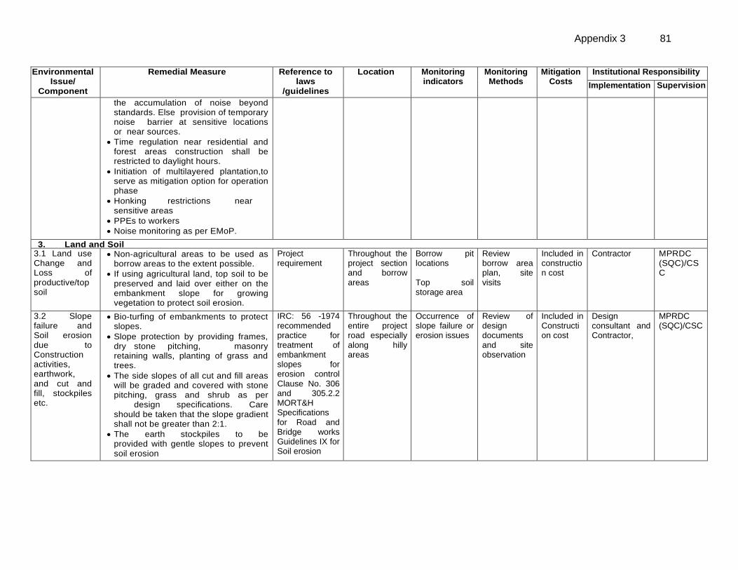
Appendix 3 81
Environmental Issue/
Component
Remedial Measure
Reference to laws
/guidelines
Location Monitoring indicators
Monitoring Methods
Mitigation Costs
Institutional Responsibility
Implementation Supervision
the accumulation of noise beyond standards. Else provision of temporary noise barrier at sensitive locations or near sources.
Time regulation near residential and forest areas construction shall be restricted to daylight hours.
Initiation of multilayered plantation,to serve as mitigation option for operation phase
Honking restrictions near sensitive areas
PPEs to workers
Noise monitoring as per EMoP.
3. Land and Soil 3.1 Land use Change and Loss of productive/top soil
Non-agricultural areas to be used as borrow areas to the extent possible.
If using agricultural land, top soil to be preserved and laid over either on the embankment slope for growing vegetation to protect soil erosion.
Project requirement
Throughout the project section and borrow areas
Borrow pit locations Top soil storage area
Review borrow area plan, site visits
Included in construction cost
Contractor
MPRDC (SQC)/CSC
3.2 Slope failure and Soil erosion due to Construction activities, earthwork, and cut and fill, stockpiles etc.
Bio-turfing of embankments to protect slopes.
Slope protection by providing frames, dry stone pitching, masonry retaining walls, planting of grass and trees.
The side slopes of all cut and fill areas will be graded and covered with stone pitching, grass and shrub as per design specifications. Care should be taken that the slope gradient shall not be greater than 2:1.
The earth stockpiles to be provided with gentle slopes to prevent soil erosion
IRC: 56 -1974 recommended practice for treatment of embankment slopes for erosion control Clause No. 306 and 305.2.2 MORT&H Specifications for Road and Bridge works Guidelines IX for Soil erosion
Throughout the entire project road especially along hilly areas
Occurrence of slope failure or erosion issues
Review of design documents and site observation
Included in Construction cost
Design consultant and Contractor,
MPRDC (SQC)/CSC
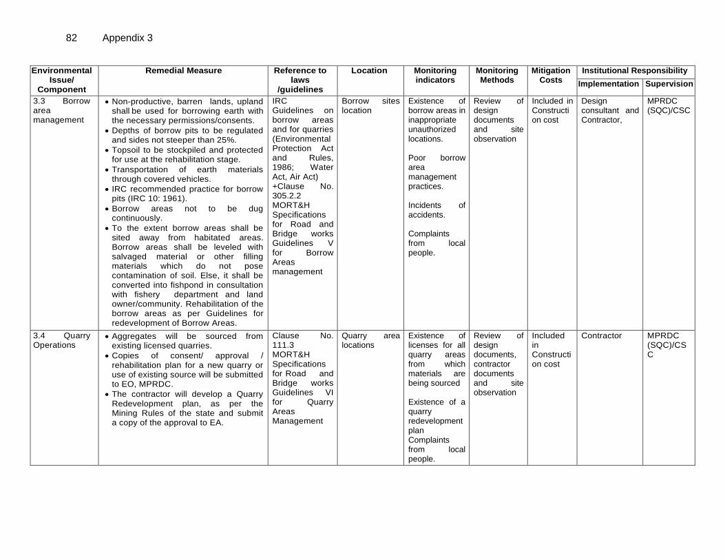
82 Appendix 3
Environmental Issue/
Component
Remedial Measure
Reference to laws
/guidelines
Location Monitoring indicators
Monitoring Methods
Mitigation Costs
Institutional Responsibility
Implementation Supervision
3.3 Borrow area management
Non-productive, barren lands, upland shall be used for borrowing earth with the necessary permissions/consents.
Depths of borrow pits to be regulated and sides not steeper than 25%.
Topsoil to be stockpiled and protected for use at the rehabilitation stage.
Transportation of earth materials through covered vehicles.
IRC recommended practice for borrow pits (IRC 10: 1961).
Borrow areas not to be dug continuously.
To the extent borrow areas shall be sited away from habitated areas. Borrow areas shall be leveled with salvaged material or other filling materials which do not pose contamination of soil. Else, it shall be converted into fishpond in consultation with fishery department and land owner/community. Rehabilitation of the borrow areas as per Guidelines for redevelopment of Borrow Areas.
IRC Guidelines on borrow areas and for quarries (Environmental Protection Act and Rules, 1986; Water Act, Air Act) +Clause No. 305.2.2 MORT&H Specifications for Road and Bridge works Guidelines V for Borrow Areas management
Borrow sites location
Existence of borrow areas in inappropriate unauthorized locations. Poor borrow area management practices. Incidents of accidents. Complaints from local people.
Review of design documents and site observation
Included in Construction cost
Design consultant and Contractor,
MPRDC (SQC)/CSC
3.4 Quarry Operations
Aggregates will be sourced from existing licensed quarries.
Copies of consent/ approval / rehabilitation plan for a new quarry or use of existing source will be submitted to EO, MPRDC.
The contractor will develop a Quarry Redevelopment plan, as per the Mining Rules of the state and submit a copy of the approval to EA.
Clause No. 111.3 MORT&H Specifications for Road and Bridge works Guidelines VI for Quarry Areas Management
Quarry area locations
Existence of licenses for all quarry areas from which materials are being sourced Existence of a quarry redevelopment plan Complaints from local people.
Review of design documents, contractor documents and site observation
Included in Construction cost
Contractor
MPRDC (SQC)/CSC
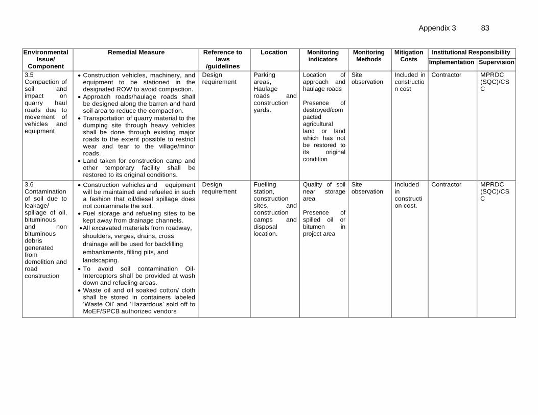
Appendix 3 83
Environmental Issue/
Component
Remedial Measure
Reference to laws
/guidelines
Location Monitoring indicators
Monitoring Methods
Mitigation Costs
Institutional Responsibility
Implementation Supervision
3.5 Compaction of soil and impact on quarry haul roads due to movement of vehicles and equipment
Construction vehicles, machinery, and equipment to be stationed in the designated ROW to avoid compaction.
Approach roads/haulage roads shall be designed along the barren and hard soil area to reduce the compaction.
Transportation of quarry material to the dumping site through heavy vehicles shall be done through existing major roads to the extent possible to restrict wear and tear to the village/minor roads.
Land taken for construction camp and other temporary facility shall be restored to its original conditions.
Design requirement
Parking areas, Haulage roads and construction yards.
Location of approach and haulage roads Presence of destroyed/compacted agricultural land or land which has not be restored to its original condition
Site observation
Included in construction cost
Contractor
MPRDC (SQC)/CSC
3.6 Contamination of soil due to leakage/ spillage of oil, bituminous and non bituminous debris generated from demolition and road construction
Construction vehicles and equipment will be maintained and refueled in such a fashion that oil/diesel spillage does not contaminate the soil.
Fuel storage and refueling sites to be kept away from drainage channels.
All excavated materials from roadway,
shoulders, verges, drains, cross
drainage will be used for backfilling
embankments, filling pits, and
landscaping.
To avoid soil contamination Oil-Interceptors shall be provided at wash down and refueling areas.
Waste oil and oil soaked cotton/ cloth shall be stored in containers labeled ‘Waste Oil’ and ‘Hazardous’ sold off to MoEF/SPCB authorized vendors
Design requirement
Fuelling station, construction sites, and construction camps and disposal location.
Quality of soil near storage area Presence of spilled oil or bitumen in project area
Site observation
Included in construction cost.
Contractor
MPRDC (SQC)/CSC
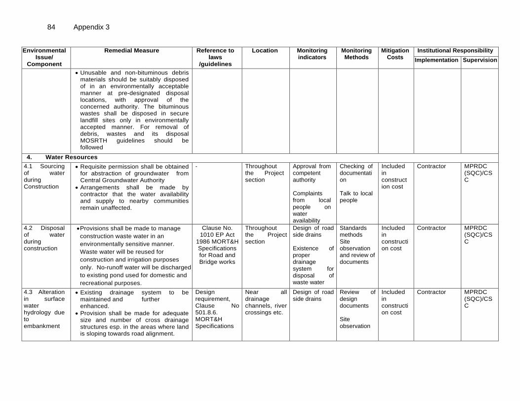
84 Appendix 3
Environmental Issue/
Component
Remedial Measure
Reference to laws
/guidelines
Location Monitoring indicators
Monitoring Methods
Mitigation Costs
Institutional Responsibility
Implementation Supervision
Unusable and non-bituminous debris materials should be suitably disposed of in an environmentally acceptable manner at pre-designated disposal locations, with approval of the concerned authority. The bituminous wastes shall be disposed in secure landfill sites only in environmentally accepted manner. For removal of debris, wastes and its disposal MOSRTH guidelines should be followed
4. Water Resources
4.1 Sourcing of water during Construction
Requisite permission shall be obtained for abstraction of groundwater from Central Groundwater Authority
Arrangements shall be made by contractor that the water availability and supply to nearby communities remain unaffected.
-
Throughout the Project section
Approval from competent authority Complaints from local people on water availability
Checking of documentation Talk to local people
Included in construction cost
Contractor
MPRDC (SQC)/CSC
4.2 Disposal of water during construction
Provisions shall be made to manage
construction waste water in an
environmentally sensitive manner.
Waste water will be reused for
construction and irrigation purposes
only. No-runoff water will be discharged
to existing pond used for domestic and
recreational purposes.
Clause No. 1010 EP Act
1986 MORT&H Specifications for Road and Bridge works
Throughout the Project section
Design of road side drains Existence of proper drainage system for disposal of waste water
Standards methods Site observation and review of documents
Included in construction cost
Contractor
MPRDC (SQC)/CSC
4.3 Alteration in surface water hydrology due to embankment
Existing drainage system to be maintained and further enhanced.
Provision shall be made for adequate size and number of cross drainage structures esp. in the areas where land is sloping towards road alignment.
Design requirement, Clause No 501.8.6. MORT&H Specifications for Road and Bridge
Near all drainage channels, river crossings etc.
Design of road side drains
Review of design documents Site observation
Included in construction cost
Contractor
MPRDC (SQC)/CSC
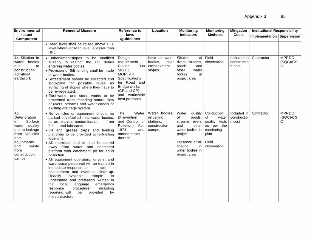
Appendix 3 85
Environmental Issue/
Component
Remedial Measure
Reference to laws
/guidelines
Location Monitoring indicators
Monitoring Methods
Mitigation Costs
Institutional Responsibility
Implementation Supervision
Road level shall be raised above HFL level wherever road level is lesser than HFL.
4.4 Siltation in water bodies due to construction activities/ earthwork
Embankment slopes to be modified suitably to restrict the soil debris entering water bodies.
Provision of Silt fencing shall be made at water bodies.
Silt/sediment should be collected and stockpiled for possible reuse as surfacing of slopes where they have to be re-vegetated.
Earthworks and stone works to be prevented from impeding natural flow of rivers, streams and water canals or existing drainage system.
Design requirement , Clause No 501.8.6. MORT&H Specifications for Road and Bridge works (CP and CP) and worldwide best practices
Near all water bodies, river embankment slopes.
Siltation of rivers, streams, ponds and other water bodies in project area
Field observation
Included in construction cost
Contractor
MPRDC (SQC)/CSC
4.5 Deterioration in Surface water quality due to leakage from vehicles and equipments and waste from construction camps.
No vehicles or equipment should be parked or refuelled near water-bodies, so as to avoid contamination from fuel and lubricants.
Oil and grease traps and fuelling platforms to be provided at re-fuelling locations.
All chemicals and oil shall be stored away from water and concreted platform with catchment pit for spills collection.
All equipment operators, drivers, and warehouse personnel will be trained in immediate response for spill containment and eventual clean-up. Readily available, simple to understand and preferably written in the local language emergency response procedure, including reporting, will be provided by the contractors
The Water (Prevention and Control of Pollution) Act, 1974 and amendments thereof.
Water bodies,
refuelling stations, construction camps.
Water quality of ponds, streams, rivers and other water bodies in project Presence of oil floating in water bodies in project area
Conduction of water quality tests as per the monitoring plan Field observation
Included in construction cost
Contractor
MPRDC (SQC)/CSC
86 Appendix 3
Environmental Issue/
Component
Remedial Measure
Reference to laws
/guidelines
Location Monitoring indicators
Monitoring Methods
Mitigation Costs
Institutional Responsibility
Implementation Supervision
Construction camp to be sited away from water bodies.
Wastes must be collected, stored and taken to approve disposal site only.
Water quality shall be monitored periodically
5. Flora and Fauna
5.1 Vegetation loss due to site preparation and construction activities and
Minimize tree cutting to the extent possible.
Roadside trees to be removed with prior approval of competent authority.
Compensatory plantation at 1:10 basis and additional plantation as per the IRC guidelines in consultation with Forest Department.
Regular maintenance of all trees planted.
Provision of LPG in construction camp as fuel source to avoid tree cutting, wherever possible.
Plantation of trees on both sides of the road. Integrate vegetation management (IVM) with the carriage way completely clear of vegetation. From the edge of the
road to the boundary of ROW, vegetation structured with smaller plants near the line and larger trees further away to avoid costly and provide habitats for a wide variety of plants and animals. Additional plantation near river banks to check erosion as part of compensatory plantation.
In the event of design changes during the construction stages additional assessments including the possibility to save trees shall be made by the EA.
Forest Conservation Act 1980 + IRC SP: 21 and IRC SP:66
Throughout project corridor
ROW width Number of trees for felling Compensatory plantation plan Number of trees replanted
Review of relevant documents – tree cutting permit, compensatory plantation plan Field observations
Road side plantation cost is included in project costs.
Relevant agency specialized in afforestation
MPRDC (SQC)/CSC
Appendix 3 87
Environmental Issue/
Component
Remedial Measure
Reference to laws
/guidelines
Location Monitoring indicators
Monitoring Methods
Mitigation Costs
Institutional Responsibility
Implementation Supervision
Road side Plantation Strategy as per IRC specifications including manuring.
Control use of pesticides/ fertilizers
6. Construction Camps 6.1 Impact associated with location
The contractor, no later than 30 days after the issuance of the Notice to proceed will prepare and submit a Health and Safety Plan to the Engineer (CSC) for review and approval. This H&S will have the following but not limited to the following measures
All camps should maintain minimum distance from following:
# 500 m from habitation # 500 m from forest areas where possible # 500 m from water bodies where possible # 500 m from through traffic route where possible
The average distance between two camps should be 50 km
Design Requirement
All construction camps
Location of campsites and distance from habitation, forest areas, water bodies, through traffic route and other construction camps
On site observation Interaction with workers and local community
Included in construction cost
Contractor and EO
MPRDC (SQC)/CSC
6.2 Worker’s Health in construction camp
The location, layout and basic facility provision of each labor camp will be submitted to SQC prior to their construction. The construction shall commence only after approval of SQC.
The contractor will maintain necessary living accommodation and ancillary facilities in functional and hygienic manner as approved by the EA.
Adequate water and sanitary latrines with septic tanks attached to soak pits shall be provided.
Preventive medical care to be provided to workers including a First-Aid kit that must be available in the camp.
Waste disposal facilities such as dust bins must be provided in the camps and regular disposal of waste must be carried out.
The Building and Other Construction workers (Regulation of Employment and Conditions of Service) Act 1996 and The Water (Prevention and Control of Pollution) Act, 1974 and amendments thereof
All construction camps
Camp health records Existence of proper first aid kit in camp site Complaints from local people
Camp records Site observation Consultation with local people living nearby
Part of the Contractors costs
Contractor
MPRDC (SQC)/CSC
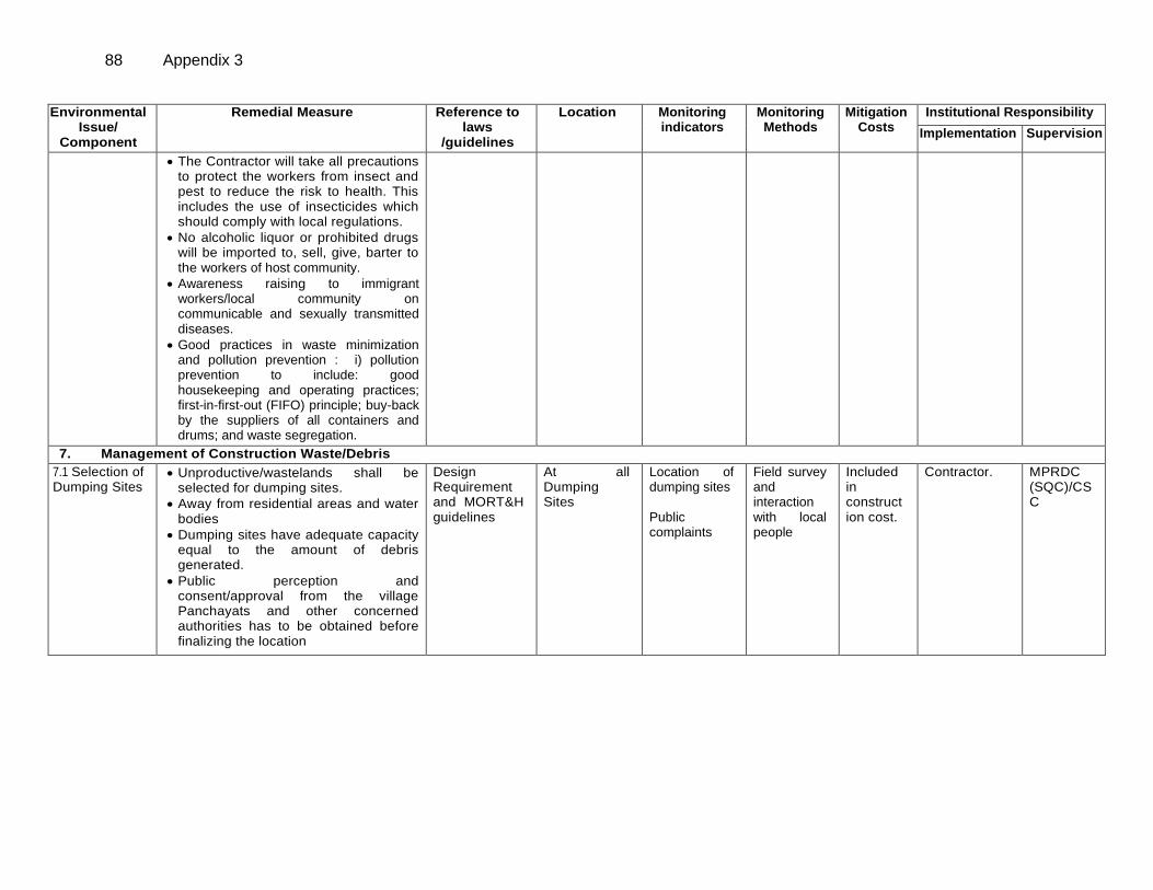
88 Appendix 3
Environmental Issue/
Component
Remedial Measure
Reference to laws
/guidelines
Location Monitoring indicators
Monitoring Methods
Mitigation Costs
Institutional Responsibility
Implementation Supervision
The Contractor will take all precautions to protect the workers from insect and pest to reduce the risk to health. This includes the use of insecticides which should comply with local regulations.
No alcoholic liquor or prohibited drugs will be imported to, sell, give, barter to the workers of host community.
Awareness raising to immigrant workers/local community on communicable and sexually transmitted diseases.
Good practices in waste minimization and pollution prevention : i) pollution prevention to include: good housekeeping and operating practices; first-in-first-out (FIFO) principle; buy-back by the suppliers of all containers and drums; and waste segregation.
7. Management of Construction Waste/Debris
7.1 Selection of Dumping Sites
Unproductive/wastelands shall be selected for dumping sites.
Away from residential areas and water bodies
Dumping sites have adequate capacity equal to the amount of debris generated.
Public perception and consent/approval from the village Panchayats and other concerned authorities has to be obtained before finalizing the location
Design Requirement and MORT&H guidelines
At all Dumping Sites
Location of dumping sites Public complaints
Field survey and interaction with local people
Included in construction cost.
Contractor.
MPRDC (SQC)/CSC
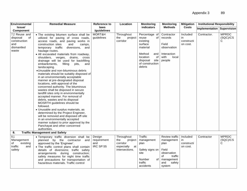
Appendix 3 89
Environmental Issue/
Component
Remedial Measure
Reference to laws
/guidelines
Location Monitoring indicators
Monitoring Methods
Mitigation Costs
Institutional Responsibility
Implementation Supervision
7.2 Reuse and disposal of construction and dismantled waste
The existing bitumen surface shall be utilized for paving of cross roads, access roads, and paving works in construction sites and camps, temporary traffic diversions, and haulage routes.
All excavated materials from roadway, shoulders, verges, drains, cross drainage will be used for backfilling embankments, filling pits, and landscaping.
Unusable and non-bituminous debris materials should be suitably disposed of in an environmentally acceptable manner at pre-designated disposal locations, with approval of the concerned authority. The bituminous wastes shall be disposed in secure landfill sites only in environmentally accepted manner. For removal of debris, wastes and its disposal MOSRTH guidelines should be followed.
Unusable and surplus materials, as determined by the Project Engineer, will be removed and disposed off-site in an environmentally accepted manner subject to prior approval by the Panchayat and other concerned authorities.
MORT&H guidelines
Throughout the project corridor
Percentage of reuse of existing surface material Method and location of disposal site of construction debris
Contractor records Field observation Interaction with local people
Included in construction cost.
Contractor.
MPRDC (SQC)/CSC
8. Traffic Management and Safety
8.1 Management of existing traffic and safety
Temporary traffic diversion shall be planned by the contractor and approved by the ‘Engineer’.
The traffic control plans shall contain details of diversions; traffic safety arrangements during construction; safety measures for night time traffic and precautions for transportation of hazardous materials. Traffic control
Design requirement and IRC SP:55
Throughout the project corridor especially at intersections.
Traffic management plan Safety signs on site Number of traffic accidents
Review traffic management plan Field observation of traffic management and safety system
Included in construction cost.
Contractor
MPRDC (SQC)/CSC
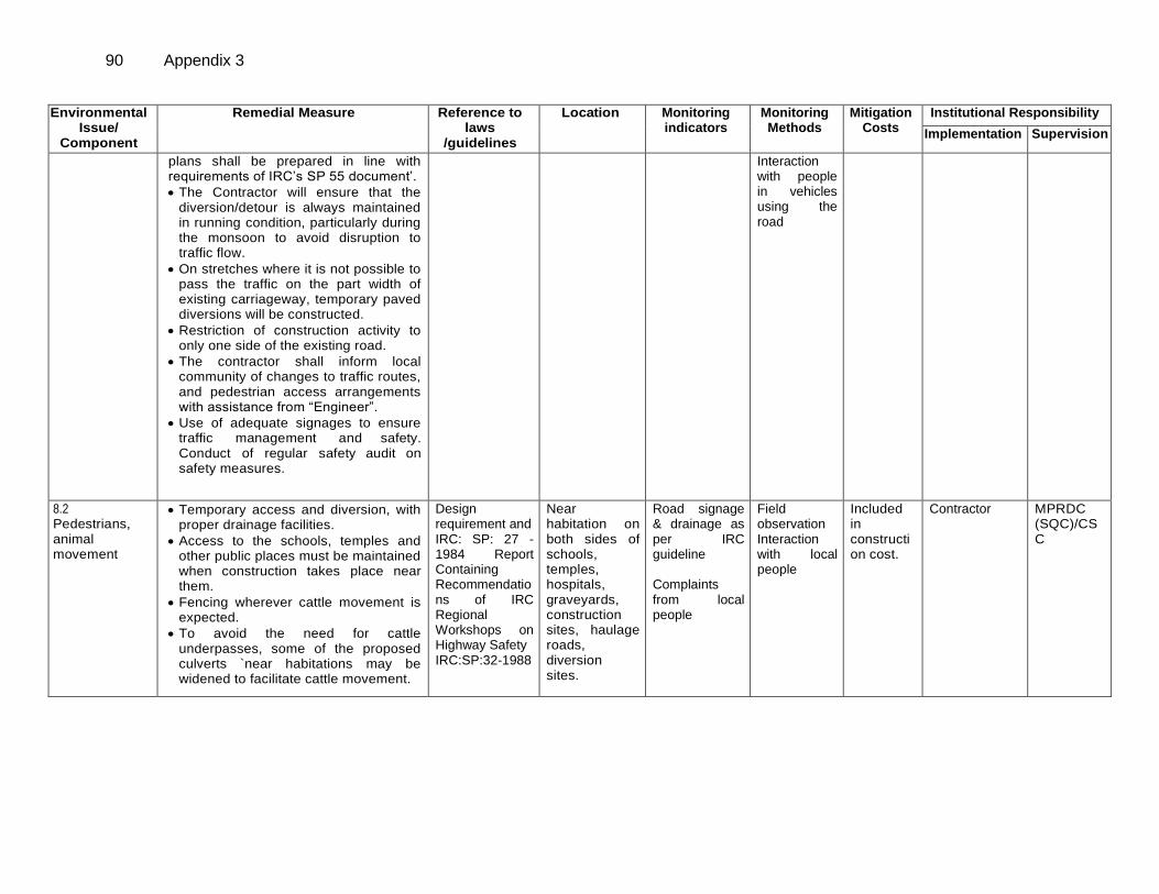
90 Appendix 3
Environmental Issue/
Component
Remedial Measure
Reference to laws
/guidelines
Location Monitoring indicators
Monitoring Methods
Mitigation Costs
Institutional Responsibility
Implementation Supervision
plans shall be prepared in line with requirements of IRC’s SP 55 document’.
The Contractor will ensure that the diversion/detour is always maintained in running condition, particularly during the monsoon to avoid disruption to traffic flow.
On stretches where it is not possible to pass the traffic on the part width of existing carriageway, temporary paved diversions will be constructed.
Restriction of construction activity to only one side of the existing road.
The contractor shall inform local community of changes to traffic routes, and pedestrian access arrangements with assistance from “Engineer”.
Use of adequate signages to ensure traffic management and safety. Conduct of regular safety audit on safety measures.
Interaction with people in vehicles using the road
8.2 Pedestrians, animal movement
Temporary access and diversion, with proper drainage facilities.
Access to the schools, temples and other public places must be maintained when construction takes place near them.
Fencing wherever cattle movement is expected.
To avoid the need for cattle underpasses, some of the proposed culverts `near habitations may be widened to facilitate cattle movement.
Design requirement and IRC: SP: 27 -1984 Report Containing Recommendations of IRC Regional Workshops on Highway Safety IRC:SP:32-1988
Near habitation on both sides of schools, temples, hospitals, graveyards, construction sites, haulage roads, diversion sites.
Road signage & drainage as per IRC guideline Complaints from local people
Field observation Interaction with local people
Included in construction cost.
Contractor MPRDC (SQC)/CSC
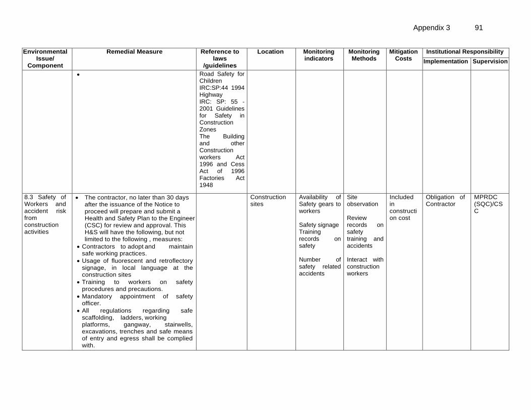
Appendix 3 91
Environmental Issue/
Component
Remedial Measure
Reference to laws
/guidelines
Location Monitoring indicators
Monitoring Methods
Mitigation Costs
Institutional Responsibility
Implementation Supervision
Road Safety for Children (5-12 Years Old) IRC:SP:44 1994 Highway Safety Code IRC: SP: 55 -2001 Guidelines for Safety in Construction Zones The Building and other Construction workers Act 1996 and Cess Act of 1996 Factories Act 1948
8.3 Safety of Workers and accident risk from construction activities
The contractor, no later than 30 days after the issuance of the Notice to proceed will prepare and submit a Health and Safety Plan to the Engineer (CSC) for review and approval. This H&S will have the following, but not limited to the following , measures:
Contractors to adopt and maintain safe working practices.
Usage of fluorescent and retroflectory signage, in local language at the construction sites
Training to workers on safety procedures and precautions.
Mandatory appointment of safety officer.
All regulations regarding safe scaffolding, ladders, working platforms, gangway, stairwells, excavations, trenches and safe means of entry and egress shall be complied with.
Construction sites
Availability of Safety gears to workers Safety signage Training records on safety Number of safety related accidents
Site observation Review records on safety training and accidents Interact with construction workers
Included in construction cost
Obligation of Contractor
MPRDC (SQC)/CSC
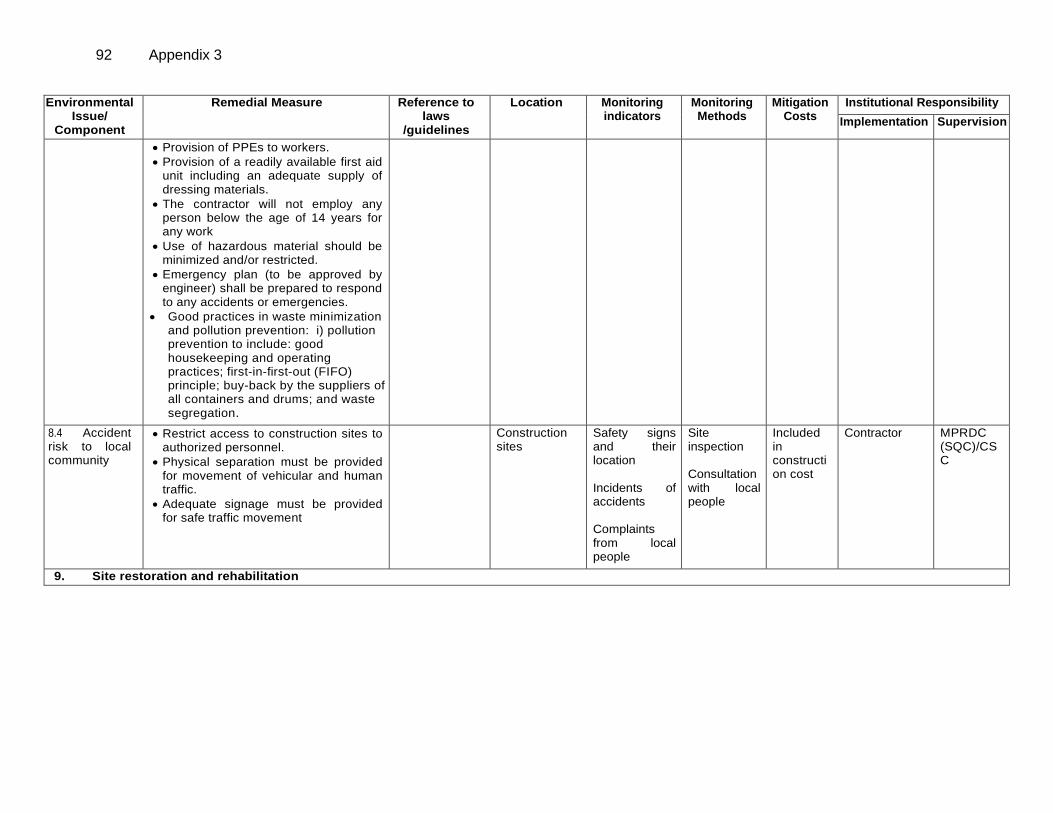
92 Appendix 3
Environmental Issue/
Component
Remedial Measure
Reference to laws
/guidelines
Location Monitoring indicators
Monitoring Methods
Mitigation Costs
Institutional Responsibility
Implementation Supervision
Provision of PPEs to workers.
Provision of a readily available first aid unit including an adequate supply of dressing materials.
The contractor will not employ any person below the age of 14 years for any work
Use of hazardous material should be minimized and/or restricted.
Emergency plan (to be approved by engineer) shall be prepared to respond to any accidents or emergencies.
Good practices in waste minimization and pollution prevention: i) pollution prevention to include: good housekeeping and operating practices; first-in-first-out (FIFO) principle; buy-back by the suppliers of all containers and drums; and waste segregation.
8.4 Accident risk to local community
Restrict access to construction sites to authorized personnel.
Physical separation must be provided for movement of vehicular and human traffic.
Adequate signage must be provided for safe traffic movement
Construction sites
Safety signs and their location Incidents of accidents Complaints from local people
Site inspection Consultation with local people
Included in construction cost
Contractor MPRDC (SQC)/CSC
9. Site restoration and rehabilitation
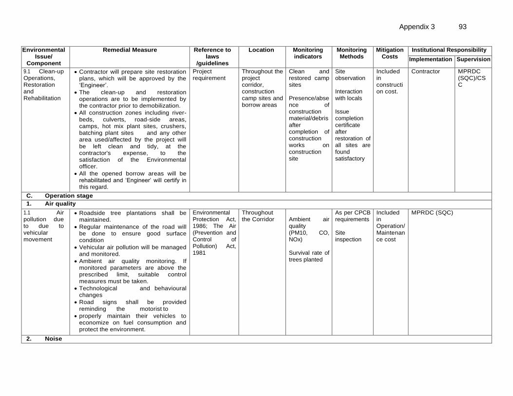
Appendix 3 93
Environmental Issue/
Component
Remedial Measure
Reference to laws
/guidelines
Location Monitoring indicators
Monitoring Methods
Mitigation Costs
Institutional Responsibility
Implementation Supervision
9.1 Clean-up Operations, Restoration and Rehabilitation
Contractor will prepare site restoration plans, which will be approved by the ‘Engineer’.
The clean-up and restoration operations are to be implemented by the contractor prior to demobilization.
All construction zones including river-beds, culverts, road-side areas, camps, hot mix plant sites, crushers, batching plant sites and any other area used/affected by the project will be left clean and tidy, at the contractor's expense, to the satisfaction of the Environmental officer.
All the opened borrow areas will be rehabilitated and ‘Engineer’ will certify in this regard.
Project requirement
Throughout the project corridor, construction camp sites and borrow areas
Clean and restored camp sites Presence/absence of construction material/debris after completion of construction works on construction site
Site observation Interaction with locals Issue completion certificate after restoration of all sites are found satisfactory
Included in construction cost.
Contractor
MPRDC (SQC)/CSC
C. Operation stage
1. Air quality
1.1 Air pollution due to due to vehicular movement
Roadside tree plantations shall be maintained.
Regular maintenance of the road will be done to ensure good surface condition
Vehicular air pollution will be managed and monitored.
Ambient air quality monitoring. If monitored parameters are above the prescribed limit, suitable control measures must be taken.
Technological and behavioural changes
Road signs shall be provided reminding the motorist to
properly maintain their vehicles to economize on fuel consumption and protect the environment.
Environmental Protection Act, 1986; The Air (Prevention and Control of Pollution) Act, 1981
Throughout the Corridor
Ambient air quality (PM10, CO, NOx) Survival rate of trees planted
As per CPCB requirements Site inspection
Included in Operation/ Maintenance cost
MPRDC (SQC)
2. Noise
94 Appendix 3
Environmental Issue/
Component
Remedial Measure
Reference to laws
/guidelines
Location Monitoring indicators
Monitoring Methods
Mitigation Costs
Institutional Responsibility
Implementation Supervision
2.1 Noise due to movement of traffic
Effective traffic management and good riding conditions shall be maintained to reduce the noise level throughout the stretch and speed limitation and honking restrictions may be enforced near sensitive locations.
The effectiveness of the multilayered plantation should be monitored and if need be, solid noise barrier shall be placed.
Create awareness amongst the residents about likely noise levels from road operation at different distances, the safe ambient noise limits and easy to implement noise reduction measures while constructing a building close to the road.
Noise Pollution (Regulation and Control) Rules, 2000 and amendments thereof
Sensitive receptors locations.
Noise levels Noise monitoring as per noise rules ,2000 Discussion with people in sensitive receptor sites
Included in Operation/ Maintenance cost
MPRDC (SQC)
3. Land and Soil 3.1 Soil erosion at embankment during heavy rain fall.
Periodic checking to be carried to assess the effectiveness of the stabilization measures viz. turfing, stone pitching, river training structures etc.
Necessary measures to be followed wherever there are failures
Project requirement
At bridge locations and embankment slopes and other probable soil erosion areas.
Existence of soil erosion sites Number of soil erosion sites
On site observation
Included in Operation/ Maintenance cost
MPRDC (SQC)
4. Water resources/Flooding and Inundation
4.1 Siltation
Regular checks shall be made for soil erosion and turfing conditions of river training structures for its effective maintenance.
Project requirement
Near surface Water bodies
Water quality Site observation
Included in Operation/ Maintenance cost
MPRDC (SQC)
4.2 Water logging due to blockage of drains, culverts or streams
Regular visual checks and cleaning of drains shall be done along the alignment to ensure that flow of water is maintained through cross drains and other channels/streams.
Monitoring of water borne diseases due to stagnant water bodies
Project requirement
Near surface Water bodies
Presence of flooded areas or areas with water stagnation
Site observation
Included in Operation/ Maintenance cost
MPRDC (SQC)
Appendix 3 95
Environmental Issue/
Component
Remedial Measure
Reference to laws
/guidelines
Location Monitoring indicators
Monitoring Methods
Mitigation Costs
Institutional Responsibility
Implementation Supervision
4.3 Road inundation due to choking of drainage channels
MPRDC will ensure that all drains (side drains and all cross drainages) are periodically cleared especially before monsoon season to facilitate the quick passage of rainwater and avoid flooding.
Project requirement
Flood prone sections the stretch particularly in rolling topography section
Incidents of flooding and road inundation with details on chainage
Field observation Interaction with local community
Included in Operation/ Maintenance cost
MPRDC (SQC)
5. Flora
5.1 Vegetation
Planted trees, shrubs, and grasses to be properly maintained.
The tree survivalist audit to be conducted at least once in a year to assess the effectiveness
Maintenance of box culverts, wherever provided.
Forest Conservation Act 1980
Project tree plantation sites
Minimum of 70% of tree survival
Records and fields observations
Operation and Maintenance Cost
MPRDC (SQC)
6. Maintenance of Right of Way and Safety
6.1 Accident Risk due to uncontrolled growth of vegetation
Efforts shall be made to make shoulder completely clear of vegetation.
Regular maintenance of plantation along the roadside
Invasive plant not to be planted near the road.
Project requirement
Throughout the Project route
Presence of and extent of vegetation growth on either side of road Accident data
Visual inspection Accident records
Included in operation/ Maintenance cost
MPRDC (SQC)
6.2 Accident risks associated with traffic movement.
Traffic control measures, including speed limits, will be enforced strictly.
Further encroachment of squatters within the ROW will be prevented.
No school or hospital will be allowed to be established beyond the stipulated planning line as per relevant local law
Monitor/ensure that all safety provisions included in design and construction phase are properly maintained
IRC:SP:55
Throughout the Project route
Police records on accident Condition and existence of safety signs, rumble strips etc. on the road
Review accident records Site observations
Included in operation/ Maintenance cost
MPRDC (SQC)
96 Appendix 3
Environmental Issue/
Component
Remedial Measure
Reference to laws
/guidelines
Location Monitoring indicators
Monitoring Methods
Mitigation Costs
Institutional Responsibility
Implementation Supervision
Highway patrol unit(s) for round the clock patrolling. Phone booths for accidental reporting and ambulance services with minimum response time for rescue of any accident victims, if possible.
Tow-away facility for the break down vehicles if possible.
Presence/absence of sensitive receptor structures inside the stipulated planning line as per relevant local law
6.3 Transport of Dangerous Goods
Existence of spill prevention and control and emergency responsive system
Emergency plan for vehicles carrying hazardous material
Throughout the project stretch
Status of emergency system – whether operational or not
Review of spill prevention and emergency response system Spill accident records
Included in operation/ Maintenance cost.
MPRDC (SQC)
Notes: EA: Executing Agency, MPRDC: Madhya Pradesh Road Development Corporation, SQC: Supervision Quality Controller, EO: Environmental
Officer, IRC: Indian Road Congress a. The “Project engineer” or “the engineer” is the team of Construction Supervision Consultants (CSC) responsible for approving the plans,
engineering drawing, release of payments to contractor etc. on behalf of the employer (MPRDC). It is usually the team leader of the CSC that takes the responsibility of signing approval documents on behalf of the CSC team.
b. The “environmental officer” is the environmental specialist under the CSC who is responsible for providing recommendations to the CSC team leader for approving activities specific to environment safeguards on behalf of “the engineer”.
Appendix 4 97
APPENDIX 4: ENVIRONMENTAL MONITORING PROGRAMME Environmental Components
Monitoring Location Frequency
Institutional Responsibility
Parameters Special Guidance Standards Implementation Supervision
Air PM2.5, PM10, SO2, NOX, CO
As per CPCB guidelines
The Air (Prevention and Control of Pollution) Rules, CPCB, 1982
At sites where hot mix plant / batching plant is located
3 times in a year for 3 years or construction period at 3 sites & once in year for five years at 3 sites during operation/defect liability period
Contractor through approved monitoring agency
PIU, MPRDC, SC
Water pH, BOD, COD, TDS, TSS, DO, Total coliform, Conductivity, Oil & Grease
Grab sample collected from source and analyze as per standard methods for examination of water and wastewater
Water quality standards by CPCB
river tributaries, roadside ponds and ground water at construction camp sites
Once during pre-construction stage 3 times in a year for 3 years or construction period At 3 locations
Contractor through approved monitoring agency
PIU, MPRDC, SC
Noise Levels Noise level for day and night on dB(A) scale
In free field at 1m distance from the equipment to be monitored
Noise standard by CPCB
At equipment yards, camp and villages along the alignment.
3 times in a year for 3 years or construction period , 3 locations & once in a year for 5 years at 3 sites during operation/defect liability period.
Contractor through approved monitoring agency
PIU, MPRDC, SC
Soil quality Monitoring of NPK &heavy metals and grease
As per IRC code of practice
Ad hock if accident / spill locations involving bulk transport of carrying hazardous materials
- PIU through an approved agency
PIU, MPRDC
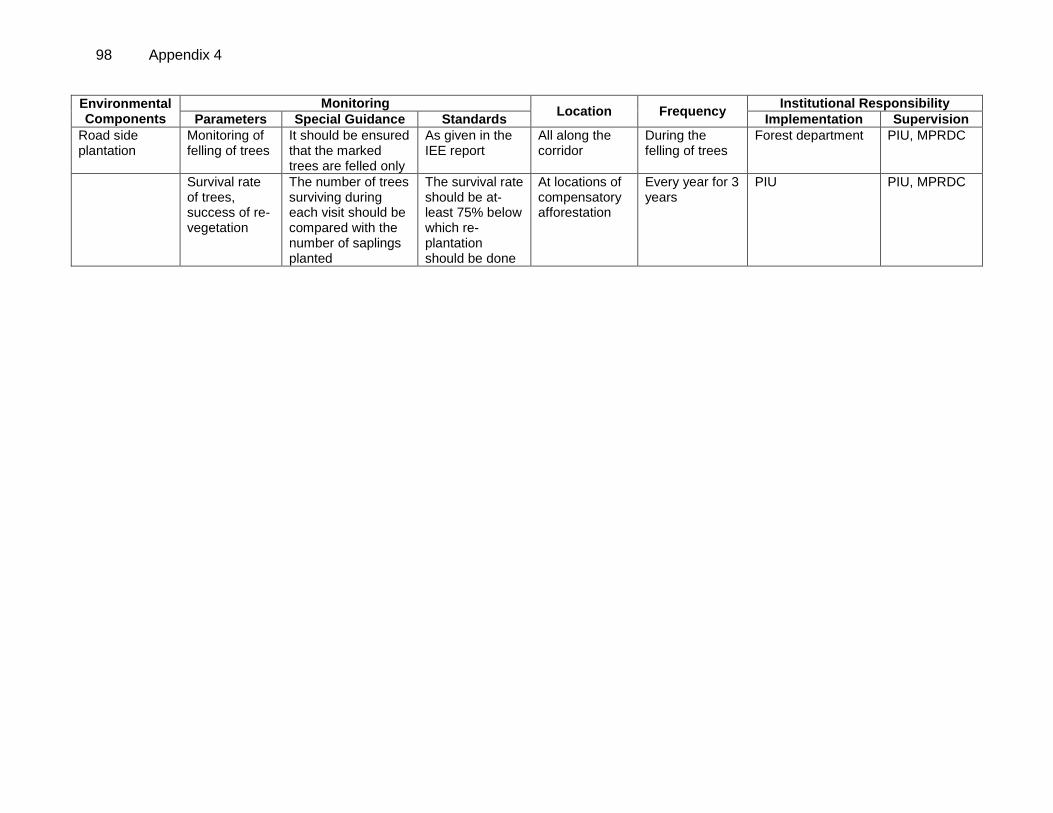
98 Appendix 4
Environmental Components
Monitoring Location Frequency
Institutional Responsibility
Parameters Special Guidance Standards Implementation Supervision
Road side plantation
Monitoring of felling of trees
It should be ensured that the marked trees are felled only
As given in the IEE report
All along the corridor
During the felling of trees
Forest department PIU, MPRDC
Survival rate of trees, success of re-vegetation
The number of trees surviving during each visit should be compared with the number of saplings planted
The survival rate should be at-least 75% below which re-plantation should be done
At locations of compensatory afforestation
Every year for 3 years
PIU PIU, MPRDC
Appendix 5 99
APPENDIX 5: NATIONAL AMBIENT AIR QUALITY STANDARDS
Concentration in Ambient Air Sl. No.
Pollutant Time Weighted Average
Industrial Residential, Rural
& Other Areas
Ecologically Sensitive Area (Notified by
Central Government )
1. Sulphur dioxide Annual Average* 50 20 (SO2)(g/m
3) 24 Hours** 80 80
2. Oxides of Nitrogen Annual Average* 40 30 (NOx) (g/m
3) 24 Hours** 80 80
3 Particulate Matter Annual Average* 60 60 (Size Less Then
10 m) or PM10 (g/m
3)
24 Hours** 100 100
4. Particulate Matter Annual Average* 40 40 (Size Less Then
2.5 m) or PM2.5 (g/m
3)
24 Hours** 60 60
5. Ozone O3 (g/m3) 8 Hours* 100 100
1 Hours** 180 180 6. Lead (Pb) (g/m
3) Annual Average* 0.5 0.5
24 Hours** 1.0 1.0 7. Carbon Monoxide 8 Hours* 2 2 (CO) (mg/m
3) 1 Hours** 4 4
8. Ammonia (NH3) Annual Average* 100 100 (g/m
3) 24 Hours** 400 400
9. Benzene (C6H6) (g/m
3)
Annual* 5 5
10. Benzo (a) Pyrane (BaP) particulate
phase only(g/m3)
Annual* 1 1
11. Arsenic (As) (g/m3) Annual* 6 6
12. Nickel (Ni) (g/m3) Annual* 20 20
* Annual arithmetic mean of minimum 104 measurements in a year taken twice a week 24 hourly at uniform interval.
** 24 hourly or 8 hourly or 1 hourly monitored values, as applicable shall complied 98% of the time in a year. However 2% of the time, it may exceed but not on two consecutive days.
100 Appendix 6
APPENDIX 6: INDIAN STANDARD DRINKING WATER SPECIFICATION-IS 10500:1991
S.no Parameters Essential Standards Relaxed Standards
1.0 Physical Standards 1.1 Colour (Hazen units) 10 50
1.2 Taste Agreeable Agreeable
1.3 Odour Unobjectionable Unobjectionable
1.4 PH 6.5-8.5 6.5-8.5
1.5 Turbidity (NTU) 10 25
1.6 TDS (mg/l) 500(without treatment) 1500(with treatment)
1.7 Total Hardness (mg/l) 300 600
2.0 Inorganic Parameters 2.1 Ca (mg/l) 75 200
2.2 Mg (mg/l) 30 100
2.3 Fe (mg/l) 0.3 1
2.4 Mn (mg/l) 0.1 0.5
2.5 Cl (mg/l) 250 1000
2.6 SO4 (mg/l) 150 400 if Mg<30mg/l
2.7 NO3 (mg/l) 45 45
2.8 F (mg/l) 0.6-1.2 1.5
2.9 Free Cl (mg/l) 0.2 0.5
3.0 Heavy Metals 3.1 Hg (mg/l) 0.001 0.001
3.2 Cd (mg/l) 0.01 0.01
3.3 Se (mg/l) 0.01 0.01
3.4 As (mg/l) 0.05 0.05
3.5 Pb (mg/l) 0.1 0.1
3.6 Zn (mg/l) 5 10
3.7 Cr+6 (mg/l) 0.05 0.05
3.8 Cu (mg/l) 0.05 1.5
4.0 Other Parameters 4.1 Phenolic Compounds 0.001 0.002
(mg/l) (as C6H5HO)
4.2 CN (mg/l) 0.05 0.05
4.3 Anionic Detergents 0.2 1.0 (mg/l) (as MBAS)
4.4 Mineral Oil (mg/l) 0.01 0.03
4.5 Pesticides Absent Absent
5.0 Microbiological Parameters
5.1 Mean Probable Number 50 without treatment Of Total Coliforms 500 outdoor bathing (Number/100 ml) 5000 with treatment
6.0 Radiological Parameters
6.1 10-6
6.2 10-7 Note: A-Desirable or essential B-Relaxable under certain circumstances such as no alternate source being available.
Appendix 7 101
APPENDIX 7: AMBIENT AIR QUALITY STANDARDS IN RESPECT OF NOISE
Area Category of Area Leq. Limits in dB(A) Code Day Time Night Time
A Industrial Area 75 70 B Commercial Area 65 55 C Residential Area 55 45 D Silence Zone 50 40
Note: Day time shall mean from 6.00 a.m. to 10.00 p.m. Night time shall mean from 10.00 p.m. to 6.00 a.m. Silence zone is defined as an area comprising not less than 100 meters around hospitals, educational institutions and courts. The silence zones are zones, which are declared as such by the competent authority. Mixed categories of areas may be declared as one of the four above-mentioned categories by the competent authority.
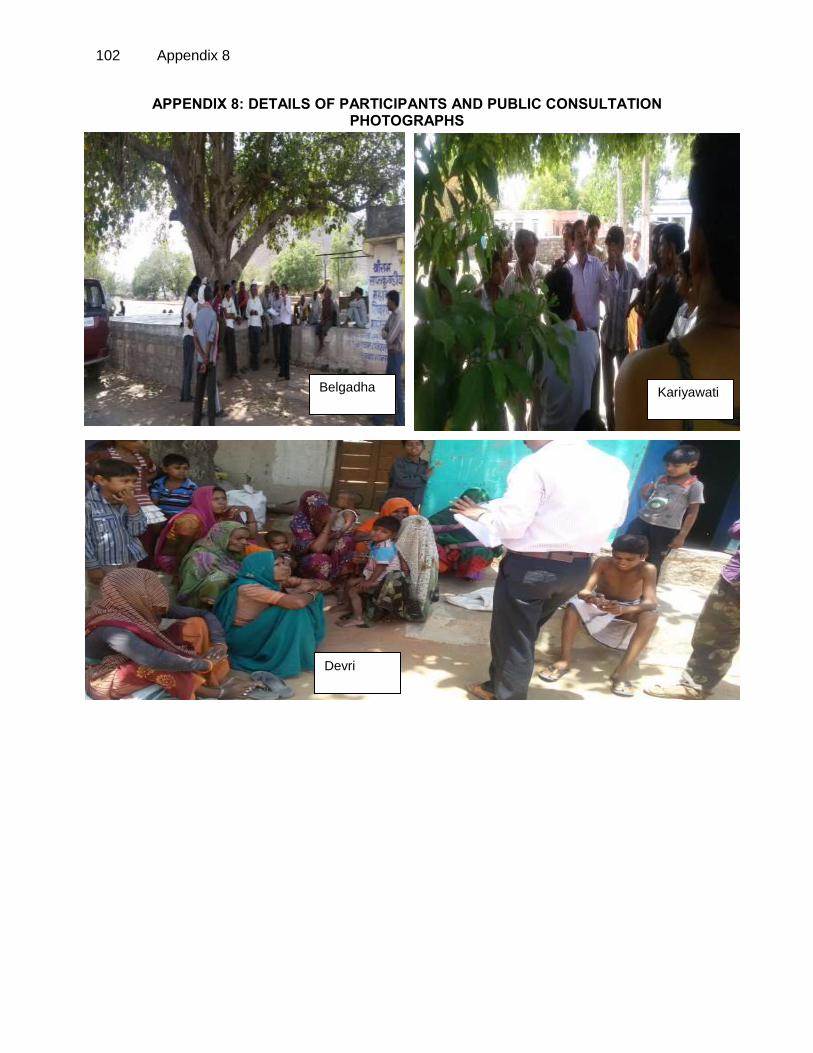
102 Appendix 8
Devri
Kariyawati Belgadha
APPENDIX 8: DETAILS OF PARTICIPANTS AND PUBLIC CONSULTATION PHOTOGRAPHS
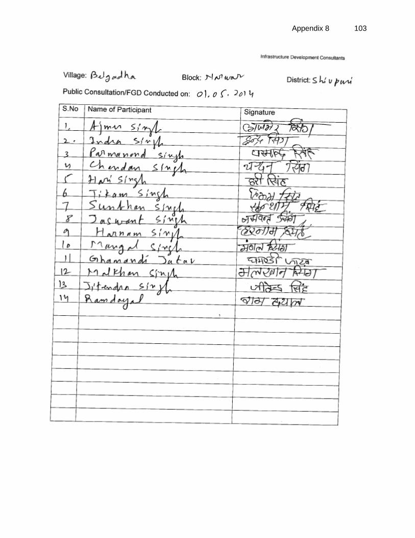
Appendix 8 103
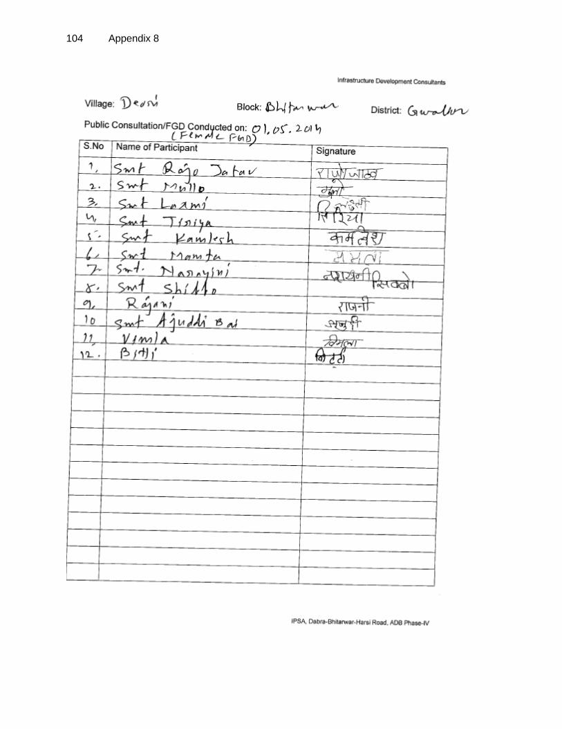
104 Appendix 8
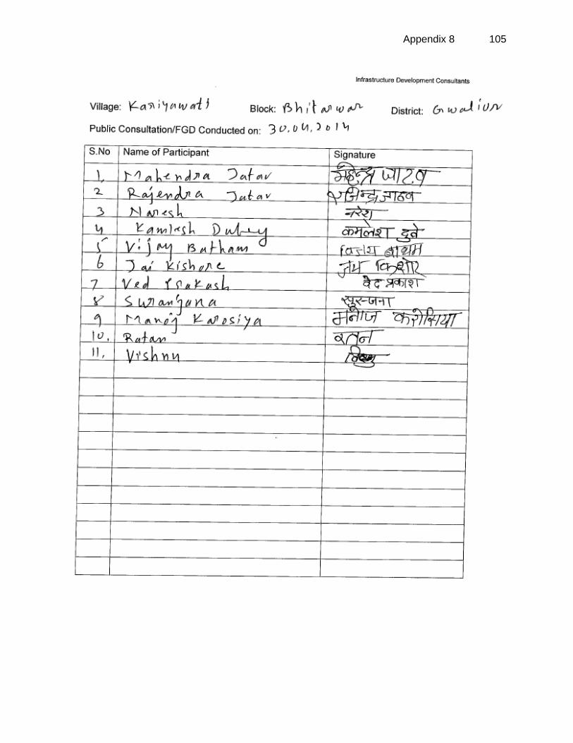
Appendix 8 105
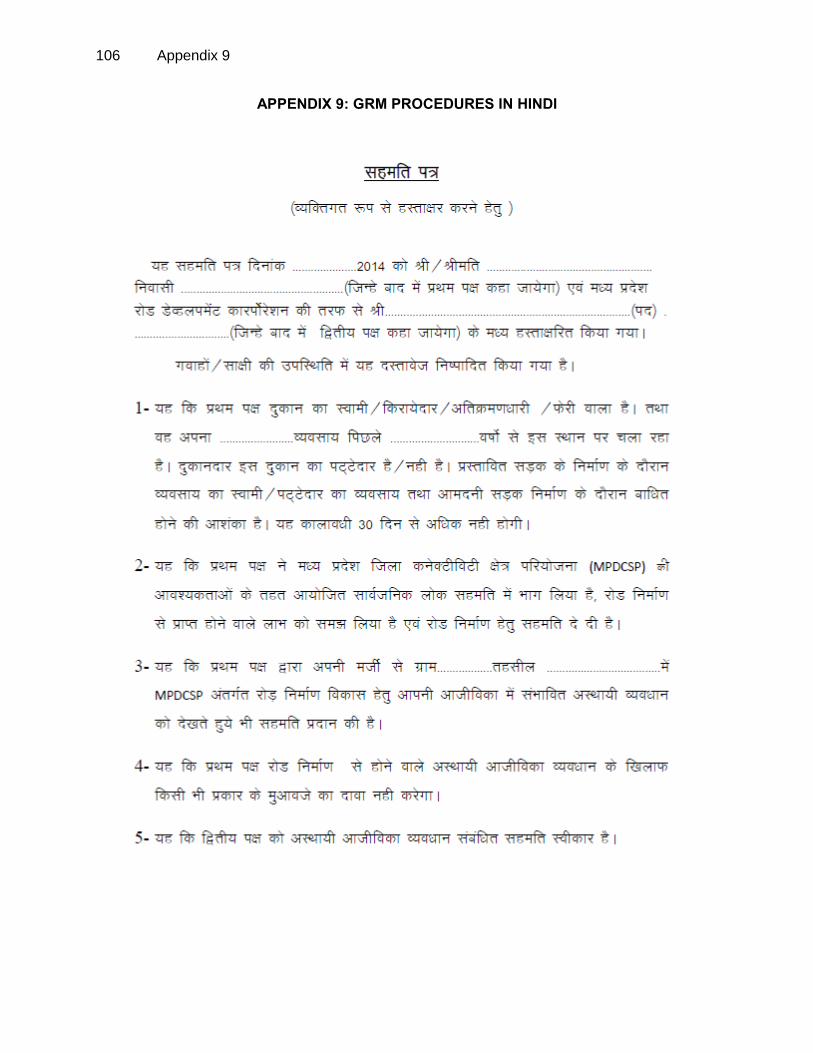
106 Appendix 9
APPENDIX 9: GRM PROCEDURES IN HINDI
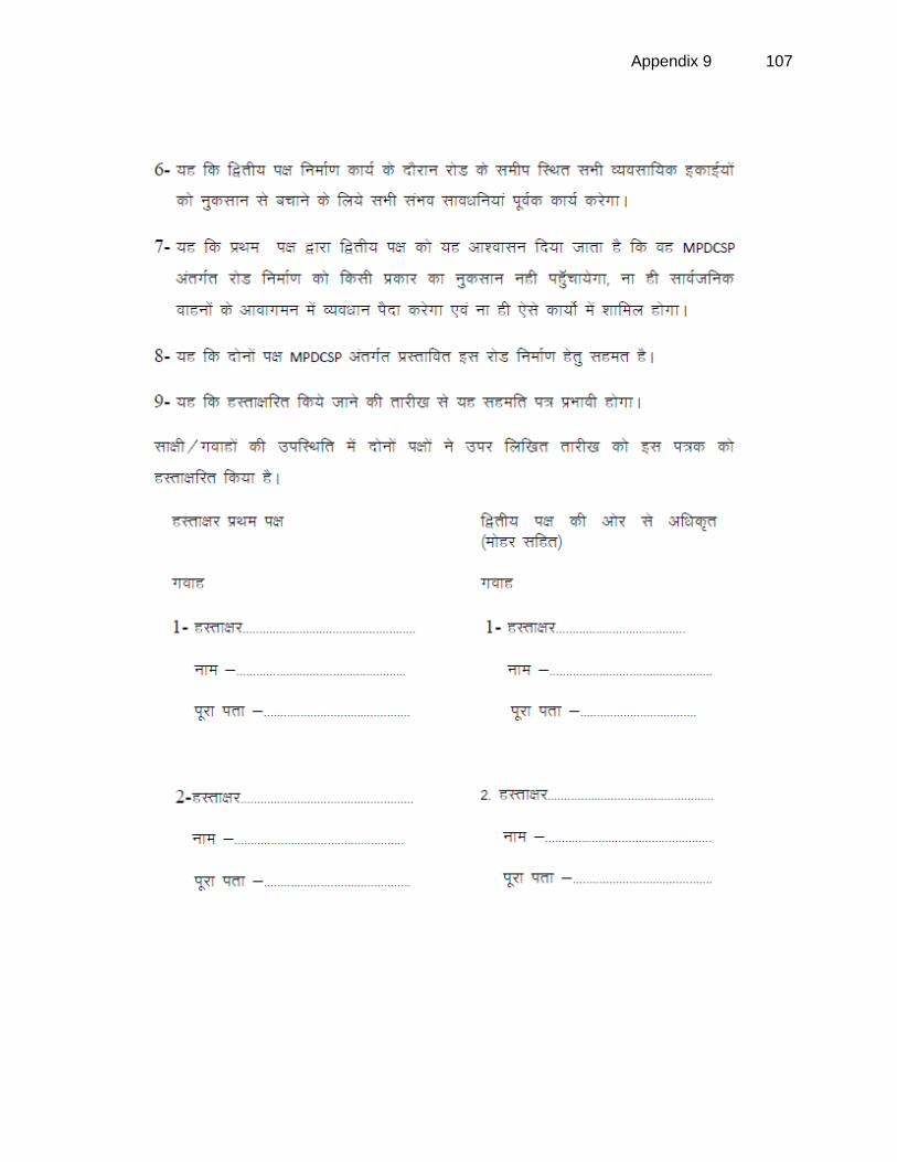
Appendix 9 107
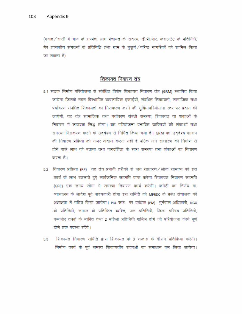
108 Appendix 9
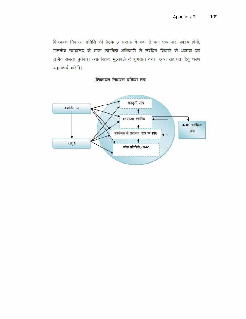
Appendix 9 109