Included Area
16
BookletChart ™ Stephens Passage – Gambier Bay NOAA Chart 17362 A reduced-scale NOAA nautical chart for small boaters When possible, use the full-size NOAA chart for navigation. Included Area
Transcript of Included Area

BookletChart™ Stephens Passage – Gambier Bay NOAA Chart 17362
A reduced-scale NOAA nautical chart for small boaters When possible, use the full-size NOAA chart for navigation.
Included Area
2
Published by the National Oceanic and Atmospheric Administration
National Ocean Service Office of Coast Survey
www.NauticalCharts.NOAA.gov 888-990-NOAA
What are Nautical Charts?
Nautical charts are a fundamental tool of marine navigation. They show water depths, obstructions, buoys, other aids to navigation, and much more. The information is shown in a way that promotes safe and efficient navigation. Chart carriage is mandatory on the commercial ships that carry America’s commerce. They are also used on every Navy and Coast Guard ship, fishing and passenger vessels, and are widely carried by recreational boaters.
What is a BookletChart?
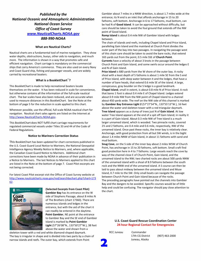
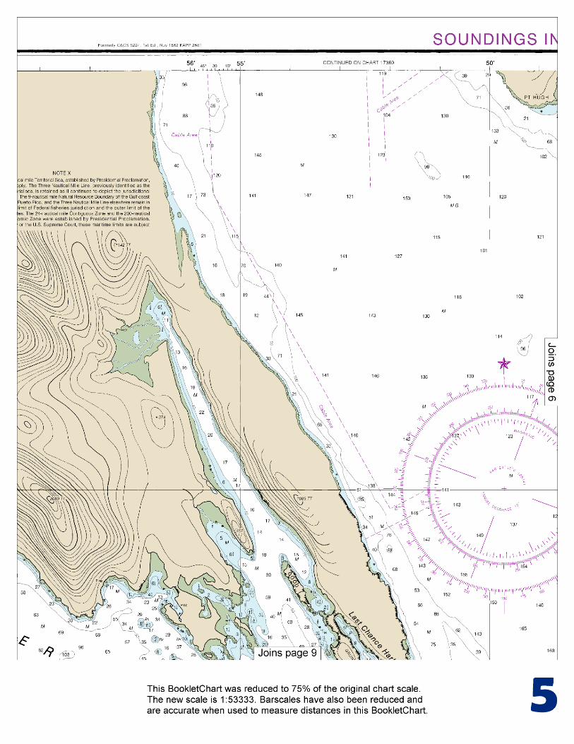
This BookletChart is made to help recreational boaters locate themselves on the water. It has been reduced in scale for convenience, but otherwise contains all the information of the full-scale nautical chart. The bar scales have also been reduced, and are accurate when used to measure distances in this BookletChart. See the Note at the bottom of page 5 for the reduction in scale applied to this chart.
Whenever possible, use the official, full scale NOAA nautical chart for navigation. Nautical chart sales agents are listed on the Internet at http://www.NauticalCharts.NOAA.gov.
This BookletChart does NOT fulfill chart carriage requirements for regulated commercial vessels under Titles 33 and 44 of the Code of Federal Regulations.
Notice to Mariners Correction Status
This BookletChart has been updated for chart corrections published in the U.S. Coast Guard Local Notice to Mariners, the National Geospatial Intelligence Agency Weekly Notice to Mariners, and, where applicable, the Canadian Coast Guard Notice to Mariners. Additional chart corrections have been made by NOAA in advance of their publication in a Notice to Mariners. The last Notices to Mariners applied to this chart are listed in the Note at the bottom of page 7. Coast Pilot excerpts are not being corrected.
For latest Coast Pilot excerpt visit the Office of Coast Survey website at http://www.nauticalcharts.noaa.gov/nsd/searchbychart.php?chart=17362.
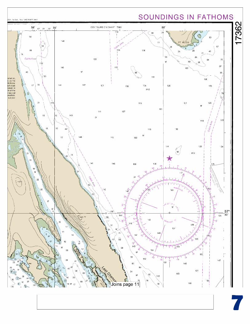
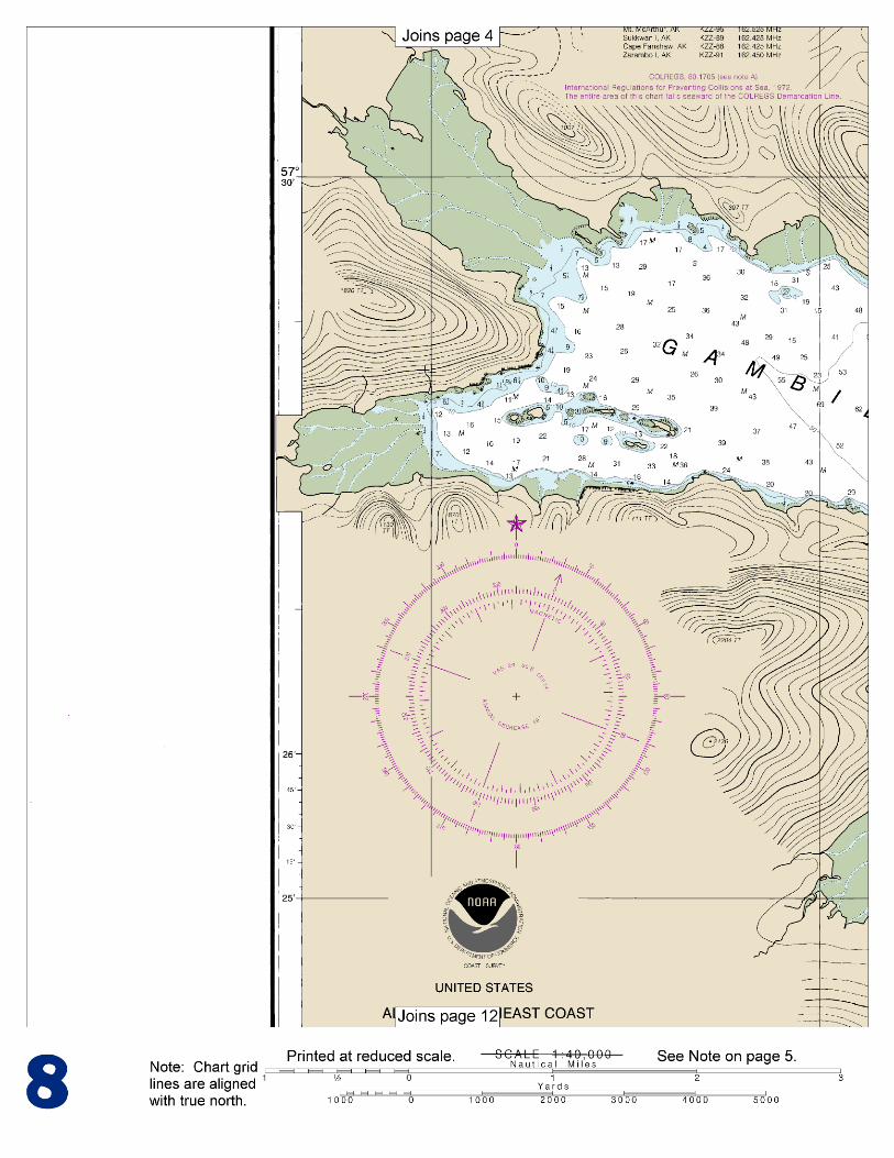
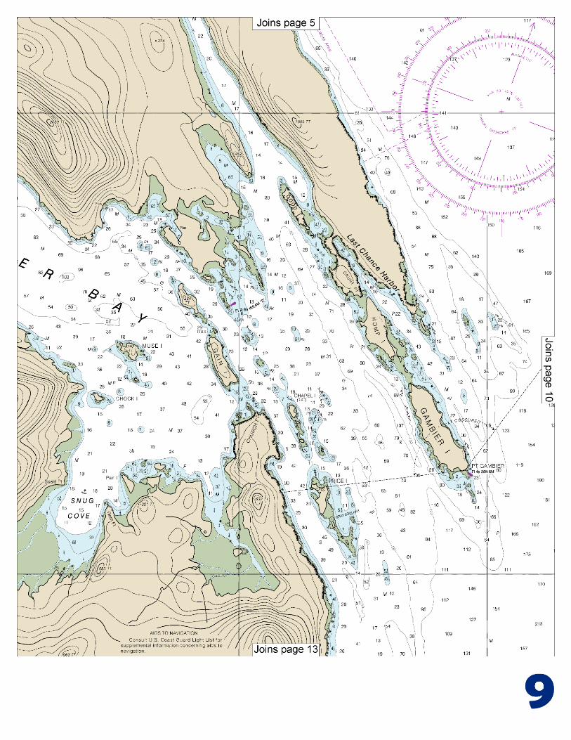
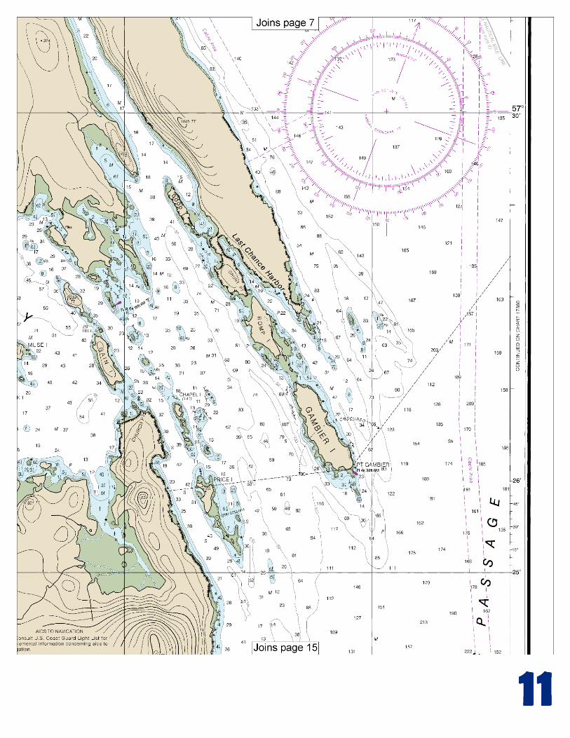
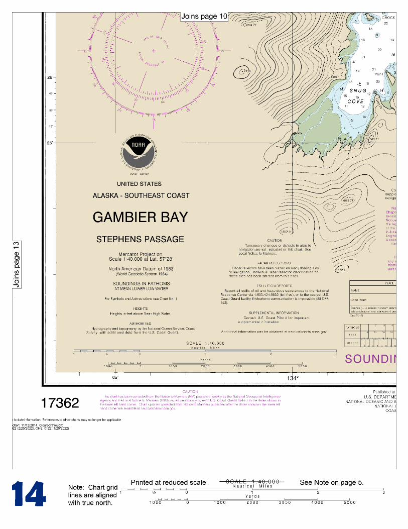
(Selected Excerpts from Coast Pilot) Gambier Bay has its entrance on the W side of Stephens Passage, about 8 miles N of The Brothers (chart 17360). There are numerous islands and ledges in the entrance, but with the aid of the chart it can readily be entered in the daytime. Point Gambier, NE point at the entrance to Gambier Bay and the SE end of Gambier Island is marked by Point Gambier Light (57°26'08"N., 133°50'27"W.), 38 feet above the water and shown from a
skeleton tower with a red and white diamond-shaped daymark. The bay is irregular in shape and is divided into two parts by a chain of narrow islands and reefs. The outer bay, which extends from Point
Gambier about 7 miles in a NNW direction, is about 1.7 miles wide at the entrance; its N end is an inlet that affords anchorage in 15 to 20 fathoms, soft bottom. Anchorage in 6 to 17 fathoms, mud bottom, can be had N of Good Island. It can be approached without difficulty, but care should be taken to avoid the foul ground that extends off the NW point of Good Island. Romp Island is about 0.4 mile NW of Gambier Island with ledges between. The chain of islands and reefs, including Chapel Island and Price Island, paralleling Gain Island and the mainland at Church Point divides the outer part of the bay into two passages. In navigating the passage west of this chain care should be taken to avoid the bare rocks, that extend 165 yards out from the point, 0.5 mile SSE of Church Point. Currents have a velocity of about 3 knots in the passage between Church Point and Gain Island, and some swirls occur around the ledges E and N of Gain Island. Price Island is 680 yards from the W shore of the outer bay. A rocky shoal with a least depth of 5 fathoms is about 1 mile SE from the S end of Price Island, with deep water between it and the ledges, that have a number of bare heads, that extend 0.6 mile SE of the island. A large, conspicuous, gray boulder on the S ledge is a good landmark. Chapel Island, small in extent, is about 0.8 mile N of Price Island. A rock that bares 1 foot is about 0.4 mile E of Chapel Island. Ledges extend about 0.9 mile NW from the NW point of Chapel Island to a channel about 450 yards wide. The reef on the NW side of this channel is marked by Gambier Bay Entrance Light 2 (57°27'54"N., 133°55'13"W.), 16 feet above the water and skeleton tower with a red triangular daymark. Tree Island appears as a clump of trees just N of Gain Island. At low water Tree Island appears at the end of a spit off Gain Island; in reality it is a part of Gain Island. About 0.3 mile NW of Tree Island is a much larger unnamed island, which is wooded. Two pinnacle rocks, covered 2½ and 2 fathoms, are 0.4 mile and 0.6 mile, respectively, NW of the unnamed island. Once past these rocks, the inner bay is relatively clear. Anchorage, with good protection from all but SW winds, is in the bight about 1.4 miles NNW of Gain Island, in about 11 fathoms with sand and mud bottom. Snug Cove, on the S side of the inner bay about 2 miles WSW of Church Point, has anchorage in 15 to 20 fathoms, soft bottom. Small craft find good protection here in 4 to 7 fathoms. Large vessels reach the cove by way of the channel close E of Church Point, Gain Island, and the unnamed island to the NW; two charted rocks are about 500 yards NNW of the unnamed island with a shoal of 8.9 fathoms between the south rock and the NNW end of the unnamed island. A S course can then be laid to pass about midway between the unnamed island and Muse Island, 0.7 mile to the SW. Only small boats can navigate the passage between Church Point and Gain Island because of the rocks. The preceding paragraphs have pointed out the channels into Gambier Bay and the dangers to be avoided. Specific courses would be of little help and could be confusing. The navigator should pay close attention to the chart.
U.S. Coast Guard Rescue Coordination Center 24 hour Regional Contact for Emergencies
RCC Juneau Commander
17th CG District (907) 463-2000 Juneau, Alaska

G
Lateral System As Seen Entering From Seaward on navigable waters except Western Rivers
PORT SIDE ODD NUMBERED AIDS
GREEN LIGHT ONLY FLASHING (2)
PREFERRED CHANNEL NO NUMBERS – MAY BE LETTERED
PREFERRED CHANNEL TO STARBOARD
TOPMOST BAND GREEN
PREFERRED CHANNEL NO NUMBERS – MAY BE LETTERED
PREFERRED CHANNEL TO PORT
TOPMOST BAND RED
STARBOARD SIDE EVEN NUMBERED AIDS
RED LIGHT ONLY FLASHING (2)
FLASHING FLASHING OCCULTING GREEN LIGHT ONLY RED LIGHT ONLY OCCULTING QUICK FLASHING QUICK FLASHING ISO COMPOSITE GROUP FLASHING (2+1) COMPOSITE GROUP FLASHING (2+1) ISO
"1"
Fl G 6s
G "9"
Fl G 4s
GR "A"
Fl (2+1) G 6s
RG "B"
Fl (2+1) R 6s
"2"
Fl R 6s
8
R "8" Fl R 4s
LIGHT
G
C "1"
LIGHTED BUOY
G "5"
GR "U"
GR
C "S"
RG
N "C"
RG "G"
LIGHT
6
R
N "6"
LIGHTED BUOY
R
"2"
CAN DAYBEACON
CAN NUN NUN
DAYBEACON
For more information on aids to navigation, including those on Western Rivers, please consult the latest USCG Light List for your area. These volumes are available online at http://www.navcen.uscg.gov
2
2
C U 5
1


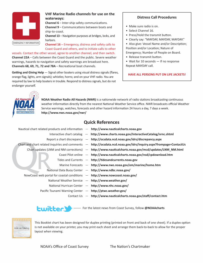
VHF Marine Radio channels for use on the waterways:Channel 6 – Inter-ship safety communications.Channel 9 – Communications between boats and ship-to-coast.Channel 13 – Navigation purposes at bridges, locks, and harbors.Channel 16 – Emergency, distress and safety calls to Coast Guard and others, and to initiate calls to other
vessels. Contact the other vessel, agree to another channel, and then switch.Channel 22A – Calls between the Coast Guard and the public. Severe weather warnings, hazards to navigation and safety warnings are broadcast here.Channels 68, 69, 71, 72 and 78A – Recreational boat channels.
Getting and Giving Help — Signal other boaters using visual distress signals (flares, orange flag, lights, arm signals); whistles; horns; and on your VHF radio. You are required by law to help boaters in trouble. Respond to distress signals, but do not endanger yourself.
EMERGENCY INFORMATION
Distress Call Procedures
• Make sure radio is on.• Select Channel 16.• Press/Hold the transmit button.• Clearly say: “MAYDAY, MAYDAY, MAYDAY.”• Also give: Vessel Name and/or Description;Position and/or Location; Nature of Emergency; Number of People on Board.• Release transmit button.• Wait for 10 seconds — If no responseRepeat MAYDAY call.
HAVE ALL PERSONS PUT ON LIFE JACKETS!
This Booklet chart has been designed for duplex printing (printed on front and back of one sheet). If a duplex option is not available on your printer, you may print each sheet and arrange them back-to-back to allow for the proper layout when viewing.
QR
Quick ReferencesNautical chart related products and information - http://www.nauticalcharts.noaa.gov
Interactive chart catalog - http://www.charts.noaa.gov/InteractiveCatalog/nrnc.shtmlReport a chart discrepancy - http://ocsdata.ncd.noaa.gov/idrs/discrepancy.aspx
Chart and chart related inquiries and comments - http://ocsdata.ncd.noaa.gov/idrs/inquiry.aspx?frompage=ContactUs
Chart updates (LNM and NM corrections) - http://www.nauticalcharts.noaa.gov/mcd/updates/LNM_NM.html
Coast Pilot online - http://www.nauticalcharts.noaa.gov/nsd/cpdownload.htm
Tides and Currents - http://tidesandcurrents.noaa.gov
Marine Forecasts - http://www.nws.noaa.gov/om/marine/home.htm
National Data Buoy Center - http://www.ndbc.noaa.gov/
NowCoast web portal for coastal conditions - http://www.nowcoast.noaa.gov/
National Weather Service - http://www.weather.gov/
National Hurrican Center - http://www.nhc.noaa.gov/
Pacific Tsunami Warning Center - http://ptwc.weather.gov/
Contact Us - http://www.nauticalcharts.noaa.gov/staff/contact.htm
NOAA’s Office of Coast Survey The Nation’s Chartmaker
For the latest news from Coast Survey, follow @NOAAcharts
NOAA Weather Radio All Hazards (NWR) is a nationwide network of radio stations broadcasting continuous weather information directly from the nearest National Weather Service office. NWR broadcasts official Weather Service warnings, watches, forecasts and other hazard information 24 hours a day, 7 days a week. http://www.nws.noaa.gov/nwr/