IN THE MATTER OF AND IN THE MATTER OF Lake Rotorua ... · document) ATTACHMENT D Federated Farmers...
62
SEW-133911-559-855-2:sew/clm IN THE MATTER OF the Resource Management Act 1991 AND IN THE MATTER OF Lake Rotorua Nutrient Management – PROPOSED PLAN CHANGE 10 to the Bay of Plenty Regional Water and Land Plan MEMORANDUM TO THE HEARING PANEL FROM COUNSEL FOR THE BAY OF PLENTY REGIONAL COUNCIL DATED 13 APRIL 2017 “PROVISION OF FURTHER INFORMATION AS REQUESTED AND UPDATED TRACK CHANGES AS A RESULT OF FURTHER DISCUSSIONS” 247 Cameron Road P O Box 143 TAURANGA Telephone: (07) 927 0502 Facsimile: (07) 578 1433 Counsel: S E WOOLER
Transcript of IN THE MATTER OF AND IN THE MATTER OF Lake Rotorua ... · document) ATTACHMENT D Federated Farmers...

SEW-133911-559-855-2:sew/clm
IN THE MATTER OF the Resource Management Act 1991 AND IN THE MATTER OF Lake Rotorua Nutrient Management –
PROPOSED PLAN CHANGE 10 to the Bay of Plenty Regional Water and Land Plan
MEMORANDUM TO THE HEARING PANEL
FROM COUNSEL FOR THE BAY OF PLENTY REGIONAL COUNCIL DATED 13 APRIL 2017
“PROVISION OF FURTHER INFORMATION AS REQUESTED AND UPDATED TRACK CHANGES AS A RESULT OF FURTHER DISCUSSIONS”
247 Cameron Road P O Box 143 TAURANGA Telephone: (07) 927 0502 Facsimile: (07) 578 1433 Counsel: S E WOOLER

SEW-133911-559-855-2:sew/clm
MAY IT PLEASE THE HEARING COMMISSIONERS
“PROVISION OF FURTHER INFORMATION AS REQUESTED AND UPDATED TRACK
CHANGES AS A RESULT OF FURTHER DISCUSSIONS”
Introduction
1. We refer to the Compendium Memorandum dated 22 March 2017, and to the
additional work ongoing; including discussions and planning matters where parties
and Panel have sought clarifications / responses or to refine proposed amendments in
the s42A report.
2. Meetings and discussions have been held throughout the hearing and break period
and additional responses addressing the matters raised are attached to this
Memorandum, except where they were filed directly. For the most part these are
planning reports in the nature of additional s42A reports or statements following
meetings.
3. Table 1 below shows the subject matter and where the documents can be viewed.
Title Appendix or website link
Report on amendment
of proposed policies
(s42A) re WWTP,
matters as discussed
between RLC and
BOPRC1
https://www.boprc.govt.nz/media/609746/sew-
133911-559-844-1-report-on-agreed-proposed-
amendments-and-outstanding-issues-wwtp.pdf
Report on averaging
NDA approach to non-
benchmarked blocks
https://www.boprc.govt.nz/media/609758/sew-
133911-559-847-1-nonbenchmarked-property-
report.pdf
Update on Water https://www.boprc.govt.nz/media/610363/summary-
1 https://www.boprc.govt.nz/media/610369/20170404_182104.pdf (Correspondence from NGATI
UENUKUKOPAKO IWI TRUST further submitter opposing; https://www.boprc.govt.nz/knowledge-centre/plans/regional-water-and-land-plan/lake-rotorua-nutrient-management-proposed-plan-change-10/lake-rotorua-nutrient-management-proposed-plan-change-10-hearing/

SEW-133911-559-855-2:sew/clm
Quality Science caucus
between Professor
Hamilton, Dr Stephens
and Mr Bruere
(contained in part 1 of
updated evidence of Dr
Stephens)
of-evidence-to-read-out-pc-10-stephens-post-
caucus-final.pdf
Planning Report on
definitions –
- Commercial
APPENDIX 1
Planning Report on
definitions –
- Houseblocks
APPENDIX 2
Planning Report on Phosphorous inclusion
ATTACHMENT A Analysis of Potential Phosphorus Rules
ATTACHMENT B Proposed changes to Plan Change 10
ATTACHMENT C Excerpt of summary of evidence from Dairy NZ setting out response on phosphorus – (see BOPRC website for full document)
ATTACHMENT D Federated Farmers and the Collective’s position
ATTACHMENT E Federated Farmer’s Proposed Changes to PPC 10
APPENDIX 3
Planning Report on
Stocking Rate Table
APPENDIX 4
Planning Report on
Inclusion of NOF
APPENDIX 5

SEW-133911-559-855-2:sew/clm
attributes from NPS-FM
2014
Planning Report on
Rural Subdivision in the
Operative Rotorua
District Plan
PDF Appendix 1 to this
report (provisions on
plan)
APPENDIX 6
Attached to covering email
Planning Response
from BOPRC planners
to additional information
filed by Grant Eccles
APPENDIX 7
Economics issues as
discussed in caucus
between Economics
Expert Witnesses
[To be filed separately, web link not yet in place]
Planning Response on
Rule 11 RWLP
(consequential
changes)
APPENDIX 8
Track Changes PPC 10
version 6 updated with
further
recommendations as a
result of above
discussions and reports
(PDF)
APPENDIX 9
Filed as PDF version with this memorandum.

SEW-133911-559-855-2:sew/clm
4. Counsel anticipates that it will be necessary to briefly address these matters when the
hearing recommences.
5. There have been delays arising from the present state of emergency in place, and
also late receipt of material from other parties. To the greatest extent possible all
remaining material will be filed by the recommencement of hearings.
13 April 2017
__________________________
S E Wooler
Counsel for the Regional Council

SEW-133911-559-855-2:sew/clm
APPENDIX 1: Planning Report on definitions – Commercial
Plan Change 10 Hearing Response to Panel’s request for information TOPIC: Definitions for commercial horticulture, cropping and dairying
1.0 Introduction Submissions were received in opposition to the restriction on commercial activity by Rules LRR3 and LRR4. These submissions highlighted that no definitions of commercial horticulture, commercial dairying and commercial cropping have been provided by the proposed plan change, resulting in any minor level of commercial activity being non complying.
2.0 Submissions Clarification was requested on what was considered to be commercial. One submitter requested that a minimum size be identified for commercial horticulture, under which such activity would be permitted. Council considered a range of approaches to address the concerns raised by these submissions. The approach to identify a minimum size for commercial horticulture of 4000m2 was not supported, with this sized garden having the ability to generate high levels of nitrogen losses depending on what type of crop was planted, the level of fertiliser application and management regimes. It is noted that PC1 to the Waikato Regional Plan has specified suitable crops but has also made commercial gardens need controlled activity The approach of identifying the level of income generated by commercial horticulture was also not supported, with such triggers such as the GST-registration threshold not reflecting the potential losses of nitrogen resulting from the activity. Rather than the suggestion to set a maximum size on a commercial garden and specify the range of crops able to be planted to stay within an acceptable level of nitrogen leaching, an approach was taken to describe the ‘act’ of commercial horticulture and define and exclude any produce generated from a household garden. This approach was noted by the panel and submitters to be vague and needed to be reconsidered to enable enforcement and compliance. It was agreed that this would be the best way but Council did not want PC10 to become overly prescriptive (i.e. list appropriate plant species and management regimes).
3.0 Proposed amendments Commercial Horticulture Based on feedback received during the hearing process a meeting was held with Brown Owl Organics Incorporated to discuss the definition of commercial horticulture and the suitable level of commercial activity that did not need to be managed by PPC10. The main outcome of this meeting was the suggestion to identify and calculate the losses of the highest leaching crop (suitable for Rotorua climate) based on a 4000m2 area and compare the losses to losses generated from a 5ha lot. From here the losses/area of the commercial garden could be reduced to align with what was provided for by the plan. Research completed by William and Tregurtha (2003) measured 300kgN/ha/year as being the worst possible N leaching from winter vegetable crops. This is not necessarily comparable to Rotorua soils and rainfall, however it is something to use in the absence of better data. It is noted in the paper that land management and correct decision-making with regard to fertilisation timing and quantities has a huge effect on N leaching. However, using this rate, an effective area of 500sqm was calculated as

SEW-133911-559-855-2:sew/clm
being the maximum size of land that could be supported in as a commercial market garden and still stay within a comparable amount of leaching to a slightly overstocked drystock farm of 5ha (permitted under the proposed rules).
Further discussion was had regarding different possible scenarios in terms of how much N is allowed to be leached. It was noted and agreed that orchards are likely to be far lower in N leaching than regularly cultivated land. Working on a hypothetical figure of 100kgN/ha/year for land managed as an orchard (with an understanding that kiwifruit may leach around 60-70kgN/ha/year), 1500sqm effective area for an orchard was identified as being the maximum size of land that could be supported and still stay within a comparable amount of leaching to a slightly overstocked drystock farm of 5 ha (permitted under the proposed rules). Council staff have internally reviewed these calculations noting that limited science is available relating to losses from horticultural land uses. It is also noted that given the climate and soils of Rotorua the worst-case scenario with nitrogen losses may not occur. For these reasons Council staff consider it appropriate to increase the permitted threshold of commercial gardens/orchards to be 1000m
2 and 3000m
2. Council staff agree with the approach identified above, and support the use of
these size limits within the definitions of PPC10 to enable commercial horticulture at or below these effective areas to be permitted activities. Any horticulture above these effective areas will result in noncompliance with Rule LRR3 or LRR4 causing the activity to require compliance with either LRR5, LRR7 or LRR8. It is noted that Brown Owl Organics oppose PC10 restricting the sale of produce from household and community gardens. This aligns with the intent of the approach taken within the section 42A report which included a definition of household garden and excluded such gardens from commercial horticulture. It is highlighted that PPC10 relates to the rural environment as shown on MapLR1. Whilst it is considered unlikely that community gardens may establish within this environment it is noted that these are usually not highly intensive and have limited fertiliser inputs. As a result it is considered that such activities would not result in high levels of nitrogen losses and are able to be considered as permitted activities by PPC10.
Commercial Cropping and Commercial Dairying Submissions were received requesting clarification on what was considered to be commercial cropping and commercial dairying. It is noted that small scale dairying and cropping activity can occur that may not result in significant losses, such as milking a few dairy cows to be consumed by the household and the use of a paddock to generate hay or some form of feed to support animals located onsite. These small scale activities are not intended to be controlled by PC10 causing the need to use the term ‘commercial’. The commercial nature of these activities would have the ability to result in higher levels of nitrogen with these having a higher stocking rate and/or levels of fertiliser application than what is usually seen within small lifestyle lots. New definitions were proposed within the section 42A report with the intent to clarify what scale of activity was to be controlled by PPC10. Concern was raised by the panel on the use of the term ‘intensive’. Other amendments Other amendments to the rule framework and definitions have been proposed by Brown Owl Organics. These include amendments to the advice notes associated with rule LRR3 and deleting the stand-alone definitions of cropping and horticulture. Brown Owl has suggested that advice note one of rule LRR3 should be deleted because the proposed definition of commercial horticulture includes the term effective area. Whilst this is acknowledged, this does not result in advice note one no longer being required with the definitions and the advice note having different intents. Advice note one intends to clarify that Rule LRR3 relates

SEW-133911-559-855-2:sew/clm
to the total land held within a certificate of title, not only effective area, thus excluding lots under 5ha in size from having farming activity managed by PPC10. The definitions identify a portion of the title that is able to be used for commercial activity. Amendments have also been suggested to advice note two, stating that rule LRR5 does not relate to lots under 5ha. However any activity that is deemed commercial, as in these definitions proposed, will result in non-compliance with rule LRR3(a) causing rules LRR5, LRR7 or LRR8 to become applicable depending on the consent pathway chosen by the applicant. The definitions from cropping and horticulture intend to support the definition of farming activity. Any form of horticulture or cropping (commercial or not) is enabled within rules LRR5, LRR6, LRR7, LRR8, LRR9 and LRR11 of PC10 with all the losses of farming activities being recorded within nitrogen management plans, overseer files, or annual land use information records with this informing the overall loss rate provided to the farming enterprise. Therefore these definitions have been retained. Conclusion Amendments to the definitions of commercial horticulture, dairying and cropping have been proposed in an attempt to clarify what scale of commercial activity is to be managed by PC10. It is recommended that these proposed changes are accepted by the Hearing Panel. The revised definitions are provided below:
Commercial Horticulture – The cultivation of land for the intensive production of vegetable or fruit or nut crops on greater than 1000sqm effective area or the production of perennial woody fruit or nut crops on greater than 3000sqm (uncultivated) for the intent of profit. purpose of resale to the general public or wholesale business. These are characterised by high inputs of capital, labour and technology (including machinery) relative to land area. Commercial Horticulture does not include any vegetable, fruit or nut crops areas of plantings that form an integral part of a household or community garden. (21-11, 56-27) Household garden: An area containing contains a high diversity of plants including vegetables,
fruits, plantation crops, spices, herbs, ornamental and medicinal plants used by the occupants of a
household for recreation, or to obtain food or materials. Household gardens are located within close
proximity to the household or within walking distance. Monetary gain from any sales of food or
materials is minor and is not the main intent of the activity. and generally have low labour
requirements with the main source of labour being from occupants of the house. Any production is
supplemental rather than a main source of family consumption and income.(21-11, 56-27)
Community garden: An area of plantings used with the intent of directly supplying a community
with food or other materials. Monetary gain from any sales of food or materials is minor and is not
the main intent of the activity. (21-11, 56-27)
Commercial cropping: The intensive cultivation of forage crops, fodder crops or maize for the intent of sale or movement offsite for profit. to the general public. This does not include alternative pasture species. (21-11, 56-27) Commercial dairying: An intensive dairy farming system characterised by high inputs of capital, labour and technology relative to land area and supported by milking shed infrastructure. Intensive production will result in losses per hectare that exceed the permitted level of nitrogen losses. (21-11, 56-27)

SEW-133911-559-855-2:sew/clm
APPENDIX 2: Planning Report on definitions – Houseblocks
Plan Change 10 Hearing Response to Panel’s request for information TOPIC: House block Definition and Description
(a) Introduction
The term house block is used in a number of places in PPC10. Through the introduction of responses to submissions the potential for uncertainty about the application of the term has been created. This was alluded to by the Panel. The following information is provided to assist the Panel on this matter.
(b) Use of the term “House block”
The term house block is used in PPC10 (track changes version 5) in the following places:
1. Introduction Table LR 3: Sector contributions 2. Policy LR P5 3. Definitions section (for Block, House block, Nitrogen Discharge Allocation, Reference
Files) 4. Schedule LR One B. Nitrogen Discharge Allocation methodology 5. Schedule LR One D. Additional matters 6. Schedule LR One E. Amendment of Nitrogen Discharge Allocation 7. Schedule LR Five: Use of reference files - Step 2.
In terms of defining what a house block is there are four uses in PPC10 that are important and that need to be consistent. These are:
1. Introduction Table LR 3: Sector contributions 2. Definitions section (for Block, House block, Nitrogen Discharge Allocation, Reference
Files) 3. Schedule LR One D. Additional matters 4. Schedule LR Five: Use of reference files - Step 2.
(c) Submissions
Submissions were received on the need to clarify the definition of House block seeking improved clarity and application. See submission 53 and 66 - page 306 and 307 of Section 42A Report: Appendix 3.
(d) Resolving the potential uncertainty with the definition of House Block
Resolving the potential uncertainty can be achieved by way of the following three amendments. As noted in each row of the table the amendments do not alter the intent or application of any PPC10 provision.

SEW-133911-559-855-2:sew/clm
Usage Resolution
Introduction Table LR 3: Sector contributions (Clean) Version 5.0 page 3
Column 6 of Table LR 3 contains standard nitrogen loss rates based on the modelled 2015 sector contributions. These rates were included for completeness and do not have any effect as a rule. The loss rate of 43.2 kgN/ha for House blocks is calculated from the catchment area of House blocks and includes a number of catchment-wide assumptions and multiple house block entities. The number differs from the specific calculated loss rate that has been recommended for inclusion in Schedule LR Five. As the numbers differ due to different assumptions, this could lead to potential confusion. It is recommended that column 6 on Table LR 3 is deleted. This amendment does not alter the intent or application of any PPC10 provision. The relevant information remains in PPC10 in Schedule LR Five.
Definitions section (House block) (Clean) Version 5.0 page 17
The recommended inclusion of a definition of “Household garden” means that the definition of “House block” should also be amended. It is also recommended that the definition of House block is made more exact by including reference to the House. It is recommended that the definition is amended as follows:
House block: The area around a house including gardens, driveways and sheds where these areas are not grazed by stock.
To: House block: The block that includes a house, sheds, septic tank system and the area around a house not grazed by stock including household gardens and driveways.
This amendment does not alter the intent or application of any PPC10 provision.

SEW-133911-559-855-2:sew/clm
Schedule LR One D. Additional matters, bpt 4 (Clean) Version 5.0 page 22
It is recommended that the reference to house block in Schedule LR One, D is amended to simply refer to the Nitrogen Discharge Allocation that comes from the OVERSEER® discharge rate. Rather than duplicate text into bpt 4 it is recommended that the words “house block” are inserted in bpt 3, and bpt 4 is consequently deleted. Amend current text:
Plantation Forestry and bush/scrub will be given a Nitrogen Discharge Allocation that equates the OVERSEER® discharge rate for these land uses within the Lake Rotorua groundwater catchment.
A house block is defined as the OVERSEER® discharge calculation for three people, 100 square metres of cultivated garden, plus the area of land.
1 To:
Plantation Forestry, and bush/scrub and house blocks will be given a Nitrogen Discharge Allocation that equates the OVERSEER® discharge rate for these land uses within the Lake Rotorua groundwater catchment.
A house block is defined as the OVERSEER® discharge calculation for three people, 100 square metres of cultivated garden, plus the area of land.
This amendment does not alter the intent or application of any PPC10 provision.
Proposed amendments are shown in PPC 10 Tracked changes version 6.

SEW-133911-559-855-2:sew/clm
APPENDIX 3: Planning Report on Phosphorous inclusion
Plan Change 10 Hearing Response to Panel’s request for information TOPIC: Including Phosphorus within PC10
1. Introduction In response to evidence presented by Council, Council experts and submitters to Proposed Plan Change 10 the Hearing Panel requested Council to consider how Phosphorus could be included within the plan change. 2. Caucusing completed – how Phosphorus could be included within PPC10 To provide direction on how the focus on phosphorus could be enhanced by within Proposed Plan Change 10 (PPC10) Council convened a workshop with a group of representative submitters who referenced the need for Plan Change 10 to acknowledge or include phosphorus. It was made clear to all attendees that the intent of the workshop was to consider how phosphorus could be included, and that discussions did not extend to altering PPC10 to remove nitrogen or alter the nitrogen loads. An overview of the key outcomes gained from the meeting are outlined below:
a. PPC10 does not need to include phosphorus any further than what it already does. The inclusion of new rules, policies and the sustainable target needs to go through a community consultation process to allow everyone to have an input.
b. It was noted that that PPC10 already covered phosphorus and required good management practises to be included within NMPs. It was requested that the term ‘industry agreed’ good management practices be used.
c. There was concern expressed about the level of detail PPC10 has gone to with identifying critical source areas in schedule LR6. Participants noted that the words should either be removed or could be softened and amended to continue to provide clarification but avoid enforce and compliance issues in the future.
d. It was noted that current tools are not developed to the level required to enable appropriate monitoring of phosphorus losses at a property level. More work needs to be done to enable phosphorus to be monitored and measured.
e. There is less science available on phosphorus compared to nitrogen. f. Farmers are already being proactive and completing actions relating to phosphorus
such as fencing of ephemeral waterways and riparian plantings. (an example of Neil Heathers farm was made).
g. Additional regulations are not supported. Rather a partnership approach would be supported where Council, land owners and advisors work together, share information and identify suitable approaches to managing phosphorus losses. Sources of funding were discussed and need for support and guidance with resource consent processing and engineering (such as earthworks)
h. It was noted that P is already highly regulated in the Operative Regional Water and Land Plan (as set out in Appendix 4 of the Memorandum of Council dated 22 March 2017).

SEW-133911-559-855-2:sew/clm
i. It was noted that a range of methods exist within PC10 that cover a number of issues raised. Discussion focused on how these could be amended to reflect the concerns raised by those at the meeting.
The outcomes of the above meeting have been supported by Council staff and have resulted in a number of changes to the policies and methods of PPC10. The only areas where such changes have not been completed relate to Policy 2 where the revised text from DairyNZ has been included and the use of the terms ‘industry agreed’. Currently a number of good management practices agreed by industry are principles rather than specific actions, this reducing the level of direction required for a regulatory approach. In addition a range of good management practices are available, and the process of developing a nitrogen management plan will enable a number of these practices that are more specific to the farm enterprise to be included within an NMP with these able to be sourced from different industries or general knowledge from the farmer or land use advisor. It is considered that the use of good management practices provides for a range of options to be included.
3. Overview of regulatory actions for the management of phosphorus. Discussions were held with Regional Council’s Rotorua Land Management officers to identify key risk areas for phosphorus losses and what actions would be relevant to manage and reduce losses within the Lake Rotorua Catchment. These discussions identified that ephemeral flow paths were the main sources of anthropogenic phosphorus losses to the Lake. Therefore activities and land management practises within these areas would need to be managed. A review of approaches taken to manage and reduce phosphorus losses within other regional plans was completed. Based on the above the below activities were identified as potential land uses to control within a regional plan:
- Winter grazing of stock - Cultivation, cropping and tilling of land - Location of stock holding areas
A copy of these rules is included within Appendix A. It is considered that broadening the focus of Plan Change 10 to require the reduction of phosphorus beyond what was initially anticipated by PC10 needs to go through a Schedule 1 process to allow anyone potentially impacted by these rules make a submission. In addition no cost benefit analysis on these rules has been completed, nor are these rules supported by research available at this point in time. Therefore including these rules within PPC10 is not supported by Council. Including an overview of the phosphorus concentration level within the introduction of PC10 showing how the TLI will uphold the NPS-FM is more appropriate. It is considered that the inclusion of rules would be more suitable to occur through the future plan change to be completed to implement the remaining relevant attributes of the NPS-FM. 4. Scope within submissions A number of submissions were received requesting the management of phosphorus alongside nitrogen. The main submissions covering this matter were from Federated Farmers and the Lake Rotorua Primary Producers Collective, however this was based on management of losses being at a sub-catchment level. The submission received by Federated Farmers explicitly requests:

SEW-133911-559-855-2:sew/clm
Page 4 - Currently PPC10 is focussed almost exclusively on N and only peripherally on P. It is our very strong recommendation that the recent advances in our knowledge compel an adaptive management approach. Specifically, the scope of PPC10 must be broadened to address nutrient reduction pathways for both N and P.
Page 6 - We propose a modified integrated framework for nutrient management that truly is an integrated framework. It includes nutrient reduction targets and management pathways for both N and P.
Page 7 - We recommend that we continue to proceed in the spirit of adaptive management: that we check and re-check our progress against the Lake TLI objective; that we set managed reduction targets for both N and P at multiple scales – catchment, sub-catchment, farm, city - and track our progress towards them; and that we are willing to “ring the changes” if changes are called for.
Page 7 – We request that: Council acknowledge – pending that review – that an Integrated Nutrient Management Framework for Lake Rotorua should include catchment and internal loads of both N and P, and management of reductions along the source-transport-sink pathway
Page 66 and 67 – Identifies a phosphorus management framework and supporting text. A second table is then suggested showing phosphorus contributions by sub-catchment.
The submission received from the Lake Rotorua Primary Producers Collective request that PC10 increase emphasis on Phosphorus as outlined below:
Page 3 Relief Sought: That both nitrogen and phosphorus and different loading levels are considered together within the integrated framework outline suggested in this submission. That nutrient reduction takes account of all the science knowledge, and a greater emphasis is placed on the total biodiversity of catchments.
Page 19: Requests inclusion of a new integrated framework covering both Nitrogen and Phosphorus.
Page 22: Requests a revised Policy 2 requiring the reduction of phosphorus to achieve the lake TLI
It should be noted that aspects of the submission received from the Lake Rotorua Primary Producers Collective are repeated in a number of submissions received. The submission received from Lachlan McKenzie requests that phosphorus be included within PPC10 as outlined below:
Page 1: The lake scientific data shows the scope of PC10 should address reductions of Pas the lake is now phosphorus limited.
Page 18- Amendments requested to Preamble/Introduction: The need to achieve the sustainable aspirational target lake load of 435 tonnes of nitrogen per annum and 37 tonnes of phosphorous per annum is based on the best science available in 1986. These targets were proposed in order to meet a TLI of 4.2, thought to represent water quality conditions in the post-war period before problems with invasive lake weeds became evident in the 1960s. Lake Rotorua has achieved the target TLI.

SEW-133911-559-855-2:sew/clm
Page 21 - Amend Policy LR2 to read: To reduce phosphorus loss to Lake Rotorua to support achievement of the Lake TLI objective and to monitor this target through science and policy reviews.
Page 21/23- Amend Policy 3 to read: To improve the use of best science and good environmental data in the management of nutrients within the Lake Rotorua groundwater catchment by developing integrated catchment models which account for all contributing sources of both nitrogen and phosphorous including internal lake loads; and by improving the use of sub-catchment data to inform effective and efficient nutrient reduction strategies.
It is noted that whilst a number of submissions have requested that PC10 include phosphorus, no submissions have requested the inclusion of new rules specific to phosphorus reduction. 5. Conclusion The addition of phosphorus rules and the sustainable phosphorus load within a policy and subsequently a rule at this time is not supported. Specifying the targeted phosphorus concentration levels within the introduction as background information is more appropriate. It is considered that such a change would need to go through a Schedule 1 process, allowing the public to have input. Taking into account the discussion and outcomes of the workshop, the revisions proposed for Proposed Plan Change 10 are outlined within Attachment B. These revisions, subject to a minor amendment to Policy 2, are supported by Dairy NZ who were present at the workshop and provided planning advice based on previous experience with the Waikato Regional Plan and Plan Change 1. This position is summarised within the evidence presented by Justine Young, Dairy NZ to the hearing panel and is included within Attachment C. The position from Federated Farmers and the Collective is included within Attachment D. The revised rules they have requested are within Attachment E, these aligning with this initial submission placed with Federated Farmers.

SEW-133911-559-855-2:sew/clm
Attachment A: Analysis of Potential Phosphorus Rules
Rules relating to Phosphorus Relevant Rules within the Operative Bay of Plenty Regional Council
(relating to farming activity) Comment
1. Permitted - Farming activities Farming activity within the Lake Rotorua groundwater catchment is a permitted activity subject to complying with the following conditions:
a. No grazing shall occur on land within a property/farming enterprise with a slope 25⁰ or above
b. No grazing shall occur within 3 metres of a waterbody
Grazing
Rule 10: Permitted – Grazing of Land
The disturbance of land, soil and ephemeral flowpaths and artificial watercourses by the grazing of stock is a permitted activity subject to the following conditions:
1 The activity complies with the following standards: (a) The activity shall not cause or induce erosion to
land or to the banks of a surface water body where the erosion is persistent or requires active erosion control measures to bring it under control. Erosion includes: (i) Instability of land or the banks of a river,
stream, lake or wetland. (ii) Scour to the bed of a river, stream, lake or
wetland. (b) The grazing of stock shall be managed to avoid the
point source discharge of surface runoff containing accumulated stock faecal material into a stream, river, lake or wetland. This excludes dairy effluent discharges that are addressed under resource consent.
(c) All practicable steps shall be taken to avoid, remedy or mitigate the increase of nutrient, urine or faecal matter, or sediment in water within artificial watercourses resulting from stock access or crossing of artificial watercourses.
(d) Grazing of stock in the riparian area of a stream, river, lake or wetland shall be managed to maintain sufficient vegetation cover to provide a filter between land and the surface water body.
Or
No setbacks from waterbodies

SEW-133911-559-855-2:sew/clm
2 The landowner implements, maintains and complies with an active Farm Quality Programme that addresses the adverse effects of grazing in a manner that complies with the provisions of this regional plan. A Farm Quality Programme can be any one of the following: (a) An operative Environmental Programme or
Property Plan; or (b) An operative Quality Assurance Programme with a
robust environmental component that is operated by an appropriate sector of the farming industry that is listed in Schedule 8; or
(c) A specific, operative environmental management plan for an area of land that is listed in Schedule 8.
2. Winter grazing of stock
The grazing of stock between 1 May and 1 September is a permitted activity subject to complying with the following conditions:
a. Grazing is not located within stormwater or overland flowpaths when they are actively flowing
b. The margin of any stream or lake located within the property/farming enterprise shall have a vegetated strip no less than 1 metre in width to intercept any sediment flow.
No specific controls in the RWLP
3. Permitted - Stock Access to waterbodies
Stock access to waterbodies is a permitted activity subject to complying with the following conditions:
a. Where the property/farming enterprise contains a waterbody this shall be fenced to a stock proof standard to ensure no cattle, horses, deer or pigs are able to be within 3 metres of the waterbody.
b. The above Rule 1(a) does not apply where a natural stock proof barrier formed by topography prevents stock access.
c. No livestock shall cross a waterbody or water course unless this is provided by way of an controlled stock crossing
Stock Control
Rule 6: Permitted – Controlled Stock Crossings of the Bed of a Stream or River
The disturbance of the bed of any permanently flowing river or stream by livestock resulting from a controlled stock crossing, that is not prohibited by Rule 8, is a permitted activity subject to the following conditions: 1 Where the activity is in a river or stream in the catchment
of the Rotorua Lakes, the activity shall be provided for by an Environment Bay of Plenty Environmental Programme or Property Plan that addresses the adverse effects of stock in surface water bodies.
2 Where the activity is in a river or stream where the water quality classification is Water Supply, the activity shall be
Topic is covered in detail within the RWLP reducing the need for this rule.
Also noted that the recent direction provided from central government is that a regulation on stock exclusion from waterways will be implemented by July 2017 (Clean Water Strategy).

SEW-133911-559-855-2:sew/clm
provided for by an Environment Bay of Plenty Environmental Programme or Property Plan that addresses the adverse effects of stock in surface water bodies.
3 For any other river or stream not listed in Rule 8, or 1 or 2 above, the activity shall comply with either 4 or 5 below:
4 The landowner implements, maintains and complies with an active Farm Quality Programme that addresses the adverse effects of stock in the beds of surface water bodies in a manner that complies with the provisions of this regional plan. A Farm Quality Programme can be any one of the following:
(a) An operative Environmental Programme or Property Plan; or
(b) An operative Quality Assurance Programme with a robust environmental component that is operated by an appropriate sector of the farming industry that is listed in Schedule 8; or
(c) A specific, operative environmental management plan for an area of land, where the plan is listed in Schedule 8.
Or
5 The activity complies with the following conditions: (a) Where the stock crossing occurs more than twice
per week on any one stream or river, the stock crossing shall not occur: (i) In a river or stream in the catchment of a
Rotorua Lake after 1 July 2006. (ii) In a river or stream in the catchment of
Tauranga Harbour after the 1 July 2007. (iii) In a river or stream in the catchment of
Ohiwa Harbour after 1 July 2007. (iv) In a stream or river with Aquatic Ecosystem
(Bay of Plenty) water quality classification, as shown on the Water Quality Classification Map, that is not otherwise in the catchments specified in (i) to (iii), after 1 July 2010.
(b) The stock crossing shall be made at, or near, right angles to the flow of water in the river or stream.

SEW-133911-559-855-2:sew/clm
(c) The stock crossing approach shall be on a shallow slope.
(d) All practicable steps shall be taken to divert stormwater away from the stock crossing approach. This is to prevent stormwater from adjacent land and stock races from flowing directly into a stream or river via the stock crossing approach.
(e) All practicable steps shall be taken to avoid, remedy or mitigate the increase of nutrient, urine or faecal matters in water from the stock crossing.
(f) All practicable steps shall be taken to avoid, remedy or mitigate the release of sediment during the stock crossing, and no clearly discernable change in the visual clarity of the water shall occur beyond a distance of 100 metres downstream of the stock crossing site.
(g) The stock crossing shall not contaminate a bathing site listed in Schedule 10 in the period between 1 November and 30 April, inclusive.
(h) The stock crossing shall not cause or induce erosion to the bed or banks of the surface water body.
Erosion includes: (i) Instability of the banks or channel. (ii) Scour to the bed of the river or stream. and results in the deposition or discharge of sediment in the river or stream.
(i) The stock crossing shall not damage or destroy a wetland, or a whitebait spawning site identified in Schedule 1C.
Rule 7: Permitted – Stock in the Bed of a River or Stream
The disturbance of the bed of any permanently flowing river or stream by livestock, excluding controlled stock crossings addressed by Rule 6 and stock access prohibited by Rule 8, is a permitted activity subject to the following conditions:
1 Where the activity is in a river or stream in the catchment of the Rotorua Lakes, the activity shall be provided for by an Environment Bay of Plenty Environmental Programme or Property Plan that addresses the adverse effects of stock in surface water bodies.

SEW-133911-559-855-2:sew/clm
2 Where the activity is in a river or stream where the water quality classification is Water Supply, the activity shall be provided for by an Environment Bay of Plenty Environmental Programme or Property Plan that addresses the adverse effects of stock in surface water bodies.
3 For any other river or stream not listed in Rule 8, or 1 or 2 above, the activity shall comply with either 4 or 5 below:
4 The landowner implements, maintains and complies with an active Farm Quality Programme that addresses the adverse effects of stock in the beds of surface water bodies in a manner that complies with the provision of this regional plan. A Farm Quality Programme can be any one of the following: (a) An operative Environmental Programme or
Property Plan; or (b) An operative Quality Assurance Programme with a
robust environmental component that is operated by an appropriate sector of the farming industry that is listed in Schedule 8; or
(c) A specific, operative environmental management plan for an area of land, where the plan is listed in Schedule 8.
Or 5 The activity complies with the following conditions:
(a) All practicable steps shall be taken to avoid, remedy or mitigate the increase of nutrient, urine or faecal matters in water from the stock access to the surface water body.
(b) All practicable steps shall be taken to avoid, remedy or mitigate the release of sediment during the stock access, and no clearly discernable change in the visual clarity of the water shall occur beyond a distance of 100 metres downstream of the site where stock have access to the surface water body.
(c) The stock access shall not contaminate a bathing site listed in Schedule 10 in the period between 1 November and 30 April, inclusive.
(d) The stock access shall not cause or induce erosion to the bed or banks of the surface water body. Erosion includes:

SEW-133911-559-855-2:sew/clm
(i) Instability of the banks or channel. (ii) Scour to the bed of the river or stream. and results in the deposition or discharge of sediment in the river or stream.
(e) The stock access shall not damage or destroy a wetland.
(f) The activity shall not damage or destroy: (i) Significant aquatic indigenous vegetation, or (ii) Aquatic habitat or spawning areas of
indigenous species, or (iii) Significant habitats of trout, as identified in Schedule 1.
Rule 8: Prohibited – Stock in the Beds of Rotorua Lakes and Natural State Rivers
The disturbance of the bed of a surface water body by stock, and associated discharge of contaminants (including sediment and faecal material), in: 1 Lakes Rotorua, Rotoiti, Rotoehu, Rotoma, Okataina,
Okareka, Tikitapu, Rotokakahi, Tarawera, Okaro, Rotomahana, Rerewhakaaitu and Ohau Channel; or
2 A river or stream where the water quality classification is Natural State (River) (as shown on the Water Quality Classification map),
Is a prohibited activity from the date that this regional plan becomes operative.
Rule 9: Discretionary – Stock in the Beds of Surface Water bodies
The disturbance of the bed of a surface water body by stock access or a stock crossing that is: 1 In a river or stream in the catchment of the Rotorua Lakes,
and not provided for by an Environment Bay of Plenty Environmental Programme or Property Plan that addresses the adverse effects of stock in surface water bodies; or
2 In a river or stream where the water quality classification is Water Supply, and not provided for by an Environment Bay of Plenty Environmental Programme or Property Plan that addresses the adverse effects of stock in surface water bodies; or
3 Not permitted by Rule 6 or Rule 7;
and the activity is not otherwise prohibited by Rule 8, is a discretionary activity.
4. Permitted – Cultivation and cropping activity and No specific controls in the

SEW-133911-559-855-2:sew/clm
the tilling of pastoral land
Cultivation, cropping and tilling are permitted activities subject to complying with the following conditions:
a. No cultivation, cropping or tilling shall occur on land within a property/farming enterprise with a slope 25⁰ or above.
b. No cultivation, cropping or tilling shall occur within 5 metres from a waterbody
c. No cultivation, cropping or tilling shall occur within a stormwater or overland flowpath
RWLP
5. Permitted – Stock holding areas
Areas for the holding of stock is a permitted activity subject to complying with the following conditions:
a. Any area for the holding of stock shall not be located within a stormwater or overland flow path
b. Any area for the holding of stock shall not be located within 20 metres of a waterbody
c. Any effluent accumulated within these areas shall be collected and disposed of according to an approved resource consent for effluent disposal
No specific controls in the RWLP
6. Restricted Discretionary – Activities that do not comply with permitted conditions
a. Activities that do not comply with permitted conditions are a restricted discretionary/discretionary activity. Discretion shall be restricted to the following matters:
i. Measures proposed to contain any sediment, contaminants and effluent onsite to avoid any losses to the the waterbody/watercourse
ii. Measures put in place to reduce the risk of erosion and loss of sediment
iii. Potential effects on water quality, groundwater supply and any drinking water for human consumption
Need to determine suitable activity status

SEW-133911-559-855-2:sew/clm
Attachment B: Proposed changes to Plan Change 10
Policy 2 Manage (70-9) diffuse and point sources of phosphorus loss through: a) regional plan discharge rules, and b) non regulatory programmes, and c) the implementation of good (43-24, FS15-17) management practices particularly within critical
source areas as part of an approved that will be detailed in through the use of Nutrient Nitrogen (43-24, FS15-7, 70-17, FS15-33) Management Plan prepared for individual properties/farming enterprises.
Method 5
LR M5 Regional Council will:
(a) develop and maintain a Rule Implementation Plan to ensure accurate and
consistent interpretation and implementation by Council and the public (56-4,
FS8-45, FS12-52);
(b) report on the achievement of the Rule Implementation Plan on a five-yearly basis through plan effectiveness reporting;
(c) develop and maintain a Nitrogen Discharge Allocation Allowance (49-78, 49-30, FS14-17) Register, that will monitor catchment-wide progress towards meeting the RPS Policy WL 3B(c) catchment nitrogen load;
(d) provide land advisory services and incentives to support land use
management change practices and/or (43-44, 70-51, FS15-42) land use
change that reduces nitrogen and phosphorus loss in the catchment;
(e) encourage and support industry agreed good management practices to be
implemented on rural properties/farming enterprises to reduce nitrogen and
phosphorus loss in the catchment.
(f) Work collaboratively in partnership with land owners, community and
industry experts to facilitate local community efforts to improve the
water quality of Lake Rotorua. (62-6, FS7-30, FS8-34, 70-52, FS15-
43)
(g) Develop within the Rotorua Te Arawa Lakes Programme an
accounting methodology for the shift in nitrogen losses between rural
and urban land uses (including for the purposes of recognising
changes to waste water discharge loads). (26-4, FS2-1, FS4-1, 26-15,
FS2-3, FS4-3, 26-5, FS2-2, FS4-2, FS8-62, FS12-5, 26-6, 26-18, FS2-
4, FS3-1, FS4-4, FS8-63, FS12-6, 26-36, 26-40)
(h) Collate and publish material about land based actions and research
that manage and reduce phosphorus losses within the Lake Rotorua
Groundwater Catchment
(i) Prioritise efforts on stream catchments which contribute proportionally
larger loads of phosphorus to Lake Rotorua. In particular Council will
support the development of catchment strategies and implementation
plans in partnership with landowners and industry experts to identify

SEW-133911-559-855-2:sew/clm
critical source areas and management approaches reduce
phosphorus losses.
Schedule LR6 (5)(b)
(b) Phosphorus management: To identify the environmental risks associated with phosphorus and sediment loss from the subject property, the significance of those risks and implementation of best good management practices management measures(43-24, FS15-7) to avoid or reduce the risks from . This shall include the identification of appropriate mitigation actions within critical source areas and other areas which may contribute to phosphorus losses.
, with these areas including:
(i) overland flow paths and areas prone to flooding and ponding,
(ii) erosion prone areas
(iii) farm tracks and races and livestock crossing structures
(iv) areas where effluent accumulates including yards, races and underpasses
(v) fertiliser, silage, compost, or effluent storage facilities and feeding or stock holding areas (43-24, FS15-7, 43-26, FS15-4)

SEW-133911-559-855-2:sew/clm
ATTACHMENT C - Excerpt of summary of evidence from Dairy NZ setting out response on phosphorus – (see BOPRC website for full document) Matters discussed during presentation of Council evidence PC10 reference to Nitrogen and Phosphorus 7. PC10 sets nitrogen targets at a catchment and property-level. There are no
equivalent phosphorus targets. Phosphorus management is referred to in LR Policy
2, LR Method 2 and LR Schedule Six clause b). DairyNZ/Fonterra submission did not
request phosphorus targets.
8. I was involved in a discussion with council staff and some other submitters on how
phosphorus should be referred to in PC10 (meeting 30 March 2017). In summary, I
believe that it is not necessary or desirable to make far reaching changes on
phosphorus management to PC10 at present. Instead, minor clarifications to the
changes recommended in the Section 42A would be beneficial. These would be at a
background information and method level and have the effect of highlighting to plan
users the council intent to continue to promote and support work on mitigating all
sources of phosphorus. I agree with the summary of key outcomes a. – i. discussed
at this meeting, received by email on 31 March from Ms Burton. With one
amendment, I support the suggested changes made to LR Policy 2 and LR Method 5
and LR Schedule Six (5)b), that were attached to the email to meeting attendees.
9. One matter that was not discussed at the meeting was that LR policy 2 focuses on
managing phosphorus from farming activities. To ensure an even handed and more
complete description of the course of action PC10 should contain policy guidance
referring to all sources of phosphorus, and that all parties will contribute to its
management. To that effect, I have suggestion below, for a further clarification of LR
Policy 2 (my additions to Ms Burton’s 31 March text, are underlined and bold):
LR Policy 2 Manage (70-9) diffuse and point sources of phosphorus loss through:
a) regional plan discharge rules, and b) non regulatory programmes, and c) the implementation of industry agreed good (43-24, FS15-17) management
practices particularly within critical source areas as part of an approved that will be detailed in through the use of Nutrient Nitrogen (43-24, FS15-7, 70-17, FS15-33) Management Plans prepared for individual properties/farming enterprises.
10. When it was notified, PC10 referred to phosphorus management in LR policy 2. It
was a limited and narrow reference, because it did not refer to urban land or point
sources of phosphorus. I understand that management of phosphorus for these
sources is wrapped up in the general discharge rules of the Land and Water
Regional Plan. Reductions of phosphorus discharge from landowners or existing
point source dischargers was not spelt out in PC10. Because of this, I believe that
the approach should not be radically changed at this late stage.

SEW-133911-559-855-2:sew/clm
11. The current approach in PC10 to phosphorus management on-farm is sufficient. I
support the inclusion of a reference to ‘Industry-agreed Good Management Practice’
in LR Policy 2. I agree that the development of the Nutrient Management Plan is an
appropriate time for the landowner and the expert advisor to do an assessment of
where on the property there is risk of phosphorus entering waterbodies. What is less
clear, is what that landowner will be required to do as part of their resource consent.
12. The concept of good management practice means different things to different
people. There is a national working group on the topic, and I understand this may
result in more guidance to councils. In the interim, before GMP is more
comprehensively discussed and agreed in New Zealand, PC10 would benefit from
the definition of GMP according to the industry-agreed GMP’s, published by
Canterbury Regional Council and dated 9 April 2015, entitled “Industry-agreed Good
Management Practices relating to water quality: Canterbury Matrix of Good
Management Project.” A related document that takes the Canterbury work as a
starting point, is the 2016 DairyNZ publication entitled “Good Management Practices:
A guide to good environmental management on dairy farms.” I understand that
council land management team uses the 2015 Industry-agreed Good Management
Practices overview document as a basis for advice on GMP when they work with
landowners. I have provided the hearings secretary with copies of both the
Canterbury and the DairyNZ-published documents.
13. LR Schedule Six clause b), contained some suggested additions (see Section 42A
strikethough). I accept the intent of the inclusions was to clarify the existing sentence,
not require more of farmers. I am not an expert in phosphorus management, so I
can’t comment on i)-v). In any case, I think the important point is that any further
intervention in a plan change should come out of a public process. PC10 is already
supported by the existing efforts in the catchment by council, the co-funded
phosphorus mitigations group and landowners. Other regional plans which seek to
manage diffuse phosphorus (for instance TukiTuki Plan Change 6 and Waikato and
Waipa River Catchments Plan Change 1) have had the benefit of developing and
discussing detailed property-level phosphorus management with landowners and the
rest of the community. Therefore, the sentence in Section 42A strikethough LR
Schedule Six clause b), that starts “This shall include the identification of..” would be
better placed in the implementation plan referred to in LR Method 5.
14. In summary, if the council continues to proactively work with landowners on
phosphorus management, this will benefit the Lake. The science review and the
NPS-FM implementation in the next five years, can build on this.

SEW-133911-559-855-2:sew/clm
ATTACHMENT D: Federated Farmers and the Collective’s position We do not support the track changes proposed by Council. While we do not disagree with some of the changes, we consider that the amendments we proposed in our submission more appropriately address the issues. We set out the reasons for our views below. Since our meeting, Dr Tom Stephens presented the results of the Science Caucus to the Panel. The Science Caucus agreements are material to this discussion, and we have reproduced the relevant extracts below (our underline):
2.3: It is our opinion that the balance of N and P reductions might change through improved understanding of algal-nutrient dynamics and specific knowledge about P-management strategies in the Lake Rotorua catchment. To act on that knowledge requires formal and robust best international scientific practice, with reviews of sufficient scope to redefine nutrient targets
2.8: We agree that robust information should be prioritised by the science review about P-mitigation across all land use types, to generate specific estimates of catchment-scale P-loading reductions, ie, potential for, effects and cost of actions to reduce P-loss, tailored to catchment specific land users.
3.3: Whilst we agree managing P alone could plausibly and effectively deliver the same outcome as managing N and P together, we disagree on the loading of P required to do so. This point should also be addressed by the Science Review proposed by LR M2 and LR M3.
These agreements are in accord with the Federated Farmers’ submission on PC10 which recommended the Science Review should revisit the portfolio of N and P targets; and that the results of that review would properly inform the upcoming NPS-FM implementation process for the Rotorua Lakes WMA.
As part of that NPS-FM process, we expect that Council will develop a “freshwater accounting” methodology accounting for all sources of P to the lake
Pending that process, Federated Farmers recommended the focus for PC10 should be the period through to around 2022; and we recommended changes to policies, methods and rules to include P alongside N.
We attach a summary of our proposed changes (that was submitted to the Hearing Panel on 17 March 2017) with the relevant sections highlighted in yellow.
In respect of the four questions posed at the meeting on 30 March 2017, Federated Farmers and the Collective’s position is: i. Does Phosphorus need to be covered by Plan Change 10? Before this question can be answered we consider that there is a more fundamental issue in that ad hoc amendments to PC10 to try to address any concerns about phosphorous cannot (and should not) be made at this stage. Issues that arise include that:
PC10 was solely about implementing rules to manage nitrogen loss from the pastoral sector. Landowners have not had any forewarning that there could potentially be policies, rules and methods adopted to control phosphorous from their properties.
There is no target to aspire to - the Science Caucus indicates that the science has changed and those changes are not yet understood or agreed. There is no measuring or monitoring tool.
There has been no engagement with affected parties (the caucusing only involved representatives from a limited number of submitters).

SEW-133911-559-855-2:sew/clm
This does not mean that phosphorous is not regulated. As set out in Appendix 4 of the Memorandum of Council dated 22 March 2017, there are already a range of policies, methods and rules regarding phosphorous in the Operative Regional Water and Land Plan. Ms Burton also sets out a range of non-regulatory actions.
ii. If so, do the policies, methods and rules adequately provide for the management of phosphorus? The RWLP and non-regulatory actions (as set out in Appendix 4) provide for the management of phosphorous. As set out in the Federated Farmers’ submission, we support properly resourced and prioritised sub-catchment action plans on the basis that they could accelerate the reduction of phosphorous losses to the lake.
iii. If no what change are required? The Federated Farmers submission makes recommendations for amendments to PC10 to provide for management of P alongside N, and to provide for all catchment sources (including ungauged catchments, urban and forestry) along source-transport-sink pathways
iv. Is there sufficient science and economic analysis to adopt the changes - The Science Caucus makes it clear that more robust science and economics is required
before landing objectives and limits for P. - Within that context, the recommendations from Federated Farmers provide a framework
for supporting and expanding existing initiatives for reducing P loads to the lake In summary, we think that we are mostly broadly in accord. For clarity, however, we prefer to advance the recommendations made in the Federated Farmers submission which we think largely address the matters we discussed. We have not specifically responded to the alternate amendments outlined by Rebecca, but we believe the key points are sufficiently taken account of in the Federated Farmers submission. One final comment is that when phosphorous is considered, all sources of phosphorous and the knowledge gaps will need to be identified such as urban, forestry and ungauged sources.

SEW-133911-559-855-2:sew/clm
ATTACHMENT E - FEDERATED FAMERS PROPOSED CHANGES TO PROPOSED
PLAN CHANGE 10
Key changes to Objectives, Policies, Methods and Rules (shown as track changes)
OBJECTIVES
New Objective LR xx: The productive potential of the Lake Rotorua catchment rural land resource is
sustained and the growth and efficient operation of rural production activities are provided for.
New Objective LR xy: recognise the multiple values of natural and physical resources by aligning
interventions to achieve multiple environmental, social, cultural and economic objectives within a long
term strategic approach
POLICIES
LR P1 To reduce nitrogen losses from land to Lake Rotorua to support achievement of the Lake
TLI objective, and achieve the 2032 sustainable lake load 2022 managed reduction
target as required by established in the Regional Policy Statement and to monitor this
target through science and policy reviews.
LR P2 To manage reduce phosphorus loss to Lake Rotorua to support achievement of the
Lake TLI objective through the implementation of management practices that will be
detailed in Nitrogen Management Plans prepared for individual properties/farming
enterprises. and to monitor this target through science and policy reviews.
LR P3 To recognise the balance between certainty and the use of the best science and good
environmental data in the management of nitrogen nutrients within the Lake Rotorua
groundwater catchment by using: developing integrated catchment models which
account for all contributing sources of both nitrogen and phosphorous including internal
lake loads; and by improving the use of sub-catchment data to inform effective and
efficient nutrient reduction strategies.
(a) the 435 tonne sustainable annual nitrogen load for Lake Rotorua from the
operative Regional Policy Statement Policy WL 3B(c);
(b) the 755 tonne load to Lake Rotorua estimated by the ROTAN model in 2011 as
the position from which nitrogen loss reductions will be determined;
(c) OVERSEER® 6.2.0 for nitrogen discharge allowance allocation purposes; and
(d) the pastoral sector reductions within the Integrated Framework approach.
LR P4 To implement adaptive management in the management of nitrogen nutrients within the
Lake Rotorua groundwater catchment through:
(i) science reviews set out in Method LR M2 and subsequent consideration by
Council of recommendations;
(ii) regular reviews of the Regional Policy Statement and Regional Water and Land
Plan objectives, policies, rules and methods under the Resource Management Act
1991;
(iii) five-year individual on-farm Nitrogen Management Plan review timeframes; and

SEW-133911-559-855-2:sew/clm
(iv) the use of OVERSEER® reference files and proportional requirements to reduce
the variability for individual property nitrogen targets.
(v) Implementing the Rotorua Lakes WMA to give effect to the NPS-FW 2014
Nitrogen allocation Managed Reduction Targets
LR P5 To achieve the support the achievement of Policy LR P1 the RWLP TLI objective
sustainable load to Lake Rotorua by allocating nitrogen discharge allowances managed
reduction targets may be allocated to dairy and drystock activities within the Lake
Rotorua groundwater catchment (Table LR 4) subject to further work on dairy support;
and to recognise standard OVERSEER® 5.4 loss rates for plantation forestry, bush/scrub
and house blocks.
Table LR 4: Allocated nitrogen loss rates to sectors.
Overseer 5.4 values to be inserted
Sector Average nitrogen loss by
sector (kgN/ha/yr)
(OVERSEER® 6.2.0 5.4)
Nitrogen loss range within
each sector (kgN/ha/yr)
(OVERSEER® 6.2.0 5.4)
Dairy 64.5 54.6 – 72.8
Drystock 25.6 18 – 54.6
No property/farming enterprise will be required to reduce its nitrogen loss below the
bottom of the relevant sector nitrogen loss range.
LR P6 To determine individual Nutrient Discharge Allowances that must be achieved by 2032
in accordance with Schedule LR One for all properties/farming enterprises that are not
provided for as permitted activities by Rules LR R1 to LR R7
LR P7 To enable the authorised transfer of nitrogen loss entitlements increases between
properties/farming enterprises from 1 July 2022 through flexibility, transfer and trading
mechanisms to encourage efficient outcomes, eg, transferable development rights, offset
mechanisms, baseline-and-credit trading schemes; mechanisms for recognising
management practices and innovations which are not in Overseer; and making provision
for collective consents for multi-property nutrient reduction proposals
LR P8 To require support achievement of the RWLP TLI objective and encourage whole-of-
community engagement by enabling sub-catchment property/farming enterprise specific
Nitrogen Nutrient Action Management Plans which may include sub-catchment managed
reduction targets will be prepared in conjunction with the sub-catchment community and
require the implementation of mitigation actions to achieve and maintain Managed
Reduction Targets (five-yearly nitrogen loss reduction targets) and Nitrogen Discharge
Allowances
LR P9 To allow as a permitted activity:

SEW-133911-559-855-2:sew/clm
(a) All land uses until 30 June 2017 provided that the land uses do not increase their
nitrogen loss.
(b) The use of land for plantation forestry and bush/scrub and constructed wetlands
and sediment detainment bunds
(c) The use of land for farming activities on properties/farming enterprises 5 hectares
or less in area from 1 July 2017 provided there is no intensive land use.
(d) The use of land for farming activities on properties/farming enterprises greater
than 5 hectares in area or between 5 hectares and 10 hectares or less in effective
area from 1 July 2017 provided there is no intensive land use.
(e) The use of land for farming activities on properties/farming enterprises between 10
and 40 hectares in effective area from 1 July 2017 to 31 June 2022 provided there
is no increase in nitrogen loss and the information keeping and reporting
conditions are met.
(f) The use of land for farming activities on properties/farming enterprises in the Lake
Rotorua groundwater catchment not previously managed by Rules 11 to 11F from
1 July 2017 to 31 June 2022 provided there is no increase in nitrogen loss and
information keeping and reporting conditions are met.
(g) The use of land for farming activities on properties/farming enterprises that can
demonstrate low nitrogen loss.
(h) The discharge of nutrients onto or into land provided the land use associated with
the discharge is authorised under Rule LR R1 to LR R11.
LR P10 To require resource consents for: To allow as a permitted activity:
(a) The use of land for farming activities on properties/farming enterprises over 40
hectares in effective area from 1 July 2017 provided there is no increase in
nitrogen loss and the information keeping and reporting conditions are met.
(b) The use of land for farming activities on properties/farming enterprises between
10 and 40 hectares in effective area from 1 July 2022 provided there is no
increase in nitrogen loss and the information keeping and reporting conditions are
met.
(c) The use of land for farming activities on properties/farming enterprises less than 5
hectares in area or that are between 5 hectares and less than 10 hectares in
effective area that are not low intensity land use from 1 July 2022 provided there
is no increase in nitrogen loss and the information keeping and reporting
conditions are met.
(d) The use of land for farming activities on properties/farming enterprises in the
Lake Rotorua groundwater catchment not previously managed by Rules 11 to
11F that are not low intensity land use from 1 July 2022 provided there is no
increase in nitrogen loss and the information keeping and reporting conditions are
met.
(e) The discharge of nutrients onto or into land provided the land use associated with
the discharge is authorised under Rule LR xx to LR Rxy.

SEW-133911-559-855-2:sew/clm
LR P11 To classify land use consent applications for farming activities that submit a Nitrogen
Management Plan demonstrating the achievement of Managed Reduction Targets and
Nitrogen Discharge Allowances by 2032 as controlled activities.
LR P12 To classify as non-complying activities, farming activities that require a land use consent
application to be made and that do not submit a Nitrogen Management Plan
demonstrating managed reduction.
LR P13 To use OVERSEER® version 6.2.0 5.4 and subsequent versions consistent with the
catchment load estimates to determine the nitrogen loss from land. Any future version
changes will need to retain consistency between catchment and farm estimates; and
may necessitate a variation to the RPS
LR P14 To consider nitrogen budgets and alternative models for determining nitrogen loss if
OVERSEER® cannot be readily used for a specific land use. Consideration of whether
alternate nitrogen budgets may be used will take into account:
(a) The ability to reliably estimate a property/farming enterprise’s long-term nitrogen
loss;
(b) The acceptability of information inputs, for example, verifiable leaching rates; and
(c) The potential availability of suitably qualified and experienced persons to develop
the nitrogen budgets.
Any alternative to OVERSEER® for nitrogen budgeting purposes must be authorised by
the Regional Council
LR P15 To require information to be supplied for:
(a) All farming activities on properties/farming enterprises between 5 hectares and 10
hectares in effective area that are not low intensity land use,
(b) All permitted farming activities on properties/farming enterprises between 10 and
40 hectares; and
(c) All permitted farming activities on properties/farming enterprises in the Lake
Rotorua groundwater catchment not previously managed by Rules 11 to 11F that
are not low intensity land use.
(d) All permitted farming activities on properties/farming enterprises over 40 hectares
in area
This information will be used to monitor compliance with permitted activity conditions.
LR P16 To grant controlled activity consents for a duration of twenty years and non-complying
activity consents, where granted, for durations less than 20 years. The duration of
consents will reflect the nature, scale and robustness of any on-farm mitigation options
proposed to achieve offset any proposed increase in nutrient losses from the
property/farming enterprise’s benchmark 2032 Nitrogen Discharge Allowance
LR P17 To decline the re-consenting of activities that have failed to achieve the required
reductions in nitrogen loss.

SEW-133911-559-855-2:sew/clm
LR P 18 When developing rules, the Council will ensure they meet the following guiding
principles:
Flexibility
- the underlying approach is principles or effects based
- entities have scope to adopt least-cost and innovative approaches
- non-regulatory measures including self-regulation are used wherever possible
Proportionality
- proposed rules have been tested against a risk-based, cost-benefit framework
- the burden of rules and their enforcement is proportionate to benefits expected
- changes proposed have been tested to assure the benefits outweigh the costs of
disruption
Certainty
- the regulatory system is predictable and provides certainty for plan users
Growth supporting
- economic objectives are given appropriate weighting
- identifying and justifying trade-offs is explicit in the accompanying s32 reports
- the need for businesses to take long term investment decisions is taken into account,
including by providing for maximum consent durations for major investments
METHODS
LR M1 Regional Council will supply information to Rotorua District Council for inclusion on Land
Information Memorandum that:
(a) clearly identifies rural properties/farming enterprises that lie within the Lake
Rotorua groundwater catchment boundary and are subject to these nitrogen
management rules; and
(b) advises landowners of rural properties/farming enterprises identified in Method LR
M1(a) to contact the Bay of Plenty Regional Council for further information.
LR M2 Regional Council will review and publish the science that determined the objectives and
limits set in the RPS and the Regional Water and Land Plan for Lake Rotorua on a five
yearly basis from 2017. These reviews may include:
(a) Review of trends in Lake water quality attributes including nitrogen, phosphorus,
Chlorophyll a, algal blooms, clarity, trophic level index2 for in-lake, inflows, and
outflow where relevant; review of the health of indigenous fauna and flora and
review of interactions and impacts of introduced fauna and flora
(b) Review of progress towards achieving the RWLP TLI objective RPS Policy WL
6B(c) 2022 catchment nitrogen load target
(c) Review of the RPS Policy WL 3B(c) catchment nitrogen load, and a nominal
phosphorus (external and internal) catchment load of 37 tP/yr3, and any other
nitrogen and phosphorus load combinations that catchment modelling shows
would meet the Lake Rotorua Trophic Level Index of 4.2. This may necessitate:
2 Trophic Level Index is defined in the Operative Regional Water and Land Plan.
3 This nominal phosphorus load was first determined by Rutherford et al (1989) and confirmed in subsequent
advice from the Water Quality Technical Advisory Group.

SEW-133911-559-855-2:sew/clm
(i) a review and rerun of the lake model (or any successor model), including its
ability to replicate recent years data;
(ii) a review and rerun of ROTAN (or any successor model), including nitrogen
and phosphorous loss rates, groundwater trends and attenuation rates by
sub-catchment, including OVERSEER® or similar estimates;
(iii) an assessment of the efficacy and risks of alum dosing and an assessment
of land-based or catchment-based phosphorus loss mitigation.
(d) Review of relevant New Zealand and international lake water quality remediation
science.
(e) Recommendations to Council including for any necessary amendments to the
RPS and the RWLP if the science supporting the targets or loads materially alters
LR M3 Regional Council will respond to the recommendations that result from Method LR M2
science reviews through a formal and public decision making process. This may include
initiation of a plan change and review of resource consent conditions.
LR M4 Regional Council will monitor permitted activities and any developing technologies to
ensure that any related risks of nitrogen nutrient loss to the catchment are understood
and acted on if necessary.
LR M5 Regional Council will:
(a) develop and maintain a Rule Implementation Plan; support the establishment and
resourcing of sub-catchment committees to develop sub-catchment Action Plans
for the reduction of nutrient loads to the lake
(b) report on the achievement of the Rule Implementation Plan sub-catchment Action
Plans on a five-yearly basis through plan effectiveness reporting;
(c) develop and maintain a Nitrogen Discharge Allowance Register, that will monitor
catchment-wide progress towards meeting the RPS Policy WL 3B(c) catchment
nitrogen load RWLP TLI objective
(d) provide land advisory services and incentives to support land use management
change and land use change that reduces nitrogen and phosphorus loss in the
catchment; and
(e) encourage industry good practices to be implemented on rural properties/farming
enterprises to reduce nitrogen and phosphorus loss in the catchment.
LR Method 41: Develop and implement Sub-Catchment Action Plans to maintain or improve lake
water quality to meet the TLI set in Objective 11. Action Plans will be developed according to the
following process.
Action Plan Stages
Stage 1 – Risk Assessment and Problem Evaluation
Stage 2 – Project Prioritisation
Stage 3 – Development of Action Plan for Lake Sub-Catchment

SEW-133911-559-855-2:sew/clm
(a) Where lake water quality exceeds the TLI and/or where nutrient loads exceed managed reduction
targets
(i) Identify and quantify the lake water quality problem and any necessary research.
(ii) Identify and quantify the reduction of nitrogen and phosphorus required in the sub-
catchment to achieve the TLI or MRT
(iii) Estimate the contributing sources of nitrogen and phosphorus in the sub-catchment, and
the effects of existing land uses and activities in the catchment on the lake’s nutrient load.
(iv) Estimate the lag between actual land use change and lake water quality effects.
(v) Establish a timeline for developing an Action Plan for the lake sub-catchment.
(c) Develop and implement Stage 3 and 4 of the Action Plan in conjunction with an Action Plan
Working Group comprising appropriate parties from the individual sub-catchment and an independent
coordinator. The Action Plan Working Group will include, but is not limited to, Rotorua District Council,
iwi, community groups, landowners, and relevant resource management agencies and industry
representative groups. The main aims of Stage 3 of the Action Plan are:
(i) Identify factors that affect lake water quality and any necessary research.
(ii) Include equitable and workable provisions to address effects on existing land uses where it
is necessary to restrict land use to maintain or improve water quality
Such provisions include, but are not limited to, criteria for possible financial assistance and
land acquisition.
(iii) Identify efficient, cost-effective and equitable measures and options to reduce inputs of
nitrogen and phosphorus from the lake catchment to maintain or improve lake water quality.
(iv) Determine if the TLI and/or MRTs can be realistically achieved, and a practicable timeline
for achieving the target TLI and/or MRTs
(d) Identify the costs and benefits of different nutrient management and reduction methods. Such
methods include, but are not limited to:
(i) Education on nutrient management;
(ii) Riparian retirement;
(iii) Constructed wetlands;
(iv) Sewage reticulation;
(v) Review of existing discharge consents in the catchment;
(vi) Land use changes;
(vii) Land purchase or lease;
(viii) Engineering works;

SEW-133911-559-855-2:sew/clm
(ix) Nutrient trading systems.
(e) Take into account the macro-economic and micro-economic effects of lake water quality
maintenance or improvement measures, including the value of land use and lake water quality to the
catchment, district, region and wider community.
(f) Apply existing funding policies and other funding options for lake water quality maintenance or
improvement works, including, but not limited to:
(i) Differential rating as a means of paying for works within the catchment.
(ii) Central government funding.
(iii) User charges.
(iv) Environmental Programmes.
(g) Determine if regulatory measures are necessary to control the discharge of nitrogen or
phosphorus, or both, from land use activities in the lake catchment
(h) Document a timetable for implementing nutrient management and reduction options.
4 Stage 4 – Implementation and Monitoring of Action Plans
(a) Implement the lake water quality improvement measures identified and agreed to in Stage 3.
(b) Evaluate and report progress towards achieving the TLI in Objective 11 and/or MRTs to all
parties, and the community.
New method: add a method making provision for a process to recognise management practices and
innovations which are not currently recognised in Overseer.

SEW-133911-559-855-2:sew/clm
RULES
Rule 1 - Permitted Activity
The use of land for farming activities/farming enterprises on properties which are less than 5 hectares
in area are permitted provided the following condition is met:
a) The farming activities/farming enterprises do not comprise of any of the following land use
activities:
Commercial cropping; or
Commercial horticulture; or
Dairy farming.
Rule 2 - Permitted Activity
The use of land for farming activities/farming enterprises on properties which are greater than 5 ha in
area but less than 10 hectares in area are permitted provided the following conditions are met:
a) The stocking rate on the property does not exceed the stocking rates specified in Schedule
XX at any point in time; and
b) The farming activities/farming enterprises do not comprise of any of the following land use
activities:
Commercial cropping; or
Commercial horticulture; or
Dairy farming
Rule 3 – Permitted Activity
The use of land for farming activities/farming enterprises on properties which are greater than 10
hectares in area, or do not meet the conditions of Rules 1 and 2, are permitted provided the following
conditions are met:
a) The use of land for farming activities/farming enterprises on properties which are less than 40
hectares in area:
The farming activities/farming enterprises will establish a nutrient benchmark in
accordance with Schedule AA and provide that information to Council by 2017, and
will not exceed it
b) The use of land for farming activities/farming enterprises on properties which are greater than
40 hectares in area:
The farming activities/farming enterprises have a lawfully established nutrient
benchmark for the property and will not exceed it; or will establish a nutrient
benchmark in accordance with Schedule AA and provide that information to Council
by 2017, and will not exceed it
For the purpose of Rule 3 nutrient benchmark means Council was provided with a register of
the annual average export of nitrogen and phosphorus from the property for the agreed
benchmarking period.
Rule 4 – Controlled Activity

SEW-133911-559-855-2:sew/clm
The use of land for farming activities/farming enterprises on properties which do not meet Rule 3 is a
controlled activity the following conditions are met:
a) The increase in the export of nitrogen or phosphorous from the proposed farming
activity/farming enterprise will be fully offset by the use of nutrient management measures on
land within the same lake catchment; and
b) The nutrient management measures used to fully offset the effects of the proposed land use
do not occur on land which is covered by indigenous forest cover or is on land located within
an urban area or lakeside settlement area
Matters of control
a) Measures to offset adverse effects on water quality, including surface water and groundwater.
b) Measures to avoid, remedy or mitigate adverse effects on aquatic ecosystems in streams and
rivers.
c) Aspects of the land use activity that cause an increase in the export of nitrogen or phosphorus
from the activity.
d) Measures to fully offset the increase in the export of nitrogen or phosphorus from the activity
within the same lake catchment.
e) Contractual arrangements with third parties where the offset measures are not applied on the
property.
f) Where the offset is not applied on the property, the change to the nutrient benchmark for both
properties. The nutrient benchmark for the property where the land use activity will take place
will increase, and the property where offset measures will take place will decrease
accordingly.
g) Information and monitoring requirements.
Rule 5 – Restricted Discretionary Activity
The use of land for farming activities/farming enterprises on properties which do not meet Rule 4 is a
Restricted Discretionary Activity:
Matters of Discretion
a) Measures to offset adverse effects on water quality, including surface water and groundwater,
including consideration of measures which may not be recognised in Overseer.
b) Measures to avoid, remedy or mitigate adverse effects on aquatic ecosystems in streams and
rivers.
c) Aspects of the land use activity that cause an increase in the export of nitrogen or phosphorus
from the activity.
d) Measures to fully offset the increase in the export of nitrogen or phosphorus from the activity
within the same lake catchment.
e) Contractual arrangements with third parties where the offset measures are not applied on the
property.
f) Where the offset is not applied on the property, the change to the nutrient benchmark limit for
both properties. The nutrient benchmark for the property where the land use activity will take
place will increase, and the property where offset measures will take place will decrease
accordingly.
g) Information and monitoring requirements.

SEW-133911-559-855-2:sew/clm
SCHEDULES
Schedule AA - Nutrient Benchmark
Information required for Nutrient benchmark
1) Land area;
2) Soils drainage class and soil characteristics;
3) Rainfall;
4) Slope/Topography;
5) Land cover and land uses on the property (including percentage of land area in different land
uses);
6) Percentage of riparian area of rivers streams and lakeshore on the property that have been
fenced, or in retirement plantings
7) Area of wetlands on the property.
8) Number of houses on the property.
9) Type of sewage treatment for the houses on the property.
10) Fertiliser application – type and amount of fertiliser, and percentage of amount applied in
May, June and July.
11) Type of livestock on the property.
12) Peak number of livestock by stock type.
13) For beef properties, the percentage of female livestock.
14) Number of livestock taken off the property, or put onto a wintering pad/loafing pad/feedpad
during winter.
15) Where a wintering pad/loafing pad/feedpad is used, the waste treatment and disposal system
for the wintering pad/loafing pad/feedpad.
16) Crop type(s), and area in each crop. This includes forestry.
17) Volume of irrigation.
18) Supplementary stock feed purchased or sold off-farm.
19) Description of other land management practices relevant to nutrient management.
20) Annual exports from the property (e.g. crops, livestock, milk solids etc).

SEW-133911-559-855-2:sew/clm
Schedule LR Six – Nitrogen Management Plan requirements
The aim of the Nitrogen Management Plan is to manage nutrient reduction so the property/farming enterprise meets the Nitrogen Discharge Allowance by 2032.
A Nitrogen Management Plan shall be prepared in accordance with A or B below by a suitably qualified and experienced person.
The Nitrogen Management Plan shall take into account sources of nitrogen associated with the farming activity and identify all relevant reasonable, practicable and affordable nitrogen management practices and mitigation measures.
The plan requirements will apply to:
1 A plan prepared for an individual property or farm enterprise; or
2 A plan prepared for an individual property which is part of a farming enterprise or a collective of
pastoral properties.
A Nitrogen Management Plans prepared for an individual property or a farming enterprise as part of an industry environment management programme approved by the Bay of Plenty Regional Council.
B Nutrient Management Plans prepared for an individual property or a farming enterprise that are not derived from an industry environment management programme.
Nitrogen Management Plans shall contain as a minimum:
1 Property details:
(a) Physical address.
(b) Name of a contact person.
(c) Description of ownership structure.
(d) Legal description of the land and farm identifier as provided by Regional Council.
(e) Name and contact details of the person responsible for managing the property/farming
enterprise if different from above.
2 A map(s) or aerial photograph at a scale that clearly shows:
(a) The boundaries of the property.
(b) A block map for the property/farming enterprise.
3 The start point on which nitrogen loss allocation is based, relevant Managed Reduction Targets
and the Nitrogen Discharge Allowance allocated to the property/farming enterprise that must be
achieved by 2032.
4 Any nitrogen benchmark under Rule 11 of the Regional Water and Land Plan.
5 A description of how each of the following management objectives, where relevant, will be met.
(a) Nitrogen management: To minimise nitrogen losses and achieve the Nitrogen Discharge
Allowance allocated to the property/farming enterprise by 2032. The Nitrogen
Management Plan must include:
(i) A nitrogen budget for the property/farming enterprise that matches the current
system or use of the system.

SEW-133911-559-855-2:sew/clm
(ii) A pathway, including a schedule of mitigation actions, that demonstrates managed
reduction to achieve the Managed Reduction Targets and the 2032 Nitrogen
Discharge Allowance in accordance with LR P8.
(iii) The specific data and records that will be kept to measure compliance with specific
targets and mitigation actions defined in 5(a)ii.
(iv) A description of any specific risks related to nitrogen leaching and runoff risks and
how these will be addressed.
(b) Phosphorus management: To identify the environmental risks associated with
phosphorus and sediment loss from the subject property, the significance of those risks
and implementation of industry best practice management to avoid or reduce the risks.
(c) Effluent management: To manage the risks associated with the operation of effluent
systems to ensure effluent systems are compliant with consent conditions (including
permitted activity standards) every day of the year.
(d) Gorse management: To manage gorse to minimise nitrogen losses.
(e) Water irrigation management: To operate water irrigation systems in a way that
minimises nitrogen losses from the property.
(f) Fertiliser management: To manage the risks associated with the application of fertiliser.
Fertiliser must be applied in accordance with the Code of Practice for Nutrient
Management 2013 or as updated; and either
(i) the Spreadmark Code of Practice 2015 or as updated; or
(ii) With spreading equipment that is maintained and self-calibrated to Spreadmark
Code of Practice standards.
6 Nitrogen budgets must be prepared using the OVERSEER® Nutrient Budget model (or an
alternative model authorised by the Regional Council) in accordance with Policy LR P13 and
LR P14.
7 Nitrogen Management Plans shall be updated:
(i) at no more than five yearly intervals from 1 June 2017; and
(ii) in response to a significant farm system change; or
(iii) in response to the addition or removal of leased land or land with contractual
arrangements in support of a property/farming enterprise; or
(iv) on the transfer of Nitrogen Discharge Allowances; or
(v) on the transfer of Managed Reduction Offsets to meet a Managed Reduction Target; or
(vi) by agreement with the Chief Executive of the Regional Council.
All updated Nitrogen Management Plans must meet the intent of the original Nitrogen Management Plan and include an updated nitrogen budget.
The information requested by the Bay of Plenty Regional Council shall be provided in an electronic format compatible with Regional Council information systems and may include but shall not be limited to the following reports from OVERSEER
® or their equivalent if an alternative model is used: Nutrient
Budget, Nitrogen, Summary, and Nitrogen Overview.

SEW-133911-559-855-2:sew/clm
APPENDIX 4: Planning Report on Stocking Rate Table Plan Change 10 Hearing Response to Panel’s request for information TOPIC: Application of Stocking Rate Table
(a) Introduction
The stocking rate table (Schedule LR Two) is designed to provide a basic framework for defining permitted activities. The requirement for a permitted activity is that they are simple and certain. Permitted activities should not be open to or require interpretation. A simply way of viewing the requirement is whether someone could visit a property and know whether the activities were permitted or not. The stocking rate table therefore provides a maximum number of stock per hectare. As notified the stocking rate table deliberately does not take into account:
Geophysical characteristics of the land
Climate
Seasonality (in terms of stock management over time)
Breeds/types
Weight ranges. It provides only a basic framework of stocking rates based on a nitrogen leaching rate of about 18 kg of Nitrogen per hectare per year. More specifically: The limitations on stock numbers set by the stocking rate table is intended to permit a farm system that:
a. Achieve the lowest practical stocking rate that will allow effective management of low intensity lifestyle block pastures;
b. Can favour a beef policy (≈ 70% cattle as a proportion of all livestock); c. Achieve a leaching rate similar to 17.9 kg N/ha/year (based on OVERSEER version 6.2.0),
given 17.9 kg N/ha/year was established as the bottom of the drystock sector NDA allocation range.
See Methodology for creation of NDA reference files and stocking rate table August 2015, Perrin Ag. Discussions on permitted activities need to reference the balance of the rule framework. The stocking rate is unlikely to provide for commercial operations – in which case a consent pathway is most likely to be appropriate.
(b) Submissions
A number of submissions have asked for the stocking rate table to be extended to cover other attributes of stock management – such as breeds that are different from the commonly observed breed types that have been used to construct the stocking rates. Submitters have also discussed adding weight to the stocking rate assessment. This is where difficulties start to arise with “simple and certain”. It is not likely that a person could visit a property and make a permitted activity assessment based on weight of animals.

SEW-133911-559-855-2:sew/clm
Other submissions have highlighted the different levels of rainfall and soil types present across the catchment and have noted the impacts this may have on growth rate of grass, nitrogen losses and suitable stocking rates. This concerns have also been raised in submissions received opposing the stocking rate numbers of deer, horses and goats and the use of Overseer to determine these rates.
(c) Potential amendments
A meeting was held with those submitters who had concerns with the stocking rate table and were available to attend. Of the 15 submitters who placed submissions on Schedule LR Two eight were either in attendance or represented. It was noted that a number of submitters may not have been able to attend due to work commitments. The concerns raised by those submitters who were not in attendance were taken into account with identification of potential amendments. A range of options are outlined below. Option 1 - Provide a methodology for how other breeds could be accommodated. The text below (an amendment to the explanatory text that follows the Schedule LR Two) provides one possible avenue for this:
For animal species not listed in Schedule LR Two Four4 (such as outdoor pigs), or for
animal breeds significantly outside standard animal performance definitions*, the corresponding maximum stocking rate under permitted Rule LR R4 is 10 Revised Stock Units per hectare. Note that a revised stock unit corresponds to an annual animal feed intake of 6000 Megajoules of Metabolisable energy which in turn equates to an annual pasture dry matter intake of approximately 550 kg. *For the purposes of Schedule LR Two, the relevant standard animal performance definitions are listed in Table 1, Section 7.1 of Methodology for creation of NDA reference files and stocking rate table Version 2 (Perrin Ag Consultants Ltd, February 2016). Advice Note: If you are not sure how to assess Revised Stock Units or how to find the animal performance definitions, you should contact a land management officer at Bay of Plenty Regional Council.
This would require the relevant Perrin Ag February 2016 Report material to be referenced. It has been replaced in the Section 42A Report version with the December 2016 version (which excludes the Stocking rate table background information). Both sets of information (the new reference file and stocking rate table methodologies) would need to be referenced for this approach. Option 2 – Simplify the table A number of submitters have identified that that table is too complex and could be simplified. It is also noted that there are some categories that would not be able to be enforced by Council compliance officer (i.e. brooding mares). A review of the table identified that a number of stock classes have the same restriction per hectare and total hectares required (i.e. thoroughbred and large hack), allowing such stock classes to be combined without reducing the ability to achieve the overall permitted loss rate. This approach is only relevant to the horse and deer stock classes. Option 3- Provide for a stage reduction over time. This approach was identified as a way to reduce the social impacts associated with reducing horse numbers within the catchment. It is noted that within Rotorua the majority of horses within the catchment would be used for recreational purposes rather than economic gain. Feedback received from submitters highlighted that the amount of time invested into maintaining and training horses resulted in a personal attachment to the horse with these being considered as a ‘pet’ and having a significant role in the dynamics of a family. Therefore it is noted by Council that reducing horse numbers within a short period of time could result in social impacts.
4 Typo in Proposed PC10 to be corrected.

SEW-133911-559-855-2:sew/clm
In instances where it is undesirable to comply with the stocking rate table as required by rule LRR4 there is the ability to comply with rule LRR5. This continues to have a permitted activity status, but provides for the current level of activity to continue out to 2022 subject to annual land use information records being submitted to Council and to show that there has been no further increase in effective area, nitrogen inputs or stocking rates. This approach provides an option to those impacted to delay the reduction of stock number (including horses) belong to reduce any social and economic impacts. In 2022 Rule LRR7 provides an avenue to continue the provision of annual land use information to Council and remain as a permitted activity subject to conditions. Therefore it is considered that PPC10 provides a range of approaches to reduce the social and economic impact, along with the cost of compliance with PPC10. It is noted that that 2032 is the set date from which losses over 435tN/yr is not provided for by the RPS. Another suggestion from submitters was to alter the table to provide for a staged reduction when it comes to horses to ensure that the stocking rate table is complied with by this time. This would also remove the need for annual land use records to be submitted to Council, with this not being supported by submitters. The staged reduction would align with the timeframes of the managed reduction targets included within nutrient (nitrogen) management plans. An example of how this may work is provided below.
July 2022 July 2027 2032
Total horses allowed per hectare
Stock Class
Pony 6.3 4.2 2.1
Small Hack 4.5 3.2 1.6
Large Hack 3.0 2.0 1.0
Total hectares required per animal
Stock Class
Pony 0.16 0.32 0.48
Small Hack 0.21 0.42 0.64
Large Hack 0.32 0.64 0.96
Option 4 – Review the stocking rate for Deer Discussions with submitters identified the option to review the stocking rate for Deer. This has resulted in amending the performance definition used for a 1-2 year stag in the Schedule LR2. The revised definition is now a Red stag starting the year at 55kg live weight and being slaughtered (average date of December) at 100kg live weight and cutting 0.3kg velvet as a spiker. The previous definition was a stag on farm for the whole year, growing fast and cutting approximately 0.6kg velvet (not the 2kg originally reported). This change sees the revised stock unit for this animal class drop from 2.3 RSU/deer to 0.9 RSU/deer and the number of R1 stags able to be carried lifted from 4.2 stags/ha to 13.2 stags/ha. This is a higher allowable stocking rate than the R1 hind equivalent as these stags are only on farm for a portion of the year, even though their daily feed intake is higher than that of a hind. Option 5 - Development of a stocking rate table for different areas of the catchment. As outlined above the stocking rate table does not reflect the geophysical characteristics of the land or climate. Different areas of the catchment have different levels of rainfall and micro-climate effecting nitrogen losses. This could impact the level of stock provided for onsite whilst upholding the permitted loss rate of 17.9kgN/ha. To reflect this there is the option of developing a range of stocking table tables for each area of the catchment. It is noted that the eastern area of the lake catchment received lower rainfall than the western side of the catchment. This approach could result in lower stocking rates for the western catchment. Given the high level of lifestyle blocks under 10ha present within the western area this approach would increase economic and social impacts of the stocking rate table, and would not resolve the submission points received.

SEW-133911-559-855-2:sew/clm
Due to the complexity of this approach and the inability to resolve the concerns raised by submitters rating to stock numbers having one stocking rate table across the catchment continues to be supported by Council staff. Option 6 - Increasing the permitted loss rate from 17.9kgN/Ha The general outcome from the meetings held with submitters was that the numbers provided for per hectare of land were too small and did not reflect what was required to manage grass and weed growth within lifestyle lots. The numbers outlined within the stocking rate have been generated by Overseer and are based on what stocking rate of each stock class would be able to comply with the permitted level of 18kgN/ha. Increasing the permitted loss rate would effectively allocate more of the available nitrogen to smaller blocks (under 10ha) and reduce the allocation provided to lots/enterprise over 10ha in size, if no corresponding reduction is made elsewhere.
It is considered that this level of impact would need to be considered and addressed through a plan change in the future to enable those impacted to have the opportunity to submit. Staff conclusion It is recommended that proposed Option 1, 2 and 4 be implemented. Option 1 provides a pathway for stock classes not listed within Schedule LR2. Option 2 reduces the complexity of the table by combining stock classes that have the same or similar land requirements, whilst Option 4 reflects more accurate calculations of deer numbers. The other options are considered complex and increase the risk of not complying with the permitted loss rate causing the reallocation of nitrogen within the catchment. It should be noted that due to time constraints these proposed revisions have not be provided to submitters to gain approval or further input.

SEW-133911-559-855-2:sew/clm
APPENDIX 5 Planning Report on Inclusion of NOF attributes from NPS-FM 2014
Plan Change 10 Hearing Response to Panel’s request for information TOPIC: Relationship of NPS-FM to PPC10, including attributes and limits
1. Introduction During the presentation of Council’s evidence the Hearing Panel requested Council staff provide information on how the Proposed Plan Change 10 (PPC10) could be amended to acknowledge its role in implementing the NPS-FM. This included identifying if there was scope to include the relevant NOF attributes within PPC10, with these based on the additional information provided by Professor Hamilton relating to the TLI of 4.2. In addition to this the Hearing Panel requested clarification on whether the 435tN/yr was considered a limit under the NPS-FM and there were a number of questions about the interrelationship between PPC10 and the NPS-FM process for the Rotorua lakes. Each of these matters are responded to below. 2. Relationship of the NPS Freshwater Management and PPC10 To implement the NPS Freshwater Management (NPS-FM) the Regional Council will need to carry out consultation/engagement processes with the communities of the Rotorua Lakes at a water management area or sub-water management area (i.e., multiple engagement groupings) scale. These processes may be lengthy – depending on the specific requirements for limit setting for each lake. There is no set view as yet as to the order that the lakes will be addressed in – or whether they can be grouped on the basis of similar issues. The Rotorua Lakes include the five under the Rule 11 nutrient capping rule framework and the seven with no specific current protection from nutrient exports from land or from the effects of land conversion. The risk presented by exposure to current and potential nutrient inflows is likely to contribute to prioritisation of consultation/engagement. Lake Rotorua is one of the five rule 11 lakes. However the focus on this lake due to its significance has provided the means to define a sustainable lake load of nitrogen to achieve the Lake’s Trophic Level Index (TLI) objective. This sustainable lake load was recently confirmed through a statutory process and it is now contained within the operative Regional Policy Statement. As a result of the PPC10 process the sustainable load for phosphorus has been further researched. The identified sustainable phosphorus load is intended to be achieved through non-regulatory actions and through reductions achieved via Nutrient Management Plans required by PPC10. Through the NPS-FM process that will encompass all the Rotorua lakes there is no intention of re-visiting the National Objective Framework attributes that have been addressed through PPC10 (i.e. total nitrogen and phosphorus). The exception to this statement is that, as verbally communicated to the Panel by Mr Lamb, if the outcome of science reviews under Method 2 indicated a need to alter a trajectory of seeking nitrogen reductions in the future then this would need to be considered by the Regional Council. Method 2 describes a commitment being made by the Regional Council to a future process. For Lake Rotorua, and for all other Rotorua Lakes, the balance of NOF attributes that are not determined by the relevant TLIs will need to be considered, along with any other attributes that Council adopts as appropriate measures for freshwater values and eventually at some

SEW-133911-559-855-2:sew/clm
point in the future implemented through plan changes. The degree of consideration will be defined by the significance of each attribute to lake health and community values. For Lake Rotorua, nitrogen and phosphorus and their relationship with the Lake’s TLI are the focus for the Regional Council and community. This leads to a partial fulfilment of the NPS-FM against the NOF attributes. Given the nature of limit setting community processes, and the range of lakes needing to be addressed, it is uncertain when future plan changes would be promulgated to address the balance of NOF attributes for Lake Rotorua. 3. Is the 435tN/yr sustainable load a limit under the NPS-FM 3.1 Limits identified by the Operative Bay of Plenty Regional Policy Statement The Bay of Plenty Regional Policy Statement includes the following objective relating to the Rotorua lakes:
Objective 28: Enhance the water quality in the lakes of the Rotorua district and other catchments at risk.
A number of RPS policies are relevant to this objective include Policies WL2B, WL3B, WL5B and WL6B. These are provided within Attachment A. As outlined within Policy WL2B, Lake Rotorua is defined as a catchment at risk. The explanation for this policy states that catchments at risk are the subject of several subsequent policies directing regional plan provisions to require the establishment of contaminant discharge limits and the managed reduction of contaminants in excess of any limits. Policy WL3B enforces this guidance by requiring limits to be established. Specific mention is given to the Rotorua Te Arawa Lakes specifying that the limits shall relate to the amount of nitrogen and phosphorus that can enter each lake and in the case of Lake Rotorua the policy sets the nitrogen limit to achieve the targeted TLI as being 435tN/yr. This provides alignment with the TLI targets set within the regional plan, and ensures that the regional plan is upholding the intent of the RPS with regard to Objective 28 and its supporting policies. Policy WL 5B and WL 6B relate to the allocation of capacity of the lake or reduction of contaminants to ensure that the limit specified within policy WL3B is met, this being the policy that has set the 435tN limit. It is noted that the issues and explanatory text for each policy within the RPS refers to the 435tN/yr being both a target and limit however the above review of the RPS policies (which have more legal weight than explanatory text) makes it clear that the 435tN/yr is intended to be a limit, with the TLI treated as the target. This is supported by the explanation for Policy WL 3B which states ‘nutrient limits are necessary to meet the regional community’s water quality targets for all at-risk catchments within the Rotorua Te Arawa lakes area’. 3.2 RPS limits compared to limits within the NPS-FM The NPS-FM requires freshwater objectives to be established, these being defined as an intended environmental outcome for a freshwater management unit (FMU). Policy A2 specifies that where the FMU does not meet the objectives Council is required to specify targets to be achieved within a specified timeframe. The National Policy Statement for freshwater management defines limit as being ‘the maximum amount of resource use available, which allows a freshwater objective to be met.’

SEW-133911-559-855-2:sew/clm
As outlined above the RPS has set the limit for nitrogen losses to Lake Rotorua as being 435tN/yr under Policy WL3B. This effectively identifies the maximum resource use (in this case the assimilative capacity of the lake to accept nitrogen) available on an annual basis to allow for the community TLI target and objective of 4.2 to be met. This aligns with the NPS-FM definition of ‘limit’. However the NPS-FM also defines the term ‘target’ with this being ‘a limit that must be met at a defined time in the future. This meaning only applies in the context of over allocation.’ Over-allocation is deemed to be a situation ‘where the resource has been allocated to users beyond a limit or is being used to a point where a freshwater objective is no longer being met.’ In the case of Lake Rotorua the current nitrogen load to Lake Rotorua is 755tN/yr which clearly shows the lake to be over allocated. Whilst the policies do not explicitly set a date for which the limit is required to be reached Policy WL6B does specify a date after which no discharges will be authorised that that result in the limit being exceeded. This effectively results in the requirement that the limit must be achieved by 2032 causing the 435tN/yr to be considered as a target under the NPS-FM. Given that the definition of ‘target’ refers to a limit, it is considered that PPC10 upholds the intent of the NPS-FM. 4. Inclusion of NOF attributes within PPC10 The TLI of 4.2 is the freshwater objective for Lake Rotorua. The RPS has commenced the implementation of the NPS-FM by specify a limit within Policy WL3B that intends to help to achieve this objective. Nitrogen and phosphorus are the only inputs that influence a TLI and there a number of different nitrogen and phosphorus ratios that can be identified within the TLI parameters. However with the RPS having set the 435tN/yr target the only corresponding phosphorus target would be 37tP/yr. Based on the TLI outcome and nitrogen and phosphorus limits Professor David Hamilton identified the associated bands for the relevant attributes within the NPS-FM. Given that PPC10 will result in the above limits for each attribute it is considered that the inclusion of this table does not deviate from the intent of PPC10 and will provide background information on the state of Lake Rotorua upon the target of 435tN/yr being achieved. It is considered that relevant objectives and policies supporting these attribute states might be included in the upcoming WMA process. This would also be the case for other attributes such as ammonia or E-coli. If required further rules relating to phosphorus could also be included at this time if deemed to be required. 4.1 Relevant Submissions on including NPS-FM material The submission received from Federated Farmers requested the inclusion of text and a table relating to the implementation of the NPS-FM. However this submission also noted opposition to the use of the TLI and reliance on the process completed to identify this TLI as being suitable to meet the requirements of the NPS-FM. As a result the submitter considers that PPC10 does not uphold the NPS-FM. Council’s response to this submission disagreed with this perspective. The text relating to the implementation of the NPS-FM from the submission is provided below:

SEW-133911-559-855-2:sew/clm
Page 28 of the submission requests the following information to be included (relevant extracts copied below):
Lake Rotorua: State, Trends, Targets In 2011, the NPS-FW introduced a National Objectives Framework (NOF) with compulsory values for safeguarding indigenous ecosystems, including bands and national bottomlines for lake water quality. The compulsory value for safeguarding ecosystems directs that the outcome should be that ecological processes are maintained, there is a range and diversity of indigenous fauna and flora, and there is resilience to change. Matters to take into account include management of adverse effects of excessive nutrients, high sediment levels, low oxygen, invasive species and changes in flow regime. The compulsory value for safeguarding the health and mauri of the people includes managing levels of bacteria to support secondary contact recreation. The following table shows 2012 lake data in the NOF Bands: bracketed values are the TLI target parameters thought to reflect water quality in the post-war period
NOF Lakes Ecosystem Health
TP mg/m3, median
TN mg/m3, median
Chlorophyll mg/m3 mg/m3, median
A healthy ecological communities
B slight algae impacts from elevated nutrients
15 (20) 334 (300)
C moderate algae impacts from elevated nutrients
7 (10)
D excessive algae, losing oxygen in bottom waters, at risk of regime shift
The NOF requirements will be considered as part of the Rotorua Lakes WMA, including with attention to the lake managed flow regime, introduced species impacts, and potentially broader indicators for safeguarding the indigenous fauna and flora in the lake. Work to date has been relatively limited but includes: An overview report on taonga and mahinga kai species recording the collapse of the customary fisheries for inanga and kokopu after the introduction of trout A review of crustacean zooplankton communities over 40 years from 1955-1995 which found that, despite major changes in nutrient inputs, species composition had not changed.
The request to include the NoF attribute table within the introduction of PPC10 aligns with the recommended approach by Council staff if the Hearing Panel deem the inclusion of the NOF attribute table to be required.
4.2 Conclusions on inclusion of NPS-FM material It is considered that including a table identifying the attributes and relevant states within the introduction of PPC10 will provide clarification on how PPC10 implements the NPS-FM in regard to nitrogen and what state the Lake will be in across the relevant attributes upon the TLI of 4.2 being achieved, of which PPC10 has a significant role. If the Panel consider such clarification is required the below table, using information presented by Professor Hamilton, is recommended to be included.
Achieving the sustainable nitrogen load for Lake Rotorua also forms part of the National Policy Statement for Freshwater Management (NPSFM 2014) implementation. This along with any reductions achieved in phosphorus through nutrient management plans will help to achieve a

SEW-133911-559-855-2:sew/clm
TLI of 4.2 this being a target set by the Rotorua community and contained within Objective 11 of this regional plan. This target effectively identifies the limits for a number of attributes listed within the NPS-FM including Phytoplankton, Total Nitrogen. Total Phosphorus and Cyanobacteria.
Attribute Attribute Unit Attribute State Numeric Attribute State
Phytoplankton (Trophic State)
mg/m3 (milligrams
chlorophyll-a per cubic metre)
C band 10 mg m-3
Total Nitrogen (Trophic State)
mg/m3 (milligrams
per cubic metre) B band 300 mg m
-3
Total Phosphorus (Trophic State)
mg/m3 (milligrams
per cubic metre) B Band 20 mg m
-3
Cyanobacteria Biovolume – mm3/L
or cell content A band ≤ 0.5mm
3/L or
≤500 cells/mL of total cyanobacteria

SEW-133911-559-855-2:sew/clm
Attachment A – Relevant Policies from the Regional Policy Statement
Policy WL 2B: Defining catchments at risk Control contaminant discharges in the following catchments at risk:
(a) The catchments of Lakes Rotoiti, Rotorua, Rotoehu, Ōkaro, Ōkāreka, Rotomā, Ōkataina, Tarawera, Tikitapu, Rotokākahi, Rerewhakaaitu and Rotomāhana; and (b) The catchments of other water bodies when they are defined and included in the Regional Water and Land Plan or Regional Coastal Environment Plan. Consideration of whether a catchment is at risk will have regard to whether it has significant values (e.g. cultural, ecological, economic, recreational) that may be adversely affected by land use or land use change or have limited capacity to assimilate discharges of contaminants without affecting those values.
Policy WL 3B: Establishing limits for contaminants entering catchments at risk Establish limits for the total amount of specified contaminants that enter the receiving waters within a catchment at risk including: (a) Contaminants to be managed to avoid compromising public health and each catchment’s ecology, mauri, fishability, swimmability and aesthetics; (b) For the Rotorua Te Arawa Lakes the amount of nitrogen and phosphorus that can enter each lake in order to achieve its target trophic level index; and (c) For Lake Rotorua the total amount of nitrogen that enters the lake shall not exceed 435 tonnes per annum.
In this explanation for this policy it is noted that nutrient limits are necessary to meet the regional community’s water quality targets for all at-risk catchments within the Rotorua Te Arawa lakes area.
Policy WL 5B: Allocating the capacity to assimilate contaminants Allocate among land use activities the capacity of Rotorua Te Arawa lakes and other water bodies in catchments at risk to assimilate contaminants within the limits established in accordance with Policy WL 3B having regard to the following principles and considerations:
(a) Equity/Fairness, including intergenerational equity; (b) Extent of the immediate impact; (c) Public and private benefits and costs; (d) Iwi land ownership and its status including any Crown obligation; (e) Cultural values; (f) Resource use efficiency; (g) Existing land use; (h) Existing on farm capital investment; and (i) Ease of transfer of the allocation.
Policy WL 6B: Managing the reduction of nutrient losses Require, including by way of rules, the managed reduction of any nutrient losses that are in excess of the limits established under Policy WL 3B by ensuring that: (a) Rural production land use activities minimise their loss of nutrients as far as is reasonably practicable by implementing on-farm best management practices; (b) Any land use change that is required within the Rotorua Te Arawa lakes catchments to achieve the limits takes into account an equitable balancing of public and private costs and benefits; and (c) No discharges shall be authorised beyond 2032 that result in the limit for Lake Rotorua being exceeded. A catchment intermediate target for the managed reduction of nitrogen loss is to be set to achieve 70% of the required reduction from 746 t/yr to 435 t/yr by 2022.

SEW-133911-559-855-2:sew/clm
APPENDIX 6: Planning Report on Rural Subdivision in the Operative Rotorua District Plan
Plan Change 10 Hearing Response to Panel’s request for information TOPIC: Provisions of the Operative Rotorua District Plan
The Hearing Panel has requested further information on the Operative Rotorua District Plan relating to forestry and subdivision within the rural zone to determine the level of restrictions that may apply to land use change within the rural environment. The Operative District Plan has three rural zones with these being Rural 1 – Working Rural, Rural 2 - Rural Lifestyle and Rural 3 – Rural Village. Of relevance to Plan Change 10 are the Rural 1 and 2 zones. An overview of the intent of each of these zones is provided below:
Rural 1 – Working Rural
Productive rural land for agriculture and forestry. Features that contribute to the amenity of this zone include the open space, forested landscapes, large lot sizes, low traffic levels, and the low numbers of buildings. The main activities provided for within this zone involve agricultural practices such as farming and forestry as well as infrastructure and network utility operations. Moderate noise levels, odour and other disturbance from agriculture, forestry, network utility infrastructure, rural industries such as mining and quarrying, and geothermal electricity generation activities are an expected element of the working rural environment.
Rural 2 - Rural Lifestyle
Rural-residential living. Lots are generally smaller than the Rural 1 zone and provide for a higher density of residential development. Dwellings are spaced apart and provide for relatively large outdoor living areas and high standards of privacy. The zone has a relatively quiet environment. Small scale farming activities are carried out on site and there are low levels of hard surface and building coverage.
The Rural 1 zone is the main zone that contains farming activity the Rural 2 zone, whilst within the groundwater catchment, is generally made up of lots under 10ha in size, and are either managed by the stocking rate table or not impacted by PC10 (if under 5ha). In instances where these lots form part of larger enterprises they will then be included within Nitrogen Management Plan approved for that enterprise and be provided with an NDA. Therefore potential land uses provided for each of these zones are relevant to the panel’s request. As highlighted during the hearing the two main land uses considered to be options for land use change by the farming community is forestry or subdivision. Forestry within the Rural 1 and 2 zones is a permitted activity subject to complying with permitted criteria. These permitted criteria relate to setbacks from roads, houses, adjoining zones, rivers and streams and generally align with the requirements of the Draft National Environmental Standard for Plantation Forestry, which was available at the time of the district plan review. Subdivision is a discretionary activity within the rural zones of the Operative District Plan. Within the Rural 1 zone the number of lifestyle lots provided for as a discretionary activity is based on the size of the parent lot and any subdivision requires a balance lot of 40ha. However the portion of the Rural 1 zone located within the Lake Rotorua groundwater catchment has been treated differently to the rest of the zone to acknowledge the need to increase lake water quality and reduce nitrogen losses. Within the Rural 1 and 2 zones located within the Lake Rotorua groundwater catchment specific rules have been included that provide for additional subdivision rights over and above the lifestyle lots allocated to each parent lot. These additional development rights are provided where the subdivision of land results in:
The protection of a Significant Natural Area (Rule 13.10.3.3 and Rule 13.10.4.3)

SEW-133911-559-855-2:sew/clm
The protection of a gully or margin of a water body retired from agriculture (Rule 13.10.3.3
and Rule 13.10.4.3)
Within the Rural 1 zone permanent land use change that results in a significant reduction in
nutrient losses (Rule 13.10.4.4)
The balance lot within for subdivision located within the Lake Rotorua groundwater catchment is only 15ha compared to 40ha for the remaining Rural 1 zone. This approach allows for greater levels of subdivision within the Rotorua catchment and helps to reduce nitrogen losses. Within the Rural 2 zone the minimum lot size is 8000m
2. In instances where the lot is reticulated the
lot size is able to be reduced to 4000m2 in area (rule 13.10.4.2). This is an incentive to reduce the
number of septic tanks within rural-residential areas and get lots to connect to available reticulation, this in turn enhancing lake water quality. These rules are included within Attachment A. It is noted that the Panel requested the objectives, policies and rules relating to subdivision within the rural zone. Of relevance to Plan Change 10 and the above mentioned rules are the below objectives and policies: Subdivision Objective 13.3.1 Subdivision enables definitive land use change which results in significant reductions in nutrient losses, thereby contributing to water quality improvements in the lakes, rivers, streams, wetlands and other water bodies within the District. Policy 13.3.1.1 Provide additional subdivision opportunities to incentivise definitive land use changes which result in significant reductions in nutrient losses in the Lake Rotorua groundwater catchment. Policy 13.3.1.2 Ensure that subdivision for the purpose of providing an incentive to land use change to improve water quality remedies or mitigates adverse effects on versatile land and the character and amenity of the zone. Policy 13.3.1.3 Provide incentives for a. the long term protection of
i) significant natural areas ii) gullies or margins of water bodies.
b. significant reductions in nutrients losses. Objective 13.3.2 Subdivision layout and design contributes to improvements in water quality through the management of riparian margins, stormwater treatment, and wastewater treatment. Policy 13.3.2.1 Ensure subdivision design avoids remedies or mitigates the adverse cumulative effects on water quality from storm water and on site waste water treatment systems including through the use of low impact design. Rural
Objective 9.3.1 A reduction in nutrient losses from rural land uses to improve the water quality of lakes, rivers, streams and wetlands, indigenous biodiversity and ecosystem functions. Policy 9.3.1.1 Manage the adverse effects of new rural land use activities within the lake and river catchments that have the potential to increase nutrient losses into streams, rivers, wetlands and lakes. Policy 9.3.1.2 Encourage land use and land management changes that achieve a reduction in nutrient losses and provide for restoration and enhancement of indigenous biodiversity and ecological functioning. Policy 9.3.1.3 Promote indigenous re-vegetation, including the legal protection of land and riparian areas that contribute to improving water quality, in particular on land that is:

SEW-133911-559-855-2:sew/clm
Susceptible to erosion
Along lakeshore and other riparian margins
Adjoining already protected features
In an area of existing indigenous vegetation or biodiversity, or where indigenous vegetation fragments can be reconnected as an ecological corridor Policy 9.3.1.4 Require the re-vegetation of gullies and wetland areas to assist both in filtering runoff and in reducing the nutrient level in stormwater before it enters water bodies. Policy 9.3.1.5 Require the on-going management of retirement areas so that vegetation is established, well maintained, and pest plants and pest animals are managed through conditions of resource consent. Policy 9.3.1.6 Promote the change from high nutrient producing activities to other rural activities to offset the adverse effects on water quality. Policy 9.3.1.7 Ensure that land use change intended to improve water quality remedies or mitigates adverse effects on indigenous biodiversity and rural amenity, particularly for changes within the sensitive rural area in the Rotorua caldera.
The above objective and policies, in addition to others, would be taken into account with the assessment with any
subdivision resource consent application. Other Objectives and Policies relate to such topics as natural hazards,
amenity/character and Infrastructure. These have not been listed but are included within Attachment A.
[See attachment provided by separate pdf of all relevant provisions]

SEW-133911-559-855-2:sew/clm
APPENDIX 7: Planning Response from BOPRC planners to additional information filed by Grant Eccles
Plan Change 10 Hearing Response to Memorandum of Grant Eccles 11 April 2017
1. Introduction
The Hearing Panel made a request of Mr Eccles to provide a view on three matters:
1. The relevance of the effect of PC10 on undeveloped land in terms of the RMA – with specific reference to the issue of underdeveloped Maori land
2. The effect of Rule LR R7 on undeveloped land
3. The statutory weight if any of the Integrated Framework.
For question 1 and 2 which are linked - this document provides Council planners’ opinion of the analysis presented and provides some more context for the Council’s analysis and subsequent decision-making. Question 3 is addressed separately by Council’s Legal Counsel in closing submissions. 2. The relevance of the effect of PC10 on undeveloped Maori land
Mr Eccles outlines the requirements of Section 32 that have guided the analysis that has led to Proposed Plan Change 10 (PPC10). These are then applied to the issue of underdeveloped Maori Land. As noted through the Hearing Panel process the terms undeveloped and underutilised are used interchangeably. Collectively it is a technical definition as it relates to a theoretical position of analysis. That is, if land is being used for a lower level of production then it theoretically could be used for it is “underutilised”. The Land Use Classification system has been used as the approach to identifying “underutilised land”5. While this provides a theoretical perspective it does not necessarily reflect reality. There are a range of decisions made about land use where landowners would consider “technically underutilised” land to be “utilised”. Ms Moleta’s evidence touches on this point: “It does not consider whether different types of production systems result in underutilised land nor does it make any judgement of how choices have been made for example why productive forest has been planted on land suitable for other uses.” The Panel has heard from submitters who are planting areas of trees on pastoral land (300 ha in one case) and who have closed a dairy farm to protect the lake. Both of these
5 As noted in the rebuttal evidence of Mr Lamb (para 41) there are a range of other parameters that
could be used to define “underutilised”. This may alter the picture of what land is included.

SEW-133911-559-855-2:sew/clm
examples would be classed as “underutilised”. The Regional Council is not privy to the many decisions that are made around long and short term, financial, environmental or cultural investment decisions that could provide a non-theoretical analysis of land utilisation. At paragraph 5 Mr Eccles identifies the benefit that would accrue to the 111,000 beneficiaries of CNIIHL. It is not disputed that financial benefits would be created by higher nitrogen loss rates from converting CNIIHL land from forestry to other uses. It is assumed that for the Lake Rotorua Groundwater Catchment this benefit would accrue only on the basis of the mana whenua allocation that is understood to operate for distributions. This would be a subset of the 111,000. However, there are also current beneficiaries of land Trusts and Maori land owners who will experience a loss of value and income associated with their land under PPC10. For example 25% of the decreases associated with dairy land apply to Maori land. This has a real impact on those Maori businesses and beneficiaries – again as identified in the Section 32 analysis. This would be exacerbated by further reductions in NDA if, for example, reallocation from pastoral land to support underutilised land to change to other land uses or a reallocation to forestry was contemplated. Changes above the existing proposals would be unsustainable for most pastoral land uses on the evidence provided by the farming community, and certainly would impact more heavily given the generally curvilinear nature of abatement costs (refer to paragraph 50 of the rebuttal evidence of Gemma Moleta). At paragraph 6 Mr Eccles infers that PPC10 will perpetuate inequities into the future that Treaty Settlements are designed to recognise. In the specific case of CNIIHL, as discussed at the Hearings, it can only be assumed by Council that the land returned was valued on the basis of Rule 11 restrictions, and by the Crown with full knowledge that Lake Rotorua was nitrogen restricted and requiring reductions to reach a sustainable Lake load. Therefore the opportunity cost can be considered to have been addressed. If this is not the case then it should not fall to Rotorua’s community to address a Crown obligation6. If the inability to develop the land is in fact seen as a breach of the Treaty obligations the remedy lies with the Crown. References to Rule 11 as an ‘interim’ position could not be taken to imply that new provisions would provide for more development and a more permissive nitrogen regime, as this would be at odds with the Regional Policy Statement approach, the Parliamentary Commissioner report, and the Deeds funding for the Lake. Also at paragraph 6, the issue of the RPS principles has been dealt with previously (see for example, rebuttal evidence of Mr Lamb paragraph 25 onwards). Mr Eccles has a perspective that is not held by Council on how these principles are met. It is also difficult for iwi/hapu to reconcile land development interests and protection of the Lake as a taonga. The principle relating to cultural values also is also equally difficult to determine. As noted in the Section 32 Report iwi management planning documents are one source of information in this respect. At paragraph 7 Mr Eccles identifies the important and well known linkages between sections 5, 6 and 8 of the RMA and the important need to consider people, communities and cultural matters when making decisions. However, those important considerations are in the light of the matters listed under “while” in section 5: “….while (a) sustaining the potential of natural and physical resources (excluding minerals) to meet the reasonably foreseeable needs of future generations; and
6 This position links directly to RPA Policy WL 5B(d).
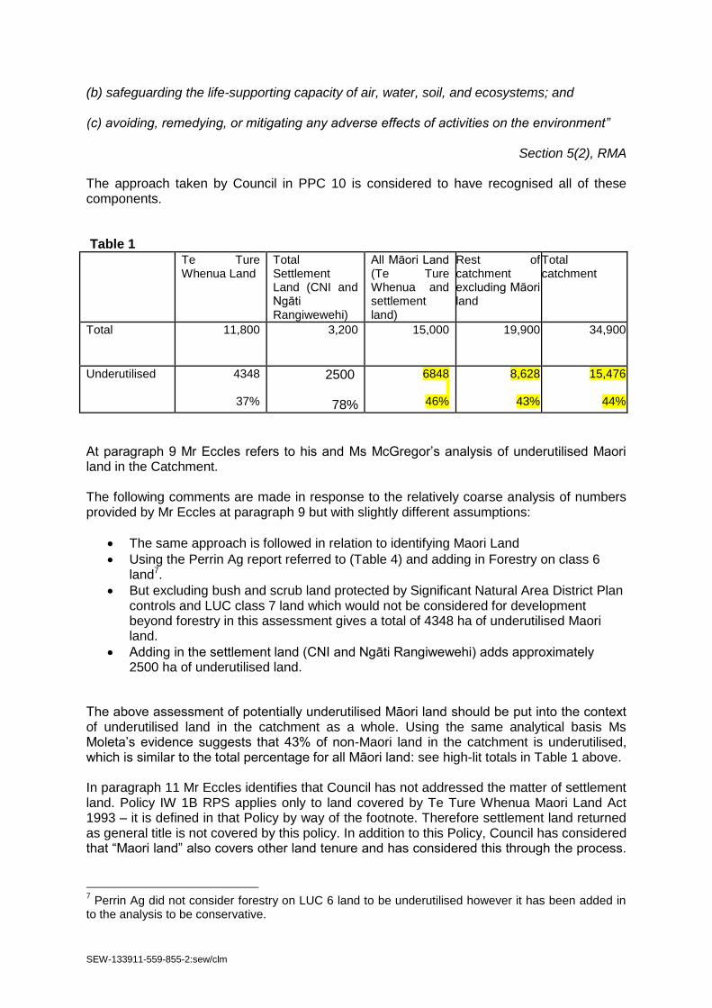
SEW-133911-559-855-2:sew/clm
(b) safeguarding the life-supporting capacity of air, water, soil, and ecosystems; and (c) avoiding, remedying, or mitigating any adverse effects of activities on the environment”
Section 5(2), RMA The approach taken by Council in PPC 10 is considered to have recognised all of these components. Table 1
Te Ture Whenua Land
Total Settlement Land (CNI and Ngāti Rangiwewehi)
All Māori Land (Te Ture Whenua and settlement land)
Rest of catchment excluding Māori land
Total catchment
Total 11,800 3,200
15,000 19,900 34,900
Underutilised 4348
37%
2500
78%
6848
46%
8,628
43%
15,476
44%
At paragraph 9 Mr Eccles refers to his and Ms McGregor’s analysis of underutilised Maori land in the Catchment. The following comments are made in response to the relatively coarse analysis of numbers provided by Mr Eccles at paragraph 9 but with slightly different assumptions:
The same approach is followed in relation to identifying Maori Land
Using the Perrin Ag report referred to (Table 4) and adding in Forestry on class 6 land7.
But excluding bush and scrub land protected by Significant Natural Area District Plan controls and LUC class 7 land which would not be considered for development beyond forestry in this assessment gives a total of 4348 ha of underutilised Maori land.
Adding in the settlement land (CNI and Ngāti Rangiwewehi) adds approximately 2500 ha of underutilised land.
The above assessment of potentially underutilised Māori land should be put into the context of underutilised land in the catchment as a whole. Using the same analytical basis Ms Moleta’s evidence suggests that 43% of non-Maori land in the catchment is underutilised, which is similar to the total percentage for all Māori land: see high-lit totals in Table 1 above. In paragraph 11 Mr Eccles identifies that Council has not addressed the matter of settlement land. Policy IW 1B RPS applies only to land covered by Te Ture Whenua Maori Land Act 1993 – it is defined in that Policy by way of the footnote. Therefore settlement land returned as general title is not covered by this policy. In addition to this Policy, Council has considered that “Maori land” also covers other land tenure and has considered this through the process.
7 Perrin Ag did not consider forestry on LUC 6 land to be underutilised however it has been added in
to the analysis to be conservative.

SEW-133911-559-855-2:sew/clm
It is also noted that Policy WL 5B relates to allocation to “land use activities” not by ownership. 3. The effect of Rule LR R7 on undeveloped land
Mr Eccles incorrectly attributes Rule LR R7 to be the primary mechanism of addressing underutilised land. Council has discussed with the Panel the package of rules that either allow properties to “lift” their nitrogen discharge or where flexibility is available in terms of moving or acquiring NDAs. The key “method” of addressing underutilised land is the allocation methodology. This is where the figure of 2,800 ha of increases to NDAs comes from – 1,800ha of which is Maori land. Rule LR R7 follows the same allocation pathway but is a permitted rule to allow low intensity farming operations an administratively simple pathway (as opposed to requiring a consent). Mr Eccles is correct that there are limitations8 with the mechanism – but this point is unclear as there are limitations in the majority of the PPC10 rules due to the need to significantly reduce the nitrogen loss from within the Catchment. 4. Summary
As noted above this is not an easy area for Regional Council staff to respond to. Ultimately, after considering the relevant matters, the context within which decisions are made remains important: Lake Rotorua is significantly over-allocated in terms of its assimilative capacity. PPC 10 has the reduction of existing nitrogen losses as its primary focus. This means that everyone will lose something – this will either be a real cost or an opportunity cost. The objective though is for everyone to gain something – a clean lake, and to reflect the underlying reasons for why Lake Rotorua is a Deed funded Lake. The Regional Council believes that it has adequately considered the matters relating to Maori interests and underutilised land in coming to appropriate decisions around PPC10, and the planning analysis supports this conclusion.
8 Mr Eccles point 15(b) is correct but only insofar as this not being allowed as a permitted activity.
Transfer of NDA occurs under Rule LR R10 and requires a consent.

SEW-133911-559-855-2:sew/clm
APPENDIX 8 Planning Response re Rule 11 RWLP (Consequential changes)
Plan Change 10 Hearing Response to Panel’s request for information TOPIC: Application of Rule 11, 11A to 11F Regional Water and Land Plan
(a) Introduction
A series of rules within the Regional Water and Land Plan were introduced to control the increase of nitrogen and phosphorus. These rules are Rule 11 and 11A to 11F. Generally these rules are focussed on rural activities on a non-point source basis however parts of the suite of rules have an application to the urban area: specifically Rule 11 and Rule 11F (see appendix for the text of these two rules9).
Rule 11: urban properties connected to a reticulated sewerage system are permitted
Rule 11F: point source discharges that increase nitrogen and phosphorus discharges - discretionary.
In practice Rule 11 is somewhat superfluous and Rule 11F is used in conjunction with other rules – but not by itself. For example, point source discharges that are not addressed by other rules are covered by Rule 37 Discretionary – Discharges to Water or Land. Any significant discharge would be considered under Rule 37 – with Rule 11F contributing only the consideration of nitrogen and phosphorus discharges. Further information on this relationship can be found in the Record of Discussions between Bay of Plenty Regional Council and Rotorua Lakes Council TOPIC: Provisions relating to WWTP infrastructure (section 5). In relation to PPC10, rule 11F has been considered in terms of what activities would solely be an increase in nitrogen and phosphorus discharge for which rule 11F would be relevant. No activities have been identified. The intent of the Rule 11 suite as identified in the Section 32 Report and effectiveness review report is to set a baseline for nutrient export and to cap nutrient export at that level (no net increases):
The intent of the rules in section 9.4 is to prevent the net increase of the export of nitrogen or phosphorus from the cumulative effects of all activities in the catchments of degraded lakes in order to assist the recovery of lake water quality.
Regional Water and Land Plan Section 9.4 Page 204
(b) Submissions
9 There is some uncertainty about Advice note 4 under Rule 11 (page 208 RWLP) identifying urban areas that are not reticulated being subject to rule11A to 11E whichever are relevant. It is unclear how these rules would apply except that all properties greater than 0.4 ha are required to be benchmarked.

SEW-133911-559-855-2:sew/clm
The matter of the retention of a restricted discretionary rule (along the lines of Rule 11F) has been submitted on by Rotorua Lakes Council (submission number 26) and referenced in evidence provided. The key matter is for there to be a similar provision to Rule 11F to apply to future waste water treatment plant discharges. One further submission (Submission FS 04) was received objecting to the submission made by Rotorua Lakes Council.
(c) Discussion
Rule 11F has been utilised in a number of consents through Council’s bundling approach. For example, dairy effluent discharge consents are issued under Rule 3210 and Rule 11F, or under Rule 3711 and 11F. The 11F portion of the consents is to acknowledge the importance of no net increase of nitrogen and phosphorus discharges although this aspect does not appear to have been an active part of considerations during the consenting process. No solely Rule 11F consents have been discovered from querying the information available and contacting staff. Council is currently undergoing a step change in information management and such queries will be more robust in the future. The Restricted Discretionary status comes into play for effluent discharges which would otherwise have been Controlled Activities under Rule 32. As noted above Rule 11F was considered during the development process for PPC10 in relation to activities that would be solely assessed under the rule. In this regard Rule 11F does not add any additional rule application. However, it is acknowledged that what it does do is reinforce the position of “no net increase in nitrogen and phosphorus” within the catchment. On this basis it does increase the robustness of the Regional Water and Land Plan as it applies to the Lake Rotorua Groundwater catchment. On this basis there is the option of retaining Rule 11F (i.e. deleting it from the consequential amendments) to ensure a specific regulatory requirement to consider the “no net increase in nitrogen and phosphorus” position within consenting processes. This would negate any need for a specific “waste water treatment discharge” rule to be inserted into PPC10.
10
Rule 32:Controlled – Discharges of Dairy Shed or Piggery Effluent to Land 11
Rule 37 – Discretionary – Discharges to Water or Land

SEW-133911-559-855-2:sew/clm
Appendix 1: Regional Water and Land Plan
Rule 11 Permitted – Land Use Activities in the Catchments of Lakes Okareka, Rotoehu, Okaro, Rotorua
and Rotoiti where the property is connected to a reticulated wastewater (sewage) system
Any land use activity in the catchments of Lakes Okareka, Rotoehu, Okaro, Rotorua or Rotoiti, where: 1 The property is connected to a reticulated wastewater (sewage) system; and either (a) or (b): (a) The property is within an urban area or lakeside settlement. (b) The property is in a rural area and is less than 0.4 hectares (4,000 m²). Is a permitted activity. Rule 11F Restricted Discretionary – Increased Discharges of Nitrogen and Phosphorus from Discharge
Activities in the Catchments of Lakes Okareka, Rotoehu, Okaro, Rotorua and Rotoiti
The increase in the discharge of nitrogen or phosphorus from a: 1 Point source discharge of contaminants to water; or 2 Point source discharge of water to water; or 3 Point source discharge of contaminants to land in circumstances where the contaminant may enter surface water or groundwater; in the catchments of Lakes Okareka, Rotoehu, Okaro, Rotorua and Rotoiti, Is a restricted discretionary activity. Environment Bay of Plenty restricts its discretion to the following matters: (a) Measures to offset adverse effects on water quality, including surface water and groundwater. (b) Measures to fully offset the increase in the discharge of nitrogen or phosphorus from the activity within the same lake catchment. (c) Measures to avoid, remedy or mitigate adverse effects on aquatic ecosystems in streams and rivers. (d) Aspects of the activity that cause an increase the export of nitrogen or phosphorus from the activity. (e) Administration charges under section 36 of the Act. (f) Financial contributions under section 10 of

SEW-133911-559-855-2:sew/clm
APPENDIX 9: Track change amendments proposed: PPC 10 Version 6
[See attached PDF version]