in /s&^©« - library.wur.nllibrary.wur.nl/isric/fulltext/ISRIC_11519.pdf · contents summary i 1....
28
Technical Soils Bulletin No. 15 in /s&^©« MATCHING OF LAND USE REQUIREMENTS WITH LAND QUALITIES USING THE JAMAICA PHYSICAL LAND EVALUATION SYSTEM (February 1989) Scanned from original by ISRIC - World Soil Information, as ICSU World Data Centre for Soils. The purpose is to make a safe depository for endangered documents and to make the accrued information available for consultation, following Fair Use Guidelines. Every effort is taken to respect Copyright of the materials within the archives where the identification of the Copyright holder is clear and, where feasible, to contact the originators. For questions please contact [email protected] indicating the item reference number concerned. MINISTRY OF AGRICULTURE RURAL PHYSICAL PLANNING DlVISION SOIL SURVEY UNIT \\S12
Transcript of in /s&^©« - library.wur.nllibrary.wur.nl/isric/fulltext/ISRIC_11519.pdf · contents summary i 1....
Technical Soils Bulletin No. 15 in /s&^©«
MATCHING OF LAND USE REQUIREMENTS WITH LAND QUALITIES USING THE JAMAICA PHYSICAL LAND EVALUATION SYSTEM
(February 1989)
Scanned from original by ISRIC - World Soil Information, as ICSU World Data Centre for Soils. The purpose is to make a safe depository for endangered documents and to make the accrued information available for consultation, following Fair Use Guidelines. Every effort is taken to respect Copyright of the materials within the archives where the identification of the Copyright holder is clear and, where feasible, to contact the originators. For questions please contact [email protected] indicating the item reference number concerned.
MINISTRY OF AGRICULTURE RURAL PHYSICAL PLANNING DlVISION SOIL SURVEY UNIT
\\S12

SUMMARY:
The development o-f a computerized Physical Land Evaluation System •for Jamaica (JAMPLES) is a complex process, particularly the elaboration o-f the matching modules. The latter enable the comparison o-f land use with land with a view to determine land suitability. The land evaluation module (LANDEV) determines the land suitability classi-fication -from previously generated -factor ratings, which indicate the partial suitabi 1 ities o-f 13 land qualities o-f a particular land unit -for a speci-fic land use alternative, taking into consideration land improvements practicable at the speci-fied level o-f technology and capital — intensity. Land qualities o-f the Dawkins clay—loam map unit, Bernard Lodge area, are matched with the land use requirements o-f selected land utilization types indicating physically suitable land use alternatives.
".QCds: land utilization types, land use requirements, land qualities, matching, land evaluation, Jamaica.
This Technical Bulletin is the 15th in a series issued by the Soil Survey Project (JM/86/008) , a bi-lateral undertaking o-f the Governments o-f Jamaica and The Netherlands. The software and report were prepared by Niels H. Batjes.
1

CONTENTS
SUMMARY i
1. INTRODUCTION 1
2. MAJOR KINDS OF LAND USE AND LAND UTILIZATION TYPES 2
3. LAND USE REQUIREMENTS 5
4. LAND QUALITIES 5
5. MATCHING OF LAND USE REQUIREMENTS WITH LAND QUALITIES 7
6. LAND SUITABILITY CLASSES 9
7. PRESENTATION OF RESULTS 10
8. DISCUSSION 12
ACKNOWLEDGEMENTS 12
REFERENCES 13
APPENDICES 15
I Calculation o-f T, I, R, S and E-indices -for speci-fic combinations o-f land units and land utilization types.
II Rules -for combining -factor ratings into land suitability. classes using the land evaluation module (LANDEV).
III Identi-fication o-f suitable -forms o-f land use -for the Dawkins clay loam soi1 mapping unit in the Bernard Lodge area, St. Catherine.
IV Short user's guide to the LANDEV module.
il

1. INTRODUCTION
Data on land resources collected during soi1 surveys have to be interpreted -for users o-f survey reports. This can be done in a number o-f ways. Formerly, the USOA Land Capability Classi-fication System (Klingebiel Se Montgomery 1961) was widely used in Jamaica (RRC 1958-1970). A disadvantage o-f the USDA system is that the uses -for which the land is classi-fied are de-fined in general terms only. The -fact that an objective comparison of alternative land uses possible for the same track of land <land unit) is not feasible with the USDA system was recognized at an early date in Jamaica where Soi1 and Land Use Surveys include tables of 'recommended crops for soils' <RRC 1958-1970).
One of the basic principles of "A Framework for Land Evaluation" (FAO 1976) is that land use performance should be assessed with respect to specific uses. The Framework is not a land evaluation system by itself; it provides guidelines with which a regional or national system can be developed.
Land evaluation according to the Framework methodology was initiated in Jamaica at the Rural Physical Planning Unit, Western Region (see Scholten & Andriesse 1982). The elaboration of a computerized Physical Land Evaluation System for Jamaica (JAMPLES) subsequently became one of the terms of reference of the Soil Survey Project. After a transitional period, during which a combination of the USDA and FAO systems were used (SSU, 1986a), work was started on the methodology and software of JAMPLES (Batjes et al. 1987).
The methodology and applications of JAMPLES are documented in various publications to which the reader is referred for additional information (SSU 1985-1989). The principles and procedures of land evaluation are explained in detail by FAO (1976, 1979a & 1983).
This paper discusses the final, critical stage in physical land evaluation which involves the matching of land qualities (LQ> of a particular land unit with land use requirements of a specific land utilization type (LUT).
Agricultural land use in Jamaica is highly varied (see CRIES/RPPD 1982). In view of this complexity and the scale of routine soil surveys prepared by Soil Survey Staff (1:25,000 - 1:50,000), four major kinds of land use (MLU) are considered in the land evaluation module (LANDEV). LUTs are defined as 'management systems*: they produce specific crops within a wel1 defined technical and socio-economic setting (i.e. MLU, see Chapter 2). The fact that each LUT has specific land use requirements, which are related to the physiology of the erop and the management and conservation practices, is discussed in Chapter 3. The procedure which allows for the comparison of land qualities (Chapter 4) with land use requirements is documented in Chapter 5. It gives the land suitability classification (Chapter 6).
1

Suggestions -for presenting results o-f physical land evaluation are made in Chapter 7 which also emphasizes the need -for interactions between land evaluators and land use planners. Subsequently, the LANDEV module is applied to a test case -from the parish o-f St. Catherine <App. III) using the procedure o-f Appendix IV.
2. MAJOR KINDS GF LAND USE AND LAND UTILIZATION JYPES
The potential suitability o-f a land unit -for a speci-Fic erop is a function of the level o-f technology and capital-intensity available to the -farmer and his management ski lis. The actual suitability is -further determined by socio—economie -factors, including Government policy towards agricultural production.
A land utilization type (LUT) is de-fined here as a management system in which a speci-fic erop is produced within the technical and socio-economic setting o-f a well de-fined major kind o-f land use <MLU). Four MLUs are considered in LANDEV. They are described below in general terms. Descriptions o-f the MLUs should be refined to suit local conditions prevailing in each survey area but this without changing the technical assumptions postulated in Appendix I. Ideally, this excercise should be carried out in collaboration with an experienced agricultural economist.
MLU-A: Mixed, non-commercial (subsistence) rain-fed -farming based on low technology and low capital-intensity.
Land use is of a permanent nature on holdings of less than x hectare each Cx: acreage to be specified by the user3. Each holding consists of several small plots which occur generally over a larger area. Capital intensity of farmers is low, limiting physical inputs to land clearing, burning and shallow tillage before sowing or planting. All field activities are carried out manually, the main tools being the spade, fork and machete. Meeding practices are generally at a low level as are erosion and drainage control. Manure, where available, is used to correct/maintain the nutriënt status of the soi1 but chemical fertilizers and lime are seldom applied. And this, mainly as a result of economie constraints. Hence the need for a fallow period to regenerate the soil fertility status.
Local varieties of annual, perennial and tree crops are grown in a mixed eropping system. A limited number of climatically adapted tree crops is grown on the homestead. Average yields remain low at the prevailing level of technology/capital-intensity. Farmers are mainly without formal education. They follow traditional methods and show little inclination towards change if such changes involve taking risks. Support from the Extension Service is needed.
2

MLU-A includes activities such as the rearing of local breeds of goats and pigs on marginal land or of chicken and rabbits on the homestead, while bee—keeping is practiced by some farmers. The produce is mainly used for subsistence but occasional surplusses are sold on the local market.
MLU-B: Mixed, commercial (rural market oriented) rainfed farming using intermediate technology and intermediate capital-intensity.
Land tenure is of a permanent nature. Farm size varies from x to y ha and plots are somewhat fragmented. Technology and capital intensity are at intermediate level. Cultivation is sometimes mechanized but most field maintenance practices are carried out manually. Soi1 drainage works are seldom used whereas sirnple soi1 conservation measures are common practice. Meeding is done by hand and commercial pesticides are used. Other physical inputs include liming, manuring and the application of fertilizer. The rate, kind and application of Chemical fertilizers is not based on erop and soi1 specific recommendations. As a result, only sirnple nutriënt deficiencies and toxicities can be remedied under good management.
Most farmers have at least primary school ing. They are willing to adopt improved methods where benefits can be clearly demonstrated. Detailed recommendations on agronomic practices are provided by the Extension Service.
MLU-B is mainly based on a mixed cropping pattern, but in some small fields annual crops are grown in pure stands. Mainly local erop varieties are grown. Sirnple moisture control measures are taken to optimize rainfall efficiency for crops.
The produce is mainly sold at rural markets. MLU—B requires adequate marketing facilities and good infrastructure.
MLU-C: Mixed, commercial <rural/urban market oriented) rainfed farming with supplementary irrigation under intermediate technology and intermediate capital-intensity.
Land tenure is of a permanent nature. Farm size varies from x to y ha and plots are mainly clustered. Management, technology and capital intensity are at intermediate level. Cultivation is often mechanized but some field maintenance practices are carried out manually. Moderate use is made of drainage works and soi1 conservation practices. Most weeding is done by hand but commercial pesticides are used. Other physical inputs include liming, manuring and the application of fertilizer. The rate, kind and application of fertilizers is based on general recommendations for particular crops but they are not soi1 specific. As a result, only sirnple nutriënt deficiencies and toxicities can be corrected under good management.
3

MLU-C mainly differs front MLU-B in that it uses supplement ar y irrigation (mainly furrow and/or sprinklers). The irrigation
facilities allow -Farmers to remedy possible periods of water shortage during the rainy season — enhanced risk security — but the irrigation capacity is not adequate for year—round irrigation.
Most farmers have at least primary school ing. They are willing to develop and adopt improved methods. Detailed recommendations on agronomic practices are provided by the Extension Service based on results of agricultural research.
The system is based on a single cropping pattern and sound erop rotation. Local and high yiel ding erop varieties are produced, mainly to be sold at rural and urban markets. This MLU requires good marketing facilities and infrastructure.
MLU-D: Commercial (urban/export market oriented) rainfed/irri-gated farming based on high technology and high capital intensity.
Land tenure is of a permanent nature. Farms are mainly large <x-y ha) and consist of contiguous plots. They are operated by highly ski lied managers, who often have a degree or diploma in agricultural education. The level of capital intensity, technical know—how and management is high. Field operations (e.g. cultivation, sowing, fertilizer application, spraying) are predominantly mechanized, but manual labour is used at harvesting. Irrigation (i.e. furrow, sprinkler or drip) is widely used in areas or periods of low rainfall, resulting in a high demand for a reliable supply of good quality piped water. Adequate use is made of drainage works and soil conservation practices. Pesticides, herbicides and inorganic fertilizers are widely used and applied on a erop respectively soil specific basis.
Physical soil characteristics are the main^source of limitations at this level of technology. "Moderate" limitations related to impeded drainage are solved through artificial drainage. Limitations of a chemical nature can be remedied in MLU—D except for salinity and sodicity. For the latter, improvements are not considered economically viable (e.g. reclamation of saline/sodic soiIs).
Modern farming and marketing techniques are used to maxi mi ze yields and economie returns. This includes the growing of high yiel ding erop varieties in pure stands and in agriculturally sound rotations. In case of irrigated pastures, beef and dairy are the main produce. All produce is sold at the urban market or exported. This makes a good infrastructure necessary.
4

3. LAND USE REQUIREMENTS
FAO (1976) de-Fines land use requirements as the set o-f conditions necessary or desirable -for the succesful and sustained operation o-f a given land utilization type.
The set o-f land use requirements related to the e-f-ficient functioning o-f a particul ar LUT includes:
Physiological requirements vary -from one erop to the other and also between erop varieties. For a particular erop, there wi11 be a difference between the physiological requirements for minimum and optimum growth. The information stored in the computerized erop data files is mainly derived from international sources (ANONYMUS 1984, BOOKER 1984, FAO 1979b, ILACO 1981, IRRI 1980, PURSEGLOVE 1968 and SYS 1980) and complemented with Jamaican expertise (MINAG 1964, MINAG 1950-1979, RPPD 1985 and ROYES 8c BARNES 1988). A listing of the contents of the erop data base is available for internal use at the Rural Physical Planning Division.
b) Management requirements. Each type of LUT has specific requirements which are related
to the level of technology and capital intensity (see Chapter 2 ) . The land improvements — both minor and major - considered practicable by farmers operating within a specific MLU are listed in Appendix II.
c) Qonservat i_gn reguLrements. Land evaluation rates land suitability on a sustained basis.
Consequently, the absence of risk of environmental degradation is considered as a land use requirement (e.g. soi1 conservation and control of soil salinity levels).
4- LAND QUALITIES
During a soil survey mapping units, which are representative for specific land units, are demarcated on a map. Soil Survey Unit Staff characterize soil mapping units using one or more major soiIs depending on the fact whether a mapping unit is pure (consociation) or compound (complex or association). The component parts of a compound mapping units may have different suitabilities for a given use. They should therefore be explicitely mentioned when presenting results of the land evaluation (see Chapter 6).
In order to account for the spatial variability of land qualities within a map unit it is recommended that land evaluation studies be based on more than one representative profiIe for each major soil (series).
5
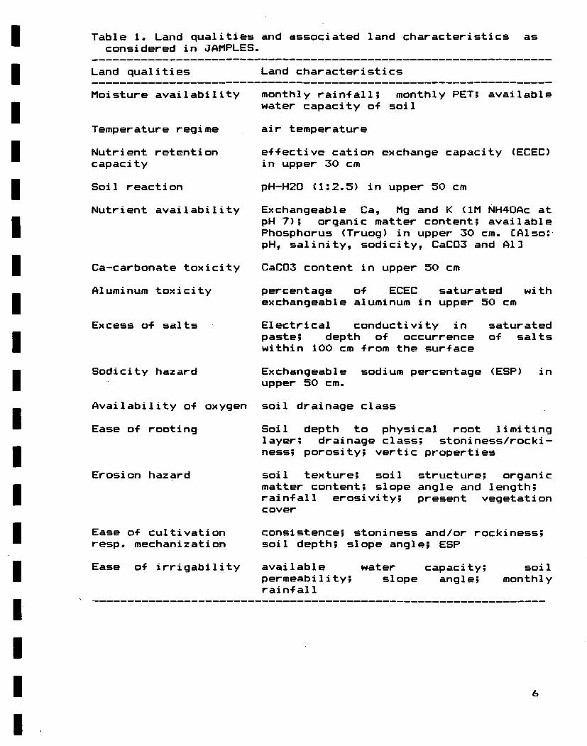
Table 1. Land qualities and associated land characteristics as considered in JAMPLES.
Land qualities Land characteristics
Moisture availability monthly rain-fall; monthly PET; available water capacity o-f soil
Temperature regime air temperature
Nutriënt retention e-f-fective cation exchange capacity (ECEC) capacity in upper 30 cm
Soil reaction pH-H20 (1:2.5) in upper 50 cm
Nutriënt availability Exchangeable Ca, Mg and K <1M NH40Ac at pH 7); organic matter content; available Phosphorus (Truog) in upper 30 cm. CAlso: pH, salinity, sodicity, CaC03 and Al]
Ca-carbonate toxicity CaC03 content in upper 50 cm
Aluminum toxicity percentage of ECEC saturated with exchangeable aluminum in upper 50 cm
Excess o-f salts Electrical conductivity in saturated paste; depth o-f occurrence o-f salts within 100 cm -from the sur-f ace
Sodicity hazard Exchangeable sodium percentage (ESP) in upper 50 cm.
Availability o-f oxygen soil drainage class
Ease o-f root ing Soil depth to physical root limit ing layer; drainage class; stoniness/rocki-ness; porosity; vertic properties
Erosion hazard soil texture; soil structure; organic matter content; slope angle and length; rain-fall erosivity; present vegetation cover
Ease o-f cultivation consistence; stoniness and/or rockiness; resp. mechanization soil depth; slope angle; ESP
Ease o-f irrigability available water capacity; soil permeability; slope angle; monthly rain-f al 1
6

Each land unit possesses specified land characteristics and/or qualities. Land qualities are complex attributes o-f land which act in a manner distinct from the actions o-f other land qualities in their influence on the suitability of land -for a speci-fied use (FAO, 1976). Land qualities are described using one or more land characteristics, which are attributes o-f land that can be measured or estimated (Table 1), and rated according to the rating system developed by Soil Survey Sta-f-f (SSL), 1987).
5- MATCHI.NG OF LAND-USE REQUIREMENTS WITH LAND QUALIHES
So -far, requirements o-f 50 crops and 4 MLUs are considered in LANDEV. This means that land suitability classi-fications -for 200 di-f-ferent LUTs could be studied with each run o-f JAMPLES. Of course, it wi11 not be meaningful to study all 200 LUTs simultaneously! The land evaluator should only select those LUTs that are relevant for the study area and of interest to the end user.
The computerized matching process is carried out in two stages using subsequently the MATM0D and LANDEV modules (Figure 1). In a non—computerized land evaluation system conversion tables would be elaborated at this stage.
a) The MATM0D module compares the requirements of particular crops with the land qualities of a land unit (SSU 1986b & 1987). This process gives the factor rati_ngs or degrees of ii.mi_tati_gn, i.e. a set of critical values which indicate how well a land use requirement is satisfied by current conditions of the corresponding land quality. Each factor rating is assessed in terms of the anticipated reduction in yield (see Appendix I).
b) The land improvements considered feasible for the specified LUT, i.e. as determined by the technical and socio—economie setting (MLU) , are simulated with LANDEV. This procedure accounts for the fact that some kinds of limitation cannot be modified (e.g. soil depth to hard rock) whereas others can by using land improvements (e.g. addition of chemical fertilizers, irrigation or drainage) (see Appendix II). The LANDEV module prints tables showing ECoyJ^sIgnal land suitability classifications for specific uses (see Appendix III).
The final land suitability classification is derived from the provisional class. At this stage, preliminary results are checked and validated. This is a cruci_al £h§.se in the land evaluation procedure! Where necessary, the land evaluator can still account for land qualities or land use requirements which are not "programmed" in the JAMPLES software (e.g. occurrence of f looding or cold winds) . It is also at this stage that the land evaluator can review the preliminary assumptions pertaining to the requirements of the LUT or the rating of the land qualities.
7
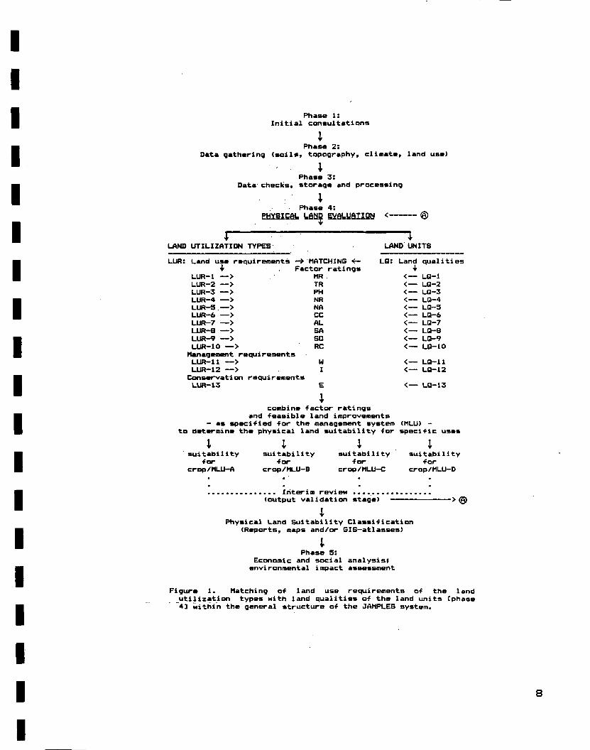
Phase 1: Initial consultations
; Phase 2:
Data gatharing <soils» topography, climate, land usa)
i Phase 3:
Data checks, storage and processing
; Phase 4 :
PHYSICfli. UÖJÜB gïfitUaiiSW < @
l " 1 LAND UTILIZATION TYPES LAND UNITS
LUR: Land use requirements -* MATCHING «- LQ: + Factor ratings
LUR-1 LUR-2 LUR-3 LUR-4 LUR-5
—> —> — > —> —>
LUR-6 — > LUR-7 — > LUR-B — > L U R - 9 — > LUR-10 — >
Management requirements LUR-11 — > LUR-12 — >
Consarvation requirements LUR-13
MR TR PH NR NA CC AL SA SO RC
U I
Land q u a l i t i i •ir
<— LQ-1 < — LQ-2 < — LQ-3 < — LQ-4 < — LQ-5 < — LQ-6 < — LQ-7 < — LQ-B < — LQ-9 < — LQ-10
< — LQ-11 < — LQ-12
< — LQ-13
combine -factor ratings and feasible land improvements
- as speci-fied for the management system (MLU) -to determine the physical land suitability for speci-fic use*
suitability for
crop/MLU-A
suitability *or
crop/MLU-B
suitability for
crop/MLU-C
suitability •for
crop/MLU-D
... Interim review ....... (output validation stage) ->®
; Physical Land S u i t a b i l i t y C l a s s i f i c a t i o n
(Reports, maps and/or GIS-at lasses)
; Phase 5:
Economie and social analysisl environmental impact assessment
Figure 1. Matching o-f land use requirements o-f the land utilization types with land qualities o-f ths land units Cphase 4] within the general structure o-f the JAMPLES system.

Land qualities not only in-Fluence erop cultivation through their e-f-fect on yields and inputs, but also through their effect on the quality o-f the harvested product <e.g. tobacco leaf, -flavour o-f cocoa bean) . The latter e-f-fect cannot easily be accounted -for in a computerized procedure, but it should be taken into account when discussing the -final suitability, particularly -for crops where the price range between good and poor quality is large (e.g. Blue Mountain versus Lowland co-f-fee) .
6- LAND SUITABILITY CLASSES
Two land suitability orders are considered in JAMPLES in accordance with the format proposed in * A Framework for Land Evaluation '(FAO 1976), viz. suitable (S) and not-suitable <N>. Classes within orders are indicated with numerals which reflect the respective degree of suitability of the land for the specified land use.
Four land suitability classes are recognized in JAMPLES (see Table 2), viz:
~ yiStliY. =»ui_table jSl),: This type of land has no significant limitations to sustained application of a given use, or only minor limitations that will not significantly reduce productivity and will not raise inputs above acceptable levels. In most years, the specified erop will produce from to 80 to 100 percent of the targeted yield.
- ModerateIy_ suitable J.S2)_: This type of land has limitations which, when combined, are moderately severe for sustained application of a given use. The limitations of the land will reduce productivity and increase required inputs to the extent that the overall advantage to be gained from the use will be appreciably lower to that experienced for Si land, but the inputs will be satisfactorily covered by the returns. In most years, the considered erop will produce from 40 to 80 percent of the targeted yield.
— d«ïC9iQ3i.l.Y. sui_tab_Ie i.S3i: When land is rated as S3 its aggregate limitations are severe for sustained application of a given use. Productivity will be so reduced that the inputs will be only marginally covered. In most years, the specified erop will produce from 20 to 40 percent of the targeted yield.
Land on which a erop produces less than 20 percent of the targeted yield in most years is termed not-suitable. It can either be currently ngt-sui.tab_Ie, i.e have limitations that are so severe so as to preclude successful sustained use of the land in the given manner, or eerfli§QentlY_ not— syltable, that is show no potential for sustained agriculture irrespective of the type of land improvements.
9

The class "not-relevant" is used when a particular land use is not pertinent within the socio-economic context of the study area.
Table 2: Agro-ecological land suitability classes determined with the land evaluation module (LANDEV).
Suitability expected % o-F targeted Order Class yield
S: suitable 51: highly suitable 80 to 100% S2: moderately suit. 40 to 80% S3: marginally suit. 20 to 40%
N: not-suitable 0 to 20%
Suitability subclasses are indicated with common letters where the land suitability -for a speci-fied use is either S2 or S3. Each letter reflects the nature o-f a major limitation -for the envisaged land use. Additional insight with regard to the nature o-f the limitations can be derived -from the tables generated with MATM0D (see Table 1 in Appendix III). So -far, six subclasses are programmed in LANDEV, viz.:
t: air temperature limiting w: rain-fall regime limiting (possibly too wet) r: rain-fall regime limiting <low, rain-fed uses only) c/p: un-favourable soil/terrain conditions (chemical and/or
physical where the most limiting condition is indicated) e: risk o-f soil erosion under sustained use
Land which rates as S2e -for a speci-fied LUT (e.g. Cg££ea arabi^ca/ MLU-B) is moderately suitable for this land use alternative. The main problem -for sustained and success-ful land use at the considered level o-f technology and capital-intensity <MLU—B) is the risk of soil degradation tnrough erosion (e).
The targeted (or optimum) yield of a particular erop changes with the technical and socio-economic setting within which it is produced. That is, it generally increases in the direction from low <MLU-A) to high <MLU—D) conditions. For most crops yield depressions, which result from partial deficiencies of specific LQs, cannot yet be quantified due to a scarcity of relevant research data for Jamaica. The col1 eetion of data on erop responses to less than optimal agro—ecological conditions is one of the most needed activities for improved land evaluation at this moment!
6. PRESENTATION OF RESULTS
Land evaluation results should be presented in a format which wi 11 be readily accepted by the end user. This involves the preparation of a report which explains the general procedure and
10

assumptions and includes summary tables which show the physical suitability o-f each land unit -for the specified land utilization types. The latter tables (Table 3) can be derived -from output generated using LANDEV. This manual stage is incorporated with a view to ensure that provisional results are throroughly checked by report-writers be-fore they are released as recommendations to end users.
Table 3. Recommended -format -for presenting resul ts o-f physical land evaluations on a soil mapping unit basis -for speci-fic land utilization types (*).
LAND UNIT LAND UTILIZATION TYPE
Soil map major slope erop—1 crop-2 ... crop-n unit code soils phases
PR1 Whim 0-27. SI SI S2
B0x5 Linstead Linstead Rosemere
0-2% 2-5% 2-57.
SI SI S2c
S2p S2p S3c
S3p S3p N
HLxl St. Ann Bonnygate Rockland
8-167. 16-307. 30-507.
S2e S3e N
S2e N N
S3e N N
* Note: One table should be prepared -for each technical and socio—economie setting (MLU).
Ideally, resul ts o-f land evaluation should also be mapped. Each map should indicate which soil mapping units are suitable -for a particular LUT. Although such maps are easier to read than land evaluation tables they are seldom prepared at RPPD, mainly in view o-f the large number o-f maps involved. The geographic in-formation system <GIS) o-f the Rural Physical Planning Division -facilitates the mapping process, but the cost o-f reproducing land suitability maps remains prohibitive.
Examples o-f land evaluation studies based on JAMPLES are included in Soil Survey Reports issued by SSU <19S8c p. 53; 1988d p. 20). Following a description o-f the physical environment (cl imate, geology, relie-f, soils and present land use) these reports identi-fy -feasible land use alternatives and review the consequences o-f each alternative on the environment <e.g. risk o-f environmental degradation). Physical land evaluation does not provide any judgement on the desirability o-f one type o-f land use as compared to another. It is mainly concerned with the assessment o-f land resources with a view to identi-fy technically -feasible land use alternatives. As such physical land evaluation provides users (e.g. farmer, planner or politician) with the basic in-formation required -for planning, development and
11

management decisions. The select ion o-f the most promising land use alternative is the task of the planner, who should also consider socio-economic and political factors in his selection. Consultations between land evaluators and planners should occur throughout the land evaluation and land use planning process.
7. DISCLJSSIQN
In computerized procedures such as MATMOD and LANDEV there is a need for checks to ensure that the results are in accord with common sense. This "human component" has been incorporated in the JAMPLES methodology.
The land evaluator should assess at an early stage which LUTs are relevant for a specific study area, and this ideally in conjunction with the end user. Thirteen land qualities, deemed most important in terms of their effect on land use performance in Jamaica, are studied with MATMOD and LANDEV. On a regional basis, however, a limited number of 'other' land qualities may also be of importance. The land evaluator should account for these regional factors when drawing up the final recommendations.
The descriptions of the major kinds of land use (MLU) and land quality ratings may be adapted where necessary, resulting in revised releases of the corresponding software modules. The effect of changes in the initial assumptions on the final land suitability for a specific LUT can readily be tested in a computerized system, thus permitting in-depth validation and calibration of the modules. In addition, computerized land evaluation procedures allow for the handling of large amounts of data in a standardized manner and at great speed.
ACKNQWLEDGEMENTS
Thanks are due to staff members of the Soi1 Survey Project for their constructive commments on the draft edition of this report, particularly Mrs P.A.M. van Gent and Messrs. V.A. Campbell, R.G. Hennemann and P. Oldeman.
12
REFERENCES
Anon., 1984. Memento de 1' agronome. Ministère des relations exterieures -Cooperation et Developement-, Paris, France.
Batjes, N.H., A.F. Bouwman and K.M. Sinclair 1987. Jamaica Physical Land Evaluation System <JAMPLES). Ir»: Beek, K.J. et al. (Eds) , Quanti-fied Land Evaluation Procedures, Publication 6, ITC, Enschede, the Netherlands. p. 39-43.
BOOKER, 1984. Booker Tropical Soi1 Manual. Bookers Agric. Inter— national Ltd., Pitman Press, Bath, United Kingdom.
CRIES/RPPD, 1982. Jamaica Resource Assessment. Comprehensive Resource Inventory System Project, Michigan State University, East Lansing in col1aboration with the Rural Physical Planning Division, Ministry o-F Agriculture, Jamaica.
FAO, 1976. A Framework -for Land Evaluation. Soils Bulletin 24, Food and Agricultural Organization o-f the United Nations, Rome, Italy.
FAO, 1979a. Land Evaluation Criteria -for Irrigation. World Soi 1 Resources Report 50, FAO, Rome, Italy
FAO, 1979b. Yield response to water. Irrigation and Drainage Paper 33, FAO, Rome, Italy.
FAO, 1983. Guidelines: Land Evaluation for Rainfed Agriculture. Soils Bulletin 52, FAO, Rome, Italy.
ILACO, 1981. Agricultural Compendium for the Tropics and Subtropics. Elseviers Scientific Publishing Co., Amsterdam, the Netherlands.
IRRI, 1980. Soil related constraints to food production in the tropics and subtropics. International Rice Research Institute/ Cornell University, Los Banos, Phillipines.
Klingebiel, A.A. & P.H. Montgomery, 1961. Land Capability Classification. Agric. Handbook No. 210, US Dept. Agric./Soil Conservation Service, Washington D.C.
MINAG, 1964. Soil Technical Guide Sheets. Agricultural Chemistry Division, Ministry of Agriculture, Kingston, Jamaica.
MINAG, 1950-1979. Investigations (various Bulletins), Ministry of Agriculture, Jamaica.
Purseglove, 1968. Tropical Crops: Mono— resp. Dico—tyledons. Longman, Harlow, United Kingdom.
Royes, H.H. & G.R. Barnes (Eds), 1988. The Jamaica Farmer's Guide. Jamaica Agricultural Society/Selecto Publishing Company, Kingston, Jamaica.
RPPD, 1985. Agro-climatic requirements of 59 crops commonly grown in Jamaica. Barker, G.H., Rural Physical Planning Division (RPPD), Ministry of Agriculture (MINAG), Jamaica. (For internal use only)
RRC, 1958-1970. Soil and Land Use Surveys, Jamaica. Regional Research Centre, Department of Soil Science, University of the West Indies, Trinidad, W.I.
Schol ten, J.J. and W. Andriesse 1982. Humic Acrisol (Orthoxic Palehumult), Jamaica. Soil Monolith Paper 5, International Soil Museum, Wageningen, the Netherlands.
SSU, 1985. Assessment of the resistance of land to erosion for land evaluation. Bouwman, A.F., Technical Soils Bulletin 2, Soil Survey Unit, RPPD, MINAG, Jamaica.
13

SSU, 1986a. Soi1 and Land Use Survey of the Coastal Plains of St. Catherine, Jamaica. V.A. Campbell, A. Commissaris & H.A. de Wit, Soil Survey Report 1, SSU, RPPD, MINAG, Jamaica.
SSU, 1986b. Matching module, Jamaica Physical Land Evaluation System (MATMOD). Bouwman, A.F., Technical Soils Bulletin 5, SSU, RPPD, MINAG, Jamaica.
SSU, 1987. Rating system for land qualities used in JAMPLES (2nd approximation). N.H. Batjes, Technical Soils Bulletin 10, SSU, RPPD, MINAG, Jamaica.
SSU, 1988a. The application of transfer functions in creating the climate data layer of the Jamaica Geographic Information System (JAMGIS). Batjes, N.H., Miscellaneous Paper 5, SSU, RPPD, MINAG, Jamaica.
SSU, 1988b. Review of agro-climatic modules of the Jamaica Physical Land Evaluation System. Batjes, N.H., Technical Soils Bulletin 13, SSU, RPPD, MINAG, Jamaica.
SSU, 1988c. Semi-detailed soil survey of the Linstead - Bog Walk area, St. Catherine, Jamaica. Batjes, N.H., A.F. Bouwman & C S . Clarke, Soil Survey Report 2, SSU, RPPD, MINAG, Jamaica.
SSU, 1988d. Land evaluation of the St. Catherine Coastal Plains, using the computerized Jamaica Physical Land Evaluation System. Batjes, N.H. & V.A. Campbell, Miscel1aneous Paper 6, SSU, RPPD, MINAG, Jamaica
SSU, 1989a. SOMOMOD: A computerized procedure for rating the land quality adequacy of water supply to annual crops under rainfed conditions. Batjes, N.H., Technical Soils Bulletin 14, SSU, RPPD, MINAG, Jamaica.
SSU, 1989b <In prep.). JAMPLES User's Guide <Version 3.0 for IBM PC compatibles). Batjes, N.H., Technical Soils Bulletin 16, Soil Survey Unit, RPPD, MINAG, Jamaica.
SYS, 1980. Land evaluation (Part I, II & III). State University of Gent, Belgiurn.
14
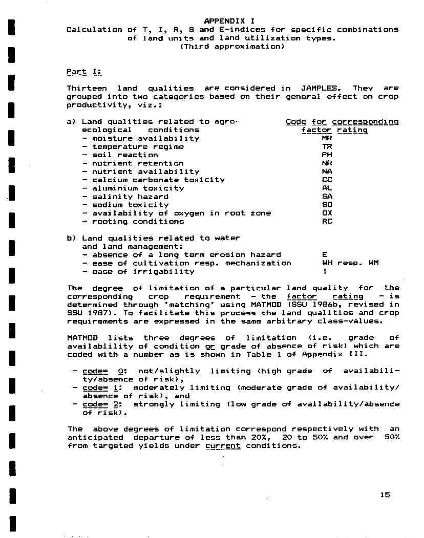
APPENDIX I Calculation o-f T, I, R, S and E-indices -for speci-fic combinations
of land units and land utilization types. (Third approximation)
Part II
Thirteen land qualities ars considered in JAMPLES. They are grouped into two categories based on their general e-f-fect on erop productivity, viz.:
a) Land qualities related to agro— Qode f gr cgr.resp_gndi.ng ecological conditions £a__tgr rati_nq - moisture availability MR - temperature regime TR — soil reaction PH — nutriënt retention NR - nutriënt availability NA — calcium carbonate toxicity CC - aluminium toxicity AL - salinity hazard SA — sodium toxicity SO - availability o-f oxygen in root zone OX - rooting conditions RC
b) Land qualities related to water and land management: — absence o-f a long term erosion hazard E — ease o-f cultivation resp. mechanization WH resp. WM — ease o-f irrigability I
The degree o-f limitation o-f a particular land quality for the corr esponding erop requirement — the factgr r.__£i.Q9 — is determined through 'matching* using MATMOD <SSU 1986b, revised in SSU 1987). To facilitate this process the land qualities and erop requirements are expressed in the same arbitrary class-values.
MATMGD lists three degrees of limitation (i.e. grade of availablility of condition gr_ grade of absence of risk) which are coded with a number as is shown in Table 1 of Appendix III.
~ co^Ër Q: not/slightly limitang (high grade of availabili-ty/absence of risk),
- cgde= _l: moderately limiting (moderate grade of availability/ absence of risk), and
- cgde= 2: strongly limiting (low grade of availability/absence of risk).
The above degrees of limitation correspond respectively with an anticipated departure of less than 20%, 20 to 50% and over 50% from targeted yields under current conditions.
15

The land suitability -for a particular LUT is assessed by taking into consideration the requirements o-f the erop and the land improvements practicable at the considered level of technology and capital-intensity <see MLU in Chapter 2 ) . This analysis is per-formed with the LANDEV module (see Table 2 in Appendix III).
1. T-index -for temper at ure regime (MLUs A, B, C and D) 1.1 I-f LT=2 and HT=2 then T-index= 40, go to 1.5 el se 1.2 1.2 H LT=2 or HT=2 then T-index= 80, go to 1.5 el se 1.3 1.3 I-f LT=1 or HT=1 then T-index= 80, go to 1.5 el se 1.4 1.4 I-f 'less limiting than above' then T-index= 100, go to 1.5 1.5 Go to 2.
2. R-index -for moisture availability (rainfed uses)
a) Annual crops (except irrigated rice) For the envisaged growing period calulate the 75%-
dependable seasonal rainfall <RS75) using transfer -functions (SSU, 1988). Compare this amount with the minimum (MiR) and maximum (MaR) seasonal erop water requirements.
a.1 I-f MiR<=RS75<=MaR then RT=0, go to c else a.2 a.2 I-f MiR-75<=RS75<MiR then RT=1, print r, go to c else a.3 a.3 I-f MaR<RS75<=MaR+150 then RT=Ö, print w, go to c else a.4 a.4 I-f RS75 < MiR - 75 then RT = 2, go to c else a.5 a.5 I-f MaR + 150 < RS75 then RT = 2, go to c else a.6 a.6 I-f RT=0 <not limiting) then go to c
b) Perennials, shrubs and treecrops Calculate the 75%-dependable annual rain-fall (RA75) and the
number o-f dry months (DM) which occur in at least 25% of the years. Compare these climatic variables with the water requirements of the erop under study, i.e. bl) the range in average annual rainfall (MiR & MaR) and b2) the length of the dry period required for good growth and production expressed in months (LDP1, LDP2).
bl) Total annual rainfall bl.1 If R75 < MiR - 200 (too dry) then Rl = 2, go to b3 bl.2 If Ma^ + 200 < R75 (too wet) then Rl = 2, go to b3 bl.3 If Mifc - 200 <= R75 < MiR then Rl = 1, print r,
go to b2 else bl.4 bl.4 If Ma&< R75 <= Mar + 200 then Rl = 0, print w,
go to b2 e U e bl.5 bl.5 If MiR =< RA75 <= MaR then Rl = 0, go to b2
b2) Length of dry period b2.1 If LDP1<= DM <= LDP2 then R2 = 0, go to b3 b2.2 If LDP1 - 2 <= DM < LDP1 then R2 = 1, print w,
go to b3 else b2.3 b2.3 If LDP2 < DM <= LDP2 + 2 then R2 = 1, print r, go to b3
else b2.4
16

b2.4 If DM < LDP1 - 2 then R2 = 2, go to b3 else b2.5 b2.5 If LDP2 + 2 < DM then R2 = 2, go to b3
b3) Derive subrating front Rl and R2 b3.1 If Rl = 2 or R2 = 2 then RT = 2, go to c else b3.2 b3.2 If Rl = 1 or R2 = 1 then RT = 1, go to c else b3.3 b3.3 If Rl = O and R2 = O then RT = 0, go to c
c) Take into account total available water capacity <AWC). - If RT is 2 the rainfall regime is strongly limiting for
the erop (too wet or too dry) so that the soi1's AWC is not considered important. Proceed with d.
- If the rating for RT is less than 2 and the region is not too wet the rainfall regime allows for economie production of the erop in most years provided soi1 AWC is favourable:
c l If AWC < 80 then RAINF = RT + 1, go to d else c.2 c.2 If AWC = >80 then RAINF == RT, go to d
d) Calculate the R-index d.1 If RAINF = O then R-index = 100, go to e else d.2 d.2 If RAINF = 1 then R-index = 80, go to e else d.3 d.3 If RAINF = 2 then R-index = 40, go to e
e) If rainfall is limiting <i.e. conditions too dry) assess the potential for irrigation (go to 3), else proceed with 4.
3. I-index for irrigability (MLUs C and D where relevant)
a) s l o p e r e q u i r e m e n t s ( t e n t a t i v e ) a.1 If slope <=8% then IR1 = 0, go to b else a.2 a.2 If 87. < slope < = 16 then IR1 = 1, go to b else a.3 a.3 If 16% < slope then IR1 = 2
b) AWC and permeabi1ity requirements bl) for irrigated rice bl.1 If PERM=>4 and slope>2% then IRRIG=IRl+2, go to e else bl.2 bl.2 If AWC=>80 and PERM<=3 then IRRIS=IR1, go to c else bl.3 bl.3 If 'other conditions than above' then IRRIG=IR1+1, go to c
b2) other crops b2.1 If AWC=>80 and 2<=PERM<=5 then IRRIG=IR1, go to c
else b2.2 b2.2 If 60<=AWC<80 and 2<=PERM<=5 then IRRIG=IR1+1. go to c
else b2.3 b2.3 If 'more limiting than above' then IRRIG=IRl+2, go to c
c) Final index for irrigability c l If IRRIG = 0 then I-index= 100, go to 4 else c.2 c.2 If IRRIG = 1 then I-index= 80, print p, go to 4 else c.3 c.3 If IRRIG =>2 then I-index= 40, go to 4.
17

4. E-index -for erosion hazard (MLUs A, B, C and O)
4.1 I-f E=0 then E-index= 100, go to 5 else 4.2 4.2 I-f E=l then E-index= 80, print e, go to 5 else 4.3 4.3 I-f E=2 then E-index= 40, go to 5.
5. S-index -for soil limitations <a-fter land improvement)
MATMOD sub-indices at resp. technology/input leveli •factor rating
(current) A B resp. C D
Availability of oxygen If DR = 0 then 100 100 100 H DR • 1 then 80 80 100 I-f DR - 2 then 40 40 80
Rooting conditions IF RC = 0 then 100 100 100 IF RC = 1 then 80 80 80 IF RC = 2 then 40 40 40
Salinity If SA = 0 then 100 100 100 If SA = 1 then 80 80 80 I-f SA = 2 then 40 40 40
Sodicity H SO = 0 then 100 100 100 I-f SO = 1 then 80 80 80 If SO = 2 then 40 40 40
Soil reaction If PH = O then ÏOO 100 100 I-f PH = 1 then 80 100 100 If PH = 2 then 40 80 100
Calcium carbonate I-f CC - 0 then 100 100 100 If CC = 1 then 80 80 80 If CC - 2 then 40 40 80
Exchangeable Aluminum If AL = O then 100 100 100 If AL = 1 then 80 100 100 If AL - 2 then 40 80 80
Nutriënt retention If NR = 0 then 100 100 ÏOO If NR = 1 then 100 100 100 If NR = 2 then 100 80 80
Nutri ent avai1ab i1i ty If NA = O then 100 100 ÏOO If NA = 1 then 80 100 100 If NA = 2 then 40 80 100
Workability <see Note) If W* = O then 100 100 100 If W* = 1 then 80 80 80 If W* = 2 then 40 40 40
18

Ngte: The range for 'slope' -for the various forms o-f land use is adapted -from the Soil Conservation Service of Jamaica <quoted by Schol ten & Andriesse 1982 p.35) which states that: •for annual crops there is no need -for permanent structures on 0-12% slopes; mechanical construction o-f bench terraces is possible on slopes between 12—36%; product ion o-f annual crops on slopes steeper than 477C is inadvisable.
The final index for the ease of workability respectively the potential for mechanization <W*) is calculated as follows:
a) MLU-A a . 1 I f s l o p e < 307. then W* = WH e l s e a . 2 a . 2 I f 307.<=slope<507. then W* = WH + 1 e l s e a . 3 a . 3 I f 'more l i m i t i n g s l o p e s ' then W* = WH + 2
b) MLU-B b . 1 I f s l o p e <16% t h e n W* = WH e l s e b . 2 b . 2 I f 167.<=slope<307. t h e n W* - WH + 1 e l s e b . 3 b . 3 I f 'more l i m i t i n g s l o p e s ' then W* = WH + 2
c ) MLU-C c l I f s l o p e < BV. t h e n W* = WM e l s e c . 2 c . 2 I f 87.<=slope<16% t h e n W* = WM + 1 e l s e c . 3 c . 3 I f 'more l i m i t i n g s l o p e s ' then W* = WM + 2
d) MLU-D d.1 If slope < 8% then W* = WM else d.2 d.2 If 87.<=slope<16% then W* - WM + 1 else d.3 d.3 If 'more limiting slopes' then W* = WM + 2
The S—index for a particular land unit and LUT can now be calculated in two stages:
1) Calculate ALPHA factor: S u~ ALPHA = (most limiting sub-index) x (average of remaining
subindices)/9o°
2) Convert ALPHA to S-index, then go to Appendix II:
ALPHA No. of limitations S-index
100 no limitations (after improvement) 100 78-99 1 or 2 moderate limitations 80 < 78 more limitations than above 40
S-index is 1 the suffix c or p - for chemical and/or limitations - is indicated in the LANDEV output for
soil conditions after land improvement.
If the physical limiting
19

Remarks
The LANDEV and MATMOD modules include *simplified' subroutines -for calculating the resistance o-f land to erosion <E) and the availa— bility o-f water supply to crops (MR). These procedures are derived from the more elaborate SODEMOD, RAINSTAT and SOMDMOD modules (SSU 1985, 1988a & 1988b). The latter modules should be used when performing detailed analyses o-f the above -factors.
20
APPENDIX II Rules -For combining -factor ratings into land suitability
classes using LANDEV.
For the general procedure re-fer to Chapter 4 o-f the report. For each land unit and land utilization type - crop-management system <MLU> system - -four arbitrary indices are calculated as shown below:
T-I-R-S-E-
ndex -for temperature regime ndex -for irrigability (MLUs C and D where relevant) ndex -for water availability (rain-fed where relevant) ndex -for soi 1 /management limitations ndex -for erosion hazard
Appendix II explained how the above indices are calculated with LANDEV. The (provisional) suitability class is derived -from the index ratings. This procedure is explained using an example: the LUT is maize/MLU—B and the land unit a 'consociation o-F Typic Eutropepts which occur on 8—16% slopes in an area with non limiting air temperature and good moisture supply'.
T-index = 100 <not limiting) R—index = 100 <not limiting) S-index = 80 (moderately limiting) E—index = 80 (moderately limiting)
The -final INDEX is obtained by multiplying the numerically lowest index value with the average o-f the remaining indices:
INDEX = 80 x (100 + 100 + B0>/Z° - 75 (rounded o-f-f figure)
The value calculated -for INDEX is subsequently suitability class using the -following key:
related to
INDEX Number o-f limitations suitability class
100 74-80 41-73 <=40
no limitations (a-fter improvements) SI 1 to 2 moderate limitations S2 3 to 4 moderate limitations S3 more limitations than above N
In the above example the land suitability subclass would read S2pe. The land unit is moderately suitable (S2) -for the speci-fied land use. The main limitations are related to physical soi1 constraints (p), e.g. stoniness, and soi1 degradation hazard (e).
21

APPENDIX III Identi-fication o-F suitable -forms o-f land use
-for the Dawkins clay-loam mapping unit in the Bernard Lodge area, St. Catherine.
The Dawkins clay-loam mapping unit, located in the dry Bernard Lodge area, is considered in this test case. The mapping unit is a consociation o-f deep, wel 1 drained, dark yellowish brown to yellowish brown, medium textured Dawkins soils with a sur-face layer o-f clay loam texture. Dawkins soils are -formed on recent alluvium and occur on level areas near stream channels and old river beds. They are coarse-loamy, mixed, isohyperthermic Typic Haplustolls. They have good physical properties but some chemical properties are limiting -for most crops (Table 1). These limitations can only be remedied at high levels o-f management which include irrigation (MLU-C and D) as -follows -from Table 2.
22

O) 01
c 30 TJ -o o
o (A i
I
-0 co -o
X J H . c t r + n B i i i n c r n n n x j n u i r t n n n T J i o n r t - a u i i n T » 3 3 gi o « » n M' i o o o c c i o d ii o H' i o o m o c ^
c »-• er o o i + 3 ID T> O
1 «O
-o T3 ID 1
3 3
CTTJ ID ID Ui 0» 3
3 O n ID 3" T
a 3 n c
T J T J H . 3 T i n 3 5 r r + I D * n n 3 n i D 3 * - i n 3 a 3 0 r + 0 - H . i i£t n | U 1 3 | l i i g 7 i a i D > 1 0 ) ^ O O ' D C I D I l i l l i l l l 3 I D C r + | l i N i Q l i i D •< > X J 3 i n i D O I D C a f D B i 3 ? r 3 r + f + » - ' 0 i ~ ~ ~ m I O I I + Ï ui -K io c »• er o o <
1 3 » T T i+ 3 ID T> 0 Bi m >< c ^ Ifl "O H . Di
c in a> T i+ er
ID C
ID
3 C r+
n H-Bi 1 3 1 ID H .
iO
O O O
O O O
O O O
O O O
t - O O
N) K- i -
W M. M.
O O O
O O O
O O O
o o o
o o o
o o o
Bi Bi 0) O O O
O O O O
O O O O
O O O O
o o o o
*•* o o o
O O O i -
o o o »-
o o o o
o o o o
o o o •-.
o o o o o o
o o o o o o
o o o o o o
o o o o o o
*-* O O ••* *-* ••*
O O O O O O O O O O O
O O O O O O O O O O O
O O O O O O O O O O O
O O O O O O O O O O O
O O ••* OO 1 - 1» - *•* O*- '-*
N N
»- o o o
o o o o
o o o o
o o o o
o o o o
o o o o Bi Bi Bi Dl O O O O
H- h* t- (SJ
O O O •-*
O O O O
o o o o
o o o o
o o o o
o o o o
Bi Dl Dl Dl O O O O
M »* »- H . .- •*
•- O O O O O
O O O O O O
O O O O O O
o o o o o o
o o o o o o
o o o o o o
Dl Dl Bi Bi Bi Bi
o o o o o o
O O O O O O O O O O O
O O O O O O O O O O O
O O O O O O O O O O O
O O O O O O O O O O O
O O O O O O O O O O O
O O O O O O O O O O O
p J f U A i f i U B f 0 J ( U ( U Q i i { D { U O O O O O O O O O O O
N3 00
n o
r H I H
o X
30
o z 30
z 3>
TJ
I o n
r
cn
cn o
X
xc 3
m o UI
o 3
Bi 3 a XI c Bi
ID in
' s in cn ID o •-H- ID
•- n r+
H Oi er
1 ID •+. ID
ID 3 n ID
z o
ID
03
o I
ID n o
00 C/i n N C
O- T CO ID v . 3 O i+
c 3 0 OUD ID •-.
M n o 3
a 1+
o 3 in
r+ Bi
1+
o 3 in
o Bi i TT
3 in in o
+» o 1
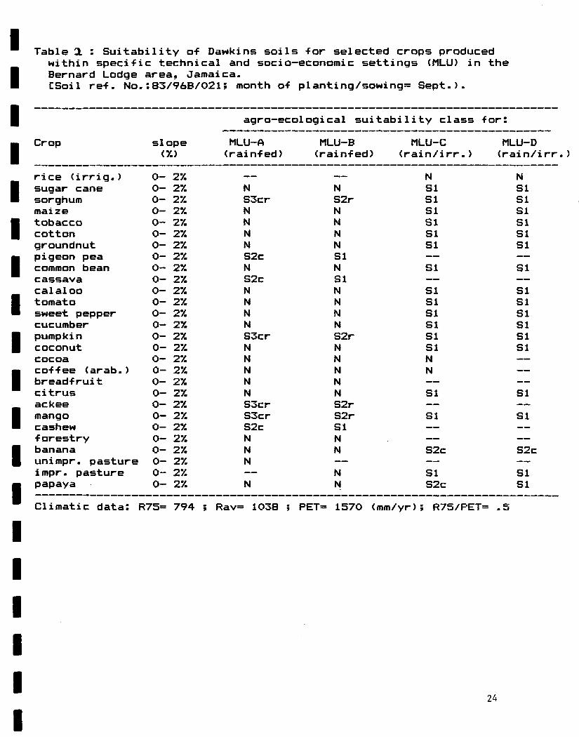
Table CL : Suitability o-f Dawkins soils -for selected crops produced within speci-fic technical and socio—economie settings (MLU) in the Bernard Lodge area, Jamaica. CSoil re-f. No.:83/96B/02l; month o-f planting/sowing= Sept.).
slope
agro-ecol ogical sui tability class for:
Cr op slope MLU-A MLU-B MLU-C MLU-D <%) (rain-fed) <rain-f ed) (rain/irr.) (rain/irr. )
rice <irrig.) 0- 27. — — N N sugar cane 0- 27. N N SI SI sorghum 0- 17. S3cr S2r SI SI maize 0- 27. N N SI SI tobacco 0- 27. N N SI SI cotton 0- 27. N N SI SI groundnut 0- 27. N N SI SI pigeon pea 0- 27. S2c SI — —
common bean 0- 27. N N SI SI cassava 0- 27. S2c SI — —
calaloo 0- 27. N N SI SI tomato 0- 27. N N SI SI sweet pepper 0- 27. N N SI SI cucumber 0- 27. N N SI SI pumpkin 0- 27. S3cr S2r SI SI coconut 0- 27. N N SI SI cocoa 0- 27. N N N —
co-f-fee (arab.) 0- 27. N N N —
breadfruit 0- 27. N N — —
citrus 0- 27. N N SI SI ackee 0- 27. S3cr S2r — —
mango 0- 27. S3cr S2r SI SI cashew 0- 27. S2c SI — —
•f orestry 0- 27. N N — —
banana 0- 27. N N S2c S2c unimpr. pasture 0- 27. N — — —
impr. pasture 0- 27. — N SI SI papaya 0- 27. N N S2c SI
Climatic data: R75= 794 ; Rav= 1038 ; PET= 1570 (mm/yr); R75/PET= .5
24
APPENDIX IV Short user's guide to the LANDEV module
This appendix explains how to access the LANDEV module -from the main menu o-f the JAMPLES system <SSU, 1989). It is presently assumed that all computerized data bases have been created/checked and that MATMOD analyses performed -for the study area. MATMOD -factor ratings can now be converted into provi-sional land suitability classes using LANDEV.
The user starts by select ing a representati ve rain-fall station •for the relevant part o-f the study area. This name is then entered into the computer. A search o-f the cl i mat ie data base, which contain 30-year mean monthly rain-fall data for over 50 stations in Jamaica, indicates whether the requested station exists in the data base.
a) I-f the requested rain-fall station does not yet exist the user can manually enter the relevant data -for his station being respectively mean monthly rain-fall -figures and elevation. The latter is used to calculate PET through linear regression (IICA, 1983). The data are automatically appended to the climatic data base.
b) I-f data -for the requested station are -found on the hard disk, an agro—cl i mat ie characterization o-f the area is displayed on the screen. The variables shown include mean rain-fall, 75%-dependable rain-fall (R75) , mean monthly potential evapo-transpiration, monthly R75/PET ratios and the length o-f the 75%—dependable growing period. R75 values are calculated -from mean rain-fall data using transfer -functions (S5U, 1988a).
The user selects the recommended month for sowing/planting (annual) crops based on the agro-climatic profiIe which is displayed on the monitor. A maximum of 2 months can be specified (2 growing periods) in each run.
Subsequently, the screen displays the names of the existing MATMOD sub—directories. The user types the name of his sub— directory and presses the enter key. All MATMOD-files in the relevant sub-directory, referenced by soil name, are now displayed on the screen. Select the land units (soils, slope class and climatic setting) which are to be included in the LANDEV run. At this stage, it is important to select only those soils for which the rainfall station is representative. If there are several climatic zones in a given study area, the above procedure will have to be repeated for the respective, representative rainfall stations!
Now that all the information has been fed into the computer the data processing starts. Results are printed as the analysis proceeds (see Table 2 in Appendix III).
CJM/86/008:TB-15, N.H. Batjes, February 19893