In Reply Tefer To: FO-2-1 May 17, 1990 · In Reply Tefer To: FO-2-1 May 17, 1990 Elf Aquitaine...
44
In Reply Tefer To: FO-2-1 May 17, 1990 Elf Aquitaine Operating Inc. Attention: Ms. B. Dougherty NOTED — KRAMER 1000 Louisiana, Suite 3800 Houston, Texas 77002 Gentlemen: Reference Is made to the following plan received May 3, 1990: Type Plan - Initial Plan of Exploration Lease - OCS-G 7743 Block - 374 Area - Eugene Island Activities Proposed - Well A In accordance with 30 CFR 250.33, this plan is hereby deemed submitted and is now being considered for approval. Your control number i s N-3689 and should be referenced in your communication and correspondence concerning this plan. Sincerely, (Orig. Sgd) A. Donald Giroir , B D. J. Bourgeois Regional Supervisor Field Operations bcc: Uase OCS-G 7743 (OFS-3-2) (FILE ROOM) / OPS-3-4 w/public info, copy of the plan ( and accomp. info. (PUBLIC RECORDS) WWill ianson: cck: 05/03/90: POECOM Officeof mo
Transcript of In Reply Tefer To: FO-2-1 May 17, 1990 · In Reply Tefer To: FO-2-1 May 17, 1990 Elf Aquitaine...
In Reply Tefer To: FO-2-1 May 1 7 , 1990
E l f Aquitaine Opera t ing Inc . Attention: Ms. B. Dougherty N O T E D — K R A M E R 1000 Louisiana, Su i t e 3800 Houston, Texas 77002
Gentlemen:
Reference Is made t o the f o l l o w i n g p lan rece ived May 3, 1990:
Type Plan - I n i t i a l Plan o f E x p l o r a t i o n
Lease - OCS-G 7743 Block - 374 Area - Eugene Island Activities Proposed - Well A
In accordance with 30 CFR 250.33, this plan is hereby deemed submitted and is now being considered for approval.
Your control number i s N-3689 and should be referenced i n your communication and correspondence concerning this plan.
Sincerely,
(Orig. Sgd) A. Donald Giroir
,B D. J. Bourgeois Regional Supervisor Field Operations
bcc: Uase OCS-G 7743 (OFS-3-2) (FILE ROOM) / OPS-3-4 w/public info, copy of the plan ( and accomp. info. (PUBLIC RECORDS)
WWill ianson: cck: 05/03/90: POECOM
Officeof
mo
PLAN OF EXPLORATION
EDGENE ISLAND 374
LEASE OCS-G-7743
MAY 03 1990 . •> FIELD *
^-OPERATIONS rftffc
"Pu&llc Informatics i . B r i e f H i s t o r y t o Date
Lease OCS-G-7743 was bough t by Conoco a t OCS Lease Sale 98 i r . 1985 . The e f f e c t i v e d a t e o f t h e lease i s August 1 , 1985. E l f A q u i t a i n e O p e r a t i n g , I n c . (EAOI) a c q u i r e d t h e l e a se f r o m Conoco and was named o p e r a t o r i n Feb rua ry , 1990.
2 . D e s c r i p t i o n o f Proposed A c t i w t i e s
EAOI p lans t o d r i l l one (1) e x p l o r a t o r y w e l l a t t h e l o c a t i o n d e s c r i b e d below. The w e l l i s scheduled t o be spudded on o r a r o u n d June 10, 1990. D r i l l i n g t i m e i s expec ted t o t ake a p p r o x i m a t e l y 2 0 d a y s .
3 . D e s c r i p t i o n o f D r i l l i n g R i g
The water depth a t t h e proposed l o c a t i o n i s a p p r o x i m a t e l y 34 0 f e e t . Water depth on t h e b l o c k ranges f r o m 315 f e e t t o 38 0 f e e t . The b l o c k i s l o c a t e d a p p r o x i m a t e l y 85 m i l e s f r o m t h e n e a r e s t p o i n t on t h e L o u i s i a n a c o a s t l i n e .
A j a c k u p r i g capable o f d r i l l i n g i n - h i s w a t e r dep th w i l l be used f o r d r i l l i n g t h i s w e l l . S a f e t y f e a t u r e s on t h i s r i g w i l l i n c l u d e w e l l c o n t r o l and b l o w o u t p r e v e n t i o n equipment as r e q u i r e d i n 30 CFR 250 .50 and 2 5 0 . 5 1 . A p p r o p r i a t e l i f e r a f t s , l i f e j a c k e t s , r i n g s , buoys, e t c . , as p r e s c r i b e d by t h e U . S. Coast Guard w i l l be p r o v i d e d . P o l l u t i o n p r e v e n t i o n and c o n t r o l f e a t u r e s w i l l i n c l u d e a l l necessary combing d r a i n s and h o l d i n g t a n k s t o p r e v e n t c o n t a m i n a t i o n o f t h e sea, i n accordance w i t h S u b p a r t C, 30 CFR 2 5 0 . 4 0 , P o l l u t i o n P r e v e n t i o n and C o n t r o l .
A d e s c r i p t i o n o f t h e d i v e r t e r system and t h e BOP schemat ic o f a t y p i c a l j a c k u p r i g i s i n c l u d e d as A t t achmen t " A " .
wv?uijIiG fnfcrmafferf

Eugene Island 374 Plan of Exploration OCS-G-7743
Operations personnel w i l l be i n compliance with 30 CFR 250 Subpart C -Training. A l l personnel w i l l be trained and w i l l carry on d r i l l s and inspections t o insure the proper maintenance and the a b i l i t y t o u t i l i z e a l l the e x i s t i n g equipment t o the f u l l e s t extent t o insure as safe an operation as possible. Mud-system monitoring procedures w i l l be u t i l i z e d on the d r i l l i n g vessel as required by 30 CFR 250.6C. There are no e x i s t i n g or planned monitoring systems f o r measuring environmental conditions f o r impact assessment i n the lease area as none are required by the lease s t i p u l a t i o n s .
I n accordance w i t h 30 CFR 250.51(c), EAOI may be required t o c o l l e c t oceanographic, meteorological and d r i l l i n g u n i t performance data. EAOI w i l l record and report t h i s information when required.
4. Well Location
Attachment "B" shows the location f o r w e l l "A" as follows:
Location "A"
Surface Location: 2500' FNL, 2500' FWL
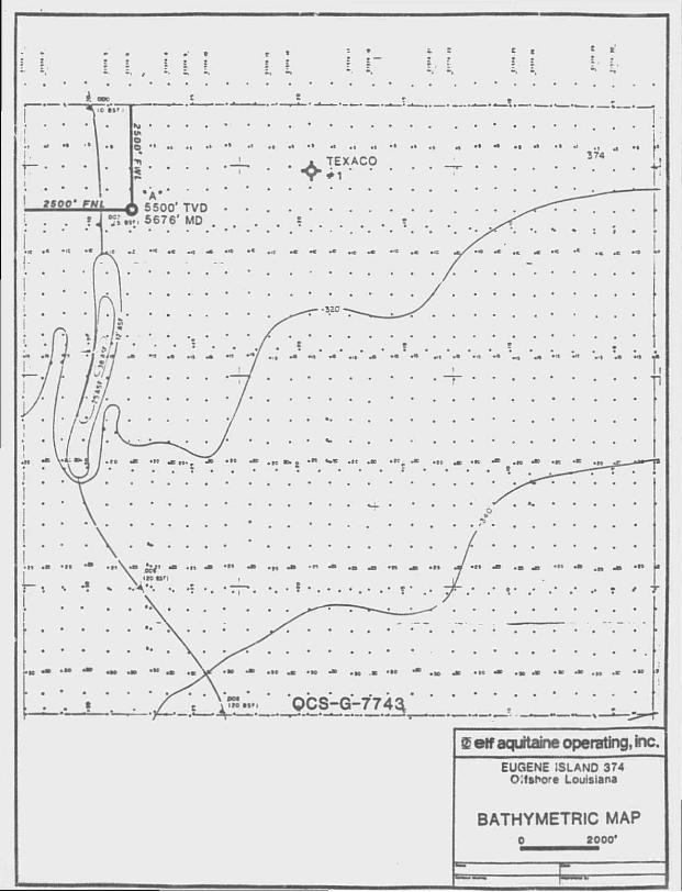
5. Bathymetry Map
Attachment "C" i s a bathymetry map showing the surface location of w e l l "A".
6. Shallow Hazards
The attached Shallow Hazards Report confirms t h a t the proposed surface l o c a t i o n i s free of seafloor anomalies, surface f a u l t s , and shallow gas sediments. (See Attachment "D".)

Eugene Is land 374 Plan o f Explorat ion OCS-G-774 3
7 . Lease S t i p u l a t i o n
S t i p u l a t i o n No. 1 vas attached to the lease agreer -it when i s s u e d . However, the Regional Direc tor has determi. d t ha t t he Archaeological Resource Report Segment of S t i p u l a t i o n No. 1 w i l l not be invoked. I f during the conduction of any ope ra t ions on the leased area any c u l t u r a l resources are d i scove red , EAOI w i l l r e p o r t the discovery immediately t o the Regional Supervisor.
EAOI w i l l also make every reasonable e f f o r t t o preserve the c u l t u r a l resource u n t i l the Regional Supervisor has t o l d EAOI how t o pro tec t i t .
8. O i l S p i l l Contingency Plan
A l l cons t ruc t ion and product ion operations s h a l l be per formed i n accordance w i t h industry standards to prevent p o l l u t i o n of the environment.
EAOI ' s O i l S p i l l Contingency Plan has been approved by the MMS, and reference i s hereby made t o t h a t plan f o r EAOI's response to any o i l s p i l l s .
T h i s p l a n designates an O i l S p i l l Team cons i s t i ng of EAOI's personnel and cont rac t personnel. This team's dut ies are t o e l i m i n a t e the source o f any s p i l l , remove a l l sources o f p o s s i b l e i g n i t i o n , deploy the most r e l i a b l e means of a v a i l a b l e t r a n s p o r t a t i o n t o monitor the movement of a s l i c k , and c o n t a i n and remove the s l i c k i f poss ib le .
EAOI i s a member o f Clean Gulf Associates (CGA) . The CGA has two permanent equipment bases i n Texas, a t Port Aransas and Galves ton , and four bases i n Louisiana, at Venice, Grand I s l e , In t r acoas ta l C i t y and Cameron. Each base i s equipped w i t h f a s t response skimmers and there i s a barge mounted high volume open sea skimmer based at Grand I s l e , Louisiana. I n e d d i t i o n t o p rov id ing equipment, the CGA also supplies a d v i s o r s f o r clean-up operations Equipment ava i l ab le from CGA and the base i t i s located at i s l i s t e d i n the CGA Manual , Volume I , Sec t ion I I I .
Es t imated response t ime f o r a s p i l l i n Eugene I s l and 374 v o u l d be approximately 18 hours. The primary CGA base of c p e r a t i o n s vould be I n t r a c o a s t a l C i t y , L o u i s i a n a .

Eugene I s l and 374 Plan o f Explorat ion OCS-G-7743
Eugene I s land 374 i s loca ted approximately 85 miles o f f the c o a s t l i n e and approximately 120 miles from the In t racoas ta l C i t y Base. Deployment t ime i s as f o l l o w s :
As t h e p o s s i b i l i t y o f an o i l s p i l l always e x i s t s , EAOI has p r o j e c t e d the t r a j e c t o r y of a s p i l l from Eugene Is land 374 u s i n g the informat ion i n the f i n a l Environmental Impact Statement f o r Lease Sale 123 and 125 dated August 1989.
_The EIS contains o i l s p i l l t r a j e c t o r y s imula t ions using seasonal surface cu r ren t s coupled w i t h wind data, adjusted every three hours f o r t h i r t y days or u n t i l a t a rge t i s c o n t a c t e d .
H y p o t h e t i c a l s p i l l t r a j e c t o r i e s were s imulated f o r each p o t e n t i a l launch s i t e across the en t i r e G u l f . These s i m u l a t i o n s presume 500 s p i l l s occurring i n each of the fou r seasons of the year. The r e su l t s i n the EIS were presented as p r o b a b i l i t i e s t h a t an o i l s p i l l beginning from a p a r t i c u l a r launch s i t e would contact a c e r t a i n land segment w i t h i n 3, 10 or 30 days. As Eugene I s l and 374 i s i n o i l s p i l l launch area C40, and u t i l i z i n g the summary of the t r a j e c t o r y analysis ( f o r 10 days) as presented i n pages IV-36 t h r c u g h IV-46, the probable projected l a n d f a l l of an o i l s p i l l i s as shown below.
A l s o l i s t e d i s the CGA map number corresponding t o the land envi ronmenta l ly s e n s i t i v e areas that may be a f f ec t ed by a s p i l l .
1. 2 . 3 .
Procurement of Vessel Load-out Time Travel Time
4 hours 2 hours
12 hours
Estimated T o t a l Deployment Time 18 hours
Area Land Segment
Contact Terrebonne Parish
LA (#16)
_1 Chance
CGA Map NVfflber
Eugene Is land B lock 374 Launch Area C40
3 6

Eugene Island 374 Plan of Exploration OCS-G-7743
I f a s p i l l should occur f rom the proposed l o c a t i o n , EAOI would immediately a c t i v a t e i t s O i l S p i l l Response Team, which v o u l d determine from c u r r e n t condit ions the probable l oca t i on and time of l a n d f a l l by con tac t ing the Nat iona l Oceanic and Atmospheric A d m i n i s t r a t i o n ' s (NOAA) Gulf of Mexico S c i e n t i f i c Support Coordinator (SSC) f o r assistance i n p r e d i c t i n g s p i l l movement. Section V, Volume I I of the CGA Operations Manual, v h i c h contains the maps as shown above, a lso includes equipment to be used f o r p r o t e c t i o n and clean-up should i t be necessary. I t includes those pieces of equipment t ha t are s t ockp i l ed by CGA and a v a i l a b l e f o r use.
Sec t ion V I , Volume I I o f the CGA Operations Manual depicts t h e protect ion response modes tha t are app l i cab le f o r o i l s p i l l clean-up ope ra t ions . Each response made i s schematic a l l y represented t o show optimum deployment and o p e r a t i o i of the equipment. Implementation o f the suggested procedures assures the most e f f e c t i v e use o f the equipment and w i l l r esu l t i n reduced ad rse impact o f o i l s p i l l s on t h e environment. Supervisory personnel have the opt ion t o m o d i f y the development and operation of equipment t o more e f f e c t i v e l y respond t o s i t e - s p e c i f i c circumstances.
9. New or Unusual Technology
No new techniques or unusual technology w i l l be reguired f o r t h i s operation.
10. Discharges A l l discharges from the Eugene Is land 374 l o c a t i o n w i l l comply with the Environmental Protect ion Agency NPDES General Permi t f o r the Gulf o f Mexico.
The estimated quantit ies expected to be discharged are as fol lows:
Quant i t i e s (bbls)
W e l l Hole Size Footage D r i l l e d Cut t ings Fluids
"A" 544 389 740 289
528 206
Estimated Total quantities to be discharged from well "A"." 1573 1123

Eugene Island 374 Plan of Explorat ion OCS-G-7743
The estimated discharge r a t e i s a maximum of 1,000 bar re l s per hour.
Any d r i l l i n g mud, d r i l l c u t t i n g s and or other so l id s w i l l no t be discharged i n t o the Gulf unless the t o x i c i t y i s measured by the EPA " D r i l l i n g Flu ids T o x i c i t y Test" i s above the 30,000 ppm l i m i t a t i o n . I n a d d i t i o n , no discharge tha t causes a sheen t o appear on the surface o f the water w i l l be made. (See Attachment "E") .
Any d r i l l i n g f l u i d s contaminated w i t h o i l and any s o l i d domestic wastes w i l l be t ranspor ted t o shore f o r proper disposal at an au thor ized disposal s i t e .
discharges w i l l be f r e e o f o i l and w i l l be i n compliance w i t h and monitored as regui red by EPA NPDES General Permit (GMG 280000) i n accordance w i t h 40 CFR 122.6. Any o i l contaminated mud w i l l be t ranspor ted t o shore f o r proper d i sposa l .
i i . Hydrogen sylfi.de EAOI requests i n accordance w i t h 30 CFR 250.67(c) t h a t the Minerals Management Service c l a s s i f y the area i n which proposed operations w i l l take place, Eugene I s l and 374, as a zone where the absence o f H2S has been conf i rmed.
EAOI believes t h a t t h i s i s not a known H s area because i n t he d r i l l i n g of the OCS-G-3575 Well #1 , d r i l l e d by Texaco on Eugene Island 374 i n 1982, no H s was encountered.
12. Projected Emissions
Projected A i r Q u a l i t y Emissions are inc luded as Attachment
Report i s requi red .
13 . Onshore Base
Eugene Island 374 i s loca ted approximately 85 miles from the nearest shoreline o f f the Louisiana coast i n the Central Gulf o f Mexico where the water depth ranges from approximately 315 fee t to 380 f e e t . A v i c i n i t y map showing the r e l a t i o n s h i p o f Eugene Island 374 t o the shore l ine and onshore base i s included as Attachment "G".

Eugene Island 374 Plan of Explora t ion OCS-G-7743
The proposed a c t i v i t i e s w i l l u t i l i z e a support base a t Freshwater C i t y , Louis iana . The base provides 24-hour se rv ice , a rad io tower w i t h phone pa tch , dock space, o f f i c e space, a parking l o t , equipment and supply storage space, d r i n k i n g and d r i l l water , e tc . During d r i l l i n g a c t i v i t i e s , he l i cop te r s w i l l make three t r i p s per week, crew boats w i l l make one t r i p per week and supply boats w i l l mike f i v e t r i p s per week. The proposed exploratory a c t i v i t i e s w i l l help t o mainta in t h i s base a t i t s present l e v e l o f a c t i v i t y . No expansion of the phys i ca l f a c i l i t i e s o r the creaL '.on of new jobs i s expected t o r e s u l t from the work planned i n conjunct ion w i t h Eugene Is land 374.
14. Structure Map
A s t ructure map drawn t o the top of each prospective hydrocarbon accumulation showing the surface l oca t i on and bottomhole l o c a t i o n • o f the proposed w e l l i s shown as Attachment " H " .
EAOI believes a l l geo log ica l i n fo rma t ion submitted under t h i s s ec t ion to be exempt from disclosure under the Freedom of Informat ion Act and i t s implementing r egu l a t i ons . A l l geologica l and geophysical data i n c l u d i n g i n t e r p r e t a t i o n s t h e r e o f , appearing on t h i s map(s) are the p r i v a t e and c o n f i d e n t i a l p roper ty o f EAOI. The p u b l i c a t i o n or reproduction t he reo f wi thout the w r i t t e n permission of EAOI i s s t r i c t l y p r o h i b i t e d .
15. Authorized Representative
I n q u i r i e s may be made t o the f o l l o w i n g authorized representat ive o f E l f Aquitaine Operat ing, Inc .
Barbara J . Dougherty Regulatory Manager E l f Aqui ta ine Operating, I n c . 1000 Louis iana , Suite 3800 Houston, Texas 77002
9974

Eugene I s l a n d 374 P l a n o f E x p l o r a t i o n OCS-G-7743
L i s t o f At tachments
" A " Schematic o f D i v e r t e r Systems and BOP Stack f o r t y p i c a l j ackup r i g .
" B " We l l L o c a t i o n P l a t and Tab le
" C " Bathymetry Map
" D " Shal low Hazards A n a l y s i s
" E " D e s c r i p t i o n o f D r i l l i n g F l u i d A d d i t i v e s
" F " A i r Q u a l i t y Review
" G " V i c i n i t y Map
" H " S t r u c t u r e Map
H I * * E n v i r o n m e n t a l Repor t
w J n Coas ta l Zone Management Cons i s t ency C e r t i f i c a t i o n
/ 9974

ATTACHMENT ••A*1

. i x su l«T Txrvtittr
ft" Alt-epei x r r r t t cost butterfly ^
4" I t i
4" - 2093' X.' KATIUAI Citt Valve
^rlve Tipe
4- - JODOf vr . >iy-. «-.llc v?ert'.» rtxdtt «fcritrollt£ IJfctt vilvr. • ^
g/t<ctl diverter » » P ^ . P
0 4" «lr-c?< Ter stt ec: Vu'ttrfly

4a
0. n- i / r - s,c::r vp
ry<ril "CT."
r - 10.0331 • l y l r j u l l c Opereted
Cite Va-Lve
I" • 10.©DDI _
© _ n-s/r - )D.o::f vp CAM res
^ v/? 1 pe L»: t tc? ft B i t s ! I U S J be:tes
y I — I ft" • 10,03:# Fydreulic 1 ' i I ^""Operetef Cete Ve-lve
I I *»tt ?sl*e
3 i i I t y u i j w t t r . t v i i i be us*4 atter Setting Protective F ipe .
-5/* - 10,033/ VP Ceserea
Type • V liti*l«
Tyr l ce l »3P tteet Arrenr c**cnt
ATTACHMENT »B"

374
TEXACO
. S L A
2 5 0 0 ' FkVi.
OCS-G-7743
I haraby certify that thli plat haa baan examined by ma
•nd thet tha Information contained thereon la to tha baat
of my knowledge and believed to be true, correct end complata.
SIGNED
P A T E
& etf aquitai. *c operating, Inc. EUGENE ii LAND 374
Otf ano; e Louisiana
WELL DETERMINATION PLAT
O 2000*

Eugene Island 374 Plan of Exploratio > OCS-G-774 3
ATTACHMENT "B"
EUGENE ISLANP 374
OCS-G-7743
WELL LQCATICN TABLE
L o c a t i o n " A "
Surface L o c a t i o n : 2500 ' FNL, 2500 ' FWL
Water Depth: + / - 340 '
9974

ATTACHMENT
E erf aquitaine operating, Inc. EUGENE ISLAND 374
Oifahore Louisiana
BATHYMETRIC MAP q 2000*

ATTACHMENT
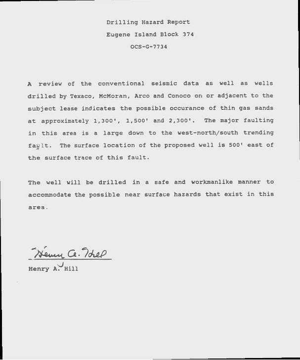
D r i l l i n g Hazard Report
Eugene Is land Block 374
OCS-G-7734
A review of the convent iona l seisinic data as we l l as wel ls
d r i l l e d by Texaco, McMoran, Arco and Conoco on or adjacent t o the
s u b j e c t lease ind ica tes the possible occurance o f t h i n gas sands
a t approximately 1 ,300 ' , 1,500' and 2 ,300 ' . The major f a u l t i n g
i n t h i s area i s a l a r g e down t o the west-nor th/south t r end ing
f a u l t . The surface l o c a t i o n of the proposed w e l l i s 500' east of
t h e surface trace o f t h i s f a u l t .
The w e l l w i l l be d r i l l e d i n a safe and workmanlike manner t o
accommodate the poss ib le near surface hazards tha t ex i s t i n t h i s
a rea .
Henry A r H i l l

ATTACHMENT " E "
PRILLING MUD COWPQHEKTS
COMMON CHEMICAL OR CHEMICAL TRADE HAME
Aluainua Stearate •AX7AFL0-S" larlta Calclua Carbonate Calclua Chlerdle Calcium Oxide Calcium Sulfite Carboxymethyl Cellulose Caustic Potash Caustic Soda Chrome Lignite .Chrome Lignosulfonate Drilling Detergent •£-Pal" Ferroehroae Lignosulfonate Cel
Cyp sum Lignite Lignosulfonate •Mud Sweep" •HCR-REX' •Shale-TroT Sapp Soda Ash Sodiua Bicarbonate Sodiua Carboxymethyl Cellulose Sodiua Chloride Sodiua Chroonte SUrch •n-9010" •TORQ-Tria* •Black Magic" "Hack Magic Superalx' Diesel
•Je l f l ake -
RICA •Pipe-Lax 1' •Vail-Nut* Hood Fibers
DESCRIPTION Or HATCTUL
Aluainua Stearate Honlonlc Surfactant larlua Sulfate (BaSo4) Aragonite (CaCo3) Hydrophilite (CaC12) Liae (Quick] Anhydrite (CaS0<) Carboxymethyl Cellulose Potassloa Hydrate Sodiun Hydroxide (NaOH) Chrome Lignite Chroae Lignosulfonate Soap Hon-tcxic, biodegradable defoaaer Derived froa «sod pulp Sodium aontaoHllonlte, bentonite, attapulgite CaSo4.2H2C Lignite Lignosulfonate Cement Pre*flush Hyoroloyzed Cereal solid Organo-elualnua complex Sodium Add Pyrophosphate Sodium Carbonate RaHC03 Sodiua Carboxymethyl Cellulose ftaCl ftaCrO4.1OH20 Cent Starch Hodegradable dr i l l ing lubneant llodegradable dr i l l ing lubricant 011 base aud conc. Sacked concentrated e l l base aud Used to aix certain less-circulation p i l l s Plastic f e l l , ihndded cellophane Loss-circulation naterial Surfactant alxed with diesel Cround walnut shells Loss-circulation material

ATTACHMENT " F "

Eugene I s l a n d 2 74 Plan of E x p l o r a t i o n OCS-G-7743
PROJECTED AIR EMI6SION SCHEDULE FOP PLAN OF EXPLORATION
GENERAL INFORMATION
Location o f F a c i l i t y :
Distance O f f s h o r e :
Name of Ri g :
Operator:
Contact Person:
T o t a l Well Footage t o be D r i l l e d i n One Year:
Date D r i l l i n g W i l l Begin:
Date D r i l l i n g W i l l End:
Eugene I s l a n d Block 374 OCS-G-7743
85 m i l e s
To be Se l e c t e d
E l f A g u i t a i n e Operata i g , I n c . , IOC.'1 '.. .siana, S u i t e 2'.00 Houston, Texas 77002
Barbara J. Dougherty Regulatory Manager
June 10, 1990
June 5, 1990
MAJOR SOURCE (OFFSHORE) - RILLING
Power used aboard d r i l l i n g v e s s e l ; approximate footage d r i l l e d - . . *
Pr o j e c t e d Emissions** Emitted Substance Tons/Year
CO 1.137 SO .350 NOX 5.-56 VOC .420 TSP .375
* Based on 60 h p h r / f t . from Table 4-3, "Atmospheric Emissions f r o m O f f s h o r e O i l and Gas Development and Pr o d u c t i o n " , EPA No. 450/3-77-026, June 1977.

E u g e n e I s l a n d 374 P l a n o f E x p l o r a t i o n OCS-G-7743
* * E m i s s i o n f a c t o r s f r o m T a b l e 3 . 3 - 1 , " C o n p i l a t i o n o f A i r P o l l u t a n t E m i s s i o n F a c t o r s , EPA R e p o r t A P - 4 2 , S e p t e m b e r , 1 9 8 5 .
MINOR SOURCES (OFFSHORE) - D R I L L I N G »
I n c l u d i n g h e l i c o p t e r l a n d i n g and t a k e - o f f (3 t r i p s / w e e k ) , c r e w b o a t s ( 1 t r i p s / w e e k ) , s u p p l v b o a t s (5 t r i p s / w e e k ) a n d l e a d i n g and u n l o a d i n g o p e r a t i o n s .
P r o j e c t e d E m i s s i o n s E m i t t e d S u b s t a n c e s T o n s / y e a r
CO
NO 2. VOC TSP
. 029
. 0 6 6
. 1 2 6
. 0 1 1
. 0 1 1
* E m i s s i o n F a c t o r s f r o m T a b l e 4 . 4 , " A t m o s p h e r i c E m i s s i o n s f r o m o f f s h o r e O i l a n d Gas D e v e l o p m e n t a n d P r o d u c t i o n " , EPA N o . 4 5 0 / 3 - 7 7 - 0 2 6 , J u n e , 1 9 7 7 .
TOT?vL ALL SOURCES (TONS/YEAR)
CO S 0 2 NOX VOC TSP
l.a j o r M i n o r
- D r i l l i n g 1.137 - D r i l l i n g .029
.350
.066 5.256 .126
.420
.011 .375 .011
TOTAL 1.166 .416 5. 382 .431 .386
ONSHORE SOURCE3
These should be about the same as minor sources unless new f a c i l i t i e s are i n s t a l l e d at the onshore base. Nc a d d i t i o n a l f a c i l i t i e s are reguired a t h i s time.
•MISSION EXFMPTION DETERMINATION
For CO: E - .-MOOD2/3 - 3,400(85) 2/3 , c , ' v ' ' 65,730 tons/year
For NOX, VOC, TSP S0 2 : E • 33.3D • 33.3(85) - 2,831 tons/year

Eugene Island 374 P lan of Exploration OCS-G-7743
As per DOI/MMS r e g u l a t i o n s , t h i s f a c i l i t y i s exempt from f u r t h e r a i r g u a l i t y rev iew ns i t has been determined tha t i t s operat ions w i l l not have s i g n i f i c a n t adverse environmental impact on a i r g u a l i t y .

ATTACHMENT " G "


ATTACHMENT " I "

ENVIRONMENTAL REPORT
EUGENE ISLAND BLOCK 374
OCS-G-7743
I . INTRODUCTION
E l f A q u i t a i n e O p e r a t i n g , I n c . (EAOI) , Hous ton , Texas, p l a n s t o c o n d u c t an e x p l o r a t i o n program i n Eugene I s l a n d a rea , S o u t h a d d i t i o n , B l o c k 374 Lease OCS-G-7743. T h i s r e p o r t i s s u b m i t t e d w i t h t h e p roposed Plan o f E x p l o r a t i o n (POE) i n acco rdance w i t h t h e r e g u l a t i o n s o f 30 CFR 250.34 and g u i d e l i n e s p u b l i s h e d November 20, 1980, and October 12, 1988.
I I . DESCRIPTION QF PFPPQSEp ACTIVITIES
EAOI p l a n s t o commence e x p l o r a t o r y a c t i v i t i e s on o r about May 15 , 1990, w i t h t h e d r i l l i n g o f w e l l "A" f r o m the proposed s u r f a c e l o c a t i o n o f 2500 f e e t f r o m t h e N o r t h l i n e and 2500 f e e t f rom t h e West l i n e o f Eugene I s l a n d Block 374 t o d e f i n e s t r u c t u r e s and t o d e l i n e a t e t h e i r hydrocarbon p o t e n t i a l . A d d i ^ . o n a l e x p l o r a t o r y o p e r a t i o n s w i l l be based upon t h e r e s u l t s o: t h i s f i r s t w e l l .
A . T r a v e l Modes and Frequencies
EAOI w i l l o p e r a t e o u t o f i t s onshore s e r v i c e base f a c i l i t i e s a t F reshwa te r C i t y , L o u i s i a n a . D u r i n g d r i l l i n g o p e r a t i o n s a h e l i c o p t e r w i l l make t h r e e t r i p s per week, s u p p l y b o a t s f i v a t r i p s pe r week and crew boats w i l l make one t r i p por week. T r a n s p o r t a t i o n vesse l s w i l l U S P t h e most d i r e c t r o u t e t o t h e l ease s i t e which i s l o c a t e d a p p r o x i m a t e l y 85 m i l e s f r o m t h e L o u i s i a n a c o a s t l i n e o f f V e r m i l i o n P a r i s h , L o u i s i a n a .
B. Support Ease The proposed a c t i v i t i e s w i l l u t i l i z e a support base at Freshwater City, LA. This base provides 24-hour service, a radio tower with phone patch, dock space, office space, a parking l o t , equipment and supply storage space, drinking and d r i l l water, etc. These proposed d r i l l i n g a c t i v i t i e s w i l l help to maintain t h i s bass at i t s present level of a c t i v i t y . No expansion of the physical f a c i l i t i e s or the creation of nsw jobs i s sxpected to result from the work planned i n conjunction with Block 374.

Eugene I s l a n d 374 E n v i r o n m e n t a l Repor t Page - 2 -
C. New Support F u t i l i t i e s
No new onshore s u p p o r t f a c i l i t i e s such as new l a n d bases, r e f i n e r i e s , s t o r a o e f a c i l i t i e s , pumping s t a t i o n , boat docks, h e l i c o p t e r paCs o r f u e l i n g f a c i l i t i e s a r e l i k e l y t o be r e q u i r e d because o f t h e a c t i v i t i e s p lanned f o r Eugene I s l a n d B l o c k 374.
New Techniques o r Unusual Technology
No new t e c h n i q u e s o r unusual t e c h n o l o g y w i l l be r e q u i r e d f o r t h i s o p e r a t i o n .
E . Map of Proposed A c t i v i t y
As shown by t h e a t t a c h e d v i c i n i t y p l a t , t h e leases on which t h e p roposed a c t i v i t i e s w i l l t a k e p l ace are l o c a t e d a p p r o x i m a t e l y 85 m i l e s f r o m t h e L o u i s i a n a s h o r e l i n e .
F . Coastal Zone Management Consis tency
T h i s p r o j e c t i s c o n s i s t e n t w i t h L o u i s i a n a ' s program f o r Coas ta l Zone Management as p r o v i d e d i n 15 CFR 93 0 and t h e Lou i s i ana S t a t e and Local C o a s t a l Resources Management A c t o f 1978 (Act 361) . The o p e r a t i o n s w i l l t ake p l ace on t h a CCS o u t s i d e o f L o u i s i a n a ' s 3 - m i l e l i m i t . C o a s t a l e f f e c t s o f t he base a r e mino r and a re c o n s i s t e n t w i t h t h e C c v s t a l Resources Program.
I I I . DESCRIPTION OF AFFECTED ENVIRONMENT AND IMPACTS
A . Phys i ca l and E n v i r o n m e n t a l
i commercial Fishing
The G u l f o f M e x i c o p r o v i d e s 4 0% o f t h e commercia l f i s h l a n d i n g s , md o n e - t h i r d o f t h e r e c r e a t i o n a l f i s h i n g a c t i v i t i e s i n t h e c o n t i n e n t a l U n i t e d S t a t e s (USDC, NMFS, 1988a) . I n 1987 commercial l a n d i n g s o f a l l f i s h e r i e s i n t h e G u l f was v a l u e d a t a p p r o x i m a t e l y $720 m i l l i o n and t o t a l e d n e a r l y 2.5 b i l l i o n pounds w i t h Cameron, L o u i s i a n a , b e i n g the l e a d i n g U . S . p o r t i n q u a n t i t y o f c o m m e r c i a l f i s h l a n d i n g s .

Eugene Island 374 Environmental Report Page - 3 -
The most impor tan t Gulf species i n quan t i t y landed (2 b i l l i o n pounds and valued at $70.5 m i l l i o n ) i s menhaden. Shrimp represents the most important Gulf species i n va lue landed i n 1987 w i t h landings of 257 m i l l i o n pounds valued a t $469 m i l l i o n . The Gulf operated f i s h i n g accounted f o r 46 percent o f the na t ional t o t a l and the blue crab f i s h e r y accounted f o r 34 percent of the n a t i o n a l t o t a l (USCD, NMFS, 1988a).
Geological and geophysical a c t i v i t i e s may i n t e r f e r e with commercial f i s h e r i e s through removal of sea f loor and pelagic areas f rom use by t r a w l e r s . Shrimp and i n d u s t r i a l bottom f i s h are caught by dragging a large
. t rawl across t he s e a f l o o r . A l i s i t e s occupied by exploratory d r i l l i n g s t ruc tures and attendant service boats and barges used f o r DSTs or shallow d r i l l i n g a c t i v i t i e s must be avoided bv t r a w l e r s . I f the structures are j ack-up d r i l l i n g r i g s , tbe area of the seaf loor removed would amount t o 2 t o 5 acres f o r each s t r u c t u r e .
Large pieces o f debr i s ( i . e . eguipment, p i p i n g , t o o l s , s t ruc tu ra l members) may acc iden ta l ly be l o s t o f f a s t ructure , supply boat or barge. The l o s t i tem(s) could ea s i l y be loca ted by d ivers and r e t r i e v e d i f i t i s los t o f f or near a s t ruc tu re bu t , i f i t i s l o s t o f f a boat or barge underway, the l o c a t i o n may not be known accurately enough t o al low i t s subsequent recovery.
D r i l l i n g opera t ions i n some f i s h i n g areas during a pa r t i cu la r season could preclude f i s h e r i e s harvest . Fish are unmarketable i f e x t e r n a l l y coated or i n t e r n a l l y contaminated w i t h o i l .
2. shipping
Eugene Island 374 i s c l e a r of a l l f a i rways and anchorage areas. Operations i s t h i s area w i l l be i n accordance w i t h t h e U. S. Coast Guard's regula t ions regarding naviga t iona l standards. The i n s t a l l a t i o n and use o f nav iga t iona l a ids , l i f e s a v i n g equipment, and other sa fe ty requirements pursuant t o U. S. Coast Guard r egu la t i ons are standard operat ing procedure f o r d r i l l i n g r i g s , p l a t fo rm and marine vessels u t i l i z e d by EAOI. There should be l i t t l e or no impact on shipping r e su l t i ng f rom the proposed opera t ions .

Fugene Island 374 Environraental Report Page - 4 -
3 . Recreational Resources and A c t i v i t i e s
The northern Gulf o f Mexico coastal zone i s one of the major recreat ional regions o f the United S ta tes , p a r t i c u l a r l y w i t h marine f i s h i n g , scuba d i v i n g , and beach-related a c t i v i t i e s . I t i s estimated t h a t over 38 m i l l i o n res iden ts of the Gulf coastal states have a major i n t e r e s t i n wate r - re la ted and water enhanced r e c r e a t i o n a l a c t i v i t y . Approximately two- th i rds of the G u l f shorefront i s composed of beach and there is one motor boat f o r about every 21 people l i v i n g i n the Gulf Region. More s p e c i f i c a l l y , approximately 13.5 m i l l i o n people, or 35 percent of the Gul f States popula t ion , l i v e i n the area most d i r e c t l y a f fec ted by Gulf a c t i v i t y , and about one - th i rd o f the reg is te red boats are l i k e l y candidates f o r marine rec rea t iona l a c t i v i t y (16 ; or g rea te r ) .
I t i s reasonable t o expect t ha t e x p l o r a t i o n and product ion on blocks leased i n the Central Gulf o f Mexico w i l l r e s u l t i n some ocean l i t t e r and could lead t o one major o i l s p i l l , and that s p i l l and d e b r i s could be c a r r i e d by wind, wave and currents to i n t e r a c t w i t h major s h o r e f r o n t r ec rea t iona l beaches throughout t he Gulf of Mexico. The t rash and debr is , such as o i l drums, large p l a s t i c containers and sheeting, computer r e a d - w r i t e r i ngs , seismic markers, styrofoam f l o a t s , p i p e thread p ro t ec to r s , d iese l f i l t e r s , hard hats and t a r b a l l s , i s c l e a r l y associated w i t h the petroleum i n d u s t r y ; however, t h r problem w i l l cause only loca l ized , shor t - t e rm inconvenience.
4 . Cultural Resources
There are no known archaeological s i t e s i d e n t i f i e d i n the area; however, EAOI agrees tha t i f any s i t e , s t ruc tu re or objec t of h i s t o r i c a l s i g n i f i c a n c e should be discovered dur ing operations, the f i n d i n g s w i l l be immediately reported t o the Sjpervisor and every reasonable e f f o r t w i l l be made t o preserve and p r o t e c t the c u l t u r a l resources from danger u n t i l the Supervisor has g i v e n d i r ec t ions as t o i t s preservat ion .
5. Ecological ly Sens i t i ve Features
There are no e c o l o g i c a l l y sens i t ive f ea tu re s i n the proposed area of operations.

Eugene I s l a n d 372 Env i ronmenta l R e p o r t Page - 5 -
6 . E x i s t i n q P i p e l i n e s
T h e r e are no known p i p e l i n e s t r a v e r s i n g B l o c k 374.
7 . Other M i n e r a l Uses
The a c t i v i t i e s p r o p o s e d f o r Eugene I s l a n d 374 w i l l have no d i r e c t or i n d i r e c t i m p a c t on o t h e r m: i e r a l uses .
8 . Ocean Dumping
A l l produced w a t e r s w i l l be t r e a t e d a c c o r d i n g t o OSHA r e g u l a t i o n s . V e s s e l s w i l l be p r o p e r l y d e s i g n a t e d so t h a t
- c u t p u t w i l l meet a l l r e c u l a t o r y r e q u i r e m e n t s and w i l l n o t exceed 35 p a r t s / m i l l i o n . The produced w a t e r s w i l l be dumped ove rboa rd and m o n i t o r e d on a month ly b a s i s .
9 . Endangered o r Threa tened Species
S i x f e d e r a l l y l i s t e d endangered whale s p e c i e s may occur i n t h e Gul f o f M e x i c o : t h e b l u e , f i n , humpback, r i g h t , s e i and g r e a t sperm w h a l e s . The r i g h t whales a r e t h e most endangere l ce tacean i n t h e G u l f o f Mexico .
The Fish and W i l d l i f e S e r v i c e has d e s i g n a t e d 15 u n t r e a t e d spec i e s t h a t c o u l d be a f f e c t e d by OCS o i l and gas o p e r a t i o n s i n t h e Gul f o f M e x i c o . A l l b u t t h e Amer ican c r o c o d i l e i n h a b i t the C e n t r a l and Western G u l f . The l i s t i n c l u d e s t h r e e mammals ( t h e J a g u a r u n d i , O c e l o t , and West I n d i a n Manatee) , seven b i r d s ( t h e b a l d e a g l e , a r c t i c p e r e g r i n e , whooping crane, b r o w n p e l i c a n , Eskimo c u r l e w , p i p i n g p l o v e r and l e a s t t e r n ) , and 6 i x o t h e r r e p t i l e s ( t h e Amer ican c r o c o d i l e and t h e h a w k s b i l l , Kemp's R i d l e y , l o g g e r h e a d , l e a t h e r b a c k and g r e e n sea t u r t l e s ) .
The most l i k e l y a f f e c t s o f o i l and gas en ce taceans a re s k i n and eye i r r i t a t i o n s , ba l een f o u l i n g , a s p h y x i a t i o n f r o m i n h a l a t i o n o f v o l a t i l e fumes, f o o d r e d u c t i o n o r c o n t a m i n a t i o n , and o i l i n g e s t i o n . S u b s u r f a c e sounds f r o m d r i l l i n g a c t i v i t i e s may induce s t r e s s and have a c u m u l a t i v e a f f e c t on h e a r i n g o r d i s r u p t a c o u s t i c communica t ions ; however , most o f t h e impac t s on whales and s h o r t - t e r m and s u b l e t h a l and e s t i m a t e d t o be low as wha les p r e f e r t o i n h a b i t a r eas beyond t h e c o n t i n e n t a l s h e l f away f r o m most n o i s e d i s t u r b a n c e s .

Eugene Island 374 Environmental Report Page - 6 -
O i l s p i l l s contacting a t u r t l e n e s t i ' beach incubation or hatching periods could cause s i g n i f t u r t l e m o r t a l i t y ( F r i t t s and McGhee, 1981) and of ^ o i . w i l s p i l l s could have a serious impact on j u v e n i l e t u r v es as sea t u r t l e s can attempt t o swallow any object of appropriate size, such as t<*r b a l l s , which could r e s u l t i n s i g n i f i c a n t t u r t l e m o r t a l i t y . There i s a 2 percent probabi t t y of one or more o i l s p i l l s occurring and contacting see .urtlea nesting h a b i t a t and less than a 10 percent p r o b a b i l i t y of one or more o i l s p i l l s occurring and contacting sea t u r t l e foraging areas o f f the c e n t r a l Louisiana coast.
The impact on various endangered and threatened species w i l l depend on the nature of the s p i l l , weather conditions, proximity of s p i l l s t o species, tolerance f o r o i l of species, and the response t i n e and effectiveness of the o i l s p i l l cleanup and containment services. Given these var j • ..les, the impact on the various endangered or t b ^atened species w i l l vary from l i t t l e or no e f f e c t t o dry serious.
The experience of o i l and gas exploration i n the Gulf of Mexico indicates t h a t there i s a small p r o b a b i l i t y of occurrence of an o i l s p i l l . EAOI, as a prudent operator, w i l l take the necessary precautions t o reduce the p r o b a b i l i t y of o i l s p i l l s . EAOI's proposed operations should pose no t h r e a t t o any endangered or threatened species.
B. Socio-Econonic
1. Related. New Employment
This i s not a p p l i c a b l e at t h i s time.
IV. UNAVOIDABLE ADVERSE IMPACTS
The proposed d r i l l i n g a c t i v i t i e s i n Eugene Island Block 374 w i l l r e s u l t i n the discharge of d r i l l i n g mud and c u t t i n g s i n t o the waters of the Gulf. The disposal of d r i l l i n g f l u i d s aiay r e s u l t i n minor decreases i n primary p r o d u c t i v i t y due t o whe m o r t a l i t y or f u n c t i o n a l impairment of plankton, benthic organisms, seagrasses, and algae i n areas of high t u r b i d i t y . A large o i l s p i l l i s very u n l i k e l y but could r e s u l t i n lo c a l i z e d severe m o r t a l i t i e s , s e l e c t i v e and functional impairment of plankton communities, thereby a l t e r i n g the community s t r u c t u r e f o r an unknown period of time.

Eugene Island 372 Environmental Report Page - 7 -
D r i l l i n g a c t i v i t i e s corld cause an increase i n the t u r b i d i t y of the affected waters f o r the duration of the a c t i v i t y period. A t u r b i d i t y plume, several hundred yards i n length, could also be created by the discharge of d r i l l c u t t i n g s and the adherent d r i l l i n g f l u i d s . This, however, would only a f f e c t waters i n the immediate v i c i n i t y of the r i g . The discharge of treate d sewage from the r i g would increase the levels of suspended solids, n u t r i e n t s , c h l o r i n e , and BOD i n a small area near the discharge p o i n t s .
A i r emissions from combustion of diesel f u e l i n r i g engines, boat engines and helicopters can a f f e c t the a i r g u a l i t y near the proposed operations s i t e s and near the onshore t r a v e l routes. I n most cases, the emissions w i l l be l o c a l i n nature and w i l l be quickly dissipated by c l i m a t i c conditions.
Catastrophic events such as o i l s p i l l s and blowouts have the pot e n t i a l t o create localized a i r q u a l i t y problems. Degradation of onshore a i r q u a l i t y i s not l i k e l y t o occur and i s not expected due to the low number of expected s p i l l s , probable distance from shore (more than 3 miles and very l i k e l y f a t h e r ) , rapid dispersion or breakup associated with o i l s p i l l s and the turbulent v a r i a b l e winds offshore. Papid dispersion of evaporative emissions from these sources i s expected.
I f i blowout resulted i n a f i r e , s u b s t a n t i a l l e v e l s of THC, NO SO CO and TSP would be emitted. Local a i r would be seOerefy degraded f o r the duration of the f i r e . The extent of degradation i s indeterminate, but i t i s u n l i k e l y t h a t i t vould be high enough to a f f e c t land resources or human health.
The proposed exploration a c t i v i t i e s are not expected t o harmfully a f f e c t water q u a l i t y , i n t e r f e r e with commercial f i s h i n g operations, recreational a c t i v i t i e s or shipping t r a f f i c

Eugene I s l a n d 374 P l a n o f E x p l o r a t i o n OCS-G-7743
SUMMARY
The proposed a c t i v : s w i l l be c a r r i e d o u t and comple ted w i t h t he guarantee c t he f o l l o w i n g i t e m s :
1 . The bes t a v a i l a b l e and s a f e s t t e c h n o l o g i e s w i l l be u t i l i z e d t h r o u g h o u t the p r o j e c t . T h i s i n c l u d e s mee t i ng a l l a p p l i c a b l e r equ i rements f o r equipment t y p e s , ger r a l p r o j e c t l a y o u t , s a f e t y sys tems , and eguipment m o n i t o r i n g sys t ems .
2 . A l l o p e r a t i o n s w i l l be covered by a M i n e r a l s Management Serv ice approved O i l S p i l l Con t ingency P l a n .
3 . A l l a p p l i c a b l e f e d e r a l , s t a t e and l o c a l r e g u i r e m e n t s r e g a r d i n g a i r emiss ions and w a t e r q u a l i t y d i s c h a r g e f o r t he proposed a c t i v i t i e s , and w e l l as any o t h e r p e r m i t c o n d i t i o n s , w i l l be complied w i t h .

Eugene I s l a n d 374 P l a n o f E x p l o r a t i o n OCS-G-7743
REFERENCES
1. U. S. Department of the I n t e r i o r , Minerals Management Service, Final Regional Environmental Impact Statement, Volume 1, January, 1983.
2. U. S. Department of the I n t e r i o r , axe s Management Service, Final Regional Environments Impact Statement, July, 1984.
3. U. S. Department of the I n t e r i o r , Minerals Management Service, Final Environmental Impact Statement, Proposed Oi l and Gas Lease Sales 104 and 105, November, 1985.
4. U. S. Department of the I n t e r i o r , Minerals Management Service, Final Environmental Impact Statement, Proposed O i l and Gas Lease Sales 110 and 112, A p r i l , 1986.
5. U. S. Department of the I n t e r i o r , Minerals Management Service, Final Environmental Impact Statement, Gulf of Mexico Sales 123 and 125.
6. U. S. Department of the I n t e r i o r , Bureau of Land Management, The Ecology of Petroleum Pent farms i n the Northwestern Gulf of Mexico.
7. U. S. Department of the I n t e r i o r , Bureau of Land Management, F i n a l Environmental Impact Statement, OCS Sale 62 and 63A, 1976.

ATTACHMENT " J "
EUGENE ISLAND BLOCK 37 4
OCS-G-7743
COASTAL ZONE MANAGEMENT
PUBLIC NOTICE CERTIFICATION NOTICE
I c e r t i f y t h a t a r r angement s have been made t o p l a c e a p u b l i c n o t i c e o f E l f A g u i t a i n e O p e r a t i n g , I n c . ' s Proposed Plan o f E x p l o r a t i o n f o r Eugene I s l a n d Block 374, Lease OCS-G-7743, i n t h e Ba ton Rouge S t a t e Times on May 14, 1990.
T h i s regues t was s e n t t o :
A d d i t i o n a l l y , a r rangements have been made w i t h t h e Kaplan H e r a l d , i n V e r m i l i o n P a r i s h , Lou i s i ana t o p u b l i s h a n o t i c e o f t h e proposed Plan o f E x p l o r a t i o n .
E l f A q u i t a i n e O p e r a t i n g , I n c .
Baton Rouge S t a t e Times I :gal Ad Depar tment 525 L a f a y e t t e S t r e e t Baton Rouge, LA 70804
/ 9 9 7 4

EUGENE ISLAND BLOCK 37 4
OCS-G-7743
COASTAL ZONE MANAGEMENT
CONSISTENCY CERTIFICATION
The proposed a c t i v i t i e s described i n d e t a i l i n t h i s Plan comply with Louisiana's approved Coastal Zone Management Program and w i l l be conducted i n a manner consistent with such program.
E l f Aquitaine Operating, Inc.

K elf aquitaine operating, inc. 1000 Louwia StUe 3800 Houaon 7e*as 77002 (713)658 9811
May 2, 1990 A i r b o r n e Express
B a t o n Rouge S t a t e Times A t t e n t i o n : Legal Ad Depar tment 525 L a f a y e t t e S t r e e t B a t o n Rouge, LA 7 08 04
RE: Not ice o f Proposed P l a n o f E x p l o r a t i o n Eugene I s l a n d B l o c k 374 OCS-G-7743 Of f shore L o u i s i a n a
Gentlemen:
P lease place t h e f o l l o w i n g n o t i c e i n t h e L e g a l Ad s e c t i o n o f t h e S ta te Tiroes f o r p u b l i c a t i o n on May 14 , 1990.
PUBLIC NOTICE
Publ ic N o t i c e o f F e d e r a l Cons i s t ency Review o f a Proposed P l an o f E x p l o r a t i o n (POE) by t h e Coas ta l Manageroent D i v i s i o n / L o u i s i a n a Depar tment o f N a t u r a l Resources f o r t h e P l a n ' s Cons i s t ency w i t h t h e L o u i s i a n a Coastal Resources Program.
A p p l i c a n t : E l f A g u i t a i n e O p e r a t i n g , I n c . 1000 L o u i s i a n a , S u i t e 3800 H o u s t o n , Texas 77002
L o c a t i o n : Eugene I s l a n d A r e a , Sou th A d d i t i o n , B l o c k 374 Lease OCS-G-7743 Lease Sale #98
D e s c r i p t i o n : Proposed Plan o f E x p l o r a t i o n f o r t h e above area p r o v i d e s f o r t h e e x p l o r a t i o n f o r t h e e x p l o r a t i o n f o r o i l and gas. E x p l o r a t i o n a c t i v i t i e s s h a l l i n c l u d e d r i l l i n g f r o m a j a c k - u p r i g and t r a n s p o r t o f d r i l l i n g crews and equipment by h e l i c o p t e r a n d / o r cargo v e s s e l f r o m an onshore base l o c a t e d a t F reshwa te r C i t y , LA. No e c o l o g i c a l l y s e n s i t i v e spec ies o r h a b i t a t s a re e x p e c t e d t o be l o c a t e d near o r a f f e c t e d b y these a c t i v i t i e s .

May 2, 1990
Baton Rouce State Times
Notice of Proposed Plan of Exploration Eugane Island Block 374 OCS-G-7743
A copy of the plan described above i s available f o r inspection at the Coastal Management D i v i s i o n Office located on the 10th f l o o r of the State Land and Natural Resources Bldg., 625 North 4th Street, Baton Rouge, Louisiana. Office hours: 8:00 am t o 5:00 pm, Monday through Friday. The public i s reguested t o submit comments t o the Coastal Management Di v i s i o n , A t t e n t i o n : OCS Plans, P.O. Box 44487, Baton Rouge, Louisiana 70804-4487. Comments must be received w i t h i n 15 days of the date of t h i s notice or 15 days a f t e r the Coastal Management d i v i s i o n obtains a copy of the plan and i t i s a v a i l a b l e f o r public inspection. This public notice i s provided t o meet the requirements of the NOAA Regulations on Federal Consistency w i t h approved Coastal Management Programs.
I f you reguire f u r t h e r information, please contact the undersigned at (713) 655-6410. Please b i l l E l f Aquitaine Operating, Inc. at the letterhead address f o r the cost of running the ad, along w i t h proof of p u b l i c a t i o n of the ad on the date reguested.
Sincerely,
Barbara J. Dougherty Regulatory Manager
/9974

© elf aquitaine operating, inc. 1000 Lom&aTa Suite 3800 Housion. Texas 77002 (713)658 9811
May 2 , 1990
The Kaplan Herald P. O. Box 236 Kaplan, Louisiana 70548
A t t e n t i o n : Legal Ad Department
RE: Notice of Proposed Plan of Exp lo ra t ion Eugene I s l a n d Block 374 OCS-G-7743 Offshore Louis iana
Gentlemen:
-Please place the f o l l o w i n g not ice i n the Legal Ad sec t ion of the State Times f o r p u b l i c a t i o n on May 14, 1990.
- PUBLIC NOTICE
Public Nc t i ce of Federal Consistency Review of a Proposed Plan o f Explora t ion (POE) by the Coastal Manageroent Div i s ion /Lou is iana Department of Natura l Resources f o r the Plan's Consistency w i t h the Louisiana Coastal Resources Program.
Appl icant : E l f Aguitaine Operating, Inc . 1000 Louisiana, Sui te 3800 Houston, Texas 77002
Location: Eugene I s land Area, South A d d i t i o n , Block 374 Lease OCS-G-7743 Lease Sale #98
Desc r ip t ion : Proposed Plan of Explora t ion f o r the above area provides f o r the exp lo ra t i on f o r the e x p l o r a t i o n f o r o i l and gas. Explorat ion a c t i v i t i e s s h a l l inc lude d r i l l i n g from a jack-up r i g and t ranspor t of d r i l l i n g crews and equipment by h e l i c o p t e r and/or cargo vessel from an onshore base located at Freshwater C i t y , LA. No e c o l o g i c a l l y sens i t ive species or hab i t a t s are expected t o be located near o r a f f e c t e d by these a c t i v i t i e s .

The Kaplan Herald
Notice of Proposed Plan of Exploration Eugene Island Block 374 O C S - G - 7 7 4 3
A copy of the plan described above i s avail a b l e f o r inspection at the Coas^ta" Management D i v i s i o n Office located on the 10th f l o o r of the State Land and Natural Resources Bldg., 625 North 4th Street, Baton Rouge, Louisiana. Office hours: 8:00 am t o 5:00 pm, Monday through Friday. The public i s requested t o submit cor.'ents t o the Coastal Management D i v i s i o n , A t t e n t i o n : OCS Plans, P.O. Box 44487, Baton Rouge, Louisiana 70804-4487. Comments must be received w i t h i n 15 days of the date of t h i s notice or 15 days a f t e r the Coastal Management d i v i s i o n obtains a copy of the plan and i t i s available f o r public inspection. This public notice i s provided t o meet the requirements of the NOAA Regulations on Federal Consistency w i t h approved Coastal Management Programs.
I f you require f u r t h e r information, please contact the undersigned at (713) 655-6410. Please b i l l E l f Aquitaine Operating, Inc. at the letterhead address f o r the cost of running the ad, along w i t h proof of p u b l i c a t i o n of the ad on t h e date requested.
S i n c e r e l y ,
Barbara J . Dougherty Regulatory Manager
/9974


![Burning the house of Fatima binte Mohammad[saww] · page 3 of 47 7.5 reply two 31 7.6 defence three 32 7.7 reply one 32 7.8 reply two 32 7.9 reply three 32 7.10 reply four 33 7.11](https://static.fdocuments.us/doc/165x107/6008f7ca6342d553a45420f3/burning-the-house-of-fatima-binte-mohammadsaww-page-3-of-47-75-reply-two-31-76.jpg)