in a contemporary disaster scenario: case studies of ...
23
ORIGINAL ARTICLE Identifying archaeological evidence of past earthquakes in a contemporary disaster scenario: case studies of damage, resilience and risk reduction from the 2015 Gorkha Earthquake and past seismic events within the Kathmandu Valley UNESCO World Heritage Property (Nepal) Christopher Davis & Robin Coningham & Kosh Prasad Acharya & Ram Bahadur Kunwar & Paolo Forlin & Kai Weise & Prem Nath Maskey & Anie Joshi & Ian Simpson & David Toll & Sean Wilkinson & Paul Hughes & Vasilis Sarhosis & Ashutosh Kumar & Armin Schmidt Received: 31 May 2019 /Accepted: 29 October 2019 # The Author(s) 2019 Abstract The 2015 Gorkha Earthquake was a human- itarian disaster but also a cultural catastrophe that dam- aged and destroyed historic monuments across Nepal, including those within the Kathmandu Valley UNESCO World Heritage Property. In the rush to rebuild, tradi- tionally constructed foundations are being removed and replaced with modern materials without assessments of whether these contributed to the collapse of a monu- ment. Generally undertaken without scientific record- ing, these interventions have led to the irreversible de- struction of earlier subsurface phases of cultural activity and the potential loss of evidence for successful tradi- tional seismic adaptations and risk reduction strategies, with no research into whether modern materials, such as concrete and steel, would offer enhanced resilience. In response to this context, multidisciplinary post-disaster investigations were undertaken between 2015 and 2018, including archaeological excavation, geophysical sur- vey, geoarchaeological analysis, linked to architectural and engineering studies, to begin to evaluate and assess the damage to, and seismic adaptations of, historic structures within Nepal’ s Kathmandu Valley. Where https://doi.org/10.1007/s10950-019-09890-7 C. Davis (*) : R. Coningham : P. Forlin Department of Archaeology, Durham University, Durham, UK e-mail: [email protected] R. B. Kunwar Department of Archaeology, Government of Nepal, Kathmandu, Nepal K. P. Acharya : K. Weise : A. Joshi ICOMOS, Kathmandu, Nepal P. N. Maskey Institute of Engineering, Tribhuvan University, Kirtipur, Nepal I. Simpson School of Biological and Environmental Sciences, University of Stirling, Stirling, UK D. Toll : P. Hughes : A. Kumar Department of Engineering, Durham University, Durham, UK S. Wilkinson School of Engineering, Newcastle University, Newcastle upon Tyne, UK V. Sarhosis School of Civil Engineering, University of Leeds, Leeds, UK A. Schmidt GeodataWIZ, Remagen, Germany J Seismol (2020) 24:729–751 /Published online: 4 December 2019
Transcript of in a contemporary disaster scenario: case studies of ...

ORIGINAL ARTICLE
Identifying archaeological evidence of past earthquakesin a contemporary disaster scenario: case studiesof damage, resilience and risk reduction from the 2015Gorkha Earthquake and past seismic eventswithin the Kathmandu Valley UNESCO World HeritageProperty (Nepal)
Christopher Davis & Robin Coningham & Kosh Prasad Acharya &
Ram Bahadur Kunwar & Paolo Forlin & Kai Weise & Prem Nath Maskey & Anie Joshi &Ian Simpson & David Toll & Sean Wilkinson & Paul Hughes & Vasilis Sarhosis &Ashutosh Kumar & Armin Schmidt
Received: 31 May 2019 /Accepted: 29 October 2019# The Author(s) 2019
Abstract The 2015 Gorkha Earthquake was a human-itarian disaster but also a cultural catastrophe that dam-aged and destroyed historic monuments across Nepal,including those within the Kathmandu Valley UNESCOWorld Heritage Property. In the rush to rebuild, tradi-tionally constructed foundations are being removed andreplaced with modern materials without assessments ofwhether these contributed to the collapse of a monu-ment. Generally undertaken without scientific record-ing, these interventions have led to the irreversible de-struction of earlier subsurface phases of cultural activity
and the potential loss of evidence for successful tradi-tional seismic adaptations and risk reduction strategies,with no research into whether modern materials, such asconcrete and steel, would offer enhanced resilience. Inresponse to this context, multidisciplinary post-disasterinvestigations were undertaken between 2015 and 2018,including archaeological excavation, geophysical sur-vey, geoarchaeological analysis, linked to architecturaland engineering studies, to begin to evaluate and assessthe damage to, and seismic adaptations of, historicstructures within Nepal’s Kathmandu Valley. Where
https://doi.org/10.1007/s10950-019-09890-7
C. Davis (*) :R. Coningham : P. ForlinDepartment of Archaeology, Durham University, Durham, UKe-mail: [email protected]
R. B. KunwarDepartment of Archaeology, Government of Nepal, Kathmandu,Nepal
K. P. Acharya :K. Weise :A. JoshiICOMOS, Kathmandu, Nepal
P. N. MaskeyInstitute of Engineering, Tribhuvan University, Kirtipur, Nepal
I. SimpsonSchool of Biological and Environmental Sciences, University of
Stirling, Stirling, UK
D. Toll : P. Hughes :A. KumarDepartment of Engineering, Durham University, Durham, UK
S. WilkinsonSchool of Engineering, Newcastle University, Newcastle uponTyne, UK
V. SarhosisSchool of Civil Engineering, University of Leeds, Leeds, UK
A. SchmidtGeodataWIZ, Remagen, Germany
J Seismol (2020) 24:729–751
/Published online: 4 December 2019
possible, we draw on archaeoseismological approachesfor the identification and classification of EarthquakeArchaeological Effects (EAEs) at selected monumentsdamaged by the 2015 Gorkha Earthquake. Lessonslearned from evidence of potential weaknesses, as wellas historic ‘risk-sensitive tactics’ of hazard reductionwithin monuments, are now being incorporated intoreconstruction and rehabilitation initiatives alongsidethe development of methods for the protection of heri-tage in the face of future earthquakes.
Keywords Kathmandu . Nepal . South Asia .
Archaeolseismology. Earthquake ArchaeologicalEffects (EAEs) . Resilience . Seismic adaptations .
Rehabilitation
1 Introduction
The collision between the Indian and Eurasian plateswhich has formed the Himalayan mountain range alsobrings with it the constant threat of seismic activity. Thecity of Kathmandu, in the foothills of the Himalayas inNepal, bears witness to thousands of years of culturaldevelopment and adaptation relating to this context.Seven monumental zones of the Kathmandu Valley,including the three medieval urban centres of Patan,Kathmandu and Bhaktapur, as well as major monumen-tal religious complexes of Buddhist stupas atSwayambhu and Baudhanath, and Hindu Temples atPashupati and Changu Narayan, were inscribed on theUNESCO World Heritage list in 1979 (Fig. 1). Thesesites, with their monumental ensembles, wererecognised by UNESCO as exceptional representationsof the unique and traditional architectural typologies andartistic achievements developed by societies within theKathmandu Valley. There was also recognition of thecontinuation of these craft traditions of elaboratewoodcarving and construction techniques incorporatingtimber, brick, tile and stone (http://whc.unesco.org/en/list/121/).
At 11.56 NST on April 25, 2015, the 7.8 magnitudeGorkha Earthquake ruptured a segment of the MainHimalayan Thrust fault (Rupakhety 2017: 19) and wasfollowed by a series of powerful aftershocks, with thestrongest at 7.3 magnitude tremor on the 12th ofMay 2015 (Varum et al. 2017: 47). It precipitated ahumanitarian disaster that caused some 9000 fatalities,injured 22,000 and destroyed 498,852 residential
buildings (Varum et al. 2017: 47). The earthquake wasalso a cultural catastrophe, causing destruction and dam-age to 691 historic buildings across Nepal, including403 within Kathmandu’s UNESCO World HeritageProperty (Gautam et al. 2015: 3). However, this is notthe first instance that these monuments, or their earlierdevelopmental phases, have been damaged by earth-quakes and that associated communities have reactedto and reconstructed their urban fabric and lives aftersuch catastrophic events.
The early history of the Kathmandu Valley has large-ly been gleaned from textual sources including inscrip-tions from the fourth century CE onwards (Regmi1983), manuscript colophons from the eight centuryCE onwards (Petech 1984) and Chronicles or vaṃśāvalīsuch as the Gopālarājavaṃśāvalī dating from the four-teenth century onwards (Vajracharya and Malla 1985).Within this rich corpus of historical narrative, theChronicles provide regular recording of major earth-quakes, including those in CE 1224, 1255, 1260,1344, 1408, 1681, 1767, 1823, 1833, 1834, 1869,1916 and 1934 (Gautam et al. 2015: 1–3). Earlier ac-counts of seismic events are fairly generalised, for ex-ample, the record of the 1408 CE earthquake stated thathouses and temples were destroyed and that ‘innumer-able living beings perished’ (Bajracharya et al. 2016:83). The later Chronicles record far more detail in theirassessments, with references to the 1833 Earthquakeincluding the numbers of damaged houses and temples,including their levels of destruction, as well as tallies ofcasualties and fatalities in different parts of the Kath-mandu Valley (Bajracharya et al. 2016: 139–140). Dur-ing this later period, additional accounts are availablefrom eyewitnesses, including the reports of ArchibaldCampbell, Assistant Surgeon at the British Residency inKathmandu, which detail the reaction of society andauthorities to the disaster, as well as broadly cataloguingcasualties, fatalities and damage to houses and monu-ments (Campbell 2018: 17–22).
The last major earthquake of modern times, prior tothe 2015 Gorkha Earthquake, was the 8.4 magnitudeBihar Earthquake of 1934 (Chaulagain et al. 2017: 7)and the account of Major General Brahma ShumsherJ.B. Rana provided systematic lists of casualties andfatalities, as well as inventories of damaged anddestroyed structures throughout Kathmandu and Nepal(Rana 1934). His narrative moved beyond records ofprevious earthquakes by providing observations andevaluations of the nature of damage to structures and
J Seismol (2020) 24:729–751730

began to frame suggestions for reconstruction and thereinforcement of buildings in the face of future seismicshocks (Rana 1934: Chapter 10). This could be arguedto be the first recorded systematic attempt within Nepalto identifying potential earthquake damage patterns, andseismic adaptive strategies, although there is little doc-umentation available and no comprehensive study hasbeen undertaken to identify the actual recovery processfrom the 1934 earthquake (Weise et al. 2017: 67).Therefore, whilst we know that past societies had toreact and adapt to earthquakes, and other short-termenvironmental shocks, there is negligible evidence ofhow this was actually undertaken or achieved in thepast.
Whilst it has been recognised that there is a ‘need forcollaboration between archaeologists, geologists,
engineers and workers in other disciplines, to evaluatethe traces of earthquakes in excavations, both for under-standing their effects at the site and for the informationthey can provide about the nature of the earthquakeimplicated’ (Ambraseys 2006: 1015), such collabora-tion has been in practice limited and seldom undertakenin contemporary disasters. Indeed, funding for suchinterdisciplinary research appears to have been focusedon human-made heritage disasters rather than naturalheritage disasters (Coningham and Weise 2019). Assuch, the aftermath of the 2015 Gorkha Earthquake thusoffered an extremely rare opportunity to bring togetherarchaeologists, geoarchaeologists, geophysicists, archi-tects, engineers and local communities to begin to un-derstand how a sample of historic monuments within theKathmandu Valley was designed and engineered and to
Fig. 1 Map of Nepal and inset showing location of monument zones comprising the Kathmandu Valley UNESCOWorld Heritage Property
J Seismol (2020) 24:729–751 731

shed light on their origins and development, as well as togather information that could be filtered into rehabilita-tion efforts to improve and monitor their seismic safetyin the face of future earthquakes. In this paper, wediscuss some of the initial findings to identify andcontrast past and present examples of earthquake dam-age and resilience found within heritage structures of theKathmandu Valley, and develop an understanding ofArchaeological Earthquake Effects (EAEs) within thearchaeological record of Nepal. As such, we also hopeto demonstrate the potential of the multidisciplinaryfield of archaeoseismology, or earthquake archaeology,both within South Asia and within immediate post-disaster environments.
2 The 2015 Gorkha Earthquake
As noted above, the 2015 Gorkha Earthquake damaged691 historic buildings across Nepal, including monu-ments located within Kathmandu’s UNESCO WorldHeritage Property, with many collapsing (Fig. 2). Initialdamage assessment and salvage efforts were undertakenby the newly established Earthquake Response Coordi-nation Office within the Department of Archaeology(Government of Nepal), which was followed by thepreparation of a Post-Disaster Needs Assessment (Weiseet al. 2017: 72). Completed on the 10th of June 2015 bythe Department of Archaeology and UNESCO Kath-mandu, the Post-Disaster Needs Assessment (PDNA2015) estimated the damage to Nepal’s cultural heritageat about US$169 million, with an associated loss ofUS$23 million from damage and impact on livelihoods(PDNA 2015: 1). As major visitor attractions, partiallyaccounting for the 7.6% of GDP generated by tourism toNepal’s Gross Domestic Product, and as foci for vener-ation, community gatherings and local markets, dam-aged heritage sites were subject to a major programmeof consultation, reconstruction and conservation.
Prior to the Gorkha Earthquake, the majority of re-search into these monuments had been focused on thearchitectural and art historical documentation of super-structures, mostly dating from between the fifteenth andeighteenth centuries CE (e.g. Basukala et al. 2014;Gutschow 1997, 2011; Korn 2007, 2014; Hutt 1994;Prushca 2015). The PDNA and reconstruction effortsfollowed a similar trajectory centred on standing archi-tecture, with no reference to the vulnerability of subsur-face archaeological heritage of the Kathmandu Valley
World Heritage Property, or the need to study and sci-entifically analyse the foundations of monuments(Coningham et al. 2016a). Adopting a Build Back Betterapproach (PDNA 2015: 1), foundations of damagedstructures were removed or dug into without recording,leading to a complete loss of evidence regarding theearlier archaeological sequence, but also removing evi-dence of seismic damage or adaptation patterns(Coningham et al. 2016a). This situation was exacerbat-ed by rapid reconstruction efforts, the majority under-taken without any research into why a monument mayhave been damaged or collapsed. These interventionsalso privileged modern engineering and materials, suchas concrete and steel, over traditional techniques andknowledge, and without an assessment of the seismicperformance of the existing or new designs (Weise et al.2017: 82; Coningham et al. 2018: 162).
In reaction to what we have termed a ‘second culturaldisaster’ brought about by the process of indiscriminateclearing and reconstruction, a team of archaeologists,geoarchaeologists, geophysicists, architects and engi-neers was brought together between 2015 and 2018 topilot post-disaster assessments and evaluations of select-ed monuments and their environs within the KathmanduUNESCO World Heritage Property. With funding fromUNESCO, the National Geographic Society as well asArts and Humanities Research Council and BritishAcademy Global Challenges Research Fund grants,with the support of the Department of Archaeology(Government of Nepal), UNESCO (Kathmandu),ICOMOS (Nepal) and the Pashupati Area DevelopmentTrust, our multidisciplinary team aimed to evaluate thenature and condition of the foundations of collapsed anddamaged monuments, to assist with plans for recon-struction and rehabilitation, as well as identify earliercultural sequences and phasing of monuments, whichcould be scientifically dated (Coningham et al. 2018:164). In so doing, we also recognised the potentialcontribution of our research in Kathmandu to the emer-gent field of archaeoseismology and the identification offurther examples for the growing corpus of EAEs.
3 Archaeoseismology within South Asia
Utilising evidence from the archaeological record to iden-tify earthquakes within antiquity, archaeoseismology hasbeen primarily focussed on reconstructing the chronolo-gy, magnitudes and epicentres of past earthquakes,
J Seismol (2020) 24:729–751732

developing an ancillary path for the preparation of histor-ical seismic catalogues (Guidoboni and Ebel 2009: 418–472). On the other hand, archaeology provides extraordi-nary evidence for the understanding of past seismic ad-aptation and preparedness (e.g. Forlin and Gerrard 2017for late medieval Europe). Frequently, the starting pointfor such a study is the use of textual sources to identifylocations and dates of historic earthquakes. South Asia isno exception, with the vast majority of recorded earth-quake events in textual sources dating from the sixteenthcentury onwards (Bi lham 2004). However,archaeoseismological methods can also be used to iden-tify earlier earthquakes through distinctive damage pat-terns within excavated sequences, as well as assessmentsof the fabric of historic standing remains. Such archaeo-logical evidence can be used to identify earthquakeswhere no textual records are present, or in an attempt toaugment the usually poor time resolution of events re-corded in textual sources (Ambraseys 2006; Galadiniet al. 2006; Silva et al. 2011; Sintubin 2011; Stiros andJones 1996).
One of the key challenges of archaeoseismology is todifferentiate damage caused by earthquakes from other
destructive events and catastrophes, including war andthe effects of long-term abandonment (Giner-Robleset al. 2009: 13; Rodríguez-Pascua et al. 2011: 20). Aclassification of EAEs was initially developed by draw-ing on examples from Baelo Claudia, Cadiz, in southernSpain (Giner-Robles et al. 2009). This was then devel-oped further with examples from sites in Europe, theMiddle East and Meso-America (Rodríguez-Pascuaet al. 2011). With reference to these examples, EAEswere then separated into primary effects (both structuraland geological) and secondary effects. Primary geolog-ical effects include seismic uplift, subsidence and faultscarps, as well as evidence of liquefactions and dikeinjections, landslides and rock falls. Primary effects onbuilding fabric include strain from ground deformation,such as folded pavements, displaced and rotated mason-ry blocks, fractures and cracks through masonry blocksand walls, as well as tilted and collapsed walls, some-times with artefacts or human remains found sealedbeneath. Post-seismic secondary effects include fires,flash floods from collapsed dams, phases of abruptabandonment, including stratigraphic gaps within thearchaeological record, and evidence of the reuse of
Fig. 2 Damage to the nine-storey palace in Hanuman Dhoka after the 2015 Gorkha Earthquake (image: Kai Weise)
J Seismol (2020) 24:729–751 733

materials and repair of buildings. This includes situa-tions in which collapsed structures were subsequentlylevelled and new structures built over the top, or areascleared and left as open ground. Although catalogueshave focussed mainly on examples from Europe, theMiddle East and Meso-America, potential EAEs havepreviously been identified within archaeological se-quences of South Asia, as discussed below.
3.1 Primary effects
A number of geological effects from earthquakes havebeen identified within archaeological sequences exca-vated in South Asia. For example, there are severalexamples of sandblows in the Indian state of Gujarat,an effect associated with liquefaction. These includethose at Bet Dwarka, within archaeological horizonsdating to the turn of the first centuries BCE/CE(Rajendran and Rajendran 2003), but also within ar-chaeological sequences at the Bronze Age Indus Valleysite of Lothal (Rajendran et al. 2008: 12). Similar indi-cations of liquefaction were identified at Biharigarh inUttar Pradesh, where excavations revealed out of se-quence fine sand layers. Radiocarbon determinationsfrom the lowest and thickest band of these fine sandhorizons suggest that these effects may relate to the1803 CE Garhwal Earthquake (Rajendran et al. 2013:1104). Further geological effects, including slip faults,fault rupture and displacement of archaeological sedi-ments suggestive of seismic activity have also beenrecognised in the sections of excavations at Indus Valleycivilisation sites such as at Kalibangan and Dholavira(Kovach et al. 2010: 124–125).
Primary EAEs linked to damage in structures havealso been reported at several sites across South Asia.These include the presence of crushed human remainswithin rubble at Mansurah in Sindh, Pakistan, and at-tributed to the destruction of the city by an earthquake inc. 980 CE (Bilham and Lodi 2010). Within excavatedsequences at Dholavira, tilted walls have been identified(Kovach et al. 2010: 124) and at Barikot (Bir-Kot-ghwandai) in Swat, Pakistan, collapsed walls and cracksacross walls have been associated with multiple earth-quake events up until the third century CE (Olivieri2015: 197–198). Assessments of standing buildingshave also identified EAEs, with characteristic out-of-plane displacement of stone blocks found in templeconstructions in Kashmir (Bilham and Bali 2014); twist-ed and tilted walls, as well as rotation and fractures in
architectural features at Temples within Kamaun Prov-ince and Garhwal Division in the Himalayas (Rajendranet al. 2013), and in seventeenth-century CE temples inChamba District, Himal Pradesh, India (Joshi andThakur 2016).
Earthquakes have also been identified as possiblefactors in the reconfiguration and reuse of materialswithin monuments, particularly Gandharan sites in Pa-kistan. Although difficult to determine, it has been sug-gested that within this region rich in Buddhist heritage, adestructive earthquake occurred at some point in thethird century CE. This has been postulated on accountof the presence of many earlier large and damaged stoneschist carved images and reliefs within later relic shrinesat several monastic sites in the region as well as manyre-contextualised narrative panels in a fragmentary con-dition (Behrendt 2009: 20). Behrendt (2009) notes thatearlier scholars have also identified earthquake damagein the region, with Sir John Marshall suggesting that theurban form of Taxila was ‘visited by a violent earth-quake’ (Marshall 1951: 63) during the early first centuryCE, with evidence for a seismic event represented by thecollapse of monuments and split stone blocks. Marshallalso suggested that the inhabitants reacted to this seismicevent by developing more earthquake-resistant buildingmethods in its aftermath (Marshall 1951: 63). Thistheme of rebuilding and reconstruction has been notedat Barikot, where several separate instances of earth-quake damage and repair have been identified through-out the history of the site (Callieri et al. 1992: 10–11).This is clearest at the Buddhist Shrine Structure [527] inCourt 28, where the archaeological sequence has beeninterpreted as a narrative for the effects, and responsesto, seismic damage. It has been suggested that an earth-quake caused the collapse and destruction of Structure[527]. This material was then levelled and a newerstructure of timber with a canopy was built over thetop. It is then postulated that a final collapse of thestructure may have been caused by a further earthquake,at some point from the third century CE (Olivieri 2011:8).
3.2 Secondary effects
Secondary effects have also been identified in SouthAsia’s archaeological record, with phases of abandon-ment at settlements linked to the aftermath of earth-quakes. For example, evidence of a short-term abandon-ment at the Bronze Age Indus Valley site of Kalibangan,
J Seismol (2020) 24:729–751734

with infertile windblown sand covering a phase of set-tlement, has been attributed to the impact of an earth-quake, with the hiatus later followed by re-settlement(Kovach et al. 2010: 124). Major and final abandon-ments of settlements have also been ascribed to earth-quakes, as with the end of occupation at Barikot in thethird century CE (Olivieri 2011: 11). However, it mustbe noted that other factors may have led to the abandon-ment and reoccupation of settlements, as noted withregard to the later phases of the Indus Valley tradition’surban decline (Coningham and Young 2015: 263–275).Indeed, secondary effects may have more long-lastingimpacts on society and it has been suggested that therecorded famine following the 1260 CE earthquake inNepal was the major cause of casualties rather than theearthquake itself (Chaulagain et al. 2017: 1). WithinKashmir, historical accounts record that earthquakeswere the causes of secondary effects such as landslidesand flooding in the medieval period, which also causedperiods of famine (Bilham and Bali 2014: 81). However,it has also been suggested that societies can sometimesexperience benefits from such effects. For example, ithas been argued that the creation of lakes and higherwater levels from landslides in Kashmir may have aidedtransport and the movement of raw materials, leading toa proliferation of temple construction within this regionduring the late ninth and early tenth centuries CE(Bilham and Bali 2014: 91–93).
3.3 Summary
Whilst the majority of the case studies utilised todevelop the framework of EAE classification areEuropean-, Middle Eastern- and Meso-American-focused, these selected examples provide evidenceof both primary and secondary EAEs identifiedwithin archaeological sequences and standing mon-uments within South Asia. Although EAEs aremore readily identified within monumental stand-ing stone constructions, evidence from the archae-ological record in South Asia indicates the poten-tial for identifying seismic damage within archae-ological sequences and brick-built structures. Cer-tainly, there is a need to further develop the cata-logue of EAEs for other traditional building struc-tures, including those with timber frames and brickinfills and comparator examples from contempo-rary observations may aid the identification and
confirmation of such damage patterns within thearchaeological record.
4 Identifying EAEs from the 2015 GorkhaEarthquake in Kathmandu
During our post-disaster investigations, the team un-dertook a small survey of selected monuments withinthe Kathmandu Valley UNESCO World HeritageProperty to assess and identify EAEs from the 2015Gorkha Earthquake, as well as potential historicEAEs visible within standing structures. These wereundertaken to provide a catalogue of general EAEsthat could be identified and used as frames of refer-ence for potential EAEs within archaeological se-quences. In addition to obvious earthquake-relateddamage, such as rubble from collapsed walls, EAEswere visible at many heritage sites and the followingprovides key illustrations from the survey from thelarge number of examples available across the Kath-mandu Valley.
Tilted walls, close to collapse, were found atseveral structures, including a clear example at abuilding within the Mrigasthali area of Pashupati(Fig. 3a). Of monuments where full collapse hadnot occurred, fractured walls, including shearcracks and ‘X’ fracture patterns through wall fa-cades were common at stone and brick structures,particularly wood-framed buildings with brickinfills. Occasionally, these cracks were caused bywall extrusions across the facades of structures.Examples of fracturing were found, but were notlimited to, structures in Mrigasthali (Fig. 3b), theJagannath temple in Hanuman Dhoka’s Durbar, orpalace, Square and at structures within Bhaktapur’spalace complex (Fig. 3c). At Pashupati, in someinstances, it was possible to identify vertical crackslinked to the displacement of walls. More complexpatterns of cracks were identified at the Shiva tem-ple located within Hanuman Dhoka Durbar Square.Here, there was evidence of composite shear cracksassociated with the extrusion of a wall, with thewall profile also appearing to be folded. Such seis-mic damage patterns are caused by horizontal mo-tion, but there was also a strong vertical componentpresent, testified by sub-vertical fractures penetrat-ing vertically. These EAEs were found at the baseof the shrine, which is not entirely surprising due to
J Seismol (2020) 24:729–751 735

this being the location where architectural stresseswould be higher. Extrusions and the shifting ofmasonry blocks was also identified, both at col-lapsed monuments such as the Vatsala Temple inBhaktapur (Coningham et al. 2016b), but also with-in the lion statues that are located just within thewestern gateway of Bhaktapur’s Durbar Square,which now flank the entrance to the Shree PadmaSecondary High School (Fig. 4).
Some EAEs identified may relate to earlier seismicevents as clearly identified at the KotillingeshworMahadev Temple within Hanuman Dhoka’s DurbarSquare. On the plinth of the monument cracks formedfrom vertical force are present, with stone blocks crack-ing, as well as blocks laid next to each other beingpushed apart. A second and later phase was then builton top of this stone plinth, which suggests that an earlierstructure may have collapsed, possibly due to an earth-quake, and the current superstructure built on top. Evi-dence from Bhaktapur suggests that such a scenario is
not uncommon in Kathmandu, where a new shelter for ashrine was erected quickly on top of a surviving brickplinth (Coningham et al. 2016b), which will be furtherdiscussed below.
5 EAEs identified previously within archaeologicalsequences of the Kathmandu Valley
In addition to these observations, prior excavations inthe Kathmandu Valley have uncovered evidence ofEAEs. From excavations conducted at Dumakhal, asettlement located close to Changu Narayan, the debrisfrom collapsed structures, uncovered towards the laterstages of the archaeological sequence, is attributed to amajor earthquake at some point in the thirteenth andfourteenth centuries CE (Khanal and Riccardi 2007: 48).
Furthermore, a range of EAEs, from a series ofpostulated seismic events, were identified during exca-vations within Harigaon (Verardi 1992). The first
Fig. 3 Tilted wall at a structure at Mrigasthali in Pashupati (a); ‘X fracture through a brick built shrine at Mrigasthali in Pashupati (b); shearcracks through one of the walls within Bhaktapur Palace Complex (c)
J Seismol (2020) 24:729–751736
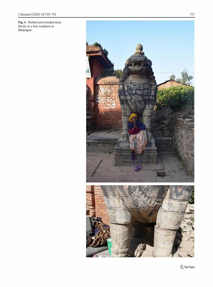
Fig. 4 Shifted and extruded stoneblocks in a lion sculpture atBhaktapur
J Seismol (2020) 24:729–751 737

occurred at some point around the sixth and seventhcenturies CE and primary effects included the identifi-cation in the stratigraphy of a ‘fault plane typical of aviolent earthquake’ (Verardi 1992: 68), as well as whatappears to be a large shear crack running down brickwall 131 of Structure 1 (Verardi 1992: 67). After thisearthquake event, secondary effects were reported, suchas the renovation and reconstruction of the seismicallydamaged Structure 1 (Verardi 1992: 79). Both primaryand secondary effects were then noted for a secondseismic event, which was deemed responsible for thesubsidence of an area of paving and a floor level, withtiles from debris reused for repair as a levelling material(Verardi 1992: 91–92). Finally, both primary and sec-ondary effects were recognised in relation to ‘an ex-tremely violent earthquake’ (Verardi 1992: 100), nearthe end of the occupied sequence of the site at somepoint in the fifteenth to sixteenth centuries CE. A fissurethrough a pavement and collapsed structures were iden-tified (Verardi 1992: 100–101), with post-earthquakereuse of materials from these damaged buildings foundin later smaller constructions (Verardi 1992: 102).
In combination with the classification of EAEs de-veloped from examples in Europe, the Middle East andMeso-America, as well as examples from previous stud-ies within South Asia and both the standing architectureand previously excavated sequences of the KathmanduValley, we were able to identify possible EAEs duringthe evaluations and assessments of foundations andearlier cultural sequences, conducted adjacent to col-lapsed monuments within the Kathmandu Valley(Table 1).
6 EAEs identified in archaeological sequencesduring post-disaster investigationsin the Kathmandu Valley
Through a combination of geophysical survey, excava-tion and geoarchaeological analysis, we identified sev-eral further examples of potential primary EAEs, as wellas adaptive strategies and responses employed by soci-eties in antiquity to seismic activity, during our post-disaster fieldwork within the Kathmandu ValleyUNESCO World Heritage Property.
Reconfiguration of space is one potential response toa seismic event (Forlin and Gerrard 2017: 99), withcollapsed structures levelled and areas left clear or newstructures built directly over the top of the earlier,
demolished buildings. A combination of geophysicalsurvey, through Ground Penetrating Radar (GPR), andtargeted excavation facilitated the investigation of sucha situation within the large Durbar Squares, and templeand palace courtyards of the Kathmandu Valley. GPRsurvey with a Mala 500-MHz system, mounted on arough-terrain cart, measuring vertically downwards, ontransects spaced 0.25 m apart, was undertaken in grids.The GPR facilitated the identification of anomaliesacross horizontal and vertical planes, identifying thedepth and spread, and potential character, of these fea-tures below areas that are currently open spaces. GPRsurvey was conducted at the three main Durbar Squaresof Hanuman Dhoka, Patan and Bhaktapur. In addition toidentifying modern features, such as pipes and electriccables, our GPR surveys illustrated that rather thanbeing empty, a number of anomalies were present thatrepresented earlier structures, sealed below the nowopen and paved surfaces.
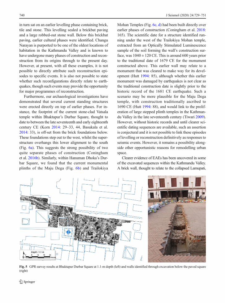
This was clearest in Bhaktapur’s Durbar Square,where several rectilinear anomalies were identified.Their shape, size and overall layout suggest walls for abuilding that may have stood in this place. Excavationsacross the Durbar Square identified several east-westand north-south wall alignments, sealed below herring-bone paving thought to be laid after the 1934 BiharEarthquake (Fig. 5). The location and nature of thesefeatures suggest that these remains most likely representthe foundations of the Lamupati, a two-storey sattal(Coningham et al. 2016b). Known from earlytwentieth-century photographs as well as watercolourspainted by Henry Ambrose Oldfield and drawings byRajman Singh from the mid-nineteenth century, thisstructure with a postulated construction date of c. 1750CE (Bajracharya et al. 2016: 82, 85) collapsed in the1934 earthquake and was not rebuilt. The levelling ofdamaged structures, which were then sealed below whatbecame open spaces, is not unique to the KathmanduValley and is a reaction to earthquakes that have beennoted in medieval Europe. For example, in Padua, Italy,within the Piazza Duomo, damaged structures werelevelled and overlaid with paving during a programmeof redevelopment in response to an earthquake dated to1117 CE (Forlin and Gerrard 2017: 99).
Bhaktapur’s Durbar Square after the 1934 BiharEarthquake provides several examples of differing re-sponses to reconstruction after the same seismic event.Whereas the Lamupati was dismantled and its founda-tions sealed below paving, the plinth and stone lions of
J Seismol (2020) 24:729–751738

the Hari Shankar temple were retained, whilst the su-perstructure was never rebuilt, possibly due to the lossof the sculpture of the main deity (UNESCO 2015: 40).The reuse of debris in reconstruction and new construc-tion efforts has been viewed as evidence of a rehabilita-tion response after an earthquake (Forlin and Gerrard2017: 99), and whilst some monuments were initiallyrebuilt with salvaged materials in slightly new configu-rations, such as the 55-windowed palace (UNESCO2015: 40), other monuments were reconstructed quicklywith completely new designs. The Silu Mahadev, locat-ed on the plinth of the original Fasu Dega (TahachoDega) Temple, just to the north of the Hari Shankartemple, had a Neo-Classical style whitewashed plasterdome with floral motifs constructed on the earlier mon-umental five-stepped brick plinth, with stone depictionsof elephant guardians, and stone lions and bulls on thesteps above (UNESCO 2015: 40). Other structures with-in Bhaktapur’s Durbar Square were reconstructed sev-eral decades later, utilisingmodernmaterials, such as theChyasilin Mandap (Gutschow and Hagmuller 1991).With historic photographs and records, as well as occur-ring in a timeframe of living memory for some inhabi-tants of the Kathmandu Valley, the changes effected andresponses after the 1934 Bihar Earthquake in Bhaktapurcan be identified. However, our archaeological investi-gations identified similar practices that are not recordedin any historical accounts from a deeper time-depth.
Within Patan’s Durbar Square, our GPR survey iden-tified several anomalies below the current paving, andexcavations not only revealed a clay platform adjacent
to the collapsed Char Narayan Temple but also a portionof a brick wall sealed below an earlier phase of paving.One of the raised areas of paving that formed the Squarewas also laid on an earlier tiled paving, which itself wasset on homogenous levelling material, which includedlarge quantities of rubble, including brickbats and bro-ken tiles. There is a potential that much of this materialindicates evidence of earlier earthquake damage, wherematerial from surrounding damaged structures wasrepurposed for levelling and reconfiguring Patan’s Dur-bar Square’s layout (Coningham et al. 2016c).
Such reconfigurations were not limited to the DurbarSquares, and GPR survey identified several linearanomalies below the courtyards within the Palace Com-plex at Hanuman Dhoka. Within the courtyard of NasalChok, there were indications of potential robbed-outwalls, as well as potential platforms sealed below thepaving within this courtyard. Within the courtyard ofLamChok, a further anomaly was identified, which mayrepresent an earlier wall phase. The existence of earlierwall phases within the palace complex has now beenconfirmed through excavations conducted by the De-partment of Archaeology (Government of Nepal) (pers.com. Ram Bahadur Kunwar and Bhaskar Gyawali).Similarly, within the open courtyard of ChanguNarayan Temple, substantial rectilinear anomalies,with a width of c. 1.5 m, may represent the remains ofcollapsed walls or foundations. Subsequent excavationswithin the complex identified earlier structures andpavements below two distinct phases of levelling. Thelast phase of levelling covered a small brick wall, which
Table 1 EAEs identified in South Asia and the Kathmandu Valley
J Seismol (2020) 24:729–751 739
in turn sat on an earlier levelling phase containing brick,tile and stone. This levelling sealed a brickbat pavingand a large robbed-out stone wall. Below this brickbatpaving, earlier cultural phases were identified. ChanguNarayan is purported to be one of the oldest locations ofhabitation in the Kathmandu Valley and is known tohave undergone many phases of construction and recon-struction from its origins through to the present day.However, at present, with all these examples, it is notpossible to directly attribute such reconstruction epi-sodes to specific events. It is also not possible to statewhether such reconfigurations directly relate to earth-quakes, though such eventsmay provide the opportunityfor major programmes of reconstruction.
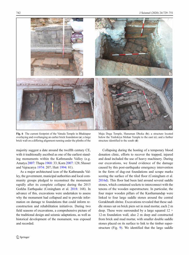
Furthermore, our archaeological investigations havedemonstrated that several current standing structureswere erected directly on top of earlier phases. For in-stance, the footprint of the current stone-clad Vatsalatemple within Bhaktapur’s Durbar Square, thought todate to between the late seventeenth and early eighteenthcentury CE (Korn 2014: 29–33, 44, Basukala et al.2014: 33), is off-set from the brick foundations below.These foundations step out to the west, whilst the super-structure overhangs this lower alignment to the south(Fig. 6a). This suggests the strong possibility of twoquite separate phases of construction (Coninghamet al. 2016b). Similarly, within Hanuman Dhoka’s Dur-bar Square, we found that the current monumentalplinths of the Maju Dega (Fig. 6b) and Trailokiya
Mohan Temples (Fig. 6c, d) had been built directly overearlier phases of construction (Coningham et al. 2018:165). The scientific date for a structure identified run-ning under the west of the Trailokiya Mohan temple,extracted from an Optically Stimulated Luminescencesample of the soil forming the wall’s construction sur-face, was 1040 ± 120 CE. This is around 600 years priorto the traditional date of 1679 CE for the monumentconstructed above. This earlier wall may relate to amonument that was cleared to make way for its devel-opment (Hutt 1994: 85), although whether this earliermonument was damaged by earthquakes is not clear asthe traditional construction date is slightly prior to thehistoric record of the 1681 CE earthquake. Such ascenario may be more plausible for the Maju Degatemple, with construction traditionally ascribed to1690 CE (Hutt 1994: 88), and would link to the prolif-eration of large stepped plinth temples in the Kathman-du Valley in the late seventeenth century (Tiwari 2009).However, without historic records and until clearer sci-entific dating sequences are available, such an assertionis conjectural and it is not possible to link these episodesof levelling or reconstruction definitively as responses toseismic events. However, it remains a possibility along-side other opportunistic reasons for remodelling urbanspace.
Clearer evidence of EAEs has been uncovered in someof the excavated sequences within the Kathmandu Valley.A brick wall, thought to relate to the collapsed Lamupati,
Fig. 5 GPR survey results at Bhaktapur Durbar Square at 1.1-m depth (left) and walls identified through excavation below the paved square(right)
J Seismol (2020) 24:729–751740
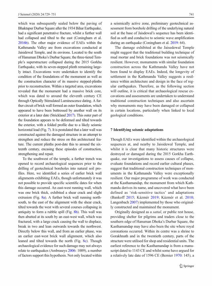
which was subsequently sealed below the paving ofBhaktapurDurbar Square after the 1934Bihar Earthquake,had a significant penetrative fracture, whilst a further wallhad collapsed and tilted to the east (Coningham et al.2016b). The other major evidence of EAEs within theKathmandu Valley are from excavations conducted atJaisidewal Temple, and its environs. Located to the southof HanumanDhoka’s Durbar Square, the three-tiered Tem-ple’s superstructure collapsed during the 2015 GorkhaEarthquake, with its seven-stepped plinth remaining large-ly intact. Excavations were undertaken to identify thecondition of the foundations of the monument as well asthe construction character of its massive stepped-plinthsprior to reconstruction. Within a targeted area, excavationsrevealed that the monument had a massive brick core,which was dated to around the eleventh century CEthrough Optically Stimulated Luminescence dating. A fur-ther circuit of brickwall formed an outer foundation,whichappeared to have been buttressed by another wall on itsexterior at a later date (Strickland 2017). This outer part ofthe foundation appears to be deformed and tilted towardsthe exterior, with a folded profile due to a likely seismichorizontal load (Fig. 7). It is postulated that a later wall wasconstructed against the damaged structure in an attempt tostrengthen and reduce the stress on this architectural fea-ture. The current plinths post-date this to around the six-teenth century, encasing these episodes of construction,strengthening and repair.
To the southwest of the temple, a further trench wasopened to record archaeological sequences prior to thedrilling of geotechnical boreholes into natural soil pro-files. Here, we identified a series of earlier brick wallalignments exhibiting EAEs, though unfortunately it wasnot possible to provide specific scientific dates for whenthis damage occurred. An east-west running wall, whichwas one brick thick, exhibited a shear crack and slightextrusion (Fig. 8a). A further brick wall running north-south, to the east of the alignment with the shear crack,tilted towards the west with several courses collapsing inantiquity to form a rubble spill (Fig. 8b). This wall wasthen abutted at its south by an east-west wall, which wasfractured, with a large crack causing the wall to displace,break in two and lean outwards towards the northwest.Directly below this wall, and from an earlier phase, wasan earlier east-west brick wall alignment, which alsoleaned and tilted towards the north (Fig. 8c). Thougharchaeological evidence for such damage may not alwaysrelate to earthquakes (Ambraseys 2006: 1009), a numberof factors support this hypothesis. Not only locatedwithin
a seismically active zone, preliminary geotechnical as-sessment from borehole drilling of the underlying naturalsoil at the base of Jaisdewal’s sequence has been identi-fied as soft and conducive to seismic wave amplificationduring an earthquake (Coningham et al. 2019: 64).
The damage exhibited at the Jaisedewal Templemight suggest that the traditional building technique ofmud mortar and brick foundations was not seismicallyresilient. However, monuments with similar foundationconstruction across the Kathmandu Valley have notbeen found to display EAEs. Indeed, the longevity ofsettlement in the Kathmandu Valley suggests a resil-ience within architecture and design in the face of reg-ular earthquakes. Therefore, as the following sectionwill outline, it is critical that archaeological rescue ex-cavations and assessments are undertaken to understandtraditional construction techniques and also ascertainwhy monuments may have been damaged or collapsedin certain locations, particularly when linked to localgeological conditions.
7 Identifying seismic adaptations
Though EAEs were identified within the archaeologicalsequences at, and nearby to Jaisidewal Temple, andwhilst it is clear that many historic structures weredestroyed or damaged during the 2015 Gorkha Earth-quake, our investigations to assess causes of collapse,evaluate foundations and record earlier cultural phases,suggest that traditional construction techniques of mon-uments in the Kathmandu Valley were exceptionallyresilient. Our major programme of work was conductedat the Kasthamandap, the monument from which Kath-mandu derives its name, and uncovered what have beendefined as ‘risk-sensitive tactics’ and adaptations(Bankoff 2015; Kázmér 2019; Kázmér et al. 2010;Langenbach 2007) implemented by those who original-ly constructed and maintained the monument.
Originally designed as a sattal, or public rest house,providing shelter for pilgrims and traders close to thesouthern edge of Hanuman Dhoka’s Durbar Square, theKasthamandap may have also been the site where royalcoronations occurred. Within its centre was a shrine toGorakhnath and in the twentieth century, parts of thestructure were utilised for shop and residential units. Theearliest reference to the Kasthamandap is from a manu-script dated to 1143 CE and whilst some have argued fora relatively late date of 1596 CE (Bernier 1970: 145), a
J Seismol (2020) 24:729–751 741
majority suggest a date around the twelfth century CE,with it traditionally ascribed as one of the earliest stand-ing monuments within the Kathmandu Valley (e.g.Amatya 2007: Thapa 1968: 33; Korn 2007: 128; Slusserand Vajracarya 1974: 207; Hutt 1994: 81).
As a major architectural icon of the Kathmandu Val-ley, the government, municipal authorities and local com-munity groups pledged to reconstruct the monumentrapidly after its complete collapse during the 2015Gorkha Earthquake (Coningham et al. 2018: 168). Inadvance of this, excavations were undertaken to assesswhy the monument had collapsed and to provide infor-mation on damage to foundations that could inform re-construction and rehabilitation initiatives. During twofield seasons of excavations, a comprehensive picture ofthe traditional design and seismic adaptations, as well ashistorical development of the monument, was exposedand recorded.
Collapsing during the hosting of a temporary blooddonation clinic, efforts to recover the trapped, injuredand dead included the use of heavy machinery. Duringour excavations, we found evidence of the damagecaused by this post-earthquake emergency interventionin the form of dug-out foundations and scrape marksscoring the surface of the tiled floor (Coningham et al.2016d). This floor had been laid around several saddlestones, which contained sockets to interconnect with thetenons of the wooden superstructure. In particular, thefour major wooden pillars of the Kasthamandap werelinked to four large saddle stones around the centralGorakhnath shrine. Excavations revealed that these sad-dle stones sat on brick piers set in mud mortar, each 2 mdeep. These were surrounded by a large squared 12 ×12-m foundation wall, also 2 m deep and constructedfrom brick and mud mortar, with smaller double saddlestones placed on its surface to link to the timber super-structure (Fig. 9). We identified that the large saddle
Fig. 6 The current footprint of the Vatsala Temple in Bhaktapuroverlaying and overhanging an earlier brick foundation (a); a largebrick wall on a differing alignment running under the plinths of the
Maju Dega Temple, Hanuman Dhoka (b); a structure locatedbelow the Trailokiya Mohan Temple to the east (c); and a furtherstructure identified to the south (d)
J Seismol (2020) 24:729–751742

stones had traces of copper sheeting on their surface,and these may have acted as a damp course between thewooden pillar and the saddle stone, a response to theannual monsoon (Coningham et al. 2016d).
Of the four central saddle stones, only three werevisible after the removal of loose debris across themonument. Excavations revealed that the northeast sad-dle stone had been sealed below a tiled floor. It was
Fig. 7 Deformed and tilted wall, with later bracing, at Jaisidewal Temple (image: Keir Strickland)
J Seismol (2020) 24:729–751 743

identified that this had most likely occurred duringconservation in the mid-twentieth century, where therotten tenon of the large northeastern pillar was pushedinto the socket below and then covered over by the tiledsurface, rather than being replaced, which would havemaintained the direct link between superstructure andfoundations. This was likely to be a major contributingfactor towards the Kasthamandap’s collapse, as wefound no major or catastrophic earthquake damagewithin the brick piers or foundations exposed duringarchaeological assessments, and no significant damagewas reported for the monument in relation to the 1934earthquake.
It would appear that the use of mud mortars withinthe foundations allowed for flexibility of the monumentduring seismic events. The only damage that could belinked to earthquakes was the identification of shortvertical cracks located below a double saddle stone onthe western length of the main foundation of the struc-ture. Limited to the upper courses, it indicates stress ofthe load of the saddle stone and its interlinked super-structure, primarily induced by the pressure of verticalmovement during a seismic event, causing the founda-tion below to be damaged (Coningham et al. 2018: 171;Fig. 10a). This also indicates that potential areas ofstress and damage were minimised and localised, ratherthan causing catastrophic failures. It is likely that such adesign with mud mortar brick masonry foundationslinked to saddle stones and the superstructure abovewas designed to save the structure from further seismicstress, limiting damage to a few specific locations. Sim-ilar damage patterns and deformation of brickwork werealso identified during excavations at the Gurujyu Sattal
at Pashupati (Fig. 10b). Again, the load of the timbersplaced within the saddle stones, which were bonded bymud mortar to the brick foundations, caused small con-centrated areas of vertical cracks below.
Whilst it is not clear which seismic events these cracksmay relate to, in the case of the Kasthamandap, scientificanalysis through Optically Stimulated Luminescence dat-ing has placed the construction of its original foundationsto c. 700 CE. This is 400–500 years earlier than its firstmention within historical texts, illustrating that theKasthamandap foundations were seismically adaptiveand had survived numerous earthquakes, up to and includ-ing the 2015Gorkha Earthquake (Coningham et al. 2016d;Coningham et al. 2018). Whilst we cannot be altogethercertain whether the superstructure of the monument hadbeen dismantled and rebuilt at points in antiquity until itscollapse in 2015, the original foundations were resilient. Acurrent programme of scientific dating analysis of timberwithin the Kasthamandap, and at other monuments withinthe KathmanduValley (Coningham et al. in 2019: 62), willprovide further evidence of potential reuse of woodenarchitectural elements and whether different phases of themonument were constructed on top of these foundations atlater dates, potentially in reaction to earthquakes.
We also identified that the monument may have hadbeen designed with inbuilt cosmological protection, ascross-walls, scientifically dated to 200 years after themonument’s original construction, running between thebrick piers and foundations, forming a nine-celled man-dala design (a representation of the universe in micro-cosm). These cross-walls may have also formed someaspect of seismic bracing for the foundations. It hasfurther been identified that the infills deposited within
Fig. 8 Trench to the southwest of Jaisidewal Temple, with sequence of brick walls exhibiting shear crack and slight extrusion (a); tilting andcollapse (b); crack and collapse of upper wall; and tilting of lower wall below (c)
J Seismol (2020) 24:729–751744

the ‘cells’ formed by the cross-walls were purposefullyprepared with soils and materials brought from outside.Preliminary geoarchaeological analysis suggesting thatthese deposits may have aided earthquake dampeningfor the monument’s foundations, and the thoughtfulcompositions of soils placed within the monument’sfoundations may have taken on a symbolic significance,which has been recorded in textual sources (Coninghamet al. 2019: 63). Further cosmological protection wasidentified with the recovery of gold foil discs withmandala designs within each of the sockets of the centralsaddle stones (Coningham et al. 2016d). Such depositsmay have provided a ‘life-breath’ to a building andafforded its protection, as well as the prosperity andwelfare to those performing the ceremony during theconstruction of a monument (Slaczka 2007: 84, 201).
Investigations at several other monuments within theKathmandu Valley have also confirmed that foundationsappear exceptionally resilient to earthquakes, with noseismic damage identified in the foundations of theJagannath, Gopinath and the TrailokiyaMohan Templesin Hanuman Dhoka, as well as at the Char NarayanTemple in Patan (Coningham et al. 2016c) and VatasalaTemple in Bhaktapur (Coningham et al. 2016d). Asdetailed above, the disconnection caused by moderninterventions between the resilient foundations and thesuperstructure above at the Kasthamandap was poten-tially a contributing factor towards collapse, rather thanthe structural integrity of traditional materials and design(Coningham et al. 2018: 171). This reflects observationson some modern structures, where earthquake damageto those built from reinforced concrete, as well as thoseusing more traditional materials, has been linked to poormaintenance (Adhikary 2016: 535–536; Varum et al.2017: 62) whereas those with well-maintained tradition-al earthquake-resistant features performed well(Adhikary 2016). Investigating causes of collapse, localsoil conditions and the seismic adaptations and perfor-mance of the foundations and superstructures of historicmonuments are therefore crucial within debates regard-ing pathways towards the rehabilitation of historic mon-uments after the 2015 Gorkha Earthquake.
8 Discussion—resilience and the post-earthquakerehabilitation of Kathmandu’s heritage
Evidence from our recent multidisciplinary post-disasterinvestigations in the Kathmandu Valley has documented
EAEs within the archaeological record and has alsoidentified how past societies responded to earthquakesand developed risk-reducing strategies to prepare forfuture seismic events. Whilst levelling damaged struc-tures and reconfiguring space is one of the potential pastresponses identified, we have also uncovered adapta-tions inbuilt within monument design. Resilient andflexible foundations, constructed of brick within mudmortar, were in some cases combined with soils thatmay have been prepared to aid earthquake dampening.Potentially taking on a symbolic significance, cosmo-logical designs for foundation layouts, as well as ritualdeposits, may also have been devised to protect monu-ments and communities from future catastrophic events.
Whilst these adaptations and construction techniquesappear to have created resilient structures, preliminarygeotechnical results suggest that these traditional de-signs may not have been as successful when constructedin certain localities due to underlying natural soil con-ditions, such as at Jaisidewal. We will continue to assessand update our archaeological, geoarchaeological andarchitectural findings at monuments across the Kath-mandu Valley in relation to new results emerging fromcontinuing geotechnical and structural engineeringinvestigations.
It is also noted, particularly from our research at theKasthamandap, that traditional design and adaptationsare only resilient if maintained and monitored. Indeed, ithas been asserted that ‘The historical architecture ofNepal is not only characterised by a remarkable conti-nuity of theoretical principles of design, proportioningof form and consistent use of particular materials anddécor but also by a tradition of conservation, involvingreconstruction and renewal… This is of added signifi-cance as brick and timber, the materials of constructionof the tiered temples, demanded regular replacementand maintenance not only as a matter of normalweathering but also in response to frequent destructionscaused by earthquakes…’ (Tiwari 2009: 27).
Recent rapid reconstruction programmes privilegingmodern materials are destroying subsurface heritagewithout recording, and also removing evidence of seis-mic adaptation and information regarding causes ofcollapse. Our investigations have shown the value andpotential in undertaking multidisciplinary investigationsto assess past seismic resilience and adaptations. TheBritish Academy Global Challenges Research Fundsponsored project ‘Reducing Disaster Risk to Life andLivelihoods by Evaluating the Seismic Safety of
J Seismol (2020) 24:729–751 745

Kathmandu’s Historic Urban Infrastructure’, is the cul-mination of these multidisciplinary partnerships, and wecontinue to assess data from the integration of archaeol-ogy, geophysics, geoarchaeology and architectural stud-ies with 3D visualisation, geotechnical and structuralengineering, as well as community engagement to con-tinue the development and disseminate co-producedmethodologies to assess, evaluate and enhance the seis-mic safety of Kathmandu’s historic urban infrastructure(Coningham et al. 2019). Such an approach has beenseen as necessary in the field of archaeoseismology,where it has been identified that ‘the scope and goalsof archaeoseismological studies should still be broad-ened, benefiting from more intimate collaborations be-tween earthquake geologists, historians, archaeologistsand anthropologists in deciphering the precise role ofearthquakes in the cultural history of a site. A betterappreciation of the complex dynamics by which ancientcultures dealt with and responded to damaging earth-quakes (e.g. anti-seismic measures) might shed light onthe resilience of past societies and their relative capacity
to withstand seismic shocks’ and ‘By highlighting howth e i r a n c e s t o r s c op ed w i t h e a r t h qu ake s ,archaeoseismology could play a key role in fosteringbetter earthquake preparedness in modern local commu-nities that are equally threatened’ (Sintubin 2011: 8).Such an approach is now being realised in Kathmanduand future results from the final analyses of geotechnicalassessments, structural engineering, materials analysisand community interactions can be filtered into ourcur r en t under s t and ings f rom archaeo logy,geoarchaeology and traditional architecture. This com-bination of existing knowledge with multidisciplinaryand interlinked research will enable the development ofstrategies for stakeholders with the responsibility of thereconstruction, rehabilitation and monitoring ofKathmandu’s historic monuments, which is now beingrealised at the Kasthamandap (Coningham et al. 2019).
Such strategies are vital as societies in seismic regionsare always living ‘Between Two Earthquakes’ (Feilden1987: 11). In the recognition that similar post-disasterscenarios for heritage structures might be encountered
Fig. 9 Nine-celled mandala formed through brick-piers, foundation wall and cross-walls uncovered during archaeological assessments atthe Kasthamandap
J Seismol (2020) 24:729–751746

in the future, we began to co-develop archaeologicalapproaches to assess and protect movable objects and
debris, as well as structural elements, floor surfaces andfoundations that survived the initial earthquake. In the
Fig. 10 Vertical cracks identified below a double saddle stone in the foundations of the Kasthamandap (a) and below a saddle stone in thefoundations of the Gurujyu Sattal, Pashupati (b)
J Seismol (2020) 24:729–751 747
immediate aftermath of emergency phase rescue opera-tions, it was noted that debris from collapsed structures,including archaeological and architectural material, wasmixed with modern rubble, was removed and dumped.Despite the painstaking efforts of Professor M.R. Aryaland the late Sukra Sagar Shrestha and their team, tosalvage, document and attribute structural elements fromcollapsed structures within Hanuman Dhoka DurbarSquare (Aryal 2017), many structural elements fromacross the Kathmandu Valley were lost or removed with-out their location being recorded. Beyond considerationsof cultural value, the economic and environmental cost ofdumping this material is huge, especially as firing bricksof a quality for heritage construction is estimated at £1.31per brick (Coningham et al. 2018: 174). In response tothis, a live training exercise conducted at Gurujyu Sattalat Pashupati, was co-designed with participants from theArmed Police Force, Nepal Police and Nepal Army, theDepartment of Archaeology (Government of Nepal) andthe Pashupati Area Development Trust, to provide amethod that could be applied to collapsed and damagedheritage (Coningham et al. 2018: 176–177; Coninghamand Weise 2019).
It was identified that those first on the scene wouldneed a quick and flexible approach that could be used atany collapsed monument, and could also be undertakenby key responders, with the potential that heritage pro-fessionals would not be able to attend the scene of everydamaged heritage monument in the immediate after-math of a disaster. The Gurujyu Sattal, a structure thathad been deliberately demolished due to safety concernsafter the 2015 Earthquake, offered the possibility of thereplication of a post-earthquake scenario. Undertaken ina safe environment over a year after the 2015 GorkhaEarthquake, the participants worked together to system-atically clear and record debris so that material recov-ered could be linked to a specific monument and broadlocation within a monument. Building on methods ini-tially outlined by Feilden (1987: 41), a simple grid wasplaced across the site, with debris removed and thendeposited in a replicated grid located close to the dam-aged monument. The creation of a replicated grid meantthat debris was removed quickly onto intact foundationsand floor surfaces, from where the trapped and injuredare most likely to be, with the spatial location of recov-ered material recorded. This material can then be leftuntil such a time that heritage professionals are availableto process and analyse it, identifying artefacts and
structural elements and materials that can be salvagedand reused (Coningham et al. 2018: 176–177).
Linked to this live-exercise, a post-disaster heritageresponse handbook was then co-designed alongsidestakeholders including heritage practitioners, aca-demics, key responders and community groups duringthe AHRC-GCRF sponsored workshop ‘Heritage atRisk 2017’, held in Kathmandu in September 2017.This handbook is now being developed into teachingmaterials as part of training programmes for these keyresponders and stakeholders. These methods were ap-plied and tested in Bagan in Myanmar, for monumentsaffected by the August 2016 Earthquake, and transposedto monuments in Jaffna Fort, northern Sri Lanka,afflicted by human-made disasters (Davis et al. 2019;Coningham and Weise 2019). Furthermore, archaeolog-ical assessments, particularly GPR surveys and linkedexcavations, are being utilised to develop Archaeologi-cal Risk Maps to map, record and protect subsurfaceheritage, not only from unrecorded post-earthquake in-terventions, but also from more long-term and ‘silent’disasters, such as unchecked development through rapidurbanisation (Coningham et al. 2018: 165). The bring-ing together of varied disciplines not only allows us toreconstruct the damage, adaptations, resilience and re-actions of past societies towards earthquakes, but facil-itates preparedness and protection of communities andheritage in the face of future seismic shocks.
Acknowledgements Fieldwork in Kathmandu would not havebeen possible without the support and dedication of the staff,officers and students from UNESCO Kathmandu, the Departmentof Archaeology (Government of Nepal), ICOMOS (Nepal),Pashupati Area Development Trust, Lumbini Buddhist University,Tribhuvan University, Durham University, the University of Stir-ling, the Maharaja Sayajirao University of Baroda, the Universityof La Trobe, University of Bradford, Newcastle University and theInstitute for the Intellectual and Cultural History of Asia (AustrianAcademy of Sciences). We are also appreciative of the first re-sponders from the Nepal Police, Armed Police and Nepal Armyfor their participation and feedback on the live post-disaster train-ing exercise co-developed at Pashupati. Further support from theOriental Heritage Sites Protection Alliance facilitated the mobilityof Officers from the Department of Archaeology (Government ofMyanmar) and Central Cultural Fund (Government of Sri Lanka)to participate in the field programme in Kathmandu. We wouldalso like to thank the Municipalities of Kathmandu, Patan andBhaktapur, as well as the communities of the Kathmandu Valley,for their support and interest in our programme of post-disasterinvestigations. We are very thankful for the comments of the twoanonymous reviewers who provided extremely useful feedback onthe original submission of this paper.
J Seismol (2020) 24:729–751748

Funding information The post-disaster fieldwork undertakenin Kathmandu was funded by an Arts and Humanities ResearchCouncil Global Challenges Research Fund Grant (AH/P006256/1), a British Academy Global Challenges Research Fund Grant(CI170241) and two UNESCO funded missions (Contracts4500283215 and 4500318125) awarded to Coningham as PI anda conservation award from the National Geographic Society(#C333-16) awarded to Acharya as PI.
Open Access This article is distributed under the terms of theCreative Commons Attribution 4.0 International License (http://creativecommons.org/licenses/by/4.0/), which permits unrestrict-ed use, distribution, and reproduction in any medium, providedyou give appropriate credit to the original author(s) and the source,provide a link to the Creative Commons license, and indicate ifchanges were made.
References
Adhikary N (2016) Vernacular architecture in post-earthquakeNepal. Int J Environ Stud 73(4):533–540
Amatya, S. (2007). Monument conservation in Nepal: my experi-ence with the World Heritage Sites of the Kathmandu Valley.Vajra Publications, Kathmandu
Ambraseys NN (2006) Earthquakes and archaeology. JArchaeological Sci 33:1008–1016
Aryal, M.R. (2017). Inventory, Recording and storage.https://www.dur.ac.uk/cech/unescochair/workshops/heritageatrisk/session2/. Accessed 02/04/2019.
Bajracharya, M., Gutschow, N. and Michaels, A. (2016). Historyof kings of Nepal. A Buddhist Chronicle. Himal Books,Kathmandu:
Bankoff G (2015) Design by Disaster. Seismic architecture andcultural adaptation to earthquakes. In: Krüger F, Bankoff G,Cannon T, Orlowski B, Schipper ELF (eds) Cultures anddisasters. Understanding cultural framings in disaster riskreduction. Routledge, Abingdon, pp 53–71
Basukala, B, Gutschow, N. and Kayastha, K. (2014) Towers ofstone: Sikhara Temples in Bhaktapur, Vatsala andSiddhilaksmi. Himal Books, Kathmandu
Behrendt KA (2009) The ancient reuse and recontextualization ofGandharan images: second to seventh centuries CE. SouthAsian Studies 25(1):11–27
Bernier, RM (1970) The temples of Nepal: an introductory survey.Voice of Kathmandu, Kathmandu
Bilham R (2004) Earthquakes in India and the Himalaya: tecton-ics, geodesy and history. Annals of Geophysics 47(2/3):839–858
Bilham R, Bali BS (2014) A ninth century earthquake-inducedlandslide and flood in the Kashmir Valley, and earthquakedamage to Kashmir’s medieval temples. Bull Earthq Eng 12:79–109
Bilham R, Lodi S (2010) The door knockers of Mansurah: strongshaking in a region of low perceived seismic risk, Sindh,Pakistan. In: Sintubin M, Stewart IS, Niemi TM, Altunel E(eds) Ancient earthquakes. The Geological Society ofAmerica Special Paper 471, Colorado, p 29.38
Callieri, P, Filigenzi, A and Stacul, G (1992) Bir-kot-ghwandai1990-1992. A preliminary Report on the excavations of theItalian Archaeological Mission, IsMEO. Annali dell’IstitutoOrientale di Napoli 52(4). Suppl. 73
Campbell A (2018) Account of the great earthquake of Nepal1833. Ratna Putsak Bhandar, Kathmandu
Chaulagain H, Gautam D, Rodgrigues H (2017) Revisiting majorhistorical earthquakes in Nepal: Overview of 1833, 1934,1980, 1988, 2011, and 2015 seismic events. In: Gautam D,Rodrigues H (eds) Impacts and insights of the Gorkha earth-quake. Elsevier, Amsterdam, pp 1–18
Coningham RAE, Weise K (2019) Ruins and debris: culturalheritage practice, resource management, and archaeology.In: Bicknell J, Judkins J, Korsmeyer C (eds) Philosophicalperspectives on ruins, monuments, and memorials.Routledge, London, pp 275–290
Coningham, RAE and Young, RL (2015) The archaeology ofSouth Asia: from the Indus to Asoka c.6500 BCE – 200CE. Cambridge University Press, Cambridge
Coningham RAE, Acharya KP, Davis CE, Kunwar RB, TremblayJC, Schmidt A, Simpson I, LaFortune-Bernard A (2016a)Post-disaster rescue archaeological investigations, evalua-tions and interpretations in the Kathmandu Valley WorldHer i t age Prope r ty (Nepa l ) : Obse rva t ions andRecommendations from a UNESCO mission in 2015.Ancient Nepal 191-192:72–92
Coningham RAE, Acharya KP, Davis CE, Kunwar RB, TremblayJC, Schmidt A, Simpson I (2016b) Preliminary results ofpost-disaster archaeological investigations at the VatsalaTemple and within Bhaktapur’s Durbar Square, KathmanduValley UNESCO World Heritage Property (Nepal). AncientNepal 191-192:3–27
Coningham RAE, Acharya KP, Davis CE, Kunwar RB, TremblayJC, Simpson IA, Schmidt A (2016c) Preliminary Results ofpost-disaster archaeological investigations at the CharNarayan Temple and within Patan’s Durbar Square,Kathmandu Valley UNESCO World Heritage Property(Nepal). Ancient Nepal 191-192:52–71
Coningham RAE, Acharya KP, Davis CE, Kunwar RB, SimpsonIA, Schmidt A, Tremblay JC (2016d) Preliminary Results ofPost-Disaster Archaeological Investigations at theKasthamandap and within Hanuman Dhoka, KathmanduValley UNESCO World Heritage Property (Nepal). AncientNepal 191-192:28–51
Coningham RAE, Acharya KP, Davis CE, Weise K, Kunwar RB,Simpson IA (2018) Look Down, Not Up: Protecting the post-disaster subsurface heritage of the Kathmandu Valley’sUNESCO World Heritage Site. In: Bracken LA, RuszczykH, Robinson T (eds) Evolving narratives of hazard and riskthe Gorkha earthquake, Nepal, 2015. Palgrave Macmillan,Cham, pp 159–181
Coningham RAE, Acharya KP, Barclay CP, Barclay R, Davis CE,Graham C, Hughes PN, Joshi A, Kelly L, Khanal S, Kilic A,Kinnaird T, Kunwar RB, Kumar A, Maskey PN, Lafortune-Bernard A, Lewer N, McCaughie D, Mirnig N, Roberts A,Sarhosis V, Schmidt A, Simpson IA, Sparrow T, Toll DG,Tully B, Weise K, Wilkinson S, Wilson A (2019) Reducingdisaster risk to life and livelihoods by evaluating the seismicsafety of Kathmandu’s historic urban infrastructure: enablingan interdisciplinary pilot. J Br Acad 7(S2):45–82
J Seismol (2020) 24:729–751 749

Davis CE, Coningham RAE, Gunawardhana P, Pushparatnam P,Schmidt A, Manuel MJ (2019) The antiquity of Jaffna Fort:new evidence from post-disaster archaeological investiga-tions in northern Sri Lanka. Antiquity 93(368):e13
Feilden B (1987) Between two earthquakes: cultural property inseismic zones. ICCROM, Rome
Forlin P, Gerrard CM (2017) The archaeology of earthquakes: theapplication of adaptive cycles to seismically-affected com-munities in late medieval Europe. Quat Int 446:95–108
Galadini F, Hinzen KG, Stiros S (2006) Archaeoseismology:methodological issues and procedure. J Seismol 10:395–414. https://doi.org/10.1007/s10950-006-9027-x
Gautam D, Pradhananga S, Kunwar RB, Sharma MK (2015)Preliminary report of monuments affected by earthquakeApril 25 2015. Department of Archaeology, Kathmandu
Giner-Robles, JL, Rodríguez-Pascua, MA, Pérez-López, R, Silva,PG, Bardají, T, Grützner, C, Reicherter, K (2009) Structuralanalysis of earthquake archaeological effects (EAE): BaeloClaudia Examples (Cádiz, South of Spain). 1st INQUA-IGCP 567 International Workshop on EarthquakeArchaeology and Palaeoseismology. Volume 2. InstitutoGeológico y Minero, Madrid
Guidoboni E, Ebel JE (2009) Earthquakes and Tsunamis in thePast. A Guide to Techniques in Historical Seismology.Cambridge University Press.
Gutschow N (1997) The Nepalese Caitya: 1500 years of Buddhistvotive architecture in the Kathmandu Valley, Stuttgart
Gutschow N (2011) Architecture of the Newars: a history ofbuilding typologies and details in Nepal. SerindiaPublications, Chicago
Gutschow N, Hagmuller G (1991) The reconstruction of the eight-cornered pavilion (Cyasilin Mandap) on Darbar Square inBhaktapur-Nepal. Ancient Nepal 123-125:1–9
http://whc.unesco.org/en/list/121/ Accessed 23/04/2019. (n.d.)Hutt M (ed) (1994) Nepal: a guide to the art and architecture of the
Kathmandu Valley. Kiscadale Publications, StirlingJoshi M, Thakur VC (2016) Signatures of 1905 Kangra and 1555
Kashmir Earthquakes in medieval period temples of ChambaRegion, Northwest Himalaya. Seismol Res Lett 86(5):1150–1160
Kázmér M (2019) Living with earthquakes along the Silk Road.In: Yang LE, Bork H-R, Fang X, Mischke S (eds) Socio-environmental dynamics along the historical Silk Road.Springer, Cham, pp 135–176
Kázmér M, Major B, Hariyadi A, Pramumijoyo S, Haryana YD(2010) Living with earthquakes – development and usage ofearthquake-resistant construction methods in European andAsian Antiquity. Geophys Res Abstr 12:EGU2010–EG14244
Khanal MP, Riccardi T (2007) Archaeological excavations in theKathmanduValley. In: A Report on the 1984-85 and 1988-89Seasons at Dumakhal. Harvard, Harvard Oriental Series
Korn W (2007) The traditional architecture of the KathmanduValley, 2nd edn. Ratna Pustak Bhandar, Kathmandu
Korn W (2014) The traditional Newar architecture of theKathmandu Valley: the Shikaras. Ratna Pustak Bhandar,Kathmandu
Kovach RL, Grijalva K, Nur A (2010) Earthquakes and civiliza-tions of the Indus Valley: a challenge for archaeoseismology.In: Sintubin M, Stewart IS, Nieme TM, Altunel E (eds)
Ancient Earthquakes. The Geological Society of America,Special Paper 471, Colorado, pp 119–128
Langenbach R (2007) From “Opus Craticium” to the “ChicagoFrame”: earthquake-resistant traditional construction. Int JArchit Herit 1:29–59
Marshall JH (1951) Taxila, vol 1. Cambridge University Press,Cambridge
Olivieri LM (2011) The last phases at Barikot: urban cults andpreliminary chronology: Data from the 2012 excavationcampaign in Swat. J Inn Asian Art Archaeol 6:7–40
Olivieri LM (2015) Urban Defences at Bīr-koṭ-ghwaṇḍai, Swat(Pakistan). New data from the 2014 Excavation Campaign.Ancient Civilizations from Scythia to Siberia 21:183–199
PDNA (2015) Post disaster needs assessment: cultural heritage(June 2015). UNESCO, Kathmandu
Petech, L (1984) Medieval history of Nepal (c. 750-1482).IsMEO, Roma
Prushca K (2015) Kathmandu Valley, Volumes 1 and 2, 2nd edn.Vajra Books, Kathmandu
Rajendran CP, Rajendran K (2003) Studying earthquake recur-rence in the Kachchh Region, India. Trans Am GeophysUnion 84(48):529–536
Rajendran CP, Rajendran K, Thakkar M, Goyal B (2008)Assessing the previous activity at the source zone of the2001 Bhuj earthquake based on the near-source and distantpaleoseismological indicators. J Geophys Res 113:1–17
Rajendran CP, Rajendran K, Sanwal J, Sandiford M (2013)Archaeological and historical database on themedieval earth-quakes of the Central Himalaya: ambiguities and inferences.Seismol Res Lett 84(6):1098–1108
Rana, BSJB (2013 1934) (trans. From the second edition by KesarLall). The great earthquake in Nepal (1934 A.D.). DongolPrinters, Nepal
Regmi DR (1983) Inscriptions of Ancient Nepal. AbhinavPublications, New Delhi
Rodríguez-Pascua MA, Pérez-López R, Giner-Robles JL, SilvaPG, Garduño-Monroy VH, Reicherter K (2011) A compre-hensive classification of Earthquake Archaeological Effects(EAE) in archaeoseismology: application to ancient remainsof Roman and Mesoamerican Cultures. Quat Int 242:20–30
Rupakhety R (2017) Seismotectonic and engineering seismologi-cal aspects of the Mw 7.8 Gorkha, Nepal, Earthquake. In:Gautam D, Rodrigues H (eds) Impacts and Insights of theGorkha Earthquake. Elsevier, Amsterdam, pp 19–46
Silva PG, Sintubin M, Reicherter K (2011) New advances instudies of earthquake archaeology and palaeoseismology.Quat Int 424:1–3
Sintubin M (2011) Archaeoseismology: past, present and future.Quat Int 242:4–10
Slaczka AA (2007) Temple consecration rituals in Ancient India:text and archaeology. Brill, Leiden
Slusser MS, Vajracarya G (1974) Two medieval Nepalese buildings:an architectural and cultural study. Artibus Asiae 36(3):169–218
Stiros, SC and Jones, RE (eds) (1996) Archaeoseismology. FitchLaboratory Occasional Paper 7, Institute of Geology andMineral Exploration and The British School at Athens, Athens
Strickland, KM 2017 2016 Archaeological investigations of acollapsed square tiered temple, post- Gorkha Earthquake:Jaisideval, Kathmandu, Nepal. Technical Report submittedto the Department of Archaeology, Government of Nepal,Kathmandu
J Seismol (2020) 24:729–751750

Thapa RJ (1968) Kasthamandapa. Ancient Nepal 3:33–43Tiwari SR (2009) Temples of the Nepal Valley. Himal Books,
KathmanduUNESCO (2015) Revisiting Kathmandu: safeguarding living ur-
ban heritage. International Symposium, Kathmandu Valley.25-29 November 2013. UNESCO, Kathmandu
Vajracharya D, Malla KP (1985) The Gopālarājavaṃśāvalī: a facsim-ile edition; with an introduction, a transcription, Nepali andEnglish translations, a glossary and indices. Steiner, Stuttgart
Varum H, Dumaru R, Furtado A, Barbosa AR, Gautam D,Rodrigues H (2017) Seismic performance of buildings inNepal after the Gorkha earthquake. In: Gautam D,
Rodrigues H (eds) Impacts and insights of the GorkhaEarthquake. Elsevier, Amsterdam, pp 47–64
Verardi G (1992) Excavations at HarigaonKathmandu. IsMEO, RomeWeise K, Gautam D, Rodrigues H (2017) Response and rehabil-
itation of historic monuments after the Gorkha earthquake.In: Gautam D, Rodrigues H (eds) Impacts and insights of theGorkha Earthquake. Elsevier, Amsterdam, pp 65–94
Publisher’s note Springer Nature remains neutral with regard tojurisdictional claims in published maps and institutionalaffiliations.
J Seismol (2020) 24:729–751 751


![[TIMING OF SLIDE: 5 minutes] - Home | FEMA.gov Scenario Exercise for Community Planning [TIMING OF SLIDE: 5 minutes] FACILITATOR: I’d like to welcome you to our Disaster Scenario](https://static.fdocuments.us/doc/165x107/5abf4b5b7f8b9aa3088df19f/timing-of-slide-5-minutes-home-femagov-scenario-exercise-for-community-planning.jpg)