Improving the Image & Visibility of · PDF fileImproving the Image & Visibility of Geodesy...
30
28/05/15 1 Geomatics Education & Research: Challenges & Opportunities, HKPU, 29 May 2014 Geomatics Education & Research: Challenges & Opportunities, HKPU, 29 May 2014 School of Civil & Environmental Engineering, UNSW, Sydney, Australia Improving the Image & Visibility of Geodesy Chris Rizos The Classical “Pillars” of Geodesy Earth Rotation and Polar Motion (EOP) The Earth’s Gravity Field Reference Frames (Terrestrial and Celestial) Geometry of the Earth’s Surface(s) -45˚ -45˚ 0˚ 0˚ 45˚ 45˚ What is wrong with this image?
Transcript of Improving the Image & Visibility of · PDF fileImproving the Image & Visibility of Geodesy...

28/05/15
1
Geomatics Education & Research: Challenges & Opportunities, HKPU, 29 May 2014 Geomatics Education & Research: Challenges & Opportunities, HKPU, 29 May 2014
School of Civil & Environmental Engineering, UNSW, Sydney, Australia
Improving the Image & Visibility of Geodesy
Chris Rizos
The Classical “Pillars” of Geodesy
Earth Rotation and Polar Motion (EOP)
The Earth’s Gravity Field
Reference Frames (Terrestrial and Celestial)
Geometry of the Earth’s Surface(s)
-45˚ -45˚
0˚ 0˚
45˚ 45˚
What is wrong with this image?

28/05/15
2
The Classical Challenges of Geodesy (1) Geometry of the Earth’s Surface(s)
-45˚ -45˚
0˚ 0˚
45˚ 45˚
• National geodetic control networks • Atmospheric refraction • Precise angle & distance measurement • Ellipsoidal calculations & map projections • Large geometric system LSE & error theory • Geodetic survey technology
Peter Apian’s Geographia 1533
Earth Rotation and Polar Motion
The Classical Challenges of Geodesy (2) -5
05
10
metres
-50
510
metres
05
1015metres
05
1015
metres
1965
1970
1975
1980
1985
1990
1995
2000
year
• Positional astronomy • Earth/mass/inertia & SEMs • Reference frame transformations • Ocean-atmosphere-solid earth
coupling • Astronomical &
space geodesy technology

28/05/15
3
The Earth’s Gravity Field
The Classical Challenges of Geodesy (3)
• GBVP & potential theory • Gravity anomalies & DoV • �Unification� of geometry &
gravimetry • Surface gravity data limitations • Height datums • Satellite GFMs • Astronomical & space geodesy
technology • Satellite altimetry • Absolute & relative gravimetry
Geomatics Education & Research: Challenges & Opportunities, HKPU, 29 May 2014
Geodesy has an “image problem”… Concepts and results are difficult to explain to a layperson or decision-maker... who thinks we don’t need it anymore or, worse, that it is an indulgence...

28/05/15
4
Geomatics Education & Research: Challenges & Opportunities, HKPU, 29 May 2014 Geomatics Education & Research: Challenges & Opportunities, HKPU, 29 May 2014
! National control networks largely complete in developed countries…but lag in developing countries
! Restrictions on access to surface gravity data…as well as incomplete coverage
! Low quality geoid models…of academic interest only ! Geodesy has “finished”?…BUT
Geodetic Stasis
By the 1970-80s:
Geomatics Education & Research: Challenges & Opportunities, HKPU, 29 May 2014 Geomatics Education & Research: Challenges & Opportunities, HKPU, 29 May 2014
! Geodesy joins the ranks of “big science”…satellite missions: altimetry, laser-tracked spacecraft, etc
! Big, expensive observatories…SLR, VLBI ! Exotic data…restricted access & capability ! SW & analysis expertise concentrated in few
centres…GFM, POD, SLR/VLBI, etc. ! Globalisation of geodesy, e.g. WGS84, GEMs ! Widening gap between classical geodesy methods
& new space-based techniques
The Beginnings of a Geodetic Renaissance
Yet:
28/05/15
5
Geomatics Education & Research: Challenges & Opportunities, HKPU, 29 May 2014 Geomatics Education & Research: Challenges & Opportunities, HKPU, 29 May 2014
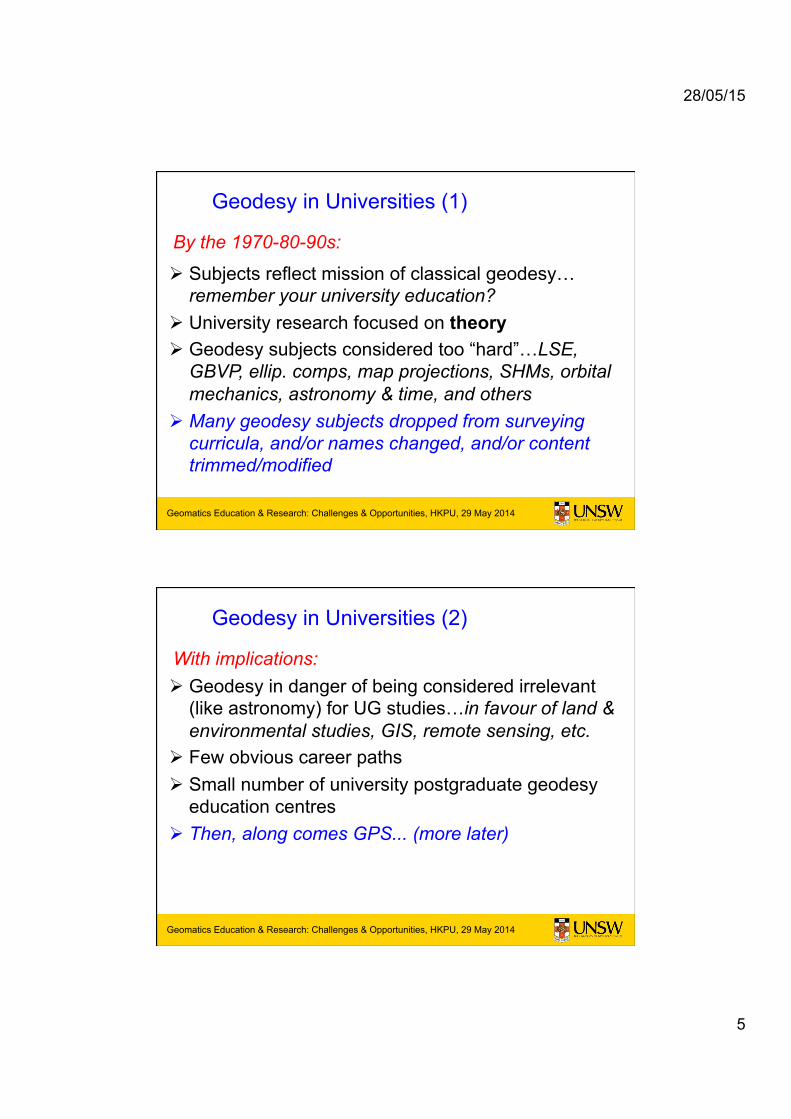
! Subjects reflect mission of classical geodesy… remember your university education?
! University research focused on theory ! Geodesy subjects considered too “hard”…LSE,
GBVP, ellip. comps, map projections, SHMs, orbital mechanics, astronomy & time, and others
! Many geodesy subjects dropped from surveying curricula, and/or names changed, and/or content trimmed/modified
Geodesy in Universities (1)
By the 1970-80-90s:
Geomatics Education & Research: Challenges & Opportunities, HKPU, 29 May 2014 Geomatics Education & Research: Challenges & Opportunities, HKPU, 29 May 2014
! Geodesy in danger of being considered irrelevant (like astronomy) for UG studies…in favour of land & environmental studies, GIS, remote sensing, etc.
! Few obvious career paths ! Small number of university postgraduate geodesy
education centres ! Then, along comes GPS... (more later)
With implications:
Geodesy in Universities (2)

28/05/15
6
Geomatics Education & Research: Challenges & Opportunities, HKPU, 29 May 2014
Modern Geodesy’s Capabilities
Geodesy now defined in terms of the following capabilities: 1. Determination of precise global, regional & local 3-D
(static or kinematic) positions on or above the Earth’s (solid or aqueous) surface
2. Mapping of land, sea & ice surface geometry 3. Determination of the Earth’s (time & spatially) variable
gravity field 4. Measurement of dynamical (4-D) phenomena:
- Solid Earth (incl. cryosphere): surface deformation, crustal motion, GIA, polar motion, earth rotation, tides, water cycle, mass transport, etc. - Atmosphere: refractive index, T/P/H profiles, TEC, circulation, etc. - Ocean: sea level, sea state, circulation, etc.
Modern geodesy has an impressive
array of space & terrestrial
technologies at its disposal
28/05/15
7
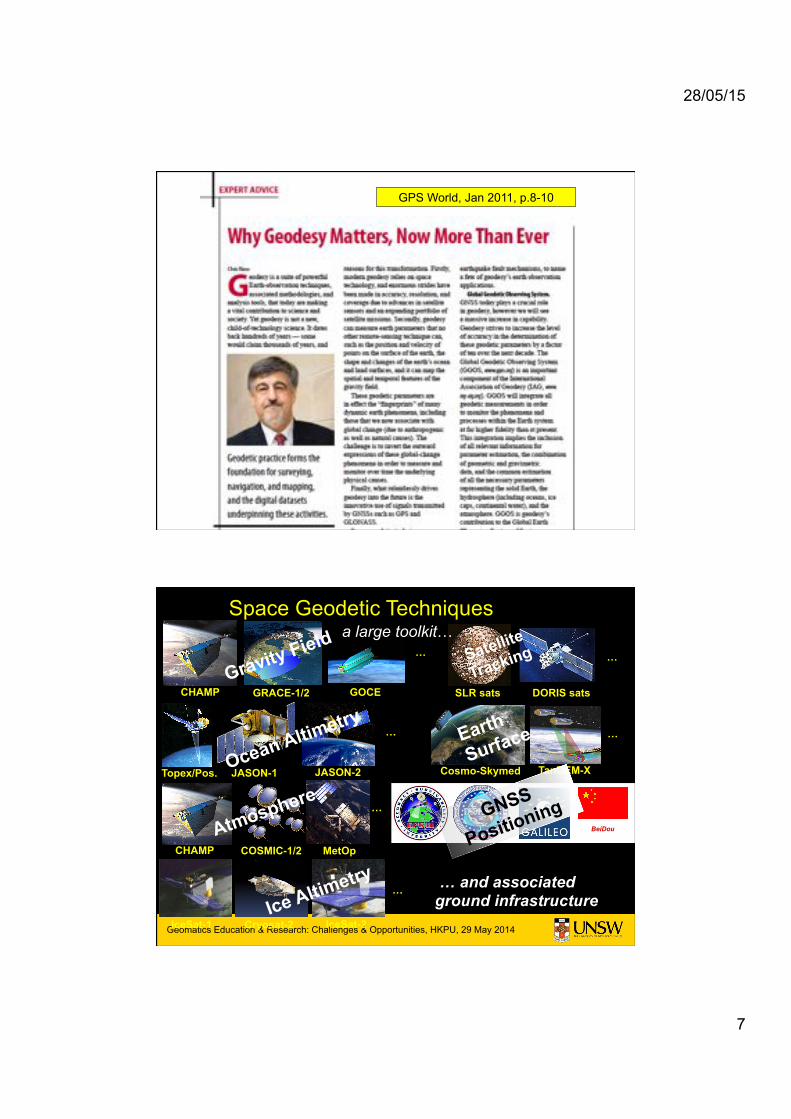
GPS World, Jan 2011, p.8-10
Geomatics Education & Research: Challenges & Opportunities, HKPU, 29 May 2014 Geomatics Education & Research: Challenges & Opportunities, HKPU, 29 May 2014
Space Geodetic Techniques
BeiDou
CHAMP GRACE-1/2 GOCE
COSMIC-1/2
Cosmo-Skymed JASON-1 TanDEM-X
…
Topex/Pos. JASON-2
CHAMP
…
…
MetOp
IceSat-2 IceSat-1 Cryosat-2
…
…
… and associated ground infrastructure
Gravity Field
Ocean Altimetry Earth
Surface
Atmosphere GNSS
Positioning
Ice Altimetry
SLR sats DORIS sats
Satellite
Tracking …
a large toolkit…

28/05/15
8
Abs.Grav.
GNSS VLBI
DORIS SLR/LLR
Ground Infrastructure for Geometrical Techniques
Geomatics Education & Research: Challenges & Opportunities, HKPU, 29 May 2014
Modern Geodesy is both a geoscience and a geospatial discipline… Making contributions as an Earth Observation Science and to Society through its services and its identification with Precise GNSS Positioning...

28/05/15
9
Geomatics Education & Research: Challenges & Opportunities, HKPU, 29 May 2014
Modern Geodesy is both a geoscience and a geospatial discipline… Making contributions as an Earth Observation Science and to Society through its services and its identification with Precise GNSS Positioning...
The challenge is getting our
messages across...
The public needs to hear not
only about good science but
how geodesy supports society
Geomatics Education & Research: Challenges & Opportunities, HKPU, 29 May 2014 Geomatics Education & Research: Challenges & Opportunities, HKPU, 29 May 2014

28/05/15
10
Geomatics Education & Research: Challenges & Opportunities, HKPU, 29 May 2014
How geodesy contributes to strengthen the study of
our changing planet
Positioning geospatial information to address global challenges
Geomatics Education & Research: Challenges & Opportunities, HKPU, 29 May 2014 Geomatics Education & Research: Challenges & Opportunities, HKPU, 29 May 2014

28/05/15
11
Geomatics Education & Research: Challenges & Opportunities, HKPU, 29 May 2014 Geomatics Education & Research: Challenges & Opportunities, HKPU, 29 May 2014
Geomatics Education & Research: Challenges & Opportunities, HKPU, 29 May 2014 Geomatics Education & Research: Challenges & Opportunities, HKPU, 29 May 2014

28/05/15
12
Geomatics Education & Research: Challenges & Opportunities, HKPU, 29 May 2014 Geomatics Education & Research: Challenges & Opportunities, HKPU, 29 May 2014
Geodesy as an Earth Observation Science
Many Earth System Effects have either Geometric, Earth Rotation & Gravitational Signatures, or combinations…
Many are coupled in complex ways… with feedbacks…
Natural Hazards Global Change Studies
Atmospheric Sounding
Ocean State Solid Earth Dynamics
Mass Transport Sea Level Rise Ocean Circulation
Ice Melt
Earthquakes, volcanoes, etc

28/05/15
13
Geodesy as an Earth Observing Science
Answer questions, such as • Climate Change:
• How much is sea level changing here? • How is the atmospheric circulation changing? • How is the Water Cycle changing? • How do the Earth, Atmosphere and Oceans exchange energy?
• Geohazards:
• Is stress building on this fault? • Has a tsunami wave been detected? • Is there an impending volcanic explosion? • What is the ground & structural deformation?
• Environmental:
• What is the mesoscale ocean circulation? • What is the pattern of the atmospheric water vapour? • How is the pattern of ground water & soil moisture changing? • What is the volume of ice being lost in the Arctic/Antarctic?
Capability: Geocentre Motion SUB-CM EARTH MEASUREMENTS
The change in the origin of the crust-fixed frame (ITRF) w.r.t. the geocentre due to non-tidal mass transport in the atmosphere and ocean. Applications: mm/yr tectonic motions, mm/yr rise in global sea level, mm level changes in local geoid (gravity) due to ground water processes...
How? SLR

28/05/15
14
Capability: Earth Rotation & Orientation
-50
510
metres
-50
510
metres
05
1015metres
05
1015
metres
1965
1970
1975
1980
1985
1990
1995
2000
year
Pole Position
-1
0
1
2
3
4
5
msec
-1
0
1
2
3
4
5
msec
1965 1970 1975 1980 1985 1990 1995 2000year
1965 1970 1975 1980 1985 1990 1995 2000year
Earth Spin Rate
How? GNSS, SLR, VLBI
http://www.iers.org
Capability: Earth Surface Motion
How? GNSS at fixed ground stations

28/05/15
15
Capability: Precision Monitoring
How? GNSS
Capability: Atmospheric Sounding
How? GNSS ground network &
spaceborne GNSS

28/05/15
16
Capability: Gravity Anomalies from Altimetry
How? POD & satellite altimetry
Capability: Monitoring Sea Level Rise
+ 3.1mm/yr
1cm
How? POD & satellite altimetry
Not just a global average SLR
28/05/15
17
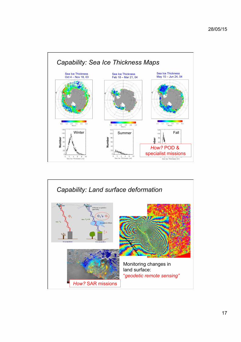
Capability: Sea Ice Thickness Maps
Sea Ice Thickness May 15 – Jun 24, 04
Sea Ice Thickness Feb 18 – Mar 21, 04
Sea Ice Thickness Oct 4 – Nov 18, 03
Summer Winter Fall
Num
ber
Num
ber
Num
ber
How? POD & specialist missions
Monitoring changes in land surface: “geodetic remote sensing”
How? SAR missions
Capability: Land surface deformation
28/05/15
18
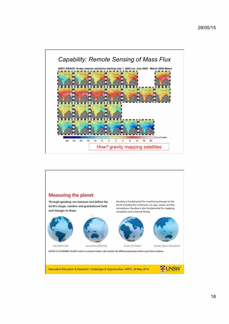
Capability: Remote Sensing of Mass Flux
How? gravity mapping satellites
Geomatics Education & Research: Challenges & Opportunities, HKPU, 29 May 2014 Geomatics Education & Research: Challenges & Opportunities, HKPU, 29 May 2014

28/05/15
19
Geomatics Education & Research: Challenges & Opportunities, HKPU, 29 May 2014 Geomatics Education & Research: Challenges & Opportunities, HKPU, 29 May 2014
The image & visibility of geodesy is
enhanced by its status as an EOS...
Geomatics Education & Research: Challenges & Opportunities, HKPU, 29 May 2014 Geomatics Education & Research: Challenges & Opportunities, HKPU, 29 May 2014
The International Geodesy Services

28/05/15
20
39
Monitoring Geometric & Gravimetric Signatures
IERS: International Earth Rotation and Reference Systems Service (ILS in 1899, BIH in 1912, IPMS in 1962, IERS in 1987)
IGS: International GNSS Service (1994) IVS: International VLBI Service (1999) ILRS: International Laser Ranging Service (1998) IDS: International DORIS Service (2003) IGFS: International Gravity Field Service (2004) BGI: Bureau Gravimetrique International (1951) IGeS: International Geoid Service (1992) ICET: International Centre for Earth Tides (1956) ICGEM: International Centre for Global Earth Models (2003) IDEMS: International Digital Elevation Models Service (1999) PSMSL: Permanent Service for Mean Sea Level (1933) IAS: International Altimetry Service (2008) BIPM: Bureau International des Poids et Mesures (Time 1875) IBS: IAG Bibliographic Service (1889)
Geo
met
ry
Gra
vim
etry
O
cean
St
d
IAG Services
GGOS…
binds them together

28/05/15
21
Geomatics Education & Research: Challenges & Opportunities, HKPU, 29 May 2014
GNSS SLR
VLBI
East (cm)
North (cm)
Up (cm)
East (cm)
North (cm)
Up (cm)
East (cm)
North (cm)
Up (cm)
East (cm)
North (cm)
Up (cm)
DORIS
Input Data: Station Position Time Series
VLBI% SLR% GNSS% DORIS% Vector%Tie%
Global Geodetic Reference Frame ITRF
http://itrf.ensg.ign.fr
ITRF2013 is coming

28/05/15
22
Geomatics Education & Research: Challenges & Opportunities, HKPU, 29 May 2014
The potential of GPS for geodesy & geodynamics was realised by the mid-to-late 1980s: • Announcement of Opportunity 1991:
International GPS Service for Geodynamics
• An official service of the IAG since January 1994
• From 1999 known simply as the International GPS Service
• Renamed the International GNSS Service in March 2005
International GNSS Service (IGS)
IGS global tracking network 1993 – 23 stns
Today over 400 permanent tracking stations comprise the IGS network. Currently the official IGS supports
two GNSS: GPS and GLONASS. Experimental IGS efforts include
Galileo, BeiDou and QZSS.
Geomatics Education & Research: Challenges & Opportunities, HKPU, 29 May 2014
~450 stations ~150 real-time ~90 multi-GNSS
The IGS Tracking Network
http://igs.org/network/netindex.html

28/05/15
23
Geomatics Education & Research: Challenges & Opportunities, HKPU, 29 May 2014
• Primary products – global tracking data – GPS and GLONASS orbits – station coords, contribution to global terrestrial reference frame ITRF
• Related products – clock corrections for satellites and selected stations – daily Earth rotation parameters – global ionosphere maps – station troposphere parameters – Standards (site guidelines, RINEX, ANTEX, IONEX, SP3, RTCM, ...) – GNSS system monitoring (constellation status, DCB, …)
IGS Products
http://igs.org/components/prods.html
Geomatics Education & Research: Challenges & Opportunities, HKPU, 29 May 2014 Geomatics Education & Research: Challenges & Opportunities, HKPU, 29 May 2014

28/05/15
24
Geomatics Education & Research: Challenges & Opportunities, HKPU, 29 May 2014 Geomatics Education & Research: Challenges & Opportunities, HKPU, 29 May 2014
The image & visibility of geodesy is
enhanced through its provision of
critical “geometric” & “gravimetric”
services for science & society...
Geomatics Education & Research: Challenges & Opportunities, HKPU, 29 May 2014 Geomatics Education & Research: Challenges & Opportunities, HKPU, 29 May 2014
Precise GNSS Positioning: More than just Geodesy

28/05/15
25
Geomatics Education & Research: Challenges & Opportunities, HKPU, 29 May 2014 Geomatics Education & Research: Challenges & Opportunities, HKPU, 29 May 2014
• GNSS: – GPS (32) (32) – GLONASS (24) (30) – Galileo (4) (30) – BeiDou (14) (35)
• RNSS: – QZSS (1) (5-7) – IRNSS (2) (7)
• SBAS: – WAAS – MSAS – EGNOS – GAGAN – SDCM
+
Number of satellites: (Current) (Planned)
From GPS to Multi-GNSS...
Geomatics Education & Research: Challenges & Opportunities, HKPU, 29 May 2014
Building Construction
Land Surveying
Port Operations
Geodesy
Machine Guidance Precision Agriculture
Monitoring Rapid Mobile Mapping
Precise Positioning GNSS Applications
• Surveying & mapping
• Precise kinematic apps, such as machine guidance/control
• Define/monitor datum, geodesy applications, etc.
• Precise georeferencing of airborne or terrestrial scanning/imaging sensors

28/05/15
26
Geomatics Education & Research: Challenges & Opportunities, HKPU, 29 May 2014 Geomatics Education & Research: Challenges & Opportunities, HKPU, 29 May 2014
Relative (Differential) Positioning GNSS Constellation(s)
Local CORS Network
GNSS User DGNSS corrs or raw CORS PR/CPH data
Geomatics Education & Research: Challenges & Opportunities, HKPU, 29 May 2014 Geomatics Education & Research: Challenges & Opportunities, HKPU, 29 May 2014
GNSS Satellite Orbit and Clock Corrections (Real-time or post-processed)
GNSS User
CORS Network GNSS Constellation(s)
CPH measurements
Precise Point Positioning

28/05/15
27
Geomatics Education & Research: Challenges & Opportunities, HKPU, 29 May 2014 Geomatics Education & Research: Challenges & Opportunities, HKPU, 29 May 2014
But do these numbers tell the
whole story?
Geomatics Education & Research: Challenges & Opportunities, HKPU, 29 May 2014 Geomatics Education & Research: Challenges & Opportunities, HKPU, 29 May 2014
But do these numbers tell the
whole story?
No, the economic & social benefits to society of accurate & reliable PNT are estimated to be greater
than the mass market “size”

28/05/15
28
Geomatics Education & Research: Challenges & Opportunities, HKPU, 29 May 2014
Some Benefits of PP GNSS in Australia
• 2008 study found productivity gains with potential cumulative benefit $73B to $134B over next 20 years in agriculture, construction and mining alone.
• Additional cumulative economic benefit $32B to $58B from a coordinated rollout of NPI.
• Also, significant environmental benefits, such as reduced carbon footprint, through greatly improved fuel efficiency.
• But current market uptake in A-C-M is about 10%!
�Economic benefits of high resolution positioning services�, Allens Consulting Group, for CRC-SI & Vic. DSE, Nov 2008, download: http://www.crcsi.com.au/uploads/publications/publication_348.pdf
Geomatics Education & Research: Challenges & Opportunities, HKPU, 29 May 2014
Advanced ITS Applications...
Positioning in vehicles is going from Passive to Active... from simple navigation to information about traffic to warnings about hazards to actively avoiding hazards
28/05/15
29
Geomatics Education & Research: Challenges & Opportunities, HKPU, 29 May 2014 Geomatics Education & Research: Challenges & Opportunities, HKPU, 29 May 2014
Geomatics Education & Research: Challenges & Opportunities, HKPU, 29 May 2014 Geomatics Education & Research: Challenges & Opportunities, HKPU, 29 May 2014
The image & visibility of geodesy is
enhanced through its identification
with cutting-edge GNSS positioning
technology & applications...

28/05/15
30
Geomatics Education & Research: Challenges & Opportunities, HKPU, 29 May 2014 Geomatics Education & Research: Challenges & Opportunities, HKPU, 29 May 2014
Concluding Remarks: The Value of Geodesy • Fundamental geoscience… solid earth geophysics, atmospheric,
cryospheric & oceanographic processes, hydrology...
• Global Change studies… climate change, water cycle & mass transport, sea level rise, mesoscale circulation, GIA, slow deformation… long-term monitoring
• Geohazard research & disaster response… seismic, volcanic, landslip, subsidence, storms, flooding, tsunami, space weather… early warning systems
• Geodetic reference frames… ITRF, national datums, SDI, gravity, timing... supports national mapping & precise positioning
• Engineering… PNT, atmospheric remote sensing, georeferencing sensor platforms, POD... operational & engineering geodesy
Geomatics Education & Research: Challenges & Opportunities, HKPU, 29 May 2014
Geodesy has an “visibility problem”… Much of what geodesy does remains unseen & under appreciated... That can change, but universities must modernise their geodesy education...