Improving air quality analysis through closer integration of observations & models Greg Carmichael,...
19
Improving air quality analysis through closer integration of observations & models Greg Carmichael, Scott Spak Air quality management contacts: Joe Hoch, Wisconsin DNR Matthew Johnson, Iowa DNR Donna Kenski, LADCO
-
Upload
silvester-quinn -
Category
Documents
-
view
216 -
download
0
Transcript of Improving air quality analysis through closer integration of observations & models Greg Carmichael,...

Improving air quality analysis through closer integration of observations & models
Greg Carmichael, Scott Spak Air quality management contacts:
Joe Hoch, Wisconsin DNR Matthew Johnson, Iowa DNRDonna Kenski, LADCO

1. Model skill for fine particle concentrations during wintertime episodes: how to improve?
2. AQ-WX feedbacks for both AQ & WX
3. Uncertainties & error attribution in derived policy metrics:
• met?• ICs/BCs? • model?
4. Value in assimilating remote sensing for AQ
• atmospheric composition• land surface• meteorology• individual vs. synergistic
effects?
MotivationsApplied science for AQ decision support
Forecasting for AQ decision support4. Daily resource for AQ
managers
5. Public benchmark data archive to inform planning & forecasters
6. Integrated forecasting—support products for transportation, energy production, hazards
7. Demonstrated need for urban-scale nowcasting tools to support local public health response to urban air quality events

1. W126 monthly index, June-July 2008 60 km CONUS western US 12 km
2. Estimate background contributions
Compare contributions from NA biomass burning emissions by turning off FINN & RAQMS BB emissions
Compare contributions from transported background (model boundary) by perturbing RAQMS and GEOS-Chem BCs for O3 & precursors:
CO, NO, NO2, NO3, HNO3, HNO4, PAN, N2O5
Evaluate W16 metric suitability and uncertainties for policy applications
Assessing the Ozone Secondary Standard with the STEM adjoint &
TES assimilation
Huang et al. (2012). Impacts of transported background pollutants on summertime Western US air quality: model evaluation, sensitivity analysis and data assimilation, ACPD, 12, 1–73.

Model horizontal/vertical resolution & BC uncertainties strongly affect W126 value...

5
… and affect W126 adjoint sensitivities almost as strongly as local precursors

extrapolated from sensitivities to 75% perturbations in BCs
Transported Background O3
in the adjoint of a regional CTM
Huang et al. (2012). Impacts of transported background pollutants on summertime Western US air quality: model evaluation, sensitivity analysis and data assimilation, ACPD, 12, 1–73.

7
LADCO Winter Nitrate Study: Phase IIHow does interactive snow affect winter PM2.5 episodes?
Most effective local & regional emissions control? NH3
• During episodes, meteorology sensitivity >= emissions sensitivity
• Urban impacts of local (100 km, 250 km) NOx & NH3 controls >60% of regional total
• CSAPR enhances effectiveness of regional NOx controls, nearly neutral to NH3

• air quality- PM2.5 & ozone- NAAQS exceedances- Background
• aerosol-climate effects• carbon cycle• renewable energy• road conditions• floods, agriculture
Integrated forecast goals
Toward 4DVAR in high resolution coupled Earth System modeling for prediction, process studies, climate, decision support, and policy applications: 2015-2030

9
Iowa City Landfill Fire 2012 7.5 acres burn, beginning 5/26 ~1 million shredded tires Uncontrolled tire fires (EPA,
1997)- 40+ species of concern- 35,000x more mutagenic than
coal-fired power plants Immediate state & federal
activity- Whole air samples, GC/MS (IA
SHL)- Regional HYSPLIT dispersion
(NOAA NWS)- MODIS visible (IA National
Guard)- Fire containment & treatment
(US EPA) Limited decision support
response for air quality & public health
This i
s a jo
b for A
QAST
5/30 1st AERMOD forecast
• 3DVAR IMAPP MODIS L2 DB
• 35 vertical levels in WRF-Chem
• AERMOD @ 100 m x 100 m
• National Elevation Dataset

11
Interdisciplinary rapid response3 intensive sampling platformsBetsy Stone (Chemistry)
PM2.5 mass and speciation 40+ organics
Charles Stanier (CBE, IIHR) <1 Hz SO2, CO, CO2
Ultrafine Particle Counter (CPC) Scanning Mobility Particle Sizer (0.015-.64
µm) Aerosol Particle Sizer (0.54-20 µm) Weather station
Tom Peters (Public Health) Grimm Optical Particle Counter (0.3-20 µm) Portable black carbon monitor
Tom Schnell (CoE Operator Performance)
HUMVEE with power for all instruments

12
Plume chasing: 150+ µg/m3 urban toxic PM2.5 sourceLandfill
fire0.8 km
1.8 km
2.7 km
Sampling points during plume chase on June 01 2012.15-minute average concentrations of 157 µg/m3 PM0.3-2.5 at plume centerline @ 0.8 km, 34 µg/m3 PM0.3-2.5 @ 2.7 km.
13
05/30 05/31 06/01 06/02 06/03 06/040
10
20
30
40
50
60
APS PM2.5
APS P
M 0
.5-
2.5
(µ
g/m
3)
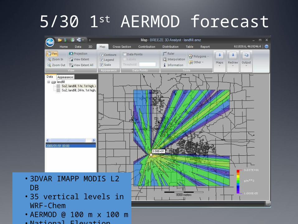
Estimated PM2.5 emissions rate: 10 ± 3 µg/m2/s ~5 g/s
5/31 WRF-Chem + AERMOD + obs ->Background PM2.5/CO/SO2 + landfill emissions
-15 -10 -5 0 5 10 15 20 25 300
10
20
30
40
50
60
SO2
AP
S P
M2.
5 hi
gh R
H h
ours
exc
lude
d
Black dots, before 6 PM on 6/2; Green dots, after 6 PM on 6/2; High RH hours excluded
~4 µg/m3 per ppb SO2
APS P
M 0
.5-
2.5
(µ
g/m
3)
SO2 (ppb)
Iowa City SO2

6/1 60hr weekend forecast to Johnson County Public Health using US EPA recommended metrics

16
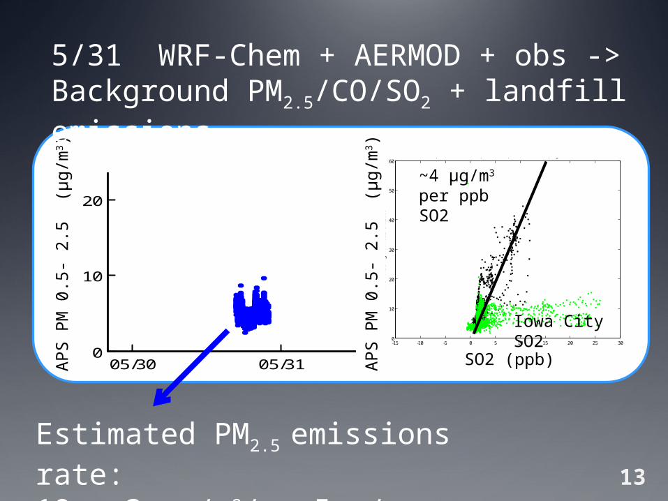
05/30 05/31 06/01 06/02 06/03 06/040
10
20
30
40
50
60
APS PM2.5
APS
PM
0.5
- 2
.5
(µg
/m3)
Verification:Increment within 3 µg/m3 AQS monitor 11.5 km east hit 77 µg/m3

17
Learning from this event: on-demand decision support productsAQAST + Johnson County + Iowa DNR
Guidelines & toolkit for state/local public health response to urban fires & toxic releases
New decision support features in AQAST forecastAERMOD meteorology inputs web portalRapid response capacity for the next year:
urban AERMOD + WRF-Chem background
Urban exposure & health modeling/monitoring
18
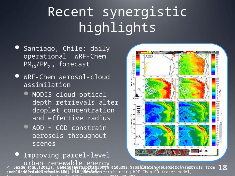
Recent synergistic highlights Santiago, Chile: daily
operational WRF-Chem PM10/PM2.5 forecast
WRF-Chem aerosol-cloud assimilation MODIS cloud optical depth
retrievals alter droplet concentration and effective radius
AOD + COD constrain aerosols throughout scenes
Improving parcel-level urban renewable energy estimates with NASA cloud retrievals
P. Saide et al. (2011). Forecasting urban PM10 and PM2.5 pollution episodes in very stable nocturnal conditions and complex terrain using WRF-Chem CO tracer model, Atmospheric Environment, doi:10.1016/j.atmosenv.2011.02.001.
P. Saide et al. (2012). Seeing aerosol through clouds: assimilating submicron aerosols from satellite cloud retrievals, PNAS, in press.

Year 2 Plans
Aerosol RF in 72-hour operational forecast system
Disaggregate AQ impacts from assimilation fields
Publish maps & data download online
Extend to custom AQ management products
Evaluate and refine configuration
Implement AERMOD rapid response capability
Support your tiger team activities