Improvements in Landsat Pathfinder methods for...
51
Improvements in Landsat Pathfinder Methods for Monitoring Tropical Deforestation and Their Extension to Extra-tropical Areas PI: John R. G. Townshend Department of Geography (and Institute for Advanced Computing Studies) University of Maryland
Transcript of Improvements in Landsat Pathfinder methods for...

Improvements in Landsat
Pathfinder Methods for Monitoring
Tropical Deforestation and Their
Extension to Extra-tropical Areas
PI: John R. G. Townshend
Department of Geography
(and Institute for Advanced Computing Studies)
University of Maryland
Objectives
To assess whether the overall approach successfully used in Landsat Pathfinder for the humid tropics can also be used in other regions to satisfy the needs of the Global Observations of Forest Cover
To carry out large scale prototyping of several advanced processing procedures, including pre-processing to reduce atmospheric and MTF effects, multi-temporal unsupervised processing, application of decision-tree methodologies, mixture modeling and other advanced procedures developed under previous research.
Objectives
Objectives
To assess the improvements introduced by advanced
processing procedures using data from areas in the Pan-
Amazon and Central Africa that were part of the previous
Landsat Pathfinder work.
Investigate how the original Landsat Pathfinder methodology
and the enhancements proposed operate in selected areas
throughout the globe.
Paraguay, southern Africa, central Asia, Eastern United States,
selected sites in the boreal forest.
Objectives

Science Implications
The Landsat Pathfinder project has demonstrated the feasibility of monitoring forest cover change over very large areas using Landsat data. To extend this approach to satisfy the needs of the Global Observations of Forest Cover will require an assessment that the overall approach successfully used in Landsat Pathfinder for the humid tropics can also be used in other regions and that more automated procedures are used.
Science Implications
NASA Landsat Pathfinder Humid Tropical
Deforestation Project
A collaborative effort between the University of Maryland at College Park’s
Geography Department, Michigan State University and NASA Goddard Space
Flight Center’s GIMMS Group. The goal of this work is to map global
deforestation for the humid tropics.
Data sets from both the TM and MSS of Landsat have been used for three time
periods, the 1970s, 1980s, and 1990s. The project has focused on - the Amazon
Basin, Central Africa, and Southeast Asia, which are the three regions where most
of the tropical deforestation in the world has occurred.
The Pathfinder project includes about 75% of the tropical rain forest areas. The
University of Maryland has had responsibility for the non-Brazilian Amazon Basin
(also known as the Pan-Amazon) along with central Africa (Details can be found
at http://www.geog.umd.edu/tropical/main.html) and Michigan State University
has responsibility for the Brazilian Amazon Basin and Southeast Asia.
Heritage

Landsat Pathfinder
Procedures for Classification
Utilize existing automated methods
Utilize the skills of the human interpreter to refine
the classification
Multispectral/ Multitemporal approach
Heritage
Landsat Pathfinder Procedures for
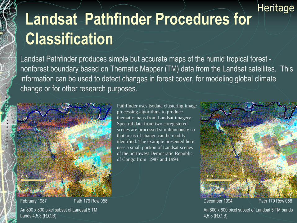
ClassificationLandsat Pathfinder produces simple but accurate maps of the humid tropical forest -
nonforest boundary based on Thematic Mapper (TM) data from the Landsat satellites. This
information can be used to detect changes in forest cover, for modeling global climate
change or for other research purposes.
Pathfinder uses isodata clustering image
processing algorithms to produce
thematic maps from Landsat imagery.
Spectral data from two coregistered
scenes are processed simultaneously so
that areas of change can be readily
identified. The example presented here
uses a small portion of Landsat scenes
of the northwest Democratic Republic
of Congo from 1987 and 1994.
February 1987 Path 179 Row 058
An 800 x 800 pixel subset of Landsat 5 TM
bands 4,5,3 (R,G,B)
December 1994 Path 179 Row 058
An 800 x 800 pixel subset of Landsat 5 TM bands
4,5,3 (R,G,B)
0 5 km 0 5 km
Heritage
Landsat Pathfinder Procedures for
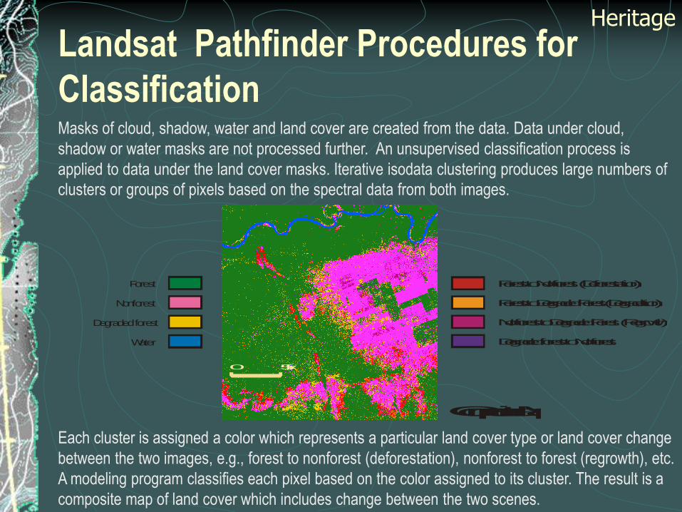
ClassificationMasks of cloud, shadow, water and land cover are created from the data. Data under cloud,
shadow or water masks are not processed further. An unsupervised classification process is
applied to data under the land cover masks. Iterative isodata clustering produces large numbers of
clusters or groups of pixels based on the spectral data from both images.
Each cluster is assigned a color which represents a particular land cover type or land cover change
between the two images, e.g., forest to nonforest (deforestation), nonforest to forest (regrowth), etc.
A modeling program classifies each pixel based on the color assigned to its cluster. The result is a
composite map of land cover which includes change between the two scenes.
Forest to Nonforest (Deforestation)
Nonforest to Degraded Forest (Regrowth)
Degraded forest to Nonforest
Forest to Degraded Forest (Degradation)
Forest
Nonforest
Degraded forest
Water
Composite Map
0 5 km
Heritage
Landsat Pathfinder Procedures for
Classification
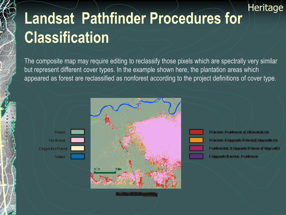
The composite map may require editing to reclassify those pixels which are spectrally very similar
but represent different cover types. In the example shown here, the plantation areas which
appeared as forest are reclassified as nonforest according to the project definitions of cover type.
Forest to Nonforest (Deforestation)
Nonforest to Degraded Forest (Regrowth)
Degraded forest to Nonforest
Forest to Degraded Forest (Degradation)
Forest
Nonforest
Degraded Forest
Water
Edited Change Map
0 5 km
Heritage

Landsat Pathfinder Procedures for
Classification
The edited composite change map is split and filtered into thematic maps for each scene. The
thematic maps are georegistered and mosaicked into a country wide product for a specific time
period.
0 5 km
Forest
Nonforest
Degraded Forest
Water
Thematic Map 1987 Thematic Map 1994
Heritage

Landsat Pathfinder Procedures for
Classification
Heritage
Thematic map time 1
Thematic map time 2Spectral bands time 2
Spectral bands time 1Composite map
Edited composite map

Landsat Pathfinder Procedures for
Classification
Heritage
The current system is producing a very consistent and accurate product
as is indicated by the fact that little, or no thematic corrections are ever
necessary when adjacent classified scenes are joined together.
Mechanisms are in place where, as further auxiliary information is made
available, the classification can be improved.
Results from Landsat Pathfinder
Results from Landsat Pathfinder project have produced delimitations of
tropical deforestation in the Pan-Amazon with unprecedented accuracy
for most areas.
Figure 1 shows in summary the distribution of the main hot spots in the
Pan-Amazon, but this gives only a very superficial impression of the
detailed data base that has been created.
Heritage

Pan-Am Hotspots

Results from Landsat PathfinderLarge parts of the Pan-Amazon are being deforested.
We have documented a spatially-concentrated "deforestation zone” in Santa Cruz where >60% of
the Bolivian deforestation is occurring at an accelerating rate in areas of tropical deciduous forest
Heritage
Results from Landsat Pathfinder
Results of large area classifications are significantly changing views of the rates of tropical deforestation.
For example in Bolivia the total closed canopy forest cover extent, including tropical
deciduous forest, totaled 472,000 km2.
The area deforested totaled 15,000 km2 in the middle 1980s and 28,800 km2 by the early 1990s.
The rate of tropical deforestation in forest zone of Bolivia with >1,000 mm y-1 precipitation was 2,200 km2 y-1 from 1985-1986 to 1992-1994.
Our estimates of deforestation are significantly lower than those reported by the FAO, but are higher than in-country estimates since the mid-1980s (Steininger et al. 1999).
Heritage

*Areas deforested by the middle 1980s were only mapped below 1000 m elevation; 1,645 km2 of the total
deforestation between the time periods were in areas over 1000 m above sea level.
Table 1. Summary of deforestation estimated for Bolivian forests, based on digital analysis of Landsat
Thematic Mapper (TM) and Multispectral Scanning System (MSS) images. All areas are in km2 and rates
are in km2 y-1. Data from the 1980s are from 1984 to 1987, the 1990s are from 1992 – 1994. All forest in the
>1000 mm precipitation zone were mapped (Steininger et al. 1999).
Department Potential
Forest
Forest Non-
Forest
Deforested
by the
1980s*
Deforested
By the
1990s
Deforestation
1980s –
1990s
Water Cloud Nodata Total
Area
Ben 92,277 87,712 105,699 816 2,909 2,093 9,564 3,030 2,646 211,560
Cochabamba 26,390 20,322 27,834 1,520 2,774 1,255 492 3,346 2,964 57,732
La Paz 64,351 56,318 37,422 1,238 2,869 1,627 849 6,781 24,391 128,626
Pando 58,789 55,999 1,726 665 1,541 876 773 1,264 2,103 63,405
Santa Cruz 218,914 199,373 125,179 10,835 18,616 7,782 2,051 1,390 20,552 367,160
Chuquisaca 11,039 10,842 24,756 - 91 91 62 151 14,982 50,884
Sum 471,760 430,566 322,615 15,073 28,801 13,724 13,791 15,961 67,638 879,367

Results from Landsat Pathfinder
In Africa rates of deforestation are much less than the Amazon
Few very large areas of clearance observed
Land cover changes that occur are often associated with previously cleared degraded forests, which have regrown
Heritage
Results from Landsat Pathfinder
Heritage

Methods
Preprocessing of Landsat data
Mixture Modeling
Improved Landsat Pathfinder Procedures
Supervised Approaches
Application of Coarse Resolution Data Products
Methods

Preprocessing of Landsat TM data
Automated co-registration
Previously tested algorithms (Fonseca and Manjunath 1996).
Atmospheric correction.
Dark target approach (Kaufman et al. 1988).
Algorithm has been successfully implemented on our SP-2
high performance computer
Methods

Preprocessing of Landsat TM data
MTF EffectsAssess the optimal pixel size
Explore the development of a non-linear filter
Assess the implications of enhancing noise due to
this procedure
Assess the extent to which these problems impact
Thematic Mapper data
Methods

MTF
table
Pixel size (m)and procedure for generating images
B1 (DN)
B2 (DN)
B3 (DN)
B4 (DN)
B5 (DN)
B7 (DN)
Land Cover % Error
1. 250m, derived by simple averaging
0 0 0 0 0 0 0
2. 250m, MTF simulation
3.19 2.99 5.08 2.97 4.58 2.13 11.00
3. 500m, aggregated from 2
1.19 1.14 1.93 1.03 1.68 0.80 4.16
4. 250m, MTF deconvolved
1.44 1.40 2.38 1.20 2.01 0.97 5.11
5. 500m, aggregated from 4
0.62 0.63 1.06 0.44 0.85 0.42 2.24
Table 2 Standard Errors of the Estimate (SEE) * of MODIS Simulated Data for 250m Pixels (at the 90% Confidence Limit)
for the Reflective Bands, Namely Bands 1 to 5 and 7 (B1 – B5 and B7) of the Thematic Mapper for Partially Forested Test Site in
Central Maryland. The Final Column Shows the SEE for the Estimated Vs. The Actual Percentages of Land Cover. The Results
Indicate the Major Impacts of the MTF of the Sensor and Reductions in Their Impacts by Pixel Enlargement and deconvolution
(Townshend Et Al. 1999).

Mixture Modeling
Intend to apply mixture modeling to assist in
classifying areas of partial tree cover.
Two approaches will be tested.Characterize each scene as a mixture of basic components to
assist in the labeling of the clusters in the unsupervised
classification
Derive proportions of scene components and then derive
differences in proportions between adjacent time periods
Methods

Improved Landsat Pathfinder Procedures
Methods
The most time-consuming part of the work for the
human analyst is the assigning the hundreds of spectral
clusters labels of the land cover classes.
Instead we will implement a hybrid unsupervised and
supervised classification.
Improved Landsat Pathfinder Procedures
Methods
This approach will rely on an unsupervised statistics
based clustering algorithm to iteratively create several
hundred cluster classes.
Clusters will then be automatically assigned to output
classes based on training bitmaps created by the human
analyst.

Improved Landsat Pathfinder Procedures
Methods
Where a cluster is included in more than one of the land cover
classes, bit maps will automatically be created over all pixels
belonging to those classes throughout the scene
Subsequent unsupervised classification will then be carried out
until all clusters are only associated with a single land cover
class.
Analyst input will still be needed but this procedure has been
shown to reduce their level of effort by a factor between
approximately 2 and 3 dependent on the scene being analyzed.

Improved Landsat Pathfinder Procedures
Methods
Analyst first identifies polygon bitmaps on image which are
assigned to a vegetation or change class.
Forest
Deforestation
Non-Forest
Improved Landsat Pathfinder Procedures
Methods
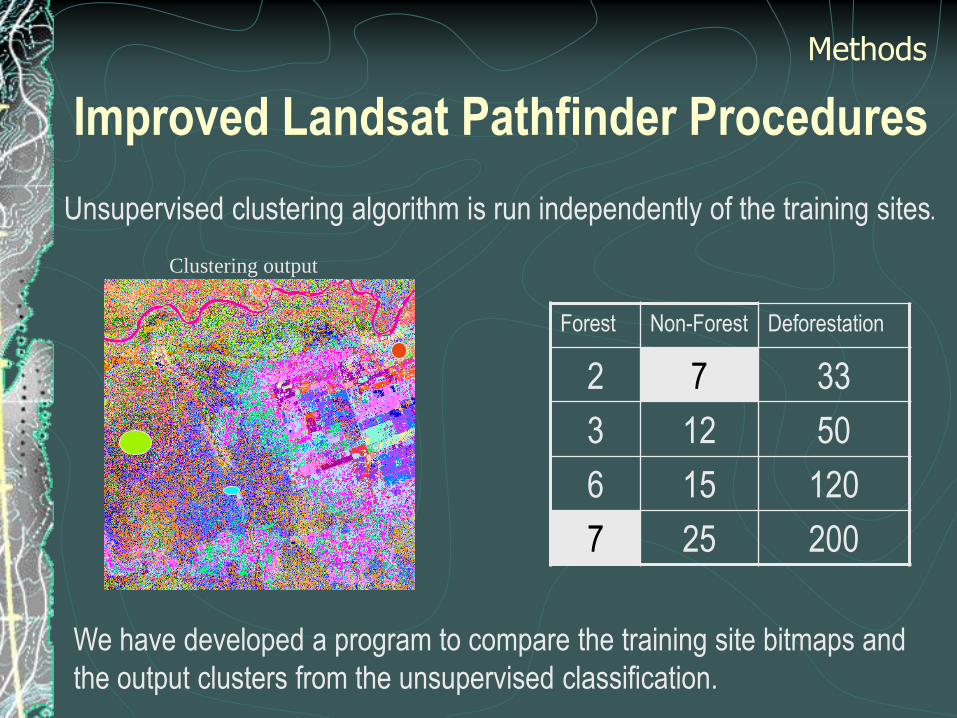
We have developed a program to compare the training site bitmaps and
the output clusters from the unsupervised classification.
Unsupervised clustering algorithm is run independently of the training sites.
Forest Non-Forest Deforestation
2 7 33
3 12 50
6 15 120
7 25 200
Clustering output

Improved Landsat Pathfinder Procedures
Methods
Those clusters belonging solely to a single land cover class will be automatically labeled
and will not need to be examined further by the analyst. Where a cluster is derived which
includes more than one of the land cover classes, then bit maps will automatically be
created over all pixels belonging to those classes throughout the scene and subsequent
unsupervised classification will then be carried out until all clusters are only associated
with a single land cover class.
Automatic
Modeling
Clustering output Thematic Map

Supervised Approaches
Increasingly improvements in our understanding of spectral
classes and ground conditions means that a more directed
supervised approach becomes feasible in many areas.
We will evaluate the following approaches.
Neural nets
Multi-layer perceptron (MLP) - Three layer network structure (input,
hidden and output)
Decision Tree Classifiers
Methods

Application of Coarse
Resolution Data Products
We will examine the extent to which we can use
multi-temporal sequences of MODIS data,
especially the NDVI and its improved vegetation
indices to assist the characterization of forest
types especially in relation to leaf type and
duration.

Extension to Other Regions
Sub-tropical forests in South America including the Chacoan Forests
Woodlands and wooded grasslands of Eastern Africa including woodland types such as miombo and mopane woodlands
Deciduous and mixed temperate forests in Maryland.
Boreal forests from central Asia in Mongolia, Russia andAlaska.

Assessment of Procedures
Two main approaches will be adopted in assessing the
performance of the various procedures
Carefully characterized ground sites based on field work
Previously well characterized complete scenes based on
field work and previous Landsat Pathfinder classification
Assessment of Procedures
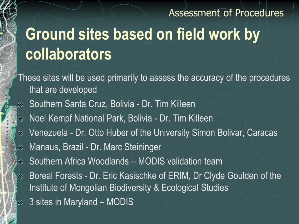
Ground sites based on field work by
collaborators
These sites will be used primarily to assess the accuracy of the procedures
that are developed
Southern Santa Cruz, Bolivia - Dr. Tim Killeen
Noel Kempf National Park, Bolivia - Dr. Tim Killeen
Venezuela - Dr. Otto Huber of the University Simon Bolivar, Caracas
Manaus, Brazil - Dr. Marc Steininger
Southern Africa Woodlands – MODIS validation team
Boreal Forests - Dr. Eric Kasischke of ERIM, Dr Clyde Goulden of the
Institute of Mongolian Biodiversity & Ecological Studies
3 sites in Maryland – MODIS
Assessment of Procedures

Previous Landsat Pathfinder Classifications
Sites include:
230-072 near Santa Cruz
006-055 in Venezuela
231-062 in Brazil
Central African image TBD
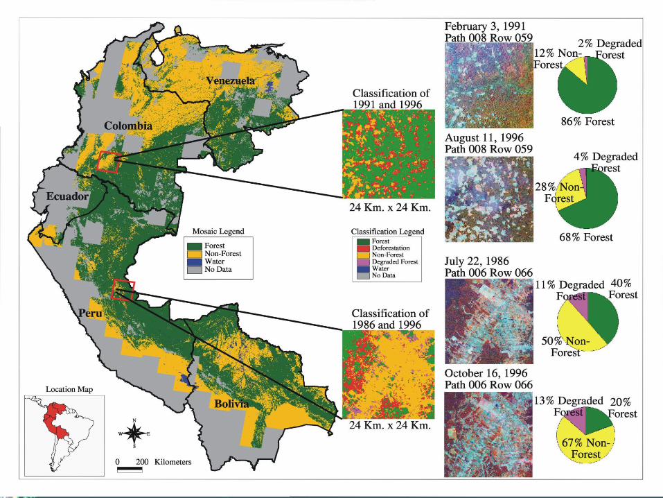
Assessment of Procedures
Sites in the tropics will be used primarily to assess the extent to
which Landsat Pathfinder results involving intensive human
intervention can be reproduced with much less intervention.

Path 006 Row 055
Nov. 1 1987 Apr. 26 1999

Extra-Tropical Test Sites
We intend to develop similar thoroughly checked scenes in
temperate forests in Paraguay and in boreal forests in
Mongolia, Russia, and Alaska.
The scenes and reference sites from outside of the tropics
will be used to assess the extent to which Landsat
Pathfinder methodology and the proposed enhancements
to this approach can be extrapolated to other regions
Assessment of Procedures
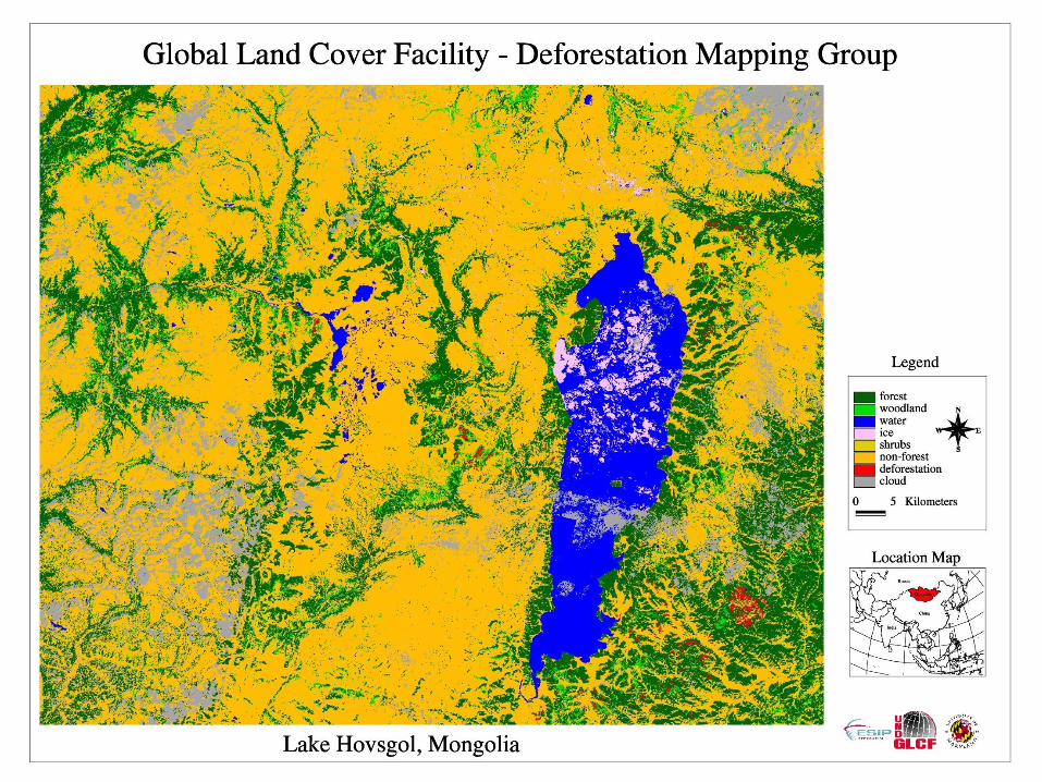
Hovsgol
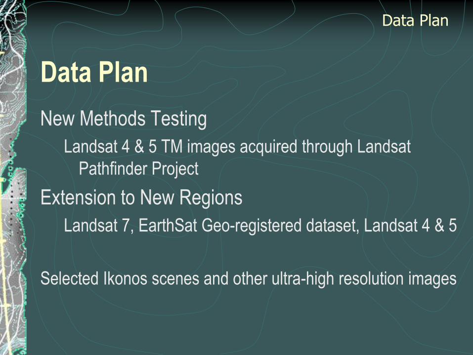
Data Plan
New Methods Testing
Landsat 4 & 5 TM images acquired through Landsat
Pathfinder Project
Extension to New Regions
Landsat 7, EarthSat Geo-registered dataset, Landsat 4 & 5
Selected Ikonos scenes and other ultra-high resolution images
Data Plan

Data Plan
Landsat Images and classification products will be
stored and distributed through the Global Land Cover
Facility.
Data Plan
Work Schedule -Year 1
Landsat Pathfinder methods will be first tested in
those extra-tropical areas most similar to the
areas in tropical areas characterized by large
scale clearance such as the clearance types in
Paraguay discussed above.
Test automated co-registration techniques and
implement the most accurate and robust
techniques based on our evaluation.
Work Schedule

Work Schedule -Year 1 (cont’d)
Implement the pre-processing procedures
associated with atmospheric correction and test
the MTF effects for TM data to decide the pixel
size to be used and whether deconvolution
should be implemented.
The improvements in unsupervised procedures
will be tested and implemented.
Work Schedule
Work Schedule -Year 2
Test the mixture modeling and supervised
components of the approach to assess whether
they bring substantial additional benefits.
Assess Landsat Pathfinder methods including
enhancements in test sites in the boreal zone.
Work Schedule

Work Schedule -Year 3
The most spatially and temporally complex areas will be
examined to assess whether processes provide
sufficiently reliable performance.
Investigate the contribution of coarser resolution data
sets for improved characterization of forest types in
terms of leaf type and duration.
Participate with GOFC activities providing advice on
how to improve the characterization and monitoring of
forest cover.
Work Schedule


Paraguay example
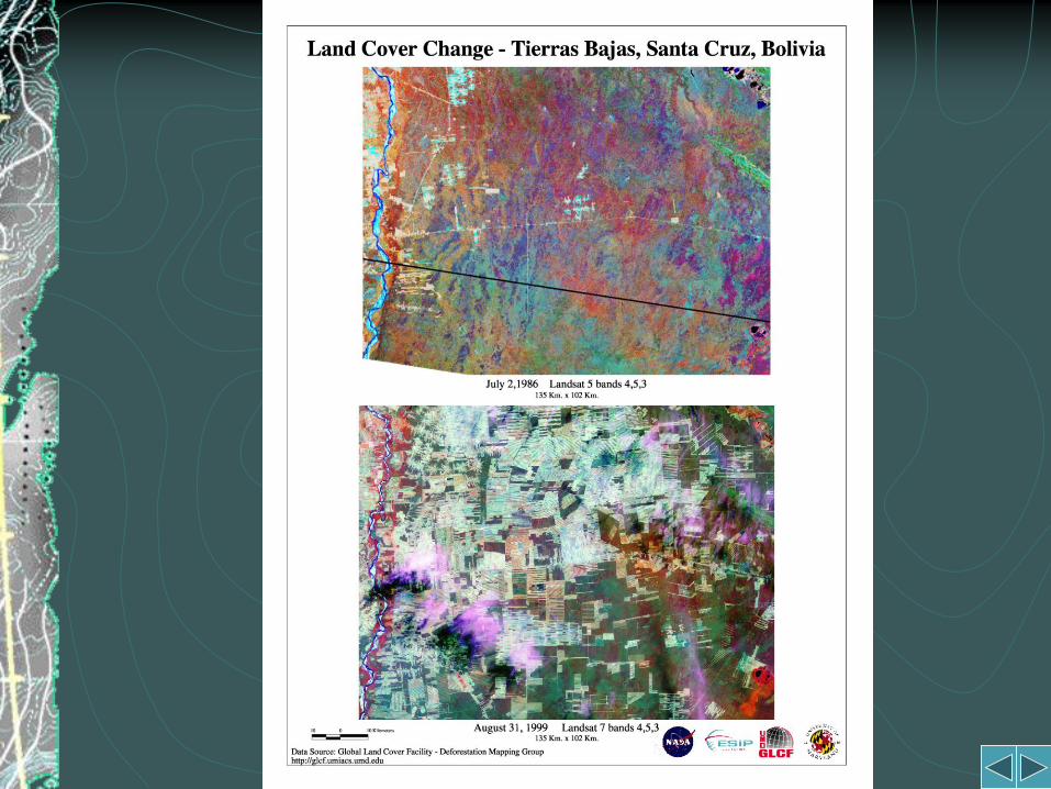
Tierras Bajas, Bolivia

Cochabamba, Bolivia

References