Improvement of Perception of the Geothermal Energy as a Potential ...
15
Proceedings World Geothermal Congress 2015 Melbourne, Australia, 19-25 April 2015 1 Improvement of Perception of the Geothermal Energy as a Potential Source of Electrical Energy in Colombia, Country Update Claudia Alfaro Dg. 53 No. 34 – 53. Servicio Geológico Colombiano. Bogotá, Colombia [email protected] Keywords: Colombia, Colombian geothermal resources, Paipa geothermal area, Azufral geothermal area, San Diego geothermal area ABSTRACT In Colombia there is not any geothermal development at this time. However, during the last few years, several factors have created new and more favorable conditions for development of geothermal energy in this country. Some of these factors are the growing concern on the global climate change, and the consequent search for finding renewable low emission gas energy sources, global and regional initiatives to promote the geothermal development in Latin America and the Caribbean countries, the recognition of the geothermal resource as a potential competitive energy source by the national power generation sector and the interest of the local tourism sector in balneology and, the persistence of the Colombian government in strengthening the role of institutions in charge of energy planning and exploration of geothermal resources, to enable the utilization of geothermal resources. Individual and joint efforts of some of the most important power generation companies, universities and governmental institutions, are being done, through the implementation of prefeasibility exploration studies and through the ongoing analysis of the regulatory and institutional framework, in order to promote the development of non-conventional renewable energy sources, including geothermal. Geothermal exploration studies are being carried out, including the systems of 1) Nevado del Ruiz volcano, probably the best known geothermal area of Colombia, where the interest of several entities converge, 2) Tufiño – Chiles – Cerro Negro volcanic complex, a bi-national project nowadays in exploration through agreement signed by Ecuador and Colombia and, 3) Azufral volcano, 4) Paipa and 5) San Diego area, studies conducted by the Colombian Geological Survey, state institution designated to explore the geothermal resources. Importantly, international interest in supporting the development of geothermal energy in Colombia highlighted from co-financing projects, providing training and promoting discussion to identify and overcome barriers for development of geothermal energy, which have been taking place in the last few years. 1.0 INTRODUCTION 1.1 Legal aspects in relation with geothermal resources In Colombia there is a general legal frame that would allow the development of the geothermal as a non-conventional renewable source of energy. The Natural Renewable Resources and Protection of the Environment National Code: Decree 2811 (Colombia, 1974), regulates the management of renewable natural resources, including the geothermal resources. Some of the most relevant aspects for geothermal resources contained in this Act are as follows: It foresees the implementation of the environmental information system to organize and keep up to date data and information concerning renewable natural resources and the environment, such as cartography, hydrometeorology, hydrology, hydrogeology, climate, soils, and geology, among others. The owners, users, concessionaires, lodgers and holders of permission of use on renewable natural resources and environmental elements, are forced to compile and to give, without any cost, in the direction of the system of environmental information, the information about environmental matter, and especially, about the consumed quantity of natural resources and environmental elements. According to the Natural Renewable Resources and Protection of the Environment National Code, geothermal resources are defined as the natural combination of water with an endogenous heat subterranean source, which result is the spontaneous production of hot water or vapors and, the endogenous heat subterranean sources from which it is possible to produce heat water or vapor by water injection. Also, the geothermal resources are defined based on thermal manifestations temperatures; fluids with temperature above 80°C are geothermal resources while those with lower temperature are considered as hot springs. The Nation reserves the control of the geothermal resources and mentions as possibilities for utilization: power generation, heat for heating, cooling and industrial uses, obtaining fresh water and mineral extraction. Regarding the concession the decree foresees that the water use authorization to exploit a geothermal source will be granted with the award of the geothermal resource and that the necessary measures to eliminate polluting effects of water or condensate vapors will be in charge of the concessionaire of geothermal resources (Colombia, 1974). In Colombia, the geothermal resources are considered a renewable energy source (Law 691, known as URE Law for the acronym of Law for Rational and Efficient Use of the Energy (Colombia, 2011)). It defines the geothermal energy as the energy that can be
Transcript of Improvement of Perception of the Geothermal Energy as a Potential ...

Proceedings World Geothermal Congress 2015
Melbourne, Australia, 19-25 April 2015
1
Improvement of Perception of the Geothermal Energy as a Potential Source of Electrical
Energy in Colombia, Country Update
Claudia Alfaro
Dg. 53 No. 34 – 53. Servicio Geológico Colombiano. Bogotá, Colombia
Keywords: Colombia, Colombian geothermal resources, Paipa geothermal area, Azufral geothermal area, San Diego geothermal
area
ABSTRACT
In Colombia there is not any geothermal development at this time. However, during the last few years, several factors have created
new and more favorable conditions for development of geothermal energy in this country. Some of these factors are the growing
concern on the global climate change, and the consequent search for finding renewable low emission gas energy sources, global and
regional initiatives to promote the geothermal development in Latin America and the Caribbean countries, the recognition of the
geothermal resource as a potential competitive energy source by the national power generation sector and the interest of the local
tourism sector in balneology and, the persistence of the Colombian government in strengthening the role of institutions in charge of
energy planning and exploration of geothermal resources, to enable the utilization of geothermal resources.
Individual and joint efforts of some of the most important power generation companies, universities and governmental institutions,
are being done, through the implementation of prefeasibility exploration studies and through the ongoing analysis of the regulatory
and institutional framework, in order to promote the development of non-conventional renewable energy sources, including
geothermal.
Geothermal exploration studies are being carried out, including the systems of 1) Nevado del Ruiz volcano, probably the best
known geothermal area of Colombia, where the interest of several entities converge, 2) Tufiño – Chiles – Cerro Negro volcanic
complex, a bi-national project nowadays in exploration through agreement signed by Ecuador and Colombia and, 3) Azufral
volcano, 4) Paipa and 5) San Diego area, studies conducted by the Colombian Geological Survey, state institution designated to
explore the geothermal resources.
Importantly, international interest in supporting the development of geothermal energy in Colombia highlighted from co-financing
projects, providing training and promoting discussion to identify and overcome barriers for development of geothermal energy,
which have been taking place in the last few years.
1.0 INTRODUCTION
1.1 Legal aspects in relation with geothermal resources
In Colombia there is a general legal frame that would allow the development of the geothermal as a non-conventional renewable
source of energy.
The Natural Renewable Resources and Protection of the Environment National Code: Decree 2811 (Colombia, 1974), regulates the
management of renewable natural resources, including the geothermal resources. Some of the most relevant aspects for geothermal
resources contained in this Act are as follows:
It foresees the implementation of the environmental information system to organize and keep up to date data and information
concerning renewable natural resources and the environment, such as cartography, hydrometeorology, hydrology, hydrogeology,
climate, soils, and geology, among others. The owners, users, concessionaires, lodgers and holders of permission of use on
renewable natural resources and environmental elements, are forced to compile and to give, without any cost, in the direction of the
system of environmental information, the information about environmental matter, and especially, about the consumed quantity of
natural resources and environmental elements.
According to the Natural Renewable Resources and Protection of the Environment National Code, geothermal resources are
defined as the natural combination of water with an endogenous heat subterranean source, which result is the spontaneous
production of hot water or vapors and, the endogenous heat subterranean sources from which it is possible to produce heat water or
vapor by water injection. Also, the geothermal resources are defined based on thermal manifestations temperatures; fluids with
temperature above 80°C are geothermal resources while those with lower temperature are considered as hot springs.
The Nation reserves the control of the geothermal resources and mentions as possibilities for utilization: power generation, heat for
heating, cooling and industrial uses, obtaining fresh water and mineral extraction. Regarding the concession the decree foresees that
the water use authorization to exploit a geothermal source will be granted with the award of the geothermal resource and that the
necessary measures to eliminate polluting effects of water or condensate vapors will be in charge of the concessionaire of
geothermal resources (Colombia, 1974).
In Colombia, the geothermal resources are considered a renewable energy source (Law 691, known as URE Law for the acronym of
Law for Rational and Efficient Use of the Energy (Colombia, 2011)). It defines the geothermal energy as the energy that can be
Alfaro
2
obtained from the terrestrial heat from the subsoil. This Law assigns to the Ministry of Mining and Energy, the responsibility to
promote, organize, and ensure the development and monitoring of the programs of rational and efficient use of energy.
The above mentioned law compel to the formulation of the Program of Rational and Efficient Use of the Energy and other Non-
conventional forms of energy (PROURE). An Indicative Action Plan defined in order to develop the PROURE was adopted
through the Resolution 18-0919 of 2010 (Colombia, 2010). The strategic subprograms outlined in that resolution include the
institutional strengthening, education and capacity building in research, technological development and innovation, knowledge
management, financial strategy and impulse to the market, consumer protection and right to information, management and tracking
of targets and indicators and promotion of the use of non-conventional sources of energy.
In fulfillment of the previously mentioned legal dispositions, a Development Plan for Non-conventional Energy Sources (PDFNCE,
for its abbreviation in Spanish) was formulated by the Mining and Energy Planning Unit (UPME for its abbreviation in Spanish)
which is a Special Administrative Unit of the national order, under the Ministry of Mining and Energy. The general objective of
that plan is to create the conditions to encourage the non-conventional energy sources. For the geothermal energy specifically, the
strategies defined by the plan include to complete prefeasibility studies in priority geothermal areas: Azufral Volcano, bi-national
project between Ecuador and Colombia, Tufiño – Chiles – Cerro Negro, and Paipa – Iza, and conduct a study on the necessary
regulations for the exploitation of the geothermal resources (UPME & Corpoema, 2010).
The Decree 4131 (Colombia, 2011) changed the juridical nature and denomination of the organization assigned to the Ministry of
Mining and Energy, in charge of the inventory, characterization and prospection of the geothermal resources; that is,
INGEOMINAS a public entity became Servicio Geológico Colombiano (SGC), a scientific and technical institute. The SGC, now
recognized like part of the science and technology national system, is responsible of carrying out basic and applied scientific
research from subsoil resources potential, to develop surveillance and monitoring of geological hazards, to administer the subsoil
information, to ensure the safe management of nuclear and radioactive materials in the country, coordinate (and perform) nuclear
research and handling and use of the nuclear reactor. Some of the functions of the SGC include generate and integrate knowledge,
compile, validate, store and provide information of geology, subsoil resources and geological hazards, in accordance with the
policies of the National Government. Other roles of the SGC include to perform the identification, inventory and characterization of
the areas of greatest potential for natural subsoil resources, such as minerals, hydrocarbons, ground water and geothermal resources,
among others, and to develop programs for the reconnaissance, prospecting and exploration of the national territory, in accordance
with the policies defined by the Ministry of Mining and Energy or the National Government.
Recently, the Colombian Government has made efforts to reinforce the legal frame of the development of non-conventional sources
of energy. The Law 1665 of July, 2013 (Colombia, 2013), of the Republic of Colombia, approved the statute of the International
Renewable Energy Agency (IRENA). This law includes as renewable energies, bio-energy, geothermal energy, hydraulic power,
marine energy (tidal wave power), oceanic thermal energy, solar energy and wind power.
Additionally, the Congress of the Republic of Colombia enacted the Law 1715 of 2014 which regulates the integration of non-
conventional renewable energy in the National Energy System (Colombia, 2014). It declares the promotion, encouragement and
incentive to the development of the activities of production and use of non-conventional sources of energy from renewable sources,
mainly those of renewable character, as a public utility issue and a matter of social, public and national interest, essential to ensure
the diversification of energy supply, competitiveness of the Colombian economy, environmental protection, the efficient use of
energy and the preservation and conservation of renewable natural resources. This law includes geothermal as a non-conventional
renewable energy and states that the Energy and Gas Regulatory Commission (CREG, from its abbreviation in Spanish, entity
attached to the Ministry of Mining and Energy) should study its proper conditions derived from the nature of the source to define its
technical regulation. The evaluation of the geothermal potential would be led by the government which will start-up instruments to
encourage the research and exploration of the geothermal resources (of high, intermediate and low temperature) and to promote its
utilization. The Ministry of Mining and Energy will determine the conditions of participation of this type of energy in the
Colombian energy market; it will establish the technical and quality requirements to be fulfilled for the facilities that use the
geothermal resource as an energy source. Simultaneously, the Ministry of Environment and Sustainable Development will
determine the environmental parameters that will have to be fulfilled by the geothermal energy projects, as well as the mitigation of
their environmental impacts that could appear in their implementation.
On the other hand and regarding the direct use in balneology, the Ministry of Commerce, Industry and Tourism, through the
Productive Transformation Program of the Tourism Vice Ministry, currently promotes development strategies such as welfare
tourism, and among them, thermalism as one of the key products (MinCIT, 2013; PTP, 2013).
Finally, the draft of Law, which text was already approved by the Senate of the Republic (Law 219 of 2013), promulgates rules to
promote, regulate, guide and control the use of therapeutic tourism and the thermal spas and the use of the thermal waters. The
object of this law is to encourage, to face and to regulate the use and sustainable use of the thermal waters, as well as to control its
use in spas promoting its therapeutic and tourist use. It designates to the Ministry of Health and Social Protection the role defining
the therapeutic utility. The Ministry of Commerce, Industry and Tourism, will determine the industrial and touristic utility. The
Colombian Geological Survey (SGC) will be in charge of the investigation, identification and inventory, including characterization
of thermal waters in the national territory. The environmental authorities (Regional Autonomous Corporations) will grant the
concession to authorize the use and exploitation of water resources located within their jurisdiction (Colombia, 2013).
1.2 Interest of the power generation sector
Some of the major power generation companies in Colombia such as CHEC S.A. E.S.P. from EPM E.S.P. Group and ISAGEN
S.A. E.S.P. are currently interested in the geothermal resources as a power source. This is also the case of ECOPETROL, known
traditionally as the Colombian Oil Company.
Alfaro
3
The Central Hidroléctrica de Caldas (CHEC), today part of the Empresas Públicas de Medellín Group (EPM), is a company that
between 1968 and 1997 did a very significant contribution to the geothermal exploration in Colombia, with the Geothermal
Investigation of the Macizo del Ruiz (CHEC, 1968; CHEC 1983) and drilling Nereidas-1 (GESA, 1997; Monsalve et al., 1998), the
first deep geothermal well in Colombia. In a new phase of exploration that initiated in 2009, CHEC-EPM reviewed information of
existing regional prefeasibility reports and are conducting, by contracting with companies specializing in geothermal exploration,
detailed exploration studies in Valle de las Nereidas, an area of about 60 km2 located in the western flank of Nevado del Ruiz
(Ormat, 2014).
On the other hand, the company ISAGEN is interested in the power potential of Nevado del Ruiz and Tufiño-Chiles-Cerro Negro
geothermal systems. In 2008, the company signed a cooperation agreement with the Colombian Geological Survey (SGC) to get the
technical support of professionals in earth sciences and to obtain the available relevant information to the exploration of geothermal
areas of Colombia, compiled and acquired by the SGC (INGEOMINAS-ISAGEN, 2008). Since then, and with the technical and
financial support of national institutions as SGC, Science and Technology Administrative Department of Colombia
(COLCIENCIAS), the National University of Colombia, International Physics Center (CIF) and the Mining and Energy Planning
Unit (UPME) and international organizations as The U.S. Trade and Development Agency (USTDA) Inter-American Development
Bank (IDB), Japanese Trust Fund for Consultancy Services (JFC) and Global Environmental Fund, ISAGEN has carried out
complementary prefeasibility studies at Nevado del Ruiz, reaching a model of the geothermal system and the selection of drilling
targets. Currently, ISAGEN is preparing exploratory drilling to confirm the viability of a potential geothermal power project
(Posada et al., 2011; BID-ISAGEN, 2012; LXRICHTER, 2013). The binational project Tufino - Chiles - Cerro Negro (border
Colombo-Ecuadorian) is being developed by a cooperation agreement between the Corporación Eléctrica del Ecuador (CELEC EP)
and ISAGEN, through specialized consulting services. These entities were delegated by the Ministry of Electricity and Renewal
Energy of Ecuador and the Ministry of Mining and Energy of Colombia to carry out this project which objective is to conduct
complementary prefeasibility studies to achieve a conceptual model, identification of exploratory targets, exploratory well designs
and to perform the environmental impact study (Mejía et al., 2014).
Ecopetrol, the Empresa Colombiana de Petróleos, was restructured by the national government in 2003. Since then, it became
Ecopetrol S.A. a public stock corporation, one hundred percent state-owned, assigned to the Ministry of Mining and Energy. The
company has different projects focused on developing energy efficiency to help reduce operating costs, back the operation,
optimize power indices and reduce dependency on conventional sources of energy. Geothermal of low enthalpy is one of those
projects. The pilot study is currently being conducted for the town of Apiay, focused on generating 5 MW (Ecopetrol, 2009).
Ecopetrol scheduled the start date of the analysis of alternatives to geothermal energy for the year 2016 (Ecopetrol, 2013).
1.3 International support
During the last few years, Colombia has benefited from international initiatives to the promotion the geothermal energy utilization
and to improve the technical capacity of the professionals involved in the geothermal development. Besides the sources of funding
through technical cooperation programs like those given by USTDA and BID/JCF/GEF, above mentioned, these initiatives have
enabled the participation of institutions from different sectors of the economy, interested in geothermal development, in training
courses on general aspects of geothermal energy and in international regional workshops for identifying and overcoming barriers
that prevent the development of geothermal energy. It is as well as professionals from organizations like UPME, Universidad
Nacional, ISAGEN S.A. E.S.P, EPM E.S.P. and SGC have, participated in workshops like Geothermal Energy Development in the
Andean Region, promoted by OLADE-IRENA, short courses on different aspects of geothermal development organized by United
Nations University –Geothermal Training Program (UNU-GTP) and LaGeo S.A. de C.V., the Organization of American States
(OAS) – UNU-GTP in cooperation with LaGeo S.A. de C.V. and the Japan International Cooperation Agency.
1.4 Power generation in Colombia
Nowadays in Colombia, the participation of the energy sources in electricity generation is as follows: hydraulic (64.1%), thermal
base on fossil fuel (30.9%) and others: minor centrals of power generation (<20 MW) and cogeneration (5%) (UPME, 2014). As it
is shown in Table 1 (in appendix), the current installed capacity is 13,886 MW and the gross production 56,790 GWh/year. The
projection for 2020 is to increase the capacity to 14,971 MW and the production 89,578 GWh/year. For the first time, the energy
sector is projecting the utilization of geothermal resources in power generation.
2. GEOLOGY BACKGROUND
2.1 Colombia’s tectonic frame
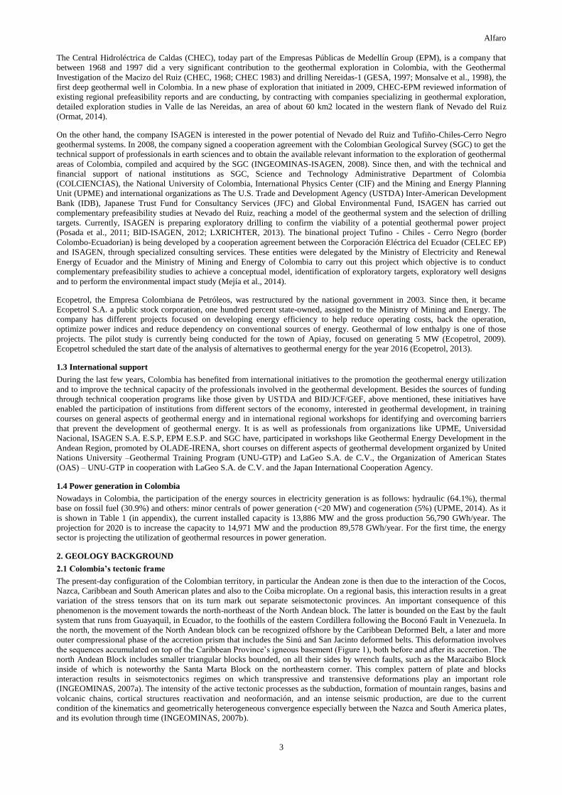
The present-day configuration of the Colombian territory, in particular the Andean zone is then due to the interaction of the Cocos,
Nazca, Caribbean and South American plates and also to the Coiba microplate. On a regional basis, this interaction results in a great
variation of the stress tensors that on its turn mark out separate seismotectonic provinces. An important consequence of this
phenomenon is the movement towards the north-northeast of the North Andean block. The latter is bounded on the East by the fault
system that runs from Guayaquil, in Ecuador, to the foothills of the eastern Cordillera following the Boconó Fault in Venezuela. In
the north, the movement of the North Andean block can be recognized offshore by the Caribbean Deformed Belt, a later and more
outer compressional phase of the accretion prism that includes the Sinú and San Jacinto deformed belts. This deformation involves
the sequences accumulated on top of the Caribbean Province’s igneous basement (Figure 1), both before and after its accretion. The
north Andean Block includes smaller triangular blocks bounded, on all their sides by wrench faults, such as the Maracaibo Block
inside of which is noteworthy the Santa Marta Block on the northeastern corner. This complex pattern of plate and blocks
interaction results in seismotectonics regimes on which transpressive and transtensive deformations play an important role
(INGEOMINAS, 2007a). The intensity of the active tectonic processes as the subduction, formation of mountain ranges, basins and
volcanic chains, cortical structures reactivation and neoformación, and an intense seismic production, are due to the current
condition of the kinematics and geometrically heterogeneous convergence especially between the Nazca and South America plates,
and its evolution through time (INGEOMINAS, 2007b).
Alfaro
4
Figure 1: Tectonic scheme of Northern South America and the Caribbean (Taken from INGEOMINAS, 2007a). Active
Mid-ocean Ridges: (1) Cayman, (2) Galapagos, (3) Ecuador) y (4) Costa Rica. Inactive Mid-ocean Ridges: (5)
Malpelo, (6) Buenaventura. Oceanic trenches, active subduction zones: (7) Middle Aerican Zone, (8) Colombo -
Ecuadorian Zone, (9) Caribbean. Oceanic trenches, inactive subduction zones: (10) Puerto Rico. Accretionary
prisms – deformed belts: (11) Los Muertos, (12) Lesser Antilles, (13) Caribbean (14) Panama. Transformational
fault zones: (15) North - East (16) Motagua – Swan, (17) Celmira – Ballena, (18) Jordan, (19) Panama, (20) Hey, (21)
Yaquina, (22) Grijalva y (23) Los Roques. Oceanic Normal Faults: (24) Pedro Bank (25) Hess. Main continental
plate faults: (26) Consaga, (27) Peltetec, (28) Pallatanga – Pujili, (29) Algeciras, (30) Cauca – Almaguer, (31) Cali –
Patía, (32) Garrapatas, (33) Ibagué, (34) Itsmina Fault zone, (35) Palestina, (36) Guaicaramo, (37) La Salina, (38)
Espiritu Santo, (39) Oca, (40) Cuisa, (41) Boconó, (42) El Pilar, (43) Bucaramanga (44) Algarrobo, (45) Meta.
Independent lithospheric blocks: (46) Coiba Microplate. Vector values (mm/year) correspond to relative plate
movements.
2.2 Geological Crustal Provinces of Colombia
The basement of the Earth crust's in the Colombian territory consists of two contrasting types of rocks that are separated by the
Cauca-Almaguer Fault, a structure that runs in a N-S direction along the western flank of the Andean Central Cordillera: to the east
of this fault it is made of proterozoic metamorphic rocks, mainly sialic, whereas to the west of the fault it consists on Upper
Cretaceous igneous, mainly volcanic rocks of simatic composition. A similar role of separation between sialic and simatic
basements is played by the Guachaca and the Simarua faults at the Sierra Nevada de Santa Marta and at the Guajira Peninsula,
respectively. The separation between these different types of basement is interpreted as a result of the accretion of oceanic
lithosphere fragments to the continental active margin of South America during the Eocene (INGEOMINAS, 2007a).
The Colombian territory has been divided in five (5) geological provinces presented in Figure 2.
The description of these geological provinces, from some excerpts taken from INGEOMINAS (2007a) is as follows:
Alfaro
5
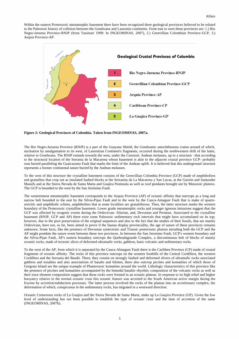
Within the eastern Proterozoic metamorphic basement there have been recognized three geological provinces believed to be related
to the Paleozoic history of collision between the Gondwana and Laurentia continents. From east to west these provinces are: 1.) Rio
Negro-Juruena Province-RNJP (from Tassinari 1999: In INGEOMINAS, 2007), 2.) Grenvillian Colombian Province-GCP, 3.)
Arquía Province-AP.
Figure 2: Geological Provinces of Colombia. Taken from INGEOMINAS, 2007a.
The Rio Negro-Juruena Province (RNJP) is a part of the Guayana Shield, the Gondwanic autochthonous craton around of which,
nucleation by amalgamation to its west, of Laurentian Continent's fragments, occurred during the northwestern drift of the latter,
relative to Gondwana. The RNJP extends towards the west, under the Cenozoic Andean molasses, up to a structure –that according
to the structural location of the Serrania de la Macarena whose basement is akin to the adjacent crustal province GCP- probably
runs buried paralleling the Guaicaramo Fault that marks the limit of the Andean uplift. It is believed that this underground structure
represents a former continental suture buried by the Andean molasses.
To the west of this structure the crystalline basement consists of the Grenvillian Colombia Province (GCP) made of amphibolites
and granulites that crop out as insulated faulted blocks at the Serranías de La Macarena y San Lucas, at the Garzón and Santander
Massifs and at the Sierra Nevada de Santa Marta and Guajira Peninsula as well as roof pendants brought out by Mesozoic plutons.
The GCP is bounded to the west by the San Jerónimo Fault.
The westernmost metamorphic basement corresponds to the Arquia Province (AP) of oceanic affinity that outcrops as a long and
narrow belt bounded to the east by the Silvia-Pijao Fault and to the west by the Cauca-Amaguer Fault that is make of quartz-
sericitic and amphibolic schists, amphibolites that at some localities are granatiferous. Then, the latter structure marks the western
boundary of the Proterozoic crystalline basement. Lower grade metamorphic rocks and younger igneous intrusions suggest that the
GCP was affected by orogenic events during the Ordovician- Silurian, and, Devonian and Permian. Associated to the crystalline
basement (RNJP, GCP and AP) there exist some Paleozoic sedimentary rock intervals that might have accumulated on its top;
however, due to the poor preservation of the original sequences and also to the fact that the studies of their fossils, that are mainly
Ordovician, have not, so far, been aimed to prove if the faunas display provinciality, the age of suture of these provinces remains
unknown. Some facts, like the presence of Devonian syntectonic and Triassic postectonic plutons intruding both the GCP and the
AP might postdate the suture event between these two provinces. In between the San Jeronimo Fault, GCP's western boundary and
the Silvia-Pijao Fault, AP's eastern boundary outcrops the Quebradagrande Complex, a discontinuous belt of blocks of mainly
oceanic rocks, made of tectonic slices of deformed ultramafic rocks, gabbros, basic volcanic and sedimentary rocks.
To the west of the AP, from which it is separated by the Cauca-Almaguer Fault there is the Caribben Province (CP) made of crustal
fragments of oceanic affinity. The rocks of this province outcrops on the western foothills of the Central Cordillera, the western
Cordillera and the Serranía del Baudó. There, they consist on strongly faulted and deformed slivers of ultramafic rocks associated
gabbros and tonalites and also associations of basalts and felsites, there also outcrop picrites and komatiites of which those of
Gorgona Island are the unique example of Phanerozoic komatites around the world. Lithologic characteristics of this province like
the presence of picrites and komatiites accompanied by the bimodal basaltic-rhyolitic composition of the volcanic rocks as well as
their trace element composition suggest that these rocks were formed in an oceanic plateau. In response to its high relief and higher
buoyancy relative to the normal oceanic crust this oceanic feature was accreted to the South American active margin during the
Eocene by accretion/subduction processes. The latter process involved the rocks of the plateau into an accretionary complex, the
deformation of which, conspicuous in the sedimentary rocks, has migrated in a westward direction.
Oceanic Cretaceous rocks of La Guajira and the Sierra Nevada de Santa Marta, make up La Guajira Province (GP). Given the low
level of understanding has not been possible to establish the type of oceanic crust and the time of accretion of the same
(INGEOMINAS, 2007b).
Alfaro
6
3.0 GEOTHERMAL RESOURCES AND POTENTIAL
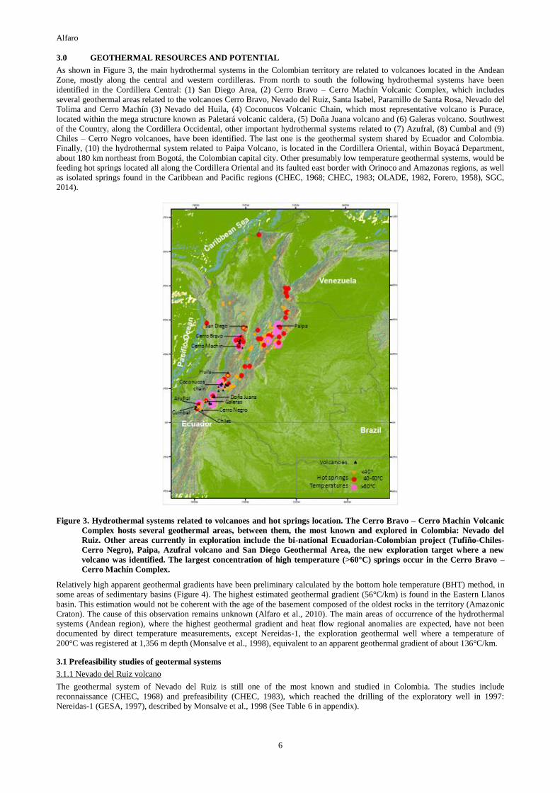
As shown in Figure 3, the main hydrothermal systems in the Colombian territory are related to volcanoes located in the Andean
Zone, mostly along the central and western cordilleras. From north to south the following hydrothermal systems have been
identified in the Cordillera Central: (1) San Diego Area, (2) Cerro Bravo – Cerro Machín Volcanic Complex, which includes
several geothermal areas related to the volcanoes Cerro Bravo, Nevado del Ruiz, Santa Isabel, Paramillo de Santa Rosa, Nevado del
Tolima and Cerro Machín (3) Nevado del Huila, (4) Coconucos Volcanic Chain, which most representative volcano is Purace,
located within the mega structure known as Paletará volcanic caldera, (5) Doña Juana volcano and (6) Galeras volcano. Southwest
of the Country, along the Cordillera Occidental, other important hydrothermal systems related to (7) Azufral, (8) Cumbal and (9)
Chiles – Cerro Negro volcanoes, have been identified. The last one is the geothermal system shared by Ecuador and Colombia.
Finally, (10) the hydrothermal system related to Paipa Volcano, is located in the Cordillera Oriental, within Boyacá Department,
about 180 km northeast from Bogotá, the Colombian capital city. Other presumably low temperature geothermal systems, would be
feeding hot springs located all along the Cordillera Oriental and its faulted east border with Orinoco and Amazonas regions, as well
as isolated springs found in the Caribbean and Pacific regions (CHEC, 1968; CHEC, 1983; OLADE, 1982, Forero, 1958), SGC,
2014).
Figure 3. Hydrothermal systems related to volcanoes and hot springs location. The Cerro Bravo – Cerro Machin Volcanic
Complex hosts several geothermal areas, between them, the most known and explored in Colombia: Nevado del
Ruiz. Other areas currently in exploration include the bi-national Ecuadorian-Colombian project (Tufiño-Chiles-
Cerro Negro), Paipa, Azufral volcano and San Diego Geothermal Area, the new exploration target where a new
volcano was identified. The largest concentration of high temperature (>60°C) springs occur in the Cerro Bravo –
Cerro Machín Complex.
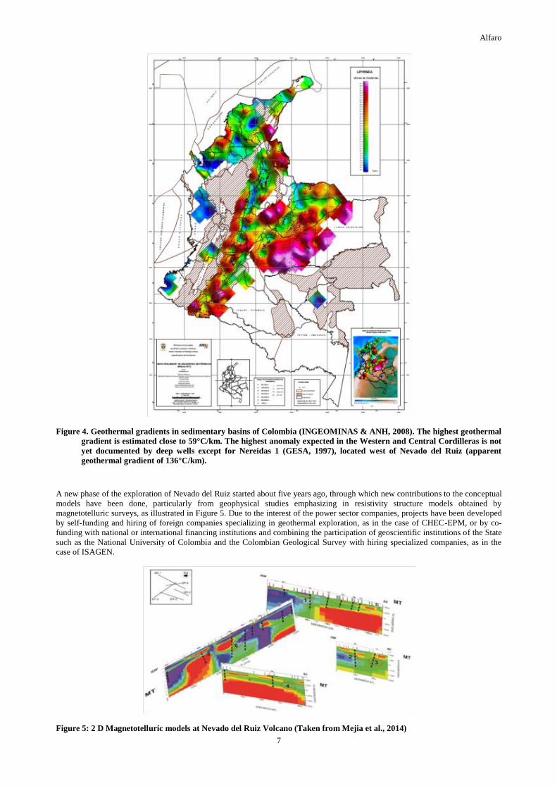
Relatively high apparent geothermal gradients have been preliminary calculated by the bottom hole temperature (BHT) method, in
some areas of sedimentary basins (Figure 4). The highest estimated geothermal gradient (56°C/km) is found in the Eastern Llanos
basin. This estimation would not be coherent with the age of the basement composed of the oldest rocks in the territory (Amazonic
Craton). The cause of this observation remains unknown (Alfaro et al., 2010). The main areas of occurrence of the hydrothermal
systems (Andean region), where the highest geothermal gradient and heat flow regional anomalies are expected, have not been
documented by direct temperature measurements, except Nereidas-1, the exploration geothermal well where a temperature of
200°C was registered at 1,356 m depth (Monsalve et al., 1998), equivalent to an apparent geothermal gradient of about 136°C/km.
3.1 Prefeasibility studies of geotermal systems
3.1.1 Nevado del Ruiz volcano
The geothermal system of Nevado del Ruiz is still one of the most known and studied in Colombia. The studies include
reconnaissance (CHEC, 1968) and prefeasibility (CHEC, 1983), which reached the drilling of the exploratory well in 1997:
Nereidas-1 (GESA, 1997), described by Monsalve et al., 1998 (See Table 6 in appendix).
Alfaro
7
Figure 4. Geothermal gradients in sedimentary basins of Colombia (INGEOMINAS & ANH, 2008). The highest geothermal
gradient is estimated close to 59°C/km. The highest anomaly expected in the Western and Central Cordilleras is not
yet documented by deep wells except for Nereidas 1 (GESA, 1997), located west of Nevado del Ruiz (apparent
geothermal gradient of 136°C/km).
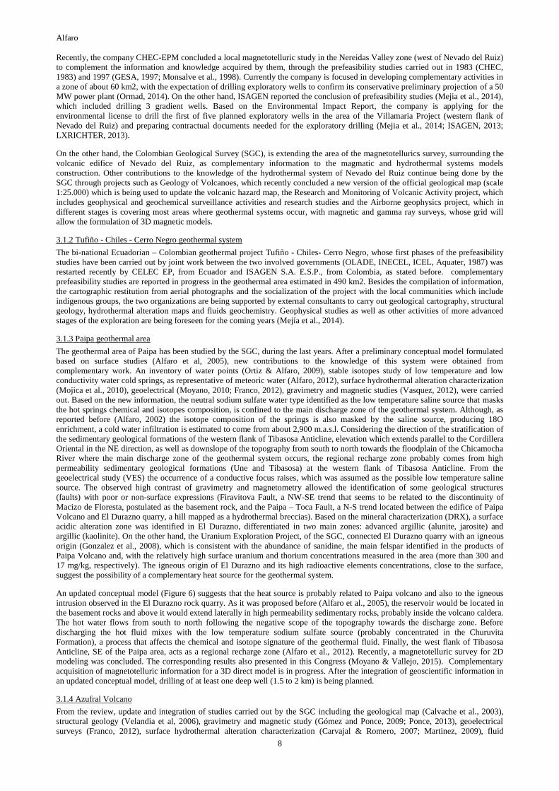
A new phase of the exploration of Nevado del Ruiz started about five years ago, through which new contributions to the conceptual
models have been done, particularly from geophysical studies emphasizing in resistivity structure models obtained by
magnetotelluric surveys, as illustrated in Figure 5. Due to the interest of the power sector companies, projects have been developed
by self-funding and hiring of foreign companies specializing in geothermal exploration, as in the case of CHEC-EPM, or by co-
funding with national or international financing institutions and combining the participation of geoscientific institutions of the State
such as the National University of Colombia and the Colombian Geological Survey with hiring specialized companies, as in the
case of ISAGEN.
Figure 5: 2 D Magnetotelluric models at Nevado del Ruiz Volcano (Taken from Mejia et al., 2014)
Alfaro
8
Recently, the company CHEC-EPM concluded a local magnetotelluric study in the Nereidas Valley zone (west of Nevado del Ruiz)
to complement the information and knowledge acquired by them, through the prefeasibility studies carried out in 1983 (CHEC,
1983) and 1997 (GESA, 1997; Monsalve et al., 1998). Currently the company is focused in developing complementary activities in
a zone of about 60 km2, with the expectation of drilling exploratory wells to confirm its conservative preliminary projection of a 50
MW power plant (Ormad, 2014). On the other hand, ISAGEN reported the conclusion of prefeasibility studies (Mejia et al., 2014),
which included drilling 3 gradient wells. Based on the Environmental Impact Report, the company is applying for the
environmental license to drill the first of five planned exploratory wells in the area of the Villamaria Project (western flank of
Nevado del Ruiz) and preparing contractual documents needed for the exploratory drilling (Mejia et al., 2014; ISAGEN, 2013;
LXRICHTER, 2013).
On the other hand, the Colombian Geological Survey (SGC), is extending the area of the magnetotellurics survey, surrounding the
volcanic edifice of Nevado del Ruiz, as complementary information to the magmatic and hydrothermal systems models
construction. Other contributions to the knowledge of the hydrothermal system of Nevado del Ruiz continue being done by the
SGC through projects such as Geology of Volcanoes, which recently concluded a new version of the official geological map (scale
1:25.000) which is being used to update the volcanic hazard map, the Research and Monitoring of Volcanic Activity project, which
includes geophysical and geochemical surveillance activities and research studies and the Airborne geophysics project, which in
different stages is covering most areas where geothermal systems occur, with magnetic and gamma ray surveys, whose grid will
allow the formulation of 3D magnetic models.
3.1.2 Tufiño - Chiles - Cerro Negro geothermal system
The bi-national Ecuadorian – Colombian geothermal project Tufiño - Chiles- Cerro Negro, whose first phases of the prefeasibility
studies have been carried out by joint work between the two involved governments (OLADE, INECEL, ICEL, Aquater, 1987) was
restarted recently by CELEC EP, from Ecuador and ISAGEN S.A. E.S.P., from Colombia, as stated before. complementary
prefeasibility studies are reported in progress in the geothermal area estimated in 490 km2. Besides the compilation of information,
the cartographic restitution from aerial photographs and the socialization of the project with the local communities which include
indigenous groups, the two organizations are being supported by external consultants to carry out geological cartography, structural
geology, hydrothermal alteration maps and fluids geochemistry. Geophysical studies as well as other activities of more advanced
stages of the exploration are being foreseen for the coming years (Mejía et al., 2014).
3.1.3 Paipa geothermal area
The geothermal area of Paipa has been studied by the SGC, during the last years. After a preliminary conceptual model formulated
based on surface studies (Alfaro et al, 2005), new contributions to the knowledge of this system were obtained from
complementary work. An inventory of water points (Ortiz & Alfaro, 2009), stable isotopes study of low temperature and low
conductivity water cold springs, as representative of meteoric water (Alfaro, 2012), surface hydrothermal alteration characterization
(Mojica et al., 2010), geoelectrical (Moyano, 2010; Franco, 2012), gravimetry and magnetic studies (Vasquez, 2012), were carried
out. Based on the new information, the neutral sodium sulfate water type identified as the low temperature saline source that masks
the hot springs chemical and isotopes composition, is confined to the main discharge zone of the geothermal system. Although, as
reported before (Alfaro, 2002) the isotope composition of the springs is also masked by the saline source, producing 18O
enrichment, a cold water infiltration is estimated to come from about 2,900 m.a.s.l. Considering the direction of the stratification of
the sedimentary geological formations of the western flank of Tibasosa Anticline, elevation which extends parallel to the Cordillera
Oriental in the NE direction, as well as downslope of the topography from south to north towards the floodplain of the Chicamocha
River where the main discharge zone of the geothermal system occurs, the regional recharge zone probably comes from high
permeability sedimentary geological formations (Une and Tibasosa) at the western flank of Tibasosa Anticline. From the
geoelectrical study (VES) the occurrence of a conductive focus raises, which was assumed as the possible low temperature saline
source. The observed high contrast of gravimetry and magnetometry allowed the identification of some geological structures
(faults) with poor or non-surface expressions (Firavitova Fault, a NW-SE trend that seems to be related to the discontinuity of
Macizo de Floresta, postulated as the basement rock, and the Paipa – Toca Fault, a N-S trend located between the edifice of Paipa
Volcano and El Durazno quarry, a hill mapped as a hydrothermal breccias). Based on the mineral characterization (DRX), a surface
acidic alteration zone was identified in El Durazno, differentiated in two main zones: advanced argillic (alunite, jarosite) and
argillic (kaolinite). On the other hand, the Uranium Exploration Project, of the SGC, connected El Durazno quarry with an igneous
origin (Gonzalez et al., 2008), which is consistent with the abundance of sanidine, the main felspar identified in the products of
Paipa Volcano and, with the relatively high surface uranium and thorium concentrations measured in the area (more than 300 and
17 mg/kg, respectively). The igneous origin of El Durazno and its high radioactive elements concentrations, close to the surface,
suggest the possibility of a complementary heat source for the geothermal system.
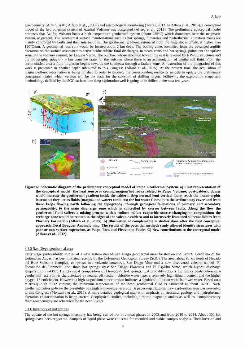
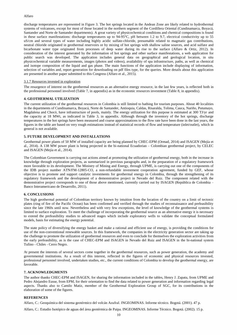
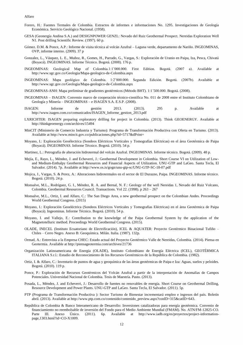
An updated conceptual model (Figure 6) suggests that the heat source is probably related to Paipa volcano and also to the igneous
intrusion observed in the El Durazno rock quarry. As it was proposed before (Alfaro et al., 2005), the reservoir would be located in
the basement rocks and above it would extend laterally in high permeability sedimentary rocks, probably inside the volcano caldera.
The hot water flows from south to north following the negative scope of the topography towards the discharge zone. Before
discharging the hot fluid mixes with the low temperature sodium sulfate source (probably concentrated in the Churuvita
Formation), a process that affects the chemical and isotope signature of the geothermal fluid. Finally, the west flank of Tibasosa
Anticline, SE of the Paipa area, acts as a regional recharge zone (Alfaro et al., 2012). Recently, a magnetotelluric survey for 2D
modeling was concluded. The corresponding results also presented in this Congress (Moyano & Vallejo, 2015). Complementary
acquisition of magnetotelluric information for a 3D direct model is in progress. After the integration of geoscientific information in
an updated conceptual model, drilling of at least one deep well (1.5 to 2 km) is being planned.
3.1.4 Azufral Volcano
From the review, update and integration of studies carried out by the SGC including the geological map (Calvache et al., 2003),
structural geology (Velandia et al, 2006), gravimetry and magnetic study (Gómez and Ponce, 2009; Ponce, 2013), geoelectrical
surveys (Franco, 2012), surface hydrothermal alteration characterization (Carvajal & Romero, 2007; Martinez, 2009), fluid
Alfaro
9
geochemistry (Alfaro, 2001; Alfaro et al., , 2008) and seismological monitoring (Torres, 2013. In Alfaro et al., 2013), a conceptual
model of the hydrothermal system of Azufral Volcano was postulated (Alfaro et al., 2013). The preliminary conceptual model
proposes that Azufral volcano hosts a high temperature geothermal system (about 225°C) which dominates over the magmatic
system, at present. The geothermal surface manifestations such as hot springs, fumaroles and hydrothermal alteration zones are
mainly controlled by faults and their intersections. The geothermal gradient, estimated from the magnetic anomaly, is higher than
120°C/km. A geothermal reservoir would be located about 2 km deep. The boiling zone, identified from the advanced argillic
alteration on the surface associated to active acidic sulfate fluid discharges, in steam vents and hot springs, points out the upflow
zone, at the volcano summit, by Laguna Verde. The outflow, whose direction toward the east is favored by NW-SE structures and
the topography, goes 6 - 8 km from the crater of the volcano where there is an accumulation of geothermal fluid. From the
accumulation area a fluid migration begins towards the southeast through a faulted zone. An extension of the integration of this
work is presented in another paper submitted to this Congress (Alfaro et al., 2015). At the present time, the acquisition of
magnetotelluric information is being finished in order to produce the corresponding resistivity models to update the preliminary
conceptual model, which version will be the basis for the selection of drilling targets. Following the exploration scope and
methodology defined by the SGC, at least one deep exploration well is going to be drilled in the next few years.
Figure 6: Schematic diagram of the preliminary conceptual model of Paipa Geothermal System. a) First representation of
the conceptual model: the heat source is cooling magma/hot rocks related to Paipa Volcano; post-calderic domes
would increase the geothermal gradient inside the caldera; deep normal semi-vertical faults reach the metamorphic
basement; they act as fluids (magma and water) conducts; the hot water flows up to the sedimentary cover and from
there keeps flowing north following the topography, through geological formations of primary and secondary
permeability, to the main discharge zone which is controlled by crosses between faults. Along the flow the
geothermal fluid suffers a mixing process with a sodium sulfate evaporitic source changing its composition; the
recharge zone would be related to the edges of the volcanic caldera and to intensively fractured siliceous lidites from
Plaeners Formation (Alfaro et al., 2005). b) Illustration of complementary studies done after the first conceptual
approach. Total Bouguer Anomaly map. The results of the potential methods study allowed identify structures with
poor or non-surface expression, as Paipa-Toca and Firavitoba Faults. C) New contributions to the conceptual model
(Alfaro et al., 2012).
3.1.5 San Diego geothermal area
Early stage prefeasibility studies of a new system named San Diego geothermal area, located on the Central Cordillera of the
Colombian Andes, has been initiated recently by the Colombian Geological Survey (SGC). The area, about 95 km north of Nevado
del Ruiz Volcanic Complex, comprises two volcanic structures, San Diego Maar and a new discovered volcano named “El
Escondido de Florencia” and, three hot springs sites: San Diego, Florencia and El Espíritu Santo, which highest discharge
temperatures is 43°C. The chemical composition of Florencia’s hot springs, that probably reflects the higher contribution of a
geothermal reservoir, is characterized by neutral pH, sodium chloride water type, a relatively high lithium content and the higher
oxygen-18 enrichment. However, a high magnesium concentration indicates a significant dilution with shallower water. Based on a
relatively high SiO2 content, the minimum temperature of the deep geothermal fluid is estimated at about 160°C. Na/K
geothermometers indicate the possibility of a high temperature reservoir. A paper regarding this new exploration area was presented
to this Congress (Monsalve et al., 2015). A more detailed geological map with emphasis on structural geology and hydrothermal
alteration characterization is being started. Geophysical studies, including airborne magnetic studies as well as complementary
fluid geochemistry are scheduled for the next 3 years.
3.1.6 Inventory of hot springs
The update of the hot springs inventory has being carried out in annual phases in 2003 and from 2010 to 2014. About 300 hot
springs have been registered. Samples of liquid phase were collected for chemical and stable isotopes analysis. Their location and
Alfaro
10
discharge temperatures are represented in Figure 3. The hot springs located in the Andean Zone are likely related to hydrothermal
systems of volcanoes, except for most of those located in the northern segment of the Cordillera Oriental (Cundinamarca, Boyacá,
Santander and Norte de Santander departments). A great variety of physicochemical conditions and chemical compositions is found
in these surface manifestations: discharge temperatures up to 94-95°C, pH between 1.2 to 9.7, electrical conductivity up to 55
uS/cm and several types of water including highly acidic sulfate-chloride, presumable related to magmatic gas contributions,
neutral chloride originated in geothermal reservoirs or by mixing of hot springs with shallow saline sources, and acid sulfate and
bicarbonate water type originated from processes of deep water during its rise to the surface (Alfaro & Ortiz, 2012). In
consideration of the interest generated by the information of hot springs and other surface manifestations, a web application for
public search was developed. The application includes general data on geographical and geological location, in situ
physicochemical variable measurements, images (photos and videos), availability of spa infrastructure, paths, as well as chemical
and isotope composition of the liquid and gas phase. The main functions of the application include displaying of information,
selection of variables and, report generation for downloading on pdf files type, for the queries. More details about this application
are presented in another paper submitted to this Congress (Alfaro et al., 2015).
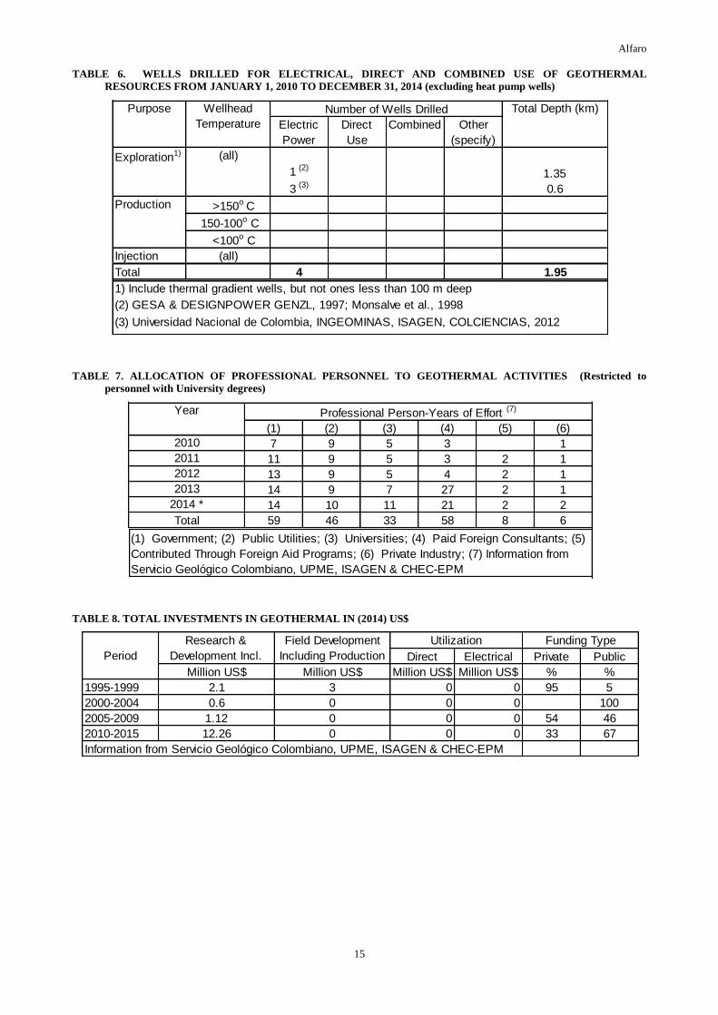
3.1.7 Resources invested in exploration
The resurgence of interest on the geothermal resources as an alternative energy resource, in the last few years, is reflected both in
the professional personnel involved (Table 7, in appendix) as in the economic resources investment (Table 8, in appendix).
4. GEOTHERMAL UTILIZATION
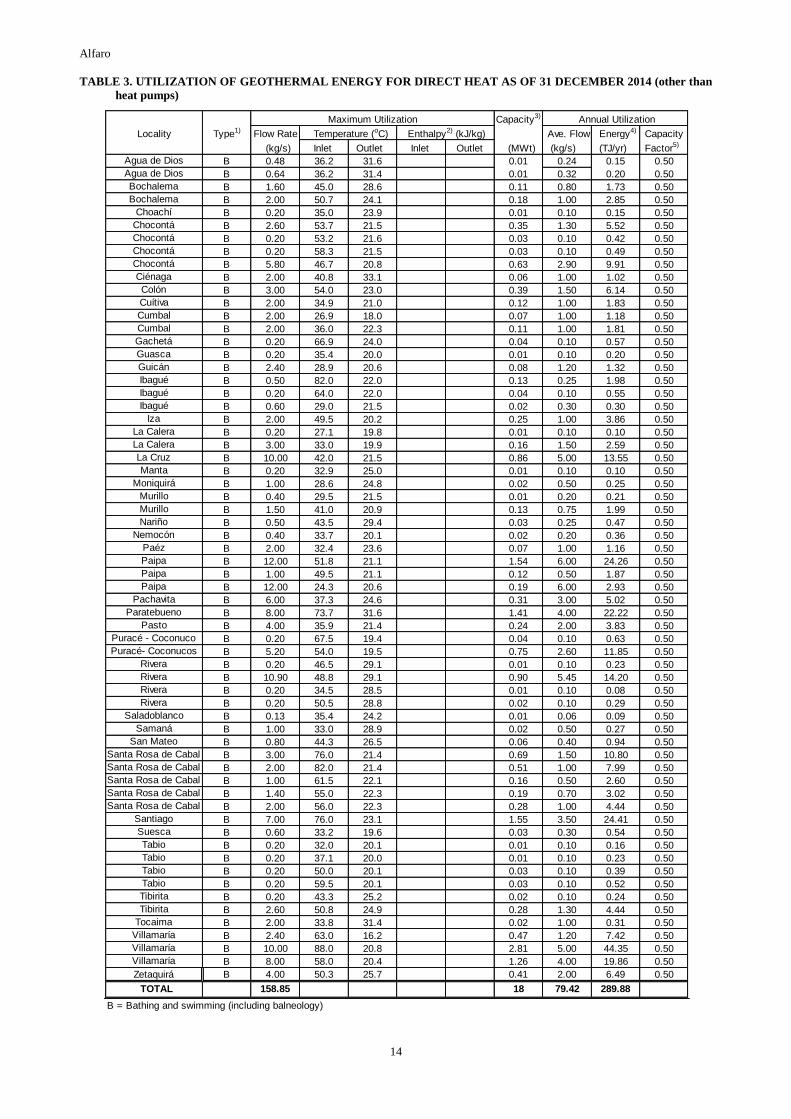
The current utilization of the geothermal resources in Colombia is still limited to bathing for tourism purposes. About 40 localities
in the departments of Cundinamarca, Boyacá, Norte de Santander, Antioquia, Caldas, Risaralda, Tolima, Cauca, Nariño, Putumayo,
Magdalena and Chocó, have infrastructure of pools, mainly. The energy utilization for this purpose is estimated at 300 TJ/yr and
the capacity at 18 MWt, as indicated in Table 3, in appendix. Although through the inventory of the hot springs, discharge
temperatures in the hot springs have been measured and coarse approximations to the flow rate have been done in the last years, the
figures in the table are based on very rough estimations instead of statistical records of flow and temperature (inlet/outlet), which in
general is not available.
5. FUTURE DEVELOPMENT AND INSTALLATIONS
Geothermal power plants of 50 MW of installed capacity are being planned by CHEC-EPM (Ormad, 2014) and ISAGEN (Mejía et
al., 2014). A 138 MW power plant is being projected in the bi-national Ecuadorian – Colombian geothermal project, by CELEC
and ISAGEN (Mejía et al., 2014).
The Colombian Government is carrying out actions aimed at promoting the utilization of geothermal energy, both in the increase in
knowledge through exploration projects, as summarized in previous paragraphs and, in the preparation of a regulatory framework
more favorable to its development. The Ministry of Mining and Energy, through UPME, is carrying out one of the components of
the IDB project number ATN/FM-12805-CO, a non-refundable investment cooperation agreement, funded by GEF, whose
objective is to promote and support catalytic investments for geothermal energy in Colombia, through the strengthening of its
regulatory framework and the development of a demonstrative project in Nevado del Ruiz. The component related with the
demonstrative project corresponds to one of those above mentioned, currently carried out by ISAGEN (República de Colombia –
Banco Interamericano de Desarrollo, 2011).
6. CONCLUSIONS
The high geothermal potential of Colombian territory known by intuition from the location of the country on a limit of tectonic
plates (ring of fire of the Pacific Ocean) has been confirmed and verified through the studies of reconnaissance and prefeasibility
since the late 1960s until now. Nevertheless and with very few exceptions, the level of knowledge of the geothermal systems is
limited to surface exploration. To meet the challenge of incorporating the geothermal source as an alternative energy it is necessary
to extend the prefeasibility studies to advanced stages which include exploratory wells to validate the conceptual formulated
models, basis for estimating the energy potential.
The state policy of diversifying the energy basket and make a rational and efficient use of energy, is providing the conditions for
use of the non-conventional renewable sources. In this framework, the companies in the electricity generation sector are taking up
the challenge to promote the utilization of geothermal resources and even to conclude for themselves the exploration activities from
the early prefeasibility, as is the case of CHEC-EPM and ISAGEN in Nevado del Ruiz and ISAGEN in the bi-national system
Tufino - Chiles - Cerro Negro.
At present the interests of several sectors come together in the geothermal resources, such as power generation, the academy and
governmental institutions. As a result of this interest, reflected in the figures of economic and physical resources invested,
professional personnel involved, undertaken studies, etc., the current conditions of Colombia to develop the geothermal energy, are
favorable.
7. ACKNOWLEDGMENTS
The author thanks CHEC-EPM and ISAGEN, for sharing the information included in the tables, Henry J. Zapata, from UPME and
Pedro Alejandro Eusse, from EPM, for their orientation to find the data related to power generation and information regarding legal
aspects. Thanks also to Camilo Matiz, member of the Geothermal Exploration Group of SGC, for its contributions in the
elaboration of some of the figures.
REFERENCES
Alfaro, C.: Geoquímica del sistema geotérmico del volcán Azufral. INGEOMINAS. Informe técnico. Bogotá. (2001). 47 p.
Alfaro, C.: Estudio Isotópico de aguas del área geotérmica de Paipa. INGEOMINAS. Informe Técnico. Bogotá. (2002). 15 p.

Alfaro
11
Alfaro, C., Velandia, F., Cepeda, H., Pardo, N., Vásquez, L. E. and Espinosa, O.: Modelo conceptual preliminar del sistema
geotérmico de Paipa. INGEOMINAS. Informe Técnico. Bogotá. (2005). 42p
Alfaro, C., Garzón, G., Bobadilla, L.: Geoquímica preliminar de gases del sistema geotérmico del volcán Azufral. Geología
Colombiana. No. 33. Bogotá. (2008) p 91-98.
Alfaro, C. Alvarado, I., Manrique, A.: Mapa preliminar de flujo de calor terrestre en la Cuenca de los Llanos Orientales.
INGEOMINAS. Informe Técnico. Bogotá. (2010).74 p.
Alfaro, C., Ponce, P., Ortiz, I., Monsalve, M.L., Franco, J. V., Torres, R., Gómez, D. and Ortega, A.: Modelo conceptual preliminar
del sistema geotérmico del volcán Azufral. Servicio Geológico Colombiano. Informe técnico. Bogotá. (2013)
Alfaro, C. & Ortiz, I.: Inventario Nacional de Manantiales Termales de Colombia. 2012. XI Congreso Latinoamericano de
Hidrogeología. IV Congreso Colombiano de Hidrogeología. Artículo No. 249. Cartagena. Colombia. (2012) 5 p.
Alfaro, C., Monsalve, M., Franco, J. V. and Ortiz, I.: Contribuciones al modelo conceptual del área geotérmica de Paipa. Servicio
Geológico Colombiano. Informe técnico. Bogotá. (2012). 40 p.
Alfaro, C.: Evaluación de la composición isotópica del agua en el área geotérmica Paipa – Iza. Servicio Geológico Colombiano.
Informe Técnico. Bogotá. (2012). 32 p.
Alfaro, C., Ortiz, I., Rodríguez, G., Matiz, C., Malo, J. and Rodríguez, G.: A Web aplication designed to publish information of
surface manifestations of hydrogthermal systems in Colombia. Proceedings World Geothermal Congress. (2015).
Alfaro, C., Ponce, P., Monsalve, M. L., Ortiz, I., Franco, J. V., Ortega, A., Torres, R., Gómez, D.: A preliminary conceptual model
of Azufral Geolthermal Systhem, Colombia. Proceedings World Geothermal Congress. (2015).
BID – ISAGEN: Notas para la investigación y desarrollo de proyectos geotérmicos en Colombia. Documento técnico. (2012). 78 p.
Disponible en http://www.isagen.com.co/comunicados/Libro_geotermia_sep18.pdf
Calvache, M.L; Cortés, G.P, Torres, M.P, Monsalve, M.L. Cepeda, H.: Mapa de cartografía geológica del volcán Azufral.
INGEOMINAS. Bogotá. (2003)
Carvajal, D. y Romero, D.: Cartografía de las zonas de alteración hidrotermal del Volcán Azufral Nariño. INGEOMINAS, Proyecto
de investigación geológica, sísmica y geotérmica el Altiplano Nariñense. Volumen 5. Bogotá. (2007). 71 p
Central Hidroeléctrica de Caldas (CHEC) and Ente Nazionale per L’Energia Elettrica (ENEL).: Proyecto de Investigación
Geotérmica en la Región del Macizo Volcánico del Ruiz. Translation. (1968). 41 pp
CHEC, Instituto Colombiano de Energía Eléctrica (ICEL), Consultoría Técnica Colombiana Ltda. (Contecol) and Geotérmica
Italiana: Investigación Geotérmica. Macizo volcánico del Ruiz. (1983).
Colombia: Decreto 2811 de 1974. Código Nacional de Recursos Naturales Renovables y de Protección al Medio Ambiente. Bogotá.
Available at http://www.alcaldiabogota.gov.co/sisjur/normas/Norma1.jsp?i=1551.
Colombia: Ley 219 del Senado de 2013. Texto Aprobado. Available at
http://servoaspr.imprenta.gov.co:7778/gacetap/gaceta.mostrar_documento?p_tipo=1698&p_numero=219&p_consec=38759
Colombia: Ley 697 de 2001. Fomento del Uso Racional y Eficiente de la Energía. Bogotá. Available at
http://www.alcaldiabogota.gov.co/sisjur/normas/Norma1.jsp?i=4449.
Colombia: Resolución 180919 de 2010. Adopción del Plan de Acción Indicativo 2010-2015 para desarrollar el Programa de Uso
Racional y Eficiente de la Energía y demás formas de Energía No Convencionales, PROURE. Bogotá. Available at
http://www.alcaldiabogota.gov.co/sisjur/normas/Norma1.jsp?i=39780.
Colombia: Decreto 4131 de 2011. Cambio de la naturaleza jurídica del Instituto Colombiano de Geología y Minería. Available at
http://www.secretariasenado.gov.co/senado/basedoc_ant/decreto_4131_2011.htm
Colombia: Ley 1665 de 2013. Aprobación del “Estatuto de la Agencia Internacional de Energías Renovables (IRENA)”. Available
at
http://wsp.presidencia.gov.co/Normativa/Leyes/Documents/2013/LEY%201665%20DEL%2016%20DE%20JULIO%20DE%
202013.pdf
Colombia: Ley 1715 de 2014. Regulación de la integración de las energías renovables no convencionales al Sistema Energético
Nacional. Available at
http://wsp.presidencia.gov.co/Normativa/Leyes/Documents/LEY%201715%20DEL%2013%20DE%20MAYO%20DE%202014.pd
ECOPETROL: Sustainabililty Report. Environmental Dimension. (2009). Availble at
http://www.ecopetrol.com.co/english/especiales/Sustainability%20Report%202009/ecoeficiencia.htm
ECOPETROL: Reporte Integrado de Gestión Sostenible 2013. (2013.) Available at
http://www.ecopetrol.com.co/especiales/informe2013/es/gestion-ambiental-de-energia.html
Franco, J. V.: Prospección geoeléctrica en los alrededores del volcán de Paipa – Boyacá. Servicio Geológico Colombiano.
Medellín. (2012) 31 p.
Franco, J. V.: Prospección Geoeléctrica al Sureste del Volcán Azufral, jurisdicción de los municipios de Túquerres, Sapuyes y
Guachucal - Nariño. Fase – II. INGEOMINAS. Informe Técnico. Medellín. (2012)
Alfaro
12
Forero, H.: Fuentes Termales de Colombia. Extractos de informes e informaciones No. 1295. Investigaciones de Geología
Económica. Servicio Geológico Nacional. (1958).
GESA (Geonergía Andina S.A.) and DESIGNPOWER GENZL: Nevado del Ruiz Geothermal Prospect. Nereidas Exploration Well
N1. Post drilling Scientific Review. (1997). 60 p.
Gómez. D.M. & Ponce, A.P.: Informe de visita técnica al volcán Azufral – Laguna verde, departamento de Nariño. INGEOMINAS,
OVP, informe interno. (2009). 37 p
Gonzalez, L., Vásquez, L. E., Muñoz, R., Gomes, H., Parrado, G., Vargas, S.: Exploración de Uranio en Paipa, Iza, Pesca, Chivatá
(Boyacá). INGEOMINAS. Informe Técnico. Bogotá. (2008). 176 p.
INGEOMINAS: Geological Map of Colombia.1:1’000.000. First Edition. Bogotá. (2007 a). Available at
http://www.sgc.gov.co/Geologia/Mapa-geologico-de-Colombia.aspx
INGEOMINAS: Mapa geológico de Colombia. 1:2’800.000. Segunda Edición. Bogotá. (2007b). Available at
http://www.sgc.gov.co/Geologia/Mapa-geologico-de-Colombia.aspx
INGEOMINAS-ANH: Mapa preliminar de gradientes geotérmicos (Método BHT). 1:1´500.000. Bogotá. (2008).
INGEOMINAS – ISAGEN: Convenio marco de cooperación técnico-científica No. 011 de 2008 entre el Instituto Colombiano de
Geología y Minería – INGEOMINAS – e ISAGEN S.A. E.S.P. (2008).
ISAGEN: Informe de gestión 2013. (2013). 295 p. Available at
http://www.isagen.com.co/comunicados/ISAGEN_Informe_gestion_2013.pdf
LXRICHTER: ISAGEN preparing exploratory drilling for project in Colombia. (2013). Think GEOENERGY. Available at
http://thinkgeoenergy.com/archives/15494
MinCIT (Ministerio de Comercio Industria y Turismo): Programa de Transformación Productiva con Oferta en Turismo. (2013).
Available at http://www.mincit.gov.co/publicaciones.php?id=5717&dPrint=
Moyano, I.: Exploración Geoélectrica (Sondeos Eléctricos Verticales y Tomografías Eléctricas) en el área Geotérmica de Paipa
(Boyacá). INGEOMINAS. Informe Técnico. Bogotá. (2010). 54 p.
Martinez, L.: Petrografía de alteración hidrotermal del volcán Azufral. INGEOMINAS. Informe técnico. Bogotá. (2009). 48 p.
Mejía, E., Rayo, L., Méndez, J. and Echeverri, J.: Geothermal Development in Colombia. Short Course VI on Utilization of Low-
and Medium-Enthalpy Geothermal Resources and Financial Aspects of Utilization. UNU-GTP and LaGeo. Santa Tecla, El
Salvador. (2014). 7p. Available at http://www.os.is/gogn/unu-gtp-sc/UNU-GTP-SC-18-07.pdf
Mojica, J., Vargas, S. & Perez, A.: Alteraciones hidrotermales en el sector de El Durazno, Paipa. INGEOMINAS. Informe técnico.
Bogotá. (2010). 24 p.
Monsalve, M.L., Rodríguez, G. I., Méndez, R. A. and Bernal, N. F.: Geology of the well Nereidas 1, Nevado del Ruiz Volcano,
Colombia. Geothermal Resources Council. Transactions. Vol 22. (1998). p 263 – 267
Monsalve, M.L., Ortiz, I. and Alfaro, C.: The San Diego Area, a new geothermal prospect on the Colombian Andes. Proceedings
World Geothermal Congress. (2015)
Moyano, I.: Exploración Geoeléctrica (Sondeos Eléctricos Verticales y Tomografias Eléctricas) en el área Geotérmica de Paipa
(Boyacá). Ingeominas. Informe Técnico. Bogotá. (2010). 54 p.
Moyano, I. and Vallejo, E.: Contribution to the knowledge of the Paipa Geothermal System by the application of the
Magnetotelluric method. Proceedings World Geothermal Congress. (2015).
OLADE, INECEL (Instituto Ecuatoriano de Electrificación), ICEL & AQUATER: Proyecto Geotérmico Binacional Tufiño –
Chiles – Cerro Negro. Anexo B: Geoquímica. Milán. Italia. (1987). 132p.
Ormad, A.: Entrevista a la Empresa CHEC: Estado actual del Proyecto Geotérmico Valle de Nereidas, Colombia. (2014). Piensa en
Geotermia. Available at http://piensageotermia.com/archives/21736
Organización Latinoamericana de Energía (OLADE), Instituto Colombiano de Energía Eléctrica (ICEL), GEOTÉRMICA
ITALIANA S.r.l.: Estudio de Reconocimiento de los Recursos Geotérmicos de la República de Colombia. (1982).
Ortiz, I. & Alfaro, C.: Inventario de puntos de agua y geoquímica de las áreas geotérmicas de Paipa e Iza: Aguas, suelos y peloides.
Bogotá. (2010). 119 p.
Ponce, P.: Exploración de Recursos Geotérmicos del Volcán Azufral a partir de la interpretación de Anomalías de Campos
Potenciales. Universidad Nacional de Colombia. Tesis de Maestría. Pasto. (2013).
Posada, L., Méndez, J. and Echeverri, J.: Desarrollo de fuentes no renovables de energía. Short Course on Geothermal Drilling,
Resource Development and Power Plants. UNU-GTP and LaGeo. Santa Tecla, El Salvador. (2011). 5p.
PTP (Programa de Transformación Productiva ): Sector Turismo de Bienestar incrementará empleo e ingresos del país. Boletín
abril. (2013). Available at http://www.ptp.com.co/contenido/contenido_preview.aspx?conID=315&catID=643.
República de Colombia & Banco Interamericano de Desarrollo: Inversiones catalizadoras para energía geotérmica. Convenio de
financiamiento no reembolsable de inversión del Fondo para el Medio Ambiente Mundial (FMAM). No. ATN/FM-12825-CO.
Parte III. Anexo Único. (2011). 6p. Available at http://www.iadb.org/es/proyectos/project-information-
page,1303.html?id=CO-X1009.

Alfaro
13
Servicio Geológico Colombiano (SGC): Base de datos del Inventario Nacional de Manantiales Termales de Colombia. (2014).
Tassinari, C.C.G. and Macambira, M.J.B.: Geochronological provinces of the Amazonian Craton. Episodes, 22(3): 174-182. The
Amazonian Craton. Episodes, 22(3), (1999), 174-182.
UPME (Unidad de Planeación Minero Energética): Plan de Expansión de Referencia. Generación y Transmisión, 2010 – 2014.
(2010). Avialable at http://www.upme.gov.co/Docs/Plan_Expansion/2010/Plan_Expansion_2010-2024_Definitivo.pdf
UPME (Unidad de Planeación Minero Energética) & Corpoema: Plan de desarrollo para las Fuentes no convencionales de energía
en Colombia (PDFNCE). Bogotá. (2010). 173 p. Available at http://www.upme.gov.co/Sigic/Sigic_001.htm.
UPME (Unidad de Planeación Minero Energética): Informe de avance proyectos de generación eléctrica. (2013). 9p. Available at
http://www.upme.gov.co/genera_electrica/Informe_avance_DICIEMBRE_2013.pdf
UPME (Unidad de Planeación Minero Energética): Informe mensual de variables de generación y del mercado eléctrico
Colombiano. Febrero. (2014). 11 p. Available at http://www.siel.gov.co/portals/0/generacion/2014/boletin-
Febrero%202014.pdf
Universidad Nacional de Colombia, INGEOMINAS, ISAGEN, COLCIENCIAS: Programa Estratégico para la Investigación y
Modelamiento del sistema hidrotermal magmático en áreas con potencial geotérmico localizadas en el flanco noroccidental del
Volcán Nevado del Ruiz, Colombia. Contrato de Financiamiento COLCIENCIAS 762 de 2009. Informe Final. Bogotá. (2012).
Vásquez, L.: Aplicación geofisica de métodos potenciales en el área geotérmica Paipa-Iza- Servicio Geológico Colombiano.
Informe Técnico. Bogotá. (2012). 93 p.
Velandia, F.; Romero, D.; Rodríguez, B.; Hincapié, G. & Salazar, E.: Esquema Estructural para Exploración Hidrogeológica en el
Altiplano Nariñense. Memoria del Congreso Colombiano de Hidrogeología. Bucaramanga. (2006).
STANDARD TABLES
TABLE 1. PRESENT AND PLANNED PRODUCTION OF ELECTRICITY
In operation in
December 2014 (2)NA 4521.0 17814 9365 38976 NA NA 13886.0 56790
Under construction
in December 2014
(3)NA 864 3016.9 NA NA 3880.9 0
Funds committed,
but not yet under
construction in
December 2014 NA NA NA NA NA NA
Estimated total
projected use by
2020 (4)
150 (5)
40 (6)
1248.3 (5)
NA NA 14971 89578.3
Other Renewables Geothermal
Gross
Prod.
GWh/yr
Capacity
MWe
Gross
Prod.
GWh/yr
(2) UPME, 2014. Informe Mensual de Variables de Generación y del Mercado Eléctrico Colombiano - Febrero de 2014. 11p. Available at
http://www.siel.gov.co/portals/0/generacion/2014/boletin-Febrero%202014.pdf
It does not include minor centrals of power generation (<20 MW: Resolution 086, 1996) and cogeneration, which corresponds to 662.3 and 66.3
MW and, 2600 and 385 GWh/year, respectively.
(3) UPME, 2013. Informe de Avance Proyectos de Generación Eléctrica Diciembre 2013. 9p. Available at
http://www.upme.gov.co/genera_electrica/Informe_avance_DICIEMBRE_2013.pdf
(4) Estimated from global projection figures and the expectations in geothermal energy. UPME, 2010. Plan de Expansión de Referencia.
Generación y Transmisión. 2010-2024. Available athttp://www.upme.gov.co/Docs/Plan_Expansion/2010/Plan_Expansion_2010-
2024_Definitivo.pdf
(5) ISAGEN, 2014. Personnal communication.
(6) CHEC-CPM. 2014. Personal communication.
Total (1)
Capacity
MWe
Gross
Prod.
GWh/yr
Capacity
MWe
Gross
Prod.
GWh/yr
Capacity
MWe
Gross
Prod.
GWh/yr
Capacity
MWe
Gross
Prod.
GWh/yr
Fossil Fuels
Capacity
MWe
Hydro Nuclear
Alfaro
14
TABLE 3. UTILIZATION OF GEOTHERMAL ENERGY FOR DIRECT HEAT AS OF 31 DECEMBER 2014 (other than
heat pumps)
Capacity3)
Locality Type1) Flow Rate Temperature (oC) Enthalpy2) (kJ/kg) Ave. Flow Energy4) Capacity
(kg/s) Inlet Outlet Inlet Outlet (MWt) (kg/s) (TJ/yr) Factor5)
B 0.48 36.2 31.6 0.01 0.24 0.15 0.50
B 0.64 36.2 31.4 0.01 0.32 0.20 0.50
B 1.60 45.0 28.6 0.11 0.80 1.73 0.50
B 2.00 50.7 24.1 0.18 1.00 2.85 0.50
B 0.20 35.0 23.9 0.01 0.10 0.15 0.50
B 2.60 53.7 21.5 0.35 1.30 5.52 0.50
B 0.20 53.2 21.6 0.03 0.10 0.42 0.50
B 0.20 58.3 21.5 0.03 0.10 0.49 0.50
B 5.80 46.7 20.8 0.63 2.90 9.91 0.50
B 2.00 40.8 33.1 0.06 1.00 1.02 0.50
B 3.00 54.0 23.0 0.39 1.50 6.14 0.50
B 2.00 34.9 21.0 0.12 1.00 1.83 0.50
B 2.00 26.9 18.0 0.07 1.00 1.18 0.50
B 2.00 36.0 22.3 0.11 1.00 1.81 0.50
B 0.20 66.9 24.0 0.04 0.10 0.57 0.50
B 0.20 35.4 20.0 0.01 0.10 0.20 0.50
B 2.40 28.9 20.6 0.08 1.20 1.32 0.50
B 0.50 82.0 22.0 0.13 0.25 1.98 0.50
B 0.20 64.0 22.0 0.04 0.10 0.55 0.50
B 0.60 29.0 21.5 0.02 0.30 0.30 0.50
B 2.00 49.5 20.2 0.25 1.00 3.86 0.50
B 0.20 27.1 19.8 0.01 0.10 0.10 0.50
B 3.00 33.0 19.9 0.16 1.50 2.59 0.50
B 10.00 42.0 21.5 0.86 5.00 13.55 0.50
B 0.20 32.9 25.0 0.01 0.10 0.10 0.50
B 1.00 28.6 24.8 0.02 0.50 0.25 0.50
B 0.40 29.5 21.5 0.01 0.20 0.21 0.50
B 1.50 41.0 20.9 0.13 0.75 1.99 0.50
B 0.50 43.5 29.4 0.03 0.25 0.47 0.50
B 0.40 33.7 20.1 0.02 0.20 0.36 0.50
B 2.00 32.4 23.6 0.07 1.00 1.16 0.50
B 12.00 51.8 21.1 1.54 6.00 24.26 0.50
B 1.00 49.5 21.1 0.12 0.50 1.87 0.50
B 12.00 24.3 20.6 0.19 6.00 2.93 0.50
B 6.00 37.3 24.6 0.31 3.00 5.02 0.50
B 8.00 73.7 31.6 1.41 4.00 22.22 0.50
B 4.00 35.9 21.4 0.24 2.00 3.83 0.50
B 0.20 67.5 19.4 0.04 0.10 0.63 0.50
B 5.20 54.0 19.5 0.75 2.60 11.85 0.50
B 0.20 46.5 29.1 0.01 0.10 0.23 0.50
B 10.90 48.8 29.1 0.90 5.45 14.20 0.50
B 0.20 34.5 28.5 0.01 0.10 0.08 0.50
B 0.20 50.5 28.8 0.02 0.10 0.29 0.50
B 0.13 35.4 24.2 0.01 0.06 0.09 0.50
B 1.00 33.0 28.9 0.02 0.50 0.27 0.50
B 0.80 44.3 26.5 0.06 0.40 0.94 0.50
B 3.00 76.0 21.4 0.69 1.50 10.80 0.50
B 2.00 82.0 21.4 0.51 1.00 7.99 0.50
B 1.00 61.5 22.1 0.16 0.50 2.60 0.50
B 1.40 55.0 22.3 0.19 0.70 3.02 0.50
B 2.00 56.0 22.3 0.28 1.00 4.44 0.50
B 7.00 76.0 23.1 1.55 3.50 24.41 0.50
B 0.60 33.2 19.6 0.03 0.30 0.54 0.50
B 0.20 32.0 20.1 0.01 0.10 0.16 0.50
B 0.20 37.1 20.0 0.01 0.10 0.23 0.50
B 0.20 50.0 20.1 0.03 0.10 0.39 0.50
B 0.20 59.5 20.1 0.03 0.10 0.52 0.50
B 0.20 43.3 25.2 0.02 0.10 0.24 0.50
B 2.60 50.8 24.9 0.28 1.30 4.44 0.50
B 2.00 33.8 31.4 0.02 1.00 0.31 0.50
B 2.40 63.0 16.2 0.47 1.20 7.42 0.50
B 10.00 88.0 20.8 2.81 5.00 44.35 0.50
B 8.00 58.0 20.4 1.26 4.00 19.86 0.50
B 4.00 50.3 25.7 0.41 2.00 6.49 0.50
TOTAL 158.85 18 79.42 289.88
B = Bathing and swimming (including balneology)
Maximum Utilization Annual Utilization
Bochalema
Choachí
Chocontá
Agua de Dios
Agua de Dios
Bochalema
Chocontá
Chocontá
Chocontá
Ciénaga
Colón
Cuítiva
Cumbal
Cumbal
Gachetá
Guasca
Guicán
Ibagué
Ibagué
Ibagué
Iza
La Calera
La Calera
La Cruz
Manta
Moniquirá
Murillo
Murillo
Nariño
Nemocón
Paéz
Paipa
Paipa
Paipa
Paratebueno
Pachavita
Pasto
Puracé - Coconuco
Puracé- Coconucos
Rivera
Rivera
Rivera
Rivera
Saladoblanco
Samaná
San Mateo
Santa Rosa de Cabal
Santa Rosa de Cabal
Santiago
Santa Rosa de Cabal
Santa Rosa de Cabal
Santa Rosa de Cabal
Suesca
Tabio
Tabio
Villamaría
Villamaría
Villamaría
Zetaquirá
Tabio
Tabio
Tibirita
Tibirita
Tocaima
Alfaro
15
TABLE 6. WELLS DRILLED FOR ELECTRICAL, DIRECT AND COMBINED USE OF GEOTHERMAL
RESOURCES FROM JANUARY 1, 2010 TO DECEMBER 31, 2014 (excluding heat pump wells)
TABLE 7. ALLOCATION OF PROFESSIONAL PERSONNEL TO GEOTHERMAL ACTIVITIES (Restricted to
personnel with University degrees)
TABLE 8. TOTAL INVESTMENTS IN GEOTHERMAL IN (2014) US$
Exploration1) (all)
1 (2)
3 (3)
>150o C
150-100o C
<100o C
Injection (all)
Total 4
1) Include thermal gradient wells, but not ones less than 100 m deep
(2) GESA & DESIGNPOWER GENZL, 1997; Monsalve et al., 1998
(3) Universidad Nacional de Colombia, INGEOMINAS, ISAGEN, COLCIENCIAS, 2012
1.95
Production
1.35
0.6
Purpose Wellhead
Temperature
Number of Wells Drilled Total Depth (km)
Electric
Power
Direct
Use
Combined Other
(specify)
(1) (2) (3) (4) (5) (6)
7 9 5 3 1
11 9 5 3 2 1
13 9 5 4 2 1
14 9 7 27 2 1
14 10 11 21 2 2
59 46 33 58 8 6
(1) Government; (2) Public Utilities; (3) Universities; (4) Paid Foreign Consultants; (5)
Contributed Through Foreign Aid Programs; (6) Private Industry; (7) Information from
Servicio Geológico Colombiano, UPME, ISAGEN & CHEC-EPM
Year Professional Person-Years of Effort (7)
Total
2010
2011
2012
2013
2014 *
Direct Electrical Private Public
Million US$ Million US$ % %
1995-1999 0 0 95 5
2000-2004 0 0 100
2005-2009 0 0 54 46
2010-2015 0 0 33 67
Information from Servicio Geológico Colombiano, UPME, ISAGEN & CHEC-EPM
12.26 0
2.1 3
0.6 0
1.12 0
Period
Research &
Development Incl.
Field Development
Including Production
Utilization Funding Type
Million US$ Million US$