Improved Resolution for the Detection of Snow With MODIS ...
4
Improved Resolution for the Detection of Snow With MODIS Using Wavelet Fusion Pascal Sirguey and Renaud Mathieu GLIMS-NZ Office School of Surveying, University of Otago PO Box 56, Dunedin, New Zealand Email: [email protected] [email protected] Yves Arnaud IRD-Great Ice Laboratoire de Glaciologie et G´ eophysique de l’Environnement 54, rue Moli` ere, 38402 Saint Martin d’H` eres cedex, France Email: [email protected] Muhammad M. Khan and Jocelyn Chanussot GIPSA-Lab/CNRS, DIS/ENSIEG Domaine Universitaire, BP 46, 38402 Saint Martin d’H` eres cedex, France Email: [email protected] [email protected] Abstract—We propose to implement the ARSIS concept to fuse the high spatial content of the two 250m spectral bands of MODIS into its five 500m bands using wavelet based multi- resolution analysis. Our objective was to test the effectiveness of this technique to increase the accuracy of snow mapping in mountainous environments. To assess the performance of this approach, we took advantage of the simultaneity between ASTER and MODIS sensors, both on the TERRA platform. With a 15m spatial resolution, the ASTER sensor provided reference snow maps that were then compared to MODIS derived snow maps. The benefit of the method was assessed through the investigation of various metrics. The enhanced snow map are therefore of great benefit for environmental and hydrological applications in steep terrain. I. I NTRODUCTION MODIS daily repeat time and multi-spectral capabilities make it a very powerful tool for the operational monitoring of snow cover properties over large areas. In order to discriminate snow from other targets the Normalized Difference Snow Index (NDSI) is commonly used [1]. It takes advantage of the contrast between the high reflectance of snow in the green part of the visible spectrum (Band 4 at 555nm) and its low reflectance in the short wave infrared (Band 6 at 1640nm). The use of these bands constraints the mapping of snow cover at 500m spatial resolution with MODIS. This relatively coarse spatial resolution limits our ability to accurately map the snow cover, especially when the slope becomes significant in mountainous terrain. However, the MODIS sensor also has two spectral bands at 250m spatial resolution. In their early work, Hall, Riggs and Salomonson [2] suggested to use these bands to produce a more detailed mapping of snow cover. The objective of this study was to investigate if wavelet-based image fusion between MODIS spectral bands would enable the determination of snow at 250m and benefit snow cover mapping in steep terrain. Towards this goal, the implementa- tion of the ARSIS concept is first described with the method for the snow classification. To validate the efficiency of the technique, a rigorous estimation of the improvement is carried out by comparing snow maps obtained “without” and “with” the fusion process with references obtained from simultaneous ASTER imagery. II. METHODOLOGY A. Image Fusion 1) Principle and methods: In Earth observation, the grow- ing number of sensors and the variety of spatial, spectral, and temporal resolutions makes satellite images suitable to fusion techniques [3]. When dealing with imagery, fusion methods usually aims to merge the rich spatial content of a high resolution image (HR) with the rich spectral content of a low spatial resolution image (LR) (e.g. typically panchromatic and multispectral images, e.g. Ikonos, SPOT, Quickbird). Several methods exist to merge multi-spectral bands in remote sensing. Among them, multi-resolution methods have been designed to extract the spatial details contained in the HR band, and subsequently fuse or “inject” these details into the LR image. This can be achieved through different methods such as High Pass Filtering (HPF), Laplacian Pyramid (LP) or Wavelet Transform (WT) [4]. Each band is decomposed into a low frequency approximation that describes the trend (radiometry), and a series of zero-mean coefficients that ac- counts for the high frequency information (spatial details). Only the spatial details are incorporated into the LR image using the related reconstruction method. Merging zero-mean wavelet coefficients also avoids the bias of radiometry in the original image as it occurs with substitution techniques. Multi- resolution methods are suitable to deal with band-to-band fusion, since they extract in the image only the details that exist at different scales. 2) The ARSIS concept and implementation: Developed by Ranchin and Wald [5], the multi-resolution based concept ARSIS (from its French name “Am´ elioration de la R´ esolution Spatiale par Injection de Structures”) has been implemented. As shown in Fig. 1, the decomposition of the HR image produces a first set of detail coefficients. These coefficients are injected in the LR image using an adequate model to improve the quality of the synthesized image. The modified coefficients are used along with the LR image for reconstruction, making the spatial resolution of the reconstructed image the same as the HR image. We used the decimated wavelet transform of Mallat [6] combined with Daubechies D12 wavelets as the
Transcript of Improved Resolution for the Detection of Snow With MODIS ...

Improved Resolution for the Detection of SnowWith MODIS Using Wavelet Fusion
Pascal Sirgueyand Renaud Mathieu
GLIMS-NZ OfficeSchool of Surveying, University of Otago
PO Box 56, Dunedin, New ZealandEmail: [email protected]
Yves ArnaudIRD-Great Ice
Laboratoire de Glaciologieet Geophysique de l’Environnement
54, rue Moliere, 38402Saint Martin d’Heres cedex, France
Email: [email protected]
Muhammad M. Khanand Jocelyn Chanussot
GIPSA-Lab/CNRS, DIS/ENSIEGDomaine Universitaire, BP 46, 38402Saint Martin d’Heres cedex, FranceEmail: [email protected]
Abstract—We propose to implement the ARSIS concept tofuse the high spatial content of the two 250m spectral bandsof MODIS into its five 500m bands using wavelet based multi-resolution analysis. Our objective was to test the effectivenessof this technique to increase the accuracy of snow mapping inmountainous environments. To assess the performance of thisapproach, we took advantage of the simultaneity between ASTERand MODIS sensors, both on the TERRA platform. With a 15mspatial resolution, the ASTER sensor provided reference snowmaps that were then compared to MODIS derived snow maps.The benefit of the method was assessed through the investigationof various metrics. The enhanced snow map are therefore of greatbenefit for environmental and hydrological applications in steepterrain.
I. INTRODUCTION
MODIS daily repeat time and multi-spectral capabilitiesmake it a very powerful tool for the operational monitoring ofsnow cover properties over large areas. In order to discriminatesnow from other targets the Normalized Difference SnowIndex (NDSI) is commonly used [1]. It takes advantage ofthe contrast between the high reflectance of snow in the greenpart of the visible spectrum (Band 4 at 555nm) and its lowreflectance in the short wave infrared (Band 6 at 1640nm).The use of these bands constraints the mapping of snowcover at 500m spatial resolution with MODIS. This relativelycoarse spatial resolution limits our ability to accurately mapthe snow cover, especially when the slope becomes significantin mountainous terrain. However, the MODIS sensor also hastwo spectral bands at 250m spatial resolution. In their earlywork, Hall, Riggs and Salomonson [2] suggested to use thesebands to produce a more detailed mapping of snow cover.The objective of this study was to investigate if wavelet-basedimage fusion between MODIS spectral bands would enablethe determination of snow at 250m and benefit snow covermapping in steep terrain. Towards this goal, the implementa-tion of the ARSIS concept is first described with the methodfor the snow classification. To validate the efficiency of thetechnique, a rigorous estimation of the improvement is carriedout by comparing snow maps obtained “without” and “with”the fusion process with references obtained from simultaneousASTER imagery.
II. METHODOLOGY
A. Image Fusion
1) Principle and methods: In Earth observation, the grow-ing number of sensors and the variety of spatial, spectral,and temporal resolutions makes satellite images suitable tofusion techniques [3]. When dealing with imagery, fusionmethods usually aims to merge the rich spatial content of ahigh resolution image (HR) with the rich spectral content of alow spatial resolution image (LR) (e.g. typically panchromaticand multispectral images, e.g. Ikonos, SPOT, Quickbird).
Several methods exist to merge multi-spectral bands inremote sensing. Among them, multi-resolution methods havebeen designed to extract the spatial details contained in the HRband, and subsequently fuse or “inject” these details into theLR image. This can be achieved through different methodssuch as High Pass Filtering (HPF), Laplacian Pyramid (LP)or Wavelet Transform (WT) [4]. Each band is decomposedinto a low frequency approximation that describes the trend(radiometry), and a series of zero-mean coefficients that ac-counts for the high frequency information (spatial details).Only the spatial details are incorporated into the LR imageusing the related reconstruction method. Merging zero-meanwavelet coefficients also avoids the bias of radiometry in theoriginal image as it occurs with substitution techniques. Multi-resolution methods are suitable to deal with band-to-bandfusion, since they extract in the image only the details thatexist at different scales.
2) The ARSIS concept and implementation: Developed byRanchin and Wald [5], the multi-resolution based conceptARSIS (from its French name “Amelioration de la ResolutionSpatiale par Injection de Structures”) has been implemented.As shown in Fig. 1, the decomposition of the HR imageproduces a first set of detail coefficients. These coefficients areinjected in the LR image using an adequate model to improvethe quality of the synthesized image. The modified coefficientsare used along with the LR image for reconstruction, makingthe spatial resolution of the reconstructed image the same asthe HR image. We used the decimated wavelet transform ofMallat [6] combined with Daubechies D12 wavelets as the
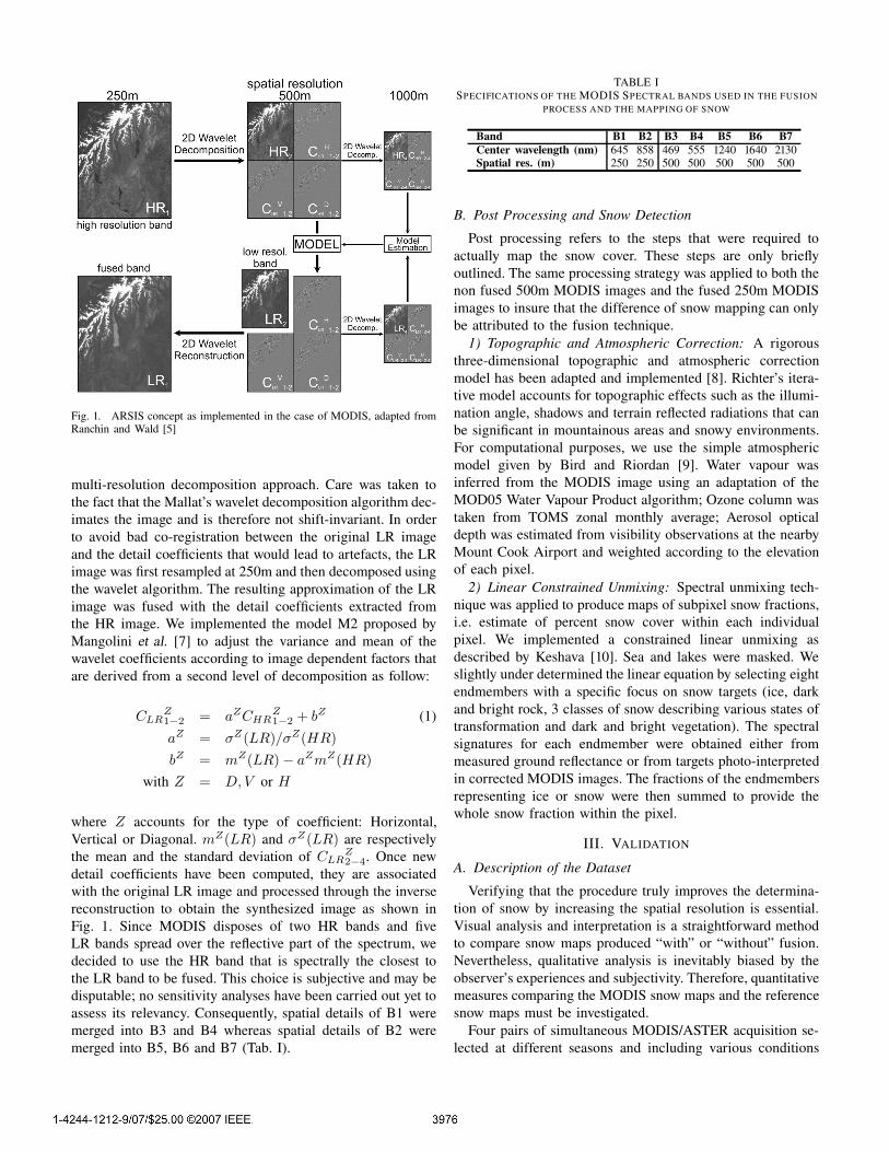
Fig. 1. ARSIS concept as implemented in the case of MODIS, adapted fromRanchin and Wald [5]
multi-resolution decomposition approach. Care was taken tothe fact that the Mallat’s wavelet decomposition algorithm dec-imates the image and is therefore not shift-invariant. In orderto avoid bad co-registration between the original LR imageand the detail coefficients that would lead to artefacts, the LRimage was first resampled at 250m and then decomposed usingthe wavelet algorithm. The resulting approximation of the LRimage was fused with the detail coefficients extracted fromthe HR image. We implemented the model M2 proposed byMangolini et al. [7] to adjust the variance and mean of thewavelet coefficients according to image dependent factors thatare derived from a second level of decomposition as follow:
CLRZ1−2 = aZCHR
Z1−2 + bZ (1)
aZ = σZ(LR)/σZ(HR)bZ = mZ(LR) − aZmZ(HR)
with Z = D, V or H
where Z accounts for the type of coefficient: Horizontal,Vertical or Diagonal. mZ(LR) and σZ(LR) are respectivelythe mean and the standard deviation of CLR
Z2−4. Once new
detail coefficients have been computed, they are associatedwith the original LR image and processed through the inversereconstruction to obtain the synthesized image as shown inFig. 1. Since MODIS disposes of two HR bands and fiveLR bands spread over the reflective part of the spectrum, wedecided to use the HR band that is spectrally the closest tothe LR band to be fused. This choice is subjective and may bedisputable; no sensitivity analyses have been carried out yet toassess its relevancy. Consequently, spatial details of B1 weremerged into B3 and B4 whereas spatial details of B2 weremerged into B5, B6 and B7 (Tab. I).
TABLE ISPECIFICATIONS OF THE MODIS SPECTRAL BANDS USED IN THE FUSION
PROCESS AND THE MAPPING OF SNOW
Band B1 B2 B3 B4 B5 B6 B7Center wavelength (nm) 645 858 469 555 1240 1640 2130Spatial res. (m) 250 250 500 500 500 500 500
B. Post Processing and Snow Detection
Post processing refers to the steps that were required toactually map the snow cover. These steps are only brieflyoutlined. The same processing strategy was applied to both thenon fused 500m MODIS images and the fused 250m MODISimages to insure that the difference of snow mapping can onlybe attributed to the fusion technique.
1) Topographic and Atmospheric Correction: A rigorousthree-dimensional topographic and atmospheric correctionmodel has been adapted and implemented [8]. Richter’s itera-tive model accounts for topographic effects such as the illumi-nation angle, shadows and terrain reflected radiations that canbe significant in mountainous areas and snowy environments.For computational purposes, we use the simple atmosphericmodel given by Bird and Riordan [9]. Water vapour wasinferred from the MODIS image using an adaptation of theMOD05 Water Vapour Product algorithm; Ozone column wastaken from TOMS zonal monthly average; Aerosol opticaldepth was estimated from visibility observations at the nearbyMount Cook Airport and weighted according to the elevationof each pixel.
2) Linear Constrained Unmixing: Spectral unmixing tech-nique was applied to produce maps of subpixel snow fractions,i.e. estimate of percent snow cover within each individualpixel. We implemented a constrained linear unmixing asdescribed by Keshava [10]. Sea and lakes were masked. Weslightly under determined the linear equation by selecting eightendmembers with a specific focus on snow targets (ice, darkand bright rock, 3 classes of snow describing various states oftransformation and dark and bright vegetation). The spectralsignatures for each endmember were obtained either frommeasured ground reflectance or from targets photo-interpretedin corrected MODIS images. The fractions of the endmembersrepresenting ice or snow were then summed to provide thewhole snow fraction within the pixel.
III. VALIDATION
A. Description of the Dataset
Verifying that the procedure truly improves the determina-tion of snow by increasing the spatial resolution is essential.Visual analysis and interpretation is a straightforward methodto compare snow maps produced “with” or “without” fusion.Nevertheless, qualitative analysis is inevitably biased by theobserver’s experiences and subjectivity. Therefore, quantitativemeasures comparing the MODIS snow maps and the referencesnow maps must be investigated.
Four pairs of simultaneous MODIS/ASTER acquisition se-lected at different seasons and including various conditions

(a) (b)
(c) (d)
Fig. 2. Visual performance in estimating the snow fraction (Mt Cook Area,South Island of New Zealand, 31 December 2002 22:35 GMT) : (a) Falsecolour RGB composite from MODIS bands 1, 2 (250m) and 3 (fused to250m). (b) Reference from ASTER (15m) aggregated at 250m. (c) Snowmapusing MODIS bands without fusion at 500m. (d) Snowmap using MODISfused bands at 250m.
of snow cover were selected in our study area (see dates inTab. II). The spatial resolution of ASTER (15m) compared tothe 250m and 500m of MODIS provides a ratio of respectively277 and 1111 ASTER pixels for each MODIS pixel. Thereforewe hypothesized that a binary classification of snow fromASTER using a threshold of the NDSI would provide accurateground truth of the snow cover. The ASTER images weretherefore orthorectified and converted to reflectance. The NDSIwas computed using ASTER band 1 (560nm) and band 4(1660nm). The snow was classified at a 15m resolution witha custom threshold of 0.7. The resulting snow maps wereresampled at 12.5m and aggregated to 250m and 500m, thusproviding the reference snow fraction maps of the area.
B. Metrics
1) Standard Descriptive Statistics: In our analysis, we usethe mean absolute error (MAE) and the coefficient of determi-nation R2 as first indicators of the performance of the fusion.The MAE is given by:
MAE =1
m × n
m∑
i=1
n∑
j=1
|xij − yij | (2)
Where x and y are the snow fraction for MODIS and ASTERrespectively, m and n are the number of rows and columns ofthe raster snow map. It provides an overall indication of thepositive or negative errors. R2 indicates the portion of variance
in the ASTER derived reference snow map that is accountedfor in the MODIS derived snow map.
2) Global Quality or Q Index: MODIS snow fraction mapsare grayscale raster datasets. Their similarity to the ASTERreference maps can be evaluated through a global imagequality index such as the Q index designed by Wang and Bovik[11]. This metric provides a unique score that ranges between−1 and 1 which makes it appropriate for ranking processingstrategies according to their performances. It is defined by:
Q =σxy
σxσy
2xy
[(x)2 + (y)2]2σxσy[
σ2x + σ2
y
] (3)
Where σxy is the covariance between test image x andreference image y, x and y are the means and σ2
x and σ2y
are the variances of x and y respectively.3) Receiver Operating Characteristics (ROC Curves): An-
other valuable tool to compare classifiers according to theirperformance is ROC Curves as they provide a comprehensiveinterpretation of confusion matrices [12]. When two classes aredefined, the Hit Rate and False Alarm Rate can be computed.They represent the probability for the classifier to categorizea pixel within the right or the wrong class respectively. Theseprobabilities define a single point in the ROC space. If theclassifier also provides the probability of belonging to one orthe other class, then a continuous ROC curve can be drawnby increasing the threshold of this probability.
In our case, such an approach cannot be applied directlysince our classifier is continuous. Indeed, the snow fractionwithin a pixel can take any value in the range [0, 1]. To tacklethis issue, the reference snow maps were equally segmentedinto eleven classes (ten thresholds: {0.5, 0.15, . . . , 0.95}). Toaccommodate for the non-uniform pixel distribution in eachclass, an equal number of pixels were randomly selected ineach class based on the smallest class. For each threshold, theclasses are gathered into two set of pixels defined as beinglower or greater than the given threshold. A ROC curve canthen be drawn from the histograms of the MODIS derivedsnow fraction for each of these two sets. Examples of ROCcurves for two thresholds are given in Fig. 4.
The visual interpretation of the curves for both products“with” or “without” fusion enables us to identify the processthat performs the best. The ROC Curve of the best classifieris located closer to the perfect discrimination curve as shownin Fig 4. This two-dimension representation can also bereduced to a single scalar value by computing the area betweenthe curve and the no-discrimination (or “pure guessing”) line(AUCD). This metric is a statistical indicator of the ability ofa classifier to correctly sort pixels into their respective classes.
IV. RESULTS
For one MODIS image shown in Fig. 2 (a) and the cor-responding ASTER reference snow map (b), (c) and (d) arethe snow maps computed from MODIS that illustrate theresolution improvement obtained with the fusion. The visualinterpretation of the snow maps for each granule lead us toconsider the fused product as “significantly better” than the

0 20 40 60 80 1000
20
40
60
80
100
ASTER Snow fraction %
MO
DIS
Sno
w fa
ctio
n %
y = 0.96x + 0R² = 0.89
(a)
0 20 40 60 80 1000
20
40
60
80
100
ASTER Snow fraction %
MO
DIS
Sno
w fa
ctio
n %
y = 1.01x + 0.01R² = 0.93
(b)
Fig. 3. Linear regression : (a) Snow fraction from MODIS 500m bandsversus ASTER reference. (b) Snow fraction from MODIS 250m fused bandsversus ASTER reference.
0 0.2 0.4 0.6 0.8 10
0.1
0.2
0.3
0.4
0.5
0.6
0.7
0.8
0.9
1
False Alarm Rate
Hit
Rat
e
Unmixing from 500m bandsUnmixing from 250m bandsPure guessingPerfect determination
(a)
0 0.2 0.4 0.6 0.8 10
0.1
0.2
0.3
0.4
0.5
0.6
0.7
0.8
0.9
1
False Alarm Rate
Hit
Rat
e
Unmixing from 500m bandsUnmixing from 250m bandsPure guessingPerfect determination
(b)
Fig. 4. Receiver Operating Characteristics Curves for two thresholds at 0.45and 0.65 (Mt Cook Area, South Island of New Zealand, 31 December 2002).
non fused one as it was obvious that more details could be seenin the 250m maps. This richer spatial information generallymatched features depicted in the 15m ASTER reference image.The plots of snow fractions from the MODIS derived snowmaps versus the true equivalent ASTER snow fractions isgiven in Fig.3. Graph (a) represents the 500m map obtainedfrom non-fused bands and (b) the 250m map obtained fromfused bands and aggregated to 500m to account for the samenumber of pixels. The product obtained with the fusion methodexhibits less point dispersion around the 1:1 ratio line meaninga better determination. The results for the various metrics andthe four granules investigated are given in Tab. II. For allgranules, we observe a favourable evolution of the coefficientR2 when the fusion was processed. An average increase of6.4% was obtained. Likewise, the MAE significantly improvedby dropping about 20% in average. The evolution of these twostandard statistics illustrates the reduced dispersion shown inthe estimation of the snow fraction (Fig. 3). The Q Index alsoincreased 3%. For all investigated thresholds the ROC curvesof the fused bands also tended towards a better determinationof the snow classes. The single scalar metrics AUCD derivedfrom the ROC curves illustrates this by increasing 9.3% inaverage.
V. CONCLUSION
In this article, we investigated the improvement that canbe achieved by using wavelet fusion between MODIS spectral
TABLE IIRESULTS FOR THE METRICS COMPUTED BETWEEN THE ASTER
REFERENCES AND MODIS SNOW MAPS DERIVED FROM NON-FUSEDBANDS (“WITHOUT”) AND FUSED BANDS (“WITH”) FOR THE FOUR IMAGES
Date R2 MAE% Q Index% AUCD%without with without with without with without with
09/11/2000 0.82 0.90 8.7 6.9 90.4 93.7 38.3 43.429/01/2002 0.89 0.93 4.5 3.8 93.8 95.7 43.5 45.331/12/2002 0.88 0.93 6.4 5.0 94.0 96.2 43.2 45.516/05/2006 0.82 0.89 10.4 8.1 90.1 93.8 36.7 42.1
bands for mapping snow cover at a higher spatial resolution.The ARSIS fusion concept along with the M2 model provedto be efficient. Qualitative analyses and rigorous metrics havebeen used to assess this result. The use of simultaneousASTER acquisition also enabled us to compare our productswith detailed reference maps without time lag. All validationtechniques showed a significant trend towards improvementand demonstrate that the snow fraction can be more accuratelyestimated with the fused 250m MODIS product. The enhancedsnow map are therefore of great benefit for environmental andhydrological applications in steep terrain.
ACKNOWLEDGMENT
This research was funded by the School of Surveying, Uni-versity of Otago. The authors would like to thank Prof. MichelFily, head of the Laboratoire de Glaciologie et Geophysiquede l’Environnement (Grenoble, France) for his support.
REFERENCES
[1] D. K. Hall, G. Riggs, V. V. Salomonson, N. E. DiGirolamo, and K. J.Bayr, “Modis snow-cover products,” Remote Sensing of Environment,vol. 83, pp. 181–194, 2002.
[2] D. K. Hall, G. A. Riggs, and V. V. Salomonson, “Development of meth-ods for mapping global snow cover using moderate resolution imagingspectroradiometer data,” Remote Sensing of Environment, vol. 54, pp.127–140, 1995.
[3] C. Pohl and J. L. V. Genderen, “Multisensor image fusion in remotesensing: Concepts, methods and applications,” International Journal ofRemote Sensing, vol. 19, no. 5, pp. 823–854, 1998.
[4] T. Ranchin and L. Wald, “The wavelet transform for the analysis ofremotely sensed images,” International Journal of Remote Sensing,vol. 14, pp. 615–619, 1993.
[5] ——, “Fusion of high spatial and spectral resolution images : Thearsis concept and its implementation,” Photogrammetric Engineeringand Remote Sensing, vol. 66, no. 1, pp. 49–61, 2000.
[6] S. Mallat, “Multiresolution approximation and wavelet orthonormalbases of L2(R),” Trans. Amer. Math. Soc., vol. 315, no. 1, pp. 69–87,1989.
[7] M. Mangolini, T. Ranchin, and L. Wald, “Procede et dispositif pourl’amelioration de la resolution spatiale d’images a partir d’autres imagesde meilleure resolution spatiale,” French Patent No 92-13961, November1992.
[8] R. Richter, “Correction of satellite imagery over mountainous terrain,”Applied Optics, vol. 37, no. 18, pp. 4004–4015, 1998.
[9] R. E. Bird and C. Riordan, “Simple solar model for direct and diffuseirradiance on horizontal and tilted planes at the earth’s surface forcloudless atmosphere,” Journal of Climate and Applied Meteorology,vol. 25, pp. 87–97, 1986.
[10] N. Keshava, “A survey of spectral unmixing algorithms,” Lincoln Lab-oratory Journal, vol. 14, no. 1, pp. 55–78, 2003.
[11] Z. Wang and A. C. Bovik, “A universal image quality index,” IEEESignal Processing Letter, vol. 9, no. 3, pp. 81–84, March 2002.
[12] T. Fawcett, “ROC graphs: Notes and practical considerations for re-searchers,” Palo Alto, USA: HP Laboratories., Tech. Rep., 2004.