IMPROVED CONNECTIVITY IN GEOGRAPHIC ROUTING...
38
IMPROVED CONNECTIVITY IN GEOGRAPHIC ROUTING PROTOCOLS USING DELAY-TOLERANT NETWORKS SCHEME IN VEHICULAR AD HOC NETWORKS RAMIN KARIMI UNIVERSITI TEKNOLOGI MALAYSIA
Transcript of IMPROVED CONNECTIVITY IN GEOGRAPHIC ROUTING...

IMPROVED CONNECTIVITY IN GEOGRAPHIC ROUTING PROTOCOLS USING DELAY-TOLERANT NETWORKS
SCHEME IN VEHICULAR AD HOC NETWORKS
RAMIN KARIMI
UNIVERSITI TEKNOLOGI MALAYSIA

IMPROVED CONNECTIVITY IN GEOGRAPHIC ROUTING PROTOCOLS
USING DELAY-TOLERANT NETWORKS SCHEME IN VEHICULAR AD HOC NETWORKS
RAMIN KARIMI
A thesis submitted in partial fulfilment of the
requirements for the award of the degree of
Doctor of Philosophy (Computer Science)
Faculty of Computing
Universiti Teknologi Malaysia
OCTOBER 2013

iii
To my beloved parents and wife
Any number of words cannot sufficiently express the love and encouragement I
received from them.

v
ABSTRACT
Vehicular Ad hoc Networks (VANET) used to build wireless networks between
vehicles (V2V), and between vehicles to infrastructure (V2I) are a subclass of Mobile
Ad hoc Networks (MANET). VANETs introduce a variety of applications to enhance
the safety and create a comfortable driving environment for drivers. Connectivity in
VANET is a fundamental operation that allows a vehicle to construct a source-to-
destination but is problematic due to the rapidly changing topologies and high speed
mobility of the vehicles involved. This study presents a Predictive Geographic Routing
Protocol (PGRP) to improve connectivity with predict greedy forwarding which could
handle a recovery strategy for local maximum environment. In PGRP, every vehicle
gives a weight to its neighbors according to the direction and location of the vehicle.
Besides that, PGRP is capable of predicting the location of every vehicle in the interval
time of hello packet based on the acceleration of the vehicle before forwarding the
packets based on location after a short interval. An improved PGRP known as Predictive
Geographic Routing Protocol with Delay-Tolerant Network (PGRP+DTN) would be
used whenever a network disconnection occurs. A buffer can be used for every vehicle
and each packet could be stored when a network is disconnected. To simulate the PGRP
and PGRP+DTN, an integrated simulation NS2.35 based model and Simulator of Urban
Mobility (SUMO) were used to generate a realistic traffic situation. The simulation
results show that PGRP outperformed GPSR and GPCR in terms of packet delivery
ratio, end-to-end delay, and average hops for improve connectivity between every two
nodes. PGRP+DTN also outperformed Geopps, GeoDTN+NAV, and VADD in terms of
packet delivery ratio, end to end delay, average hops for improve connectivity between
every two nodes whenever they want to exit from DTN. The research has proven that
the problems of connectivity in VANET can be resolved by using the proposed
protocols.

vi
ABSTRAK
Rangkaian Ad-hoc Kenderaan (VANET) digunakan untuk membina rangkaian
tanpa wayar antara kenderaan (V2V) dan antara kenderaan dengan infrastruktur (V2I)
adalah subkelas Rangkaian Ad-hoc Bergerak (MANET). VANET memperkenalkan
pelbagai aplikasi untuk meningkatkan keselamatan dan mewujudkan persekitaran
pemanduan yang selesa kepada pemandu. Perhubungan dalam VANET adalah operasi
asas yang membolehkan kenderaan membina sumber-ke-destinasi tetapi bermasalah
disebabkan oleh perubahan topologi yang cepat dan pergerakan berkelajuan tinggi
kenderaan yang terlibat. Kajian ini membentangkan Protokol Ramalan Laluan
Geografik (PGRP) untuk memperbaiki hubungan dengan meramalkan kelewahan
penghantaran yang boleh mengendalikan strategi pemulihan persekitaran tempatan yang
maksimum. Dalam PGRP setiap kenderaan memberikan berat kepada kenderaan-
kenderaan lain yang mengikut arahan dan lokasi kenderaan terbabit. Selain itu PGRP
mampu meramal lokasi setiap kenderaan dalam jangkamasa paket hello berdasarkan
kecepatan kenderaan sebelum penghantaran paket berdasarkan lokasi selepas
jangkamasa yang singkat. Sebuah PGRP yang ditambah baik yang dikenali sebagai
Protokol Ramalan Laluan dengan Rangkaian Toleran Tertangguh (PGRP+DTN) akan
digunakan setiap kali terjadi pemutusan rangkaian. Penimbal boleh digunakan pada
setiap kenderaan dan setiap paket boleh disimpan apabila rangkaian diputuskan. Untuk
mensimulasikan PGRP dan PGRP+DTN simulasi berasaskan model bersepadu NS2.35
dan Simulator Pergerakan Perbandaran (Sumo) telah digunakan untuk menjanakan
keadaan lalu lintas yang realistik. Keputusan simulasi menunjukkan bahawa PGRP
mengatasi GPSR dan GPCR dari segi nisbah paket penghantaran, penangguhan hujung-
ke-hujung, dan loncatan purata bagi meningkatkan hubungan antara setiap dua nod.
PGRP+DTN juga mengatasi Geopps, GeoDTN+NAB, dan VADD dari segi nisbah
penghantaran paket, penangguhan hujung-ke-hujung, loncatan purata bagi meningkatkan
hubungan antara setiap dua nod apabila kedua-duanya hendak keluar dari DTN. Kajian
ini telah membuktikan bahawa masalah perhubungan dalam VANET boleh diselesaikan
dengan menggunakan protokol yang dicadangkan.
iv
ACKNOWLEDGEMENT
I am indebted to my supervisor, Dr. Norafida Ithnin for giving me the
opportunity to work with her and introducing me to this very exciting field of
vehicular ad hoc networks. Without their continued support and interest, this thesis
would not have been the same as presented here.
My thanks also go to my co-supervisor Dr. Shukor Abd Razak for all his
support, guidance, and encouragement over the last Four years.
My fellow postgraduate students should also be recognized for their valuable
suggestions and support. Warm thanks goes out to PhD candidate Ali Asadi for
including me in the many collaborative opportunities. I must express my sincerest
and heartiest thanks to my father, mother, wife and brother, for their encouraging
attitude unfailing patience and excellent cooperation throughout my research.

vii
TABLE OF CONTENTS
CHAPTER TITLE PAGE
DECLERATION ii
ACKNOWLEDGEMENT iv
ABSTRACT v
ABSTRAK vi
TABLE OF CONTENTS vii
LIST OF TABLES xii
LIST OF FIGURES xiii
LIST OF ABBREVIATIONS xvi
LIST OF SYMBOLS xviii
LIST OF APPENDICES xi
1 INTRODUCTION 1
1.1 Overview 1
1.2 Background of Problem 5
1.2.1 Connectivity between Nodes in Interval
Time of Hello Packet in Geographic
Routing Protocol 5
1.2.2 Route Recovery and Forwarding Method in
Geographic Routing Protocols 10
1.3 Problem Statement 11
1.4 Purpose of Study 12
1.5 Objectives 13
1.6 Scope of study 13
1.7 Significance of the Study 14
1.8 Summary and Organization of the Thesis 15
viii
2 LITERATURE REVIEW 16
2.1 Introduction 16
2.2 Vehicular Ad-Hoc Networks Characteristics 17
2.2.1 Highly Mobility and dynamic topology 17
2.2.2 Frequently Disconnected Network
(Intermittent connectivity) 17
2.2.3 Network topology and connectivity 18
2.2.4 Unlimited transmission power 18
2.2.5 Predictable mobility 18
2.3 VANET Applications 19
2.4 Vehicular Communication 20
2.4.1 Inter-Vehicle Communication 21
2.4.2 Vehicle-to-Roadside Communication 21
2.5 DSRC Spectrum for VANET 22
2.5.1 Vehicular Ad hoc Network Architecture 24
2.6 Vehicular Delay-Tolerant Network 26
2.7 Specific Protocols in VANET Routing 27
2.7.1 Topology-based Routing Protocols 28
2.7.1.1 Proactive (table-driven) Routing 28
2.7.1.2 Reactive (On Demand): 29
2.8 Geographic (Position-based) Routing: 29
2.8.1 Non-DTN Routing Protocols in VANET 30
2.8.1.1 Greedy Perimeter Stateless Routing
(GPSR) 30
2.8.1.2 GPCR – Greedy Perimeter
Coordinator Routing 31
2.8.1.3 VCLCR- VANET Cross Link
Corrected Routing Protocol 33
2.8.1.4 CAR- Connectivity-Aware Routing 34
2.8.1.5 GSR – Geographic Source Routing 35

ix
2.8.1.6 Anchor-based Street- and Traffic-
Aware Routing Protocol (A-STAR) 37
2.8.1.7 Predictive Directional Greedy
Routing Protocol (PDGR) 39
2.8.2 DTN- Routing Protocols in VANET 39
2.8.2.1 VADD – Vehicle-Assisted Data
Delivery 40
2.8.2.2 Geographical Opportunistic Routing
Protocol (GeOpps) 41
2.8.2.3 GeoDTN+Nav- GeographicDTN
Routing with Navigator 41
2.9 A Comparison of Geographic Routing Protocols
in VANETS 42
2.10 HELLO Message in VANET 45
2.11 Geographic Routing Protocol Mechanisms 45
2.12 Vehicular Ad hoc Network Simulators 51
2.12.1 Mobility model generator for Vehicular
networks (MOVE) 51
2.12.2 Simulation of Urban Mobility (SUMO) 51
2.12.3 Network Simulator (NS-2) 52
2.13 Chapter Summary 53
3 RESEARCH METHODOLOGY 55
3.1 Introduction 55
3.2 Research Framework 56
3.2.1 Problem Analysis and Literature Review 56
3.2.2 Predictive Geographic Routing Protocol
(PGRP) 61
3.2.3 Predictive Geographic Routing Protocol
with Delay-Tolerant Network
(PGRP+DTN) 62
3.3 Simulation Setup 63
3.3.1 Realistic Highway Scenario 63
3.3.1.1 Realistic Urban scenario for
PGRP+DTN 65
x
3.4 Chapter Summary 67
4 PREDICTIVE GEOGRAPHIC ROUTING
PROTOCOL 68
4.1 Introduction 68
4.2 Relationship between Greedy Prediction and
Perimeter Prediction Strategy in PGRP 69
4.2.1 Greedy Predictive Forwarding Strategy 71
4.2.2 Perimeter Predictive Forwarding Strategy 72
4.3 Predictive Geographic Routing Protocol (PGRP) 74
4.3.1 Hello Packet Structure in PGRP 76
4.3.2 Calculate Weight for Current node 77
4.3.3 Calculate Weight for Neighbors 78
4.3.3.1 Calculating the Location of Every
Neighbor 80
4.3.3.2 Calculating the Direction of a
Neighbor in Relation to the
Destination 83
4.3.4 Checking For Out of Bounds (CFO) 84
4.3.5 Checking Connectivity in Perimeter Mode 87
4.4 Predictive Geographic Routing Protocol with
Delay-Tolerant Network 91
4.4.1 Relationship between Greedy Prediction
Strategy, Perimeter Prediction Strategy and
DTN 91
4.4.2 Packet Format for PGRP+DTN 93
4.4.3 DTN Mechanism for PGRP 94
4.5 Chapter Summary 99
5 SIMULATION AND RESULTS 100
5.1 Introduction 100
5.2 Traffic Simulator Scenario for PGRP 101
5.2.1 Performance Evaluation for PGRP 102
xi
5.2.2 Simulation Setup for PGRP 104
5.2.3 Simulation Results in Highway and Urban
Environment in PGRP 104
5.3 Simulation Scenario for PGRP+DTN 109
5.3.1 Performance Evaluation for PGRP+DTN 109
5.3.2 Simulation Setup for PGRP+DTN 110
5.3.3 Simulation Results in Realistic Highway
and Urban Environment in Malaysia for
PGRP+DTN 112
5.4 Chapter Summary 117
6 CONCLUSION AND FUTURE WORK 119
6.1 Introduction 119
6.2 Discussion 120
6.3 Contribution of the Thesis 122
6.4 Future Work 124
REFERENCES 125
Appendices A 130

xii
LIST OF TABLES
TABLE NO. TITLE PAGE
2.1 Table Example of VANETs applications 20
.2.2 Comparison of DSRC and other forms of mobile
communication 23
2.3 A Comparison of Geographic Routing Protocols in
VANETs 44
3.1 The overall research plan 59
3.2 Sumo Parameters for E2 highway scenario 64
3.3 Sumo Parameters City of Kuala lumpur scenario 66
5.1 Sumo Parameters for city scenario 102
5.2 Sumo Parameters for highway scenario 102
5.3 Simulation setting for proposed PGRP 104
5.4 Simulation setting for proposed PGRP+DTN 111

xiii
LIST OF FIGURES
FIGURE NO. TITLE PAGE
1.1 Different velocities more than zero at time (t1) 8
1.2 Different velocities more than zero at time (t2) 8
1.3 Out of boundary problem at time (t1) 9
1.4 Out of boundary problem at time (t2) 9
2.1 communication between Vehicle to-vehicle 21
2.2 Vehicle-to-roadside communication 22
2.3 Cellular/WLAN VANET Architecture 24
2.4 Ad-Hoc VANET Architecture 25
2.5 Hybrid VANET Architecture 25
2.6 Taxonomy of Routing Protocols in VANET 28
2.7 Coordinator Nodes in GPCR 32
2.8 Applying Coordinator Nodes in GPCR 32
2.9 List of intersections that determine the path of the packet 36
2.10 Greedy forwarding 36
2.11(a) A-STAR recovery strategy 38
2.11(b) A-STAR recovery strategy 38
2.12 Geographic routing protocol mechanisms 46
2.13 Face traversal by right-hand rule 47
2.14 Face change mechanism 47
2.15 The RNG graph 48
2.16 The GG graph 49
2.17 Comparison of GG and RNG. 50
2.18 FlowChart of MOVE 53
3.1 Research Framework 58
3.2 E2 highway of Malaysia chosen for Simulation 63

xiv
3.3 The part of the E2 Highway map converted into Sumo
Format 64
3.4 City of Kuala Lumpur - region considered for simulation 65
3.5 The Map converted into Sumo Format 66
4.1 Relationship between Greedy Prediction and Perimeter
Prediction in PGRP 70
4.2(a) greedy predictive forwarding strategy in current time 72
4.2(b) greedy predictive forwarding strategy in next time 72
4.3(a) Perimeter predictive forwarding strategy in current time 73
4.3(b) Perimeter predictive forwarding strategy in next time 74
4.4 Flow chart describing the operation of the PGRP 75
4.5 Hello Packet structure 77
4.6 New coordinates for Nodes a and b 80
4.7 Direction of every Vehicle in relation to the destination 83
4.8(a) Checking for out of bounds at time t1 85
4.8(b) checking for out of bounds at time t2 85
4.9(a) CFO less than one 86
4.9(b) CFO equal to one 86
4.9(c) CFO of more than one (CFO>1) 87
4.10 Local maximum scenario 88
4.11(a) Relationship between checking connectivity in perimeter
predictive mode and hop count in highway scenarios 90
4.11(b) Relationship between checking connectivity in the
perimeter predictive mode and hop count in urban
scenarios 90
4.12 Relationship between Greedy prediction, perimeter
prediction and DTN 92
4.13 Data packet format for PGRP+DTN 93
4.14 Disconnect network in perimeter predictive strategy 95
4.15 Disconnect network in greedy predictive strategy 95
4.16 Predictive DTN mode in time t1 96
4.17 Predictive DTN mode in time t2 96
4.18 Flow chart describing the operation of the PGRP+DTN 98
5.1 urban simulation scenarios 101
5.2 (a) Packet Delivery Ratio in Highway scenarios 105
5.2 (b) Packet Delivery Ratio in Urban scenarios 106
5.3 (a) End-to-End Delay in Highway scenarios 107

xv
5.3 (b) End-to-End Delay in Urban scenarios 107
5.4 (a) Average Hops in Highway scenarios 108
5.4 (b) Average Hops in Urban scenarios 109
5.5 (a) Packet Delivery Ratio in E2 Highway scenarios in
Malaysia 113
5.5(b) Packet Delivery Ratio in City of kuala lumpur - region
scenarios in Malaysia 113
5.6(a) End-to-End Delay in E2 Highway scenarios in Malaysia 114
5.6(b) End-to-End Delay in City of kuala lumpur - region
scenarios in Malaysia 115
5.7(a) Average Hops in in E2 Highway scenarios in Malaysia 116
5.7(b) Average Hops in City of kuala lumpur - region scenarios
in Malaysia 117

xvi
LIST OF ABBREVIATIONS
A-STAR – Anchor- Based Street and Traffic Aware Routing
CAR – Connectivity Aware Routing
CBF – Contention Based Forwarding
CFO – Checking For Out of Bounding
DSRC – Dedicated Short Range Communications
DTN – Delay-Tolerant Network
GG – Gabriel Graph
GeoDTN+Nav – Geographical Delay-Tolerant Network +Navigation
GeOpps – Geographical Opportunistic Routing
GPSR – Greedy Perimeter Stateless Routing
GPS – Global Positioning System
GPCR – Greedy Perimeter Coordinator Routing
GSR – Geographical Source Routing
SUMO – Simulation of Urban Mobility
ITS – Intelligent Transportation System
MANETs – Mobile Ad hoc NETworks
MOVE – Mobility Model Generator for Vehicular Networks
MOT – Maximum Of Transmission Range
NS2 – Network Simulator
PDGR – Predictive Directional Greedy Routing
PDF – Packet Delivery Ratio
RNG – Relative Neighborhood Graph
TTL – Time-to-Live
V2V – Vehicle-to-Vehicle
V2I – Vehicle-to-Infrastructure
V2x – Vehicle-to-Vehicle and Vehicle-to-Infrastructure

xvii
VADD – Vehicle-Assisted Data Delivery
VANETs – Vehicular Ad hoc NETworks
VCLCR – VANET Cross Link Corrected Routing Protocol
WLAN – Wireless Local Area Network
PGRP – Predictive Geographic Routing Protocol

xviii
LIST OF SYMBOLS
Loccur – the location for current node
Locdest – the location for destination
Loccur,dest – location vector between current node and destination
Dk – Distance between neighbor k and destination
Dcur – Distance between current node and destination
Weight k – Total Weight for neighbor k
Vcur – Velocity vector for current node
PDk – Prediction of distance between neighbor k and destination
PDcur – Prediction of distance between current node and destination
PDk/PDcur – prediction of closeness next candidate hop for next time
Vvehicle c – Velocity for vehicle C
Vvehicle B – Velocity for vehicle B
CFO – Checking For Out of bound
DIS – Distance between every two node in next time
Dest – destination for the packet
hcmax – the maximum hops
hcmin – the minimum hop count
chc – current hop count

CHAPTER 1
1 INTRODUCTION
1.1 Overview
A novel class of wireless networks introduced as Vehicular Ad hoc Networks
(VANETs) is presented in this research. VANETs are topologies of moving vehicles
used in similar and different radio interface technologies and equipped with wireless
interfaces that use short-range to medium-range communication systems. One of the
classes of the mobile ad hoc networks is a VANET that facilitates communication
between vehicles by using close stable equipment on a roadside when vehicles are
surrounded by other vehicles. In the field of Vehicular Ad hoc Networks, new
developments are strongly encouraged for industries that involve automotive and
wireless technology.
In 2003, a dedicated short-range communications (DSRC) system was
proposed in North America. In this DSRC system, 75 MHz of spectrum was
appropriated by Federal Communication Commission (FCC) in the U.S. for use with
Vehicular Ad hoc Networks (Intl, 2003a). In Europe, a Vehicle-to-Vehicle
Communication Consortium (V2V-CC) emerged as the Original Automotive
Equipment Manufacturers (OEMs) where vehicle manufacturers have been
attempting to improve the efficiency and safety of road traffic using inter-vehicle
communication (Kenney, 2011).

2
The use of a routing protocol in VANETs would guarantee the way for two
nodes to exchange information with each other. The protocol contains the route
establishment procedure, forwarding decision maker procedure, and procedure for
recovery of failed route. For these procedures to take place, knowing the exact
location of a node is important.
Presently, nearly 250 million newly registered vehicles in the US are
equipped with navigation systems and GPS receivers. (Hummels, 2007). This
situation has caused Geographic routing protocols to be popular routing protocols in
VANET because of their simplicity, low overhead, and availability of GPS devices.
The geographic routing protocols are very compatible with sparse and dense traffic
environment and categorized as either Delay-Tolerant Networks (DTN) Geographic
routing or non-DTN Geographic routing.
DTN Geographic routings have been used in situations where there is no
connectivity between vehicles in VANETs. This normally happens in sparse traffic
environments. Unlike traditional ad hoc networks, the end-to-end path between a
source and destination will only be available for a short and unpredictable period of
time. In a DTN, the mobile node keeps a packet until it finds an opportunity to send
it to the destination and when there is no connectivity between nodes, the data will be
stored in the buffer (Fall and Farrell, 2008). When a neighbor appears within the
transmission range of the mobile node, the data in the buffer would be forwarded to
that neighbor. However, in non DTN geographic routings, it is assumed that vehicles
in a network have end-to-end connectivity.
Geographic routing protocols are divided in two different modes: the first is a
greedy mode and the second mode is a perimeter mode. In the greedy mode, the
source or current node forwards a packet to a close neighbor who has a good chance
of reaching the destination. However, problems will occur if there are no neighbors
close to the destination. In the perimeter mode, the geographic routing protocol

3
extracts packets from the local maximum (Cheng et al., 2010a; Karp and Kung,
2000; Lochert et al., 2005).
In non DTN Geographic routing protocols, Greedy Perimeter Stateless
Routing (GPSR) (Karp and Kung, 2000) and Greedy Perimeter Coordinator Routing
(GPCR) (Lochert et al., 2005) use greedy and perimeter modes to forward a data
packet to a destination. In Geographic Source Routing (GSR) (Lochert et al., 2003),
Anchor-based Street- and Aware Routing Protocol (A-STAR) (Kenney, 2011),
VCLCR-VANET Cross Link Corrected Routing Protocol (VCLCR) (Bako and
Weber, 2011), Connectivity-Aware Routing (CAR) (Naumov and Gross, 2007),
Predictive Directional Greedy and Routing Protocol (PDGR)(Gong et al., 2007) use
only the greedy mode to forward the data packet to a destination and these routing
protocols do not support the local maximum scenario.
In DTN Geographic routing protocols, Vehicle-Assisted Data Delivery
(VADD) (Zhao and Cao, 2008) and GeOpps-Geographical Opportunistic Routing
(GeOpps) (Leontiadis and Mascolo, 2007) use greedy mode to forward a data packet
to a destination. Besides that, GeoDTN+NAV(Geographic DTN Routing with
Navigator) (Cheng et al., 2010a) also uses the greedy and perimeter modes to
forward the data packet to a destination.
In a VANET, the structure of the network and connectivity between every
two nodes are valid only for a few minutes or seconds because of the high mobility
and different velocities of nodes in these networks. On the other hand, most of non
DTN and DTN proposed geographic routing protocols assume that the velocity of
vehicles in VANETs is static in interval time and every vehicle identifies its
neighbors by a hello packet. These protocols in the non DTN geographic routing
include Greedy Perimeter Stateless Routing (GPSR) (Karp and Kung, 2000) and
Greedy Perimeter Coordinator Routing (GPCR) (Lochert et al., 2005).
4
Other non DTN geographic routing protocols such as Connectivity-Aware
Routing (CAR) (Naumov and Gross, 2007), Geographic Source Routing (GSR)
(Lochert et al., 2003; Tian et al., 2002), Anchor-based Street-and Traffic-Aware
Routing (A-STAR) (Seet et al., 2004) and Contention-Based Forwarding(CBR)
(Füßler et al., 2004) support static mobility in VANETs. In DTN geographic
routing, protocols such as Vehicle-Assisted Data Delivery (VADD) (Zhao and Cao,
2008), GeOpps-Geographical Opportunistic Routing(GeOpps) (Leontiadis and
Mascolo, 2007) and Geographic DTN Routing with Navigator (Cheng et al., 2010b)
support static mobility at interval time when every vehicle identifies its neighbors by
hello packet. However, in the real world, the assumption that a vehicle is static may
not be true given the mobility of vehicles.
Another problem faced by most geographic routings is that vehicles have
different acceleration rates when they pass or overtake each other in interval time by
hello packet. The passing or overtaking of vehicles increases the number of hops and
end-to-end connectivity. Hence forwarding methods and prediction of location of
neighbors for every vehicle to be affected and improve the connectivity in non DTN
geographic routing and DTN geographic routing protocols (Cheng et al., 2010b;
Gong et al., 2007).
A forwarding method in some non DTN geographic routings such as CAR
and GSR is the greedy forwarding. A forwarding packet is sent to a close neighbor
whose destination is within the transmission range. However, this forwarding
method does not always operate when some nodes with connectivity to a destination
is not close enough to the destination. In this situation, some non DTN routings
such as GPSR , GPCR, and DTN geographic routing prefer GeoDTN+NAV (Cheng
et al., 2010b) to be applied as a recovery method for forwarding a packet to a
destination. On the other hand, Delay-Tolerant Network (DTN) would be used in a
geographic routing when greedy and recovery methods could not support the
connectivity between a source and a destination.

5
The predict mobility is useful in non DTN and DTN geographic routings
because moving vehicles have high mobility and the limitation of the transmission
range is normally 250 meters. Furthermore, the life time of a connectivity between
two vehicles is very short (Artimy et al., 2005; Füßler et al., 2004).
1.2 Background of Problem
Vehicular Ad Hoc Network (VANET) is a particular type of Mobile Ad Hoc
Network (MANET), where vehicles equipped with transmission capabilities are
interconnected to form a network. The topology created by vehicles is very dynamic
and significantly non-uniformly distributed. Standard MANET routing algorithms
are not suitable for transferring information in these networks. An advantage of
VANET is the accessibility of its navigation systems that allow each vehicle to be
aware of the geographic location of its neighbors.
It is a challenging task to develop an efficient VANET routing protocol that
can handle connectivity in geographic routing and route recovery as well as have a
forwarding method in highway and urban vehicular environment for high packet
delivery ratio and low end to end delay and low average hops. The discussions on
connectivity in geographic routing and route recovery, forwarding method are
presented in the following sections.
1.2.1 Connectivity between Nodes in Interval Time of Hello Packet in
Geographic Routing Protocol
Geographic Routing is a routing approach that forwards packets to close
neighbors which will then be sent to a destination when a mediate node is available

6
between a source and destination (Lochert et al., 2003; Naumov and Gross, 2007) in
VANET. The availability of GPS devices has made Geographic routing protocols
popular, but, disconnected network partitions are created by the dynamic nature of
Vehicular Ad hoc Networks.
Non DTN Geographic routing protocols in VANETs such as GPSR and GSR
(Karp and Kung, 2000; Lochert et al., 2003) face limitations such as routing loops,
too many hops and wrong directions. On the other hand, every vehicle in geographic
routing protocols sends a hello packet within the transmission range to identify its
neighbors after the interval time. After receiving information from its neighbors, it
sends the data packet according to the forwarding method to a destination. Some
routing protocols such as GSR,GPCR, GPSR, A-STAR and VCLCR in non DTN
geographic routing protocols do not support connectivity between every two nodes in
interval time of hello packet because these routing protocols assume that the mobility
in interval time in a hello packet is static.
Predictive Directional Greedy Routing (PDGR) (Gong et al., 2007) has been
suggested to be used as a means to deal with this issue as it supports forwarding
packet in a mobile node to every neighbor in future highway scenarios and this
would help improve connectivity between every two nodes. However, this routing
does not support urban scenarios and cannot support connectivity of every two nodes
if they are out of bounds in the short interval time of a hello packet. Although PDGR
supports overtaking in highway but it would not operate when two vehicles are close
to each other because in this situation, the average hop and end-to-end delay will
increase.
To improve connectivity in DTN geographic routing protocols, VADD (Zhao
and Cao, 2008) uses a prediction mechanism for forwarding a packet to a destination.
VADD uses predictable mobility to forward these packets and only predicts the
direction of a vehicle in urban scenarios but does not predict forwarding them to

7
neighbors in the short intervals. Unfortunately, it may cause more hops and longer
routing delays. Furthermore, DTN geographic routing GeOpps (Leontiadis and
Mascolo, 2007) and GeoDTN+NAV (Cheng et al., 2010b) use a Delay-Tolerant
Network mechanism in a sparse network but none of these routing protocols could
predict the location of one hop in the short intervals when there is more than one
neighbor. On the other hand, GeoDTN+NAV improve connectivity between every
two nodes with forwarding method but this method is determined based on the static
mobility of a hello packet in the interval time. Besides that, GeoDTN+NAV could
not support the connectivity between nodes during the interval time of a hello packet.
Hence, the delivery packet ratio decreases, and end-to-end delay and average hops
between nodes increase in the connectivity.
In non DTN and DTN Geographic Routing protocols in VANETs, most
routing protocols assume that velocities of vehicles are static in the interval time of a
hello packet (Karp and Kung, 2000; Lochert et al., 2005; Naumov and Gross, 2007)
but this assumption may not be true in the real world. Additionally, these routing
protocols do not support scenarios where one vehicle overtakes or passes another
vehicle. In overtaking scenarios, the velocity between vehicles would be different
resulting in an increased number of hops and end-to-end delay. The connectivity
between two vehicles in VANETs is short lived at high speeds and each vehicle
usually would have a maximum transmission range between 250-300 meters (Füßler
et al., 2004); which decreases the delivery ratio. In Figure 1.1, Vehicle A wants to
send the data packet to Vehicle Destination while Vehicle A and Vehicle B are
moving in the same direction. Vehicle A would send the hello packet to identify its
neighbors within the transmission range. After receiving the hello packet reply,
vehicle A would identify Vehicle B but during this time, vehicle A is close to its
neighbor’s destination. In this situation, Vehicle A in time (t2) resends a hello packet
to identify its neighbors closest to its destination.
In Figure 1.2, Vehicle B overtakes Vehicle A. In such a situation and
according to traditional routing protocols such as GPSR (Karp and Kung, 2000),
GPCR (Lochert et al., 2005), CAR (Naumov and Gross, 2007), GSR (Lochert et al.,

8
2003), A-STAR (Seet et al., 2004), when Vehicle A receives a packet to be
forwarded to a destination at time (t1), then Vehicle A would not choose Vehicle B as
the next hop. After the interval time of a hello packet, Vehicle B would be closer to
the destination at time (t2). Then, Vehicle A at time (t2) will forward the packet to
Vehicle B that is closer to the destination. If Vehicle B receives a packet at time t,
then Vehicle B can start the next round of forwarding the packet at time (t2) which
would decrease end-to-end delays and average hops as well as to increase the packet
delivery ratio.
A
C
Destination
B
Figure 1.1 Different velocities more than zero at time (t1)
Destination
A
B
C
Figure 1.2 Different velocities more than zero at time (t2)
9
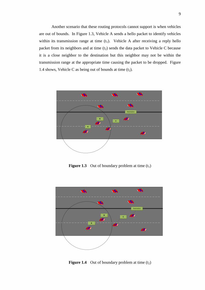
Another scenario that these routing protocols cannot support is when vehicles
are out of bounds. In Figure 1.3, Vehicle A sends a hello packet to identify vehicles
within its transmission range at time (t1). Vehicle A after receiving a reply hello
packet from its neighbors and at time (t2) sends the data packet to Vehicle C because
it is a close neighbor to the destination but this neighbor may not be within the
transmission range at the appropriate time causing the packet to be dropped. Figure
1.4 shows, Vehicle C as being out of bounds at time (t2).
A
BC
Destination
Figure 1.3 Out of boundary problem at time (t1)
BC
A
Destination
Figure 1.4 Out of boundary problem at time (t2)

10
In order to design a Unicast protocol for VANET, two major problems must
be considered. Firstly, the protocol must be able to predict the future position of a
vehicle according to vehicle position information gathered from the GPS and hello
packet. Secondly, the forwarding method protocol must be able to support the
dynamic rate of velocity at the hello packet interval time.
1.2.2 Route Recovery and Forwarding Method in Geographic Routing
Protocols
Geographic routing protocols have two modes. They are the greedy and the
recovery modes (Karp and Kung, 2000). The greedy mode nodes use positions of
one-hop neighbors from a hello packet. Greedy mode selects nearest vehicle to
destination at each stage. Using greedy algorithm in a routing protocol is not always
possible because of position of the sender and its one-hop neighbors. If there are no
other vehicle in the transmission range of the sender, the packet may stop at this
point and cannot make a progress toward destination. This problem called local
maximum where there are not any node closer than the sender to the destination. In
the case of local maximum problem, greedy algorithms fail to select any relay node
for transmission. In the case of greedy algorithm failure, the uses of recovery
algorithm are required. One of the recovery algorithms problems is that they do not
predict the location and movement of vehicles during hello packet interval time
(Lochert et al., 2005). In non DTN and DTN routing protocols, geographic routing
protocols such as GPSR (Karp and Kung, 2000), GPCR (Lochert et al., 2005),
VCLCR (Bako and Weber, 2011) and GeoDTN+NAV (Cheng et al., 2010a) use a
recovery mode whenever it achieves the local maximum. In GPSR, GPCR and
VCLCR, routing protocol forwarded packets are according to greedy forwarding, but
the GeoDTN+NAV forwarded packet would be sent according to the greedy
forwarding based on the calculated weight of every neighbor. Hence this routing
protocol could not predict the location of its neighbors in the near future.

11
In geographic routing protocols in sparse environments, CAR (Naumov and
Gross, 2007), VADD (Zhao and Cao, 2008), GeOPPs (Leontiadis and Mascolo,
2007) and GeoDTN+NAV (Cheng et al., 2010a) are used as the DTN mode for store
carry-and-forward packet . However, none of these routing protocols could predict
the location of its neighbors in the near future when it wants to exit from the DTN
node.
1.3 Problem Statement
This research has addressed the problems of inefficient connectivity
geographic routing protocol, its inability to predict neighbor locations and the
forwarding method with consideration of local maximum scenario for real-time V2V
communication in highway and urban scenarios. The considerations of two main
problems are necessary in the VANET unicast protocol designs. First one is
predication of greedy forwarding in the hello packet interval time and to handle
recovery algorithms to handle local maximum problem. Recovery mode uses in
network disconnection, nodes mobility because of routing in the wrong direction and
causing error due to mobility increase the numbers of hop. Second problem is the
connectivity in partitioned networks for highway and urban scenarios.
Even though VANET shows great promise, its success depends on whether
VANET routing, predictions, forwarding mechanisms would be able to satisfy higher
packet delivery ratios, incur minimum delays, and has the minimum average hops
requirements of applications to be deployed on these networks. The following
sections present the research questions and the main issues of this study.

12
This study was guided by the following questions:
i. How to design and develop an efficient geographical forwarding
method that can predict greedy forwarding and handle a recovery
strategy for local maximum environment?
ii. How to design and develop an efficient connectivity Geographic
Routing protocol for VANET that can handle partitioned networks for
highway and urban scenarios?
iii. How to implement an efficient connectivity geographic routing
protocol with predict best next hop that can handle a disconnected
network for highway and urban scenarios by comparing packet
delivery ratio, end-to-end delay, and average hop with other similar
works?
1.4 Purpose of Study
The purpose of this study is to design a predictive GeoDTN Routing and
forwarding method for inter-vehicle communication in highway and urban
environments.

13
1.5 Objectives
The purpose of this study was guided by the following objectives:
i. To design and develop an efficient connectivity geographic routing
protocol that can predict greedy forwarding and handle a recovery
strategy for local maximum environment.
ii. To design and develop an efficient connectivity geographic routing
protocol for VANET that can handle a disconnected network for
highway and urban scenarios.
iii. To implement an efficient connectivity geographic routing protocol
with predict best next hop that could handle a disconnected network
for highway and urban scenarios by comparing packet delivery ratio,
end-to-end delay, and average hop with other similar works.
1.6 Scope of study
This study focused on the development of VANET routing protocols,
predictive geographic routing and forwarding methods for inter-vehicle
communications in highway and urban environments. The scope of this research
covered the following:

14
1. Evaluation of the proposed protocols was based on both networking
and vehicular mobility components. In this study, a traffic simulator,
called Simulation of Urban Mobility (SUMO), and a mobility
simulator called Mobility model generator for vehicular network
(MOVE) were used to generate realistic traffic simulations. The
performance of the proposed protocols was evaluated using a Network
Simulator (ns2).
2. In the proposed VANET routing protocol, the data packets could be
freely forwarded to the next available node within the communication
range and there was no security check on data dissemination.
3. The geographic routings assumed that all vehicles have advanced and
available GPS devices where each vehicle has a geographical routing
and knows its own location and destination.
4. The vehicles are assumed to be the same size and equipped with an
802.11 DCF wireless interface.
5. For PGRP +DTN, it is assumed that a store carry forward mechanism
for DTN is used.
1.7 Significance of the Study
In the wake of recent developments in information and mobile
communications technologies, the Automobile Industry is paying special attention to
Vehicular Ad hoc Networks research as new discoveries would benefit the industry
and road users.

15
Vehicular Ad hoc Networks research specifically on routing in VANETs is a
challenging task due to the high speed mobility and constant change in the topology
of vehicles. Furthermore, geo- routing protocols are becoming popular due to the
advancement and availability of GPS devices. Thus, seeking answers to the research
questions listed above and developing an integrated routing architecture protocol
would assist messages in a network to reach the destination in a more efficient way.
1.8 Summary and Organization of the Thesis
This chapter has presented the motivation underlying the research by reviewing the
background of the problem, providing a problem statement, as well as outlining the
purpose and objectives of the study. In addition, the potential contribution of this
research has also been highlighted. This thesis consists of six chapters: Chapter 1
briefly explains the problem statement, aim of project, contribution and organization
of the thesis, Chapter 2 has the background of VANET characteristics, applications,
standards as well as the literature review on routing protocols in Vehicular Ad hoc
Networks, Chapter 3 describes the research framework and experimental setups that
correspond to the geographic routing in VANETs, Chapter 4 presents a Predictive
Geographic Routing Protocol and Predictive Geographic Routing Protocol with
Delay-Tolerant Network for VANETs, Chapter 5 illustrates the simulations and
results, followed by chapter 6 which is the conclusion of the research.

125
REFERENCES
Almeida, M. (March, 2011). Advances in Vehicular Networking Technologies:
InTech.
Armstrong, L. (2011). Dedicated short range communications (DSRC). On-line].
Available: www. leearmstrong. com/DSRC/DSRCHomeset. h tm.
Artimy, M. M., Robertson, W., and Phillips, W. J. (2005). Assignment of dynamic
transmission range based on estimation of vehicle density. Paper presented at
the Proceedings of the 2nd ACM international workshop on Vehicular ad hoc
networks, 40-48.
Bako, B., and Weber, M. (2011). Efficient Information Dissemination in VANETs.
Balon, N. (2006). Introduction to vehicular ad hoc networks and the broadcast
storm problem.
Bilstrup, K., Uhlemann, E., Strom, E. G., and Bilstrup, U. (2008). Evaluation of the
IEEE 802.11 p MAC method for vehicle-to-vehicle communication. Paper
presented at the Vehicular Technology Conference, 2008. VTC 2008-Fall.
IEEE 68th, 1-5.
Biswas, S., Tatchikou, R., and Dion, F. (2006). Vehicle-to-vehicle wireless
communication protocols for enhancing highway traffic safety.
Communications Magazine, IEEE, 44(1), 74-82.
Câmara, D., Frangiadakis, N., Filali, F., and Bonnet, C. (2011). Vehicular delay
tolerant networks. Handbook of Research on Mobility and Computing:
Evolving Technologies and Ubiquitous Impacts, 356-367.
Camp, T., Boleng, J., and Wilcox, L. (2002). Location information services in
mobile ad hoc networks. Paper presented at the Communications, 2002. ICC
2002. IEEE International Conference on, 3318-3324.
Cheng, P.-C., Lee, K. C., Gerla, M., and Härri, J. (2010a). GeoDTN+ Nav:
geographic DTN routing with navigator prediction for urban vehicular
environments. Mobile Networks and Applications, 15(1), 61-82.

126
Cheng, P.-C., Lee, K. C., Gerla, M., and Härri, J. (2010b). GeoDTN+Nav:
Geographic DTN Routing with Navigator Prediction for Urban Vehicular
Environments. Mobile Networks and Applications, 15(1), 61-82.
Deza, M. M., and Deza, E. (2009). Encyclopedia of distances: Springer.
Fall, K., and Farrell, S. (2008). DTN: an architectural retrospective. Selected Areas
in Communications, IEEE Journal on, 26(5), 828-836.
Fall, K., and Varadhan, K. (2007). The network simulator (ns-2). URL: http://www.
isi. edu/nsnam/ns.
Fiore, M., Harri, J., Filali, F., and Bonnet, C. (2007). Vehicular mobility simulation
for VANETs. Paper presented at the Simulation Symposium, 2007.
ANSS'07. 40th Annual, 301-309.
Franz, W., Eberhardt, R., and Luckenbach, T. (2001). Fleetnet-internet on the road.
Paper presented at the 8th World Congress on Intelligent Transport Systems.
Füßler, H., Hartenstein, H., Widmer, J., Mauve, M., and Effelsberg, W. (2004).
Contention-based forwarding for street scenarios. Paper presented at the 1st
International Workshop in Intelligent Transportation (WIT 2004), 155-159.
Gong, J., Xu, C.-Z., and Holle, J. (2007). Predictive directional greedy routing in
vehicular ad hoc networks. Paper presented at the Distributed Computing
Systems Workshops, 2007. ICDCSW'07. 27th International Conference on,
2-2.
Huang, C.-M., Li, J.-W., and Chen, C.-T. (2010). Distributed Hash Table-Based
Interrogating-Call Session Control Function Network in the Internet Protocol
Multimedia Subsystem for Efficient Query Services. The Computer Journal,
53(7), 918-933.
Hummels, D. (2007). Transportation costs and international trade in the second era
of globalization. The Journal of Economic Perspectives, 21(3), 131-154.
Intl, A. (2003a). Standard specification for telecommunications and information
exchange between roadside and vehicle systems-5 GHz band Dedicated Short
Range Communications (DSRC). Medium Access Control and Physical
Layer specifications, E2213-03.
Intl, A. (2003b). Standard specification for telecommunications and information
exchange between roadside and vehicle systems-5GHz band Dedicated Short
Range Communications (DSRC). Medium Access Control and Physical
Layer specifications, E2213-03.
Issariyakul, T., and Hossain, E. (2011). Introduction to network simulator NS2:
Springer.
Jaap, S., Bechler, M., and Wolf, L. (2005). Evaluation of routing protocols for
vehicular ad hoc networks in typical road traffic scenarios. The 11th Open
European Summer School (EUNICE 2005).

127
Jain, S., Fall, K., and Patra, R. (2004). Routing in a delay tolerant network (Vol.
34): ACM.
Karnadi, F. K., Mo, Z. H., and Lan, K.-c. (2007). Rapid generation of realistic
mobility models for VANET. Paper presented at the Wireless
Communications and Networking Conference, 2007. WCNC 2007. IEEE,
2506-2511.
Karp, B., and Kung, H.-T. (2000). GPSR: Greedy perimeter stateless routing for
wireless networks. Paper presented at the Proceedings of the 6th annual
international conference on Mobile computing and networking, 243-254.
Katrin, B., Elisabeth, U., Erik G, S., and Urban, B. (2009). On the ability of the
802.11 p MAC method and STDMA to support real-time vehicle-to-vehicle
communication. EURASIP Journal on Wireless Communications and
Networking, 2009.
Kenney, J. B. (2011). Dedicated short-range communications (DSRC) standards in
the United States. Proceedings of the IEEE, 99(7), 1162-1182.
Kim, Y.-J., Govindan, R., Karp, B., and Shenker, S. (2005). Geographic routing
made practical. Paper presented at the Proceedings of the 2nd conference on
Symposium on Networked Systems Design & Implementation-Volume 2,
217-230.
Krajzewicz, D., and Rossel, C. (2007). Simulation of urban mobility (SUMO).
Centre for Applied Informatics (ZAIK) and the Institute of Transport
Research at the German Aerospace Centre.
Kumar, R., and Rao, S. (2008). Directional greedy routing protocol (DGRP) in
mobile ad-hoc networks. Paper presented at the Information Technology,
2008. ICIT'08. International Conference on, 183-188.
Lee, K. C., Cheng, P.-C., Weng, J.-T., Tung, L.-C., and Gerla, M. (2008). VCLCR:
a practical geographic routing protocol in urban scenarios. UCLA Computer
Science Department, Tech. Rep. TR080009.
Lee, K. C., Lee, U., and Gerla, M. (2009). Survey of routing protocols in vehicular
ad hoc networks. Advances in Vehicular Ad-Hoc Networks: Developments
and Challenges, IGI Global, 21.
Leontiadis, I., and Mascolo, C. (2007). Geopps: Geographical opportunistic routing
for vehicular networks. Paper presented at the World of Wireless, Mobile
and Multimedia Networks, 2007. WoWMoM 2007. IEEE International
Symposium on a, 1-6.
Li, F., and Wang, Y. (2007). Routing in vehicular ad hoc networks: A survey.
Vehicular Technology Magazine, IEEE, 2(2), 12-22.
Lochert, C., Hartenstein, H., Tian, J., Fussler, H., Hermann, D., and Mauve, M.
(2003). A routing strategy for vehicular ad hoc networks in city
128
environments. Paper presented at the Intelligent Vehicles Symposium, 2003.
Proceedings. IEEE, 156-161.
Lochert, C., Mauve, M., Füßler, H., and Hartenstein, H. (2005). Geographic routing
in city scenarios. ACM SIGMOBILE Mobile Computing and
Communications Review, 9(1), 69-72.
Marchau, V., and Walker, W. (2003). Dealing with uncertainty in implementing
advanced driver assistance systems: an adaptive approach. Integrated
Assessment, 4(1), 35-45.
Mauve, M., Widmer, A., and Hartenstein, H. (2001). A survey on position-based
routing in mobile ad hoc networks. Network, IEEE, 15(6), 30-39.
Moustafa, H., and Zhang, Y. (2009). Vehicular networks: techniques, standards,
and applications: Auerbach Publications.
Naumov, V., and Gross, T. R. (2007). Connectivity-aware routing (CAR) in
vehicular ad-hoc networks. Paper presented at the INFOCOM 2007. 26th
IEEE International Conference on Computer Communications. IEEE, 1919-
1927.
Nzouonta, J., Rajgure, N., Wang, G., and Borcea, C. (2009). VANET routing on
city roads using real-time vehicular traffic information. Vehicular
Technology, IEEE Transactions on, 58(7), 3609-3626.
Olariu, S., and Weigle, M. C. (2009). Vehicular networks: from theory to practice
(Vol. 20): Chapman & Hall/CRC.
Prasanth, K., Duraiswamy, K., Jayasudha, K., and Chandrasekar, C. (2009).
Minimizing end-to-end delay in vehicular ad hoc network using edge node
based greedy routing. Paper presented at the Advanced Computing, 2009.
ICAC 2009. First International Conference on, 135-140.
Reichardt, D., Miglietta, M., Moretti, L., Morsink, P., and Schulz, W. (2002).
CarTALK 2000: Safe and comfortable driving based upon inter-vehicle-
communication. Paper presented at the Intelligent Vehicle Symposium, 2002.
IEEE, 545-550.
Schoch, E., Kargl, F., Weber, M., and Leinmuller, T. (2008). Communication
patterns in VANETs. Communications Magazine, IEEE, 46(11), 119-125.
Seet, B.-C., Liu, G., Lee, B.-S., Foh, C.-H., Wong, K.-J., and Lee, K.-K. (2004). A-
STAR: A mobile ad hoc routing strategy for metropolis vehicular
communications. NETWORKING 2004. Networking Technologies, Services,
and Protocols; Performance of Computer and Communication Networks;
Mobile and Wireless Communications, 989-999.
Sesay, S., Yang, Z., and He, J. (2004). A survey on mobile ad hoc wireless network.
Information Technology Journal, 3(2), 168-175.

129
Simulator, N. (2011). The Network Simulator version two–NS 2. http//www. isi.
edu/nsnam/ns/. Acessado em: Janeiro de.
Soares, V. N., Farahmand, F., and Rodrigues, J. (2009). A layered architecture for
vehicular delay-tolerant networks. Paper presented at the Computers and
Communications, 2009. ISCC 2009. IEEE Symposium on, 122-127.
Std, A. E2213-03,―Standard Specification for Telecommunications and Information
Exchange Between Roadside and Vehicle Systems—5 GHz Band Dedicated
Short Range Communications (DSRC) Medium Access Control (MAC) and
Physical Layer (PHY) Specifications‖.
Tian, J., Stepanov, I., and Rothermel, K. (2002). Spatial aware geographic
forwarding for mobile ad hoc networks.
Weil, T. (2007). Wireless access in vehicular environments (WAVE)-the emerging
IEEE 1609 standard: Nov.
Yousefi, S., Mousavi, M. S., and Fathy, M. (2006). Vehicular ad hoc networks
(VANETs): challenges and perspectives. Paper presented at the ITS
Telecommunications Proceedings, 2006 6th International Conference on,
761-766.
Zhao, J., and Cao, G. (2008). VADD: Vehicle-Assisted Data Delivery in Vehicular
Technology, IEEE Transactions on, 57(3), 1910-1922.
Zoican, R., and Galatchi, D. (2010). Analysis and simulation of a Predictable
Routing Protocol for VANETs. Paper presented at the Electronics and
Telecommunications (ISETC), 2010 9th International Symposium on, 153-
156.