Importance of porosity and transfer of matter in the rock...
14
ORIGINAL ARTICLE Importance of porosity and transfer of matter in the rock weathering processes: two examples in central Spain E. Molina Ballesteros • J. Garcı ´a Talego ´n • A. C. In ˜igo In ˜igo • M. Gonza ´lez Sa ´nchez • H. Herrero Ferna ´ndez Received: 31 March 2009 / Accepted: 14 February 2011 Ó Springer-Verlag 2011 Abstract Some physical properties (bulk and free porosity, pore size distribution), and the chemical compo- sition and mass balance of two deeply weathered profiles one developed on Hercynian granodiorite and the other on pre-Cambrian slates were studied. Hydric and mercury porosimetry, nitrogen adsorption techniques, chemical analyses and XRD techniques were used. On granodiorite, weathering has created increased porosity with a pore diameter \ 5 lm, whereas on slates the weathering has produced of ca. 1 lm in diameter. These pore sizes have played an important role in the weathering processes. Assuming that weathering preserves volumes, except in the uppermost part of the profiles, it brought about a loss of matter of more than 12% (*300 kg/m 3 ) on granodiorite and ca. 30% (*800 kg/m 3 ) on slates. These changes are related to shifts in the mineralogical evolution, with the appearance of new 2:1 and 1:1 phyllosilicates and Fe oxy- hydroxides as the main authigenic minerals. The release of matter, at least since the upper Neogene until the present, has led to the lowering of relief in a more or less homo- geneous way, giving rise to gentle hillsides and flat sur- faces below which the current river networks are incised. Porosity studies have the potential to explain several specific landforms as well as affecting landscape devel- opment in general. Keywords Weathering Porosity Mass balance Granodiorite Slates Piedmont surfaces Introduction The oldest geological entity of the Iberian Peninsula is the Hercynian basement which crops out in the western half (Fig. 1a). It is formed of the rocks affected by and gener- ated during the Hercynian orogeny, some 305 Ma. ago. During the Mesozoic and early Cainozoic, this basement underwent long cycles of erosion (Swenzner 1936; Ribeiro 1942; Sole ´ Sabaris 1952; Gladfelter 1971; Martı ´n Serrano 1988) leading to the development of extensive erosion surfaces (the ‘‘fundamental polygenic peneplain’’ of Pedr- aza 1978) and to residual mountain ranges (such as the Montes de Toledo, Sierra Morena, etc.), and inselbergs in resistant lithologies standing up to 200–400 m above the planation surface. Remnants of this old relief are preserved in horsts and grabens elevated by the Tertiary Alpine orogeny which thus fundamentally changed the reginal topography (Birot and Sole ´ Sabaris 1954; Portero and Aznar 1984; Martı ´n Serrano 1991; Cantano Martı ´n and Molina Ballesteros 1999). Erosion of these reliefs produced a sedimentary cover named the Ran ˜a which is widely distributed over the basement rocks. Ran ˜as are piedmont deposits up to 20 m thick in the scarp foot but less than a metre thick in the distal zones. They are formed of pebbles, gravels and sands embedded within a clayey matrix of reddish to ochre hues. Morphologically, they form piedmont platforms (Fig. 1b) E. Molina Ballesteros (&) J. Garcı ´a Talego ´n Dpto. de Geologı ´a, Universidad de Salamanca, Salamanca, Spain e-mail: [email protected] A. C. In ˜igo In ˜igo M. Gonza ´lez Sa ´nchez H. Herrero Ferna ´ndez Insto. de Recursos Naturales y Agrobiologı ´a de Salamanca (IRNASA-CSIC), Salamanca, Spain E. Molina Ballesteros J. Garcı ´a Talego ´n A. C. In ˜igo In ˜igo M. Gonza ´lez Sa ´nchez H. Herrero Ferna ´ndez Unidad Asociada de Investigacio ´n Universidad de Salamanca-CSIC, Salamanca, Spain 123 Environ Earth Sci DOI 10.1007/s12665-011-1015-y
Transcript of Importance of porosity and transfer of matter in the rock...

ORIGINAL ARTICLE
Importance of porosity and transfer of matter in the rockweathering processes: two examples in central Spain
E. Molina Ballesteros • J. Garcıa Talegon •
A. C. Inigo Inigo • M. Gonzalez Sanchez •
H. Herrero Fernandez
Received: 31 March 2009 / Accepted: 14 February 2011
� Springer-Verlag 2011
Abstract Some physical properties (bulk and free
porosity, pore size distribution), and the chemical compo-
sition and mass balance of two deeply weathered profiles
one developed on Hercynian granodiorite and the other on
pre-Cambrian slates were studied. Hydric and mercury
porosimetry, nitrogen adsorption techniques, chemical
analyses and XRD techniques were used. On granodiorite,
weathering has created increased porosity with a pore
diameter \5 lm, whereas on slates the weathering has
produced of ca. 1 lm in diameter. These pore sizes have
played an important role in the weathering processes.
Assuming that weathering preserves volumes, except in the
uppermost part of the profiles, it brought about a loss of
matter of more than 12% (*300 kg/m3) on granodiorite
and ca. 30% (*800 kg/m3) on slates. These changes are
related to shifts in the mineralogical evolution, with the
appearance of new 2:1 and 1:1 phyllosilicates and Fe oxy-
hydroxides as the main authigenic minerals. The release of
matter, at least since the upper Neogene until the present,
has led to the lowering of relief in a more or less homo-
geneous way, giving rise to gentle hillsides and flat sur-
faces below which the current river networks are incised.
Porosity studies have the potential to explain several
specific landforms as well as affecting landscape devel-
opment in general.
Keywords Weathering � Porosity � Mass balance �Granodiorite � Slates � Piedmont surfaces
Introduction
The oldest geological entity of the Iberian Peninsula is the
Hercynian basement which crops out in the western half
(Fig. 1a). It is formed of the rocks affected by and gener-
ated during the Hercynian orogeny, some 305 Ma. ago.
During the Mesozoic and early Cainozoic, this basement
underwent long cycles of erosion (Swenzner 1936; Ribeiro
1942; Sole Sabaris 1952; Gladfelter 1971; Martın Serrano
1988) leading to the development of extensive erosion
surfaces (the ‘‘fundamental polygenic peneplain’’ of Pedr-
aza 1978) and to residual mountain ranges (such as the
Montes de Toledo, Sierra Morena, etc.), and inselbergs in
resistant lithologies standing up to 200–400 m above the
planation surface. Remnants of this old relief are preserved
in horsts and grabens elevated by the Tertiary Alpine
orogeny which thus fundamentally changed the reginal
topography (Birot and Sole Sabaris 1954; Portero and
Aznar 1984; Martın Serrano 1991; Cantano Martın and
Molina Ballesteros 1999).
Erosion of these reliefs produced a sedimentary cover
named the Rana which is widely distributed over the
basement rocks. Ranas are piedmont deposits up to 20 m
thick in the scarp foot but less than a metre thick in the
distal zones. They are formed of pebbles, gravels and sands
embedded within a clayey matrix of reddish to ochre hues.
Morphologically, they form piedmont platforms (Fig. 1b)
E. Molina Ballesteros (&) � J. Garcıa Talegon
Dpto. de Geologıa, Universidad de Salamanca, Salamanca, Spain
e-mail: [email protected]
A. C. Inigo Inigo � M. Gonzalez Sanchez �H. Herrero Fernandez
Insto. de Recursos Naturales y Agrobiologıa de Salamanca
(IRNASA-CSIC), Salamanca, Spain
E. Molina Ballesteros � J. Garcıa Talegon �A. C. Inigo Inigo � M. Gonzalez Sanchez �H. Herrero Fernandez
Unidad Asociada de Investigacion Universidad
de Salamanca-CSIC, Salamanca, Spain
123
Environ Earth Sci
DOI 10.1007/s12665-011-1015-y

sloping gently (ca. 1–2%) from the scarp foot to the axes of
the local drainage basins, the main rivers of which (e.g.
Tajo, Duero) are more than 150 m lower down. The age of
the Rana cover is unresolved, but an age-range from the
Upper Neogene to the earliest Pleistocene can be assumed.
Beneath these piedmont deposits, the outcrops of the
basement are consistently weathered to a considerable
depth (Fig. 1c). Slates, migmatites, granitoids, quartzites,
etc. and all types of dykes are affected by a weathering
mantle 50 m or more thick, the degree of weathering
increases upwards within the sequence. This type of profile
is characteristic of the central ‘‘Meseta’’ of the Iberian
Peninsula.
Many profiles developed on this sedimentary cover have
been studied from a pedological viewpoint, paying atten-
tion to mineralogical and/or agronomic aspects (Espejo
1978, 1987; Vaudour 1977; Gallardo et al. 1987; Martın
Serrano 1988; Ingelmo et al. 1991; Pardo et al. 1993;
Martınez Lope et al. 1995; Molina et al. 1991; Molina
Ballesteros and Cantano Martın 2002). In the Montes de
Toledo region (provinces of Ciudad Real and Toledo,
central Spain), the study of such weathering profiles
cropping out beneath the Rana were studied by authors as
Vicente et al. 1991, 1997; Borger 1997; Clausell et al.
2001. All these works have yielded the following general
conclusions:
– The sediments of the Rana are palaentological deserts
for they are unfossiliferous, with the exceptions of
fragments of quartzites which are transported from the
headwater regions and which include the imprints of
trilobites.
– The main types of soil developed on the Rana are
luvisols, ultisols and planosols with local formation of
vertisols. Profiles are rich in clay (up to ca. 50% in
some horizons) with a more-or-less acid trend, hydro-
morphic features, significant changes in internal struc-
ture, and migration of matter and ions (mainly of Si, Al
and Fe) through the profile.
– The three zones are developed in the weathered
basement: (1) a lower level, with the inherited parent
mineralogy; (2) an intermediate level in which there is
bisialitization (generation of phyllosilicates 2:1), and
(3) an upper level, where monosialitization (generation
of phyllosilicates 1:1) has occurred.
– The same weathering processes have affected both the
sedimentary cover and the basement, but under differ-
ent conditions. The changes look like similar to
toposequences developed under tropical and subtropi-
cal climates.
The work reported here is concerned not with the
weathering process, but with changes in porosity, density,
and transfer of matter that have affected the uppermost
parts of the basement beneath these covers. Two profiles,
one developed on a two-mica granodiorite and the other on
slates, and both outcropping under the Rana cover are
analysed and discussed.
The first profile is located in the province of Toledo
(Fig. 1 a), cropping out on a 70 m high scarp of along the
Basement
Weathering mantle
Raña
profiles Situation of picture b
Situation of profiles
3ºW
40ºN
S, T, Salamanca, Toledo
a
b
c
Fig. 1 a Map of the Iberian
Hercynian Massif and situation
of the picture b. b typical view
of the Rana piedmont eroded by
the rivers coming from the
Montes de Toledo, near Los
Navalucillos village. c Sketch of
a Rana landscape with the
position of the weathering
mantle beneath the Rana cover
Environ Earth Sci
123

road between the towns of Navahermosa and Los Naval-
morales, close to the resort ‘‘Urbanizacion Rio Cedena’’
(URC) (39�3902900N; 4�3201400W), in the northern pied-
mont of the Montes de Toledo. It stands at an elevation of
ca. 770 m a.s.l.. The region has a Mediterranean climate
with a continental trend but influenced by the nearby
mountains with summits between 1,200 and 1,400 m high.
The mean annual temperature measured in the villages
located in the piedmont is 14�C (e.g. Navahermosa, mean
January 4�C, July 26�C). The annual rainfall in the zone
varies between 500 mm in the piedmont up to[900 mm in
the summits of the mountains where snow may settle for
some weeks during January or February. The water balance
of these soils shows a deficit from May to September or
October, and a surplus of water (22–35%) from January to
April (Espejo 1978).
The second site is located in the southwestern border of
the Duero basin and close to the Portuguese border (prov-
ince of Salamanca, western Spain). The Alpine orogeny
gave rise to the elevated bloc of the sierras Tamames–
Francia to the south, and the Ciudad Rodrigo basin, with a
NE–SW trend, to the north (Fig. 1). From these sierras, an
apron of alluvial fans extends into the basin forming the
Ranas of this region. The profile studied is located at ca.
1060 m a.s.l., at the intersection of the roads joining the
villages of Serradilla (SER), El Maillo and Morasverdes
(40�3305600N; 6�1200500W) on a scarp some 70 m high.
There have been previous investigations of the soils of the
Rana (Garcıa Rodrıguez et al. 1977; Garcıa Rodrıguez
1987; Ingelmo et al. 1991; Molina Ballesteros and Cantano
Martin 2002), and of the weathered basement rocks beneath
(Molina et al. 1990; Cantano Martın M (1996) Evolucion
morfodinamica del sector suroccidental de la cuenca de
Ciudad Rodrigo. Salamanca. Tesis Doctoral, Univ. Huelva,
unpublished).
The region has a Mediterranean climate affected by the
mountains located just to the south with summits more than
1700 m a.s.l. Oceanic influences are introduced from the
west along the Ciudad Rodrigo basin. Mean annual tem-
perature also varies between\10�C in the mountains up to
ca. 13�C in the basin (Morasverdes, mean January 3�C,
mean July 24�C). The annual precipitation (rain-
fall ? snow) varies from ca. 500 mm in the interior of the
basin up to [1300 mm in the highest points of the moun-
tains. The water regime of these soils is something dif-
ferent to that of the Montes de Toledo (Ingelmo et al.
1991). The dry season is normally from June to September,
with a water deficit \20% in soils close to the sierras and
ca. 30% in soils located in the middle of the basin.
Overall runoff from the Rana soils can vary between ca.
20–45% of the rainfall, the highest being during winter
(Garcıa Rodrıguez et al. 1977; Espejo 1978; Garcıa
Rodrıguez 1987; Gallardo et al. 1987; Ingelmo et al. 1991;
Pardo et al. 1993).
Materials, methods and techniques
Materials
The URC profile (Fig. 2) shows a lower part, of ca. 55–60 m
high where a two-micas granodiorite outcrop is separated into
blocks grading to corestones which are embedded in a light
grey (10Y 7/1), massive and friable regolith. The upper part is
formed of some 12–14 m of the Rana cover, with reddish
(2.5YR 5/8) and yellow (2.5Y 7/8) hues and in which some
sedimentary structures can be recognized. The granodiorite
consists of crystals of quartz, K feldspars, plagioclases (of
some centimeters long) and two micas as the main minerals.
The SER profile (Fig. 3) displays a lower section, where
outcrops of Precambrian slates separated into slabs of grey
hues (10Y 5/1), changing upwards first to orange (2.5YR
6/2) and then into a compact clayey mass of red hue (10R
4/8) crossed by yellowish (7.5YR 7/8) and light grey
(10YR 8/2) ribbons, all beneath a structureless 2–3 m thick
Rana cover.
In both profiles, the contact between the weathered
basement and the Rana is erosional. But, whereas the
inherited structures of the slates can be identified a few
meters beneath the cover (Fig. 4), on granodiorite the
weathering is some tens of meters deep and original
structures are not apparent immediately beneath the sedi-
mentary cover (Fig. 5). However, intrusive veins (quartz,
pegmatites, etc.) are preserved their directions practically
throughout the long of the profiles.
Methodology
To measure the degree of rock weathering, different
methods have been developed, based on the changes in
densities between weathered and non-weathered parent
material, and/or assuming that during weathering some
elements are not removed. Thus, some indices and
numerical models based on mass-balance calculations have
been developed (e.g. Reiche 1943; Parker 1970; Grant
1986; Brimhall et al. 1991; Baumgartner and Olsen 1995;
Chiquet et al. 2000).
Referring to the silicate rocks, one of the geochemical
indices used to measure the degree of weathering is the
relationship between the acid (SiO2 ? Al2O3) and the
alkaline and alkaline-earth (CaO ? MgO ? Na2O ? K2O)
components. It is based on the assumption that this rela-
tionship increases by the release of the latter during
weathering.
Environ Earth Sci
123

Moreover, authors use many other relationships
depending on the goal to outline.
Depending on the purpose of investigation other
authors have used other methods, but taking into
account the data obtained in this work, we decided to
use both the mass-balance methods (e.g. Grant) and the
method based on chemical calculations (e.g. Parker
index). The relationships (Al2O3 ? Fe2O3) to SiO2, and
K2O to (CaO ? MgO ? Na2O) were also applied in
order to highlight some significant changes through the
profiles.
Parker’s index Iw (1970) was designed to point out the
‘‘capacity’’ or ‘‘facility’’ of a homogeneous rock to be
weathered. It has mainly been used for igneous rocks,
obtaining values of Iw [ 100 for non-weathered basic and
ultra basic rocks, and Iw \ 70 for non-weathered leuco-
cratic rocks. An increase in weathering leads to a reduction
in the Iw index.
To ascertain how the major elements have moved
throughout the profiles, the criteria of Grant (1986), based
on the relationship between chemical composition and
changes in the mass balance, were used. Grant’s equation
is:
CAi ¼
MO
MAðCO
i þ DCiÞ ð1Þ
where CiA and Ci
O are the concentrations of the component
‘‘i’’ in weathered (A) and non-weathered (O) parent rock,
MO and MA are the masses of non-weathered and weath-
ered rock, and DCi is change in concentration of ‘‘i’’ due to
weathering.
This is a function of a straight line (isocone) in a CiA versus
CiO diagram in which MO/MA is the slope of the isocone.
Techniques
The mineralogy of the samples from the profiles was
determined by:
– Observation of thin sections using a Leitz Laborlux 12
Pol S petrographic microscope.
– X-ray diffraction (XRD) on a Philips PW-1730 device
with a PW-1050/81 goniometer, and a PW-1710
50m
1.5m4m
15m
35m
45m
0m
PROFILE URC
Raña
50m
1.5m4m
15m
35m
45m
0m
PROFILE URC
A
A
B
B
q
f
f
ff b
b
b
q
wf
c
c
wb
ox
ic
v
v
v
v
cFig. 2 Sketch and
microphotographs (2 nicols) of
thin sections of two samples
from the URC profile. The no
weathered corestones at the base
of the profile (sample A)
develop upward to arenized
granodiorite (sample B)
embedded into a sandy mass
more or less rich in clays.
Mineralogy of
microphotographs: q quartz,
f-wf feldspar more or less
weathered, b-wb biotite more or
less weathered, c clayey mass
generated in situ by weathering
(of feldspars?), ox Fe
oxyhydroxides, ic illuviated
clay, v voids. Scale bar 100 lm
Environ Earth Sci
123

diffractometer control. XRD patterns of the\2 mm and
\2 lm fractions for each sample, combining the
powder and oriented aggregates methods. Moreover,
the ethylene glycol and thermic treatments have been
applied to the \2 lm fraction.
The petrophysical properties of the samples were stud-
ied using:
A
A
B
B
0m
50m
2m
8m12m
20m
40m
PROFILE SER
Raña0m
50m
2m
8m12m
20m
40m
PROFILE SER
Fig. 3 Sketch and
microphotographs (2 nicols) of
thin sections of two samples
from the SER profile. The
unweathered slate (sample A) is
rich in phyllosilicates, with
some opaque minerals and
grains of quartz (white spots).
Most of the dark domains in
microphotograph B (weatheredslate) are Fe oxyhydroxide
concentrations. Scale bar100 lm
Fig. 4 View of the Rana cover, of no more than 4–5 m thick, upon
the weathered slates in the surrounding of Serradilla del Arroyo.
Pebbles and gravels of quartzite and some quartz are spread from the
upper surface on the riverbanks and gullys
Fig. 5 Clear contact between weathered granodiorite and the Rana
cover at the top of the URC profile. The regolith of the granodiorite is
very soft and friable and the Rana displays some sedimentary
structures in its lower parts
Environ Earth Sci
123

– Hydric determinations, providing information on
changes in density and porosity, as indicated by French
Standard Norms NF B10-503 (1973) and NF B10-504
(1973),
– Mercury porosimetry techniques, on a Quanta Chrome
device, model PoreMaster PM 60-6, to determine pore
size distribution and total porosity,
– Nitrogen adsorption–desorption isotherms of the sam-
ples by means of a Gemini apparatus from Micromer-
itics to know the specific surface, using a computer
program developed by Rives (1990).
Major chemical elements were analyzed by emission
spectrophotometry (IPC MASS) on a Pelkin Elmer appa-
ratus after acid dissolution of the samples (HNO3 ? HF)
by microwave digestion.
Results
Profile on Granodiorite
In the profile developed on granodiorite (Fig. 2), the many
intrusive veins within the regolith showing that the section
is in situ. The rocks of which they are composed become
friable 1–2 m below the base of the Rana (Fig. 5). This
means that most structures of the parent rock are preserved
despite changes in rock density.
The hydric properties of the samples studied (Figs. 6, 7)
show that weathering has not led to changes in real density
but rather to a moderate reduction in bulk density (Fig. 6).
Slight differences between total and free porosity upwards
(Fig. 7) through it was not possible to measure in the
uppermost part of the profile (1.5 m) as samples collapsed
under water. The Hg porosimetry (Fig. 8) also revealed the
increase in porosity upwards, showing that in samples from
non-weathered granodiorite (corestone) the Hg porosimeter
had not detected a porosity of \5 lm in diameter. By
contrast, at the top of the weathering profile, a massive
saprolite of finer porosity has developed, with the
appearance of two maxima in the histogram of pore dis-
tribution: one between 0.1 and 1 lm and the other ca.
20 lm in pore diameter.
Measurements of specific surface by means of the
nitrogen adsorption–desorption isotherm method were only
useful in samples from the uppermost two levels of the
profile, which were between 10 and 12 m2/gr, the rest of
samples having values below the limits of detection of the
instrument. By contrast, the Hg porosimetry method
showed values between 1.5 and 4 m2/gr for samples from
the top of the weathered granodiorite, while samples from
the lower levels revealed values \1 m2/gr.
The mineralogical data from this profile (Table 1) show
a progressive enrichment in phyllosilicates, mainly of the
1:1 (kaolinite s.l.) and 2:1 (smectite s.l.) groups, with a
slight reduction in feldspars upwards. Moreover, Table 2
points out that there is an increase in both the acid/alkaline
and in the K2O/(CaO ? MgO ? Na2O) fractions above ca.
15 m deep.
Taking into account that the dykes, mainly of quartz,
aplite and pegmatite, preserve their directions throughout
almost the whole profile, we assume that weathering has
been conservative in volume (isovolume). Thus, MO and
MA of the Grant’s Equation (1) can be replaced by the bulk
densities qO and qA, respectively. Table 3 shows the values
of DCi for each component, and RDCi is the matter lost by
the different levels. Data of the Parker’s index from the
samples are also shown.
Profile on slates
In the profile on slates (Figs. 3, 4), one of the first traits of
weathering is the development of splinters of 5–15 cm in
length, their size shrinking upwards, this leading to a
compact level of weathered slates in which some inherited
structures are preserved (e.g. planes of diaclases), although
the schistosity has been wiped out. The colours change
from grey hues of the ‘‘no’’ weathered slates at the bottom,
to reddish hues crossed by yellowish and bleached ribbons
Granodiorite (water)
2,2
2,3
2,4
2,5
2,6
2,7
0 5 10 15 20 25 30 35 40 45 50
distance to the cover bottom (m)
den
sity
(gr/
cc)
bulk
real
bulk
real
Fig. 6 Changes in real and bulk densities with depth in the URC
profile
Granodiorite (water)
0
5
10
15
0 5 10 15 20 25 30 35 40 45 50
distance to the cover bottom (m)
po
rosi
ty%
totalfree
totalfree
Fig. 7 Changes in total and free porosities with depth in the URC
profile
Environ Earth Sci
123

due to the removal of the Fe oxy-hydroxides from the joint
planes just beneath the Rana cover.
As in the previous case, the nitrogen adsorption–
desorption isotherms were only useful for samples located
at the top of the profile, with a value of ca. 10-11 m2/gr.
Hydric properties revealed an important reduction in
bulk density at the top of the profile (Fig. 9). Total and free
porosity (Fig. 10) rapidly widen upwards, but the values
for non-free porosity are low throughout the profile. The
Hg porosimetry method showed that, except for samples
Fig. 8 Changes in pore size distribution in three samples from the URC profile
Environ Earth Sci
123

from the base of the profile with a very low specific surface
(*0.003 m2/gr), the rest offered different values with an
irregular distribution along it. Nevertheless, samples from
the top of the weathered slates showed the highest values,
being between 2.3 and 3.6 m2/gr.
A comparison of data on total porosity obtained by
means of the Hg technique on samples of both profiles
(Fig. 11) showed that this parameter increases upwards
more rapidly in slates. Moreover, the histogram of pore
Table 1 XRD data of both the \2 mm and of the \2 lm fractions of samples from the URC profile
From the Rana bottom Quartz Feldspar Phyllosil. Oxyhydr. Phyllosilicates (\2 lm fraction)
1:1 group Illite micas 2:1 group Interstrat.
Profil URC
1.5 m xx x xx t x x x t
4 m xx x xx x x xx x t
15 m xx x x – t x t t
35 m xx xx x – t xx t –
45 m xx xx x –
– Non-detected, t traces, x frequent, xx abundant
Table 3 Geochemical relationships among the oxides of main components of the URC profile
From Rana bottom SiO2% Al2O3% Fe2O3% MnO% MgO% CaO% Na2O% K2O% TiO2% P2O5% Vol%. Matter lost% Parker Iw
Profile URC
1.5 m DCi 71.06 15.37 2.09 0.02 0.38 0.25 1.11 4.20 0.21 0.05 4.26 47
4 m DCi 75.42 13.46 1.38 0.03 0.35 0.56 2.57 4.73 0.17 0.14 1.94 65
?0.90 –4.15 –2.16 –0.03 –1.40 –0.88 –2.66 –0.02 –0.48 –0.16 –0.55 11.4
15 m DCi 69.80 14.95 2.99 0.05 0.89 1.99 3.05 3.49 0.43 0.22 2.75 63
–2.97 –2.58 –0.68 –0.01 –0.90 ?0.43 –0.88 –0.60 –0.27 –0.09 –0.06 8.8
35 m DCi 68.33 14.83 3.44 0.06 2.06 0.47 3.09 4.58 0.43 0.20 2.54 73
–1.05 –2.04 –0.12 0.00 ?0.33 –0.93 –0.71 ?0.58 –0.23 0.08 –0.14 4.5
45 m 66.43 16.17 3.40 0.06 1.17 1.38 3.66 3.78 0.67 0.28 2.56 74
Slates (water)
0
0,5
1
1,5
2
2,5
3
0 5 10 15 20 25 30 35 40
den
sity
(g
r/cc
)
distance to the cover bottom (m)
real
bulk
Fig. 9 Changes in real and bulk densities with depth in the SER
profile
Slates (water)
05
101520
2530
3540
0 5 10 15 20 25 30 35 40
distance to the cover bottom (m)
po
rosi
ty % total
free
Fig. 10 Changes in total and free porosities with depth in the SER
profile
Table 2 Chemical data, matter
lost, and Parker’s index (Iw) of
samples from the URC profile
From Rana bottom SiO2 ? Al2O3/CaO ?
MgO ? Na2O ? K2O
Al2O3 ? Fe2O3/SiO2 K2O/CaO ?
MgO ? Na2O
Profile URC
1.5 m 14.51 0.24 2.41
4 m 10.82 0.19 1.36
15 m 8.99 0.25 0.60
35 m 8.15 0.26 0.81
45 m 8.26 0.29 0.60
Environ Earth Sci
123
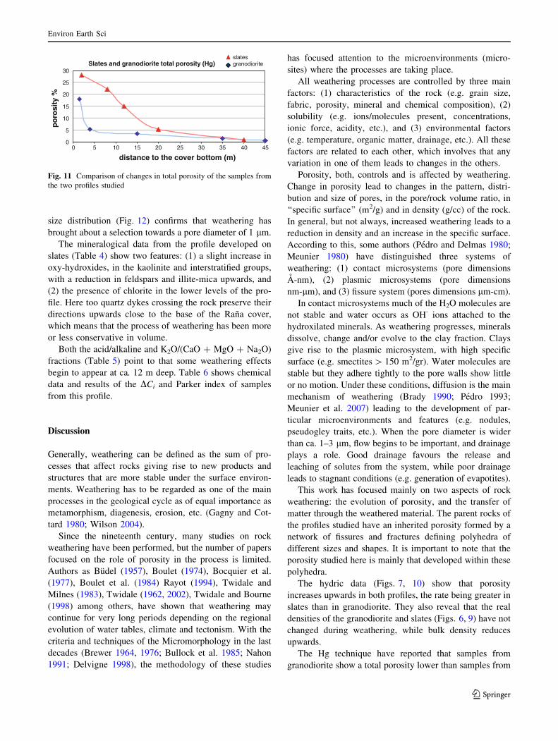
size distribution (Fig. 12) confirms that weathering has
brought about a selection towards a pore diameter of 1 lm.
The mineralogical data from the profile developed on
slates (Table 4) show two features: (1) a slight increase in
oxy-hydroxides, in the kaolinite and interstratified groups,
with a reduction in feldspars and illite-mica upwards, and
(2) the presence of chlorite in the lower levels of the pro-
file. Here too quartz dykes crossing the rock preserve their
directions upwards close to the base of the Rana cover,
which means that the process of weathering has been more
or less conservative in volume.
Both the acid/alkaline and K2O/(CaO ? MgO ? Na2O)
fractions (Table 5) point to that some weathering effects
begin to appear at ca. 12 m deep. Table 6 shows chemical
data and results of the DCi and Parker index of samples
from this profile.
Discussion
Generally, weathering can be defined as the sum of pro-
cesses that affect rocks giving rise to new products and
structures that are more stable under the surface environ-
ments. Weathering has to be regarded as one of the main
processes in the geological cycle as of equal importance as
metamorphism, diagenesis, erosion, etc. (Gagny and Cot-
tard 1980; Wilson 2004).
Since the nineteenth century, many studies on rock
weathering have been performed, but the number of papers
focused on the role of porosity in the process is limited.
Authors as Budel (1957), Boulet (1974), Bocquier et al.
(1977), Boulet et al. (1984) Rayot (1994), Twidale and
Milnes (1983), Twidale (1962, 2002), Twidale and Bourne
(1998) among others, have shown that weathering may
continue for very long periods depending on the regional
evolution of water tables, climate and tectonism. With the
criteria and techniques of the Micromorphology in the last
decades (Brewer 1964, 1976; Bullock et al. 1985; Nahon
1991; Delvigne 1998), the methodology of these studies
has focused attention to the microenvironments (micro-
sites) where the processes are taking place.
All weathering processes are controlled by three main
factors: (1) characteristics of the rock (e.g. grain size,
fabric, porosity, mineral and chemical composition), (2)
solubility (e.g. ions/molecules present, concentrations,
ionic force, acidity, etc.), and (3) environmental factors
(e.g. temperature, organic matter, drainage, etc.). All these
factors are related to each other, which involves that any
variation in one of them leads to changes in the others.
Porosity, both, controls and is affected by weathering.
Change in porosity lead to changes in the pattern, distri-
bution and size of pores, in the pore/rock volume ratio, in
‘‘specific surface’’ (m2/g) and in density (g/cc) of the rock.
In general, but not always, increased weathering leads to a
reduction in density and an increase in the specific surface.
According to this, some authors (Pedro and Delmas 1980;
Meunier 1980) have distinguished three systems of
weathering: (1) contact microsystems (pore dimensions
A-nm), (2) plasmic microsystems (pore dimensions
nm-lm), and (3) fissure system (pores dimensions lm-cm).
In contact microsystems much of the H2O molecules are
not stable and water occurs as OH- ions attached to the
hydroxilated minerals. As weathering progresses, minerals
dissolve, change and/or evolve to the clay fraction. Clays
give rise to the plasmic microsystem, with high specific
surface (e.g. smectites [ 150 m2/gr). Water molecules are
stable but they adhere tightly to the pore walls show little
or no motion. Under these conditions, diffusion is the main
mechanism of weathering (Brady 1990; Pedro 1993;
Meunier et al. 2007) leading to the development of par-
ticular microenvironments and features (e.g. nodules,
pseudogley traits, etc.). When the pore diameter is wider
than ca. 1–3 lm, flow begins to be important, and drainage
plays a role. Good drainage favours the release and
leaching of solutes from the system, while poor drainage
leads to stagnant conditions (e.g. generation of evapotites).
This work has focused mainly on two aspects of rock
weathering: the evolution of porosity, and the transfer of
matter through the weathered material. The parent rocks of
the profiles studied have an inherited porosity formed by a
network of fissures and fractures defining polyhedra of
different sizes and shapes. It is important to note that the
porosity studied here is mainly that developed within these
polyhedra.
The hydric data (Figs. 7, 10) show that porosity
increases upwards in both profiles, the rate being greater in
slates than in granodiorite. They also reveal that the real
densities of the granodiorite and slates (Figs. 6, 9) have not
changed during weathering, while bulk density reduces
upwards.
The Hg technique have reported that samples from
granodiorite show a total porosity lower than samples from
Slates and granodiorite total porosity (Hg)
0
5
10
15
20
25
30
0 5 10 15 20 25 30 35 40 45
distance to the cover bottom (m)
po
rosi
ty%
granodioriteslates
Fig. 11 Comparison of changes in total porosity of the samples from
the two profiles studied
Environ Earth Sci
123

slates; but comparing the trends of this parameter in the
two profiles (Fig. 11), samples from granodiorite show a
marked increase close to the cover bottom. It may be
related to an increase in the clay content within the sap-
rolithe. Moreover, in the granodiorite the Hg porosimetry
(Fig. 8) shows that weathering has caused a fine porosity
with a pore diameter\5 lm, while it has led to a selective
porosity of ca. 1 lm in slates (Fig. 12). Therefore, the
behaviour of the trapped water will be different in the two
profiles (Figs. 7, 10).
Porosities of ca. 1 lm establish the difference between
flow and the absence of flow of water through the fine
pores (Pedro and Delmas 1980; Pedro 1993). In these two
profiles, some water is retained within the fine pores of the
weathered rock, being slightly higher on slates (ca. 5%)
than in granodiorite (ca. 3.5%). Once into the pores, it is
Fig. 12 Changes in pore size distribution in three samples from the SER profile
Environ Earth Sci
123

retained as non-movable water, the rest of which being
leached out throughout the fissures and cracks. According
to Figs. 8 and 12, diffusion can affect the whole profile on
slates due to the fine pores, whereas in the profile on
granodiorite the effects occur higher in the profile, where
pores finer than \5 lm appear.
In both profiles, weathering has led to important trans-
formations in the mineralogical composition, with the
generation of some 2:1 and 1:1 phyllosilicates, and oxy-
hydroxides as new minerals (Tables 1, 4). At the top of the
profile on slates, just beneath the Rana cover, Fe ions
released by weathering are oxidized, most of them
remaining in situ and giving rise to the red hues of this
level. Only along the immediate walls of fissures and
fractures, where flow is possible, do the hues change to
yellowish, greyish, and even whitish, mainly depending on
the chemical and/or biochemical conditions of the solu-
tions. These changes in colour are due to the degree of
hydration of the oxyhydroxides which is also controlled by
the pore space (Tardy and Nahon 1985; Nahon 1991): the
finer are the pores the more dehydrated (more reddish) are
the oxyhydroxides.
Some of the most interesting results obtained concerns
the movement of components through the weathered rocks.
Table 4 XRD data of both the \2 mm and of the \2 lm fractions of samples from the SER profile
From the Rana
bottom
Quartz Feldspar Phyllosilicates
(\2 lm fraction)
Oxyhydr. 1:1 group Illite micas 2:1 group Chlorite Interstr..
Profile SER
2 m xx t xx x xx x x – x
8 m xx x xx t x x x t x
12 m xx x xx t t xx x t t
20 m xx xx xx – t xx t x t
40 m xx xx xx –
– Non-detected, t traces, x frequent, xx abundant
Table 5 Chemical data, matter
lost, and Parker’s index (Iw) of
samples from the SER profile
From Rana bottom SiO2 ? Al2O3/CaO ?
MgO ? Na2O ? K2O
Al2O3 ? Fe2O3/SiO2 K2O/CaO ? MgO ?
Na2O
Profile SER
2 m 20.08 0.47 5.08
8 m 13.95 0.43 2.09
12 m 11.22 0.40 1.01
20 m 9.66 0.41 0.87
40 m 9.40 0.42 0.87
Table 6 Geochemical relationships among the oxides of main components of the SER profile
From Rana
bottom
SiO2% Al2O3% Fe2O3% MnO% MgO% CaO% Na2O% K2O% TiO2% P2O5% Vol%. Matter
lost%
Parker
Iw
Profile SER
2 m DCi 60.80 21.14 7.52 0.01 0.65 0.02 0.00 3.41 0.40 0.09 6.72 32
–18.64 –4.84 –1.41 –0.06 –2.45 –0.27 –1.32 –1.65 –0.11 -0.13 ?0.04 30.85
8 m DCi 60.02 18.70 7.32 0.16 1.84 0.01 0.02 3.77 0.40 0.13 6.20 37
-9.16 -3.33 -0.32 ?0.07 -1.36 -1.26 -1.32 -0.77 -0.04 -0.08 ?0.93 15.4
12 m
DCi
62.94 17.95 7.57 0.08 3.15 0.17 0.27 3.62 0.56 0.11 4.75 40
-6.74 -3.97 -0.12 -0.02 -0.30 -0.15 -1.09 0–95 ?0.10 -0.10 -0.29 14.0
20 m
DCi
60.42 18.52 6.54 0.06 2.84 0.25 1.26 3.82 0.88 0.16 3.85 50
-2.71 -1.61 -0.30 0.00 -0.23 -0.04 -0.13 -0.35 ?0.44 -0.03 -0.64 5.7
40 m 59.18 18.92 6.42 0.06 2.89 0.28 1.31 3.92 0.38 0.19 4.24 62
Environ Earth Sci
123

Using the Grant’s Equation (1) in both profiles, it may be
seen that practically all elements are mobile (Tables 3, 6):
slates have released ca. 30%, and granodiorite at least ca.
12%, without taking into account the upper part of the
profile. This means that at the top of the profiles, slates
have lost up to ca. 800 kg/m3 of matter and granodiorite
more than 300 kg/m3. Moreover, these tables also show
that Parker’s index affords a higher value in granodiorite
than in slates. According to this index, the slates (lower
index) should be more resistant than the granodiorite
(higher index). However, the difference between the two
extremes in both profiles is higher on slates than on
granodiorite, which means that slates have also undergone
a higher degree of weathering.
On the other hand, the geochemical indices (Tables 2, 5)
outline that in both profiles the weathered basement pre-
sents a lower and an upper part, the separation being
located between 4 and 15 m deep in the URC profile, and
between 12 and 20 m deep in the SER profile. Taking into
account that K ions are common in quite resistant silicates
as muscovite and microcline, and that in our profiles the
content in feldspar reduces upwards, the source of this
element will be mainly the micas and interstratified
phyllosilicates.
After the data of Tables 3 and 6, Al, Fe and Na appear
as the main elements lost in samples from the granodiorite,
whereas Si and Al are the main elements lost in samples
from slates. By contrast, data after Tables 2 and 5 point
that Si, Al and K are concentrated upwards in both profiles.
In the profile on granodiorite this apparent contradiction
can be explained due to that many of the dissolved minerals
are plagioclase and biotite which deliver a lot of Si, Al, Na,
Ca, Fe, etc. to the solution. Minerals as muscovite, quartz
and part of the K feldspar remain in a regolith lighter in
density but preserving the parent structures. By contrast, in
the profile on slates the resistant minerals, apart of quartz,
will be K phyllosilicates (e. g. muscovites more or less
weathered and vermiculites) while most of feldspars are
weathered due to their small grain size.
The (Al2O3 ? Fe2O3)/SiO2 fraction is used also to
evaluate the climatic and/or geomorphological meaning of
these profiles. According to Tables 2 and 5, there are not
drastic changes in this relationship through the profiles. But
a typical feature of the tropical and subtropical soils is the
enrichment in 1:1 phyllosilicates (mainly kaolinite) and Fe
oxyhydroxides at the top of the profiles, and here this
enrichment has not any significance except, perhaps, in the
profile on slates. Therefore, according to mineralogical and
chemical data, and to the different indices used here,
weathering affecting the basement looks like to be better
related to the hydrological evolution of the landscape than
having any climatic significance (Molina Ballesteros and
Cantano Martın 2002). For a very long time (at least since
the Pliocene to the lower Pleistocene?) the basement
underwent weathering processes under groundwater con-
ditions, as long as water tables were close to these pied-
mont surfaces. Once the drainage systems start to insert
into the landscape, water tables went down leading to the
weathering mantle outcrops. Where the Rana cover is not
thick (e.g. \3–4 m) pedological and hydrogeological
weathering can contact each other, and the limit between
the two processes is difficult to establish due to the removal
of mater.
This protracted removal of matter from both the profiles
and the landscapes has important consequences. It leads to
subsidence and compaction of sediments (e.g. ponds on the
Rana surface) and, with time enough, to unequal volume
reductions with the reinforcement of differences in the
reliefs (Twidale, 2007).
The two profiles studied here are located not far from
the headwaters of their landscapes, such that they are
zones where leaching is dominant. Under geological
stability for a very long time, the loss of matter has led
to a lowering of the landscape in a fairly homogeneous
way, giving rise to well levelled piedmont platforms and
hills with gentle slopes. Currently, the profiles continue
to evolve, as seen in their persistent humidity even
during dry seasons.
Conclusions
The present work emphasizes the importance of changes in
porosity for the rock weathering. Variations in this
parameter have had significant consequences in the min-
eralogical and geochemical processes studied.
At the same time, weathering has given rise to changes
in pore size distribution within the profiles: it has created a
fine porosity of \5 lm in diameter on granodiorite, but
leading to a selective porosity of ca. 1 lm in diameter on
slates.
Changes in porosity and bulk density (hydric properties)
are related to mineralogical variations and the movement of
matter within the profiles. According to the Grant’s equa-
tion, almost all major elements are moved, either in solu-
tion or carried away within the leached minerals. Assuming
that most of the weathering is isovolume, this loss of matter
can reach up to ca. 800 kg/m3 in slates, and may exceed the
300 kg/m3 in granodiorite in the upper levels of the profiles
studied.
These changes are also related to the generation of new
minerals such as phyllosilicates of the smectite s.l. and
kaolinite s.l. groups and Fe oxy-hydroxides. Smectites
appear in the intermediate level of the weathering in both
profiles while kaolinites lead to be dominant at the top of
the profiles.
Environ Earth Sci
123

There have been two types of weathering working at the
same time: (1) hydrogeological weathering, affecting to the
basement and being more or less conservative for the
inherited structures, and (2) pedological weathering, which
disturbed the inherited structures affecting to the Rana
sediments and to the upper part of the basement.
All these weathering processes are related to the mor-
phological evolution of the region, at least since the Upper
Neogene period, most of them are still active. They have
led to a long-term lowering of the landscape, giving rise to
levelled piedmont platforms and gentle hillside slopes.
They have the potential to explain topographic features in
terms of bedrock porosity and susceptibility to weathering,
and also to the development of various specific land forms
and to landscape evolution.
Acknowledgments The authors acknowledged the interesting sug-
gestions of Prof. C. R. TWIDALE. We also thank the Ministerio de
Educacion y Ciencia of Spain and the Junta de Castilla y Leon for
financial support under Projects CGL2007-62168/BTE (funds
FEDER) and Project SA024A07, respectively.
References
Baumgartner LP, Olsen SN (1995) A least-squares approach to mass
transport calculations using the isocon method. Econom Geol
90:1261–1270
Birot P, Sole Sabaris L (1954) Investigaciones sobre la morfologıa de
la Cordillera Central espanola. Nsto J S Elcano CSIC, Madrid,
p 87
Bocquier G, Rognon P, Paquet H, Millot G (1977) Geochimie de la
surface et formes du relief. II. Interpretation pedologiques des
depressions annulaires entourant certains inselbergs. Sci Geolog
Bull 30(4):245–253
Borger H (1997) Enviromental changes during the Tertiary: the
examples of palaeoweathering residues in Central Spain. In:
Widdowson M (ed) Palaeosurfaces: recognition, reconstruction
and palaeoenviromental interpretation. Geological Society of
London Special Publication n8 120, pp 159–173
Boulet R (1974) Toposequences de sols tropicaux en Haute Volta.
Equilibres et desequilibres pedobioclimatiques. These Sci,
Strasbourg, p 330
Boulet R, Chauvel R, Lucas Y (1984) Les systemes de transformation
en Pedologie. In: Livre Jubilaire du Cinquantrnaire 1934–1984,
Association Francaise pour l’Etude du Sol (AFES), 167–179
Brady NC (1990) The nature and properties of Soils, 10th edn.
MacMillan, New York, p 621
Brewer R (1964) Fabric and mineral analysis of soils. Wiley, New
York, p 462
Brewer R (1976) Fabric and mineral analysis of soils. Robert E.
Krieger Pub. Co, Huntinton, p 482
Brimhall GH, Lewis CJ, Ford C, Bratt J, Taylor G, Waring O (1991)
Quantitative geochemical approach to pedogenesis: importance
of parent material reduction, volumetric expansion and eolian
influx in laterization. Geoderma 51:51–91
Budel J (1957) Die ‘‘Doppelten Einebnungsflachen’’ in den fauchten
Tropen. Zeitschrift fur Geomorphologie, NF 1:201–228
Bullock P, Fedoroff N, Jongerius A, Stoops G, Tursina T, Babel U
(1985) Handbook for soil thin sections description. Waine
Research Publ, Albrighton, p 152
Cantano Martın M, Molina Ballesteros E (1999) La cuenca de Ciudad
Rodrigo y sus bordes. Studia Geol. Salmanticensia, vol esp. N87: La evolucion del relieve en zocalos antiguos. Procesos,
formaciones superficiales y sedimentos asociados. Salamanca,
pp 121–135
Chiquet A, Colin F, Hamelin B, Michard A, Nahon D (2000)
Chemical mass balance on the Toledo granite (Spain). Chem
Geol 170:19–35
Clausell JV, Bastida J, de la Torre J, Ramo P (2001) Balance de
masas en procesos de alteracion sobre pizarras paleozoicas del
Macizo Iberico. Actas III Congr. Iberico de Geoquımica y VIII
Congr. Geoquımica de Espana, Zaragoza, pp 347–350
Delvigne JE (1998) Atlas of micromorphology of mineral alteration
and weathering. Canadian Miner Specl Publ 3:494
Espejo R (1978) Estudio del perfil edafico y caracterizacion de las
superficies tipo Rana del sector Canamero- Horcajo de los
Montes. Tesis Doctoral ETS Ingenieros Agronomos, Madrid.
477 pp (Unpublished)
Espejo R (1987) The soils and ages of the ‘‘Ranas’’ surfaces related to
the Villuercas and Altamira mountain ranges (Western Spain).
Catena 14:399–418
French Standard Norm NF B10 (1973) Mesures de la porosite, de la
masse volumetrique reel et de la masse volumetrique apparente,
Paris 503
French Standard Norm NF B10 (1973) Mesure du Coeficient
d’Absorption d’Eau, Paris 504
Gagny C, Cottard F (1980) Proposition de signes conventionnels pour
la representation de certaines structures magmatiques acquises
au course de la mise en place et de la cristallisation. Comptes
Rendus 105ieme Congres National de la Societe de Savantes,
Caen (Sciences), vol 2, pp 37–50
Gallardo J, Perez Gonzalez A, Benayas J (1987) Paleosuelos de los
pidemontes villafranquienses y de las terrazas pleistocenas de la
region de valle de Henares- Alto Jarama. Boetın Geologico y
Minero 98:27–39
Garcıa Rodrıguez MP (1987) Dinamica del hierro y del aluminio en
suelos desarrollados sobre sedimentos pliocenos del Campo de
Yeltes (Salamanca). Trabajos del Centro de Edafologıa y
Biologıa Aplicada (CSIC), Salamanca, p 98
Garcıa Rodrıguez MP, Corteza Bonin J, Sanchez Camazano M, Prat
Perez L, Lorenzo Martın LP, Ledesma Garcıa M (1977) Suelos
sobre sedimentos postmesozoicos de la zona Yeltes-Huebra
(Salamanca). Anuario del Centro de Edafologıa y Biologıa
Aplicada (CSIC), Salamanca, pp 107–139
Gladfelter BG (1971) Meseta and Campina landforms in Central Spain.
A geomorphology of the Alto Jarama basin. The University of
Chicago. Dept. of Geography, Research Paper n8 130, pp 204
Grant JA (1986) The Isocon diagram. A simple solution to Gresens’
equation for metasomatic alteration. Econ Geol 81:1976–1982
Ingelmo F, Cuadrado S, Hernandez J, Ibanez A (1991) Degradacion
fısica de los suelos de una zona de Ranas de la provincia de
Salamanca. Suelo y Planta 1:619–630
Martın Serrano A (1988) El relieve de la region occidental zamorana.
La evolucion morfologica de un borde del Macizo Hesperico.
Insto. de Estudios Zamoranos ‘‘Florian de Campo’’, CSIC-
Diputacion de Zamora (eds), pp 309
Martın Serrano A (1991) La definicion y el encajamiento de la red
fluvial actual sobre el Macizo Hesperico en el marco de la
geodinamica alpina. Rev Soc Geol Espana 4:337–351
Martınez Lope MJ, Garcıa Gonzalez MT, Molina Ballesteros E (1995)
Relationship between geomorphology and palaeoweathering on
the Hercynian basement in Central Spain: a mineralogical and
geochemical approach. Rev Soc Geol Espana 8:127–136
Meunier A (1980) Les mecanismes de l‘alteration des granites et le
role des microsystemes. Etude des arenes du Massif granitique
de Parthenay (Deux-Sevres). Mem Soc Geol France 140:1–80
Environ Earth Sci
123

Meunier A, Sardini P, Robinet JC, Pret D (2007) The petrography of
weathering processes: facts and outlooks. Clay Miner
42:415–435
Molina Ballesteros E, Cantano Martın M (2002) Study of weathering
processes developed on old piedmont surfaces in Western Spain:
new contributions to the interpretation of the ‘‘Rana’’ profiles.
Geomorphology 42:279–292
Molina E, Cantano M, Vicente MA, Garcıa Rodrıguez P (1990) Some
aspects of palaeoweathering in the Iberian Hercynian Massif.
Catena 17:333–346
Molina E, Garcıa Gonzalez MT, Espejo R (1991) Study of
paleoweathering on the Spanish Hercynian basement. Montes
de Toledo (Central Spain). Catena 18:354–354
Nahon DB (1991) Introduction to the petrology of soils and chemical
weathering. Wiley, New York, p 313
Pardo E, Gallardo J, Perez-Gonzalez A, Gomez-Miguel V (1993)
Variabilidad morfologica de suelos en el piedemonte de la Rana
de la vertiente norte de Montes de Toledo. In: La Rana en
Espana y Portugal, Monografıa n8 2 del Centro de Ciencias
Medioambientales, C.S.I.C., Madrid, pp 149–157
Parker A (1970) An index of weathering for silicate rocks. Geol Mag
107:501–504
Pedraza J (1978) Estudio geomorfologico de la zona de enlace entr las
Sierras de Gredos y Guadarrama (Sistema Central espanol).
Tesis doctoral, Fac. Ciencias Geologicas, Univ. Complutense,
Madrid (unpublished)
Pedro G (1993) Un phenomene normal de la surface de la planete :
l’alteration des roches. In: Vicente Henandez MA, Molina
Ballesteros E, Rives Arnau V, CSIC (eds) Alteracion de granitos
y rocas afines. Madrid, pp 17-50
Pedro G, Delmas AB (1980) Regards actuels sur les phenomenes
d’alteration hydrolitique. Cahiers ORSTOM, (Pedologie)
18(3–4):217–234
Portero JM, Aznar JM (1984) Evolucion morfotectonica y sedimen-
tacion terciarias en el Sistema Central y cuencas limıtrofes
(Duero y Tajo). I Congreso Espanol de Geologıa. Tomo
3:253–263
Rayot V (1994) Alterations du centre de l’Australie: role des solutions
salines dans la genese des silcretes et des profiles blanchis.
Memoires Sciences de la Terre, 22, Ecole de Mines de Paris-
CSIRO Australia, 142 pp
Reiche F (1943) Graphic representation of chemical weathering.
J Sediment Petrol 13:58–68
Ribeiro O (1942) Notas sobre a evolucao geomorfologica da orla
meridional da Cordilheira Central entre Sobreira Formosa e a
fronteira. Bol Soc Geol Portugal 1:123–144
Rives V (1990) Computer program for analyzing nitrogen adsorption
isotherms on porous solids. Absorp Sci Technol 8:95–103
Sole Sabaris L (1952) Geografıa de Espana y Portugal. Tomo 1.
Espana. Geografıa Fısica: El Relieve. Montaner y Simon,
Barcelona, p 500
Swenzner JE (1936) Zur morphologie des Zentral Spanischen
Hochlandes. Geographie Abhandel 3(10):128
Tardy Y, Nahon D (1985) Geochemistry of laterites. Stability of
Al-goethite, Al-hematite and Fe3?-kaolinite in bauxites and
ferricretes. An approach to concretion formation. Am J Sci
285:865–903
Twidale CR (1962) Steepened margin of inselbergs from north-
western Eyre Peninsula, South Australia. Zeitschrift fur Geo-
morphologie 6(1):51–69
Twidale CR (2002) The two stage concept of landform and landscape
development involving etching: origin, development and impli-
cation of an idea. Earth Sci Rev 57:37–74
Twidale CR (2007) Concatenation and resultant inequalities in
denudation. Phys Geogr 28:50–75
Twidale CR, Bourne JA (1998) Flared slopes revised. Phys Geogr
19(2):110–133
Twidale CR, Milnes AR (1983) Slope processes active late in arid
scarp retreat. Zeitschrift fur Geomorphologie 27(3):343–361
Vaudour J (1977) La region de Madrid. Alterations, sols et paleosols.
These Doctorat d’Etat, Ed. Ophris, 1979, pp 390
Vicente MA, Molina E, Espejo R (1991) Clays in paleoweathering
processes: study of a typical weathering profile in the Hercynian
basement in the Montes de Toledo (Spain). Clay Miner 26:81–90
Vicente MA, Elsass F, Molina E, Robert M (1997) Paleoweathering
in slates from the Iberian Hercynian Massif (Spain): investiga-
tion by TEM of clay mineral signatures. Clay Miner 32:435–451
Wilson MJ (2004) Weathering of the primary rock-forming minerals:
processes, products and rates. Clay Miner 39:233–266
Environ Earth Sci
123