
Importance of data and information for users of ocean and coastal space and the role of industry as...
34
EMODnet Sea Basin Checkpoints Stakeholder Conference Importance of data and information for users of ocean and coastal space and the role of industry of users and providers of marine data Dr Valerie Cummins, Feb 2017 GLOBAL CHANGE IN THE COASTAL ZONE FutureEarthCoasts.org
-
Upload
emodnet -
Category
Data & Analytics
-
view
99 -
download
2
Transcript of Importance of data and information for users of ocean and coastal space and the role of industry as...

EMODnet Sea Basin Checkpoints Stakeholder Conference
Importance of data and information for users of ocean and coastal space and the role of industry of
users and providers of marine data
Dr Valerie Cummins, Feb 2017
GLOBAL CHANGE IN THE COASTAL ZONE
FutureEarthCoasts.org

Then…


Now…


now
• Norms for marine data & information
• More sophisticated products and information services
• Implementation of data standards (e.g. Inspire) and greater Interoperability
• Greater accessibility: Multiple use of marine data; Smart phone Apps
• Systems thinking*
• SeaBasins Approach
• Rapid pace of technological change (i.e. sensors; cloud computing; IOT; marine acoustics; drone technology)…
*Case Study: 30 years of LOICZ –
1. Modelling of biogeochemical fluxes to
determine nutrient loading in estuaries and deltas
around the world.
2. The human dimension in the naughties
3. Future Earth Coast – integrating Dynamic
Coast, Human development at the Coast and
Pathways towards Sustainable Development

What is
missing?

The Global Ocean Observation System
According to GOOS, the current
global ocean observing system is
60% complete:Tide gauge stations
Drifting buoys
Tropical moored buoys
Profiling floats
Ships of opportunity
Ocean reference stations
Ocean carbon networks
Dedicated ship support
Data and assimilation subsystems
Management and product delivery
Satellites (SST, Surface topography, wind, colour, sea ice)
Towards a European Ocean
Observation System..
• More integrated – i.e. Systems of systems
• More efficient – i.e. Essential Ocean
Variables (EOVs), long term monitoring,
multiple uses
• More sustainable – i.e. Temporal scales
from hourly to decadal, and spatial scales
from 1km2 to planetary systemFrom Visbeck, Karstensen and Reitz (2015)

Over 6,000 separate bathymetric surveys of all kinds by public authorities in
Europe ex Black and Baltic Seas (mulitbeam, single beam, plummet, unsp).
EMODNet hydrography preparatory action
Drowning in data?
Deficiencies in the political system, plus
supply and use of scientific data, inhibit
effective fisheries management (Daw &
Gray, 2005)
Importance of data and information for users of ocean and coastal space

Importance of data and information for users of ocean and coastal space

�et�cea� ���it�ri�g ENVIRONMENTAL Storm surges Water quality MARINE
BIOTECHNOLOGY Wave pr�pagati��
Chemical characteristics Biological functioning Ecosystems goods and services Seabed Mining
Economics Offshore wind Wave Propagation Predator / Prey interactions Shipping Logistics
Transport MARITIME SURVEILLANCE Security
Ports Human factors Pollution Monitoring
Marine recreation Fisheries Aquaculture
Seaweed Harvesting Social Wellbeing

Mega-trends of the 21st Century
•Growing Population
•Limitations of Neo-Classical Economics
•Energy Scarcity
•Diminished Ecosystem Goods and Services
•Climate Change
•Day et al., 2012
Why is marine data so important …?

The
age of
man…
There is no precedent for the speed and variety of changes underway
today, save perhaps the asteroid impact that ended the reign of
dinosaurs 65million years ago. Callum Roberts, 2012
a new geological epoch – in a single lifetime humanity has become the dominant force

‘Wicked problems are complex, challenging, with multiple feedbacks, are highly uncertain and have ambiguous solutions’
(Rittel & Weber, 1973).
‘Wicked’ problems in The Anthropocene
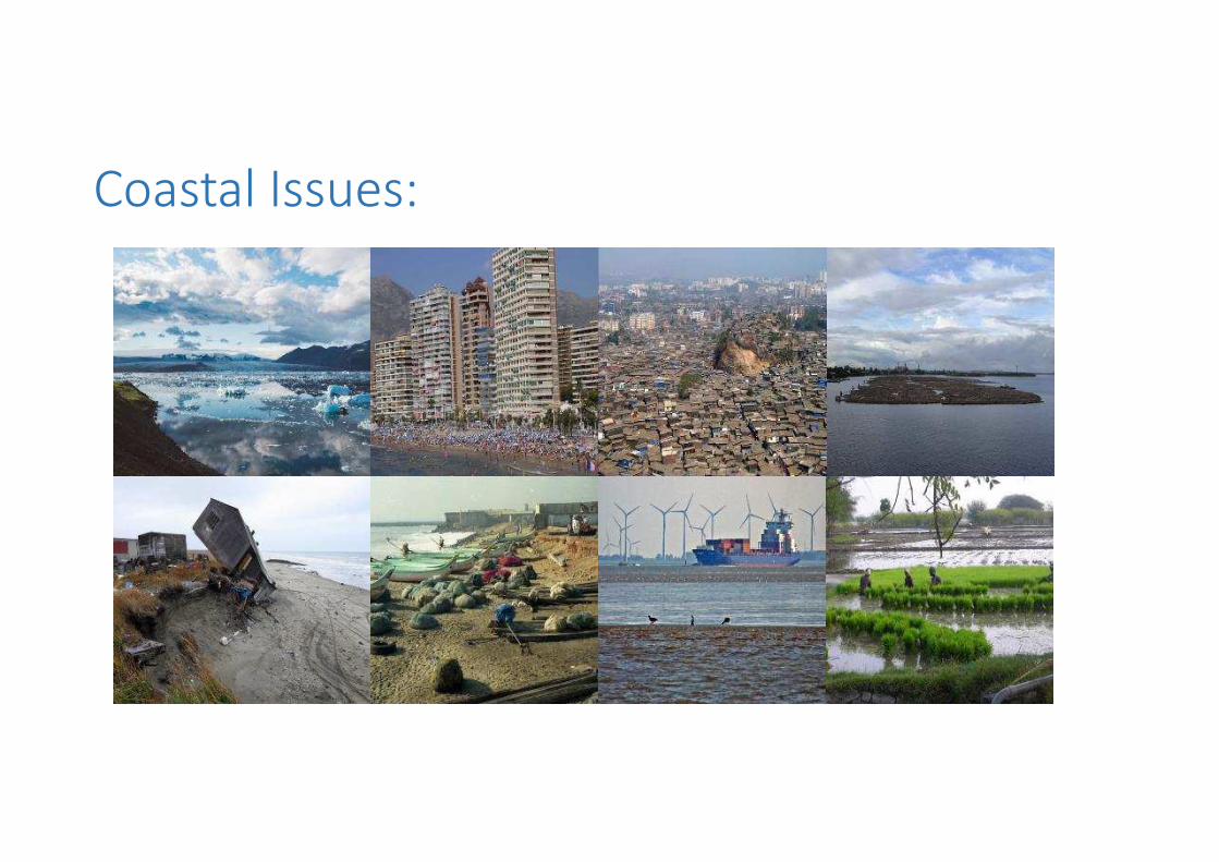
Coastal Issues:


Future…

“The Future is
Blue”Karmenu Vella, Seafest, Cork 2015

Drivers of Blue Growth:-
• Technology developments
(offshore into deeper waters)
• Finite resources (food and energy
scarcity driving exploration in new
frontiers – 71% of the planet)
• Greenhouse Gas emissions –
marine renewables and transport
5.4 million jobs
7 million by 2020

Maritime Spatial Planning Process

The Marine World 2030*
• Strong opportunities for growth • Commercial Shipping (people, economy, natural
resources)
• Ocean Space (economy, natural resources)
• Naval Sectors (driver is economic power)
• Rapid transformation arising from competition & innovation
• Critical need for stability for private sector to invest
Lloyds, Qinetiq, University of Southampton (2015). Global Marine Technology Trends 2030
Status Quo Scenario, Global Commons Scenario, Competing Nations Scenario

What’s next…?
Advanced materials
Big data analytics
Robotics
Sensors
Communications
Shipbuilding
Propulsion & powering
Smart ship
Commercial Shipping
Advanced materials
Big data analytics
Autonomous systems
Human computer interactions
Advanced manufacturing
Energy mgt
Cyber & electronic warfare
Human augmentation
Naval
Advanced materials
Big data analytics
Autonomous systems
Sensors & communications
Carbon capture & storage
Sustainable energy generation
Deep ocean mining
Marine biotechnology
Ocean space
Lloyds, Qinetiq, University of Southampton (2015). Global Marine Technology Trends 2030

Other new norms…?
Content
• More comprehensive data sets on• Plastics in the marine environment• Ocean acidification
• The human dimension• Social science – understanding attitudes and behaviours• Integrating data from social media in the recognised maritime picture
Technology
• IOT (yottabytes of data)
• Communications at sea
• Energy storage as a game changer in • Range and scale of activities over the horizon• Efficiencies and effectiveness of sensor technology e.g. gliders

Industry as users and providers of marine data

What do we mean by industry…

Industry as Users of Marine Data
Start ups
SMEs
MNCs
Inve
sto
rs
Insurers/
certification
bodies
Ships
owners,
builders,
operators
Marine
Mining
Fisheries & Aquaculture
Marine
Tourism
Operators
Marine Biotechnology
Marine
Business
Services
Marine
RenewablesEquipment,
Tech/ Service
Providers
Coastal
Engineering
Port
Operators
Marine
Construction
+ Salvage
Hydrocarbon
Companies
+Decommissioning
1. Cost saving / efficiencies
passed on to the industry as
customer (e.g. survey once;
data sharing)
2. Space for added services –
entrepreneurship –
opportunity for the
commercial sector to
monetise marine data
Manage expectations around
commercial use versus
commercialisation of marine
data….

Maritime & energy
Innovation Space

Industry as Producers of Marine Data
• Private companies collect even more data than public authorities, but these are seldom integrated
• Marine data infrastructure report, (2009).
• Private companies spend €3billion/year on marine data inc. surveys to collect new data, purchasing data from third parties, and processing data until it is fit for purpose
• European Commission Marine Data Infrastructure Framework Service Contract, No. FISH/2006/09 – Lot 2 Final Report Dec 2009

Image: Dr Tom Doyle
Image: Tom Doyle
Fuzzy boundaries - Industry as both users and producers of marine data
Open Data
and
Innovation

OPIN Case Study (Ocean Power Innovation Network)

Conclusions
• Ocean observing is a global priority; Europe can demonstrate leadership
• An enhanced European marine monitoring and observation system must meet the requirements of science, policy, civil society andindustry
• The European opportunity is to build capacity towards both physical infrastructure and institutional innovation

Recommendation
A key concept that can act as a beacon to guide us along the way is ‘interoperability’,
Interoperability of technologies (physical and software interoperability)
Interoperability of data (semantic and logical interoperability)
Interoperability of the people involved (human interoperability and integrated
institutional arrangements).
(adapted from McCormack, (2017) in Bartlett & Celliers, Geoinformatics for Marine & Coastal Management).


![[ID] Week 05 Use Context and Users / Data Collection](https://static.fdocuments.us/doc/165x107/5a649e9a7f8b9a76568b4d97/id-week-05-use-context-and-users-data-collection.jpg)


