IMPORT, EXPORT AND TRANSFORM DRILL DATA - …minemap.com.au/demoqaz/Manuals/DRILLHOLES -...
66
MineMap IMS 2.0 Produced by W.S. Mart and G. Markey For MineMap Pty Ltd Intelligent Mining Software “Solutions” MineMap IMS - Import, Export And Transform Drill Data
Transcript of IMPORT, EXPORT AND TRANSFORM DRILL DATA - …minemap.com.au/demoqaz/Manuals/DRILLHOLES -...

MineMap IMS 2.0
Produced by W.S. Mart and G. MarkeyFor MineMap Pty Ltd
Intelligent Mining Software “Solutions” MineMap IMS - Import, Export And
Transform Drill Data

Intelligent Mining Software “Solutions”MineMap IMS - Import, Export And Transform Drill Data
Copyright © 2014 by William Seldon Mart and Geoff Markey. All rights reserved.
Page 2

Intelligent Mining Software “Solutions”MineMap IMS - Import, Export And Transform Drill Data
Table of Contents
INTRODUCTION....................................................................................................................5
IMPORTING DRILLHOLES................................................................................................7
Fixed Width Text........................................................................................................................ 8
Delimited Text............................................................................................................................. 9
IMS ASCII..................................................................................................................................... 10
IMS CAD....................................................................................................................................... 11
Microsoft Access....................................................................................................................... 12
EXPORTING DRILLHOLES..............................................................................................14
CSV................................................................................................................................................ 15
Desurvey..................................................................................................................................... 16
IMS ASCII..................................................................................................................................... 17
IMS CAD....................................................................................................................................... 18
OPERATIONS.......................................................................................................................19
Merge DHL Files........................................................................................................................ 20
Update DHL Files...................................................................................................................... 21
Convert ASC to CSV.................................................................................................................. 22
Rotate, Translate, Scale.......................................................................................................... 23
Convert Grid System............................................................................................................... 28
FILE FORMATS AND MINEMAP IMS DRILLHOLE FILE CREATION..................30
Fixed Width Text Files............................................................................................................ 30
Page 3

Intelligent Mining Software “Solutions”MineMap IMS - Import, Export And Transform Drill Data
Comma Separated Text Files................................................................................................ 31
MineMap IMS CAD Files.......................................................................................................... 32
Access Database....................................................................................................................... 34
Structure of a Database.......................................................................................................... 35
Creating an Access Database................................................................................................ 36
Connecting to Access............................................................................................................... 39
Selection of Field Data............................................................................................................ 40
Hole Header and Survey Fields........................................................................................... 41
Survey Selection....................................................................................................................... 42
Assay Selection......................................................................................................................... 43
Lithology Fields........................................................................................................................ 45
Geotechnical Structure Fields.............................................................................................. 47
Processing.................................................................................................................................. 49
Raw Data Error Checking.....................................................................................................50
Overlapping Depths................................................................................................................ 51
Negative Thickness................................................................................................................. 51
Negative Depth......................................................................................................................... 52
Survey Record Errors............................................................................................................. 52
Blank Sample Intervals.......................................................................................................... 53
Unused Data............................................................................................................................... 54
Page 4

Intelligent Mining Software “Solutions”MineMap IMS - Import, Export And Transform Drill Data
INTRODUCTION
MineMap IMS can import drillholes from a Microsoft Access database or from text files. MineMap IMS can also export drillholes and perform various operations on existing drillholes. To access the drilhole import/export module use the menu option <Drillholes><Import, Export and Transform...> (Figure 1).
Figure 1: Locating MineMap IMS option
The import/export module displays a bank of buttons that allow you to perform the required operation ().
Page 5

Intelligent Mining Software “Solutions”MineMap IMS - Import, Export And Transform Drill Data
Figure 2: Drillhole conversion dialog box
Page 6

Intelligent Mining Software “Solutions”MineMap IMS - Import, Export And Transform Drill Data
IMPORTING DRILLHOLES
To import a drillhole file select one of the buttons in the Import section of the Drillhole Conversion dialog box (). These buttons allow you to import data in the following formats:
Fixed width text
Delimited text
MineMap IMS ASCII (ASC)
MineMap IMS CAD (SVY)
Microsoft Access (MDB)
Page 7
Intelligent Mining Software “Solutions”MineMap IMS - Import, Export And Transform Drill Data
Fixed Width Text
When you choose the option to Import Fixed Width Text you will be asked to nominate the relevant files to be read (Figure 3).
Figure 3: Importing fixed width text files
A Hole header file is required but the other input files are optional. The output file is also required.
Refer to the examples in the Fixed Width Text Files section for more information.
Page 8

Intelligent Mining Software “Solutions”MineMap IMS - Import, Export And Transform Drill Data
Delimited Text
When you choose the option to Import Delimited Text you will be asked to nominate the relevant files to be read (Figure 3).
A Hole header file is required but the other input files are optional. The output file is also required.
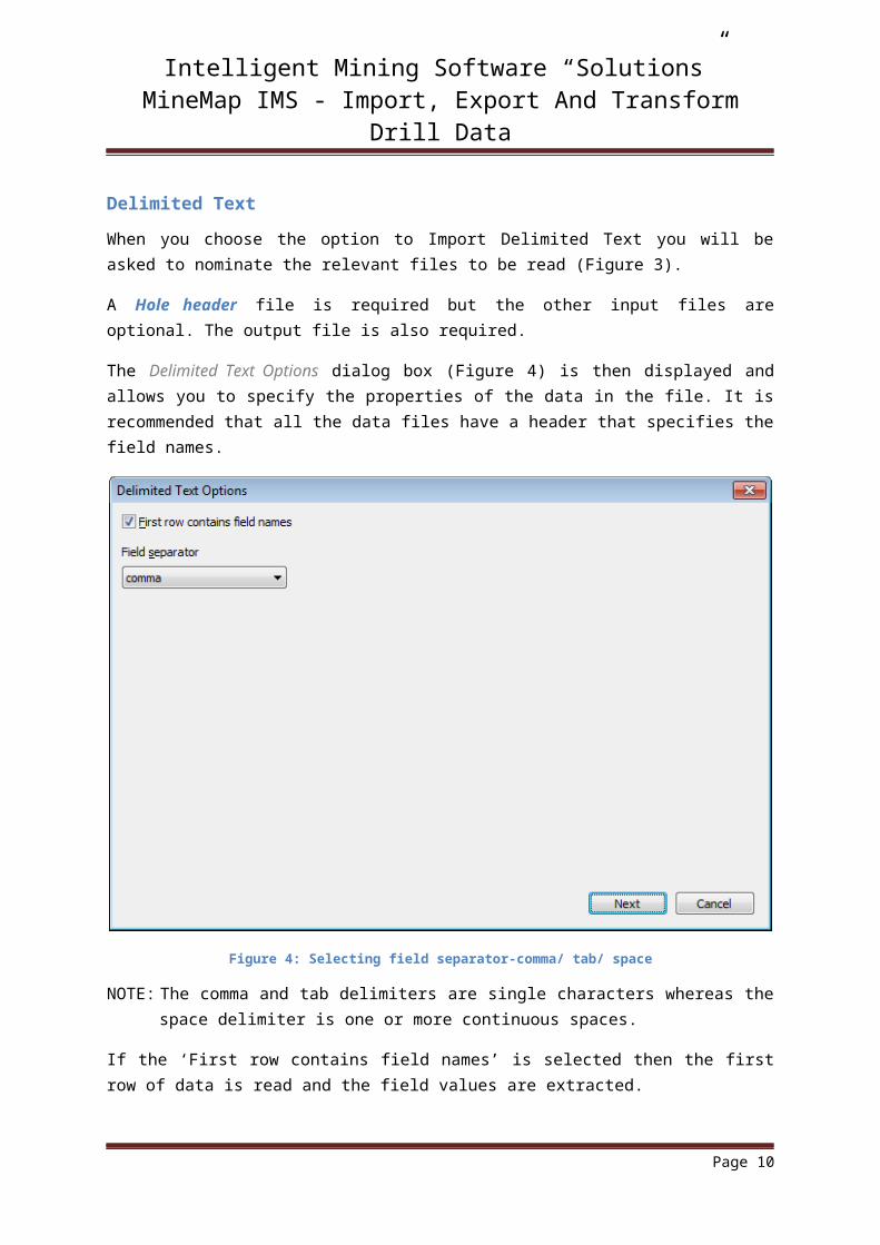
The Delimited Text Options dialog box (Figure 4) is then displayed and allows you to specify the properties of the data in the file. It is recommended that all the data files have a header that specifies the field names.
Figure 4: Selecting field separator-comma/ tab/ space
NOTE: The comma and tab delimiters are single characters whereas the space delimiter is one or more continuous spaces.
If the ‘First row contains field names’ is selected then the first row of data is read and the field values are extracted.
All the dialog boxes that are displayed from this point on are the same as those displayed Fixed Width case. Refer to the examples in the Comma Separated Text Files section for more information.
Page 9
Intelligent Mining Software “Solutions”MineMap IMS - Import, Export And Transform Drill Data
IMS ASCII
This option imports MineMap IMS ASCII drillhole files created in MineMap IMS. It displays the Import ASCII Files To Drillholes dialog box (Figure 5) which allows you to select the required ASCII files by pressing the <Add files...> button. An added input file can be removed from the list by pressing the <Delete> button, after selecting the file. An output file is also required.
Figure 5: Selecting MineMap IMS ASCII files
Page 10

Intelligent Mining Software “Solutions”MineMap IMS - Import, Export And Transform Drill Data
IMS CAD
This option imports special purpose MineMap IMS CAD files. It displays the Import SVY Files To Drillholes dialog box (Figure 6) which allows you to select the required CAD from the default directory. An output file is also required.
Figure 6: Selection of MineMap IMS CAD files
Page 11

Intelligent Mining Software “Solutions”MineMap IMS - Import, Export And Transform Drill Data
Microsoft Access
When this option is chosen, the Data Source dialog box (Figure 7) is displayed. Choose the required Microsoft Access database and the name of the output file.
Figure 7: Browsing database
MineMap IMS then attempts to connect to the specified database. If the connection is successful then the Tables dialog box (Figure 8) is displayed so that you can select the appropriate tables or queries.
Page 12

Intelligent Mining Software “Solutions”MineMap IMS - Import, Export And Transform Drill Data
Figure 8: Selection of tables/queries
Only the Hole header field is required although, in general, the other fields will also be specified. If a field is not required then select ‘Not used’ for that field.
A series of dialog boxes are then presented which allow you to specify which fields in the table correspond to the required fields for each record.
Page 13

Intelligent Mining Software “Solutions”MineMap IMS - Import, Export And Transform Drill Data
EXPORTING DRILLHOLES
MineMap IMS can export drillhole files to CSV or ASCII format files.
To import a drillhole file select one of the buttons in the Export section of the Drillhole Conversion dialog box (Figure 2). These buttons allow you to export data to the following formats:
CSV
Desurvey
IMS ASCII
IMS CAD
Page 14

Intelligent Mining Software “Solutions”MineMap IMS - Import, Export And Transform Drill Data
CSV
This option exports an MineMap IMS drillhole file to comma separated value (CSV) format files containing Hole header, Survey, Assay, Lithology and Geotech structure information. It displays the Export Drillholes To CSV Files dialog box (Figure 9).
Figure 9: Exporting to CSV
Specify the names of the file which will receive the corresponding data. It is recommended that these files should contain information about the field names in the header.
Page 15

Intelligent Mining Software “Solutions”MineMap IMS - Import, Export And Transform Drill Data
Desurvey
This option creates a point data file suitable for use in 3rd party kriging or conditional simulation applications. The point data is composed of the centroid locations for the samples, grade data and stratigraphy.
Select the appropriate parameters from the Export Drillholes To Desurvey Files dialog box (Figure10).
Figure 10: Desurvey a drillhole file
NOTE: To create a file that includes the drillhole name, include the ‘hole name’ as the stratigraphy or a separate field when creating the original DHL file in MineMap IMS.
Page 16

Intelligent Mining Software “Solutions”MineMap IMS - Import, Export And Transform Drill Data
IMS ASCII
This option exports a MineMap IMS drillhole file to an ASCII file. It displays the Export Drillholes To An ASCII File dialog box (Figure 11).
Figure 11: Exporting to ASC
The drillhole file is selected from any directory.
If the conversion is successful then a message box describing the data converted will be displayed.
Page 17

Intelligent Mining Software “Solutions”MineMap IMS - Import, Export And Transform Drill Data
IMS CAD
This option exports a MineMap IMS drillhole file to a MineMap IMS CAD file. It displays the Export Drillholes To A Survey File dialog box (Figure 12).
Figure 12: Exporting to MineMap IMS CAD
The drillhole file is selected from any directory.
If the conversion is successful then a message box will be displayed.
Page 18

Intelligent Mining Software “Solutions”MineMap IMS - Import, Export And Transform Drill Data
OPERATIONS
MineMap IMS can perform various transformations on existing drillhole files as follows:
1. Merge DHL files combines multiple MineMap IMS drillhole files into a single file.
2. Update DHL files converts older MineMap IMS drillhole files to files that are compatible with the current version.
3 Convert ASC to CSV converts drillhole files in the ASCII format to the corresponding CSV format.
4. Rotate, transform, scale converts drillhole files from one grid system to another using a linear transformation specified by rotating, transforming and scaling coordinates.
5. Convert grid system converts drillhole files from one grid system to another using a linear transformation specified by transformation coefficients.
Page 19

Intelligent Mining Software “Solutions”MineMap IMS - Import, Export And Transform Drill Data
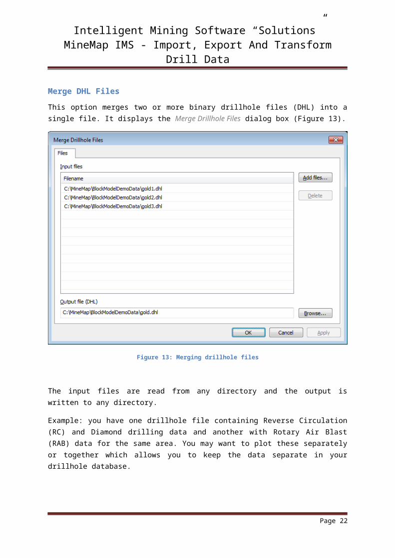
Merge DHL Files
This option merges two or more binary drillhole files (DHL) into a single file. It displays the Merge Drillhole Files dialog box (Figure 13).
Figure 13: Merging drillhole files
The input files are read from any directory and the output is written to any directory.
Example: you have one drillhole file containing Reverse Circulation (RC) and Diamond drilling data and another with Rotary Air Blast (RAB) data for the same area. You may want to plot these separately or together which allows you to keep the data separate in your drillhole database.
Page 20
Intelligent Mining Software “Solutions”MineMap IMS - Import, Export And Transform Drill Data
Update DHL Files
This option updates older (pre v3.06) binary drillhole files to the latest version. New binary drillholes use completely specified coordinates so are independent of the internal datum used by older versions.
Page 21
Intelligent Mining Software “Solutions”MineMap IMS - Import, Export And Transform Drill Data
Convert ASC to CSV
This option exports a drillhole file in ASCII format to CSV format files containing Hole header, Survey, Assay and Lithology. It displays the Convert ASCII to CSV dialog box (Figure 14).
Figure 14: Converting ASC to CSV
Provide names for any files you want to output; it isn’t necessary to provide names for all tables. It is recommended that these files should contain information about the field names in the header.
Page 22
Intelligent Mining Software “Solutions”MineMap IMS - Import, Export And Transform Drill Data
Rotate, Translate, Scale
This option converts data from one grid system to another using a linear transformation based on transforming, rotating and scaling coordinates. It can transform between old imperial or standard map grids (AMG, etc.) and local map/mine grids.
Figure 15: Rotate, translate and scale
In Figure 15 select a reference point and specify the transformation order. This initializes the transformation equations.
Page 23

Intelligent Mining Software “Solutions”MineMap IMS - Import, Export And Transform Drill Data
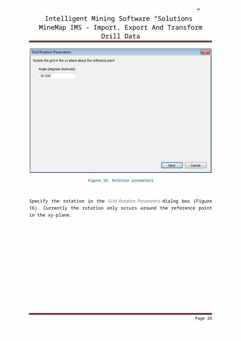
Figure 16: Rotation parameters
Specify the rotation in the Grid Rotation Parameters dialog box (Figure 16). Currently the rotation only occurs around the reference point in the xy-plane.
Page 24

Intelligent Mining Software “Solutions”MineMap IMS - Import, Export And Transform Drill Data
Figure 17: Translation parameters
Specify the translation parameters in the Grid Translation Parameters dialog box (Figure 17). Unlike the angle of rotation, this transformation takes place in three dimensions.
Page 25
Intelligent Mining Software “Solutions”MineMap IMS - Import, Export And Transform Drill Data
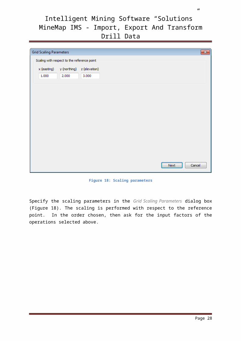
Figure 18: Scaling parameters
Specify the scaling parameters in the Grid Scaling Parameters dialog box (Figure 18). The scaling is performed with respect to the reference point. In the order chosen, then ask for the input factors of the operations selected above.
Page 26

Intelligent Mining Software “Solutions”MineMap IMS - Import, Export And Transform Drill Data
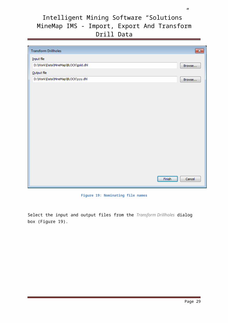
Figure 19: Nominating file names
Select the input and output files from the Transform Drillholes dialog box (Figure 19).
Page 27
Intelligent Mining Software “Solutions”MineMap IMS - Import, Export And Transform Drill Data
Convert Grid System
This option converts drillhole files from one grid system to another using a linear transformation specified by transformation coefficients. These coefficients are derived from the transformation specified in the Transform Drillholes dialog box (Figure 20). To create a transformation, select <New transformation...> and simply enter the northings and eastings for each point in both grid coordinates (Figure 21).
Figure 20: Transforming drillholes
NOTE: The transformation takes place in the xy-plane and does not take elevations into consideration.
Page 28
Intelligent Mining Software “Solutions”MineMap IMS - Import, Export And Transform Drill Data
Figure 21: Creating a new grid transformation
Page 29

Intelligent Mining Software “Solutions”MineMap IMS - Import, Export And Transform Drill Data
FILE FORMATS AND MINEMAP IMS DRILLHOLE FILE CREATION
The following sections have more detailed information about the various file types and the process of importing drillhole data into MineMap IMS.
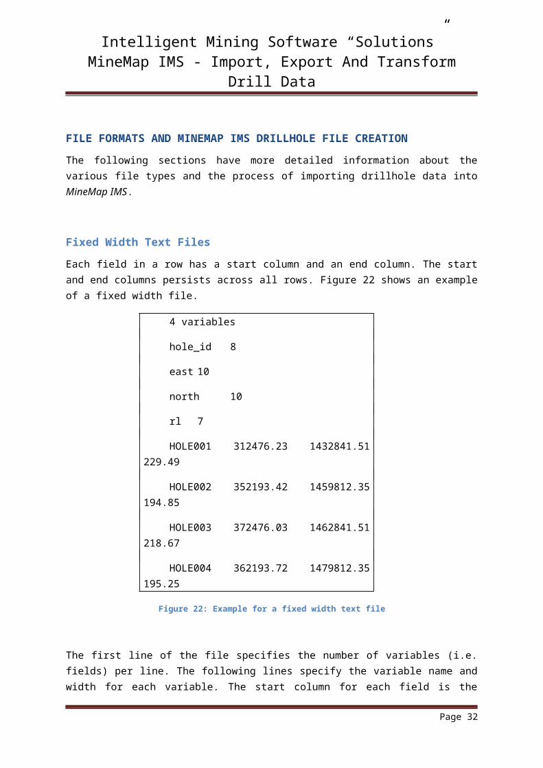
Fixed Width Text Files
Each field in a row has a start column and an end column. The start and end columns persists across all rows. Figure 22 shows an example of a fixed width file.
4 variables
hole_id 8
east 10
north 10
rl 7
HOLE001 312476.23 1432841.51 229.49
HOLE002 352193.42 1459812.35 194.85
HOLE003 372476.03 1462841.51 218.67
HOLE004 362193.72 1479812.35 195.25
Figure 22: Example for a fixed width text file
The first line of the file specifies the number of variables (i.e. fields) per line. The following lines specify the variable name and width for each variable. The start column for each field is the first non-blank character. The data then follows with no end of file characters needed.
If a range of columns are to be ignored simply define a dummy variable name with its width being the number of columns to ignore. The fixed width format can be produced by most database packages or by using a ‘flat file’ macro in a spreadsheet.
NOTE: Micromine drillhole files can be imported directly as fixed width text. The extra information they contain in their header is catered for and can be read without editing.
Page 30

Intelligent Mining Software “Solutions”MineMap IMS - Import, Export And Transform Drill Data
Comma Separated Text Files
Each field is separated by a delimiting character such as a comma, space or tab. An optional header line defining the name of each field can be included. Note that it is not necessary for each field to lie within the same columns from line to line but they must lie between the same pairs of delimiters on each line. An example of a comma separated text file is shown in Figure 23.
hole_id,east,north,rl
HOLE001, 312476.23, 1432841.51, 229.49,
HOLE002, 352193.4, 1459812.3, 194.85,
Figure 23: Example for a CSV file
Data can be written in this format from most spreadsheets. No end-of-file characters are required.
Page 31
Intelligent Mining Software “Solutions”MineMap IMS - Import, Export And Transform Drill Data
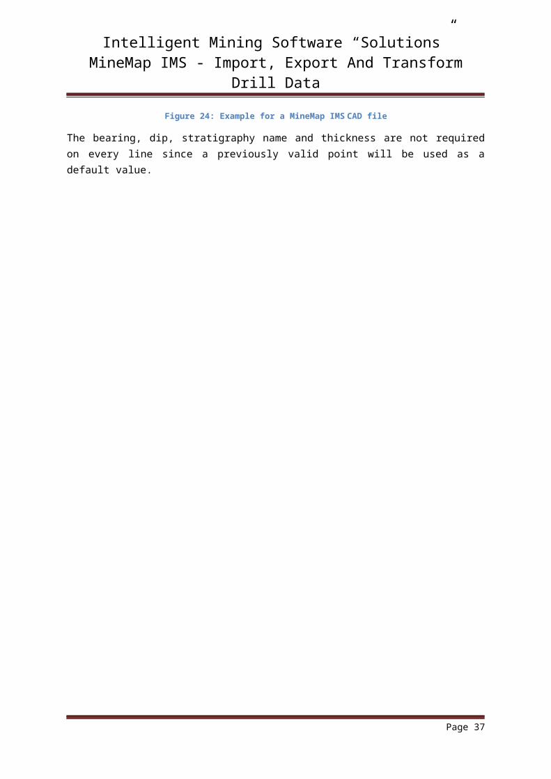
MineMap IMS CAD Files
MineMap IMS CAD files used for importing drillholes are slightly different from regular MineMap IMS CAD files. They include a header line with the number of assays followed, on subsequent lines, by the names of those assays.
The point comment field can contain sample attributes. The attributes are identified by a prefix character. A summary of the attributes that can be stored in the comment field of each point are given in Table 1.
Table 1: Sample attributes in Point comment field
Attribute Character Example Notes
Azimuth B B258.9 Measured from due north. If no azimuth is provided a default of 0.0 is used.
Dip D D-60.0 Measured from the horizontal plane. A dip of -90° corresponds to a vertical hole and is the default if no dip is provided.
Name N NHole01 A character string that is used for the hole name.
Thickness T T1.0 The thickness or length of the sample. The default is 1.0m.
Strat Name S SC1 The stratigraphy name of the sample. The default is C1.
Assays None 4.35 A list of assay values in the order specified in the header line.
Page 32
Intelligent Mining Software “Solutions”MineMap IMS - Import, Export And Transform Drill Data
Figure 24 shows an example of a MineMap IMS CAD file that has been modified for importing drillholes.
2 Assays
AUAV
AS
6777.972 3881.262 195.000 1 NDH001 B270 D-90 T2 0.5 0.2
6912.954 3866.451 195.000 2 NDH002 B270 D-90 T2 0.75 0.5
6783.436 3820.469 195.000 3 NDH003 B270 D-90 T2 1 0.8
6897.347 3815.800 195.000 4 NDH004 B270 D-90 T1 1.25 1.1
6806.837 3775.279 195.000 5 NDH005 B270 D-90 T1 1.5 1.4
6896.564 3745.657 195.000 6 NDH006 B270 D-90 T1 1.75 1.7
Figure 24: Example for a MineMap IMS CAD file
The bearing, dip, stratigraphy name and thickness are not required on every line since a previously valid point will be used as a default value.
Page 33

Intelligent Mining Software “Solutions”MineMap IMS - Import, Export And Transform Drill Data
Access Database
Microsoft Access is a relational database management system for Microsoft Windows. Its ease of use and ability to extensively query the raw data make it an ideal management tool for large drillhole data sets. Data can be imported into Microsoft Access from a variety of sources and can also be exported in a wide variety of formats.
MineMap IMS can import tables and queries from Microsoft Office Access 2000 and above databases which use MDB the extension.
Microsoft, Access and Windows are trademarks of Microsoft Corporation
Page 34

Intelligent Mining Software “Solutions”MineMap IMS - Import, Export And Transform Drill Data
Structure of a Database
In general the minimum fields needed for a drillhole database are the following:
drillhole name
easting and northing coordinates
collar elevation
dip, azimuth and depth
sample from and to
assay value
The structure of a typical database is shown in Figure 25.
PIC00000002
Figure 25: Relationship of tables
In this example the database contains four tables related by the unique drillhole name (hole_id).
Page 35

Intelligent Mining Software “Solutions”MineMap IMS - Import, Export And Transform Drill Data
Creating an Access Database
Frequently the drillhole data is set-up in two files within Microsoft Excel spreadsheets (or equivalent software) since data entry facilities in spreadsheets are usually more user-friendly than database software. Figure 26 shows a Microsoft Excel spreadsheet which contains drillhole collar information.
Figure 26: Hole Header data in MS Excel
In this example the hole_id, easting, northing, rl (reduced level elevation), depth, dip and azimuth have been recorded for each drillhole collar position. In some cases the above data is recorded in two files, one containing the hole_id, easting coordinate, northing coordinate, and rl while the other contains the hole_id, depth, dip and azimuth. The two files are the ‘collar’ file and ‘survey’ file, respectively. This separation is useful where inclined drillholes exist.
Another Microsoft Excel spreadsheet should contain the downhole sampling information for each of the holes listed in the first spreadsheet. Each row records the information for a single assay sample: the drillhole name, depth-from and depth-to.
Page 36
Intelligent Mining Software “Solutions”MineMap IMS - Import, Export And Transform Drill Data
Figure 27 shows a Microsoft Excel spreadsheet which contains the drillhole assay information.
Figure 27: Assay data in MS Excel
NOTE: for every record in the ‘collars’ spreadsheet there may be many samples (i.e. many records in the ‘assays’ spreadsheet).
In addition to collar, survey and assay data there may be lithology data files and geotechnical structure data files.
Figure 28 shows the database window displaying the tables and queries for the Gold Demo Dataset which is part of the MineMap IMS tutorial.
Page 37

Intelligent Mining Software “Solutions”MineMap IMS - Import, Export And Transform Drill Data
PIC00000001
Figure 28: Tables/queries in MS Access
The data can be entered directly or imported from Microsoft Excel spreadsheets by choosing <External Data>Excel. See the Microsoft Access manual for more details.
NOTE: The Microsoft Access tables should be sorted before they can be imported MineMap IMS. To do this, create a ‘select’ query for each of the tables that you want to import. Sort the records in ascending order firstly by ‘hole_id’ for the Collar table and then by ‘from’ in the case of the Assay and Lithology, or by ‘depth’ in the Survey tables. Select these queries to access the data for drillhole creation.
NOTE: See the XLS to MDB manual (XLStoMDB.pdf) for more details.
You can also perform the reverse operation and output data tables or queries from Microsoft Access to Microsoft Excel spreadsheets or text files using <External Data>Export. See the Microsoft Access manual for more details.
Page 38

Intelligent Mining Software “Solutions”MineMap IMS - Import, Export And Transform Drill Data
Connecting to Access
MineMap IMS uses DAO to directly connect to the required database file. It is recommended that no other software should work with the database file at the same time; this includes Microsoft Access.
Page 39

Intelligent Mining Software “Solutions”MineMap IMS - Import, Export And Transform Drill Data
Selection of Field Data
The Tables dialog box (Figure 29) is displayed once the data source has been defined.
Figure 29: selecting the tables/queries
When selecting ‘Lithology’ data you have the choice to use up to five lithology data tables, one for each lithology type. Once the database tables or ASCII text files have been selected on the Tables dialog box, a series of dialog boxes requiring the selection of fields within the nominated tables/files are displayed.
Page 40
Intelligent Mining Software “Solutions”MineMap IMS - Import, Export And Transform Drill Data
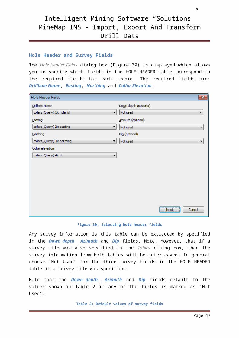
Hole Header and Survey Fields
The Hole Header Fields dialog box (Figure 30) is displayed which allows you to specify which fields in the HOLE HEADER table correspond to the required fields for each record. The required fields are: Drillhole Name, Easting, Northing and Collar Elevation.
Figure 30: Selecting hole header fields
Any survey information is this table can be extracted by specified in the Down depth, Azimuth and Dip fields. Note, however, that if a survey file was also specified in the Tables dialog box, then the survey information from both tables will be interleaved. In general choose ‘Not Used’ for the three survey fields in the HOLE HEADER table if a survey file was specified.
Note that the Down depth, Azimuth and Dip fields default to the values shown in Table 2 if any of the fields is marked as ‘Not Used’.
Table 2: Default values of survey fields
Field Default Value
Downdepth 0.0
Azimuth 0.0
Dip -90
Page 41

Intelligent Mining Software “Solutions”MineMap IMS - Import, Export And Transform Drill Data
Survey Selection
In general all survey records should be specified in a separate SURVEY table instead of the HOLE HEADER table. You will then be presented with the Survey Fields dialog box (Figure 31).
Figure 31: Selecting survey fields
The Drillhole Name field is required but the Down depth, Azimuth and Dip can be set to ‘Not used’ in which case they will be given a default value (Table 3).
Table 3: Default values of survey fields
Field Default Value
Downdepth 0.0
Azimuth 0.0
Dip -90
The data in the survey table must be grouped by hole_id and should be sorted by ascending depth.
Page 42

Intelligent Mining Software “Solutions”MineMap IMS - Import, Export And Transform Drill Data
Assay Selection
The ASSAYS table is required for importing drillholes. The assay fields are specified in the Assay Fields dialog box (Figure 32).
The Drillhole Name, Sample from and Sample to fields are required but the Stratigraphy name field is optional and defaults to ‘C1’.
Figure 32: Selecting assay fields
The data in the assay table must be grouped by hole_id should be sorted in ascending ‘from-to’ order.
Page 43

Intelligent Mining Software “Solutions”MineMap IMS - Import, Export And Transform Drill Data
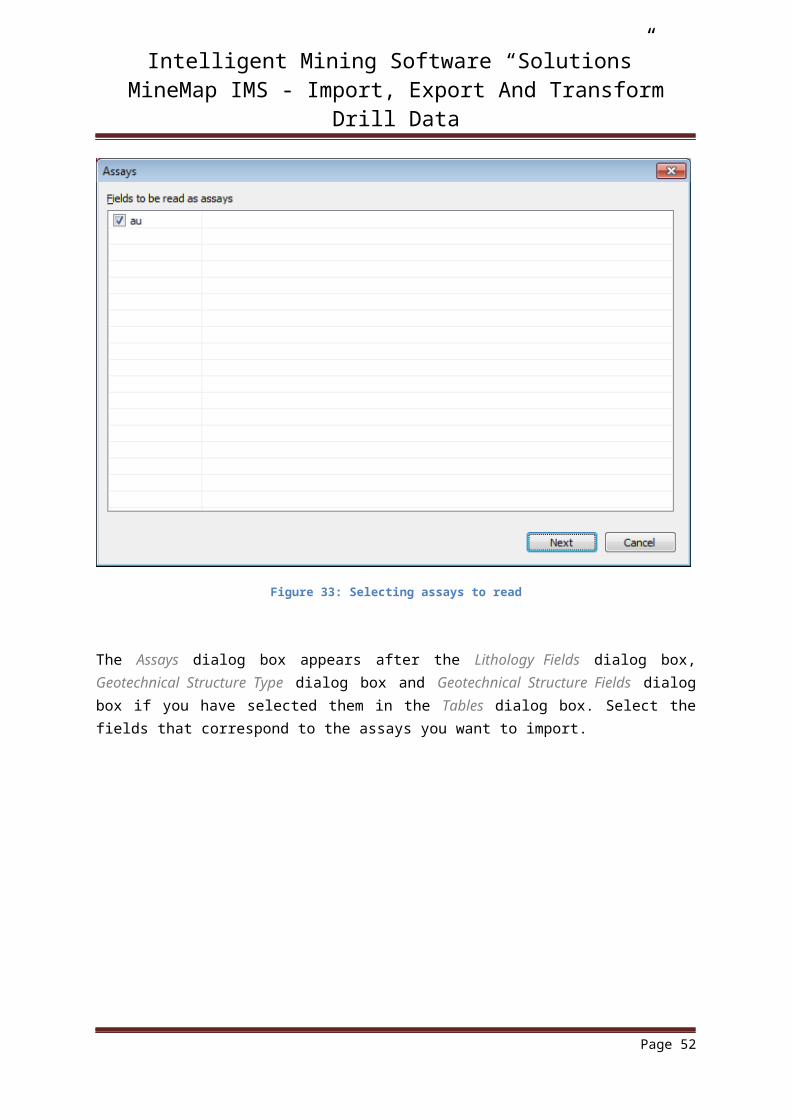
Figure 33: Selecting assays to read
The Assays dialog box appears after the Lithology Fields dialog box, Geotechnical Structure Type dialog box and Geotechnical Structure Fields dialog box if you have selected them in the Tables dialog box. Select the fields that correspond to the assays you want to import.
Page 44

Intelligent Mining Software “Solutions”MineMap IMS - Import, Export And Transform Drill Data
Lithology Fields
Up to five tables can be used when importing data from Microsoft Access with each table corresponding to a different lithology type. The lithology fields are specified in the Lithology Fields dialog box (Figure 34).
Figure 34: Lithology fields
All fields are required and the data must be grouped by hole_id and be in ascending from-to order.
Normally adjacent, matching lithologies are combined but you can output individual lithological records instead by selecting the check box.
Page 45

Intelligent Mining Software “Solutions”MineMap IMS - Import, Export And Transform Drill Data
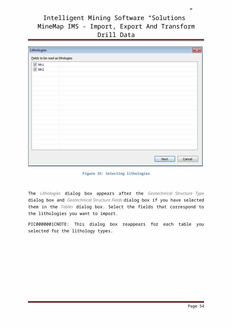
Figure 35: Selecting lithologies
The Lithologies dialog box appears after the Geotechnical Structure Type dialog box and Geotechnical Structure Fields dialog box if you have selected them in the Tables dialog box. Select the fields that correspond to the lithologies you want to import.
PIC0000001CNOTE: This dialog box reappears for each table you selected for the lithology types.
Page 46
Intelligent Mining Software “Solutions”MineMap IMS - Import, Export And Transform Drill Data
Geotechnical Structure Fields
MineMap IMS can import geotechnical structure information. Each record in the geotechnical table consists of an orientation and a comment that are applied at a given depth down a drillhole. MineMap IMS supports two methods for specifying the orientation of a structure record:
1. Dip and direction (azimuth)2. Alpha and beta
This information is specified in the Geotechnical Structure Type dialog box (Figure 36).
Figure 36: Nominating Geotechnical structure type
(1) Dip is measured in degrees below the horizontal plane. The dip direction is the azimuth and is measured in degrees clockwise from due north.
(2) Alpha is the angle between the structure plane and the drillhole axis. Beta is the angle between a reference line (at the top or bottom of the core) and the down-hole apex of the structure ellipse.
NOTE: A drillhole file containing geotechnical structure records is incompatible with older versions of MineMap IMS.
The Geotechnical Structure Fields dialog box (Figure 37) appears if you select dip direction and dip whereas the Geotechnical Structure Fields dialog box (Figure 38) appears if you select alpha and beta.
Page 47

Intelligent Mining Software “Solutions”MineMap IMS - Import, Export And Transform Drill Data
PIC0000000E
Page 48

Intelligent Mining Software “Solutions”MineMap IMS - Import, Export And Transform Drill Data
Figure 37: Selecting geotechnical structure fields for dip direction and dip
Figure 38: Selecting geotechnical structure fields for alpha and beta
Page 49

Intelligent Mining Software “Solutions”MineMap IMS - Import, Export And Transform Drill Data
Processing
When importing data, MineMap IMS checks if the records are sorted by ascending hole name. If the data is sorted then MineMap IMS uses a fast importer to produce the binary drillhole file. Unsorted data can result in a significantly slower import.
MineMap IMS also checks for common errors present in the data (see Raw Data Error Checking).
When processing is complete a summary appears which alerts you to any problems encountered during the import (Figure 39). This same information is available in the error log.
Figure 39: Summary of drill data conversion
Page 50

Intelligent Mining Software “Solutions”MineMap IMS - Import, Export And Transform Drill Data
Raw Data Error Checking
MineMap IMS checks for the following errors in the raw data:
Overlapping Depths
Negative Thickness
Negative Depth
Survey Record Errors
Blank Sample Intervals
If MineMap IMS encounters an error in the raw data it will write the error to the error log and display the Invalid Data dialog box. The invalid data is then ignored and processing continues. It is, therefore, recommended that you check the raw data thoroughly before attempting to create a drillhole file.
Page 51
Intelligent Mining Software “Solutions”MineMap IMS - Import, Export And Transform Drill Data
Overlapping Depths
Overlapping depths arise when one or more records refer to similar depth ranges. Figure 40 shows an example of overlapping depths: the record on row 8 (from = 5, to = 7) overlaps the record on row 7 (from = 6, to = 7).
Figure 40: Assay data set with a depth overlap
NOTE: Data records are numbered such that the header record is record 0 so the data in rows 7 and 8 are records 6 and 7 respectively.
Negative Thickness
Negative thicknesses arise when a ‘from’ value is greater than the corresponding ‘to’ value. Figure 41 shows an example of a negative thickness: the record on row 6 has a ‘from’ value greater than the ‘to’ value.
Figure 41: Assay data set with a negative thickness record
NOTE: Data records are numbered such that the header record is record 0 so the data in row 6 is record 5.
Page 52

Intelligent Mining Software “Solutions”MineMap IMS - Import, Export And Transform Drill Data
Negative Depth
Negative depths arise when the ‘from’ or ‘to’ values are negative. Figure 42 shows an example of negative depth: the record on line 2 has a negative ‘from’ value.
Figure 42: Assay data set with a negative depth record
NOTE: Data records are numbered such that the header record is record 0 so the data in row 2 is record 1.
Survey Record Errors
Survey records must be sorted by depth and must not have negative or duplicate depths. Figure 43 shows an example of survey record errors.
Figure 43: Survey data set with errors
The 5th data record shows it is not sorted in ascending order of ‘depth’. The 7 th data record ‘depth’ is negative and 12th and 13th data records carry the same depth.
NOTE: Data records are numbered such that the header record is record 0.
Page 53
Intelligent Mining Software “Solutions”MineMap IMS - Import, Export And Transform Drill Data
Blank Sample Intervals
The ‘from’ or ‘to’ fields are required and must not be blank. Figure 44 shows an example of blank values.
Figure 44: Assay data set with blank sample intervals
The 6th record contains a blank ‘from’ field while the 10th record contains a blank ‘to’ field.
NOTE: Data records are numbered such that the header record is record 0.
Page 54

Intelligent Mining Software “Solutions”MineMap IMS - Import, Export And Transform Drill Data
Unused Data
In addition to the errors discussed above there are also other conditions which cause ignored data:
1. records with no matching hole header2. data in one or more tables that is not sorted by hole name in ascending from-to order.
Figure 45: Example for summary of unused data
Figure 45 shows there are (4448-4095=) 353 unused assay records and they are not invalid. i.e. Its collar details are not presented in the ‘Hole header’ table or file.
Page 55