Impacts of Population Pressure and Poverty Alleviation … · · 2005-10-26Impacts of Population...
24
AJEAM-RAGEE Volume 10 March 2005 p26-49 26 Impacts of Population Pressure and Poverty Alleviation Strategies on Common Property Resource Availability in Rural Tanzania Ndalahwa F. MADULU Institute of Resource Assessment, University of Dar es Salaam P.O. Box 35097, Dar es Salaam, Tanzania. Tel: +255-22-2410144; Fax: +255-22-2410393; E-mail: [email protected] Abstract: This paper outlines the linkages between population pressure and common property resources availability in Tanzania. It examines on whether population pressure has an influence on diminishing common property resources at the local level and establishes the coping mechanisms of the local communities in response to new circumstances and changing environment. In the course of discussion, an attempt has been made to assess the extent to which population pressure have influenced availability of common property resources at the local level; and identify policy implications and alternatives strategies to cope with diminishing common property resources. Further analysis have been made of the extent to which poverty alleviation strategies at the local level influence non-sustainable use and degradation of common property resources. These issues require a closer examination of the circumstances under which population; development and environment linkages manifest themselves. Whereas the population has shown a continuous increase, there is less information about the rate at which the common property resources are diminishing in response to changing demographic conditions. Similarly, the impacts of various poverty alleviation strategies on diminish common property resources at the local level are not well documented. Small and large-scale mining operations in Mabuki and Maganzo villages has been used as an example to illustrate the transformation in the way local communities use and manage common property resources. The identified long-term implications of the various practices to include increased environmental degradation; accelerated food insecurity, increased poverty, diminishing common property resources, increased land use conflicts, and creation of a landless class at the village level. These implications require policy commitment and support to enable sustainable utilization of common property resources. Key words: Commons property resources, population pressures, poverty, globalization, community conservation, and partnership management
-
Upload
nguyenminh -
Category
Documents
-
view
218 -
download
1
Transcript of Impacts of Population Pressure and Poverty Alleviation … · · 2005-10-26Impacts of Population...
AJEAM-RAGEE Volume 10 March 2005 p26-49
26
Impacts of Population Pressure and Poverty Alleviation Strategies on
Common Property Resource Availability in Rural Tanzania
Ndalahwa F. MADULU
Institute of Resource Assessment, University of Dar es Salaam
P.O. Box 35097, Dar es Salaam, Tanzania.
Tel: +255-22-2410144; Fax: +255-22-2410393; E-mail: [email protected]
Abstract: This paper outlines the linkages between population pressure and common property resources
availability in Tanzania. It examines on whether population pressure has an influence on diminishing
common property resources at the local level and establishes the coping mechanisms of the local
communities in response to new circumstances and changing environment. In the course of discussion, an
attempt has been made to assess the extent to which population pressure have influenced availability of
common property resources at the local level; and identify policy implications and alternatives strategies
to cope with diminishing common property resources. Further analysis have been made of the extent to
which poverty alleviation strategies at the local level influence non-sustainable use and degradation of
common property resources. These issues require a closer examination of the circumstances under which
population; development and environment linkages manifest themselves. Whereas the population has
shown a continuous increase, there is less information about the rate at which the common property
resources are diminishing in response to changing demographic conditions. Similarly, the impacts of
various poverty alleviation strategies on diminish common property resources at the local level are not
well documented. Small and large-scale mining operations in Mabuki and Maganzo villages has been
used as an example to illustrate the transformation in the way local communities use and manage common
property resources. The identified long-term implications of the various practices to include increased
environmental degradation; accelerated food insecurity, increased poverty, diminishing common property
resources, increased land use conflicts, and creation of a landless class at the village level. These
implications require policy commitment and support to enable sustainable utilization of common property
resources.
Key words: Commons property resources, population pressures, poverty, globalization, community
conservation, and partnership management
AJEAM-RAGEE Volume 10 March 2005 p26-49
27
1. Introduction
The World Commission on Environment and Development in 1987, challenged the international
community and national governments to work towards a sustainable future that will broaden, not
contract, the choices future generations will have to make. This call was amplified by the United
Nations General Assembly which called for a balance between population and environment
capacities in order to make sustainable development possible, keeping in mind the links between
population levels, consumption patterns, poverty and the natural resource base (UNFPA, 1991).
The emphasis was directed towards addressing the relationship between demographic pressures
on the one hand, and non-sustainable consumption patterns on the other. These arguments
suggest the need to examine the linkages between changes in the demographic conditions and
those in the Common Property Resources (CPRs). The task here is to: re-examine the
population/resource imbalances; correct inefficient and wasteful use of resources; and seek
optimal strategies that can ensure access of the local communities to CPRs.
Garrett Hardin defined the “commons “to mean any resource which is shared by a group of
people (Hardin, 1968). It is on the basis of this definition that the concept of Common Property
Resources has been developed to mean the resources that are shared and jointly managed by the
local communities in general. Common Property Resources (CPRs), therefore refer to those
resources in which a group of people has co-equal use rights, especially rights that exclude the
use of these resources by other people. (Oström 1986). Examples of CPRs include the air we
breathe, the water we drink, new land for farming and grazing, fish from the sea, and wood for
fuel and housing. Following the logic of the commons, each community member has the right to
share the resources from the common resource pool.
The concept of Common Property Resources (CPRs) describes the dynamics in which people
establish and respect community-based management rules regarding natural resource use and
development (CIEL, 2002). Evidence gathered elsewhere suggests that local communities have
for many years being able to protect their common property resources on a sustainable manner
by using locally designed and commonly agreed by-laws and procedures that benefit all
stakeholders (McNeely and Ness, 1996; Kauzeni and Madulu, 2000). Through adaptation to their
AJEAM-RAGEE Volume 10 March 2005 p26-49
28
local environments, local communities developed a well understanding of their CPRs and how to
sustainably manage them through their own established regulations.
Population growth and the resultant human activities have been viewed as generating pressures
to the natural resource base in general and CPRs in particular. This statement is demonstrated by,
among others, the rapid decline in vegetation cover, pollution of common water sources, and
increased pressure on traditional grazing areas. Although this view dominates, different
communities have dealt with the management of their CPRs in different ways. Despite the fact
that many local communities has for a long time contributed to the conservation and protection
of CPRs, only recently their importance in natural resource management and the need for benefit
sharing are been recognized (McNeely and Ness, 1996; URT, 1998a). Analysis of the people’s
perceptions of the socio-economic pressure on coastal forest resource use and management in
Tanzania, for example, show no direct responsibility on the part of the local communities for the
maintenance and protection of the coastal forests because the local communities do not consider
the resources to belong to them. The denial of access to CPRs perpetuates negative perceptions
among the local communities that natural resources are a liability to them rather than an asset.
Discussing the importance of local communities in biodiversity and environmental conservation,
McNeely and Ness (1996) argued for the need to respect, preserve, and maintain knowledge,
innovations, and practices of indigenous and local communities embodying traditional lifestyles.
Efforts to put this approach into practice in Tanzania are getting momentum, though still at a
very limited level.
Recent trends have shown diminishing trends in CPRs due to population pressure and the various
human actions. Large areas of land, forests, mineral deposits, wildlife, and water resources have
been depleted, leading to serious environmental problems. Similarly, various resource use
conflicts have emerged and are, to a larger extent, triggered by population pressure, and the
neglect of the local communities’ interests in the CPR management strategies. This
complementary relationship between humans and CPRs necessitates consideration of the end
user of the CPRs in any discussion of resource management issues.

AJEAM-RAGEE Volume 10 March 2005 p26-49
29
For a long time the Tanzanian government has considered itself the sole manager of all natural
resources obtainable in the country. This is in total contradiction to policy documents and
statements which state that the government holds the natural resources in trust (CIEL, 2002). The
concept of trust assumes that the trustee is supposed to manage the said property in the best
interests of the beneficiary until such time the beneficiaries are capable of managing their
property themselves. However, for the government, this self-evident truth has always been
equated to total ownership because the policies and laws of the country do not define what trust
means, the functions of the trustee and the obligations of the trustee to the beneficiary.
This paper discusses how population pressure and policy changes have influenced changes in the
CPRs in the rural setting, and how local people’s lifestyles are being molded by population
pressure, changes in the CPR accessibility as influenced by changing land uses and the
emergence of new economic opportunities like mining at the local level. Using the case of
Mabuki and Maganzo villages in Mwanza and Shinyanga regions, respectively, the paper
demonstrates that various demographic and policy changes that have occurred over time have
had implications on the nature and extend of CPR accessibility and use patterns. The paper
argues that the expansion of agriculture activities and emergence of mining activities that has
expended into the traditional grazing and farming areas, has to a larger extent affected
accessibility of local communities to their CPRs at the local level.
2. Population pressure and CPR conservation
The link between population pressure and CPRs could be traced back to Malthus1 in 1798 who
argued that there are diminishing returns to additional labour to land (Wilber, 1978). Malthus
viewed population increase to cause declines in agricultural output and impoverishment of land
resources. Boserup looked at population pressure as a driving force towards intensive land uses
and technological change (Boserup, 1965). She viewed population pressure as a force that
stimulates adoption of new techniques that enable more frequent cultivation, hence, greater
output. In Boserup’s views increased population pressure is an impelling force to agricultural
1 Thomas Malthus launched the population economic growth debate in 1798 with the proposition that population, when unchecked, increases in geometric ratio, and subsistence increase only on arithmetical ratio (Wilber, 1978).

AJEAM-RAGEE Volume 10 March 2005 p26-49
30
intensification. However, the Boserup hypothesis has been criticized for failing to consider the
effects of inadequate public policy on agricultural development. Hardin (1968) argued that as the
population grows and resources decline, the commons collapses and ends in "the tragedy of the
commons".
The increase in population may lead to expansion of farm lands, decline of grazing land, and
conflicting resource uses emerge. As a result, the impacts on the common resource poor
increases in the form of deforestation, land fragmentation, overgrazing, water scarcity and land
degradation. Such features reduce the carrying capacity of the land and the capability of the
CPRs to meet the needs of the present and future population.
Different policies affect farming systems and the impact is aggravated by population pressure,
leading to degradation of common property resources including land at the local level. Evidence
from Machakos (Kenya) seem to suggest that population pressure in an agricultural areas
stimulates changes in farming and income generating systems and reverse the degradation
process towards sustainable resource management (Tiffen et.al, 1994). Yet the World Bank
views population pressure as a major hindrance to economic development and a cause of
environmental damage (World Bank, 1989). These contradicting views necessitate a closer look
into the linkages between population dynamics and natural resource conservation, including
CPRs at the micro-level.
The linkage between population, environment, and natural resources exploitation can, thus, be
demonstrated by the association between consumption, technology used, and population. In order
to gain some sense of the contribution of population growth to CPR depletion, a review of the
IPAT Model developed by Ehrlich and Ehrlich (1990) is important. The formula for the model is
explained as I = PAT, Where I is the Impact on the environment, P is the population (absolute
size, growth rate, distribution), A stands for affluence (usually measured as GNP per capita), and
T refers to the technology in use (amount of pollution per unit of GNP). This model
demonstrates that environmental impact (I) is a joint function of population (P), affluence (A),
and technology (T). For any given type of technology, any given level of consumption, any level
of poverty, the more people there are, the greater is the turn, on remaining resources. Although
AJEAM-RAGEE Volume 10 March 2005 p26-49
31
not enough is known about the complex relationships between population and resources, this
model demonstrates that economic development cannot continue if key resources are depleted
(UNFPA, 1991).
Human beings use the environment in three basic ways: as a resource bank – the environment
supplies them with raw materials needed to maintain their existence, and their social and
technological structures; as a habitat – people require more space per individual than any other
species; and as a sink for wastes – human beings produce more waste than other species. It
should be emphasized that population concerns are central to the sustainability of CPRs, because
the more people there are on the earth, the greater the impact on the environment and pressures
on the CPRs. The increasing population pressure on common property resource at the household
and community levels could be demonstrated by the rate of land fragmentation, deforestation,
and land use conflicts, especially between agriculture on the one hand, and livestock keeping and
mining on the other. These features demonstrate a significant deterioration of the common
property resource pool. For example, the rapid technological change in Kwimba District from
the hand hoe to an ox-plough and tractors led to increased capacity to cultivate and increased
demand for arable land. Consequently, agricultural expansion has been directed to areas that
were traditionally used for communal grazing. It can therefore be argued that population pressure
is a driving force to diminish CPRs and increased resource use conflicts at the local level.
The underlying assumption here is that increases in human population stimulate competing
interests resource uses. Expansions of ecological threshold of the human population, for
example, often occur at the expense of range management, hence, decreasing the carrying
capacity of CPRs in (Meerteens et al, 1995). Examining the demographic settings around major
conservation areas of Tanzania, It has been argued that the impact of man and his activities on
the environment has translated itself into a new emphasis on planning with ecological
integration. Shishira and Yanda (1998) observed that almost all Forest Reserves in Tabora
Region were encroached in the form of opening up of new farms and settlements, clearing of
forests for agricultural and lumbering activities. Similar features were noted in and around the
Swagaswaga Game Reserve in Kondoa District (Madulu, 2001). These threats necessitate an
AJEAM-RAGEE Volume 10 March 2005 p26-49
32
integrated land use management strategy, which take on board the interests of the local
population.
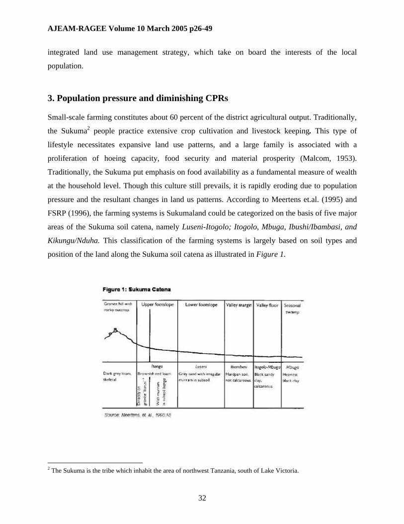
3. Population pressure and diminishing CPRs
Small-scale farming constitutes about 60 percent of the district agricultural output. Traditionally,
the Sukuma2 people practice extensive crop cultivation and livestock keeping. This type of
lifestyle necessitates expansive land use patterns, and a large family is associated with a
proliferation of hoeing capacity, food security and material prosperity (Malcom, 1953).
Traditionally, the Sukuma put emphasis on food availability as a fundamental measure of wealth
at the household level. Though this culture still prevails, it is rapidly eroding due to population
pressure and the resultant changes in land us patterns. According to Meertens et.al. (1995) and
FSRP (1996), the farming systems is Sukumaland could be categorized on the basis of five major
areas of the Sukuma soil catena, namely Luseni-Itogolo; Itogolo, Mbuga, Ibushi/Ibambasi, and
Kikungu/Nduha. This classification of the farming systems is largely based on soil types and
position of the land along the Sukuma soil catena as illustrated in Figure 1.
2 The Sukuma is the tribe which inhabit the area of northwest Tanzania, south of Lake Victoria.

AJEAM-RAGEE Volume 10 March 2005 p26-49
33
Meertens et.al (1995) gave the major characteristics of each of the major parts of the Sukuma
soil catena. The Luseni-itogolo dominated farming system is characterised by poor quality soils
dominated by sandy loam. The Itogolo plain farming system is dominated Itogolo soils, which is
relatively fertile. The Mbuga plain dominated farming systems dominated by mbuga soils (black
cotton soils) which are very fertile in nature but are regularly flooded. The Ibushi dominated
farming system is dominated by the Ibushi soils which are among the most fertile soils in the
lake zone. Such soils are characterised by good chemical fertility, good workability and free of
flooding risks. However, these soils are easily eroded. The Kikungu/Nduha farming system is
characterised by relatively steep sand slopes that make them susceptible to erosion and nutrient
losses.
These characteristics were very fundamental is determining the land use patterns and the location
of various crops grown by the local population. The rapid increase of the population was
consequently accompanied by a significant departure from the traditional practices, hence
abandoning the indigenous knowledge that was used to determine land use and land management
systems over time.
Subsistence farming which is the dominant farming system in Sukumaland is labour intensive
and time consuming. Malcom (1953) described the wealthiest man in Sukumaland as the man
with the largest family because a large family means more hoes which spell grain and other
material wealth. He viewed food production to the fundamental measure of riches in Sukumaland
where agriculture is considered to be an occupational identity and source of social prestige
(Madulu, 1998). Similar observations were noted in Bunda District (Kauzeni and Madulu, 2000)
and Urambo District (Melamari et.al, 2003) where the number of wives and children are
considered to be important source of labour and an indicator of family wealth. According to the
1978, 1988 and 2002 population censuses, Mwanza and Shinyanga Regions were the most
populous regions in Tanzania (Table 1).
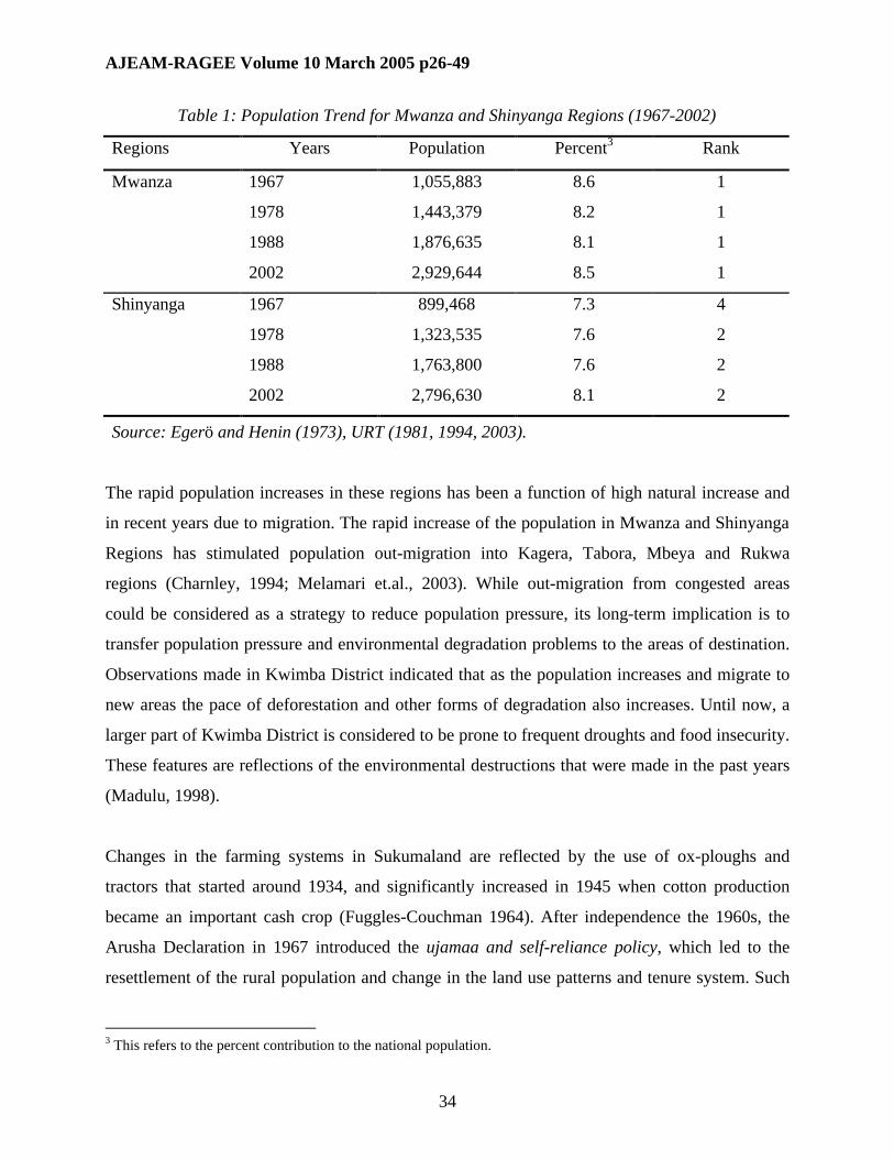
AJEAM-RAGEE Volume 10 March 2005 p26-49
34
Table 1: Population Trend for Mwanza and Shinyanga Regions (1967-2002)
Regions Years Population Percent3 Rank
1967 1,055,883 8.6 1
1978 1,443,379 8.2 1
1988 1,876,635 8.1 1
Mwanza
2002 2,929,644 8.5 1
1967 899,468 7.3 4
1978 1,323,535 7.6 2
1988 1,763,800 7.6 2
Shinyanga
2002 2,796,630 8.1 2
Source: Egerö and Henin (1973), URT (1981, 1994, 2003).
The rapid population increases in these regions has been a function of high natural increase and
in recent years due to migration. The rapid increase of the population in Mwanza and Shinyanga
Regions has stimulated population out-migration into Kagera, Tabora, Mbeya and Rukwa
regions (Charnley, 1994; Melamari et.al., 2003). While out-migration from congested areas
could be considered as a strategy to reduce population pressure, its long-term implication is to
transfer population pressure and environmental degradation problems to the areas of destination.
Observations made in Kwimba District indicated that as the population increases and migrate to
new areas the pace of deforestation and other forms of degradation also increases. Until now, a
larger part of Kwimba District is considered to be prone to frequent droughts and food insecurity.
These features are reflections of the environmental destructions that were made in the past years
(Madulu, 1998).
Changes in the farming systems in Sukumaland are reflected by the use of ox-ploughs and
tractors that started around 1934, and significantly increased in 1945 when cotton production
became an important cash crop (Fuggles-Couchman 1964). After independence the 1960s, the
Arusha Declaration in 1967 introduced the ujamaa and self-reliance policy, which led to the
resettlement of the rural population and change in the land use patterns and tenure system. Such
3 This refers to the percent contribution to the national population.

AJEAM-RAGEE Volume 10 March 2005 p26-49
35
changes necessitated expansions of farmlands into the communal grazing areas as most of the
high lands were distributed to new villagers for residential plots.
4. Availability and use of CPRs in Ng’wakilyambiti Village
Ng’wakilyambiti village is located about 42 km on the South-west of Ngudu town, in Kwimba
District. The village originated from Nera chiefdom, which was headed by Chiefs, and assisted
by sub-village headsmen (Wanangwa). Each sub-chiefdom had a Mwanangwa who was
responsible for the day to day management and administration of development issues. This
administrative or institutional structure of the village was changed during the villagization period
of 1974. Although no major boundaries changes were effected after villagization, people from
scattered hamlets and settlements were pulled into the concentrated administrative units, the
village. Every household was given a plot to build a house for residence, disregarding the
traditional land tenure systems on the basis of the Sukumaland soil catena (FSRP, 1996;
Meertens et.al., 1995). Currently, the total land area of the village is 3980 hectares. Table 2
shows the population trends and growth rates in Ng’wakilyambiti village.
Table 2: Population Size and Growth Rates for Ng’wakilyambiti Village (1978-2002)
Population Years
Males Females Total
Growth Rates Sex Ratios
1978 1,020 1,175 2,195 - 87
1988 1,153 1,214 2,367 0.8 95
2002 1,437 1,594 3,0314 1.8 90
Sources: URT (1981, 1992).
The village population increased from 2,195 in 1978 to 2,267 people in 1988 and and 3,031 in
2002. These population figures indicate that the village had a growth rate of 0.8 percent between
1978 and 1988, 1.8 percent between 1988 and 2002. The relaxation of the villagization
4 Draft Village Statistics for the 2002 Population and Housing Census as given by the Central Census Office, National Bureau of Statistics, 2004.

AJEAM-RAGEE Volume 10 March 2005 p26-49
36
regulations in the mid-1980s enabled people to move back to their former settlements (mahame),
hence, creating new sub-villages headed by sub-village chairmen (Kitongoji).
There is a clear divide of the highland areas that are dominated by luseni soils, and the low-lying
areas dominated by the mbuga soils. There are few areas that are reserved for forestry, though
they are dominated by scattered bushes and thorny thickets. A large part of the village is mbuga
(considered to be fertile) and luseni soils (comparatively sandy and less fertile). The mbuga areas
were mostly used for grazing purposes in the past, but they have been transformed into major
maize, sorghum, paddy, and cotton cultivation. Paddy is increasingly replacing cotton as a cash
crop mainly due to unreliable marketing systems and low prices for cotton. Due to increasing
population pressure, and the importance of rice as a source of household income, most of the
traditional communal grazing areas in the village are been transformed into farmland leading to
more land use conflicts.
Observations from Ng’wakilyambiti village in Kwimba District indicate that livestock keepers
have been squeezed by agricultural expansion to the extent of causing cultural change and
significant land use conflicts in the village. Most livestock keepers in the Ng’wakilyambiti
village do spare grazing areas within their own farms for their livestock, as no one would allow
some one’s livestock to graze in his/her farm without a prior agreement or consent of the
landlord. This situation has been reached because of the disappearance of the communal grazing
areas, most of which have been
transformed into farms at the
expense of extensive free rage
grazing practises as illustrated
in Figure 2. Such changes in
the land use have been
instigated by population
pressure at the local level hence
demand for more land for
agricultural purposes (Madulu
1998).

AJEAM-RAGEE Volume 10 March 2005 p26-49
37
Historical tales demonstrate the presence of dense forest cover in the village in the past. The
village name itself originated from a story of two women who were attached, killed, and eaten by
hyenas during day time in 1980s. This is an indication that the area was forested and inhabited by
wildlife.
None of these features exist today because a large part of the village land has been cleared and
cultivated. The village has recorded a significant transformation in the agricultural technology.
Changes in farming system and technology in Ng’wakilyambiti village have occurred in three
different phases: Phase One was marked by the dominance of the hand hoe where farms were
small and located around homes. Phase Two was characterized by the introduction of tractors
and use of inorganic fertilizers5. Phase Three was dominated by the use of ox-ploughs which
replaced tractors and the hand hoe. Many farmers who were using hand hoes (igembe), machetes
(ipanga) and the axe (mbasa) to clear the land before ploughing, are currently using ox-ploughs
and ox-weeders. The village administration reported to have 350 ox-ploughs and 334 oxen in
2000 alone. Such a big number of ox-ploughs necessitate expansive farming especially in the flat
mbuga areas, which were the common grazing areas in the past. This situation has caused
remarkable shortage of pasture, and stimulating out-migration of livestock keepers. Given the
various changes described above (i.e. technological, demographic, economic, ecological, and
climatic), changes in land use patterns and availability of CPRs in the village are inevitable.
Another indicator of degradation of the common property resources in the village is the recurrent
food shortages, which are mainly caused by repeated drought and poor farming practices. The
repeated drought in the village could probably be a continuation of impacts of past excessive
deforestation practices 1920s when tsetse eradication campaigns were implemented by the
colonial administration (Tanganyika, 1958). Since 1997, the village has experienced significant
out-migration of residents to Kahama and Urambo Districts in Shinyanga and Tabora regions,
respectively. The main causes of out-migrations include scarcity of grazing areas, scarcity of
arable land, and recurrent food shortages (Madulu, 1998; Melamari et.al., 2003). These reasons
signify the diminishing common property resources in the village leading to landlessness, land
use conflicts, and out-migrations.
5 This phase didn’t last long because it was expensive to maintain the tractors.
AJEAM-RAGEE Volume 10 March 2005 p26-49
38
Traditionally, land was distributed and utilised according to customary inheritance rules and
procedures based on family and community solidarity (Wilemski 1994). In most cases
communities spared communal land for grazing purposes. Under the Sukuma culture homesteads
are normally located on the upper side of the Sukuma catena which is characterized by rock
outcrops (Meertens et al. 1995). Crop farming was largely done in the Luseni, Ikungu and Nduha
parts of the catena, leaving the water-logged mbuga areas (characterized by alluvial black soils)
for seasonal grazing. This system is no longer viable as most of the mbugas have been
transformed into cotton, maize, and rice farms. These areas are been considered to be the only
remaining frontiers for agricultural expansion purposes.
It can be argued that due to rapid population increase, the traditional land tenure and
management systems have been eroded. This situation is further exacerbated by the expanding
market economy and emergence of non-farm activities like mining, which compete with
agriculture for land. The emergence of diamond mining in Mabuki and Maganzo villages in
Kwimba and Shinyanga District, respectively, have intensified the degradation of common
property resources at the village level, and has increased the problem of landlessness and land
use conflicts, especially between livestock-keepers, cultivators and miners (Madulu, 1998;
2004). Though the Villagisation Act (URT, 1975) accorded the village governments the
responsibility of distributing land, the principles of traditional tenure systems still remained
strong.
4. Emerging mining activities and diminishing CPRs
A number of sectoral policy reforms have been initiated in Tanzania in recent years. These
include policy changes in the mining, agriculture, investment, health, education, local
government reforms, and changes in the political arenas. The purpose of these reforms is to
encourage local communities’ involvement and to increase efforts towards sustainable
development through facilitation of small-scale economic activities including mining.
Mabuki and Maganzo villages are an old traditional village that occupies a strategic position
along the Mwanza-Shinyanga trunk road. Maganzo is also strategically located adjacent to the
Williamson Diamond Mine at Mwadui. Although the majority of the population in these villages

AJEAM-RAGEE Volume 10 March 2005 p26-49
39
identify themselves as farmers, there is a significant increase of population involved in small-
scale diamond mining. Over 90 per cent of households in Mabuki village identify land scarcity as
a major obstacle to agriculture expansion. Increasing utilization of land for diamond mining has
facilitated this problem. Table 3 shows the Mabuki and Maganzo population and growth rates
between 1978 and 2002.
Table 3: Population Size and Growth Rates for Mabuki Village (1978-2002)
Population
Villages
Years
Males Females Total
Growth
Rates
Sex Ratios
1978 1,842 1,825 3,667 - 101
1988 2,761 2,387 5,148 3.4 116
Mabuki 2002 4,281 4,293 8,574 3.6 100
1978 1,312 1,401 2,713 - 94
1988 1,884 1,958 3,842 3.5 96
Maganzo 2002 3,846 2,803 6,649 5.5 137
Sources: URT (1981, 1992, 2004).
The population data for both settlements show significantly high growth rates during the 1978/88
and 1988/02 inter-censual periods. In Mabuki village, the population increased from 3,667 in
1978 to 5148 in 1988, and 8,574 in 2002. In Maganzo, the increase was from 2,713 people in
1978 to over 6,000 people in 2002. The observed population increases and growth rates were
largely contributed by the mushrooming mining industry which attracted many migrants into the
villages. This is demonstrated by the high sex ratio of 116 for Mabuki in 1988 and 137 for
Maganzo in 2002, suggesting a sex selective migration in favor of men. Diamond mining at
Mabuki started as far as 1922 before the opening of the famous Williamson Diamond Mines at
Mwadui in 1940s. It was observed in Mabuki that over 60 percent of the small-scale miners in
1992 were migrants (Madulu, 1998).
There are three main types of mining operations, namely: small, medium and large-scale mining.
The first type is the small-scale mining which is largely dominated by a large number of poor,
livelihood-seeking migrants. The second type is the medium-scale mining which is dominated by
AJEAM-RAGEE Volume 10 March 2005 p26-49
40
outsiders, often regional government officials who have gained access to mining land through
their positions, and hire small-scale miners to pan for them. Most medium-scale miners are
absentee miners who employ small-scale migrant miners to work for them. The third type is the
large-scale mining which is mostly dominated by foreign investors using mechanised mining
techniques. In most cases the negotiations for mining rights done by the medium and large scale
miners are done at without involving the local people. They bypass the local community in their
efforts to obtain mining permits.
Large scale diamond mining has been operating in Mwadui near Maganzo since 1940s.
However, this type of mining was abandoned in Mabuki after establishing the Mwadui Mine. In
both settlements, however, small-scale mining have been flourishing in recent decades. The
coming of large-scale mining in Mabuki increased the risk of both farmers and small-scale
miners loosing their land and mining sites (Madulu 1998). These groups are not consulted when
their land is been allocated to a large-scale miner. In many cases, peasants are required to accept
nominal compensation to their properties, which exclude land anyway. This implies that, the
local communities have no say in determining the fate of their properties and the level of
compensation to their common property resources. In other words, the introduction of large and
small-scale mining operations in these villages have accelerated the diminishing and degradation
pace for the CPRs The linkage between small-scale mining and degradation of CPRs is largely
reflected in the utilization of grazing and farming lands for mining purposes.
Large and medium-scale miners neither pay equitable compensation to the villagers for the loss
of their land taken for mining activities, nor to the village administration for the destruction of
the village environment. Small and medium-scale diamond miners dig large holes and leave
moonlike appearances covered with piles of sand and rocks and pits which are rarely
rehabilitated after the mining operations (Figure 3).
Similar and even more dangerous features are found where small-scale gold mining activities are
conducted in Geita, Bukombe and Kahama Districts (Yanda et.al. 2000). The presence of large-
scale miners in the village has sparked a number of conflicts over land use, water and grazing
areas (Madulu, 2004). The dominance of migrants within the mining community raises a

AJEAM-RAGEE Volume 10 March 2005 p26-49
41
question of access and
ownership of land. The
miners access to land is
highly variable, ranging from
official permission from the
national ministry responsible
for mining or regional
government office, to
unofficial purchases from
local farmers, villagers
mining on their own land,
and villagers assigning plots
to migrant miners with agreement of sharing the proceeds (Madulu, 1998). All these strategies
have implications on the sustainability of CPRs at local levels as no resources are re-invested in
the village to improve their status and rehabilitate the destructed environment.
Small-scale miners’ diamond sales are usually very arbitrary. There is no centralized marketing
system in the village. Diamonds originating in the two villages are sold without any form of
taxation or loyalty to the village. The lack of diamond tax revenues means that almost nothing
from the diamond is re-invested in the village social service and productive infrastructure. This
implies that instead of contributing to the social and economic wellbeing of the local
communities, small-scale mining is seriously undermining the villages’ development through
widespread degradation of the village CPRs and environments. First, mining is resulting in poor
and old villagers being pushed off their land through private sale of mining plots and government
allocation of mining blocks. Second, mining pulls the youth labor out of agriculture and livestock
keeping through involvement in mining activities as independent miners or hired laborers. The
absence of youth in agriculture deprives the sector a vital source of labour. Thirdly, mining
activities destroy the environment and accelerates land use diversification at the expense of
agriculture and livestock keeping. Lastly, mining activities increases the risks of food insecurity
through increased population pressure and reduced arable land and agricultural production.

AJEAM-RAGEE Volume 10 March 2005 p26-49
42
These adverse effects require immediate policy interventions for the benefit of the future
generations and their environments.
5. Institutional and legal frameworks for the management of CPRs
One way of ensuring sustainable use of CPRs is to have legal recognition of the CPR and
community based property rights (CIEL, 2002). This will provide assurance that local
communities will benefit better from the investment they make in terms of time and labor to
protect the CPRs. It will also provide authority to the local people to prevent non-sustainable
utilization of the CPRs through local enforcement of management regulations. The formal
recognition of the community based CPRs and property rights by is desirable and can help to
ensure that CPRs are respected, and sustainably managed and utilized in pursuit of the public
interest.
Although there are many laws and regulations that aim at protecting the use of various natural
resources, little efforts have been made to ensure that CPRs are recognized and sustainably
managed. For example, the Wildlife Conservation Act No. 12 of 1974 (URT, 1974) which is the
major guiding document in relation to wildlife conservation have many loopholes that deprived
local communities access to their traditional CPRs. In most cases villagers are not given
alternative sources of CPRs whenever a new wildlife conservation area is created. Moreover, the
various institutions established to manage natural resources have deliberately excluded local
communities in the planning and management of the resources including CPRs from which they
drive their day to day needs.
Though it is commonly agreed that local communities are indispensable managers of the
common property resources, their exclusion in the resource management could better explain the
observed dwindling of CPRs in many parts of Tanzania. Through their indigenous knowledge,
experience and management systems, the Sandawe6 people of Kondoa District who are hunters
and bee keepers provide us lessons to demonstrate that local communities could, on their own
initiatives, sustainably manage and maintain their ecosystems by ensuring a dynamic ecological
6 Traditionally, the Sandawe people are hunters and beekeepers; hence, they needed the forests for their own survival.
AJEAM-RAGEE Volume 10 March 2005 p26-49
43
equilibrium and the continuous availability of essential common CPRs to the stakeholders
(Madulu, 2001). For the Sandawe people who largely depend on availability of forests and
wildlife for their livelihood both as hunters and bee-keepers, the issue of sustainable use and
management of natural resources including CPRs is a matter of survival.
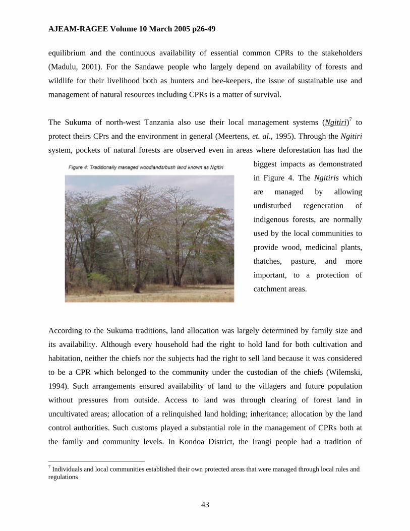
The Sukuma of north-west Tanzania also use their local management systems (Ngitiri)7 to
protect theirs CPrs and the environment in general (Meertens, et. al., 1995). Through the Ngitiri
system, pockets of natural forests are observed even in areas where deforestation has had the
biggest impacts as demonstrated
in Figure 4. The Ngitiris which
are managed by allowing
undisturbed regeneration of
indigenous forests, are normally
used by the local communities to
provide wood, medicinal plants,
thatches, pasture, and more
important, to a protection of
catchment areas.
According to the Sukuma traditions, land allocation was largely determined by family size and
its availability. Although every household had the right to hold land for both cultivation and
habitation, neither the chiefs nor the subjects had the right to sell land because it was considered
to be a CPR which belonged to the community under the custodian of the chiefs (Wilemski,
1994). Such arrangements ensured availability of land to the villagers and future population
without pressures from outside. Access to land was through clearing of forest land in
uncultivated areas; allocation of a relinquished land holding; inheritance; allocation by the land
control authorities. Such customs played a substantial role in the management of CPRs both at
the family and community levels. In Kondoa District, the Irangi people had a tradition of
7 Individuals and local communities established their own protected areas that were managed through local rules and regulations

AJEAM-RAGEE Volume 10 March 2005 p26-49
44
conserving ritual areas where circumcision ceremonies and other rituals were conducted.
However, this tradition has increasingly been degrading largely due to lack of political and
institutional support and population pressure. Lindberg, (1996) equated this type of destruction to
erosion of both the environment and people’s culture.
There are conflicting interests in the management of CPRs at various levels. While the national
government on the one hand considered CPRs to belong to the nation, local communities and
villagers consider CPRs to be theirs. Significant attempts have been made to ensure participatory
and demand-driven management of CPRs. Through the new Water Policy (URT, 2002), for
example, the emphasis has been put on ensuring community and private sector involvement in
the operation and maintenance of water schemes through the Water User Groups (WUG)
approach. Moreover, the National Forest Policy (URT, 1998a) and the National Wildlife Policy
(URT, 1998b) both emphasize on local community and stakeholder participation in forest and
wildlife conservation through joint management agreements between all stakeholders.
These examples suggest that a productive partnership that ensures direct benefits to all
stakeholders need to be put in place in order to alleviate poverty and minimize CPR use conflicts
and harmonization of stakeholders’ interests.. This is true, especially when the value of the local
communities’ indigenous knowledge is recognised. The suggested approaches could flourish if
local communities are considered to be protection managers/partners as well as beneficiaries of
their own environments and resources (Kauzeni and Madulu, 2000). This means instituting
community-based approaches to CPRs conservation. This calls for partnership management to
ensure communal benefit, and sustainable utilization and management of resources especially in
areas where the management of CPRs have been significantly affected by population pressure.
6. Conclusion
This paper has discussed the impacts of population pressure and policy changes on CPRs
availability and sustainable management. It has illustrated that conflicting interests and changing
management systems has in many cases led to diminishing CPRs base. Examples from mining,
agricultural and pastoral communities have been cited to demonstrate the influence the changing
policies, and the implications on the welfare of the local communities. The degradation of CPRs

AJEAM-RAGEE Volume 10 March 2005 p26-49
45
especially arable land and pasture is accelerated by rapid population increase which stimulates
agricultural expansion to meet the population needs.
In many areas local communities have adopted various poverty alleviation strategies, some of
which have also facilitated the erosion of CPRs at the local levels. The expansion of agricultural
practices into the traditional grazing areas, the involvement in mining activities, the
diversification of cropping patterns, and migration, all are considered to be poverty alleviation
strategies. In many cases, however, these strategies are implemented without proper
environmental protection approaches. It has been argued that various activities that are taking
place in the name of poverty alleviation actually deplete the CPRs at the local level. Such
experiences stimulate resource use conflicts and competition, which occur at the expense of the
local communities’ welfare and sustainable development.
Expansion of mining activities in farmlands and communal grazing areas, for example, increases
environmental degradation and fear of losing land among local communities. Due to such fears,
prospective land sales and non-sustainable mining operations among the small-scale farmers
have increased. The long-term implications of these practices include accelerated food
insecurity, development of a landless class among rural communities, accelerated poverty, and
rapid degradation of the environment. The examples cited in this paper illustrate that local
communities are capable of established institutional and legal frameworks that could facilitate
sustainable use and management of CPRs. These traditional legal and institutional frameworks
were very effective in the past, but have largely been affected by population pressure and lack of
political will and support. As a result, many of the traditional resource management systems have
been rendered ineffective, hence, are non-functional.
The paper concludes that while population pressure increases the risk of disappearance of most
CPRs, involving local communities in the planning and management of such resources is of
prime importance, and could trigger sustainable conservation and development at the grassroots
level. In all respects, local communities need to be considered as equal partners and their interest
be given due importance. The paper calls for an integrated approach that could reconcile the
interests of all stakeholders, including local communities in managing and benefiting form the

AJEAM-RAGEE Volume 10 March 2005 p26-49
46
CPRs through. This means that community participation is a precondition for successful and
sustainable CPRs use and management. The paper also calls for political and legal support in the
efforts to manage common property resources at all levels. Such support could facilitate the
harmonization of stakeholders’ interests and minimize resource use conflicts and the impacts
emanating from rapid population increase.
8. References
Boserup, E. (1965), The Conditions of Agricultural Growth: The Economics and Agrarian
Change Under Population Pressure, George Allen and Unwin Ltd., London. Chicago
University Press, Chicago.
Charnley, S. (1994), Cattle, Commons, and Culture: The Political Ecology of Environmental
Change on a Tanzanian Rangeland, Unpublished Ph.D. Thesis, Stanford University
Centre for International Environmental Law (2002), Amplifying Local Voices, Striving for
Environmental Justice, Proceedings of the African Public Interest Law and Community-
Based Property Rights Workshop, Usa River, Arusha Tanzania, 1st-4th August 2000.
Egerö, B. and R.A. Henin (1973), Mortality, in Egerö, B. and R.A. Henin (eds) The Population
of Tanzania: An Analysis of the 1967 Population Censuis, Vol. 6, Bralup and Bureau of
Statistics, Dar es Salaam, (pp. 176-185).
Ehrlich, P.R. and A.H. Ehrlich (1990), The Population Explosion, Simon and Schuster, New
York.
Farming Systems Research Programme (1996), State of the Art 1992-1996, Lake Zone
Agricultural Research and Training Institute, Ukiriguru, Mwanza.
Fuggles-Couchman, N.R. (1964), Agricultural Changes in Tanganyika: 1945-1960, Food
Research Institute, Stanford University, Stanford, California.
Hardin, G. (1968), The Tragedy of the Commons, Journal SCIENCE, No. 162:1243-1248.
Kauzeni, A.S. and N.F. Madulu (2000), Review of Development Programmes/Projects in Bunda
District, Consultancy Report to SIDA, Dar es Salaam.
AJEAM-RAGEE Volume 10 March 2005 p26-49
47
Lindberg, C. (1996), Society and Environment Eroded: A Study of Household Poverty and
Natural Resource Use in Two Tanzanian Villages, Geografiska Regionstudier Nr. 29,
Uppsala.
McNeeley, J.A. and Ness, G. (1996), People, Parks and Biodiversity: Issues in Population-
Environment Dynamics, In: Dompka, V. (ed.). Human Population, Biodiversity and Protected
areas: Science and Policy Issues, AAAS Program on Population and Sustainable
Development.
Madulu, N.F. (1998), Changing Lifestyle in Farming Societies of Sukumaland: The Case Study
of Two Villages in Kwimba District, Tanzania, De-Agrarianization and Rural Employment
Network, Working Paper Vol. 27, Afrika-Studiecentrum, Leiden.
Madulu, N.F. (2001), Population Dynamics and Sustainable Conservation of Protected Areas in
Tanzania: The Case of Swagaswaga Game Reserve in Kondoa District, READ No. 2,
Uppsala University, Sweden .
Madulu, N.F. (2004), Digging for a Living in Tanzania: Migration, Farming Traditions and
Current Mining Pursuits in the Lake Victoria Basin, Tanzania Economic Trends, Vol. 17 No.
1 pp. 37-50
Malcolm, D.W. (1953), Sukumaland: An African People and Their Country, International
African Institute, Oxford University Press, London.
Melamari, L. Madulu, N.F. and Isinika, A. (2003), Baseline Study in the Uyumbu Pilot WMA in
Urambo District, Volume 3: Uyumbu Report, Wildlife Division, Dar es Salaam.
Meertens, H.C.C, L.J. Ndege and H.J. Enserink (1995), Dynamics in Farming Systems: Changes
in Time and Space in Sukumaland, Tanzania, Royal Tropical Institute, Amsterdam.
Oström, E. (1986) How Inexorable is the 'Tragedy of the Commons?' Institutional Arrangements
for Changing the Social Structure of Social Dilemmas, Presented at a Distinguished Faculty
Research Lecture, Office of Research and Graduate Development, Indiana University.
Shishira, E.K. and P.Z. Yanda (1998), An Assessment and Mapping of Forest Resources in Part
of Tabora Region, Tanzania, Using Aerial Photography, Research Report, Ministry of
Natural Resources and Tourism, Dar es Salaam.

AJEAM-RAGEE Volume 10 March 2005 p26-49
48
Tanganyika (1958), Tanganyika African Population Census, 1957: Analysis by Sex and Age for
Provinces, Districts and Territorial Census Areas, East African Statistical Department, Dar es
Salaam.
Tiffen, M., M. Mortimore and F. Gichuki (1994), More People Less Erosion: An Environmental
Recovery in Kenya, John Wiley & Sons, West Sussex, England.
United Nations Fund For Population Activities (1991), Population, Resources and the
Environment: The Critical Challenges, UNFPA, New York.
United Republic of Tanzania, (1974), The Wildlife Conservation Act, 1974. The Gazette of the
United Republic of Tanzania, Vol. LV. Nov. 1974.
United Republic of Tanzania (1975), Sheria ya Kuandikishwa Vijiji vya Ujamaa, Ofisi ya Waziri
Mkuu na Makamu wa Rais, Idara ya Maendeleo ya Ujamaa na Ushirika, Dodoma.
United Republic of Tanzania (1981), 1978 Population Census: Population by Age and Sex for
Villages/Wards and Urban Areas, Bureau of Statistics, Dar es Salaam.
United Republic of Tanzania (1992), 1988 Population Census, Mwanza Regional Profile, The
1988 Census Reports, Takwimu - Bureau of Statistics, Dar es Salaam, Tanzania.
United Republic of Tanzania (1994), 1988 Population Census, National Profile: The Population of
Tanzania – An Analytical Report, Bureau of Statistics, Dar e s Salaam.
United Republic of Tanzania, (1998a). National Forest Policy, Ministry of Natural Resources
and Tourism, Government Printers, Dar es Salaam.
United Republic of Tanzania, (1998b), National Wildlife Policy, Ministry of Natural Resources
and Tourism, Government Printers, Dar es Salaam.
United Republic of Tanzania, (2002). National Water Policy, Ministry of water and Livestock
Development, Dodoma.
United Republic of Tanzania, (2003), 2002 Population and Housing Census – Age and Sex
Distribution (Vol. II), Central Census Office, National Bureau of Statistics, Dar es Salaam.
Wilber, K.C. (1978), Population in western economic theory, Populi, Vol. 5, No.3 (pp. 14-29).

AJEAM-RAGEE Volume 10 March 2005 p26-49
49
Wilemski, E.A. (1994), 'The Land Question and Peasants in East Africa, Hemisphere: Studies on
Cultures and Societies, No. 9, pp. 121-149.
World Bank (1989), Sub-Saharan Africa: From Crisis to Sustainable Growth (A long-term
Perspective Study), The World Bank, Washington.
Yanda, P.Z., Shishira, E., Madulu, N.F., and Kauzeni, A.S. (2000), Survey and Mapping of Land
Use/Land Cover and Erosion Hazards in Lake Victoria Hazards, Lake Victoria
Environmental Management Project (LVEMP), Technical Report No. 2, Dar es salaam.