Impact of the Deepening of Colonial Navigation Systems on Wetland Systems in India
14
Impact of the Deepening of Colonial Navigation Systems on Wetland Systems in India – case of Canoly Canal and Kottuli Wetlands, Calicut, Kerala Anjana Bhagyanathan, Dr. A. K. Kasthurba, Prof. Deepak Dhayanithy S-17 Water Management and Sustainable Ecosystem India Water Week 2013, New Delhi
-
Upload
india-water-week -
Category
Documents
-
view
217 -
download
4
description
Seminar Session 17
Transcript of Impact of the Deepening of Colonial Navigation Systems on Wetland Systems in India

Impact of the Deepening of Colonial Navigation Systems on Wetland
Systems in India – case of Canoly Canal and Kottuli Wetlands, Calicut, Kerala
Anjana Bhagyanathan, Dr. A. K. Kasthurba, Prof. Deepak DhayanithyS-17 Water Management and Sustainable Ecosystem
India Water Week 2013, New Delhi

Acknowledgement• For sharing their experience and expertise
pertaining to Kozhikode, Canoly Canal and Urban Planning, we thank – Mr. C. K. Ramachandran
• retd IAS officer, Kozhikode– Dr. A. Achuthan
• retd HOD, Civil Engineering, NIT Calicut– Dr. Meera Bhagyanathan
• MD, Kozhikode– Prof. Seethalakshmi
• School of Architecture and Planning, Chennai
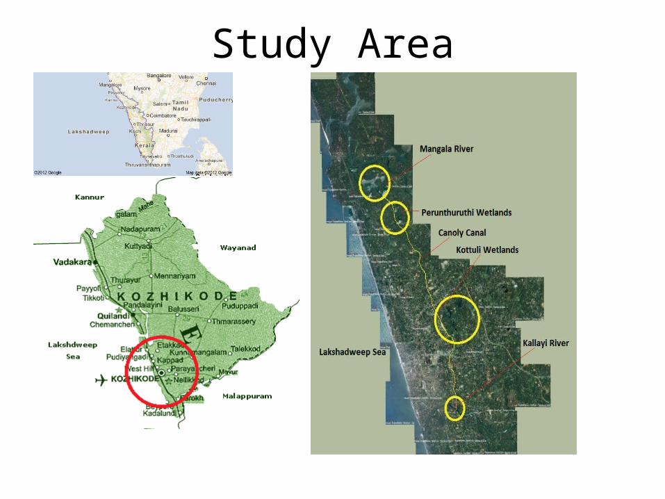
Study Area
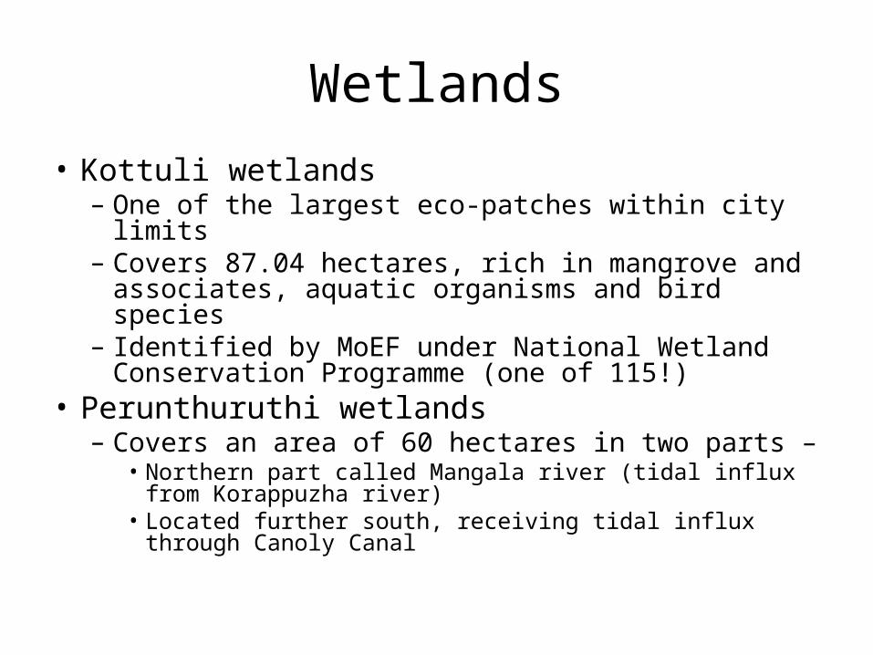
Wetlands• Kottuli wetlands– One of the largest eco-patches within city limits– Covers 87.04 hectares, rich in mangrove and
associates, aquatic organisms and bird species– Identified by MoEF under National Wetland
Conservation Programme (one of 115!)• Perunthuruthi wetlands– Covers an area of 60 hectares in two parts –
• Northern part called Mangala river (tidal influx from Korappuzha river)
• Located further south, receiving tidal influx through Canoly Canal

Canal Development Proposal
• Kerala Shipping and Inland Navigation department’s proposal to revive the West Coast Canal system includes– Deepening and widening of the Canoly Canal– NABARD assisted project to de-silt Canoly Canal
and Kallayi river– Proposal to deepen canal and river funded by the
River Management Fund– An aim to improve drainage in Kozhikode city

Objective of the Study
• Impact on hydrodynamics of Kottuli wetlands by the proposed deepening of the Canoly Canal
• Highlights the need for a similar study on the impact on Mangala river and Peruthuruthi wetlands
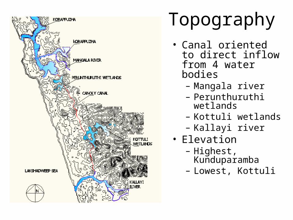
Topography• Canal oriented to
direct inflow from 4 water bodies– Mangala river– Perunthuruthi
wetlands– Kottuli wetlands– Kallayi river
• Elevation– Highest,
Kunduparamba– Lowest, Kottuli
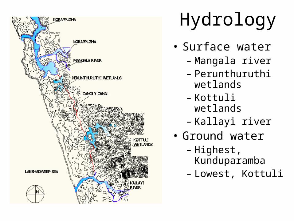
Hydrology• Surface water– Mangala river– Perunthuruthi
wetlands– Kottuli wetlands– Kallayi river
• Ground water– Highest,
Kunduparamba– Lowest, Kottuli
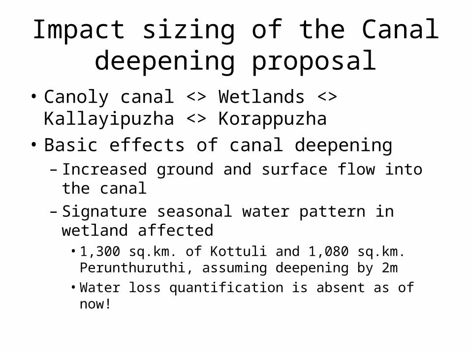
Impact sizing of the Canal deepening proposal
• Canoly canal <> Wetlands <> Kallayipuzha <> Korappuzha
• Basic effects of canal deepening– Increased ground and surface flow into the canal– Signature seasonal water pattern in wetland affected• 1,300 sq.km. of Kottuli and 1,080 sq.km. Perunthuruthi,
assuming deepening by 2m• Water loss quantification is absent as of now!
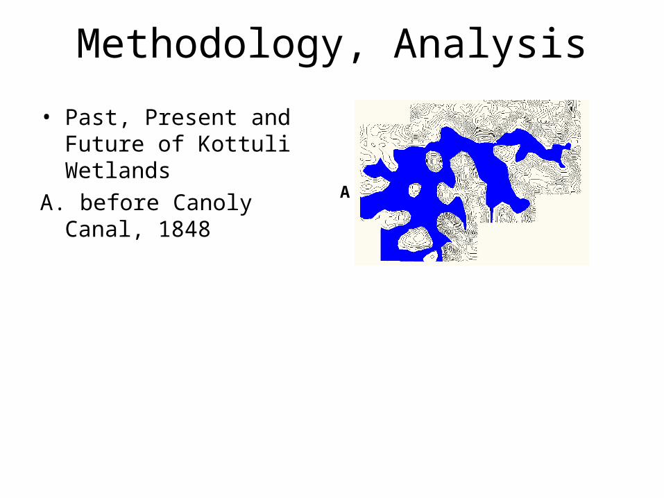
Methodology, Analysis
• Past, Present and Future of Kottuli Wetlands
A. before Canoly Canal, 1848A
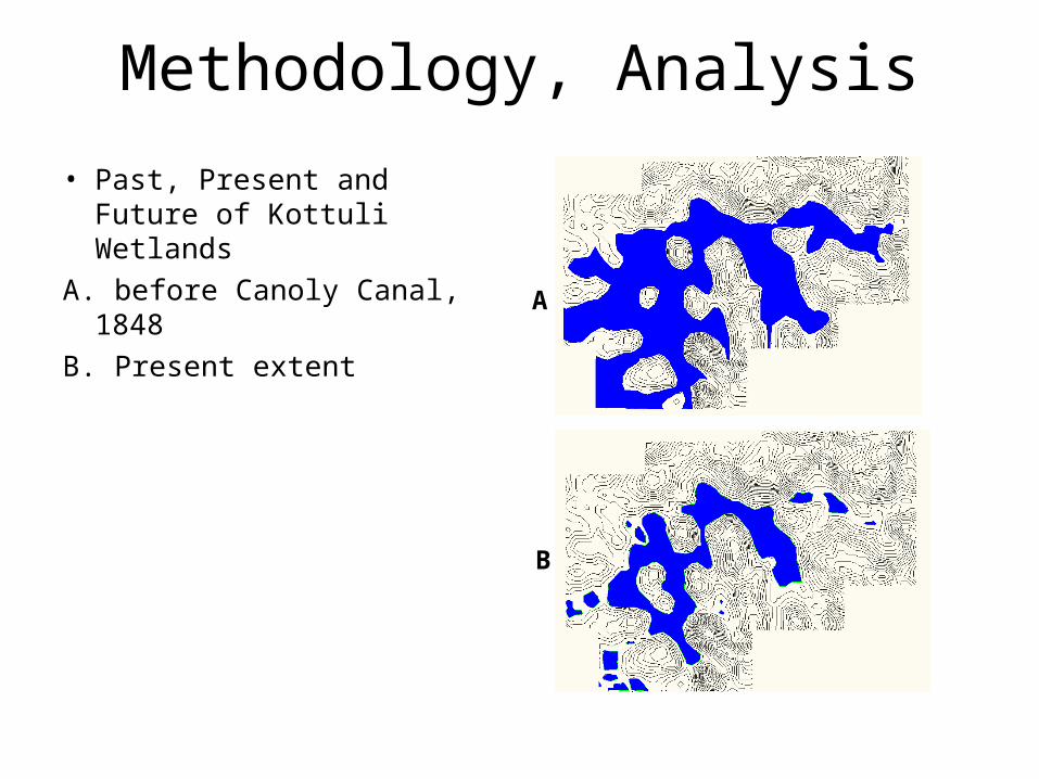
Methodology, Analysis
• Past, Present and Future of Kottuli Wetlands
A. before Canoly Canal, 1848B. Present extent
A
B
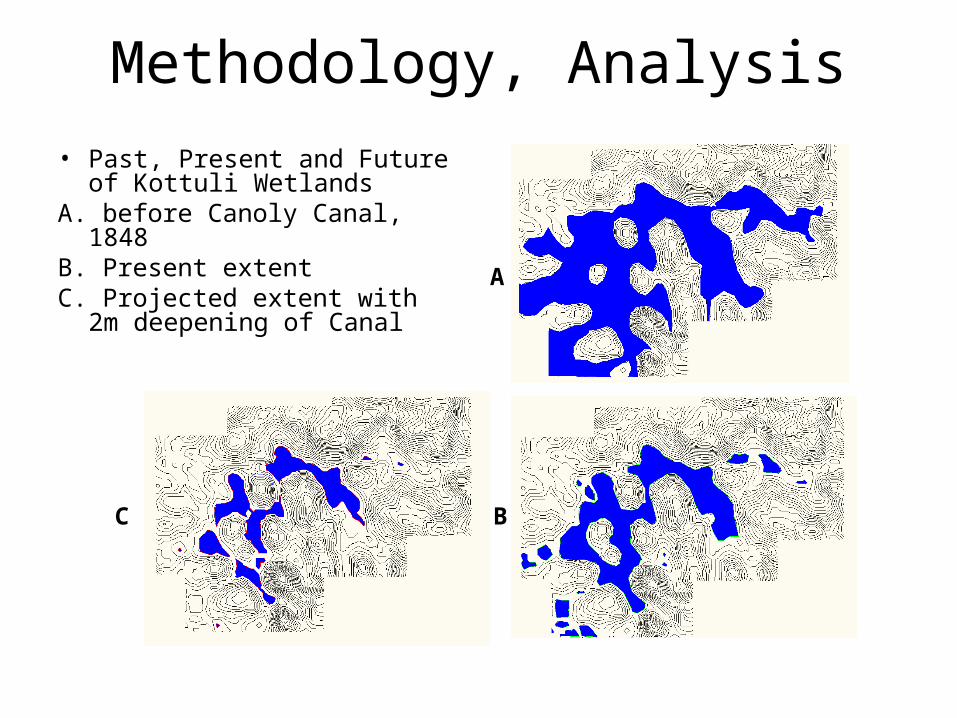
Methodology, Analysis• Past, Present and Future of
Kottuli WetlandsA. before Canoly Canal, 1848B. Present extentC. Projected extent with 2m
deepening of Canal
A
BC

Recommendations• Interconnected nature of water bodies cannot be
ignored• Canal deepening has larger impacts on flow dynamics• Watersheds approach to urban surface water
management is crucial to iron out inconsistencies and unexpected outcomes
• Key to develop a topographical base map as a common information set available to various urban planning exercises – water supply, sewerage, transport, water harvesting, irrigation and conservation efforts

Thank you!