ILLUSTRATED TRAIL GUIDE DENNY COVE - Friends of South ... · DENNY COVE TRAIL DESCRIPTIONS Denny...
2
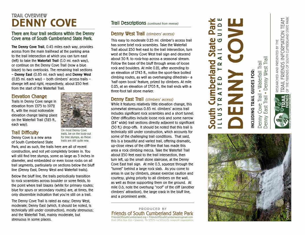
South Cumberland State Park ILLUSTRATED TRAIL GUIDE DENNY COVE INCLUDING TRAIL GUIDES FOR: Denny Cove Trail • Waterfall Trail Denny East Trail • Denny West Trail FRIENDS OF SOUTH CUMBERLAND STATE PARK TRAIL FRIENDS RESEARCHED AND PRESENTED BY THE TRAIL FRIENDS INFORMATION TEAM OF THE FRIENDS OF SOUTH CUMBERLAND STATE PARK Denny Falls Denny West Trail (climbers’ access) This easy to moderate 0.25 mi. climber’s access trail has some brief rock scrambles. Take the Waterfall Trail about 250 feet east to the trail intersection, turn west at the Denny Cove West trail sign and descend about 30 ft. to rock-hop across a seasonal stream. Follow the base of the bluff through areas of loose rock and boulders. At mile 0.21, after ascending to an elevation of 1743 ft., notice the sport-face bolted climbing routes, as well as overhanging dihedrals— a ‘half open book’ feature, prized by climbers. At mile 0.25, at an elevation of 1703 ft., the trail ends with a three-foot tall stone marker. Denny East Trail (climbers’ access) While it features relatively little elevation change, this somewhat strenuous 0.85 mi. climbers’ access trail includes significant rock scrambles and a short tunnel. Other difficulties include loose rock and some narrow (24” wide) trail sections directly adjacent to significant (50 ft.) drop-offs. It should be noted that this trail is technically still under construction, which accounts for some of the challenging trail conditions. That said, this is a beautiful and varied trail, offering dramatic, up-close views of the cliff-line that has made this area a rock climbing mecca. Take the Waterfall Trail about 250 feet east to the trail intersection, then turn left, up the small stone staircase, at the Denny Cove East trail sign. At mile 0.3, squeeze through the “tunnel” behind a large rock slab. As you come to areas in use by climbers, please exercise caution and courtesy, giving priority to all climbers on the wall, as well as those supporting them on the ground. At mile 0.6, note the overhung “roof” of the cliff (another climbers’ attraction), the large crack in the bluff line, and a prominent arete. Trail Descriptions (continued from reverse) Friends of South Cumberland State Park FriendsOfSouthCumberland.org • FriendsOfSouthCumberland@gmail.com Post Office Box 816 • Sewanee, TN 37375 • a 501(c)(3) nonprofit organization PRODUCED BY TRAIL OVERVIEW DENNY COVE There are four trail sections within the Denny Cove area of South Cumberland State Park. The Denny Cove Trail, 0.45 miles each way, provides access from the main trailhead at the parking area to the trail intersection at which you can turn east (left) to take the Waterfall Trail (1.0 mi. each way), or continue on the Denny Cove Trail (now a blue blaze) to two overlooks. The remaining trail sections – Denny East (0.85 mi. each way) and Denny West (0.25 mi. each way) – both climbers’ access trails – diverge left and right, respectively, about 250 feet from the start of the Waterfall Trail. Elevation Change Trails in Denny Cove range in elevation from 1375 to 1972 ft., with the most noticeable elevation change taking place on the Waterfall Trail (325 ft., each way). Trail Difficulty Denny Cove is a new area of South Cumberland State Park, and as such, the trails here are all of recent construction, and not yet completely broken in. You will still find tree stumps, some as large as 3 inches in diameter, and embedded or even loose rocks on all trail segments, particularly on sections below the bluff line (Denny East, Denny West and Waterfall trails). Below the bluff line, the trails periodically transition to rock scrambles across boulder or scree fields, to the point where trail blazes (white for primary routes; blue for spurs or secondary routes) are, at times, the only discernible indication that you’re still on a trail. The Denny Cove Trail is rated as easy; Denny West, moderate; Denny East (which, it should be noted, is technically still under construction), mostly strenuous; and the Waterfall Trail, mainly moderate, but strenuous in some places. On most Denny Cove trails, be on the look-out for tree stumps, as these trails are still quite new.
Transcript of ILLUSTRATED TRAIL GUIDE DENNY COVE - Friends of South ... · DENNY COVE TRAIL DESCRIPTIONS Denny...
Sout
h Cu
mbe
rland
Sta
te P
ark
IL
LU
ST
RA
TE
D
TR
AI
L
GU
ID
E
DEN
NY
COVE
INCL
UD
ING
TR
AIL
GU
IDES
FO
R:
Den
ny C
ove
Trai
l • W
ater
fall
Trai
l D
enny
Eas
t Tra
il •
Den
ny W
est T
rail
FRIE
ND
S O
F SO
UT
H C
UM
BER
LAN
D S
TAT
E P
AR
K
TRA
IL F
RIE
ND
S
RESE
ARCH
ED A
ND
PRE
SEN
TED
BY
THE
TRAI
L FR
IEN
DS
INFO
RMAT
ION
TEA
MO
F TH
E FR
IEN
DS
OF
SOU
TH C
UM
BER
LAN
D S
TATE
PAR
KD
enny
Fal
ls
Denny West Trail (climbers’ access)
This easy to moderate 0.25 mi. climber’s access trail has some brief rock scrambles. Take the Waterfall Trail about 250 feet east to the trail intersection, turn west at the Denny Cove West trail sign and descend about 30 ft. to rock-hop across a seasonal stream. Follow the base of the bluff through areas of loose rock and boulders. At mile 0.21, after ascending to an elevation of 1743 ft., notice the sport-face bolted climbing routes, as well as overhanging dihedrals— a ‘half open book’ feature, prized by climbers. At mile 0.25, at an elevation of 1703 ft., the trail ends with a three-foot tall stone marker.
Denny East Trail (climbers’ access) While it features relatively little elevation change, this somewhat strenuous 0.85 mi. climbers’ access trail includes significant rock scrambles and a short tunnel. Other difficulties include loose rock and some narrow (24” wide) trail sections directly adjacent to significant (50 ft.) drop-offs. It should be noted that this trail is technically still under construction, which accounts for some of the challenging trail conditions. That said, this is a beautiful and varied trail, offering dramatic, up-close views of the cliff-line that has made this area a rock climbing mecca. Take the Waterfall Trail about 250 feet east to the trail intersection, then turn left, up the small stone staircase, at the Denny Cove East trail sign. At mile 0.3, squeeze through the “tunnel” behind a large rock slab. As you come to areas in use by climbers, please exercise caution and courtesy, giving priority to all climbers on the wall, as well as those supporting them on the ground. At mile 0.6, note the overhung “roof” of the cliff (another climbers’ attraction), the large crack in the bluff line, and a prominent arete.
Trail Descriptions (continued from reverse)
Friends of South Cumberland State ParkFriendsOfSouthCumberland.org • [email protected] Office Box 816 • Sewanee, TN 37375 • a 501(c)(3) nonprofit organization
Thanks for your support of the Friends of South Cumberland, and our work to protect and maintain Tennessee’s largest -- and most spectacular -- State Park!
Naullain V. KendrickPresidentFriends of South Cumberland State Park, Inc.
P R ODUC E D BY
TRAIL OVERVIEW
DENNY COVEThere are four trail sections within the Denny Cove area of South Cumberland State Park.
The Denny Cove Trail, 0.45 miles each way, provides access from the main trailhead at the parking area to the trail intersection at which you can turn east (left) to take the Waterfall Trail (1.0 mi. each way), or continue on the Denny Cove Trail (now a blue blaze) to two overlooks. The remaining trail sections – Denny East (0.85 mi. each way) and Denny West (0.25 mi. each way) – both climbers’ access trails – diverge left and right, respectively, about 250 feet from the start of the Waterfall Trail.
Elevation ChangeTrails in Denny Cove range in elevation from 1375 to 1972 ft., with the most noticeable elevation change taking place on the Waterfall Trail (325 ft., each way).
Trail DifficultyDenny Cove is a new area of South Cumberland State Park, and as such, the trails here are all of recent construction, and not yet completely broken in. You will still find tree stumps, some as large as 3 inches in diameter, and embedded or even loose rocks on all trail segments, particularly on sections below the bluff line (Denny East, Denny West and Waterfall trails).
Below the bluff line, the trails periodically transition to rock scrambles across boulder or scree fields, to the point where trail blazes (white for primary routes; blue for spurs or secondary routes) are, at times, the only discernible indication that you’re still on a trail.
The Denny Cove Trail is rated as easy; Denny West, moderate; Denny East (which, it should be noted, is technically still under construction), mostly strenuous; and the Waterfall Trail, mainly moderate, but strenuous in some places.
On most Denny Cove trails, be on the look-out for tree stumps, as these trails are still quite new.
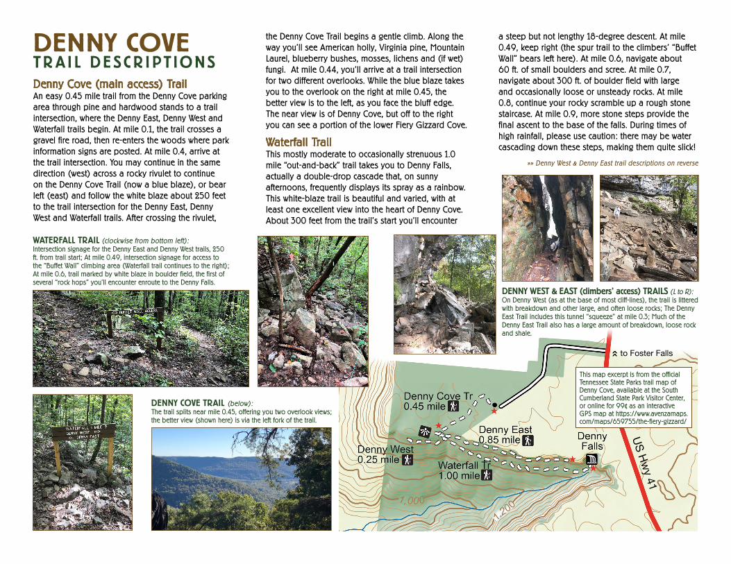
DENNY COVETR A I L DE SC R I PT IONSDenny Cove (main access) TrailAn easy 0.45 mile trail from the Denny Cove parking area through pine and hardwood stands to a trail intersection, where the Denny East, Denny West and Waterfall trails begin. At mile 0.1, the trail crosses a gravel fire road, then re-enters the woods where park information signs are posted. At mile 0.4, arrive at the trail intersection. You may continue in the same direction (west) across a rocky rivulet to continue on the Denny Cove Trail (now a blue blaze), or bear left (east) and follow the white blaze about 250 feet to the trail intersection for the Denny East, Denny West and Waterfall trails. After crossing the rivulet,
the Denny Cove Trail begins a gentle climb. Along the way you’ll see American holly, Virginia pine, Mountain Laurel, blueberry bushes, mosses, lichens and (if wet) fungi. At mile 0.44, you’ll arrive at a trail intersection for two different overlooks. While the blue blaze takes you to the overlook on the right at mile 0.45, the better view is to the left, as you face the bluff edge. The near view is of Denny Cove, but off to the right you can see a portion of the lower Fiery Gizzard Cove.
Waterfall Trail This mostly moderate to occasionally strenuous 1.0 mile “out-and-back” trail takes you to Denny Falls, actually a double-drop cascade that, on sunny afternoons, frequently displays its spray as a rainbow. This white-blaze trail is beautiful and varied, with at least one excellent view into the heart of Denny Cove. About 300 feet from the trail’s start you’ll encounter
a steep but not lengthy 18-degree descent. At mile 0.49, keep right (the spur trail to the climbers’ “Buffet Wall” bears left here). At mile 0.6, navigate about 60 ft. of small boulders and scree. At mile 0.7, navigate about 300 ft. of boulder field with large and occasionally loose or unsteady rocks. At mile 0.8, continue your rocky scramble up a rough stone staircase. At mile 0.9, more stone steps provide the final ascent to the base of the falls. During times of high rainfall, please use caution: there may be water cascading down these steps, making them quite slick!
»» Denny West & Denny East trail descriptions on reverse
WATERFALL TRAIL (clockwise from bottom left):Intersection signage for the Denny East and Denny West trails, 250 ft. from trail start; At mile 0.49, intersection signage for access to the “Buffet Wall” climbing area (Waterfall trail continues to the right); At mile 0.6, trail marked by white blaze in boulder field, the first of several “rock hops” you’ll encounter enroute to the Denny Falls.
DENNY WEST & EAST (climbers’ access) TRAILS (L to R):On Denny West (as at the base of most cliff-lines), the trail is littered with breakdown and other large, and often loose rocks; The Denny East Trail includes this tunnel “squeeze” at mile 0.3; Much of the Denny East Trail also has a large amount of breakdown, loose rock and shale.
This map excerpt is from the official Tennessee State Parks trail map of Denny Cove, available at the South Cumberland State Park Visitor Center, or online for 99¢ as an interactive GPS map at https://www.avenzamaps.com/maps/659755/the-fiery-gizzard/
DENNY COVE TRAIL (below):The trail splits near mile 0.45, offering you two overlook views; the better view (shown here) is via the left fork of the trail.
US Hwy 41
to Foster Falls»

![[Richard denny] communicate_to_win](https://static.fdocuments.us/doc/165x107/559cbddd1a28ab76268b46ae/richard-denny-communicatetowin.jpg)