IIRS-Edusat Implementation Document - Indian Institute of Remote
49
IIRS Satellite & Internet based Distance Learning Programme Implementation Document VERSION 10.0 – APRIL 2013 INDIAN INSTITUTE OF REMOTE SENSING INDIAN SPACE RESEARCH ORGANISATION DEPARTMENT OF SPACE, GOVERNMENT OF INDIA 4 - KALIDAS ROAD, DEHRADUN (UTTRAKHAND) www.iirs.gov.in
Transcript of IIRS-Edusat Implementation Document - Indian Institute of Remote

IIRS Satellite & Internet based Distance Learning Programme
Implementation Document
VERSION 10.0 – APRIL 2013
INDIAN INSTITUTE OF REMOTE SENSING
INDIAN SPACE RESEARCH ORGANISATION
DEPARTMENT OF SPACE, GOVERNMENT OF INDIA
4 - KALIDAS ROAD, DEHRADUN (UTTRAKHAND)
www.iirs.gov.in

Version
10.0 – April 2013
Editors
PLN Raju ([email protected])
Prasun Kumar Gupta ([email protected])
Geoinformatics Division
Indian Institute of Remote Sensing
Indian Space Research Organisation
Published by
EDUSAT Team
Indian Institute of Remote Sensing
EDUSAT Studio & Control Room 2007-2013
Indian Institute of Remote Sensing
Indian Space Research Organisation
Dept. of Space, Govt. of India
#4 Kalidas Road, Dehradun
Uttarakhand 248001, India
Tel: +91 135 252 4130
Fax: +91 135 274 1987
e-mail: [email protected]
IIRS WEB Homepage: http://www.iirs.gov.in
This compilation © 2013 is funded by the Indian Institute of Remote Sensing (IIRS) Outreach
Program. Reproduction of this volume or any parts thereof (excluding short quotations for the
use in the preparation of reviews and technical and scientific papers) may be made only after
obtaining the specific approval of the publisher. The facts appearing in this volume are only
indicative. Authors retain all rights to the content..

Table of Contents
1. About Indian Institute of Remote Sensing ............................................................................................ 1
2. About EDUSAT ....................................................................................................................................... 2
3. EDUSAT Network .................................................................................................................................. 3
4. Why Satellite based training? ............................................................................................................... 4
5. Utilization of EDUSAT bandwidth by IIRS .............................................................................................. 5
6. Course Overview ....................................................................................................................................... 7
6. CEC-UGC role in implementation of the program .............................................................................. 13
7. Initial Setup ......................................................................................................................................... 13
8. Online Learning Management System “TrainNet” ............................................................................. 14
9. Future Plan .......................................................................................................................................... 14
10. List of IIRS Faculty members involved (2007 – 2013) ..................................................................... 15
12. List of Guest Faculty members involved in EDUSAT Course (2007-2013) ...................................... 22
13. List of Participated Universities (2007 – 2013) ............................................................................... 24
14. Feedback from the Universities ...................................................................................................... 38
15. Annexure 1: Total Number of Participants in EDUSAT Course (Till March, 2013) .......................... 44
16. Annexure 2: Abbreviations ............................................................................................................. 45

Table of Figures and Tables
Figure 1 - Development & Launch of EDUSAT .............................................................................................. 2
Figure 2 - Regional Beams & National Beam ................................................................................................ 2
Figure 3 : Potential Uses of EDUSAT ............................................................................................................. 3
Figure 4 : Total Number of Participants in 6years ........................................................................................ 5
Table 1 : IIRS - EDUSAT Summary of Courses till 2013 .................................................................................. 6
Table 2: IIRS EDUSAT Course Curriculum ...................................................................................................... 7
Table 3a: EDUSAT Advance Course Curriculum on “Advances in Geoinformatics” ...................................... 8
Table 4: List of Faculty of EDUSAT Basic Course ......................................................................................... 15
Table 5: List of Guest Faculty of EDUSAT Course ........................................................................................ 22
Table 6: Participant Universities ................................................................................................................. 24
Table 7: Total Number of EDUSAT Course Participants .............................................................................. 44
Table 8: Abbreviations ................................................................................................................................ 45

1
Satellite based Distance Learning Program
Basics of Remote Sensing, Geographical Information
System & Global Positioning System
1. About Indian Institute of Remote Sensing
Indian Space Research Organisation (ISRO) has a vibrant Earth Observation (EO) programme of 20
satellite missions launched during past 25 years evolved through National Natural
Resources Management System (NNRMS) and providing mainstream data for natural
resources and disaster management both nationally and globally. Indian Remote Sensing
Satellite (IRS) system was commissioned with the launch of IRS-1A, in 1988. With twelve
satellites in operation, IRS is the largest civilian remote sensing satellite constellation in the
world providing imagery in a variety of spatial, spectraland temporal resolutions through series
of satellites like Resourcesat, Oceansat, Cartosat, RISAT, Megha-Tropiques, etc.
Indian Institute of Remote Sensing (IIRS), Dehradun is one of the units of ISRO to realize the
Indian space vision, as a key player, in capacity building for successful implementation of EO
programme for societal benefits. IIRS is a premier institute with internationally acclaimed
expertise in the area of training, education and research in use of geospatial technology for
applications covering mineral prospecting,watershed management and monitoring, drought
and flood assessment, ocean resources and disaster management, leading to livelihood
security and understanding the impact of climate change. IIRS alumni include global leaders
in geospatial technology.
For distance-based learning, the IIRS EDUSAT programme, initiated in 2007 with participation
of 12 universities, has now expanded to more than 85 institutions/universities. The e-learning
programme is also being provided by the Institute.
The headquarters of Indian Society of Remote Sensing (ISRS), one of the largest non-
governmental scientific society in the country, is also located in the Institute campus.
Students at IIRS are trained and groomed by around 70 multi-disciplinary full-time faculty. IIRS
is one of the only few institutions in India with high teacher-student ratio. The institute is
involved in research activities on high resolution satellite image analysis (space, aerial and
terrestrial), 3D visualization of real world mobile applications, hyperspectral ,RS data analysis,
photogrammetry, microwave data analysis, snow melt runoff, landslide hazard modeling,
carbon flux measurement and modeling, data assimilation, statistical & Numerical modeling
in understanding atmosphere and climate, mineral prospecting, hydrological process, soil
erosion, wildlife habitat and bio diversity analysis are providing wide opportunities to students.

2
2. About EDUSAT EDUSAT is the first Indian satellite built
exclusively for serving the educational sector and
was launched successfully by GSLV-F01 on 20-
9-2004 (Figure 1: Development & Launch of
EDUSAT). It is mainly intended to meet the
demand for an interactive satellite based distance
education system for the country. It strongly
reflects India‘s commitment to use space
technology for national development, especially
for the development of the population in remote
and rural locations. The 1950 kg EDUSAT was
launched from Satish Dhawan Space Centre
(SDSC) SHAR, Sriharikota, into a
Geosynchronous Transfer Orbit (GTO) by
ISRO‘s Geosynchronous Satellite Launch
Vehicle (GSLV).
The satellite is co-located with KALPANA-1
and INSAT-3C satellites at 74 deg East
longitude. Compared to the satellites launched in
the INSAT series so far, EDUSAT has several
new technologies. The spacecraft is built around
a standardized spacecraft bus called I-2K. It has
a multiple spot beam antenna with 1.2 m
reflector to direct the Ku band spot beams
precisely towards their intended regions of
India, a dual core bent heat pipe for thermal
control, high efficiency multi-junction solar
cells and an improved thruster configuration for
optimized propellant use for orbit and
orientation maintenance. The satellite uses
radiatively cooled Ku band Traveling Wave
Tube Amplifiers (TWTAs) and dielectrically loaded C-band Demultiplexer for its
communication payloads. EDUSAT carries five Ku-band transponders providing spot beams,
one Ku-band transponder providing a national beam and six Extended C-band transponders with
national coverage beam (Figure 2: Regional Beams & National Beams). (http://www.isro.gov.in)
From 5th course onwards the IIRS outreach program was shifted to INSAT 4CR. INSAT 4CR, is
co-located with kalpana-1 at 740 east longitude.
Figure 1 - Development & Launch of EDUSAT
Figure 2 - Regional Beams & National Beam

3
3. EDUSAT Network In the first phase of pilot projects, a Ku-band
transponder on-board INSAT-3B, already in orbit, was
used. In this phase, Visveswaraiah Technological
University (VTU) in Karnataka, Y B Chavan State
Open University in Maharashtra and Rajiv Gandhi
Technical University in Madhya Pradesh were
covered. In the second phase, EDUSAT is being used
in a semi-operational mode and at least one uplink in
each of the five spot beams will be commissioned.
About 100-200 classrooms will be connected in each
beam. Coverage will be extended to the whole of India
through spot beams and the Ku-band national beam
will also be used to connect a few national institutions. The Hub for National Beam has been
established at Ahmedabad.
The National Beam is planned to be used for:
Indira Gandhi National Open University —100 terminals across the country and another 20
terminals in the North East for teachers‘ training.
National Council for Educational Research and Training — 100 terminals for Secondary
and Higher Secondary Education and Teachers Training.
Indian Institutes of Technology at Kharagpur and Chennai — 70 and 5 terminals respectively
Institute of Electronics and Tele-communication Engineers — 18
DST/National Council of Science Museums — 25
Centre for Environmental Education — 5
Regional Beams of EDUSAT were planned to be as follows:
Southern Beam: Anna University, Chennai (260 nodes), Annamalai University, Chennai (57
nodes), Gandhigram Rural Institute, Dindigal(90 nodes), Bharathidasan University,
Tiruchirapalli (22 nodes),Sarva Shiksha Abhiyan, Tamilnadu (442 nodes) Western Beam:
Gujarat Government, Department of Education (148 nodes), Maharashtra Knowledge
Corporation Ltd (50 nodes), July 2005 Depar tment of Higher Education, MP (50 nodes), Tribal
Development, MP (50 nodes), BITS, Pilani (20 nodes), Technical Education Board, Rajasthan
(91 nodes) and Blind People‘s Association, Ahmedabad (25 nodes) Northern Beam: State
Institute of Educational Technology (67 nodes), Guru Nanak Dev University (GNDU), Amritsar
(40 nodes), Tapar Institute of Engineering and Technology, Patiala 10 nodes), Department of
Training and Technical Education,New Delhi (40 nodes), UP Rajashri Tandon Open University,
Allahabad (55 nodes) Eastern Beam: West Bengal University of Technology, Kolkata (40
nodes), Vidyasagar University, Midnapore, West Bengal (10 nodes), Netaji Subhas Open
University, Kolkata (90 nodes), Jarkhand Education Project Council, Ranchi (192 nodes)
North-Eastern Beam: Assam Agricultural University, Jorhat (18 nodes), Arunachal University,
Itanagar (13 nodes), Manipur University, Imphal (200 nodes), Nagaland University, Kohima (10
nodes), Sikkim Government Law College, Gangtok (20 nodes)
Figure 3 : Potential Uses of EDUSAT

4
The IIRS EDUSAT based program is broadcast on the National beam covering all universities
within the geographical bounds of Indian sub continent.
4. Why Satellite based training? Contact based training though advantageous and beneficial, is not always possible for many to
attend due to time limitations, financial constraints and importantly day-to-day commitments at
work place. There are many types of training courses, which can be attended from a distance
with different types of technology and tools. The first among them is the distance education
(correspondence courses) supported either with or without study centers. The next one is
―Internet based courses‖ replacing the conventional correspondence courses. The advanced type
of courses are ―e-learning‖ where the student can avail the content of the course through the
internet, stream the lectures using the internet and have interaction with teachers on a specified
date. They can be provided with FAQs (Frequently Asked Questions) and quiz materials for easy
learning. The students can appear for examinations on a specified date and location.
The Satellite based training also follows more or less e-learning method and provides direct
interaction with the teacher/expert when the lecture is delivered using EDUSATINSAT-4CR
satellite communication. It is advantageous because of its good quality reception and interactions
are not constrained due to bandwidth problems of Internet.
To increase the reach, IIRS started using A-VIEW software from 7th
course onwards. It works
using high speed internet connection and has been developed by Amrita University, e-learning
Institutions on the high speed national knowledge network (NKN) can benefit from this medium.

5
5. Utilization of EDUSAT bandwidth by IIRS
Figure 4 : Total Number of Participants in 7years
The use of Remote Sensing (RS), Geographic Information System (GIS), Global Positioning
System (GPS) and associated geo-spatial technologies is increasing rapidly, creating an urgent
demand for trained manpower. IIRS proposes to utilize the EDUSAT facility to strengthen
institutions by sharing IIRS faculty expertise in running Geoinformatics programs, train students
at undergraduate / postgraduate level at institutions that have established Geoinformatics facility
with the funding support from NNRMS and other institutions/organizations that regularly
approach IIRS for Geoinformatics expertise.
Under the EDUSAT training program, IIRS has established its own Teaching end Studio and
Uplinking facility in the campus under national beam coverage of EDUSAT and link with the
users. The First training course was conducted for 12 universities/institutions on ―Basics of
Remote Sensing, Geographical Information System and Global Positioning System‖ for
6 weeks duration during January 29 – 09 April 2007 with participation of 349 students registered
for this course.

6
Table 1 : IIRS - EDUSAT Summary of Courses till 2013
EDUSAT Course Summary
1st
Course
2nd
Course
3rd
Course
4th
Course
5th
Course
6th
Course
7th
Course
8th
Course
9th
Course
10th
Course Total
No. of
Lecture Hrs. 45 34 36 35.3 41.1 10 48 20 48 20 337.4
Hrs. of
Interactive
Session
15 17.5 18 12 10.2 3 24 10 24 10 143.7
Total Hrs 60 51.5 54 47.3 51.3 13 72 30 72 30
481.1
Total No. of
Participants 349 931 915 935 1101 171 1389 578 1170 1033 8572
Total
Universities
Participated
12 22 40 48 26 10 36 19 39 42
Total
Universities
Interacted
9 18 25 20 13 6 15 10
10 15
Course
Duration Jan-Apr
07
Sep-Dec
07
Aug-Nov
08
Aug-Oct
09
Oct-Dec
10
Feb-Mar
11
Aug-Nov
11
Feb-Mar
12
Aug-Oct
12
Feb-Mar
13

7
6. Course Overview
Course Structure and Curriculum
The training course on ―Remote Sensing, Geographical Information System and Global
Positioning System‖ for university students is structured into four modules as detailed below:
Module 1 Remote Sensing & Digital Image Processing 2 Weeks
Module 2 Global Positioning System 1 Week
Module 3 Geographical Information Systems 2 Weeks
Module 4 Applications and advances 1 Week
Total 6 Weeks
The details of course curriculum for basic course for each topic is given in the following table: Table 2: IIRS EDUSAT Course Curriculum
Sr.No. Course Curriculum Duration
1
Remote sensing
Principles of Remote Sensing
Platforms and sensors
Thermal Remote Sensing
Microwave Remote Sensing
Spectral Signature properties of Soil, Water and Vegetation
Atmospheric interactions of EMR
Elements of Interpretation
Indian Remote Sensing Satellite programs
Satellite data reception, products generation and ordering
procedures
Digital image analysis
Pre-processing, enhancement techniques and Classification
algorithms(Supervised and Unsupervised)
2 Weeks
Total 21 hrs
Lectures – 9 hrs;
Interaction / Discussion –
8 hrs i.e., 30 minutes each
after one hour lecture
Demonstration / hands
on – 4 hrs, i.e. 30 min
each after one hour
practical demonstration
and discussion
2
Global Positioning System
Overview of GPS/other Navigation System Signals,
constellation and
functionality
Navigation Principles, code and carrier wave measurements
GPS Errors
Principles of Differential GPS
Surveying Methods and integration with GIS themes
Application case studies
Comparison of different navigation systems
1 Week
Total 6 hrs
Lectures – 2 hrs;
Interaction /
Discussion – 2 hr i.e. 30
Minute each after one
hour lecture
Demonstration / hands
on - 2 hr, i.e. 30 Minute
each after one hour l
demonstration and discussion

8
The course curriculums of advanced courses are given below:
Table 3a: EDUSAT Advance Course Curriculum on “Advances in Geoinformatics”
1. Advances in Geoinformatics
Indian Space Program- Present & Future
Earth Observation & Geoinformatics Technological
Trends
Spatial Databases
Geo Data Modelling
Programming & GIS Customization
Web GIS
Mobile Mapping
3D GIS & Visualisation
Tele Matics & Transportation Systems
Spatial Decision Support System
Open Source GIS(OSGEO Live Demonstration)
4 weeks
Total 15hrs
3
Geographical Information System
Overview of GIS
Spatial Data Models (Vector and Raster Models)
Data formats and structures
Non-Spatial data models (Hierarchical, Network and
RDBMS data.
models)
Inputting, editing and topology creation
Hardware and Software requirements for GIS
Coordinate systems, Datum and Projections
Spatial Analysis (Vector as well as Raster)
Digital Elevation Models and applications
Network analysis
Web resources for GIS
2 Weeks
Total 21 hrs
Lectures – 9 hrs;
Interaction / Discussion –8 hrs
i.e., 30 minutes each
after one hour lecture
Demonstration / hands
on – 4 hrs, i.e. 30 min
each after one hour
practical demonstration
and discussion
4
RS and GIS Applications
Operational Remote Sensing Applications in India.
Agriculture– Total area and crop type, yield forecasting,
Agrometeorology.
Soil survey and Mapping, Land evaluation and Soil
Conservation
Planning.
Forest Inventory, Ecosystem analysis & Biodiversity
characterization and
management.
Geology and Geomorphology, Hydrogeology &
Engineering Geology with emphasis on Landslide
Studies.
1 Week
Total 12 hrs
Lectures – 8 hrs;
Interaction /
Discussion – 4 hr i.e. 30
Minute each after one
hour lecture

9
Table 4b: EDUSAT Advance Course Curriculum on “Hyperspectral Remote Sensing”
2. Hyperspectral Remote Sensing
Hyperspectral remote sensing: An Overview
Spectroscopy: Theory and Practice
Introduction to Hyperspectral tools and
Familiarization with Hyperspectral Data
Demonstration of Laboratory spectra collection using
ASD Spectro-Radiometer
Spectral Libraries and Familiarization of USGS, JHU,
IGCP, JPL and other spectral libraries
Hyperspectral Image pre-processing; noise removal,
atmospheric corrections procedures and data
calibration
Image Preprocessing; atmospheric and geometric
corrections
Hyperspectral Remote Sensing Data Processing (Data
reduction, feature extraction and (end member
selection)
Hyperspectral Image classification algorithms
Hyperspectral Remote Sensing Data Processing (Data
reduction & feature extraction)
Hyperspectral Remote Sensing Data Processing (End
member selection)
Hyperspectral Image classification
Hyperspectral Remote sensing and its applications in
Mineral exploration
Hyperspectral Remote sensing and its applications in
Water quality
Hyperspectral Remote sensing and its applications in
Planetary exploration
Hyperspectral IR sounding and retrieval of
Atmospheric parameters
Hyperspectral Remote sensing and its applications in
Snow, Ice and Glacier Studies
Hyperspectral Remote sensing and its applications in
Forestry
Hyperspectral Remote sensing and its applications in
Soils
Hyperspectral Remote sensing and its applications in
Agriculture
7weeks
Total 20 hrs

10
Table 5a: EDUSAT “Advance Course on “GEOWEB SERVICES-TECHNOLOGY & APPLICATIONS”
3.
GEOWEB SERVICES-TECHNOLOGY & APPLICATIONS
Introduction to Geospatial technology
Internet technology- Overview & architecture
Web applications for geo-spatial data disseminations
and processing - Geoweb 2.0 and AJAX
Introduction to Web technology for GIS- Mapserver
and Geoserver
Introduction to Web technology for GIS- ArcGIS
server
Spatial Database Organization and Management-
PostgreSQL and POSTGIS
Spatial Database Organization and Management-
PostgreSQL and POSTGIS
Spatial data interoperability and OGC Web services
Geoserver and Mapserver installations and
configuration
Introduction to OpenLayer API and GeoEXT
3D geo-visualization and simulation using Blender
and KML
ISRO Geoweb Services- Case studies
Geoweb services on Water Resource Information
System of India
ISRO Bhuvan Geoportal: Products and Services
Utilization of Bhuvan data and information services-
Applications in Urban/rural development
Geoweb application development using Bhuvan data
services and API
Open data and Map services: Spatial mashup
solutions and crowd sourcing
Applications of Distributed GIS- SDI and
applications
Metadata standards and catalogue services-
Geonetwork and demonstration on Indian
Bioresource Information Network (IBIN).
Open source geo-spatial technology for web GIS
Development
5weeks
Total 20hrs

11
Course curriculum is under constant revision. Further changes in the course curriculum are
underway. Newer concepts and newer ideas are being thought of being taught for the benefit of
the student/user community.
Who can attend the training?
The registered students who are undergoing final year undergraduate/ postgraduate courses are
entitled to apply for the training program. Their applications have to be duly sponsored by the
respective university/institute/college and forwarded through coordinators from the respective
centers. Accommodation of individuals is not entertained.
To benefit a wider audience, full time faculty and research /Ph.D scholars may also be registered
on case to case basis.
Institutions or individuals on NKN or any other high speed internet connection may also apply.
Registration of participants
The eligible candidates need to apply for the course well in advance through the resource
faculty/focal point at one of the university/institute that is identified to receive the training
program. Candidates are advised to visit the IIRS website (http://www.iirs.gov.in/) for updated
information on how to apply for the course. Fourth course onwards an online registration system
was introduced, which allowed paper-less registration for the EDUSAT course. Participants have
to login to IIRS EDUSAT registration and register against their university. The computerized list
will be send to the university coordinators for approval.
Course fee involved
There is no fee for this course. University / institution involved to conduct the course may charge
the students to recover the operational expenses, if required. IIRS does not play a role in this
connection.
Award of certificates
IIRS will award certificates to the registered candidates who successfully complete the training
program, in person at the institute or will be dispatched to the individuals. The participants
should meet the minimum attendance and marks required to be awarded the certificate. The
University/Institution /College Coordinators will be responsible to complete the required
formalities in this regard.
12
MOU requirements to avail the EDUSAT based training program
The participating Universities / Institutions are required to confirm their participation in this
program and agree to the following broad terms and conditions:
University/Institute shall support its own EDUSAT classroom facility for the planned
training.
University/Institute shall meet the financial requirements on its own for the expenditure
incurred on the training at their place.
Identified focal point at the University/Institute shall coordinate the day-to-day activity
requirements of the planned training program.
University/Institute will be responsible for arranging the EDUSAT classroom for the
schedule training program, registering students for the training, attendance of the students
and taking care of all needs, as and when required.
Institute/University coordinator shall collect feedback at the end of each module for
improvements to me made in future courses.
Attendance and Grading FAQ’s
Q: How much attendance in required from a student joining the course?
A: 75% Totally for 4 modules.
Q: Should it be counted for each module separately or in total?
A: 60% for each module and 75% in total.
Q: If someone joined late, his/her attendance be counted from the date of joining?
A: No. The basic criterion is that the attendance is being monitored and reported from the
beginning of the course.
Q: What is percentage of marks to qualify for the certificate?
A: 40%
Q: Should it be calculated for individual module or all the modules in aggregate?
A: Individual modules.
Q: One-half of the marks can be rounded up to one mark or should remain as such?
A: In the evaluation of a complete paper if the participant achieves one-half marks in the total, it
may be rounded up to one mark.
Feedback mechanism
A feedback mechanism is planned in which the students and all others concerned are advised to
give their feedback at any time during the course. A feedback form through IIRS website can be
utilized to send the feedbacks to the coordinator of the EDUSAT program. A formal feedback
will be obtained from all the participants by the respective University coordinator, on completion
of the course and will be utilized for improving the future courses.

13
Workshop on “Experience/Feedback of EDUSAT Program”
A workshop may be held at the end of each course in order to assess various aspects, such as,
meeting the overall objective of the course, course content, and lecture delivery, completion of
practical, regular interactive sessions, online quiz and assessment procedures and plan for the
future training courses. It can be organized at IIRS or at any one of the participating universities /
institutions.
Sponsorship of the program
National Natural Resources Management System (NNRMS), Department of Space (DOS) has
sponsored the training program, for conducting it at IIRS.
Contact person at IIRS
The total project is divided into three parts: Initiation, setting-up the EDUSAT teaching end,
Classrooms at universities, and implementation using the facilities. Shri P.L.N. Raju, GroupHead
Remote Sensing & Geoinformatics Group has been identified as the Project Manager with
overall responsibilities of the IIRS outreach program. He will be assisted by Shri Prasun Kumar
Gupta, Scientist/Engr. ―SD‖, Geoinformatics Department, IIRS in up-gradation and
standardization of services under EDUSAT.
6. CEC-UGC role in implementation of the program
EDUSAT is the first satellite designed, developed and launched solely for education, as a joint
initiative of ISRO and MHRD (Ministry of Human Resource Department). It is intended to
provide interactive satellite based higher education at country level, to be implemented by
IGNOU, AICTE, ICAR, NCERT and UGC. IIRS will be utilizing UGC network through CEC
(Consortium for Educational Communication), for the identified institutions and universities.
Most of these institutions have already established SITs (Satellite Interactive Terminals) required
for the proposed training. CEC will be providing the required slot of time for conducting the
program on the national beam.
7. Initial Setup
The EDUSAT based course was implemented in three phases over a period of three years (2007-
2009). The implementation plan envisaged at the beginning of the program constituted of one
phase a year. It began by identifying universities/institutions, formulation of the syllabus and
setting up of a teaching studio at IIRS. The program was an instant success as soon as it went on
air. The workshop at the end of the program gave valuable feedback. The second phase
constituted to upgrading the course curriculum and expanding the list of participating
universities/institutions. The final phase dealt with finalizing the course curriculum and
finalizing the set up to run an IIRS certificate program on yearly basis.

14
8. Online Learning Management System “TrainNet”
Till the 5th EDUSAT based course conducted by IIRS, open source video streaming software
―VLC‖ was used to transmit the instructional content. In this process, the slides of the lectures
were down converted to SD (Standard Definition) video resolution (640 pixels X 480 lines),
often leading to drastic loss in clarity of lecture content. Combined with unmanaged satellite
bandwidth, the output at student‘s end took a major toll on the audio and video quality received
especially during bad weather and heavy rains.
Problems such as interrupted learning, deterioration in student interest and incomplete
knowledge transfer were highlighted multiple times in the feedback received after the course and
during the workshops.
DECU/SAC Ahmedabad took the decision to implementation an online Learning Management
System called ―TrainNet‖ teacher/student software at all teaching/classroom ends across India on
the EDUSAT National Beam.
IIRS EDUSAT implemented the software and ran a one month program (on trial basis) to
evaluate the capabilities of the new software and also introduce it to the teaching faculty.
The TrainNet system is comprised of a suite of powerful software applications for delivery of
instructional and informational content. With TrainNet, the teacher can not only present the
content through a variety of channels, but also interact directly with the students in real time.
The control console, i.e, the Teacher application of TrainNet software is part of an interactive,
collaborative learning experience. Live feedback from the students makes the lesson more
dynamic and more effective. On the teacher‘s side, the presentation includes any or all of the
following elements:
• Live video and audio
• Slides prepared by the Course Builder application
• Live whiteboard.
• Live text chat
• Exchange of files or messages via e-mail
• Quizzes, either prepared in advance or on the spot
• Instant feedback of quiz results
In addition, the teacher has the power to control certain aspects of the operation of the students‘
own PCs in order to manage the environment of the virtual classroom, such as during a quiz.
These features include:
• Opening or closing applications residing on the students‘ PCs
• Changing the size of the video display containing the live feed from the studio
• Activating or deactivating part of the students‘ feedback interface, including mouse and
keyboard.
It was found that with efficient bandwidth management and better quality content being
transmitted to the students, TrainNet has better potential in delivering video based educational
content through the satellite medium.
9. Future Plan After successful completion of EDUSAT implementation at IIRS, it is now planned to reach out
to maximum number of universities. To expand its operations, IIRS EDUSAT also plans to
implement internet based courses so as to cater to working professional and part time students.

15
10. List of IIRS Faculty members involved (2007 – 2013)
Table 4: List of Faculty of EDUSAT Basic Course
S. No.
Photo
Name; Designation and Department; Area Of Specialization; Contact Details
I. Remote Sensing Module
1. 1
Dr. Y .V N Krishnamurthy
Director IIRS & CSSTEAP
Remote Sensing & GIS Applications in Natural Resources Management
0135-2524101
2.
Dr. V.K.Dadhwal
Director, National Remote Sensing Centre
(NRSC)
Crop Modelling, Remote Sensing Applications in Agriculture,
Terrestrial Carbon Cycle, Land Cover Land Use Change Modelling ,
Land Surface Process
3. 2
Dr. P. S. Roy
Former Director IIRS & CSSTEAP
Satellite Remote Sensing, Geo-Information Science and Technology
4. 3
Ms. Shefali Agrawal
Head, Photogrammetry & Remote Sensing Department(PRSD)
Remote Sensing, Image Analysis & Satellite Photogrammetry and
LIDAR data proccessing
0135-2524112

16
5. 4
Ms. Minakshi Kumar
Scientist/Engr. ‗SF‘,PRSD
Image Processing & Remote Sensing
0135-2524116
6. 5
Ms. Heena Pande
Scientist/Engr. 'SE',PRSD
Photogrammetry and Image Analysis
0135-2524117
7. 6
Ms. Poonam Seth Tiwari
Scientist/Engr. 'SE', PRSD
Photogrammetry and Image Processing
0135-2524117
8. 7
Dr. Yogesh Kant
Scientist/Engr. ‗SE‘, Marine & Atmospheric Science Department
RS application to studies in land surface processes RS & GIS
application to Environmental Physics, Studies in Aerosol
Characterization
0135-2524228
9.
Mr. Vinay Kumar
scientist/Engr.SD
RemoteSensing, Image
Analysis
0135-2524112
10. 8
Shri Shashi Kumar
Scientist/Engr. ‗SC‘, PRSD Department
Microwave Remote Sensing, Modelling
0135-2524132

17
II. GPS Module
1
Shri P. L. N. Raju
GHRSGG
Geoinformatics, 3D visualization, Spatial Data Infrastructure and RS
policies, 0135-2524123
2
Shri Ashutosh Bhardwaj
Scientist/Engr. 'SE',PRSD
Photogrammetry, Remote Sensing, GPS, LIDAR
0135-2524166
3
Dr. B. D. Bharath
Scientist/Engr. 'SE',URSD
Architecture and town planning
0135-2524191

18
III. GIS Module
1. 1
Shri P.L .N. Raju
GHRSGG
Geoinformatics, 3D visualization, Spatial Data Infrastructure and RS
policies
0135-2524123
2. 2
Dr. Ram Mohan Rao
Scientist/Engr. ‗SE‘, NRSC
DBMS, Internet GIS & Security Challenges
0135-2524129
3. 3
Dr. Sameer Saran
Scientist/Engr. ‗SE‘, Geoinformatics Department
Web GIS, Spatial database and Modelling, Data Mining
0135-2524128
4.
Mr. Kapil Oberai
Scientist - SD ,Databases, Web Technology and WebGIS
0135-2524126
5. 5
Ms. Vandita Srivastava
Scientist/Engr. ‗SE‘, Geoinformatics Department,
Spatial Analysis and Modelling, Information Extraction
0135- 2524127

19
6.
Dr. Harish Chandra Karnatak
Remote Sensing and Geoinformatics Department
Scientist/Eng. SE
Web based Geoinformatics, Enterprise and distributed GIS, Spatial
DBMS, DSS/SDSS, Open source GIS, spatial analysis and processing
on web. Phone-0135-2524332 email- [email protected]
7. 4
Shri P. K. Gupta
Scientist/Engr. ‗SD‘, Geoinformatics Department
Programming & Application Development, Open Source GIS and
Modelling
0135-2524125

20
IV. RS & GIS Application
1.
Dr. S.K. Saha
Dean (Acadamics)
GHERSG
Land Degradation, Crop Inventory, Watershed Management
0135- 2524337
2.
Dr. S.P.S. Kushwaha
Group Director, PPEG , Head Forestry & Ecology Department
0135 – 2524170
3.
Dr. P. K. Champati Ray
Head, Geosciences Department
Geological Hazards, Mathematical Geology
0135-2524156
4.
Dr. S.P. Agarwal
Head, Water Resources Department
Hydrological Modelling and Watershed management
0135-2524162
5.
Dr. D. Mitra
Head, Marine & Atmospheric Sciences Department
Geomorphology and Coastal Management
0135-2524181
6.
Dr. Sarnam Singh
Scientist/Engr. 'SG', Forestry & Ecology Department
Biodiversity
0135 – 2524174

21
7.
Dr. Suresh Kumar
Scientist/Engr. 'SF', Agriculture & Soil Department
Soil Survey & Land Evaluation, Soil Erosion Modeling, Watershed
Management
0135-2524137
8.
Dr. N.R. Patel
Scientist/Engr. 'SF', Agriculture & Soil Department
Agro meteorology Crop Inventory
0135-2524138
9.
Shri I. C. Das
Scientist/Engr. ‗SE‘, NRSC
Geological Remote Sensing, Landslide & Ground Water
0135-2524155
10.
Ms. Sadhana Jain
Scientist/Engr. ‗SE‘, URSD
Architecture and Town Planning
0135-2524190
11.
Dr. Sandeep Maithani
Scientist/Engr. 'SE', URSD
Civil Engineering and town planning
0135-2524189
12.
Dr. Praveen Thakur
Scientist/Engr. 'SE', Water Resources Department
Civil Engineering, Hydrological Modelling, Planetary Research
0135-2524166

22
12. List of Guest Faculty members involved in EDUSAT Course (2007-2013)
Table 5: List of Guest Faculty of EDUSAT Course
1
Dr. K. Radhakrishnan
Chairman, Indian Space Research Organisation, Chairman, Space
Commission, Secretary, Department of Space, Government of India
Space Technology, applications and space program Management.
2
Dr. George Joseph
Former- Director , CSSTEAP & Former- Director SAC
Remote Sensing, Sensors
3
Dr. V. Jayaraman, Satish Dhawan Professor
Former Director , National Remote Sensing Centre
Spacecraft Systems engineering, applications development and
policy/regulatory frameworks
5
Dr. V.K.Dadhwal
Director, National Remote Sensing Centre (NRSC)
Crop Modelling, Remote Sensing Applications in Agriculture,
Terrestrial Carbon Cycle, Land Cover Land Use Change Modelling ,
Land Surface Process
6
Dr. M.J. Kark
Chairman of the Department of Geo-Information Processing, ITC, The
Netherlands
Geoinformation Processing,Geovisualisation
+31 (0)53 4874463

23
7
Maj Gen(Dr)B Nagrajan
Additional Suveyor General, Indian Institute of Surveying &
mapping, SOI Hyderabad
Cartography and Map projection
040-27201181
8
Dr. R. Nagaraja
Group Director, NRSC Data Centre
Satellite Data Products, Acquisition & Processing
9
Dr. K.S. Rajan
Head, lab for Spatial Informatics, Associate Prof., IIIT, Hyderabad
Application of GIS & Remote Sensing to Sustainable Environmental
Issues
040- 6653 1000 Ext: 1276
10
Dr. R. D. Garg
Assistant Professor, IIT Roorkee
RS, GIS, DIP Surveying, GPS, SAR Interferometry
01332-28583
11
M. Arulraj
Bhuvan Cell, NRSC
Scientist/Eng. SE
Web GIS, GIS data analysis, Geo-visualization and Data processing on
web.
Phone-040-23884589
email- [email protected]

24
13. List of Participated Universities (2007 – 2013) Table 6: Participant Universities
S. No. Universities Coordinator Contact Details
1. Pune University Co-ordinators -
1. Dr. Vishwas S. Kale
2. Dr. Sudhakar D. Pardeshi
:09422358356
Contact Details -
020-25693370
020-25601364/63
(O) :020-2561364,65
09422512246
9423490469
(Dr. B.C.Vaidya
Prof. & Head
Dept. of Geography
University of Pune
Ganeshkhind
Pune – 411007)
2. NIT Warangal Dr. Deva Pratap 9848573005
9491065005
(0944166637-Navatha)
3. Sagar University Dr. R.K. Rawat (M) : 09425655335
(O) : 0758-2265441
9424451579
4. Banasthali
University
Ms. Archana Mangal
Mr. Rajnish Thereja
9414318288
Chilka Sharma
304022
(M) : 09352322054,
9785380996
(O): 01438-228648,228647
(R) : 01438- 228573
9828539026

25
5. Kashmir University Dr. Fairoz Dar (M) : 09797215426
6. Jamia Milia Islamia Prof. S. M. Rashid
Pro-Vice-Chancellor, JMI
Jamia Millia Islamia
Dept of Geography
JMI
Jamia Nagar
New Delhi - 1100 25
Dr. Masood Ahsan Siddiqui
Dept. of Geography
Jamia Milia Islamia
Dr.Rashid(M) : 09891460383
Dr.Masood Ahsan Siddiqui
(M): 09990948270
7. JNU New Delhi Dr. Milap Punia (M) : 09968340401
(O) : 011-26704196, 26704531
8. BIT, Mesra Dr. C. Jeganathan
Professor
Department of Remote Sensing
Birla Institute of Technology
(BIT), Mesra
Ranchi-835215, Jharkhand
India
8987630041
9. HNB University Prof. C.M. Sharma
Coordinator
EDUSAT Programme
HNB Garhwal University
Srinagar Garhwal
Uttarakhand
(M) : 9412079937
(O) : 01346- 252055
10. IIT Roorkee Dr. R.D. Garg (M) : 9412954222
01332-285893
11. Madurai Kamraj
University
Dr.R.S.Suja Rose
Coordinator
Assistant Professor
Dept. of Environmental Remote
Sensing and Cartography
Madurai Kamaraj University,
Madurai 625 021
(M) : 09488011660
(O) : 0452-2458471 ext 245,
0452-2458257

26
12. Thanjavar University
13. Anna University Dr. S. Sanjeevi (M) : 09444782949
(O) : 044-22203311
9444996699(Kannan)
14. Ajmer University Dr. Sarvesh Palria
Head, Department of Remote
Sensing
and Geo-informatics
& Dean, Students' Welfare
M.D.S.University,
Ajmer-305009
Tel 0145-2788144, m
9414555898
(M) : 09414555898
(O) : 0145-2788144
15. PSG College Prof. Ranganathan
Head of Department Physics
PSG College of Arts & Science
Civil Aerodrome
Post Coimabatur 641014
(M) : 09843847072
(O) : 0422-4397123, 4397901
16. Guwahati University Dr. Shyamanta Chakraborty (M) : 09859976185
(O):0361-2570599
17. Gujarat University
(EMMRC
Ahmedabad,)
Dr. Dinesh Goswami
Prepond
(M) : 09426401665
(O) : 079- 40262414,40262400,
26302409, 26309278
18. CEPT University Prof. Anjana Vyas
Darshana Rawal
(M) : 09825522844
(O) : 079- 26302470 (Ext. 132)
19. MG Science Inst. 9898078806
(M) : 09444205566
(M) :09444414688
(Dr. Bhaskeran)
20. Madras University Dr.V.Madha Suresh
Reader
Department of Geography
University of Madras
Chepauk, Chennai - 600005
Dr. G. Bhaskeran

27
21. Govt. College
Baramulla
Arshad
Arshad Ahmad Yatoo,
Asstt. Prof. Computer Science,
(coordinator EDUSAT)
Govt. College Baramulla
9797840007
22. Jammu University Dr.Avtar Singh Jasrotia
Associate professor &
Course Coordinator
M.Sc Remote Sensing
P.G.Department of Geology
University of Jammu
Jammu-180 006
(M) : 09419133793
23. Shivaji University Sachin Panhalkar
Assistant Professor,
Dept. of Geography,
Shivaji University,
Kolhapur - 416 004
Maharashtra
9011774456
(M) : 08600647950
(O) : 0231-2699194
24. Tripura University Dr. Nibedita Das (M) : 09436134923
(O) : 0381-2375330
25. Rajiv Gandhi
University
Dr.SK Patnaik
Dept. of Geography
Rajiv Gandhi University
Doimukh,Itanagar
Dist. Papum Pare
Arunachal Pradesh-791112
Fax -03602277317,881
EDUSAT number-03602278533
Gibji Nimachow (not co-
ordinator now)
(M) : 09436896698
(O) : 0360 – 2277322, 2001048
9436042271
3602277322
26. Bharathiar
University
Coimbatore (O):0422-2422222,2422321, 2422234
27. HARSAC, Hissar Dr. K.E. Mothi Kumar (M) : 09416288045
(O) : 01662-231045
28. Guru Jambeshwar
University
29. Guru Nanak Khalsa
College

28
30. Kurukshetra
University
Mrs. Rajeshwari (M) : 09255150770
31. Jharkhand Space
Application Center
Dr. A.T. Jeyaseelan
Director
JSAC
Dept. Of Information
Technology,
Govt. Of Jharkhand, Second
Floor,
(M) : 09431114145
(O) : 0651-2401719
Engineer’s Hostel No.1, Near Goal Chakkar, Dhurwa
32. Nagpur University Dr. Vilas Shridhar Sapkal
Vice-Chancell0r
Rashtrasant Tukadoji Maharaj
Nagpur University, Nagpur.
Dr. Rekha Sharma
Reader
UGC-ASC,
(O) : 0712-2546637, 2522456
Fax No: 2532841, 2500736
9823755977
33. Jadavpur University Anirban Mukhopadhyay (M) : 09831432302
34. ADM College,
Nagapattinam
Mrs. R. Priscilla (O) : 04365-249261, 249126
Fax No: 04365- 248096
35. Walchand College of
Engineering ADM
College for Women,
Suneel Vasant Chikurde
DCE, BE Civil-WM, ME Civil-
Environmental, PGDBM, PGDCS,
C-RS GIS
Sr. Lecturer, Department of Civil
Engineering
Center Coordinator MS-CIT &
MS-ACIT
(M) : 09890618430
1) Shri Sunil S Mahajan - Sr
Technician -
09890602918
Walchand College of
Engineering, Sangli 416 415
Maharashtra-India
Dial +91-233-2300330 Civil Dept /
2300383 College / 2303030 Resi /
9890618430
2) Shri Khalil M Bagwan - Lecturer
9767308583
3) Prof Sunil N Kulkarni Sr Lecturer
9423149421
4) Prof Dr K. S. Wagh - HOD
- 09421223416

29
36. IARI, Delhi Dr. R.N. Sahoo
Mrs. Kalpana Kamble
(M) : 09868206724
(M) : 09899179897(Kalpana)
(O) : 011-25841178, 25848853
25843014,
Fax: 011- 2584 2321
37. National Bureau of plant genetic Resources, New Delhi [email protected],
38. Indian agriculture Statistics Research Institute, New Delhi [email protected]
39. Mysore University Dr.M.S Sethu Madhav
Dept. Of Earth Science
University of Mysore
Manasa Gangotri
Mysore -570006
(M) : 09449086819
(O) : 0821- 2419562
Fax No: 0821- 2419366
40. Presidency College Mr. Gour Gopal Ray
Prof. Ashish Sarkar
Head, Dept. Of Geography
Presidency University, Kolkata-
700073
(M) : 09231580079
41. Prof. Amita Chatterjee
Vice Chancellor
Presidency University
Kolkata
Dr. Aloke S. Chatterjee
Dept. Of Geology
Presidency University
Kolkata
983655173
3322411960
9432314696
9830715625

30
42. Panjab University,
Chandigarh
Prof. Surya Kant
Surya Kant
Professor (Retd.)
Department of Geography
Panjab University, Chandigarh-
160 014
Phone:0172-2727714/253-
4258/68 (O)
email: [email protected]
Prof. Smita Bhutani
Prof of Geography
Geography
Panjab University
Chandigarh
(O) : 0172-2534258, 2534268
(M) : 09814666492
Fax No : 0172 – 2727714
9779141517
43. Banaras Hindu
University
Dr. Sanjay Kumar Tiwari
Associate Professor,
UGC- Academic Staff College,
BHU,
Varanasi-5
(O) : 0542 – 2369460, 2307135
(M) : 9453038452
9453038452
Fax No : 0542 - 2369460
Mob: 09453038452
44. FRI, Dehradun Shri Amit Asthana
Dr. S.D Sharma (Coordinator)
(M) : 9410153241 (Amit Asthana)
(M) : 9412059308 (SD Sharma)
45. Delhi University Dr. Seema M. Parihar
Developing Countries Research
Center
Opp. SGTB Khalsa College
Patel Chest Marg, North Campus
(M) : 09810333191
(O) : 0120-27662812
(R) : 0120-2606829
E-Mail: [email protected]
46. University of Delhi
University of Delhi
Delhi-110007
Phones: 27667939 (O), 0120-
2606829
9810333191 (M)
E-Mail: [email protected]
47. Mizoram University Mr. C Lalnuntlunga (M) : 09862555802
(O) : 0389- 2330109

31
48. Tezpur University,
Napaam, Assam
Shri S.I. Singh (O) : 03712-267109
(M) : 09435381365
Fax No : 91-3712-267114
49. Manipur University Dr. Arun Kumar (M) : 09862027955
(O) : 0385- 2435173
50. Assam University,
Silchar
Dr. Angshu Maan Sen
Director, Computer Center
Assam University
Silchar- 788011
Assam
(O) : 03842-270826
(R) : 03842-234740,
(M) : 09435700730
Fax No: 03842 – 270802, 270849
8749811759- Dipankar Das
9706138725
51. Amrita Vishwa
Vidyapeetham Univ.,
Coimbatore
Dr. (Mrs.) Geetha P
Faculty
Department of Remote Sensing
and Wireless Sensor
Networks(CEN)
AmritaVishwa Vidyapeetham
Ettimadai,Coimbatore-105
(O) : 0422-2656422/ 2422
(M) : 09843060402
52. Guru Ghasidas
University
Prof. M.S.K. Khokhar
9039309355
Professor & Head
Department of RuralTechnology
Guru Ghasidas university
Bilaspur (Chhattisgarh) 495 009
Emai-
Mobile No. 09425219157
09425541789 Dr. Geeta
Pushpraj Singh-
9406433396
Office No. 07752-260287
53. Allahabad University Prof. Alok Dubey
Coordinator EDUSAT Programme
Department of Geography
University of Allahabad
Allahabad - 211 002
Anupam Pandey
Dr.MS Singh
9415316745, 9532636733
(O) : 0532 – 2501560,
09450627883
9415317650
MS Singh

32
54. MP Council of
Science &
Technology
Dr. R.K. Arya
Sr. Resource Scientist/ Incharege,
Computer Infrastructure &
Application Division
Shailendra Singh Dabi
Scientist
Program Coordinator,EDUSAT
Training
09981453795 (M)
9893639875
55. Smt Parvatibai
Chowgule College
Vishal Malave
Smt Parvatibai Chowgule
College,Fatorda, Margao
Goa - 403602
Contact Numbers:9763216542
Prof Rakhi Dixit
9881176429
56. Rajsthan Univ. Dr. Seema Jalan
UGC Research Awardee
Department of Geography
University of Rajasthan
Jaipur (Rajasthan)-302004
Prof.RN Mishra
Head, Dept,of Geography
Univ of Rajsthan
JLN Marg
Jaipur-302015
9314503681
9887643513
m
Dr.Sarina Kalia
9214504699
Prof. R.D. Gurjar at 09414249440
57. MVR College Srinivas Reddy
MVR Degree College Karlapalam
Guntur District
Andhra Pradesh
9550870587
AP- 522111
58. MASTEC Dr. R. K. Pritamjit Singh
Co-Ordinator, EduSat
Director MASTEC, Central Jail
Road
Imphal- 795001
SIT Manipur
9862566538
Dr. Shivaji Chongtham
SIT, Manipur Science &
9557307773
9862009135

33
Technology Council.
59. Bharatidasan Univ. Dr. Balasubramani K
Asst. Professor
Geography Dept.
School of Geosciences
Bharatidasan University
Palkalaiperur, Tiruchirappall
Tamilnadu
Sushant Sawant-08754963276
9944060319
60. IIITM-K Dr. R. Jaishanker
Associate Professor &
Coordinator (Ecological
Informatics)
Indian Institute of Information
Technology & Management -
Kerala (IIITM-K)
Technopark Campus
Kariyavattom (PO)
Thiruvananthapuram 695 581
Kerala, India
Ph: 91-471-2527567 (ext 115)
iirs_students16
61. Andhra Univ Dhananjay Rao
9440191968
62. NIT, Tiruchirapalli S.Saravanan
Assistant Professor
Department of Civil Engineering
Saravanan Subbarayan
National Institute of Technology Tiruchirappalli
Tiruchirappalli - 620015, INDIA
+91431 250 3175 (office)
+91 (0) 9489104248 (Mobile)
+91 (0) 9600735885 (Mobile)
63. Bharathidasan
University
Dr. C.J.KUMANAN
Professor and Head
Centre for Remote Sensing
Bharathidasan University
Khajamalai Campus
Tiruchirappalli - 620 023
Tamil Nadu, India
Phone Off : +91 431 2331667
9443841583
9443378145

34
64. IIT-Bombay Dr. Y.S. Rao
Associate Professor
Centre of Studies in Resources Engineering
Indian Institute of Technology, Bombay
Powai Mumbai-400076, India
Phs.(Off.)+91-22-25767683,(Home)022-25768683 Fax:+91-22-
25723190
Email: [email protected]
http://www.csre.iitb.ac.in/ysrao/
65. JNTU Dr. Vemu Sreenivasulu
Professor of Civil Engineering
Department of Civil
Engineering
Mobile: 09440107978
Jawaharlal Nehru Technological University Kakinada (JNTUK)
Kakinada - 533 003
Andhra Pradesh, India
66. IIS University, Jaipur Joy Gardner
Dept of Geography
The IIS University
ICG Campus, Gurukul Marg, SFS,
Mansarovar,
Jaipur 302 020, (Raj.) India
8003092956
IIS University, Jaipur
67. Aligarh Muslim
University
Dr.Liaqat A.K.Rao
M.Phil.,Ph.D
Associate Professor
Head Of the Department
Geology
Aligarh Muslim University
Aligarh-202002
9837554490
0571-2700615
Himanshu Govil(Research Scholar)
9927337832
68. Holkar Science
College, Indore
Dr.R.K.Tugnawat
Principal
Holkar Science College
Indore, MP- 452001
Mr.V.Gadgil ,HOD, Geology
9425384421
Ph: 0731-2464074

35
69. P.G Govt. College
Kota
Dr. Ajay Vikram Singh Chandela
Associate Professor ,Geography
P.G Govt. College Kota
9414286752
70. Chhattisgarh Council
of Science and
Technology
M.K.Baig
Project Director
Chhattisgarh Council of
Science and Technology
MIG-25,Indravati Colony
Raipur- C.G 492 001
7712429993
9479123355
Stuti Nigam
71. State Council of
Science Technology
&
Environment,Shimla
Dr. SS Negi,
Member Secretary
Dr. Hemant Gupta
Joint Member of Secretary
State Council of Science Technology and Environment
Block 34 SDA Complex
Kasumpti Shimla - 171009
Dr.Rajender Thapa
Sr. Scientist
Ramesh – 9418009260
01772620998,9418500959,
72. Tribhuvan University Krishna Prasad Bhandari
Western Region Campus
Institute of Engineering
Tribhuvan University
Pokhara, Nepal
Chakrapani Upadhyay
Assistant Campus chief
(Academic)
Western Region Campus
Institute of Engineering ,Tribhuvan University
Lamachaur ,Pokhara
Mobile Phone 00977- 9846026112

36
73. Willingdon College,
Sangli
Shri.R.G.Jadhav
Assistant Professor
Coordinator
Dr. N.T.Padal
Assistant Professor
Asst. Coordinator
Dr. H.S.Nirmale,
Principal.
Willingdon College
9823067040
9960819748
Post Office: Willingdon College, Vishrambag, Sangli – 416 415
Maharashtra
74. Nagaland University Dr. M. S. Rawat
Associate Professor of Geography &
Coordinator of IIRS Outreach Program at Nagaland University
Department of Geography
Nagaland University, Lumami
Mokokchung- 798 601 (Nagaland)
9612292496
75. Central University of
Karnataka
Dr (Mrs) Sulochana Shekhar
Associate Professor
8123127188
School of Earth Sciences
Central University of Karnataka
II Floor, Karya Soudha,
Gulbarga University
GULBARGA-585 106
8123127188
76. MNIT Dr. Smriti Ashok
Guest Faculty,
Department of Architecture and Planning
91-982-914-0757 (M)
Malviya National Institute of Technoloy (MNIT)
J. L. N. Marg,
Jaipur – 302017
77. Military College of
Telecommunication
Engineering
Major Ashish Bhagawan Sutar
FCTS,
MCTE,
Mhow,
PIN - 453441,
Madhya Pradesh
8818800842

37
78. Annamalai University Dr. S. Vasudevan Ph.D.,
Assistant Professor
Department of Earth Sciences
Annamalai University
Annamalainagar 608002
Tamilnadu, INDIA
email : [email protected]
Fax : 04144 - 238080 Mobile: 09443622798
79. Central University of
Jharkhand
Dr.Laxmi Kant Sharma
Assistant Professor &
Co-ordinator (Geo
Informatics),
Co-ordinator (IIRS outreach
programme)
Centre for Land Resource Management
Phones:+91-9430700932,
Email: [email protected], Web: www.cuj.ac.in
Central University of Jharkhand, Brambe-835205, Ranchi (India)
80. S.N.D.T. Women's
University
Dr.G. M. Magar( Associate
Professor & Head),
P.G. Dept. of Computer
Science,
S.N.D.T. Women's University,
Juhu Tara Road, Santacruz(w),
Mumbai-400 049.(MS), India
e-Mail: [email protected]
Phone: (off) 022-26605127
Mobile:09423365143
81. CSKHPKV,PALAMPUR Vaibhav Kalia
Astt. Professor[Computers]
Centre for Geo-informatics
College of Basic Sciences
82. Soil Survey & Soil
Conservation Dept.
Kerala
Dr. P.N.Premachandran
Addl. Director of Soil Conservation
Sree Sabari Building Chalai
P.O Thiruvanathapuram-36
Kerala
9847138143
83. Lovely Professional
University
Ripudaman Singh
Assistant Professor in
Geography,
Lovely Professional University
Jalandhar - Delhi G.T. Road
(NH-1),
Phagwara, Punjab (India) - 144411

38
84. Indian School of
Mines, Dhanbad
Dr. Dheeraj Kumar
Course Coordinator
M.Tech Geomatics
Department of Mining Engineering
Indian School of Mines,
Dhanbad- 826004
Jharkhand
85. Slapur University Mr.Anil S. Yedage
Assistant Professor
Geoinformatics,
School of Earth Sciences
Solapur University
Solapur - 413 255 (Maharashtra)
Phone & Fax. Off. 0217-2744770
Contact +91-9860478472
Email [email protected]
14. Feedback from the Universities
In2007, 2009 and2010, three workshops have been conducted to gather feedback from
participating universities and there by conduct the future courses with improvements. The
feedback received from 2nd
& 3rd
workshop participants is as given below:
Second EDUSAT Workshop Feedback
After 3 successful broadcasts of the program all the participating universities and new
universities expressed their desire to continue their affiliation with the IIRS EDUSAT training
courses in the future. There were suggestions to present the lectures/presentations in multi
lingual mode, if possible. It was communicated clearly by all participants that the EDUSAT
program is very beneficial as the participants are exposed to National level operational activity in
RS & GIS. A national level calendar for IIRS EDUSAT Program needs to be worked out and
mandatory UGC guidelines have to be made for participation in EDUSAT programs. The
success and effectiveness of this program was demonstrated when the request to run the
EDUSAT training program twice in a year was expressed in unequivocal voice. Other points of
feedback included providing motivation/incentive for University Coordinator, further
standardizing the evaluation procedure for awarding certificates, compulsory attendance to all
registered participants and use of advanced technologies like pod casting for propagation of
EDUSAT training programs.
Feedback prior to 3rd EDUSAT Workshop
All the EDUSAT program participants expressed that it was a unique opportunity for them to be
interacting with eminent scientists of ISRO centers. The lecture content, presentations and
demonstrations was reported to be excellent. The method of teaching, interactions, quiz sessions
and examination formats was appreciated and liked by the student community. The problems
faced in the initial transmission/broadcast phases were numerous, and the same was reflected in
the statement from university coordinators. While the technology used in the transmission of

39
EDUSAT programs was still in its nascent phases, issues like unclear speech & video and
undecipherable text of presentations on projector/TV sets was faced by all. We also received
requests to extend the duration of courses, schedule the broadcasts keeping regional holidays in
mind, date formatting files and documents kept on FTP server directories, providing study
materials in advance and maintaining internet groups of participating students.
Feedback analysis of 3rd EDUSAT Workshop
Are the objectives of the course fulfilled?
Co-ordinator and students feel that the objective of the course is fulfilled.
Program organization and methods
Delivery system, content, inter activeness, relevance in Module I, II and three are rated
very good to good both by co-ordinators and students.
Duration of the course
Most of the co-ordinators feel the duration of the course is just short and some feels it is
short. Most of the students feel the duration is short.
Quality of reception of program transmission
Co-ordinators and students feel that the quality is good to very good
Technical difficulties faced in operation: Interruption of signals at times, occasional loss
of clarity (both audio and video), problem in recording the transmission, Discontinuity
during rains, sometimes there is difficulties in down linking in remote places.
Suggestions for new time slots of transmissions
Afternoon transmission is preferred by most of the co-ordinators (Preferred time
suggested 1600-1800 hrs).
Co-ordinator opinion
o Do the participants show interest in the program?
Yes, very much
o Are the participants able to assimilate the contents?
Most of them feel it is ―yes‖, some of them feel ―not so much‖ but the lecture
material is good for understanding the contents. Some one feels that the
interaction time after lecture should be increased to 30-40 minutes.
Students Opinion
o Whether the co-ordination/organization of the program at respective centres ok?
Yes, Good to very Good
o How to improve the program organization?
By improving the participants and lectures interactions.
More time to applications may given then theory.
Lectures should be more illustrative with examples.
Formation of a group mail id for the students and the co-ordinators for
improving the interactions.
Strengths
Learned and experienced resource persons.
Well written course material.
Students get another certificate apart from their regular course.
Weaknesses
Frequent changes in the transmission time.
Amount of content is more than the time available to assimilate.
40
Arrangement of practical classes in the students end to give more exposure on
software.
Interaction is less.
Timely distribution of certificates.
Reading material for third and fourth module not available completely.
Suggestions
Arrangement of repeat telecast.
Providing infrastructural and financing support.
Fixed time of transmission.
More interactions.
All questions and answers to be put in the website or to be provided in
hard/soft copies.
More emphasis on practical classes.
More ―Demos‖ in the module.
Honorarium to the university co-ordinators by the respective universities.
Upgrade the certificate program to PG Diploma program.
Course fee for maintenance and infrastructure.
Reading material to be available at the beginning of the module.
Transmission and related infrastructure to be improved.
Fourth EDUSAT Workshop Feedback:
During IIRS User Interaction Meet (IUIM) 2013, a special technical session on EDUSAT
programme was conducted. Total 39 participants (university coordinators and students) have
participated in the session. The session was co-chaired by Dr. Nagendra Rao Deputy Director,
LEOS-ISRO, Dr.K.V. Krishna Murthy, Director Geological Survey of India and Dr. Brijendra
Pateria, Director Punjab Remote Sensing Centre Ludhiana. During this session the lead talk was
delivered by Shri. V.S. Palsule, Director DECU-ISRO. The participants of the session also
presented the status of IIRS Outreach Programme at their Centre with Students feedback. The
summary of the feedback is presented here.

41
FEEDBACK SUMMARY
42
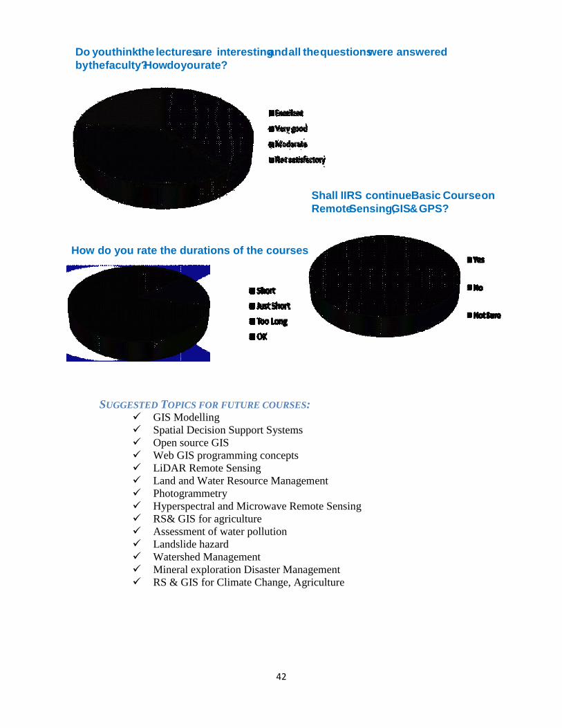
SUGGESTED TOPICS FOR FUTURE COURSES: GIS Modelling
Spatial Decision Support Systems
Open source GIS
Web GIS programming concepts
LiDAR Remote Sensing
Land and Water Resource Management
Photogrammetry
Hyperspectral and Microwave Remote Sensing
RS& GIS for agriculture
Assessment of water pollution
Landslide hazard
Watershed Management
Mineral exploration Disaster Management
RS & GIS for Climate Change, Agriculture
Do you think the lectures are interesting and all the questions were answered
by the faculty? How do you rate?
Shall IIRS continue Basic Course on
Remote Sensing, GIS & GPS?
How do you rate the durations of the courses

43
EDUSAT Participants during IUIM-2013

44
15. Annexure 1: Total Number of Participants in EDUSAT Course (Till March, 2013)
Table 7: Total Number of EDUSAT Course Participants
EDUSAT Course Summary
1st
Course
2nd
Course
3rd
Course
4th
Course
5th
Course
6th
Course
7th
Course
8th
Course
9th
Course
10th
Course Total
No. of
Lecture Hrs. 45 34 36 35.3 41.1 10 48 20 48 20 337.4
Hrs. of
Interactive
Session
15 17.5 18 12 10.2 3 24 10 24 10 143.7
Total Hrs 60 51.5 54 47.3 51.3 13 72 30 72 30 481.1
Total No. of
Participants 349 931 915 935 1101 171 1389 578 1170 1033 8572
Total
Universities
Participated
12 22 40 48 26 10 36 19
39
42
Total
Universities
Interacted
9 18 25 20 13 6 15 10
10 15
Course
Duration
Jan-Apr
07
Sep-Dec
07
Aug-Nov
08
Aug-Oct
09
Oct-Dec
10
Feb-Mar
11
Aug-Nov
11
Feb-Mar
12
Aug-
Oct 12 Feb-
Mar 13

45
16. Annexure 2: Abbreviations
Table 8: Abbreviations
CEC Consortium for Educational Communication
CSSTE-AP Centre for Space Science and Technology Education in Asia Pacific
DOS Department of Space
GIS Geographical Information System
GPS Global Positioning System
IGNOU Indira Gandhi National Open University
IIRS Indian Institute of Remote Sensing
INSAT Indian National Satellite
ISRO Indian Space Research Organization
ITEC International Technical and Economic Cooperation
NITTTR NITTTR National Institute of Technical Teachers Training and Research
NNRMS National Natural Resources Management System
NRSC National Remote Sensing Centre
ROT Receive Only Terminal
SCAAP Special Commonwealth African Assistance Plan
SIT Satellite Interactive Terminal
UGC University Grants Commission
UG/PG Undergraduate/Postgraduate
![IIRS Report on ISRS Symposium in Dec. 2016[1] · organisation to the Chipko Andolan (Hug the Trees Movement). Dr. A. Senthil Kumar, Chair, ISRS - Dehradun Chapter and Director, IIRS](https://static.fdocuments.us/doc/165x107/5eb52a47993af937be54127a/iirs-report-on-isrs-symposium-in-dec-20161-organisation-to-the-chipko-andolan.jpg)