![-4 02 O x o 13 +1-6 +6 IJ Iffi 1110 ff6 -kLl * Iffi IkK] 14 (Ill klqL * 'J 1 …/media/Files/shiga/... · 2019-11-10 · -4 02 O x o 13 +1-6 +6 IJ Iffi 1110 ff6 -kLl_ * Iffi IkK]](https://static.fdocuments.us/doc/165x107/5e422425ac97fb550f32a86f/4-02-o-x-o-13-1-6-6-ij-iffi-1110-ff6-kll-iffi-ikk-14-ill-klql-j-1-mediafilesshiga.jpg)
:*iim W3iP **Iffi - Ontario€¦ · 3. That I am a member of the Professional Engineers of Ontario...
19
!fe-''v vy.i',.-'-. m. CON-SHAWKEY GOLD MINES LIMITED Striker Township District of Algoma Sault Ste. Marie Mining Division Ontario ?K:- -VVV i SEP 13 1967 B RESIDENT GEOLOGIST SAULT December J8, 1967 GHD Consultants Limited : *iim **Iffi W3iP
Transcript of :*iim W3iP **Iffi - Ontario€¦ · 3. That I am a member of the Professional Engineers of Ontario...

!fe-''vvy.i',.-'-.
m.
CON-SHAWKEY GOLD MINES LIMITED
Striker Township
District of Algoma Sault Ste. Marie Mining Division
Ontario
?K:-
-VVV
iSEP 13 1967
BRESIDENT GEOLOGIST
SAULT
December J8, 1967 GHD Consultants Limited
:*iim **IffiW3iP

mfS"'*sir4v*
Ipff^-- KilKfc:
LOCATION
ACCESS
RESOURCES
HISTORY
TOPOGRAPHY
VEGETATION
LINE CUTTING
GENERAL GEOLOGY
CONCLUSIONS AND RECOMMENDATIONS 6
CONCLUSIONS
RECOMMENDATIONS
ESTIMATED COST OF PROPOSEDDRILLING
CERTIFICATE
ACKNOWLEDGEMENTS
APPENDIX "A"
MAP5J
7
7
8
9
10
•-. "-- v.; ..'- .;';V 'VW^^WW'^W.^^*-'^
-; ! ;:-':S:p^S
: - ' ^^11^
1
2
2
3
4
4
4
•- - 14 . .•~4'ie i "-vt i--.-'~,!^V:-i*^.
*V:"5i*##r-.-;
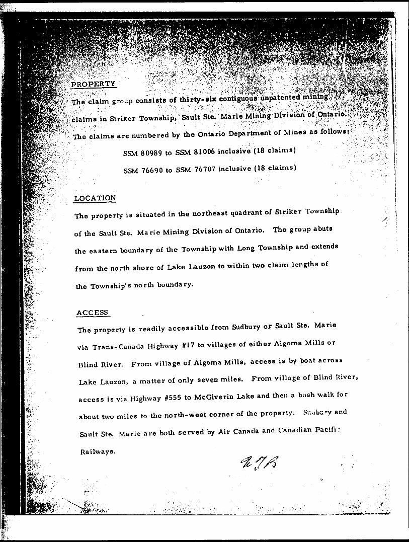
'3jjj!tMiPROPERTY
, - ..'.-. ^ ! .V- •f*.\
?pTh* claim group consists of thirty-aix contiguous unpatehted-..,.^^,,,,^•A -;:-""" "' ' ' ."''' ; v--'-.y.--'-'-V-*'-*'''- . ;'-- ' '-V^lS^ij^v*'' • ^••:-.^'.^-''ii.'^'^t'^'.:i^t.^^.
Striker Township,v Sault Ste; Marie M&lng bivisiorf ofvOhtario^* -- - - -... v - ' - -•-•'•-••V'. '-.-i- -. . - . •--.•-j
J*i-T*K
•
ki"l^v"i.
l-
1SIt̂k*1
•" "iSa iifllitj as Jfoliowsrv'."-;!;^1 ''-^The claims are numbered by the Ontario Department of Mines as follows:
SSM 80989 to SSM 81006 inclusive (18 claims)
SSM 76690 to SSM 76707 inclusive (18 claims)
LOCATION
The property is situated in the northeast quadrant of Striker Township
of the Sault Ste. Marie Mining Division of Ontario. The group abuts
the eastern boundary of the Township with Long Township and extends
from the north shore of Lake Lauzon to within two claim lengths of
the Township's north boundary.
ACCESS
The property is readily accessible from Sudbury or Sault Ste. Marie
via Trans-Canada Highway #17 to villages of cither Algoma Mills or
Blind River. From village of Algoma Mills, access is by boat across
Lake Lauzon, a matter of only seven miles. From village of Blind River,
access is via Highway #555 to McGiverin Lake and then a bush walk for
about two miles to the north-west corner of the property. Suvibury and
Sault Ste. Marie are both served by Air Canada and Canadian Pacifi:
Railways.
;- i

Ipv•pv--MA
m-J'r^r•t'flk-'
\P-.-* '. . -. *
Hydro electric power is available from the Ontario Hydro grid which
supplies the Sudbury-Sault Ste. Marie-Blind River area.
Timber and other building materials are available locally.
Transport via Highway #17, the Canadian Pacific Railway and/or Air
Canada to Sudbury or Sault Ste. Marie is no problem.
An old lumber road trending north-east passes through the property.
It has been obscured by later beaver work and is overgrown at places.
On the accompanying geological and magnetometer survey maps, the
road has been shown by double dashed lines where obvious and by a
single dashed line interspersed with question marks where flooded or
too overgrown to recognize.
HISTORY
The general area of the property has been prospected for copper over
many years and for uranium during the 1953-1956 era. Some of the
drilling done in this general area is inconclusive as a fe\v of the drill
holes failed to reach the basement. The location of the earlier diamond
drill holes is shown on the attached property map and the drilling da:a
, , . .. . . .,..-.' . - '-fs. rfr "*:-'j.';t'j*f:y.ti, : SyV-'ii,*;"

^fcV*2w*iB -^iS^^-'-'TTj-"'"—~'' -——r™---—- —v"' ::/;v'v\•'--•'-•i'ii' ':'--^:^y^-'^^ 'v-t-r^ VXS'^ij^^f'/f^^^lsS's
1. A diamond drill hole was completed by Algbina pre.Pro^ertle?*"^^" Ltd., in 1955 in the now claim #SSM ^'--^ ^ ^'^^-- ^'' '^
.v* carried to a depth of 1365'j- it hit the basement at a depth of -v ^S
1201', but no uranium bearing quartz pebble conglomerate was
encountered.
2. Gwillim Lake Gold Mines Ltd., drilled a hole in 1955 to a
depth of 830' in now claim #SSM 80991. The hole passed
through quartzites up to a depth of 267' and between 267' and
823' it ran through diabase. From 823* onwards the hole was in
hornblende granite (basement) but no radioactive conglomerates
were encountered.
3. Fitzpatrick Uranium Mines drilled seven holes in now claim
HSSM 76697 in 1955. All the holes were very shallow (ranged
in depth from 25' to 59") and ended in quartzite.
TOPOGRAPHY
The relief of the country is fairly high and a scarp and dip slope topography
prevails in the sediments. The drainage is controlled by the geology,
creeks flow either along the strike or along the weak zones, i. e. contart
zones. The diabase dykes of the Keweenav.ar. type are less resistant to
erosion and usually form small stream channels. There has been fairly

l^plP*!
'''VS**V VtA^WAi* a**tt*ri**r **ABt*ltSvt rv Sv\ a 1X1*"f\f wmJ4tt tfWvWk *u\t1**W **WA^Vd! Am*M*er*^-;|.,vitt-iJi^*a^tv*
7^ -••\^ - '~
j&^'f"pi'/' ' :.-'''
W &&S
K*-,W'~
m L "-^i
i
!-;- - i .Vif . A t.-'.:...*
- - . --. ' - , , - - - - . . :. - •^•^W-^y?
Both coniferous and deciduous trees are common. A lot of forest cover "-- 1 1
has been destroyed by previous forest fires and there is practically no
soil over the quartzite areas.
LINE CUTTING
Line cutting was done on the property during the month of November, 1967
and a total of 46 miles of lines were cut. Three major east-west base
lines were necessary and cross lines were cut north-south from the
base lines at 300 foot intervals.
GENERAL GEOLOGY
The property lies on the southern limb of Chiblow anticline and is
underlain by a thick (about 500') gabbro body in the eastern part and by
Huronian sediments belonging to Lower and Middle Mississagi Formations
in the western part. In the north eastern part of the property Archean
basement rocks of granitic to granodioritic composition outcrop. These
formations are cut by a number of thin east-\vest running diabase dykes.
A vertical fault of no significant throw runs cast-west in the middle of
the property. Following is a brief description of the formations h
chronological order.
in a

V.-}.'.'-- . .V';
r^-v-y".-- "- - " '. : - - "' - - ' ' - "' . -•^Diabase Dykes (Keweenawan)
'•T 'W1 "T.l**iY '.'
^^These dykes are olivine bearing and cut all the older formations. The
trend is east-west to slightly north of west./: They are usually
ft^••"-.
•' v%'Z.
^•t-ll^ilffe-'*\'~'- ' 'J . •V-,^.-('ilfe-v'iV-^/'-'^S*^V-;^ : 'i^fe^
i "?'; :.'^:i^*"r-;;-. ' - .. v.-^r-v ,.
- - '- 'v." -f:-:^?,:-.: -. ,-,,'.V..-Aj .
' -" ; '',:
^y; thin (of the order of 20' - 30'), can be traced over lenghts of 200'-300'.; ' '' '- -' ' ' 'They cut the host rocks at steep angles and in certain cases are almost
vertical.
Nipissing Diabase
The gabbro sill is about 500" thick and covers about 307r of the map area.
At its contact with quartzites it shows a chilled edge. The body is almost
barren and only at one place (Line 18W. 18N) slight traces of sulphide
mineralization were observed.
Lower and Middle Mississagi Formations
Middle Mississagi Formation outcrops in the western part of the area and
is represented by arkosic quartzites and interbedded argillltes. Lower
Mississagi Formation outcrops in the central and north-west part of the
property and is represented by pink to light colored quartzites and light
greenish arkosic quartzites. The quartzites arc medium to fine grained
and fairly well sorted. The sediments are frequently cross bedded and
show well developed mega-ripple marks, which suggest north westerlyt
current directions. At the contact with Nipissing Diabase the quartzite*
arc slightly bleached and show slich*. concent rations of magnetite anrl
othor mafic minerals.
m

Magnetometer Survey
A magnetic survey using a Sharpe Fluxgate magnetometer MJ
carried out during November, 1967. Magnetometer readings•: ; itaken both on base lines and cross lines at 100* intervals. Technical
details of the instrument can be found in Appendix "A".
Discussion of the Magnetometer Survey Results
A base control station arbitrarily assigned a magnetic value of 1500
gammas was established at HOON, 33+50E and all the readings were
adjusted to it. Ir. general, the quartzites and arkosic quartzites produce
fairly constant magnetic susceptibility but higher readings are obtained
on the diabase body. Some of the highs in the diabase may be attributed
to concentration of magnetite in the diabase, other high readings occur
on the tops of ridges where tile soil cover is minimum. Higher magnetic
readings were also obtained in the stream channels, this is probably
due to concentration of magnetite in the sand in the stream bed.
Discussion of Scintillometer Results
A scintillometer traverse \\as run following the old road and then along
Line 6W from base line 39 + 60N. The instrument used was a S. R. A. T.
scintillometer of S. P. P. 2. NF type. Usuall-- very low counts were
obtained on the sediments but some of the higher readings correspond
to more arkosic and sericitic bands in the quartzite.
M*
. f :K- I , ' - ! -CONCLUSIONS AND RECOMMENDATIONS
It is suggested that at least two vertical diamond drill holes (size
i*
fefe

should be put on the property.,; There are gobi
basement within 1500
holes is marked on the
foot in each hole. The position bf ;the 'suggested-
•^ a ccompanying geological map.^jThe^ old/winter- : --^v - - .. . ...W;. ;--'^," •i-itiKvj-i ^^^eVi^^**^*!^-' ,. ' . - -,- .v ' ."- *.v-:. "'•'T-^V.vT " ^.-^?,.:-,wv-iP3i.^j-:'t(|^
road passing through the property can be used for this purpose and -
plenty of water is available for any such purpose.
rev
f
CONCLUSIONS-- :
The results of the geological survey indicate that the general picture
of rock type distribution as shown in the Ontario Department of Mines
P304 and Compilation Series 2108 is quite accurate. The detailed
geological map accompanying this report shows the detail as mapped.
The magnetometer survey suggests no unexpected complications relative
to intrusives with the readings being generally rather uniform.
The diamond drilling carried out by earlier exploration efforts give
inconclusive results in view of either their local and/or the failure to
penetrate to sufficient depth.
In view of the presently known geological data, it would appear that the
obvious location for any exploratory drilling to cross section the favorable
lower Mississagi Sediments in the vicinity of the basement complex,
would be from the middle Mississagi outcrop area on the south and west
part of the claim group.
H ECOMM EN DA TICKS...——————————————— . . ^y
i i is suggested that diamond drilling be carried out from a site or sites
- - - ' •~ f -

r-*sp.'Sf.J'T."
m
^ iwithin the area underlain by the middle Mississagi SedimentsK^S'ti*-"- : ,- : ' \ - : - : --' - . .-,-.v;:;. : -' - \:.:V-, ".^V;, t: ••Vv**V.-'*i^Sfc?,:* ^K'V..-:..---- • •'•-' - -' - - - - -':"' ; ' - ; " -' - -!. s-!v --, ' \:-"'.-\ ••',^??-"ifor the favorable lower Mississagi conglomerate at or nea
l''-:: 'l;4''basement rocks. A suitable location for the initial drill hole might be
on claim #SSM 76690 with actual collar location dependent on local
topography. It would be advisable to provide for a minimum of three
holes with any decision relative to the second and third drill dependent
on the data resulting from No. 1. These holes should reach basement
at approximately 1500 feet, thus three holes would involve a total or
an estimated 4500 feet of drilling.
ESTIMATED COST OF PROPOSED DRILLING
Initial D. D. hole 1500 feet @ S8. 00 S12, 000. 00 TV.o additional D. D. holes (if advisable)
3000 feet @ S8. 00 24, 000. 00 Engineering, supervision and Transportation 7, OOP. 00
Total 343,000. 00
Respectfully submitted
GHD CONSULTANTS LIMITED
w&m
W. Boyes, P. Eng. F. G. A. C.

m
That I am a geologist and reside
SS . Weston, Ontario,
2. That I am a graduate in Honour Geology from the University
of Western Ontario,
3. That I am a member of the Professional Engineers of Ontario
and a Fellow of the Geological Association of Canada,
4. That I have been engaged in the practise of geology for
twenty years,
5. That I have no interest, nor expect to receive any interest,
directly or indirectly in the property or the securities of
Con-Shawkey Gold Mines Ltd.
6. That the accompanying report is based on personal knowledge
of the area, on government reports and maps and as otherwise
referred to in acknowledgement. "
DATED at TORONTO, this 28th day of December, 1967.
William T. Bo/es, P. Eng. F. G. A. C.

-^ - - . -,i- t?^-^vv-ff'i *v*s*w^*s/r\ift-,iit- .ri ,- 'V 1 -- ,. 1 -Ontario Department of Mines .'^jf ̂Geological Report No. 20^fl^'A-.**1 "..'^-' ''." ; . '/" \ ' . - 1 .. 1 '.'-" '" ' "' ' - -
*^|; Geological Report No. 13 71 v;' Ontario^Dep^rtmenfjo'rMines . s
Geological Circular No. 6 Ontario Department of Mines-.".- - - "'~ ' '- ' - :-''. •••' '".
Preliminary Map P. 304 Ontario Department of Mines
Compilation 2108 Ontario Department of Mines
Report GHD Consultants Limited (July 10th, 1967) David A. Duff, P. Eng.
Field Geological Mapping Z. Aziz, M. Se.
Geophysical Survey GHD Consultants
Fr
•y-.-fa'-;
1 ••ft- '--' l ",- vi*- ^ -v '-.' - ^

SPECIFICATIONS
SV" v\•"ste"---.
i:
MF-1 Standard surveying and prospecting magnetometer ;^with s elf-levelling sensor. - -'- ' -- . : .-. - .^v*-^. : '•••'• :';: ,.::-- , '•-.^'i-'{.', .^"'x^.-/
•*-'.' " ^ ^ '- ' '" , ~'~.."'" .' ''-' '- . ' -' - '."' ', - .•^(•/V.^'."'-'' - ' "i ;' ' - .'- ''r'.-'^".' :" ••': ',' - - "-J^" Vv '-..T V- l^ - '- "v^. ^/"'" ~ "- ' - HV',1.',
jlanges! Plus or minus - l, 000 gammas l. s e. 3, 000 M
10,000 "30,000 "
100,000 "
Sensitivity: 20 gammas por. div50 "
200 "500 "
2000 "
Meter: Taut-band suspension, l, 000 gamma scale: l 7/8" long 50 div3, 000 " " l 11/16" long 60 db
Accuracy^ l, 000 to 10, 000 gamma ranges - 0. 57c of full scale 30, 000 to 100, 000 gamma ranges t jyf of fuu scaie
Operating Temperature;
Temperature Stability:
Bucking Adjustments';
- 400 C to 400- 400 F to 1000 F
OLess than 2 gammas per C (l gamma/ F)
10, 000 to 75, 000 gammas by 9 steps of approximately 8, 000 gammas and fine control by l O-turn potentiometer. Con vertible for Southern hemisphere or t 30, 000 gammas equatorial.
Batteries; 12 x 1. 5V - flashlight batteries ("C" cell type)(AC Power supply available)
Consumption;
Dimensions:
Weights;
50 milliampercs
Instrument; 6 1/2" y 3 1/2" x 12 1/2" -165 x 90 x 320mm
Battery Pack: 4* x 2" x 7" -- 100 x 50 x180 mm
Shipping Container: 10" dia. x 16" -255 mm dia. x 410 M-:
Instrument: 5 Ihs. 12 oz. - l, t Battery Pack: J Ihs. -l o z. -l Shipping; l ' '"i.
i

0)
(OO
SI-'W)
}^SuS
lrv i
S i S j 5
S i 8."W
----"--' *-
ri ft UK
(/) Z< x oo'J
W--I
11 r
. :.* :-, 7-ic. ,
a ,
f -l~t^
"-
" -
- A'J.
/^ '
' "
•l./.
' ,
' '
. _ _
-^ ——
1 ——
— —
— ~"
o i
i/
^
i r'-'
i '1
' ''
r ''
-/i
J '
' '""''I
— —
r ^ 1
^
't
-j' t * "" i
i ' ^
' f i'x
* n
iS
f\\
o..o
'l
* '
U-''lM
ffp
|
,'r' "~
"',
'xi
' .
i" r
iiyi
4^X
LfS
^••-
(9221-1^1) 'dM
I U
9pqoo

:\':~-'i~i-^ V:-:V';v
•W-

BASE L INE I05+6QN
SSM
80990 10SSM
80989SSM
80991 8092
isw SS" nw
80994SSM
IW 80995SSM
8099680993
SSM
J0997SSM
80998SSM
8100180999
SSM
81003SSM
81002IW 76706 htio81004
SSM
81005SSM
81006767021485 -1SI*
7670376704
K.EY MAP88 i S SM'
76699' '-
aultSte.Uan. f I PROPER.TY
SSM
76695 7669476696 \
SSM
7669176693
CON-SHAWKEY GOLD MINES LTD.TWP 4 ALGOMA M1MIMG DIVISION, OMTAR-IO.
MAGNETOMETER 8 GEOLOGICAL SURVEY
G.H.D. CONSULTANTS LTD.

Base Line IQ5+60N
SSM
80990SSM
80991^FXV-
80992
SSM
8099380996 80995
SSM
80999809980997
76705 81004 81003
V^--.J
SSfo
76703
SSM
76702767048I005 81006
LOCATION MAP
SSM
76699SSM
76700SSM
76701 l ^UDBURV
76695 76694
76693
CON'SHAWKEY GOLD MINES LTD.TXA/P, ALGOMA MINING DIVISION, O NlTArZ\O.
Base Line O+QO
GEOLOGICAL SURVEY
GHD CONSULTANTS L.TD.
-2.0O800
FEET
'z
- oo/f-

BASE L INE I05+6QN
LEGEND
KEWEENAWAN DIABASE DYKE
NIPISSING
SSM
80990SSM
80989GROUP MIDDLE M1SS1SSAOI QUARTZ ITE S i
LOWEie
ALGOMAN GRANITE
SSM
80991
FAULT
STRIK.E AND DIP OF
CLIFF (WITH HEIGHT)
-O" CLAIM POST
SCINTILLOMETER READING (COUNTS PER SECOND)
PROPOSED DIAMOND DR.ILL HOLE
STREAM OK OZEEK,
SLOPE
~ OLD LUMBER
-- LUMBER ^OAD ( UMCEIZTAlIsj)
MAGNETOMETER HEADING
3OOO GAMMA CONTOUR
GAMMA COMTOUe
SSM
80995 80994
5 1 ^ W * J J l
/-//VE 79+20 N
SSM
80997
SSM
81003A- mc
81004
BASE LINE 53 N
SSM
76702SSM
S 8100576704
ST' 4 l* i 3t i f s ^ s I l i l i
•s 76699 .48,76700
SSM
76695147. S SM \
76696 \
SSM
76691
SURVEY BASE X-
M
eeiSAI STRIKER 200

Base Line IO5+6ON
34
17
21
17
LEQEMfr
KEWEENAWAN DIABASE
NIPISSING GABBRO
BF2UCE GtZOUP MIDOt-E
LOWER
ALGOMAW
O t*T CR Q
O R \ P T
QUAKTZ,ITE^
QUAfZTZi
41J02SW0205 0ei9A1 STRIKER aio