Principles of Conservation Biology BIOL 4160. What is Conservation Biology?

Gunnison Sage-grouse Rangewide Conservation Plan
III. CONSERVATION ASSESSMENT A. Biology and Life History Species Description
The largest grouse in North America is the sage-grouse, a species first described by Lewis and Clark in 1805 (Schroeder et al. 1999). Sage-grouse are charismatic birds known for their elaborate mating ritual where males congregate and “dance” to attract a mate on a specific strutting ground called a lek. Sage-grouse species in North America were once abundant and widespread but have declined throughout their range (Schroeder et al. 1999).
Sage-grouse are most easily identified by their large size, dark brown color, distinctive black bellies, long, pointed tails, and association with sagebrush habitats. Both sexes have yellow-green eye combs, which are less prominent in females. During the breeding season males have conspicuous filoplumes (specialized feathers on the neck), a black bib on a white upper breast and yellow-green air sacs on the chest.
For many years it was believed that all sage-grouse were a single species, known as the sage-grouse. In 2000, Young et al. (2000) identified GUSG as a distinct species. Geographic isolation, distinct genetic differences (Kahn et al. 1999, Oyler-McCance et al. 1999) and behavioral differences in strutting display separate GUSG from other sage-grouse, which are now called greater sage-grouse (Barber 1991, Young 1994, Young et al. 2000). The current ranges of the 2 species are not overlapping or adjacent (Schroeder et al. 2004). GUSG are also significantly smaller than greater sage-grouse (GRSG) in size of culmen, carpel, and tarsus, and they weigh approximately 1/3 less (Hupp and Braun 1991, Young et al. 2000). There are also distinctive plumage differences; GUSG males have more elaborate filoplumes and distinct, broad white barring on the tail feathers (Young et al. 2000).
Concern about the small population sizes and the long-term survival of the sage-grouse in current GUSG population areas started to surface in the early 1990’s. These concerns lead environmental groups to petition the USFWS in January 2000 to list the species as endangered. On March 15, 2000, the USFWS designated the GUSG as a Candidate species for threatened and endangered status. Under this designation, the status of GUSG is reviewed annually to determine if it is still warranted for listing and, if so, to determine its listing priority, which is based on the taxonomy of the species and the magnitude and immediacy of threats to the bird. Life History
Although GUSG and GRSG are different genetically, morphologically, and behaviorally with respect to strutting ground displays, their life histories and habitat requirements are believed to be similar (Young 1994). Most research exploring the life history and habitat requirements of sage-grouse has been conducted on GRSG and comparably little research has been done specifically on GUSG. Through the remainder of this document, the term sage-grouse is used when referring to sage-grouse in general. When
Conservation Assessment: 22Biology & Life History

Gunnison Sage-grouse Rangewide Conservation Plan
information is known to be specific to GRSG or GUSG, the species acronym will be used. Except where referenced, the following life history information is taken from Schroeder et al. (1999) and applies to both GRSG and GUSG.
Sage-grouse require sagebrush throughout the year for food and cover. Unlike many other game birds, GRSG and GUSG do not possess a muscular gizzard and therefore lack the ability to grind and digest seeds and only occasionally, by accident, consume grit (Rasmussen and Griner 1938, Leach and Hensley 1954). With the exception of insects in the summer, the year-round diet of adult GRSG consists of leafy vegetation. Forbs dominate the summer diet and sagebrush leaves are used the rest of the year (Leach and Hensley 1954, Wallestad 1975).
In the spring, sage-grouse gather on traditional breeding areas commonly referred to as "strutting grounds," but more generally referred to as "leks" (Patterson 1952, Gill 1965). Lek sites are open areas that have good visibility (allowing sage-grouse a greater opportunity to avoid predation) and acoustical qualities so the sounds of display activity can be heard by other sage-grouse.
In Colorado, strutting occurs from mid-March through late May, depending on elevation (Rogers 1964), and the same would hold true for Utah. Males establish territories on leks in early March, but the timing varies annually by 1-2 weeks depending on weather condition, snow melt, and day-length. Males assemble on the leks approximately 1 hour before dawn, and strut until approximately 1 hour after sunrise each day for about 6 weeks (Scott 1942, Eng 1963, Lumsden 1968, Wiley 1970, Hartzler 1972, Gibson and Bradbury 1985, Gibson et al. 1991). The sage-grouse mating system is polygamous (a male mates with several females). Most females visiting the lek are bred by a few males occupying the most advantageous sites near the center of the lek (Scott 1942, Lumsden 1968, Wiley 1973a, Hartzler and Jenni 1988). Most females arrive on leks each morning after the males do, and depart while the males are still displaying. When a hen is ready to mate she invites copulation by spreading her wings and crouching (Scott 1942, Hartzler 1972, Wiley 1978, Boyce 1990). Males provide no parental care or resources and females generally leave the lek and begin their nesting effort immediately after mating.
Nests are not uniformly distributed within nesting habitat (Bradbury et al. 1989, Wakkinen et al. 1992) although some research indicates that 70-80% of all nests often occur within 2 miles of an active lek (Bradbury et al. 1989, Wakkinen et al. 1992). Research on GRSG in northwestern Colorado from 2001-2002 shows that female movements are more extensive than previously reported, with 46% (n = 78/169) of the radio-marked females nesting within 1.8 miles of the lek of capture, 76% (n = 128/169) within 4 miles, and 88% (n = 148/169 within 5.8 miles (Hausleitner 2003, A. D. Apa unpublished data). In addition, female grouse have been documented moving as far as 15-20 miles from the lek where they were captured (assumed to be the lek upon which they bred). In North Park, Colorado, Schoenberg (1982) reported an average GRSG lek to nest movement of 1.6 miles, and research in Idaho has shown movements that range from 2.1 – 3.0 miles (Wakkinen 1990, Fischer 1994, Apa 1998).
For GUSG, 85.2% (n = 69/81) of all nests were located within 4 miles from the lek of capture (Apa 2004, NPS unpublished data; see Appendix J, “GUSG Habitat Use Data”). When only considering the Gunnison Basin, 80% (n = 20/25) of nests were placed < 4 miles from the lek of capture (Young 1994, Apa 2004, NPS unpublished data). In contrast, only 68% (n = 17/25) of nests are placed < 3 miles from the lek of capture. GUSG lek-to-nest
Conservation Assessment: 23Biology & Life History

Gunnison Sage-grouse Rangewide Conservation Plan
distances range from 0.6 – 0.83 miles at Poncha Pass (n = 3; Nehring and Braun 2000), 0.3 – 2.0 miles at Monticello, Utah (n = 3; Swenson 2003), and 0.1 – 12.6 miles for 6 of the GUSG populations (n = 37; Apa 2004). Young (1994) reported nest locations averaged 2.6 + 2.2 miles from the nearest lek (n = 37) in the Gunnison Basin.
Nests are typically shallow bowls lined with leaves, feathers and small twigs placed on the ground at the base of a live sagebrush bush. GRSG clutch size ranges from 6 to 10 eggs, with 7 to 9 being the most common (Wallestad and Pyrah 1974, Connelly et al. 1993, Gregg et al. 1994, Schroeder 1997). In Moffat County, Colorado, GRSG clutch size averages from 5.7 eggs for yearling females to 7.0 eggs for adult females (overall average was 6.7 eggs; Hausleitner 2003). Young (1994) reported a mean clutch size for GUSG of 6.8 ± 0.7 (n = 24) eggs, and Swenson (2003) found GUSG clutches ranging from 6-10 in Utah (n = 3). Incubation does not start until the last egg is laid and eggs are incubated 27 to 28 days (Patterson 1952).
GRSG have one of the lowest nest success rates of all the upland game bird species (Schroeder 1997), ranging from 63% in Montana to 10% in Oregon (Drut 1994, Connelly et al. 2000). In Moffat County, nest success in 2001-02 ranged from 45% - 60% (Hausleitner 2003, A. D. Apa unpublished data). GRSG nest abandonment is not uncommon if the hen is disturbed. While re-nesting is infrequent, it does occur (Patterson 1952; Eng 1963; Hulet 1983; Connelly et al. 1991). Young (1994) reported that 1 (4.8%) GUSG female renested during her 3-year study. GUSG are less apt to re-nest than GRSG (Young 1994). Clutch size of re-nesting attempts varies from 4 to 7 eggs (Schroeder 1997). Hatching begins around mid-May and usually ends by July. Most eggs hatch in June, with a peak between June 10 and June 20. In Moffat County the mean clutch initiation date was 26 April in 2001 and 21 April for 2002 (Hausleitner 2003).
Chicks are precocial and leave the nest with the hen shortly after hatching. The availability of food and cover are key factors related to chick and juvenile survival. During the first 3 weeks after hatching, insects (beetles, ants, grasshoppers) are the primary food of GRSG chicks (Patterson 1952, Trueblood 1954, Klebenow and Gray 1968, Savage 1968, Peterson 1970; Johnson and Boyce 1990, Johnson and Boyce 1991, Drut et al. 1994b; Pyle and Crawford 1996, Fischer et al. 1996b). Diets of 4 to 8-week-old chicks were found to have more plant material (approximately 70% of the diet), of which 15% was sagebrush (Peterson 1970). Succulent forbs are predominant in the diet until chicks exceed 3 months of age, at which time sagebrush becomes a major dietary component (Gill 1965; Klebenow 1969; Savage 1969; Connelly and Markham 1983; Gates 1983; Connelly et al. 1988, Fischer et al. 1996b).
During the pre-egg laying period, females select forbs that are generally higher in calcium and crude protein than sagebrush (Barnett and Crawford 1994). Females with chicks move to areas containing succulent forbs and insects, often in wet meadow habitat, where cover is sufficiently tall to conceal broods and provide shade. Groups of unsuccessful females and flocks of males follow similar habitat use patterns but are less dependent on wet meadow areas than females with broods. Insects are consumed by adult grouse, but forbs and sagebrush leaves represent a majority of the diet (Rasmussen and Griner 1938, Moos 1941, Knowlton and Thornely 1942, Patterson 1952, Leach and Hensley 1954). Highly used forbs include common dandelion, prickly lettuce, hawksbeard, salsify, milkvetch, sweet clover, balsamroot, lupine, Rocky Mountain bee plant, alfalfa, and globemallow (Girard 1937, Knowlton and Thornley 1942, Batterson and Morse 1948, Patterson 1952, Trueblood
Conservation Assessment: 24Biology & Life History

Gunnison Sage-grouse Rangewide Conservation Plan
1954, Leach and Browning 1958, Wallestad et al. 1975, Barnett and Crawford 1994). The quantity of forbs in adult GRSG diets in summer varies with location.
As fall approaches, intermixing of broods and flocks of adult birds is common and the birds move from riparian areas to sagebrush-dominated landscapes that continue to provide green forbs. Fringed sagebrush is often a transitional food as grouse shift from summer to winter diets.
From late-autumn through early spring the diet of GRSG is almost exclusively sagebrush (Girard 1937, Rasmussen and Griner 1938, Bean 1941, Batterson and Morse 1948, Patterson 1952, Leach and Hensley 1954, Barber 1968, Wallestad et al. 1975). Many species of sagebrush can be consumed, including big, low, silver, and fringed sagebrush (Remington and Braun 1985, Welch et al. 1988, 1991, Myers 1992). GRSG have been shown to select differing subspecies of sagebrush for their higher protein levels and lower concentrations of monoterpenes (Remington and Braun 1985, Myers 1992). Grouse have been shown to gain weight over the winter (Beck and Braun 1978, Remington and Braun 1988), but in exceptionally harsh winters, fat reserves can decrease (Hupp and Braun 1989a).
During particularly severe winters sage-grouse are dependent on very tall sagebrush, which is exposed even above deep snow, providing a consistently available food source. GRSG are capable of making long movements (>18 miles) to find appropriate habitat. GUSG have been documented making movements as large as 17 miles (Root 2002). The extent of movement varies with severity of winter weather, topography, and vegetation cover.
GRSG winter range in Colorado varies according to snowfall, wind conditions, and suitable habitat (Rogers 1964). Sage-grouse may travel short distances or many miles between seasonal ranges. Movements in fall and early winter (September-December) can be extensive with some movements exceeding 20 miles. In North Park, Colorado, Schoenberg (1982) documented female GRSG moving more than 18 miles from winter to nesting areas. Hausleitner (2003) found that in Moffat County, Colorado, female GRSG moved an average of 6 miles from nesting areas to winter sites. The range of movements was extensive, and ranged from < 0.5 - 19 miles
Flock size in winter is variable (15-100+), with flocks frequently comprised of a single sex (Beck 1977, Hupp 1987). Many, but not all, flocks of GRSG males can over-winter in the vicinity of their leks, and by March they are usually within 2-3 miles of breeding areas used the previous year. These movements depend on whether the population is non-migratory or moves between 2 or more seasonal ranges (Connelly et al. 2000).
Annual survival rates of GRSG also vary (Table 4). Survival rates have been estimated from banding or radio telemetry studies. Survival of juveniles from hatch to fall has been estimated to be 38% in Wyoming (June 1963). The survival rate of GRSG varies by year, sex, and age (Zablan 1993). There is reasonable evidence to suggest that female GRSG have higher survival rates than males (Swenson 1986). This higher survival rate may be due to sexual dimorphism. Females have cryptic plumage and a more secretive nature versus the more elaborate plumage and display activities of males (Schroeder et al. 1999).
Conservation Assessment: 25Biology & Life History

Gunnison Sage-grouse Rangewide Conservation Plan
Table 4. Annual survival rates of GRSG.
GRSG Sample Survival Rate Location Study Adult females 55% Colorado Zablan 1993 Females 75% Idaho Connelly et al. 1994 Males 60% Idaho Connelly et al. 1994 Females 67% Wyoming June 1963 Males 59% Wyoming June 1963 Adult Females (2001-2002) 65% Colorado Hausleitner 2003 Yearling Females (2001-2002) 71% Colorado Hausleitner 2003 Adult females (2002-2003) 48% Colorado Hausleitner 2003 Yearling Females (2002-2003) 78% Colorado Hausleitner 2003
It is not unreasonable to expect that GUSG survival rates are similar to those of
GRSG. Apa (2004) reported that GUSG survival from capture (April 2002) through 31 March 2003 for males was 0.48 ± 0.07 (n = 47) and for females was 0.57 ± 0.06 (n = 57). Survival across all the isolated populations was pooled to empirically compare GUSG male and female survival in the isolated populations to the Gunnison Basin (Apa 2004). Female survival in the isolated populations and Gunnison Basin was 0.52 ± 0.08 (n = 40) and 0.71 ± 0.11 (n = 17), respectively. Male survival in the isolated populations and Gunnison Basin was 0.51 ± 0.09 (n = 29) and 0.41 ± 0.12 (n = 17), respectively.
Habitat Requirements
The extensive literature describing seasonal habitat use by GRSG spans 9 western states and 60 years, but there is considerably less information available for GUSG (Hupp 1987, Hupp and Braun 1989b, Young 1994, Commons 1997, Swenson 2003, and Apa 2004). The following habitat descriptions are based on GUSG data when available, and on GRSG information when needed. In addition, if the quality of GUSG data is questionable, information from GRSG is used.
Sage-grouse use extensive landscapes throughout the year and can move great distances or have annual migratory patterns (Beck 1975, Wallestad 1975, Hulet 1983, Berry and Eng 1985, Connelly et al. 1988, Wakkinen 1990, Fischer 1994). Sage-grouse are wide ranging because they require a diversity of seasonal habitats (Connelly et al. 2000), and have specialized dietary requirements (see Schroeder et al. 1999 for numerous citations). Sage-grouse may use small portions of many different landscape types during different life stages (Connelly et al. 2000) and movements between small seasonal ranges may be extensive.
Sage-grouse habitat requirements may differ by season (Connelly et al. 2000). Connelly et al. (2000) segregated habitat requirement into 4 seasons: (1) breeding habitat; (2) summer - late brood-rearing habitat; (3) fall habitat; and (4) winter habitat. In some situations, fall and summer - late brood-rearing habitats are indistinguishable, but this depends on the movement patterns of the population and habitat availability. The breeding habitat category includes lekking, pre-laying female, nesting, and early brood-rearing habitat. Summer - late brood-rearing habitat includes habitat used during this period by males, non-brooding females, and females with broods. Fall habitat consists of “transition” range from
Conservation Assessment: 26Biology & Life History

Gunnison Sage-grouse Rangewide Conservation Plan
late summer to winter, and can include a variety of habitats used by males and females (with and without broods). Winter habitat is used by segregated flocks of males and females (Beck 1977). Management of sage-grouse habitats should include all habitat types necessary for fulfillment of life history needs.
For the purpose of this plan, we have combined the summer - late brood-rearing and fall habitat into a single habitat category, “summer – fall”, resulting in 3 overall seasonal habitats, rather than 4. Summer – late brood-rearing habitat is typically characterized by high elevation mesic areas, cropland, wet meadows, and riparian areas. Grouse continue to use these as fall approaches and there is a slow conversion of the diet from forbs to sagebrush. As mentioned earlier, in many cases these two seasonal habitats are indistinguishable, but in the future local information may provide additional insight as to when and where these 2 seasonal habitats can be clearly separated.
All the seasonal habitats described here include habitat used by brooding females, unsuccessful female, and male flocks.
Breeding Habitat (Leks, Pre-laying Habitat, Nesting Habitat, and Early Brood-rearing Habitat)
Leks (mid-March – mid-May)
There are no habitat investigations specific to GUSG strutting habitat. Most of the information collected is specific to GRSG.
Lek sites can be very traditional with grouse displaying in the very same location from year to year. Some leks are known to have been in use since the 1950’s (Rogers 1964). Leks are usually located in small open areas adjacent to stands of sagebrush with 20% or greater canopy cover (Klott and Lindzey 1989). Openings may be natural or human created, including (but not limited to) small burns, drill pads, irrigated pasture, and roads (Connelly et al. 1981, Gates 1985).
Superficially, lek sites do not appear limiting (Schroeder et al. 1999), but they may vary in escape cover and quality of sagebrush (Patterson 1952, Gill 1965, Connelly et al. 1988, Connelly et al. 2000). The amount of land needed for males to strut can vary greatly. Lek sites are usually flat to gently sloping areas of <15% slope in broad valleys or on ridges (Hanna 1936, Patterson 1952, Hartzler 1972, Giezentanner and Clark 1974, Wallestad 1975, Dingman 1980, Autenrieth 1981, Klott and Lindzey 1989). Lek sites have good visibility and low vegetation structure (Tate et al. 1979, Connelly et al. 1981, Gates 1985), and acoustical qualities that allow sounds of breeding displays to carry (Patterson 1952, Hjorth 1970, Hartzler 1972, Wiley 1973b, 1974, Bergerud 1988, Phillips 1990). The absence of taller shrubs/trees or other obstructions appears to be critical for continued use of these sites by displaying males.
Sites chosen for display are typically close to sagebrush that is > 6 inches tall and has a canopy cover > 20% (Wallestad and Schadweiler 1974). Usually leks are located in the vicinity of nesting habitat (Wakkinen et al. 1992) and are in areas intersected by high female traffic (Bradbury and Gibson 1983, Bradbury et al. 1986, Gibson et al. 1990, Gibson 1992, 1996). These sagebrush areas are used for feeding, roosting, and escape from inclement
Conservation Assessment: 27Biology & Life History

Gunnison Sage-grouse Rangewide Conservation Plan
weather and predators. Males are usually found roosting in sagebrush stands with canopy cover of 20 - 30% (Wallestad and Schladweiler 1974).
Daytime movements of adult males GRSG during the breeding season do not vary greatly. Wallestad and Schladweiler (1974) found daily movements ranged between 0.2 and 0.8 miles from leks, with a maximum cruising radius of 0.9 to 1.2 miles. Ellis et al. (1987) reported that dispersal flights of male GRSG (to day-use areas) ranged from 0.3 – 0.5 miles, with the longest flights ranging from 1.2 – 1.3 miles. Carr (1967) reported that the cruising radius of male GRSG ranged from 0.9 – 1.1 miles. Rothenmaier (1979) found that 60 – 80% of male GRSG locations were within 0.6 – 0.7 miles of a lek. Emmons (1980) reported that male dispersal distances to day-use areas of 0.1 miles were common and that 67% of all use areas were greater than 0.3 miles from the lek. In addition, Schoenberg (1982) found that male daily movements averaged 0.6 miles, but ranged from 0.02 – 1.5 miles. No similar data are available for GUSG.
Pre-laying Habitat (late-March – April)
No information is available regarding pre-laying habitat for GUSG. Connelly et al. (2000) recommend that breeding habitat should include pre-laying habitat but little is known or understood about pre-laying habitat, even for GRSG. It has been suggested that pre-laying habitats should provide a diversity of vegetation to meet the nutritional needs of females during the egg development period. For pre-laying females in Oregon, Barnett and Crawford (1994) suggest that the habitat should contain a diversity of forbs that are rich in calcium, phosphorous and protein.
Nesting Habitat (mid-April – June)
GRSG prefer to nest under tall (11 – 31 inches) sagebrush (Connelly et al. 2000). Peterson (1980) found in North Park, Colorado that nest bushes averaged approximately 20 inches. In Moffat County, Colorado this value is slightly higher and ranges from 30 – 32 inches (Hausleitner 2003). Often, the actual nest bush is taller than the surrounding sagebrush plants (Keister and Willis 1986, Wakkinen 1990, Apa 1998). In northwestern Colorado, the nest bush was nearly 10 inches taller than surrounding shrubs (Hausleitner 2003). The canopy cover of sagebrush around the nest ranges from 15 - 38% (Patterson 1952, Gill 1965, Gray 1967, Wallestad and Pyrah 1974, Keister and Willis 1986, Wakkinen 1990, Connelly et al. 1991, Apa 1998, Connelly et al. 2000). Sagebrush canopy cover around nests in northwestern Colorado had a similar range of values, and averaged 27% (Hausleitner 2003).
Young (1994) reported GUSG nesting under sagebrush that had a mean height of 16.1 inches in the Gunnison Basin. In the Gunnison Basin, Apa (2004) found GUSG nested in areas with a mean sagebrush height of 18.6 inches. In contrast, non-use sites exhibited average mean sagebrush heights of 3.6 inches (Apa 2004). Average horizontal cover of sagebrush varied from 17.4 – 26.0% while non-sagebrush cover varied from 7.9 – 13.7%; non-sagebrush cover at non-use locations was 6.9%.
Conservation Assessment: 28Biology & Life History

Gunnison Sage-grouse Rangewide Conservation Plan
Good quality nesting habitat consists of live sagebrush with sufficient canopy cover, and substantial grasses and forbs in the understory (Connelly et al. 2000). Few herbaceous plants are growing in April when nesting begins, so residual herbaceous cover from the previous growing season is critical for nest concealment in most areas, although the level of herbaceous cover depends largely on the potential of the sagebrush community (Connelly et al. 2000). Reasonable and scientifically defensible habitat structure guidelines specific to GUSG need to be developed.
Nearly all nests are located beneath sagebrush plants (Patterson 1952, Gill 1965, Gray 1967, Wallestad and Pyrah 1974) and GRSG nesting under sagebrush plants have higher nest success than those that nest under plants other than sagebrush (Connelly et al. 1991). Sage-grouse nest sites also have an important component of herbaceous vegetation (Connelly et al. 2000). Grass heights are variable and as measured across the West range from 5 – 13 inches (Connelly et al. 2000). In addition, horizontal grass cover measurements are also variable and range from 4 – 51% cover. These measurements are similar to northwest Colorado data; Hausleitner (2003) reported that grass heights at nests ranged from 5-6 inches, grass cover averaged approximately 4%, and forb cover averaged about 7% (Hausleitner 2003).
Although not clearly understood, it is also believed that understory herbaceous cover (horizontal and vertical) is important for GUSG nesting habitat. Young (1994) found in the Gunnison Basin that nesting females used nest sites with horizontal grass and forb cover that averaged 9.5% and 3.7%, respectively. Apa (2004) found across southwestern Colorado that GUSG females nested in areas with grass cover of 24.9% and forb cover of 17.6%. Grass height was 4.0 inches and forb height was 1.6 inches.
Early Brood-rearing
Early brood-rearing habitat requirements are very similar to nesting habitat requirements. Early brood-rearing habitat is found relatively close to nest sites (Connelly et al. 2000), but individual females with broods may move large distances (Connelly 1982, Gates 1983). Early brood-rearing habitat is typically characterized by sagebrush stands with canopy cover of 10-15% (Martin 1970, Wallestad 1971) with herbaceous understories that exceed 15% cover (Sveum et al. 1998a, Lyon 2000). In Moffat County, Colorado, sagebrush stands average approximately 11% canopy cover and herbaceous understories average about 14% horizontal cover (Hausleitner 2003). High plant species diversity (sometimes also referred to as species richness) is also typical in early brood-rearing habitat (Dunn and Braun 1985, Klott and Lindzey 1990, Drut et al. 1994a, Apa 1998). Sagebrush heights ranged from 6 to 18 inches in Montana (Sveum et al. 1998a, Lyon 2000) and about 23 inches in Moffat County (Hausleitner 2003). Adjacent shrub areas of 20-25% canopy cover have been reported as preferred for escape and day roosting (Wallestad 1971; Dunn and Braun 1987), but night roosting sites in Moffat County, Colorado had only 4% sagebrush canopy cover and sagebrush height was 20 inches
In early summer, the size of the area used appears to depend on the interspersion of sagebrush types that provide an adequate amount of food and cover. Females and broods can select riparian habitats in the sagebrush type that have abundant forbs and moisture (Gill 1965; Klebenow 1969; Savage 1969; Connelly and Markham 1983; Gates 1983; Connelly et al. 1988; Fischer et al. 1996a). Females with broods remain in sagebrush uplands as long as
Conservation Assessment: 29Biology & Life History

Gunnison Sage-grouse Rangewide Conservation Plan
the vegetation remains succulent, but may move to wet meadows as vegetation desiccates (Fischer et al. 1996b). Depending on precipitation and topography, some broods may stay in sagebrush/grass communities all summer while others shift to lower areas (riparian areas, hay meadows or alfalfa fields) as upland plant communities desiccate (Wallestad 1975). Summer - Fall Habitat
As sagebrush communities continue to dry out and many forbs complete their life cycles, sage-grouse typically respond by moving to a greater variety of and more mesic habitats (Patterson 1952). Sage-grouse begin movements in late June and into early July (Gill 1965, Klebenow 1969, Savage 1969, Connelly and Markham 1983, Gates 1983, Connelly et al. 1988, Fischer 1994). By late summer and into the early fall, females with broods, non-brood females, and groups of males become more social, and flocks are more concentrated (Patterson 1952). This is the period of time when GUSG can be observed in atypical habitat such as agricultural fields (Commons 1997).
From mid-September into October, GRSG prefer areas with more dense sagebrush (>15% canopy cover) and late green succulent forbs before moving to early transitional winter range where sexual segregation of flocks becomes notable (Wallestad 1975, Beck 1977, Connelly et al. 1988). During periods of heavy snow cover in late fall and early winter, use of mountain and Wyoming big sagebrush stands is extensive.
Winter
As late fall approaches weather events trigger movements to winter areas. The timing of this movement varies, influenced by yearly weather conditions. Winter habitat use depends upon snow depth and availability of sagebrush, which is used almost exclusively for both food and cover. Used sites are typically characterized by canopy cover > 25% and sagebrush > 12 - 16 inches tall (Shoenberg 1982) associated with drainages, ridges, or southwest aspects with slopes < 15% (Gill 1965, Wallestad 1975, Beck 1977, Robertson 1991). In Colorado, less than 10% of available sagebrush habitat is used during deep snow conditions by GRSG (Beck 1977) and GUSG (Hupp and Braun 1989b). When snow deeper than 12 inches covers over 80% of the winter range, GRSG have been shown in Idaho to rely on sagebrush greater than 16 inches in height in valleys for foraging (Robertson 1991).
Lower flat areas and shorter sagebrush along ridge tops provide roosting areas. During extreme winter conditions, GRSG will spend nights and portions of the day (when not foraging) burrowed into “snow roosts” (Back et al. 1987). Snow roosts are dug when snow has the proper texture by scratching with feet or by wing movements.
Hupp and Braun (1989b) found that most GUSG feeding activity during the winter occurred in drainages and on slopes with south or west aspects in the Gunnison Basin. In years with severe winters resulting in heavy accumulations of snow, the amount of sagebrush exposed above the snow can be severely limiting. Hupp and Braun (1989b) investigated GUSG feeding activity during a severe winter in the Gunnison Basin in 1984, where they estimated <10% of the sagebrush was exposed above the snow and available to sage-grouse.
Conservation Assessment: 30Biology & Life History

Gunnison Sage-grouse Rangewide Conservation Plan
In these conditions, the tall and vigorous sagebrush typical in drainages were an especially important food source for GUSG.
Conservation Assessment: 31Biology & Life History

Gunnison Sage-grouse Rangewide Conservation Plan
B. Distribution and Abundance Distribution Historic Distribution
Determining the historic range of GUSG is problematic for many reasons, most notably because of widespread loss of sagebrush habitats, which preceded scientific study of the species. Additionally, GUSG have been extirpated from many areas for which no useful zoological records or specimens exist. According to Young et al. (2000) the GUSG is believed to have historically occurred in Colorado, Kansas, Oklahoma, New Mexico, Arizona, and Utah. A more recent review of historical records, museum specimens, and potential sage-grouse habitat by Schroeder et al. (2004) concluded that GUSG are believed to have historically occurred in southwestern Colorado, northwestern New Mexico, northeastern Arizona, and southeastern Utah (Fig. 3). Accounts of GUSG in Kansas and Oklahoma are not supported with museum specimens and Schroeder et al. (2004) found potential inconsistencies with the historic records and the sagebrush habitat currently believed to be necessary for GUSG survival available in those areas. Applegate (2001) concluded that sage-grouse should be considered hypothetical in Kansas because none of the sagebrush species closely associated with sage-grouse occurred there. He attributed historical, anecdotal reports as mistaken locations or misidentification of lesser prairie chickens.
For these reasons, southwestern Kansas and western Oklahoma were not included on the historic GUSG range map (Schroeder et al. 2004). GUSG range is estimated to have been 21,376 mi2 historically, and 1,822 mi2 (8.5% of the original) is estimated to be the current species range (Schroeder et al. 2004). We modified the historical distribution map by Schroeder et al. (2004) in Colorado and Utah, based on several sources (Fig. 3, see pg. 34 for explanation).
Conservation Assessment: 32Distribution & Abundance

33C
onservation Assessment:
Distribution and Abundance
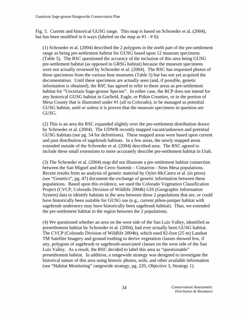
Fig 3. Current and historical Gunnison sage-grouse range. See next page for details on numbers found on map.
Gunnison Sage-grouse Rangewide Conservation Plan
Fig. 3. Current and historical GUSG range. This map is based on Schroeder et al. (2004), but has been modified in 6 ways (labeled on the map as #1 - # 6):
(1) Schroeder et al. (2004) described the 2 polygons in the north part of the pre-settlement range as being pre-settlement habitat for GUSG based upon 12 museum specimens (Table 5). The RSC questioned the accuracy of the inclusion of this area being GUSG pre-settlement habitat (as opposed to GRSG habitat) because the museum specimens were not actually reviewed by Schroeder et al. (2004). The RSC has requested photos of these specimens from the various host museums (Table 5) but has not yet acquired the documentation. Until these specimens are actually seen (and, if possible, genetic information is obtained), the RSC has agreed to refer to these areas as pre-settlement habitat for “Uncertain Sage-grouse Species”. In either case, the RCP does not intend for any historical GUSG habitat in Garfield, Eagle, or Pitkin Counties, or in the portion of Mesa County that is illustrated under #1 (all in Colorado), to be managed as potential GUSG habitat, until or unless it is proven that the museum specimens in question are GUSG. (2) This is an area the RSC expanded slightly over the pre-settlement distribution drawn by Schroeder et al. (2004). The UDWR recently mapped vacant/unknown and potential GUSG habitats (see pg. 54 for definitions). These mapped areas were based upon current and past distribution of sagebrush habitats. In a few areas, the newly mapped areas extended outside of the Schroeder et al. (2004) described area. The RSC agreed to include these small extensions to more accurately describe pre-settlement habitat in Utah. (3) The Schroeder et al. (2004) map did not illustrate a pre-settlement habitat connection between the San Miguel and the Cerro Summit – Cimarron - Sims Mesa populations. Recent results from an analysis of genetic material by Oyler-McCance et al. (in press) (see “Genetics”, pg. 47) document the exchange of genetic information between these populations. Based upon this evidence, we used the Colorado Vegetation Classification Project (CVCP, Colorado Division of Wildlife 2004b) GIS (Geographic Information System) data to identify habitats in the area between these 2 populations that are, or could have historically been suitable for GUSG use (e.g., current piñon-juniper habitat with sagebrush understory may have historically been sagebrush habitat). Thus, we extended the pre-settlement habitat in the region between the 2 populations. (4) We questioned whether an area on the west side of the San Luis Valley, identified as presettlement habitat by Schroeder et al. (2004), had ever actually been GUSG habitat. The CVCP (Colorado Division of Wildlife 2004b), which used 82-foot (25 m) Landsat TM Satellite Imagery and ground truthing to derive vegetation classes showed few, if any, polygons of sagebrush or sagebrush-associated classes on the west side of the San Luis Valley. As a result, the RSC decided to label this area as “questionable” presettlement habitat. In addition, a rangewide strategy was designed to investigate the historical nature of this area using historic photos, soils, and other available information (see “Habitat Monitoring” rangewide strategy, pg. 220, Objective 3, Strategy 1).
Conservation Assessment: 34Distribution & Abundance

Gunnison Sage-grouse Rangewide Conservation Plan
(5) Based on the CVCP (Colorado Division of Wildlife 2004b) we added pre-settlement distribution on the east side of the San Luis Valley. Both the GIS data and a long-term CDOW employee’s knowledge of the area suggest that GUSG were likely distributed on the east side of the valley, and that this was the area linked to pre-settlement GUSG distribution in New Mexico. (6) We expanded the Schroeder et al. (2004) pre-settlement distribution map in 3 areas. All these areas (2 associated with the Gunnison Basin population, 1 with the Poncha Pass population) currently contain GUSG and/or sagebrush habitat. The broad scale used by Schroeder et al. (2004) for delineation of pre-settlement habitat could have understandably missed small areas like these. The RSC agreed to include these small extensions to more accurately describe pre-settlement habitat in Colorado.
Conservation Assessment: 35Distribution & Abundance

Gunnison Sage-grouse Rangewide Conservation Plan
Table 5. Museum specimens collected for area identified in Fig. 3 as “Uncertain Sage-grouse Species”. SEX AGE NUMBER DATE SPECIFIC
LOCATION COLLECTION COLLECTOR
Female Adult DMNH-27087 7/12/1905
Between Colter and Spitzer's Neck near Grand River
Denver Museum of Natural History A. H. Felger
Female Adult DMNH-27088 7/12/1905
Between Colter and Spitzer's Neck near Grand River
Denver Museum of Natural History A. H. Felger
Male Unknown AM-315107 3/7/1906 Garfield County
Agassiz Museum, Harvard University
J. E. Thayer
Male Unknown AM-315106 3/22/1906 Garfield County
Agassiz Museum, Harvard University
J. E. Thayer
Female Unknown FMNH-131312 10/27/1902 Newcastle, Garfield
County Field Museum-Chicago
H. W. Marsden, L. B. Bishop (9295)
Female Unknown FMNH-131313 10/27/1902 Newcastle, Garfield
County Field Museum-Chicago
H. W. Marsden, L. B. Bishop (9296)
Male Unknown FMNH-131315 9/14/1903 Newcastle, Garfield
County Field Museum-Chicago
H. W. Marsden, L. B. Bishop (9792)
Female Unknown FMNH-131314 9/15/1903 Newcastle, Garfield
County Field Museum-Chicago
H. W. Marsden, L. B. Bishop (9791)
Female Unknown FMNH-131316 9/15/1903 Newcastle, Garfield
County Field Museum-Chicago
H. W. Marsden, L. B. Bishop (9793)
Unknown Juvenile AM-272666 7/7/1904 Newcastle, Garfield
County
Agassiz Museum, Harvard University
From Peabody Museum
Male Unknown AMNH-353699 9/15/1903 Newcastle, Garfield
County American Museum of Natural History Unknown
Female Unknown AMNH-353700 9/15/1903 Newcastle, Garfield
County American Museum of Natural History Unknown
Current Distribution
GUSG currently occur in what have previously been considered 8 widely scattered and isolated populations in Colorado and Utah (Fig. 4). In Colorado, 7 GUSG population areas are: Cerro Summit – Cimarron - Sims Mesa, Crawford, Dove Creek, Gunnison Basin, Piñon Mesa, Poncha Pass, and San Miguel Basin. During the winter in some or most years, GUSG also inhabit a small portion of Grand County, Utah. These birds are believed to be part of the Piñon Mesa population that predominantly occupies and breeds in Mesa County, Colorado.
Conservation Assessment: 36Distribution & Abundance

Gunnison Sage-grouse Rangewide Conservation Plan
The Utah population is located near the town of Monticello and may be contiguous with the Dove Creek population in Colorado. Genetic data have also suggested these 2 populations could be considered one population (see “Genetics”, pg. 47). Thus, we consider them 2 subpopulations of a single population, but discuss them separately within the “Conservation Assessment” section because they occur in 2 states and each has its own local work group and local conservation plan. However, on RCP maps the 2 subpopulations are shown as a single population, and within the “Conservation Strategy” (pg. 201) we consider them as a single population from a conservation standpoint, although we specify some actions and targets for each state, again because of the separate entities and groups involved in managing the birds. Because we deem these 2 former “populations” as 1 population, we consider there to currently be 7 GUSG populations.
The Cerro Summit – Cimarron – Sims Mesa and San Miguel Basin populations both exhibit a patchy distribution of GUSG. As a result, we identify separate “subpopulations” within each. At Cerro Summit – Cimarron – Sims Mesa there are 2 subpopulations: (1) Cerro Summit – Cimarron; and (2) Sims Mesa. In San Miguel Basin there are 6 subpopulations: (1) Dry Creek Basin; (2) Hamilton Mesa; (3) Miramonte Reservoir; (4) Gurley Reservoir; (5) Beaver Mesa; and (6) Iron Springs.
Conservation Assessment: 37Distribution & Abundance

Fig. 4. Locations of current Gunnison sage-grouse populations. The discontinuity in occupied habitat at the state line in the Dove Creek – Monticello area is not entirely a mapping artifact; where there is occupied habitat on the Colorado side there is an abrupt change to cropland on the Utah side of the border. The abrupt transition at the state border in the Piñon Mesa area may be due to
38 C
onservation Assessment:
Distribution and Abundance
differing mapping efforts between the states and is addressed in the “Habitat Monitoring” rangewide strategy (see Objective 1, Strategy 3, pg. 221).

Gunnison Sage-grouse Rangewide Conservation Plan
Abundance Lek Counts and Population Estimation
Inventory and monitoring of wildlife populations is an obvious prerequisite to conserving them, and is especially important when quantitative goals for species conservation have been developed. What is not obvious is how to accomplish inventory, and what level of resources is appropriate to commit to this task, since resources devoted to inventory and monitoring will not be available for other critical conservation tasks. Having very accurate and precise estimates of GUSG numbers does not in and of itself improve the species’ status. Population trends of sage-grouse have been monitored across the western U.S. using variations on a lek count methodology first described by Patterson (1952), who studied sage-grouse in Wyoming. Patterson speculated that the maximum number of males counted over 3 or 4 counts spread throughout the display period might be a useful index to sage-grouse population trends. Wildlife managers have monitored populations of many species through the use of indices, where a count or measurement is made of some characteristic of a population that is both convenient to measure and is thought to be related to abundance. With birds, indices are often based on vocalizations made during the breeding season, such as pheasant “crow” call counts, dove coo-count indices, and bobwhite whistling counts (Lancia et al. 1994). Anderson (2001) noted the weaknesses of this type of sampling, which may be convenient for wildlife managers, but does not lead to defensible estimates of population size or status. The index, whether it is pheasant crows or the number of male sage-grouse counted on a lek, has an unknown relationship to the larger population of interest.
As a result of the publication of Patterson (1952) the lek count became the standard for sage-grouse population monitoring. Patterson (1952) based the census on the belief that all males regularly attend leks. His suggested maximum of 3 or 4 counts made sense under this assumption, because given normal environmental variables associated with lek counts (e.g., cold temperatures, snow, predator harassment), it might take 3 or 4 trips to get a “good” count of all the males present.
The lek count protocol proposed by Patterson (1952) has weaknesses. Dalke et al. (1963:833) thought lek counts provided a reasonably accurate method of determining breeding population trends, but noted the high degree of variability in daily counts and suggested a “…need for more refined census methods as sage-grouse management becomes more intensive in the future.” Jenni and Hartzler (1978:51) used and supported the technique but speculated that high variance in counts was because “…some unestablished birds wandered about visiting different leks on different mornings.”
Beck and Braun (1980) presented a critical review of the practice of using lek counts to assess population trends or size. They pointed out that without information on the total number of leks in an area, attendance patterns of adult and yearling males, inter-lek movements, and the relationship between the maximum count and the population size, nothing could be concluded about population size or trends from lek counts. Despite these criticisms, the Western States Sage Grouse Committee essentially codified lek counts as a means to assess population trends 2 years later when it published its Sage Grouse Management Practices (Autenrieth et al. 1982). The publication advises caution in the interpretation of counts because of the high level of variance in the data, but no additional aid
Conservation Assessment: 39Distribution & Abundance

Gunnison Sage-grouse Rangewide Conservation Plan
in interpretation of lek count data is given. The committee’s most recent guidelines (Connelly et al. 2000) also suggest viewing lek data with caution, but state that lek counts (per Autenreith et al. 1982) provide the best index to breeding population levels. In an extension of that assumption, Connelly et al. (2000) reaffirm specific statements from Connelly and Braun (1997) that suggest there has been a 17 - 47% decline in breeding populations across their range.
Applegate (2000) and Anderson (2001) pointed out that index data cannot be extrapolated to estimates of animal density or abundance unless the proportion of the total population that is counted in the index method is known. For sage-grouse populations, this depends on (1) the proportion of leks that are known and counted; (2) the number and timing of counts conducted; (3) time of day in which counts are conducted; (4) lek attendance rates by yearling and adult males; and (5) the sex ratio of the population. All of these parameters are likely to vary significantly spatially and over time, yet when population estimates are derived from lek count data these parameters are assumed to be fixed constants.
Assumptions Made in Sage-grouse Population Estimation from Lek Counts
Lek count data have been used to make inferences about sage-grouse population
trends for at least 50 years, without any credible scientific investigation into the relationship between lek counts and population size. Because of the interest in having population estimates for sage-grouse (and because of the lack of other efficient methods for population estimation of sage-grouse), it is now a common practice to use lek data to estimate the size of various populations of sage-grouse. Multiple untested assumptions are often made in using lek count data to estimate sage-grouse population size (Table 6). These usually include assumptions regarding population sex ratio, an estimate of the percentage of leks that are counted, and the percent of males in the population that are counted at leks. The Washington State Recovery Plan for Greater Sage-grouse (Stinson et al. 2004) also mentions that males could make inter-lek movements, but does not address this in its estimates (Stinson et al. 2004).
Conservation Assessment: 40Distribution & Abundance

Gunnison Sage-grouse Rangewide Conservation Plan
Table 6. Untested assumptions made in using lek count data to estimate sage-grouse population size.
Assumptions
Region/Source
Sex Ratio M:F
Percentage of all leks that were
located and counted
% of males (associated with the lek) that are actually counted
Gunnison Basin/Gunnison Basin Conservation Plan
(GBCP 1997) 1:2 80 % (50 – 100 %)
used 75 %
San Juan County, Utah/Utah Gunnison Sage Grouse
Conservation Plan (SJCCP 2000)
1:2 Not described 75%
Nevada – statewide Conservation Plan (Neel
2001) 3:7 – 2:3 80 % 75 %
Washington State (Stinson et al. 2004) 1:1.6 100 % 100 %
Here we examine 4 assumptions made in estimating population from lek counts. (1) Percent of leks counted. We recognize that lek counts may be useful as a trend
indicator, under the assumption that a constant percentage of leks are detected. It is not necessary to know what the percentage of leks detected is, but to estimate population size, either all leks must be counted, or the proportion of the total that is counted must be estimated (lek detection probability).
Numerous studies have documented that lek densities vary considerably over time. Bradbury et al. (1989) found a persistent excess of large and small lek sizes. Within an area, lek numbers seem to increase roughly in proportion to population size (Cannon and Knopf 1981). Core or “traditional” leks increase in size, while satellite leks appear and disappear as populations increase and decrease. Thus, it is probably not reasonable to assume that the proportion of leks detected is constant over time unless search effort increases proportionally as populations increase. Managers and researchers are also far more likely to detect and count a higher proportion of leks at low population densities than at high densities. It is probably also not reasonable to assume unknown leks are of “average” size, because unknown leks are more likely to be satellite leks and thus smaller, and because detectability may be a function of number of males, larger leks may be more noticeable.
(2) Interlek Movements. Attendance by males at more than 1 lek is problematic,
because birds may be counted multiple times at different leks, thus inflating population estimates, or they may not be counted at all if they are attending a different lek when counts occur. The ability of lek counts to serve as an index to population trends will not be affected by inter-lek movements if the movements are relatively constant from year to year.
Conservation Assessment: 41Distribution & Abundance

Gunnison Sage-grouse Rangewide Conservation Plan
Unfortunately, interlek movements are both significant and variable. Dalke et al. (1963) reported interlek movements by individual (banded) adult males varied by year from 22 - 47%. Dunn and Braun (1987) recorded no marked birds moving between leks in 1982, but 14 of 91 (15%) were observed at 2 or more leks in 1983. Emmons and Braun (1984) reported all (11) juvenile males attended from 2-4 leks during the breeding season, while interlek movements of adults were infrequent (3 of 11; 27%).
(3) Lek Attendance. Population estimates from lek count data assume that a constant
proportion of males, often 75%, are detected by the maximum of 3-4 counts (e.g., Table 6). There is considerable evidence that lek attendance is highly variable due to age, social status, weather, body condition, and parasite load or disease. Patterson (1952:152) suggested that all males regularly attended leks, although the only data he presented to support this assertion was: “All these marked birds were identified morning after morning occupying the same territory on the strutting ground.” He was examining marked birds with respect to territoriality in this reference, and the marking referred to birds he captured on leks and dyed, or birds he identified by tail feather patterns. Dalke et al. (1963:820) didn’t calculate attendance rate for banded birds, but indicated that “…banded males were ordinarily absent from the strutting grounds from 1 to 3 days at a time…”, and “The less dominant males were irregular in their visitations. The dominant males were present almost daily under all conditions.” Dalke et al. (1963:822) also noted, “Banded males were often seen in the sagebrush adjacent to the strutting grounds,” although this was attributed to trapping disturbance. Hartzler (1972) documented males with almost daily lek attendance and others that only sporadically attended leks in Montana. Wiley (1973a) stated that there was a “…large pool of non-lek males that exists in most lek species,” and he further speculated (Wiley 1974) that attendance patterns of males were likely to be a function of density (lek size). Dunn and Braun (1987) reported daily attendance rate of marked adult males was only 43%, ranging from 3-96% for individual males. Daily attendance by yearling males was only 33% (Dunn and Braun 1987).
One bias in assessing attendance based on observations of banded birds is that apparent low attendance may be caused by mortality of banded birds. Emmons and Braun (1984:1023) studied male sage-grouse lek attendance with the objective “…to examine the daily attendance patterns on leks of male sage grouse during the breeding season,” but lumped attendance across 5-day, 15-day, or season-long averages. Although their data indicated significant within-year and across-year variation even when lumped into 5-day intervals, they did not report what fraction of radio-marked males would be detected by normal counting protocols. Since 93% of the birds they based their attendance rates on were trapped while night-roosting on leks, it is probable they (and others) caught highly territorial, dominant males who regularly attend leks, and thus it is likely the estimate of lek attendance may be biased high.
The physical condition of sage-grouse can also affect their attendance at leks. Hupp and Braun (1989a) found that sage-grouse had depleted lipid and protein reserves following a severe winter in Colorado. This, and snow cover, caused the birds to largely delay initiating display activities until late April. There was substantial variation in lipid reserves across 3 years, which could impact lek attendance and display rates. The authors noted substantially higher variation in lek counts within a season for GUSG than for GRSG in North Park.
Conservation Assessment: 42Distribution & Abundance
Gunnison Sage-grouse Rangewide Conservation Plan
Boyce (1990) reported that males with avian malaria were significantly less likely to attend leks than males without malaria, and that malaria varied spatially and temporally across 11 leks in southeast Wyoming. Thus, disease prevalence has the potential to impact attendance rates and lek counts, and variability in disease prevalence may increase variability in attendance rates.
Walsh et al. (2004) studied attendance rates of radio-marked and color-banded male and female sage-grouse captured during winter in Middle Park, Colorado during 1 mating season. They found male daily attendance rates were highly variable (7-86% for adults, and 0-42% for yearlings), and influenced by age, date, and time of day. They documented that counts conducted between half an hour after sunrise and 1.5 hours after sunrise (typical when managers count more than 1 lek in a morning) detected only 74% and 44% of the actual high count of adults and yearlings for that day, respectively.
(4) Sex-ratio. Most population estimates derived from lek counts assume 2
females/male in the breeding population (e.g., Table 6). This assumption is based on long-term wing data obtained by determining sexing and ageing wings obtained at wing barrels or check stations (CDOW, unpublished report). It is apparent both from wing data and from population modeling that sex ratios vary markedly from year to year. This is because males encounter higher mortality rates as they mature and enter the breeding population (Zablan et al. 2003). Therefore the sex ratio will be a function of the age structure of the population; older age-structured populations will have high female-to-male sex ratios because this differential mortality will have had longer to operate. Following years of above average recruitment, populations will have female-to-male sex ratios closer to 1:1, since yearling and first-year adults will dominate the population and will have experienced little differential mortality. Sex ratios of yearling GUSG from wing data (CDOW, unpublished report) have ranged from 0.8 to 2.4 females/male from 1977 to 1993, while adult sex ratios have varied from 1.3 to 3.4 over the same period. It is apparent that assuming a constant sex ratio is not defensible since it masks real variability and the processes that create it. The long-term (1977 - 1993) average sex ratio was 1.6 yearling and adult females per yearling and adult male, significantly lower than the 2.0 females/male typically used in population estimation equations. Alternative Methods of Population Estimation
Given the unreliability of the assumptions used, how do estimates derived from them compare to other, more rigorous estimates? Using mark-recapture statistical techniques, Walsh (2002) estimated the size of adult and yearling male and female GRSG populations in Middle Park over 1 breeding season. He compared them to population estimates derived from lek counts using standard assumptions (90% of leks are known and counted, 75% of males are counted, and there are 2 females/male in the population). He found that adjusted lek count estimates underestimated population size from mark-recapture estimates by 28%, because attendance rates were much lower than assumed and there were more females (2.3/male) than assumed.
Stiver (University of Nebraska, personal communication), using mark-recapture techniques, estimated there were 53 male and 115 female GUSG in San Miguel County in
Conservation Assessment: 43Distribution & Abundance

Gunnison Sage-grouse Rangewide Conservation Plan
Colorado in Spring, 2003. Extrapolation from the maximum of 4 lek counts using standard assumptions listed above yielded estimates of 41 males and 82 females, underestimating the mark-resight estimates by 23 and 29 %, respectively. The maximum of 4 counts of males represented only 53% of the male population (as estimated by mark-resight), well below the assumed 75%. Thus, estimates of population size extrapolated from lek count data using standard assumptions appear to significantly underestimate population sizes.
Mark-recapture methods have shown promise in developing population estimates with confidence intervals, but the difficulty in capturing and marking the proportion of the population necessary (Walsh 2002) suggest it will be practical only for small populations. Recent research (Wilson et al. 2003) has explored using individual DNA as a marker, eliminating the need to handle and mark individual birds. The CDOW is exploring the utility of using DNA assayed from fecal droppings as a mark-recapture technique. CDOW will also explore the practicality of using other methods to estimate lek and/or population density such as line-transects (Burnham et al. 1980). CDOW will continue to test the assumptions about male attendance and sex ratios implicit in estimating population size from traditional lek counts.
Conclusions
It is not defensible to generate population estimates for sage-grouse from lek counts
by assuming that (1) all (or some fraction) leks are known; (2) unknown leks are of average size; (3) the maximum of 3 or 4 counts represents 75% of the males in the population; (4) there are exactly 2 (or any fixed ratio) females per male in the population; and (5) there is no variability in the assumptions across time, space, or population size. Unfortunately, that does not diminish the need for population estimates. It is difficult to evaluate past population trends, or to assess where we are relative to population targets or population viability without estimates of current population size. Either new methods need to be developed, or assumptions used to extrapolate from lek counts need to be evaluated and refined.
Estimating population size of GUSG by whatever means will be expensive and potentially disruptive to individual sage-grouse at varying levels. In the long-term, annual estimates of population size are probably unnecessary and may be counter-productive from the standpoint of diverting resources and impacting birds. However, currently annual lek counts represent the only method for monitoring trends in GUSG populations, and should be continued until better, more precise estimates can be obtained. Therefore, even though we recognize the lack of statistical reliability, we estimate population sizes from lek counts using the following assumptions:
1) All leks are known and counted (estimate is thus conservative if some leks are unknown). 2) The maximum of 3-4 counts represents 53% of males in each population (Stiver, unpublished data). 3) There are 1.6 females (yearling and adult) per male (yearling and adult) in the population. This is the long-term average estimated from wing data collected in the Gunnison Basin (CDOW, unpublished report).
Conservation Assessment: 44Distribution & Abundance

Gunnison Sage-grouse Rangewide Conservation Plan
The formula that incorporates these assumptions follows:
C = maximum male count on lek
Population Estimate = C C
053 05316
. ..+ ×
⎛⎝⎜
⎞⎠⎟
RCP Estimated Population Size
The total population size has recently been estimated to be fewer than 5,000 birds, of which fewer than 3,000 occur in the Gunnison Basin (Young et al. 2000). Each of the other 7 populations is reported to contain fewer than 500 birds, and several, including the Utah population, have fewer than 150 birds (Young et al. 2000). Using 2004 lek count data and the assumptions listed for this plan, we generated the current population sizes (Table 7).
Table 7. GUSG 2004 lek counts and population estimates.
Population Male High Count(Total for all leks)
Number of Leks (includes leks with 0
males present in 2004)
Estimated Population Size
Cerro Summit– Cimarron - Sims
Mesa 8 4 39
Crawford 26 5 128
Dove Creek 2 6 10
Gunnison Basin 498 78 2,443
Monticello, Utah 31 5 152
Piñon Mesa 29 8 142
Poncha Pass 8 1 39
San Miguel Basin 50 10 245
Total 652 117 3,198 Decline of Gunnison Sage-grouse
Although few would argue that GUSG populations have declined from historic levels, the extent of the decline has been debated. The issue has received a great deal of attention, but no scientific peer-reviewed scrutiny. In a document submitted to the USFWS as consideration for listing the species, Webb (2000:38) concluded that GUSG populations have
Conservation Assessment: 45Distribution & Abundance

Gunnison Sage-grouse Rangewide Conservation Plan
undergone “…extremely rapid population declines from 1980 to 1990 and the present.” This document also quoted from an unpublished memo from the CDOW that suggested the “…total number of Gunnison sage grouse has declined at least by 80-90% since 1950” (Webb 2000:45). This memo also qualitatively suggested that sage-grouse numbers in the Gunnison Basin “…have decreased at least by 50-60% since the early 1950’s…” (Webb 2000:45). No rigorous quantitative analyses were conducted on these percentage calculations. Young (2003) suggests that historical numbers prior to 1950 are unknown, but were “…several orders of magnitude higher…” than current levels.
Young (2000, unpublished memorandum to biologists working with GUSG) concluded that there was a 66% decline in the Gunnison Basin population since 1953. This observation was based on a decline in the average number of males counted on leks, from 123 males/lek in 1953 to 30 males/lek in 1999. However, this parameter estimate could be misleading because it is dependent upon both the count of males, and the number of leks counted. During this period, it appears that many leks in the Ohio Creek area of the Gunnison Basin were lumped into a single lek for reporting purposes. This “lek” was reported to have 517 males in 1953 and 301 in 1954, but only 7 in 1957 (Rogers 1964:83-85). Further evidence of this lek combination is that Rogers (1964:83) described this complex as being “…in a shape of a large L, with a base approximately 4 miles wide and a long axis of about 12 miles…” Sandfort (1954:62) described this complex of breeding birds as “SW ¼ Section 22, SW ¼ Section 24, NE ¼ Section 27, Section 26, E ½ Section 35 and SW ¼ Section 36 T51N, R1W; N ½ Section 1, T50N, R1W, W ½ Section 6, T50N, R1E.” Because of inconsistencies in “lek” definition in these early lek surveys, the RSC does not believe that the parameter of average number of males/lek is a defensible parameter to infer a specific decline in population.
Nevertheless, there has clearly been a historical decline in counts of GUSG males on leks, including in the Ohio Creek lek complex. Records for Ohio Creek show 517 and 301 males, in 1953 and 1954, respectively (Rogers 1964:83). The 1954 count reflected only 1 count/lek and is probably biased low. Recent counts in this area have ranged from 194 (2004) to 299 (1999). The recent high count of 299 is 42% lower than the 1953 count of 517, suggesting that declines in at least the Ohio Creek area may have been this high, or higher.
A standard lek count protocol has been used in Colorado since approximately 1996 (Colorado Division of Wildlife 2004a). Prior to that, lek counts were sporadically and very inconsistently conducted. For example, the high count of males attributed to the “Ohio Creek” lek/lek complex, was 517 in 1953, 301 in 1954, not reported from 1955-1956, 7 in 1957, and not counted again until 1959 (146 males) (Rogers 1964:83-91). Obviously, this level of variability reflects multiple factors affecting counts other than population variation.
Therefore, we do not disagree that there are fewer GUSG today than occurred historically. However, no level of sophisticated statistical analyses will precisely elucidate the degree of past declines. We chose to focus in the RCP on evaluating how many GUSG are necessary in the future to conserve this species, rather than the relative degree of population decline.
Conservation Assessment: 46Distribution & Abundance

Gunnison Sage-grouse Rangewide Conservation Plan
C. Genetics
There has been much concern about the viability of small populations and how it might be affected by demographic, environmental, and genetic stochasticity, as well as catastrophic events (Shaffer 1981, Soulé 1987). Although minimum viable population sizes vary enormously among species, it is generally thought that populations smaller than a few hundred individuals warrant careful scrutiny in this regard (Shaffer 1987). While the persistence of wild populations is usually influenced more by ecological effects (such as direct effects of catastrophes and environmental and demographic stochasticity) than by genetic effects, when they are reduced to small populations by artificial means such as habitat destruction, genetic factors and their interaction with ecological factors become increasingly important (Lande 1995a). Previous genetic studies have used mitochondrial markers (Kahn et al. 1999) and both mitochondrial and nuclear markers (Oyler-McCance et al.1999) to compare GRSG populations from northern Colorado with GUSG. These genetic studies, as well as comparisons of morphology (Hupp and Braun 1991) and behavior (Young et al. 1994) led to the recognition of GUSG as a new species (Young et al. 2000). Since GUSG are now recognized as a new species it is necessary to investigate the population structure of the species so that a more comprehensive understanding of the species can be obtained. Oyler-McCance et al. (in press) investigated population structure of GUSG using mitochondrial DNA (mtDNA) sequence data and data from 8 nuclear microsatellite loci. Their study included DNA from 264 individuals from 6 different geographic areas (Gunnison Basin, Curecanti [part of Gunnison Basin, see Fig. 5, pg. 50], Crawford, San Miguel, Dove Creek - Monticello, and Piñon Mesa) and 4 individuals from the Cerro Summit - Cimarron portion of the Cerro Summit – Cimarron - Sims Mesa area. The goal of their study was to provide strong estimates of population structure, genetic diversity, and relatedness among populations, and to apply this genetic data to management issues. Oyler-McCance et al. (in press) found that levels of genetic diversity (Table 8) were highest in Gunnison, with an average of 5 alleles per microsatellite locus and 3 mtDNA haplotypes represented. The Gunnison population consistently had more alleles than other populations, and contained most of the alleles present in other populations. This is consistent with the fact that this population is the largest and most stable. All other populations had much lower levels of diversity. For example, Piñon Mesa averaged only 2.13 alleles per locus (Table 8). These lower levels of diversity in other GUSG populations are likely linked to small population sizes and a high degree of geographic isolation. Forty-nine different alleles were identified in GUSG. Of these, the Gunnison Basin contained 37 (76% of the total). Collectively, the smaller populations contained 12 alleles (24% of the total) not identified in Gunnison. Although additional genetic sampling in the Gunnison Basin might have picked up 1 or 2 of these alleles that may be present, but rare, it appears that the smaller populations are adding to the genetic diversity present within the species. At least 1, perhaps 2 of the alleles not found in the Gunnison Basin may be due to introgression of GRSG with GUSG. These GUSG populations have been isolated from each other for probably less than 50 years, time enough to drift apart genetically but probably not enough time to accumulate a significant number of locally adaptive genetic mutations. Therefore, translocations of selected genotypes from the Gunnison Basin to smaller
Conservation Assessment: 47Genetics

Gunnison Sage-grouse Rangewide Conservation Plan
populations, and vice-versa, should increase local genetic diversity and the probability of retaining this genetic diversity over time.
At the species level, GUSG have low levels of genetic diversity, particularly when compared to GRSG. Oyler-McCance et al. (in review) sequenced the same mtDNA region among 44 populations of GRSG from across the range and found an average of 6.9 haplotypes per population, compared to an average of 2.33 found for GUSG. In the same study, Oyler-McCance et al. (in review) found an average of 5.88 microsatellite alleles per locus in GRSG using all but 1 (LLSD4) of the microsatellite loci used for GUSG. GUSG were found by Oyler-McCance et al. (in press) to have an average of 2.9 alleles per locus. Table 8. Polymorphism of microsatellite loci among six populations of GUSG.
Population Mean
Sample Size1 (SD)
Mean # Alleles per
Population (SD)
% of Loci Polymorphic
Mean Observed
Heterozygosity (SD)
Mean Expected
Heterozygosity (SD)
Gunnison Basin 83.13 (4.45) 5.00 (3.85) 100 0.38 (0.22) 0.40 (0.20) Curecanti 25.00 (1.46) 2.88 (1.25) 88 0.37 (0.17) 0.37 (0.18) Crawford 22.50 (0.76) 3.00 (1.41) 88 0.41 (0.23) 0.43 (0.21) San Miguel Basin 56.75 (2.55) 3.25 (1.98) 75 0.51 (0.09) 0.57 (0.10) Dove Creek -
Monticello 42.38 (2.26) 3.00 (1.77) 75 0.46 (0.24) 0.51 (0.22)
Piñon Mesa 19.50 (0.93) 2.13 (1.55) 50 0.36 (0.24) 0.42 (0.29) 1 Mean sample size refers to the mean number of samples that amplified across the different loci. Even though there was a set sample size for each population (e.g., 30), not every individual sample amplified for every locus. Thus, for one locus there may be a sample size of 30 (everything amplified), but in additional loci perhaps only 29 samples amplified.
Although the importance of maintaining substantial genetic variation in small
populations is debated, most agree that genetic variation is relevant to the health and viability of populations and that it must be addressed and monitored in management plans (O’Brien and Evermann 1988, Quattro and Vrijenhoek 1989). Bouzat et al. (1998a) and Westemeier et al. (1998) showed that fertility and hatching success of greater prairie chickens were reduced due to a genetic bottleneck caused by habitat loss. The GUSG, a close relative of greater prairie chicken (both are members of Tetraoninae), also appear to have experienced isolation and reduction in population size resulting from the loss of habitat (Fig. 3, pg. 33). Further, genetically depauperate populations may face enhanced susceptibility to parasitic agents or infectious disease such as West Nile Virus, which has been shown to be a significant threat for GRSG (Naugle et al. 2004).
Oyler-McCance et al. (in press) found that pairwise population FST values (a measure of genetic structure) showed congruent patterns of population genetic structure in both the microsatellite and the mitochondrial data. This suggests that all populations are genetically discrete units that can be considered distinct populations with the exception of Gunnison and Curecanti, which are closely linked geographically (Fig. 5). STRUCTURE (a software program that delineates how many genetically discrete "units" are best described by the data) analysis further substantiated their finding of a high degree of population structure and low amounts of gene flow by defining 6 populations (yet with Curecanti and Gunnison very closely related). Further, FST calculated among all 6 GUSG populations was found to be significantly higher than it was for GRSG Oyler-McCance et al. (in press). This is indicative
Conservation Assessment: 48Genetics
Gunnison Sage-grouse Rangewide Conservation Plan
of reduced gene flow among the 6 populations of GUSG in conjunction with increased genetic drift that is characteristic of small populations.
Conservation Assessment: 49Genetics

50C
onservation Assessment:
Genetics
Fig. 5. Location of Curecanti within Gunnison Basin GUSG population area.

Gunnison Sage-grouse Rangewide Conservation Plan
Historically, Dove Creek - Monticello, San Miguel, Crawford, and Piñon Mesa all
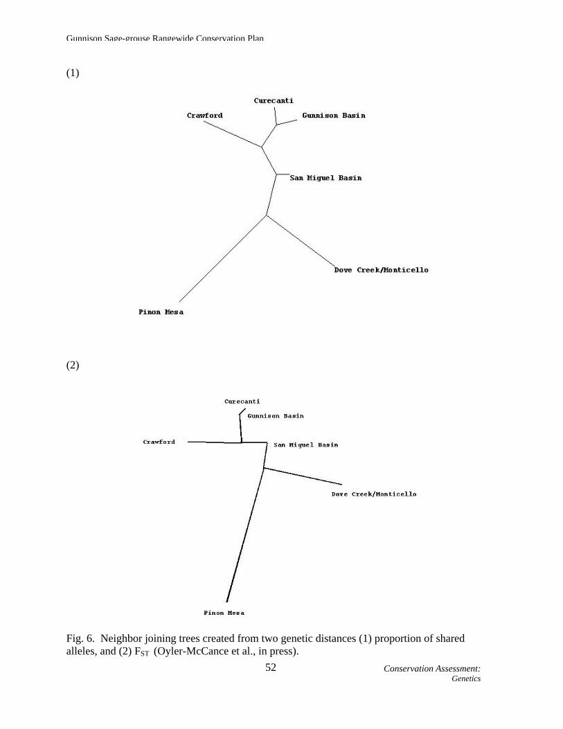
had much more sagebrush habitat and probably larger GUSG populations that were somewhat connected through more contiguous areas of sagebrush habitat. Oyler-McCance et al. (2001) quantified the loss and fragmentation of sagebrush habitat in southwestern Colorado. They documented a 20% loss of sagebrush habitat between the late 1950's and the early 1990's, and that sagebrush in 37% of the plots examined was significantly fragmented. The clearing of sagebrush for cultivated crops, highway construction, ranch development, powerline placement, reservoir construction, and other facets of human settlement has destroyed and fragmented sagebrush habitats in southwestern Colorado. This has lead to the current isolation of these populations, which is consistent with the relatively low amounts of gene flow and isolation by distance documented here. Both neighbor-joining trees generated by Oyler-McCance et al. (in press), constructed using different measures of genetic distance, showed similar topologies, with Gunnison and Curecanti closely linked, followed by Crawford and San Miguel (Fig. 6). The Dove Creek -Monticello and Piñon Mesa populations were consistently set apart from all other populations and from each other. These neighbor-joining trees as well as a significant Mantel test show that the geographic distances are correlated with genetic distances between populations. Oyler-McCance et al. (in press) noted that a few individuals in their STRUCTURE analysis appeared to have the genetic characteristics of a population other than their own (Fig. 7), suggesting the possibility that they are dispersers from a different population. Using GeneClass2 software, Oyler-McCance et al. (in press) identified 3 potential first generation migrants. Two probable dispersers were individuals moving from San Miguel into Dove Creek - Monticello and Crawford. The San Miguel population itself appeared to have a mixture of individuals with differing probabilities of belonging to different clusters (Fig. 7). This suggests that San Miguel may act as a conduit of gene flow among the satellite populations surrounding the larger population in Gunnison. Additionally, Oyler-McCance et al. (in press) found that the 1 other potential disperser involved movement into Crawford from Curecanti. This is not surprising given their close geographic proximity (Fig. 4, pg. 38). The 4 individuals from Cerro Summit - Cimarron included in the study by Oyler-McCance et al. (in press) were found to be more closely related to individuals from San Miguel than from Gunnison or Curecanti, which are closer geographically. This suggests a linkage between San Miguel and the Cerro Summit - Cimarron area that is surprising, given the geographic distance between them and the fact that the city of Montrose sits between them (Fig. 4, pg. 38). With a sample size of only 4 individuals, Oyler-McCance et al. (in press) found it hard to make strong conclusions about the genetic characteristics of Cerro Summit – Cimarron - Sims, yet they suggest that the Cerro Summit – Cimarron - Sims area may act as an important stepping-stone that links the larger populations of Gunnison, Curecanti, and San Miguel.
Conservation Assessment: 51Genetics
Gunnison Sage-grouse Rangewide Conservation Plan
(1)
(2)
Fig. 6. Neighbor joining trees created from two genetic distances (1) proportion of shared alleles, and (2) FST (Oyler-McCance et al., in press).
Conservation Assessment: 52Genetics

Fig. 7. Results of STRUCTURE analysis conducted by Oyler-McCance et al. (in press). Each vertical bar represents an individual grouped into populations (1 = Gunnison Basin, 2 = Piñon Mesa, 3 = San Miguel Basin, 4 = Dove Creek - Monticello, 5 = Crawford, 6
53C
onservation Assessment:
Genetics
= Curecanti, 7 = 4 samples taken from Sims Mesa). The colors on each vertical bar represent the probability of the individual belonging to a certain cluster. Each cluster is represented by a unique color.
Gunnison Sage-grouse Rangewide Conservation Plan
D. GUSG Habitat Mapping Efforts Mapping of GUSG habitat is key to assessing the current status of populations. There are 2 projects in progress that map current GUSG habitat. Current habitat for the RCP was generated using the CDOW habitat mapping effort described below. RCP Habitat Mapping
CDOW is in the process of refining Wildlife Resource Information System (WRIS) mapping efforts for GUSG habitat. The following habitat definitions were used during the initial mapping portion of this project, and appear in maps in the RCP. For consistency, both CDOW and UDWR used these definitions for RCP mapping purposes.
Occupied Habitat: Areas of suitable habitat known to be used by GUSG within the last 10
years from the date of mapping. Areas of suitable habitat contiguous with areas of known use, which do not have effective barriers to sage-grouse movement from known use areas, are mapped as occupied habitat unless specific information exists that documents the lack of sage-grouse use. This category can be delineated from any combination of telemetry locations, sightings of sage-grouse or sage-grouse sign, local biological expertise, GIS analysis, or other data sources.
Vacant or Unknown Habitat: Suitable habitat for sage-grouse that is separated (not
contiguous) from occupied habitats that either (1) has not been adequately inventoried, or (2) has not had documentation of grouse presence in the past 10 years.
Potentially Suitable Habitat: Unoccupied habitats that could be suitable for occupation of sage-grouse if practical restoration were applied. Soils or other historic information (photos, maps, reports, etc.) indicate sagebrush communities occupied these areas. As examples, these sites could include areas overtaken by piñon-juniper or converted to rangeland.
In the “Habitat Monitoring” rangewide strategy we recommend further refining these habitat definitions, particularly to distinguish between “Vacant” and “Unknown” habitat (see pg. 220, Objective 1).
BLM Habitat Mapping An additional mapping effort was initiated by the BLM in 2002, through a contract
with the Colorado Natural Heritage Program (CNHP), as part of a national agency mapping effort. With the help of other agency biologists, the Colorado BLM completed a statewide habitat risk map. BLM and CDOW biologists (primarily) hand-edited spatial information about sagebrush and sage-grouse habitats on 1:100,000 topographic maps based on Basin-wide vegetation inventory data and local knowledge of the area. They identified existing sage-grouse habitat in Colorado that appears to be in good condition, as well as habitat that is
Conservation Assessment: 54Mapping Efforts

Gunnison Sage-grouse Rangewide Conservation Plan
“at risk.” For those habitats considered to be at risk biologists identified the specific threat or threats to the habitat (e.g., weeds, fire, lack of fire), and whether the “risk” threatened habitat quality or might result in habitat loss and/or fragmentation. In identifying habitat quality (“good” or “at risk”), biologists also considered whether the habitat quality in a habitat polygon was likely to significantly degrade within 5 years if no management actions were taken. CNHP organized, compiled, facilitated and produced the results of this mapping effort. These maps were not included in this plan due to their large size; currently, one can access the maps at local BLM field offices.
Four habitat quality risk factors were identified: (1) weed invasion; (2) piñon-juniper encroachment; (3) old and even-aged sagebrush overstory; and (4) poor herbaceous understory condition. Six factors causing habitat loss or fragmentation were noted: (1) weed domination; (2) piñon-juniper replacement; (3) oil and gas development; (4) powerline infrastructure development; (5) subdivisions (human development); and (6) existing or proposed land uses (ranging from land exchange to agricultural conversion).
For each polygon, any occurrence of sage-grouse was noted, and site-specific comments (e.g., wildfire, gravel pit, weed infestation associated with oil field) were recorded. The BLM habitat map will be updated every 5 years to reflect changes in habitat due to management, new information, or a consequence of nature (e.g., drought, fire, disease). These maps are expected to help identify and prioritize BLM budget, conservation actions, and management for sage-grouse on public lands. The maps will also be made available to other agencies and local work groups to use as a tool in sage-grouse management proposals and decisions.
Conservation Assessment: 55Mapping Efforts

Gunnison Sage-grouse Rangewide Conservation Plan
E. Status and Distribution of Individual Populations Cerro Summit – Cimarron - Sims Mesa Population General Description
The Cerro Summit - Cimarron and Sims Mesa areas are considered 2 subpopulations and are described separately within this section. They are geographically separated and, to date, it is not known if sage-grouse move between the 2 areas. The Cerro Summit - Cimarron subpopulation is in Montrose County, centered about 15 miles east of Montrose, Colorado (Figs. 4 [pg. 38] and 8). The current spatial extent of the Cerro Summit - Cimarron subpopulation is approximately 31,900 acres. The habitat varies in elevation from 7,000 to 9,000 feet and consists of patches of sagebrush habitat fragmented by oakbrush and irrigated pastures. Patches of late-seral stage sagebrush are found primarily on steep hillsides. Landownership in the Cerro Summit - Cimarron area is approximately 81% private, 12% CDOW (Cimarron State Wildlife Area), 7% BLM, and 0.1% NPS (Fig. 8 and Appendix D). Land-use is primarily livestock grazing, hay production and recreation. The area includes large, relatively undisturbed tracts being managed as working ranches. However, portions of the area (less than 5 % of the occupied range), especially those with level terrain, are currently being subdivided for residential development.
The Sims Mesa Area is located in Montrose County about 7 miles south of Montrose, Colorado (Figs. 4 [pg. 38] and 8), and is approximately 5,300 acres. Elevation ranges from 6,000 to 7,000 feet and consists of small patches of sagebrush that are heavily fragmented by piñon-juniper, residential and recreational development, and agricultural lands. Landownership is roughly 44% private, 51% BLM, and 6% CDOW (Fig. 8 and Appendix D). Land-use at Sims Mesa is primarily ranching.
Conservation Assessment: 56Individual Populations Status – Cerro –Cimarron – Sims

Fig. 8. Location, landownership, and habitat status of the Cerro Summit – Cimarron – Sims Mesa GUSG population. Habitat status
57C
onservation Assessment:
Individual Populations Status – Cerro –C
imarron – Sim
s
definitions are provided on page 54. The original landownership data layer (Bureau of Land Management 2002) has been modified; however inaccuracies may be present.
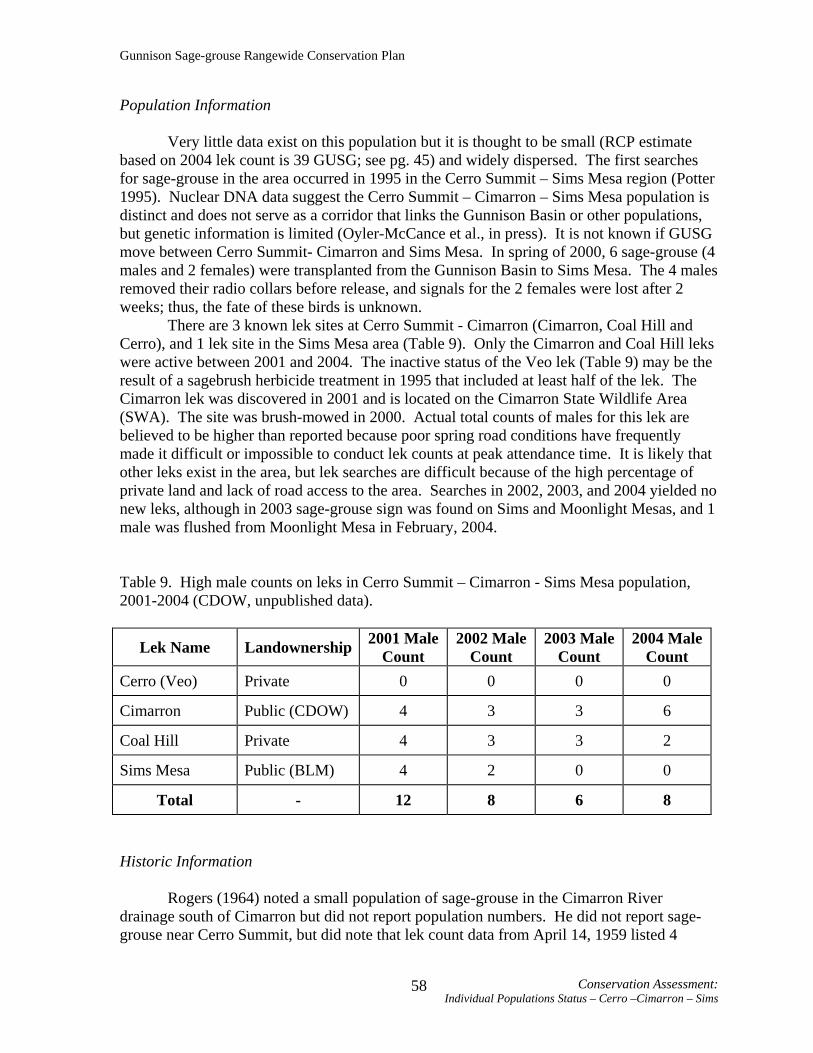
Gunnison Sage-grouse Rangewide Conservation Plan
Population Information
Very little data exist on this population but it is thought to be small (RCP estimate based on 2004 lek count is 39 GUSG; see pg. 45) and widely dispersed. The first searches for sage-grouse in the area occurred in 1995 in the Cerro Summit – Sims Mesa region (Potter 1995). Nuclear DNA data suggest the Cerro Summit – Cimarron – Sims Mesa population is distinct and does not serve as a corridor that links the Gunnison Basin or other populations, but genetic information is limited (Oyler-McCance et al., in press). It is not known if GUSG move between Cerro Summit- Cimarron and Sims Mesa. In spring of 2000, 6 sage-grouse (4 males and 2 females) were transplanted from the Gunnison Basin to Sims Mesa. The 4 males removed their radio collars before release, and signals for the 2 females were lost after 2 weeks; thus, the fate of these birds is unknown.
There are 3 known lek sites at Cerro Summit - Cimarron (Cimarron, Coal Hill and Cerro), and 1 lek site in the Sims Mesa area (Table 9). Only the Cimarron and Coal Hill leks were active between 2001 and 2004. The inactive status of the Veo lek (Table 9) may be the result of a sagebrush herbicide treatment in 1995 that included at least half of the lek. The Cimarron lek was discovered in 2001 and is located on the Cimarron State Wildlife Area (SWA). The site was brush-mowed in 2000. Actual total counts of males for this lek are believed to be higher than reported because poor spring road conditions have frequently made it difficult or impossible to conduct lek counts at peak attendance time. It is likely that other leks exist in the area, but lek searches are difficult because of the high percentage of private land and lack of road access to the area. Searches in 2002, 2003, and 2004 yielded no new leks, although in 2003 sage-grouse sign was found on Sims and Moonlight Mesas, and 1 male was flushed from Moonlight Mesa in February, 2004.
Table 9. High male counts on leks in Cerro Summit – Cimarron - Sims Mesa population, 2001-2004 (CDOW, unpublished data).
Lek Name Landownership 2001 Male Count
2002 Male Count
2003 Male Count
2004 Male Count
Cerro (Veo) Private 0 0 0 0
Cimarron Public (CDOW) 4 3 3 6
Coal Hill Private 4 3 3 2
Sims Mesa Public (BLM) 4 2 0 0
Total - 12 8 6 8 Historic Information
Rogers (1964) noted a small population of sage-grouse in the Cimarron River drainage south of Cimarron but did not report population numbers. He did not report sage-grouse near Cerro Summit, but did note that lek count data from April 14, 1959 listed 4
Conservation Assessment: Individual Populations Status – Cerro –Cimarron – Sims
58

Gunnison Sage-grouse Rangewide Conservation Plan
individuals (including 2 males) at Cerro Summit. For the Sims Mesa area, Rogers (1964:115) states, “ On the eastern slope of the Uncompahgre, a few sage grouse are found in the Simms (sic) Mesa-Duckett Draw area west of Colona and possibly in the Dry Creek area northwest of Montrose.” A lek count at Sims Mesa conducted by Rogers on April 9, 1960 tallied 8 male grouse. Local Conservation Plan
No local conservation plan or work group exists for the Cerro Summit – Cimarron - Sims Mesa population. Habitat Improvements/Completed Conservation Actions
The Cimarron SWA has > 3,000 acres of sagebrush cover with the potential for habitat improvements to benefit GUSG. Several patches of shrubs were mowed (total area approximately 90-100 acres) in 2000, resulting in the establishment of a new lek in 2001. Boundary fences to exclude trespassing cattle from wetland areas are planned and thus far approximately 8 miles of fence have been repaired. No extensive habitat treatments are planned until additional distribution and habitat use data for sage-grouse are available. The CDOW earmarked $15,000 for additional habitat improvements adjacent to Cimarron SWA, completed in September 2004. Efforts to implement habitat improvements in the Sims Mesa area are also pending until more is known about GUSG distribution and habitat use. This population is small and the effects of an ill-timed or poorly conceived habitat treatment project could result in loss of important sage-grouse habitat. However, the BLM has proposed a program to increase diversity in some of the plowed and seeded areas. This will likely involve herbicide applications and drilling a native grass/non-native forb mix (small burnet and ladak alfalfa), as funding becomes available. In 2003, 2 grazing permits at Sims Mesa were purchased by CDOW. The CDOW is also funding approximately 385 acres of habitat improvements at Sims Mesa to remove invading piñon-juniper, reduce sagebrush canopy cover, and reseed in areas with poor understory. Easements/Candidate Conservation Agreements with Assurances
The majority (80%) of the Cerro Summit - Cimarron area is privately owned (Fig. 8) and cooperation with landowners is key to successful management and long-term population viability of GUSG. Currently (through 2003), 2,798 acres in occupied habitat, and 559 acres in potential habitat are under easement in Cerro Summit – Cimarron – Sims Mesa (Fig. 9; see also Appendix D). Efforts by the CDOW to establish easements have been limited, pending data on GUSG distribution.
In addition, several private property owners have shown interest in easements or Candidate Conservation Agreements with Assurances (CCAA). A CCAA is an agreement between the USFWS and 1 or more non-federal landowners that, “… provides non-Federal property owners who voluntarily agree to manage their lands or waters to remove threats to candidate or proposed species assurances that their conservation efforts will not result in
Conservation Assessment: Individual Populations Status – Cerro –Cimarron – Sims
59

Gunnison Sage-grouse Rangewide Conservation Plan
future regulatory obligations in excess of those they agree to at the time they enter into the Agreement…” (U.S. Fish and Wildlife Service 2005). Currently no CCAA’s exist for any of the GUSG areas. An umbrella CCAA is being developed by the CDOW. If implemented, this CCAA would allow landowners within the Colorado portion of GUSG range (including the Cerro Summit – Cimarron – Sims Mesa area) to participate in the CCAA by signing up through the CDOW’s agreement, via certificates of inclusion, rather than directly with the USFWS.
Conservation Assessment: Individual Populations Status – Cerro –Cimarron – Sims
60

61C
onservation Assessment: Individual
Populations Status – Cerro –C
imarron – Sim
s
Fig. 9. Conservation easements in the Cerro Summit – Cimarron – Sims Mesa GUSG area (data current through 2003). Habitat status definitions are provided on page 54.

Gunnison Sage-grouse Rangewide Conservation Plan
Crawford Population General Description The Crawford population of GUSG is located in Montrose County, Colorado, about 8 miles southwest of the town of Crawford and north of the Gunnison River (Figs. 4 [pg. 38] and 10). Approximately 35,000 acres of habitat are currently occupied by GUSG. The Crawford area ranges in elevation from 5,084 feet at the Gunnison River to 9,020 feet near Cathedral Peak on the east side. The area is characterized by diverse topography including rocky drainages covered by piñon-juniper woodlands, rolling uplands dominated by big sagebrush and mountain big sagebrush, and gentle slopes with primarily hay meadows, saltbush, and wheatgrass. The region is semi-arid, with approximately 14 inches of precipitation falling annually on Fruitland Mesa. About 50% of this moisture occurs as winter snowfall. Basin big sagebrush and black sagebrush dominate the mid-elevation uplands. Of the land in the area, 63% is managed by the BLM, 13% is managed by the NPS and 24% is privately owned (Fig. 10 and Appendix D). The area includes rural housing and town sites as well as agricultural developments (especially orchards).
Conservation Assessment: Individual Populations Status – Crawford
62

Fig. 10. Location, landownership, and habitat status of the Crawford GUSG population. Habitat status definitions are provided on
63C
onservation Assessment:
Individual Populations Status Craw
ford
page 54. The original landownership data layer (Bureau of Land Management 2002) has been modified; however inaccuracies may be present.

Gunnison Sage-grouse Rangewide Conservation Plan
Population Information
The Crawford Area Conservation Plan (CACP 1998) reported a 1996-1997 estimate of 129 – 228 GUSG in the Crawford population, based on counts of males at leks (CACP 1998; see “Lek Counts and Population Estimation”, pg. 39). Note that the RCP population estimate for Crawford (128) is based on 2004 lek count data and uses slightly different assumptions (see pg. 45). Currently there are 4 active leks in the Crawford area (Table 10), all in sagebrush habitat adjacent to a 7-mile stretch of road and all on land managed by the BLM. This area represents the largest contiguous sagebrush-dominated habitat within the Crawford boundary. Table 10. High male counts on leks in the Crawford population, 2001-2004 (CDOW, unpublished data).
Lek Name Landownership 2001 Male Count
2002 Male Count
2003 Male Count
2004 Male Count
Dam Public (BLM) 0 8 3 6
Fruitland Public (BLM) 6 11 12 7
Middle Public (BLM) 0 1 0 0
Range Cone Public (BLM) 22 20 8 9
Section 35 Public (BLM) 0 2 1 4
Total - 28 42 24 26 Historic Information
Rogers (1964) noted that sage-grouse were present in the Crawford area and estimated the population density to be less than 10 individuals/mi2. He did not report any lek count data. Consistent lek counts in the Crawford area were initiated in 1978. Since that time, the number of active lek sites has fluctuated between 3 and 7, but historically individuals were counted on 15 different leks. GUSG have probably occurred in all suitable sagebrush habitats in the Crawford area (Fig. 10). Local Conservation Plan
The Crawford Area GUSG work group formed in 1995 and the CACP (1998) was finalized and signed July 22, 1998. The CACP boundary includes current and probable or historic range of GUSG in Montrose and Delta Counties (CACP 1998). The probable or historic range designations are based on known historic use sites and sage-grouse observations, as well as the location of sagebrush habitat and suitable soil types for sagebrush.
Conservation Assessment: Individual Populations Status – Crawford
64

Gunnison Sage-grouse Rangewide Conservation Plan
Specific habitat problems identified in the Crawford Area Conservation Plan (CACP 1998:5) are (1) fragmentation of habitat components (i.e. too much distance between nesting and brooding areas, and wet areas); (2) invasion of piñon-juniper into sagebrush habitats; (3) inadequate grass and forbs in the sagebrush understory (limits brood-rearing habitat); (4) low vegetation age-class diversity (homogeneous old age stand exists); (5) low vegetation vigor; (6) poor vegetation conditions on leks (too much vegetation > 8 inches high); and (7) few mesic sites.
The primary population goal in the CACP (1998) is to maintain a minimum spring population of 225 individuals and to increase that to 480 individuals by 2010. Additionally, the plan aims to maintain a minimum of 4 active leks with at least 14 males/lek. The plan habitat goal is based on the population goal, to “Maintain on suitable sites across the Crawford landscape relative large, contiguous stands of sagebrush with a variety of vegetative conditions interspersed throughout, in the desired arrangement with good connectivity to provide the quantity and quality of sage grouse habitat to support at least the desired optimum population level by 2010” (CACP 1998:7).
To meet the population and habitat goals, 3 general conservation objectives are identified. They are to (1) maintain and improve the quality of GUSG habitat; (2) reduce fragmentation by preventing, minimizing, and mitigating past, present and future loss of GUSG habitat; and (3) identify and manage physical disturbances to reduce adverse effects to GUSG. Conservation actions in the plan are divided into the following categories: information and education, monitoring, avoiding or mitigating permanent loss of habitat, restoring or improving the quality of grouse habitat and populations, reducing physical disturbance to sage-grouse, and improving community support and participation (CACP 1998). Habitat Improvements/Completed Conservation Actions
The CDOW, BLM, and North Fork Habitat Partnership Program have completed approximately 5,800 acres of habitat improvement projects for GUSG in the Crawford area. These treatments include prescribed burns to develop wet meadow habitat and control piñon/juniper invasion (2,845 acres), piñon-juniper removal (700 acres), roller chopping (1,050 acres), rotobeating (1,200 acres), interseeding (20 acres), and improvement and development of new lek sites by mowing shrubs. In addition, 5 wet seeps have been developed off an existing waterline or by other means to enhance or create wet areas for GUSG. Several leks presently used for display are in areas that were brushbeat in 1994 and 1996. The BLM is continuing to control piñon-juniper invasion through the use of prescribed burns and mechanical treatments, with equipment such as the hydroaxe. Easements/Conservation Agreements with Assurances
There are currently (data through 2003) conservation easements on 523 acres in occupied habitat, and 936 acres in potential habitat at Crawford (Fig. 11; see also Appendix D). There is potential interest in future easements.
An umbrella CCAA is being developed by the CDOW. If implemented, this CCAA would allow landowners within the Colorado portion of GUSG range (including the
Conservation Assessment: Individual Populations Status – Crawford
65
Gunnison Sage-grouse Rangewide Conservation Plan
Crawford area) to participate in the CCAA by signing up through the CDOW’s agreement, via certificates of inclusion, rather than directly with the USFWS.
Conservation Assessment: Individual Populations Status – Crawford
66

67C
onservation Assessment:
Individual Populations Status – Craw
ford
Fig. 11. Conservation easements in the Crawford GUSG area (data current through 2003). Habitat status definitions are provided on page 54.

Gunnison Sage-grouse Rangewide Conservation Plan
Dove Creek Subpopulation General Description
The Dove Creek GUSG subpopulation is located primarily in western Dolores County, Colorado, north and southwest of Dove Creek (Figs. 4 [pg. 38] and 12); a small portion of occupied habitat extends into San Miguel County (Fig. 12). The estimated area occupied by the subpopulation is approximately 28,300 acres and elevation ranges from 6,600 – 8,100 feet. Habitat north of Dove Creek is characterized as mountain shrub habitat, dominated by oakbrush interspersed with sagebrush. The area west of Dove Creek is dominated by sagebrush, but the habitat is highly fragmented and has a sparse understory that is primarily crested wheatgrass.
Approximately 87% of occupied habitat at Dove Creek is privately owned, and 13% is managed by the BLM (Fig. 12 and Appendix D). Land-use in Dove Creek is mostly agriculture, but a major subdivision called Secret Canyon Ranches lies within the boundary. The Secret Canyon Ranches subdivision is 2,700 acres (about 9% of the GUSG Dove Creek subpopulation occupied range) and has been subdivided into 35-50-acre tracts, although few of these tracts have been developed.
Apa (2004) measured vegetation characteristics at nest sites in Dove Creek and compared them to published habitat guidelines for sage-grouse (Connelly et al. 2000). He found that sagebrush canopy cover at 6 of 9 nest sites was below the recommended range for cover. Although grass cover was adequate at 80% of nest sites, grass height was well below the recommended guidelines (Connelly et al. 2000) at all nest sites; thus grass provided little concealment at nests. Perhaps poor cover, exacerbated by drought, was the reason why all but 1 nest failed during this study. Unmarked sage-grouse hens with broods were observed heavily using fields enrolled in the Conservation Reserve Program (CRP) in areas west of Dove Creek, and on the north side of town were seen moving up into oakbrush/mountain shrub communities with sagebrush in the understory.
Conservation Assessment: Individual Populations Status – Dove Creek
68

Fig. 12. Location, landownership, and habitat status of the Dove Creek and Monticello GUSG populations. Habitat status definitions are provided on page 54. The abrupt discontinuity in occupied habitat at the state line is not entirely a mapping artifact; where there is occupied habitat on the Colorado side there is an abrupt change to cropland on the Utah side of the border. Resolving differences in “Potential” and “Vacant/Unknown” habitat mapping efforts between the states is addressed in the “Habitat Monitoring” rangewide
69C
onservation Assessment:
Individual Populations Status – Dove C
reek
strategy (see Objective 1, Strategy 3, pg. 221). The original landownership data layer (Bureau of Land Management 2002) has been modified; however inaccuracies may be present.

Gunnison Sage-grouse Rangewide Conservation Plan
Population Information
The Dove Creek Conservation Plan (DCCP 1998) estimated that the local subpopulation size in 1998 was from 81 to 135 individuals, based on extrapolation from counts of males at leks (see “Lek Counts and Population Estimation”, pg. 39). Note that the RCP population estimate for Dove Creek (10) is based on 2004 lek count data and uses slightly different assumptions (see pg. 45). All lek sites in the Dove Creek area are located in agricultural fields on private lands (Table 11). Several leks are located in fields enrolled in the CRP program and planted to permanent grass cover, which makes them poor lek sites. Consequently, lek site locations are dynamic, moving often. Table 11. High male counts on leks in the Dove Creek subpopulation, 2001-2004 (CDOW, unpublished data).
Lek Name Landownership 2001 Male Count
2002 Male Count
2003 Male Count
2004 Male Count
Alfalfa Private 2 0 0 0 Panoramic
View Private 20 0 3 0
Phantom Private 0 0 0 0
Sage Private 0 5 3 2 Sage
Southeast Private 0 9 0 -*
Section 18/Schutt Private 0 4 1 0
Wheatfield Private 5 2 1 0
Total - 27 20 8 2 * As of 2004 this lek should not be considered separately from Sage lek – same birds likely attend both, depending on the year. Count both leks, but consider it 1 count. Historic Information
Rogers (1964) reported that all sagebrush dominated habitats in Dolores and Montezuma counties were historically used by sage-grouse. The historic distribution was highly fragmented by piñon-juniper and rocky canyons. Local Conservation Plan The DCCP (1998) was completed November 23, 1998. It described the boundary of the Dove Creek GUSG management area as within Dolores County, which was based on
Conservation Assessment: Individual Populations Status – Dove Creek
70
Gunnison Sage-grouse Rangewide Conservation Plan
field observations during 1994-1997, reports from landowners, radiotelemetry studies, and location of suitable habitat.
The DCCP (1998) lists several specific factors that may be seasonally limiting for GUSG. Suitable escape cover (relatively tall sagebrush) near leks is lacking in many cases. Grasses and forbs in the understory of some sagebrush areas are not adequate for nesting and brood-rearing. During late summer and fall, sage-grouse in the Dove Creek area often find the best grass and forb availability in drainage areas and on the margins of agricultural fields. But some of this habitat is dramatically reduced in fall after crops are harvested and pastures have been grazed. Snow depth may render sagebrush unavailable to GUSG in higher elevation areas northeast of Dove Creek.
The population goal described in the DCCP (1998) is to maintain a minimum of 5 active leks with an average of 10 males/lek, resulting in a spring population of 199 individuals. The optimum spring population goal listed in the plan is to have 6 active leks with 20 males/lek translating to a population of 480 individuals.
To achieve the population goal the plan lists the following 3 objectives, to (1) maintain and improve the quality of sage-grouse habitat; (2) reduce fragmentation by preventing, minimizing and mitigating past, present, and future loss of sage-grouse habitat; and (3) identify and manage physical disturbances to reduce adverse effects to sage-grouse (DCCP 1998:10)
Conservation actions in the DCCP (1998) are divided into the following categories: information and education, monitoring, avoiding or mitigating permanent loss of habitat, restoring or improving quality of grouse habitat and populations, reducing physical disturbance to sage-grouse, and improving community support and participation. Habitat Improvements/Completed Conservation Actions
There have been few habitat treatments in Dove Creek. Approximately 400 acres of oakbrush have been mechanically treated to improve the area as sage-grouse habitat, and an additional 400-acre area mowed for big game use has been used by GUSG (Apa 2004). In 2002 the CDOW completed a 200-acre dixie harrow treatment with seeding on a private land parcel west of Dove Creek. In addition the CDOW constructed an interseeder for use in seeding sagebrush and understory species in CRP and other areas in Dove Creek. Three test plots (2-5 acres) were seeded with the interseeder in 2003: 1 in CRP (sagebrush seeded), 1 in non-native rangeland (sagebrush seeded), and 1 in sagebrush (grass/forb mix seeded).
Easements/ Conservation Agreements with Assurances
Easements on 1,013 acres in occupied habitat have been signed with landowners in the Dove Creek area (data current through 2003, Fig. 13; see also Appendix D). Dove Creek landowners have submitted a request for CDOW to purchase a potential total of 2,000 - 3,000 acres. The purchase is pending.
An umbrella CCAA is being developed by the CDOW. If implemented, this CCAA would allow landowners within the Colorado portion of GUSG range (including the Dove Creek area) to participate in the CCAA by signing up through the CDOW’s agreement, via certificates of inclusion, rather than directly with the USFWS.
Conservation Assessment: Individual Populations Status – Dove Creek
71
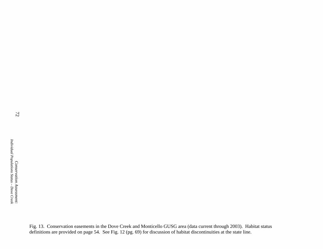
72C
onservation Assessment:
Individual Populations Status – Dove C
reek
Fig. 13. Conservation easements in the Dove Creek and Monticello GUSG area (data current through 2003). Habitat status definitions are provided on page 54. See Fig. 12 (pg. 69) for discussion of habitat discontinuities at the state line.

Gunnison Sage-grouse Rangewide Conservation Plan
Gunnison Basin Population General Description The Gunnison Basin is an intermontane basin that includes parts of Gunnison and Saguache Counties, Colorado. The current GUSG range is approximately 593,000 acres, roughly centered around the town of Gunnison (Figs. 4 [pg. 38] and 14). Elevations in the area range from 7,500 to 9,500 feet. Uplands are moderately to steeply rolling and are dissected by permanent and intermittent stream drainages. Shallow eroded gulches are common on upland slopes and steep-sloped mesas occur in several parts of the Basin.
Big sagebrush dominates upland vegetation and has a highly variable growth form depending on local site conditions. On dry south slopes the sagebrush is short and widely spaced and on wetter sites it can be tall and vigorous. Generally, sagebrush rangelands below 8,500 feet are older stands with little understory. Higher elevation stands receive more moisture and have healthier understories, though many of these stands are monotypic with dense, closed canopies. Most of the valley bottoms along the major stream corridors have been converted to hay and pastureland.
Approximately 51% of the delineated GUSG range is managed by the BLM, 14% by the USFS, 2% by the NPS, 2% by the CDOW, 1% by the Colorado State Land Board, and 31% is privately owned (Fig. 14 and Appendix D). Land-use is primarily ranching and hay production, but residential subdivision development has been expanding out from Gunnison in the past 25 years.
Young (1994) reported 43.2% nest success for GUSG in the Gunnison Basin. This is on the low end of the normal range for sage-grouse. Apa (2004) documented 9 nesting attempts, of which 6 were successful (67%). Apa (2004) also reported on vegetation characteristics at nest sites and compared them to published guidelines for sage-grouse (Connelly et al. 2000). He found sagebrush canopy cover to be within the range suggested by the guidelines at 3 of 9 nests, and above the guideline standard at 6 of the 9 nests. Grass height at all 9 nests was below guideline levels, while grass cover was within guidelines at 2 of 9. In most sage-grouse habitats in Colorado sagebrush canopy conceals nests more than grass does. The guideline standards (Connelly et al. 2000) are dominated by published literature from the Great Basin and Northwest, where bluebunch wheatgrass and other bunch grasses predominate. Apa (2004) also reported vegetation characteristics at brood-rearing sites. Sagebrush canopy was within (or above) guidelines at 13 of 20 sites (65%), while forb cover was within the guideline range at 15 of 23 sites (65%).
The CDOW analyzed the sex and age composition of GUSG wings collected at check stations in the Gunnison Basin when hunting seasons were open. Chicks/hen in the harvest can serve as an index to productivity (integrates nest success and chick survival). Although quite variable, juveniles/hen in the harvest (excluding years with less than 100 wings) averaged 4.3, compared to the standard suggested by the sage-grouse guidelines of greater than or equal to 2.25 juveniles per hen for stable or increasing populations (Connelly et al. 2000). From 1977 to 1998, juvenile/hen ratios were below 2.25 only once. However, from 1977 to 1988, juveniles/hen averaged 5.2, but from 1989 to 1998, they averaged 3.6. Although the absolute numbers seem reasonable, the trend is clearly downward.
Conservation Assessment: Individual Populations Status – Gunnison Basin
73

74C
onservation Assessment:
Individual Populations Status – Gunnison Basin
Fig. 14. Location, landownership, and habitat status of the Gunnison Basin GUSG population. Habitat status definitions are provided on page 54. The original landownership data layer (Bureau of Land Management 2002) has been modified; however inaccuracies may be present.

Gunnison Sage-grouse Rangewide Conservation Plan
Population Information
The Gunnison Basin GUSG population has been estimated at 1,992 (Colorado Division of Wildlife 2004a) based on counts of males on leks and using estimate assumptions like those in the GBCP (1997; see “Lek Counts and Population Estimation”, pg. 39). Note that the RCP population estimate for the Gunnison Basin (2,443) is also based on 2004 lek count data, but uses slightly different assumptions (see pg. 45). Currently, approximately 78 leks are surveyed annually for breeding activity in the Gunnison Basin (Colorado Division of Wildlife 2004a). In the Gunnison Basin, these are divided into the following categories: (1) active – display and/or breeding activity by at least 2 males observed on at least 2 visits during the breeding season; (2) inactive – no display or breeding activity observed for the last 5 – 9 years; (3) unknown –less than 2 males were observed during 2 visits during the breeding season, or less than 2 visits were made during breeding season, or lek has been considered inactive for less than 5 years; and (4) historic – considered inactive for 10 or more years. In 2003, in the Gunnison Basin there were 36 active leks, 34 inactive leks, 10 leks of unknown status, and no historic leks (Colorado Division of Wildlife 2004a). Lek count data are summarized by lek area for the Gunnison Basin (Table 12). Approximately 45% of these leks occur on private land and 55% on public (primarily BLM) land.
Conservation Assessment: Individual Populations Status – Gunnison Basin
75
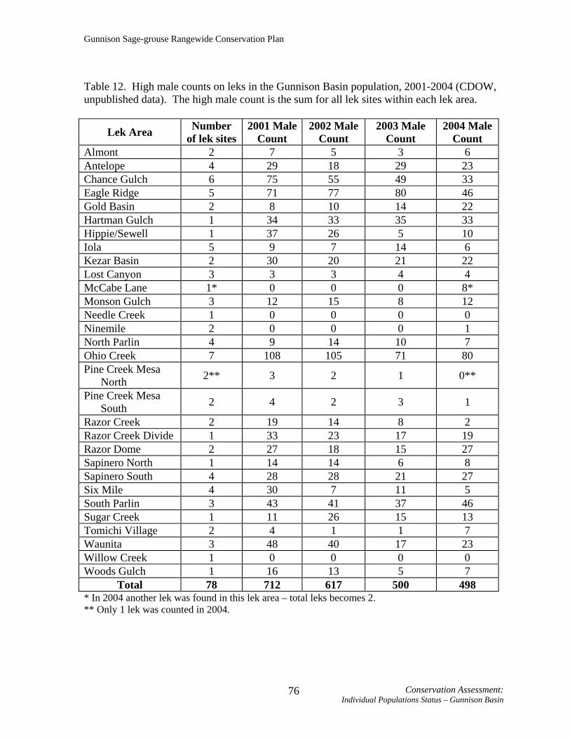
Gunnison Sage-grouse Rangewide Conservation Plan
Table 12. High male counts on leks in the Gunnison Basin population, 2001-2004 (CDOW, unpublished data). The high male count is the sum for all lek sites within each lek area.
Lek Area Number of lek sites
2001 Male Count
2002 Male Count
2003 Male Count
2004 Male Count
Almont 2 7 5 3 6 Antelope 4 29 18 29 23 Chance Gulch 6 75 55 49 33 Eagle Ridge 5 71 77 80 46 Gold Basin 2 8 10 14 22 Hartman Gulch 1 34 33 35 33 Hippie/Sewell 1 37 26 5 10 Iola 5 9 7 14 6 Kezar Basin 2 30 20 21 22 Lost Canyon 3 3 3 4 4 McCabe Lane 1* 0 0 0 8* Monson Gulch 3 12 15 8 12 Needle Creek 1 0 0 0 0 Ninemile 2 0 0 0 1 North Parlin 4 9 14 10 7 Ohio Creek 7 108 105 71 80 Pine Creek Mesa
North 2** 3 2 1 0**
Pine Creek Mesa South 2 4 2 3 1
Razor Creek 2 19 14 8 2 Razor Creek Divide 1 33 23 17 19 Razor Dome 2 27 18 15 27 Sapinero North 1 14 14 6 8 Sapinero South 4 28 28 21 27 Six Mile 4 30 7 11 5 South Parlin 3 43 41 37 46 Sugar Creek 1 11 26 15 13 Tomichi Village 2 4 1 1 7 Waunita 3 48 40 17 23 Willow Creek 1 0 0 0 0 Woods Gulch 1 16 13 5 7
Total 78 712 617 500 498 * In 2004 another lek was found in this lek area – total leks becomes 2. ** Only 1 lek was counted in 2004.
Conservation Assessment: Individual Populations Status – Gunnison Basin
76
Gunnison Sage-grouse Rangewide Conservation Plan
Historic Information
It is likely that GUSG historically occurred in all suitable sagebrush habitats from east of Sargents (Marshall Creek, upper Tomichi Creek), west to Blue Creek (further west to at least Colorado Highway 347), north to at least Brush Creek and Taylor Park, and south to the Hinsdale-Gunnison County boundary and Cochetopa Park in Saguache County (GBCP 1997). Generally, there has been a contraction in occupied area at the periphery of the historic range. Rogers (1964) stated that Gunnison County had one of the largest sage-grouse populations in the state. Local Conservation Plan
The GBCP (1997) was completed in June 1997. The GBCP (1997) was the first local conservation plan written and it served as a template for other work groups when writing their local conservation plans.
The primary population goal described in the GBCP (1997) is a minimum spring breeding population of 2,600 sage-grouse on 25 known active leks distributed throughout the Gunnison Basin, with an average of 26 males per lek. The optimum spring population goal is 3,600 individuals on 30 known leks that are well distributed throughout the Basin, with an average of 30 males per lek. The GBCP (1997) intent is to reach the optimum population numbers in 15 years. The overall habitat goal described in the GBCP is, “To manage the Gunnison Basin watershed in a manner that restores Gunnison sage grouse distribution and numbers as determined by the carrying capacity of the habitat” (GBCP 1997:8).
Three objectives were developed to achieve the population and habitat goals. They are to (1) maintain and improve the quality of GUSG habitat; (2) reduce fragmentation by preventing, minimizing, and mitigating past, present and future loss of GUSG habitat; and (3) identify and manage physical disturbances to reduce adverse effects to GUSG.
Conservation actions in the GBCP (1997) are divided into the following categories: information/education/coordination, research and monitoring, mapping and inventory, permanent loss of habitat, habitat quality and physical disturbance. Implementation of the conservation actions is outlined in 5 phases over 15 years. Habitat Improvements/Completed Conservation Actions
Many habitat improvement projects in the Gunnison Basin were reported in 2002 and 2003 (Colorado Division of Wildlife 2002, 2003) (Table 13). Some additional BLM activities included maintenance on 4 existing grazing exclosures, incorporation of sage-grouse habitat objectives into some BLM grazing permit renewals, and protection of leks during the breeding season by closing some roads and signing others, mapping and monitoring habitat, and acquisition of 500 acres of private land to benefit GUSG management. A Watchable Wildlife site at Waunita Lek was approved and completed. Several grazing permit reductions/adjustments (often over 50%) have been made in the BLM Gunnison Field Office to benefit GUSG and GUSG habitat. In addition, aggressive drought management actions (including temporary non-use of grazing permits) were taken on public lands in 2002 and 2003 to protect the sagebrush community.
Conservation Assessment: Individual Populations Status – Gunnison Basin
77

Gunnison Sage-grouse Rangewide Conservation Plan
A recently identified threat to sagebrush habitat in the Basin is an increasing invasion of cheatgrass (CDOW CVCP Review 2002). The CDOW and Gunnison County Weed Coordinatior initiated a program to map, monitor, and control cheatgrass in 2002, when they mapped and treated 35 acres of cheatgrass. In 2003, that effort increased to 100 acres, and in 2004, the effort increased to 300 acres (participation included the BLM in 2004). Treatment of cheatgrass in Gunnison County is being done with fall applications of “Plateau” herbicide, after native cool season perennial grasses are dormant, to prevent damage to the native grasses that provide habitat for grouse.
A vegetation inventory study by CDOW, BLM, and NRCS was begun in Long Gulch in 2002. Discussions among the Gunnison County Rural Electric Association, CDOW, and USFS resulted in a powerline being rebuilt in its current path rather than in a new one through a lek area, and in a new substation being built below ground to minimize GUSG impacts. Table 13. Habitat improvement projects reported by CDOW (Colorado Division of Wildlife 2002, Colorado Division of Wildlife 2003).
General Location Project Description Acres Treated(if applicable)
Project Completed By
Long Gulch Brush mow/Seed 376 CDOW, BLM
Long Gulch Mow/Fence/Seed 1 BLM
Long Gulch Mow 70 NRCS
Long Gulch Spike treatment 250 NRCS
Dutch Gulch Wetland/riparian restoration (600 willow stems) N/A CDOW
Dutch Gulch SWA Fencing 400 CDOW West Antelope Creek Brush Mowing 30 BLM
Tomichi Dome New exclosure N/A BLM
Leaps Gulch New exclosure N/A BLM
Antelope Creek Lek Reseed burn area with mountain big sagebrush 320 BLM
Spray cheatgrass 110 BLM, CDOW, County Weed Coordinator
McIntosh Mountain Controlled burn (patchy result) 154 CDOW, BLM
Indian Creek Drainage
Controlled burn (patchy result) 22 CDOW, BLM
Kezar Basin Mow/Seed 60 BLM, NRCS
Conservation Assessment: Individual Populations Status – Gunnison Basin
78

Gunnison Sage-grouse Rangewide Conservation Plan
Table 13. Habitat improvement projects reported by CDOW (Colorado Division of Wildlife 2002, Colorado Division of Wildlife 2003).
General Location Project Description Acres Treated(if applicable)
Project Completed By
Kaichen Easement Riparian aspen/willow restoration CDOW,
landowner
Dutch Gulch SWA Plant 5,000 willow stems within fence N/A CDOW
Long Gulch Aerate/Partial seed (for drought effects) 47 CDOW
Monson Gulch Aerate/Partial seed (for drought effects) 174 CDOW, BLM
South Parlin Flats Aerate/Partial seed (for drought effects) 17 CDOW, BLM
Woods Gulch Fence for riparian pasture 65 CDOW, USFS Easements/Candidate Conservation Agreements with Assurances
Easements have been established on 26,145 acres in occupied habitat and 3,884 acres in potential habitat in the Gunnison Basin (data current through 2003, Fig. 15; see also Appendix D). This includes 310 acres in active lek habitat and 199 acres in inactive leks. In addition, in late 2003, the CDOW received approval to issue an RFP (request for proposal) for fee title acquisition of important grouse habitats in southwestern Colorado. As a result, the CDOW is in the process of purchasing private lands to protect leks in Blinberry Gulch and Chance Gulch.
An umbrella CCAA is being developed by the CDOW. If implemented, this CCAA would allow landowners within the Colorado portion of GUSG range (including the Gunnison Basin area) to participate in the CCAA by signing up through the CDOW’s agreement, via certificates of inclusion, rather than directly with the USFWS.
Conservation Assessment: Individual Populations Status – Gunnison Basin
79

80C
onservation Assessment:
Individual Populations Status – Gunnison Basin
Fig. 15. Conservation easements in the Gunnison Basin GUSG area (data current through 2003). Habitat status definitions are provided on page 54.
Gunnison Sage-grouse Rangewide Conservation Plan
Monticello, Utah Subpopulation General Description The Utah subpopulation of GUSG is located in the southeastern corner of the state in San Juan County near the town of Monticello (Figs. 4 [pg. 38] and 12 [pg. 69]). The GUSG inhabit a broad, relatively flat, plateau on the northeast side of the Abajo Mountains, between 6,700 and 7,000 feet elevation. GUSG habitat in this area is generally characterized by large grass pastures and agricultural fields interspersed with fragmented patches of Wyoming sagebrush and black sagebrush. Annual precipitation averages about 12 inches and is very important in determining the availability of water and good brood habitat. There are no perennial water sources on this plateau.
Three types of GUSG conservation areas, each progressively smaller and nested within the previous area, have been designated in the San Juan County Conservation Plan (SJCCP 2000). A Conservation Area of over 800,000 acres was identified using current and historic habitats, GUSG observations, and remaining sagebrush areas in the county that may have the potential to provide suitable GUSG habitat. Within the Conservation Area, a Core Conservation Area of about 247,000 acres was delineated based on only current and historic use information. A Conservation Study Area (CSA) of approximately 59,700 acres was delineated within the Core Conservation Area using GUSG movement information obtained from a graduate research telemetry study. The CSA is similar to the area that is currently considered occupied habitat, but a small number of birds are known to exist outside the CSA. Currently occupied habitat is approximately 70,600 acres. This habitat consists of approximately 95% private land (most of which is currently enrolled in CRP), 4% managed by the BLM, and 1% by the state of Utah. The remaining private lands are used as rangeland pastures for cattle grazing or for dryland farming. Population Information There are currently 5 known leks in the Monticello subpopulation, but the East Seep lek has been inactive for 2 years. The males from the East Seep lek appear to have combined with a nearby lek, the Roring lek (Table 14). The number of males observed on the Roring lek nearly doubled in 2000 when the East Seep lek was abandoned. The Dodge Point lek was discovered in 1997 and is located outside the CSA. The number of males observed on this lek has continually declined since 1997 and no birds were found there in 2003.
The UDWR estimated a 2003 subpopulation size of 100-120 individuals. This estimate is based on a formula that assumes 75-90% of the males are being counted during spring lek counts and that the male to female ratio in the subpopulation is 1:2 (see “Lek Counts and Population Estimation”, pg. 39). Note that the RCP population estimate for Monticello (152) is based on 2004 lek count data and uses slightly different assumptions (see pg. 45).
Conservation Assessment: Individual Populations Status – Monticello, UT
81

Gunnison Sage-grouse Rangewide Conservation Plan
Table 14. High male counts on leks in the Monticello subpopulation, 2001-2004 (UDWR, unpublished data).
Lek Name Landownership 2001 Male Count
2002 Male Count
2003 Male Count
2004 Male Count
BLM Public (BLM) 4 3 4 4*
Dodge Point Private 3 1 0 1
East Seep Private 3 0 0 0 Hickman Flats
Private (protected by easement) 12 8 6 8*
Roring Private 25 23 20 20
Total - 47 35 30 31* * BLM and Hickman Flats leks are very close and grouse move between them, within and between days. Both are counted on the same day, and the combined total in 2004 was never higher than 10. Although separate high counts for these 2 leks total to 12, for the total high count we only used the total of 10 counted on both leks on a single day. Counts on the 2 leks should probably be combined in the future. Historic Information The historic range and population size of GUSG in Utah is not well documented. Lek sites in the Monticello area were first identified and counted in 1968 by UDWR. By 1970, annual counts were being conducted on 6 active leks. In 1974, brood-rearing and wintering areas were surveyed by UDWR biologists. Wings from hunter-harvested GUSG were also collected for sex and age ratio information beginning that year. Hunting for GUSG in the Monticello subpopulation was closed in 1982 due to declining trends in lek counts and hunter harvest. The hunt was reopened in 1985 to a shorter season and lower bag limit, then closed again 4 years later. GUSG hunting has not been allowed in the Monticello area since 1989.
Prior to 1968, there is no known written documentation of GUSG in the Monticello area. However, personal accounts of sage-grouse observations from long-time county residents indicated that the GUSG range extended considerably farther in all directions than the area that is currently occupied. Based on these personal reports, it is believed that GUSG inhabited areas that were about 25 miles north to the town of La Sal, about 15 miles south to Devil’s Canyon, farther east to the Colorado border, and farther west to the base of the Abajo Mountains.
Since lek surveys began in 1968, 3 active lek sites located on private property have been converted from sagebrush habitat to cropland or grazing pastures. The number of GUSG males attending these 3 sites declined rapidly and eventually the leks were abandoned. Approximately 2,000–3,000 acres of important sagebrush habitat within the CSA have been lost from conversion since the initiation of the CRP program in 1985. This was largely the result of private landowners “cleaning up” sagebrush areas adjacent to their idle farmlands under CRP.
Conservation Assessment: Individual Populations Status – Monticello, UT
82

Gunnison Sage-grouse Rangewide Conservation Plan
Local Conservation Plan The SJCCP (2000; Monticello subpopulation) was completed in November 2000 and an update was finalized in March 2003. The update primarily contains the results of recent research in the area and how this information should be applied to the SJCCP.
A primary goal of the SJCCP is to “ensure long-term conservation of GUSG within its historic range in San Juan County” but while preserving and enhancing “personal income on privately-owned agricultural lands” within the area (SJCCP 2000:17). A specific population objective to be met by the next 15 years is to have a spring breeding population of 500 individuals attending 6-8 leks, with an average of 20-25 males/lek.
Four habitat objectives for the core area are listed in the SJCCP (2000). They are to reestablish appropriate (1) breeding complex vegetation (including adequate escape cover) on 50-75% of the areas within 2 miles of known leks; (2) brood-rearing habitat on 50-75% of the area within 4 miles of known leks; (3) winter habitat on 50% of the areas; and (4) contiguous travel corridors (and to maintain these) (SJCCP 2000).
Conservation strategies in the SJCCP (2000) are divided into the following categories: develop public support and funding base for the conservation plan, monitoring and evaluation, species protection and population enhancement, restoring and improving habitat quality, and reducing physical disturbance. Habitat Improvements/Completed Conservation Actions As of February 2000, a total of 36,825 acres of private land within the Core Conservation Area has been enrolled in CRP. UDWR and NRCS developed a sage-grouse seed mixture for use in Monticello fields enrolled in the CRP. The cost of the seed and cost of preparing the land for seeding totaled over $1.2 million and involved a collaborative cost sharing effort among the UDWR, private land owners, the NRCS and the Farm Services Agency (FSA).
UDWR has been planting sagebrush seedlings and aerially seeding CRP fields with sagebrush to expand sagebrush cover in nesting and wintering areas. Cooperative UDWR-private landowner projects have been completed on a conservation easement property to thin shrub dominated sites with no understory, and to reseed them with grass-forb mixes to increase herbaceous cover. UDWR, NRCS, and USFWS have worked jointly to complete 2 water development projects on private lands. A well was drilled and a solar pump installed to spread water along a draw and create a wet meadow for brood-rearing habitat. Small drinkers were installed along an existing livestock water system to provide water for GUSG during summer months when livestock were not present.
Many CRP contracts in San Juan County expired in 1995. UDWR worked with NRCS and the FSA to designate San Juan County as a priority conservation area under CRP, because of GUSG. Designation as a priority conservation area meant that agricultural land submitted for CRP enrollment consideration did not have to meet the CRP erodibility index requirements. However, landowners could only qualify for the program if they agreed to implement approved wildlife conservation practices. Approximately 32,667 acres were enrolled in CRP as a direct result of this conservation priority initiative.
Conservation Assessment: Individual Populations Status – Monticello, UT
83

Gunnison Sage-grouse Rangewide Conservation Plan
Easements/Candidate Conservation Agreements with Assurances Two parcels of private land (2,240 and 320 acres) are protected for GUSG by in-
perpetuity conservation easements (Fig. 13, pg. 72). Both parcels contain lek sites that have been active since lek counts were initiated by UDWR in the late 1960’s. Other potential conservation easements or land purchases are being negotiated.
Conservation Assessment: Individual Populations Status – Monticello, UT
84
Gunnison Sage-grouse Rangewide Conservation Plan
Piñon Mesa Population General Description The Piñon Mesa GUSG population is located in Mesa County, about 22 miles southwest of Grand Junction, Colorado (Figs. 4 [pg. 33] and 16). The estimated range currently occupied by GUSG at Piñon Mesa is approximately 38,900 acres. The area makes up the northwest end of the Uncompahgre Plateau and elevation ranges from 4,600 - 9,800 feet. The topography varies greatly and the area is noted for its canyon country, especially on the borders. Considerable moisture falls throughout the year in the higher elevations in the center of the area. The interior portions of Piñon Mesa are composed of mesas and canyons but the general terrain is less fragmented and more open. At lower elevations, saltbush, sagebrush, and greasewood are common. Piñon-juniper dominates on the lower and intermediate slopes. Oakbrush is found at higher elevations with patches of sagebrush and snowberry occurring in oakbrush openings. Sagebrush habitat is interspersed with patches of piñon-juniper and oakbrush. Landownership is 70% private, 28% BLM and 2% USFS (Fig. 16 and Appendix D). Land-use in the area is primarily livestock grazing, hay production and recreation, and development is occurring in some areas.
Conservation Assessment: Individual Populations Status – Piñon Mesa
85

Fig. 16. Location, landownership, and habitat status of the Piñon Mesa GUSG population. Habitat status definitions are provided on page 54. Discontinuities in habitat at the state border may be due to differing mapping efforts between the states and is addressed in
86C
onservation Assessment:
Individual Populations Status – Piñon Mesa
the “Habitat Monitoring” rangewide strategy (see Objective 1, Strategy 3, pg. 221). The original landownership data layer (Bureau of Land Management 2002) has been modified; however inaccuracies may be present.

Gunnison Sage-grouse Rangewide Conservation Plan
Population Information A population estimate of 78-123 GUSG is reported in the Piñon Mesa Conservation Plan (PMCP 2000) and is based on the observation of 26 males on 4-5 leks (see “Lek Counts and Population Estimation”, pg. 39). Note that the RCP population estimate for Piñon Mesa (142) is based on 2004 lek count data and uses slightly different assumptions (see pg. 45). In 2002, there were 6 known leks in the area (Table 15). The discovery of new lek sites was due to an abundance of grouse sign. The Piñon Mesa area may have additional lek sites, but the high percentage of private land, a lack of roads, and heavy snow cover during spring make locating additional leks difficult. Table 15. High male counts on leks in the Piñon Mesa population, 2001-2004 (CDOW, unpublished data).
Lek Name Landownership 2001 Male Count
2002 Male Count
2003 Male Count
2004 Male Count
Fish Park Private 0 0 0 0 King’s West (new
in 2003) Private - - 2 6
Luster Basin Private 6 8 10 8
Nelson Creek Private 6 2 0 2 Payne Mesa
North Private 4 0 2 1
Payne Mesa Pond Private 10 10 5 4 Payne Mesa
South Private 5 7 4 4
2V Gate (new in 2003) Private - - 2 4
Total - 31 27 25 29 Historic Information It is believed that GUSG historically occurred in all suitable sagebrush habitats in the Piñon Mesa area. This area is much larger than the currently occupied habitat. Rogers (1964) reported active grouse leks southwest of the Glade Park store (Fig. 16, junction of 16.5 road and other road leading southwest out of Colorado National Monument). The extent of the population has contracted, with only the most favorable habitats on Piñon Mesa being used today. Winter use of areas west of the Glade Park Store by migratory GUSG was documented in the winter of 2002/2003 (CDOW, unpublished data).
Conservation Assessment: Individual Populations Status – Piñon Mesa
87

Gunnison Sage-grouse Rangewide Conservation Plan
Local Conservation Plan
The PMCP (2000) was finalized on May 24, 2000. The plan boundaries are based on known historic use sites and sage-grouse observations, as well as the present potential of remaining sagebrush-dominated habitats. The overall goal of the plan is to: “Increase sage grouse numbers and distribution in the Piñon Mesa area while maintaining current ranching uses and a healthy landscape” (PMCP 2000:10).
The PMCP (2000) lists specific habitat quality concerns for the entire Piñon Mesa area as (1) invasion of piñon and juniper into sagebrush areas; (2) low vegetation class diversity (homogeneous old age stands exist); (3) low vegetation vigor; and (4) poor vegetation conditions on leks (too much vegetation greater than 8 inches high). At Glade Park additional habitat issues include (1) fragmentation of habitat components by housing development (i.e. too much distance between nesting, brooding, and wet areas); (2) inadequate grass and forbs in sagebrush understory; and (3) a short supply of wet areas and water sites. In addition, the PMCP (2000) identifies suitable winter habitat as possibly limiting in the Piñon Mesa population.
The primary population goal stated in the PMCP is to: “Maintain a sage grouse population in the Piñon Mesa area that is in balance with the carrying capacity of the habitat” (PMCP 2000:10). Specifically, the plan calls for a “…minimum spring population of at least 8 active leks (7 on Piñon Mesa and 1 on Glade Park) each with 15 males that are counted during spring lek counts.” (PMCP 2000:10).
The PMCP habitat goal is to “Maintain and improve, on suitable sites across the Piñon Mesa landscape, relatively large, contiguous stands of sagebrush with a variety of vegetative conditions interspersed throughout, in the desired arrangement with good connectivity to provide the quantity and quality of sage grouse habitat to support the desired optimum population level by 2010” (PMCP 2000:10). Three general conservation objectives are identified in the PMCP (2000). They are to (1) maintain and improve the quality of GUSG habitat; (2) reduce fragmentation by preventing, minimizing, and mitigating past, present and future loss of GUSG habitat; and (3) identify and manage physical disturbances to reduce adverse effects to GUSG.
Conservation actions in the PMCP (2000) are divided into the following categories: information and education, monitoring, avoiding or mitigating permanent loss of habitat, restoring or improving quality of grouse habitat and populations, reducing physical disturbance to sage-grouse, and improving landowner and community support and participation. Habitat Improvements/Completed Conservation Actions Nearly 3,000 acres of GUSG habitat in the Piñon Mesa area have been treated in the last 5 years, with funding coming from BLM, CDOW, and private landowners. Many of these treatments have occurred in unoccupied habitats with the intention of increasing suitable habitat and expanding the range of GUSG. Most of these habitat improvements have involved roller chopping to remove piñon-juniper with simultaneous seeding for grasses and forbs. Completed projects include lek development (40 acres), seeding (593 acres), clearing/mowing/cutting (and sometimes seeding) of piñon-juniper and tall sagebrush
Conservation Assessment: Individual Populations Status – Piñon Mesa
88
Gunnison Sage-grouse Rangewide Conservation Plan
(approximately 4,581 acres), reseeding following fire (3,671 acres), and a burn that occurred in piñon-juniper (Dierich wildfire, approximately 2,533 acres). Easements/Candidate Conservation Agreements with Assurances Currently (through 2003), 7,266 acres in occupied habitat in the Piñon Mesa area are protected by perpetual conservation easements (Fig. 17; see also Appendix D). An additional 13,661 acres in potential habitat are under easement. Some existing conservation easements are being renegotiated to include provisions for protection and management of GUSG.
An umbrella CCAA is being developed by the CDOW. If implemented, this CCAA would allow landowners within the Colorado of GUSG range (including the Piñon Mesa area) to participate in the CCAA by signing up through the CDOW’s agreement, via certificates of inclusion, rather than directly with the USFWS.
Conservation Assessment: Individual Populations Status – Piñon Mesa
89

90C
onservation Assessment:
Individual Populations Status – Piñon Mesa
Fig. 17. Conservation easements in the Piñon Mesa GUSG area (data current through 2003). Habitat status definitions are provided on page 54. See Fig. 16 (pg. 86) for discussion of habitat discontinuities at the state line.
Gunnison Sage-grouse Rangewide Conservation Plan
Poncha Pass Population General Description The Poncha Pass GUSG population is located in Saguache County and is centered about 10 miles northwest of Villa Grove, Colorado (Figs. 4 [pg. 38] and 18). The known population distribution is in the sagebrush habitat from the summit of Poncha Pass extending south for about 8 miles on either side of U.S. Highway 285 (Fig. 18); the estimated range of the population is about 20,400 acres and the area varies in elevation from about 8,020 - 9,020 feet. The vegetation is dominated by mountain big sagebrush, with some black sagebrush and oakbrush, especially in drainages. Sagebrush in this area is extensive and continuous with very little fragmentation. Vegetation inventory data illustrate that sagebrush habitat quality throughout the Poncha Pass area is adequate for GUSG (Nehring and Apa 2000). San Luis Creek runs through the area, providing a year-round water source and lush, wet meadow riparian habitat. The BLM manages 48% of the area, the USFS manages 26%, 24% is in private holdings, and 2% is managed by the Colorado State Land Board (Fig. 18 and Appendix D). Most of the area is managed for domestic livestock grazing, wildlife, recreation, and watershed values. Several permanent residences are established in the region, most of which are within a mile of Highway 285, and several ranch houses are scattered throughout the area.
Conservation Assessment: Individual Populations Status – Poncha Pass
91

92C
onservation Assessment:
Individual Populations Status – Poncha Pass
Fig. 18. Location, landownership, and habitat status of the Poncha Pass GUSG population. Habitat status definitions are provided on page 54. The original landownership data layer (Bureau of Land Management 2002) has been modified; however inaccuracies may be present.

Gunnison Sage-grouse Rangewide Conservation Plan
Population Information
The Poncha Pass Conservation Plan (PPCP 2000) estimated that the population at Poncha Pass ranges from 15 - 20 individuals, based on counts of males at leks (see “Lek Counts and Population Estimation”, pg. 39). Note that the RCP population estimate for Poncha Pass (39) is based on 2004 lek count data and uses slightly different assumptions (see pg. 45).
Currently there is only 1 lek, located on BLM-administered land at Poncha Pass (Table 16). Lek activity monitoring at Poncha Pass has been inconsistent, but information from 1990 indicates that there may have been another lek 1 mile northeast of the current lek. Lek counts conducted in 1997 reported individuals displaying approximately 1 mile south of the current lek, indicating either that the Poncha lek location has shifted over the years or includes a greater area than currently thought. Consistent lek counts were initiated in 1999 by CDOW. Lek counts in 1999 dropped from 5 males to 1 male. In spring 1999, the known resident population at Poncha Pass consisted of 1 male and 5 - 6 hens (Nehring and Braun 2000). Table 16. High male counts on leks in the Poncha Pass population, 2001-2004 (CDOW, unpublished data).
Lek Name Landownership 2001 Male Count
2002 Male Count
2003 Male Count
2004 Male Count
Poncha Lek Public (BLM) 5 9 7 8
In 1992, a CDOW effort to simplify hunting restrictions inadvertently opened the
Poncha Pass area to sage-grouse hunting and at least 30 grouse were harvested from the Poncha Pass population. Declining numbers since 1992 have caused the CDOW to initiate transplants with GUSG trapped in the Gunnison Basin (Nehring and Apa 2000). In 2000, 24 GUSG were released at Poncha Pass, followed by additional transplants in 2001 and 2003 (Table 17). Transplanted individuals have been monitored for survival and reproduction. Approximately 68% of all transplanted individuals survived, which is higher than in previous attempts at transplanting sage-grouse in Idaho (Musil et al. 1993). Transplanted females have bred successfully (A. D. Apa, personal communication) and display activity resumed on the historic lek in spring 2001. Transplanted birds have used habitat beyond the area already in use by resident GUSG (Nehring and Apa 2000), suggesting that there is adequate available habitat for birds that are transplanted.
Conservation Assessment: Individual Populations Status – Poncha Pass
93

Gunnison Sage-grouse Rangewide Conservation Plan
Table 17. Age and sex of GUSG transplanted to Poncha Pass, 2000-2002 (Nehring and Apa 2000, CDOW, unpublished data). Transplanted Birds 2000 2001 2002 Adult Males 17 3 2 Yearling Males 0 6 1 Adult Females 4 4 2 Yearling Females 3 7 2 Total 24 20 7 Historic Information According to Rogers (1964), GUSG historically occupied suitable habitats in the San Luis Valley but by the 1950’s, all GUSG were thought to have been extirpated. Rogers (1964) ranked the Poncha Pass area as the best potential site for transplanting sage-grouse. In 1971 and 1972, approximately 30 GUSG from the Gunnison Basin were reintroduced at Poncha Pass by the CDOW and the BLM. Due to lack of monitoring, it is not known how successful the reintroduction was, but the population had persisted until the inadvertent hunting season jeopardized it after 1992. Local Conservation Plan The Poncha Pass Conservation Plan (PPCP 2000) was finalized on March 21, 2000. Area boundaries were drawn using known GUSG use sites, observations, and location of sagebrush-dominated habitats. The result is the area considered used, or potentially used by GUSG. Because of the small size of the Poncha Pass population, the PPCP states that, “…there is a strong possibility that this population will disappear unless another reintroduction is undertaken” (PPCP 2000:7).
The population goal in the PPCP (2000) is to have 2 active leks with a minimum of 10 males/lek, for an estimated minimum spring population of 81 individuals. The plan estimates the maximum sustainable population under optimum conditions to be 180 individuals.
The PPCP (2000) does not outline any specific habitat goals or objectives but it lists 3 general conservation objectives. They are to (1) discover (through field research and monitoring) issues that positively or negatively affect the well being of sage-grouse and incorporate this information into management actions to their benefit; (2) protect and improve sage-grouse habitat, as appropriate by reduction, prevention and/or mitigation of habitat fragmentation; and (3) identify and manage physical disturbances to reduce adverse effects to GUSG (PPCP 2000:8).
Conservation actions in the PPCP (2000) are divided into the following categories: inventory and mapping, research, monitoring, habitat quality, information/education/coordination, permanent habitat loss, and physical disturbance.
Conservation Assessment: Individual Populations Status – Poncha Pass
94

Gunnison Sage-grouse Rangewide Conservation Plan
Habitat Improvements/Completed Conservation Actions Currently there are no plans for habitat treatment work in the Poncha Pass area. Continued collection of distribution and habitat use data are necessary before some small-scale manipulations might be considered. This population is undoubtedly small and the effects of an ill-timed or poorly conceived habitat treatment project could be detrimental. Easements/Candidate Conservation Agreements with Assurances Negotiations have been underway on potential conservation easements in wet meadow habitat along San Luis Creek and in sagebrush habitat along the Lone Tree drainage, but no easements have been finalized.
An umbrella CCAA is being developed by the CDOW. If implemented, this CCAA would allow landowners within the Colorado portion of GUSG range (including the Poncha Pass area) to participate in the CCAA by signing up through the CDOW’s agreement, via certificates of inclusion, rather than directly with the USFWS.
Conservation Assessment: Individual Populations Status – Poncha Pass
95

Gunnison Sage-grouse Rangewide Conservation Plan
San Miguel Basin Population General Description The San Miguel Basin population is located in Montrose and San Miguel Counties in Colorado. There are 6 GUSG subpopulations within the San Miguel Basin. The subpopulation areas are at Dry Creek Basin, Hamilton Mesa, Miramonte Reservoir, Gurley Reservoir, Beaver Mesa, and Iron Springs (Figs. 4 [pg. 38] and 19). Dry Creek Basin is 10 miles south of Naturita, Hamilton Mesa and Miramonte Reservoir are located about 11 miles southwest of Norwood, Gurley Reservoir is about 9 miles south of Norwood, Beaver Mesa is about 6 miles west of Placerville, and Iron Springs is about 4 miles north of Placerville. Some of these 6 areas are used year-round by GUSG, and others are used especially in particular seasons. Recent radiotelemetry studies (Apa 2004, J. Stiver, University of Nebraska, personal communication) have suggested that GUSG in the San Miguel Basin move widely and between subpopulations.
The terrain at Dry Creek Basin is bowl-shaped and elevation varies from 6,300 - 7,100 feet. The area occupied by GUSG is approximately 61,300 acres. Sagebrush habitat in the Dry Creek Basin area is patchy in distribution. Understory is either lacking in grass and forb diversity (i.e. <3 species/acre), or nonexistent. The central part of Dry Creek Basin contains highly alkaline soils and the region is dominated primarily by desert shrubs such as shadscale, greasewood, and low sage. The surrounding uplands are managed by the BLM and contain extensive, and generally contiguous, stands of Wyoming big sagebrush (A. Winward and S. Monsen, personal communication). Where irrigation is possible, private lands in the southeast portion of Dry Creek Basin are cultivated. Sagebrush habitat on private land has often been heavily thinned, or removed entirely. Most of the Dry Creek area is managed by the BLM (57%), CDOW (12%), or the Colorado State Land Board (1%), and the rest is privately owned (30%) (Fig. 19 and Appendix D).
A nearby disjunct area also used seasonally by this population is Hamilton Mesa, where elevation ranges from 8,500 to 8,900 feet (Fig. 19). Occupied habitat at Hamilton Mesa covers about 4,100 acres. GUSG are known to use this habitat during the summer, but it is not yet known whether it is used in other seasons. Hamilton Mesa is primarily in private ownership (85%), with limited Colorado State Land Board (11%) and BLM (4%) managed property (Fig. 19 and Appendix D). The terrain at Miramonte Reservoir is flat, with elevation varying only from 7,800 - 8,000 feet. Occupied sage-grouse habitat is approximately 11,600 acres. Sagebrush stands at Miramonte Reservoir are generally contiguous with a mixed grass (>3 species/acre) and forb (>2 species/acre) understory. Low and black sagebrush are common with some mountain big sagebrush in drainages. Landownership is 76% private, 6% controlled by USFS, 15% managed by CDOW, and 2% by the BLM (Fig. 19 and Appendix D). The Gurley Reservoir area is flat, with elevations ranging from 8,000 - 8,300 feet. Occupied GUSG habitat is about 6,900 acres. Sagebrush habitat in the Gurley Reservoir area is heavily fragmented and the understory is a mixed grass (>3 species/acre) and forb community (> 2 species/acre). Attempts to farm in Goshorn Flats in the early part of the 20th century led to the removal of much of the sagebrush. Ultimately, many of these attempts failed and agricultural activities now are restricted primarily to the seasonal irrigation of pasture. Sagebrush has re-established in most of these pastures, but grazing pressure and
Conservation Assessment: Individual Populations Status – San Miguel Basin
96
Gunnison Sage-grouse Rangewide Conservation Plan
competition from introduced grass species have kept the overall sagebrush composition low. A large portion of the area (91%) is privately owned with the rest being managed by USFS (4%), BLM (3%) and the Colorado State Land Board (2%) (Fig. 19 and Appendix D). Elevation at Iron Springs and Beaver Mesa ranges from 8,200 – 9,000 feet. Occupied habitat is approximately 5,700 acres at Iron Springs and 8,800 acres at Beaver Mesa. Sagebrush stands in Iron Springs and Beaver Mesa are contiguous and there is a mixed grass understory with species diversity > 3 species/acre. The Beaver Mesa area has numerous scattered patches of oakbrush not found in Iron Springs. Landownership in both areas is heavily private (Beaver Mesa – 99.5%, Iron Springs – 89%). The remaining portion of Beaver Mesa (0.5%) is managed by the BLM. At Iron Springs the remainder is managed by the USFS (6%), and the Colorado State Land Board (6%) (Fig. 19 and Appendix D). Livestock production and farming are the primary landuses in the San Miguel Basin. Rural housing is common and some residential development is occurring.
Conservation Assessment: Individual Populations Status – San Miguel Basin
97

98C
onservation Assessment:
Individual Populations Status – San Miguel Basin
Fig. 19. Location, landownership, and habitat status of the San Miguel Basin GUSG population. Habitat status definitions are provided on page 54. The original landownership data layer (Bureau of Land Managment 2002) has been modified; however inaccuracies may be present.

Gunnison Sage-grouse Rangewide Conservation Plan
Population Information A population estimate of 165-276 individuals, based on lek counts of males, is reported in the San Miguel Basin Conservation Plan (SMBCP 1998) (see “Lek Counts and Population Estimation”, pg. 39). Note that the RCP population estimate for San Miguel Basin (245) is based on 2004 lek count data and uses slightly different assumptions (see pg. 45). There are 10 known leks in San Miguel Basin (Table 18). Lack of roads, restricted access on private land and snow conditions in the spring make lek searches in the area difficult. Table 18. High male counts on leks in the San Miguel population, 2001-2004 (CDOW, unpublished data).
Subpopulation Area Lek Name Ownership
2001 Male Count
2002 Male Count
2003 Male Count
2004 Male Count
Desert Private 14 7 4 0 Nelson Creek CDOW 4 3 1 1 Dry Creek
Basin Triangle CDOW 7 5 2 1 Beaver Mesa Private 0 3 6 No
Count Beaver
Mesa North Private 8 6 0 3 Beaver Mesa
Beaver Mesa South Private 6 3 0 1
Iron Springs Iron Springs Private 9 15 6 2 Gurley
Reservoir Cone Private 5 5 5 7
Miramonte CDOW 27 31 16 19 Miramonte Reservoir Redd
Ranches Private N/A N/A 11 18
Hamilton Mesa None N/A - - - -
Total - 80 78 51 52 Historic Information Rogers (1964) reported that all big sagebrush-dominated habitats in San Miguel and Montrose Counties were historically used by sage-grouse. This included portions of the
Conservation Assessment: Individual Populations Status – San Miguel Basin
99

Gunnison Sage-grouse Rangewide Conservation Plan
Paradox Valley, the area between Naturita and Nucla, the area immediately south of Norwood, Iron Springs Mesa as well as Beaver Mesa, the Miramonte Reservoir Basin, Gurley Reservoir, Cone Reservoir and extending west into Dry Creek Basin. The historic distribution was highly fragmented by piñon-juniper forests, rocky canyons, dry basins void of sagebrush, and ponderosa pine–aspen habitats. Local Conservation Plan The SMBCP (1998) was finalized on July 17, 1997, and revised on July 17, 1998. An addendum to the plan was completed in November 2001. The boundaries of the plan include areas presently and historically occupied by GUSG. They were drawn based on known historic use sites, sage-grouse observations and present potential of remaining sagebrush-dominated habitat.
The SMBCP (1998) lists minimum (255 sage-grouse within 3-5 years) and optimum (480 GUSG within 10-15 years) population goals. These numbers translate to at least 150 males counted on 7-8 active leks distributed throughout the San Miguel Basin.
Three general conservation objectives are identified in the SMBCP. They are to (1) maintain and improve the quality of GUSG habitat; (2) reduce fragmentation by preventing, minimizing, and mitigating past, present and future loss of GUSG habitat; and (3) identify and manage physical disturbances to reduce adverse effects to GUSG (SMBCP 1998:7).
Conservation actions in the SMBCP (1998) are divided into the following categories: information and education, monitoring, avoiding or mitigating permanent loss of habitat, restoring or improving habitat quality, reducing physical disturbance to sage-grouse, and improving and community support and participation.
The SMBCP addendum incorporates information gathered since 1997 to outline more specific conservation objectives and conservation actions. The actions outlined in the addendum are designed to address short-term needs as they are currently perceived.
Possible limiting factors were listed in the November 2001 addendum to the San Miguel Conservation Plan. Factors that may affect habitat quality include erosion and impacts from cattle and local wildlife in riparian areas (brood-rearing habitat), and inadequate understory, especially in late-seral stands of sagebrush, which reduces potential nesting and brood habitat. Habitat loss in the form of piñon-juniper encroachment is also a problem in some areas such as Dry Creek Basin. Although predation was identified as a threat to GUSG in this area, the addendum suggests that a reasonable alternative to predator control is to manage the landscape and habitat in ways that reduce predator success. An additional challenge facing GUSG management in the area is the large amount of privately controlled land. Cooperating with private landowners in the protection and management of GUSG will be key to the long-term success of any GUSG preservation effort. Habitat Improvements/Completed Conservation Actions Habitat improvement projects in the San Miguel Basin have been limited due to a lack of information on specific habitat use by GUSG in the area and to a large amount (53%) of private land in the area. In Dry Creek Basin, 600 acres of sagebrush were mowed and reseeded and piñon-juniper was removed at the periphery of the area known to be used by GUSG. The project is about half completed and was halted when drought conditions caused
Conservation Assessment: Individual Populations Status – San Miguel Basin
100

Gunnison Sage-grouse Rangewide Conservation Plan
widespread sagebrush defoliation. It will be completed when participating agencies determine conditions are appropriate. Sagebrush mowing and reseeding of 40 acres of CDOW property was completed in 2001. In the Miramonte Reservoir area, the CDOW removed livestock grazing from a 1,350-acre parcel purchased in 2000. The area was also fenced, the county road was moved and reseeded, water sources were enhanced, and numerous erosion control efforts were undertaken. The CDOW conducted a 200-acre reseeding project on a burn that occurred on the Dry Creek Basin SWA in the summer of 2003. In the fall of 2003, the CDOW also initiated reseeding in both sagebrush, and non-sagebrush areas on the Dry Creek Basin SWA. Easements/Candidate Conservation Agreements with Assurances Currently (data through 2003), 883 acres in occupied habitat are protected by easement in the San Miguel Basin (Fig. 20; see also Appendix D). Of this, approximately 400 acres are at Hamilton Mesa, 230 acres at Iron Springs, and 250 acres at Miramonte Reservoir. Landowners at Beaver Mesa and Iron Springs have expressed some interest in further easements. In 2000, the CDOW purchased 1,350 acres of GUSG habitat in the Miramonte Reservoir area, including a lek site and brood habitat. Additional tracts of land are for sale, but will require fee title transfer because the landowner has no interest in conservation easements. An umbrella CCAA is being developed by the CDOW. If implemented, this CCAA would allow landowners within the Colorado portion of GUSG range (including the San Miguel Basin area) to participate in the CCAA by signing up through the CDOW’s agreement, via certificates of inclusion, rather than directly with the USFWS.
Conservation Assessment: Individual Populations Status – San Miguel Basin
101

102C
onservation Assessment:
Individual Populations Status – San Miguel Basin
Fig. 20. Conservation easements in the San Miguel Basin GUSG area (data current through 2003). Habitat status definitions are provided on page 54.