forestry.alaska.govforestry.alaska.gov/Assets/pdfs/forestpractices/Region II Riparian... · 2...
190
1 Alaska Forest and Resources Practices Act Documentation of Region II Review 2003-2006 DNR Division of Forestry 550 W. 7th Avenue, Anchorage, AK 99501 June 2006
Transcript of forestry.alaska.govforestry.alaska.gov/Assets/pdfs/forestpractices/Region II Riparian... · 2...

1
Alaska Forest and Resources Practices Act
Documentation of Region II Review
2003-2006
DNR Division of Forestry
550 W. 7th Avenue, Anchorage, AK 99501 June 2006
June 2006
2
Alaska Forest and Resources Practices Act
Documentation of Region II Review 2003-2006
June 2006
Table of Contents
This package documents the review and revision process for the Forest Resources and Practices
Act riparian standards review for Region II (boreal forests in southcentral Alaska including the
interior Copper River Basin). The process began in May 2003 and culminated in adoption of
legislation in June 2006. It covers the work of the Region II Science and Technical Committee,
the Implementation Group, and the Board of Forestry. It also includes HB420, the legislation
that implemented the recommendations from this process.
In addition to these materials, the Science and Technical Committee produced the Region II
Forest Resources & Practices Riparian Management Annotated Bibliography, July 2004 which
is available on request from the DNR Division of Forestry.
Science & Technical Committee (S&TC) documents
▪ Region II Forest Practices Riparian Standards Science & Technical Committee 5
Contact List, June 4, 2003
▪ Consensus Points -- Region II Science and Technical Committee—Stream 7
Classification System, Recommended Buffers, and Other Issues, May 26, 2004
▪ Minutes of Science and Technical Committee meetings
o Meeting #1 – May 22, 2003 18
o Meeting #2 – July 8, 2003 28
o Meeting #3 – September 23, 2003 35
o Meeting #4 – November 24, 2003 47
o Meeting #5 – February 3, 2004 55
o Meeting #6 – March 10, 2004 63
o Meeting #7 – April 12, 2004 72
o Meeting #8 – April 26, 2004 83
o Meeting #9 – May 18, 2004 93
o Meeting #10 – May 26, 2004 105
▪ Diagrams of terrace top and augmented buffer on Type IIA rivers 115
▪ Diagrams of buffers on outer bends subject to erosion – Type IIA and IIB rivers 118
Implementation Group documents
▪ Contact list 120
▪ Consensus Points -- Region II Implementation Group and Science and 123
Technical Committee Recommendations, April 6, 2005
▪ Region II FRPA Waterbody Classification System Examples, May 26, 2005 137
▪ Minutes of Implementation Group meetings
o Meeting #1 – February 17-18, 2005 140

3
o Meeting #2 – March 31, 2005 156
Board of Forestry Minutes – Excerpts that address the Region II review 171
Summary of public review 185
4
Science & Technical Committee (S&TC)
documents

5
Region II Forest Practices Riparian Standards Science & Technical Committee Contact List -- June 4, 2003
Name Phone Fax e-mail Address
Dan Billman
644-2042 644-2022 [email protected] HDR Alaska, Inc. 2525 C Street, Suite 305 Anchorage, AK 99503-2632
Bob Clark 267-2222 267-2422 [email protected]
ADF&G Sport Fish Division Research & Technical Services 333 Raspberry Road Anchorage, AK 99518-1599
Dean Davidson 743-9537 743-9480
USFS Chugach National Forest 3301 C Street, Suite 300 Anchorage, AK 99503-3998
Jeff Davis 761-3859 [email protected]
DNR OHM&P 333 Raspberry Road Anchorage, AK 99518-1599
Jim Durst 459-7254
456-3091 [email protected]
DNR OHM&P 1300 College Road Fairbanks, AK 99701-1551
Jim Eleazer 761-6225 761-6201 [email protected] DNR Division of Forestry 101 Airport Road Palmer, AK 99645
Chris Foley 465-5257 465-5274 [email protected]
DEC Air & Water Quality Division 410 Willoughby St., Suite 303 Juneau, AK 99801-1795
Marty Welbourn Freeman
269-8473 269-8931 [email protected]
DNR Division of Forestry 550 W. 7th Ave., Suite 1450 Anchorage, AK 99501
Ed Holsten 743-9453 743-9479 [email protected] USDA Forest Service AK Region S&PF, FHP,& PNW 3301 C St., Ste. 202 Anchorage, Alaska 99503
Jason Mouw 267-2179 267-2364 [email protected]
ADF&G Sport Fish Div.-RTS 333 Raspberry Road Anchorage, AK 99518-1599
Bob Ourso
344-4549 Call first [email protected] USGS Alaska Science Center 4230 University Drive, Suite 201 Anchorage, AK 99508
Doug Palmer
260-0127 262-7145 [email protected]
Senior Fishery Biologist U.S. Fish and Wildlife Service Kenai Fish & Wildlife Field Office P.O. Box 1670 Kenai, AK 99611
Dan Rinella
257-2734 257-2707 [email protected] UAA-ENRI 707 A Street Anchorage, AK 99501
Michael Shephard
743-9454 743-9479 [email protected] USFS State & Private Forestry 3301 C Street, Suite 202 Anchorage, AK 99503-3956
Chris Stark
474-6292 474-7204 [email protected] P.O. Box 80543 Fairbanks, AK 99708

6

7
Consensus Points Region II Science and Technical Committee—Stream Classification System,
Recommended Buffers, and Other Issues
May 26, 2004
Waterbody Type Recommendations Notes
Riparian management areas
All waterbody types
C19: Buffers and SMZ’s are measured from OHWM. C31: A terrace is defined as a change in elevation ▪ > 10’ for IIA1 waters
or ▪ > 20’ for IIB waters
and with a slope greater than 30%. The terrace top is the point at which the terrace slope decreases by >20% as you move away from the water body (the same as the slope break definition in 11AAC95.280). If a terrace top exists within the no-cut buffer, there is no additional SMZ. See diagrams
C9: At peak sun angles (roughly 50 degrees in Region II during the maximum warming period from June 21-July 21), trees that average 65’-70’ in height will cast shade on a stream about 60’ from the stream bank. At lower sun angles, the distance increases. At an angle of 20 degrees, 65’-70’ trees will cast shade about 180’ from the bank. The effect of low-angle sunlight on stream temperature is unknown at this time. Low-angle radiation effects increase as the density of the canopy and understory decrease. Note: At low sun angles, understory vegetation may play an important role in shade as well. C11: Existing FRPA buffers appear to be working to provide adequate protection for fish habitat and water quality at current harvest levels. Effectiveness studies are limited to date. Relevant information includes the Tydingco study on the Kenai Peninsula, the productivity of Region II fish populations, and some applicable studies from elsewhere in Alaska and the Pacific Northwest. C12: There is a great variability among stand types in Region II. Differences include variability in stand composition, stand density, the presence or absence of trees in the riparian area under natural conditions, and differences between subregions (i.e., Copper River Basin, Kenai Peninsula, west side Cook Inlet, and Mat-Su sites). C20: A no-cut area of at least 100’ is what has been applied on the ground in virtually all harvesting in Region II across all ownerships since the FRPA and its regulations were updated in the early 1990s. Regionwide, adverse effects to fish habitat and water quality have not been documentecd that are linked to timber harvest operations. (See also C11) C21: Little harvesting has occurred close to type IIA1 waters due to natural vegetation (i.e., extensive riparian areas that aren’t forested), low tree value, land ownership patterns, and land use designations on public land. On state land, wildlife considerations have also led to wider setbacks through area plans and Forest Land Use Plans (FLUPs).
8
Waterbody type Recommendations Notes
All waterbody types, continued
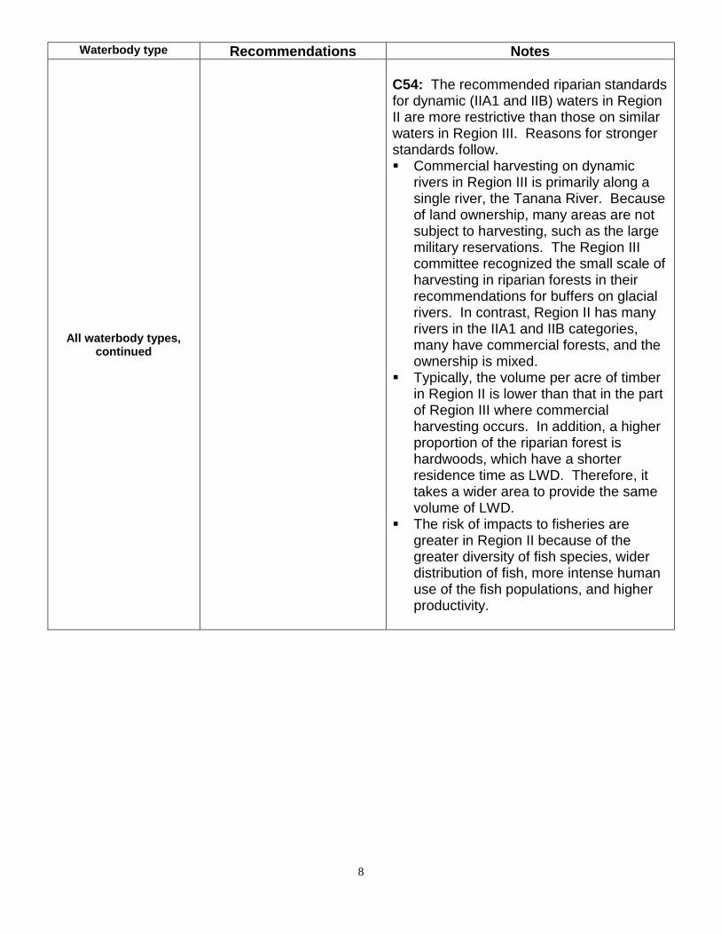
C54: The recommended riparian standards for dynamic (IIA1 and IIB) waters in Region II are more restrictive than those on similar waters in Region III. Reasons for stronger standards follow. ▪ Commercial harvesting on dynamic
rivers in Region III is primarily along a single river, the Tanana River. Because of land ownership, many areas are not subject to harvesting, such as the large military reservations. The Region III committee recognized the small scale of harvesting in riparian forests in their recommendations for buffers on glacial rivers. In contrast, Region II has many rivers in the IIA1 and IIB categories, many have commercial forests, and the ownership is mixed.
▪ Typically, the volume per acre of timber in Region II is lower than that in the part of Region III where commercial harvesting occurs. In addition, a higher proportion of the riparian forest is hardwoods, which have a shorter residence time as LWD. Therefore, it takes a wider area to provide the same volume of LWD.
▪ The risk of impacts to fisheries are greater in Region II because of the greater diversity of fish species, wider distribution of fish, more intense human use of the fish populations, and higher productivity.

9
Waterbody type Recommendations Notes
Type IIA1 ▪ Anadromous
or HVR fish ▪ Non-glacial ▪ >50’ wide at
OHWM ▪ Not confined ▪ Dynamic
channels
▪ Point bars, islands, obvious erosion, scour planes, active or recent side channels
C16: A no-cut zone is important, coupled with a special management zone (SMZ) to provide an adequate supply of LWD to the system. The SMZ should relate to the likelihood of the channel moving into that area. Eroding outside bends are key sites for potential LWD recruitment. C22: For type IIA1 waters, the committee recommends ▪ a 150’ no-cut buffer, and ▪ an SMZ on the area from 150’ to 300’
measured from OHWM or to the terrace top break, whichever comes first. See C31 and diagram for terrace top
C23: For type IIA1 waters, a no-cut buffer greater than 100’ is recommended in recognition of the large size of these waters and their rapid channel movement. Timber management is allowed within the SMZ, however, harvests must be designed to maintain the supply of LWD, with particular consideration to retaining wood at sites that are more likely to recruit LWD from erosion, such as meander cutoffs and the downstream portion of outer bends. C32: For SMZs on IIA1 waters: ▪ Harvest is not restricted on inside
bends and straight reaches. ▪ On outside bends, harvest of up to 50%
of the merchantable trees is allowed. This does not restrict the pattern of harvesting within the SMZ (i.e., it does not require single-tree selection). The intent is to keep some of the timber in the SMZ for LWD.
▪ Outside bends within harvest units should be identified in the DPO.
▪ Following procedures in 11 AAC 95.355(a)-(d), harvest trees may be felled into the no-cut portion of the riparian area when necessary to minimize damage to residual trees.
▪ Trees felled into the no-harvest zone may be topped to the merchantable specification and the tops left within the no-harvest zone; tops left shall be treated in accordance with 11 AAC 95.370(d)-(e) to reduce risk of insect infestation.
C7am: Type IIA1 waters are wide non-glacial streams that ▪ Have anadromous or high-value
resident fish, ▪ are not confined and have dynamic
channels, and ▪ have point bars, islands, and areas
of obvious bank erosion. Channel morphology is an important factor in maintaining LWD in this type. Examples of Type IIA1 waters include the lower reaches of:: ▪ Willow Creek (Mat-Su) ▪ Montana Creek (Mat-Su) ▪ Clear Creek (Mat-Su) ▪ Peters Creek (Mat-Su [Petersville
Rd.]) ▪ Theodore River (W Side Cook Inlet) ▪ Chuitna River (W Side Cook Inlet) ▪ Lewis River (W Side Cook Inlet) ▪ Gulkana River (Copper River) ▪ E. Fk. Chistochina R. (Copper R.) ▪ Hanagita River (Copper R.) ▪ Anchor River (Kenai) ▪ Deep Creek (Kenai) ▪ Ninilchik River (Kenai) C14: Type IIA1 channels move and LWD recruitment from erosion and avulsion is important. C15: In Type IIA1, LWD is important both on-site for pool formation, and in the system as a whole for channel morphology. C21: Little harvesting has occurred close to type IIA1 waters due to natural vegetation (i.e., extensive riparian areas that aren’t forested), low tree value, land ownership patterns, and land use designations on public land. On state land wildlife considerations have also led to wider setbacks through area plans and Forest Land Use Plans (FLUPs).
10
Waterbody Type Recommendations Notes
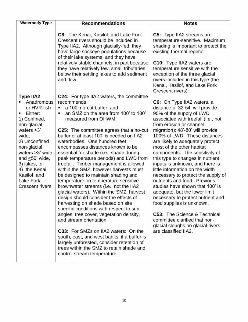
Type IIA2 ▪ Anadromous
or HVR fish ▪ Either: 1) Confined, non-glacial waters >3’ wide, 2) Unconfined non-glacial waters >3’ wide and <50’ wide, 3) lakes, or 4) the Kenai, Kasilof, and Lake Fork Crescent rivers
C8: The Kenai, Kasilof, and Lake Fork Crescent rivers should be included in Type IIA2. Although glacially-fed, they have large sockeye populations because of their lake systems, and they have relatively stable channels, in part because they have relatively few, small tributaries below their settling lakes to add sediment and flow. C24: For type IIA2 waters, the committee recommends ▪ a 100’ no-cut buffer, and ▪ an SMZ on the area from 100’ to 180’
measured from OHWM. C25: The committee agrees that a no-cut buffer of at least 100’ is needed on IIA2 waterbodies. One hundred feet encompasses distances known to be essential for shade (i.e., shade during peak temperature periods) and LWD from treefall. Timber management is allowed within the SMZ, however harvests must be designed to maintain shading and temperature on temperature sensitive brownwater streams (i.e., not the IIA2 glacial waters). Within the SMZ, harvest design should consider the effects of harvesting on shade based on site specific conditions with respect to sun angles, tree cover, vegetation density, and stream orientation. C33: For SMZs on IIA2 waters: On the south, east, and west banks, if a buffer is largely unforested, consider retention of trees within the SMZ to retain shade and control stream temperature.
C5: Type IIA2 streams are temperature-sensitive. Maximum shading is important to protect the existing thermal regime. C10: Type IIA2 waters are temperature sensitive with the exception of the three glacial rivers included in this type (the Kenai, Kasilof, and Lake Fork Crescent rivers). C6: On Type IIA2 waters, a distance of 32-54’ will provide 95% of the supply of LWD associated with treefall (i.e., not from erosion or channel migration); 48’-80’ will provide 100% of LWD. These distances are likely to adequately protect most of the other habitat components. The sensitivity of this type to changes in nutrient inputs is unknown, and there is little information on the width necessary to protect the supply of nutrients and food. Previous studies have shown that 100’ is adequate, but the lower limit necessary to protect nutrient and food supplies is unknown. C53: The Science & Technical committee clarified that non-glacial sloughs on glacial rivers are classified IIA2.

11
Waterbody type Recommendations Notes
Type IIB ▪ Anadromous
or HVR fish ▪ Glacial
waters others than those listed in IIA2
▪ Typically unconfined, with point bars, islands, obvious erosion, scour planes, and active or recent side channels
C27: For type IIB waters, the committee recommends ▪ a 150’ no-cut buffer, and ▪ an SMZ on the area from 150’ to 500’
measured from OHWM or to the terrace top, whichever comes first.
C28: For type IIB waters, a no-cut buffer greater than 100’ is recommended in recognition of the large size of these waters and their rapid channel movement. Timber management is allowed within the SMZ, however harvests must be designed to maintain the supply of LWD, with particular consideration to retaining wood at sites that are more likely to recruit LWD from erosion such as the heads of islands and the downstream portion of outer bends. On IIB streams that are incised or have single channels rather than braided channels, the SMZ can be relatively narrow, since it just extends to the terrace top. C32: For SMZs on IIB waters: ▪ Harvest is not restricted on inside bends and
straight reaches. ▪ On outside bends, harvest of up to 50% of the
merchantable trees is allowed. This does not restrict the pattern of harvesting within the SMZ (i.e., it does not require single-tree selection). The intent is to keep some of the timber in the SMZ for LWD.
▪ Outside bends within harvest units should be identified in the DPO.
▪ Following procedures in 11 AAC 95.355(a)-(d), harvest trees may be felled into the no-cut portion of the riparian area when necessary to minimize damage to residual trees.
▪ Trees felled into the no-harvest zone may be topped to the merchantable specification and the tops left within the no-harvest zone; tops left shall be treated in accordance with 11 AAC 95.370(d)-(e) to reduce risk of insect infestation.
C17: LWD is important in type IIB systems. LWD is important for channel morphology, e.g., formation of islands, bars, and side channels. Large quantities of LWD is needed at a single point to form log jams. C18: There is no data for setting buffer width on IIB waters other than full floodplain width. C26: Extensive reaches of IIB waters are highly dynamic and can move from terrace to terrace over time.
12
Type IID ▪ Anadromous
or HVR fish ▪ Non-glacial
<3’ wide at OHWM
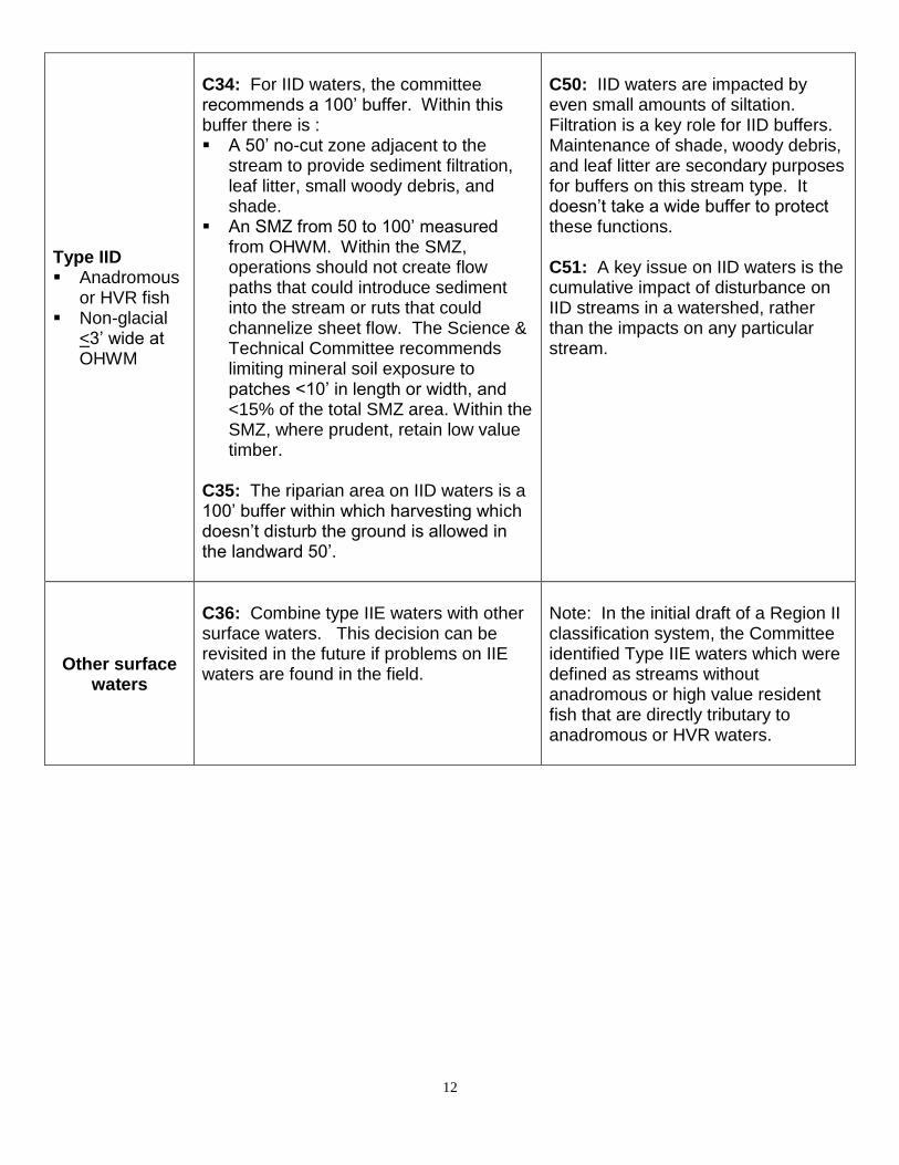
C34: For IID waters, the committee recommends a 100’ buffer. Within this buffer there is : ▪ A 50’ no-cut zone adjacent to the
stream to provide sediment filtration, leaf litter, small woody debris, and shade.
▪ An SMZ from 50 to 100’ measured from OHWM. Within the SMZ, operations should not create flow paths that could introduce sediment into the stream or ruts that could channelize sheet flow. The Science & Technical Committee recommends limiting mineral soil exposure to patches <10’ in length or width, and <15% of the total SMZ area. Within the SMZ, where prudent, retain low value timber.
C35: The riparian area on IID waters is a 100’ buffer within which harvesting which doesn’t disturb the ground is allowed in the landward 50’.
C50: IID waters are impacted by even small amounts of siltation. Filtration is a key role for IID buffers. Maintenance of shade, woody debris, and leaf litter are secondary purposes for buffers on this stream type. It doesn’t take a wide buffer to protect these functions. C51: A key issue on IID waters is the cumulative impact of disturbance on IID streams in a watershed, rather than the impacts on any particular stream.
Other surface waters
C36: Combine type IIE waters with other surface waters. This decision can be revisited in the future if problems on IIE waters are found in the field.
Note: In the initial draft of a Region II classification system, the Committee identified Type IIE waters which were defined as streams without anadromous or high value resident fish that are directly tributary to anadromous or HVR waters.

13
Blockages
C2: The table in 11 AAC 95.265(g) should be used in Region II where potential blockages exist. C3: No change is needed to the existing standard for beaver dams in 11 AAC 95.265(g)(7).
C4: If a blockage exists for salmon, there is also blockage for upstream passage of high value resident fish species. However, some high value resident fish populations can exist above blockages because they don’t require downstream passage. Therefore, you can’t presume that the presence of a blockage means that there are no high value resident fish upstream. Note: In Region I, the blockage table was essential because fish distribution is commonly limited by a blockage from a falls or steep gradient. The extent of fish distribution in Region II is usually not determined by those types of blockages..

14
Field review of stream classifications
C41: Add to 11AAC 95.265(c): In Region II, the division will base its decision on the criteria set out in the definitions of Region II stream types and the evidence or lack or evidence of anadromous fish or high value resident fish, at or upstream of the area proposed for reclassification. C42: Add to 11AAC 95.265(d): In Region II, field reviews may be requested for presence or evidence of high value resident fish as well as anadromous fish (use the same language as adopted for Region III).
Slope Stability Standards
C40: Because of the redundancy with other BMPs, and the high proportion of streams covered by the recommended buffers and SMZs in Region II, the slope stability standards in 11 AAC95.280 are not required in Region II.
Definitions
Temporary and
permanent roads
C29: The committee recommended that Region II use the same definitions for “temporary road” and “permanent road” as Region III.
Lake or pond
C30: The committee recommended that Region II use the same definition of “lake or pond” as in Region III.
Estuaries
C52: Waterbody types include estuarine areas where they occur in Region II. Where estuaries exist, the buffer for the adjacent waterbody type would apply. SMZs do not apply to estuarine areas.
C1: There are few estuarine areas adjacent to commercial forest land in Region II. If estuaries exist in this Region, they are likely to be covered by buffers.
15
Invasive Species
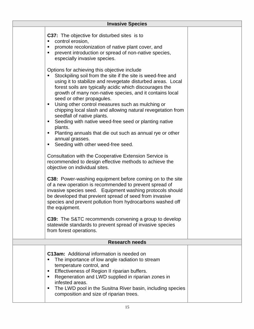
C37: The objective for disturbed sites is to ▪ control erosion, ▪ promote recolonization of native plant cover, and ▪ prevent introduction or spread of non-native species,
especially invasive species. Options for achieving this objective include ▪ Stockpiling soil from the site if the site is weed-free and
using it to stabilize and revegetate disturbed areas. Local forest soils are typically acidic which discourages the growth of many non-native species, and it contains local seed or other propagules.
▪ Using other control measures such as mulching or chipping local slash and allowing natural revegetation from seedfall of native plants.
▪ Seeding with native weed-free seed or planting native plants.
▪ Planting annuals that die out such as annual rye or other annual grasses.
▪ Seeding with other weed-free seed. Consultation with the Cooperative Extension Service is recommended to design effective methods to achieve the objective on individual sites. C38: Power-washing equipment before coming on to the site of a new operation is recommended to prevent spread of invasive species seed. Equipment washing protocols should be developed that previent spread of seed from invasive species and prevent pollution from hydrocarbons washed off the equipment. C39: The S&TC recommends convening a group to develop statewide standards to prevent spread of invasive species from forest operations.
Research needs
C13am: Additional information is needed on ▪ The importance of low angle radiation to stream
temperature control, and ▪ Effectiveness of Region II riparian buffers. ▪ Regeneration and LWD supplied in riparian zones in
infested areas. ▪ The LWD pool in the Susitna River basin, including species
composition and size of riparian trees.
16
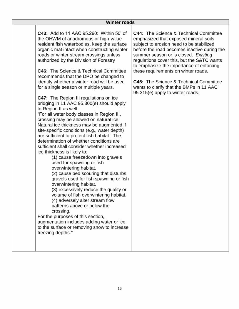
Winter roads
C43: Add to 11 AAC 95.290: Within 50’ of the OHWM of anadromous or high-value resident fish waterbodies, keep the surface organic mat intact when constructing winter roads or winter stream crossings unless authorized by the Division of Forestry C46: The Science & Technical Committee recommends that the DPO be changed to identify whether a winter road will be used for a single season or multiple years. C47: The Region III regulations on ice bridging in 11 AAC 95.300(e) should apply to Region II as well. “For all water body classes in Region III, crossing may be allowed on natural ice. Natural ice thickness may be augmented if site-specific conditions (e.g., water depth) are sufficient to protect fish habitat. The determination of whether conditions are sufficient shall consider whether increased ice thickness is likely to:
(1) cause freezedown into gravels used for spawning or fish overwintering habitat, (2) cause bed scouring that disturbs gravels used for fish spawning or fish overwintering habitat, (3) excessively reduce the quality or volume of fish overwintering habitat, (4) adversely alter stream flow patterns above or below the crossing.
For the purposes of this section, augmentation includes adding water or ice to the surface or removing snow to increase freezing depths.”
C44: The Science & Technical Committee emphasized that exposed mineral soils subject to erosion need to be stabilized before the road becomes inactive during the summer season or is closed. Existing regulations cover this, but the S&TC wants to emphasize the importance of enforcing these requirements on winter roads. C45: The Science & Technical Committee wants to clarify that the BMPs in 11 AAC 95.315(e) apply to winter roads.

17
Field Booklets
C48: Include the classification chart, examples of waterbody types, and the diagram of the “terrace top” definition and SMZ location in the field booklet of FRPA regulations.
Region II-III Boundary (Copper River area)
C49: There is no clear reason to change the boundary between Region II and III. The portion of the Copper River basin now in Region II should stay in Region II.

Region II Science & Technical Committee Minutes Meeting #6 – March 10, 2004 18
Region II Forest Practices Riparian Standards Science & Technical Committee Minutes Meeting #1
May 22, 2003 -- Anchorage, AK
Attendance
Dan Billman Marty Freeman, co-chair
Bob Clark Ed Holsten
Dean Davidson Jason Mouw
Jeff Davis Doug Palmer
Jim Durst, co-chair Dan Rinella
Jim Eleazer Michael Shephard
Chris Foley Chris Stark
Note: Handouts referenced in the minutes are available from either co-chair.
Purpose of Science and Technical Committee (S&TC). Freeman and Durst briefly reviewed
the charge of the S&TC:
▪ To compile the best available scientific and technical knowledge about fish habitat, riparian
ecosystems, water quality, hydrology, and forest practices relevant to riparian management in
Region II.
▪ Using this knowledge, to develop a stream classification system for Forest Resources and
Practices Act (FRPA) implementation in Region II and recommend a preferred system to the
Board of Forestry.
▪ To review the forest practices riparian standards in Region II, and if needed, recommend
changes to Board of Forestry
▪ To identify needed research relevant to riparian management in Region II
The S&TC is asked to apply the best scientific and technical expertise to the review. It is not
charged with doing economic or political assessments – that will be covered by the
Implementation Group.
Introductions. S&TC members introduced themselves and briefly described their areas of
expertise.
Background on Forest Resources and Practices Act (FRPA). Freeman and Durst briefly
reviewed the FRPA.
The Act is designed to protect fish habitat and water quality, and ensure prompt reforestation of
forestland while providing for a healthy timber industry. It ensures that both the timber and
commercial fishing industries can continue to provide long-term jobs. The Act governs how
timber harvesting, reforestation, and timber access occur on state, private, and municipal land.
Forest management standards on federal land must also meet or exceed the standards for state
land established by the Act.
The Act was originally adopted in 1978, with major revisions in 1990 to address riparian
management on private land, enhance notification procedures for timber operations, reorganize
the Board of Forestry, and establish enforcement procedures. The 1990 revisions included

Region II Science & Technical Committee Minutes Meeting #6 – March 10, 2004 19
interim riparian standards for Regions II-III. Additional changes to the stream classification
system and riparian management standards for coastal forests (Region I) were adopted in 1999,
and for interior Alaska (Region III) this year.
The Act applies to commercial timber operations on forestland, including harvesting, roading,
site preparation, thinning, and slash treatment operations. All commercial harvest operations that
encompass or border surface waters or a riparian area are subject to the Act regardless of their
size. In addition, operations that do not border surface waters are subject to the Act if they are
larger than 40 acres (Region II).
The Act requires that landowners submit a Detailed Plan of Operations (DPO) to the state before
beginning commercial timber operations. The DPO is reviewed by the DNR Division of
Forestry, DNR Office of Habitat Management & Permitting (OHMP), and DEC Air &Water
Quality Division to ensure compliance with the Act.
The FRPA sets standards for forest management along waterbodies, including buffers.
Harvesting of individual trees within buffers may occur only after inspection by the agencies,
and an agency determination that the harvest can be done without significantly harming fish
habitat or water quality. The Act also includes slope stability standards designed to prevent mass
wasting and erosion into waterbodies. Reforestation is required on all forest ownerships except
where the land will be converted to another use, or where the harvest area is significantly
composed of dead or dying trees.
Regulations adopted under the Act establish best management practices (BMPs) for road
construction and maintenance, and timber harvesting. The BMPs are designed to prevent
adverse impacts to fish habitat and water quality from timber operations.
The Board of Forestry directed the agencies to review the riparian standards in the Act. The
review of Regions I and III is complete. Both efforts resulted in legislative changes to the Act,
and in regulatory changes. The Board is committed to using the best available science, and
recognizes that there is a need to make decisions despite some scientific uncertainty.
Freeman and Durst also reviewed the four principles that the Board of Forestry uses in
considering revisions to the Act – fairness, “No Big Hit”, enforceability, and opportunity for
professional management.
Science & Technical Committee Process. The S&TC will begin by review existing literature
relevant to riparian management in Region II. This effort will build on the work done for Region
III (see bibliography). ADF&G also started compiling additional information (see handout).
The second phase will be to draft a waterbody classification system. The system can build on the
systems for Regions I and III where appropriate, but should be tailored to Region II conditions.
The classification is targeted at FRPA implementation – it is not a system for classifying waters
for other purposes. The final classes will reflect groups of waterbody types that need similar
management standards to protect fish habitat and water quality. In both Region I and III, the

Region II Science & Technical Committee Minutes Meeting #6 – March 10, 2004 20
initial draft of a classification system had more classes than the final system. The systems were
simplified as recommendations for management guidelines were developed.
The final task will be to review the existing riparian management standards and recommend
changes if needed.
Implementation Group. After the S&TC has made its recommendations, the agencies will
convene an Implementation Group to figure out how to implement the scientific
recommendations in a way that is practical on the ground. The Implementation Group will
include a variety of stakeholders representing resource agencies, forest landowners (e.g., Native
corporations, boroughs), the timber and fishing industries, and other affected interests such as
environmental groups and tourism or recreation interests. This group will consider economic
impacts in their recommendations.
Board of Forestry. The Board of Forestry is a 9-member board appointed by the Governor to
provide oversight on implementation and revision of the Forest Resources and Practices Act. Its
members represent a broad group of interests. The co-chairs will keep the Board briefed
throughout the S&TC process. The Board is a good group to help forge consensus on forestry
issues and has provided strong support for adoption of legislation and regulation changes
recommended by the Science & Technical Committees.
Organization. The co-chairs reviewed the handout on organization of the S&TC. The
Committee is an informal working group. It operates by consensus whenever possible. When
consensus cannot be reached, different opinions will be presented to the Board for resolution.
The co-chairs will take care of meeting logistics, keep the meetings efficient and focused,
document the review process, provide public outreach, and brief the Board.
Committee meetings are open to public, and there will be opportunities for visitors to provide
comments. The comment format will stay informal unless large numbers of visitors make it
necessary to structure a more formal comment period. Copies of meeting minutes will be sent to
the mail list once reviewed and adopted by the Committee. We welcome ideas for additional
names to add to the mail list. Requests for presentations to the Committee should go through the
co-chairs. If a committee member is absent, that member can ask an alternate to attend.
Alternates should have similar expertise, and the Committee member should brief the alternate
on the issues ahead of time
Committee members may bring in specialists if appropriate. For example, agency
representatives may want to call in specialists to provide information on particular issues. Visits
of such specialists should be coordinated with the co-chairs. The co-chairs will also invite Bob
Ott from the Tanana Chiefs Conference to present information on recent riparian research in
Region III.
Bob Clark recommended that a summary of committee activities be distributed to the public in
addition to making the meetings and minutes available.
Region II Science & Technical Committee Minutes Meeting #6 – March 10, 2004 21
The co-chairs asked how the Committee wanted to handle media contacts.
C1 The Committee agreed that media questions should be referred to the co-chairs.
Members agreed not to speak for the group as a whole.
[Consensus points will be shown in this format – blocked and labeled with a “C” number.]
Existing standards. The co-chairs reviewed the existing riparian management standards for
Region II compared to the other regions (see handouts). Buffer standards for state and other
public land are the same as the standards in Region I. Private land standards are the same as the
standards for Region III prior to the recent update.
Overview of harvest activity in Region II. Jim Eleazer summarized recent harvest activity in
Region II. In the Copper River area harvest levels have been about 250 thousand board feet
(MBF) per year. Harvest levels jumped in 1994-96 to salvage timber on Native corporation land
in the spruce bark beetle infestation area while there were export markets for this wood. Copper
River timber harvests have been ground-based operations (i.e., not cable logging), and most has
been harvested in the winter. Most harvests are clearcuts.
Salvage operations were largely exempt from reforestation requirements. However, the Division
of Forestry surveyed regeneration on about 12,000 acres of Native land in 2002 and found that
natural regeneration met or exceeded the reforestation standards in the FRPA.
Harvests on state land have a required 100-foot buffer. Native operations have typically left 100-
foot buffers as well. There were a few cases of harvesting within 100’ of the Klutina River, with
no apparent adverse impacts. Harvesting in the Chitina area was generally kept away from
anadromous waters, and buffers were left voluntarily. Many waterbodies near harvest areas are
glacially fed.
Holsten asked about the condition of buffers left in salvage areas. Eleazer said that he would
find out and report back to the Committee on buffer condition and expected harvest levels for the
future.
In the Mat-Su area, most forest land is owned by the state or borough, and buffers are required
on these public lands. The 20-year average harvest is about 500 MBF per year. There has been
some increase recently on Mat-Su Borough land, and there is some increasing interest in
harvesting birch. There is some out-of-state demand for birch for furniture and toys to replace
use of red alder which typically comes from riparian area.
There is a consistent demand for small quantities of white spruce (e.g., Deception Creek). On
state land, harvesting has occurred in the Houston area since 1990, and there are a few more
years of harvesting left in that area. Recent demand for spruce from state land has declined due
to the availability of wood from land cleared for subdivisions. This has provided a cheaper
source of wood to small local mills since there are short haul distances and no reforestation
requirements. No state timber sales were purchased in 2002.

Region II Science & Technical Committee Minutes Meeting #6 – March 10, 2004 22
Jeff Davis noted that Susitna Valley Hardwoods has been purchasing some private sales, and has
been maintaining riparian buffers. There have been no requests for variation from buffer
requirements on public land.
The Kenai area has had the highest harvest levels in southcentral Alaska over the last decade.
On private land, another two to three years of timber harvest is likely on the Kenai Peninsula and
near Tyonek. A lot of harvesting is occurring on small private parcels as well, both for timber
(including chips) and to reduce high fuel loads following the beetle infestation. That harvest is
likely to continue for another three to four years. The Kenai Peninsula Borough sold timber on
about 2,500 acres over the last few years (10-15 million board feet (MMBF)), and another three
to four years of harvesting is expected on Borough land. The state sold 13 MMBF on 3,000
acres last year, and has scheduled sales on another 5,000 acres (25-30 MMBF) in 2003, and
3,000 acres per year (about 20 MMBF per year) for the next two to three years.
A lot of reforestation has been done, and more is expected. Road maintenance and closure
following harvest and reforestation will be major issues for the next few years. The October
2002 floods substantially damaged bridges, culverts, and roads. We don’t know whether
damaged roads will be reopened or closed. Road condition and availability will affect the
profitability of remaining sales, and could affect the extent of harvesting.
Freeman noted that fuel loading from dead spruce is a major wildfire hazard, and is a key reason
for the extensive harvesting on state land. All state sales are reforested, and Eleazer reported that
reforestation has been successful, with good plantation survival and scarification working well.
In some areas birch is replacing white spruce as the main cover type. Some federal funding has
also been available for reforestation on private land. Eleazer will find out what information is
available on regeneration surveys on private land, and report back to the Committee.
Holsten summarized the status of the spruce bark beetle infestation. In southcentral, the beetle
has consumed most of the spruce that is its food source – there is little beetle habitat left. There
are spots of active infestation on the lower Kenai Peninsula around Anchor Point, near Iliamna
and Pedro Bay, and in the Chugach and Copper River areas. The 2002 insect and disease
surveys documented 50,000 acres of active infestation, the lowest level in many years. The
infestation peaked at about one million acres in 1996. There is little spruce bark beetle activity
in interior Alaska.
Eleazer noted that beetle-killed trees in the Kenai area typically break off or blow down. About
10-15% of the stands are currently on the ground, and there are pockets where 50% of the trees
are down and jackstrawed. The dead stands are now covered by 4- to 5-foot tall dead grass in the
spring. Fire management experts say the wildfire risk is SCARY.
Eleazer said that on private land there have been few requests to cut timber within 100 feet of
waterbodies. In many cases there is a natural unforested area around fish streams. Timber is
usually cut only to the slope break because of equipment constraints. Buffers have been left in
nearly all other areas. In 1990, there was an approved harvest of 12 trees in a riparian area, and
in 1999 a request was approved to harvest along a 400-foot stretch of stream, but a 75’ buffer

Region II Science & Technical Committee Minutes Meeting #6 – March 10, 2004 23
was left. A third request to harvest in a riparian area was dropped in 1997. Harvests on state and
other public land have left 100-foot or greater buffers.
Davis said that about 5-10% of the streamside areas on the southern Kenai Peninsula are forested
(south of Tustumena Lake). On the northern Kenai, harvest has essentially been completed on
lands along streams outside the Kenai National Wildlife Refuge. The rest are naturally non-
forest. On the west side and near Tyonek cottonwood is the dominant tree in riparian areas and
there is little harvest of cottonwood.
Holsten asked whether planting in dead, unharvested buffers is allowed. Freeman and Eleazer
answered that planting is allowed, but there are some restrictions on use of mechanized
equipment. Durst added that landowners could also request a variation to operate in buffers for
reforestation.
Eleazer noted that that has been some management of second growth trees in buffers in southeast
Alaska, such as thinning to encourage more open cover. The amount of activity has depended on
the availability of grant funding.
Stream distribution. Durst presented a map that shows the general distribution of anadromous
waters by region. He noted that Region I streams are generally short, steep, and closely-spaced.
Flow varies seasonally, and most streams are anadromous. Much of Region III has fewer,
longer, low gradient main river systems like the Tanana and Kuskokwim. The upper reaches
commonly have high value resident fish, but not anadromous fish. Region II waters tend to be
intermediate between those in regions I and III; they are longer than Region I, and there is a high
density of anadromous waters, except in the upper reaches.
Bob Clark commented that the Copper River basin has some characteristics similar to waters in
the interior (e.g., Kantishna and upper Tanana rivers) and some similarities to southcentral
waters (e.g., Susitna River). Salmon distributions are similar to southcentral, but there are fewer
coho waters.
Freeman encouraged the group to keep all the areas of Region II in mind as we discuss issues.
Durst suggested coming up with examples of the different stream types as the Committee
develops a waterbody classification system.
Holsten asked whether there have been any studies on the hydrology of harvested vs.
unharvested watersheds in southcentral Alaska. Freeman agreed to check with the agencies and
others to find out.
Literature review and Region II issues. Durst summarized literature review work done to date.
The Region III process printed an annotated bibliography that covered seven topics relating to
riparian management in interior Alaska. In addition, Celia Rozen from ADF&G compiled
references that may be of interest for southcentral Alaska.

Region II Science & Technical Committee Minutes Meeting #6 – March 10, 2004 24
Because the group had not had time to review the bibliography and the material from Rozen,
they agreed to defer discussion of whether additional information was needed on the topics
covered by those documents.
Discussion focused on identifying additional issues and types of information needed, and
assigning leads for seeking that information.
Freeman noted that in addition to reviewing the existing standards, some issues that are
important to Region II haven’t been covered in the other regions. Key Region II issues include
▪ Management of riparian areas in infested areas
▪ Management of riparian areas on small anadromous and high value resident fish streams
▪ Winter roads in southcentral Alaska
After discussion, committee members added the following issues to the Region II list:
▪ Classification of glacial rivers with and without pro-glacial lakes or other lakes that act as
settling areas. Glacial rivers with lakes (e.g., the Kenai River system) have significantly
different flow and turbidity characteristics (and geomorphologic processes?) than glacial
rivers without large lakes (e.g., the Susitna River).
▪ The relationship of beaver dams to classification of stream types.
▪ Management of forest practices buffers in areas of mixed ownership where non-forest land
may not retain buffers (e.g., the Anchor River area).
▪ Riparian management adjacent to waterbodies that have been stocked for fishing.
▪ Interaction of winter roads built for forest operations and subsequent ATV use.
▪ The effect of glacial outburst waters on forested riparian areas (e.g., Nelchina and Skilak).
Non-forest activities: Freeman and Eleazer noted that riparian requirements for non-forestry
activities vary by municipality, state land use plans, and Coastal Districts. Eleazer clarified that
if forest land is cleared for conversion to another use, it may require a National Pollution
Discharge Elimination System (NPDES) permit from EPA. Forest land use conversions don’t
have to submit a Detailed Plan of Operations to the Division of Forestry if they are on platted
land within a municipality. If they are not platted, the activity does require a DPO and it is
subject to FRPA best management practices (e.g., for road construction), but not buffer or
reforestation requirements. If the land is not converted to another use within five years, then
reforestation is required. The Division must monitor DPOs for land use conversions to ensure
that the conversion takes place.
Durst added that harvests on Native allotments are managed by the Bureau of Indian Affairs as a
trust, and are not subject to the Forest Practices Act. BIA does have federal timber sale
handbooks that it uses to guide design of sales on allotments.
ATVs: Eleazer raised the issue of ATV on forest roads – ATV use can be a significant problem,
especially at stream crossings. Davis commented that it is important to consider potential ATV
use in road design.
To do list. The group identified a list of tasks, and volunteered to tackle them as follows…

Region II Science & Technical Committee Minutes Meeting #6 – March 10, 2004 25
All: By the July 8 meeting: Review the Region III bibliography and the handout of references
for Region II compiled by Celia Rozen to identify any gaps in information review
relevant to the Region II review process.
For the July 8 meeting, we will have progress reports on the following tasks. Tasks should
be completed by the following meeting (September)
Ed Holsten/Jeff Davis/Michael Shephard:
▪ Compile information on management of riparian areas in infested zones.
Ed Holsten/Marty Freeman
▪ Check on availability of watershed monitoring data that would show whether harvesting has
affected flow characteristics.
Dean Davidson:
▪ Compile information on the relationship of riparian management to soil type (e.g.,
revegetation on gravel vs. silt soils following loss of trees to infestation).
Bob Clark:
▪ Compile information on riparian area management along small anadromous and high value
resident fish streams.
▪ Provide a map showing the location of stocked lakes in Region II.
Jeff Davis
▪ Compile information on winter roads in southcentral Alaska, including the interaction of
winter roads with ATV use.
Chris Foley/Jason Mouw
▪ Compile information on how other states manage riparian buffer management in areas of
patchwork ownership (e.g., where other land uses may not maintain riparian buffers). Jim
Eleazer will also contact Jim Colla/Idaho on this topic.
▪ Compile information from other states on riparian standards for lakes.
Jim Eleazer
▪ Report on information from regeneration surveys on private land in areas exempt from
reforestation requirements.
▪ Report on the condition of harvest buffers left in infested areas in the Copper River basin and
expected harvest levels in the Copper River basin.
Jason Mouw
▪ Compile information on fluvial geomorphology in northern environments (e.g., channel
movement), especially in glacial systems.
Jason Mouw/Chris Stark
▪ Compile information on overwintering fish habitat in Region II.

Region II Science & Technical Committee Minutes Meeting #6 – March 10, 2004 26
Chris Stark
▪ Compile information on slope stability in Region II.
Dan Billman
▪ Provide a map showing the location of glacial rivers subject to periodic lake outburst in
Region II
▪ Provide a map showing the location of glacial rivers that have pro-glacial lakes
Jim Durst
▪ Contact Mac McLean about briefing the Region II S&TC on the culvert standard review
process.
▪ Find out whether the culvert standard process is considering issue of icing in culverts, and
whether effects of culverts and bridges on icing are known.
▪ Provide S&TC with copies of map showing the distribution of anadromous waters in Region
II compared to Regions I and III.
Dan Rinella
▪ Provide information from the NAQWA studies on temperature effects in brownwater
streams.
Marty Freeman
▪ Update and distribute contact list.
▪ Provide map of forest area and streams.
▪ Check with municipalities (Kenai, Anchorage, Mat-Su) for maps of harvested areas.
▪ Report on 2003 legislative changes that affect forest practices.
▪ Check with municipalities on riparian standards for development activities.
▪ Contact Bob Ott about doing a presentation on the Tanana River dynamics study.
▪ Summarize relevant guidelines/BMPs in state land use plans and the Susitna Forest
Guidelines.
Next meeting. July 8, 2003, Atwood Building Conf. Room, Suite 1270, Anchorage
Agenda items for next meeting:
▪ Progress reports on compilation of background information (see To Do List above)
▪ Report on DNR Office of Habitat Management & Permitting process to revise culvert
permitting for forestry operations (Mac McLean, OHMP)
▪ Discussion of remaining information needs – is information needed other than that in the
Region III bibliography, the ADF&G compilation of references, or the tasks in the To Do
List?
Handouts
▪ Contact list
▪ Mailing list
▪ Agenda
▪ May 5, 2003 letter from co-chairs to S&TC
Region II Science & Technical Committee Minutes Meeting #6 – March 10, 2004 27
▪ S&TC Organization
▪ Table 1. Existing riparian management standards by region and land owner
▪ Table 2. Existing riparian management standards in Region II
▪ Status of Region II-III research needs for Forest Practices
▪ Region II riparian standards references compiled by Celia Rozen, ADF&G
▪ Excerpt from 1989 FRPA review (“Green Book”)
▪ Alaska Forest Practices Act Documentation of Review 1996-98 (Region I)
▪ Region III Forest Resources & Practices Riparian Management Annotated Bibliography,
2000
▪ Alaska Forest Resources and Practices Act Documentation of Region III Review 1999-2001
▪ Fact Sheet: Alaska Forest Resources and Practices Act, December 13, 1999
▪ Bill Text Senate Bill 88
▪ Web page – International Conference on Wood in World Rivers Searchable Database

Region II Science & Technical Committee Minutes Meeting #6 – March 10, 2004 28
Region II Forest Practices Riparian Standards Science & Technical Committee Minutes Meeting #2
July 8, 2003 - Anchorage, AK
Attendance
Dan Billman Marty Freeman, co-chair
Bob Clark Ed Holsten
Dean Davidson Jeff Davis
Doug Palmer Bob Ourso
Jim Durst, co-chair Dan Rinella
Jim Eleazer Michael Shephard
Chris Foley
Note: Handouts referenced in the minutes are available from either co-chair.
Introductions. Bob Ourso attended by teleconference. Bob works in the USGS NAQWA
program as a stream ecologist. He does water quality assessments and works on urban land use
issues. He noted that he has cooperated with Cook Inlet Keeper on their stream condition
analyses.
Jason Mouw was out with a new baby – Congratulations! Chris Stark was out with an injured
knee – Condolences.
Minutes. The draft minutes from the May meeting were approved as written.
Updates on information compilation.
Riparian standards
▪ State land use plan and municipal riparian standards for development activities --
Alison Arians, DOF, handed out charts summarizing relevant riparian guidelines in state land
use plans and municipal/borough codes for southcentral Alaska. Guidelines vary by land
use, and by fish presence and type. (see handouts)
▪ 2003 legislative changes that affect forest practices – SB 88 was passed and signed,
adopting the updated riparian standards for Region III. A copy of the bill was distributed at
the last meeting.
Marty Freeman handed out a copy of SB 149 (see handout). The bill focuses on forest
management planning, but includes a provision that limits DNR authority to impose riparian
standards that are more stringent than those in the Forest Resources & Practices Act. Stricter
standards can no longer be imposed through Forest Land Use Plans for individual sales.
Within the Tanana Valley State Forest, stricter standards can only be adopted if there is a
finding of “compelling state interest.”
▪ Riparian buffer management in other states, and management around lakes --Chris
Foley will prepare a table summarizing standards in the Pacific Northwest. He reported that
Region II Science & Technical Committee Minutes Meeting #6 – March 10, 2004 29
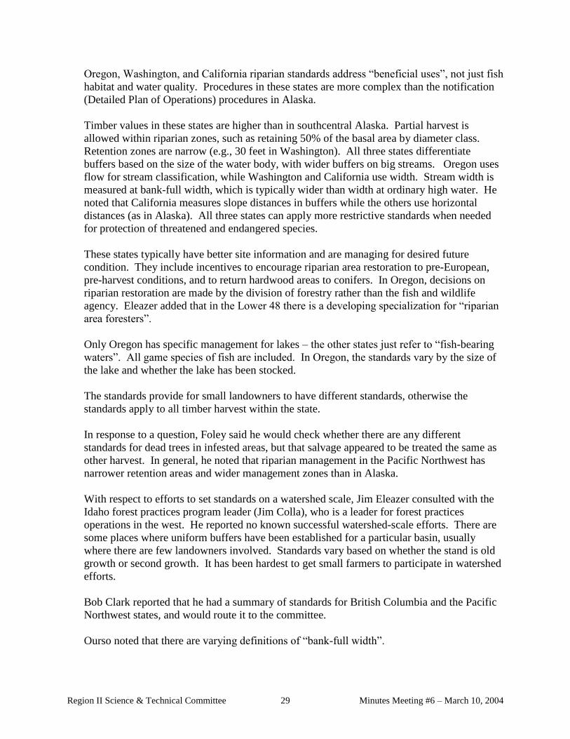
Oregon, Washington, and California riparian standards address “beneficial uses”, not just fish
habitat and water quality. Procedures in these states are more complex than the notification
(Detailed Plan of Operations) procedures in Alaska.
Timber values in these states are higher than in southcentral Alaska. Partial harvest is
allowed within riparian zones, such as retaining 50% of the basal area by diameter class.
Retention zones are narrow (e.g., 30 feet in Washington). All three states differentiate
buffers based on the size of the water body, with wider buffers on big streams. Oregon uses
flow for stream classification, while Washington and California use width. Stream width is
measured at bank-full width, which is typically wider than width at ordinary high water. He
noted that California measures slope distances in buffers while the others use horizontal
distances (as in Alaska). All three states can apply more restrictive standards when needed
for protection of threatened and endangered species.
These states typically have better site information and are managing for desired future
condition. They include incentives to encourage riparian area restoration to pre-European,
pre-harvest conditions, and to return hardwood areas to conifers. In Oregon, decisions on
riparian restoration are made by the division of forestry rather than the fish and wildlife
agency. Eleazer added that in the Lower 48 there is a developing specialization for “riparian
area foresters”.
Only Oregon has specific management for lakes – the other states just refer to “fish-bearing
waters”. All game species of fish are included. In Oregon, the standards vary by the size of
the lake and whether the lake has been stocked.
The standards provide for small landowners to have different standards, otherwise the
standards apply to all timber harvest within the state.
In response to a question, Foley said he would check whether there are any different
standards for dead trees in infested areas, but that salvage appeared to be treated the same as
other harvest. In general, he noted that riparian management in the Pacific Northwest has
narrower retention areas and wider management zones than in Alaska.
With respect to efforts to set standards on a watershed scale, Jim Eleazer consulted with the
Idaho forest practices program leader (Jim Colla), who is a leader for forest practices
operations in the west. He reported no known successful watershed-scale efforts. There are
some places where uniform buffers have been established for a particular basin, usually
where there are few landowners involved. Standards vary based on whether the stand is old
growth or second growth. It has been hardest to get small farmers to participate in watershed
efforts.
Bob Clark reported that he had a summary of standards for British Columbia and the Pacific
Northwest states, and would route it to the committee.
Ourso noted that there are varying definitions of “bank-full width”.

Region II Science & Technical Committee Minutes Meeting #6 – March 10, 2004 30
Vegetation, access, and forest management
▪ Map of forest area and streams – Freeman reported that DNR is working on a map
showing general forest cover and anadromous waters. Completion is scheduled for fall.
▪ Maps of harvested areas – Arians reported that harvest maps by ownership in the Kenai
Peninsula Borough are available on the borough’s website. Most harvesting has been on
Native corporation land, with the state and borough running second and third. Information
for the Mat-Su Borough is more limited and hasn’t been compiled for mapping. There is
little harvesting in Anchorage to map. There’s no local government in the Copper River
basin, and no consolidated mapping. Foley suggested overlaying areas of private land
greater than 40 acres where the FRPA would apply and forest vegetation.
▪ Winter roads and ATV use in southcentral – Jeff Davis is compiling a list of ATV
surveys. ADF&G surveyed ATV crossings in the Mat-Su and Kenai Peninsula, and did a
study of ATV use on the Kenai. Wherever there is a desirable destination and some access,
there is ATV use for recreation and hunting. In some areas there is little if any incentive for
use. Some roads are used by both timber operators and ATVs, and it is hard to separate the
impacts from the different users. The Mat-Su area has fewer roads and less ATV impact than
the Kenai. ATV use in the Deception Creek area for fall moose hunting has caused erosion
on logging roads built for winter use. He noted that DOF dug “tank traps” on the roads
which reduced problems. In the Mat-Su Borough harvest area at Chijuk Creek the main
roads were all-season roads with bridges which decreased stream crossing damage. Remote
land sales and moose hunting patterns can greatly affect ATV effects on roads built for
logging. Jeff is also checking for information from Canada and from the Yakutat area. He is
starting a bibliography.
▪ Management of riparian areas in infested zones – Ed Holsten reported that he found no
data on buffer management specific to infested areas. Jeff Davis noted that there may be
some information in the ADF&G bibliography compiled by Celia Rozen (handout at last
meeting).
▪ Regeneration surveys on private land in areas exempt from requirements – Jim Eleazer
reported that DOF had a contractor look at information for the Kenai and Copper River areas
– there haven’t been any reforestation exemptions in the Mat-Su area. Ahtna and Chitina
corporations harvested about 17,750 acres that were exempt from reforestation requirements.
Last year, DOF took over 2000 plots on 14,000 acres of land. Data analysis is underway.
On the Kenai Peninsula over 70,000 acres have been harvested on land exempt from
reforestation requirements. Exempt areas include land owned by Native corporations, the
City of Kenai, Kenai Peninsula Borough, Mental Health Trust, and individual private owners.
Regeneration surveys are the landowner’s responsibility where reforestation is required.
Surveys are due within 7 years of harvest. DOF has a handbook of procedures. If the land is
exempt, no survey is required. Cook Inlet Region, Inc. (CIRI), Ninilchik Native Association,
and the Kenai borough have done regeneration surveys on exempt land and are willing to
share the data. The DOF Forest Stewardship program has done surveys on some small

Region II Science & Technical Committee Minutes Meeting #6 – March 10, 2004 31
private parcels and the data are available. The stewardship surveys don’t distinguish
between natural regeneration and plantings, however. Jim has a report in draft and will send
the final copy to the S&TC. DOF will begin contacting owners with available data and will
summarize results.
▪ Condition of harvest buffers left in infested areas in the Copper River basin. Jim
Eleazer reported that buffers are all dead (99-100% mortality). Buffers left were on big
rivers with bluffs. Breakage is now occurring and natural bank erosion is eating into buffers.
There isn’t any data on regeneration in buffers in infested areas. The Copper River Area
foresters have observed a lack of regeneration and vegetation in buffers, in contrast to the
grass regrowth on the Kenai Peninsula.
▪ Expected harvest levels in the Copper River basin. Jim Eleazer said that most harvesting
occurred in the mid-1990s when there was a spike in the pulp market. Rivers in the Copper
River area form big barriers to harvest activity. However, beetle-killed trees deteriorate more
slowly than in the Kenai area, and pulp could be harvested for 10-15 years after infestation.
Future harvesting will depend on another spike in the pulp market. Hardwoods are replacing
spruce in many areas. If a hardwood market develops there might be more interest in the
Copper River area, but the rivers are still barriers. DOF doesn’t expect accelerated
harvesting in this area. Currently, about 75 acres per year (300 MBF) are harvested for local
use.
Ed Holsten commented that beetle-killed trees in the Copper River area might remain usable
for pulp even longer, possibly up to 50 years.
Hydrology and geomorphology
▪ Watershed monitoring data re flow characteristics. Bob Ourso reported that southcentral
Alaska has been losing stream gages with long continuous records due to budget cuts. Data
is patchy. There is some information for the lower Kenai Peninsula on interactions of
harvesting, infestation, and flow, e.g., in the Ninilchik watershed where over 50% of the
beetle-killed forest has been harvested. The only information available so far shows little or
no effect of harvesting on flow rates because of the natural system conditions – in many areas
unforested marshes are adjacent to streams so harvest are naturally separated from the stream
courses. People are just beginning to look at the data in more detail. Based on field
observation there aren’t problems unless harvest occurs right up to the stream. It also isn’t a
factor in streams with flows less than 500 cfs. Beetle kills can increase LWD in streams, but
this may be dependent on stream flows.
Holsten agreed that there is little flow data. Cook Inlet Keeper has some water quality
monitoring data for the lower Kenai Peninsula watersheds. The data shows little change
post-harvest, but there is much older data. There is some literature on harvesting and flow
rates, less on the impacts of infestations on flow. Typically, flow rates increase after harvest,
and then taper off as the land is reforested. None of this literature is from Alaska.

Region II Science & Technical Committee Minutes Meeting #6 – March 10, 2004 32
Ourso added that the only data from comparable climatic areas is possibly from Poland.
There are only a few long-term studies. Holsten noted that there is also some data from a
1950s spruce beetle infestation in Colorado.
▪ Map of glacial rivers that have pro-glacial lakes; glacial lake outbursts. Dan Billman
showed a 1971 map with data on glacial with periodic outbursts. Some outburst lakes are no
longer active. Dean Davidson said Larry Mayo is still monitoring outburst lakes. Dan B. has
not found any information yet on pro-glacial lakes. Jim Eleazer noted that the National Park
Service has gages on Kennecott Lake which blows out annually.
▪ NAWQA studies on temperature effects in brownwater streams. Dan Rinella reported
that the NAWQA website has long-term monitoring data on 32 Cook Inlet basin streams. It
includes data on the relationship between air temperature and stream temperature and
developed a model to estimate the effect of increased carbon dioxide on stream temperature.
Lowland streams would warm the most. For example the model predicts a 4 to 5 degree
increase in the Deshka River temperature with a doubling of atmospheric carbon dioxide.
Lowland streams don’t have a lot of timber along the streams, but they are temperature
sensitive.
Jeff Davis suggested that small tributaries to lowland streams may be forested and
susceptible to temperature increases, e.g., tributaries in the Chijuk Creek sale in the Susitna
basin. He also explained that permitting for anadromous waters (AS 41.14.870) covers only
catalogued anadromous streams, and many reaches aren’t catalogued. Fish passage
requirements address both anadromous and resident fish streams.
Bob Clark added that king salmon have been lost at times due to temperature increases – king
salmon wait for cool stream temperatures to spawn. Increases in alders along streams also
increase nitrogen inputs. Jim Durst agreed that opening streams to light and temperature
increases changes the character of the stream.
Riparian management
▪ Riparian area management along small anadromous and high value resident fish
streams. Bob Clark is compiling a bibliography on small streams. He talked with John
Richardson at the University of British Columbia who is conducting a new study on small
streams. He expects to have an annotated bibliography by the end of the summer.
Michael Shephard noted that the North American Forest Ecology Workshop in Corvallis will
be posting abstracts and presentations online. The workshop included a lot of presentations
on riparian areas. (see handout)
Fisheries
▪ Map showing the location of stocked lakes in Region II. Bob Clark got a list of names and
GPS points for stocked lakes in southcentral Alaska. He has produced a first draft of a map,

Region II Science & Technical Committee Minutes Meeting #6 – March 10, 2004 33
but there are some problems with the coordinates to resolve. A total of 178 lakes are
stocked, mostly in Region II. (see handout)
▪ Culvert permitting for forestry operations. Jim Durst handed out an excerpt from the
April 30-May 1, 2003 Board of Forestry meeting which summarized OHMP's work to
resolve permitting issues for fish passage. Icing is not explicitly covered in the current
process.
▪ Anadromous waters map. Jim Durst handed out a map of anadromous waters by region.
Jeff Davis noted that OHMP tries to map the upper limit of anadromous waters using
helicopters when funding allows. They now try to identify barriers to fish as well, but did
not do so in the past.
Remaining information needs and issues
▪ Exotic species in riparian areas. Michael Shephard raised concerns about exotic plant
species in riparian areas. For example hundreds of acres of white sweet clover are along the
Stikine River. Exotic species can affect the characteristics of riparian areas. For example in
some areas Japanese knotweed is replacing alder, which also changes the insect community.
Jeff Davis noted that seed mixes for restoration work might include exotics. There may be a
linkage between FRPA and exotic species in the mass wasting and road maintenance
regulations. Dean Davidson will contact the Plant Materials Center in Palmer, and others
knowledgeable about exotics, for additional information.
▪ Icing and culverts. Jim Durst asked whether other information on icing and culverts is
needed. Jeff Davis said it is too early to know whether the problem is solved. Dan Billman
noted that the memorandum of agreement between OHMP and the Department of
Transportation addresses icing. Durst noted potential for using half-pipes for temporary
stream crossings of small streams. Dan B. agreed that they are good as long as they are
pulled prior to floods.
▪ Research buffers. Jim Eleazer noted that Region II is the only region without established
research buffers. Jeff Davis said that it would be interesting to know what is happening
before and after the infestation and before and after harvesting. Chris Foley said there might
be an opportunity for research in the Two Rivers Trust area (Ninilchik). Dean Davidson said
that the USFS is monitoring vegetation change related to the beetle infestation but has data
for only about five years, and it isn’t in riparian areas. Depending on vegetation
classification and overstory, such changes may or may not have effects on fish habitat and
water quality. Dan Billman noted that Calamagrostis that is coming in is good for bank
stability, but not for shading. Dean Davidson said that Calamagrostis comes in where there
is enough fine-textured soil.
Next Meeting.
▪ The Region II Science and Technical Committee meet next Tuesday, September 23, 2003,
with a goal of concluding the information reports.

Region II Science & Technical Committee Minutes Meeting #6 – March 10, 2004 34
Handouts
▪ Agenda
▪ Draft minutes from meeting #1, May 22, 2003
▪ SB 149
▪ USDA Forest Service. 2003. Forest insect and disease conditions in Alaska—2002. General
Technical Report R10-TP-113. 62 pp.
▪ Region II (Southcentral) land use plans: Relevant riparian guidelines
▪ Region II (Southcentral) municipality and borough code: Relevant riparian guidelines
▪ Excerpt from Woody Debris Bibliography, UC Center for Forestry. Lassettre, N.S. Dept. of
Landscape Architecture and Environmental Planning. UC Berkeley. 1999.
▪ Updated Region II S&TC contact list
▪ Annotated references on Stream Flow/Beetle Epidemics and Stream Flow/Harvesting, Fire
▪ Young, Kyle, A. 2000. Riparian zone management in the Pacific Northwest: Who’s cutting
what? Env. Mgmt. 26:2 pp. 131-144
▪ Harvey, A.M. 1969. Channel capacity and the adjustment of streams to hydrologic regime.
J. Hydrology 8 pp. 82-98.
▪ Annotated reference from National Water Quality Assessment Program report – Kyle and
Brabets, 2001. Water temperature of streams in the Cook Inlet basin, Alaska and implication
of climate change. USGS Water Resources Investigations Report 01-4109.
▪ Jim Durst – progress report including map of distribution of anadromous waters by FRPA
region and notes on DNR Office of Habitat Management and Permitting process to revise
culvert permitting for forestry operations. July 8, 2003
▪ Map of state legislatively designated areas in Region II. OHMP 5/21/03.
▪ Moore, R. Dan, and Richardson, John S., eds. 2003. Small stream channels and their
riparian zones: Their form, function, and ecological importance in a watershed context, in
Can. J. For. Res. 33(8): 1352-1362.
TO DO:
▪ All: Complete information review for assigned topics
▪ Freeman: send copy of Rozen bibliography to Holsten
▪ Freeman: send copy of handouts to Ourso, Stark, Mouw
▪ Freeman and Eleazer: Look at FRPA re places with respect to possible exotic species issues,
e.g., revegetation under 11 AAC 95.330, etc.; review 1981 revegetation guidelines by region,
mass wasting
▪ Davidson: compile information on seed mixes and exotic species, esp. with relationship to
stream restoration

Region II Science & Technical Committee Minutes Meeting #6 – March 10, 2004 35
Region II Forest Practices Riparian Standards Science & Technical Committee Minutes Meeting #3
September 23, 2003 – Anchorage, AK
Attendance
Dan Billman Marty Freeman, co-chair
Bob Clark Ed Holsten
Dean Davidson Jeff Davis
Doug Palmer Jason Mouw
Jim Durst, co-chair Chris Foley
Jim Eleazer Michael Shephard
Minutes. The minutes from the July 8, 2003 meeting were adopted with minor changes.
Presentations by Bob Ott. Bob Ott, Research Forester for the Tanana Chiefs Conference
Forestry Program gave three presentations on riparian management.
Ott began with a presentation on Principles of riparian buffer design. (See handout) He defined
riparian zones as three-dimensional ecotones that include both terrestrial and aquatic ecosystems,
extend laterally with variable width along the length of a stream, and provide a variety of aquatic
and non-aquatic functions. Aquatic communities, functions of large woody debris (LWD), and
other considerations vary with the size of the stream. Buffer design should consider both cross-
sectional and longitudinal factors.
Cross-sectional considerations vary with the width and the nature of the buffer. Buffers are
commonly a fixed-width, which are relatively easy to implement. Fixed width buffers don’t
account for stream migration. They typically do not vary in response to adjacent land
management actions or upslope influences such as sedimentation from erodible soils and mass
wasting events. He presented a chart showing the distance needed to provide various habitat
components as a function of tree height:
Root strength approx. 0.3 x average tree height
Litterfall approx. 0.5 x average tree height
Shading approx. 0.7 x average tree height
Coarse woody debris 1.0 average tree height.
Ott noted that woody debris includes wood of all diameters. Providing LWD (i.e., wood with
some specified minimum diameter) would require buffering a distance equal to the average
height at which tree diameter reaches -the specified minimum diameter, known as the effective
tree height. Designing for shade and LWD require the greatest buffer width, automatically

Region II Science & Technical Committee Minutes Meeting #6 – March 10, 2004 36
incorporating the buffer width needed to maintain nutrient inputs from litterfall and root strength
needed for bank stability.
For LWD, the closer a tree is to a stream, the greater the probability of wood from that tree being
recruited into the stream. -On level ground, a tree on the bank has a 50% probability of falling
into the stream. As distance from the bank increases, the probability of falling into the stream
decreases until it reaches zero at a distance equal to the effective tree height.
For shade, the buffer width must consider sun angle during the period of maximum warming,
tree height, and stream width. The larger the stream, the less effect trees have on stream
temperature.
To maximize chemical filtering, e.g. adjacent to agricultural areas, or sites where herbicides are
applied, one model uses a no-cut buffer adjacent to the waterbody, plus a partial harvest area
between the no-cut buffer and the area of chemical application. Rapidly growing vegetation in
the partially harvested area would increase the uptake of chemical pollutants.
Blowdown can affect the timing of when LWD is available to a stream – it can increase short-
term inputs, but may result in gaps in the supply until regrowth occurs.
Longitudinal considerations. Sometimes buffer length is more important than width, e.g., for
nutrient adsorption. Relationships between riparian vegetation and stream width vary along the
length of a water course. It may be beneficial to identify where buffers are most needed (e.g., as
system-wide LWD sources) or most likely to perform desired chemical, biological, or
geomorphological functions. Models that incorporate longitudinal considerations include:
▪ “CADA-EC” model – this approach calculates the contributing area and dispersal area for
each stream segment to identify sites where a significant, unfiltered pollution load goes into
surface waters.
▪ Constant buffer loading – each stream segment has a buffer width proportional to the size of
its up-slope drainage or source area. This method results in buffer widths that may vary by
stream segment. Patchy buffers – Both harvest intensity and buffer width vary at different
sites along the waterbody. This approach may be most appropriate for large rivers. For
example, erosion rates vary along different reaches of the Tanana River, and vegetation is not
controlling bank erosion. A supply of LWD is needed, but the wood is used throughout the
system, not necessarily adjacent to the location where wood is supplied. The river is large
enough to transport woody debris throughout the system.
In summary, Ott said that buffers should be
▪ designed to achieve specific management objectives,
▪ monitored frequently, and
▪ adjusted as needed based on monitoring results.
Durst noted that variations in the Tanana landscape effectively result in patchy buffers. He asked
whether narrower buffers might achieve riparian function goals along stable stream reaches.
Davis asked how buffers can be designed to deal with dynamic river systems. Ott said that there
are many unknowns about the role of WD in large river systems, especially glacial rivers. Small

Region II Science & Technical Committee Minutes Meeting #6 – March 10, 2004 37
streams, stable side sloughs, and other areas where LWD is important near its point of
recruitment are probably the most important places to assure that buffer wood remains after
harvest. The scale of harvesting was key in deciding how to structure buffers in Region III –
only about 1,000 acres are harvested annually in the Tanana River Basin, and most of this is not
near the river.
Freeman noted that the issue of whether to require buffers on dynamic rivers, and if so, how to
design the buffers was the one issue on which the Region III Science & Technical Committee did
not reach consensus. The Committee did agree on several points – that vegetation wasn’t
controlling bank erosion on these rivers, that LWD is important for river geomorphology, and
that the role of LWD for fish habitat in glacial rivers is largely unknown. The Implementation
Group recommended a buffer on these rivers to maintain a system-wide supply of LWD, but
allowed partial harvest in the outer half of the buffer. The group also recognized that the buffers
for Region III should be reconsidered if there is a big change in the amount of riparian forest that
is harvested. Ott noted that a lot of land in the riparian area of the Tanana River is not subject to
harvesting (e.g., military land). Durst added that the Implementation Group recognized the need
for a system that is easy to use in the field. The current system provides the 10 habitat
components protected under the Forest Resources and Practices Act (FRPA) regionwide, but
there will be local variation.
Clark asked whether buffers have been shown to affect soil moisture or humidity – in particular,
by retaining moisture do they reduce erosion from dry soils. Ott said moisture is probably
maintained if shading is maintained.
Ott’s second presentation was on the Tanana River dynamics project. The images used to
conduct the analysis can be viewed on the Tanana Chiefs Conference website:
www.tananachiefs.org. This project provides data on bank erosion and LWD inputs into the
entire Tanana River, from the junction of the Nabesna and Chisana rivers to the confluence of
the Tanana and Yukon Rivers. It also serves as a benchmark for assessing whether future
erosion and LWD recruitment rates change in comparison to the time period that was studied.
About eighty percent of the flow in the Tanana is from glaciers. The river was divided into 10
km reaches for analysis.
Erosion rates in a reach varied from 0.3 ha to 309 ha over the approximately 20 year study
period. Large amounts of erosion occurred downstream from confluences of glacial tributaries
with high bedloads in the upper part of the watershed. The Tanana also has a steeper gradient
upstream of Fairbanks, resulting in higher stream velocity and higher energy in the water course.
The other river reach with a relatively large amount of erosion was a dune formation in the
Aeolian Hills in the lower watershed. Low erosion rates occurred in areas with cohesive
riverbanks —such as bedrock formations in the Bean Ridge and Cathedral Creek areas —and in
the extensive wetland areas around Tetlin and Minto. High flows during floods divert water into
the wetlands where their potentially erosive energy is dispersed. Large glacial rivers that did not
carry large bedloads to their confluence with the Tanana (e.g., Kantishna River) had much
smaller effects on Tanana erosion patterns.

Region II Science & Technical Committee Minutes Meeting #6 – March 10, 2004 38
The portion of the river between Fairbanks and Delta was the most erosive overall. It comprised
10% of the river length, but contained 35% of the eroded area, and contributed 39% of the LWD
volume in the river system.
At the watershed scale, keys to identifying highly erosive areas are:
▪ proximity to glacial tributaries transporting large bedloads (gravels, cobbles),
▪ steep slope gradients,
▪ low cohesiveness of banks, and
▪ absence of adjacent wetlands.
Within specific reaches factors that increase erosiveness also include:
▪ location in a main channel (more erosive than side channels),
▪ location at the upstream end of an island, and
▪ location on the outside bend of a meander. The outer bends also tend to have the largest
trees.
About 37% of the erosion patches were <20m wide at their widest point, 57% were <30m wide,
and -86% were <69m wide. Given these widths, some riparian buffers along the Tanana will
erode. Typical riparian –buffer design guidelines don’t account for river channel migration.
A total of -12,615 (alternate wording: a total of about 12,500 acres) acres of land eroded over
approximately 20 years along the Tanana, more than the acreage of timber harvest near the river
over the same period. Erosion occurs in pulses. Vegetation isn’t controlling erosion on the main
channels of the Tanana – most of the erosion occurs under the water surface, below the rooting
depth of the trees. Scales of size and time are very important for separating the influences of
vegetation from those of hydrology on erosion in a particular reach.
Most of the wood volume contributed to the river comes from sawlog-sized stands. White
spruce sawlog stands -constituted 9% of the eroded land area and contributed 25% of the LWD;
mixed white spruce and balsam poplar sawlog stands comprised another -6% of the eroded land
area and contribute 17% of the LWD. Large trees that are decay resistant and have root wads
attached (especially spruce) are hypothesized to be the most important wood for initiation of
debris dams. Trees with these characteristics are also the most commercially valuable ones (i.e.
sawlog-sized white spruce).
Based on river discharge records at Nenana - that date back to 1962, river discharge during the
study period (1978--99) appears to be reasonably typical.
Ott’s final presentation was on Riparian Buffer Dynamics in Region III. Three research buffers
have been established and monitored in the Tanana Basin to look at the long-term dynamics of
tree growth, mortality, and recruitment, including LWD sources.
1) Elaine Long buffer, harvested 1993. This buffer on a Tanana River side channel is adjacent
to a 40-acre harvest of white spruce sawtimber. The buffer is 66’ wide and 1100’ long. It was
remeasured after years 1, 2, 3, 4, and 6. An 11-year remeasurement is scheduled for 2004. All
trees in the buffer >4.5’ tall were mapped, and seedlings and understory vegetation were tracked

Region II Science & Technical Committee Minutes Meeting #6 – March 10, 2004 39
within 44 vegetation plots. These data make it possible to follow spatial dynamics and changes
in the numbers of trees by species over time.
Over the first five years, 87 trees died, mostly balsam poplars. During this period, 72 white
spruce were damaged by Ips beetles and 17 were killed. Ingrowth composition was 2% birch,
16% white spruce, and 82% balsam poplar. Stocking of ingrowth trees was fairly adequate but
patchily distributed. After five years, stocking of newly recruited trees was greater on the river
side of the buffer —beaver activity resulted in stump sprouts of balsam poplar. More balsam
poplar ingrowth was recorded than spruce, with paper birch ingrowth seen in only one of the 10
sample transects.
2) Delta buffer, harvested winter 1995-96. This buffer on a Tanana River side channel is 45’
wide by 300’ long. This monitoring buffer site was installed in 1997 and remeasured after five
years (2002). All live trees >1/2” dbh and snags were tagged and mapped. Seedlings were
recorded by species and height within 50 regeneration plots. Tree cover, understory cover, and
ground cover also were assessed.
Trees in the Delta buffer are dominantly white spruce, and all tree mortality in the first five years
was white spruce. Over this period, total trees decreased from 222 to 208; live trees decreased
from 206 to 176. The buffer remains intact. Overstory cover was stable (56.9% in 1997 to
59.7% in 2002). There was an increase in moss cover, and a decrease in branch/downed log
cover due to decay. The decrease in the number of trees probably relates to the phase of
development of this stand.
Durst asked about the role of windblown silt deposits in the Delta buffer. Ott said that this was
not evaluated.
3) Tok buffer, harvested summer 1992. This buffer is 136’wide by 300’ long. Study timing
and methods are the same as for the Delta buffer. The Tok River buffer has a closed canopy on
the river side, and a heavy alder understory.
This buffer appears stable. However, because the plots were established five years after harvest,
any early pulse in mortality could have been missed. Total trees increased from 727 in 1997 to
742 in 2002. Seedling densities and tree recruitment (i.e. ingrowth) were higher in this buffer
than in the Delta buffer. The cover of some understory plant species is increasing.
Overall, live tree density is increasing in the Elaine Long buffer, is stable in the Tok buffer, and
is decreasing in the Delta buffer. Species composition is stable at Delta and Tok; in the Elaine
Long buffer, balsam poplar is increasing. At Delta and Tok, overstory tree cover is stable, and
cover of the most common understory plant species is stable (Delta) or increasing (Tok).
Overstory and understory cover were not reported for the Elaine Long buffer.
Buffer dynamics appear to be related to the stage of forest development. A pulse of white spruce
mortality may occur post-harvest. Large woody debris recruitment from riparian buffers along
stable river banks is minimal compared to recruitment due to bank erosion, but may be locally
important. In disturbance-based forests, the supply of LWD may be maintained system-wide if

Region II Science & Technical Committee Minutes Meeting #6 – March 10, 2004 40
there are enough patches of different age in the riparian area, but the supply won’t likely be
stable at a given site.
Fish passage guidance. Mac McLean, Fairbanks Area Office Manager for the DNR Office of
Habitat Management & Permitting (OHMP), summarized the process underway to resolve fish
passage issues under AS 41.14.840 and the FRPA (see handout). The General Permit portion of
this approach can be adopted quickly under OHMP’s existing AS 41.14.840 authorities. A
memorandum of agreement to coordinate review processes and culvert standards between the
OHMP authorities and FRPA will take additional work.
OHMP will be updating a memorandum of agreement on fish passage between them and the
Alaska Department of Transportation and Public Facilities (DOT&PF). The update may amend
existing stream simulation principles for culvert design and installation. OHMP is also
discussing with the US Forest Service a proposal to exempt culverts that use stream simulation
principles from concurrent review by the state (e.g., issuance of a General Concurrence identical
to the proposed General Permit). Because fish passage is not specific to a particular industry or
agency, OHMP would like to establish the same culvert design standards for private industries,
DOT&PF, and the US Forest Service.
To decrease icing in culverts, OHMP is trying to encourage subsurface flow in gravels. There is
no “one size fits all” solution to icing problems, which still require steam pipes and slotting for
some crossings. The solution depends on the cause of icing, depth to bedrock, etc. OHMP is
trying to incorporate techniques that have worked elsewhere.
Eleazer noted that if the FRPA regulation on culverts (11 AAC 95.305) is changed, the agencies
will also have to discuss the definitions of “fish-bearing waters” and “high value resident fish”.
McLean agreed that we will need to look at those policy calls, clarify biological objectives, and
identify efficient means to meet the objectives.
Shephard asked whether there is a fund to deal with problem culverts, such as those blown out by
floods. McLean said that funding is piecemeal, and that we need to assess the costs and benefits
of designing culverts to pass bigger floods. We should learn from problems that occur and not
replace blowouts with the same structure. Clark added that we need to set priorities for where to
apply the limited funds that are available. Freeman noted that it would be beneficial to
coordinate information on problem culverts with the Alaska Clean Water Actions (ACWA)
database because of potential funding opportunities. Foley also encouraged OHMP to consider
incentives and mitigation opportunities when strategizing on how fix problem culverts.
PROGRESS REPORTS ON COMPILATION OF BACKGROUND INFORMATION
Riparian management
Riparian buffer management in areas of patchwork ownership. Eleazer reported that a
contact in Idaho has checked with Oregon, Washington, and Idaho about riparian management
efforts that cross ownership boundaries. Several groups have come together in these states, all

Region II Science & Technical Committee Minutes Meeting #6 – March 10, 2004 41
prompted by lawsuits regarding waters on the impaired waters list under section .303(d) of the
Clean Water Act. Without the hammer of enforcement actions by EPA, the groups would not
have reached consensus on riparian standards. These are largely functioning as or under
watershed advisory groups focused on agricultural water uses and endangered species. Grazing
impacts on headwater water quality are still a large problem that can confound any effects due to
forestry activities, but are outside the purview of watershed advisory groups. Foley added that
DEC is trying to encourage formation of local watershed councils.
Clark noted that watershed efforts often focus on water quality issues on land above the extent of
fish habitat. Foley commented that EPA is trying to roll all pollutants and water issues in a
watershed together across ownerships to develop Total Maximum Daily Load (TMDL) plans.
TMDL plans outline problems and solutions, but don’t have requirements to implement the
solutions.
Riparian standards for lakes. Mouw found a good literature review on lakes which he will e-
mail to the committee. It is hard to find articles specific to lakes. There is more on the impacts
of harvesting around lakes than on riparian protection systems. One study addressed water
temperature in boreal lakes and found no change in shallow zones. There are other examples to
contradict this. One study found that hydrology and connectivity is at least as important for
lakes as what the upland land management activities are. Overall, the literature is similar to that
for streams and rivers.
Ott commented that Mark Oswood (UAF, retired) expected lakes to be collection areas because
of the lack of water movement. McLean noted that collection may depend on the flow path, and
Clark added that it would be affected by position in the watershed. Mouw said that in any
situation, residence time would be longer in lakes than flowing waters. Clark will contact the US
Forest Service about the Florence Lake study near Cube Cove. They looked at impacts on a lake
with cutthroat trout where narrow buffers were left.
Durst said the Region III STC expected lakes to be sensitive to decreases in LWD because wood
doesn’t move in and out. Steve Albert, ADF&G, said that he had a big argument over a
lakeshore variation on Afognak Lake with respect to hiding habitat for juveniles. There’s some
literature on LWD value in larger lakes.
Vegetation, access, and forest management
Map of forest area and streams. Freeman displayed the updated draft map showing
anadromous waters and vegetation types prepared by Hans Buchholdt, DOF.
Winter roads and ATV use. Davis reported that a recent study by Rinella measured some
increase in fine sediments around ATV fords. The slope of the approaches was found to be an
important factor on the Kenai Peninsula. Research is continuing.
Management of riparian areas in infested zones. There is little progress on this topic so far –
it will go faster now that field season is over. Holsten will contact the US FOREST SERVICE in
Utah on this topic.

Region II Science & Technical Committee Minutes Meeting #6 – March 10, 2004 42
Regeneration surveys in infested areas. Eleazer has the final report on regeneration
information available from surveys in beetle-infested areas.
▪ DOF put in 2100 plots covering both exempt and non-exempt lands in the Copper River
Basin and will finish their analysis in Dec. 2003.
▪ Cook Inlet Region, Inc. and the Kenai Peninsula Borough have done research on the Kenai
Peninsula, but data are not yet analyzed.
▪ Ninilchik Native Association has now completed regeneration surveys on 3000 acres, but
data are not yet analyzed and reported.
▪ On small private ownerships, we have access to data from forest stewardship plans and
several reports are due this winter.
Eleazer will provide updates as these reports are completed. It will be challenging to compile
and normalize the data because of different survey methods. There are variations in how
plantings, scarified areas, logging seasons, and exempt/non-exempt acreage was tracked.
FRPA links to exotic species issues. Freeman handed out materials on the FRPA and exotics.
There are not strong ties in the FRPA or its regulations. Linking FRPA to invasive species issues
would have to be done in the context of FRPA authorities, e.g., forest sustainability, significant
impairment of productivity, or protection of fish habitat and water quality.
Davis noted that there could be links with winter road stabilization. Shephard reported that there
is ongoing research in Washington and Oregon on the effect of invasives in riparian areas on
aquatic insects and, by extension, fish. There is now concern about invasives moving into
Alaskan riparian areas – for example, Melilotus alba along the Nenana and Matanuska Rivers.
There is also concern over use of invasives in revegetation. The effects on riparian areas of
replacing native species with exotics that appear to be noninvasive (such as lodgepole pine and
Siberian larch on the Kenai) are unknown. Mouw said that he was seeing invasives colonizing
barren sites rather than displacing existing vegetation. Holsten countered that Japanese
knotweed is displacing native species.
Eleazer said that seed mixes that could include exotics are used more on landslides, revegetation
of shovel-logged areas, and roads that are put to bed. Typically a standard grass seed mix is
used. Durst commented that reed canary grass is known to cause problems in southeast Alaska
along streams and in wetlands.
Seed mixes and exotic species. Davidson is contacting people for information on use of native
species in stream restoration. Gay Muhlberg’s ADF&G publication is the best source. The only
regulations Davidson is aware of are those of the National Park Service that prohibit use of
exotics, or if exotics are used they must be monitored. He also noted that there is no regulation
on the use of topsoil for revegetation which can include non-native seeds or spread exotics from
one part of the state to another. He will continue to pursue information and is looking for Stoney
Wright’s lists of native species for revegetation. McLean will send him the lists.
Region II Science & Technical Committee Minutes Meeting #6 – March 10, 2004 43
Hydrology and geomorphology
Watershed monitoring data on flow characteristics. Clark described a study by UAF
graduate student Troy Tydingco. The study on three Kenai Peninsula streams didn’t find any
impact of harvesting on water characteristics with the exception of a potential for increased water
temperature. It would be interesting to remeasure these sites, but flood flows have intervened,
and likely changed the study streams. Durst noted that no harvest occurred in the riparian areas
of the streams Tydingco studied because they had willow breaks or other natural setbacks that
did not contain commercial timber.
Fluvial geomorphology in northern environments. Mouw is compiling the annotated
bibliography for this topic. He previously circulated by e-mail a paper on hydrologic regimes.
Issues are comparing different types and applications of buffers to different stream types, and
defining the boundary to the riparian zone. Questions arise on how the riparian system should be
separated from the terrestrial system and how the floodplain is maintained. Davidson referenced
CRREL studies on this topic.
Riparian management
Riparian management and soil type. Davidson is still looking for information on this.
Riparian area management along small fish streams. Clark is about 2/3 of the way through
annotation of about 75 references, using a ProCite database. He reported that “small” has been a
difficult term to define, but that there is little information on management on small streams.
There is more information, including good review articles, emerging on small headwater
drainage networks and their integration into downstream areas, even if they are not fish-bearing
waters. Small streams provide sediment, water, nutrients, and organic matter to downstream
waters. There is also a lot of Lower 48 work being done on amphibians and salamanders related
to the Endangered Species Act. There is little yet on the cumulative impacts of different buffer
designs on streams.
Fisheries
Map of stocked lakes. Clark said the map of stocked lakes is available as a PDF file and could
be added to the vegetation/anadromous waters map.
Overwintering fish habitat. Mouw reported that there is little information specific to Region II.
He e-mailed one literature review to the committee, and is also identifying unpublished
literature. Overwintering occurs largely in floodplain periphery areas where upwelling
groundwater raises temperatures, such as old river channels with hyporheic linkage. He will also
talk to ADF&G Sport Fish Division staff on results from telemetry studies of spawning
aggregations and overwintering areas in the upper Susitna Basin.

Region II Science & Technical Committee Minutes Meeting #6 – March 10, 2004 44
BIBLIOGRAPHY FORMAT AND TIMELINE
Freeman reviewed a draft outline (see handout). Following discussion, the committee agreed on
the following outline.
Fish habitat
▪ Overwintering fish habitat in Region II Jason Mouw/Chris Stark
▪ Fish use of glacial waters (esp. review of Su hydro lit.) Jeff Davis/Bob Clark
Hydrology and geomorphology
▪ Fluvial geomorphology in northern environments Jason Mouw
(e.g., channel movement), especially in glacial systems
▪ Slope stability in Region II Chris Stark
▪ Temperature effects in brownwater streams Dan Rinella
▪ Impacts of infestation and harvesting on stream flow Ed Holsten/Bob Ourso
characteristics
Access
▪ Winter roads in southcentral Alaska, including the Jeff Davis
interaction of winter roads with ATV use
Management of riparian areas
▪ Management of riparian areas in infested zones Holsten/Davis/Michael Shephard
▪ Riparian management and soil type (e.g., revegetation Dean Davidson
on gravel vs. silt soils following loss of trees to
infestation
▪ Riparian area management along small anadromous Bob Clark
and high value resident fish streams
▪ Riparian buffer management in areas of patchwork Chris Foley/Mouw/Eleazer
ownership
▪ Riparian management adjacent to lakes Jason Mouw/Bob Clark
▪ Revegetation Dean Davidson
NEXT STEPS AND ISSUES LIST
Freeman provided an overview of the next steps in the Region II review process. We will
▪ Complete the annotated bibliography outlined above.
▪ Develop a working draft of a FRPA Region II waterbody classification system
▪ Review existing riparian standards and BMPs
▪ Address other issues for Region II
Wherever appropriate, we will build on the work already done in Regions I and III.
Freeman also handed out the list of Region II issues identified so far -- in addition to reviewing
the existing riparian standards, there are some issues that may not be covered by the standards or
the work in Regions I and III. After discussion, the list was revised as follows.

Region II Science & Technical Committee Minutes Meeting #6 – March 10, 2004 45
▪ Riparian management in infested areas
▪ Riparian management on small anadromous and high value resident fish streams
▪ Classification of glacial rivers with and without pro-glacial lakes or other lakes that act as
settling areas. Glacial rivers with lakes (e.g., the Kenai River system) have significantly
different flow and turbidity characteristics (and geomorphologic processes?) than glacial
rivers without large lakes (e.g., the Susitna River).
▪ The relationship of beaver dams to classification of stream types.
▪ Riparian management in areas of patchwork ownership where non-forest land may not retain
buffers (e.g., the Anchor River area).
▪ Riparian management adjacent to waterbodies that have been stocked for fishing.
▪ Interaction of winter roads built for forest operations and subsequent ATV use.
▪ The effect of glacial outburst waters on forested riparian areas (e.g., Nelchina and Skilak).
▪ Exotic species in riparian areas
▪ Icing and culverts
▪ Research buffers in Region II, and other research needs/priorities
▪ Definition of estuarine areas for Region II?
▪ Do we need a blockage table for Region II? Does 11 AAC 95.265(g) apply to Region II?
▪ What FRPA region should cover the Copper River basin?
NEXT MEETING is scheduled for Monday, November 24, 2003 in the Atwood Conference
Room.
Handouts:
Draft minutes #2
Draft issues list
FRPA links to exotic species
Bibliography outline
Bibliography sample
Format for bibliography citations – Excerpt from Transactions of the American Fisheries Society
Guide for Authors. 2003.
Examples of harvest areas in Mat-Su
Buffer strip management for lakes
Revegetation in Alaska using native plants
Strategy for resolution of AS 41.14.840/FRPA
Fox, J.D., and R. A. Ott. Feb., 2002. Riparian Buffer Design. Presented at “Riparian Zone
Management”, A Continuing Forestry Education workshop sponsored by Yukon River
Chapter of Society of American Foresters
Belt, G.H., J.O’Laughlin, and T. Merrill. June, 1992. Design of Forest Riparian Buffer Strips
for the protection of water quality: Analysis of scientific literature. Idaho Forest,
Wildlife and Range Policy Analysis Group. Report No. 8.
Other attendees
Steve Albert, ADF&G Sport Fish
Alison Arians, DNR DOF
Mac McLean, DNR OHMP

Region II Science & Technical Committee Minutes Meeting #6 – March 10, 2004 46
Bob Ott, Tanana Chiefs Conference
To Do
▪ Clark – contact USFS about Florence Lake study
▪ Freeman – provide copies of final report on regeneration studies to S&TC
▪ Eleazer – updates on regeneration survey results
▪ Shephard – look for examples of guidelines on invasives and revegetation
▪ Freeman – contact Michelle Hebert re invasives guidelines
▪ McLean – send copy of Stoney Wright’s lists of species for revegetation to Dean Davidson
▪ Freeman – get contact info on ADF&G map of stocked lakes to Hans Buchholdt to combine
with the vegetation and anadromous waters map.
▪ Freeman – send handouts to absent members
▪ Freeman – finalize minutes for Meeting #2 and distribute to mailing list.
▪ Holsten – circulate copy of Troy Tydingco study

Region II Science & Technical Committee Minutes Meeting #6 – March 10, 2004 47
Region II Forest Practices Riparian Standards Science & Technical Committee Minutes Meeting #4
November 24, 2003 -- Anchorage
Attendance
Bob Ourso (phone) Marty Freeman, co-chair
Bob Clark Ed Holsten
Dean Davidson Jeff Davis
Doug Palmer Jason Mouw
Jim Durst, co-chair Chris Foley (phone)
Jim Eleazer Michael Shephard
Chris Stark Dan Bogan (for Dan Rinella)
Minutes. The minutes from the September 23, 2003 Meeting #3 were approved subject to
review by Bob Ott for his presentations.
Issues update.
Regeneration survey results. Jim Eleazer handed out a report from Dick Sanders on available
regeneration information. The Kenai Peninsula Borough pre- and post-harvest survey results are
complete. For the Copper River area, survey results for unlogged buffers adjacent to the Klutina
and Tazlina rivers are available. Seedling establishment and the number of live remaining trees
exceed the FRPA requirements, and the amount of beetle activity in the buffers was variable. A
summary of the DOF surveys on Ahtna and Chitina lands is in preparation. More hardwoods
were present on the Klutina, more trees were left alive, and some older spruce survived. There is
as much white spruce as hardwood regeneration occurring. The report has no mention of
Calamagrostis taking over these sites.
Ed Holsten said that grass is not an issue in the Copper River area. The Kenai area is wetter and
prone to grass. Chris Stark said that he has seen Calamagrostis along river banks in the Copper
River area. Holsten noted that the Wrangell-St. Elias National Park did a report on spruce bark
beetle and that they also found decent regeneration and little grass competition.
Bibliography update.
Overwintering fish habitat in Region II and Fish Use in Glacial Waters. Mouw reported that
there was a good start on this topic from the Region III bibliography (see handout). Mouw noted
several additions including:
▪ 1981 Susitna Hydro study documents that juvenile coho and chinook use clearwater
tributaries in the summer, but seek out groundwater-fed side sloughs for overwintering in the
Susitna River. These sites are fed by upwellings. Mouw noted that because side sloughs are
on the periphery of floodplains, they are susceptible to disturbance from other land uses,
culverts, fills, etc.
▪ 1983b Susitna Hydro study focuses on all resident species. It showed that adult rainbows also
seek out side slough habitat at confluences with the main river. These sites have low flows,

Region II Science & Technical Committee Minutes Meeting #6 – March 10, 2004 48
little frazil ice, and some feeding opportunities. For the bibliography, Mouw focused on
literature from cold climates. Groundwater is assumed to be more important in cold climates,
and its importance was documented in the Susitna Hydro study.
▪ Cunjak’s 1996 paper is a good general review of effects of land management activities on
overwintering habitat.
▪ 1975 study by Bustard and Narver shows a preference by coho and cutthroat for clear vs.
silted substrates. Fish habitat in this area may be susceptible to introduction of sediments.
▪ 1983 Tschaplinski and Harman showed a decrease in the number of overwintering juveniles
adjacent to clearcuts without adequate buffers.
Bob Clark will also review the Region III bibliography for sources on glacial waters. Davis said
his work on the glacial waters section is in progress.
Fluvial geomorphology in northern environments. Mouw noted some key reports in this section.
▪ 1994 Milner and Petts is a good overview, and describes braiding, anastomoses, and split
forms which occur in the Susitna. These patterns produce a great mosaic of aquatic habitat
connected to the main channel. This mosaic is key for winter fish habitat. Land use patterns
can disrupt the pattern of such complex habitats, for example impeding access to overwinter
or flood-avoidance habitats.
▪ 2001 Mallard et al. documents that although glacial systems are cold, there is thermal
heterogeneity within them. Fish respond to the temperature variability in winter.
Stark reported that he has some additional information on chinook for this section, and noted that
Jim Reynolds book has a section on overwintering.
Doug Palmer added that on systems with large lakes, rainbows and Dollies will seek out the
lakes for overwintering. On the Kenai 80% of these species use the lakes. Mouw and Clark
noted that this is true elsewhere as well. Mouw also noted that beaver ponds are important if
deep enough.
Temperature effects in brownwater streams. Clark observed that brownwater systems are
warmer and are important for fish – grayling use them at a certain life stage. Brownwater areas
along the Susitna are bigger than along the Tanana and don’t go anoxic in the winter, because the
ice cover is less complete. There are few studies on brownwater systems. Jim Durst said the
brownwater systems may be different in the wetlands complex in the Gold Creek/Talkeetna area.
Slope stability in Region II. Chris Stark said that there isn’t any literature on this topic from
Region II, but there is a lot of literature from outside, including southeast Alaska and British
Columbia. Stark will identify the info relevant to Region II and have a draft for review in two to
three weeks. Dean Davidson said that he has adapted information from southeast for use on the
Chugach National Forest but it isn’t specific to riparian areas.
Harvesting and flow characteristics associated with infestation. Holsten (see handout) said that
on the lower Kenai where forests are mostly conifers, hydrologic impacts are likely. However,
there are no Alaskan studies on this topic, but there are a few Lower 48 studies on the effects of
spruce bark beetle infestations on hydrology. Bragg, a USFS scientist in the Rocky Mountains is

Region II Science & Technical Committee Minutes Meeting #6 – March 10, 2004 49
studying large woody debris recruitment relating to catastrophic disturbance. However there are
no growth and yield models available for this area to use the Forestry Vegetation Simulation
model that links into Bragg’s model. Holsten noted that, on the Kenai Peninsula, 80-90% of a
stand is on the ground in 5-10 years after being killed by beetles, with a concomitant increase in
the amount of fallen wood from 2 to 50 tons per acre.
In British Columbia the mountain pine beetle outbreak doubled this year to 10 million acres, and
is impacting high elevation stands. There is concern that it will move into jack pine stands which
will enable it to expand across Canada.
Stark asked whether there is a connection between the beetle outbreak and the 2002 floods on the
Kenai. Holsten said no, it was just happenstance. The floods were related to the stream
morphology and poor road systems, not the bark beetle. These were huge floods, and similar
floods have occurred in the past.
Mouw asked how the impacts would differ between a spruce bark beetle infestation and
harvesting. Holsten replied that with the infestation there would be decreased interception and
evapotranspiration. The infestation essentially converts the stand characteristics from those of a
conifer stand to those of a hardwood stand in winter. Spring runoff peaks are higher and earlier.
Holsten also observed that green white spruce stands average about 5 tons per acre of large
woody debris. That increases to 50 tons/acre five to ten years after the beetle infestation. Eighty
to ninety percent of the wood is on the ground.
Every ecosystem in the west is getting hammered by drought and climate change (e.g.,
intermountain pinyon-juniper forests). Climatologists predict it will extend for decades. Many
believe that the drought conditions of the past 10 years have stressed all conifer stands in North
America, placing them at risk for insect infestations.
Management of riparian areas in infested zones. Holsten reported that that there isn’t much
information. A water quality audit was done in Idaho in 1999, comparing bull trout in managed
and unmanaged riparian zones. Some USFS areas in Utah are managing riparian areas,
replanting some understocked areas and even pulling infested large diameter spruce out of
riparian areas in an effort to keep the critical mass of the infestation low. Some forest practices
guidelines allow removal of a percentage of riparian areas in some states. In those cases, harvest
systems with low surface disturbance are typically used. Riparian management activity depends
on who wants to take on the EIS work to get approval. Most activity is for regeneration. A
forest in Utah wanted to pull out infested trees in riparian areas adjacent to high value habitat.
Many Lower 48 areas are already roaded so there’s access for reforestation work.
Stark asked whether younger aged trees are surviving on the Kenai. Holsten said that it varies,
some stands are even-aged with little advanced regeneration, and the changes is structure and
composition are significant. In some areas, trees down to 2” diameter have been killed. The
diversity has decreased in infested areas with the loss of the spruce and shade species, and an
increase in grass. In infested Sitka spruce stands there is lots of regeneration, less in the white
spruce stands. This is at least partly due to the broader regeneration abilities of Sitka spruce.

Region II Science & Technical Committee Minutes Meeting #6 – March 10, 2004 50
Jeff Davis noted that he saw lots of regeneration on downed wood at higher elevations, but less
on the southern Kenai Peninsula and at lower elevations.
Davidson and Holsten noted that the stand history and structure before infestation can determine
the outcome. On the Kenai, the mature floodplain stands are now old cottonwood amongst dead
spruce. Once the cottonwood dies, the forested floodplain may revert to grassland due to lack of
regeneration of either spruce or cottonwood. Spruce/hemlock stands on north-facing slopes tend
to convert to hemlock, while spruce/hardwood stands tend to convert to hardwoods. The amount
of conifer needles in the duff, soil temperatures, and moisture all affect how much grass comes in
beneath a dying stand.
Revegetation and soil type. Dean Davidson (see handout) reported that there is a new BLM
book with an excellent discussion from the Lower 48, but nothing published from Alaska. Many
people are working on pieces. The one paper he found that dealt with these issues focused on
alluvial fans.
Winter roads and ATV use. Davis (see handout) reported that exposed soil leads to
sedimentation with ATV use. The FRPA definition for winter roads refers to seasonality, not a
requirement for the surface layer to stay intact. State sales usually require 12” of snow and
undisturbed vegetation, and there has been little problem. On private lands, winter roads often
have removed the vegetation and there is potential for sedimentation. Some roads are used too
long in spring or are disturbed by subsequent ATV use once forestry activities end. Mike
Weidmer, ADF&G, studied winter roads on the southern Kenai. On the Kenai, most winter
roads are associated with seismic lines or other routes. ATVs will use whatever accesses a
destination. Side roads that don’t have a destination revegetate, but main seismic lines don’t. It
is important to maintain vegetation on these routes, especially on approaches to riparian areas.
We should reconsider use of winter roads for areas that will subsequently have ATV use. Winter
spur routes are OK, but we should reconsider that use of winter roads for areas that will
subsequently have ATV use. Major road should be all-season if possible. Davidson said that
invasive species are more likely to spread along roads as well. Bogan concurred that roads
create corridors for invasives.
Eleazer added that the Susitna basin climate is not reliable for winter roads and ice bridges. In
the Susitna basin it is important to keep roads on the upper well-drained areas. Crossings need to
be adequate, and we need to think about landing siting relative to stream crossings. Freeman
added that we need to think whether the Copper River fits better with Region II or III for winter
roads.
Riparian buffer management in areas of patchwork ownership. There are some examples for
watershed management across ownerships in non-timber areas with 303(d) waters. Plum Creek
is the leader for forestry work through Habitat Conservation Plans for threatened and endangered
species. A 30-year incidental take permit is granted for land management activities under
approved plans. A total of 418,000 acres of land is included in the Cascades Habitat
Conservation Plan. The Native Fish Habitat Conservation Plan covers 1.6 million acres. Other
states are using it as a model. Eleazer is reviewing relevant parts of the plan, including
provisions for a channel migration zone.

Region II Science & Technical Committee Minutes Meeting #6 – March 10, 2004 51
Riparian area management along small anadromous and high value resident fish streams. Clark
(see handout) reported that most of the work has been on headwater streams rather than small
lowland creeks. Studies have shown the importance of headwaters streams, even when they have
no fish. The linkage between headwaters and downstream areas is important. Clark has PDFs of
review articles and some other articles. There may be some overlap with the Region III
bibliographic section. There is little on the cumulative effects in headwater areas. A significant
question is at what level of activity or disturbance linkages to downstream areas are broken.
There are some long-term (25-year) studies, and some information on the impacts of
clearcutting, but not on the impacts where different buffers are in place. There is a need for
research on small lowland streams – the effects are likely to be different.
Eleazer said that guidelines in Montana, Idaho, and Eastern Washington have established
minimum acreages for watersheds to be protected to preserve bull trout. These average about 52
to 300 acres in size.
Eleazer noted that some small streams in Region II are intermittent and don’t have a consistent
defined channel as needed to meet the definition of “stream” in the FRPA. There was agreement
that streams of this type west of the Susitna can provide seasonal habitat for coho.
Riparian management adjacent to lakes. Clark said there are some references to lakes in studies
on headwaters, but not much specific information on the effects of logging on lake fish habitat.
There are some studies on the impacts of logging and fire on Canadian Shield lakes. Lakes
moderate downstream temperatures – if lakes warm up, it could warm streams as well. Durst
added that Ducks Unlimited is addressing habitat changes around Canadian lakes. They are not
focusing on Alaska because of the FRPA standards.
Revegetation. Davidson (see handout) said the Muhlberg citation is good. Stoney Wright at the
Plant Materials Center has a Powerpoint presentation on grass mixes by climate and moisture
zone. Davidson noted that many people are doing unpublished work on this topic. He said some
surveys are coming out on conditions under which plants want to invade, include a list of
conditions to avoid. Davidson will circulate this information. In general, it’s best to let
revegetation occur on its own unless there is potential for erosion, flooding, etc. In that case,
natural occurring invaders should be used as much as possible. Davidson is testing annual rye
grass that will die off – he is pulling away from non-local perennial grasses. Fireweed provides
stability once established, but is very difficult to seed in intentionally.
Next steps/To Do:
▪ All -- review the draft sections already handed out and get comments to the editors of those
sections.
▪ By December 31, drafts of the remaining sections -- brownwater streams (Rinella), lakes
(Clark), and slope stability (Stark) – will be complete. The editors of these sections will
distribute them for review. All should review this section and get comments to him.
▪ There are not sufficient published reports on riparian management in patchwork ownerships
to include it in the bibliography. Eleazer will compile available information and distribute it
to the committee.

Region II Science & Technical Committee Minutes Meeting #6 – March 10, 2004 52
Region II Research needs. The committee briefly discussed research needs for Region II to
prepare for an early RFP for Alaska Clean Water Action (ACWA) grants for FY04-05. Freeman
provided an overview of recent and current work in regions I and III. The following topics were
identified.
▪ Research buffers for Region II – there are research buffers for Regions I and III, but none are
established for Region II. In particular, there aren’t established research buffers in infested
areas.
▪ Small stream management – identification of small streams with anadromous or high value
resident fish, and management of riparian areas along such streams. This could build on
Stark’s project in progress on small fish stream identification for Region III. It is expensive to
catalog small streams, so more predictive work is needed. Conditions and needed
management on small streams is likely different than on larger waters.
▪ Fish passage – ADF&G (and OHMP) is interested in prioritizing work needs for repair or
replacement of culverts. They are especially interested in analysis of upstream habitat in
Southcentral. A related topic is the need for an assessment of the standards for sizing of
stream crossings – are the standards appropriate, is there a need for bypass culverts.
▪ Resident fish streams – mapping is needed on known resident fish streams. ADF&G Sport
Fish Division is working on a demonstration project for Bristol Bay rainbow trout to expand
their Fish Distribution Database (based on the anadromous waters catalog) to cover resident
fish.
▪ Continued work on the role of LWD in glacial rivers, particularly as it applies to fish habitat.
Begin waterbody classification process. Freeman briefly reviewed the principles for a FRPA
classification system, the existing classification systems for Region I and III, and the Region III
matrix of habitat components and forestry impacts (see handout). The group agreed that the
Region III system is a good foundation for Region II, with the addition of
1) A category for glacial waters that have lakes that act as settling areas. These waters carry less
sediment and have relatively stable channels.
2) A category for tributaries to anadromous and high-value resident fish streams.
The committee identified examples for the different categories from across the Region II area.
(See draft chart, attached.)
NEXT MEETING is scheduled for Tuesday, February 3, 2004 in the Atwood Conference
Room.
Handouts:
▪ Draft minutes Meeting #3
▪ Summary comments 2002 residual regeneration plots KPB timber sales
▪ KPB timber sales reforestation survey info 11/03
▪ Information from Plum Creek website
o Cooperative partnerships
Region II Science & Technical Committee Minutes Meeting #6 – March 10, 2004 53
o The art and science of protecting native fish
o Conservation agreements
o Final Native Fish Habitat Conservation Plan (NFHCP)
o Appendix Rp-1 (Montana State SMZ rules; Idaho State FPA Rule riparian
prescriptions)
o Appendix Rp-2 (Eastern Washington NFHCP riparian prescriptions; Western
Washington NFHCP riparian prescriptions; Technical rationale for Western Washington
NFHCP riparian prescriptions)
o Appendix Rp-3 (how state rules work to apply NFHCP commitments)
o Appendix Rp-4 (Plum Creek NFHCP riparian definitions and procedures)
o Appendix Rp-5 (Plum Creek NFHCP CMZ prescription key)
o Appendix Rp-6 NFHCP covered activities that are “exempt” from Washington’s forest
practices rules
▪ Revegetation in Alaska using Native Plants and Soils in Riparian/Wetlands and
Interpretations for Use, Dean Davidson, ed.
▪ Riparian area function and management in headwaters and small streams, Robert Clark, ed.
▪ The use of winter roads in forest practices, and the relationship with ATV use, Jeff Davis, ed.
▪ Overwintering and spawning ecology of fishes in cold climates in relation to physical factors,
interspecific species interactions, and energetics, Jason Mouw, ed.
▪ Fluvial process with special emphasis on glacial rivers, Jason Mouw, ed.
▪ Stream flow/beetle epidemics, Ed Holsten, ed.
▪ The effects of timber harvest practices on fish habitat in Kenai Peninsula streams. T. A.
Tydingco. Unofficial copy of M.S. Thesis, May 1999.
▪ Draft FRPA Stream classification principles and 10 habitat components
▪ Waterbody classification by FRPA Region, Sept. 15, 2003.
▪ Region III Science/Technical Committee – Importance Matrix of Water Body Types and
FRPA Habitat Components
▪ Region III Final Key to Forest Practices Waterbody Classification System.
Next steps/To Do:
▪ All -- review the draft sections already handed out and get comments to the editors of those
sections.
▪ By December 31, drafts of the remaining sections -- brownwater streams (Rinella), lakes
(Clark), and slope stability (Stark) – will be complete. The editors of these sections will
distribute them for review. All should review this section and get comments to him.
▪ There are not sufficient published reports on riparian management in patchwork ownerships
to include it in the bibliography. Eleazer will compile available information and distribute it
to the committee.
▪ Davidson will circulate information on condition under which plants are likely to
invade/conditions to avoid.
▪ Freeman will forward information on Region II research needs to the ACWA grant process.
▪ Freeman will compile a chart of the interim waterbody classification system. (attached)

Region II Science & Technical Committee Minutes Meeting #6 – March 10, 2004 54
▪ All – review the draft classification chart, particularly the questions in italics. Please send
comments or additions to Marty Freeman and Jim Durst.
DRAFT Interim Region II FRPA Waterbody Classification System 11-24-04
Type Description Examples (area)
IIA Non-glacial waters (including lakes) with
anadromous or high-value resident fish; estuaries?
Lake Cr. (Mat-Su)
Willow Cr. (Mat-Su) Deshka R. (Mat-Su)
Ninilchik R. (Kenai)
Deep Cr. (Kenai) Anchor R. (Kenai)
Swanson R. (Kenai) Gulkana R. (Copper R.)
E.Fk. Chistochina (Copper R)
Hanagita R. (Copper R.) IIB
Glacial waters below lakes that serve as settling areas and glacial sloughs and side
channels (e.g., spawning areas). These are glacial waters with relatively stable
channels.
Kasilof R. & Tustemena Lk. (Kenai)
Kenai R. & Lk. (Kenai) Klutina R. & Lk. (Copper R.)
IIC Glacial waters with relatively dynamic
channels and without settling lakes
Susitna R. (Mat-Su)
Matanuska R. (Mat-Su) Knik R. (Mat-Su)
Chulitna R. (Mat-Su) Copper R. (Copper R.)
IID Small anadromous or high-value resident fish streams [Note: need definition of “small”; generally you can step across it;
bankfull vs. ordinary high water]
Upper Chijuk Cr. (Mat-Su) N. Fk. Campbell Cr. (Anch.) Upper Clam Cr. (Kenai)
Upper Chakok Cr. (Kenai) E. Fk. Moose R. (Kenai)
Beaver Cr. (Kenai) Stariski Cr. (Kenai)
IIE Tributaries without anadromous or high-value resident fish that are directly tributary to anadromous or HVR fish waters
(analogous to Type IC and ID waters)
Upper Montana Cr (Mat-Su) Moose Cr. (Mat-Su) N. Fk. Eagle R. (Anchorage)
Happy Cr. (Kenai)
Other
surface waters
Other fresh water springs, lakes, or ponds
with a surface outlet, or a freshwater stream, the designated uses of which are
protected under 18AAC70
Examples?

Region II Science & Technical Committee Minutes Meeting #6 – March 10, 2004 55
Region II Forest Practices Riparian Standards Science & Technical Committee Minutes Meeting #5
February 3, 2004 -- Anchorage
Attendance
Jeff Davis Marty Freeman, co-chair
Bob Clark Dean Davidson
Doug Palmer Jason Mouw
Jim Durst, co-chair Chris Foley
Jim Eleazer Michael Shephard
Chris Stark Dan Rinella
Minutes. The minutes from the November 24, 2003 Meeting #4 were approved without change.
Announcements. Michael Shephard announced that the USFS Forest Health Program received
a $250.0K grant to study regeneration in the Anchor River watershed on the Kenai Peninsula.
They have not yet identified staff for the project and are looking for help. Davis noted that a
report from OHMP said that the Ninilchik harvest areas should be resurveyed. Foley noted
interest in what is regenerating on unharvested land. Shepard commented that there will be a
report at the INFEST symposium on the results of FIA remeasurements on permanent plots on
the Kenai. Marty Freeman announced that the INFEST symposium on spruce bark beetle
infestations in southcentral Alaska is scheduled for Feb. 24-26 in Homer. She also provided the
committee with a status update on FY04/05 FRPA Effectiveness Monitoring grant priorities
resulting from a January 15 meeting.
Bibliography update.
Fish use of glacial waters. Jason Mouw has completed the section on juvenile use of glacial
waters. Information on juveniles is less well known, and studies are harder to conduct. He
found an additional reference to add to the bibliography – it notes that juvenile king salmon use
the Susitna River mainstem. In British Columbia, juvenile coho and trout drop down into
mainstems in the winter. The mainstems are warmer and have a greater volume of water.
Davis was working on the section on adult fish. He said that chum and sockeye spawning has
been documented in side channels and sloughs, even if they are turbid. He also reported that fish
use brownwater streams in the winter because they don’t freeze. He will proceed with compiling
the information on adults.
Temperature effects in brownwater systems. Dan Rinella will have this section compiled by the
next meeting.
Bob Clark suggested that reviewers include a short synopsis of what desired information was not
found during the literature review. This could be used to guide upcoming research and to
identify potential gaps for future reviews.

Region II Science & Technical Committee Minutes Meeting #6 – March 10, 2004 56
Stream Classification. The committee discussed the draft classification system developed at
the November meeting. Mouw said that some streams are flashy, while others have peaks that
are slower to rise and fall. The flashy streams tend to be less stable (e.g., Willow Creek) while
stable streams with slower-responding streams typically include wetland complexes. Montana is
looking at the channel migration zone on rivers. The value of wood differs by stream type. For
example, LWD is less important in the Deshka River – it’s a low gradient, brownwater system
that runs through many wetlands with more black spruce and less cottonwood. LWD
recruitment is different because of the different tree composition.
Doug Palmer suggested that gradient might be a factor to consider in the stream classification
system.
Foley asked whether there is enough harvesting to separate out freshwater systems. Durst
commented that harvesting near flashier systems such as Willow Creek may have more long-
term effect on fish habitat than along more stable systems such as the Deshka. Freeman noted
that some streams are protected with very wide buffers, such as the Susitna State Recreation
Rivers. Eleazer said that operationally there is insufficient timber to attract much harvesting, and
access across wetlands is difficult in the maritime climate of the Mat-Su. Thaws make large
wetland crossings unreliable. Davidson said that if you have black spruce in this area you’ll get
winter flow.
Davidson commented that you have to be careful of trees in the headwaters. Durst asked
whether gradient is a more important factor in the headwaters or at lower elevations.
Estuaries. Freeman explained that the existing definition of estuaries only applied to Type A
streams in Region I. She asked whether there were any known estuaries adjacent to potential
commercial harvest areas in Region II. Eleazer said there may be some on the west side of Cook
Inlet. Palmer said he’s not sure how far salt water intrudes into that area. Clark noted that most
tidal systems flow through big flats without trees. Shephard commented that it depends on
where the site is located relative to the 1964 earthquake uplift. There is also a lot of flushing of
sediments.
Rinella suggested Seattle Cr. and Resurrection Cr. as possible estuarine areas, but they are in
Region I. Davidson said the only spots for Region II estuaries are where there is a steep slope
coming to the waterline. Shephard reported that there are beach ridges on the west side of Cook
Inlet that have been colonized by spruce and have creeks that run parallel to the shoreline.
C1 – There are few, if any, estuarine areas adjacent to commercial forest land in Region II. If
estuaries exist in this Region, they are likely to be covered by buffers. The Science and
Technical Committee will review the FRPA definition of estuaries after reviewing the buffer
standard to determine whether the definition should be expanded to include Region II.
Stream blockage table. Freeman briefly reviewed the stream blockage table in 11 AAC
95.265(g), and asked whether such a table is needed for Region II, or whether anadromy is
limited where streams peter out, rather than by blockages. The table is intended to guide

Region II Science & Technical Committee Minutes Meeting #6 – March 10, 2004 57
landowners and operators during timber harvest and road design to determine what stream
reaches are likely to have anadromous fish. The table should provide correct answers the great
majority of the time. If the landowners or the agencies question whether a specific site is
correctly classified using the blockage table, they can request a site visit by OHMP to determine
whether there is presence or evidence of anadromous fish in the stream. The results of the field
inspection can be used to reclassify a stream when appropriate.
Davis added that OHMP has used the table in Region II as a guide if there’s a question, and
found it to be workable. Clark, Mouw, and Davidson generally agreed. Durst noted that the
table is for adult fish, and you also need a way to estimate whether juvenile coho are moving
upstream. Palmer said that sometimes the youngest coho can’t make it upstream, but older fish
can. In addition to life stage, the table also does not address the differences between perennial
and intermittent waterbodies.
Eleazer noted that high value resident fish are an issue in Region II that isn’t covered by the
existing table.
Durst suggested that the existing table can be used where applicable, e.g., where there are
waterfalls. The committee should also consider a category in the table for rainbow trout. Palmer
said that the Anchor, Kasilof, Ninilchik, and upper Copper rivers and Stariski and Deep creeks
are examples of steelhead streams in this region, and cutthroat trout are only in Region I.
Steelhead are already covered in the table.
Clark said that he will think about blockage criteria for Dolly Varden and rainbow trout.
C2: The table in 11AAC95.265(g) should be used in Region II where potential blockages exist.
The Committee will consider whether additional categories should be added to address blockages
for rainbow trout and Dolly Varden.
Beaver dams as blockages. Freeman explained that the existing regulations (11 AAC
95.265(g)(7)) state that a beaver dam is not presumed to constitute a blockage. This means that a
beaver dam is not automatically considered a blockage, but may be considered a blockage based
on site specific circumstances such as size and longevity. After a brief discussion, the committee
agreed that no change is needed to the existing standard for beaver dams.
C3: No change is needed to the existing standard for beaver dams in 11 AAC 95.265(g)(7).
Riparian Functions.
Matrix of habitat components by stream type. Freeman and Durst reviewed the ten habitat
components set out in AS 41.17.115, noting interconnections and ways of capturing some values
by managing for others. As a linkage between these components and stream classification, the
Region III STC developed an importance matrix that displayed importance of each habitat
component within each waterbody type, and the likelihood of forest practices activities to affect
that component. The Region II committee agreed that it would be useful to develop a similar
tool (See attached Excel file). The effects ratings are dependent on expected levels of harvest,

Region II Science & Technical Committee Minutes Meeting #6 – March 10, 2004 58
so the committee reviewed currently anticipated harvest levels for both softwoods (primarily
sawlog) and hardwoods (primarily chips). The chip facility in Homer has been purchased and
moved to Valdez. The company is also looking at hardwood chips from the Copper and Mat/Su
basins.
Buffer functions on nonglacial rivers (Type IIA). The committee discussed the size cutoff
between “large” (Type IIA) and “small” (Type IID) nonglacial water bodies. Eleazer said that
the small streams he had in mind for Type IID were 12-18” wide, and meander across the
landform and through the timber. Foley noted that LWD tends to be across rather than in
streams less than 5’ wide. Stark said that some of the LWD across becomes long-term LWD
within over time. After further discussion, the committee agreed that Type IIA water bodies are
more than 3’ wide at OHW.
In general, the committee agreed that riparian buffers are very important for Type IIA streams.
Buffer supply LWD and bank stability, and channel morphology is tied to bank stability. These
systems can have variable or spotty canopies, so removal of riparian vegetation can increase air
temperatures and sunlight. Harvest adjacent to these systems likely will affect shape and timing
of annual hydrograph. Intact riparian areas are highly productive for nutrients and food sources,
protect water quality and spawning gravels from erosion and sedimentation.
Buffer functions on glacial rivers (Types IIB and IIC). Clark said that channel migration is
more important than tree height on the glacial rivers. Durst said that there is a tradeoff between
temporal and spatial variation when designing buffers for dynamic channels. Mouw noted that
there is variation in these glacial water body types. Upwelling areas can be very important
seasonally or year-round for fish.
For Type IIB (stable glacial) streams, LWD is very important in side channels for direct habitat
and for channel morphology, and has moderate resident time in the main channel(s). Streamside
vegetation helps maintain stable and undercut banks, which provide food sources, nutrients, and
filtering for water quality and clean spawning gravels. Water quality and flow stability are
relatively high because of intervening lakes.
LWD in Type IIC streams is often transported from point of entrance to jams, which are
important for mainstem resting and rearing habitat, for and side channels, in the same manner as
in Region III. Bank stability may be inversely related to the amount of LWD. These streams
tend to be quite cold, with areas of thermal heterogeneity such as upwellings. Flows are variable
and flashy. Water quality is spatially and seasonally variable, and can be very important in
winter months when glacial melt ceases. At those times, mainstem areas can be used for
overwintering or for spawning (e.g., chum salmon). These streams are considered to have lower
food availability, nutrient cycling, and effects from sunlight than other types.
Buffers functions on small nonglacial streams (Type IID). Stark said that large (>12”
diameter) LWD is important to pool formation and sediment trapping in small streams. It takes a
long time from tree fall to LWD recruitment into the water column. Once the wood is in the
stream, it is very important for sediment storage and transport processes. Foley noted that logs
may decay some before they are incorporated into small streams. He suggested that small

Region II Science & Technical Committee Minutes Meeting #6 – March 10, 2004 59
streams might need smaller buffers, or that a special management zone similar to that on Type
IIIC streams could be used. Shephard said that wood could rot before becoming LWD, but
added that even small diameter wood can be coarse woody debris.
Clark said that you need a buffer for LWD recruitment and other functions. He said that these
streams, along with intermittent and headwater streams, are currently receiving research attention
in the Lower 48. Davidson said that the Forest Service is working on these areas as well.
Shephard said that we need a survey of what is used as LWD is small streams. Trees on the bank
are used, but we don’t know about trees that are further back.
Stark said that a special management zone was OK in Region III because there aren’t many Type
IIIC streams. He said that rules to guide operators are helpful, but that it could be done with a
narrower zone on the small streams.
Durst said that in Region III there weren’t a lot of trees within a reach – tree density in the
riparian area was low. Palmer said that the density is variable. For example, Slikok Creek has
trees, but Deep Creek is willow in the riparian area. Eleazer agreed that the composition of the
riparian areas is variable.
Eleazer said that the main difficulty for timber sale layout and harvesting in Region II has been
on multiple small (Type IID) stream, and noted that operators in Region II generally are less
experienced than those in Region I. He said that some buffer is needed. Clark agreed that
direction is needed for operators, especially where mechanical harvesting for hardwoods is
occurring. Freeman reported that there is increased interest in harvesting hardwoods in both the
Mat-Su and Copper River areas, but that the feasibility of these operations isn’t yet known.
Foley asked whether just sun angle information could be used in buffer design on small streams.
Clark said that some wood delivery and leaf litter are needed, but not 100% of the supply.
Durst asked whether windfirmness should be considered. Eleazer said that wind hasn’t been a
big problem in Region II – trees are shorter than in other areas, and birch is mixed with the
spruce in many areas. Cottonwood does lose branches to wind. Clark said that is important for
coarse woody debris in creeks.
Foley asked about the science of tree retention along these streams, given that some fish-bearing
streams have forest vegetation and some don’t.
Mouw commented that channel morphology and bank stability are other issues. Streams in
treeless areas (e.g., muskegs) tend to be low gradient and meandering. Upland forest streams
have different bank material. Stark said that the importance of different bank vegetation may
change seasonally. He suggested that tree height may be more relevant than sun angles.
In summary, LWD is more often over rather than in Type IID waters, but that which gets in is
very important for sediment processes and pool formation. Bank stability is very important, and
channel morphology tends to remain fixed. If bank stability, channel morphology, or the usually
high water quality are disturbed, Type IID streams have low recovery abilities. Hydrographs are

Region II Science & Technical Committee Minutes Meeting #6 – March 10, 2004 60
often groundwater driven, with slow velocities. Combined with generally open canopies, this
can make these waters susceptible to changes in sunlight and water temperature. Food sources
are understory driven, and the roles and levels of nutrient cycling are currently unknown.
Buffer functions on nonfish tributary streams (Type IIE). Much less is known about the
importance and functions of this waterbody type. Treeline is generally lower in Region II than in
Region I, so there is a relatively narrow band of potential interaction between headwater streams
and forest practices.
Type IIE streams are most important to fishbearing waters for delivery of LWD, sediments (both
beneficial and mass wasting), and food. Portions of Region II (e.g., places in the Copper River
basin) have soils that can become unstable if disturbed.
Buffer Design.
Freeman reviewed existing buffer standards by region, and the methodology for developing
those buffers. The Region I buffers were based primarily on the distance needed to protect the
supply of LWD (tree height). The Region III buffers were based on both LWD and shading to
reduce peak summer temperatures (tree height and sun angles). Committees in those regions
believed that if temperature and LWD are adequately addressed by buffer design, such buffers
will also address other habitat components except for stream flow. Stream flow effects can be at
widely varying scales depending on basin sizes.
Foley commented that in Region I, timber was the primary value on private lands, but that is
different in Region II. He also noted that in Region III a higher proportion of the timber volume
is in the floodplain – timber is more dispersed in Region II. In Region II the economic value of
timber is lower than of Region I, and the timber is dispersed over a bigger geographic area than
in Region III. He added that on the Kenai Peninsula landowners have been good about
establishing voluntary buffers (typically 100 feet). Harvesting on the Kenai is decreasing.
Eleazer said that average birch and aspen heights are roughly 50-60’ tall in Region II, and white
spruce are 60-65’ tall in the Mat-Su, but taller on the Kenai. 100’ is excessive for Region II tree
heights except for black cottonwood which can reach this height.
The committee next discussed why Region II riparian standards might vary from those for
Region I or Region III. Reasons included different species of trees and of fish (e.g., coho and
rainbow trout in Region II are wide ranging), different disturbance regimes, different levels of
terrestrial and aquatic productivity, and different land-ownership patterms. In Region II,
municipalities have large timber holdings. Additionally, wildlife-related issues such as brown
bear and mountain goat habitats have entered into forest practices discussions.
Almost all logging in Region II has been ground based, and the topography of much of the Kenai
Peninsula includes bluffs which have limited operability to areas beyond streamside riparian
areas. This, and some riparian areas with bands of noncommercial vegetation, has often resulted
in wide de facto buffers being left on the Kenai.

Region II Science & Technical Committee Minutes Meeting #6 – March 10, 2004 61
Type IIA. Eleazer said that average spruce volumes along the Tanana River floodplain are
greater than those on the Kenai Peninsula, which are greater than general Region II volumes.
The role and extent of stream shading was discussed. Several on the committee believed that
water temperatures were likely highest in mid-July to mid-August. Doug Palmer will get
temperature data from the Kenai. Jim Durst will rework the Region III shading chart prepared
by John Fox to account for Region II sun angles and tree heights.
Davidson asked about setbacks. He said that Forest Service data indicate that secondary
disturbances from roads added to disturbances from harvest can increase the risk of mass wasting
after a major rainfall event.
The sense of the committee was that LWD and shade considerations would cover other habitat
components, and that effects on Region II stream flows would occur at a scale larger than any
potential buffers.
Types IIB and IIC. Mouw said that erosion appears to be the major recruitment method for
whole trees. Recruitment of boles without rootwads (particularly for hardwoods) is more a
function of bole rot and wind snap. The committee agreed that sources of LWD are needed, but
there was not yet agreement on how much is needed and how to provide it.
Stark asked about operational experiences to date with 100-foot buffers in Region II. Eleazer
said that the only real problem area he had noted has been on small streams (Type IID),
particularly when there are multiple channels so buffers can abut or overlap. This makes layout
difficult and expensive, and can involve a significant proportion of the harvestable timber in an
area.
Type IID. In general, once a tree goes down across or into a Type IID stream, it’s not mobile
because of the lower energy levels of these streams. Stark said that Region II has more small
streams of this type than does Region III, and more of them are anadromous (typically rearing
coho). Vegetation along small streams in Region II runs the gambit from willow thickets to
sparse trees to commercial timber stands. Eleazer said that Type IID streams will need some sort
of buffer in light of fish habitat and resources present.
The committee discussed the high levels of temporal and spatial variability in reaches of these
streams. Windthrow in not believed to be an issue with buffers along these streams in Region II
because of deeper rooting depths and hardwood species.
To Do:
▪ Shephard and Freeman will meet to discuss options for guidance on invasive species prior to
the next committee meeting.
▪ Eleazer will bring information on average tree heights for the Mat-Su, Copper River, and
Kenai areas.
▪ Durst will do sun angle calculations for southcentral based on the period of warmest water
(mid-July) and tree heights.

Region II Science & Technical Committee Minutes Meeting #6 – March 10, 2004 62
▪ Palmer will provide information on maximum stream temperature dates to Durst.
▪ All – think of examples of all waterbody types in Region II, particularly glacial sloughs and
side channels.
Next meeting: Wednesday March 10, 2004.

Region II Science & Technical Committee Minutes Meeting #6 – March 10, 2004 63
Region II Forest Practices Riparian Standards Science & Technical Committee Minutes Meeting # 6
March 10, 2004 -- Anchorage
Attendance
Jeff Davis Marty Freeman, co-chair
Bob Clark Ed Holsten
Doug Palmer Jason Mouw
Jim Durst, co-chair Chris Foley (phone)
Jim Eleazer Michael Shephard
Dan Billman Dan Rinella
Minutes. Final approval of the minutes from Meeting #5 in February was deferred.
Bibliography update. Davis said that he has submitted requests for information for the section
on fish use in glacial waters. Rinella handed out the draft section on temperature effects in
brownwater systems.
Stream blockage table. The committee discussed whether further changes were needed to the
stream blockage table. Clark commented that fish passage could occur above permanent
blockages in some circumstances, such as above blockages created by uplift from earthquakes.
Others noted that under FRPA if fish are found above a blockage, the stream is still classified as
a fish stream.
Clark and Palmer said that it is hard to have a single figure for blockage criteria – fish passage
varies with life stages, plunge pools, etc. High value resident fish don’t have to pass
downstream at a particular life stage. The limiting factor is often overwintering habitat for
resident fish. Dolly Varden occur high in the mountains. Clark added that Dollies occur in the
upper reaches of many Susitna drainage streams, but the populations may or may not be fished.
Grayling are the dominant species in the upper Susitna and Copper River drainages. In the
Susitna, Dollies and rainbow are below Devil’s Canyon and grayling above. There is some
harvest of grayling but we don’t know how significant the harvest is.
Clark said that it would be very complex to develop a blockage table for all the species. Davis
added that if a blockage exists for salmon, it would also block passage for Dollies and rainbows,
and the same is true for the juvenile blockage criteria.
C4: If a blockage exists for salmon, there is also blockage for upstream passage of high value
resident fish species. However, some high value resident fish populations can exist above
blockages because they don’t require downstream passage. Therefore, you can’t presume that
the presence of a blockage means that there are no high value resident fish upstream.
Durst commented that determination of whether or not a resident fish population qualifies as
high value resident is typically done on a case-by-case basis, but there is some documentation of

Region II Science & Technical Committee Minutes Meeting #6 – March 10, 2004 64
resident fish use in some systems. Clark added that there are known fisheries on some headwater
streams.
Billman asked whether log jams are blockages. Freeman said that it requires a determination in
the field. Davis noted that the situation is parallel to that for beaver dams – it is not a presumed
blockage, but can be a blockage in some cases.
Buffer design. Tree height: Eleazer presented data on average tree height by area based on
timber cruises in the areas, and data from Tom Malone at UAF that is part of a growth and yield
study (see handouts). Malone’s data covered several hundred white spruce trees with
measurements at 4-foot intervals from all three areas, and height to a 4” top. Clark asked how
much tree sizes differed by basin, and how such differences might be dealt with in region-wide
buffer prescriptions. Shephard noted that there are tree height data from 130 permanent plots on
the Kenai Peninsula collected by the USFS. Eleazer said that he had seen instances where
microclimate played a major role in both growth rates and tree species. Mouw said that there is a
data set on tree growth and height in the Susitna watershed; growth rates and diameters were
variable. Growth rates were much higher for riparian spruce and birch, and lowland balsam
poplar grows much more rapidly than upland balsam poplar.
Clark noted that the tree heights are variable between watersheds and that a set buffer distance
may be overprotective in some areas and under protective in others. The goal is to be sure that
the activities that affect fish maintain habitat conditions in the current range of variability. There
isn’t much data on thresholds for changes in habitat components that would adversely affect fish.
Clark asked whether tree heights are typically taller in riparian areas. Eleazer said that the data
are taken from areas with commercial timber which would encompass sites with the greatest
height growth. He noted that in the Mat-Su, cottonwood were taller than other species. Sites
that are slightly elevated from the stream level have better growth than swales which are wetter
and colder.
Freeman said that the Murphy and Koski study found that about 95% of LWD recruitment from
tree fall comes from within 2/3 of tree height. Even at the upper range of tree heights for all but
Mat-Su cottonwood, 2/3 of tree height would be about 54’, well within the range of buffers in
other FRPA regions.
Billman asked whether big cottonwood are harvested. Eleazer said that in the Susitna, most of
the rivers have 100-200’ no-harvest buffers under the state land use plans.
Shephard said that his sense is that trees on the west side of Cook Inlet have more Sitka spruce
influence and may be taller. Holsten said the spruce in that area grade from Sitka spruce to white
spruce. Eleazer will contact Mike Cooney or Dick Sanders, forest consultants who have worked
in the Crescent River area recently, to ask about information on tree height from that area.
Davis commented that the economic value of timber in mixed white spruce-white birch forests in
Region II is lower than in pure spruce stands in other regions.

Region II Science & Technical Committee Minutes Meeting #6 – March 10, 2004 65
Shading: Durst summarized data Doug Palmer provided which show that water temperatures
peaked about July 13-17 in Deep Cr., Stariski Cr., Anchor R., and the Ninilchik R. in 2002 and
2003. To estimate distances needed to maintain shading, Durst looked at the latitudes for the
northern and southern ends of Region II (about a 5 degree difference in summer sun angles). At
65’ tree heights, a 59’ buffer provides maximum shading. At 55’ tree height, a 50’ buffer
provides maximum shading. On slopes, trees provide a wider band of shade from a given tree
height.
Billman said that the greatest cumulative effect of heating in a lake is one month either side of
solstice. Peak water use occurs from May 21 through July 21 in Anchorage. The highest use is
in July. Later in the summer it is cloudier and cooler and water use decreases. Palmer added that
water temperatures always peak in July. Durst agreed to recalculate the width figures based on a
period from May 21-July 21.
Freeman noted that Region II buffers based primarily on tree heights for LWD would be about
32’ to 50’ wide, and those based primarily on shade angles would be 42’ to 78’ wide based on
information the committee has reviewed to date.
IIA - Non-glacial waters with anadromous or hvr fish: Clark noted that Willow Creek and
Montana Creek channels are not all that stable, so LWD recruitment may be more from channel
migration more than from treefall, so channel morphology is important. We need more of a
watershed look at protecting fish habitat. Small streams (such as those currently classified as
Type II-D) are more stable and 66’ total buffer area probably covers those situations. Billman
said that we would almost need to map the meander belt width over the life of trees to cover
these situations. Mouw added that the LWD recruitment method is variable among the streams.
Wood is important but much wood is captured by lateral movement -- where the stream moves in
the lifetime of a tree – rather than by tall, mature trees dying and falling in.
Davis asked whether there is a way to calculate the movement zone by category. Mouw replied
that there is some work on migration rates, with a protocol becoming standard to identify areas
within a floodplain susceptible to erosion and point bar accretion. Some states are identifying
areas of a river’s floodplain that will be susceptible to erosion. Clark suggested that the lifetime
of trees would be a reasonable time frame to assess. Holsten said it might be something like 150
years in southcentral because of the prevalence of disease, although some spruce near McCarthy
have been aged in the high 300s.
Durst asked how sediment filtering capacity might affect size of buffers along type IIA waters in
terms of water quality (not bed load). Billman replied that it is a function of the slope – if the
slope is flat you can have a narrower buffer, you need more on steep slopes. Clark said that
sedimentation is less key than lateral movement for this stream type and it’s affected by sediment
loads in the stream. Durst noted that Davidson previously commented that sedimentation risk
could be higher on some soil types. Shephard said that the effect of natural disturbances are
additive on top of harvesting effects.
Davis said that the wavelength of the meanders would be a place to start. Billman said that
meander belt width would apply to waters like Willow and Montanan creeks, and the Theodore

Region II Science & Technical Committee Minutes Meeting #6 – March 10, 2004 66
River and Chuit Creek (Chuitna River?) on the west side of Cook Inlet. Davis asked whether
there is a relation to channel width, or whether specific streams in this type that meander could
be listed. Billman said that they are typically larger streams with steeper gradients. Rosgen
Type E waters (e.g., the Deshka) are most affected by roads.
The committee discussed whether or not consideration of channel width and slope could lead to
classification of when to use meander belt width. Rinella has some data on channel slope from
ENRI studies. Mouw said that channel slope are variable, and even Willow Cr. has some
bedrock-confined reaches. Davis noted that under FRPA different reaches and different stream
banks can be classified into different types.
Mouw said that you could separate out the dynamic waters in this category quickly. Davis
agreed that the list is limited, and generally covers the larger streams. Smaller streams are more
stable, contained, or glacial. Billman suggested there may be only 10 or so of these waters.
Durst said they are generally more than about 25’ wide.
Clark added that the streams in question are generally king salmon streams. He will pull out
king salmon spawning streams from the list of anadromous waters. King salmon waters need
LWD. Billman added that these waters tend to be changeable during floods. Clark noted that
coho tend to use the more stable brownwater channels because of somewhat different life
histories. Billman will look up the equation that relates meander width to channel width.
The committee subdivided the IIA waters into two categories – the large, dynamic channels
(IIA1) and smaller more stable streams (IIA2). Billman noted that many IIA2 streams can be
narrower (typically <50’) than the shade width of the taller trees adjacent to those streams.
Clark said that buffers are sieves for sediments on this water body type, and that looking at shade
and LWD from recruitment from tree fall make more sense on this type.
Davis noted that we don’t have data on what buffer width is required to provide for some of the
habitat components. Clark responded that it’s a risk assessment. No buffer would be a high risk.
What distance is a threshold for low risk? The strategy is to try to lay out a range and assess the
pros and cons for the different factors. He said that 100’ seems to work, but we don’t know why.
Are there more risks with going to 66’? Clark said he didn’t know, and added that we can’t ask
for zero risk.
Billman said that we can assign needed widths for LWD (component #1), temperature/shade
(#4), and sunlight (#10). Sunlight is the inverse concern from shade. Buffers won’t affect flow
(#5). Bank stability (#2) and morphology (#3) are addressed by the distances needed for shade
and LWD for stream type IIA1.
Clark added that water quality (#6) and sedimentation/clean spawning gravels (#9) might be
influenced by buffers but we don’t have numbers to assess this. Davis said that effects on these
components are more a function of road design and construction than harvesting. Billman
agreed that cross-drainage is very important – you don’t want to funnel too much sediment-laden
water through buffers. Clark added that this stream type is sensitive to sedimentation.

Region II Science & Technical Committee Minutes Meeting #6 – March 10, 2004 67
Davis asked about nutrient cycling (#7) – we don’t know if these streams are nutrient limited.
ADF&G did a review of riparian studies and found 100’ buffers took up 95-99% of nutrients.
Durst said there was one paper where they dumped chemicals in a riparian areas to check what
distance was effective. The studies already had 100’ buffers in place and they captured all
dumped nutrients and clays, but not pesticides.
Billman said that maximum shade is key for these streams. Clark said that many of these are
temperature-sensitive brownwater streams. Billman noted that channel morphology is more
important for IIA1 streams, while streamside vegetation is more critical for IIA2 streams.
C5: Type IIA2 streams are temperature-sensitive. Maximum shading is important to protect
productivity.
C6: On Type IIA2 waters, a distance of 32-54’ will provide 95% of the supply of LWD
associated with treefall (i.e., not from erosion or channel migration); 48’-80’ will provide 100%
of LWD. These distances are likely to adequately protect most of the other habitat components.
The sensitivity of this type to changes in nutrient inputs in unknown, and there is little
information on the width necessary to protect the supply of nutrients and food. Previous studies
have shown that 100’ is adequate, but the lower limit necessary to protect nutrient and food
supplies is unknown.
C7: Type IIA1 waters are streams larger than 25’ at OHWM that are not confined and have
dynamic channels. Channel morphology is an important factor in maintaining LWD in this type.
The number of waters in this category are limited. Type IIA1 waters are generally important for
king salmon spawning.
Type IIA1 waters are:
▪ Willow Creek (Mat-Su)
▪ Montana Creek (Mat-Su)
▪ Clear Creek (Mat-Su)
▪ Theodore River (W Side Cook Inlet)
▪ Chuitna River (W Side Cook Inlet)
▪ Gulkana River (Copper River)
▪ E. Fk. Chistochina R. (Copper R.)
▪ Hanagita River (Copper R.)
The Committee will also review the following waters for possible inclusion in Type IIA1:
▪ Peters Creek (Mat-Su [Petersville Rd.])
▪ Anchor River (Kenai)
▪ Deep Creek (Kenai)
▪ Ninilchik River (Kenai)
▪ Lewis River (W Side Cook Inlet)
IIB - Glacial waters with anadromous or high value resident fish: Glacial waters were initially
separated by the presence or absence of large lakes that act as settling ponds for sediment.
Region II Science & Technical Committee Minutes Meeting #6 – March 10, 2004 68
Mouw commented that some glacial waters below lakes are influenced by periodic outbursts
from ice dams. Billman said that Snow River goes out annually and the outburst flood does little
damage. The Beluga Rivers has a bigger outburst – it acts like a river without a settling lake
because of the floods – the channel is braided, dynamic, and acts much like a IIC.
Palmer noted that bank erosion does contribute trees in rivers subject to outbursts. Billman said
that erosion is generally slow in this type, and LWD inputs are lower. He suggested that some
IIB waters -- such as the Kenai and Kasilof rivers -- are more like those in IIA2, but are less
shade dependent. Clark commented that they are sensitive to sediment loads like IIA2
waterbodies even though they are glacially colored. They have less seasonal variation in
sedimentation.
Shephard asked why IIB streams are rated less sensitive to LWD effects than IIA. Billman
responded that more LWD is from treefall than erosion in IIA.
C8: The Kenai, Kasilof, and Crescent rivers should be included in Type IIA2. Although
glacially-fed, they have large sockeye populations because of their lake systems, and they have
relatively stable channels, in part because they have relatively few, small tributaries below their
settling lakes to add sediment and flow.
The committee then discussed more dynamic glacial rivers such as the Susitna and Copper River.
Clark said that the lakes on these systems behave more like big pools, with a residence time of
about 1-2 years, compared to 9-10 year residence times for the lakes in Type IIA2. Rinella said
that these rivers are similar to the Tanana and other dynamic rivers in Region III. LWD
recruitment is primarily through erosion rather than passive treefall. Clark noted that the fish
species are different than those in Region III, particularly the distribution of coho. Billman noted
that there are variable sediment types along the Susitna River. The Copper River flows through
more lacustrine soils above the gorge.
Clark said that influences on these rivers occur more at the watershed scale than over the
distance within a buffer. Durst commented that approximately 10% of the north bank of the
Tanana River is riprapped, and that influences river morphology significantly. Mouw asked
whether side channels and sloughs buffer the mainstem in these rivers. Davis said that side
channels are spawning areas in these systems. Durst noted that in Region III the backwater
sloughs were pulled out of the glacial river category because of their temperature sensitivity and
productivity.
Mouw said that there are clear water upwelling sources which provide clearer water than the
main stem, such as the Delta Islands portion of the Susitna and possibly some backwater slough
areas as well. Davis said that clear sloughs can be distinguished from glacial water in the
Talkeetna system from air photos as well, although they have not been identified as significant
salmon spawning areas to date. Rinella said that the Matanuska has about a half dozen
clearwater areas including sloughs but they are small. There is an oxbow slough on the Moose
River.

Region II Science & Technical Committee Minutes Meeting #6 – March 10, 2004 69
Davis commented that stable islands are largely forested with cottonwood.
Billman said that he agrees with the “banking concept” in the Tanana Basin for providing LWD
to the system as a whole. Davis asked about the possibility of establishing a wider buffer
(perhaps out to the terrace?) but allowing some harvest in the buffer. Billman responded that a
wide buffer doesn’t make sense where you have a bluff. He liked “playing the averages” and
having set buffer widths – it protects the side channels by keeping them stable at low flow and
providing wood at high flow. Foley said that all stream types have some bluffs and that you
could treat these areas differently. Under FRPA you can classify different banks differently.
Foley suggested that if cottonwood is the dominant and taller species along a stream, perhaps the
spruce could be harvested while maintaining the cottonwood. Eleazer noted that if hardwood
harvest increases in Region II, it will likely focus on birch rather than on cottonwood.
Mouw commented that true river terraces are never flooded. On the Susitna, forested areas with
200 year old trees that could flood are better named benches than terraces. Side channels and
sloughs are embedded in benches within a floodplain.
Buffer vs. SMZ. The group discussed the pros and cons of a no-cut buffer vs. a special
management zone that allowed harvesting.
Clark said that a buffer has more likelihood of losing timber within a reach to channel migration,
but at a watershed scale, the watershed wouldn’t all be harvested at once.
Mouw noted that there is a lot of intergravel flow that is interconnected, and that cottonwoods
affect biogeochemical cycling in these systems. Davis agreed that you could take out white
spruce in the floodplain with relatively little impact compared to cottonwood. Eleazer said that
cottonwood reproduces better with light than under selective harvest systems that maintain
shade. He added that there are few commercial white spruce on the floodplains – white spruce
doesn’t do well with flooding.
Clark said he didn’t know how to set a buffer on a stream that is ¼-mile wide like the Susitna.
Eleazer noted that it is hard to operate near the Susitna – you have to cut the banks for road
approaches, and buffers leave just “doughnut holes” of commercial timber on islands. There are
numerous eagle nesting trees, and salmon. Timber sale layout is expensive, and most of the
timber is cottonwood. Holsten agreed that the product value is low. Even white birch is not very
economical because of the amount of defect. The Copper River has less hardwood. Billman said
there isn’t much along the Matanuska River. Clark noted that cottonwood is the major LWD
supply in these rivers and it delineates the true riparian zone.
Billman said that glacial sloughs need shade for temperature control in the summer.
Buffer options: The committee discussed pros and cons of a 50’ no-cut buffer with 100’ no-cut
zone for cottonwood vs. a 100’ no-cut zone that would allow harvest of 50% of the white spruce.

Region II Science & Technical Committee Minutes Meeting #6 – March 10, 2004 70
Shephard said that he expected that riparian cottonwood would typically be closer to 100’ in
height. Average height measurements from the Kenai and Copper River areas may include
upland cottonwood which tend to be shorter.
Billman said that you don’t need to keep glacial waters cool, and the 50’ no-cut/100’ no
cottonwood buffer would be OK for rivers like the Kashwitna on the upper reach, and the lower
reach is braided and therefore would have buffers on each channel?
The committee recommended a 100’ buffer in which no cottonwood >5” dbh could be harvested,
and a 50’ no-cut buffer for white spruce. This matches the effective shading heights for each
species, allows some spruce harvest, retains full shade in the summer when side channels and
sloughs are susceptible to temperature increases.
The committee revised the draft classification into the following types (see attached chart).
IIA1 – Non-glacial waters >25’ at OHWM with migratory channels
IIA2 – Other non-glacial waters >3’ at OHWM; lakes; and the Kenai, Kasilof, and Crescent
rivers.
IIB – All other glacial waters
IID – no change at this meeting (non-glacial waters <3’ at OHWM)
IIE – no change at this meeting (tribs to anadromous or HVR fish waters that don’t have
populations of anadromous or HVR fish)
Next meetings: The group set the dates for three more meetings with the goal of completing the
Science & Technical Committee recommendations before June. Meetings are set for 9:00-4:30
on Monday April 12, Monday April 26, and Tuesday May 18 in the Atwood Building.
Next steps/To Do:
Bob Clark: review the list of anadromous waters for king salmon spawning streams
Dan Billman: look up the equation that relates meander width to channel width.
All: Review the draft list of Type IIA1 waters for appropriate classification
Mouw: Circulate references on the role of cottonwood
Freeman: Bring references to protection of residuals in existing regs and Region III package
Handouts
Agenda
Minutes #5
Riparian Buffer Design – Fox/Ott
Mean tree height
FRPA buffer width for stream shading
Temperature effects in brownwater streams

Region II Science & Technical Committee Minutes Meeting #7 – April 12, 2004 70
DRAFT Interim Region II FRPA Waterbody Classification System March 10,
2004 Type Description Examples (area)
IIA1 Non-glacial streams > 25’ at OHWM that
have anadromous or high-value resident fish
are not confined and have
dynamic channels
Channel morphology is an important factor in
maintaining LWD in this type.
These waters are generally important for king salmon
spawning.
Willow Cr. (Mat-Su) Montana Cr. (Mat-Su)
Clear Cr. (Mat-Su) ? Peters Cr. (Mat-Su)
Theodore R. (W Side CI)
Chuitna R. (W Side CI) ? Lewis R. (W. Side CI)
Gulkana R. (Copper R.) E.Fk. Chistochina (Copper R)
Hanagita R. (Copper R.) ? Anchor R. (Kenai)
? Deep Cr. (Kenai) ? Ninilchik R. (Kenai)
Is this a finite list – i.e. are these all
the known Type IIA1 waters?
IIA2
Waters with anadromous or high-value resident fish that
include Non-glacial waters >3’
and <25’ wide Lakes, and
The Kenai, Kasilof, and Crescent rivers. [These
waters have large sockeye populations because of the
lake systems; few, rel.
small tributaries below their settling lakes; and
generally stable channels. They are more similar to
the non-glacial waters in this category than to the
dynamic glacial streams.]
Fish Cr. (Mat-Su) Lake Cr. (Mat-Su)
Deshka R. (Mat-Su) Little Susitna (Mat-Su)
Chickaloon R. (Mat-Su) Alexander Cr. (Mat-Su)
Chijuk Cr. (Mat-Su) Trapper Cr. (Mat-Su)
Goose Cr. (Mat-Su) Crescent R. (W. Side CI)
Ninilchik R. (Kenai)
Deep Cr. (Kenai) Anchor R. (Kenai)
Moose R. (Kenai) Crooked Cr. (Kenai)
Swanson R. (Kenai) Kasilof R. & Tustemena Lk. (Kenai)
Kenai R. & Lk. (Kenai)
IIB All other glacial waters with anadromous or high value
resident fish
Chakachamna R. (W. Side CI) Beluga R. (W. Side CI)
Kahiltna R. (Mat-Su)
Region II Science & Technical Committee Minutes Meeting #7 – April 12, 2004 71
Susitna R. (Mat-Su) Matanuska R. (Mat-Su)
Knik R. (Mat-Su) Kashwitna R. (Mat-Su)
Sheep Cr. (Mat-Su) Skwentna R. (Mat-Su)
Chulitna R. (Mat-Su) Klutina R. & Lk. (Copper R.)
Copper R. (Copper R.) Tazlina R. (Copper R.)
IID Anadromous or high-value resident fish streams <3’ at
OHWM
Upper Chijuk Cr. (Mat-Su) N. Fk. Campbell Cr. (Anch.)
Upper Clam Cr. (Kenai) Upper Chakok Cr. (Kenai)
E. Fk. Moose R. (Kenai) Beaver Cr. (Kenai)
Stariski Cr. (Kenai)
IIE Tributaries without anadromous or high-value
resident fish that are directly tributary to anadromous or
HVR fish waters (analogous to Type IC and ID waters)
Upper Montana Cr (Mat-Su) Moose Cr. (Mat-Su)
N. Fk. Eagle R. (Anchorage) Happy Cr. (Kenai)
Other
surface waters
Other fresh water springs,
lakes, or ponds with a surface outlet, or a
freshwater stream, the designated uses of which are
protected under 18AAC70

Region II Science & Technical Committee Minutes Meeting #7 – April 12, 2004 72
Region II Forest Practices Riparian Standards Science & Technical Committee Minutes Meeting #7
April 12, 2004 -- Anchorage
Attendance
Jeff Davis Marty Freeman, co-chair
Bob Clark Ed Holsten
Doug Palmer Jason Mouw
Jim Durst, co-chair Chris Foley (phone)
Jim Eleazer Michael Shephard
Dan Billman Dan Rinella
Dean Davidson
Minutes. The minutes from Meetings #5 and #6 were amended and adopted.
Stream classification. The group reviewed the draft waterbody classification chart from the last
meeting. Clark reported that he and Mouw checked the anadromous waters catalog for king
salmon spawning streams and found many more than expected, including many that would fit
into the IIA1 category. Therefore, Type IIA1 is not a short list as thought at the last meeting.
Clark also noted that the Kenai, Kasilof, and Crescent rivers all have late summer king runs as
well as runs earlier in the season. He recommended that the list of IIA1 streams identified so far
be considered examples of IIA1 streams rather than a complete list of streams in this type.
Mouw added that most of the king streams are type IIA1, and are often connected to the big
rivers. IIA1 streams may provide overwintering habitat. Clark commented that the presence of
king salmon runs may not be the key to this stream type. The main issue is that there is a
dynamic channel.
Davis asked if we could separate Type IIA1 waters out by Rosgen classification. Mouw said that
IIA1 streams don’t fit within a single Rosgen class. They can go from a low grade slowly
meandering channel to others like Montana and Willow creeks that are high gradient. Could
include all but braided channels that move around. Clark said that you could relate some Rosgen
classes to this type, but he wasn’t sure how well they would work in Alaska.
Mouw suggested that the difference between IIA1 and IIA2 streams is the rate of channel
migration (slower in IIA2), and in IIA2 the emphasis is appropriately on shade. In IIA1 the rate
of erosion is high enough to recruit wood over time. Durst suggested that channels in IIA1
streams appear to migrate at a frequency shorter than average tree age. In type IIA2, the
frequency appears to be longer than average tree age. Davidson agreed that some rivers have
sinuous, meandering, dynamic channels.
Palmer said that the Anchor River should be classified IIA1. Billman said that the streams the
committee was asked to consider after the last meeting are all IIA1 (Peters Cr., Lewis R., Anchor
R.). Several members said that the lower portions of Deep Creek and the Ninilchik R. are IIA1
and their upper reaches are IIA2.

Region II Science & Technical Committee Minutes Meeting #7 – April 12, 2004 73
Billman said that the 25’ maximum width should be dropped from the definition of IIA1
streams. For example, the Little Susitna is wider than 25’.
Mouw said that classification of IIA1 and IIA2 streams is clear at the ends of the ranges. If the
waters are meandering and not split, with no permanent islands it’s a IIA2. Stream classification
is by stream reach not for the whole length of the stream. Michael Shephard said that IIA1
streams have a high bed load and high energy. Rinella commented that IIA1 streams have
exposed gravel bars and typically unvegetated point bars. Type IIA2 streams generally have
lower gradients with organic and sandy (less than 2 mm diameter?) substrates.
Mouw said that there is a continuum of stream migration rates and energy from braided rivers to
meandering streams with point bars to sloughs.
Billman emphasized that IIA1 streams are big, nonglacial waters that move around, have lots of
erosion, and recruit LWD through erosion. Type IIA2 streams are medium-sized waters that
aren’t moving much. Classification varies by reach – for example, the Kenai River is mostly
IIA2, but has a IIA1 reach where the Russian River dumps a high bed load into the Kenai.
Davidson noted that boat use also affects erosion on some rivers like the Kenai and Deshka.
Davis asked whether stream order could be used to classify these waters. Billman and Foley said
no.
The Committee revised the definition of Type IIA1 streams (see attached chart), and agreed to
review some waters to see if there is a common definition for the maximum width of IIA1
streams. Davidson said that the Little Susitna is 85-95’ and the Russian is 75-85’.
Billman said that on IIA1 streams it is important to leave wood for the stream to bulldoze into
the water. On IIA2 streams we need to leave wood to fall in the water. Mouw said that IIA2
streams recruit some of their wood from erosion.
Davidson said that if a stream is actively eroding it should be evident in the field.
Billman reiterated that IIA1 streams are “BIG HONKING” streams. IIA1 streams are also
obvious in air photos – the belt width is visible, and there is evidence on the ground of gravel
bars and erosion. IIA2 streams can also be big, but are not moving around much, and windfall
and erosion both play a role in LWD recruitment. Confined streams are also IIA2.
In answer to a question, Durst said that as a practical matter, reaches can usually be broken out as
separate classifications if they are about 200’ or longer.
Buffer design. Eleazer presented the information from Tom Malone, UAF based on the heights
of over 900 white spruce trees in the Mat-Su, Kenai, and Copper River areas. Mature white
spruce are taller on average than mature birch or aspen. On some sites, cottonwood can be taller
than spruce. Average cottonwood height is greater in riparian areas than upland areas. Riparian

Region II Science & Technical Committee Minutes Meeting #7 – April 12, 2004 74
cottonwood along the Susitna River are particularly tall. Clark also presented an analysis of the
distribution of tree heights from this data.
Based on the average spruce heights, trees up to 66-67’ from the streambank provide shade at
peak sun angles during the season of maximum heating (May 21-July 21). Based on maximum
tree heights, trees up to 80-90’ from the streambank contribute shade under the same conditions.
White spruce
height (in feet)
Shade cast at peak sun angles during
max. warming (May 21-July 21)
Kenai Mean height 58-64’ ~66-67’
Maximum height 77-81’ ~80’
Mat-Su Mean height 56-68’ ~66-67’
Max. height 87-94’ ~90’
Copper R. Mean height 58-69’ ~66-67’
Max height 77-91’ ~90’
Davis commented that maximum stream temperature in Chester Creek and Wasilla Creek occurs
in late July or early August. He said that maximum shading alone does not account for a
significant portion of the total incoming solar radiation, and discussion of the density of the
forest cover is also important. He disagreed with using a buffer shading model based primarily
on peak sun angles on east-west oriented streams.
Billman responded that early in the season when deciduous trees don’t have leaves, the radiation
at low sun angles would only affect timing of melt out. Davis said that it would also move up
the period of energy absorption by the stream.
Billman commented that you could also argue that earlier sunlight would benefit increased food
production. Clark noted that you could also argue that it would cause smolts to leave earlier.
Davis questioned whether we know enough to play out all the variables and understand their
impacts – he said we should try to maintain natural conditions.
Billman stated that if a buffer shades the stream width, additional shade has little effect. Davis
responded that the effect depends on stand density. Durst added that understory vegetation is
also a factor. Billman asked where you would have a buffer where the nearby trees don’t
provide shade and trees farther from the bank do. Mouw said it could happen if there is a stand
with a single high canopy layer. Davis said that stand density also matters and you can’t
discount low angle radiation (i.e., at 20- 40 degree sun angles). Sometimes the only band of
trees is 50-60’ from the stream. On brownwater streams you need to be cautious.
Billman noted that from March to May radiation hits a white surface and is reflected – the stream
isn’t absorbing much. Davis said that lower sun angles also occur early and late in the day in the
summer. Sunlight from angles >20 degrees is a significant part of the total radiation. At 20
degrees, the shade from a 65’ tree reached 179’ on flat ground, longer if the tree is on a bluff.

Region II Science & Technical Committee Minutes Meeting #7 – April 12, 2004 75
Holsten asked how critical shading is. Clark said it is probably important in brownwater
streams. Davis said it would be important for the Deshka and Anchor rivers also, where warm
temperatures have been recorded. Buffers affect the incoming energy which is one factor in
stream temperature. Clark said that rearing salmonids like shade when choosing resting or
rearing areas in a stream. Palmer noted that shade is also a function of instream cover.
Mouw said that stand density, species composition, and the number of canopy layers affect
shading. Eleazer said that the understory in cottonwood is typically dense alder and devils club
which would contribute shade at low sun angles. Davis agreed that dense alder near a stream
contributes a lot of shade.
Palmer said that Kenai Peninsula data suggest that high temperatures are a concern for 30-60
days when temperatures are greater than 13-15ºC. Effects in Region II on fish at those
temperatures are mostly sublethal, affecting juvenile rearing and potentially delaying spawning..
Earlier in the year, warming is probably a good thing. Davidson added that early season
warming primarily affects the timing of runoff. Davis said the amount of midsummer absorption
of low angle energy is the key question. Clark said that the main effect is on the timing of
spawning. High temperature effects in Region II are sublethal. The Deshka does get warm
enough for egg mortality and delayed spawning.
Davidson said the key sites are on the medium-sized streams. Billman said it is mainly an issue
of forested, lowland streams that are relatively narrow, and that there are relatively few of these
susceptible streams. Davis disagreed, saying that the Anchor River has a higher gradient, and
that on big streams the only shade is from trees along the edges. The impact of energy from 20-
35 degree sun angles can be argued.
What forest types can be found beside streams that are temperature sensitive? Shephard said the
issue is cleaner is SE where there is high density forest cover. On the Kenai Peninsula, there are
often large unforested areas adjacent to streams, with trees up on a terrace. On Kenai-Kodiak
trees >70’ from the bank are the only shade on some systems. In the Mat/Su, many
clearwater/brownwater , low gradient streams, relatively narrow, with meandering channels
bounded by cottonwood. More upland Mat/Su water bodies have mixed spruce/birch. In the
Copper River basin, riparian areas have relatively continuous spruce cover.
About 20% of the daily solar radiation in midsummer comes from 0-20 degrees, and 40% from
0-30 degrees. The solar energy from the sun at any angle is independent of season. Davis asked
if anyone knew whether, if a stream only gets a bit of shade during the day, is that shade
relatively unimportant since it is so little or is it very important since shade is so limited?
Davidson said we may need to go back to basing buffers on tree heights and add caveats for
areas with cottonwood.
Davis reiterated that a 65’ tree casts 179’ of shade at a 20 degree sun angle. Alternatively you
could provide a wider management zone and allow activity within the zone as long and you
maintain a certain density of trees. Foley commented that Oregon uses a similar approach,
requiring a certain number of stems diameter class. Shephard suggested that the standard could

Region II Science & Technical Committee Minutes Meeting #7 – April 12, 2004 76
be structured to require that if you have less that a certain number of trees per acre in the
management zone, the full management zone width would be a no-cut buffer. Foley said that
would require a timber cruise that might not be justified by the tree value.
Davis suggested a management zone should be 150-200’ wide in Region II to maintain shade
from low sun angles. Mouw responded that that suggestion assumes that lower angle radiation is
important and that the buffer should maintain full shade.
In response to a question, Eleazer said that cottonwood harvest in Region II has mostly been for
dunnage, using 30-80 year old trees with clean boles and little rot. Older cottonwood have too
much rot. There has been little cottonwood harvesting.
Foley said that the issue of low angle energy is interesting, but questioned whether we know
what these streams need. Durst said that the protocols and methods for measuring solar radiation
are fairly well worked out; the more difficult portion would be to determine what is “needed” by
a given stream. Clark said that we are trying to preserve existing stream conditions while
allowing harvest. The assumption is that what we have now is functional.
Davis said that a research project could measure how much light is absorbed in different forest
types.
Davidson asked whether the existing 100’ standard works. Davis said yes, at current harvest
levels. Davidson asked whether there is a reason to change the 100’ standard. Holsten said the
Troy Tydingco study showed no significant effects from harvesting – it’s the only study in
Region II. Clark added that Region II salmon populations are doing fine. Holsten added that
buffer studies in other areas also support the existing standard. Unless we think that Region II
waters are so different than other areas, we have to assume they are working. Davidson said that
we don’t have scientific data to change the 100’ standard. Davis agreed, but added that if we are
to change the standard, then the model should include lower sun angles.
C9: At peak sun angles (roughly 50 degrees in Region II during the maximum warming
period from June 21-July 21), trees that average 65’-70’ in height will cast shade on a
stream about 60’ from the stream bank. At lower sun angles, the distance increases. At
an angle of 20 degrees, 65’-70’ trees will cast shade about 180’ from the bank. The
effect of low-angle sunlight on stream temperature is unknown at this time. Low-angle
radiation effects increase as the density of the canopy and understory decrease. Note: At
low sun angles, understory vegetation may play an important role in shade as well.
C10: Type IIA2 waters are temperature sensitive with the exception of the three glacial
rivers included in this type (the Kenai, Kasilof, and Crescent rivers).
C11: Existing FRPA buffers appear to be working to provide adequate protection for
fish habitat and water quality at current harvest levels. Effectiveness studies are limited
to date. Relevant information includes the Tydingco study on the Kenai Peninsula, the
health of Region II fish populations, and some applicable studies from elsewhere in
Alaska and the Pacific Northwest.

Region II Science & Technical Committee Minutes Meeting #7 – April 12, 2004 77
C12: There is a great variability among stand types in Region II. Differences include
variability in stand composition, stand density, the presence or absence of trees in the
riparian area under natural conditions, and differences between subregions (i.e., Copper
River Basin, Kenai Peninsula, west side Cook Inlet, and Mat-Su sites).
C13: Additional information is needed on
▪ The importance of low angle radiation to stream temperature control, and
▪ Effectiveness of Region II riparian buffers.
Buffers on IIA1 streams. Freeman reviewed comments on this stream type from the previous
meeting, including the need for systemwide LWD and concern for maintaining cottonwood.
Davis added that some LWD in the IIA1 waters stays in the system locally and forms pools.
Billman said that LWD movement is episodic, occurring at high water conditions.
Davidson said the rate of channel movement might be estimated by looking at the age of trees on
point bars plus some period for recruitment, possibly 25 years. Mouw said that cottonwood seed
comes in with floods. Davidson said that point bars probably get a slug of cottonwood seeds at
least every 2-5 years since cottonwood are prolific seeders.
Mouw said that studies have shown that channel migration rates do correlate with point bar
vegetation. Airphoto interpretation and GIS work has also been used to identify channel
migration rates. Washington State has methods to identify the area potentially affected by
channel migration, then relating it to tree growth. It uses the meander amplitude as the channel
migration zone. This method includes aquatic habitat that is connected to the river.
Davis said that he believes there is a standard rule of thumb that relates channel width to
meander amplitude and frequency. Billman said that the width of the zone may be set by the
hydrophysics or by geology (e.g., bedrock control). There are two type of determiners: geologic
(within terraces) and meander energetics. Mouw noted that avulsion, cutbank erosion, point bar
accretion, and formation of oxbows and side channels complicates the understanding of the rates
of erosion.
Davis suggested that a zone could be defined by using the elevation at which the stream is at
twice the bank full width. Billman said that would be hard to do in the field.
Billman said that the main area for recruiting LWD is on the outside bends, particularly the
downstream half of the bend. He suggested that a standard buffer could be established along the
stream, with a wider zone, perhaps twice the standard zone, on the outside bends where erosion
is most rapid. IIA1 streams need LWD from active erosion on the bends. This approach doesn’t
affect recruitment from avulsion.
Clark suggested that a standard buffer could be set and then harvest allowed in the outer potion
of the buffer in areas that are not actively eroding. The width should be based on a function of
stream width.

Region II Science & Technical Committee Minutes Meeting #7 – April 12, 2004 78
Eleazer commented that we should make sure the buffer is one that operators can implement in
the field and that can be monitored for implementation and effectiveness.
Palmer suggested using a buffer plus the width of the river – that would provide larger buffers
and more potential LWD along wider (and presumably more erosive) rivers. Foley said that
range-finders that would provide easy estimates of river width are accurate up to about 100’. He
asked whether a buffer of the size suggested would amount to a taking of smaller parcels along
large rivers. Davis suggested that such a buffer could be set for categories of stream width.
Mouw said that this approach might work for Type IIA2 streams that were discussed earlier, but
that LWD recruitment isn’t that simple in the field for Type IIA1 streams because of split and
multiple channels with embedded areas of merchantable timber. Patches of floodplain timber
contribute LWD by avulsion. He would like to look into using some water surface elevation
relationship such as the bankfull width. Davis asked what width we would potentially be looking
at—100’? 1,000’? Mouw replied that the needed width varies with the stream size and degree of
confinement. Providing 100% of LWD would need protection terrace to terrace. Some terraces
are hard to define, and some streams have no terraces on one or both sides. Also, “smaller” IIA1
streams can be operating within the floodplains of major rivers (e.g., Willow Creek near the
Parks Highway bridge and within the floodplain of the Susitna River).
Freeman summarized the existing standards in Region II. State land has a 100’ no-cut zone and
the 100-300’ zone is a special management zone (SMZ) where harvest must be consistent with
maintaining important fish and wildlife habitat. Other public land has a 100’ no-cut zone.
Private land has a 100’ SMZ where harvest must be designed to protect fish habitat and water
quality from significant adverse impacts.
The committee explored a number of riparian standards options that could provide the functions
identified in the preceding discussion. One suggestion was to require an SMZ in the 100-300’
area on IIA1 streams on all land where timber harvest could occur at some level but must be
designed to be consistent with maintaining important fish habitat, particularly a system-wide
source of LWD. The SMZ standard could include guidance on concerns for this stream type,
such as the position of rapidly eroding sites that are important for LWD recruitment, and
considering stream width or bank-full width or elevation in designing harvests in the SMZ.
Clark said that the riparian zone should be at least the channel width, twice the channel width, or
100’. The area actually affected is probably small. Davis said the amount of area is uncertain.
Maybe the zone could be 100’ no-cut, with 100-300’ partial cut? Mouw said that has no idea
whether 300’ is way too much or too little on this type of stream. Davis suggested developing
category classes (based on channel width?) for riparian standards. Foley said that he liked that
approach because it should be able to get us something operable without waiting for labor-
intensive site-specific solutions.
C14: Type IIA1 channels move and LWD recruitment from erosion and avulsion is important.
C15: In Type IIA1, LWD is important both on-site for pool formation, and in the system as a

Region II Science & Technical Committee Minutes Meeting #7 – April 12, 2004 79
whole for channel morphology.
C16: In Type IIA1, a no-cut zone is important, coupled with a special management zone (SMZ)
to provide an adequate supply of LWD to the system. The SMZ should relate to the likelihood
of the channel moving into that area. Eroding outside bends and sites where meanders are likely
to be cut off are key sites for potential LWD recruitment.
The committee agreed that they should review information on the width of IIA1 channels and
look at airphotos to help define SMZs for this stream type. (See to do list at end of minutes).
Buffers on type IIB streams. Type IIB includes glacial waters other than the Kenai, Kasilof,
and Crescent rivers. In this type, LWD is important system-wide for channel morphology, and
recruitment is primarily from bank erosion. Billman added that stream temperature and water
quality are not an issue in buffer design for this type. Durst said that water quality varies during
the year (i.e., clearer in winter), and water quality impacts could be an issue depending on the
timing of spawning. Clark said that there is spawning by chum and sockeye salmon in the
mainstem and some upwelling areas of some IIB rivers, and that fry leave the stream gravels
prior to higher, siltier flows.
Davidson said that the use of LWD in this stream type is different. Because the river moves, the
value of LWD at a particular site is for a relatively short period of time. LWD migrates out of
the channel or is carried to another location. These are big rivers that move around quite a bit, so
the goal initially is to make sure that some time is left after for recruitment.
Durst noted that there is some variability – for example, the upper Susitna River has a split
channel form rather than a braided form. Billman said that the river is confined in that reach.
Most of the bed load in the Susitna is from the Chulitna. You need to leave something on these
rivers, but there is no data on the number of trees needed per distance. Davis agreed that they are
big rivers and move around a lot.
Freeman noted that on state land the area plans also apply, and there are municipal setbacks on
some of these rivers.
Eleazer clarified that in these rivers, if a site is not growing terrestrial upland vegetation, it is
considered part of the channel and is buffered. Mouw said that channel migration is so rapid that
the channels aren’t growing trees.
Billman said that these rivers need a buffer along their length, but there is no data to specify what
the buffer width should be. Along some reaches, one or more banks are high cut slopes. Timber
harvest atop these banks could only affect the river if they were cut to the edge and then had a
mass wasting event such as after a big rain.
Davis commented that these streams can take a lot of the bank at one point; the other argument is
that one point might not matter out of a large system.

Region II Science & Technical Committee Minutes Meeting #7 – April 12, 2004 80
Mouw said that LWD is important, and a lot of LWD is needed at a location to form a log jam.
Terraces are of value. Davidson said that if a terrace is forested it has to be relatively stable.
Mouw observed that the terrace-to-terrace width along these streams varies from as narrow as
OHW to more than a mile. Sometimes the terraces are hard to identify.
Davis suggested that a possible riparian zone could include the area to the terrace or to a set
distance, whichever comes first. He is referring to major, non-floodable terraces, ones that are
hard to drive down, generally more than tree height tall. He said that this could be hard to
implement in areas with relatively low terraces such as the Susitna River near Trapper Creek.
Billman noted that Rolly Creek has lots of timber on its first, low (6-8’ high) terrace.
C17: LWD is important in type IIB systems. LWD is important for channel morphology, e.g.,
formation of islands, bars, and side channels. A lot of LWD is needed at a single point to form
log jams.
C18: On IIB waters there is no data for setting buffer width other than full floodplain width.
Possible buffer designs for this type include:
▪ 100’ no cottonwood harvest, 50’ no-cut zone
▪ Status quo (100’ state/other public no-cut zone, 100’ SMZ private, plus 100-300’ SMZ on
state land)
▪ Buffer set with a standard width or to the terrace, whichever is narrower.
Invasive species. Jamie Snyder, Fred Sorensen, and Michael Rasy from the Integrated Pest
Management program of the Cooperative Extension Service did a presentation on known
invasive species in Alaska that could affect riparian and forested areas. Examples include:
▪ hemp nettle,
▪ garlic mustard,
▪ sweet clover,
▪ hawkweed,
▪ reed canary grass,
▪ ornamental jewelweed,
▪ Canada thistle,
▪ spotted knapweed,
▪ European bird cherry,
▪ Japanese knotweed, and
▪ whitetop/pepperweed.

Region II Implementation Group Minutes Meeting #1 – February 17-18, 2005 81
Spotted knapweed in particular has spread into riparian areas. It is likely to be particularly
problematic in Interior Alaska. It has a single taproot, and when it replaces native species it
contributes to increased erosion, loss of topsoil, and declining water quality – it has ecosystem
level negative effects. Sweet clover is moving quickly into native systems, and is found on
gravel bars in a number of major river systems. Its ecological ramifications are unknown. Bird
cherry has taken over portions of Chester Cr. in Anchorage, and may thrive in part because
moose don’t like it as well as native species for forage. Canada thistle is a concern because it has
shown rapid adaptation to pesticides.
Noxious weeds have typically been those which cause economic problems for livestock. There
are often laws and enforcement for plants listed as “noxious weeds”. There usually aren’t laws
on “invasive” plants, but they may cause significant ecological problems.
Snyder distributed a pamphlet on BMPs for invasive species from Montana. She listed some of
the types of BMPS that can be considered.
▪ Prevent spread by scouting and treating areas in advance of logging. Invasive plants can be
clipped or dug, bagged, and landfilled. Composting in black plastic bags is also effective.
▪ Identify equipment cleaning sites.
▪ Allow native cover to mature and produce seed before mowing or clearing.
▪ Stockpile weed-free materials.
▪ Educate field staff and operators.
▪ Winter logging or helicopter logging are preferable because they cause less ground
disturbance. However, there is a tradeoff as ground disturbance is often needed to create
mineral soil seedbeds for commercial tree species.
▪ Power washing equipment that is brought in from other areas.
▪ Revegetating exposed soil with fast-growing native species.
▪ Retain shade as much as possible.
▪ Avoid or limit use of fertilizers when reseeding.
Shephard reported that the USFS has $40,000 to inventory the Kenai Peninsula for invasive
species this year.
Straw bales for erosion control have been a problem – most come from sites contaminated by
invasive species in the Interior West.
NEXT MEETING: The next meeting may be moved to Wed., April 28, if that day has fewer
conflicts for S&TC members than the 26th. Durst and Freeman will check with the committee
and confirm the date.
To Do:
Review Ott/Fox response
Consider stream width and meander belt for Theodore (Billman), Willow (Davis), Anchor and
Gulkana (Clark)
Freeman – e-mail Jamie Snyder for links to invasive species identification websites.
Freeman – send minutes #4-6 to mailing list

Region II Implementation Group Minutes Meeting #1 – February 17-18, 2005 82
Handouts
Agenda
Minutes #5 and #6
Draft Interim Region II FRPA Waterbody Classification System, March 10, 2004
A Closer Look at Riparian Buffer Design for Shade – Jeff Davis
Map of king salmon streams in Region II (from Bob Clark)
Calculation of buffer widths for stream shading (sun angle chart for Region II) from Jim Durst
Existing winter road standards in FRPA regulations
Slope Stability Standards – Background
Existing regulations on permanent and temporary roads
Existing winter road standards in FRPA regulations
Summary of sampled tree heights in SC Alaska (Bob Clark)
Sampled tree heights – various stands in SC Alaska (Bob Clark)
Invasive plant prevention guidelines. September 2003. Center for Invasive Plant Management.

Region II Implementation Group Minutes Meeting #1 – February 17-18, 2005 83
Region II Forest Practices Riparian Standards Science & Technical Committee Minutes Meeting #8
April 26, 2004 -- Anchorage
Attendance
Jeff Davis Marty Freeman, co-chair
Bob Clark Ed Holsten
Doug Palmer Jason Mouw
Jim Durst, co-chair Chris Foley (phone)
Jim Eleazer Michael Shephard
Dan Billman Dean Davidson
Chris Stark
Minutes. The minutes from Meetings #7 were amended and adopted.
Bibliography. Chris Stark finished compiling slope stability references which have been
distributed by e-mail. He said that stability problems usually occur at slope angles greater than
30 degrees. Stark noted that you can see old slides in the landscape that fit that situation. Doug
Swanston with USFS in the Tongass was a major source of information. There are no local
studies. Davidson reported that he adapted Swanston’s information for the Chugach National
Forest and it seems to work. He also said that there is an older report from Montana that
provides an assessment tool for identifying slide-prone areas. It is based largely on historical
activity. He will try to get a copy to forward to Stark.
Jeff Davis has gotten the documents from ARLIS for the final section on fish use in glacial
waters, and will finish that section by May 26, 2004.
Stream classification. The committee reviewed the updated waterbody classification chart.
Mouw commented that there is no minimum width for different channel types, but there may be
a width below which channel migration may not matter in terms of wood recruitment. He said
that there is a rule of thumb that connects channel width to meander wavelength and amplitude,
but you still can’t predict where a channel will move to in a given time period.
▪ Meander wavelength = 11 times the channel width
▪ The radius of the meander = 2 times the channel width
▪ Meander amplitude relates to the radius.
Type IIA1.The committee discussed whether type IIA1 waters could be defined more clearly.
Mouw and Davis said that these are generally third order streams or larger. Billman said that
stream energetics and the method of LWD recruitment (from channel movement as opposed to
treefall) are the key characteristics rather than size. Durst added that IIA1 streams have to have
enough energy to move gravel in the bedload. Davidson said that they are typically Rosgen type
C and D waters. Davis said that they are typically at least 50’ wide. Palmer agreed, and added
that 100 feet would be too big for a minimum size on this type. Mouw said that the reason this
type of stream moves so much is because of the width:depth ratio – they are shallow and wide.

Region II Implementation Group Minutes Meeting #1 – February 17-18, 2005 84
There was general agreement that IIA1 waters are at least 50’ wide. Palmer noted that the upper
reaches of essentially all IIA1 waters are IIA2.
Type IIE. Eleazer noted that Happy Creek has been stocked in the past, but that it goes over a
bluff into the ocean – it is not tributary to an anadromous or high value resident fish stream.
Clark said that the stream is no longer stocked, but that there are resident fish in the upper
waters. He didn’t know whether the resident fish were actively used, but could check. The
committee agreed to drop Happy Creek from the list of examples of IIE waters.
Type IID. Palmer noted that Beaver Creek and Stariski Creek are more than 3 feet wide. Durst
and Freeman noted that the similar stream type in Region III was made up mostly of unnamed
and unmapped waters. The committee agreed that the same is true of Type IID.
Meander belt width. Billman brought an aerial photo copy of the lower Theodore River
showing the meander belt running from valley wall to valley wall. There is big timber around
the river. It is very active. The substrate is relatively small—small gravel and smaller sized
particles. He overlaid photos from 1968 and 1990 at similar water levels which show five
meanders cut off in that time. The Theodore is a good king salmon producer on the west side of
Cook Inlet.
Davis brought air photos of Willow Cr. downstream of the Parks Highway, along with channel
measurements. The actual location is different from that on the topo maps. An oxbow cutoff by
DOT as a result of road construction is visible. There is also decreased sinuosity downstream of
the highway and railroad bridges and increased sinuosity above; perhaps bedload is deposited
above the bridge where flow is slowed.
Mouw noted that the wetlands adjacent to the current riparian area can be use to identify old
channel locations.
Stark will bring data on meanders and width for the Gulkana River, and Clark will do the same
for the Anchor River.
Buffer design – sun angles. Marty reviewed the previous consensus point on sun angles (C9).
Durst brought in an updated chart on sun angles that includes shade distances at 20 degree sun
angles and tree heights at 10-foot intervals from 60 to 110 feet. Freeman reviewed data added to
the relationship between buffer width and the proportion of spruce trees from which shade would
be captured. A 100-foot buffer captures the shade from all Region II spruce at peak sun angles
from at least May 11-August 1. It includes shade from sun angles down to about 31degrees in
the southern part of Region II.
Davis and Mouw discussed a paper from the central Cascades on the important of leaf area index
to shading. They will distribute it to the committee for consideration. Davis said that 30-meter
buffers were successful in the systems studied in the paper. Mouw said the paper notes that
canopy structure is variable across the region.

Region II Implementation Group Minutes Meeting #1 – February 17-18, 2005 85
Davis said that it is mainly IIA2 streams that are temperature sensitive, and where canopy
density and solar energy from low sun angles may matter. Holsten noted that dense conifer
canopies are decreasing in parts of Region II due to the bark beetle infestation and subsequent
tree fall.
Buffer design – Type IIA1 and IIA2 waters. The committee reviewed prior consensus points.
Davis said that he would prefer a specific buffer width recommendation for private lands rather
than the current SMZ so that each detailed plan of operations (DPO) doesn’t require a site-
specific decision.
In response to a question, Eleazer said that there has been little harvesting on private land within
100’ of fish streams in Region II. Much of the harvesting has been salvage operations of low
value, dead and dying trees, the majority being on the Kenai Peninsula. Freeman added that
natural topography and open areas near waterways also contributed to harvesting setbacks on
private lands. Eleazer commented that with different forest conditions there could have been
arguments on each buffer. Freeman noted that there has been some private harvesting on CIRI
land in the Susitna Basin, and Davis said there has been private harvesting near Montana Creek.
Durst said that North Pacific Industries’ recent DPOs for harvesting near the Tazlina River on
Ahtna land included 100’ buffers with a statement that some harvest might occur within the
buffers.
Billman said that a 100’ no-cut buffer appears to be working. It’s what has been used on the
ground. We need shade and LWD and that’s a distance that provides it. Management of the next
200’ might depend on land ownership. Stark concurred that things are looking fine from the
fish’s perspective if you look at available population data.
Clark clarified that no one has identified problems with fish populations associated with forestry.
Region II fish populations are sustaining the harvest. He added that we know that clearcutting
up to a stream is bad business for fish. What we don’t know is at what point between 100’ and
zero the break point is where adverse impact would occur. We have had cutting going on under
the 100’ setbacks. Billman observed that a 100’ no-cut buffer on private land is a more
conservative standard than what is currently in the FRPA. “We have done the experiment” to
prove that 100’ works.
Mouw countered that there is evidence from the literature that 100’ does not work for IIA1
waters. No one has studied the buffer question specifically in Region II, and little of the
harvesting that has occurred has been on IIA1 waters.
Davidson said that there is insufficient evidence to suggest we should change from what’s been
done in terms of buffers.
Clark said that we could agree that “at least” 100’ is needed for IIA2 waters. We can’t be
definitive beyond that, but we have no information that it is insufficient for IIA2 waters. Billman
emphasized that 100’ as a minimum should apply to all lands. One hundred feet encompasses
the distances we know are important for these waters for shade and LWD recruitment, but
temperature concerns may require wider SMZs in some places.

Region II Implementation Group Minutes Meeting #1 – February 17-18, 2005 86
In response to a question about fish population use of various streams, Stark said that it is
important to protect local conditions. Individual fish populations are genetically adapted to the
conditions in their home waters. They do well in a variety of different site conditions throughout
the species range, but do not do well when transplanted to different conditions in variable
conditions in a stream area for which they have fidelity.
Mouw said that the SMZ on IIA1 waters might vary. The channel migration zone is terrace to
terrace. A 300’ SMZ might be too much for some waters and too little for others. Terraces are
not always easy to define. Stark said that it could result in varying SMZ widths within small
distances which would be hard for an operator to implement.
C19: Buffers and SMZ’s are measured from OHWM.
C20: A no-cut area of at least 100’ is what has been applied on the ground in virtually all
harvesting in Region II across all ownerships since the FRPA and its regulations were updated in
the early 1990s. This has provided adequate protection of fish habitat and water quality. (see
also C11)
C21: Little harvesting has occurred close to type IIA1 waters due to natural vegetation (i.e.,
extensive riparian areas that aren’t forested), low tree value, land ownership patterns, and land
use designations on public land. On state land wildlife considerations have also led to wider
setbacks through area plans and Forest Land Use Plans (FLUPs).
C22: For type IIA1 waters, the committee recommends
▪ a 150’ no-cut buffer, and
▪ an SMZ on the area between 150’ and 300’ from OHWM or to the terrace/slope break,
whichever comes first.
C23: For type IIA1 waters, a no-cut buffer greater than 100’ is recommended in recognition of
the large size of these waters and their rapid channel movement. Timber management is allowed
within the SMZ, however, harvests must be designed to maintain the supply of LWD, with
particular consideration to retaining wood at sites that are more likely to recruit LWD from
erosion, such as meander cutoffs and the downstream portion of outer bends.
C24: For type IIA2 waters, the committee recommends
▪ a 100’ no-cut buffer, and
▪ an SMZ on the area between 100’ and 180’ from OHWM.
C25: The committee agrees that a no-cut buffer of at least 100’ is needed on IIA2 waterbodies.
One hundred feet encompasses distances known to be essential for shade (i.e., shade during peak
temperature periods) and LWD from treefall. Timber management is allowed within the SMZ,
however harvests must be designed to maintain shading and temperature on temperature
sensitive brownwater streams (i.e., not the IIA2 glacial waters). Between 100’ and 180’ harvest
design should consider the effects of harvesting on shade based on site specific conditions with
respect to sun angles, tree cover, vegetation density, and stream orientation.

Region II Implementation Group Minutes Meeting #1 – February 17-18, 2005 87
Buffer design – Type IIB. Mouw showed slides of a variety of glacial river conditions in the
Susitna basin. He noted that ice flows during break-up also contribute to LWD recruitment, not
just late summer high flows. He said that the issue on this stream type is LWD, and it would
take a wider buffer to maintain the supply of LWD.
Holsten commented that IIB rivers move, but most of the movement is channel to channel. Stark
responded that within the lifespan of trees, these rivers can find new channels. Mouw added that
these are extremely dynamic systems, and that lateral movement in IIB waters is greater than that
in IIA1 waters. IIB waters recruit older trees as LWD at a faster rate, and management areas
need to be wider than just what’s needed for shading. He suggested that there should be an SMZ
that is floodplain width. Davidson asked whether the riparian standards should be similar to
those in IIA1.
Clark suggested that all cottonwood within this zone should be left. Mouw said that cottonwood
growth is important to island formation and formation of side channels. Durst said that on the
Tanana River, cottonwood isn’t the major LWD tree – it is white spruce that is important for log
jams because it floats better and has a longer residence time. Davis said that cottonwood is key
in the Susitna area, but not as important in other parts of Region II.
Davis suggested that the smaller glacial waters are similar to type IIA1 streams, and that LWD in
the smaller glacial waters is also important for pool formation.
Stark said that the science on glacial waters isn’t all clear. Durst said that there is documentation
that lots of LWD is needed in glacial systems, and noted a study on the Queets River in
Washington.
Davidson asked whether most of the overwintering habitat for fish is at the confluence of
tributaries into the glacial rivers and in upwelling areas. He also said that LWD may create holes
in the river bed where groundwater can enter the glacial system and provide overwintering
habitat. Stark disagreed, and said that groundwater upwellings occur with or without scour holes
below LWD. LWD causes depositional features like islands rather than increasing scouring.
Upwellings are largely independent of LWD. Durst noted that most glacial waters become
relatively clear, base flow systems once the glaciers stop melting in the fall, and that deep areas
in the mainstem Tanana River provide overwintering habitat.
Stark observed that the science is just starting to be compiled on dynamic channels. The
concepts of how they work have been around for 20 years, but the data is just starting to build up
on the need for retention zones. Mouw added that Washington State is widening its no-cut
buffers on glacial rivers.
Stark commented that we need to recognize that a river could take awhile to reach bank to bank
as it moves. Clark added that trees closest to the edge of the river have the greatest near-term
value – they are the most likely to be recruited as LWD in the near term.
Davis stated that side channels in glacial rivers are essential.

Region II Implementation Group Minutes Meeting #1 – February 17-18, 2005 88
Foley said that we need to maintain the volume of LWD in Region II, and that tree volumes per
acre are lower in Region II than in the other regions, so a bigger area may be needed.
Palmer said that allowing some harvest makes sense. Some of the potential LWD will be
recruited from the riparian area, but some won’t be.
Mouw noted that side channels and sloughs as well as main channels would have buffers.
Davis said that the glacial Kashwitna River is very similar to IIA1 waters – it has a lot of
suspended sediment, but less bed load movement that some of the bigger glacial rivers.
The committee discussed, but did not reach agreement on the question of whether there is some
width at which glacial waters could be separated in subclasses, nor whether smaller glacial
waters could be combined with IIA1 waters.
The committee will discuss specific guidance for the special management zones at the next
meeting – what characteristics or sites should be maintained in the SMZs.
The committee discussed the appropriate width for an SMZ along glacial rivers. The range of
area went from 300’ (the same as on IIA1 waters) to the full floodplain. Floodplain width is
variable, but on large rivers like the Susitna, it can be 1-2 miles wide.
The committee agreed that a 500’ SMZ was a reasonable compromise. However, Foley and
Eleazer noted that it would be difficult and time-consuming to mark the 500’ distance on the
ground. From 500’, the river bank would not be visible, and field staff would have to work back
and forth to measure the 500’ distance. The committee discussed how to address this concern.
One option proposed was to use a 300’ buffer instead of a 150’ buffer with an SMZ out to 500’.
Eleazer noted that even 300’ is hard to measure because the stream bank (OHWM) is often not
visible from 300’ He said that the existing 300’ SMZ on state land often becomes a de-facto
300’ buffer because of the time it takes to mark the 100’-buffer line plus a second SMZ line on
the ground. Many operators are small and even some of the larger landowners can’t afford the
cost of satellite imagery to identify these areas remotely. Foley added that distances can’t be
accurately scaled off airphotos unless they are ortho-rectified which can be costly.
C26: Extensive reaches of IIB waters are highly dynamic and can move from terrace to terrace
over time.
C27: For type IIB waters, the committee recommends
▪ a 150’ no-cut buffer, and
▪ an SMZ on the area between 150’ and 500’ from OHWM or to the terrace/slope break,
whichever comes first.
C28: For type IIB waters, a no-cut buffer greater than 100’ is recommended in recognition of
the large size of these waters and their rapid channel movement. Timber management is allowed
within the SMZ, however harvests must be designed to maintain the supply of LWD, with
Region II Implementation Group Minutes Meeting #1 – February 17-18, 2005 89
particular consideration to retaining wood at sites that are more likely to recruit LWD from
erosion such as the heads of islands and the downstream portion of outer bends. On IIB streams
that are incised or have single channels rather than braided channels, the SMZ will be relatively
narrow, since it just extends to the terrace/slope break.
In response to a question about likely Implementation Group concerns, Freeman said that
previous Implementation Groups have followed the Science & Technical Committee
recommendations when there is consensus from the S&TC. When there is no consensus, the
Implementation Group or the Board will choose an alternative. She said there has been general
acceptance that anadromous and high-value resident fish streams need some buffer. She also
said that she expected the group would question inconsistencies between the sensitivity matrix
and the recommendations, and differences between recommended standards in Region II and
other regions. The S&TC would have to back up the differences with scientific information on
why they differ. She also said that local studies tend to be weighed more heavily than research
from different ecosystems. Past discussions have also raised issues about why salmon flourish in
some areas without forest cover, such as Kodiak Island, but forested buffers are considered
essential in other areas.
The committee discussed the differences between Region II glacial waters and those in other
regions, and said that the risk to fish habitat from harvesting is greater in Region II because of
▪ a greater number of glacial waters with anadromous or high-value resident fish in Region II,
▪ greater diversity of anadromous and high-value resident fish species in Region II and wider
distribution of those species,
▪ greater fish productivity per stream mile and greater total production of commercial fish,
▪ lower tree stocking within the riparian area to supply LWD,
▪ a greater proportion of riparian timber is cottonwood which doesn’t persist as long in the
water;
▪ increased proportion of cottonwood in the Susitna riparian areas,
▪ lower timber values, and
▪ greater fishing pressure.
Clark said that the number of coho and the density of chinook are much greater in Region II than
in Region III.
Davis also said that overwintering habitat is limiting for chinook and coho. The amount of
overwintering habitat is proportional to the amount of off-channel habitat, and the amount of off-
channel habitat is proportional to the amount LWD in the system.
Stark said that individual fish populations are genetically adapted to the natural range of
conditions on their home waters. Populations from one area, such as Kodiak, are unlikely to
thrive when transplanted to another part of the state, and vice-versa. To maintain local
populations, the range of natural conditions in the local areas should be maintained.
There were also comments that while fish are temperature sensitive, and some waters approach
or exceed optimum conditions for fish production, temperature increases in other areas may
result in increased productivity.

Region II Implementation Group Minutes Meeting #1 – February 17-18, 2005 90
NON-BUFFER ISSUES
Temporary/permanent road definitions. Marty reviewed the existing definitions for
temporary and permanent roads. Temporary roads are those that will be in place three years or
less, and permanent roads will be in place 20 years or more. There is an undefined gap in
between. The definitions affect only the sizing of culverts and bridges and the adjacent
roadways. Crossing structures on temporary roads must be designed to pass 25-year floods;
those on permanent roads must be designed to pass 50-year floods. In Region III, the gap was
closed at 5 years – roads in place <5 years are defined as temporary, and permanent roads are
those that are in place >5 years.
Davis noted that there are many temporary seasonal roads in Region II. Freeman explained that
the “temporary/permanent” definitions only address the overall duration of the road, not the
length of time or season it is used within a year. Eleazer said that the issue of seasonal vs.
permanent road classification is a training issue, not something that needs a regulatory change.
Seasonal roads must still meet the BMPs to prevent water quality problems. Marty noted that
fish passage requirements often drive crossing specifications.
Stark asked how much impact changing the definition of “permanent road” from 20 to 5 years
would have on operators. Eleazer said that a lot of the culvert sizing is currently done by rule of
thumb. The main problems with culverts are icing in winter. Region II still uses largely
temporary seasonal or winter roads, and most of the permanent roads have been built by the State
to pretty high standards. Foley said that a 5-year break is a good approach. Roads in place
longer than 5 years should require a higher crossing structure standard. He would like to
eliminate the gray zone.
C29: The committee recommended that Region II use the same definitions for “temporary road”
and “permanent road” as Region III.
Riparian management of stocked waters. Freeman reported that in Region III, the definition
of “lake and pond” was changed to include waters that did not have an inlet and outlet if they had
a population of high-value resident fish. The change was made to recognize that a number of
lakes in interior Alaska (some stocked, some not) have no outlet, but are important for sport
fishing. Clark said that the same is true in Region II.
C30: The committee recommended that Region II use the same definition of “lake or pond” as
in Region III.
Riparian management in infested areas. Freeman noted that many areas of Region II have
been hit hard by the spruce bark beetle infestation, and the spruce in many riparian areas are
dead. She asked whether there should be any different management practices on such sites.
Holsten suggested that this issue should be added to the Region II research needs list and be
revisited in the future. The USFS, UAA-ENRI, and DOF are starting a multi-year study in the
Anchor River watershed to look at regeneration and LWD recruitment on harvested and

Region II Implementation Group Minutes Meeting #1 – February 17-18, 2005 91
unharvested land affected by the bark beetle. Michael Shephard is leading a part of the study
that will assess the current and future supply of LWD in these areas.
Foley asked whether additional harvesting should be allowed in buffers if the landowner
committed to replanting the areas after harvesting. Replanting could accelerate reforestation and
the regrowth of new LWD. Holsten said that we don’t yet know whether that kind of incentive is
needed, because we don’t know how much natural regeneration is occurring in those areas.
Davis said that many unharvested areas are regenerating. Eleazer said that DOF is seeing
considerable variability in regeneration – some previously forested areas are converting to grass
cover. Holsten agreed that stocking is uneven. He said USFS study sites have an average of
only 40 trees per acre. He added that where winter harvesting was done, there was little
scarification, and little natural regeneration.
Durst said that on one site on Army land in Region III, OHMP recommended approval of a
variation for salvage up to 25’ from a waterbody in a burned area. No harvest was allowed
within 25’ to maintain bank stability and long-term LWD recruitment. Many smaller stems
would remain to provide other values.
NEXT MEETING:
To Do:
Jeff Davis – finish bibliography section
Jeff Davis/Jason Mouw – distribute paper from Cascades on sun angles and shading
Chris Stark – info on meanders and channel width for the Gulkana River
Bob Clark – info on meanders and channel width for the Gulkana River
Bob Clark -- compile data on angler days and fish harvest in Region II compared to Regions I
and III. (Note to Bob: FRPA region boundaries are different than ADF&G regions, and fish
production from some areas, e.g., Bristol Bay, won’t overlap with timber harvest areas. The
more closely we can match fishery data to the FRPA boundaries, the better.)
All: Work on definition for “terrace or slope break” in C22. FYI, the current definition of
“slope break” in the FRPA is: “11AAC.280(c) The break of a slope is the point where the slope
extending up from the top of the stream bank changes to the lower angle slope of the adjacent
upland. For purposes of measurement, the break of a slope is where the degree of slope is
reduced by 20 percent or more when measured away from the stream.”
All: Consider what documentation is necessary to provide reasons for proposed Region II
standards, particularly where they differ from that currently in place or where different from
similar water bodies in Region I or Region III. Also review importance matrix from earlier
meetings, and check for potential inconsistencies with riparian standard recommendations that
may need to be reconciled.
All: Consider what guidance can be given to operators and landowners for management of the
SMZs – what features/sites should be maintained/avoided/targeted during timber harvest? What
practices should be encouraged?
Freeman: E-mail bibliography to Chris Stark.
Freeman: E-mail information on Forest Health Forester III to Stark and Shephard.
Freeman: Get copies of bibliography in word (some were only PDFs).

Region II Implementation Group Minutes Meeting #1 – February 17-18, 2005 92
Handouts
Agenda
Draft April 12 minutes
Revised classification chart
Summary of consensus points 4-23-04
Calculation of buffer widths for stream shading
John Fox and Bob Ott, letter to S&TC on low angle shading, 4-14-04
Jason Mouw letter to Fox and Ott re low angle shading 4-21-04
Existing riparian standards by stream and stream type 4-20-04
Photos and measurements – Willow Cr. downstream of Parks Highway (from Jeff Davis)
Photos of riparian forests along Susitna and Talkeetna rivers (from Jason Mouw)

Region II Implementation Group Minutes Meeting #1 – February 17-18, 2005 93
Region II Forest Practices Riparian Standards
Science & Technical Committee Minutes Meeting #9 May 18, 2004 -- Anchorage
Attendance
Chris Stark Marty Freeman, co-chair
Bob Clark Ed Holsten
Doug Palmer Jason Mouw
Jim Durst, co-chair Chris Foley (phone)
Jim Eleazer Michael Shephard
Dan Billman Dean Davidson
Minutes. The minutes from Meetings #8 were amended and adopted including review of
consensus items from that meeting.
BUFFER AND STREAM CLASSIFICATION ISSUES
Stream classification. The committee reviewed the updated waterbody classification chart.
Definition of terrace and slope break. The committee discussed how “terrace” and “slope
break” should be defined for use in determining the outer extent of SMZs along type IIA1 and
IIA2 waters. Freeman reviewed the existing definition of “slope break” in the regulations.
Billman suggested that a terrace is a feature with a vertical height >10’ and a change in slope
angle. Shephard suggested that half a tree height might be a better determinant for the vertical
rise. The intent is to capture the end of the area where a stream will move and recruit LWD.
Davidson commented that the indicators should capture evidence that the feature has been stable
for a long time. Billman said that you could quickly hit a feature like that on smaller streams like
Willow Creek, but not on big ones like the Susitna River except near the edge of the floodplain.
Some rivers like the Chulitna are incised and the banks would reach the height limit. Mouw said
that a 10’ high feature could still be an erodible forested bench on rivers like the Talkeetna. The
vertical rise should be more than 10’, but he didn’t know what the right height should be.
Shephard said that the height should be something simple to measure, perhaps 15-20’.
Eleazer noted that in Region I, harvesting uses cable systems, but Region II harvesting is ground
based. For the Division of Forestry, the rule of thumb is that a slope >30% usually stops ground
based equipment. Davidson said that the cut slope on a terrace is usually about 60%, and asked
how high a drop a machine could maneuver. Foley said harvesting equipment can usually handle
a 5’ bank by cutting a road down in, but roading even a 10’ bank takes a lot of work on a 60%
slope, and it would be hard to skid logs without building a road. A 10’ height might work for
field practicality with rubber-tired feller-bunchers and skidders. Eleazer added that most
operators tow logs with their equipment rather than lifting them. That limits where they can go.
Foley said the issue is whether roads should be allowed in SMZs. Freeman reviewed the current
regulations on road location.

Region II Implementation Group Minutes Meeting #1 – February 17-18, 2005 94
Billman said that measuring a 10’ vertical rise from the toe of the slope would probably work.
Eleazer commented that harvesting usually stops at the terrace top. Problems on the cut slopes
are with roading rather than harvesting. Davidson said that a 10’ rise might be a good rule to
test. The group discussed whether a 10’ rise was sufficient. Mouw said that on the Talkeetna
River where the channel is constrained, a 10’ rise is still within the erodible area. Shephard said
that a 20’ rise is a better standard – that is clearly an old terrace. Eleazer asked how frequently
situations like that on the Talkeetna River occur, and noted that the Talkeetna River is a State
Recreation River with a ¼-mile zone where harvesting won’t occur. Mouw said that similar
conditions would occur on other rivers as well, but he only had data for the Talkeetna.
Stark said that the amount a stream could rise relates to the stream depth. Few streams rise more
than double their depth at bankfull, and few Region II streams are >10’ deep. After further
discussion, the group agreed that the standard should be taller for the larger waters in type IIB
than for IIA1 waters.
C31: A terrace is defined as a change in elevation
▪ > 10’ for IIA1 waters or
▪ > 20’ for IIB waters and
with a slope greater than 30%. The terrace top is the point at which the terrace slope decreases
by >20% as you move away from the water body (the same as the slope break definition in
11AAC95.280). If a terrace top exists within the no-cut buffer, there is no additional SMZ.
SEE DIAGRAMS
SMZ Management. The committee discussed management guidelines for the recommended
SMZs on type IIA1, IIA2, and IIB waters.
SMZs on IIA1 and IIB waters. The committee focused on guidance to operators regarding what
activities are intended to occur within SMZs and on consistent definitions.
Davidson said that the bottom 2/3 of outer bends is the area of active erosion. Foley commented
that it is hard to define where a meander bend occurs. Durst asked whether “cut bank” was a
better term. Billman said that the SMZ language doesn’t need to refer to “meander cutoffs”,
because buffers on those areas are likely to overlap. Meander cutoffs are just a subset of outer
bends.
Foley said that the committee needs to clarify what is allowed in an SMZ so that it’s not a de
facto no harvest zone. Billman said that on inside bends, the whole area can be harvested and
still meet the management intent. The same would be true for straight reaches. On outer bends,
some of the timber should be left to provide additional LWD. On outside bends the standard
could be similar to that for type IIIB waters, where 50% of the merchantable timber can be
harvested within guidelines. In Region II, the partial harvesting should allow patch cutting to
better match the timber and economics.
Foley noted that it will be difficult to verify compliance with standards in wide SMZs – the full
width won’t be easily visible. It would take a timber cruise to prevent a violation, and given the

Region II Implementation Group Minutes Meeting #1 – February 17-18, 2005 95
modest value of the timber, that’s not practical. Billman said that operators should be allowed to
cut in swaths or some other blocky pattern, rather than being required to use single-tree selection,
which would make partial harvest of the SMZ more feasible and facilitate verification of
compliance. The intent is to maintain additional LWD, but even distribution of the residuals
isn’t necessary.
Shephard asked how long a reach must be for it to qualify as a straight stretch. Stark said ¼-
mile. If you can’t see that far along the stream, then it’s a bend.
SMZs on IIA2 waters. Stark asked if there were any data to address his concern that increased
low angle sunlight could cause early break-up. That’s more of a concern than its potential to
increase summer stream temperatures. He added that global warming is also trending toward
earlier break-ups. Mouw and Holsten said that they were unaware of any data. Holsten said the
same question has been raised in relation to loss of tree cover due to the spruce bark beetle
infestation. There are data from the Lower 48 on effects of infestation on timing and heights of
peak flows, but not on the date of break-up. It is expected that loss of tree cover will accelerate
break-up. Clark added that more sunlight is likely to make stream characteristics, including
break-up, more variable and leads to a spread out hydrograph. Davidson noted that less cover
results in more snow cover on the ground which keeps the ground warmer, but also reflects more
heat. Billman said that the impacts are tied to the cover condition of the whole watershed rather
than on specific reaches, and not to harvesting in SMZs especially for large IIA2 streams.
Freeman asked about leaf area index data for Region II. Mouw said that data on leaf area index
in boreal forests (as low as 3) shows lower indices than those in the Sridar paper (about 7). Stark
said that Mark Oswood (UAF, retired) might have data on indices, and Holsten said that Beth
Schulz with the USFS might be another source of data.
Mouw asked whether there was a consensus that some retention is needed if the buffer is
naturally unforested – he believes it is. Davidson said that most sunlight is from higher angles –
his gut feeling is that the low angle sunlight is not important to stream temperature. Stark
disagreed and noted that it is cooler in a tent pitched in the shade even if the trees are at a
distance. He agreed that below some angle it makes no difference, but above some angle it does.
He agreed with Mouw. Holsten said the effect would also depend on the depth of the channel.
Billman added that the stream azimuth also affects the impact of low angle sun. Shade from
trees back from the banks would have little effect on a stream running east-west, but would have
more effect on a north-south stream. Stark noted that the proposed buffers aren’t varied based on
the stream aspect.
Foley asked whether there is really sufficient scientific information to back up retention of trees
100-180’ from a waterbody if there are naturally no trees closer to the water. Stark said he
believes there is sufficient science. Clark noted that trees also affect retention of humidity and
cooling of air temperatures along a stream. Mouw said that low angle sunlight is influential
under certain circumstances; the question is whether or not it is significant. Clark noted that
there are commonly temperature exceedences on some streams, such as the Deshka. Foley added
that there are documented exceedences on some southern Kenai streams as well. Clark noted

Region II Implementation Group Minutes Meeting #1 – February 17-18, 2005 96
that the exceedences typically occur on streams in open canopy areas. Billman concluded by
saying that low angle sunlight is important, but we don’t know how important.
C32: For SMZs on IIA1 and IIB waters:
▪ Harvest is not restricted on inside bends and straight reaches.
▪ On outside bends, harvest of up to 50% of the low value timber is allowed. This does not
restrict the pattern of harvesting within the SMZ (e.g., it does not require single-tree
selection). The intent is to keep some of the timber in the SMZ for LWD.
▪ Outside bends within harvest units should be identified in the DPO.
▪ Following procedures in 11 AAC 95.355(a)-(d), harvest trees may be felled into the no-cut
portion of the riparian area when necessary to minimize damage to residual trees.
▪ Trees felled into the no-harvest zone may be topped to the merchantable specification and the
tops left within the no-harvest zone; tops left shall be treated in accordance with 11 AAC
95.370(d)-(e) to reduce risk of insect infestation.
Holsten commented that the distribution of leave trees in IIA1/IIB SMZs is left to a site by site
decision.
C33: For SMZs on IIA2 waters: On the south, east, and west banks, if a buffer is largely
unforested, consider retention of trees within the SMZ to retain shade and control stream
temperature.
Buffers on Type IID waters. Freeman reviewed the classification description for this type, and
said that you can step across IID streams. Eleazer said that these occur in both the Kenai and
Mat-Su areas, and tend to be perennial and slow-moving, with organic substrates and low
gradients. Forested banks on this type are more common in the Mat-Su area. Many cross from
muskegs into forested areas in areas with fairly flat topography. Bank soils are often organic.
Although narrow, IID streams can be deep. Billman noted that the Anchorage hillside has
streams of this type as well.
Clark said that fish use of IID waters is largely for rearing and refuge. Mouw said that spawning
occurs in some streams, for example Fire Creek near Fire Lake north of Anchorage and Shirley
Creek that flows into Willow Creek. Palmer said that Jerome Creek (Kenai Peninsula) is a IID
stream with coho and rainbow trout spawning.
Davidson noted that there is considerable groundwater contribution to these streams. Billman
said there is also bog drainage. He added that they are very stable channels. Davidson said that
riparian trees play a big role for these streams, but low angle sunlight is not an issue – it would
be hard to reach the water in this type. Groundwater influx also helps control the stream
temperature and flow.
Clark said the main issue with Type IID waters is the cumulative impact – the number of such
streams in a watershed that are affected is more important than the impacts on any particular
stream.

Region II Implementation Group Minutes Meeting #1 – February 17-18, 2005 97
Freeman noted that under the existing FRPA riparian standards, these waters have the same
protection as large rivers.
Eleazer commented that we often don’t know how far fish extend in these waters – there is no
blockage. Clark said that in similar streams in Bristol Bay, fish go until the water disappears.
Billman said that the buffer on this type is for shade and water quality, not for LWD. These
waters are impacted by even small amounts of siltation. Filtration is a key role for the buffers.
Ground disturbance that captures and localizes sheet runoff, from wheel ruts for example, is a
major concern. He said that he has worked on restoration of such streams in the Anchorage
bowl; the best known restoration technique is to fence the stream – the farther back the better --
and allow natural vegetation to regrow.
Clark added that leaf litter is important, but it doesn’t take a wide buffer to provide sufficient
litter inputs. Foley noted that a buffer on these waters would not emphasize shade or LWD.
Billman said that some harvest near these streams is OK if there is not ground disturbance – with
winter logging for example – but it is hard to identify these streams under snow cover. Eleazer
noted that the existing regulations require stream identification and layout in snow-free
conditions. That generally works well. Durst added that summer identification is a problem
where winter access is needed for timber sale layout, but said that is more of an issue in Region
III than Region II.
Billman asked whether the committee could recommend a 100’ setback on summer logging and
a narrower buffer for winter logging. Holsten noted that some ground disturbance is useful to
provide some mineral soil seedbed sites.
After the lunch break the committee continued discussion of IID waters.
Billman said that wood in IID waters is valuable for cover and substrate, but it doesn’t need to be
big. Clark noted that it is easy to block fish passage on small streams.
Foley observed that the SMZ basically prohibits summer operation because the types of
equipment (feller-buncher and forwarder) used in Region II can’t reach very far into a 50’ zone.
Stark asked what the economic would be. Eleazer said that harvest in areas with IID streams is
largely winter harvest.
Holsten said that some ground disturbance is OK in the SMZ.
Eleazer said that the issue for forest operations with IID streams is that 100’ buffers take out so
much ground that large areas can be inoperable. 50’ buffers would provide more room. Ground
that is summer harvested typically has fewer riparian areas – it is drier ground. The areas with
multiple small streams are typically lower, wetter sites that are winter logging ground, but
operators are required to walk the ground in the summer to identify streams.
C34: On type IID waters, require:

Region II Implementation Group Minutes Meeting #1 – February 17-18, 2005 98
▪ A 50’ no-cut buffer to provide sediment filtration, leaf litter, small woody debris, and shade.
▪ An SMZ from 50-100’. Within the SMZ there should be no disturbance to the ground
surface or organic mat. Operations should not create flow paths that could introduce
sediment into the stream or ruts that could channelize sheet flow.
Within the SMZ, where prudent, retain low value timber.
Clark said that it would be hard to justify a 100’ no-cut area on these waters; 50’ seems
reasonable. Depending on the scale of operations, logging could actually affect fish production –
it depends mostly on what portion of this type of stream is affected.
Stark asked about the situation on type IID waters on the Kenai Peninsula, in the Ninilchik
watershed for example. Clark and Holsten said that many Kenai IID waters are in muskegs or
grassy willow areas rather than forested areas. Eleazer added that there was more topographic
relief on the Kenai than there is in the Mat-Su. Not many of the streams in harvest areas were
<3’ wide. The Mat-Su stream net is denser than that on the Kenai or in the Copper River area.
In the Mat-Su, there is often merchantable timber up to the edge of IID streams. There is not
much windthrow in the Mat-Su, and it isn’t expected to be a problem with 50’ buffers on these
streams.
Foley suggested flagging the riparian area on IID streams as a 100’ zone in which harvesting is
allowed in the outer 50’ where feasible without excessive ground disturbance. That might make
it easier to track compliance. The whole 100’ zone would be the “riparian area” under the
FRPA, within which there is a 50’ no-cut area adjacent to the stream.
Davidson reiterated that a little mineral soil exposure is a good thing for regeneration. USFS
contracts call for no single exposure >10’ long, and soil exposure in the harvest area of no
greater than 15% of the total area. Soil exposure includes roads and landings.
Eleazer noted that in the mixed spruce-birch forest that is typical of much of the Mat-Su, 50’ is
close to the average tree height. There are probably 2-3 crown widths in the 50’ buffer. He also
noted that the Susitna Forest Guidelines have a cumulative managed area limit of 60% for areas
where forestry is a primary designation and 40% where forestry is a secondary designation.
C35: The riparian area on IID waters is a 100’ buffer within which harvesting which doesn’t
disturb the ground is allowed in the landward 50’.
Mouw said he didn’t know what to say on this stream type. Clark said that 50’ is plenty to
protect an individual stream; it’s more an issue of the percentage of the drainage that is cut. He
added that four-wheeler (ATV) stream crossings are a bigger issue for this stream type than
harvesting.
Riparian management on type IIE waters. Freeman reviewed the classification of these
streams – they are streams that don’t have anadromous or high-value resident fish that are
tributary to anadromous or high-value resident fish waters. In Region I, they have slope stability
standards and low value timber retention language (11 AAC 95.280). In Region III, the decision
was not to apply these slope stability standards. Clark said that the main concerns for these

Region II Implementation Group Minutes Meeting #1 – February 17-18, 2005 99
streams are transport of sediment, nutrients and leaf litter, invertebrates and other food sources,
and LWD to downstream fish streams. Foley noted that Sealaska documented some LWD
transport from headwater (Type I-C and I-D) streams downstream in Region I. Mouw noted that
in Region II many of these streams are above timberline and therefore don’t supply LWD.
Eleazer commented that he didn’t know of any streams of this type in Mat-Su with timber in
riparian areas and gradients of >12% that would be similar to the type I-E streams in southeast
Alaska. Stark said that some tributaries to the Chulitna River may have very steep gradients.
Freeman noted that the IIE category is small in Region II because of the extent of anadromous
and high value resident fish distribution, especially in the type IID waters – even small streams
have fish because there are few blockages or steep gradients in forested areas. There is little
overlap between IIE waters and commercial forests.
Foley said that water quality issues on these waters are covered by the BMPs for surface waters
that are already in the regulations.
C36: Combine type IIE waters with other surface waters. This decision can be revisited in the
future if problems on IIE waters are found in the field.
NON-BUFFER ISSUES
Invasive species. Shephard is reviewing the literature and compiling guidelines from other
areas. Many of the guidelines are for arid lands, but some are pertinent to Alaska, including
some of the guidelines developed by BLM.
Alison Arians summarized the key invasive plant issues relating to forest operations in Alaska.
Controlling the spread of invasive species seed in the main priority here. Second is erosion
control and allowing native species to recolonize disturbed areas. The third priority is
monitoring for early detection of new invasives and targeting responses.
She suggested the following discussion topics:
Private land Public land
Ensure that equipment is weed-free before
entering new areas (i.e., pressure-wash
equipment before moving it into a new area)
Same
Erosion control and revegetation along roads:
use a thin layer of mulched/chipped slash to
stabilize banks. Don’t seed unless there is a
large road cut. Allow the natural seed rain to
recolonize the site.
Same, plus use weed-free seed when seeding is
necessary on large road cuts.
Material sites: use mulch and maybe weed-
free seed for revegetation.
Same
Straw bales – use weed-free bales when
available
Same
Initiate monitoring as part of forestry field
work. Watch for and report invasive plants.

Region II Implementation Group Minutes Meeting #1 – February 17-18, 2005 100
Education and good field keys will be needed.
In remote and otherwise infested areas, try to
eradicate invasives. Develop a priority list for
invasive species response.
In discussion, Davidson commented that mulching with wood chips sucks nitrogen from the soil.
Shephard also noted that revegetation can be a problem in Alaska because there are few supplies
of native seed. Freeman observed that the monitoring program proposed focuses on staff
education and training in recognition of invasive species rather than a structured monitoring
protocol. Shephard said that work is underway on easy-to-use field booklets for identification of
invasive species that are known to be in Alaska or are likely to appear here. The booklets in
preparation are for the southeast and interior regions. Foley emphasized the need for booklets
that are easy to use in the field.
Shephard said that it’s important to prevent spread of invasive species from towns into natural
forests, and because of that, equipment washing is a priority. The goal is to get monitoring to be
a part of routine fieldwork and inspections rather than establish a new monitoring effort.
Davidson supported the idea of developing a system for prioritizing where response to invasives
is needed.
C37: The objective for disturbed sites is to
▪ control erosion,
▪ promote recolonization of native plant cover, and
▪ prevent introduction or spread of non-native species, especially invasive species.
Options for achieving this objective include
▪ Stockpiling soil from the site if the site is weed-free. Local forest soils are typically acidic
which discourages the growth of many non-native species, and it contains local seed or other
propagules.
▪ Using other control measures such as mulching or chipping local slash and allowing natural
revegetation from seedfall of native plants.
▪ Seeding with native weed-free seed or planting native plants.
▪ Planting annuals that die out such as annual rye or other annual grasses.
▪ Seeding with other weed-free seed.
Consultation with the Cooperative Extension Service is recommended to design effective
methods to achieve the objective on individual sites.
C38: Power-washing equipment before coming on to the site of a new operation is
recommended to prevent spread of invasive species seed. Equipment washing protocols should
be developed that prevent spread of seed from invasive species and prevent pollution from
hydrocarbons washed off the equipment.
Region II Implementation Group Minutes Meeting #1 – February 17-18, 2005 101
C39: The S&TC recommends convening a group to develop statewide standards to prevent
spread of invasive species from forest operations.
Stark asked about the invasiveness of lodgepole pine. Freeman said that reproduction of
lodgepole is documented in Alaska – there are 3rd generation lodgepole on some sites. It is likely
to naturalize in Region II, but its invasiveness is uncertain. Holsten said that lodgepole is
typically a pioneer species and not likely to become invasive here. Shephard said that in some
countries such as Chile where there is widespread disturbance from grazing it is invasive.
Freeman noted that there have also been concerns about lodgepole in Sweden where it is widely
planted. The FRPA does not preclude reforestation with non-native species, it just requires
“commercial species” which would include lodgepole. The state policy is to use only native
species for reforestation. DOF does some experimental planting, but doesn’t use non-native
species on an operational basis.
Riparian management in areas of patchwork ownership. This issue was raised in recognition
that many Region II streams pass through a variety of land ownerships and land classifications.
Activities not covered by FRPA may not require riparian buffers, however state land use plans
and municipal ordinances in Region II do establish a variety of protection measures, some of
which are even more extensive than FRPA standards (e.g., State Recreation River corridors).
She also noted that the authority under FRPA only extends to commercial forest operations.
Foley said that the patchwork ownership in Region II just reinforces the value of the buffers on
forest land.
The committee did not make any additional recommendations for riparian management
guidelines in areas of patchwork ownership.
Slope stability standards. Freeman reviewed the slope stability standards in 11AAC 95.280
and the other BMPs that overlap with the slope stability standards (see handout).
C40: Because of the redundancy with other BMPs, and the high proportion of streams covered
by the recommended buffers and SMZs in Region II, the slope stability standards in 11
AAC95.280 are not required in Region II.
Estuaries. Freeman reviewed C1b which stated that there are no known forested estuaries in
Region II. Mouw asked about estuaries on the southern end of the west side of Cook Inlet such
as at the mouth of the Crescent River. Holsten noted that forests in much of that area have been
killed by spruce bark beetle and has little value for commercial harvesting. The spruce there is
“Sitka-ish” in type. Shephard noted that there is longshore transport in that area, and sediment
deposits more like those in Icy Bay or along the Alaska Peninsula.

Region II Implementation Group Minutes Meeting #1 – February 17-18, 2005 102
The committee agreed to leave C1 as originally written for now. Clark will research this further
before the next meeting.
Stream classification system. Eleazer suggested attaching the list of examples with the stream
types in the regulation field booklet or even the DPO for Region II. Many of the major streams
in Region II are on the list, and it would help operators with correct classification of streams.
Freeman said it could be an Appendix in the field booklet of regulations.
Review of high value resident streams. Freeman reviewed the additions to the regulations in
11AAC95.265 that clarify that stream classification is based on presence or evidence of high
value resident fish as well as anadromous fish, and that field checks could be done for high value
resident fish as well as anadromous. The committee agreed that the same language should apply
to Region II.
C41: Add to 11AAC 95.265(c): In Region II, the division will base its decision on the criteria
set out in the definitions of Region II stream types and the evidence or lack or evidence of
anadromous fish or high value resident fish, at or upstream of the area proposed for
reclassification.
C42: Add to 11AAC 95.265(d): In Region II, field reviews may be requested for presence or
evidence of high value resident fish as well as anadromous fish (use the same language as
adopted for Region III).
Region II-III boundary for Copper River. The committee briefly discussed whether the
Copper River area fits best in Region II or Region III. Durst said that some classifications put it
in one region, and some in the other. Based on hydrography, it appears to fit best into Region
III. Based on vegetation, it is more like Region II. The only thing clear is that it is transitional
between the two regions. The committee will continue discussion of this issue at the next
meeting. Durst, Foley, and Gary Mullen from the DOF Copper River area office will be in the
field this week and will consider the issue on the ground.
NEXT (LAST!?) MEETING: May 26, 2004 – USFS State & Private Forestry Conference
Room, 3301 C Street, Suite 202, Anchorage
Agenda for May 26:
▪ Report from Clark on estuaries in Region II
▪ Review issue on ATV use on winter roads and winter road BMPs
▪ Review Davis bibliography and final bibliography package
▪ Region II-III boundary in Copper River area
▪ Final review of classification system and key
▪ Review importance matrix
▪ Final review of complete package of consensus points and recommendations and confirm
committee consensus
▪ Discuss key differences between Region II and Regions I and III
▪ Next steps: BOF, Implementation Group, BOF, COs, GO, Legislature, regs

Region II Implementation Group Minutes Meeting #1 – February 17-18, 2005 103
To Do:
All: review road BMPs
Clark: Consider whether there are any Region II estuaries.
Davis: Bibliography section
Freeman: Ask Beth Schulz and Mark Oswood about LAI data
Freeman: Talk with Clark about use and production data
Freeman: Talk with Eleazer about average riparian volumes/acre Region II vs. III
Handouts
Agenda
Draft April 28 minutes
Revised classification chart 4-28-04
Summary of consensus points 5-3-04
Letter from John Fox to Jason Mouw re effect of low angle sunlight
Summary of information from Excel workbook on Copper River tree heights provided by Daryl
McRoberts and analyzed by Jim Durst
11AAC 95.265 Classification of surface water bodies
11AAC 95.175 Uses within a riparian area
Slope Stability Standards – Background
Excerpt of meeting #5 minutes on estuaries

Region II Implementation Group Minutes Meeting #1 – February 17-18, 2005 104
Diagrams for Region II STC Meeting #9 Minutes
Revised June 2, 2004
Floodplain, Waterbody, Terrace, and Terrace Top:
Terrace Top Beyond Buffer and SMZ:
Terrace Top Within SMZ; SMZ Ends at Top:
Terrace Top Within Buffer; No SMZ:
Region II Implementation Group Minutes Meeting #1 – February 17-18, 2005 105
Region II Forest Practices Riparian Standards Science & Technical Committee Minutes Meeting #10
May 26, 2004 -- Anchorage
Attendance
Chris Stark Marty Freeman, co-chair
Bob Clark Ed Holsten
Doug Palmer Jason Mouw
Jim Durst, co-chair Chris Foley (phone)
Jim Eleazer Michael Shephard
Dan Billman Dean Davidson
Jeff Davis
Minutes. The minutes from Meetings #9 were amended and adopted including review of
consensus items from that meeting.
Bibliography. Davis reported on his section on fish use of glacial waters. He said there is
chum, sockeye, and some coho spawning in side channels of glacial systems such as the Susitna
River. Juveniles usually spend 2 years in freshwater. Hooligan also spawn in the lower 30 miles
of the Susitna River in large numbers. Chum spawning areas often surface dewater in the fall.
Egg survival depends on timing of ice formation to force subsurface water into the redds. There
is information on run timing, substrate of spawning beds, and water depth in relation to spawning
sites. Spawning chum may key more on upwelling waters than other parameters such as
substrate.
Freeman said that she will finish formatting the bibliography sections and send them to the
authors for final review, then e-mail all the bibliography sections to the committee. Hard copies
will be printed and bound for distribution to the committee, Board of Forestry, Implementation
Group, libraries, and others who request copies.
Estuaries. After consulting with other biologists, Clark reported that there are a few forested
estuaries on the west side of Cook Inlet in Region II, near Tuxedni Bay. There is little potential
for harvesting in these areas.
Terrace data. Mouw said that he checked the depth of several streams in the field after the last
meeting, and reported the following results.

Region II Implementation Group Minutes Meeting #1 – February 17-18, 2005 106
Waterbody Stream depth (thalweg
to bankfull height)
Waterbody
class
Terrace height
under SMZ
Little Susitna R. @ Parks
Highway 11 IIA2 n/a
Little Susitna R. – upper 7.8 IIA2 n/a
Willow Creek 6 IIA1 10’
Montana Creek 10 IIA1 10’
Susitna R. near Sunshine 20 IIB 20’
Talkeetna R. @ USGS
gage 10 IIB 20’
Talkeetna R. @ RR bridge 8 IIB 20’
Campbell Creek 4.3 IIA2 n/a
Kenai R. near Soldotna 12 IIA2 n/a
Kenai R. below Skilak
Lake 14.2 IIA2 n/a
Matanuska River 12 IIB 20’
Anchor River 8 IIA1 10’
Ninilchik River 7 IIA1 10’
Sixmile Creek 14 (Region I) n/a
Mouw said that the distance from the thalweg to the bankfull height is considered the maximum
depth. He noted that Campbell Creek when he measured it this week was between “ordinary
high water” level and bankfull. It is 4-5’ deep.
Based on the work of Dave Rosgen, the ratio of the 50-year flood depth to the maximum depth is
from 1.3 to 2.7 depending on stream type, with an average of 2.0. That is, the 50-year depth
would be about the same height above bankfull depth as the distance from the thalweg to the
bankfull depth.
Billman noted that the difference between the depth for a 50-year flood and a 100-year flood is
much less than the difference between “maximum depth” and the 50-year flood depth. He also
commented that culverts designed to pass the 50-year flow will pass it, but not in the same
manner as the natural stream bed.
The recommended definitions for terrace top start measuring the height increase beyond the edge
of the no-cut buffer. This will put the start of the measured height above OHWM. Given these
parameters, the SMZ recommendations -- a 10’ height for IIA1 stream terraces and 20’ for IIA2
streams – would capture the 50-year flood depths on the streams Mouw measured. The terrace
definition wouldn’t capture the flood depths on all IIA2 streams, but it doesn’t apply to that
stream type – IIA2 SMZs are designed for shade rather than recruitment of LWD through bank
erosion. Mouw noted that on some streams that he measured, the difference between depth at
OHWM and at bankfull differs by as much as two feet. He also noted that LWD recruitment is
often from surfaces at higher elevations than those inundated by OHW or floods. Palmer
reiterated that the change in elevation in the terrace definition is measured from the toe of the
slope, not OHWM, so the definition works.

Region II Implementation Group Minutes Meeting #1 – February 17-18, 2005 107
The Committee affirmed the recommendations in C31 for the definition of the terrace top on
type IIA1 and IIB waters.
SMZs on IID Waters. Freeman noted that there were several comments at the previous meeting
on the need for some soil disturbance to get regeneration in forested areas. She asked whether
there should be some allowance for soil disturbance in the IID SMZs to encourage regeneration.
Billman reiterated that the main concern is sedimentation, and there is a need to prevent rutting
that could channelize sheet flow. Foley suggested requiring operations in the SMZ to skid
timber parallel to the stream rather than perpendicular to it to avoid creating channels that run
into the stream. He said one road would be sufficient to get timber out of the SMZ.
In response to questions, Eleazer said that there aren’t examples of operations within 100’ of
waterbodies to know how this would work. However, operators in Region II typically use dozers
or skidders to selectively harvest. There is some disturbance even with winter logging, but not
much. DOF usually has to go back in to do site preparation on winter logging areas because
there isn’t enough ground disturbance to create adequate seed sites. Davis added that he hasn’t
seen operations working parallel to the water. Running parallel to the water would cross small
gullies that run into the streams.
Clark said that it may not be necessary to scarify and regenerate the SMZ. The main purpose of
the zone is to prevent sedimentation, not maintain LWD.
Billman asked what “minimize sedimentation” looks like in the field. Eleazer said that in the
field it is easy to recognize the opposite. For example, if roads are crossing gullies and creating
links to the drainage, DOF would ask for remediation. DOF would look at the potential for
causing a problem to water quality or fish. Most places with these streams are winter operations.
You could operate in a few places in the summer, but streams may be dewatered then since many
IID streams are seasonal.
Billman asked whether DOF has direction to take action if there is a violation. Durst, Freeman,
and Eleazer explained the FRPA authorities. The first option is to talk with the operator to get
voluntary compliance. Then there are directives, charging documents for violations, and stop
work orders. Typically, a few directives and charging documents are issued each year. The
approach can be tailored to the specific situation.
Davidson said that the US Forest Service defines “detrimental disturbance” as areas that are
more than 10’ long or that cover more than 15% of the area, including roads and transfer sites.
This standard has proven effective on the ground in preventing development of big ruts and
channels, and he has found areas treated in this manner to be quite resistant to disturbance from
rain events and sheet flow. Small ruts <10’ create productive sites for regeneration without
allowing sedimentation.
Davidson said that this standard also provides specific direction for operators and is easily
measurable on the ground. One method is by pacing through the area and counting the

Region II Implementation Group Minutes Meeting #1 – February 17-18, 2005 108
proportion of paces in disturbed areas. Eleazer said that he also prefers a measurable standard.
The “significant” standard is ambiguous.
C34am Revise the second bullet to: “An SMZ from 50-100’. Within the SMZ, operations
should not create flow paths that could introduce sediment into the stream or ruts that could
channelize sheet flow. The Science & Technical Committee recommends limiting mineral soil
exposure to patches <10’ in length or width, and <15% of the total SMZ area.
Clark said that he has no problem with harvesting in the SMZ that is 50-100’ from any one
particular IID stream. He is more concerned with the cumulative effects of harvesting in a
watershed. Some planning device is needed to avoid cutting huge portions of drainages, but he
doesn’t have a specific recommendation. There is some protection in some of the land use plans.
Eleazer that in Plum Creek they recommended setting aside 40 acre blocks to stay intact until
regeneration occurs on adjacent land. Freeman noted that on state land, much land is designated
for non-forestry purposes. In the Susitna Basin, the Susitna Area Plan and Susitna Forest
Guidelines limit the proportion of the state land that can be harvested. On the Kenai Peninsula,
borough, federal, and private landownerships predominate and management guidelines have not
been as coordinated at in the Susitna Basin. Eleazer noted that little additional harvesting is
likely on the Kenai Peninsula because of the forest condition. Freeman added that the main
forested area in the Copper River Basin is a checkerboard of federal and Native ownership.
Mouw said that the Matanuska valley has some areas of private land ownership with big trees.
Eleazer said that they are in Chickaloon Native Association ownership. Little state land in the
Matanuska Valley is classified for forestry. There was a small state sale near Caribou Creek – a
negotiated sale adjacent to a sale on private land. Freeman added that there were past sales in the
Matanuska Valley Moose Range to create moose browse. Eleazer observed that there is little
commercial timber left in the Moose Range. One proposed sale in the Fishhook area was pulled
from the schedule due to recreation concerns.
Winter road standards. The committee reviewed the existing BMPs for winter roads (see
handout), and discussed the effects of ATV use, especially stream crossings, on fish streams.
Eleazer said that it is almost impossible to build effective barriers to ATV use. Davis said that
(retired) DOF forester Steve Strube did a good job on one site by ditching a “tank trap”. Eleazer
noted that even with similar construction, ATV users have cut trails around the traps. On public
lands, gates are sometimes a liability, especially when a route is used for winter travel. DOF
tries to lock gates in the summer and open them in the winter.
Foley said that ATV use is an issue with water quality, but it is often an issue of trespass as well.
Freeman added that road location is important – where DOF has built spurs that dead end they
get little use unless they access attractive features like lakes.
Davis said that stream crossings are the main issue with ATV use. He would like to see organic
material maintained at stream crossings, and limit winter use to times when the soil is frozen.

Region II Implementation Group Minutes Meeting #1 – February 17-18, 2005 109
Eleazer said that DOF is considering getting some short metal bridges that could be bolted
together in 20’ sections for use on access to state timber sales. Bridges would maintain stream
banks and vegetation, and could be removed, but there would still be a trail on each side of the
crossing in the summer. Davis said that bridges would help, as would dropping birch trees
across the trail at entry points. Foley asked whether OHMP could require a Fish Habitat Permit
for piling birch on stream sides for road closure under AS 41.14. Durst and Clark said that such
authority is limited to the ordinary high water mark of the stream.
Mouw asked whether there is a problem identifying small streams in the winter. Davis described
one problem at Willow, but noted that there is already a regulation requiring operators to mark
streams in the summer.
Billman asked whether any stretch of road with mineral soil could be required to meet the
standards of summer roads. Eleazer observed that those standards would result in fords on fish
streams. Billman said that fords are OK if built properly – people will use the ford rather than
crossing at multiple areas. It impacts the habitat in a 10-15’ stretch, but protects the surrounding
area. Davis agreed that fords are OK for ATVs, but not for logging equipment – there is too
much debris associated with logging.
Eleazer said that it’s important to keep summer and winter road categories separate. Foley said
that he has seen winter roads that have big road cuts, but then go back to more typical winter
road conditions on each side.
Davis stated that he wouldn’t issue a Title 41.14 permit for cutting in the stream bed. Durst said
that he has issued Title 41.14 permits that allow bank cutting, but that such actions are the
exception and are only done in places where erosion is not likely to be an issue. Eleazer added
that if a DOF authorization is required, operators could be required to submit their request in
advance in writing.
C43: Add to 11 AAC 95.290: Within 50’ of the OHWM of anadromous or high-value resident
fish waterbodies, keep the surface organic mat intact when constructing winter roads or winter
stream crossings unless authorized by the Division of Forestry.
Freeman noted that the FRPA requires due deference to OHMP on fish habitat questions, and
due deference to DEC on water quality issues.
C44: The Science & Technical Committee emphasized that exposed mineral soils subject to
erosion need to be stabilized before the road becomes inactive during the summer season or is
closed. Existing regulations cover this, but the S&TC wants to emphasize the importance of
enforcing these requirements on winter roads.
Stark expressed concern that 50’ is not enough in the worst case scenario. Billman asked
whether there are regulations that prevent harm if cuts occur outside the 50’ area. Eleazer
pointed out 11 AAC 95.320(d) which is a strong standard. Durst noted that 11 AAC 95.290(f)
says that “A winter road must be constructed to avoid degradation of water quality and where
feasible the alteration of drainage systems.” Freeman added that 11 AAC 95.315(e) gives the

Region II Implementation Group Minutes Meeting #1 – February 17-18, 2005 110
Division of Forestry the ability to require additional road maintenance to prevent degradation of
water quality. Stark concluded that he agrees with C44 given the reassurance from the agencies.
C45: The Science & Technical Committee wants to clarify that the BMPs in 11 AAC 95.315(e)
apply to winter roads.
Eleazer commented that the Mat-Su and Kenai areas are difficult situations for winter roads due
to the maritime climate. However, there are spring windows when cold nighttime temperatures
provide an opportunity to do needed maintenance in the early hours and still get equipment out at
the end of the season.
Foley asked whether operators can be required to indicate on the DPO whether a winter road will
be used one season or for multiple years so that the agencies know whether to inspect the road
before the spring work season ends. Eleazer said that the DPO isn’t in regulation, so it can be
revised when needed with input from the agencies. Tweaks will be needed in the DPO as the
updated standards for Regions II and III are implemented.
C46: The Science & Technical Committee recommends that the DPO be changed to identify
whether a winter road will be used for a single season or multiple years.
Shephard asked how many winter roads there are on the Kenai Peninsula. Davis said that there
are lots. Foley noted that there is little good gravel for road construction on the Kenai.
Eleazer also observed that in Region I there are bigger logging companies with more experience.
In Southcentral and the Interior the companies are less sophisticated.
Billman recommended that the Region II guideline on ice bridging also be adopted for Region
III. The committee concurred.
C47: The Region III regulations on ice bridging in 11 AAC 95.300(e) should apply to Region II
as well.
“For all water body classes in Region III, crossing may be allowed on natural ice. Natural ice
thickness may be augmented if site-specific conditions (e.g., water depth) are sufficient to protect
fish habitat. The determination of whether conditions are sufficient shall consider whether
increased ice thickness is likely to:
(1) cause freezedown into gravels used for spawning or fish overwintering habitat,
(2) cause bed scouring that disturbs gravels used for fish spawning or fish overwintering
habitat,
(3) excessively reduce the quality or volume of fish overwintering habitat,
(4) adversely alter stream flow patterns above or below the crossing.
For the purposes of this section, augmentation includes adding water or ice to the surface or
removing snow to increase freezing depths.”
Stream classification and key. Freeman clarified that the IIA2 waterbody type includes all
non-glacial confined streams regardless of width and non-glacial unconfined streams between 3’
and 50’ wide.

Region II Implementation Group Minutes Meeting #1 – February 17-18, 2005 111
Stark asked whether a minimum distance should be specified for changing from one waterbody
type to another. He said that Rosgen uses ¼-mile as the minimum length. This is a distance you
can see, and over this distance you can tell if the reach is dynamic. Davis said that the Region II
classification system is based on features that occur mostly at the scale of the reach or larger. He
asked where measurement of the ¼-mile would begin and end – is it relative to the boundary of
the harvest unit? Eleazer said that in Region I the original regulations used 200’ as the minimum
distance for breaking a reach into separate type. It was such a short distance that it was a pain in
the neck. The agencies evolved into determining the classification based on the “preponderance
of the reach” when classifying streams in the field.
Davis said that it will be difficult at a given spot to determine whether a non-glacial stream >50’
wide is a IIA1 or IIA2 stream. He suggested using the Rosgen parameters to decide. Under the
Rosgen system, measurements are required which then place a stream into a particular box.
Durst responded that any classification system will still need decisions on stream types. Stark
said that even in the Rosgen system there are ways out of the boxes.
Eleazer commented that when there are stream classification questions outside DOF’s expertise,
we’ve gotten hydrologists like Mouw or Dave Blanchet (USFS) to weigh in.
Mouw noted that stream conditions (e.g., meanders, LWD, and exposed gravel bars) are all on a
continuum and must be evaluated at a scale beyond a reach. Even the Deshka River has some
exposed gravel bars. He said that it easy to make the classification calls on the extreme cases. In
general, IIA1 waters have more wood in the system, exposed bars, and more recent and active
side channels. Freeman said that streams (such as nondynamic) will almost certainly have small
sections of another type, so the classification has to look at a longer stretch. Billman said that the
decision goes back to how wood gets into the stream. IIA1 streams recruit wood in high water
events, and recruit a lot at once. IIA2 streams recruit through slow channel movement and
treefall.
Davis asked about the classification for Willow Creek. Billman said that its lower end is
dynamic (IIA1). Mouw concurred, especially for the reach just above the Parks Highway bridge
– that’s the most dynamic reach. Mouw said that dynamic streams have more side channels and
“scour planes” – broader sites that are willow-covered or bare surfaces within the system with
visible wood deposits.
Eleazer suggested that if the lower stream reaches are generally IIA1 waters, and the upper
reaches are typically IIA2, we could have experts look at the maps and define where the break is.
Developing a map of the stream classifications would make it easy for everyone. Billman said
that probably 80% of the road-accessible IIA1 waters are listed in the examples on the
classification chart. Foley said that there is merit in including the list of examples in the field
booklet of regulations – it would help the operators a lot.
C48: Include the classification chart, examples of waterbody types, and the diagram of the
“terrace top” definition and SMZ location in the field booklet of FRPA regulations.

Region II Implementation Group Minutes Meeting #1 – February 17-18, 2005 112
Region II-III boundary in the Copper River area. Durst reviewed a number of ecological
classification schemes to see where they put the part of the Copper River Basin that is in Region
II (see map handouts). Based on fish species, this area is more like southcentral Alaska – it has
large populations of chum, sockeye, and trout. Overall, the vegetation is more like Region II.
However, the hydrological net and the distribution of permafrost are more similar to Region III.
It is clearly a transitional area between Regions II and III. He concluded that overall he didn’t
find a clear reason to recommend moving the Copper River area from Region II to Region III.
Eleazer said that the key considerations for the FRPA are fish habitat and water quality. If the
Copper River fisheries are more like those in Region II, then it should be Region II. There are
probably fewer water quality issues in the Copper River due to the extent of glacial waters.
Clark reported that the Copper River has sockeye, rainbow trout, and Dolly Varden, whereas the
Tanana Basin key species are chum, grayling, pike, and burbot.
Shephard observed that based on precipitation, temperature, and soils Region II is all a
transitional belt, but there is no good reason to move the Copper River portion from Region II to
Region III.
Clark asked whether harvest operations would need to be more like those in the interior – is a
higher proportion of the timber close to the rivers in the Copper River area? Durst replied that
the part of the Copper River area he saw when inspecting NPI operations last week was more
like Region II. There is black cottonwood or balsam poplar on the river bottoms, and spruce.
Holsten and Shephard concurred that the forests are more like Region II than Region III.
Clark noted that the USGS hydrologic map shows the Copper River area as part of the Interior.
He said that is because they can predict peak flows and low flows better using regressions
developed in the Interior than those from southcentral Alaska.
Stark said he disagreed with keeping the Copper River area in Region II. He said that the
maritime influence in the Mat-Su valley and on the Kenai in greater than it is in the Copper River
area. Trout are there because of where the river is. Up where fish are there is a lot of white
spruce on the shoreline, similar to the pattern in Region III. It’s a transition zone for sure. Trees
are all along the river. The amount of cottonwood increases as you go south. Near Copper
Center, things start to change. But he said that he likes having Copper River in Region II
because of the protection levels.
Foley was also on the NPI inspection last week. He said that he went to Glennallen expecting it
to be more like Region III, but came back thinking there is no reason to change. The volumes
per acre were running >5 MBF for commercial timber sales.
C49: There is no clear reason to change the boundary between Region II and III. The portion of
the Copper River basin now in Region II should stay in Region II.
More on IID waters… Billman observed that the consensus chart didn’t include a consensus
point explaining the rationale for the buffer and SMZ. After a brief discussion, the committee

Region II Implementation Group Minutes Meeting #1 – February 17-18, 2005 113
agreed to incorporate key points from the minutes of the last meeting into the following
consensus points.
C50: IID waters are impacted by even small amounts of siltation. Filtration is a key role for IID
buffers. Maintenance of shade, woody debris, and leaf litter are secondary purposes for buffers
on this stream type. It doesn’t take a wide buffer to protect these functions.
C51: A key issue on IID waters is the cumulative impact of disturbance on IID streams in a
watershed, rather than the impacts on any particular stream.
More on estuaries… Mouw commented that there is a lot of mud on the estuaries in Region II.
The committee agreed that on the few sites where forested estuaries exist in Region II, the buffer
for the adjacent stream type should apply to the estuary.
C52: Waterbody types include estuarine areas where they occur in Region II. Where estuaries
exist, the buffer for the adjacent waterbody type would apply. SMZs do not apply to estuarine
areas.
FINAL OVERVIEW. The committee reviewed the consensus chart and importance matrix and
incorporated changes from this meeting and the edits to the minutes of the May 18 meeting.
C53: The Science & Technical committee clarified that non-glacial sloughs on glacial rivers are
classified IIA2.
The group also discussed the reasons for recommending more restrictive riparian standards on
dynamic rivers in Region II than in Region III, and affirmed the following points.
C54: The recommended riparian standards for dynamic (IIA1 and IIB) waters in Region II are
more restrictive than those on similar waters in Region III. Reasons for stronger standards
follow.
▪ Commercial harvesting on dynamic rivers in Region III is primarily along a single river, the
Tanana River. Because of land ownership, many areas are not subject to harvesting, such as
the large military reservations. The Region III committee recognized the small scale of
harvesting in riparian forests in their recommendations for buffers on glacial rivers. In
contrast, Region II has many rivers in the IIA1 and IIB categories, many have commercial
forests, and the ownership is mixed.
▪ Typically, the volume per acre of timber in Region II is lower than that in the part of Region
III where commercial harvesting occurs. In addition, a higher proportion of the riparian
forest is hardwoods, which have a shorter residence time as LWD. Therefore, it takes a
wider area to provide the same volume of LWD.
▪ The risk of impacts to fisheries are greater in Region II because of the greater diversity of
fish species, wider distribution of fish, more intense human use of the fish populations, and
higher productivity.
▪

Region II Implementation Group Minutes Meeting #1 – February 17-18, 2005 114
Eleazer will compile data on timber volumes in Regions II and III prior to the July Board of
Forestry meeting, and Clark will compile data on the comparative fishery values (production,
species, and user-days) in the two regions.
An additional difference on IIA1 and IIA2 waters, is that temperature exceedences have been
repeatedly documented on a number of streamss, including the Deshka, Ninilchik, and Anchor
rivers and Deep and Stariski creeks.
To Do:
Freeman: Get draft bibliography out to committee for review
All: Review draft bibliography and get comments back to Freeman by June 21
Freeman/Durst: Get draft minutes, classification chart and key, importance matrix, and
consensus points to the Committee
All: Review and edit/adopt draft minutes, chart, key, matrix, and consensus points.
Clark: Compile and forward comparative data on Region II/Region III fishery values
Eleazer: Compile and forward comparative data on Region II/Region III timber volumes
Handouts
Agenda
Draft May 18 minutes
Draft Classification Key for Region II waterbodies
Draft 2-4-04 Importance Matrix
Revised classification chart 4-28-04
Summary of consensus points 5-18-04
Draft diagrams for measurement of terraces, buffers, and SMZs
Packet of ecoregion, vegetation, permafrost, and hydrologic maps
Existing winter road regulations

Region II Implementation Group Minutes Meeting #1 – February 17-18, 2005 115
Diagrams of Terrace Top Break and Augmented buffer on Type IIA and IIB rivers
Example 1
Terrace top break beyond
augmented buffer
Terrace
top break
Buffer
150’
Augmented buffer for
Type IIA
Augmented buffer for
Type IIB
75’
175’
Example 2
Terrace top break within augmented
buffer - buffer ends at terrace top
Terrace
top break
Buffer
(150’)Augmented buffer (e.g, 50’)

Region II Implementation Group Minutes Meeting #1 – February 17-18, 2005 116

Region II Implementation Group Minutes Meeting #1 – February 17-18, 2005 117
Buffer
150’
No augmented
buffer
Terrace
top break
Example 3
Terrace top break within buffer –
no augmented buffer

Region II Implementation Group Minutes Meeting #1 – February 17-18, 2005 118
Diagrams of buffers on outer bends subject to erosion – Type IIA and IIB rivers
200’
flow
150’
Type IIA river
Augmented buffer on outer
bend subject to erosion
3 stream w
idths
upstream (600’)
5 stream widths
downstream (1000’)
150’
Point bar
Site for measuring
stream width
OHWM
Edge of standard buffer
Edge of augmented buffer on
outer bend subject to erosion
No point bar
225’
Apex of point bar
Apex of point bar
150’
Type IIB river
Augmented buffer on outer
bend subject to erosion
150’
Point bar
Site for measuring
stream width
OHWM
Edge of standard buffer
Edge of augmented buffer on
outer bend subject to erosion
No point bar
flow
200’
5 stream widths
downstream (1000’)
3 stream w
idths
upstream (600’)
325’

Region II Implementation Group Minutes Meeting #1 – February 17-18, 2005 119
Implementation Group
Documents

Region II Implementation Group Minutes Meeting #1 – February 17-18, 2005 120
March 31, 2005
Name e-mail address Phone # Fax # Address
Bob Churchill [email protected] 261-5421 (w) 279-8927 (h)
3720 Barrow St. Anchorage, AK 99599
Travis Cronin [email protected] 822-8138 822-3495
Ahtna Inc. Land Department PO Box 649 Glennallen, AK 99588
Brent Davis [email protected] 424-7655 P.O. Box 1171 Cordova, AK 99574
Jim Durst [email protected] 459-7254 456-3091
DNR Office of Habitat Mgmt. & Permit. 1300 College Road Fairbanks, AK 99701-1551
Jim Eleazer [email protected] 761-6225 761-6201
DNR Division of Forestry 101 Airport Road Palmer, AK 99645
Marty Freeman
[email protected] 269-8473 269-8931
DNR Division of Forestry 550 W. 7th Ave., Suite 1450 Anchorage, AK 99501
Chris Foley [email protected] 465-5257 465-5274
DEC Division of Water 410 Willoughby St., Suite 303 Juneau, AK 99801-1795
Jim Gladish 399-6333 (c) 283-4020 office
235-1403
Northwest Cutters Inc. P.O. Box 2575 Kenai, AK 99611
Joe Hart [email protected] [email protected]
823-2223 (w) 320-1111 (c)
823-2202 fax
Chitina Native Corporation P.O. Box 3 Chitina, AK 99566
Jeff Herrmanns/
[email protected] 786-7766 University of Alaska Land

Region II Implementation Group Minutes Meeting #1 – February 17-18, 2005 121
Jerry Kilanowski
Mgmt. Office 3890 University Lake Drive, #103 Anchorage, AK 99508
Scott Maclean
[email protected] 269-6778 269-5678
DNR Office of Habitat Mgmt. & Permit. 550 W. 7th Avenue, Suite 1420 Anchorage, AK 99501
Roger McRoberts
[email protected] 357-3722 299-0898 (c)
357-3822
NPI, LLC 1075 Check St., Suite 106 Wasilla, AK 99654
Rick Smeriglio
[email protected] 288-3614 31749 Solar Mountain Road Seward, AK 99664
Ron Swanson [email protected] 745-9868 745-9635
Matanuska-Susitna Borough 350 E. Dahlia Avenue Palmer, AK 99645
Bob Clark [email protected] 267-2222 267-2422
ADF&G Sport Fish Division Research & Technical Services 333 Raspberry Road Anchorage, AK 99518-1599
Eric Uhde [email protected] 274-3662 274-8733
Alaska Center for the Environment 807 G Street, Suite 100 Anchorage, AK 99501
Wade Wahrenbrock
[email protected] 260-4212 260-4263
DNR Division of Forestry 42499 Sterling Hwy Soldotna, AK 99669

Region II Implementation Group Minutes Meeting #1 – February 17-18, 2005 122

Region II Implementation Group Minutes Meeting #1 – February 17-18, 2005 123
Consensus Points: Region II Implementation Group and Science and
Technical Committee Recommendations -- April 6, 2005
Waterbody Type
Implementation Group Recommendations
Science & Technical Committee Recommendations and Notes
Riparian Management Areas
All waterbody types
IGC27: The Implementation Group recommends adoption of the waterbody classification system developed by the S&TC. [NOTE: When incorporated into the statutes and regulations, Type IIA1 will be renamed Type IIA, and Type IIA2 will be renamed Type IIC.] IGC2: Buffers and SMZs are measured from OHWM. IGC3: A terrace is defined as a change in elevation ▪ > 10’ for IIA1 waters or ▪ > 20’ for IIB waters and with a slope greater than 30%. The terrace top is the point at which the terrace slope decreases by >20% as you move away from the water body (the same as the slope break definition in 11 AAC 95.280). See diagrams
C9: At peak sun angles (roughly 50 degrees in Region II during the maximum warming period from June 21-July 21), trees that average 65’-70’ in height will cast shade on a stream about 60’ from the stream bank. At lower sun angles, the distance increases. At an angle of 20 degrees, 65’-70’ trees will cast shade about 180’ from the bank. The effect of low-angle sunlight on stream temperature is unknown at this time. Low-angle radiation effects increase as the density of the canopy and understory decrease. Note: At low sun angles, understory vegetation may play an important role in shade as well. C11: Existing FRPA buffers appear to be working to provide adequate protection for fish habitat and water quality at current harvest levels. Effectiveness studies are limited to date. Relevant information includes the Tydingco study on the Kenai Peninsula, the productivity of Region II fish populations, and some applicable studies from elsewhere in Alaska and the Pacific Northwest. C12: There is a great variability among stand types in Region II. Differences include variability in stand composition, stand density, the presence or absence of trees in the riparian area under natural conditions, and differences between subregions (i.e., Copper River Basin, Kenai Peninsula, west side Cook Inlet, and Mat-Su sites). C20: A no-cut area of at least 100’ is what has been applied on the ground in virtually all harvesting in Region II across all ownerships since the FRPA and its regulations were updated in the early 1990s. Regionwide, adverse effects to fish habitat and water quality have not been documented that are linked to timber harvest operations. (See also C11) C21: Little harvesting has occurred close to type IIA1 waters due to natural vegetation (i.e., extensive riparian areas that aren’t forested), low tree value, land ownership patterns, and land use designations on public land. On state land, wildlife considerations have also led to wider setbacks through area plans and Forest Land Use Plans (FLUPs).

Region II Implementation Group Minutes Meeting #1 – February 17-18, 2005 124
Waterbody
Type Implementation Group Recommendations Science & Technical Committee
Recommendations and Notes
All waterbody types, cont.
IGC28: The recommended riparian standards for dynamic (IIA1 and IIB) waters in Region II are more restrictive than those on similar waters in Region III. Reasons for stronger standards follow. ▪ Commercial harvesting on dynamic rivers in
Region III is primarily along a single river, the Tanana River. Because of land ownership, many areas are not subject to harvesting, such as the large military reservations. The Region III committee recognized the small scale of harvesting in riparian forests in their recommendations for buffers on glacial rivers. In contrast to Region III, Region II has many rivers in the IIA1 and IIB categories, many have commercial forests, and the ownership is mixed. The Implementation Group notes that while the amount of recent harvesting in Region II is similar to that in Region III, there is potential for significant increases in harvesting in the foreseeable future in Region II.
▪ Typically, the volume per acre of timber in Region II is lower than that in the part of Region III where commercial harvesting occurs. In addition, a higher proportion of the riparian forest is hardwoods, which have a shorter residence time as LWD. Therefore, it takes a larger area to provide the same volume of LWD.
▪ The risk of impacts to fisheries are greater in Region II because of the greater diversity of fish species, wider distribution of fish, higher productivity, and the economic importance of commercial and recreational fishing to the region.
IGC31: Establish a special management zone on state land, as follows: “On state forest land managed by the department that is in Region II, along Type IIA, IIB, IIC, and IID water bodies, harvest of timber may occur between the landward extent of the no harvest zone and 300 feet from the water body consistent with the maintenance or enhancement of important wildlife habitat as determined by the state forester with due deference to the deputy commissioner.”
C54: The recommended riparian standards for dynamic (IIA1 and IIB) waters in Region II are more restrictive than those on similar waters in Region III. Reasons for stronger standards follow. ▪ Commercial harvesting on dynamic
rivers in Region III is primarily along a single river, the Tanana River. Because of land ownership, many areas are not subject to harvesting, such as the large military reservations. The Region III committee recognized the small scale of harvesting in riparian forests in their recommendations for buffers on glacial rivers. In contrast, Region II has many rivers in the IIA1 and IIB categories, many have commercial forests, and the ownership is mixed.
▪ Typically, the volume per acre of timber in Region II is lower than that in the part of Region III where commercial harvesting occurs. In addition, a higher proportion of the riparian forest is hardwoods, which have a shorter residence time as LWD. Therefore, it takes a wider area to provide the same volume of LWD.
▪ The risk of impacts to fisheries are greater in Region II because of the greater diversity of fish species, wider distribution of fish, more intense human use of the fish populations, and higher productivity.

Region II Implementation Group Minutes Meeting #1 – February 17-18, 2005 125
Waterbody type Implementation Group
Recommendations Science & Technical Committee Recommendations and
Notes
Type IIA (IIA1) ▪ Anadromous
or HVR fish ▪ Non-glacial ▪ >50’ wide at
OHWM ▪ Not confined ▪ Dynamic
channels ▪ Point bars,
islands, obvious erosion, scour planes, active or recent side channels
IGC4: For type IIA1 waters, the Implementation Group recommends ▪ a 150’ no-cut buffer,
and ▪ on outer bends
subject to erosion, a no-cut buffer that extends to 225’ or the terrace top break, whichever comes first. See C31 and diagram for terrace top
IGC5: Outer bends subject to erosion within harvest units should be identified in the DPO. IGC30: The augmented buffer on Type IIA1 and IIB rivers extends for a distance equal to eight times the stream width at OHWM measured on a reach between bends and not widened by channel movements or a point bar. The augmented buffer should be located with three stream widths upstream of the point opposite the apex of the point bar and five stream widths downstream. See diagram.
C7am: Type IIA1 waters are wide non-glacial streams that ▪ Have anadromous or high-value resident fish, ▪ are not confined and have dynamic channels, and ▪ have point bars, islands, and areas of obvious bank
erosion. Channel morphology is an important factor in maintaining LWD in this type. Examples of Type IIA1 waters include the lower reaches of:: ▪ Mat-Su -- Willow Creek, Montana Creek, Clear Creek,
Peters Creek ▪ W. Side Cook Inlet -- Theodore River, Chuitna River, Lewis
River ▪ Copper River -- Gulkana River, E. Fk. Chistochina R.,
Hanagita River ▪ Kenai -- Anchor River, Deep Creek, Ninilchik River C14: Type IIA1 channels move and LWD recruitment from erosion and avulsion is important. C15: In Type IIA1, LWD is important both on-site for pool formation, and in the system as a whole for channel morphology. C16: A no-cut zone is important, coupled with a special management zone (SMZ) to provide an adequate supply of LWD to the system. The SMZ should relate to the likelihood of the channel moving into that area. Eroding outside bends are key sites for potential LWD recruitment. C21: Little harvesting has occurred close to type IIA1 waters due to natural vegetation (i.e., extensive riparian areas that aren’t forested), low tree value, land ownership patterns, and land use designations on public land. On state land wildlife considerations have also led to wider setbacks through area plans and Forest Land Use Plans (FLUPs). C22: For type IIA1 waters, the committee recommends ▪ a 150’ no-cut buffer, and ▪ an SMZ on the area from 150’ to 300’ measured from
OHWM or to the terrace top break, whichever comes first. See C31 and diagram for terrace top

Region II Implementation Group Minutes Meeting #1 – February 17-18, 2005 126
Waterbody Type
Implementation Group Recommendations
Science & Technical Committee Recommendations and Notes
Type IIA (IIA1), Cont.
IGC29: “Outer bend subject to erosion” means a stream bend with a cut-bank that is opposite a point bar. IGC37: “Point bar” "A ridge or low mound of sediment, often sand or gravel, which has been deposited on the inside of a curve in a stream, where the water velocity is lower."
C23: For type IIA1 waters, a no-cut buffer greater than 100’ is recommended in recognition of the large size of these waters and their rapid channel movement. Timber management is allowed within the SMZ, however, harvests must be designed to maintain the supply of LWD, with particular consideration to retaining wood at sites that are more likely to recruit LWD from erosion, such as meander cutoffs and the downstream portion of outer bends. C32: For SMZs on IIA1 waters: ▪ Harvest is not restricted on inside bends and straight
reaches. ▪ On outside bends, harvest of up to 50% of the
merchantable trees is allowed. This does not restrict the pattern of harvesting within the SMZ (i.e., it does not require single-tree selection). The intent is to keep some of the timber in the SMZ for LWD.
▪ Outside bends within harvest units should be identified in the DPO.
▪ Following procedures in 11 AAC 95.355(a)-(d), harvest trees may be felled into the no-cut portion of the riparian area when necessary to minimize damage to residual trees.
Trees felled into the no-harvest zone may be topped to the merchantable specification and the tops left within the no-harvest zone; tops left shall be treated in accordance with 11 AAC 95.370(d)-(e) to reduce risk of insect infestation.

Region II Implementation Group Minutes Meeting #1 – February 17-18, 2005 127
Waterbody Type
Implementation Group Recommendations
Science & Technical Committee Recommendations and Notes
Type IIC (IIA2) ▪ Anadromous
or HVR fish ▪ Either: 1) Confined, non-glacial waters >3’ wide, 2) Unconfined non-glacial waters >3’ wide and <50’ wide, 3) lakes, or 4) the Kenai, Kasilof, and Lake Fork Crescent rivers
IGC6: For type IIA2 waters, the Implementation Group recommends a 100’ no-cut buffer. IGC7: For timber harvests along non-glacial Type IIA2 waters on state and other public land, the landowner will work with the Office of Habitat Management & Permitting during preparation of the Forest Land Use Plan for state timber sales, or other timber harvest plans for sales on other public land to identify sites where stream temperature is a concern and where the buffer isn’t forested. On these sites, design sales to maintain forest cover within 100-180’ from OHWM where needed to retain shade and maintain stream temperature.
C5: Type IIA2 streams are temperature-sensitive. Maximum shading is important to protect the existing thermal regime. C8: The Kenai, Kasilof, and Lake Fork Crescent rivers should be included in Type IIA2. Although glacially-fed, they have large sockeye populations because of their lake systems, and they have relatively stable channels, in part because they have relatively few, small tributaries below their settling lakes to add sediment and flow. C6: On Type IIA2 waters, a distance of 32-54’ will provide 95% of the supply of LWD associated with treefall (i.e., not from erosion or channel migration); 48’-80’ will provide 100% of LWD. These distances are likely to adequately protect most of the other habitat components. The sensitivity of this type to changes in nutrient inputs is unknown, and there is little information on the width necessary to protect the supply of nutrients and food. Previous studies have shown that 100’ is adequate, but the lower limit necessary to protect nutrient and food supplies is unknown. C10: Type IIA2 waters are temperature sensitive with the exception of the three glacial rivers included in this type (the Kenai, Kasilof, and Lake Fork Crescent rivers). C24: For type IIA2 waters, the committee recommends ▪ a 100’ no-cut buffer, and ▪ an SMZ on the area from 100’ to 180’ measured from
OHWM. C25: The committee agrees that a no-cut buffer of at least 100’ is needed on IIA2 waterbodies. One hundred feet encompasses distances known to be essential for shade (i.e., shade during peak temperature periods) and LWD from treefall. Timber management is allowed within the SMZ, however harvests must be designed to maintain shading and temperature on temperature sensitive brownwater streams (i.e., not the IIA2 glacial waters). Within the SMZ, harvest design should consider the effects of harvesting on shade based on site specific conditions with respect to sun angles, tree cover, vegetation density, and stream orientation. C33: For SMZs on IIA2 waters: On the south, east, and west banks, if a buffer is largely unforested, consider retention of trees within the SMZ to retain shade and control stream temperature. C53: The Science & Technical committee clarified that non-glacial sloughs on glacial rivers are classified IIA2.

Region II Implementation Group Minutes Meeting #1 – February 17-18, 2005 128
Waterbody type Implementation Group Recommendations
Science & Technical Committee Recommendations and Notes
Type IIB ▪ Anadromous
or HVR fish ▪ Glacial
waters others than those listed in IIA2
▪ Typically unconfined, with point bars, islands, obvious erosion, scour planes, and active or recent side channels
IGC8: For type IIB waters, the Implementation Group ▪ a 150’ no-cut buffer, and ▪ on outer bends subject to
erosion, a no-cut buffer that extends to 325’ or the terrace top break, whichever comes first. See C31 and diagram for terrace top
IGC9: For augmented buffers on IIB waters: Outer bends subject to erosion within harvest units should be identified in the DPO. IGC29: “Outer bend subject to erosion” means a stream bend with a cut-bank that is opposite a point bar.
C17: LWD is important in type IIB systems. LWD is important for channel morphology, e.g., formation of islands, bars, and side channels. Large quantities of LWD is needed at a single point to form log jams. C18: There is no data for setting buffer width on IIB waters other than full floodplain width. C26: Extensive reaches of IIB waters are highly dynamic and can move from terrace to terrace over time. C27: For type IIB waters, the committee recommends ▪ a 150’ no-cut buffer, and ▪ an SMZ on the area from 150’ to 500’ measured from
OHWM or to the terrace top, whichever comes first. C28: For type IIB waters, a no-cut buffer greater than 100’ is recommended in recognition of the large size of these waters and their rapid channel movement. Timber management is allowed within the SMZ, however harvests must be designed to maintain the supply of LWD, with particular consideration to retaining wood at sites that are more likely to recruit LWD from erosion such as the heads of islands and the downstream portion of outer bends. On IIB streams that are incised or have single channels rather than braided channels, the SMZ can be relatively narrow, since it just extends to the terrace top. C32: For SMZs on IIB waters: ▪ Harvest is not restricted on inside bends and straight
reaches. ▪ On outside bends, harvest of up to 50% of the
merchantable trees is allowed. This does not restrict the pattern of harvesting within the SMZ (i.e., it does not require single-tree selection). The intent is to keep some of the timber in the SMZ for LWD.
▪ Outside bends within harvest units should be identified in the DPO.
▪ Following procedures in 11 AAC 95.355(a)-(d), harvest trees may be felled into the no-cut portion of the riparian area when necessary to minimize damage to residual trees.
▪ Trees felled into the no-harvest zone may be topped to the merchantable specification and the tops left within the no-harvest zone; tops left shall be treated in accordance with 11 AAC 95.370(d)-(e) to reduce risk of insect infestation.

Region II Implementation Group Minutes Meeting #1 – February 17-18, 2005 129
Waterbody Type
Implementation Group Recommendations
Science & Technical Committee Recommendations and Notes
Type IID ▪ Anadromous
or HVR fish ▪ Non-glacial
<3’ wide at OHWM
IGC10: For IID waters, the Implementation Group recommends a 100’ buffer. Within this buffer there is : ▪ A 50’ no-cut zone
adjacent to the stream to provide sediment filtration, leaf litter, small woody debris, and shade.
▪ An SMZ from 50 to 100’ measured from OHWM. Within the SMZ, operations shall not create flow paths that could introduce sediment into the stream or ruts that could channelize sheet flow
(IGC11 was deleted by the group as redundant of IGC10.)
C34: For IID waters, the committee recommends a 100’ buffer. Within this buffer there is : ▪ A 50’ no-cut zone adjacent to the stream to provide
sediment filtration, leaf litter, small woody debris, and shade.
▪ An SMZ from 50 to 100’ measured from OHWM. Within the SMZ, operations should not create flow paths that could introduce sediment into the stream or ruts that could channelize sheet flow. The Science & Technical Committee recommends limiting mineral soil exposure to patches <10’ in length or width, and <15% of the total SMZ area. Within the SMZ, where prudent, retain low value timber.
C35: The riparian area on IID waters is a 100’ buffer within which harvesting which doesn’t disturb the ground is allowed in the landward 50’. C50: IID waters are impacted by even small amounts of siltation. Filtration is a key role for IID buffers. Maintenance of shade, woody debris, and leaf litter are secondary purposes for buffers on this stream type. It doesn’t take a wide buffer to protect these functions. C51: A key issue on IID waters is the cumulative impact of disturbance on IID streams in a watershed, rather than the impacts on any particular stream.
Region II Implementation Group Minutes Meeting #1 – February 17-18, 2005 130
Waterbody Type
Implementation Group Recommendations
Science & Technical Committee Recommendations and Notes
Stream Classification and Blockages
All waterbody types
IGC12: The table in 11 AAC 95.265(g) should be used in Region II where potential blockages to anadromous fish exist. IGC13: No change is needed to the existing standard for beaver dams in 11 AAC 95.265(g)(7). IGC14: Add to 11 AAC 95.265(c): In Region II, the division will base its decision on the criteria set out in the definitions of Region II stream types and the evidence or lack or evidence of anadromous fish or high value resident fish, at or upstream of the area proposed for reclassification. IGC15: Add to 11 AAC 95.265(d): In Region II, field reviews may be requested for presence or evidence of high value resident fish as well as anadromous fish (use the same language as adopted for Region III).
C2: The table in 11 AAC 95.265(g) should be used in Region II where potential blockages exist. C3: No change is needed to the existing standard for beaver dams in 11 AAC 95.265(g)(7). C4: If a blockage exists for salmon, there is also blockage for upstream passage of high value resident fish species. However, some high value resident fish populations can exist above blockages because they don’t require downstream passage. Therefore, you can’t presume that the presence of a blockage means that there are no high value resident fish upstream. Note: In Region I, the blockage table was essential because fish distribution is commonly limited by a blockage from a falls or steep gradient. The extent of fish distribution in Region II is usually not determined by those types of blockages.. C41: Add to 11 AAC 95.265(c): In Region II, the division will base its decision on the criteria set out in the definitions of Region II stream types and the evidence or lack or evidence of anadromous fish or high value resident fish, at or upstream of the area proposed for reclassification. C42: Add to 11 AAC 95.265(d): In Region II, field reviews may be requested for presence or evidence of high value resident fish as well as anadromous fish (use the same language as adopted for Region III).

Region II Implementation Group Minutes Meeting #1 – February 17-18, 2005 131
Implementation Group
Recommendations Science & Technical Committee Recommendations
and Notes
Definitions
Temporary and
permanent roads
IGC17: The Implementation Group recommends that Region II define “temporary road” as a road that will be left in place for a period of seven years or less and “permanent road” as a road that will be left in place for a period of more than seven years. This time period is intended to allow temporary roads to stay in place long enough to administer required reforestation activities. This definition will have to be revisited if the period for reforestation in Region II changes in the future.
C29: The committee recommended that Region II use the same definitions for “temporary road” and “permanent road” as Region III.
Lake or pond
IGC18: The Implementation Group recommends that Region II use the same definition of “lake or pond” as in Region III.
C30: The committee recommended that Region II use the same definition of “lake or pond” as in Region III.
Estuaries
IGC19: Waterbody types include estuarine areas where they occur in Region II. Where estuaries exist, the buffer for the adjacent waterbody type would apply. SMZs do not apply to estuarine areas.
C1: There are few estuarine areas adjacent to commercial forest land in Region II. If estuaries exist in this Region, they are likely to be covered by buffers. C52: Waterbody types include estuarine areas where they occur in Region II. Where estuaries exist, the buffer for the adjacent waterbody type would apply. SMZs do not apply to estuarine areas.

Region II Implementation Group Minutes Meeting #1 – February 17-18, 2005 132
Implementation Group Recommendations
Science & Technical Committee Recommendations and Notes
Slope Stability Standards
IGC16: Because of the redundancy with other BMPs, and the high proportion of streams covered by the recommended buffers and SMZs in Region II, the slope stability standards in 11 AAC 95.280 are not required in Region II.
C40: Because of the redundancy with other BMPs, and the high proportion of streams covered by the recommended buffers and SMZs in Region II, the slope stability standards in 11 AAC 95.280 are not required in Region II.
Invasive Species
IGC20: The Implementation Group recommends convening a group to develop practical statewide standards to prevent spread of invasive species from forest operations.
C37: The objective for disturbed sites is to ▪ control erosion, ▪ promote recolonization of native plant cover, and ▪ prevent introduction or spread of non-native species, especially
invasive species. Options for achieving this objective include ▪ Stockpiling soil from the site if the site is weed-free and using it to
stabilize and revegetate disturbed areas. Local forest soils are typically acidic which discourages the growth of many non-native species, and it contains local seed or other propagules.
▪ Using other control measures such as mulching or chipping local slash and allowing natural revegetation from seedfall of native plants.
▪ Seeding with native weed-free seed or planting native plants. ▪ Planting annuals that die out such as annual rye or other annual
grasses. ▪ Seeding with other weed-free seed. Consultation with the Cooperative Extension Service is recommended to design effective methods to achieve the objective on individual sites. C38: Power-washing equipment before coming on to the site of a new operation is recommended to prevent spread of invasive species seed. Equipment washing protocols should be developed that prevent spread of seed from invasive species and prevent pollution from hydrocarbons washed off the equipment. C39: The S&TC recommends convening a group to develop statewide standards to prevent spread of invasive species from forest operations.

Region II Implementation Group Minutes Meeting #1 – February 17-18, 2005 133
Implementation Group Recommendations Science & Technical Committee Recommendations and Notes
Research needs
IGC21: Additional information is needed on ▪ The importance of low angle radiation to stream
temperature control, and ▪ Effectiveness of Region II riparian buffers. ▪ Regeneration and LWD supplies in riparian zones in
infested areas. ▪ The LWD pool in the Susitna River basin, including
species composition and size of riparian trees. ▪ The role of LWD in large, dynamic glacial and non-
glacial rivers.
C13am: Additional information is needed on ▪ The importance of low angle radiation to
stream temperature control, and ▪ Effectiveness of Region II riparian buffers. ▪ Regeneration and LWD supplies in riparian
zones in infested areas. ▪ The LWD pool in the Susitna River basin,
including species composition and size of riparian trees.
Winter roads
IGC22: Add to 11 AAC 95.290: To prevent introduction of sediment into a water body, maintain bank stability, and protect channel morphology, within 50’ of the OHWM of anadromous or high-value resident fish waterbodies, maintain the integrity of the surface organic mat when constructing winter roads or winter stream crossings unless authorized by the Division of Forestry IGC23: Add to the DPO regulations, “Where known, identify whether a winter road will be used for a single season or multiple years.” IGC24: The Region III regulations on ice bridging in 11 AAC 95.300(e) should apply to Region II as well. “For all water body classes in Region III, crossing may be allowed on natural ice. Natural ice thickness may be augmented if site-specific conditions (e.g., water depth) are sufficient to protect fish habitat. The determination of whether conditions are sufficient shall consider whether increased ice thickness is likely to:
(1) cause freezedown into gravels used for spawning or fish overwintering habitat, (2) cause bed scouring that disturbs gravels used for fish spawning or fish overwintering habitat, (3) excessively reduce the quality or volume of fish overwintering habitat, (4) adversely alter stream flow patterns above or below the crossing.
For the purposes of this section, augmentation includes adding water or ice to the surface or removing snow to increase freezing depths.”
C43: Add to 11 AAC 95.290: Within 50’ of the OHWM of anadromous or high-value resident fish waterbodies, keep the surface organic mat intact when constructing winter roads or winter stream crossings unless authorized by the Division of Forestry C44: The Science & Technical Committee emphasized that exposed mineral soils subject to erosion need to be stabilized before the road becomes inactive during the summer season or is closed. Existing regulations cover this, but the S&TC wants to emphasize the importance of enforcing these requirements on winter roads. C45: The Science & Technical Committee wants to clarify that the BMPs in 11 AAC 95.315(e) apply to winter roads. C46: The Science & Technical Committee recommends that the DPO be changed to identify whether a winter road will be used for a single season or multiple years.

Region II Implementation Group Minutes Meeting #1 – February 17-18, 2005 134
Implementation Group Recommendations Science & Technical Committee Recommendations and Notes
IGC33: The Group recommended the following changes to the road construction and road closure regulations to make the terms more consistent, allow DNR to take action to prevent road degradation and siltation from all vehicles, and address potential degradation in any season: In 11 AAC 95.290,
• Change “off-road vehicle” to “off-highway vehicle” in (g)(3)
• Change “summer” to “seasonal” in (h) In 11 AAC 95.320,
• Change “four-wheeled highway vehicle” to “highway vehicle” in (b)(3)
• Change “legal traffic” to “highway vehicles” in (e) IGC34: Change the definition of winter road as follows: 11 AAC 95.900 (90) “winter road” means a road that can seasonally [NORMALLY] support highway loads without significant roadbed degradation or surface water siltation [REGULAR LOGGING VEHICLE TRAFFIC ONLY DURING WINTER MONTHS] that has a load-bearing capacity derived from a combination of frost, snow, or ice;” IGC35: Add standards for winter road construction to 11 AAC 95.290 as follows: “An operator must comply with the following standards when constructing winter roads: 1) Where feasible, an operator will avoid placing fill material other than snow or ice on non-forested muskegs. If fill material other than snow or ice is required to cross a non-forested muskeg, the operator will install culverts or other drainage structures as necessary to maintain natural hydrologic water flow through muskeg vegetation. 2) Development of winter roads across non-forested muskegs must be completed when a combination of snow and/or ground frost conditions will support construction equipment. 3) Construction of winter roads across non-forested muskegs will be completed in a manner that minimizes impact to muskeg vegetation. 4) Within 50 feet of streams, winter road construction will maintain the integrity of the surface organic mat and avoid introduction of sediment or other debris into surface waters. 5) Winter roads must be designed and constructed to minimize exposure of soils and overburden on road slope gradients near streams. This may include use of rolling dips, drivable cross ditches or other techniques that will direct water runoff away from streams. 6) When use of a temporary winter road is concluded, the road will be closed in accordance with 11 AAC 95.320.”
C47: The Region III regulations on ice bridging in 11 AAC 95.300(e) should apply to Region II as well. “For all water body classes in Region III, crossing may be allowed on natural ice. Natural ice thickness may be augmented if site-specific conditions (e.g., water depth) are sufficient to protect fish habitat. The determination of whether conditions are sufficient shall consider whether increased ice thickness is likely to:
(1) cause freezedown into gravels used for spawning or fish overwintering habitat, (2) cause bed scouring that disturbs gravels used for fish spawning or fish overwintering habitat, (3) excessively reduce the quality or volume of fish overwintering habitat, (4) adversely alter stream flow patterns above or below the crossing.
For the purposes of this section, augmentation includes adding water or ice to the surface or removing snow to increase freezing depths.”

Region II Implementation Group Minutes Meeting #1 – February 17-18, 2005 135
Implementation Group Recommendations
IGC35, cont. Add standards for winter road maintenance to 11 AAC 95.315 as follows: “(c) Winter roads will be maintained as follows.
(1) Winter roads will be maintained to provide a frozen running surface that will support logging traffic. (2) During thaw periods, an operator will suspend or curtail road use as necessary to minimize surface material erosion and significant impacts to non-forested muskeg vegetation.
(3) At the conclusion of winter road use or prior to spring season breakup, an operator will perform maintenance activities to reduce melt water runoff and erosion of road surface material. This may include creating runoff breaks in snow berms, use of slash debris on road surfaces, or other techniques” IGC 36: “highway vehicle” means a motorized vehicle by which a person or property may be transported over a highway as defined in AS 28.40.

Region II Implementation Group Minutes Meeting #1 – February 17-18, 2005 136
Implementation Group Recommendations Science & Technical Committee Recommendations and Notes
Field Booklets
IGC25: Include the
• classification chart,
• examples of waterbody types,
• diagram of the “terrace top” definition, and
• diagram of augmented buffers on outer bends on Type IIA and IIB rivers
in the field booklet of FRPA regulations.
C48: Include the classification chart, examples of waterbody types, and the diagram of the “terrace top” definition and SMZ location in the field booklet of FRPA regulations.
Region II-III Boundary (Copper River Area)
IGC26: No change is recommended to the regional boundaries – the interior part of the Copper River Basin is appropriately included in Region II.
C49: There is no clear reason to change the boundary between Region II and III. The portion of the Copper River basin now in Region II should stay in Region II.
Variation procedures
IGC32: The Implementation Group endorsed the following change to the regulations for riparian variations in Region II. Add to 11 AAC 95.220(14): “(E) in Regions II and III,
(i) a map at 1:12,000 scale or finer that clearly shows the anadromous or high value resident fish waterbody and the approximate location of the requested, trees; (ii) a description of the species and the DBH range of the trees requested for harvesting; (iii) the minimum distance from OHWM to the area in which the variation harvest is proposed; (iv) the percentage of trees eight inches DBH or greater within the reach for which any variation is sought that (i) the operator is requesting to harvest; and (ii) were harvested under a prior variation request;”

Region II Implementation Group Minutes Meeting #1 – February 17-18, 2005 137
138
Region II FRPA Waterbody Classification System Examples May 26, 2005
Note: The examples of streams for each type are subject to review in the
field. Field conditions at the specific site of operations will determine the actual classification of a stream reach.
Type Description Examples (area)
IIA
(IIA1)
Non-glacial streams >50’ wide at OHWM that have
anadromous or high-value resident fish and
are not confined and have dynamic channels
have point bars, islands, and areas of obvious
bank erosion, scour planes, and active or
recent side channels.
Channel morphology is an important factor in
maintaining LWD in this
type.
Lower reaches of: Willow Cr. (Mat-Su)
Montana Cr. (Mat-Su) Clear Cr. (Mat-Su)
Peters Cr. (Mat-Su) Theodore R. (W Side CI)
Chuitna R. (W Side CI) Lewis R. (W. Side CI)
Gulkana R. (Copper R.) E.Fk. Chistochina (Copper R)
Hanagita R. (Copper R.) Anchor R. (Kenai)
Deep Cr. (Kenai) Ninilchik R. (Kenai)
IIC
(IIA2)
Waters with anadromous or high-value resident fish that include
Confined reaches of non-glacial waters >3’ wide,
Unconfined reaches of glacial waters >3’ wide and <50’ wide’
Lakes, The Kenai, Kasilof, and
Lake Fork Crescent rivers.
(These 3 glacial systems have large sockeye populations because of the lakes; few,
relatively small tributaries below their settling lakes; and
generally stable channels. They are more similar to the
Fish Cr. (Mat-Su)
Lake Cr. (Mat-Su) Deshka R. (Mat-Su)
Little Susitna (Mat-Su) Alexander Cr. (Mat-Su)
Chijuk Cr. (Mat-Su)
Trapper Cr. (Mat-Su) Goose Cr. (Mat-Su)
upper Anchor R. (Kenai) Moose R. (Kenai)
Crooked Cr. (Kenai) Swanson R. (Kenai)
Lower Stariski Cr. (Kenai) Kasilof R. & Tustemena Lk. (Kenai) Kenai R. & Lk. (Kenai)
Crescent R. (W. Side CI) Tazlina L. (Copper R.)

139
non-glacial waters in this
category than to the majority of glacial streams.)
Bone Creek? (Copper R.)
Mentasta Creek (Copper R.) Indian Creek (Copper R.) Tulsona Creek (Copper R.)
Indian Creek (Copper R.) Sinona Creek (Copper R.)
Ahtell Creek (Copper R.) Chistochina R. (Copper R.) Upper reaches of many IIA (IIA1)
streams are also classified IIC (IIA2)
IIB
All other glacial streams with anadromous or high value
resident fish.
IIB waters typically are not confined and have dynamic
channels, and have point
bars, islands, and areas of obvious bank erosion, scour
planes, and active or recent side channels.
Chakachamna R. (W. Side CI) Beluga R. (W. Side CI)
North Fork Crescent River Crescent R. below N. Fork/Lake Fork confluence (W. Side)
Chichantna R. (W. Side) Kahiltna R. (Mat-Su)
Susitna R. (Mat-Su) Matanuska R. (Mat-Su) Knik R. (Mat-Su)
Kashwitna R. (Mat-Su) Sheep Cr. (Mat-Su)
Yentna R. (Mat-Su) Skwentna R. (Mat-Su) Chulitna R. (Mat-Su)
Talkeetna R. (Mat-Su) Klutina R. (Copper R.)
Copper R. (Copper R.) Tazlina R. (Copper R.) Nelchina R. (Copper R.)
Chistochina R. (Copper R.) Gakona R. (Copper R.)
Chitina R. (Copper R.) Slana R. (Copper R.)
IID
Anadromous or high-value
resident fish streams <3’ at OHWM
These streams are typically unnamed
and often unmapped because of their small size ; can be upstream of IIA2 reaches
Other
surface waters
Other fresh water springs, lakes, or ponds with a surface
outlet, or a freshwater stream, the designated uses of which are protected under 18AAC70
Upper Montana Cr (Mat-Su) Moose Cr. (Mat-Su)
N. Fk. Eagle R. (Anchorage) Many unnamed and unmapped waters

140
Region II Forest Practices Riparian Standards Implementation Group Minutes -- Meeting #1
February 17-18, 2005 -- Anchorage, AK
Attendance
Bob Churchill
Bob Clark
Travis Cronin
Brent Davis
Clare Doig (Day 2)
Jim Durst, co-chair
Jim Eleazer
Chris Foley
Marty Freeman, co-chair
Jerry Kilanowski (Day 1)
Scott Maclean
Roger McRoberts
Rick Smeriglio
Ron Swanson
Eric Uhde
Wade Wahrenbrock
Notes: Handouts referenced in the minutes are available from either co-chair.
Acronyms are listed for reference the end of the minutes.
DAY 1
Welcome, Introductions, and Overview. Freeman and Durst welcomed those in attendance.
Folks went around the room and gave a brief personal introduction describing their areas of
expertise. Freeman provided a brief synopsis of the next two days’ meetings, an overview of the
agenda as proposed, and what steps need to be taken next.
Region II Process and Purpose. Freeman briefly reviewed the history of the Alaska Forest
Resources and Practices Act (FRPA) and the regional review process of the FRPA and its
regulations that began in Region I in 1996.
• The FRPA targets maintenance of fish habitat and water quality in a manner that allows
for economical timber harvesting.
• The current version of the FRPA was adopted in 2003, the current Regulations in 2004.
• The Region II Science and Technical Committee (STC) developed 4 products: an
annotated bibliography, a stream classification system, recommendations for changes to
existing standards, and a packet of minutes from their 10 meetings.
• In its discussions, the STC did not specifically consider land ownership, technical
feasibility, or practicality of implementing its recommendations. That is the role of the
Implementation Group of stakeholders.
141
• The Board of Forestry (BOF) has reviewed the recommendations of the STC and directed
that this Implementation Group be established to develop implementable statutes and
regulations based on the STC recommendations. The goal is to have these items
available for the July 2004 BOF meeting in Fairbanks.
Freeman then went through the Implementation Group (IG) Organization document with the
group. This is an informal working group rather than a formal meeting. Our goal is to seek
consensus on all points. When consensus is not possible, the IG will forward alternatives to the
BOF, who will choose. Throughout the regional STC reviews, the BOF has reiterated that the 4
guiding principles from the 1989 FRPA Green Book that are to guide the IG’s work.
Additionally, guidelines are to remember that a field presence is needed, and that site-specific
variability and flexibility is also needed.
The group discussed establishing a media contact policy. Smeriglio said that contact should
happen through the chairs as much as possible, that members should stick to consensus points as
much as possible, and that disagreements not be aired publicly. Churchill suggested that
questions go to the chairs except for specific questions that come to the appropriate organization.
IGC1: If contacted by the media regarding workings of the Region II Implementation Group,
members are to refer to the chairs when possible, speak only from consensus points, defer
discussions on points of disagreement, and let the chairs know about the contact.
Note: IGC = Implementation Group Consensus point
Swanson gave an overview of the increased level of forestry activity in the Matanuska-Susitna
Borough (MSB). There are about 50,000 ac of timberlands within the MSB. Public interest in
harvest operations was generally low until recently, but is now getting more attention. The
northern portion of the MSB has seen a major increase in tourism and population in the past 15
years, both of which can lead to potential conflicts with timber harvest.
Eleazer gave an overview of activities on state lands. The Susitna Forest Guidelines were
developed in a three-year process, and apply to State lands that have a primary or co-primary
forestry designation. The Division of Forestry (DOF) has been working on public information
meetings regarding what the FRPA does and does not cover. He noted that no public review
occurs on a Detailed Plan of Operations (DPO) submitted by operators, and parties can request to
be on a one-year mailing list for DPO summaries in a particular area. State and boroughs have
public processes for reviewing timber sales. Timber harvest on the Kenai Peninsula has declined
rapidly after the spruce bark beetle epidemic. Sap rot and wind snap are becoming significant
loss factors for trees still standing, and fiber production is the only use left. Some low level,
rather constant demand for timber is anticipated. The Homer Spit chip facility has been
dismantled and there is no longer a large operator on the Kenai Peninsula. Wahrenbrock said
that Kenai operations peaked in the mid-1990s and are now back to more traditional levels.
Eleazer said that the Copper River basin had 3-season harvest in 2004 by NPI on Ahtna lands,
and NPI intends to continue in 2005. McRoberts added that NPI is planning to return to the
Copper River area in several places in the near future after some reevaluation of their operation.
Eleazer noted that there had been no FRPA problems on the NPI operations. Cronin said that
142
sometimes things look bad after logging to an uneducated eye, but once one understands that
some ground disturbance away from streams is necessary for reforestation, things look much
better.
Davis asked what products were coming from these harvests. McRoberts responded that chips
currently have a higher market value so no one is asking NPI for logs. Local mills may
recognize the need to buy stumpage in the future. Eleazer said that most birch is used for
firewood, while spruce is typically cut into green roughsawn lumber. There is one kiln for
drying. About 5-8% of an acre of birch is sawlog quality because birch matures at 80 years and
most in the Mat-Su is about 120 years old. A higher percentage of the spruce is sawlog quality.
Haul distances are key to making the economics work. Kilanowski said that most of the birch is
chippable but not of sawlog quality. All Mat-Su stands are mixed spruce and hardwood; beetles
are present but not massive infestations probably because there are only pockets of spruce (about
1-1.5 mbf spruce per acre). On the Kenai, spruce was much denser and in more pure stands (5-6
mbf/ac typical, Ninilchik area about 10 mbf/ac). Beetle-killed spruce is sawlog quality for about
two years according to Wahrenbrock.
Smeriglio asked what the MSB’s role and position were on timber harvest—more as landowner
or as local government? Swanson replied that it is currently changing from small scale to larger
scale harvests with concurrent increase in public awareness. He needs to represent interests of
both the landowner (MSB) and its residents during these discussions. They are starting to hear
some interest in establishment of zoning.
Review of Existing Standards. Freeman reviewed FRPA region boundaries, and the hydrologic
and fish resources differences between regions, then presented a FRPA primer. FRPA is targeted
at fish habitat and water quality. OHMP works with landowners for wildlife habitat on private
lands. On state lands, land use plans designate wildlife habitat. She then reviewed existing
riparian management standards by region and land ownership, gave a PowerPoint presentation
on the Region II STC process, findings, and recommendations.
Smeriglio asked about the potential for roading within streamside management zones (SMZs) or
no-cut buffers. Would changing the Region II buffer and or SMZ widths change or put
additional burdens on landowners with regard to roads? Freeman said no; road locations within
riparian areas are covered under existing regulations. Wahrenbrock asked about terrace heights
as depicted in the PowerPoint presentation. Freeman and Durst said that the STC specified that
measurement is to the top of the terrace rather than the bottom because the side slopes contribute
to the riparian area.
Freeman noted that the BOF has specifically asked the IG to examine STC C54 (Reasons for
more restrictive recommended riparian standards for dynamic waters in Region II than those on
similar waters in Region III).
Wahrenbrock asked what was known about the fate and persistence of wood in large rivers.
Durst responded with a general description of work done in the Pacific Northwest and along the
Tanana River. The biggest difference is that wood in large rivers may be most important in jams

143
and frequently downstream from the introduction site. Freeman noted that this topic was
identified by the STC as a research priority.
Eleazer noted that, in Region II, some <3’ wide streams are dry during drought periods but still
provide anadromous fish habitat during other seasons. Wahrenbrock asked about availability of
information on resident fish distributions. Clark, Durst, and Freeman responded with
information on the fish distribution database kept by the Alaska Department of Fish and Game’s
Division of Sport Fish and other resident fish data sources, and agreed that lack of complete
information is a concern.
Review of STC Recommendations. The IG then began a review of the recommendations
developed by the Region II STC.
C49 Region Boundaries. The IG concurred with the STC that no change is recommended to the
existing FRPA region boundaries.
IGC26: No change is recommended to the regional boundaries – the interior part of the Copper
River Basin is appropriately included in Region II.
C19 Streamside Measuring Point. Durst and Freeman described the regulatory and field use of
the ordinary high water mark (OHWM) for the beginning of streamside buffer and SMZ
measurement. Kilanowski asked for clarification of OHWM determination in an area with active
channel changes such as Icy Bay. Davis asked about the role of potentially changing water
levels due to climate change. Durst described how OHWM determinations had been made at
new and breached beaver dams. The IG concurred with the STC recommendation.
IGC2: Buffers and SMZs are measured from OHWM.
C31 Terrace Definition. Eleazer noted that the use of 30% as the defining slope was largely
based on state timber sale contracts, which generally prohibit ground-based yarding on slopes
steeper than 30%. The IG concurred with the STC terrace definition.
IGC3: A terrace is defined as a change in elevation
▪ > 10’ for IIA1 waters or
▪ > 20’ for IIB waters and
with a slope greater than 30%. The terrace top is the point at which the terrace slope decreases
by >20% as you move away from the water body (the same as the slope break definition in 11
AAC 95.280).
Type IIA1 Water Bodies (C16, C22, C23, & C32). McRoberts said that the STC
recommendations regarding SMZs look extremely cumbersome to explain and lay out. He
would rather have a set distance, since the STC recommendations would likely require flagging
in two lines anyway. Durst said that the STC’s understanding was that much of planning would
be done from aerial photos. McRoberts responded that much of the aerial photo coverage in
Region II is getting about 10 years old, which could lead to problems on some dynamic stream
reaches when evaluating areas likely to erode. The group generally agreed with this last point,

144
also noting that all of Region II does have relatively recent aerial photo or satellite image
coverage. Freeman said that the goal is system wide LWD, and that she thought the group was
open to suggestions for a better way to achieve this. Swanson agreed that there are practical
limitations to how layout can be done.
The group discussed that most layout work and harvest is done in the winter when visibility and
travel are somewhat restricted. Given that Region II timber generally has a low unit value,
landowners would rather have set layout distances to minimize layout costs. The sense of the
group was that there is likely little overlap between Type IIA1 water bodies and available
commercial timberlands because of land ownerships and recreational river designations.
Existing land use plans make many Type IIA1 riparian areas unharvestable, and much of the
timber along this water body type on the Kenai Peninsula has already been harvested.
The group’s goal was to come up with a riparian standard that was simple, and easy to identify in
the field or on photos. Kilanowski asked if a set distance such as 200’ or to the terrace top would
work. McRoberts said that there is a big difference between the Kashwitna and Susitna rivers.
Durst noted that the SMZ would only go to the terrace top on the more incised rivers. Clark said
that there are more likely to be braided sections than meandering bends on large rivers.
McRoberts said that on the Klutina and Tazlina rivers where he had laid out sales, there were
some areas of flats within the generally incised riparian areas. Where the channel wasn’t moving
around, there were big trees including large white spruce; where the channel was moving, there
weren’t harvestable trees. NPI left 100’ buffers along these rivers. Durst noted that NPI left
merchantable trees in some of these buffers.
McRoberts said that laying out the outer extent of an SMZ 325’ from OHWM would be difficult.
Durst replied that larger streams like the Klutina wouldn’t trigger the additional buffering often
because they don’t meander much. McRoberts noted that there have been past cottonwood
harvests on Susitna River islands. Eleazer said that relied on a past North Slope dunnage market
for cottonwood, and there is little or no market now for cottonwood. Cronin said that there could
be a dunnage market if a gas pipeline is built. Eleazer noted that the Kashwitna Management
Plan stops road construction short of the Kashwitna River until a bridge is ready so as to not
create a destination for recreational use.
Clark said that terraces could be far back, and would need the SMZ there but there are relatively
few meander bends. McRoberts said that this was more likely on the Kashwitna River or Sheep
Creek than on the Susitna. Davis said the reason for widening buffers is to capture adequate
LWD.
The group recommended a 150’ no-cut buffer with additional setbacks on “erodible” areas and
outside bends. DOF, OHMP, and ADF&G will work to define field triggers for areas of
additional buffers on outside bends.
IGC4: For type IIA1 waters, the Implementation Group recommends
▪ a 150’ no-cut buffer, and
▪ on outer bends where erosion is likely to occur, a no-cut buffer that extends to 225’ or the
terrace top break, whichever comes first. See C31 and diagram for terrace top
145
IGC5:
• Outside bends within harvest units should be identified in the DPO.
▪ Following procedures in 11 AAC 95.355(a)-(d), harvest trees may be felled into the no-cut
portion of the riparian area when necessary to minimize damage to residual trees.
▪ Trees felled into the no-harvest zone may be topped to the merchantable specification and the
tops left within the no-harvest zone; tops left shall be treated in accordance with 11 AAC
95.370(d)-(e) to reduce risk of insect infestation.
Type IIB Water Bodies (C27, C28, & C32). The STC evaluation and recommendations for these
waters are similar to those for Type IIA1. Clark said that avulsion plays a larger role than
meander cutoff in Type IIB compared to Type IIA1. McRoberts said that he did not typically
think of commercial timber along this type of river except in a few places, and that most of those
have already been harvested. Cronin said that Ahtna was able to commercially harvest balsam
poplar along Type IIB water bodies that was used as dunnage for the North Slope, and he
anticipated that such a market could surface again. The IG recommended a similar approach to
Type IIB waters as that for Type IIA1.
IGC8: For type IIB waters, the Implementation Group
▪ a 150’ no-cut buffer, and
▪ on outer bends where erosion is likely to occur, a no-cut buffer that extends to 325’ or the
terrace top break, whichever comes first. See C31 and diagram for terrace top
IGC9: For SMZs on IIB waters:
▪ Outside bends within harvest units should be identified in the DPO.
▪ Following procedures in 11 AAC 95.355(a)-(d), harvest trees may be felled into the no-cut
portion of the riparian area when necessary to minimize damage to residual trees.
▪ Trees felled into the no-harvest zone may be topped to the merchantable specification and the
tops left within the no-harvest zone; tops left shall be treated in accordance with 11 AAC
95.370(d)-(e) to reduce risk of insect infestation.
Type IIA2 Water Bodies (C8, C24, C25, & C33). Wahrenbrock asked what the basis was for the
STC’s concerns about low angle sunlight along these water bodies. He said that in his
experiences on the Kenai Peninsula taking fire weather and fuel moisture measurements such
low angle radiation did not have much climate effect compared to the ambient air temperature.
He cited work done by the Western Climate Center; records of Kasilof frost-free period ranges
from about 60 to 120 days, which is variability greater than the effects of low angle sun.
Wahrenbrock said that he wouldn’t feel good about requiring extra buffers for low angle shade
from private landowners.
Durst reiterated the STC discussions on potential effects of low angle sun on snow melt timing,
and the examples of low angle solar loading on tents. Clark said that concern was primarily for
brownwater streams without vegetation close to the stream such as in the Mat-Su. These types
of systems are on the edge of thermal exceedance. He also said that shade is an important
component of fish cover on some streams but agreed not on the Kenai. The Deshka River is an
example of more concern where shade differences could affect ice-out. Maclean asked whether

146
or not there is an insulation effect from buffer trees. Clark responded that there are some data
suggesting that from lakes.
Eleazer said that to administer the FRPA, the agencies would need to know if a buffer is
unforested. This would require imagery rather than the more typical map in a DPO. What
would be the best way to implement the C33 buffer stocking and SMZ retention guidelines if the
applicant did not have access to imagery; also how would one actually design sale layouts to
meet C33’s provisions? How would we apply these directions on the ground? Wahrenbrock
expressed concern with determining when the SMZ was needed. He said that he had been
reviewing Type IIA2 streams on the Kenai in his head, and that he believed that a very small
subset (5%) have timber near the stream. Churchill said we need to be sensitive to public
perceptions and to feasibility. These are key waters for recreational fishing.
McRoberts said that his experience with large landowners is they have all been leaving at least
100’ along such streams, and that they tend to measure to the tree line rather than the creek [this
would increase the setback from the water body]. His experience is that they don’t lay out units
where trees are so sparse that the SMZ provisions would kick in. He asked if OHMP would
provide the specific recommendations on where the SMZ would apply. Ahtna has already
provided their imagery to DOF, so that information is available. Cronin agreed that Ahtna
imagery was readily available for legitimate purposes. Could the agencies require a survey be
done? There was discussion in the group that perhaps we should only provide the SMZ on state
lands since the forest land use plan process could be used to consult with OHMP on the SMZ.
Durst said that Type IIA2 water bodies are quite varied, with the bigger rivers usually having
more timber beside them. McRoberts said that crossings are usually needed where timber is
along these streams. Wahrenbrock said that he felt there were insufficient data to require SMZs
on other public and private lands. Churchill said he was quite concerned by the potential for
heating on small streams.
Two proposals emerged:
Option 1 – This proposal would require 100’ no-cut buffers on all land ownerships. On state and
other public lands, DOF would work with OHMP during the forest land use plan or timber sale
planning process to identify sites where stream temperature is a concern and where there isn’t a
forested buffer, and consider ways to design such a sale to maintain forest cover within an SMZ
100-180’ from OHWM.
Option 2 – Under this proposal, a 100’ no-cut buffer and no SMZ would be required on private
lands; on state and other public lands, a no-cut buffer would be created extending 100’ from
OHWM or 80’ from the edge of timber, whichever comes first, but no greater than 180’ from the
OHWM.
Option 1 had consensus with all but OHMP, with about half the group and the OHMP staff
comfortable with Option 2. OHMP’s concern related to the ability to do timely field work to
ascertain stream temperature sensitivity and forested buffer presence or condition. OHMP will
consider the options tonight and the group will revisit this on Day 2.
147
Type IID Water Bodies (C34, C35, C50, & C51). The group began discussing the STC’s
recommendations for Type IID water bodies. The STC believed that there is a large number of
this stream type potentially in commercial timberland, and that they are almost always unmapped
and unnamed. Discussion was continued to Day 2.
Agreements. Significant progress was made today. The IG reached agreements on:
• the basic implementation group process,
• how to handle any media contacts,
• riparian standards for Type IIA1, IIA2, and IIB water bodies,
• recognition that SMZs in those standards are intended for fish habitat and water quality and
not wildlife habitat, and
• assignment of an ad hoc group (headed by Bob Clark) to develop a definition for outer bend.
DAY 2
Type IIA2 Water Bodies (continued from Day 1). After reconsideration, OHMP joined the
consensus for Option 1. Durst said that the option is messy on paper, and the first couple of
applications will likely be messy before things smooth out. He felt that Option 1 was less
predictable than Option 2, but will probably end up about the same but with more work.
IGC6: For type IIA2 waters, the Implementation Group recommends a 100’ no-cut buffer.
IGC7: For timber harvests along non-glacial Type IIA2 waters on state and other public land,
the landowner will work with the Office of Habitat Management & Permitting during
preparation of the Forest Land Use Plan for state timber sales, or other timber harvest plans for
sales on other public land to identify sites where stream temperature is a concern and where the
buffer isn’t forested. On these sites, design sales to maintain forest cover within 100-180’ from
OHWM where needed to retain shade and maintain stream temperature.
Type IID Water Bodies (continued from Day 1). Smeriglio asked about the cumulative
productivity of these streams compared to other water body types. Clark responded that Type
IID waters are typically upper tributaries of the other identified types rather than separate
systems. As such, they play an important role in salmon rearing. IID water bodies are typically
too cold for good spawning habitat; some are groundwater fed. Fish tend to use larger streams
such as the Susitna River for overwintering habitat. Cumulative impacts to Type IID streams are
a bigger deal than effects on any one of them. Logging ¾ of the IID streams in a watershed
without leaving buffers would be a big impact, but salmon can move to use available rearing
habitat as long as it isn’t already full.
McRoberts said that he has done lots of layout work in the Mat-Su and doesn’t believe that there
are lots of Type IID water bodies near commercial timberland. Eleazer said that there are a fair
number in the Deception Creek area near Houston, and possibly in the West Petersville area.
Most have not been sampled for fish because layout is in the winter but the identified ones have
been buffered. He’s not sure if all are cataloged, and can’t always find them under the snow

148
during layout. He said that they often originate out of muskegs rather than being steep
headwater streams. Clark noted that many are unforested because of this.
Swanson noted that forestry activities aren’t really the problem in this type of waters. Rather, it
is all terrain vehicle (ATV) activity post-harvest that causes surface disturbance and rutting that
can lead to concentration of surface flows. Therefore, we should keep ATVs out of the 100’
Type IID zone to the greatest extent possible. Churchill said that he co-chaired an ATV
discussion for the Board of Game, and that it’s a big issue. Swanson said that we need to send a
message to land managers that ATV impacts originating from settlement areas into forestry areas
needs to be controlled.
The group then had a general discussion of the role of scarification in water quality and
regeneration. Foley asked if there is sufficient scarification with winter harvest for good
reforestation. Freeman said you can get 15% under the STC recommendation, but that DOF has
sometimes required more. Wahrenbrock said that the goal on the Kenai Peninsula was for 25%
scarification. Eleazer said that 40-50% scarification is typically required in Mat-Su timber sale
contracts. If a harvest unit is scarified within 12-18 months of harvest, it lets birch seed become
established and knocks back the grasses. Eleazer noted that Dean Davidson in the STC has
reported that a 50’ undisturbed filter band would stop sediment transport in Region II unless a
flow path was created. Wahrenbrock said that the current standard was therefore successful—
50’ is sufficient given the existing BMPs.
McRoberts said that, operationally, he would likely lay out a full 100’ buffer and tell the machine
operator to reach in and grab whatever he could but not cross the line. Foley said that the tracked
and wheeled systems regulation cover most of this. Durst said that it was difficult to meet these
standards in the field with winter harvests. Foley said that if you do it with mechanized harvest
equipment it will work and you won’t see much surface disturbance compared to hand felling.
Wahrenbrock noted that you always split yard on the streams. The sense of the IG was that the
STC’s intent could be met by a 50’ no-cut buffer, no-rut language, and existing regulations on
wheeled and tracked yarding (11 AAC 95.365).
IGC10: For IID waters, the Implementation Group recommends a 100’ buffer. Within this
buffer there is:
▪ A 50’ no-cut zone adjacent to the stream to provide sediment filtration, leaf litter, small
woody debris, and shade.
▪ An SMZ from 50 to 100’ measured from OHWM. Within the SMZ, operations shall not
create flow paths that could introduce sediment into the stream or ruts that could channelize
sheet flow
IGC11: The riparian area on IID waters is a 100’, within which harvesting which doesn’t
disturb the ground is allowed in the landward 50’.
Stream Classification and Measurement. McRoberts said that DOF needs to make flash cards to
help identify stream classes in the field. Durst and Swanson agreed that classification should be
based on reasonably average reaches within the operation areas. Eleazer said the practicality is
that classifications are based on a preponderance of evidence and that we almost always get good

149
agreement in the field. McRoberts asked about determination of stream widths, particularly in
areas with one or more beaver dams. Foley rephrased the question as, “If there is a 2’ wide
stream with a beaver pond, is the area with the pond reclassified?” Clark and Durst said that the
width determination for classification of water body type is made based on free-flowing reaches
because typing is largely based on hydrology, and the energetics of Foley’s example would still
be those of a 2’ wide stream. Durst noted that measurements for buffers and SMZs begin at the
OHWM, which can be quite wide behind a beaver dam.
IGC25: Include the classification chart, examples of waterbody types, and the diagram of the
“terrace top” definition and SMZ location in the field booklet of FRPA regulations.
Blockage Table. The group discussed blockages to fish passage in Region II, and the history and
use of the 11 AAC 95.265(g)(4) anadromous fish blockage table. There are not believed to be
many physical blockages in Region II—“We don’t do waterfalls”—but the blockage table is
applicable for those that may exist. Clark noted that the values for blockage of steelhead could
probably be used for resident rainbow trout Region II since they can move around stream
systems. Churchill will look at the table and figure out what appropriate values would be for
Region II resident fish, including Dolly Varden. The group concurred with the STC’s
recommendation regarding beaver dams.
IGC12: The table in 11 AAC 95.265(g) should be used in Region II where potential blockages
exist.
IGC13: No change is needed to the existing standard for beaver dams in 11 AAC 95.265(g)(7).
Field Reviews. The group concurred with the STC’s recommendations in C41 and C42 to add
high value resident fish to 11 AAC 95.265(c) consistent with the change made in Region III.
IGC14: Add to 11 AAC 95.265(c): In Region II, the division will base its decision on the
criteria set out in the definitions of Region II stream types and the evidence or lack or evidence
of anadromous fish or high value resident fish, at or upstream of the area proposed for
reclassification.
IGC15: Add to 11 AAC 95.265(d): In Region II, field reviews may be requested for presence
or evidence of high value resident fish as well as anadromous fish (use the same language as
adopted for Region III).
Slope Stability Standards. In Region I, there are narrower buffers, steep side slopes, and high
precipitation amounts so slope stability standards are needed. In Region III, there are wider
buffers, generally shallow slopes, and low precipitation so slope stability standards were
removed. Wahrenbrock said that he thought there was no use for slope stability standards in
Region II, that enforcement of regulations along anadromous streams in particular covered it.
Durst said that he was comfortable dropping slope stability standards in Region II because they
appear to be redundant given the lower risks. Eleazer and Foley agreed that proposed buffers
and the existing tracked and wheeled harvest systems regulations are sufficient. Smeriglio said

150
he was uncertain of the feasibility of implementing slope stability standards in Region II, and
would defer to OHMP.
IGC16: Because of the redundancy with other BMPs, and the high proportion of streams
covered by the recommended buffers and SMZs in Region II, the slope stability standards in 11
AAC 95.280 are not required in Region II.
Temporary and Permanent Roads. Freeman gave an overview of this issue. Designations of
roads as temporary or permanent change whether culverts and bridges are designed to a 25-year
or 50-year flood standard, respectively, under 11 AAC 95.300 and .305. All other aspects of
road design, construction, and maintenance are the same for both road designations. At present,
temporary roads in Regions I and II are in place for <3 years and permanent roads are in place
for ≥20 years, leaving a regulatory gap of 17 years. The reasons for this are unknown, and it is
believed to be unintended. During the Region III riparian standards review, that region’s
timelines were revised to 5 years for temporary and >5 years for permanent.
The group discussed the issues, centering on landowner costs compared to public resource risks,
quickly agreeing that the gap between temporary and permanent should be closed. Davis asked
how often roads are left open for longer than 5 years. Cronin said it wasn’t uncommon for areas
that will have subsequent harvest or development. McRoberts said longer term roads are more
common for large landownerships. Durst noted that roads may also need to remain open for 7
years to check for reforestation. Doig said that with a large block of land, you don’t leave all
roads open for a long time, just the main roads. The costs of larger culverts could matter if
significantly larger ones were required for a 50-year design standard. Durst said that his
experience was that most operational uses for temporary roads could be finished in 5 years.
Swanson said we should tie the timing to the reforestation requirements (11 AAC 95.375). This
is currently 7 years in Region II. The intent is that temporary roads could be used to access,
harvest, and reforest a site, while permanent roads would be used to provide longer term access
to areas of continuing operations. We don’t want a situation where a temporary road is put back
in to meet reforestation requirements. Smeriglio said that we need to focus on the original intent
of these regulations—flood passage. Freeman asked at what flood duration risk of damage due
to larger flood is great enough to merit an increased culvert size. Wahrenbrock said that on the
Kenai Peninsula that most roads are either permanent mainline or 1-2 year spurs. Smeriglio said
that it was more important to not have a gap between temporary and permanent than whether the
division was at 5 or 7 years. If it is tied to reforestation, then be sure to note that it will need to
be revisited if the reforestation standard changes. The group concurred with this approach, and
so noted.
IGC17: The Implementation Group recommends that Region II define “temporary road” as a
road that will be left in place for a period of seven years and “permanent road” as a road that will
be left in place for a period of seven years or more. This time period is intended to allow
temporary roads to stay in place long enough to administer required reforestation activities, and
will have to be revisited if the period for reforestation in Region II changes in the future.

151
Lakes and Ponds. The current definition for lake or pond in Region II requires an identifiable
inlet and outlet. The concern brought by the STC is that not all water bodies that contain
anadromous or high value resident fish (including natural flood-accessed as well as intentionally-
stocked waters) have such inlets and outlets. The group agreed with STC C30 to adopt the
Region III language for use in Region II as well.
IGC18: The Implementation Group recommends that Region II use the same definition of “lake
or pond” as in Region III.
Estuaries. The group discussed the occurrence of estuarine areas in Region II, and the likelihood
of commercial timberland adjacent to estuaries. They agreed with the STC’s C52
recommendation to include the buffer but not the SMZ from the water body type forming the
estuarine area.
IGC19: Water body types include estuarine areas where they occur in Region II. Where
estuaries exist, the buffer for the adjacent waterbody type would apply. SMZs do not apply to
estuarine areas.
Invasive Species. The IG reviewed C37, C38, and C39 for background on this issue. They were
comfortable with the STC C39 recommendation to convene a group to develop statewide
standards. Swanson noted that such a group should not restrict its focus to forestry activities.
IGC20: The IG recommends convening a group to develop statewide standards to prevent
spread of invasive species from forest operations.
Research Needs. The group reviewed the research and additional information needs identified
by the STC. The sense was to expand the LWD research need to cover both glacial and non-
glacial large, dynamic rivers. Swanson said that much of the work cited in the STC annotated
bibliography is fine but dated. Is the work still the current science? Does the bibliography or the
work need to be updated? Freeman reviewed the bibliographic work currently being done by
Bob Ott. Swanson acknowledged that, but still believed the IG needs to add current work, and
Region II-specific work and inventories, to the research needs list.
Smeriglio asked whether or not the ten habitat components listed in the FRPA are still the
relevant and most important ones for fish habitat. Clark said that little is known about nutrient
cycling at present, but that work is being done in the Lower 48 on this now and there will likely
be some differences between there and Alaska. Davis said that, by being conservative now, we
are hopefully covering some of the components we know little about now (e.g., nutrient cycling)
but that may turn out to be important in the future. Wahrenbrock said that Cook Inlet Keeper is
doing temperature sampling on the Kenai Peninsula, looking at the relationship between buffers
and water temperatures. Maclean said that he has been talking to DEC about continuous
measurement of both surface water and intergravel temperatures.
Cronin noted that the group also had not discussed or considered the role of buffers for providing
subsistence resources, including areas downstream of timber operations and across areas of
patchwork ownerships. Eleazer said that he will try to get an updated copy of a document from

152
Plum Creek Timber Co. that deals with management across patchwork ownerships in
Washington and Idaho to share with Cronin.
Smeriglio asked about effects of ATVs and winter roads, and whether or not such effects are
really getting addressed at present. Freeman said that there are ongoing problems, and that the
group needs to focus on links to FRPA, particularly crossings. Swanson said that in the MSB,
ATVs are a huge issue but are not directly forestry-related. In areas where ATVs can be
controlled, routes can be hardened and impacts reduced. The problem is where use cannot be
controlled or is not known. He said that the connection to the FRPA is how one designs roads
and operations to not encourage ATVs afterward. Smeriglio agreed that foresters should focus
on what they can control under FRPA, which is primarily crossings and road locations.
Wahrenbrock said that he has worked with Cook Inlet Region, Inc. to leave bridges on some
roads to lower impacts on riparian areas crossed. Doig said that the resulting effects depend on
the bridge type and maintenance issues.
IGC21: Additional information is needed on
▪ The importance of low angle radiation to stream temperature control,
▪ Effectiveness of Region II riparian buffers,
▪ Regeneration and LWD supplied in riparian zones in infested areas,
▪ The LWD pool in the Susitna River basin, including species composition and size of riparian
trees, and
▪ The role of LWD in large, dynamic glacial and non-glacial rivers.
Winter Roads: Freeman opened a discussion of the role of winter roads and potential effects on
fish habitat and water quality. In Region III, the experience has centered on thaw disturbance of
permafrost or ice-rich ground and fine-grained soils. The question is really whether or not
sediments can get into water bodies. She then reviewed the existing FRPA regulations for winter
roads.
McRoberts said that NPI has been using winter roads in both the Copper River basin and
Mat-Su. On good ground, they are grubbing with a bulldozer (severing trees, moving rootwads)
and pushing material to the side to get a flattened running surface. On water bodies, they are
bridging the whole floodplain with a snow berm baled up using a backhoe. To date, NPI has not
needed to augment such crossings with water to get the snow to set or to be load bearing. On
good ground, bulldozers can make a single pass and have a frozen ground surface; 3-4” of snow
on this make a good running surface once compacted. At cold temperatures with the wet snow in
Region II, one can have a good running surface as soon as 15 minutes after compacting. Durst
asked if he was removing part of the organic mat when grubbing. McRoberts said yes, 4-6”.
When they come back in to scarify, rootwads are scattered back on the road clearing. About
300’ of scattered rootwads discourages ATV use.
Wahrenbrock said that he has similar experiences on the Kenai to those described by McRoberts.
Operators typically blade snow off winter roads early in the season to let the frost deepen, and
use snow to bridge low areas. On uplands, construction is similar to McRoberts’ description.
On muskegs, operators wait for snow, compact it to increase frost depth, blade it off and run on it
after one week.

153
Eleazer said that in the Copper River basin, the maritime influence is considerably less so the
snow is drier. This can lead to deeper freezing which makes winter roads easier. He said that
NPI had not been operating on winter roads this season. The low-clearance chip trucks require a
very smooth and level road (gravel).
The group considered the STC’s C43, which recommends no disturbance to the organic mat on
within 50’ of anadromous or HVR water bodies. Wahrenbrock felt that it is not enforceable, and
that some disturbance can be done (e.g., shaving the tops off of tussocks) without introducing
sediment into the adjacent water body. Smeriglio asked if one could stockpile shaved organic
mat beside the road and replace it when done. Wahrenbrock said that you want to leave the
organic mat in place as much as possible, but that some surfacing material is needed. Durst said
that the organic mat can be quite variable in composition and depth, often with a thin layer of
living plant material over an accumulation of dead material. The exception would be tussocks,
which sprout from the base so can withstand some top shaving. Clark agreed that taking the tops
off tussocks won’t harm them a bit.
McRoberts noted that Jeff Davis advocated in Mat-Su DPO reviews doing crossings in muskegs
to control summer ATV access. If you can’t disturb the organic mat while crossing a muskeg,
then such crossings become impossible. Foley said that such crossings seem counterintuitive.
Durst explained that it depends on the type and water level of the muskeg, but that Delta DOF
had had good success controlling access this way.
Wahrenbrock said that one needs to keep the mat intact during use as well as during
construction. Smeriglio asked if you could use fill on such crossings. Durst replied that snow
fill is the best, and that Fish Habitat permits require stream crossing fill to be substantially free of
vegetative debris.
IGC22: Add to 11 AAC 95.290: To prevent introduction of sediment into a water body,
maintain bank stability, and protect channel morphology, within 50’ of the OHWM of
anadromous or high-value resident fish water bodies, maintain the integrity of the surface
organic mat when constructing winter roads or winter stream crossings unless authorized by the
Division of Forestry
IGC23: Add to the DPO, “Where known, identify whether a winter road will be used for a
single season or multiple years.”
The experience of those in the group is that there is enough maritime influence in Region II that
there is little or no need to augment ice thicknesses; piling and compacting wet snow is sufficient
to provide a load bearing surface. McRoberts, Wahrenbrock, and Eleazer agreed that it is better
to develop a winter road surface by adding snow to it than by plowing snow off. Wahrenbrock
asked about shutting down winter roads to use when thaw cycles negate the load bearing
capability of winter roads. The group concurred that there is a need for clarification of such
ability in the regulations.

154
IGC24: The Region III regulations on ice bridging in 11 AAC 95.300(e) should apply to Region
II as well.
“For all water body classes in Region III, crossing may be allowed on natural ice. Natural ice
thickness may be augmented if site-specific conditions (e.g., water depth) are sufficient to protect
fish habitat. The determination of whether conditions are sufficient shall consider whether
increased ice thickness is likely to:
(1) cause freezedown into gravels used for spawning or fish overwintering habitat,
(2) cause bed scouring that disturbs gravels used for fish spawning or fish overwintering
habitat,
(3) excessively reduce the quality or volume of fish overwintering habitat, or
(4) adversely alter stream flow patterns above or below the crossing.
For the purposes of this section, augmentation includes adding water or ice to the surface or
removing snow to increase freezing depths.”
Swanson asked for a better definition of “vehicle” for road maintenance and closure purposes.
Foley and Wahrenbrock added that there is a need to address placing breaks in snow berms on
road sides (or alternately dragging the berm back onto the road surface) to prevent water flow
down roads during breakup.
Next Steps/To Do:
▪ All – check with your constituents on everything that was done and agreed to today and
yesterday.
▪ Durst/Freeman – get out draft meeting minutes for review by all prior to next meeting.
▪ DOF/OHMP – work on language addressing SMZs on state land for important wildlife
habitat.
▪ Eleazer – work on language for winter road closure/thaw regulations, winter road
maintenance and snow management to prevent erosion, and logging vehicle definition.
▪ Clark – define or develop trigger language for what is an outer bend; check blockage chart
for applicability to HVR in Region II.
NEXT MEETING
scheduled for Thursday, March 31, 2005 at 8:30 a.m. in the Atwood Conference Room.
Agenda Items Include
• Review consensus points and draft minutes
• Definition of outside bends/erosive areas
• Blockage table update, including HVRs
• Roads within SMZs
• SMZs for wildlife habitat on state land
• Consider definition of “riparian area” in FRPA if RII buffers are >100’
ACRONYMS USED IN THE MINUTES
ATV All Terrain Vehicle
BOF Alaska Board of Forestry
DOF Alaska Department of Natural Resources, Division of Forestry
DPO Detailed Plan of Operations

155
FRPA Alaska Forest Resources and Practices Act (AS 41.11.010 – 41.17.950)
HVR High Value Resident fish (AS 41.17.950(10))
IG Region II Riparian Standards Implementation Group
LWD Large Woody Debris (typically at least 10’ long and 4” diameter at small end)
mfb thousand board feet
MSB Matanuska-Susitna Borough
OHMP Alaska Department of Natural Resources, Office of Habitat Management & Permitting
OHWM Ordinary High Water Mark (AS 41.17.950(15))
SMZ Streamside Management Zone
STC Region II Riparian Standards Science and Technical Committee

156
Region II Forest Practices Riparian Standards Implementation Group Minutes Meeting #2
March 31, 2005 -- Anchorage, AK
Attendance
Brent Davis Scott Maclean
Jim Durst, co-chair Jason Mouw
Jim Eleazer Roger McRoberts
Chris Foley (by phone) Rick Smeriglio
Marty Freeman, co-chair Ron Swanson
Jim Gladish Eric Uhde
Jeff Herrmanns Wade Wahrenbrock
Notes: Handouts referenced in the minutes are available from either co-chair.
Agenda and minutes. The Implementation Group (IG) reviewed the agenda and minutes, and
adopted the minutes with revisions.
Process. Freeman provided the group with a reminder of the implementation group process:
group discussions → adoption of consensus points → review by the Board of Forestry →
legislation to revise statutes → adoption of regulations to implement statutory revisions.
Follow-up issues from meeting #1. The group discussed several issues that were carried over
from meeting #1. “IGC” is the abbreviation for “Implementation Group Consensus point.”
IGC1 – The IG confirmed the consensus point on working with the media as written in the
minutes from meeting #1.
IGC27 – The IG confirmed the consensus point clarifying that the Group adopted the stream
classification system as developed by the Region II Science & Technical Committee.
ICG5 and IGC9 – The IG discussed whether to keep or delete the guidelines on felling in partial
harvest zones along Type IIA1 and IIB waters. These guidelines were developed for Region III
buffers. Wahrenbrock noted that existing regulations in 11 AAC 95.355 largely cover this
situation already, and seems to be working well for operators. Eleazer agreed that the existing
regulations give operators the ability to fell into no-harvest zones where appropriate.
Gladish said that the language in the draft consensus points would have to be changed, or it
would allow operators to fell trees into the buffer all the time. He also asked why the draft
language allows tops to be left in the buffer zone – they’d be pulled out with tree-length
harvesting. Freeman said that the intent was to minimize disturbance in the no-harvest zone.
Herrmanns also noted that leaving wood in the buffer adds to the supply of LWD.
Eleazer said that the proposed language would really apply only to hand-falling operations. With
mechanical harvesters, the trees would be pulled out of the buffer.

157
Gladish said that the option to fell trees into the buffer is a help. Foley said it’s like leaving more
slash in that zone. Gladish said that even with tree-length harvesting there would be more limbs
left in the no-cut zone.
IGC5am and IGC9am Drop the references to felling into the no-harvest zone. This
activity is covered under existing regulations. Revise the text for these consensus points
as follows:
“Outer bends subject to erosion within harvest units should be identified in the DPO.”
Science & Technical Committee C54 – Freeman explained that the Board of Forestry
specifically asked the IG to review consensus point 54 from the Region II Science & Technical
Committee. This point lists the underlying reasons for recommending wider buffers on dynamic
rivers in Region II than in Region III. The Board felt that this point included value statements
that are the purview of the Implementation Group rather than the Science & Technical
Committee.
Eleazer commented that the Region III buffers for dynamic rivers reflected the small scale of
harvesting along the rivers in Region III, and assumed that the scale of harvesting would remain
small for the foreseeable future because of the land ownership pattern. The current harvest level
in Region II is also small, but the potential increase in harvesting in the near term is greater.
McRoberts asked why the military reservations are off-limits to harvesting in the interior –
harvesting is occurring on Fort Richardson. Durst said that essentially no harvest has occurred
on military lands in Region III except for some firewood salvage. The Department of Defense
has cut some forestland and riparian buffers as part of land use conversions.
Smeriglio said he was OK with the differences between regions as long as they were well
documented. He said that the point in C54 that refers to the greater competition for fish in
Region II is the strongest – greater competition for fish justifies stronger standards for this area.
Swanson agreed.
Herrmanns asked whether wider buffers would provide additional benefits to the fish
populations. Smeriglio responded that the proposed buffers aren’t maximum buffers, but they
are protective. The Region I buffers could be wider, but aren’t because of the high value of the
timber. In Region II the value of the timber is lower and the value of the fish is higher.
Herrmanns commented that on the Kenai Peninsula the buffer trees are dead, which may delay
recruitment of new trees. Uhde asked how dead trees in the buffer affect salmon. Herrmanns
said that it reduces shading and increases temperature. Water temperatures are rising on creeks
in areas with dead timber and it will take a long time to reestablish shade. He would like to give
the Division of Forestry and the biologists maximum flexibility to make the best decisions on
individual cases. He said that the Kenai situation will be a problem due to the lack of shade.
Smeriglio responded that private land harvests on the Kenai have been done under the existing
standards. It isn’t true that all the trees are dead spruce. The Kenai Peninsula is a small part of

158
Region II, and that the standards should fit the whole region. Herrmanns said that the University
would like flexibility to harvest some of the dead trees near Kenai Peninsula streams.
Durst said that there is a tradeoff between predictability and flexibility and some landowners like
having predictable standards. He noted that there is an opportunity for riparian harvests through
a variation request.
Smeriglio said that the S&TC didn’t conclude that there is an opportunity to enhance riparian
habitat through scarification. Herrmanns said that without scarification you don’t get
regeneration on the Kenai. Freeman noted that the S&TC recommended additional research on
the subject of riparian management in infested areas. She commented that a recent DOF study in
the Anchor River watershed found that the presence or absence of residual trees had a greater
effect on regeneration than scarification.
Durst said that the Kenai harvesting is largely done due to the status of the spruce bark beetle
infestation. There is little future for commercial harvesting on the Kenai Peninsula.
Gladish returned to the discussion of C54, and said that logging along one river shouldn’t be the
reason for a region-wide policy. Freeman asked if the group could add some other language to
address potential for future harvests. Gladish asked for clarification on the purpose for buffers
more than 100’ wide. Freeman gave an overview of LWD processes on large and small river
systems.
The IG agreed that C54 should clarify that recent harvesting in Region II has been of a similar
scale to Region III, but there is potential for significant increases in Region II harvests in the
future.
Herrmanns asked whether the C54 point on human use of fish is a landowner issue. Durst said
that there is a balance between resources, and that the relative values of timber and fish vary by
region. The Science & Technical Committee said that tree values are lower and fish values
higher in Region II.
Herrmanns said that if you harvest to a 200’ buffer in hardwoods, it’s not a wasteland – it comes
back. Smeriglio said that the Science & Technical Committee focus was on fish protection.
Gladish said that the proposed buffers in the chart don’t affect the timber available to the
industry. He said he’s been accused of leaving wildlife habitat in his harvest areas.
Davis asked whether “human use” is the relevant focus for the 3rd bullet in C54. It should focus
on biology. Maclean said that the economic value of fish is also relevant. Swanson added that
higher fish productivity matters because of the harvest. Smeriglio commented that high
productivity for fish is similar to high fertility for soils. Gladish said that the goal is protecting
high productivity.
Foley commented that human use is connected to road access. It is appropriate to leave in
human use because it is a factor in determining shared risk and tradeoffs.

159
Davis said that the current consensus point doesn’t include a statement on economic importance
of fish.
Foley commented that we are trying to provide upland resources to maintain the productivity.
He asked why a wider buffer is needed in Region II if the amount the river moves is similar in
Regions II and III. If the wood volume is lower in Region II, do these rivers naturally have less
LWD?
Durst said that the idea is that the buffers are banking volume for future recruitment. In some
cases, the river will erode through the buffer and into harvested areas; in others, the river will
erode only part or none of the buffer. The buffers are designed to provide enough wood on
average over time to meet fish habitat needs.
Mouw replied that rates of erosion and tree growth rates were considered in recommending the
buffer width in Region II.
Herrmanns asked about the riparian cottonwood stands – they are higher volume stands than
typical Region III stands. Eleazer and Freeman replied that some cottonwood exists, mostly in
the Mat-Su part of the region along big rivers. In other areas of Region II, the tree cover is
mostly birch and spruce – largely birch.
Swanson said that harvesting does occur on many more rivers in Region II, and fish factors come
into play.
Eleazer observed that it is a departure in Region II to not have separate standards for different
landowner types. As an implementer, he likes having common standards because you don’t need
three different prescriptions, especially where there is a checkerboard of different land
ownerships. It is more efficient. He was surprised but appreciative that the private owners
didn’t argue for separate standards at the last meeting.
Swanson said that it reflects the lower timber values in Region II. Smeriglio said that there is a
whole different harvesting regime in Region II because there is harvest along many river
systems. He agreed that this is an astonishing departure from the other regions, and it is
encouraging. It follows the science.
Eleazer noted that in the Lower 48 where there are areas with checkerboard ownership and
problems arose, it was because the Endangered Species Act (ESA) provisions had been triggered
by one owner, and the National Marine Fisheries Service shut down the whole watershed until
there was a plan to protect the fish habitat. The only time landowners worked together was
subject to an ESA injunction. This proposal could eliminate that situation.
Freeman noted that the private landowner representatives weren’t at this meeting. She did mail
copies of the proposed buffers to the full mailing list which includes Native corporations, the
Trusts, and municipalities. So far there have been no comments. She will check with the major
landowners prior to the Board of Forestry meeting.

160
Maclean said that he would rather include an economic reference in a consensus item. Foley
said that, compared to regions I and III, Region II has high human use of resources, and therefore
high economic value, which comes to bear in the trade-offs discussed in the Green Book ground
rules. Maclean asked if those considerations were within the group’s mission. Freeman
responded that it was one of the areas to be considered by the Implementation Group.
Foley said that given current economics, perhaps we should just say that wider buffers are the
correct solution for Region II. He said that he was more comfortable with that than with the
language in C54 explaining wider buffer LWD recruitment. Mouw recapped the Science &
Technical Committee’s discussions on geomorphic processes and buffer LWD recruitment.
Maclean said that it was his understanding that the S&TC also considered the different resident
times for balsam poplar and spruce LWD pieces.
IGC28: Revise C54 for the Implementation Group as follows:
“IGC28: The recommended riparian standards for dynamic (IIA1 and IIB) waters in Region II are more restrictive than those on similar waters in Region III. Reasons for stronger standards follow. ▪ Commercial harvesting on dynamic rivers in Region III is primarily along a
single river, the Tanana River. Because of land ownership, many areas are not subject to harvesting, such as the large military reservations. The Region III committee recognized the small scale of harvesting in riparian forests in their recommendations for buffers on glacial rivers. In contrast, Region II has many rivers in the IIA1 and IIB categories, many have commercial forests, and the ownership is mixed. The Implementation Group notes that while the amount of recent harvesting in Region II is similar to that in Region III, there is potential for significant increases in harvesting in the foreseeable future in Region II.
▪ Typically, the volume per acre of timber in Region II is lower than that in the part of Region III where commercial harvesting occurs. In addition, a higher proportion of the riparian forest is hardwoods, which have a shorter residence time as LWD. Therefore, it takes a wider area to provide the same volume of LWD.
▪ The risk of impacts to fisheries are greater in Region II because of the greater diversity of fish species, wider distribution of fish, [MORE INTENSE HUMAN USE OF THE FISH POPULATIONS, AND] higher productivity, and economic importance of commercial and recreational fisheries to the region.
Blockage chart for resident fish: Bob Clark and Bob Churchill were not present. The co-chairs
will check with them and send any follow-up recommendations to the Implementation Group by
e-mail.
Eleazer commented that we shouldn’t assume that a blockage for pink and chum which are weak

161
swimmers would be a blockage for resident fish. Mouw and Durst noted that there are few
places in Region II where streams support only pink and chum and not other salmon species.
Smeriglio asked whether a landowner is responsible for providing a buffer if fish are found on
site. Freeman said yes. A landowner or operator should identify known streams and their
classification. The agencies review the classification, and if they think it is incorrect, they can
check it in the field. If, after operations begin, an anadromous or high value resident fish stream
is found, the owner/operator must treat it as a classified stream and leave the appropriate buffer
in any uncut areas. Eleazer noted that layout is supposed to be done in snow-free conditions to
prevent harvesting of unidentified riparian areas.
McRoberts said that NPI has had some problems getting unclear answers from OHMP when
asking for stream classification determinations in Region II. Herrmanns also noted that the
anadromous waters catalog is incomplete, even on the Kenai Peninsula. He encouraged ADF&G
to do more cataloging. Eleazer commented that the catalog in better in the Susitna Basin than
many areas because of work done on the Susitna Hydro Project studies, but even there it is not
complete.
McRoberts added that the upper limits of anadromous fish use are not necessarily accurate – in
some cases the annotation on the maps should say “end of survey”, not “limit of fish”. The
survey can end a long way from the actual end of fish distribution.
Durst said that both OHMP and ADF&G recognize the incompleteness of the anadromous
waters catalog. Efforts for many years to get CIP funds to expand it have been denied. The
long-term goal is to document use by resident as well as anadromous species. At this point,
cataloging efforts are project driven. He agreed that different upper end markers for “end of fish
habitat” and “end of survey” would be useful. He also reminded catalog users that the maps all
indicate that actual use may extend beyond the specified reaches.
Definition of “outer bends”: Jason Mouw worked with Bob Clark to develop a definition of
“outer bends”. Mouw noted that there is a difference between meandering streams and braided
streams, and outer bends are more typical of meandering streams because there is not enough
bedload material movement for outwash deposits. Two geomorphic features are distinguishable
on the ground in meandering systems:
1) a point bar (lateral bar) opposite an outer bend, and
2) a cut-bank subject to erosion at a wide range of flows, particularly high flows.
Outer bends are also usually associated with a pool below a riffle, since zones of erosion
typically erode the bed as well as the bank.
Smeriglio asked whether someone in the field could expect to see point bars, and what the effect
of high water levels would be on that. Mouw responded that point bars should be clearly visible
in the field, and that signs would be present even when they are covered by high water.
Mouw and Clark also considered the question of how long the outer bend is. They looked at a
study by Williams (see handout) on meandering streams. From the model and data in the study,
Clark developed a rule of thumb that the distance of concern on the outer bend is approximately

162
8 times the width of the stream measured below the bend. The stream usually widens somewhat
at the bend.
Smeriglio asked about non-erosive outer bends, and Durst asked whether other erosive areas
such as heads of islands should be included in augmented buffers. This had been discussed by
the S&TC without coming to agreement.
The Group discussed whether type IIA1 and IIB buffers should stop at the terrace top. They
agreed to leave the buffer as is and clarified that the standard 150’ buffer can extend beyond the
terrace top, but an augmented buffer would stop at the terrace top break (see diagrams at end).
The IG agreed to the following definitions for the augmented buffers.
IGC29: “Outer bend subject to erosion” means a stream bend with a cut-bank that is
opposite a point bar.
ICG 30: The augmented buffer on Type IIA1 and IIB rivers extends for a distance equal
to eight times the stream width at OHWM measured below the bend. The augmented
buffer should be located with three stream widths upstream of the point opposite the apex
of the point bar and fives stream widths downstream. (See diagram at end of minutes.)
Wildlife habitat in SMZs on state land: Freeman explained that under the existing Region II
standards, a special management zone extends on state from the edge of the 100’ buffer out to
300’ from OHWM. Within this zone, timber harvest must be consistent with the maintenance of
important fish and wildlife habitat. The FRPA states that public land should be managed to
“Make allowance for important fish and wildlife habitat.” The SMZ is the one standard in the
Forest Practices Act that addresses wildlife protection. The S&TC did not discuss whether or not
the SMZ should be continued on state land.
Durst reported that OHMP recommends leaving the existing SMZ language for wildlife habitat,
and deleting the reference to fish habitat since fish habitat concerns are being addressed by the
revised buffer recommendations being developed by the group.
Eleazer noted that on state land, many large rivers already have augmented buffers under the area
plans.
Swanson commented that he is nervous about the impact this standard could have on small Type
IID stream, and also the precedent for borough lands since much of the public does not perceive
a difference between municipal and state lands but rather lumps them together as “public” lands.
McRoberts said that most of Region II is wildlife habitat. We should clarify that it applies to the
anadromous and high value resident fish streams only, not all surface waters.
Swanson asked what “maintenance of wildlife habitat” means – does it mean you can’t make any
change? Eleazer replied that in Region I the SMZ has become a de facto buffer. Wahrenbrock
said that 300’ has also been the typical buffer in Region II Forest Land Use Plans, and that there
was friction between the Wildlife Conservation Division and the old Habitat Division on that

163
issue. He said that the Wildlife Conservation Division wanted to encourage browse production
through harvesting, and the Habitat Division opposed harvesting.
Durst commented that habitat enhancement shouldn’t be a license to cut everything. Swanson
said that allowing enhancement in the SMZ is appropriate.
Smeriglio noted that this standard depends on the application of “due deference” to maintain
credibility.
The IG agreed to the following SMZ.
IGC31: Establish a special management zone on state land, as follows: “On state forest
land managed by the department that is in Region II, along Type IIA, IIB, IIC, and IID
water bodies, harvest of timber may occur between the landward extent of the no harvest
zone and 300 feet from the water body consistent with the maintenance or enhancement
of important wildlife habitat as determined by the state forester with due deference to the
deputy commissioner.”
Variation procedures for Region II: Freeman explained that the Forest Practices Act has a
process that landowners, timber owners, or operators can use to request a variation from any
requirements of the Act or its implementing Regulations. In Region II, most variation requests
have been for exemption from the reforestation standards in areas with insect infestations. The
process has most frequently been used in Region I to allow landowners to harvest high value
timber within riparian buffers where it can be done without adversely impacting fish habitat or
water quality. In Region I, the Division of Forestry, and in nearly all cases, the Office of Habitat
Management and Permitting review each variation request on the ground, and make a decision
whether to approve or deny each individual tree. Landowners have to include a list and location
of each tree they request in a Detailed Plan of Operations or Change of Operations.
This system works in Region I where individual trees have very high values. [Note: in recent
years, we have averaged about 16 requests for variation per year, and approved harvest of an
average of 428 trees per year.] In Regions II and III, individual trees are smaller and of lower
value, and it would not be practical or economically feasible to list individual trees in a variation
request. The agencies recommend amending the language in the regulations for Region II
variations to take out the requirement to identify individual trees (see handout). Landowners
would still have to identify the location of the proposed request, the minimum distance from
OHWM to the proposed variation harvest, the species and size range of the trees proposed for
harvest, and the percentage of large trees within the reach proposed for harvest.
Durst described a recent variation request in the Tok area – the first such request under the
current Region III standards. He said the operator requested all merchantable trees along a reach
of the Tok River. It would be very time consuming to do a tree-by-tree evaluation of this type of
variation request. The proposed change is believed to be workable for Regions II and III even
though the potential for abuse is increased (without information on individual trees).

164
Swanson asked what the appropriate diameter cutoff is for considering the proportion of trees in
the variation. Freeman noted that the current standards use 9” dbh as the cutoff for the partial
harvest zone on Type IIIB streams, and 8” is the cutoff for small streamside variations in the
northern part of Region I. The draft proposed a 9” cutoff.
Eleazer said that diameter-limit cuts in Region II are usually broken at 9” for spruce and 11” for
birch. Gladish said that they are currently harvesting trees down to 7-8” dbh. Eleazer suggested
an 8” cutoff, and commented that this provision probably won’t be used much in Region II.
Smeriglio said that he’s not afraid of variations as long as the agencies check them on the
ground. With the guarantee of people looking at them on the ground, it’s a reasonable tradeoff.
Herrmanns suggested that it would be necessary to paint or flag variation trees. It’s easy to
overcut with mechanical harvesting. Eleazer said that there is no requirement for paint in the
current regulations, but it has become an accepted practice on the Region I variations. DOF may
require flagging or painting as an implementation measure in the approval of a variation.
Freeman said that the conditions will vary from site to site.
IGC32: The Implementation Group endorsed the following change to the regulations for
riparian variations in Region II.
Add to 11AAC95.220(14):
“(E) in Regions II and III,
(i) a map at 1:12,000 scale or finer that clearly shows the anadromous fish
waterbody and the approximate location of the requested, trees;
(ii) a description of the species and the DBH range of the trees requested
for harvesting;
(iii) the minimum distance from OHWM to the area in which the variation
harvest is proposed;
(iv) the percentage of trees eight inches DBH or greater within the reach
for which any variation is sought that
(i) the operator is requesting to harvest; and
(ii) were harvested under a prior variation request;”
Logging vehicles and winter road definition: Eleazer proposed several minor changes to the
definitions and terms used to refer to vehicles in the road construction and road closure
regulations (see handout). The changes would make the terms more consistent. He also
proposed changing the definition of winter road. The proposal would allow seasonal closures
other than in summer if necessary to prevent degradation of the road or siltation into
waterbodies. It reflects changes to approved highway loads that occur during spring breakup.
Smeriglio asked if DOF could be given permission to prohibit all traffic on roads to prevent
degradation rather than just highway vehicles. The group discussed the challenge of closing
roads to use by ATVs. There was general agreement that you can’t build an effective barrier to
4-wheelers – users just cut their way around the barrier.

165
Smeriglio asked whether the regulation on blocking seasonal use (11 AAC 95.290(h)) should
apply to “vehicles” or “highway vehicles”. McRoberts asked whether DEC has the authority to
shut roads to non-highway vehicles. Eleazer will check with the Department of Motor Vehicles
on the definition of “highway vehicle”.
Eleazer noted that 11 AAC 95.315 gets the landowner off the hook for non-forest use that causes
damage. 11 AAC 95.190(h) gives DNR some additional authority. Foley asked whether the
regulation is a financial burden on DOF. Smeriglio said the authority to close a road to 4-
wheelers is discretionary, and would only be in effect if the state chooses to exercise that
authority. Eleazer said that if a state used this authority to close a road to prevent damage, it
would have to pay for the necessary actions and then try to recover the cost. There can be
liability problems with implementation of closures, too.
Gladish said that deleting “highway” gives the state the option of taking action on other vehicles,
even if it’s just posting the road.
Foley said DEC’s main worry is logging traffic that tries to push the operating season during
breakup or thaws.
In answer to a question, Freeman said that 11AAC95.320 is not retroactive – it applies beginning
with the effective date.
IGC33: The Group recommended the following changes to the road construction and
road closure regulations to make the terms more consistent, allow DNR to take action to
prevent road degradation and siltation from all vehicles, and address potential
degradation in any season:
In 11 AAC 95.290,
• Change “off-road vehicle” to “off-highway vehicle” in (g)(3)
• Change “summer” to “seasonal” in (h)
In 11 AAC 95.320,
• Change “four-wheeled highway vehicle” to “highway vehicle” in (b)(3)
• Change “legal traffic” to “highway vehicles” in (e)
IGC34: Change the definition of winter road as follows:
11AAC 95.900 (90) “winter road” means a road that can seasonally [NORMALLY]
support highway loads without significant roadbed degradation or surface water siltation
[REGULAR LOGGING VEHICLE TRAFFIC ONLY DURING WINTER MONTHS]
that has a load bearing capacity derived from a combination of frost, snow, or ice;”
Winter road construction: Wahrenbrock presented proposed additions to the road construction
standards that cover winter roads (see handout). The proposals
• Address past situations where some operators have added fill to winter roads that created
dams in wetlands during the summer. The fill can’t be removed in the summer because the
surface doesn’t support vehicles, and in the winter the fill is frozen in.

166
• Encourage construction of winter roads through augmentation of the snow cover rather than
bulldozing vegetation.
• Incorporates language from the S&TC recommendations for avoiding disturbance that could
cause sedimentation within 50’ of streams.
There was discussion that the language for operations with 50’ of a stream should use the same
“maintain the integrity” standard that the IG adopted at the previous meeting.
Gladish said that the proposal doesn’t have much that responsible operators aren’t already doing.
McRoberts note that some roads are a mix – they combine segments of winter road with
segments of all-season road.
The Group endorsed the proposed regulations with a few minor changes which are incorporated
into the following text.
IGC35: Add to 11 AAC 290(f) Road construction:
“An operator must comply with the following standards when constructing winter roads:
(1) Where feasible, an operator will avoid placing fill material other than snow or ice on
non-forested muskegs. If fill material other than snow or ice is required to cross a
non-forested muskeg, the operator will install culverts or other drainage structures as
necessary to maintain natural hydrologic water flow through muskeg vegetation.
(2) Development of winter roads across non-forested muskegs must be completed when
a combination of snow and/or ground frost conditions will support construction
equipment.
(3) Construction of winter roads across non-forested muskegs will be completed in a
manner that minimizes impact to muskeg vegetation.
(4) Within 50 feet of streams, winter road construction will maintain the integrity of the
surface organic mat and avoid introduction of sediment or other debris into surface
waters.
(5) Winter roads must be designed and constructed to minimize exposure of soils and
overburden on road slope gradients near streams. This may include use of rolling
dips, drivable cross ditches or other techniques that will direct water runoff away
from streams.
(6) When use of a temporary winter road is concluded, the road will be closed in
accordance with 11 AAC 95.320.”
Add to 11 AAC 95.315 Road maintenance:
“Winter roads will be maintained as follows.
(1) Winter roads will be maintained to provide a frozen running surface that will
support logging traffic.
(2) During thaw periods, an operator will suspend or curtail road use as necessary to
minimize surface material erosion and significant impacts to non-forested muskeg
vegetation.
167
(3) At the conclusion of winter road use or prior to spring season breakup, an operator
will perform maintenance activities to reduce melt water runoff and erosion of road
surface material. This may include creating runoff breaks in snow berms, use of
slash debris on road surfaces, or other techniques.”
Review of consensus package. The IG reviewed the complete package of consensus
recommendations.
There was a suggestion that a definition of “point bar” is needed to help with field identification
of “outer bends subject to erosion”.
Durst asked whether augmented buffers should also apply to the heads of islands or areas of
cutbank erosion that can lead to avulsions, because the Science & Technical Committee also
referred to erosion at these sites. McRoberts, Eleazer, and Swanson responded that there are few
islands other than those on state land that is already subject to the Susitna Forestry Guidelines
that have harvestable timber. Gladish said that he could think of no instances in Region II with
appropriate geomorphology and commercial timber. There is not a big need for augmented
buffers on other areas.
One person noted that there are few outer bends on Type IIB rivers where there would be
augmented buffers that extend to 325’ on outer bends.
Freeman reported that Doug Hanson of Tanana Chiefs said that in the northern part of the
Copper River basin, much of the timber is close to the rivers. He suggested that the impact of
wide IIA1/IIB buffers would be greatest in this area, near Gulkana, Gakona, and Mentasta.
McRoberts said that the Gulkana - Gakona area is plateau country, and that the timber around
Mentasta isn’t commercial – it is largely smaller and there is a lot of black spruce.
The Group discussed IGC 10 and 11 with respect to buffers on Type IID streams. They
concluded that ICG 11 was less clear and was redundant.
IGC36: Delete IGC 11.
Review of draft statute and regulation changes. Freeman described the next steps in the
process.
• Freeman and Durst will finalize the minutes from meeting #1 as adopted by the IG.
• Freeman and Durst will draft the minutes from meeting #2, revise the buffer chart, revise the
diagrams of terrace top, draft a diagram of “outer bends”, and update the chart of consensus
points. The co-chairs will send these documents to the IG for review. The IG will review the
documents and e-mail edits to Freeman to compile the final copies.
• Freeman will contact major commercial forest landowners who weren’t present (Ahtna,
Chitina, CIRI, Ninilchik, Montana Creek, Mental Health Trust,…) to be sure they are
informed about the proposed changes. If there are significant concerns, Freeman will contact
the IG to discuss how to proceed.

168
• Assuming there is consensus from the IG, the package of recommendations will be sent out
to the full mailing list (about 200 addresses) and submitted to the Board of Forestry at their
July 13-14 meeting in Fairbanks.
• If the Board endorses the package, DNR will prepare draft legislation for introduction in the
2006 legislative session.
• When the statutory changes pass, DNR will conduct the regulatory review process to adopt
the proposed regulatory changes.
She emphasized that it is important to have the support of the Implementation Group in this
process, and asked whether the Group members are comfortable with the draft package. The
Group assented. Swanson reported that he had also checked with the Kenai Peninsula Borough
and they are also comfortable with the package.
To do list:
Recommendations on use of blockage chart for resident fish (IGC12) – Bob Clark/Bob Churchill
Check with DMV on definition of “highway vehicles” – Jim Eleazer
Draft definition of “point bar” – Jason Mouw/Bob Clark
Draft minutes, charts; update consensus points, diagrams, and charts – Freeman/Durst
Send final minutes to mailing list – Marty Freeman
Contact major landowners to review proposals – Marty Freeman (e.g., Native corps., MHT)
Handouts
Agenda #2
Minutes from meeting #1
Consensus points
Chart comparing existing and proposed buffers
Variation standards
Wildlife and SMZs
Draft “outer bend” definition
Draft vehicle and road closure language
Draft statute and regulation changes
Updated contact list
Mail list

169
170
Board of Forestry Minutes –
Excerpts that address the
Region II review

171
FINAL MINUTES Board of Forestry Meeting
Juneau April 29-May 1, 2003
WEDNESDAY, APRIL 29, 2003
Call to Order and Roll Call. Chairman Jahnke called the meeting to order at 8:17 a.m.
Anchorage and Fairbanks teleconference rooms were connected. Board members present were
Larry Hartig, Tim June, Jeff Jahnke, Bob Hamilton for Adrian LeCornu, Craig Lindh, Rick
Rogers, Rick Smeriglio, and Chris Stark. A quorum was present. Rogers introduced himself –
he currently works for Chugach Alaska.
Agency Annual Reports
Division of Forestry. […]
Projections for 2003 FRPA activity.
2003 special projects include adoptions of regulations for Region III riparian management if SB
88 passes, review of Region II riparian management standards, compliance monitoring, support
for the high priority effectiveness monitoring projects, and completion of the TVSF plan
amendment for Unit 2. […]
Hartig – Will DEC be involved in Region II? Are there any different issues in this region?
FoelyFoley -- DEC will participate throughout the Region II process, with a focus on water
quality. The FRPA just covers commercial forest operations, so Foley doesn’t know whether
being closer to urban areas will raise different issues.
ADF&G Division of Habitat & Restoration. Howard reported for ADF&G. […] Reviewing
adequacy of funding for Region II participation. Generally effective, want RIII standards
adopted, and review of RII standards. See later briefing on .840. 2003 – procedures for
classifying SE streams, Ninilchik Habitat assessment project, DPO database, field presence for
winter road closeout and water quality relationships.
Stark – Is there a potential that ADF&G won’t have funds to participate in the Region II process?
Howard – plans to participate, and will get the same amount of 319 money as last year. OHMP
will need $167.0 in General Fund match to ensure use of those funds. Jim Durst will co-chair the
Region II review and Jeff Davis will participate as the FRPA staff member for OHMP. Stark
commented that Dave Ryland would be great on the review. Howard responded that Ryland’s
array of duties will be different now that he is in the Sport Fish Division.
Region II update. Freeman reported that the Region II process was delayed several months
pending the Habitat division reorganization. Prior to the reorganization, DOF and ADF&G
identified the Science and Technical Committee (S&TC) members. The agencies will convene
the S&TC in Anchorage on May 22. Freeman and Jim Durst (OHMP, Fairbanks) will co-chair

172
the S&TC. Members include experienced state field staff, and scientists with expertise in forest
ecology and entomology, forest soils, hydrology, aquatic science, stream ecology, and fish
biology.
The Region II process will be the same as for Regions I and III, working first with the S&TC,
then with an Implementation Group with representatives of affected interests, and keeping the
Board briefed throughout the process. The co-chairs will maintain a mail list of interested
parties, and will send them copies of all meeting minutes.
The first phase for the S&TC will be a literature review, focusing on new information published
since the 2000 Region III bibliography, studies specific to Region II, and special topics for
Region II such as management of buffers in infested areas, management of small anadromous or
high value resident fish streams, and wint
er roads in southcentral Alaska. ADF&G has already done some work on the literature review.
Phase two will be development of a stream classification system for Region II. This effort will
build on Region I and III work where appropriate, but will be tailored to southcentral Alaska.
The last phase will review riparian standards and recommend revisions as appropriate.
THURSDAY, MAY 1, 2003
Topics for the Annual Report to Governor.
The Board identified the following list of topics for the annual report to the Governor.
▪ Continue the Region II riparian management review process
▪ All three agencies should be involved, make sure funding is sufficient for all three
agencies
▪ It’s time to do this review since the level of activity will decline following salvage
FINAL MINUTES Board of Forestry Meeting
Anchorage August 5-6, 2003
TUESDAY, AUGUST 5, 2003
Call to Order and Roll Call. Chairman Jahnke called the meeting to order at 8:30 a.m. Juneau
and Fairbanks teleconference rooms were connected. Board members present were Larry Hartig,
Bill Oliver, Jeff Jahnke, Craig Lindh, Rick Rogers, Rick Smeriglio, and Chris Stark. Adrian
LeCornu was absent and the mining seat is vacant so a quorum was not present.
Region II update. Marty Freeman, DOF Forest Resources Program Manager. The S&TC has
met twice. The co-chairs are very pleased with the committee participation. The committee is
173
hard at work compiling background information. In addition to issues noted previously for
Region II, the committee is gathering information on pro-glacial lakes/outburst dams, riparian
management in areas of mixed ownership, beaver dams and classification of stream types,
riparian management adjacent to waterbodies that have been stocked for fishing, and interaction
of winter roads built for forest operations and subsequent ATV use. The next meeting is
scheduled for September.
FINAL MINUTES Board of Forestry Meeting
Fairbanks November 4, 2003
Call to Order and Roll Call. Chairman Jahnke called the meeting to order at 8:19 a.m. Juneau
and Anchorage teleconference rooms were connected. Board members present were Larry
Hartig, Bill Oliver, Jeff Jahnke, Craig Lindh, Rick Rogers, Rick Smeriglio, and Chris Stark, Jack
DiMarchi. Adrian LeCornu was not present and he had no substitute. A quorum was present.
Region II review status. Marty Freeman, DOF reported that the Science & Technical
Committee has held three meetings so far. The next meeting is scheduled for November 24,
2003. Work has focused on review of existing literature. The target is to have a draft of the
annotated bibliography sections at the November meeting and complete it at the following
meeting. See handouts.
The Board packet also includes a list of Region II issues as requested by the Board at the last
meeting (see handout).
FINAL MINUTES Board of Forestry Meeting
Juneau February 10-11, 2004
Call to Order and Roll Call. Chairman Jahnke called the meeting to order at 10:33 a.m.
Fairbanks and Anchorage teleconference rooms were connected. Board members present were
Larry Hartig, Bill Oliver, Jeff Jahnke, Craig Lindh, Rick Rogers, Rick Smeriglio, Chris Stark,
Jack DiMarchi, and Ron Wolfe for Adrian LeCornu. A quorum was present.

174
Region II riparian standards. Freeman reported that the Region II Science & Technical
Committee met twice since the last Board meeting. The Committee has developed a working
draft of an annotated bibliography – just a few sections remain to be completed.
The Committee also developed an interim classification system (see handout). The draft system
builds on the work from Regions I and III, but also includes a new waterbody type for glacial
waters below settling lakes, for example, the Kenai River
At their meeting on February 3, 2003, the Committee started review of waterbody classification
issues and riparian standards. So far, they have agreed that:
▪ No change is needed to the regulations on beaver dams and classification of stream types (11
AAC 95.265(g)(7)) – i.e., a beaver dam is not a presumed barrier.
▪ There are few, if any, estuarine areas that overlap with commercial forest areas in Region II.
The Committee will consider whether a reference to Region II should be added to the existing
definition after completing the riparian standard review (11 AAC 95.900(26)).
▪ In most cases, fish waters in forested areas in Region II are limited by flow rather than
blockage. However, in cases where blockages exist, the Region I table is appropriate for the
species addressed. The Committee will consider adding columns for key resident species in
Region II, e.g., rainbows and Dolly Varden.
The Committee also drafted a matrix relating the waterbody types and the 10 habitat components
listed in AS 41.17.115 to fish productivity and sensitivity to changes from forest operations. (see
handout). Sensitivity ratings are somewhat higher than in Region III due to the different species
mix and distribution in Region II, including the widespread presence of coho, and different
distribution of high value resident fish (e.g., rainbow trout); higher numbers of fish overall;
warmer temperatures; and possibly different development in relation to frequency of natural
disturbance.
Smeriglio asked whether the Type IIE waters have fish. Freeman clarified that IIE waters do not
have anadromous or high value resident fish.
Hartig asked whether the Kenai should be considered differently than other areas, perhaps
through a watershed approach rather than by waterbody type. The Kenai won’t be in commercial
forest use for awhile. Freeman responded that it would take different authority than the FRPA.
She also noted that Region II encompasses the Mat-Su and Copper River areas as well as the
Kenai.
Wolfe asked whether there were any representatives of private landowners on the Science &
Technical Committee. Freeman said that the Native corporations did not fund anyone to
participate on their behalf. Landowners will be part of the Implementation Group that reviews
the S&TC recommendations. CIRI is the most active of the Native corporations involved in
southcentral forestry, and they projected that their harvests would be complete by the time the
Region II standards are adopted.

175
FINAL MINUTES Board of Forestry Meeting
Fairbanks July 28-29, 2004
Call to Order and Roll Call. Chairman Jahnke called the meeting to order at 8:43 a.m. Juneau
and Anchorage teleconference rooms were connected. Board members present were Larry
Hartig, Bill Oliver, Jeff Jahnke, Craig Lindh, Rick Rogers, Rick Smeriglio, Chris Stark, Jack
DiMarchi. The ANCSA Corporation seat was vacant but Jahnke said that he expects it to be
filled soon. A quorum was present.
Region II review status. Marty Freeman reviewed the Region II riparian standards review
process and products in a powerpoint presentation. The Science &Technical Committee
completed their review and produced the following documents (see handouts).
• An annotated bibliography
▪ Stream classification key
▪ Stream classification chart
▪ Matrix of waterbody type and habitat components
▪ Summary of consensus points
▪ Meeting minutes from the ten meetings.
The S&TC proposed four types of waterbodies with anadromous or high value resident fish. For
each of the four types, they recommend a buffer and a special management zone (SMZ). The
recommendations widen the buffers for large dynamic streams, and narrow them for small
streams. Because of overlap with the buffers, SMZs, and BMPs, the slope stability standards in
11 AAC 95.280 are unnecessary in Region II. The S&TC recommended that the Region I
blockage table (11AAC 95.265(g)) be used where there are potential blockages in Region II.
They also recommended that the Region III definitions for “lake or pond”, “temporary road”, and
“permanent road” be applied to Region II. Finally, they considered invasive plant issues for the
first time and recommend actions to prevent spread of invasives and encourage establishment of
a statewide committee to consider BMPs for invasive species issues related to the Forest
Resources and Practices Act.
Freeman noted that the role of the S&TC is to make recommendations based on their collective
scientific and technical expertise. They were not charged with considering economics, land
ownership, etc. – that is the role of the Implementation Group in the next step of the process.
Hartig said that it is unusual that the S&TC didn’t come back to the Board with any unresolved
questions. He asked whether more time for deliberation would have resulted in different
recommendations, especially on the Type IIA1 and Type IIB waters – are these
recommendations conservative and does that reflect the make up of the committee? Stark
responded that as researchers learn more, the recommendations for protective zones have
increased. He felt that the S&TC had the necessary information in hand to make their
recommendations. The Region III S&TC split on the issue of buffer recommendations for

176
glacial rivers. The Region II group, especially Jason Mouw [ADF&G hydrologist], dug into this
issue more. Stark agreed that the recommendations could evolve in negotiations. The scientific
data doesn’t specify 150-foot widths, but the committee actually considered much wider areas,
up to the full terrace-to-terrace width.
Smeriglio said that he is ready to move the process along to the Implementation Group phase.
He also asked whether the committee did not reach consensus on any issues, for example ATV
use. Freeman and Stark responded that many of the ATV issues are outside the authority of the
FRPA. Rogers added that fording anadromous streams with vehicles is outside state law already.
Smeriglio asked about consensus point #51 which notes that “A key issue on IID waters is the
cumulative impact of disturbance on IID streams in a watershed, rather than the impacts on any
particular stream.” Freeman noted that watershed-level impacts aren’t limited to forestry
operations; they involve other transportation routes, residential development, etc.
Smeriglio asked about the comment that the Implementation Group is charged with “political”
considerations. Freeman explained that they consider appropriate standards for public vs. private
landowners, for example. Rogers added that they must balance costs and benefits to determine
what would be good policy. Smeriglio commented that the Implementation Group discussion of
Type IID waters will be particularly important. Jahnke observed that the Board has been
successful in FRPA reviews by keeping focused on the issues before going to the legislature.
Hartig said that understanding how firm the science is important in deciding to move forward to
the Implementation Group. He asked more about the ATV use issue. There should be a
connection between the road closure plan and ongoing management – even though roads are
closed under the FRPA rules, they shouldn’t just be left to whatever happens in terms of ATV
use. The Board should recommend that landowners be concerned with roads beyond the life of
the forest operations. Jahnke suggested that we may need a follow-up group to address this
issue. Hartig said that he would like the Implementation Group to consider that. Smeriglio said
it should particularly be considered on public lands. Hartig said that if a road is designed to
provide public access, maybe it should be built to a higher standard.
Rogers noted that the view of large woody debris (LWD) in the Region II process was different
than in other areas that looked at LWD supply from tree fall. He also asked whether there is any
information on the value of root wads as LWD even if the bole of the tree has been harvested –
maybe there’s a contribution to LWD even if there’s no buffer. Stark said that there isn’t any
data on that, but there was some discussion. More mass, i.e., bole + root wad, probably stays in
place longer. Freeman also noted that tree fall is the major source of LWD for the more stable
streams (i.e., IIA2, IID), but that recruitment on the dynamic waters (IIA1 and IIB) is from
erosion as well as tree fall.
Rogers asked about consensus point #54 – why do streams with more use have a higher value?
Stark responded that heavily used streams like the Russian River merit more protection than
small podunk streams. If you want to anger people, do something on the Kenai. Freeman
commented that higher productivity means that the fish values at risk are higher.

177
Oliver said that if there’s a shortage of salmon anywhere it’s in Region III for subsistence and
commercial use. Stark responded that the problem in Region III was ocean production that
affected the Yukon, Kuskokwim, and Norton Sound fish that spend their time in the Bering Sea.
Those stocks have now bounced back. Freshwater productivity for those fish was unaffected. In
Region III, he is comfortable with the situation on land.
Rogers commented that it is hard to separate policy from science, and the S&TC conclusions
include some value judgments. He thinks overall it is good work, and the issues will be dealt
with in the Implementation Group. Jahnke agreed, and said that the topics the Board has brought
up are typically the focus of Implementation Group discussions.
To summarize, Jahnke suggested that the Board recommend moving forward to the
Implementation Group phase, and charging the Implementation Group with
1) Looking at solutions to issues of ATV use and water quality, and
2) Reviewing the discussion in consensus point 54 on values.
Hartig said his concern is in knowing that there is science enough to fully evaluate the issues.
Jahnke replied that the Implementation Group and Board have access to the discussions on the
science.
Eleazer added that the S&TC is a science and technical group that also has on-the-ground
experience with forest practices. For the IID streams, woody debris is a factor, and the
recommended buffer incorporates woody debris. Much of the shade is from the shrub
component in IID riparian areas. While there is no clear data on sediment movement on that
stream type, the soil scientist was confident that a 50-foot filter trip works.
Smeriglio observed that for Type IID waters most of the habitat components were rated
important. He asked if they were considered. Freeman said yes, and added that the understory is
important in maintaining the habitat components on this type. While nutrient cycling was rated
important there isn’t local data on that component.
The Board concurred with proceeding to the Implementation Group phase. Jahnke encouraged
Board members to send suggestions for candidates to Freeman.
Rogers asked about including the University and Mental Health land trusts on the Group.
Freeman concurred. DiMarchi asked whether there will be overlap with the S&TC. Freeman
said that the co-chairs and the agency representatives will probably be the same, which will help
connect the two phases. There may be some other overlap or the Implementation Group could
call on members of the S&TC to do presentations to the Group.
Fred Dean, who was a member of the Region III implementation Group, commented that the
Region III Group was a good, well-considered process for coming out with workable solutions.
178
FINAL MINUTES Board of Forestry Meeting
Anchorage November 9, 2004
Call to Order and Roll Call. Chairman Jahnke called the meeting to order at 8:10 a.m. Juneau
and Fairbanks teleconference rooms were connected. Board members present were Larry Hartig,
Bill Oliver, Jeff Jahnke, Craig Lindh, Rick Rogers, Rick Smeriglio, Jack DiMarchi, Ron Wolfe.
Matt Cronin arrived at 8:15. The Board welcomed Wolfe and Cronin as new members. All
Board seats are now filled. A quorum was present. Cronin introduced himself. He has been a
research professor at the School of Natural Resources and Agricultural Sciences at UAF since
August. His background is in the genetics of fish, wildlife, and domestic animals. He has also
done private sector consulting and previously held an affiliate professorship at UAF. His
research included work on the North Slope and in the Pacific Northwest with endangered
species. His focus is on applied research for natural resources management.
Region II review – Implementation Group. Marty Freeman, DOF reported that DOF and
OHMP are convening the Implementation Group. They have short list of candidates for the
group. They have reviewed the candidate list with many Board members and will review with
others during breaks. They are now confirming the availability of the candidates. Freeman
noted that the forest landowner group will probably have three representatives, one each from
borough, trust, and Native corporation lands because of the fragmented forest ownership in
Region II. Progress has been slowed by state timber project activity. Two 2-day meetings are
planned with a break in between to work with constituencies and collect additional information
as needed.
Smeriglio said that the boroughs are both landowners and agencies with police powers, and can
enforce their own regulations. He said it isn’t clear that they should be there in addition to the
other landowners. Freeman noted that the Mat-Su and Kenai boroughs have been active in
selling timber resources, and are subject to the FRPA. Rogers said that the municipalities have
significant lands, and although they have other local government functions, they also have
interest in forest management. Hartig said that it is essential that the boroughs be there. They do
wear more hats thank just forest landowners. The State and the municipalities have to work
together. There is more of a municipal presence in Region II. We could run into conflicts if the
boroughs are not at the table. We could call them “local government” representatives rather than
forest landowners. Smeriglio agreed that including them as local governments was a good point.

179
FINAL MINUTES Board of Forestry Meeting
Fairbanks July 13, 2005
Call to Order and Roll Call. Chairman Jahnke called the meeting to order at 8:08 a.m.
Anchorage and Juneau conference rooms were connected. Board members present were Larry
Hartig, Bill Oliver, Jeff Jahnke, Craig Lindh, Rick Smeriglio, Jack DiMarchi, Matt Cronin, and
Rick Rogers. A quorum was present.
Region II riparian review. Freeman did a powerpoint presentation on the recommendations
from the Region II Implementation Group (see handout). The I.G. generally endorsed the
recommendations from the Science and Technical Committee. Changes during the I.G. process
include:
• Revising the buffer along IIA and IIB waters to have an augmented buffer along outer bends
subject to erosion rather than an SMZ that allows partial harvest. The revised proposal is
easier for operators to implement in the field while providing similar protection for supplies
of LWD. The IG also defined “outer bend” and “point bar” and provided more detail on
location of the augmented buffers.
• Recommending continuation of the SMZ on state land out to 300’ from classified waters, and
extended the SMZ to other public land. The SMZ is specifically for maintenance or
enhancement of wildlife habitat – the riparian buffers adequately address fish habitat.
• Limiting consideration of potential heating at low sun angles to public land.
• Recommending defining temporary roads as roads in place 7 years or less, rather than 5 years
or less as in Region III.
• Adding management standards for construction and maintenance of winter roads, including a
revised definition of winter road and an added definition for “highway vehicle”.
Cronin asked whether the road building standards would apply on both public and private land.
Freeman said yes.
Hartig asked whether the proposed standards together with the fish passage General Permit
standards would meet the Army Corps stipulations for the 404 permit silvicultural exemption.
Freeman said that the FRPA standards meet or exceed the 404 permit stipulations.
Hartig asked whether the proposed standards leave flexibility for addressing the impact of low
angle sun on stream temperature on private land if it’s found that this is a critical factor. Would
it be possible without a regulation change? Is it safe to say that the proposed buffer on private
land is an absolute buffer? Rogers replied that if the state is going to require different buffers, it
needs to be in regulation. The Act is adaptive and could be changed in the future if merited. The
current proposals are the best shot from the Science & Technical Committee and the
Implementation Group. Freeman confirmed that in order for the agencies to require private
landowners to leave a wider buffer to preserve shade at low sun angles, a change to the statute or
regulations would be required. Hartig and Freeman both noted that the Act is a balance of risk

180
and benefit on public and private lands. Hartig said he would go with the Implementation
Group’s recommendations.
Cronin asked whether there has been discussion of the “taking” issue with respect to FRPA. It is
unfair to tell an owner they can’t cut their trees. Rogers said that has been an issue, and that the
decision is that there’s a balance between restricting private land for the public interest for that
reason. We are beyond that issue now. There is a cost-benefit issue. The balance was one of the
issues in the Green Book principles. Hartig added that it goes two ways – private actions
shouldn’t adversely impact public resource, i.e., fish. FRPA lets the landowner know what to
expect, what they can do without adverse impacts. Government can restrict private property use
within reason, abut they can’t take away most of the value of the land. We always try to achieve
a balance. Cronin said that you can also argue that leaving trees can increase fire hazard looking
at it from one perspective.
Rogers commented that the size of buffers caused initial concern. The Science and Technical
Committee and Implementation Group did a thorough and thoughtful job. His concern is that the
Region II standards won’t be a precedent for other regions. He asked that the rationale for wider
buffers in Region be clear, especially relative to the buffers in Region I. The difference in timber
value is a significant part of the difference in standards. Be careful in documenting why there
are differences and be clear that part of the difference is the difference in the resource values
involved. Landowners don’t seem to be very concerned about the buffers. There will be
challenges in implementing the augmented buffers on outer bends on the ground. The diagrams
help. The agencies will need to work on education, and agencies and operators will have to work
closely together. Freeman agreed with the need for education and cooperation. She noted that
the augmented system in the I.G. recommendations came from industry representatives who
preferred a widened buffer to a system that had both a no-cut buffer and a partial-cut buffer. The
partial cut system would require more flagging on the ground.
Smeriglio said that he was on the I.G. He complimented the industry and landowner
representatives on the group, especially those from the University and the Borough. He was
impressed with the industry’s willingness to accept scientific recommendations, and their
flexibility in figuring out ways to make them work. The original Science & Technical
Committee recommendations for partial harvest would have been impossible to implement on
the ground. The industry said it would be easier to make it all buffer. Smeriglio recognized that
the Region II proposal asks people to leave money in the woods. However, the timber values are
lower and the fish values higher in Region II, especially for the recreational fishery. The
proposal is somewhat complicated. Overall the Science & Technical Committee did the heavy
lifting with the bibliography. The original discussion of buffers covered everything from valley
wall to valley wall.
As the environmental representative on the Board, Smeriglio solicited input from environmental
organizations, including Cook Inlet Keeper, SEACC, the Alaska Center for the Environment, the
Alaska Chapter of the Sierra Club, and Cascadia Wildlands, and they are not opposed to the
proposal. This was a good process with a good bunch of people working on it.

181
Dave Sherman from SEACC in Juneau asked three questions by teleconference. In response,
Freeman confirmed that the average volume in state timber sales in Regions II and III
respectively has been 4 MBF/ac and 7 MBF/ac respectively. Freeman noted that those are
harvest volumes, not standing volumes – some sales in both regions are partial harvests. She
also confirmed that temporary roads are put to bed using the best management practices in the
FRPA regulations. Jim Eleazer of DOF also responded to a question from Sherman on the
change in definition from “off-road vehicle” to “off-highway vehicle”. Eleazer explained that
FRPA is not intended to manage off-road vehicles such as dirt bikes, and it would be impossible
to manage those. The Region II proposal changes this to clarify the FRPA standard.
Foley noted that DEC certifies the FRPA and regulations as the non-point strategy for forestry.
If DEC sees persisting temperature exceedences in forest areas, they would ask DNR to
reconsider the BMPs. It’s important to have these be the regulations for water quality as well as
forestry.
Durst commented that the Act allows for variations, which also help address economic concerns
about the economics of leaving valuable timber in the buffers.
Hartig said that the augmented buffers are complicated, and there will need to be a definition of
how you measure stream width. Freeman explained that the proposals do define where to
measure stream width. Hartig said that the proposal should also include a definition on where
slope break is measured.
Smeriglio commented that the hydrologists definition of “point bar” and reference to erosion
features helps make the augmented buffer usable in the field.
Hartig said that simpler variation procedures for Regions II and III are important given the
complexity and size of the proposals and the buffer recommendations.
Jahnke asked whether there was any opposition from the Board to proceeding with turning the
Implementation Group proposal into legislation. Cronin asked whether the public process has
closed. Freeman explained that the Implementation Group process is done, but both the
legislation and regulation processes are public. If the agencies decide to recommend applying
any of the proposed regulation changes (e.g., the definitions of “permanent” and “temporary”
road) to Region I as well as Region II, they will first discuss any such recommendation with the
Board.
Jahnke noted that the Board recommends that the intent language for legislation clearly state that
the buffer recommendations for Region II are specific to the conditions in that region, and are
not intended to be a precedent for changing the buffer standards in the other regions.
Rogers noted that when the Board has taken FRPA changes to the legislature, the Board has
succeeded in getting the proposal adopted without legislative changes.
►Jahnke concluded that with the consensus of Board, Freeman will draft a legislative and
regulatory package for Board approval at the next meeting.

182
FINAL MINUTES Board of Forestry Meeting
Anchorage October 25, 2005
Call to Order and Roll Call. Chairman Maisch called the meeting to order at 8:05 a.m.
Fairbanks and Juneau conference rooms were connected. Board members present were Larry
Hartig, Bill Oliver, Wayne Nicolls, Rick Smeriglio, Jack DiMarchi, Matt Cronin, Rick Rogers,
and John Sturgeon substituting for Ron Wolfe. A quorum was present.
Legislation status and proposals. Marty Freeman, DOF, reported on the draft bill to update
riparian standards in Region II. DNR is working with the Attorney General’s Office on a final
draft for the bill. At the July 2005 BOF meeting, the Board emphasized that Region II standards
not be extended to Regions I or III, and should not be viewed as a precedent for changes to those
regions. DNR agreed to add findings to the bill to clarify that there are different standards
tailored to each region, and explaining why Region II buffers are wider on large, dynamic rivers.
Sealaska drafted findings, and did a good job of capturing the points raised by Board (see
handout). The findings are included in the draft bill, with the addition of “water quality” to the
resources protected by the riparian standards. DNR and the Governor’s Office are discussing
options for introducing the bill.
Rogers appreciated DOF taking the Board’s concerns into account. Hay recommended that the
Board have a backup plan in case legislators strip the findings section out of the bill. Freeman
noted that DOF will document process, including the findings, and the Board minutes will be a
second layer of documentation that the intent is that the proposed standards are specific to
Region II only. The Board unanimously supported the bill as drafted with the inclusion of the
findings section.
DRAFT MINUTES Board of Forestry Meeting
DEC Conference Room, Juneau March 1, 2006
Call to Order and Roll Call. Chairman Maisch called the meeting to order at 8:02 a.m.
Fairbanks and Juneau conference rooms were connected. Board members present were Larry
Hartig, Rick Smeriglio, Mike Satre substituting for Jack DiMarchi, Wayne Nicolls, Matt Cronin,
Rick Rogers, and Ron Wolfe. A quorum was present.
2006 Legislation status and proposals. HB420/SB262 was introduced a month ago at the
request of the Governor to implement the recommendations to update Region II riparian
standards. The bill is the language developed through the Science & Technical Committee,

183
Implementation Group, and Board of Forestry process. It was heard in the House Special
Committee on Fisheries and passed out with a minor Committee Substitute to fix a technical
error. On the House side, the bill will next be heard in the House Resources Committee. The
bill had an initial hearing in the Senate Resources Committee. There were a number of good
questions, but no apparent concerns with the content. The vice-chair raised a question about
whether to include the findings section in the bill or separate it out into a letter of intent. DNR’s
preference is to keep the findings in the bill – they are part of the consensus reached by the
Board. The second Senate referral is to the Senate Finance Committee. Hearings have been
stalled due to the legislature’s focus on the petroleum tax. If the Region II bill doesn’t get
through this year, it would have to be reintroduced next year.
Wolfe emphasized that Sealaska’s position is that the findings are as important as any other part
of the bill. He noted that the Senate legislative drafting manual prefers not to include findings.
Wolfe asked that anyone testifying make it clear that the findings are part of the consensus
process. This is a good bill provided it stays intact.
Hartig commented that the risk to the bill is not really opposition, it is getting held up for other
reasons. We need to keep legislators keyed in to keeping this moving.
Smeriglio agreed that part of the consensus is that the findings should be as they are. He listened
to Senator Seekins’ objection that it becomes the legislature’s findings, but they didn’t really
arrive at this conclusion. Smeriglio is neutral in that regard. He agreed that it’s fine to keep the
information in findings, but doesn’t know whether that will fly. He noted that lack of Region II
buffers is a concern for federal approval of the State’s 6217 strategy and associated funding.
Freeman noted that there is now a Committee Substitute for the bill on the House side
(CSHB420FISH), which includes a technical correction that we requested. It also includes the
findings. If the House bill gets through a floor vote first, it will become the vehicle for Senate
review.
Rogers concurred on the importance of keeping the findings as part of the consensus process.
The legislature should concur with the findings and do their due diligence on the background.
That reinforces the need to include the findings and be aware of why the Region II bill is unique
to Region II and not a precedent for other areas.
Cronin asked whether the House and Senate bills are the same. Freeman said yes, except that the
Senate version does not yet include the technical correction. Cronin asked who did the analysis
of the existing riparian standards. Freeman said that it was the Science & Technical Committee,
which included scientists and experienced agency staff with various areas of expertise. Their
conclusions were then vetted with affected interests, landowners, resource agencies, and the
Board.

184
Summary of Public
Review

185
FRPA Region II Riparian Standards Summary of Review
April 10, 2006
The Science & Technical Committee for the Region II FRPA riparian standards review included
the following people, all of whom endorsed the recommendations that were the foundation for
the draft bill.
Science & Technical Committee (S&TC)
▪ Co-Chairs:
Marty Freeman (DNR Division of Forestry)
Jim Durst (DNR Office of Habitat Management & Permitting)
▪ Experienced state field staff. Each agency had a lead contact. Other staff were brought in as
needed to provide expertise on specific issues.
▪ Jim Eleazer DNR Division of Forestry
▪ Jeff Davis DNR Office of Habitat Management & Permitting
▪ Bob Clark ADF&G Division of Sport Fish
▪ Chris Foley DEC Division of Water
▪ Scientific expertise from agencies and industry. This may include fisheries biologists,
hydrologists, and forest ecologists with scientific knowledge about Alaskan fisheries, riparian
habitats, aquatic ecosystems, and interactions between forest practices, fish habitat, and water
quality.
▪ Ed Holsten USFS State & Private Forestry (forest ecology/entomology)
▪ Michael Shephard USFS Chugach N.F. (forest ecology)
▪ Dean Davidson USFS Chugach N.F. (forest soils)
▪ Dan Billman HDR Engineering (hydrology)
▪ Jason Mouw ADF&G Division of Sport Fish (hydrology)
▪ Dan Rinella Univ. Alaska Anchorage (Aquatic science)
▪ Bob Ourso USGS (stream ecology)
▪ Chris Stark Univ. of Alaska Fairbanks (fish biology)
▪ Doug Palmer USFWS Kenai NWR (fish biology)
The Implementation Group for the Region II FRPA riparian standards included the following
people, all of whom endorsed the draft bill.
Implementation Group (I.G.)
Bob Churchill, Alaska Flyfishers/Anchorage Fish & Game Advisory Committee
Travis Cronin, Chitina Inc.
Brent Davis, Cordova fisherman
James Durst, co-chair, DNR Office of Habitat Management & Permitting
Jim Eleazer, DNR Division of Forestry
Chris Foley, DEC Division of Water

186
Marty Welbourn Freeman, co-chair, DNR Division of Forestry
Jim Gladish, Northwest Cutters
Jeff Herrmanns, University of Alaska, Land Management Office
Scott Maclean, DNR Office of Habitat Management & Permitting
Roger McRoberts, NPI/Alaska Forest Association
Rick Smeriglio, Moose Pass/Board of Forestry
Ron Swanson, Mat-Su Borough
Eric Uhde, Alaska Center for the Environment
Technical Advisors
Wade Wahrenbrock, DNR Division of Forestry
Bob Clark, ADF&G Sport Fish Division
Jason Mouw, ADF&G Sport Fish Division
Joe Hart, Chitina Native Corporation, was also invited to participate on the I.G., but was unable
to attend the meetings due to last-minute conflicts. He was provided with all I.G. materials.
Board of Forestry. DNR briefed the Board on the Region II review throughout the process. The
Board unanimously supported the bill (HB 420) with the inclusion of the findings section that
clarifies that these standards are specific to Region II. Board members during the Region II
review period follow.
Alaska Native Corporation: Adrian LeCornu (through 7/04)
Ronald Wolfe (8/04-present)
Commercial Fisherman’s organization: Tim June (through 6/03)
William Oliver (7/03-present
Environmental Organization: Richard Smeriglio
Forest Industry Trade Association: Rick Rogers
Mining Organization: John DiMarchi (8/03-present)
Non-governmental Fish/Wildlife Biologist: Chris Stark (through7/04)
Matthew Cronin (8/04-present)
Non-governmental Forester: Craig Lindh (through 6/05)
Wayne Nicolls (7/05 – present)
Recreational Organization: Larry Hartig
Public information. Minutes from all Science & Technical Committee and Implementation
Group meetings, consensus points, and explanatory diagrams were sent to a mail list of 158
Native corporations and tribal groups, local governments, timber businesses, resource agencies,
trust land managers, and organizations representing timber, environmental, recreation, and
fishing interests.
Public contacts and briefings. In mid-May 2005, Marty Freeman, DOF co-chair, also called
Native corporations, municipalities, and trust land owners with forest land in Region II directly,
offered to meet with them to answer questions, and invited feedback. Following initial calls,
Freeman met directly with CIRI, Ninilchik Native Association, the Mental Health Trust Land

187
Office, and Whitney Logging. In November, Freeman contacted Clint Hall, head of Husky
Wood/Denali Log Homes.
Entities contacted are:
Ahtna, Inc.
Alaska Forest Association
Chickaloon Native Association
Chitina Native Corporation
Chugach Alaska Corporation
Cook Inlet Region Inc.
Denali Log Homes/Husky Wood
Eklutna, Inc.
Kenai Native Association
Kenai Peninsula Borough
Mental Health Trust Land Office
Montana Creek Native Association
Ninilchik Native Association Inc.
Salamatof Native Association
Seldovia Native Association
Tyonek Native Association
Whitney Logging

175
COMMENTS
In summary, comments from landowners and operators indicated that impacts from the proposed
standards are limited due to the Region II topography and existing vegetation patterns, and
relatively low timber values. Specific comments received on the Region II proposal follows.
Mental Health Trust Land Office – Doug Campbell.
• Commented that the proposals were “extremely practical and logical”, and that there was a
clear effort to get to what works on the ground.
• Asked whether tracked vehicles count as highway vehicles under 11 AAC 95.290. [No-
tracked vehicles aren’t highway vehicles.]
• Noted that the Mental Health Trust has little harvestable timber left in Region II.
Eklutna, Inc – Curtis McQueen.
• Eklutna doesn’t have an agenda for commercial harvesting at present. They do clear land for
development and deal with treefalls. Timber harvesting may or may not occur on Eklutna
land in the future, and they have been approached by NPI.
• The July Board meeting might be a short time for the corporation to review the proposals.
Tyonek Native Corporation – Ted Kroto.
• Tyonek is working with NRCS on habitat enhancement projects on forest land, and have
identified areas to convert to browse production.
• Tyonek is out of commercial timber harvesting for the foreseeable future.
Salamatof Native Association – Penny Carty.
• Didn’t know of any commercial forestry properties along fish streams. There’s some land
near the Kenai River, but it’s not forestry land.

176
Cook Inlet Region, Inc, Ninilchik Native Association, and Whitney Logging – Kirk McGee
(CIRI), Teresa Resser (CIRI), Hazel Falton (CIRI), Dean Kvasnikoff (NNAI), Corey
Whitney (Whitney Logging).
• Kvasnikoff noted that the proposals wouldn’t make a big difference on the Kenai because of
the Kenai topography. He doesn’t foresee more harvesting on the west side of Cook Inlet.
On the Kenai, they wouldn’t have done anything differently under the proposed rules – the
corporations stayed back from the streams anyway. He noted that the timber on Native land
is a private resource.
• Kvasnikoff said that the time frame on reforestation under FRPA is a bigger issue than the
proposed riparian standards. [Note: DOF plans to initiate a review of the Region II-III
reforestation standards in fall 2006.]
• There is a possibility of some harvesting on CIRI land in the Mat-Su area.
Chugach Alaska Corporation – Rick Rogers. See attached e-mail of comments and response.
Cheesh-na Tribal Council – Elaine Sinyon. See attached e-mail of comments and response.
Alaska Forest Association – Owen Graham. Owen talked with Roger McRoberts about the
proposals. Roger’s comments back to Owen are attached.
Denali Log Homes/Husky Wood – Clint Hall. Clint is primarily in timber processing, however
he has some logging equipment and may be involved in logging in the future. He said, “I can’t
see any reason why I wouldn’t support the proposal” for the Region II standards.
Montana Creek Native Association – Janet Daniels. Janet asked for the packet of materials
describing the process and changes. The packet was sent in May. No subsequent comments.
Support for HB 420/SB262
Resource Development Council
Alaska Center for the Environment
Matanuska-Susitna Borough
Alaska Mental Health Trust Land Office
Department of Environmental Conservation
DNR Office of Habitat Management & Permitting
Alaska Conservation Voters (in Conservation Watch, 4-21-06)
Legislative hearings
• House Special Committee on Fisheries, Feb. 15, 2006 – passed out of committee, no
opposition
• House Resources Committee, March 22, 2006 – passed out of committee, no opposition
• Senate Resources Committee, Feb. 15, 2006 – bill heard, but lacked quorum
• Senate Resources Committee, April 28, 2006 – passed out of committee, no opposition
• Senate Finance Committee, May 3, 2006 – passed out of committee, no opposition
• Passed by House (38–0) in floor vote April 11, 2006.
• Passed unanimously (20-0) by Senate in floor vote May 5, 2006.


![ALPHABETICAL LIST OF REFERENCES - AK Forestryforestry.alaska.gov/Assets/pdfs/forestpractices/8Alpha...limited distribution only). [ITB] Chen, L. C. 1968. The biology and taxonomy of](https://static.fdocuments.us/doc/165x107/5af928de7f8b9abd588c7ff7/alphabetical-list-of-references-ak-distribution-only-itb-chen-l-c-1968.jpg)