II. EFFECTS - ReliefWeb...Camp Simeon Ola, Legazpi City, Albay. g. Delivered aqua tabs to nine (9)...
64
Transcript of II. EFFECTS - ReliefWeb...Camp Simeon Ola, Legazpi City, Albay. g. Delivered aqua tabs to nine (9)...
2
II. EFFECTS
A. Pre-Emptive Evacuation (TAB B)
1. A total of 16,380 families were pre-emptively evacuated in Region V due to Mt. Mayon phreatic eruption. Source: DILG SitRep No. 04 as of 24 January 2018
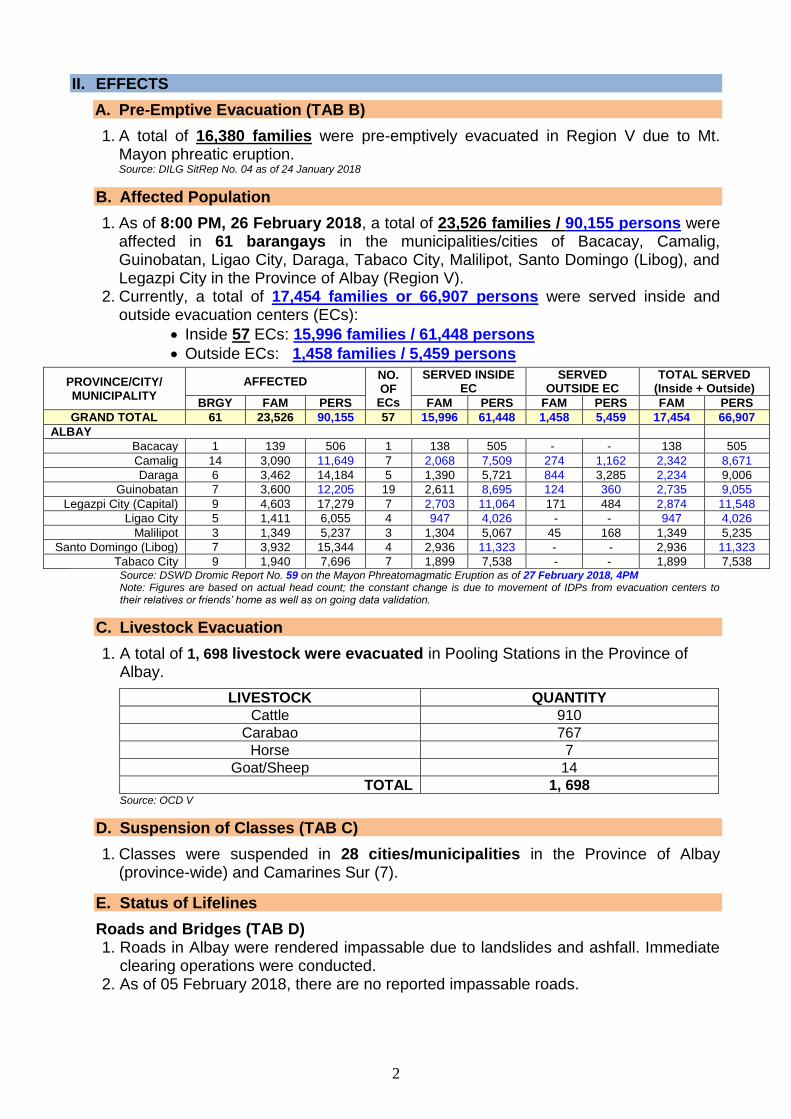
B. Affected Population
1. As of 8:00 PM, 26 February 2018, a total of 23,526 families / 90,155 persons were affected in 61 barangays in the municipalities/cities of Bacacay, Camalig, Guinobatan, Ligao City, Daraga, Tabaco City, Malilipot, Santo Domingo (Libog), and Legazpi City in the Province of Albay (Region V).
2. Currently, a total of 17,454 families or 66,907 persons were served inside and outside evacuation centers (ECs):
• Inside 57 ECs: 15,996 families / 61,448 persons
• Outside ECs: 1,458 families / 5,459 persons
PROVINCE/CITY/ MUNICIPALITY
AFFECTED NO. OF
ECs
SERVED INSIDE EC
SERVED OUTSIDE EC
TOTAL SERVED (Inside + Outside)
BRGY FAM PERS FAM PERS FAM PERS FAM PERS
GRAND TOTAL 61 23,526 90,155 57 15,996 61,448 1,458 5,459 17,454 66,907
ALBAY
Bacacay 1 139 506 1 138 505 - - 138 505
Camalig 14 3,090 11,649 7 2,068 7,509 274 1,162 2,342 8,671
Daraga 6 3,462 14,184 5 1,390 5,721 844 3,285 2,234 9,006
Guinobatan 7 3,600 12,205 19 2,611 8,695 124 360 2,735 9,055
Legazpi City (Capital) 9 4,603 17,279 7 2,703 11,064 171 484 2,874 11,548
Ligao City 5 1,411 6,055 4 947 4,026 - - 947 4,026
Malilipot 3 1,349 5,237 3 1,304 5,067 45 168 1,349 5,235
Santo Domingo (Libog) 7 3,932 15,344 4 2,936 11,323 - - 2,936 11,323
Tabaco City 9 1,940 7,696 7 1,899 7,538 - - 1,899 7,538 Source: DSWD Dromic Report No. 59 on the Mayon Phreatomagmatic Eruption as of 27 February 2018, 4PM Note: Figures are based on actual head count; the constant change is due to movement of IDPs from evacuation centers to their relatives or friends’ home as well as on going data validation.
C. Livestock Evacuation
1. A total of 1, 698 livestock were evacuated in Pooling Stations in the Province of Albay.
LIVESTOCK QUANTITY
Cattle 910
Carabao 767
Horse 7
Goat/Sheep 14
TOTAL 1, 698 Source: OCD V
D. Suspension of Classes (TAB C)
1. Classes were suspended in 28 cities/municipalities in the Province of Albay (province-wide) and Camarines Sur (7).
E. Status of Lifelines
Roads and Bridges (TAB D) 1. Roads in Albay were rendered impassable due to landslides and ashfall. Immediate
clearing operations were conducted. 2. As of 05 February 2018, there are no reported impassable roads.
3
Status of Flights (TAB E) 1. A total of eleven (11) international flights and 132 domestic flights were
cancelled due to the Volcanic Activity.
2. All domestic and international flights have already resumed.
3. The Philippine Airlines resumed its normal operations to Legazpi, Albay beginning 31 January 2018.
Sources: MIAA, PAL, and Cebu Pacific
E. Declaration of State of Calamity
1. On 16 January 2018, the Province of Albay, Region V was declared under the State of Calamity thru Resolution No. 00670-2018.
F. Schools Affected
1. A total of 65 Schools, 72,166 Learners, and 2,732 DepEd Personnel located within the 6-9 kilometer Permanent Danger Zone were affected. Source: OCD V Situation Report #59 re Mt. Mayon Alert Level 4
G. Damage to Agriculture
1. A total of ₱166,288,833.36 worth of damages to agriculture was incurred in the Province of Albay:
PROVINCE CROPS HVCC FISHERIES TOTAL
Albay
Rice ₱139,794,636.80 ₱20,890,320.00 ₱532,000.00 ₱161,216,956.80
Corn ₱4,593,876.56
-
₱4,593,876.56
Abaca ₱478,000.00 ₱478,000.00
TOTAL ₱166,288,833.36 Sources: OCD RO V and DA; Note: The decrease is due to ongoing validation
2. A total of 10,443 farmers were affected:
CITY / MUNICIPALITY NO. OF AFFECTED
FARMERS
WITHOUT BREAKDOWN
Tabaco City 458
Bacacay 29
Malilipot 83
Sto. Domingo 239
Legazpi City 60
Daraga 1,144
Camalig 650
Guinabotan 2,624
Ligao City 1,482
Polangui 1,502
Oas 2,172
TOTAL: 10,443 Sources: DA and DAR
III. ACTIONS TAKEN
A. National Disaster Risk Reduction and Management Council (NDRRMC)
1. NDRRM Operations Center (NDRRMOC)
a. Activated the alert status to BLUE ALERT effective 8:00 AM, 15 January 2018.
b. Coordinated with RDRRMC V re PHIVOLCS Eruption Notification Form for Mayon Volcano.
4
c. Disseminated information/notification thru Short Messaging System. d. Prepared and disseminated the following Emergency Alert and Warning
Messages (EAWMs) to provide information and warning to the public regarding Mayon Volcano’s activity:
EAWM Area
13 January 2018 re Mayon Volcano generated a steam driven explosion at 5:06 PM and produced 2.5 km high grayish ash plume that drifted towards the Southwest.
Region V
14 January 2018 re raising of alert from Alert Level 2 to Alert Level 3
Region V
22 January 2018 re raising of alert from Alert Level 3 to Alert Level 4
Region V
27 January 2018, 10:30 AM re Lahar Advisory Region V
27 January 2018, 6:22 PM re Mayon Volcano Eruption Notification
Region V
28 January 2018, 5:36 AM re Mayon Volcano Eruption Notification
Region V
28 January 2018, 10:33 AM re Mayon Volcano Eruption Notification
Region V
28 January 2018, 3:28 PM re Mayon Volcano Eruption Notification
Region V
28 January 2018, 7:11 PM re Mayon Volcano Eruption Notification
Region V
29 January 2018, 8:16 PM re Mayon Volcano Eruption Notification
Province of Albay
29 January 2018, 10:45 PM re Mayon Volcano Eruption Notification
Province of Albay
30 January 2018, 11:51 AM re Mayon Volcano Eruption Notification
Province of Albay
30 January 2018, 5:11 PM re Mayon Volcano Eruption Notification
Province of Albay
31 January 2018, 8:13 PM re Mayon Volcano Eruption Notification
Province of Albay
31 January 2018, 9:52 AM re Mayon Volcano Eruption Notification
Province of Albay
31 January 2018, 11:56 AM re Mayon Volcano Eruption Notification
Province of Albay
31 January 2018, 6:01 PM re Mayon Volcano Eruption Notification
Province of Albay
31 January 2018, 9:27 PM re Mayon Volcano Eruption Notification
Province of Albay
01 February 2018, 8:51 AM re Mayon Volcano Eruption Notification
Province of Albay
01 February 2018, 9:11 PM re Mayon Volcano Eruption Notifications
Province of Albay
02 February 2018, 9:18 AM re Mayon Volcano Eruption Notification
Province of Albay
03 February 2018, 6:00 PM re Mayon Volcano Eruption Notification
Province of Albay
05 February 2018, 5:22 AM re Mayon Volcano Eruption Notification
Province of Albay
05 February 2018, 3:59 PM re Mayon Volcano Eruption Notification
Province of Albay
05 February 2018, 9:15 PM re Mayon Volcano Eruption Notification
Province of Albay
05 February 2018, 9:49 PM re Mayon Volcano Eruption Notification
Province of Albay
09 February 2018, 2:11 PM re Mayon Volcano Eruption Notification
Province of Albay
11 February 2018, 8:33 PM re Mayon Volcano Province of Albay
5
EAWM Area
Eruption Notification
13 February 2018, 4:53 PM re Mayon Volcano Eruption Notification
Province of Albay
15 February 2018, 3:11 PM re Mayon Volcano Eruption Notification
Province of Albay
17 February 2018, 1:03 AM re Mayon Volcano Eruption Notification
Province of Albay
18 February 2018, 1:59 AM re Mayon Volcano Eruption Notification
Province of Albay
19 February 2018, 4:49 AM re Mayon Volcano Eruption Notification
Province of Albay
21 February 2018, 7:43 AM re Mayon Volcano Eruption Notification
Province of Albay
24 February 2018, 3:37 AM re Mayon Volcano Eruption Notification
Province of Albay
25 February 2018, 6:11 AM re Mayon Volcano Eruption Notification
Province of Albay
25 February 2018, 10:53 PM re Mayon Volcano Eruption Notification
Province of Albay
e. Disseminated Volcano Observatory Notice for Aviation (VONA) regarding Lava Fountaining.
f. Raised the alert status of NDRRMOC from Blue to Red effective 22 January 2018.
g. Conducted Response Cluster Meetings on 22 and 23 January 2018, 6:00 PM.
2. Philippine Institute of Volcanology and Seismology (PHIVOLCS)
a. Provision of Mayon Volcano Eruption Notification. b. Continuous monitoring of the situation. c. Issued Volcano Observatory Notice for Aviation (VONA) regarding Lava
Fountaining.
3. Department of Social Welfare and Development (DSWD)
a. DSWD-DReAMB raised alert status from Green to Red. b. Continuously coordinating with DSWD FO V for significant reports on the
status of displacement and assistance and relief efforts.
4. Armed Forces of the Philippines (AFP)
a. Provided manpower and transportation assistance for the hauling and distribution of drinking water containers to the evacuation center at Brgy. Anislag Elementary School.
b. Provided manpower assistance for the hauling of 345 DSWD boxes relief goods at Camalig Gym, Brgy. 2 Camalig, Albay.
5. Telecommunications Service Providers (ABS-CBN, GLOBE, and SMART)
a. Disseminated Emergency Alert and Warning Messages to Region V.
6. Department of the Interior and Local Government (DILG)
a. Continuously coordinating with DILG Regional Office V on the preparedness actions of LGUs affected by the Mayon Volcano phreatomagmatic eruption.
b. Continuously updates the SILG on the preparedness actions of LGUs affected by the Mayon Volcano phreatomagmatic eruption and lava flow.
c. Closely monitors the situation on the ground with regard to the raising the alert level 2 of Mayon Volcano into alert level 3.
6
d. Close monitoring of the situation on the ground with regards to the increase of activity of Mayon Volcano and the raising of alert 3 (Relatively high unrest) into alert level 4 (Intense unrest).
7. Department of Environment and Natural Resources (DENR)
a. Donated 100,000 N95 dust masks to LGU Guinobatan, Albay.
8. Department of Health (DOH)
a. Continuous monitoring and coordination with DOST-PHIVOLCS regarding the status of Mayon Volcano.
b. Coordinated with DOH Region V for any untoward incident and response needed.
c. Provided a total of ₱31,663,231.21 worth of logistical support to DOH RO V. d. A total of 9,273 consultations were reported from January 15 to February 17,
2018. Majority (6,138 or 66%) of the consultations were due to Acute Respiratory Infection (ARI) followed by fever (1,223 or 13%), hypertension (672 or 7%), diarrhea (581 or 6%), and wounds (399 or 4%).
e. Conducted assessment and provided technical assistance to Regional Office V.
f. Attended the Mayon Volcano Updates meeting at PNP Officers Lounge, Camp Simeon Ola, Legazpi City, Albay.
g. Delivered aqua tabs to nine (9) affected LGUs. h. Deployed composite team from Provincial Health Office and DOH V to
continuously monitor and reassess evacuation camps.
9. Philippine Coast Guard (PCG)
a. Deployed two (2) M-35 Trucks with twelve (12) personnel, nine (9) K9 personnel, and two (2) k9 dogs with handlers; and two (2) ambulances with 5 personnel and 2 doctors to Coast Guard District Bicol for augmentation.
b. Deployed three (3) M-35 Trucks to haul of relief goods to the affected municipalities in the province of Bicol.
c. Coordinated with the PCGA District Auxiliary for the possible augmentation of their Deployable Response Group / Search and Rescue (DRG/SAR) Team for deployment.
10. Department of Public Works and Highways (DPWH)
a. Deployed and placed on standby the equipment from three District Engineering Offices (DEOs) of Albay, Camarines Norte, and Equipment Management Division (EMD):
• One (1) unit of dump truck and one (1) unit of backhoe from Albay 1st DEO are on standby for possible deployment
• One (1) unit of dump truck from Albay 2nd DEO is deployed to Camalig and Daraga Albay to assist in evacuation and relief operations. Additional dump trucks from volunteer private contractors help in distribution/delivery of relief goods
• Two (2) units of L300, two (2) units of dump truck, 2 pick-up trucks and one (1) unit of road grader from Albay 3rd DEO are deployed in Ligao City to assist in evacuation and relief operations
• One (1) unit of dump truck, one (1) unit of boom truck and twelve (12) maintenance crew from Camarines Norte DEO arrived at Albay 3rd DEO to augment their workforce
7
• One (1) unit of mini dump truck, one (1) unit of stake truck and one (1) unit of bus from EMD RO-V are on standby for possible deployment.
b. Continuously monitoring the situation. c. DEOs provided road signage along affected areas for precaution during heavy
ashfall.
11. Civil Aviation Authority of the Philippines (CAAP)
a. Issued a Notice to Airmen (NOTAM) regarding airspace restrictions and warnings related to Mayon Volcano eruption.
12. Philippine Atmospheric, Geophysical and Astronomical Services Administration (PAGASA)
a. Issues Special Weather Forecasts for Mayon Volcano.
13. Department of Agriculture (DA)
a. Provided farm equipment, supplies and materials amounting to ₱22,079,317.00 to the affected farmers.
14. Other Partners
a. Task Force SAGIP conducted psychosocial activity at Comun Elementary School, Camali and film showing at Daraga North District, Budiao Elementary School, Daraga.
b. Aquinas University of Legazpi conducted psychosocial activity for affected learners in Quirangay Elementary School.
c. WHO, UNICEF, UNFPA, PRC, OCHA, BFP, and Americares Philippines are among the health cluster partners who contributed in the conduct of assessments and provision of health services for the affected communities.
B. Regional/Local Disaster Risk Reduction and Management Councils (R/LDRRMC)
1. RDRRMC V
Office of Civil Defense (OCD) V a. Disseminated to all concerned the PHIVOLCS Bulletin raising the Alert Status
of Mayon Volcano from Alert Level 2 to Alert Level 3. b. Attended the Updates Meeting of PHIVOLCS re Status of Mayon Volcano on
14 January 2017. c. OCD-RDRRMC Bicol on Red Alert Status for Mayon Volcano since
14 January 2018, 1:00 AM. d. Continuous coordination with DOST- PHIVOLCS re Status of Mayon Volcano. e. Sent through SMS the status of volcanic activity of Mayon Volcano to
RDRRMC members and stakeholders. f. Coordinated with MDRRMO Camalig, Guinobatan and Daraga and sent to
PDRRMO – Albay through SMS status of volcanic activity of Mayon Volcano. g. On close monitoring. h. Conducted RDRRMC Emergency Meeting re Updates for Mayon Volcano
Operations 2018 at Tactical Operations Group – Philippine Air Force, Airport Site, Legazpi City.
i. Continuous coordination with LDRRMOs and RDRRMC Member Agencies. j. Conducted Aerial Survey regarding the extent of lava flow with member
agencies on 17 January 2018. k. Provided logistics to regional responders.
8
l. Dispatched trucks from AFP, PNP, and DPWH for the evacuation of affected residents.
m. Conducted briefing re Mayon Volcano Updates with Secretary of DENR, held at Handyong Hall, OCD V, Camp Ola, Legazpi City on 22 January 2018.
n. Dispatched trucks from AFP, PNP, and DPWH for evacuation of residents within the 8-km EDZ.
o. Conducted Mayon Volcano Updates meeting on 23 January 2018 at Camp Ola, Legazpi City.
p. Conducted meeting re Construction of Toilets and Temporary Learning Spaces in Evacuation Centers.
q. Activated a 24/7 coordination hub for Mayon Response 2018, located on 3rd floor, Trauma Building, BRTTH Compound, Legazpi City on 26 January 2018.
r. Delivered thirty-five (35) rolls of Sakoline to Albay PEO to be used for the construction of temporary comfort rooms.
s. Facilitated the unloading of NFIs provided by IOM (6,000 Tarpaulin and 800 hygiene kits).
DILG V a. Attended the Emergency Meeting at TOG5 for Mayon updates. b. Reported/presented real-time situation to RDRRMC Bicol for coordination
assistance and provision of needed intervention of particular agency. c. Ensure the LCEs of affected LGUs located within the 7-km PDZ are provided
with necessary precautionary measures, particularly to undertake immediate evacuation.
d. Mobilize field operating units to provide timely updates for any untoward and significant incidents.
e. Advised the DILG field operating units to constantly coordinate with PDRRMCs/PDRRMOs.
f. Maintained and intensified open-line coordination with preparedness and response agencies.
g. Continuous sending of text blast regarding Mayon updates to concerned field operating units.
h. Constituted DILG V Team for Response Cluster to the Incident Command Post Operations Center to assist in the validation of real-time reporting and sending of urgent directives to the affected LGUs.
i. Released Public Service Announcement to all Punong Barangays thru Broadcast Media to ensure that all evacuees are safe and outside of the declared PDZ and advised to report to the Camp Manager in their respective AORs and to the AFP personnel manning the choke points within the vicinity of the danger zone.
j. Issued advisory to all concerned LCEs on their responsibility to ensure that declared danger zones are free from returning evacuees.
DSWD V a. Has standby funds amounting to ₱5,662,702.15 and stockpiles of 13,352
family food packs (FFPs) and Non-Food items (NFIs) consist of 37,242 pcs. malong, 382 rolls laminated sacks, 7,327 dignity kits and 54,832 blankets ready for augmentation to LGUs.
b. Provincial Action Team (PAT) and Municipal Action Team (MAT) members in the province of Albay are on standby and continuously coordinating with the P/C/MDRRMOs for status reports and updates. EMT of the Field Office is already activated and rendered its duty today.
9
c. As of 18 January 2018, DWSD-FO QRT is still on red alert status. Emergency Telecom Equipment is on standby and is ready for deployment as the need arises.
d. Quick Response Team is on Red Alert and additional teams established to augment in monitoring of affected population.
e. Prepositioned 2 tents at Bicol Regional Training and Teaching Hospital (BRTTH) for possible influx of patients.
f. Conducted monitoring, validation, and assessment of Evacuation Centers to ensure that the needs of IDPs are met and that the ECs are compliant to a zero sexual and gender-based violence in coordination with the C/MDRRMOs and C/MSWDOs together with the P/MATs.
g. Monitored the relief distribution of DSWD family food packs at Salvacion Elementary School in Sto. Domingo, Albay.
h. Conducted Response Cluster Meeting presided by the Regional Director. i. Prepositioned two (2) tents to BRTTH in case of influx of patients. j. Participated in the tactical session of PAT Albay for the deployment of DSWD
Staff in the nine (9) Evacuation Centers of Guinobatan, Albay for monitoring of relief distribution, coordinating with LGU staff on matters concerning camp management to ensure IDP security and well-being, and provide feedback on camp situations to the Field Office.
k. Conducted psychosocial support for adults and children (IDPs) in Guinobatan Albay.
l. Conducted profiling of evacuees in Maipon Elementary School. m. Monitored the activities of evacuees at Mauraro Evacuation Center and
discussed some of their issues and concerns. n. Submitted the updated profile of evacuees situated at Bubulusan Evacuation
Center to OCD. o. Provided additional 6,360 FFPs to LGU Legazpi City, Malilipot, and Sto.
Domingo amounting to ₱2,549,772.00. p. Deployed additional Staff in Guinobatan to take charge of psychosocial
activities. q. Released additional 1,906 Family Food Packs from National Resource
Operations Center (NROC) with a total cost of ₱766,212.00 to the LGU of Ligao.
r. Attended meeting with Sec. Francis Tolentino for the updates on the status of ECs in the municipality of Guinobatan and other existing ECs in the province on 13 February 2018 at the PRO5 Conference Room, Camp Ola, Legazpi City.
s. Provided family food packs to LGU Camalig amounting to ₱1,950,420.00. t. Turned over check for the Cash for Work Program for affected families in
Guinobatan. u. DSWD personnel rendered duty as IMT at the Incident Command Post of the
OCD RDRRMC based at the Bicol Regional Teaching and Training Hospital (BRTTH) to act on reported incidents concerning food and non-food items.
v. Provided two (2) tents intended as Temporary Learning Spaces (TLS) to the LGU of Guinobatan, Albay.
w. Distributed two (2) tents and two (2) laminated sacks to LGU Sto. Domingo while two (2) tents were given to LGU Tabaco City.
x. Distributed 922 family food packs (FFPs) from the National Relief Operations Center (NROC), while 427 FFPs were distributed from the FO to LGU Malilipot.
y. DSWD provided 2,997 food packs from NROC to LGU Legazpi City on 21 February 2018. A total of 18,358 pcs of malong were distributed to Camalig -
10
2,878 pcs; Daraga - 2,358; Guinobatan – 3,526 pcs; Ligao City – 904 pcs; Malilipot – 698 pcs; Tabaco City – 2,830 pcs; Sto. Domingo – 4,888 pcs; and Bacacay – 276 pcs.
z. Conducted an orientation on Camp Coordination and Camp Management (CCCM) in Legazpi City to DOH, DOLE, DPWH, DOST, DENR, DILG and DA as personnel.
aa. Provided 2,179 sleeping kits for internally displaced persons of LGU Daraga amounting to ₱1,651,682.00.
bb. Provided 2,963 food packs from NROC to LGU Legazpi. cc. Distributed 10 tents to LGU Camalig as temporary shelter for evacuees. dd. Provided 1,112 food packs from NROC to LGU-Bacacay, Albay. ee. Provided 1,899 food packs from NROC to LGU-Tabaco City
DOST – PHIVOLCS V a. Hosted a meeting regarding the status of Mayon Volcano. b. Close monitoring of Mayon Volcano activities. c. Disseminate Mayon Volcano Bulletins and advisories to LGUs and other
stakeholders. d. Close coordination with OCD5, PDRRMO Albay and LGUs of the province. e. As of 16 January 2018, a 7-km Extended Danger Zone is implemented.
Bureau of Fire Protection (BFP) V a. Issued memorandum dated 15 January 2018 to BFP Albay re Heightened
Alert (Activation of OPLAN PAGHALASA). b. Ensured availability of fire/rescue/emergency medical personnel, assets and
equipment for possible response operations. c. Coordinated with C/MDRRMCs for appropriate dispositions of actions. d. Rationed water to evacuation centers. e. Conducted fire safety inspection, flushing and declogging operations, food
packs packing/distribution and distribution of flyers at evacuation site. f. Conducted flushing of volcanic ash in Camalig, Albay. g. Conducted fire safety inspection at San Jose Elementary School and San
Jose National High School on 18 February 2018. h. Conducted water rationing in the following evacuation centers on 18 February
2018: ▪ Bical National High School, Tabaco City ▪ Ligao Technical Vocational High School, Ligao City ▪ Nabonton Elementary School, Ligao City ▪ Mauraro Elementary School, Guinobatan
Coast Guard District Bicol a. On full alert b. Augmented K9 personnel and two (2) SAR dogs, and one (1) M35 truck with
seven (7) personnel onboard and placed on standby for briefing and possible deployment.
c. Placed asset and DRGs on standby for possible deployment. d. Advised stations/substations to place their DRGs on standby for possible
augmentation. e. Provided assistance in the psychosocial relief operation of TAYO at Brgy.
Dita, Elementary School, Legazpi City. f. Placed land mobility on standby for possible deployment.
11
Department of Agriculture (DA) V a. Provision of two (2) trucks for evacuation of livestock to the identified pooling
sites, and to Albay Experiment Stations in Tabaco City and Albay Breeding Station in Camalig Albay.
b. Continuous provisions of logistic support and other materials for evacuation with additional provisions for medicine and other biologics:
• 70 bottles of 10 lm. Vit. ADE
• 10 bottles of 10 m. Terramycin LA
• 5 canisters of Enrofloxacin
• 5 liters of Iodine
• 2 gallons of Vivaguard c. Preparation of four hundred seventy-five (475) bags of hybrid corn seeds and
ten (10) bags of corn grits, for distribution at the affected areas. d. Procurement of brush cutters, laminated sacks, ropes and buffer stocking of
drugs and biologics. e. Conducted update/on-site validation for the identified pooling sites of livestock
and animal extending the coverage to 9-km Extended Danger Zone. f. Evacuated and transported a total of 167 animals within the 7-8 km EDZ to
pooling/evacuation centers in the municipalities of Camalig and Daraga. g. Provided support to livestock raisers/farmers (10m rope per animal, 10 kgs
feed concentrates per animal, waterer/feeder, etc.). h. Implementation of animal healthcare intervention at the evacuation centers. i. Coordination with various banner programs for the three month contingency
plan re Mayon Volcano Eruption in the affected areas. j. Conducted animal tagging and veterinary mission which include check-up,
treatments, vitamin supplementations, and other healthcare activities. k. Provided training on vegetable production to 500 identified farmers. l. Continuous monitoring and maintenance of the pooling and evacuation sites. m. Established strategic feeding camps and provided laminated sacks to protect
the feeder, water, and feeds in case of ash fall. n. Conducted training on Vegetable Production in Protective Culture to the
following:
• 50 farmer evacuees from Barangays Magapo, Mariroc Nagsipit, Bonot, Buhian, Oson, Buang, Comon, San Isidro and Tabiguian in Tabaco City on 13 February 2018;
• 60 farmer participants from Barangays Calbayog and San Roque in Malilipot and Sta. Misericordia in Sto. Domingo on 12 February 2018.
o. Identified the greenhouse sites for the farmers which include the CAO vacant lot in Tabiguian Elementary School, San Vicente, and San Antonio Elementary School in Tabaco City and Buang Nursery Station in the municipality of Bacacay.
p. Provided polyethylene UV-treated plastic films, 100m of plastic mulch, two bags Durabloom, one unit of sprinkler and 100 pieces of bamboo sticks to 270 farmer participants for the establishment of tunnel-type greenhouses.
q. Continued monitoring and maintenance of the pooling and evacuation sites. The team also established strategic feeding camps and provided laminated sacks to protect the feeder, water and feeds in case of ash fall; ruminant feeding concentrates; PVC drums as feeder/water containers; and 10-meter-nylon ropes. It also conducted animal tagging and veterinary mission service which include check-up, treatments, vitamin supplementations, and other healthcare activities.
12
DA - Bureau of Fisheries and Aquatic Resources V a. Conducted monitoring of water physio-chemical parameters to the 2 major
aquaculture areas (Lake Buhi and Lake Bato) b. Distributed 200 kgs of tilapia as nutritional support to IDPs of Guinobatan on
01 February 2018. c. Alerted Quick Response Team for possible deployment and assistance to
LGUs and evacuation centers. d. Continuously provide interventions and assistance including laminated sacks,
hybrid seeds, fertilizers, 4WD farm tractor, conventional Hybrid Yellow Corn, animal food supplements, mallard ducks, knapsack sprayer, organic fertilizers, seedling trays, garden tools, power sprayer, pump and engine set, solar pumps and tilapia fingerlings
Department of Education (DepEd) V a. Inspected schools/classrooms used as evacuation centers. b. Alerted all concerned schools and the School DRRM Coordinators to prepare
the classrooms that will be used as ECs. c. Organized Monitoring Team of DepEd Engineers to validate the need for
Temporary Learning Spaces (TLS) in the identified Evacuation Centers. d. Prepared Contingency Plans (Emergency classes; shifting of classes) to all
schools used as ECs to ensure continuity of classes for the affected displaced learners and those who are actually enrolled in the school that is being used as ECs.
e. Consolidated list of concerns in the ECs such as needs to construct temporary comfort rooms, repair of TLS for the learners, assignment of security officers and financial assistance for the electricity and water bills.
f. Conducted a Planning Conference with the Division DRRM Coordinators for upcoming activities such as the Psychological First Aid for the displaced learners and affected personnel.
g. Monitored the construction of Temporary Learning Spaces (TLS) of the 23 recipient schools of the Batch 1 and 2 TLS.
Department of Environment and Natural Resources (DENR) V a. Donated 276 sacks of wood charcoal, firewood, and coco lumber to the
Provincial Government of Albay for distribution to the evacuees at different evacuation centers.
b. Activated and implemented the scenario-based multi-hazard contingency plan and emergency management manual and creation of Quick Response Team.
c. Provided service vehicle to LGU Sto. Domingo, Albay to transport evacuees to the designated evacuation centers and in carrying light materials for the construction of temporary shelters on 16 January 2018.
d. Continuously monitoring air and water quality of EMB V. e. Conducted intensive information, education and communication campaigns
through Social Media and DENR Radio Programs. f. Installed a water purifying system thru the efforts of Mines and Geoscienes
Bureau (MGB) V.
DENR – Environmental Management Bureau (DENR-EMB) V a. Deployed ambient air quality sampling at areas affected by Mayon Volcano.
Department of Health (DOH) V a. Declaration of Code White Alert Status in relation to Mayon Volcano Phreatic
Explosion. b. Raised alert status from Code White to Code Blue.
13
c. Deployment of two (2) Rapid Health Assessment Teams in Camalig, Guinobatan and Ligao City.
d. Logistics provided – LGU Guinobatan and LGU Camalig: ₱19,800 worth of mask (1,500 pcs.) each and ₱10,076.40 worth of assorted medicines each.
e. Additional logistics provided – LGU Guinobatan and Camalig: ₱58,000.00 each worth of medicines and supplies.
f. Conducted Orientation on Psychological First Aid for DOH-CHD V Monitoring Teams to be deployed and the use of monitoring tools and inventory of logistics.
g. Conducted Rapid Health Assessment on affected municipalities by Joint PDO-PHO Teams.
h. Deployed six (6) DOH-CHD V monitoring team on 16 January 2018 to the affected municipalities.
i. Activated Oplan Mayon. j. Delegated contingency buildings as extension wards in case of patient surge. k. Prepositioned personal protective equipment (PPE) related to volcanic
eruption. l. Activated the Hospital Alliance Network with private hospitals. m. Monitored breakout of diseases in evacuation centers. n. Disseminated referral forms for IDPs requiring medical intervention. o. Conducted emergency ManCom meeting to discuss plans for Alert Level 4 of
Mayon Volcano. p. Coordinated with Bicol Medical Center and Bicol Sanitarium re Deployment at
the evacuation centers. q. Distributed hygiene kits and water containers in the Municipality of
Guinobatan and in Legazpi City. r. Assessed Lower Binogcasan School as well as Gogon Elementary School
and provided Jerry cans and hygiene kits to the evacuees. s. Conducted Mental Health and Psychosocial Support (MHPSS) sessions e.g.
Art Therapy in evacuation centers. t. Augmented 100 hygiene kits and 100 water containers each for Malilipot and
Sto. Domingo. u. Launched the Public Health Associate (PHA) Health Check-up in collaboration
with PHO-Albay, CHO-Albay, Philippine Army, BRTH, and partners. v. Visited IDPs at Bariw, Camalig and Binatagan – Agencia Española de
Cooperación Internacional Para el Desarrollo (AECID), Ligao City ECs and provided 100 hygiene kits and 100 water containers.
w. Deployed one (1) medical team in Sto. Domingo, Albay. x. Convened the health workers of government and NGOs for the MHPSS Crash
Course. y. Provided 23 portalets in the municipalities of Guinobatan (10) and Camalig
(13). z. Conducted meeting with the medical societies in Bicol, Provincial Health
Office, hospital associations and partners relative to the harmonization of health interventions and to discuss guidelines on “Adopt an Evacuation Center”.
aa. Conducted Health and WASH Assessment at Sitio Bical EC in Sto. Domingo, Albay.
bb. Distributed hygiene kits for pregnant women. cc. Provided toilet bowls to DPWH Regional Office V and Provincial Engineering
Office of Salugan, Camalig, Albay for the construction of toilet facilities. dd. Distributed 18,324 insecticide treated mosquito nets to the affected LGUs.
14
ee. Launched Tamang Serbisyo sa Kalusugan ng Pamilya (TseKap) in Gogon Elementary School, Legazpi City.
ff. Continuous distribution of drinking water through WATSAN Filtration machine in Ligao, Guinobatan, Camalig, and Daraga ECs.
gg. Conducted Nutritional Assessment to children and pregnant women. hh. Provided Mid-Upper Arm Circumference (MUAC) tapes for children and adults
and an orientation was conducted to the volunteer workers and NDPs on how to use MUAC for nutrition assessment.
ii. Augmented the number of Long Lasting Insecticide-Treated Nets to Rural Health Units (RHU) in Tabaco City, Bacacay, Sto. Domingo, and Malilipot.
jj. Distributed water purifications tablets to Sto. Domingo RHU. kk. Deployed a medical team from Veterans Regional Hospital to Camalig
evacuation center. ll. Conducted house to house health advocacy on proper hygiene and safe
drinking water practices at San Andres Resettlement, Sto. Domingo, Albay and provided water containers to evacuees.
mm. A total of 380 toilets were constructed in different evacuation centers in the affected municipalities of Albay Province. Of which, 338 were constructed by the DPWH and 42 by the LGUs
nn. Conducted house to house health advocacy on proper hygiene and safe drinking water practices at San Andres resettlement, Sto. Domingo, Albay and provided water containers to the evacuees.
oo. Conducted orientation for second batch of Human Resources for Health Provincial DOH Albay (HRH-PDO) on Minimum Initial Services Package (MISP) on Sexual Reproductive Health, Enhanced Disease Surveillance through SPEED, Camp Management and Flow of Reporting.
pp. Americares Philippines (DOH partner) provided 990 mask for individuals, 492 hygiene kits for the families, and 244 individual received MHPSS services in Camalig, Albay
qq. Conducted Medical Mission at San Andres Resettlement, Sto. Domingo, Albay.
rr. Delivered 200 pcs water containers at San Andres Resettlement Site, Sto. Domingo, Albay.
ss. Provided assistance to the Salamat Dok Medical Mission at Bical, Sto. Domingo.
tt. Distributed two (2) spraying machine and 300 gal. of Lauryl Dimethyl Benzyl Ammonium Chloride to PHO Albay.
uu. Conducted water sampling of refilling station in Sto. Domingo. vv. Launched the PHA Tsekap at San Andres Resettlement Site, Sto Domingo,
Albay. ww. Provided 200 pcs water containers for distribution in the different evacuation
centers in Daraga. xx. Ongoing delivery of nebulizers to all evacuation centers (3 units nebulizer per
evacuation center). yy. Continued Conduct of MHPSS sessions in the evacuation centers. zz. Continued deployment of Joint DOH-PHO Surveillance teams to 3 districts of
Albay. aaa. Monitored the status of toilet construction by PEO and DPWH. bbb. Continued conduct of health services in the evacuation centers. ccc. Delivered hard-boiled egg for Senior Citizens, lactating and pregnant women
at Inascan ES, Guinobatan. ddd. Delivered nebulizers to different RHUs.
15
eee. Released advisory #2018-0029 dated 14 February 2018 containing the guidelines to ensure food safety and quality medicines in all evacuation centers to prevent adverse events related to feeding activities and medical missions.
fff. Conducted orientation for the 5th batch of HRH PDO Albay on MISP, Nutrition, Enhanced Surveillance, and SPEED.
ggg. Continuous coordination with Ziga District Memorial Hospital, Tabaco; JB Duran Memorial Hospital, Ligao; LGU and private hospitals for referral of patients.
hhh. Deployed two (2) composite teams from PHO and CHD V to continuously monitor and re-assess evacuation camps including reporting of diseases surveillance.
iii. Distributed 15,000 liters of safe drinking water through WATSAN filtration machine via lorry in Guinobatan and Camalig evacuation centers.
jjj. Conducted water sampling to water refilling stations in Daraga evacuation centers.
kkk. Constructed one (1) kitchen in Bascaran ES, Daraga. lll. Coordinated with MENRO in the regular garbage collection. mmm. Conducted Nutritional Assessment to children and pregnant women in
Malilipot and Camalig. nnn. Provided Mid-Upper Arm Circumference (MUAC) tapes for children and
adults to all ECs. ooo. Conducted MHPSS orientation and crash course to the government and
non-government health workers. ppp. Conducted MHPSS session in the evacuation centers in Tabaco and Legazpi
City ECs. qqq. Augmented assorted medicines and vaccines to Bicol Sanitarium Medical
Team.
Bicol Regional Training and Teaching Hospital (BRTTH) a. On Code Blue Alert status in accordance with the Mayon Volcano
Alert Level 4. b. Activated and placed Emergency Department on standby. c. Prepositioned appropriate logistical needs. d. Conducted safety rounds to hospital areas. e. Established Fast Lane at Emergency Department and Outpatient Department
for Mayon Patients. f. Established protocols on psychosocial, respiratory, and burn cases related to
Mayon Volcano Eruption. g. Provided assistance in the establishment of RDRRMC-Incident Command
Post. h. Distributed masks for personnel and prepositioned personal protective
equipment related to volcano eruption. i. Provision of water supply from Water Sanitation Division (WATSAN). j. Established a hospital burn unit for possible cases relate to the eruption.
Department of Trade and Industry (DTI) V a. Issued advisory to all wet markets, supermarkets, groceries, bakeries, and
water refilling stations to strictly comply with the provisions of the Price Act and Price Ceiling.
b. Mobilized Monitoring Teams including Market Administrators in the different municipalities to check on the prices and supply of basic necessities and coordinated with the local broadcast and television networks to further disseminate relevant information on the effectivity of Automatic Price Control.
16
c. Intensified monitoring of basic commodities including locally made bread such as pandesal, slice bread, pancit canton, and face mask. As a result, no price movement was noted and supply is available.
d. Provided alternative sources of income to Mayon evacuees through techno-transfer and training in coordination with the Local Government Units.
e. Issued DTI-Albay Memo Circular No. 1 s. 2018 re Price Act compliance. f. Conducted price and supply monitoring of basic necessities and prime
commodities. g. Disseminated price freeze of basic necessities through radio and TV. h. Coordinated with the LGUs of Camalig and Guinobatan to assist DTI in the
monitoring of basic necessities and prime commodities. i. Facilitated Skills Training on Bags and Basket Making for Mayon evacuees of
Tabaco City and Sto. Domingo. j. Coordinated with the LGUs of Camalig and Guinobatan and distributors
regarding the conduct of Diskwento Caravan in identified evacuation centers. k. Facilitated skills training on Pili Shell Craftfor Mayon evacuees from Brgy.
Buang, Tabaco City. l. Provided free haircut for evacuees. m. Conducted Diskwento Caravan in San Jose Elementary School Grounds for
the evacuees from Brgys. Calbayog and San Roque, Malilipot. Basic necessities and prime commodities were offered for sale at discounted price with bundled free products.
n. Provided Skills Training on Chips Making to 35 housewives in Maninila EC, Guinobatan and to 40 housewives in Amtic EC, Ligao City.
Department of Labor and Employment (DOLE) V a. Provided a total of 30 million pesos Emergency Employment Assistance under
the Tulong Pang Hanapbuhay sa Ating Displaced Workers (TUPAD) for 10,000 evacuee-beneficiaries starting 30 January 2018.
National Telecommunications Commission (NTC) V a. NTC V Task Force Bayanihan provided continuous monitoring report given by
radio groups who are rendering assistance in every evacuation center. b. Other radio groups are roving in several evacuation centers, while monitoring
the situation of the area. c. Globe is providing Libreng Tawag and Wifi to several evacuation centers in
Albay and in addition provided 3G Mobile Repeater to the Abay Public Safety and Emergency Management Office (APSEMO) for emergency use.
d. Smart provided tents in addition to the three hotlines given to the Albay Public Safety and Emergency Management Office (APSEMO) for emergency use.
Philippine National Police- Police Regional Office (PNP-PRO) 5 a. Standby for deployment of SAR Personnel with equipment, Security
Personnel and mobility from Regional Mobile Force Battalion, Regional Headquarters Support Group and Regional Logistics Division.
b. In close coordination with MDRRMCS and with standby personnel for deployment.
c. Conduct monitoring and inspection of the affected barangays under the 6km PDZ
d. Provides security at the Evacuation center. e. Assisted in the evacuation of affected population in the municipality of
Camalig, and Guinobatan. f. Issued Memorandum to Albay PNP Provincial Director directing all units under
their jurisdiction to stand by alert SAR personnel and equipment for possible deployment as need arises and monitor situation. Likewise, direct police
17
station within the 6-km PDZ to closely coordinate with their respective MDRRMC.
g. Issued Memorandum to Regional Logistics, Headquarters Support Group and Regional Mobile Force Battalion to put on standby alert SAR personnel equipment and vehicle for possible deployment as need arises.
h. Assisted in the relief operations of LGUs Albay.
Department of Public Works and Highways (DPWH) V a. Instructed Albay 1st, 2nd, and 3rd District Engineers to monitor the ongoing
eruption of Mayon Volcano and activated DRRMTs to clear ashfall/rocks that may block National Roads and Bridges.
b. Continuously monitoring river channels near the foot of Mayon Volcano within their AOR for possible Lahar Flows that will affect the National Roads and Bridges.
c. Provided assistance in the evacuation operation at Brgy. Amtic, Ligao City. d. Cleared debris coming from the slopes of Mayon during heavy rains. e. Albay 2nd ND 3RD DEO – DRRM Team on standby. f. Equipment Management Division – DRRM team on standby. g. Albay 3rd DEO donated a total of 20 sacks of rice and 200 containers of
mineral water to the LGUs of Ligao City and Guinobatan, Albay. h. Albay 2nd DEO assisted in transfer of evacuees to ECs and in providing relief
operations.
Department of Tourism (DOT) V a. Issued travel advisory for Mayon Volcano Alert Level 4.
9th ID, Philippine Army a. Placed four (4) military trucks on standby for possible evacuation. b. Conducted information campaign in the neighboring barangays in the 6-km
PDZ. c. Prepositioned one (1) KM250 and one (1) KM450 with DRO personnel of 83rd
IB for possible deployment and for the conduct of pre-emptive evacuation to residents in the 6-8 km.
d. Dispatched one (1) KM250 and one (1) KM450 with DRO personnel to APSEMO for possible deployment and for the conduct of pre-emptive evacuation to residents in the 6-8 km.
e. Three (3) KM 450, one (1) KM 250, two (2) M35, and three (3) squads, one DRO Team on standby for deployment.
f. DRUs/Assets were deployed for possible conduct of HADR operations. g. Evacuated 30 families with 153 individuals from Brgys. Matnog and Budiao,
Daraga, Albay to Buraguis Elementary School Evacuation Center, Legaspi City.
h. Continuously coordinates with the Task Force Sagip for the deployment of DRTs in evacuating the residents.
i. Conducted preventive evacuation at Brgy. Padang, Leagazpi City and assisted in evacuation of residents of Brgy. Budiao and Brgy. Bañadero, Daraga, Albay and Mabinit, Legazpi City.
j. Assisted the LGU Guinobatan in the packaging of relief goods. k. Transported relief goods to Camalig and Daraga, Albay and Buragwis,
Legazpi City. l. Coordinated with OCD Region V and Albay PDRRMO for the updates
regarding the event and possible response operations. m. Provided assistance in distributing relief goods in Brgy. Mauraro, Guinobatan,
and Brgy. Caguiba, Camalig, Albay. n. Evacuated a total of 850 persons from Brgy. Bigaa, Legazpi City.
18
o. Continuously conducting evacuation to Brgy. Puro and Brgy. Bigaa, Legazpi City.
p. Continuously providing Security Forces, Disaster Rescue Team and Mobility. q. Transported and assisted the Team Albay Youth Organization (TAYO) in the
conduct of psychological relief operations and feeding program in Albay Central School, Bagong Bayan Elementary School, and Cabangan Elementary School of Legazpi City.
r. Conducted aerial survey/inspection over Mayon Volcano together with DOST-PHIVOLCS and RDRRMC V on 30 January 2018, 9:58 AM.
s. Provided transportation assistance to LGU Legazpi for the hauling and distribution of 1,000 sacks of relief goods to the affected families of Mayon Volcano in Legazpi City ECs.
t. Distributed face masks and assorted relief goods to different evacuation centers in Albay and Legazpi City on 30 January 2018.
u. Provided transportation and manpower assistance for the distribution of 425 sacks of rice to the following ECs:
• Gogon Elementary School (173 sacks)
• Bagumbayan Elementary School (67 sacks)
• Bitano Elementary School (79 sacks)
• Buragwis elementary School (14 sacks)
• Cabagan Elementary School (30 sacks)
• Lamba Elementary School (15 sacks)
• Albay Central School (32 sacks)
• EMs Barrio Elementary School (15 sacks) v. Provided transportation assistance to DSWD in hauling of 103 sacks of rice
and 200 boxes of relief of goods intended to the evacuees at Gogon Elem School, Bagumbayan Elem School, and Puro Elementary School in Legaspi City.
w. In close coordination with OCD Regional Office V, Albay PDRRMC and MDRRMOs re status and updates of Mayon and for possible response operation.
x. Provided manpower assistance in the construction of Temporary Learning Shelters (TLS) at Brgy. Lower Binogsacan, Guinobatan and Ligao City National Tech Vocational High School.
y. Construction of Temporary Learning Shelters (TLS) in Don Juan Garcia Elementary School, Brgy. Quitago, Guinobatan, Albay.
z. Provided manpower assistance on repacking of relief goods, plastic mat and blankets at Camalig gymnasium, Brgy. 3, Camalig, Albay.
aa. Provided transportation and manpower assistance for the transport of 1,900 boxes of relief goods to be delivered to the different evacuation centers in Camalig, Albay.
bb. Provided security and assistance in picking-up and refilling 200 jerry cans at the Water Treatment Site in Busay River, Casagwa Daraga, Albay.
Naval Forces Southern Luzon, PN a. Evacuated 105 individuals from Brgys. Lidong and San Fernando to San
Andres Elementary school and Resettlement area, all in Sto. Domingo, Albay. b. Conducted mustering of DRRT for possible deployment. c. Evacuated 105 individuals from Brgys. Lidong and San Fernando to San
Andres Elementary School. d. Transported relief goods from Casablanca Hotel to Brgy. Gabawan
Elementary School, Daraga spearheaded by Albay Youth Organization (TAYO).
19
Tactical Operations Group (TOG) 5, Philippine Air Force a. Facilitated availability of aircraft to be used for aerial survey of Mayon Volcano b. Placed DRU Team on standby with equipment and mobility to provide
assistance for evacuation. c. Transported a total of 174 persons from Brgy. Buyuan, Mabinit, and Matanag
to various evacuation sites. d. Facilitated the conduct of aerial survey of Mayon Volcano together with OCD
V, PHIVOLCS, DSWD, 9ID PA, and APSEMO. e. Evacuated 8 families with 32 individuals from Brgy. Matanag, Legaspi City to
Albay Central School. f. Evacuated a total of 33 families / 134 persons in Brgy. Muladbucad, Pequiño,
Guinobatan to Municipal Hall of Guinobatan on 23 January 2018. g. Continuous provision of Security Forces, Disaster Rescue Teams (DRTs),
and mobility to the evacuees. h. Evacuated a total of seven (7) families from Brgy. Padang to Puro
Elementary School. i. Placed two (2) Humanitarian Assistance Disaster Response (HADR) teams
on standby composed of six (6) TOG 5, four (4) 505th, and four (4) Special Operations Wing (SPOW) persons on board M35 and KM450 Troop Carrier Truck.
j. Deployed two (2) NCO to act as Liaison Officers at Legazpi CDRRMO and Task Force SAGIP, Camp Ola, Legazpi City respectively.
k. In constant coordination with Task Force SAGIP for the deployment of DRTs for the evacuation of residents.
l. Constant and real-time weather monitoring. m. Donated 22 pieces empty drums to be utilized as water containers in different
evacuation centers in Albay Province. n. Provided transportation assistance regarding decamp of evacuees from EM’s
Barrio evacuation centers to Sitio Tinago, Brgy Bigaa, Legazpi City. o. Facilitated and provided manpower during unloading of seven hundred forty
eight (748) boxes of non-food items (family pack) intended for the affected families of Mayon Eruption. Said relief items were stored at TOG 5 Hangar Building and Disaster Coordinating Center (DCC) Building, Legazpi City.
p. Currently conducting Rapid Damage Assessment Needs Analysis.
2CRG Civil Relations Group AFP d. Conducted live reporting (7 AM) at DWDD re Mayon Update. e. Disseminated update re Mayon Volcano to AFP units in Area of Responsibility
(AOR) and to HCRS through email and text brigade. f. Continuous monitoring of the Mayon situation in coordination with AFP units
and APSEMO. g. Coordination with APSEMO regarding photos of Mayon activities to be used in
the ISA product of 2CRG.
5FSSU AFP a. Provided transportation assistance to DSWD in hauling of 103 sacks of rice
and 200 boxes of relief goods intended to the evacuees at Gogon Elementary School, Bagumbayan Elementary School and Puro, Legazpi City.
National Food Authority (NFA) a. Has sufficient stock of rice and arrangements with nearby regions for
augmentation of stocks.
20
PDRRMC Albay a. Close coordination with PDRRMC Chairman and members for the updates
regarding the event and possible response actions. b. Coordination with PHIVOLCS from time to time as to the status of Mayon
Volcano. c. Sent an updates for public information via SMS and through social media to all
stakeholders. d. Suspension of classes for Kinder to Senior High school in 15 January 2018 in
schools used as evacuation centers:
• Evacuation of residents inside and within the periphery of the 6-km PDZ: ➢ Camalig – Brgys. Anoling, Quirangay, Tumpa, Sua, Tinubran ➢ Guinobatan – Brgys. Tandarora and Maninila ➢ Daraga – Brgys. Miisi, Banadero, Matnog and Budiao ➢ Ligao City – Brgys. Baligang and Amti ➢ Tabaco City – Brgys. Magapo Buang and Buhian ➢ Malilipot – Brgys. Canaway and Calbayog
e. Strictly no farming and orchid picking inside the 6-km PDZ in Barangays Anoling, Quirangay, Tumpa, Sua, Tinubran in Camalig; Tandarora, Maninila in Guinobatan; Miisi, Banadero, Matnog and Budiao in Daraga: Baligang and Amti in Ligao City: Magapo Buang and Buhian in Tabaco City: and Canaway and Calbayog in Malilipot.
f. Residents within the slope of the volcano experiencing heavy ash fall should take precautionary measure against possible roof collapse due to accumulated heavy ash and rain.
g. C/MDRRMCs are advised to implement this advisory in their areas of jurisdiction.
h. Coordinated with the affected MDRRMOs of ash fall to conduct immediate assessment in their AOR.
i. Close coordination with PDRRMC Chairman and members for the updates regarding the event and possible response actions.
j. In coordination with PHIVOLCS re the status of Mayon Volcano. k. Sent and updates for public information via SMS through social media to all
stakeholders. l. Distributed IOM Tents and hygiene kits to LGUs.
Provincial Health Office (PHO) Albay a. Water and Sanitation (WATSAN) team distributed drinking water to evacuation
centers. b. Replenished and distributed medicines and other logistics to different
evacuation centers. c. Deployed monitoring teams to conduct assessment of evacuation centers and
surveillance of diseases. d. Supplied potable water to evacuation centers in Guinobatan, Daraga, and
Camalig.
Provincial Agricultural Services (PAS) Albay a. Submitted a proposal on alternative livelihood for evacuees. b. Coordinated with different City and Municipal agricultural offices.
Provincial Social Welfare and Development Office (PSWDO) Albay a. Daily repacking of relief commodities for prepositioning and distribution to
different evacuation centers. b. Distributed daily relief requirements to LGUs.
21
c. Received donations (food and non-food items) from different government agencies and NGOs.
Provincial Engineer’s Office (PEO) Albay a. Ongoing construction of sanitary toilets. b. Provided support to relief operations. c. Provided a standby vehicle at the Operations Center.
MDRRMCs Camalig, Guinobatan, and Daraga a. Field assessment of affected areas of the Mayon Volcano Activity. b. Distributed face masks to the affected population of the activity. c. Implement evacuation operations of population in the 6-8km PDZ. d. MDRRMO Malilipot implemented evacuation operations of population at risk in
Barangays Calbayog and Canaway. e. Ordered the cancellation of classes in the municipality. f. Conducted meeting with Punong Barangays (PBs) and validation of
evacuated population. g. Continuously inspecting affected barangays to ensure that all families are
evacuated. h. Conducted force evacuation of barangays within the 6-km PDZ of Mayon
Volcano.
MDRRMC Sto. Domingo a. Placed the Mayon Unit Barangays (Lidong, Fidel, Surtida, Sta. Mesiricordia,
and San Fernando) on alert and on standby. b. Strictly prohibited farming, orchid picking, and other activities inside the 6-km
PDZ traversing the Mayon Unit Barangays. c. Advised affected BDRRMCs to implement the advisory in their AORs. d. Conducted meeting with LDRRMC and DepEd Principal. e. The Local Chief Executive (LCE) announces suspension of classes,
preparation and evacuation on marginalized sector within 6-km PDZ. f. Distributed laminated sacks as tent materials to schools and barangays. g. Installed basic lifelines and toilets. h. Conducted Rapid Needs Assessment and installed Communication System at
ECs.
CDRRMC Legazpi City a. Notified five (5) critical northern Barangays of the City (Mabinit, Bonga,
Matanag, Buyuan, and Padang) of the situation thru call and SMS. b. Instructed BDRRMCs and Punong Barangays to strictly enforce the PDRRMC
Albay Advisory No. 1 and monitor any updates. c. Placed City Health Office and CSWDO on standby. d. Alerted Disaster Response partners. e. Continuously disseminating advisories on social media official account. f. Conducted emergency meeting with Brgys. Mabinit, Bonga, Matandag,
Buyuan, and Padang. g. Instructed BDRRMCs and Punong Barangays to strictly enforce the No Entry,
No Farming and No. Picking of Orchids within the 6-km PDZ and within the 7-km Extended Danger Zone.
h. Placed Legazpi City Fire Station on standby. i. Coordinated with Legazpi School Division Office to prepare the evacuation
site and centers. j. Conducted decampment of evacuees from Brgys. Bonga, Buyuan, Mabinit,
Matandag, and Padang. k. Conducted forced evacuation of residents at the 8-km PDZ.
22
CDRRMC Tabaco City a. Strictly implemented closure of the road going to Mayon Planetarium until
further notice. b. Advised affected BDRRMCs to implement advisory in their AOR. c. Convened CDRRMC to discuss proactive measures related to Mayon Volcano
Activity. d. Activated the MDRRMC Operations Center on 13 January 2018 for
monitoring, warning, and communication purposes. e. Issued MDRRMC Advisory No. 2 s. 2018 on 13 January 2018, placing Mayon
Unit Barangays on preparedness status and activating all BDRRMCs. f. Issued MDRRMC Advisory No. 3 s. 2018 on 14 January 2018, suspending
classes on all levels at Mayon Unit Barangays and schools to be used as evacuation centers.
g. MDRRMC Chairman issued Executive Order no. 3 s. 2018 on 14 January 2018, reorganizing the MDRRMC Response Cluster approach due to the abnormal activity of Mayon.
h. Approved the utilization of unspent DRRM Fund. i. Conducted forced evacuation of barangays within the 6-km PDZ of Mayon
Volcano. j. Conducted Rapid Needs Assessment at evacuation centers.
CDRRMC Ligao City and MDRRMC Bacacay and Malilipot a. Supervised all evacuation centers in their respective LGUs. b. Activated and maintained their 24/7 operations center. c. Updated the PDRRMC Secretariat on issues and concerns in the evacuation
centers. d. In close coordination with OVD V, PDRRMO Albay, and C/MDRRMC
members on updates regarding the event and possible response actions. e. Coordinated with PHIVOLCS from time to time. f. Sent updates via SMS and social media to all stakeholders. g. Ongoing relief operations.
PDRRMC Catanduanes a. Deployed a water, sanitation, and hygiene (WASH) team to aid the health and
water sanitation of displaced families in Albay.
PDRRMC Camarines Sur a. Convened to discuss the possible effects of Mayon Volcano’s eruption. b. Created an inter-agency group from MDRRMCs Libmanan, Pasacao, Milaor
and Tinambac; BFP Camarines Sur, PNP, and the Provincial Government (Environment Disaster Management Response Office, Provincial Health Office, Provincial Social Welfare and Development Office, Multimedia Education Center, and the Provincial Cultural Office). Seventy (70) multi-disciplinary personnel have been selected to address matters concerning Medical, Water Sanitation, Solid Waste Management, Fire Safety, Psychosocial Activities, Emergency Medical Services, and Relief.
CDRRMC Iriga City a. Activated the DepEd Division office and school-based DRR coordinators. b. Health office has 24/7 response team to help in the prevention of illness
related to ashfalls.
23
PDRRMC Sorsogon a. Deployed PDRRMO Sorsogon WatSan team to Anislag Evacuation Center,
Brgy. Anislag, Daraga, Albay for purified water assistance with the partner team Camarines Norte Prime Water.
Philippine Red Cross – Albay Chapter a. Deployed WASH assessment teams in all evacuation centers. b. Provided toilet bowls, tarpaulins, and dust masks to LGU Guinobatan. c. Provided 2,000 pieces of masks to LGU Camalig. d. Provided portalets in Lower Binogsacan, Guinobatan West, Gabawan ES,
Sitio Sohotton, San Andres and Bical NHS e. Provided relief assistance, psychosocial support, and hot meals to the
evacuees. f. On-going delivery of drinking water in Albay Central School, Bagumbayan
Central School, Bical Elementary School, San Jose Elementary School, Malilipot Central School, Bantayan NHS, and Upper Malabog HS.
g. On-going construction of latrines in Lower Binogsacan, Guinobatan West, Malilipot Central School, San Jose Elementary School, Comon Elementary School, and Tabaco NW Central School.
h. Constructed temporary learning spaces in Legazpi City and Guinobatan, Albay.
C. Cost of Assistance (TAB F)
1. A total of ₱441,421,211.72 worth of assistance was provided by DSWD, DOH, OCD, DepEd, DOLE, DENR, PRC, LGUs, I/NGO, DA, UNFPA, Office of the President (OP), and PCSO to the affected families in the Province of Albay.
Note: Figures are constantly changing due to ongoing data validation being conducted by DSWD.
Sources: DSWD Dromic Report No. 58 on the Mayon Phreatomagmatic Eruption as of 26 February 2018, 7PM; DOH HEARS PLUS Report as of 04 February 2018; and OCD RO V SitRep No.69.
SitRep No. 51 TAB A
Mayon Volcano Phreatic Eruption Chronological of Events and Eruption Notifications
13 January to 28 February 2018
- Chronological of Events - 1 of 35
13 January 2018
Mayon Volcano generated a steam driven explosion at 5:06 PM and produced 2.5 km high grayish ash plume that drifted towards the Southwest.
Traces of ash fall were found in the Municipalities of Camalig, Guinobatan, Daraga and Ligao City.
At 8:49 AM, Mayon Volcano had a phreatic eruption. Ash fall was expected at the west and southwest slopes.
14 January 2018
As of 12:30 AM, PHIVOLCS raised the Alert Level of Mayon Volcano from Alert Level 1 (abnormal) to Alert Level 2 (increasing unrest).
At 11:43 AM, another phreatic eruption occurred that lasted approximately 15 minutes based on seismic record. The event produced ash plume that was largely obscured by summit clouds. Sulfuric odor was detected in and traces of ash fell on Camalig, Albay. For the past 24 hours, Mayon Volcano has noticeably increased its unrest.
DOST-PHIVOLCS raised the alert status of Mayon Volcano from Alert Level 2 (increasing unrest) to Alert Level 3 (increased tendency towards hazardous eruption). This means Mayon is exhibiting relatively high unrest and that magma is at the crater and that hazardous eruption is possible within weeks or even days.
Other LGUs with barangays within the 6-km Permanent Danger Zone (PDZ) converted their respective MDRRMCs to discuss proactive actions to be undertaken by their LGU in case situation escalates. Barangays within the 6-km PDZ were alerted and advised to prepare in case of evacuation.
15 January 2018
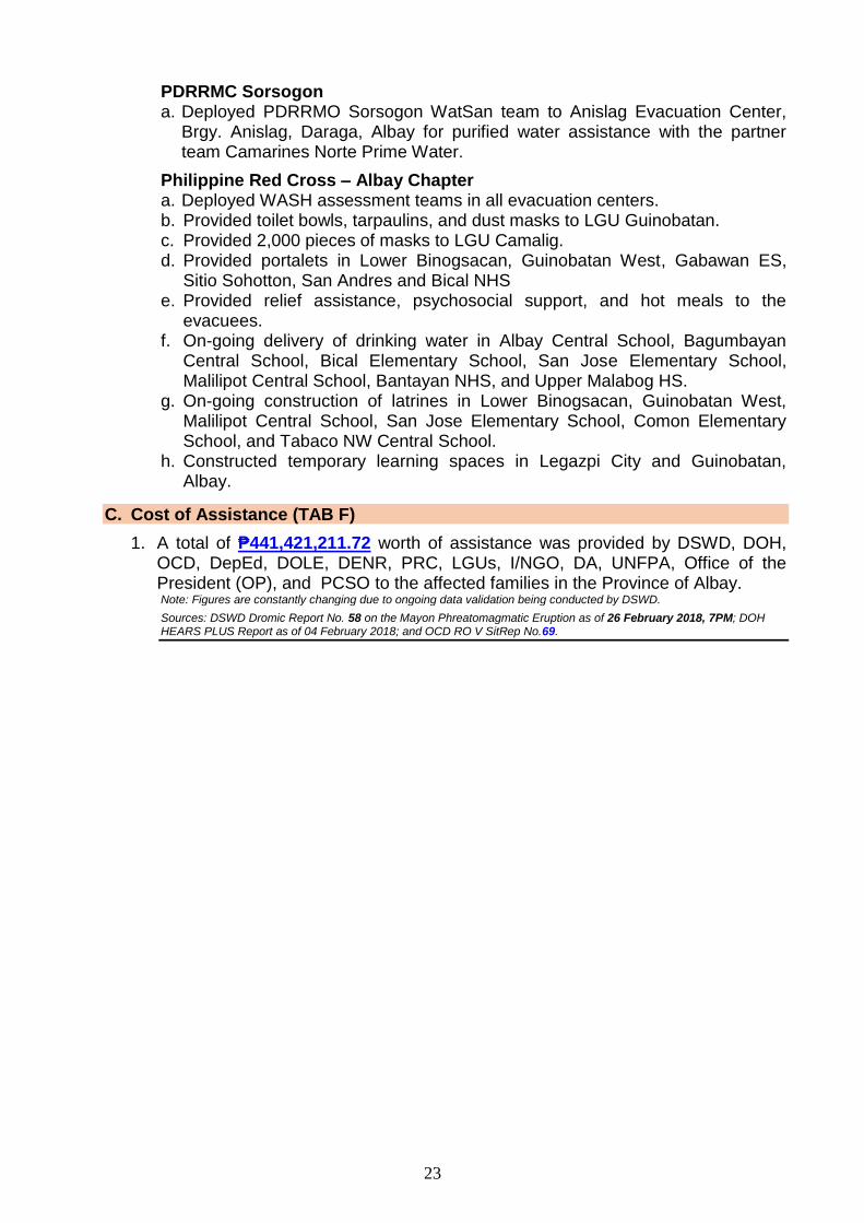
Two lava collapse events occurred that produced rockfall and small-volume pyroclastic density currents at 9:41 AM and 10:05 AM that lasted 5 and 7 minutes respectively, based on seismic record. Ashfall were reported in Brgys. Travesia, Muladbucad Grande, Maninila, Masarawag, Poblacion, Iraya, Ilawod, Calzada, Inamnan Grande, Inamnan Pequeno, Maguiron, Quitago and Mauraro in the municipality of Guinobatan; Brgys. Cabangan, Anoling, Sua, Tumpa, Quirangay, Gapo, Sumlang, Brgys. 1 to 7 in the Municipality of Camalig.
15 January 2018 | Photo by: Kenneth Osabal
Chronology of Events 2 of 35
A degrassing event at 11:07 AM that lasted 8 minutes produced a grayish to dirty white ash column with a maximum of height of approximately 1000 meters above the summit before drifting west-southwest.
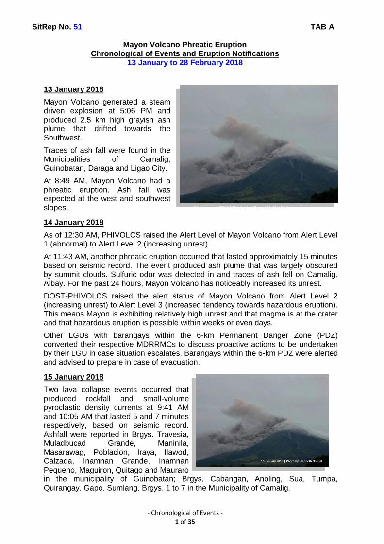
16 January 2018
A total of nine (9) episodes of tremor, four (4) of which accompanied short-duration lava fountaining, and 75 lava collapse events, corresponding to rockfall along the front and margins of advancing lava and short pyroclastic flows downriver of Mi-isi Gully within the PDZ were recorded by Mayon’s seismic network. Collapse events and some degrassing events at the summit crater generated ash that rose to 2 km and fell on barangays of Camalig, Guinobatan, and Polangui. Lava flow on the Mi-isi Gully has presently advanced to approximately 2km from the crater, while shorter volume lava flows have been emplaced on the upper slopes of the Bonga Gully.
17 January 2018
Lava effusion from the new summit lava dome and lava collapse events characterized Mayon Volcano’s eruptive activity in the past 24 hours. One hundred forty-three (143) lava collapse events and one (1) tremor were recorded by Mayon’s seismic monitoring network. The lava collapse events corresponded to rockfall along the front and margins of advancing lava and pyroclastic flows downriver of Mi-isi, Matanag, and Buyuan Gullies within the PDZ.
18 January 2018
Quiet lava effusion from the new summit lava dome and lava collapse events characterized Mayon Volcano's eruptive activity in the past 24 hours. Forty-eight (48) rockfall events, two (2) pyroclastic density currents or PDCs and one (1) volcanic earthquake were recorded by Mayon's seismic monitoring network. Rockfall events were generated by the collapsing lava front and margins of the advancing lava flow on the Mi-isi Gully and by shedding from the summit dome onto the Matanag and Buyuan Gullies. The Mi-isi lava flow has advanced to approximately three (3) kilometers from the summit crater whilst PDCs were emplaced roughly within the same reaches on this drainage, all well within the PDZ. Ash clouds were lofted from the rockfall and PDCs events as well as from the persistent disintegration of lava on the advancing front of the Mi-isi lava flow before drifting to the southwest.
19 January 2018
Quiet lava effusion from the new summit lava dome and lava collapse events characterized Mayon Volcano’s eruptive activity in the past 24 hours. Twenty four (24) rockfall events and one (1) volcanic earthquake were recorded by Mayon’s seismic monitoring network. Rockfall events were generated by the collapsing lava front and margins of the advancing lava flow on the Mi-isi Gully and by shedding from the summit dome onto the Bonga Gully. Currently, the Mi-isi lava flow has advanced to
Chronology of Events 3 of 35
approximately three (3) kilometres from the summit crater well within the PDZ. Ash clouds were lofted from the rockfall events as well as from the persistent disintegration of lava on the advancing front of the Mi-isi lava flow before drifting to the southwest.
20 January 2018
Quiet lava effusion from the new summit lava dome and lava collapse events characterized Mayon Volcano's eruptive activity in the past 24 hours. Five (5) rockfall events were recorded by Mayon's seismic monitoring network. Rockfall events were generated by the collapsing lava front and margins of the advancing lava flow on the Mi-isi Gully and by shedding from the summit dome onto the Bonga Gully. Currently, the Mi-isi lava flow has advanced to three (3) kilometers from the summit crater well within the PDZ. Ash clouds were lofted from the rockfall events as well as from the persistent disintegration of lava on the advancing front of the Mi-isi lava flow before drifting to the southwest.
Alert Level 3 remains in effect over Mayon Volcano, which means that it is currently in a relatively high level of unrest as magma is at the crater and hazardous eruption is possible within weeks or even days.
21 January 2018
Quiet lava effusion from the new summit lava dome and lava collapse events characterized Mayon Volcano's eruptive activity in the past 24 hours. Fourteen (14) rockfall events and ten (10) pyroclastic density currents or PDCs were recorded by Mayon's seismic monitoring network. Rockfall events were generated by the collapsing lava front and margins of the advancing lava flow on the Mi-isi Gully and by shedding from the summit dome onto the Bonga Gully. Currently, the Mi-isi lava flow has advanced to three (3) kilometers from the summit crater well within the Permanent Danger Zone (PDZ). Weak ash clouds were lofted from the rockfall events as well as from the persistent disintegration of lava on the advancing front of the Mi-isi lava flow before drifting to the southwest.
Alert Level 3 remains in effect over Mayon Volcano, which means that it is currently in a relatively high level of unrest as magma is at the crater and hazardous eruption is possible within weeks or even days.
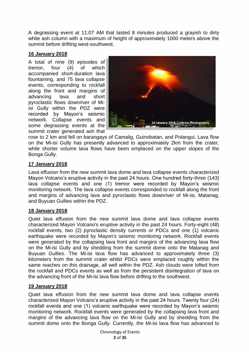
22 January 2018
Lava eruption from the summit and lava collapse events characterized Mayon Volcano’s eruptive activity in the past 24 hours. Three (3) episodes of volcanic tremor, two (2) of which corresponded to lava fountaining, sixty-four (64) rockfall events and one (1) pyroclastic density current or PDC were recorded by Mayon’s seismic monitoring network. Strombolian activity at 10:45 PM and 2:25 AM generated 500m to 200m high lava fountains, respectively, and ash plumes that rose 1,300m above the
Chronology of Events 4 of 35
summit. The ash plumes were drifted southwest and ashfall was experienced in Brgys. Oas and Guinobatan.
The lava fountains signified an increase in mass eruption rate, as lava was observed to be flowing more voluminously than before, feeding the advancing Mi-isi lava anew and feeding two (2) new lava flows on the Bonga Gully. Currently, the Mi-isi lava flow has advanced beyond 3km from the summit crater well within the PDZ.
At 1:00 PM, 22 January 2018, PHIVOLCS raised the Alert Level of Mayon Volcano to Alert Level 4 (hazardous eruption imminent). The Danger Zone is extended to 8 kilometers radius from the summit vent. The public is strongly advised to be vigilant and desist from entering this danger zone. Civil aviation authorities must also advise pilots to avoid flying close to the volcano’s summit as ash from eruptions can be hazardous to aircraft.
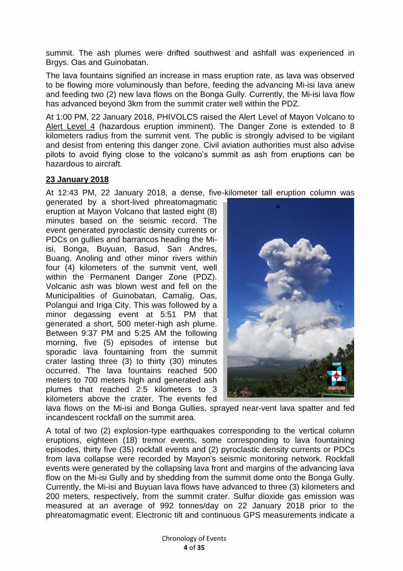
23 January 2018
At 12:43 PM, 22 January 2018, a dense, five-kilometer tall eruption column was generated by a short-lived phreatomagmatic eruption at Mayon Volcano that lasted eight (8) minutes based on the seismic record. The event generated pyroclastic density currents or PDCs on gullies and barrancos heading the Mi-isi, Bonga, Buyuan, Basud, San Andres, Buang, Anoling and other minor rivers within four (4) kilometers of the summit vent, well within the Permanent Danger Zone (PDZ). Volcanic ash was blown west and fell on the Municipalities of Guinobatan, Camalig, Oas, Polangui and Iriga City. This was followed by a minor degassing event at 5:51 PM that generated a short, 500 meter-high ash plume. Between 9:37 PM and 5:25 AM the following morning, five (5) episodes of intense but sporadic lava fountaining from the summit crater lasting three (3) to thirty (30) minutes occurred. The lava fountains reached 500 meters to 700 meters high and generated ash plumes that reached 2.5 kilometers to 3 kilometers above the crater. The events fed lava flows on the Mi-isi and Bonga Gullies, sprayed near-vent lava spatter and fed incandescent rockfall on the summit area.
A total of two (2) explosion-type earthquakes corresponding to the vertical column eruptions, eighteen (18) tremor events, some corresponding to lava fountaining episodes, thirty five (35) rockfall events and (2) pyroclastic density currents or PDCs from lava collapse were recorded by Mayon's seismic monitoring network. Rockfall events were generated by the collapsing lava front and margins of the advancing lava flow on the Mi-isi Gully and by shedding from the summit dome onto the Bonga Gully. Currently, the Mi-isi and Buyuan lava flows have advanced to three (3) kilometers and 200 meters, respectively, from the summit crater. Sulfur dioxide gas emission was measured at an average of 992 tonnes/day on 22 January 2018 prior to the phreatomagmatic event. Electronic tilt and continuous GPS measurements indicate a
22 January 2018 | PHIVOLCS
Chronology of Events 5 of 35
sustained swelling or inflation of the edifice since November and October 2017, consistent with pressurization by magmatic intrusion.
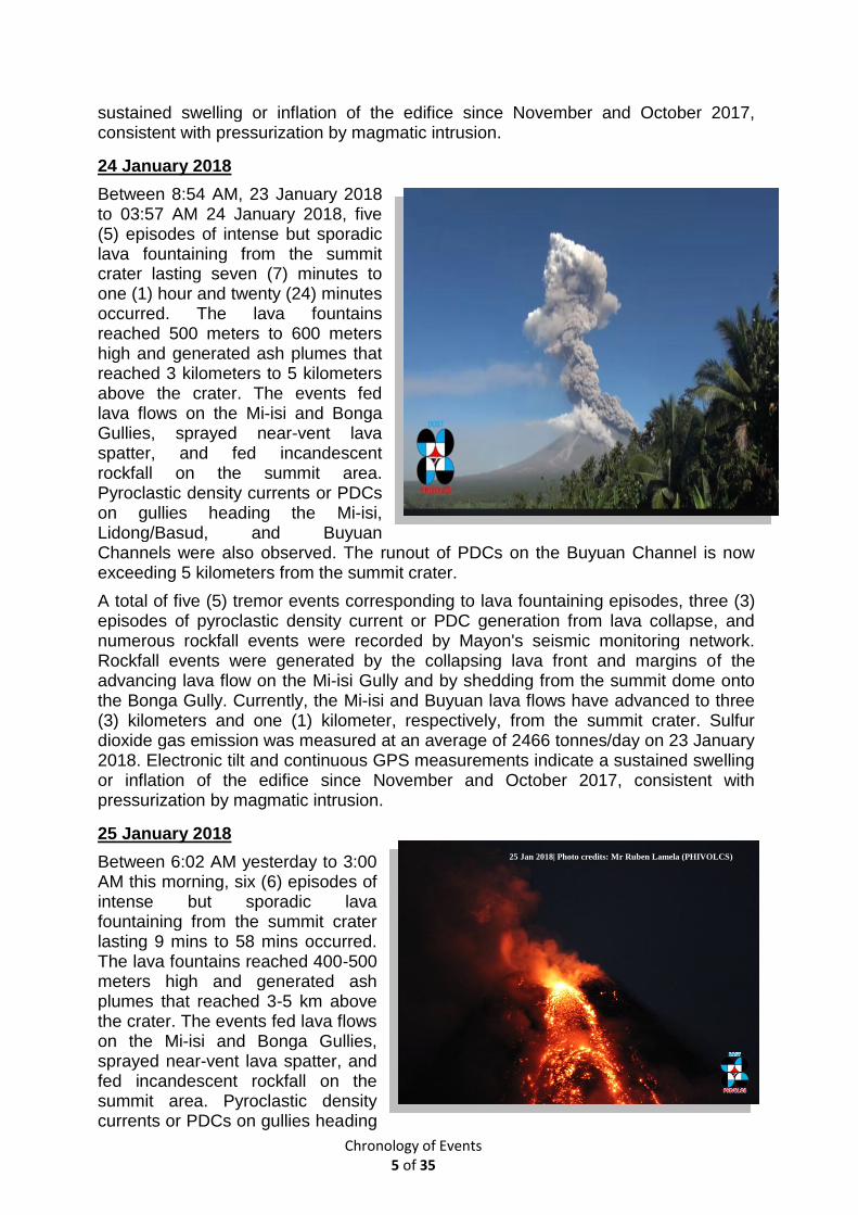
24 January 2018
Between 8:54 AM, 23 January 2018 to 03:57 AM 24 January 2018, five (5) episodes of intense but sporadic lava fountaining from the summit crater lasting seven (7) minutes to one (1) hour and twenty (24) minutes occurred. The lava fountains reached 500 meters to 600 meters high and generated ash plumes that reached 3 kilometers to 5 kilometers above the crater. The events fed lava flows on the Mi-isi and Bonga Gullies, sprayed near-vent lava spatter, and fed incandescent rockfall on the summit area. Pyroclastic density currents or PDCs on gullies heading the Mi-isi, Lidong/Basud, and Buyuan Channels were also observed. The runout of PDCs on the Buyuan Channel is now exceeding 5 kilometers from the summit crater.
A total of five (5) tremor events corresponding to lava fountaining episodes, three (3) episodes of pyroclastic density current or PDC generation from lava collapse, and numerous rockfall events were recorded by Mayon's seismic monitoring network. Rockfall events were generated by the collapsing lava front and margins of the advancing lava flow on the Mi-isi Gully and by shedding from the summit dome onto the Bonga Gully. Currently, the Mi-isi and Buyuan lava flows have advanced to three (3) kilometers and one (1) kilometer, respectively, from the summit crater. Sulfur dioxide gas emission was measured at an average of 2466 tonnes/day on 23 January 2018. Electronic tilt and continuous GPS measurements indicate a sustained swelling or inflation of the edifice since November and October 2017, consistent with pressurization by magmatic intrusion.
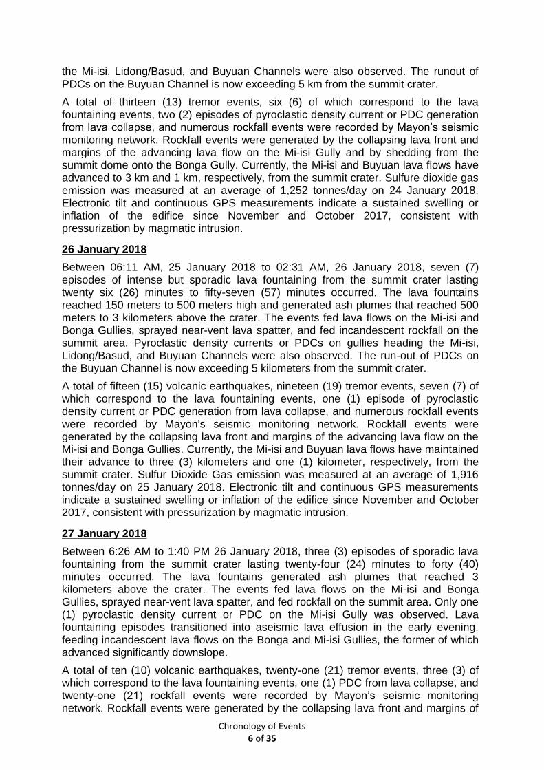
25 January 2018
Between 6:02 AM yesterday to 3:00 AM this morning, six (6) episodes of intense but sporadic lava fountaining from the summit crater lasting 9 mins to 58 mins occurred. The lava fountains reached 400-500 meters high and generated ash plumes that reached 3-5 km above the crater. The events fed lava flows on the Mi-isi and Bonga Gullies, sprayed near-vent lava spatter, and fed incandescent rockfall on the summit area. Pyroclastic density currents or PDCs on gullies heading
25 Jan 2018| Photo credits: Mr Ruben Lamela (PHIVOLCS)
Chronology of Events 6 of 35
the Mi-isi, Lidong/Basud, and Buyuan Channels were also observed. The runout of PDCs on the Buyuan Channel is now exceeding 5 km from the summit crater.
A total of thirteen (13) tremor events, six (6) of which correspond to the lava fountaining events, two (2) episodes of pyroclastic density current or PDC generation from lava collapse, and numerous rockfall events were recorded by Mayon’s seismic monitoring network. Rockfall events were generated by the collapsing lava front and margins of the advancing lava flow on the Mi-isi Gully and by shedding from the summit dome onto the Bonga Gully. Currently, the Mi-isi and Buyuan lava flows have advanced to 3 km and 1 km, respectively, from the summit crater. Sulfure dioxide gas emission was measured at an average of 1,252 tonnes/day on 24 January 2018. Electronic tilt and continuous GPS measurements indicate a sustained swelling or inflation of the edifice since November and October 2017, consistent with pressurization by magmatic intrusion.
26 January 2018
Between 06:11 AM, 25 January 2018 to 02:31 AM, 26 January 2018, seven (7) episodes of intense but sporadic lava fountaining from the summit crater lasting twenty six (26) minutes to fifty-seven (57) minutes occurred. The lava fountains reached 150 meters to 500 meters high and generated ash plumes that reached 500 meters to 3 kilometers above the crater. The events fed lava flows on the Mi-isi and Bonga Gullies, sprayed near-vent lava spatter, and fed incandescent rockfall on the summit area. Pyroclastic density currents or PDCs on gullies heading the Mi-isi, Lidong/Basud, and Buyuan Channels were also observed. The run-out of PDCs on the Buyuan Channel is now exceeding 5 kilometers from the summit crater.
A total of fifteen (15) volcanic earthquakes, nineteen (19) tremor events, seven (7) of which correspond to the lava fountaining events, one (1) episode of pyroclastic density current or PDC generation from lava collapse, and numerous rockfall events were recorded by Mayon's seismic monitoring network. Rockfall events were generated by the collapsing lava front and margins of the advancing lava flow on the Mi-isi and Bonga Gullies. Currently, the Mi-isi and Buyuan lava flows have maintained their advance to three (3) kilometers and one (1) kilometer, respectively, from the summit crater. Sulfur Dioxide Gas emission was measured at an average of 1,916 tonnes/day on 25 January 2018. Electronic tilt and continuous GPS measurements indicate a sustained swelling or inflation of the edifice since November and October 2017, consistent with pressurization by magmatic intrusion.
27 January 2018
Between 6:26 AM to 1:40 PM 26 January 2018, three (3) episodes of sporadic lava fountaining from the summit crater lasting twenty-four (24) minutes to forty (40) minutes occurred. The lava fountains generated ash plumes that reached 3 kilometers above the crater. The events fed lava flows on the Mi-isi and Bonga Gullies, sprayed near-vent lava spatter, and fed rockfall on the summit area. Only one (1) pyroclastic density current or PDC on the Mi-isi Gully was observed. Lava fountaining episodes transitioned into aseismic lava effusion in the early evening, feeding incandescent lava flows on the Bonga and Mi-isi Gullies, the former of which advanced significantly downslope.
A total of ten (10) volcanic earthquakes, twenty-one (21) tremor events, three (3) of which correspond to the lava fountaining events, one (1) PDC from lava collapse, and twenty-one (21) rockfall events were recorded by Mayon’s seismic monitoring network. Rockfall events were generated by the collapsing lava front and margins of
Chronology of Events 7 of 35
the advancing lava flow on the Bonga and Mi-isi Gullies. Currently, the Mi-isi and Bonga lava flows have maintained their advance to three (3) and 1.8 kilometers, respectively, from the summit crater. Sulfur Dioxide Gas emission was measured at an average of 1,916 tonnes/day on 25 January 2018. Electronic tilt and continuous GPS measurements indicate a sustained swelling or inflation of the edifice since November and October 2017, consistent with pressurization by magmatic intrusion.
28 January 2018
Between 6:22 PM yesterday to 1:40 AM this morning, two (2) episodes of sporadic lava fountaining from the summit crater lasting 23 minutes and 55 minutes occurred. The events fed lava flows on the Mi-isi and Bonga Gullies, sprayed near-vent lava spatter, and fed rockfall on the summit area. In between lava fountaining episodes, lava effusion continued to feed lava flows on the Bonga and Mi-isi Gullies. Heavy rainfall throughout the day generated sediment-laden stream flows in channels draining the volcano edifice.
A total of four (4) volcanic earthquakes, seven (7) tremor events, two (2) of which correspond to the lava fountaining events, twenty-three (23) rockfall events were recorded by Mayon’s seismic monitoring network. Rockfall events were generated by the collapsing lava front and margins of the advancing lava flow on the Bonga and Mi-isi Gullies. Currently, the Mi-isi and Bonga lava flows have maintained their advance to 3 and 1.8 km, respectively, from the summit crater. Sulfur dioxide gas emission was measured at an average of 1,916 tonnes/day on 25 January 2018. Electronic tilt and continuous GPS measurements indicate a sustained swelling or inflation of the edifice since November and October 2017, consistent with pressurization by magmatic intrusion.
29 January 2018
Between 5:36 AM yesterday to 7:47 PM last night, four (4) episodes of sporadic lava fountaining from the summit crater lasting thirty-six (36) minutes to fifty-seven (57) minutes occurred. The events fed lava flows on the Mi-isi and Bonga Gullies, sprayed near-vent lava spatter, and fed rockfall on the summit area. The lava fountaining events were succeeded by lava effusion in the early morning that fed new lava flow on the Bonga and Mi-isi Gullies. Heavy rainfall that lasted until the early morning generated channel confined lahars on the Binaan Channel and sediment-laden streamflows in channels draining the volcano edifice due to the remobilization of deposits of pyroclastic density currents or PDCs on the watershed areas.
A total of forty-one (41) volcanic earthquakes, six (6) tremor events, four (4) of which correspond to the lava fountaining events, and sixteen (16) rockfall events were recorded by Mayon's seismic monitoring network. Rockfall events were generated by the collapsing lava front and margins of the advancing lava flow on the Bonga and Mi-isi Gullies. Currently, the Mi-isi and Bonga lava flows have maintained their advance to three (3) and 1.8 kilometers, respectively, from the summit crater. Sulfur dioxide gas emission was measured at an average of 1,916 tonnes/day on 25 January 2018. Electronic tilt and continuous GPS measurements indicate a sustained swelling or inflation of the edifice since November and October 2017, consistent with pressurization by magmatic intrusion.
30 January 2018
Beginning 7:50 last night, energetic lava effusion with sporadic lava fountaining events and generation of lava-collapse fed pyroclastic density currents or PDCs or
Chronology of Events 8 of 35
“uson” occurred until 11:06 PM. Although the upper slopes were heavily obscured, the seismic record indicated onset of this eruption cycle with a large-volume lava collapse at 7:50 PM at the summit crater that fed PDCs on the Mi-isi and Bonga Gullies, followed by lava fountaining at 8:16 that lasted 8 minutes. This was followed by obscured large-volume lava effusion that lasted for an hour and 36 minutes, interspersed with sporadic lava fountaining and/or PDC generation based on the seismic record. Sporadic lava fountaining was visually and seismically detected and persisted until 11:06 PM. The lava fountains reached 200 meters high and generated ash plumes that reached 1.5 kilometers above the crater. Significant ashfall was reported in Camalig and Guinobatan, Albay before 9:00 PM, possible due to the lava fountaining and PDC events.
A total of one hundred nineteen (119) volcanic earthquakes, nine (9) tremor events, two (2) of which correspond to lava fountaining events, two (2) distinct episodes of PDC generation from lava collapse, and sixty-eight (68) rockfall events were recorded by Mayon's seismic monitoring network. Rockfall events were generated by the collapsing lava front and margins of the advancing lava flow on the Bonga and Mi-isi Gullies. Sulfur Dioxide Gas emission was measured at an average of 1,916 tonnes/day on 25 January 2018. Electronic tilt and continuous GPS measurements indicate a sustained swelling or inflation of the edifice since November and October 2017, consistent with pressurization by magmatic intrusion.
31 January 2018
At 11:51 AM yesterday, one (1) lava-collapse fed Pyroclastic Density Current (PDC) event on Mi-isi Gully occurred that produced a 1,250 meter-high ash cloud that drifted southwest. This was succeeded by two (2) more PDC events on the Basud Gully that lasted until 12:09 PM and produced ash clouds draft drifted southwest. Low whitish to light-gray plumes were continuously emitted from the crater throughout the day, and sporadic ashing began at 5:11 PM. This was followed by continuous and sluggish lava effusion in the evening and early morning that continually fed lava flows on the Mi-isi and Bonga Gullies. Intermittent short-lived lava fountaining to 200m heights occurred throughout the night.
A total of two hundred ninety-eight (298) volcanic earthquakes, four (4) distinct episodes of PDC generation from lava collapse, and fifty-two (52) rockfall events were recorded by Mayon’s seismic monitoring network. Rockfall events were generated by the collapsing lava front and margins of the advancing lava flows on the Bonga and Mi-isi Gullies. Sulfure dioxide gas emission was measured at an average of 3,428 tonnes/day on 30 January 2018. Electronic tilt and continuous GPS measurements indicate a sustained swelling or inflation of the edifice since November and October 2017, consistent with pressurization by magmatic intrusion.
01 February 2018
Sporadic and weak lava fountaining and continuous degassing from the summit crater characterized Mayon’s activity yesterday. Much of the activity produced low white to light-gray plumes, with the exception of five events that produced 1000 meter-tall gray ash plumes between 8:13 AM and 11:56 AM, at 6:01 PM and at 9:37 PM. Four (4) episodes of lava-collapse pyroclastic density current or PDC events occurred between 9:53 AM and 5:50 PM and emplaced PDCs on the Mi-isi, Basud and Bonga Gullies within two kilometers of the summit crater. A series of loud booming sounds between 10:55 AM and 12:26 PM, audible for more than 10 kilometers, were generated along with bursts of steam-laden plumes from the summit crater.
Chronology of Events 9 of 35
Throughout the night, quiet lava effusion fed lava flows and rockfall in the Mi-isi and Bonga gullies and barrancos between these. The Mi-isi and Basud lava flows have advanced to 3.2 kilometers and 3.6 kilometers, respectively, from the summit crater.
A total of two hundred seventy-three (273) volcanic earthquakes, most of which corresponded to sporadic and weak fountaining events, fifteen (15) tremor events, and seven (7) rockfall events were recorded by Mayon's seismic monitoring network. Rockfall events were generated by the collapsing lava front and margins of the advancing lava flows on the Bonga and Mi-isi Gullies. Sulfur dioxide gas emission was measured at an average of 2,299 tonnes/day on 31 January 2018. Electronic tilt and continuous GPS measurements indicate a sustained swelling or inflation of the edifice since November and October 2017, consistent with pressurization by magmatic intrusion.
02 February 2018
Sporadic and weak lava fountaining, continuous lava effusion and degassing from the summit crater characterized Mayon’s activity yesterday. Much of the activity produced low white to light-gray plumes, with the exception of four events that produced 750 to 1500 meter-tall gray ash plumes at 6:04 AM, 7:56 AM, 8:51 AM and 9:11 PM accompanied by loud booming sounds audible within ten (10) kilometers of the summit crater. Eleven (11) episodes of lava-collapse pyroclastic density current (PDC) events were visually observed between 8:51 AM yesterday and 2:01 AM this morning depositing along Mi-isi, Basud and Bonga Gullies within two (2) kilometers of the summit crater. Throughout the night, quiet lava effusion fed lava flows and rockfall in the Mi-isi and Bonga-Buyuan channels and barrancos between these. The Mi-isi and Bonga-Buyuan lava flows have advanced to 3.2 kilometers and 4.0 kilometers, respectively, from the summit crater.
A total of three hundred thirty eight (338) volcanic earthquakes, most of which corresponded to sporadic and weak fountaining events, two (2) tremor events, eleven (11) distinct episodes of PDC generation from lava collapse and two (2) rockfall events were recorded by Mayon’s seismic monitoring network. Rockfall events were generated by the collapsing lava front and margins of the advancing lava flows on the Bonga and Mi-isi Gullies. Sulfur dioxide gas emission was measured at an average of 3,066 tonnes/day on 01 February 2018. Electronic tilt and continuous GPS measurements indicate a sustained swelling or inflation of the edifice since November and October 2017, consistent with pressurization by magmatic intrusion.
03 February 2018
Sporadic and weak lava fountaining, lava flow and degassing from the summit crater characterized Mayon’s activity yesterday. Much of the activity produced low white to light-gray plumes, with the exception of one event that produced a 1,000 meter-tall gray ash plume at 9:18 AM. Throughout the night, quiet lava effusion fed lava flows in the Mi-isi and Bonga-Buyuan channels and barrancos between these. The Mi-isi and Bonga-Buyuan lava flows have advanced to 3.2 kilometes and 4.3 kilometers, respectively, from the summit crater.
A total of seventeen (17) volcanic earthquakes, most of which corresponded to sporadic and weak fountaining events, ten (10) tremor events were recorded by Mayon’s seismic monitoring network. Sulfur Dioxide Gas emission was measured at an average of 1,583 tonnes/day on 02 February 2018. Electronic tilt and continuous GPS measurements indicate a sustained swelling or inflation of the edifice since November and October 2017, consistent with pressurization by magmatic intrusion.
Chronology of Events 10 of 35
04 February 2018
Sporadic and weak lava fountaining, lava flow and degassing from the summit crater characterized Mayon’s activity yesterday. One event produced a 500-meter high ash plume and a low and weak lava fountain that lasted 37 seconds. Throughout the night, quiet lava effusion fed lava flows in the Mi-isi and Bonga-Buyuan channels and barrancos between these. The Mi-isi and Bonga-Buyuan lava flows have advanced to 3.2 kilometers and 4.3 kilometers, respectively, from the summit crater.
A total of fifty-five (55) volcanic earthquakes, most of which corresponded to sporadic and weak fountaining events, nine (9) rockfall events were recorded by Mayon's seismic monitoring network. Sulfur dioxide gas emission was measured at an average of 1,583 tonnes/day on 02 February 2018. Electronic tilt and continuous GPS measurements indicate a sustained swelling or inflation of the edifice since November and October 2017, consistent with pressurization by magmatic intrusion.
05 February 2018
Sporadic and weak lava fountaining, lava flow and degassing from the summit crater characterized Mayon’s activity yesterday. Two lava fountaining events yesterday produced 500 and 550 meter high ash plumes 10:38 AM and 1:52 PM both observed with rumbling sounds. The first event of these two events, lasting for an hour and fifty four minutes of sporadic lava flows, was accompanied by booming sounds audible within 10 kilometers of the summit crater. Throughout the night, quiet lava effusion fed lava flows in the Mi-isi and Bonga-Buyuan channels and barrancos between these with the exception of two weak lava fountaining events early this morning at 02:54 AM and 05:22 AM. These events were visually observed to have ejected high volumes of incandescent lava that have advanced to 3.2 kilometers and 4.5 kilometers, through the Mi-isi and Bonga-Buyuan channels respectively, from the summit crater.
A total of one hundred sixty four (164) volcanic earthquakes, most of which corresponded to sporadic and weak fountaining events, two (2) rockfall events and one (1) tremor event were recorded by Mayon's seismic monitoring network. Sulfur dioxide gas emission was measured at an average of 1,583 tonnes/day on 02 February 2018. Electronic tilt and continuous GPS measurements indicate a sustained swelling or inflation of the edifice since November and October 2017, consistent with pressurization by magmatic intrusion.
06 February 2018
Mayon’s activity in the past 24 hours was characterized b sporadic to near continuous lava fountaining, lava flow and degassing from the summit crater. Repeated lava fountaining from 5:57 AM to 1:46 PM and near continuous lava fountaining from 3:59 PM to present were recorded by the volcano seismic network. These were associated with generation of steam-laden ash plumes up to four hundred (400) meters high. The lava fountaining episodes were accompanied by rumbling sounds audible within 10 kilometres of the summit crater. Throughout the night, lava flows, and consequent incandescent rockfalls were observed in the Mi-isi and Bonga-Buyuan channels. Effused high volumes of incandescent lava flows have advanced to 3.2, 4.5, and approximately 3.0 kilometers down the Mi-isi, Bonga-Buyuan and Basud channels, respectively, from the summit crater.
A total of one hundred sixteen (116) volcanic earthquakes, most of which corresponded to lava fountaining events were recorded by Mayon’s seismic monitoring network. Sulfur dioxide gas emission was measured at an average of 1,583 tonnes/day on 02 February 2018. Electronic tilt and continuous GPS
Chronology of Events 11 of 35
measurement indicate a sustained swelling or inflation of the edifice since November and October 2017, consistent with pressurization by magmatic intrusion
07 February 2018
Mayon’s activity in the past 24 hours was characterized by near continuous lava fountaining, lava flow and degassing from the summit crater. Seventy eight successive lava fountaining episodes, 152 in total since 5:57 AM of 5 February, have been recorded by the seismic network. Discrete episodes lasted three to 41 minutes and were accompanied by rumbling sounds audible within 10 kilometers of the summit crater. Persistent steam-laden plumes rose up to 2.5 kilometers from the summit before drifting east and northeast. Throughout the night, lava flows and consequent incandescent rockfalls were observed in the Mi-isi and Bonga-Buyuan channels. Effused volumes of incandescent lava flows have advanced to 3.3 and 4.5 kilometers down the Mi-isi and Bonga-Buyuan channels, respectively, from the summit crater. Pyroclastic density currents or PDCs have deposited to the 4.6, 4.4 and 4.2 kilometer reaches of the Mi-isi, Bonga and Basud Gullies, respectively.
A total of eighty-three (83) volcanic earthquakes, most of which corresponded to lava fountaining events were recorded by Mayon's seismic monitoring network. Sulfur dioxide gas emission was measured at an average of 1,885 tonnes/day on 06 February 2018. Electronic tilt and continuous GPS still record sustained swelling or inflation of the edifice since November and October 2017, consistent with pressurization by magmatic intrusion.
08 February 2018
Mayon’s activity in the past 24 hours was characterized by near continuous lava fountaining, lava flow and degassing from the summit crater. Thirty-five successive lava fountaining episodes since 12:35 PM yesterday have been recorded by the seismic network. Discrete episodes lasted nine to 233 minutes and were accompanied by rumbling and heaving sounds audible beyond 10 kilometers of the summit crater. Incandescent lava fountains 150 meters tall generated steam-laden plumes that rose 800 meters from the summit before drifting northeast. Throughout the night, lava flows and consequent incandescent rockfalls were observed in the Mi-isi and Bonga-Buyuan channels. Effused volumes of incandescent lava flows have advanced to 3.3 kilometers, 4.5 kilometers and 400 meters down the Mi-isi, Bong and Basud Gullies, respectively, from the summit crater. Pyroclastic density currents or PDCs have deposited to the 4.6, 4.4 and 4.2 kilometer reaches of the Mi-isi, Bonga and Basud Gullies, respectively.
A total of thirty-six (36) volcanic earthquakes, most of which corresponded to lava fountaining events were recorded by Mayon's seismic monitoring network. Sulfur dioxide gas emission was measured at an average of 2526 tonnes/day on 07 February 2018. Electronic tilt and continuous GPS still record sustained swelling or inflation of the edifice since November and October 2017, consistent with pressurization by magmatic intrusion.
09 February 2018
Mayon’s activity in the past 24 hours was characterized by near continuous lava fountaining, lava flow and degrassing from the summit crater. Sixty nine (69) successive lava fountaining episode since 12:35 PM, 07 February 2018 have been recorded by the seismic network. Discrete episodes lasted 3 to 233 minutes and were accompanied by rumbling and heaving sounds audible beyond 10 km of the summit
Chronology of Events 12 of 35
crater. Incandescent lava fountains 100m tall generated steam-laden plumes that rose up to 800m from the summit before drifting northeast. Throughout the night, lava flows and consequent incandescent rockfalls were observed in the Mi-isi and Bonga-Buyuan channels. Effused volumes of incandescent lava flows have advanced to 3.3 km, 4.5 km, and 900 m down the Mi-isi, Bonga, and Basud Gullies, respectively, from the summit crater. Pyroclastic density currents or PDCs have deposited to the 4.6, 4.5, and 4.2 km reaches of Mi-isi, Bonga, and Basud Gullies, respectively.
A total of fifty-four (54) volcanic earthquakes, most of which corresponded to lava fountaining events were recorded by Mayon’s seismic monitoring network. Sulfur dioxide gas emission was measured at an average of 2,526 tonnes/day on 07 February 2018. Electronic tilt and continuous GPS and still record sustained swelling or inflation of the edifice since November and October 2017, consistent with pressurization by magmatic intrusion.
10 February 2018
Mayon’s activity in the past 24 hours was characterized by near continuous lava fountaining, lava flow and degassing from the summit crater. Sixty-six (66) successive lava fountaining episodes since 08:08 AM last February 9, 2018 have been recorded by the seismic network. Discrete episodes lasted three (3) to forty-six (46) minutes and were accompanied by rumbling sounds audible beyond 10 kilometers of the summit crater. Incandescent lava fountains 200 meters tall generated steam-laden plumes that rose up to 800 meters from the summit before drifting northeast. Throughout the night, lava flows and consequent incandescent rockfalls were observed in the Mi-isi and Bonga-Buyuan channels. Effused volumes of incandescent lava flows have advanced to 3.3 kilometers, 4.5 kilometers and 900 meters down the Mi-isi, Bonga and Basud Gullies, respectively, from the summit crater. Pyroclastic density currents or PDCs have deposited to the 4.6, 4.5 and 4.2 kilometer reaches of the Mi-isi, Bonga and Basud Gullies, respectively.
A total of seventy-six (76) volcanic earthquakes, most of which corresponded to lava fountaining events were recorded by Mayon's seismic monitoring network. Sulfur dioxide gas emission was measured at an average of 336 tonnes/day on 09 February 2018. Electronic tilt and continuous GPS still record sustained swelling or inflation of the edifice since November and October 2017, consistent with pressurization by magmatic intrusion.
11 February 2018
Mayon’s activity in the past 24 hours was characterized by sporadic and weak lava fountaining, lava flow and degassing from the summit crater. Discrete episodes of lava fountaining lasted four (4) to seven (7) minutes were accompanied by rumbling sounds audible beyond 10 kilometers of the summit crater. Incandescent lava fountains 400 meters tall generated steam-laden plumes that rose up to 800 meters from the summit before drifting southwest, west southwest, north northwest, and northwest. Throughout the night, lava flows and consequent incandescent rockfalls were observed in the Mi-isi and Bonga-Buyuan channels. Effused volumes of incandescent lava flows have advanced to 3.3 kilometers, 4.5 kilometers and 900 meters down the Mi-isi, Bonga and Basud Gullies, respectively, from the summit crater. Pyroclastic density currents or PDCs have deposited to the 4.6, 4.5, and 4.2 kilometer reaches of the Mi-isi, Bonga and Basud Gullies, respectively.
A total of one hundred eight (108) volcanic earthquakes, most of which corresponded to lava fountaining events were recorded by Mayon's seismic monitoring network.
Chronology of Events 13 of 35
Electronic tilt and continuous GPS still record sustained swelling or inflation of the edifice since November and October 2017, consistent with pressurization by magmatic intrusion.
12 February 2018
Mayon’s activity in the past 24 hours was characterized by sporadic and weak lava fountaining, lava flow and degrassing from the summit crater. Discrete episodes of lava fountaining lasted 4-20 minutes. Incandescent lava fountains 150m tall generated steam-laden plumes that rose up to 400m from the summit before drifting Northwest and West Northwest. Throughout the night, lava flows and consequent incandescent rockfalls were observed in the Mi-isi and Bonga-Buyuan channels. Effused volumes of incandescent lava flows have advanced to 3.3 km, 4.5 km, and 900m down the Mi-isi, Bonga, and Basud Gullies, respectively, from the summit crater. Pyroclastic density currents or PDCs have deposited to the 4.6, 4.5, and 4.2 km reaches of the Mi-isi, Bonga, and Basud Gullies, respectively.
A total of ninety-two (92) volcanic earthquakes, most of which corresponded to lava fountaining events were recorded by Mayon’s seismic monitoring network. Electronic tilt and continuous GPS still record sustained swelling or inflation of the edifice since November and October 2017, consistent with pressurization by magmatic intrusion.
13 February 2018
Mayon’s activity in the past 24 hours was characterized by sporadic and weak lava fountaining, lava flow and degassing from the summit crater. Although the upper slopes were heavily obscured, the seismic record indicated discrete episodes of lava fountaining that lasted three (3) to fifty-five (55) minutes. Throughout the night, lava flows and consequent incandescent rock falls were observed in the Mi-isi and Bonga-Buyuan channels. Effused volumes of incandescent lava flows have advanced to 3.3 kilometers, 4.5 kilometers and 900 meters down the Mi-isi, Bonga and Basud Gullies, respectively, from the summit crater. Pyroclastic density currents or PDCs have deposited to the 4.6, 4.5 and 4.2 kilometer reaches of the Mi-isi, Bonga and Basud Gullies, respectively.
A total of seventy-six (76) volcanic earthquakes, most of which corresponded to lava fountaining events were recorded by Mayon’s seismic monitoring network. Electronic tilt and continuous GPS still record sustained swelling or inflation of the edifice since November and October 2017, consistent with pressurization by magmatic intrusion.
14 February 2018
Mayon’s activity in the past 24 hours was characterized by sporadic and weak lava fountaining, lava flow and degassing from the summit crater. Although the upper slopes were heavily obscured, the seismic record indicated discrete episodes of lava fountaining that lasted five (5) to fifty (50) minutes. Throughout the night, lava flows and consequent incandescent rockfalls were observed in the Mi-isi and Bonga-Buyuan channels. Effused volumes of incandescent lava flows have advanced to 3.3 kilometers, 4.5 kilometers and 900 meters down the Mi-isi, Bonga and Basud Gullies, respectively, from the summit crater. Pyroclastic density currents or PDCs have deposited to the 4.6, 4.5 and 4.2 kilometer reaches of the Mi-isi, Bonga and Basud Gullies, respectively. Lahar was also reported at Anoling channel during field visits yesterday.
A total of ninety-four (94) volcanic earthquakes, most of which corresponded to lava fountaining events were recorded by Mayon's seismic monitoring network. Electronic
Chronology of Events 14 of 35
tilt and continuous GPS still record sustained swelling or inflation of the edifice since November and October 2017, consistent with pressurization by magmatic intrusion.
15 February 2018
Mayon’s activity in the past 24 hours was characterized by sporadic and weak lava fountaining, lava flow and degassing from the summit crater. Although the upper slopes were heavily obscured during the day, the seismic network recorded discrete episodes of lava fountaining that lasted five (5) to twenty (20) minutes. This was followed by a period of lull beginning at 4:45 PM until the early morning, until lava fountaining resumed at 3:21 AM. Effused volumes of incandescent lava flows have advanced to 3.3 kilometers, 4.5 kilometers and 900 meters down the Mi-isi, Bonga and Basud Gullies, respectively, from the summit crater. Pyroclastic density currents or PDCs have deposited to the 4.6, 4.5 and 4.2 kilometer reaches of the Mi-isi, Bonga and Basud Gullies, respectively. Heavy rainfall yesterday also generated channel-confined sediment-laden stream flows in most channels where PDC deposits were emplaced.
A total of ninety-nine (99) volcanic earthquakes, most of which corresponded to lava fountaining events, and one (1) rockfall event were recorded by Mayon's seismic monitoring network. Electronic tilt and continuous GPS still record sustained swelling or inflation of the edifice since November and October 2017, consistent with pressurization by magmatic intrusion.
16 February 2018
Mayon’s activity in the past 24 hours was characterized by sporadic and weak lava fountaining, lava flow, and degassing from the summit crater. Discrete episodes of lava fountaining that lasted eighteen (18) minutes to two hours and twenty-three minutes were accompanied by rumbling and chugging sounds audible beyond 10 kilometers of the summit crater. Incandescent lava fountains 200 meters tall generated steam-laden plumes that rose to 400 meters from the summit before drifting southwest and west-southwest. Throughout the night, lava flows and consequent incandescent rockfalls were observed in the Mi-isi, Bonga, and Basud Guilles, respectively, from the summit crater. Pyroclastic density currents or PDCs have deposited to the 4.6, 4.5, and 4.2 kilometer reaches of the Mi-isi, Bonga, and Basud Gullies, respectively.
A total of fifty-four (54) volcanic earthquakes, most of which corresponded to lava fountaining events were recorded by Mayon’s seismic monitoring network. Electronic tilt and continuous GPS still record sustained swelling or inflation of the edifice since November and October 2017, consistent with pressurization by magmatic intrusion.
17 February 2018
Mayon’s activity in the past 24 hours was characterized by sporadic and weak lava fountaining, lava flow and degassing from the summit crater. Discrete episodes of lava fountaining that lasted three hours and fifty-nine (239) minutes were accompanied by rumbling sounds audible beyond 10 kilometers of the summit crater. Incandescent lava fountains generated steam-laden plumes that rose 500 meters from the summit before drifting southwest and northwest. This was followed by a period of lull beginning at 7:15 PM until the early morning, until lava fountaining resumed at 1:03 AM. Throughout the night, lava flows and consequent incandescent rockfalls were observed in the Miisi and Bonga-Buyuan channels. Effused volumes of incandescent lava flows have advanced to 3.3 kilometers, 4.5 kilometers and 900
Chronology of Events 15 of 35
meters down the Miisi, Bonga and Basud Gullies, respectively, from the summit crater. Pyroclastic density currents or PDCs have deposited to the 4.6, 4.5 and 4.2 kilometer reaches of the Miisi, Bonga and Basud Gullies, respectively.
A total of sixty-seven (67) volcanic earthquakes, most of which corresponded to lava fountaining events, and one (1) rockfall event were recorded by Mayon’s seismic monitoring network. Sulfur dioxide (SO2) emission was measured at an average of 1,922 tonnes/day on 16 February 2018. Electronic tilt and continuous GPS still record sustained swelling or inflation of the edifice since November and October 2017, consistent with pressurization by magmatic intrusion.
18 February 2018
Mayon’s activity in the past 24 hours was characterized by sporadic and weak lava fountaining, lava flow and degassing from the summit crater. Three (3) discrete lava fountaining episodes were recorded at 1:03 AM and 4:49 PM yesterday and 1:59 AM this morning. The first of these lasted twelve hours and eighteen minutes, generating grayish ash plumes that rose 400 m above the summit crater. Discrete seismic events associated with otherwise obscured lava fountaining lasted three to 21 minutes and were recorded until 1:21 PM yesterday. The second episode lasted 43 minutes and consisted of discrete seismic events of up to 10 minutes duration that were accompanied by rumbling sounds audible beyond 10 kilometers of the summit crater. The third episode started early this morning and is characterized by discrete signals with attendant incandescent lava flow. Lava flows have advanced to 3.3 kilometers, 4.5 kilometers and 900 meters down the Mi-isi, Bonga and Basud Gullies, respectively, from the summit crater. Pyroclastic density currents or PDCs have deposited to the 4.6, 4.5 and 4.2 kilometer reaches of the Mi-isi, Bonga and Basud Gullies, respectively.
A total of fifty-five (55) volcanic earthquakes, most of which corresponded to lava fountaining events, and three (3) rockfall events were recorded by Mayon’s seismic monitoring network. Sulfur dioxide (SO2) emission averaged 1,339 tonnes/day on 17 February 2018. Electronic tilt and continuous GPS still record sustained swelling or inflation of the edifice since November and October 2017, consistent with pressurization by magmatic intrusion. 19 February 2018
Mayon’s activity in the past 24 hours was characterized by sporadic and weak lava fountaining, lava flow and degassing from the summit crater. Six (6) discrete lava fountaining episodes that lasted ten (10) to twenty-three (23) minutes were recorded by the seismic network. These generated dirty white to brownish ash plumes that rose to two hundred fifty (250) meters above the summit crater before drifting southwest. Three (3) episodes of lava collapse pyroclastic density current (PDC) events were visually observed yesterday between 5:57 AM and 9:16 AM in the Basud and Bonga-Buyuan Gullies. Lava flow sustained at 3.3 kilometers, 4.5 kilometers and 900 meters on the Mi-isi, Bonga and Basud Gullies, respectively, from the summit crater. Pyroclastic density currents or PDCs have deposited to the 4.6, 4.5 and 4.2 kilometer reaches of the Mi-isi, Bonga and Basud Gullies, respectively.
A total of fifty-four (54) volcanic earthquakes, most of which corresponded to lava fountaining events, and one (1) rockfall event was recorded by Mayon’s seismic monitoring network. Sulfur dioxide (SO2) emission averaged 1,339 tonnes/day on 17
Chronology of Events 16 of 35
February 2018. Electronic tilt and continuous GPS still record sustained swelling or inflation of the edifice since November and October 2017, consistent with pressurization by magmatic intrusion.
20 February 2018 Mayon’s activity in the past 24 hours was characterized by sporadic and weak lava fountaining, lava flow and degassing from the summit crater. As of 4:05 AM this morning, fifty-six (56) discrete lava fountaining episodes that lasted five (5) to sixty-two (62) minutes were recorded by the seismic network. One (1) lava collapse pyroclastic density current (PDC) event that generated white to dirty white plume was visually observed yesterday at 6:16 AM along the Basud Gully. Lava flow sustained at 3.3 kilometers, 4.5 kilometers and 900 meters on the Mi-isi, Bonga and Basud Gullies, respectively, from the summit crater. Pyroclastic density currents or PDCs remained confined within the farthest recorded reaches of 4.6, 5.2 and 4.2 kilometers on the Mi-isi, Bonga and Basud Gullies, respectively. A total of seventy-two (72) volcanic earthquakes, corresponding to lava fountaining and tremor events, were recorded by Mayon's seismic monitoring network. Sulfur dioxide (SO2) emission averaged 2,148 tonnes/day on 19 February 2018. Electronic tilt and continuous GPS still record sustained swelling or inflation of the edifice since November and October 2017, consistent with pressurization by magmatic intrusion. 21 February 2018 Mayon’s activity in the past 24 hours was characterized by sporadic and weak lava fountaining, lava flow and degassing from the summit crater. Discrete seismic events associated with otherwise obscured lava fountaining that lasted six (6) to fifteen (15) minutes were recorded until 1:18 AM this morning. Incandescent lava fountains generated dirty white ash plumes that rose 500 meters from the summit before drifting west-northwest. Lava flow sustained at 3.3 kilometers, 4.5 kilometers and 900 meters on the Mi-isi, Bonga and Basud Gullies, respectively, from the summit crater. Pyroclastic density currents or PDCs remained confined within the farthest recorded reaches of 4.6, 5.2 and 4.2 kilometers on the Mi-isi, Bonga, and Basud Gullies, respectively. A total of one hundred eighty-three (183) volcanic earthquakes, corresponding to recharge of magma beneath the edifice and lava fountaining events, were recorded by Mayon's seismic monitoring network. Sulfur dioxide (SO2) emission was measured at an average of 2,148 tonnes/day on 19 February 2018. Electronic tilt and continuous GPS still record sustained swelling or inflation of the edifice since November and October 2017, consistent with pressurization by magmatic intrusion.
22 February 2018
Mayon’s activity in the past 24 hours was characterized by sporadic and lava fountaining, lava flow and degassing from the summit crater. Between 7:34 AM yesterday and 4:06 AM this morning, the seismic network recorded eighty (80) discrete seismic events associated with otherwise obscured lava fountaining that lasted two (2) to forty-nine (49) minutes and were accompanied by rumbling and chugging sounds audible beyond 10 kilometers of the summit crater. Incandescent lava fountains with heights of 100 to 600 meters generated dirty white to gray ash
Chronology of Events 17 of 35
plumes that rose 100 to 800 meters from the summit before drifting west-southwest to southwest. Seven (7) episodes of lava-collapse pyroclastic density current (PDC) events were visually observed between 1:44 PM and 3:05 PM yesterday depositing along Mi-isi, Basud and Bonga-Buyuan Gullies within two kilometers of the summit crater. Lava flow sustained at 3.3 kilometers, 4.5 kilometers and 900 meters on the Mi-isi, Bonga and Basud Gullies, respectively, from the summit crater. Pyroclastic density currents or PDCs remained confined within the farthest recorded reaches of 4.6, 5.2 and 4.2 kilometers on the Mi-isi, Bonga and Basud Gullies, respectively.
A total of one hundred forty-three (143) volcanic earthquakes, corresponding to recharge of magma beneath the edifice and lava fountaining events, were recorded by Mayon’s seismic monitoring network. Sulfur dioxide (SO2) emission was measured at an average of 4,273 tonnes/day on 21 February 2018. Electronic tilt and continuous GPS still record sustained swelling or inflation of the edifice since November and October 2017, consistent with pressurization by magmatic intrusion.
23 February 2018
Mayon’s activity in the past 24 hours was characterized by generally quiet lava effusion, degassing from the summit crater and a brief, 200-meter tall lava fountain at 7:17 PM. During daytime yesterday, between 5:49 AM and 5:03 PM, twenty-one (21) episodes of lava-collapse pyroclastic density currents (PDC) were visually observed on the Miisi, Basud and Bonga-Buyuan Gullies within 2-4 kilometers of the summit crater. At night, lava effusion from the vent continued to feed lava flows that have maintained fronts at 3.3 kilometers, 4.5 kilometers and 900 meters on the Miisi, Bonga and Basud Gullies, respectively, from the summit crater. A total of seven (7) volcanic earthquakes and nineteen (19) rockfall events were recorded by Mayon's seismic monitoring network. Sulfur dioxide (SO2) emission was measured at an average of 1,459 tonnes/day on 22 February 2018. Electronic tilt and continuous GPS indicate that the edifice is still swollen or inflated relative to November and October 2017 due to pressurization by magmatic intrusion, consistent with campaign Precise Leveling data acquired this week. 24 February 2018 Mayon’s activity in the past 24 hours was characterized by generally quiet lava effusion and degassing from the summit crater. During daytime yesterday, between 10:32 AM and 1:44 PM, six (6) episodes of lava-collapse pyroclastic density currents (PDC) were visually observed on the Mi-isi, Basud and Bonga-Buyuan Gullies within 4-5 kilometers of the summit crater. At night, lava effusion from the vent continued to feed lava flows that have maintained fronts at 3.3 kilometers, 4.5 kilometers and 900 meters on the Mi-isi, Bonga and Basud Gullies, respectively, from the summit crater. A total of three (3) volcanic earthquakes and eight (8) rockfall events were recorded by Mayon's seismic monitoring network. Sulfur dioxide (SO2) emission was measured at an average of 2070 tonnes/day on 23 February 2018. Deflation of the lower slopes that began on 20 February was recorded by electronic tilt, consistent with the transition to quiet lava effusion at the summit crater. Nonetheless, overall electronic tilt and continuous GPS data indicate that the edifice is still swollen or inflated relative to November and October 2017, consistent with campaign Precise Leveling data acquired this week.
Chronology of Events 18 of 35
25 February 2018
Mayon’s condition for the past 24 hours was characterized by a short lull that was followed by lava collapses, generally quiet degassing, weak lava fountaining and effusion and degassing from the summit crater. Between 7:23 AM and 2:02 PM yesterday, five (5) episodes of lava-collapse pyroclastic density currents (PDC) were visually observed on the Mi-isi, Basud and Bonga-Buyuan Gullies within 4-5 kilometers of the summit crater. Sporadic activity at the summit resumed at 2:56 PM and generated ash plumes 100-500 meters above the summit that drifted to the southwest. In the evening, lava effusion from the vent was observed to continue feeding lava flows that have maintained fronts at 3.3 kilometers, 4.5 kilometers and 900 meters on the Mi-isi, Bonga and Basud Gullies, respectively, from the summit crater. A total of one hundred twenty-three (123) volcanic earthquakes and two (2) rockfall events were recorded by Mayon's seismic monitoring network. Sulfur dioxide (SO2) emission was measured at an average of 2070 tonnes/day on 23 February 2018. Deflation of the lower slopes that began on 20 February was recorded by electronic tilt, consistent with the transition to quiet lava effusion at the summit crater, a brief lull and resumption of sporadic fountaining. Nonetheless, overall electronic tilt and continuous GPS data indicate that the edifice is still swollen or inflated relative to November and October 2017, consistent with campaign Precise Leveling data acquired this week.
26 February 2018
Mayon’s condition for the past 24 hours was characterized by weak lava fountaining, lava effusion and degassing from the summit crater. As of 7:04 AM this morning, a total of thirty six (36) discrete episodes of lava fountaining lasting two (2) to nineteen (19) minutes have occurred, accompanied by booming and rumbling sounds audible beyond 10 kilometers of the summit crater. Lava fountains 50-200 meters tall generated steam-laden plumes that rose to 150-600 meters from the summit before drifting southwest, west-northwest, northwest, and northeast. In the evening, lava effusion from the vent was observed to continue feeding lava flows that have maintained fronts at 3.3 kilometers, 4.5 kilometers and 900 meters on the Mi-isi, Bonga and Basud Gullies, respectively, from the summit crater. Only two (2) episodes of lava-collapse pyroclastic density currents (PDC) were visually observed between 10:33 AM and 10:38 AM yesterday on the Mi-isi, Basud and Bonga-Buyuan Gullies within 4 kilometers of the summit crater.
A total of one hundred twenty-four (124) volcanic earthquakes and one (1) rockfall event were recorded by Mayon's seismic monitoring network. Sulfur dioxide (SO2) emission was measured at an average of 2070 tonnes/day on 23 February 2018. Deflation of the lower slopes that began on 20 February was recorded by electronic tilt, consistent with the transition to quiet lava effusion at the summit crater, a brief lull and resumption of sporadic fountaining. Nonetheless, overall electronic tilt and continuous GPS data indicate that the edifice is still swollen or inflated relative to November and October 2017, consistent with campaign Precise Leveling data acquired this week.
Chronology of Events 19 of 35
27 February 2018 Mayon’s condition for the past 24 hours was characterized by weak lava fountaining, lava effusion and degassing from the summit crater. Lava fountaining events lasted two (2) minutes to one (1) hour and 17 minutes and generated fountains 150 meters tall and steam-laden plumes that rose to 100-600 meters from the summit before drifting west-northwest, northwest, and north-northeast. In the evening, lava effusion from the vent was observed to continue feeding lava flows that have maintained fronts at 3.3 kilometers, 4.5 kilometers and 900 meters on the Mi-isi, Bonga and Basud Gullies, respectively, from the summit crater. Seven (7) episodes of lava-collapse pyroclastic density currents (PDC) were visually observed between 6:06 AM and 1:36 PM yesterday on the Mi-isi, Basud and Bonga-Buyuan Gullies within 4 kilometers of the summit crater. A total of one hundred twenty-eight (128) volcanic earthquakes, seventy-nine (79) of which correspond to lava fountaining events, and twelve (12) rockfall events were recorded by Mayon's seismic monitoring network. Sulfur dioxide (SO2) emission was measured at an average of 2,787 tonnes/day on 26 February 2018. Deflation of the lower slopes that began on 20 February is still being recorded by electronic tilt. Nonetheless, overall electronic tilt and continuous GPS data indicate that the edifice is still swollen or inflated relative to November and October 2017, consistent with campaign Precise Leveling data acquired last week. 27 February 2018 Mayon’s activity in the past 24 hours was characterized by generally quiet lava effusion and degassing from the summit crater. During daytime yesterday, between 9:14 AM and 5:19 PM, two (2) episodes of lava-collapse pyroclastic density currents (PDC) were visually observed on the Miisi and Bonga-Buyuan Gullies within 4-5 kilometers of the summit crater. At night, lava effusion from the vent continued to feed lava flows that have maintained fronts at 3.3 kilometers, 4.5 kilometers and 900 meters on the Miisi, Bonga and Basud Gullies, respectively, from the summit crater.
A total of twenty-six (26) volcanic earthquakes and ten (10) rockfall events were recorded by Mayon's seismic monitoring network. Sulfur dioxide (SO2) emission was measured at an average of 1,533 tonnes/day on 28 February 2018. Deflation of the lower slopes that began on 20 February is still being recorded by electronic tilt. Nonetheless, overall electronic tilt and continuous GPS data indicate that the edifice is still swollen or inflated relative to November and October 2017, consistent with campaign Precise Leveling data acquired last week.
Eruption notifications:
Date and Time Estimated Height of Ash/steam Plume
Cloud Remarks
14 January 2018, 8:49 AM
General Drift of Plume: Southwest
Ash/Steam Plume/Cloud color: gray
14 January 2018, 11:43 AM
General Drift of Plume: Southwest
Ashfall experience in Camalig, Albay
15 January 2018, 9:41 AM
General Drift of Plume: South-
Southwest Ash/Steam Plume/Cloud color: grayish
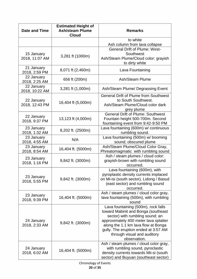
Chronology of Events 20 of 35
Date and Time Estimated Height of Ash/steam Plume
Cloud Remarks
to white Ash column from lava collapse
15 January 2018, 11:07 AM
3,281 ft (1000m)
General Drift of Plume: West-Southwest
Ash/Steam Plume/Cloud color: grayish to dirty white
21 January 2018, 2:59 PM
8,071 ft (2,460m) Lava Fountaining
22 January 2018, 2:25 AM
656 ft (200m) Ash/Steam Plume
22 January 2018, 10:22 AM
3,281 ft (1,000m) Ash/Steam Plume/ Degrassing Event
22 January 2018, 12:43 PM
16,404 ft (5,000m)
General Drift of Plume from Southwest to South Southwest.
Ash/Steam Plume/Cloud color dark grey plume
22 January 2018, 9:37 PM
13,123 ft (4,000m) General Drift of Plume: Southwest Fountain height 500-700m. Second fountaining event from 9:42-9:50 PM
23 January 2018, 1:32 AM
8,202 ft. (2500m) Lava fountaining (600m) w/ continuous
rumbling sound.
23 January 2018, 4:55 AM
N/A Lava fountaining (500m) w/ booming
sound; obscured plume
23 January 2018, 8:54 AM
16,404 ft. (5000m) Ash/Steam Plume/Cloud Color Gray,
Phreatomagmatic with rumbling sound
23 January 2018, 1:16 PM
9,842 ft. (3000m) Ash / steam plumes / cloud color:
grayish-brown with rumbling sound occurred.
23 January 2018, 5:55 PM
9,842 ft. (3000m)
Lava fountaining (600m), with pyroplastic density currents implaced
on Mi-isi (south sector), Lidong / Basud (east sector) and rumbling sound
occurred.
23 January 2018, 9:39 PM
16,404 ft. (5000m) Ash / steam plumes / cloud color gray, lava fountaining (500m), with rumbling
sound
24 January 2018, 2:33 AM
9,842 ft. (3000m)
Lava fountaining (500m), rock falls toward Mabinit and Bonga (southeast
sector) with rumbling sound; an approximately 400 meter lava splatter along the 1.1 km lava flow at Bonga gully. The eruption ended at 3:57 AM
through visual and auditory observation.
24 January 2018, 6:02 AM
16,404 ft. (5000m)
Ash / steam plumes / cloud color gray, with rumbling sound, pyroclastic
density currents towards Mii-si (south sector) and Buyuan (southeast sector)
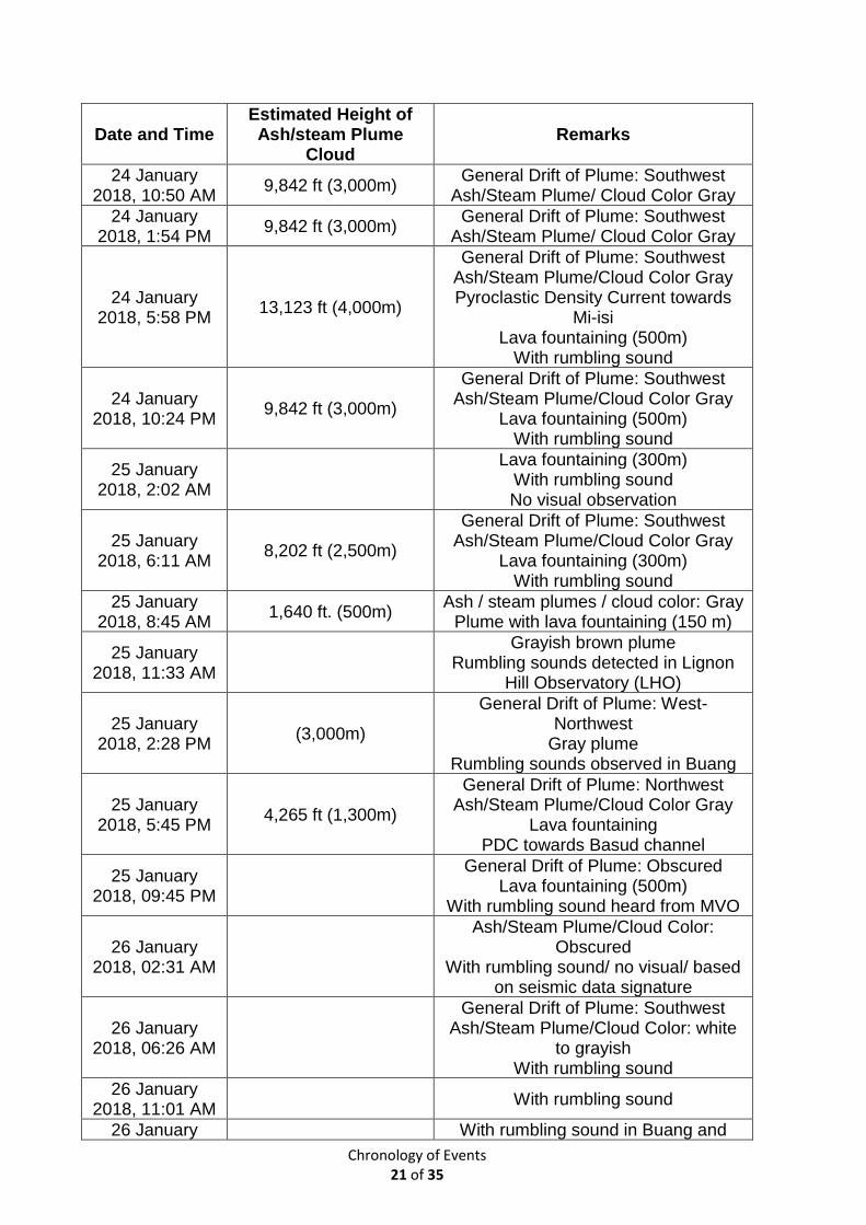
Chronology of Events 21 of 35
Date and Time Estimated Height of Ash/steam Plume
Cloud Remarks
24 January 2018, 10:50 AM
9,842 ft (3,000m) General Drift of Plume: Southwest
Ash/Steam Plume/ Cloud Color Gray
24 January 2018, 1:54 PM
9,842 ft (3,000m) General Drift of Plume: Southwest
Ash/Steam Plume/ Cloud Color Gray
24 January 2018, 5:58 PM
13,123 ft (4,000m)
General Drift of Plume: Southwest Ash/Steam Plume/Cloud Color Gray Pyroclastic Density Current towards
Mi-isi Lava fountaining (500m)
With rumbling sound
24 January 2018, 10:24 PM
9,842 ft (3,000m)
General Drift of Plume: Southwest Ash/Steam Plume/Cloud Color Gray
Lava fountaining (500m) With rumbling sound
25 January 2018, 2:02 AM
Lava fountaining (300m)
With rumbling sound No visual observation
25 January 2018, 6:11 AM
8,202 ft (2,500m)
General Drift of Plume: Southwest Ash/Steam Plume/Cloud Color Gray
Lava fountaining (300m) With rumbling sound
25 January 2018, 8:45 AM
1,640 ft. (500m) Ash / steam plumes / cloud color: Gray
Plume with lava fountaining (150 m)
25 January 2018, 11:33 AM
Grayish brown plume
Rumbling sounds detected in Lignon Hill Observatory (LHO)
25 January 2018, 2:28 PM
(3,000m)
General Drift of Plume: West- Northwest
Gray plume Rumbling sounds observed in Buang
25 January 2018, 5:45 PM
4,265 ft (1,300m)
General Drift of Plume: Northwest Ash/Steam Plume/Cloud Color Gray
Lava fountaining PDC towards Basud channel
25 January 2018, 09:45 PM
General Drift of Plume: Obscured
Lava fountaining (500m) With rumbling sound heard from MVO
26 January 2018, 02:31 AM
Ash/Steam Plume/Cloud Color: Obscured
With rumbling sound/ no visual/ based on seismic data signature
26 January 2018, 06:26 AM
General Drift of Plume: Southwest Ash/Steam Plume/Cloud Color: white
to grayish With rumbling sound
26 January 2018, 11:01 AM
With rumbling sound
26 January With rumbling sound in Buang and
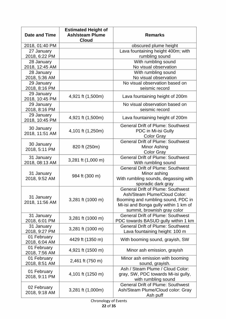
Chronology of Events 22 of 35
Date and Time Estimated Height of Ash/steam Plume
Cloud Remarks
2018, 01:40 PM obscured plume height
27 January 2018, 6:22 PM
Lava fountaining height 400m; with
rumbling sound
28 January 2018, 12:45 AM
With rumbling sound No visual observation
28 January 2018, 5:36 AM
With rumbling sound No visual observation
29 January 2018, 8:16 PM
No visual observation based on
seismic record
29 January 2018, 10:45 PM
4,921 ft (1,500m) Lava fountaining height of 200m
29 January 2018, 8:16 PM
No visual observation based on
seismic record
29 January 2018, 10:45 PM
4,921 ft (1,500m) Lava fountaining height of 200m
30 January 2018, 11:51 AM
4,101 ft (1,250m) General Drift of Plume: Southwest
PDC in Mi-isi Gully Color Gray
30 January 2018, 5:11 PM
820 ft (250m) General Drift of Plume: Southwest
Minor Ashing Color Gray
31 January 2018, 08:13 AM
3,281 ft (1,000 m) General Drift of Plume: Southwest
With rumbling sound
31 January 2018, 9:52 AM
984 ft (300 m)
General Drift of Plume: Southwest Minor ashing
With rumbling sounds, degassing with sporadic dark gray
31 January 2018, 11:56 AM
3,281 ft (1000 m)
General Drift of Plume: Southwest Ash/Steam Plume/Cloud Color:
Booming and rumbling sound, PDC in Mi-isi and Bonga gully within 1 km of
summit, brownish gray color
31 January 2018, 6:01 PM
3,281 ft (1000 m) General Drift of Plume: Southwest
PDC towards BASUD gully within 1 km
31 January 2018, 9:27 PM
3,281 ft (1000 m) General Drift of Plume: Southwest
Lava fountaining height: 100 m
01 February 2018, 6:04 AM
4429 ft (1350 m) With booming sound, grayish, SW
01 February 2018, 7:56 AM
4,921 ft (1500 m) Minor ash emission, grayish
01 February 2018, 8:51 AM
2,461 ft (750 m) Minor ash emission with booming
sound, grayish.
01 February 2018, 9:11 PM
4,101 ft (1250 m) Ash / Steam Plume / Cloud Color:
gray, SW, PDC towards Mi-isi gully, with rumbling sound
02 February 2018, 9:18 AM
3,281 ft (1,000m) General Drift of Plume: Southwest
Ash/Steam Plume/Cloud color: Gray Ash puff
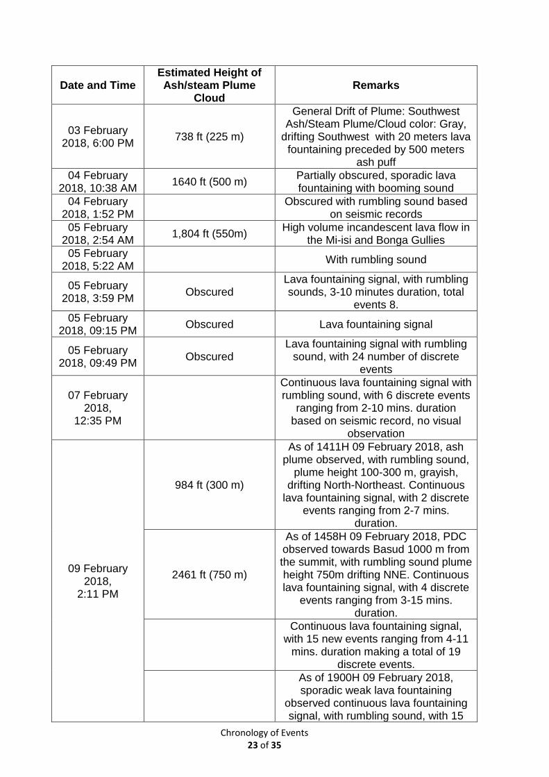
Chronology of Events 23 of 35
Date and Time Estimated Height of Ash/steam Plume
Cloud Remarks
03 February 2018, 6:00 PM
738 ft (225 m)
General Drift of Plume: Southwest Ash/Steam Plume/Cloud color: Gray,
drifting Southwest with 20 meters lava fountaining preceded by 500 meters
ash puff
04 February 2018, 10:38 AM
1640 ft (500 m) Partially obscured, sporadic lava fountaining with booming sound
04 February 2018, 1:52 PM
Obscured with rumbling sound based
on seismic records
05 February 2018, 2:54 AM
1,804 ft (550m) High volume incandescent lava flow in
the Mi-isi and Bonga Gullies
05 February 2018, 5:22 AM
With rumbling sound
05 February 2018, 3:59 PM
Obscured Lava fountaining signal, with rumbling sounds, 3-10 minutes duration, total
events 8.
05 February 2018, 09:15 PM
Obscured Lava fountaining signal
05 February 2018, 09:49 PM
Obscured Lava fountaining signal with rumbling
sound, with 24 number of discrete events
07 February 2018,
12:35 PM
Continuous lava fountaining signal with rumbling sound, with 6 discrete events
ranging from 2-10 mins. duration based on seismic record, no visual
observation
09 February 2018,
2:11 PM
984 ft (300 m)
As of 1411H 09 February 2018, ash plume observed, with rumbling sound,
plume height 100-300 m, grayish, drifting North-Northeast. Continuous
lava fountaining signal, with 2 discrete events ranging from 2-7 mins.
duration.
2461 ft (750 m)
As of 1458H 09 February 2018, PDC observed towards Basud 1000 m from the summit, with rumbling sound plume height 750m drifting NNE. Continuous lava fountaining signal, with 4 discrete
events ranging from 3-15 mins. duration.
Continuous lava fountaining signal, with 15 new events ranging from 4-11
mins. duration making a total of 19 discrete events.
As of 1900H 09 February 2018, sporadic weak lava fountaining
observed continuous lava fountaining signal, with rumbling sound, with 15
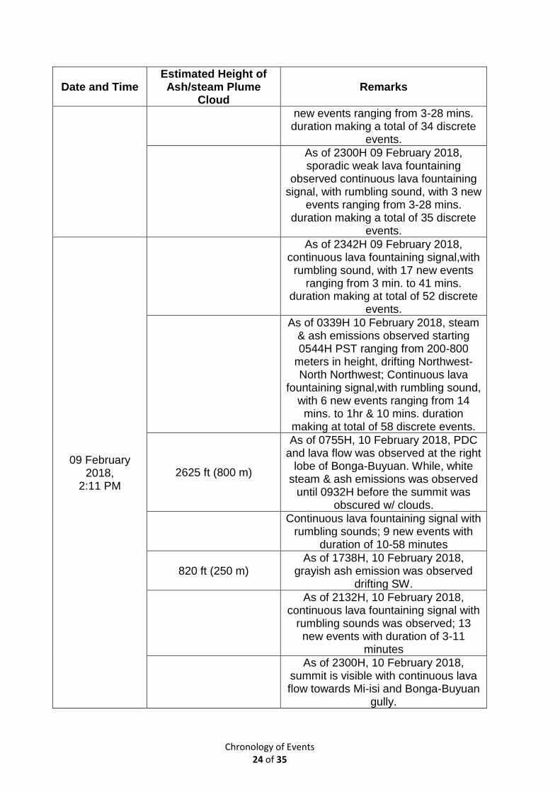
Chronology of Events 24 of 35
Date and Time Estimated Height of Ash/steam Plume
Cloud Remarks
new events ranging from 3-28 mins. duration making a total of 34 discrete
events.
As of 2300H 09 February 2018, sporadic weak lava fountaining
observed continuous lava fountaining signal, with rumbling sound, with 3 new
events ranging from 3-28 mins. duration making a total of 35 discrete
events.
09 February 2018,
2:11 PM
As of 2342H 09 February 2018, continuous lava fountaining signal,with
rumbling sound, with 17 new events ranging from 3 min. to 41 mins.
duration making at total of 52 discrete events.
As of 0339H 10 February 2018, steam & ash emissions observed starting 0544H PST ranging from 200-800
meters in height, drifting Northwest-North Northwest; Continuous lava
fountaining signal,with rumbling sound, with 6 new events ranging from 14 mins. to 1hr & 10 mins. duration
making at total of 58 discrete events.
2625 ft (800 m)
As of 0755H, 10 February 2018, PDC and lava flow was observed at the right
lobe of Bonga-Buyuan. While, white steam & ash emissions was observed
until 0932H before the summit was obscured w/ clouds.
Continuous lava fountaining signal with
rumbling sounds; 9 new events with duration of 10-58 minutes
820 ft (250 m) As of 1738H, 10 February 2018,
grayish ash emission was observed drifting SW.
As of 2132H, 10 February 2018, continuous lava fountaining signal with
rumbling sounds was observed; 13 new events with duration of 3-11
minutes
As of 2300H, 10 February 2018, summit is visible with continuous lava flow towards Mi-isi and Bonga-Buyuan
gully.
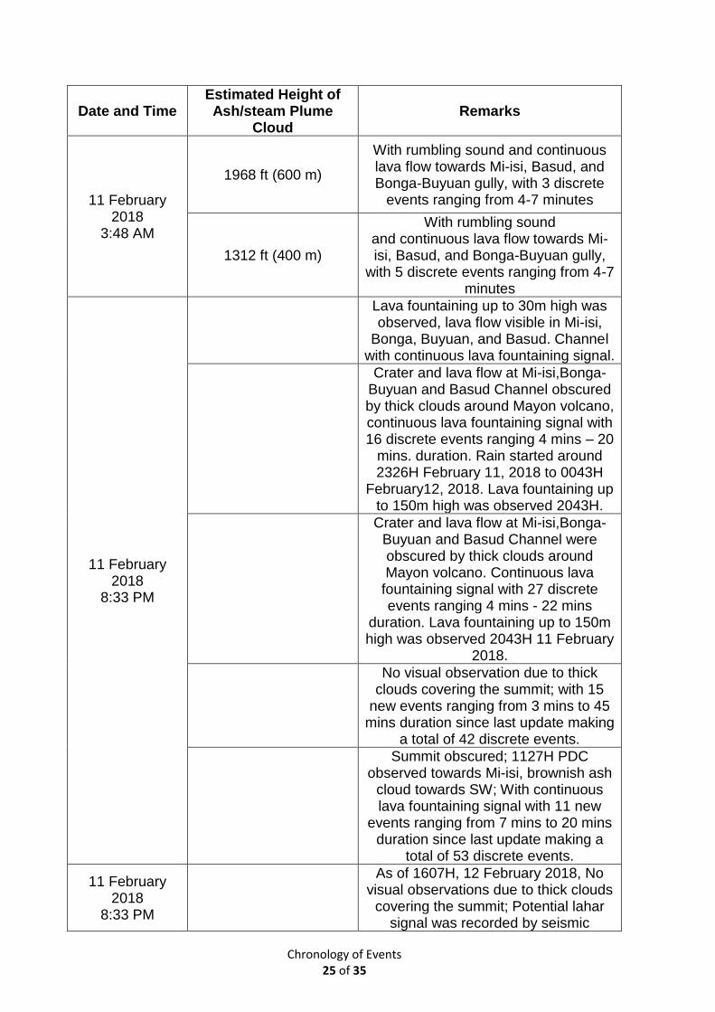
Chronology of Events 25 of 35
Date and Time Estimated Height of Ash/steam Plume
Cloud Remarks
11 February 2018
3:48 AM
1968 ft (600 m)
With rumbling sound and continuous lava flow towards Mi-isi, Basud, and Bonga-Buyuan gully, with 3 discrete
events ranging from 4-7 minutes
1312 ft (400 m)
With rumbling sound and continuous lava flow towards Mi-isi, Basud, and Bonga-Buyuan gully,
with 5 discrete events ranging from 4-7 minutes
11 February 2018
8:33 PM
Lava fountaining up to 30m high was observed, lava flow visible in Mi-isi,
Bonga, Buyuan, and Basud. Channel with continuous lava fountaining signal.
Crater and lava flow at Mi-isi,Bonga-Buyuan and Basud Channel obscured by thick clouds around Mayon volcano, continuous lava fountaining signal with 16 discrete events ranging 4 mins – 20
mins. duration. Rain started around 2326H February 11, 2018 to 0043H
February12, 2018. Lava fountaining up to 150m high was observed 2043H.
Crater and lava flow at Mi-isi,Bonga-Buyuan and Basud Channel were obscured by thick clouds around Mayon volcano. Continuous lava
fountaining signal with 27 discrete events ranging 4 mins - 22 mins
duration. Lava fountaining up to 150m high was observed 2043H 11 February
2018.
No visual observation due to thick clouds covering the summit; with 15
new events ranging from 3 mins to 45 mins duration since last update making
a total of 42 discrete events.
Summit obscured; 1127H PDC observed towards Mi-isi, brownish ash
cloud towards SW; With continuous lava fountaining signal with 11 new
events ranging from 7 mins to 20 mins duration since last update making a
total of 53 discrete events.
11 February 2018
8:33 PM
As of 1607H, 12 February 2018, No visual observations due to thick clouds
covering the summit; Potential lahar signal was recorded by seismic
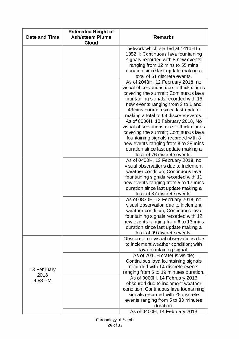
Chronology of Events 26 of 35
Date and Time Estimated Height of Ash/steam Plume
Cloud Remarks
network which started at 1416H to 1352H; Continuous lava fountaining signals recorded with 8 new events
ranging from 12 mins to 55 mins duration since last update making a
total of 61 discrete events.
As of 2043H, 12 February 2018, no visual observations due to thick clouds covering the summit; Continuous lava fountaining signals recorded with 15 new events ranging from 3 to 1 and 43mins duration since last update
making a total of 68 discrete events.
As of 0000H, 13 February 2018, No visual observations due to thick clouds covering the summit; Continuous lava
fountaining signals recorded with 8 new events ranging from 8 to 28 mins duration since last update making a
total of 76 discrete events.
As of 0400H, 13 February 2018, no visual observations due to inclement weather condition; Continuous lava fountaining signals recorded with 11
new events ranging from 5 to 17 mins duration since last update making a
total of 87 discrete events.
As of 0830H, 13 February 2018, no visual observation due to inclement weather condition; Continuous lava fountaining signals recorded with 12
new events ranging from 6 to 13 mins duration since last update making a
total of 99 discrete events.
13 February 2018
4:53 PM
Obscured; no visual observations due to inclement weather condition; with
lava fountaining signal.
As of 2011H crater is visible; Continuous lava fountaining signals
recorded with 14 discrete events ranging from 5 to 19 minutes duration.
As of 0000H, 14 February 2018 obscured due to inclement weather
condition; Continuous lava fountaining signals recorded with 25 discrete
events ranging from 5 to 33 minutes duration.
As of 0400H, 14 February 2018
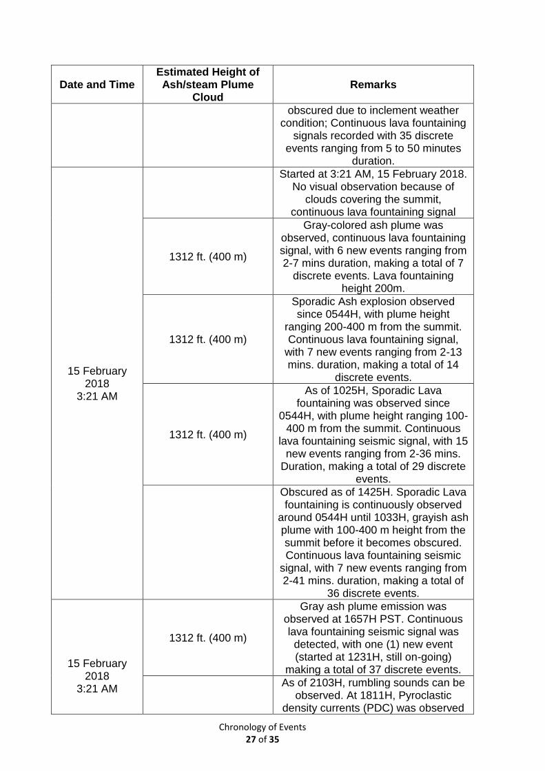
Chronology of Events 27 of 35
Date and Time Estimated Height of Ash/steam Plume
Cloud Remarks
obscured due to inclement weather condition; Continuous lava fountaining
signals recorded with 35 discrete events ranging from 5 to 50 minutes
duration.
15 February 2018
3:21 AM
Started at 3:21 AM, 15 February 2018. No visual observation because of
clouds covering the summit, continuous lava fountaining signal
1312 ft. (400 m)
Gray-colored ash plume was observed, continuous lava fountaining signal, with 6 new events ranging from 2-7 mins duration, making a total of 7
discrete events. Lava fountaining height 200m.
1312 ft. (400 m)
Sporadic Ash explosion observed since 0544H, with plume height
ranging 200-400 m from the summit. Continuous lava fountaining signal,
with 7 new events ranging from 2-13 mins. duration, making a total of 14
discrete events.
1312 ft. (400 m)
As of 1025H, Sporadic Lava fountaining was observed since
0544H, with plume height ranging 100-400 m from the summit. Continuous
lava fountaining seismic signal, with 15 new events ranging from 2-36 mins.
Duration, making a total of 29 discrete events.
Obscured as of 1425H. Sporadic Lava fountaining is continuously observed
around 0544H until 1033H, grayish ash plume with 100-400 m height from the summit before it becomes obscured. Continuous lava fountaining seismic
signal, with 7 new events ranging from 2-41 mins. duration, making a total of
36 discrete events.
15 February 2018
3:21 AM
1312 ft. (400 m)
Gray ash plume emission was observed at 1657H PST. Continuous lava fountaining seismic signal was detected, with one (1) new event (started at 1231H, still on-going)
making a total of 37 discrete events.
As of 2103H, rumbling sounds can be
observed. At 1811H, Pyroclastic density currents (PDC) was observed
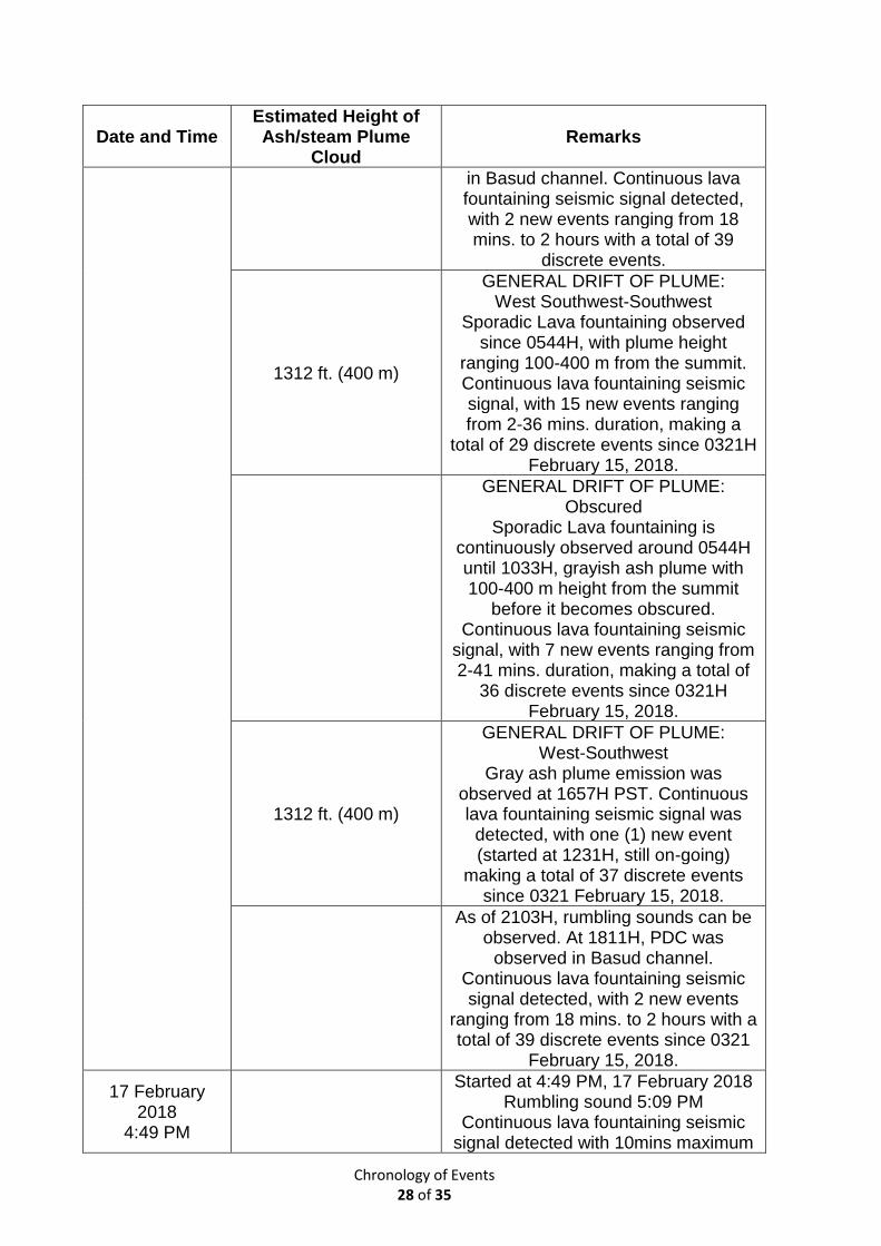
Chronology of Events 28 of 35
Date and Time Estimated Height of Ash/steam Plume
Cloud Remarks
in Basud channel. Continuous lava fountaining seismic signal detected, with 2 new events ranging from 18 mins. to 2 hours with a total of 39
discrete events.
1312 ft. (400 m)
GENERAL DRIFT OF PLUME: West Southwest-Southwest
Sporadic Lava fountaining observed since 0544H, with plume height
ranging 100-400 m from the summit. Continuous lava fountaining seismic signal, with 15 new events ranging from 2-36 mins. duration, making a
total of 29 discrete events since 0321H February 15, 2018.
GENERAL DRIFT OF PLUME: Obscured
Sporadic Lava fountaining is continuously observed around 0544H until 1033H, grayish ash plume with 100-400 m height from the summit
before it becomes obscured. Continuous lava fountaining seismic
signal, with 7 new events ranging from 2-41 mins. duration, making a total of
36 discrete events since 0321H February 15, 2018.
1312 ft. (400 m)
GENERAL DRIFT OF PLUME: West-Southwest
Gray ash plume emission was observed at 1657H PST. Continuous lava fountaining seismic signal was detected, with one (1) new event (started at 1231H, still on-going)
making a total of 37 discrete events since 0321 February 15, 2018.
As of 2103H, rumbling sounds can be observed. At 1811H, PDC was
observed in Basud channel. Continuous lava fountaining seismic signal detected, with 2 new events
ranging from 18 mins. to 2 hours with a total of 39 discrete events since 0321
February 15, 2018.
17 February 2018
4:49 PM
Started at 4:49 PM, 17 February 2018 Rumbling sound 5:09 PM
Continuous lava fountaining seismic signal detected with 10mins maximum
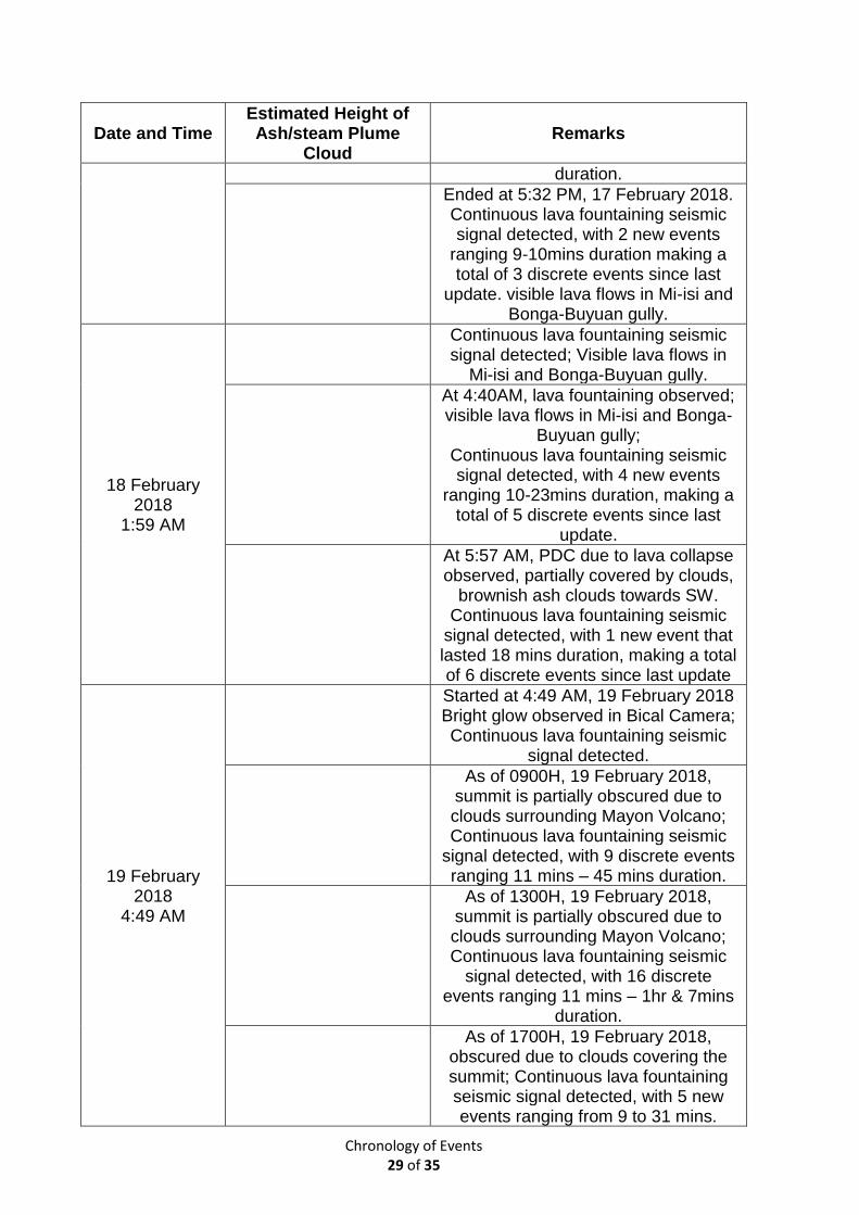
Chronology of Events 29 of 35
Date and Time Estimated Height of Ash/steam Plume
Cloud Remarks
duration.
Ended at 5:32 PM, 17 February 2018. Continuous lava fountaining seismic signal detected, with 2 new events
ranging 9-10mins duration making a total of 3 discrete events since last
update. visible lava flows in Mi-isi and Bonga-Buyuan gully.
18 February 2018
1:59 AM
Continuous lava fountaining seismic signal detected; Visible lava flows in
Mi-isi and Bonga-Buyuan gully.
At 4:40AM, lava fountaining observed; visible lava flows in Mi-isi and Bonga-
Buyuan gully; Continuous lava fountaining seismic signal detected, with 4 new events
ranging 10-23mins duration, making a total of 5 discrete events since last
update.
At 5:57 AM, PDC due to lava collapse observed, partially covered by clouds,
brownish ash clouds towards SW. Continuous lava fountaining seismic
signal detected, with 1 new event that lasted 18 mins duration, making a total of 6 discrete events since last update
19 February 2018
4:49 AM
Started at 4:49 AM, 19 February 2018 Bright glow observed in Bical Camera; Continuous lava fountaining seismic
signal detected.
As of 0900H, 19 February 2018, summit is partially obscured due to clouds surrounding Mayon Volcano; Continuous lava fountaining seismic
signal detected, with 9 discrete events ranging 11 mins – 45 mins duration.
As of 1300H, 19 February 2018, summit is partially obscured due to clouds surrounding Mayon Volcano; Continuous lava fountaining seismic
signal detected, with 16 discrete events ranging 11 mins – 1hr & 7mins
duration.
As of 1700H, 19 February 2018, obscured due to clouds covering the summit; Continuous lava fountaining seismic signal detected, with 5 new events ranging from 9 to 31 mins.
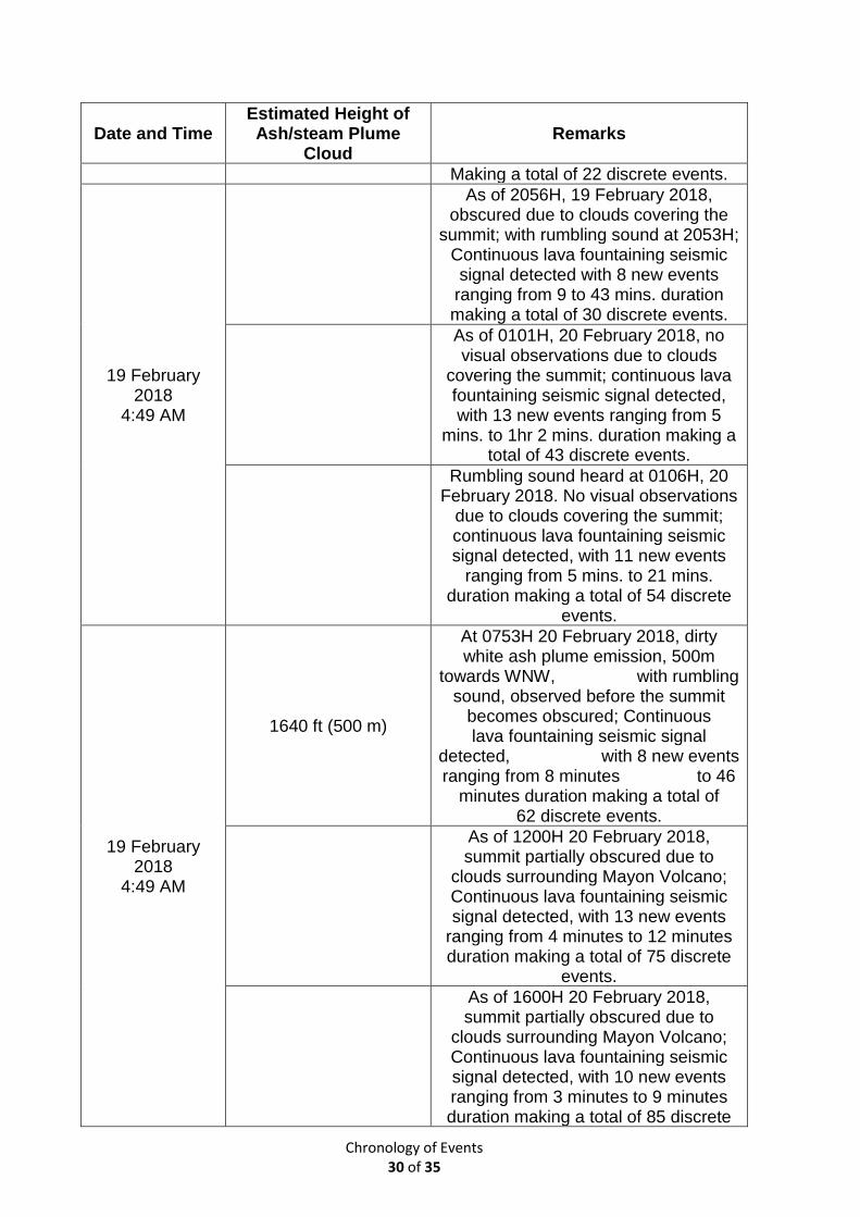
Chronology of Events 30 of 35
Date and Time Estimated Height of Ash/steam Plume
Cloud Remarks
Making a total of 22 discrete events.
19 February 2018
4:49 AM
As of 2056H, 19 February 2018, obscured due to clouds covering the
summit; with rumbling sound at 2053H; Continuous lava fountaining seismic signal detected with 8 new events
ranging from 9 to 43 mins. duration making a total of 30 discrete events.
As of 0101H, 20 February 2018, no visual observations due to clouds
covering the summit; continuous lava fountaining seismic signal detected, with 13 new events ranging from 5
mins. to 1hr 2 mins. duration making a total of 43 discrete events.
Rumbling sound heard at 0106H, 20 February 2018. No visual observations
due to clouds covering the summit; continuous lava fountaining seismic signal detected, with 11 new events
ranging from 5 mins. to 21 mins. duration making a total of 54 discrete
events.
19 February 2018
4:49 AM
1640 ft (500 m)
At 0753H 20 February 2018, dirty white ash plume emission, 500m
towards WNW, with rumbling sound, observed before the summit
becomes obscured; Continuous lava fountaining seismic signal
detected, with 8 new events ranging from 8 minutes to 46
minutes duration making a total of 62 discrete events.
As of 1200H 20 February 2018, summit partially obscured due to
clouds surrounding Mayon Volcano; Continuous lava fountaining seismic signal detected, with 13 new events
ranging from 4 minutes to 12 minutes duration making a total of 75 discrete
events.
As of 1600H 20 February 2018, summit partially obscured due to
clouds surrounding Mayon Volcano; Continuous lava fountaining seismic signal detected, with 10 new events ranging from 3 minutes to 9 minutes duration making a total of 85 discrete
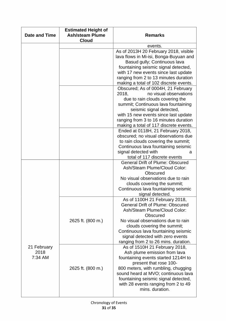
Chronology of Events 31 of 35
Date and Time Estimated Height of Ash/steam Plume
Cloud Remarks
events.
As of 2013H 20 February 2018, visible lava flows in Mi-isi, Bonga-Buyuan and
Basud gully; Continuous lava fountaining seismic signal detected, with 17 new events since last update ranging from 2 to 13 minutes duration making a total of 102 discrete events.
Obscured; As of 0004H, 21 February 2018, no visual observations
due to rain clouds covering the summit; Continuous lava fountaining
seismic signal detected, with 15 new events since last update ranging from 3 to 16 minutes duration making a total of 117 discrete events.
Ended at 0118H, 21 February 2018, obscured; no visual observations due to rain clouds covering the summit; Continuous lava fountaining seismic signal detected with a
total of 117 discrete events
21 February 2018
7:34 AM
General Drift of Plume: Obscured Ash/Steam Plume/Cloud Color:
Obscured No visual observations due to rain
clouds covering the summit; Continuous lava fountaining seismic
signal detected.
2625 ft. (800 m.)
As of 1100H 21 February 2018, General Drift of Plume: Obscured Ash/Steam Plume/Cloud Color:
Obscured No visual observations due to rain
clouds covering the summit; Continuous lava fountaining seismic
signal detected with zero events ranging from 2 to 26 mins. duration.
2625 ft. (800 m.)
As of 1510H 21 February 2018, Ash plume emission from lava
fountaining events started 1214H to present that rose 100-
800 meters, with rumbling, chugging sound heard at MVO; continuous lava fountaining seismic signal detected, with 28 events ranging from 2 to 49
mins. duration.
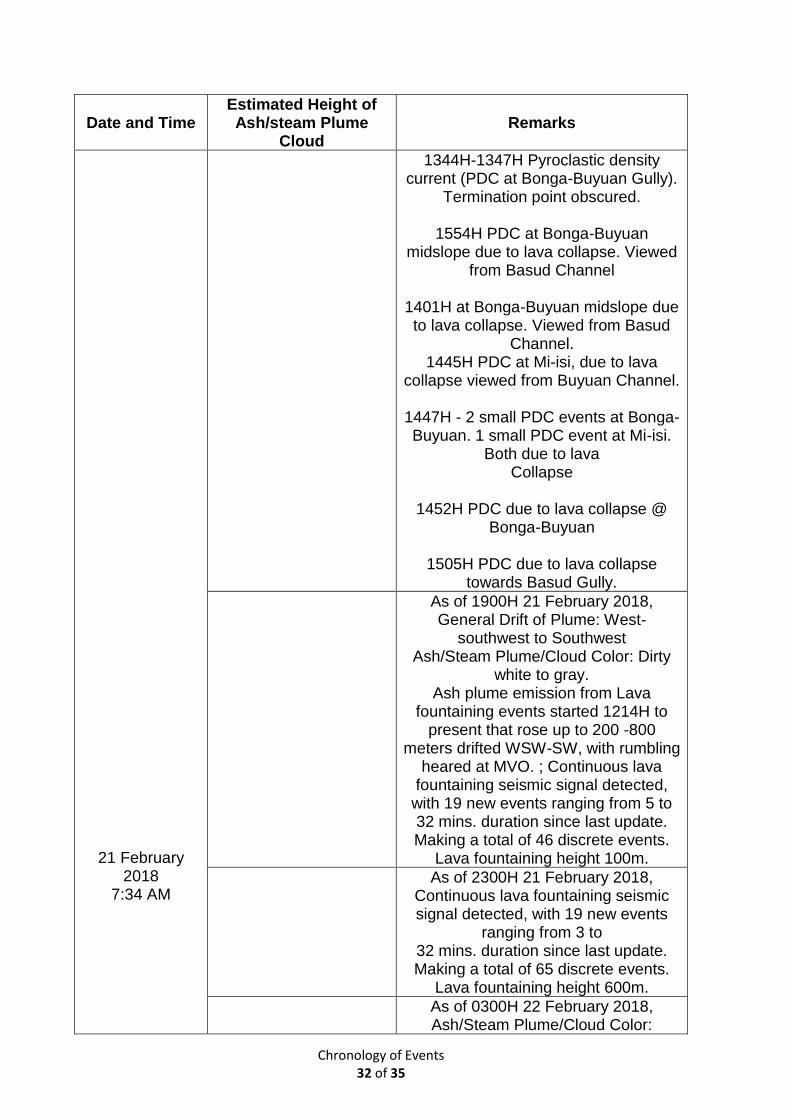
Chronology of Events 32 of 35
Date and Time Estimated Height of Ash/steam Plume
Cloud Remarks
21 February 2018
7:34 AM
1344H-1347H Pyroclastic density current (PDC at Bonga-Buyuan Gully).
Termination point obscured.
1554H PDC at Bonga-Buyuan midslope due to lava collapse. Viewed
from Basud Channel
1401H at Bonga-Buyuan midslope due to lava collapse. Viewed from Basud
Channel. 1445H PDC at Mi-isi, due to lava
collapse viewed from Buyuan Channel.
1447H - 2 small PDC events at Bonga-Buyuan. 1 small PDC event at Mi-isi.
Both due to lava Collapse
1452H PDC due to lava collapse @
Bonga-Buyuan
1505H PDC due to lava collapse towards Basud Gully.
As of 1900H 21 February 2018, General Drift of Plume: West-
southwest to Southwest Ash/Steam Plume/Cloud Color: Dirty
white to gray. Ash plume emission from Lava
fountaining events started 1214H to present that rose up to 200 -800
meters drifted WSW-SW, with rumbling heared at MVO. ; Continuous lava
fountaining seismic signal detected, with 19 new events ranging from 5 to 32 mins. duration since last update. Making a total of 46 discrete events.
Lava fountaining height 100m.
As of 2300H 21 February 2018, Continuous lava fountaining seismic signal detected, with 19 new events
ranging from 3 to 32 mins. duration since last update. Making a total of 65 discrete events.
Lava fountaining height 600m.
As of 0300H 22 February 2018, Ash/Steam Plume/Cloud Color:
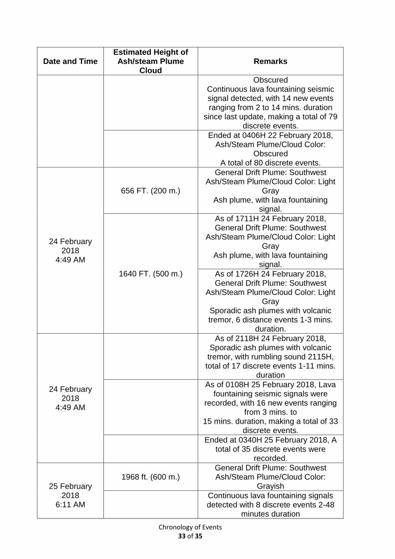
Chronology of Events 33 of 35
Date and Time Estimated Height of Ash/steam Plume
Cloud Remarks
Obscured Continuous lava fountaining seismic signal detected, with 14 new events ranging from 2 to 14 mins. duration
since last update, making a total of 79 discrete events.
Ended at 0406H 22 February 2018, Ash/Steam Plume/Cloud Color:
Obscured A total of 80 discrete events.
24 February 2018
4:49 AM
656 FT. (200 m.)
General Drift Plume: Southwest Ash/Steam Plume/Cloud Color: Light
Gray Ash plume, with lava fountaining
signal.
1640 FT. (500 m.)
As of 1711H 24 February 2018, General Drift Plume: Southwest
Ash/Steam Plume/Cloud Color: Light Gray
Ash plume, with lava fountaining signal.
As of 1726H 24 February 2018, General Drift Plume: Southwest
Ash/Steam Plume/Cloud Color: Light Gray
Sporadic ash plumes with volcanic tremor, 6 distance events 1-3 mins.
duration.
24 February 2018
4:49 AM
As of 2118H 24 February 2018, Sporadic ash plumes with volcanic
tremor, with rumbling sound 2115H, total of 17 discrete events 1-11 mins.
duration
As of 0108H 25 February 2018, Lava fountaining seismic signals were
recorded, with 16 new events ranging from 3 mins. to
15 mins. duration, making a total of 33 discrete events.
Ended at 0340H 25 February 2018, A
total of 35 discrete events were recorded.
25 February 2018
6:11 AM
1968 ft. (600 m.) General Drift Plume: Southwest Ash/Steam Plume/Cloud Color:
Grayish
Continuous lava fountaining signals detected with 8 discrete events 2-48
minutes duration
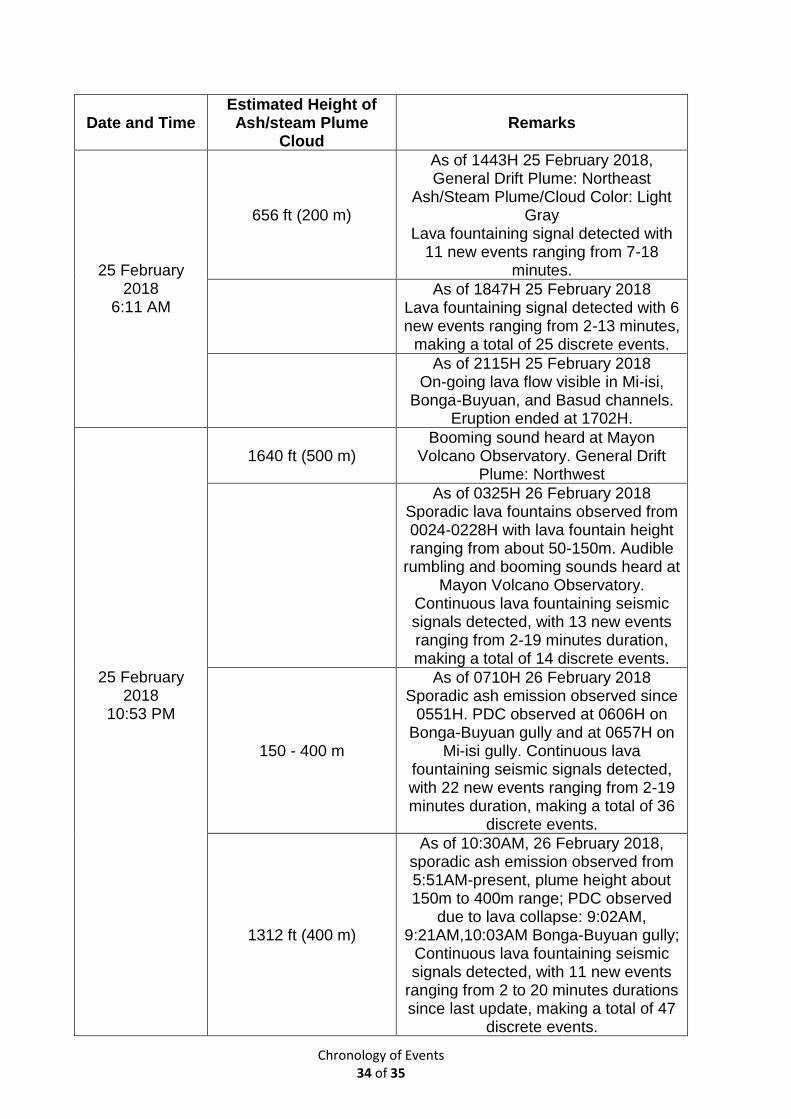
Chronology of Events 34 of 35
Date and Time Estimated Height of Ash/steam Plume
Cloud Remarks
25 February 2018
6:11 AM
656 ft (200 m)
As of 1443H 25 February 2018, General Drift Plume: Northeast
Ash/Steam Plume/Cloud Color: Light Gray
Lava fountaining signal detected with 11 new events ranging from 7-18
minutes.
As of 1847H 25 February 2018 Lava fountaining signal detected with 6 new events ranging from 2-13 minutes,
making a total of 25 discrete events.
As of 2115H 25 February 2018 On-going lava flow visible in Mi-isi,
Bonga-Buyuan, and Basud channels. Eruption ended at 1702H.
25 February 2018
10:53 PM
1640 ft (500 m) Booming sound heard at Mayon
Volcano Observatory. General Drift Plume: Northwest
As of 0325H 26 February 2018 Sporadic lava fountains observed from 0024-0228H with lava fountain height ranging from about 50-150m. Audible
rumbling and booming sounds heard at Mayon Volcano Observatory.
Continuous lava fountaining seismic signals detected, with 13 new events ranging from 2-19 minutes duration, making a total of 14 discrete events.
150 - 400 m
As of 0710H 26 February 2018 Sporadic ash emission observed since
0551H. PDC observed at 0606H on Bonga-Buyuan gully and at 0657H on
Mi-isi gully. Continuous lava fountaining seismic signals detected, with 22 new events ranging from 2-19 minutes duration, making a total of 36
discrete events.
1312 ft (400 m)
As of 10:30AM, 26 February 2018, sporadic ash emission observed from 5:51AM-present, plume height about 150m to 400m range; PDC observed
due to lava collapse: 9:02AM, 9:21AM,10:03AM Bonga-Buyuan gully;
Continuous lava fountaining seismic signals detected, with 11 new events
ranging from 2 to 20 minutes durations since last update, making a total of 47
discrete events.
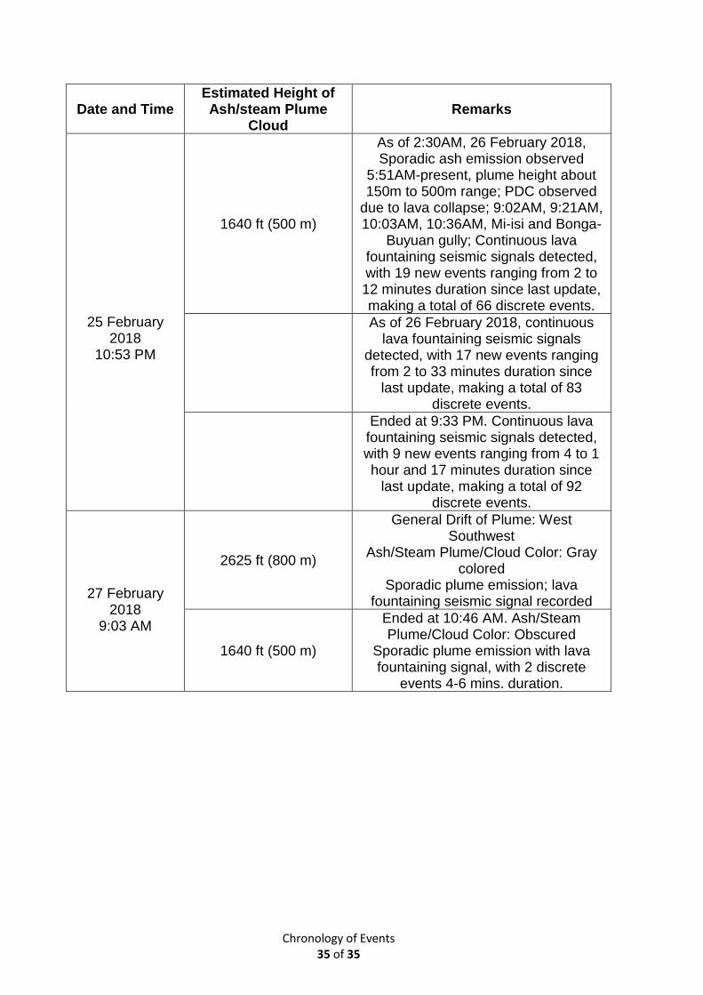
Chronology of Events 35 of 35
Date and Time Estimated Height of Ash/steam Plume
Cloud Remarks
25 February 2018
10:53 PM
1640 ft (500 m)
As of 2:30AM, 26 February 2018, Sporadic ash emission observed
5:51AM-present, plume height about 150m to 500m range; PDC observed
due to lava collapse; 9:02AM, 9:21AM, 10:03AM, 10:36AM, Mi-isi and Bonga-
Buyuan gully; Continuous lava fountaining seismic signals detected, with 19 new events ranging from 2 to 12 minutes duration since last update, making a total of 66 discrete events.
As of 26 February 2018, continuous lava fountaining seismic signals
detected, with 17 new events ranging from 2 to 33 minutes duration since
last update, making a total of 83 discrete events.
Ended at 9:33 PM. Continuous lava fountaining seismic signals detected, with 9 new events ranging from 4 to 1 hour and 17 minutes duration since
last update, making a total of 92 discrete events.
27 February
2018 9:03 AM
2625 ft (800 m)
General Drift of Plume: West Southwest
Ash/Steam Plume/Cloud Color: Gray colored
Sporadic plume emission; lava fountaining seismic signal recorded
1640 ft (500 m)
Ended at 10:46 AM. Ash/Steam Plume/Cloud Color: Obscured
Sporadic plume emission with lava fountaining signal, with 2 discrete
events 4-6 mins. duration.
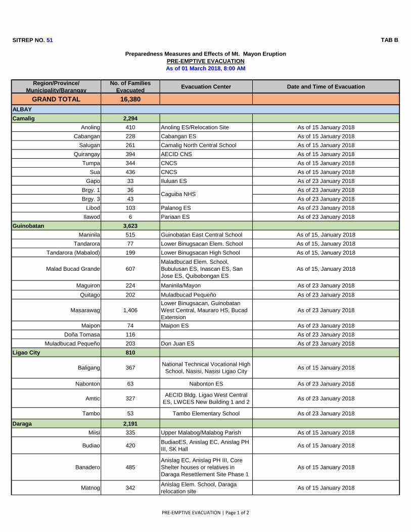
SITREP NO. 51 TAB B
Region/Province/
Municipality/Barangay
No. of Families
EvacuatedEvacuation Center Date and Time of Evacuation
GRAND TOTAL 16,380
ALBAY
Camalig 2,294
Anoling 410 Anoling ES/Relocation Site As of 15 January 2018
Cabangan 228 Cabangan ES As of 15 January 2018
Salugan 261 Camalig North Central School As of 15 January 2018
Quirangay 394 AECID CNS As of 15 January 2018
Tumpa 344 CNCS As of 15 January 2018
Sua 436 CNCS As of 15 January 2018
Gapo 33 Iluluan ES As of 23 January 2018
Brgy. 1 36 As of 23 January 2018
Brgy. 3 43 As of 23 January 2018
Libod 103 Palanog ES As of 23 January 2018
Ilawod 6 Pariaan ES As of 23 January 2018
Guinobatan 3,623
Maninila 515 Guinobatan East Central School As of 15, January 2018
Tandarora 77 Lower Binugsacan Elem. School As of 15, January 2018
Tandarora (Mabalod) 199 Lower Binugsacan High School As of 15, January 2018
Malad Bucad Grande 607
Maladbucad Elem. School,
Bubulusan ES, Inascan ES, San
Jose ES, Quibobongan ES
As of 15, January 2018
Maguiron 224 Maninila/Mayon As of 23 January 2018
Quitago 202 Muladbucad Pequeño As of 23 January 2018
Masarawag 1,406
Lower Binugsacan, Guinobatan
West Central, Mauraro HS, Bucad
Extension
As of 23 January 2018
Maipon 74 Maipon ES As of 23 January 2018
Doña Tomasa 116 As of 23 January 2018
Muladbucad Pequeño 203 Don Juan ES As of 23 January 2018
Ligao City 810
Baligang 367National Technical Vocational High
School, Nasisi, Nasisi Ligao CityAs of 15 January 2018
Nabonton 63 Nabonton ES As of 23 January 2018
Amtic 327AECID Bldg. Ligao West Central
ES, LWCES New Building 1 and 2 As of 23 January 2018
Tambo 53 Tambo Elementary School As of 23 January 2018
Daraga 2,191
Miisi 335 Upper Malabog/Malabog Parish As of 15 January 2018
Budiao 420BudiaoES, Anislag EC, Anislag PH
III, SK HallAs of 15 January 2018
Banadero 485
Anislag EC, Anislag PH III, Core
Shelter houses or relatives in
Daraga Resettlement Site Phase 1
As of 15 January 2018
Matnog 342Anislag Elem. School, Daraga
relocation siteAs of 15 January 2018
Preparedness Measures and Effects of Mt. Mayon Eruption
PRE-EMPTIVE EVACUATION
As of 01 March 2018, 8:00 AM
Caguiba NHS
PRE-EMPTIVE EVACUATION | Page 1 of 2
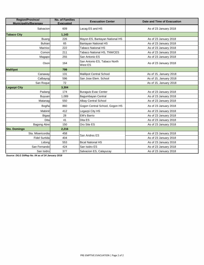
Region/Province/
Municipality/Barangay
No. of Families
EvacuatedEvacuation Center Date and Time of Evacuation
Salvacion 609 Lacag ES and HS As of 23 January 2018
Tabaco City 1,143
Buang 226 Mayon ES, Bantayan National HS As of 23 January 2018
Buhian 65 Bantayan National HS As of 23 January 2018
Maririoc 222 Tabaco National HS As of 23 January 2018
Comon 211 Tabaco National HS, TNWCES As of 23 January 2018
Magapo 255 San Antonio ES As of 23 January 2018
Oson 164San Antonio ES, Tabaco North
West ESAs of 23 January 2018
Malilipot 799
Canaway 131 Malilipot Central School As of 15, January 2018
Calbayog 596 San Jose Elem. School As of 15, January 2018
San Roque 72 As of 15, January 2018
Legazpi City 3,304
Padang 174 Buraguis Evac Center As of 23 January 2018
Buyuan 1,089 Bagumbayan Central As of 23 January 2018
Matanag 550 Albay Central School As of 23 January 2018
Bogña 860 Gogon Central School, Gogon HS As of 23 January 2018
Mabinit 412 Legazpi City HS As of 23 January 2018
Bigaa 28 EM's Barrio As of 23 January 2018
Dita 41 Dita ES As of 23 January 2018
Bagong Abre 150 Oro Site ES As of 23 January 2018
Sto. Domingo 2,216
Sta. Misericordia 458 As of 23 January 2018
Fidel Surtida 404 As of 23 January 2018
Lidong 553 Bical National HS As of 23 January 2018
San Fernando 424 San Isidro ES As of 23 January 2018
San Isidro 377 Salvacion ES, Calayucay As of 23 January 2018
Source: DILG SitRep No. 04 as of 24 January 2018
San Andres ES
PRE-EMPTIVE EVACUATION | Page 2 of 2
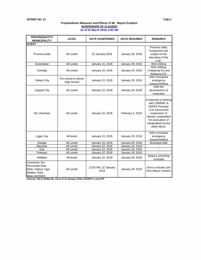
SITREP NO. 51 TAB C
PROVINCE/CITY/
MUNICIPALITYLEVEL DATE SUSPENDED DATE RESUMED REMARKS
Province-wide All Levels 22 January 2018 January 29, 2018
Province wide;
Suspension are
subject to the
discretion of the
LCE.Guinobatan All Levels January 15, 2018 January 29, 2018 With shifting
Camalig All Levels January 15, 2018 January 29, 2018
With shifting;
(Taladong ES and
Baligang ES)
Tabaco CityPre-school to Senior
High SchoolJanuary 15, 2018 January 29, 2018
With scheduled
emergency
classes/shifting
Legazpi City All Levels January 15, 2018 January 29, 2018
With the
decampment of
evacuees
Sto. Domingo All Levels January 22, 2018 February 2, 2018
Conducted a meeting
with LDRRMC &
DEPEd Principal.
LCE announced
suspension of
classes, preparation
for evacuation of
marginalized sector
within 6kms.
Ligao City All levels January 15, 2018 January 29, 2018
With scheduled
emergency
classes/shifting
Daraga All Levels January 15, 2018 January 29, 2018 Municipal wide
Bacacay All Levels January 22, 2018 January 24, 2018 -
Oas All Levels January 22, 2018 January 29, 2018 -
Polangui All Levels January 22, 2018 January 29, 2018 -
Malilipot All levels January 22, 2018 January 29, 2018Adopt a scheming
schedule
Camarines Sur
Rinconada Area
(Bato, Nabua, Iriga,
Balatan, Bula,
Baao and Buhi)
All Levels12:00 NN, 22 January
2018January 29, 2018
Due to volcanic ash
from Mayon Volcano
Sources: DILG SitRep No. 03 as of 22 January 2018, OCDRO V, and AFP
Preparedness Measures and Effects of Mt. Mayon Eruption
SUSPENSION OF CLASSES
As of 01 March 2018, 8:00 AM
ALBAY
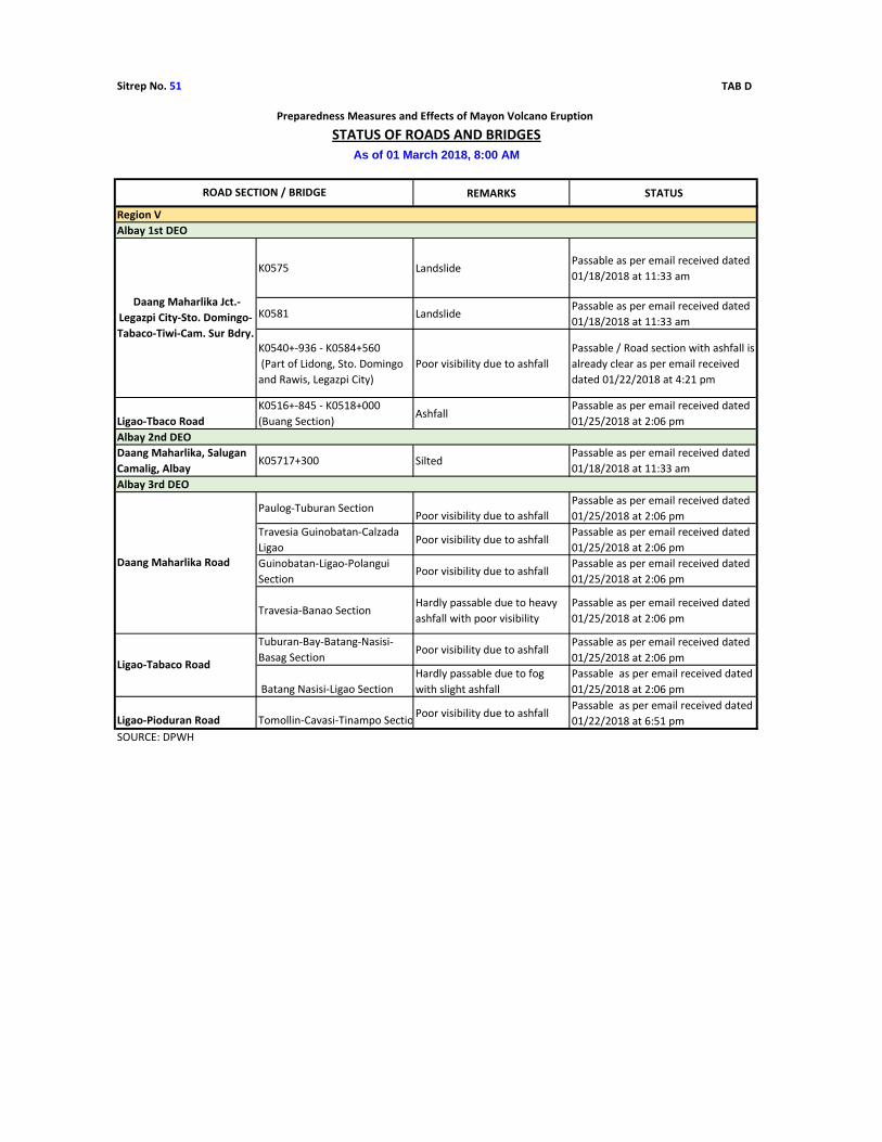
Sitrep No. 51 TAB D
REMARKS STATUS
K0575 LandslidePassable as per email received dated
01/18/2018 at 11:33 am
K0581 LandslidePassable as per email received dated
01/18/2018 at 11:33 am
K0540+-936 - K0584+560
(Part of Lidong, Sto. Domingo
and Rawis, Legazpi City)
Poor visibility due to ashfall
Passable / Road section with ashfall is
already clear as per email received
dated 01/22/2018 at 4:21 pm
Ligao-Tbaco Road
K0516+-845 - K0518+000
(Buang Section)Ashfall
Passable as per email received dated
01/25/2018 at 2:06 pm
Daang Maharlika, Salugan
Camalig, AlbayK05717+300 Silted
Passable as per email received dated
01/18/2018 at 11:33 am
Paulog-Tuburan SectionPoor visibility due to ashfall
Passable as per email received dated
01/25/2018 at 2:06 pm
Travesia Guinobatan-Calzada
LigaoPoor visibility due to ashfall
Passable as per email received dated
01/25/2018 at 2:06 pm
Guinobatan-Ligao-Polangui
SectionPoor visibility due to ashfall
Passable as per email received dated
01/25/2018 at 2:06 pm
Travesia-Banao SectionHardly passable due to heavy
ashfall with poor visibility
Passable as per email received dated
01/25/2018 at 2:06 pm
Tuburan-Bay-Batang-Nasisi-
Basag SectionPoor visibility due to ashfall
Passable as per email received dated
01/25/2018 at 2:06 pm
Batang Nasisi-Ligao Section
Hardly passable due to fog
with slight ashfall
Passable as per email received dated
01/25/2018 at 2:06 pm
Ligao-Pioduran Road Tomollin-Cavasi-Tinampo SectionPoor visibility due to ashfall
Passable as per email received dated
01/22/2018 at 6:51 pm
SOURCE: DPWH
Albay 1st DEO
Preparedness Measures and Effects of Mayon Volcano Eruption
STATUS OF ROADS AND BRIDGES
As of 01 March 2018, 8:00 AM
ROAD SECTION / BRIDGE
Region V
Daang Maharlika Jct.-
Legazpi City-Sto. Domingo-
Tabaco-Tiwi-Cam. Sur Bdry.
Albay 2nd DEO
Albay 3rd DEO
Daang Maharlika Road
Ligao-Tabaco Road
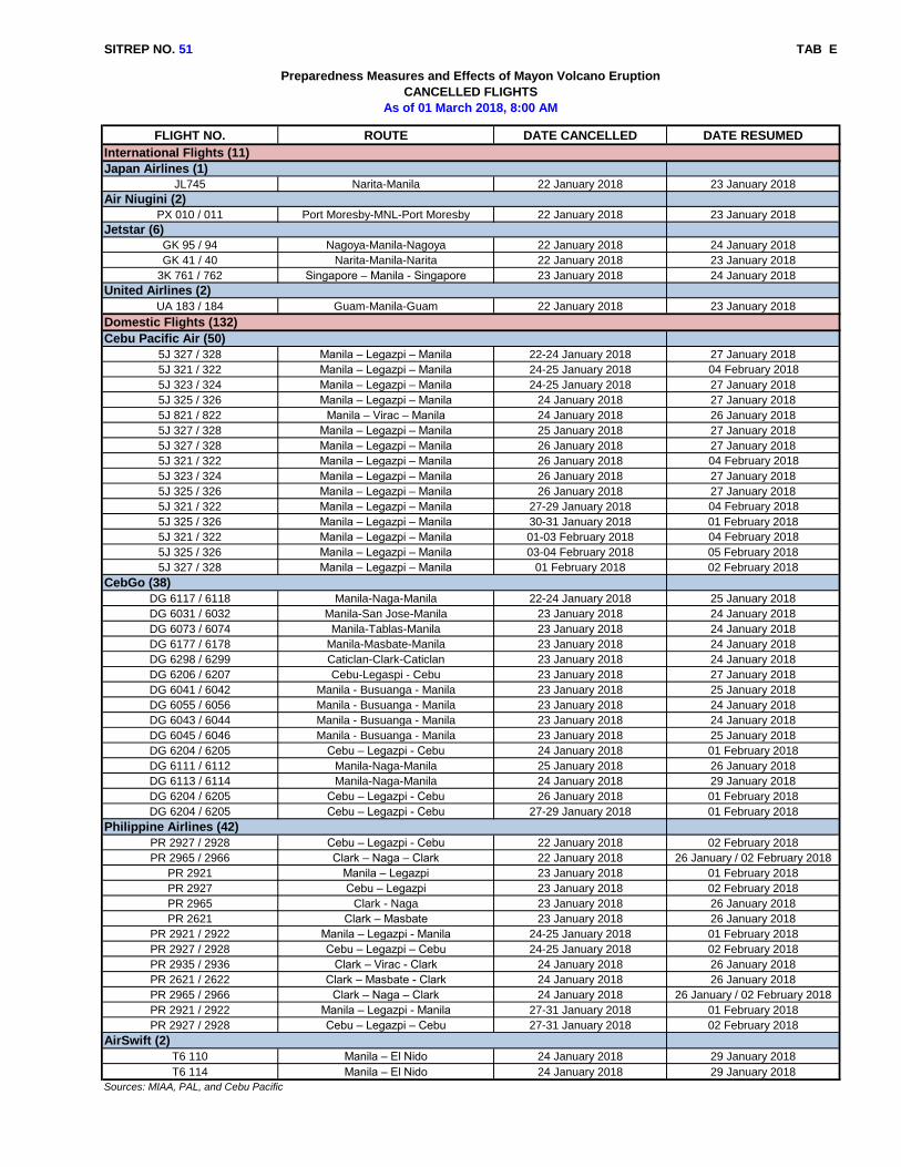
SITREP NO. 51 TAB E
FLIGHT NO. ROUTE DATE CANCELLED DATE RESUMED
JL745 Narita-Manila 22 January 2018 23 January 2018
PX 010 / 011 Port Moresby-MNL-Port Moresby 22 January 2018 23 January 2018
GK 95 / 94 Nagoya-Manila-Nagoya 22 January 2018 24 January 2018
GK 41 / 40 Narita-Manila-Narita 22 January 2018 23 January 2018
3K 761 / 762 Singapore – Manila - Singapore 23 January 2018 24 January 2018
UA 183 / 184 Guam-Manila-Guam 22 January 2018 23 January 2018
5J 327 / 328 Manila – Legazpi – Manila 22-24 January 2018 27 January 2018
5J 321 / 322 Manila – Legazpi – Manila 24-25 January 2018 04 February 2018
5J 323 / 324 Manila – Legazpi – Manila 24-25 January 2018 27 January 2018
5J 325 / 326 Manila – Legazpi – Manila 24 January 2018 27 January 2018
5J 821 / 822 Manila – Virac – Manila 24 January 2018 26 January 2018
5J 327 / 328 Manila – Legazpi – Manila 25 January 2018 27 January 2018
5J 327 / 328 Manila – Legazpi – Manila 26 January 2018 27 January 2018
5J 321 / 322 Manila – Legazpi – Manila 26 January 2018 04 February 2018
5J 323 / 324 Manila – Legazpi – Manila 26 January 2018 27 January 2018
5J 325 / 326 Manila – Legazpi – Manila 26 January 2018 27 January 2018
5J 321 / 322 Manila – Legazpi – Manila 27-29 January 2018 04 February 2018
5J 325 / 326 Manila – Legazpi – Manila 30-31 January 2018 01 February 2018
5J 321 / 322 Manila – Legazpi – Manila 01-03 February 2018 04 February 2018
5J 325 / 326 Manila – Legazpi – Manila 03-04 February 2018 05 February 2018
5J 327 / 328 Manila – Legazpi – Manila 01 February 2018 02 February 2018
DG 6117 / 6118 Manila-Naga-Manila 22-24 January 2018 25 January 2018
DG 6031 / 6032 Manila-San Jose-Manila 23 January 2018 24 January 2018
DG 6073 / 6074 Manila-Tablas-Manila 23 January 2018 24 January 2018
DG 6177 / 6178 Manila-Masbate-Manila 23 January 2018 24 January 2018
DG 6298 / 6299 Caticlan-Clark-Caticlan 23 January 2018 24 January 2018
DG 6206 / 6207 Cebu-Legaspi - Cebu 23 January 2018 27 January 2018
DG 6041 / 6042 Manila - Busuanga - Manila 23 January 2018 25 January 2018
DG 6055 / 6056 Manila - Busuanga - Manila 23 January 2018 24 January 2018
DG 6043 / 6044 Manila - Busuanga - Manila 23 January 2018 24 January 2018
DG 6045 / 6046 Manila - Busuanga - Manila 23 January 2018 25 January 2018
DG 6204 / 6205 Cebu – Legazpi - Cebu 24 January 2018 01 February 2018
DG 6111 / 6112 Manila-Naga-Manila 25 January 2018 26 January 2018
DG 6113 / 6114 Manila-Naga-Manila 24 January 2018 29 January 2018
DG 6204 / 6205 Cebu – Legazpi - Cebu 26 January 2018 01 February 2018
DG 6204 / 6205 Cebu – Legazpi - Cebu 27-29 January 2018 01 February 2018
PR 2927 / 2928 Cebu – Legazpi - Cebu 22 January 2018 02 February 2018
PR 2965 / 2966 Clark – Naga – Clark 22 January 2018 26 January / 02 February 2018
PR 2921 Manila – Legazpi 23 January 2018 01 February 2018
PR 2927 Cebu – Legazpi 23 January 2018 02 February 2018
PR 2965 Clark - Naga 23 January 2018 26 January 2018
PR 2621 Clark – Masbate 23 January 2018 26 January 2018
PR 2921 / 2922 Manila – Legazpi - Manila 24-25 January 2018 01 February 2018
PR 2927 / 2928 Cebu – Legazpi – Cebu 24-25 January 2018 02 February 2018
PR 2935 / 2936 Clark – Virac - Clark 24 January 2018 26 January 2018
PR 2621 / 2622 Clark – Masbate - Clark 24 January 2018 26 January 2018
PR 2965 / 2966 Clark – Naga – Clark 24 January 2018 26 January / 02 February 2018
PR 2921 / 2922 Manila – Legazpi - Manila 27-31 January 2018 01 February 2018
PR 2927 / 2928 Cebu – Legazpi – Cebu 27-31 January 2018 02 February 2018
T6 110 Manila – El Nido 24 January 2018 29 January 2018
T6 114 Manila – El Nido 24 January 2018 29 January 2018
Air Niugini (2)
Preparedness Measures and Effects of Mayon Volcano Eruption
CANCELLED FLIGHTS
As of 01 March 2018, 8:00 AM
International Flights (11)
Japan Airlines (1)
AirSwift (2)
Sources: MIAA, PAL, and Cebu Pacific
Jetstar (6)
United Airlines (2)
Domestic Flights (132)
Cebu Pacific Air (50)
CebGo (38)
Philippine Airlines (42)
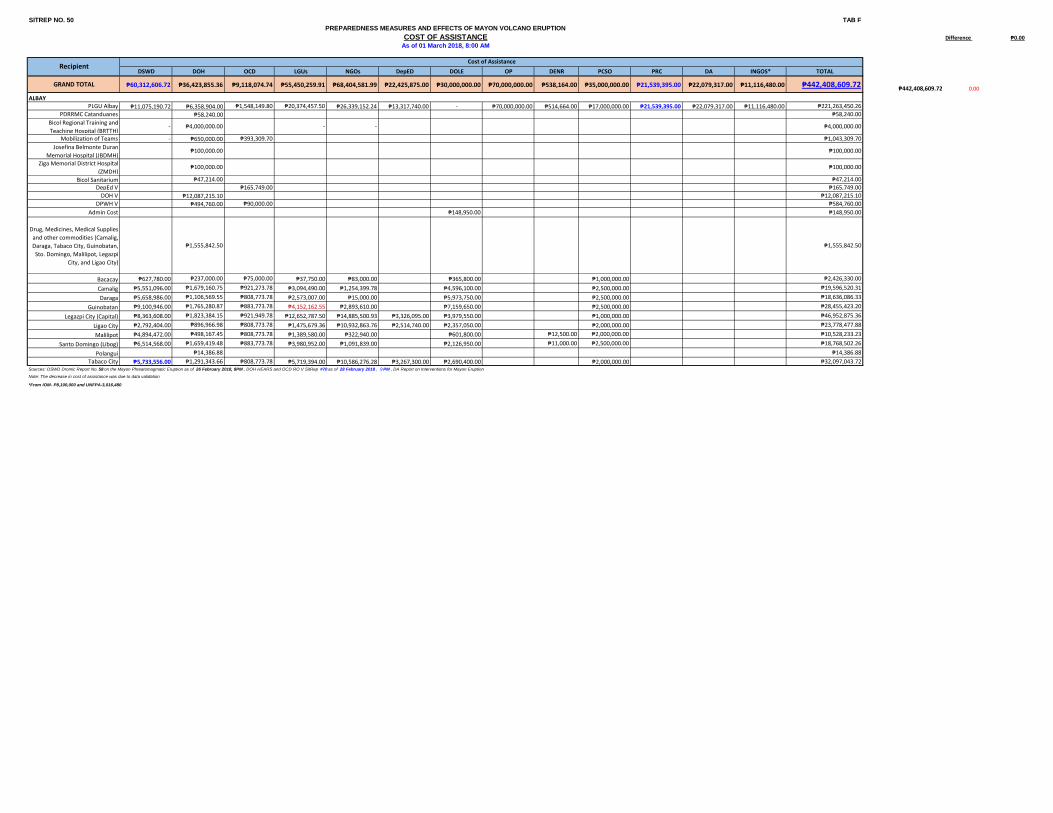
SITREP NO. 50 TAB F
Difference ₱0.00
DSWD DOH OCD LGUs NGOs DepED DOLE OP DENR PCSO PRC DA INGOS* TOTAL
GRAND TOTAL ₱60,312,606.72 ₱36,423,855.36 ₱9,118,074.74 ₱55,450,259.91 ₱68,404,581.99 ₱22,425,875.00 ₱30,000,000.00 ₱70,000,000.00 ₱538,164.00 ₱35,000,000.00 ₱21,539,395.00 ₱22,079,317.00 ₱11,116,480.00 ₱442,408,609.72₱442,408,609.72 0.00
PLGU Albay ₱11,075,190.72 ₱6,358,904.00 ₱1,548,149.80 ₱20,374,457.50 ₱26,339,152.24 ₱13,317,740.00 - ₱70,000,000.00 ₱514,664.00 ₱17,000,000.00 ₱21,539,395.00 ₱22,079,317.00 ₱11,116,480.00 ₱221,263,450.26
PDRRMC Catanduanes ₱58,240.00 ₱58,240.00
Bicol Regional Training and
Teaching Hospital (BRTTH)- ₱4,000,000.00 - - ₱4,000,000.00
Mobilization of Teams - ₱650,000.00 ₱393,309.70 ₱1,043,309.70
Josefina Belmonte Duran
Memorial Hospital (JBDMH)₱100,000.00 ₱100,000.00
Ziga Memorial District Hospital
(ZMDH)₱100,000.00 ₱100,000.00
Bicol Sanitarium ₱47,214.00 ₱47,214.00
DepEd V ₱165,749.00 ₱165,749.00
DOH V ₱12,087,215.10 ₱12,087,215.10
DPWH V ₱494,760.00 ₱90,000.00 ₱584,760.00
Admin Cost ₱148,950.00 ₱148,950.00
Drug, Medicines, Medical Supplies
and other commodities (Camalig,
Daraga, Tabaco City, Guinobatan,
Sto. Domingo, Malilipot, Legazpi
City, and Ligao City)
₱1,555,842.50 ₱1,555,842.50
Bacacay ₱627,780.00 ₱237,000.00 ₱75,000.00 ₱37,750.00 ₱83,000.00 ₱365,800.00 ₱1,000,000.00 ₱2,426,330.00
Camalig ₱5,551,096.00 ₱1,679,160.75 ₱921,273.78 ₱3,094,490.00 ₱1,254,399.78 ₱4,596,100.00 ₱2,500,000.00 ₱19,596,520.31
Daraga ₱5,658,986.00 ₱1,106,569.55 ₱808,773.78 ₱2,573,007.00 ₱15,000.00 ₱5,973,750.00 ₱2,500,000.00 ₱18,636,086.33
Guinobatan ₱9,100,946.00 ₱1,765,280.87 ₱883,773.78 ₱4,152,162.55 ₱2,893,610.00 ₱7,159,650.00 ₱2,500,000.00 ₱28,455,423.20
Legazpi City (Capital) ₱8,363,608.00 ₱1,823,384.15 ₱921,949.78 ₱12,652,787.50 ₱14,885,500.93 ₱3,326,095.00 ₱3,979,550.00 ₱1,000,000.00 ₱46,952,875.36
Ligao City ₱2,792,404.00 ₱896,966.98 ₱808,773.78 ₱1,475,679.36 ₱10,932,863.76 ₱2,514,740.00 ₱2,357,050.00 ₱2,000,000.00 ₱23,778,477.88
Malilipot ₱4,894,472.00 ₱498,167.45 ₱808,773.78 ₱1,389,580.00 ₱322,940.00 ₱601,800.00 ₱12,500.00 ₱2,000,000.00 ₱10,528,233.23
Santo Domingo (Libog) ₱6,514,568.00 ₱1,659,419.48 ₱883,773.78 ₱3,980,952.00 ₱1,091,839.00 ₱2,126,950.00 ₱11,000.00 ₱2,500,000.00 ₱18,768,502.26
Polangui ₱14,386.88 ₱14,386.88
Tabaco City ₱5,733,556.00 ₱1,291,343.66 ₱808,773.78 ₱5,719,394.00 ₱10,586,276.28 ₱3,267,300.00 ₱2,690,400.00 ₱2,000,000.00 ₱32,097,043.72
*From IOM- P8,100,000 and UNFPA-3,016,480
Sources: DSWD Dromic Report No. 58 on the Mayon Phreatomagmatic Eruption as of 26 February 2018, 8PM , DOH HEARS and OCD RO V SitRep #70 as of 28 February 2018 , 9 PM , DA Report on Interventions for Mayon Eruption
Note: The decrease in cost of assistance was due to data validation
ALBAY
PREPAREDNESS MEASURES AND EFFECTS OF MAYON VOLCANO ERUPTION
COST OF ASSISTANCEAs of 01 March 2018, 8:00 AM
RecipientCost of Assistance