
IGCSE Geography (0460) Unit 2.2 Landforms and...
12
1 IGCSE Geography (0460) Unit 2.2 Landforms and Landscape Processes (Weathering and Rivers) 2.2.1 Weathering What you need to know and be able to do: Tick off those you feel confident about: Recognise that weathering involves the breakdown of rock in situ and, as such, should be distinguished from erosion. Describe what is meant by different types of weathering – physical/mechanical (freeze-thaw action, exfoliation), chemical (carbonation, oxidation) and biological. Explain the main factors influencing the type and rate of weathering – climate and rock features (mineral composition, grain size of the rock, presence of lines of weakness). The influence of climate on the rate of weathering could be illustrated with reference to simple explanation as to why weathering is more rapid in humid tropical regions of the world than in temperate regions.
Transcript of IGCSE Geography (0460) Unit 2.2 Landforms and...

1
IGCSE Geography (0460)
Unit 2.2 Landforms and Landscape Processes (Weathering and Rivers)
2.2.1 Weathering What you need to know and be able to do:
Tick off those you feel confident about:
Recognise that weathering involves the breakdown of rock in situ and, as such, should be distinguished from erosion.
Describe what is meant by different types of weathering – physical/mechanical (freeze-thaw action, exfoliation), chemical (carbonation, oxidation) and biological.
Explain the main factors influencing the type and rate of weathering – climate and rock features (mineral composition, grain size of the rock, presence of lines of weakness). The influence of climate on the rate of weathering could be illustrated with reference to simple explanation as to why weathering is more rapid in humid tropical regions of the world than in temperate regions.
2
Type of rocks
There are three main types of rocks
Igneous that are formed from molten rock that has cooled, e.g. Basalt and Granite. The rate of cooling affects the size of the grains i.e. Basalt cools very quickly and therefore the size of grains are small and smooth.
Sedimentary are laid down in layers. They usually consist of plant and animal remains or particles of rocks that have been eroded, e.g. limestone and sandstone.
Metamorphic rocks these are igneous or sedimentary rocks that have been morphed (changed) due to extreme pressures of heat or pressure. These include marble and slate.
The effects of weathering
Weathering involves the disintegration and decomposition of rocks in the place they were formed. Unlike erosion weathering does not need to involve movement.
So, Erosion is the removal of solids (sediment, soil, rock and other particles) in the natural environment. Erosion is distinguished from weathering, which is the process of chemical or physical breakdown of the minerals in the rocks, although the two processes may occur concurrently.
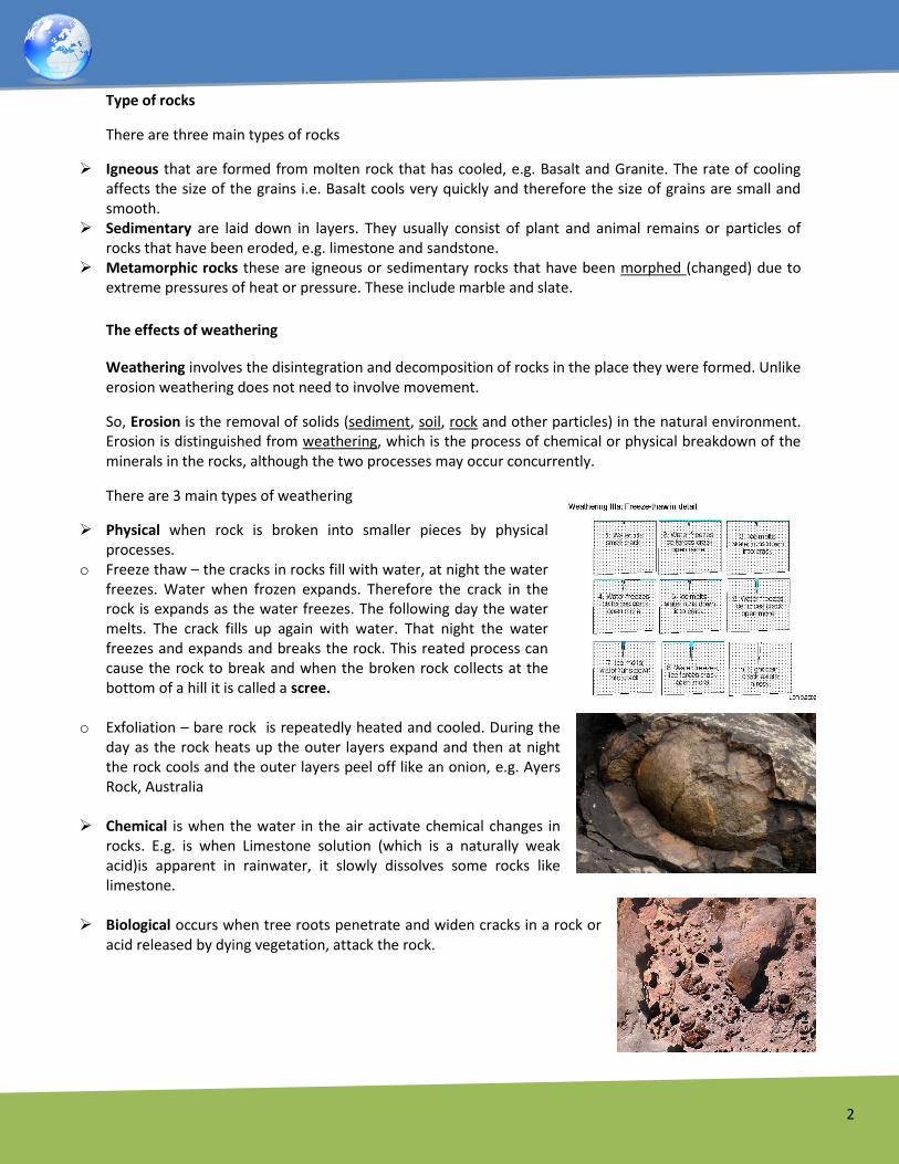
There are 3 main types of weathering
Physical when rock is broken into smaller pieces by physical processes.
o Freeze thaw – the cracks in rocks fill with water, at night the water freezes. Water when frozen expands. Therefore the crack in the rock is expands as the water freezes. The following day the water melts. The crack fills up again with water. That night the water freezes and expands and breaks the rock. This reated process can cause the rock to break and when the broken rock collects at the bottom of a hill it is called a scree.
o Exfoliation – bare rock is repeatedly heated and cooled. During the day as the rock heats up the outer layers expand and then at night the rock cools and the outer layers peel off like an onion, e.g. Ayers Rock, Australia
Chemical is when the water in the air activate chemical changes in rocks. E.g. is when Limestone solution (which is a naturally weak acid)is apparent in rainwater, it slowly dissolves some rocks like limestone.
Biological occurs when tree roots penetrate and widen cracks in a rock or acid released by dying vegetation, attack the rock.

3
Factors influencing weathering
Resistance – how hard or soft the rock is.
Permeability –
Impermeable rocks will not allow water to pass through Impermeable is for impossible to pass Permeable rocks allow water to pass through Think Permeable is for Permission to pass Permeability can be further classified to porous and pervious.
Different rocks weather at different rates. In warm, humid environments chemical weathering is fast so granites and limestones tend to weather rapidly. In drier, colder environments, freeze-thaw is a major process of weathering and so layered rocks, especially shales tend to weather rapidly. The more easily weathered shale is broken and moved down slope by gravity and rain. The quickly weathered material cannot support a steep slope and so it does not form cliffs. The sandstone of the cliff, is "strong" and weathers slowly. It is, however, constantly undercut by the down slope movement of the weaker shale. Losing support from underneath, blocks of the sandstone break off the cliff face and roll down the slope.

4
2.2.2 River Landscapes and Processes What you need to know and be able to do:
Demonstrate an understanding of the work of a river in eroding, transporting and depositing.
Understand and be able to explain erosional processes of hydraulic action, corrasion, corrosion (solution) and attrition.
Understand and explain river transport processes including traction, saltation, suspension and solution.
Be able to give reasons why and where in a river’s course deposition takes place.
Understand that the effectiveness of the river processes will vary according to the volume and velocity of the running water and the nature of the load (boulders, pebbles, sand and silt) which, in turn, will be affected by the bedrock along the course of the river.
Describe and explain the landforms associated with these processes.
A study should be made of the following: Forms of river valleys – long profile and shape in cross section, rapids, waterfalls, potholes, meanders, oxbow lakes, deltas, levées and flood plains.

5
As a river flows from its source (where a river starts) to its mouth (where a river flows into a sea or lake) the shape of both the long profile (a slice through the river from source to mouth) and the cross profile (a slice across the river) changes.
Long profiles
Long profile of a river
Near the source of a river, which is often (but not always) in an upland area, it flows over steep slopes with an uneven surface. It often flows over a series of waterfalls and rapids. Highland areas are often composed of hard igneous rocks, which are ideal for such features to form.
As it flows down the steep slopes the water performs vertical erosion, cutting down towards the river bed and carving out steep sided V-shaped valleys.
As the river flows towards the mouth, the slopes become less steep and eventually the river will flow over flat land as it approaches the sea.
The discharge (amount of water flowing) will increase as the river approaches the sea.

6
Cross Profile
Near the source of a river there is more vertical erosion as the river flows downhill, using its energy to overcome friction (A). As a result the channels are narrow and shallow and may contain large boulders and angular fragments eroded and weathered from the steep valley sides. The sediment in the river creates turbulence and friction.
As the river approaches the mouth, velocity and energy increase due to increased discharge, and the river performs more lateral erosion making the channel wider, and smoother (B) and (C). As a result there is less turbulence and friction, making the river more efficient.

7
Erosion
Erosion involves the wearing away of rock and soil found along the river bed and banks. Erosion also
involves the breaking down of the rock particles being carried downstream by the river.
There are four main forms of river erosion:
Hydraulic action – the force of the river against the banks can cause air to be trapped in cracks and
crevices. The pressure weakens the banks and gradually wears it away.
Abrasion (corrosion) - rocks carried along by the river wear down the river bed and banks.
Attrition - rocks being carried by the river smash together and break into smaller and smoother particles.
Solution (corrosion) - soluble particles are dissolved into the river.
Rivers pick up and carry material as they flow downstream. A river may transport material in four
different ways:
Solution - minerals are dissolved in the water and carried along in solution.
Suspension - fine light material is carried along in the water.
Saltation - small pebbles and stones are bounced along the river bed.
Traction - large boulders and rocks are rolled along the river bed.
Transport of material in a river
Rivers need energy to transport
material, and levels of energy
change as the river moves from
source to mouth.
When energy levels are very high,
large rocks and boulders can be
transported. Energy levels are
usually higher near a river's source,
when its course is steep and its
valley narrow. Energy levels rise
even higher in times of flood.
When energy levels are low, only small particles can be transported (if any). Energy levels are lowest
when velocity drops as a river enters a lake or sea (at the mouth).

8
Deposition
When a river loses energy, it will drop or deposit some of the material it is carrying.
Deposition may take place when a river enters an area of shallow water or when the volume of water
decreases - for example after a flood or during times of drought.
Deposition is common towards the end of a river's journey, at the mouth.
Deposition at the mouth of a river can form deltas - for example the Mississippi Delta.
Upper-course river features include steep-sided V-shaped valleys, interlocking spurs, rapids, waterfalls
and gorges.
Middle-course river features include wider, shallower valleys, meanders, and oxbow lakes.
Lower-course river features include wide flat-bottomed valleys, flood plains and deltas.
Upper course features

9
Upper-course river features
As the river moves through the upper course it cuts
downwards. The gradient here is steep and the river
channel is narrow. Vertical erosion in this highland part of
the river helps to create steep sided V-shaped valleys,
interlocking spurs, rapids, waterfalls and gorges:
As the river erodes the landscape in the upper course, it
winds and bends to avoid areas of hard rock. This
creates interlocking spurs, which look a bit like the interlocking parts of a zip.
When a river runs over alternating layers of hard and soft rock, rapids and waterfalls may form. The
graphic shows how waterfalls and rapids are formed.
The formation of waterfalls and rapids

10
Middle course features
Meanders
In the middle course the river has more energy and a
high volume of water. The gradient here is gentle and
lateral (sideways) erosion has widened the river
channel. The river channel has also deepened. A larger
river channel means there is less friction, so the water
flows faster:
As the river erodes laterally, to the right side then the
left side, it forms large bends, and then horseshoe-like
loops called meanders.
The formation of meanders is due to both deposition and erosion and meanders gradually migrate
downstream.
The force of the water erodes and undercuts the river bank on the outside of the bend where water flow
has most energy due to decreased friction.
On the inside of the bend, where the river flow is slower, material is deposited, as there is more friction.
Over time the horseshoe become tighter, until the ends become very close together. As the river breaks
through, eg during a flood when the river has a higher discharge and more energy, and the ends join, the
loop is cut-off from the main channel. The cut-off loop is called an oxbow lake. The animation
demonstrates how these features form.
Upstream a large bend becomes a horseshoe and is eventually cut-off to become an oxbow lake.
Downstream the river is eroding its outer bank and depositing on its inner bank to create a new meander.

11
Lower course features
In the lower course, the river has a high volume and a large discharge. The river channel is now deep and
wide and the landscape around it is flat. However, as a river reaches the end of its journey, energy levels
are low and deposition takes place.
The river now has a wide floodplain. A floodplain is the area around a river that is covered in times of
flood. A floodplain is a very fertile area due to the rich alluvium deposited by floodwaters. This makes
floodplains a good place for agriculture. A build up of alluvium on the banks of a river can create levees
which raise the river bank.
Deltas are found at the mouth of large rivers - for example, the Mississippi. A delta is formed when the
river deposits its material faster than the sea can remove it. There are three main types of delta, named
after the shape they create:
Three main types of delta
Type of delta Example
Arcuate or fan-shaped - the land around the river mouth arches out into the sea, the river splits many times on the way to the sea, creating a fan effect.
The Niger Delta
Cuspate - the land around the mouth of the river juts out arrow-like into the sea.

12
Type of delta Example
The Ebro Delta
Bird's foot - the river splits on the way to the sea, each part of the river juts out into the sea, rather like a bird's foot.
The Mississippi Delta


![Page 1 Mark Scheme Syllabus Paper IGCSE – June 2003 0460 01 (0460)/0460_s0… · Credit reference to actual examples to illustrate MAX. 1 mark 4 at 1 mark [4] 3 (a) (i) ... employment,](https://static.fdocuments.us/doc/165x107/5f349017f075b47ce9031d3a/page-1-mark-scheme-syllabus-paper-igcse-a-june-2003-0460-01-04600460s0-credit.jpg)


