Identification of a large, moderate bedrock conductor (BYC1 ......Identification of a large,...
12
▪ Identification of a large, moderate bedrock conductor (BYC1) at the Balla Yule Prospect ▪ BYC1 underlies anomalous Ni-Co geochemical results and Ni-Cu-Co sulphide petrological results ▪ Follow up fixed loop TEM survey planned at Balla Yule Golden State Mining Limited (ASX code “GSM”, “Golden State” or the “Company”) is pleased to announce the completion of two moving loop time domain electromagnetic (MLTEM) surveys at the Yule North Project (see ASX announcement dated 3 rd Sept. 2019). Figure 1: Yule North MLTEM survey areas (yellow outlines) with modelled BYC1 conductor plate (red) over RTP 1VD magnetic image. Golden State’s Managing Director, Michael Moore commented: "The identification of a bedrock conductor is an encouraging first step in our exploration drive at the Balla Yule Prospect. We look forward to following up this geophysical survey work with a fixed loop electromagnetic survey which may assist in defining a worthy drill target.” For personal use only
Transcript of Identification of a large, moderate bedrock conductor (BYC1 ......Identification of a large,...

▪ Identification of a large, moderate bedrock conductor (BYC1)
at the Balla Yule Prospect
▪ BYC1 underlies anomalous Ni-Co geochemical results and
Ni-Cu-Co sulphide petrological results
▪ Follow up fixed loop TEM survey planned at Balla Yule
Golden State Mining Limited (ASX code “GSM”, “Golden State” or the “Company”) is pleased to
announce the completion of two moving loop time domain electromagnetic (MLTEM) surveys at the Yule
North Project (see ASX announcement dated 3rd Sept. 2019).
Figure 1: Yule North MLTEM survey areas (yellow outlines) with modelled BYC1 conductor plate (red) over RTP
1VD magnetic image.
Golden State’s Managing Director, Michael Moore commented:
"The identification of a bedrock conductor is an encouraging first step in our exploration drive at the
Balla Yule Prospect. We look forward to following up this geophysical survey work with a fixed loop
electromagnetic survey which may assist in defining a worthy drill target.”
For
per
sona
l use
onl
y
P a g e | 2
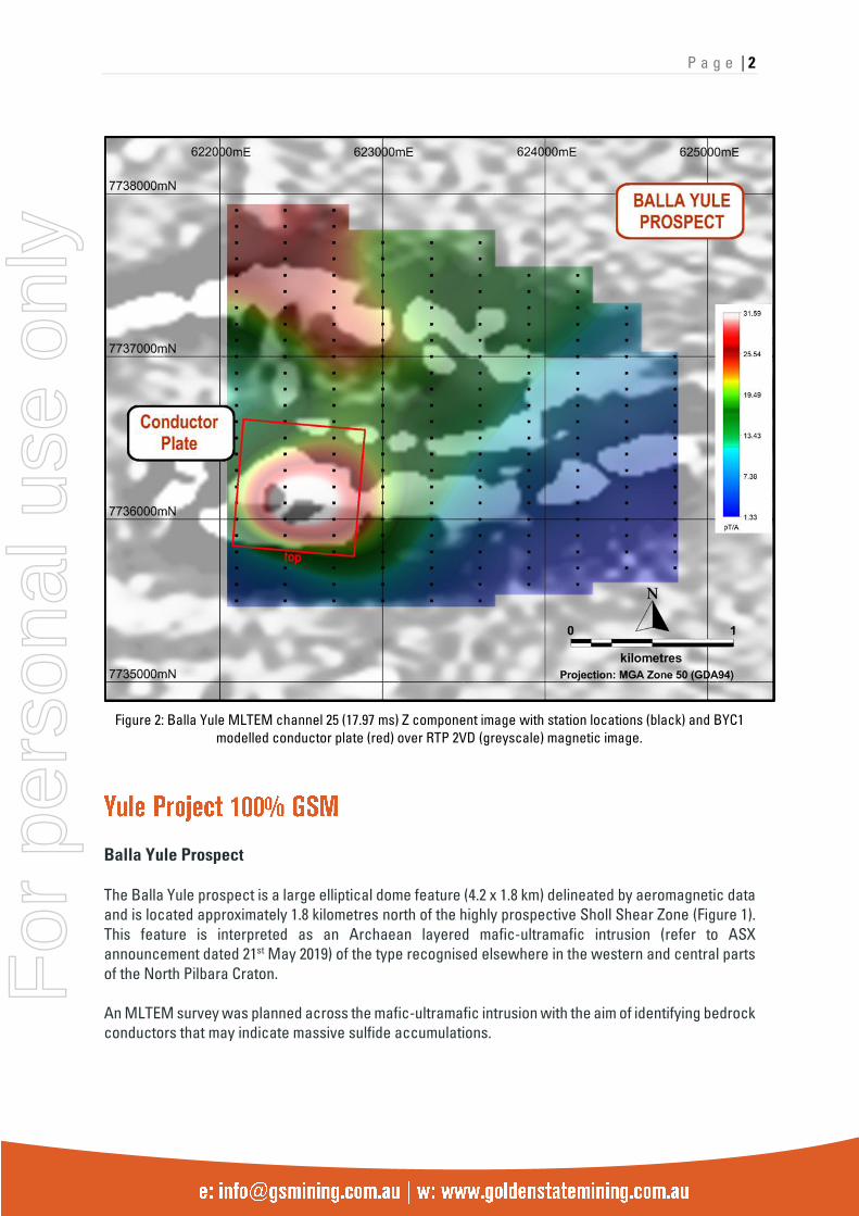
Figure 2: Balla Yule MLTEM channel 25 (17.97 ms) Z component image with station locations (black) and BYC1
modelled conductor plate (red) over RTP 2VD (greyscale) magnetic image.
Balla Yule Prospect
The Balla Yule prospect is a large elliptical dome feature (4.2 x 1.8 km) delineated by aeromagnetic data
and is located approximately 1.8 kilometres north of the highly prospective Sholl Shear Zone (Figure 1).
This feature is interpreted as an Archaean layered mafic-ultramafic intrusion (refer to ASX
announcement dated 21st May 2019) of the type recognised elsewhere in the western and central parts
of the North Pilbara Craton.
An MLTEM survey was planned across the mafic-ultramafic intrusion with the aim of identifying bedrock
conductors that may indicate massive sulfide accumulations.
For
per
sona
l use
onl
y

P a g e | 3
Figure 3: Balla Yule drill section looking West showing Modelled MLEM conductor plate with respect to previous
drilling
Ten lines of MLTM surveying have been completed at the Balla Yule target area for a total of 20.5 line
kilometres (215 stations) (Figure 2). Survey lines covered a significant strike length of the mafic-
ultramafic intrusion as defined by the strong magnetic anomaly.
MLEM surveying at the Balla Yule prospect has successfully identified a discrete bedrock anomaly that
has been modelled as a large (~750 m x 900 m), moderate conductance (~150-200 S) plate, dipping ~20-
40 degrees to the north at a depth of ~130-150 m below surface (Figure 3). The conductor (BYC1) is
BYC1 MLEM conductor plate
For
per
sona
l use
onl
y

P a g e | 4
coincident with the magnetic unit (Figure 1), interpreted as a mafic-ultramafic intrusion, and underlies
anomalous Ni-Co geochemical results and Ni-Cu-Co sulphide petrological results from RC drill samples.
Conductor BYC1 could represent the response of stringer, strongly disseminated and/or matrix Ni-Cu
sulphides, part of a mafic-hosted layered titanomagnetite/vanadium sequence, or pyrrhotitic
metasediments (e.g. iron formation), although no metasedimentary units have been recognised in the
immediate area to date.
Quarry Well Prospect
Two untested, late time EM (Sirotem) anomalies were identified in an historical WMC report during the
geophysical review of the Yule Project (refer to ASX announcement dated 26th June 2019). An MLTEM
survey was planned to verify these anomalies. Four lines of MLTEM surveying were completed at the
Quarry Well target area for a total of 5.2 line kilometres (56 stations).
The historical Sirotem anomalies were not detected with the new MLTEM survey. A review of the
historical and new data indicates that they were likely artefacts associated with surficial magnetic
material. Quarry Well is no longer considered an EM target but it should continue to be evaluated as a
target for structurally related gold and/or base metal mineralisation.
Further Yule Exploration Activities
Fixed loop TEM surveying is planned to better constrain and assess the Balla Yule bedrock conductor.
GSM is currently liaising with contractors to complete this work as soon as possible.
Detailed magnetic modelling of the mafic-ultramafic intrusion using the available high-resolution
aeromagnetic data will also be carried out and incorporated into the assessment of the BYC1 conductor
for potential drill targeting.
Aircore (AC) drill planning of three high priority gold and rare metal pegmatite targets at the Yule South
Project is advancing and awaiting statutory government approvals. This program is expected to
commence once Heritage Surveys have been completed.
- Mike Moore (Managing Director) on 08 6323 2384 / 0438 938 934
- Greg Hancock (Non-Executive Director) 08 6323 2384 / 0418 263 388
For
per
sona
l use
onl
y
P a g e | 5
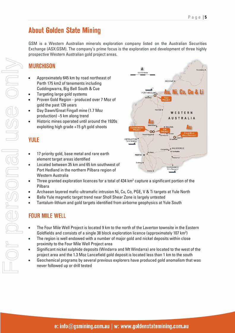
GSM is a Western Australian minerals exploration company listed on the Australian Securities
Exchange (ASX:GSM). The company’s prime focus is the exploration and development of three highly
prospective Western Australian gold project areas.
• Approximately 645 km by road northeast of
Perth 175 km2 of tenements including
Cuddingwarra, Big Bell South & Cue
• Targeting large gold systems
• Proven Gold Region - produced over 7 Moz of
gold the past 126 years
• Day Dawn/Great Fingall mine (1.7 Moz
production) ~5 km along trend
• Historic mines operated until around the 1920s
exploiting high grade +15 g/t gold shoots
• 17 priority gold, base metal and rare earth
element target areas identified
• Located between 35 km and 65 km southwest of
Port Hedland in the northern Pilbara region of
Western Australia
• Three granted exploration licences for a total of 434 km2 capture a significant portion of the
Pilbara
• Archaean layered mafic-ultramafic intrusion Ni, Cu, Co, PGE, V & Ti targets at Yule North
• Balla Yule magnetic target trend near Sholl Shear Zone is largely untested
• Tantalum-lithium and gold targets identified from airborne geophysics at Yule South
• The Four Mile Well Project is located 9 km to the north of the Laverton townsite in the Eastern
Goldfields and consists of a single 38 block exploration licence (approximately 107 km2)
• The region is well endowed with a number of major gold and nickel deposits within close
proximity to the Four Mile Well Project area
• Significant nickel sulphide deposits (Windarra and Mt Windarra) are located to the west of the
project area and the 1.3 Moz Lancefield gold deposit is located less than 1 km to the south
• Geochemical programs by several previous explorers have produced gold anomalism that was
never followed up or drill tested
For
per
sona
l use
onl
y
P a g e | 6
FORWARD LOOKING STATEMENTS
As a result of a variety of risks, uncertainties and other factors, actual events,
trends and results may differ materially from any forward looking and other
statements mentioned or implied herein not purporting to be of historical fact. In
certain cases, forward-looking information may be identified by (without limitation)
such terms as "anticipates", "believes", “should”, "could", "estimates", “target”,
“likely”, “plan”, "expects", "may", “intend”, "shall", "will", or "would". Any
statements concerning mining reserves, resources and exploration results may
also be forward looking in that they involve estimates based on assumptions.
Forward looking statements are based on management’s beliefs, opinions and
estimates as of the respective dates they are made. The Company does not assume
any obligation to update forward looking statements even where beliefs, opinions
and estimates change or should do so given changed circumstances and
developments.
COMPETENT PERSONS STATEMENT
The information in this report that relates to Exploration Results, Mineral
Resources or Ore Reserves is based on information compiled by Geoff Willetts who
is a Member of the Australian Institute of Geoscientists (AIG). Geoff Willetts is the
Exploration Manager, a full-time employee of Golden State Mining Limited (GSM)
and holds shares and options in the Company.
Geoff Willetts has sufficient experience relevant to the style of mineralisation and
type of deposit under consideration and to the activity currently being undertaken
to qualify as a Competent Person as defined in the 2012 edition of the
“Australasian Code for Reporting of Exploration Results, Mineral Resources and
Ore Reserves”. Geoff Willetts consents to the inclusion in this report of the matters
based on his information in the form and context in which it appears. Information
on previous explorers and historical results are summarised in the Independent
Geologist’s Report of the Golden State Mining Limited Prospectus dated 22 August
2018.
The information in this release that relates to Geophysical Results and
Interpretations is based on information compiled by Anne Tomlinson who is a
Member of the Australian Institute of Geoscientists (AIG). Anne Tomlinson is a
Principal Geophysicist and Director at Southern Geoscience Consultants. Anne
Tomlinson has sufficient experience which is relevant to the style of mineralisation
and type of deposit under consideration and to the activity being undertaking to
qualify as a Competent Person as defined in the 2012 Edition of the ‘Australasian
Code for Reporting of Exploration Results, Mineral Resources and Ore Reserves’.
Anne Tomlinson consents to the inclusion in the release of the matters based on
this information in the form and context in which it appears.
For
per
sona
l use
onl
y
P a g e | 7
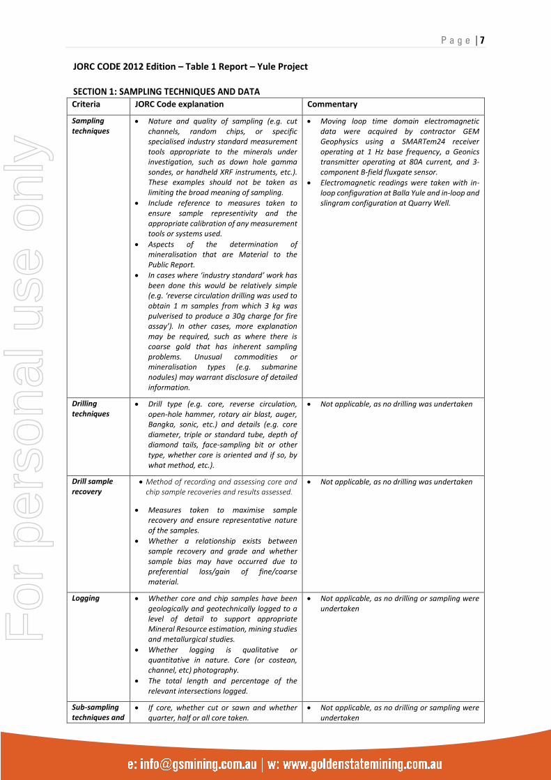
JORC CODE 2012 Edition – Table 1 Report – Yule Project SECTION 1: SAMPLING TECHNIQUES AND DATA Criteria JORC Code explanation Commentary
Sampling techniques
• Nature and quality of sampling (e.g. cut channels, random chips, or specific specialised industry standard measurement tools appropriate to the minerals under investigation, such as down hole gamma sondes, or handheld XRF instruments, etc.). These examples should not be taken as limiting the broad meaning of sampling.
• Include reference to measures taken to ensure sample representivity and the appropriate calibration of any measurement tools or systems used.
• Aspects of the determination of mineralisation that are Material to the Public Report.
• In cases where ‘industry standard’ work has been done this would be relatively simple (e.g. ‘reverse circulation drilling was used to obtain 1 m samples from which 3 kg was pulverised to produce a 30g charge for fire assay’). In other cases, more explanation may be required, such as where there is coarse gold that has inherent sampling problems. Unusual commodities or mineralisation types (e.g. submarine nodules) may warrant disclosure of detailed information.
• Moving loop time domain electromagnetic data were acquired by contractor GEM Geophysics using a SMARTem24 receiver operating at 1 Hz base frequency, a Geonics transmitter operating at 80A current, and 3-component B-field fluxgate sensor.
• Electromagnetic readings were taken with in-loop configuration at Balla Yule and in-loop and slingram configuration at Quarry Well.
Drilling techniques
• Drill type (e.g. core, reverse circulation, open-hole hammer, rotary air blast, auger, Bangka, sonic, etc.) and details (e.g. core diameter, triple or standard tube, depth of diamond tails, face-sampling bit or other type, whether core is oriented and if so, by what method, etc.).
• Not applicable, as no drilling was undertaken
Drill sample recovery
• Method of recording and assessing core and chip sample recoveries and results assessed.
• Measures taken to maximise sample recovery and ensure representative nature of the samples.
• Whether a relationship exists between sample recovery and grade and whether sample bias may have occurred due to preferential loss/gain of fine/coarse material.
• Not applicable, as no drilling was undertaken
Logging • Whether core and chip samples have been geologically and geotechnically logged to a level of detail to support appropriate Mineral Resource estimation, mining studies and metallurgical studies.
• Whether logging is qualitative or quantitative in nature. Core (or costean, channel, etc) photography.
• The total length and percentage of the relevant intersections logged.
• Not applicable, as no drilling or sampling were undertaken
Sub-sampling techniques and
• If core, whether cut or sawn and whether quarter, half or all core taken.
• Not applicable, as no drilling or sampling were undertaken
For
per
sona
l use
onl
y
P a g e | 8
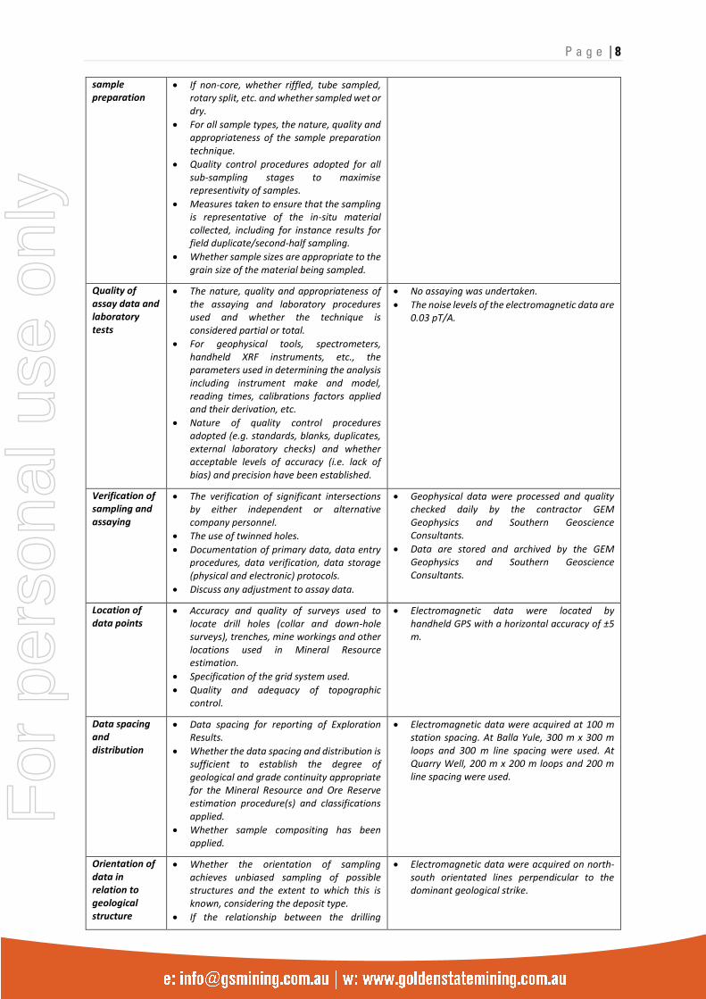
sample preparation
• If non-core, whether riffled, tube sampled, rotary split, etc. and whether sampled wet or dry.
• For all sample types, the nature, quality and appropriateness of the sample preparation technique.
• Quality control procedures adopted for all sub-sampling stages to maximise representivity of samples.
• Measures taken to ensure that the sampling is representative of the in-situ material collected, including for instance results for field duplicate/second-half sampling.
• Whether sample sizes are appropriate to the grain size of the material being sampled.
Quality of assay data and laboratory tests
• The nature, quality and appropriateness of the assaying and laboratory procedures used and whether the technique is considered partial or total.
• For geophysical tools, spectrometers, handheld XRF instruments, etc., the parameters used in determining the analysis including instrument make and model, reading times, calibrations factors applied and their derivation, etc.
• Nature of quality control procedures adopted (e.g. standards, blanks, duplicates, external laboratory checks) and whether acceptable levels of accuracy (i.e. lack of bias) and precision have been established.
• No assaying was undertaken.
• The noise levels of the electromagnetic data are 0.03 pT/A.
Verification of sampling and assaying
• The verification of significant intersections by either independent or alternative company personnel.
• The use of twinned holes.
• Documentation of primary data, data entry procedures, data verification, data storage (physical and electronic) protocols.
• Discuss any adjustment to assay data.
• Geophysical data were processed and quality checked daily by the contractor GEM Geophysics and Southern Geoscience Consultants.
• Data are stored and archived by the GEM Geophysics and Southern Geoscience Consultants.
Location of data points
• Accuracy and quality of surveys used to locate drill holes (collar and down-hole surveys), trenches, mine workings and other locations used in Mineral Resource estimation.
• Specification of the grid system used.
• Quality and adequacy of topographic control.
• Electromagnetic data were located by handheld GPS with a horizontal accuracy of ±5 m.
Data spacing and distribution
• Data spacing for reporting of Exploration Results.
• Whether the data spacing and distribution is sufficient to establish the degree of geological and grade continuity appropriate for the Mineral Resource and Ore Reserve estimation procedure(s) and classifications applied.
• Whether sample compositing has been applied.
• Electromagnetic data were acquired at 100 m station spacing. At Balla Yule, 300 m x 300 m loops and 300 m line spacing were used. At Quarry Well, 200 m x 200 m loops and 200 m line spacing were used.
Orientation of data in relation to geological structure
• Whether the orientation of sampling achieves unbiased sampling of possible structures and the extent to which this is known, considering the deposit type.
• If the relationship between the drilling
• Electromagnetic data were acquired on north-south orientated lines perpendicular to the dominant geological strike.
For
per
sona
l use
onl
y
P a g e | 9
orientation and the orientation of key mineralised structures is considered to have introduced a sampling bias, this should be assessed and reported if material.
Sample security
• The measures taken to ensure sample security.
• Not applicable, as no samples were taken.
Audits or reviews
• The results of any audits or reviews of sampling techniques and data.
• There have been no 3rd party reviews of the data.
For
per
sona
l use
onl
y
P a g e | 10
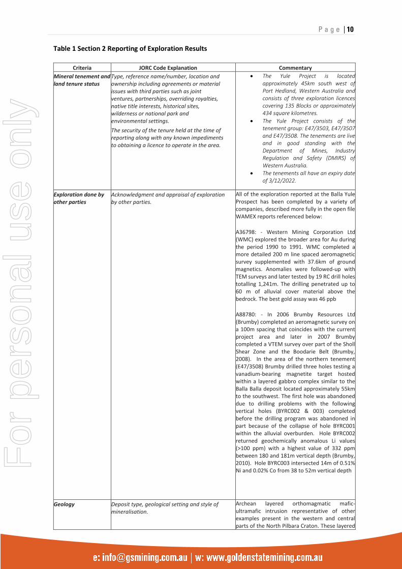
Table 1 Section 2 Reporting of Exploration Results
Criteria JORC Code Explanation Commentary
Mineral tenement and land tenure status
• Type, reference name/number, location and ownership including agreements or material issues with third parties such as joint ventures, partnerships, overriding royalties, native title interests, historical sites, wilderness or national park and environmental settings.
• The security of the tenure held at the time of reporting along with any known impediments to obtaining a licence to operate in the area.
• The Yule Project is located approximately 45km south west of Port Hedland, Western Australia and consists of three exploration licences covering 135 Blocks or approximately 434 square kilometres.
• The Yule Project consists of the tenement group: E47/3503, E47/3507 and E47/3508. The tenements are live and in good standing with the Department of Mines, Industry Regulation and Safety (DMIRS) of Western Australia.
• The tenements all have an expiry date of 3/12/2022.
Exploration done by other parties
• Acknowledgment and appraisal of exploration by other parties.
• All of the exploration reported at the Balla Yule Prospect has been completed by a variety of companies, described more fully in the open file WAMEX reports referenced below:
A36798: - Western Mining Corporation Ltd (WMC) explored the broader area for Au during the period 1990 to 1991. WMC completed a more detailed 200 m line spaced aeromagnetic survey supplemented with 37.6km of ground magnetics. Anomalies were followed-up with TEM surveys and later tested by 19 RC drill holes totalling 1,241m. The drilling penetrated up to 60 m of alluvial cover material above the bedrock. The best gold assay was 46 ppb
A88780: - In 2006 Brumby Resources Ltd (Brumby) completed an aeromagnetic survey on a 100m spacing that coincides with the current project area and later in 2007 Brumby completed a VTEM survey over part of the Sholl Shear Zone and the Boodarie Belt (Brumby, 2008). In the area of the northern tenement (E47/3508) Brumby drilled three holes testing a vanadium-bearing magnetite target hosted within a layered gabbro complex similar to the Balla Balla deposit located approximately 55km to the southwest. The first hole was abandoned due to drilling problems with the following vertical holes (BYRC002 & 003) completed before the drilling program was abandoned in part because of the collapse of hole BYRC001 within the alluvial overburden. Hole BYRC002 returned geochemically anomalous Li values (>100 ppm) with a highest value of 332 ppm between 180 and 181m vertical depth (Brumby, 2010). Hole BYRC003 intersected 14m of 0.51% Ni and 0.02% Co from 38 to 52m vertical depth
Geology • Deposit type, geological setting and style of mineralisation.
Archean layered orthomagmatic mafic-ultramafic intrusion representative of other examples present in the western and central parts of the North Pilbara Craton. These layered
For
per
sona
l use
onl
y
P a g e | 11
Criteria JORC Code Explanation Commentary
intrusions are prospective for Ni, Cu, Co, PGE (Platinum Group Elements), V, Ti and Au.
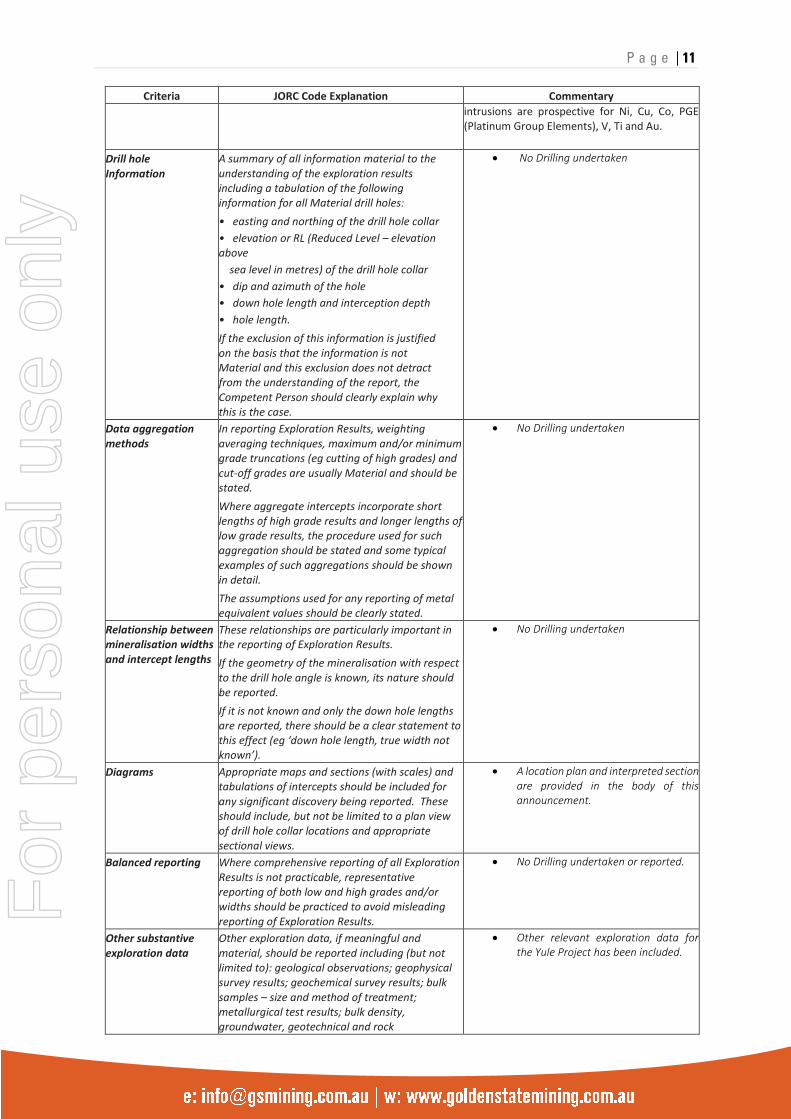
Drill hole Information
• A summary of all information material to the understanding of the exploration results including a tabulation of the following information for all Material drill holes:
• easting and northing of the drill hole collar
• elevation or RL (Reduced Level – elevation above
sea level in metres) of the drill hole collar
• dip and azimuth of the hole
• down hole length and interception depth
• hole length.
• If the exclusion of this information is justified on the basis that the information is not Material and this exclusion does not detract from the understanding of the report, the Competent Person should clearly explain why this is the case.
• No Drilling undertaken
Data aggregation methods
• In reporting Exploration Results, weighting averaging techniques, maximum and/or minimum grade truncations (eg cutting of high grades) and cut-off grades are usually Material and should be stated.
• Where aggregate intercepts incorporate short lengths of high grade results and longer lengths of low grade results, the procedure used for such aggregation should be stated and some typical examples of such aggregations should be shown in detail.
• The assumptions used for any reporting of metal equivalent values should be clearly stated.
• No Drilling undertaken
Relationship between mineralisation widths and intercept lengths
• These relationships are particularly important in the reporting of Exploration Results.
• If the geometry of the mineralisation with respect to the drill hole angle is known, its nature should be reported.
• If it is not known and only the down hole lengths are reported, there should be a clear statement to this effect (eg ‘down hole length, true width not known’).
• No Drilling undertaken
Diagrams • Appropriate maps and sections (with scales) and tabulations of intercepts should be included for any significant discovery being reported. These should include, but not be limited to a plan view of drill hole collar locations and appropriate sectional views.
• A location plan and interpreted section are provided in the body of this announcement.
Balanced reporting • Where comprehensive reporting of all Exploration Results is not practicable, representative reporting of both low and high grades and/or widths should be practiced to avoid misleading reporting of Exploration Results.
• No Drilling undertaken or reported.
Other substantive exploration data
• Other exploration data, if meaningful and material, should be reported including (but not limited to): geological observations; geophysical survey results; geochemical survey results; bulk samples – size and method of treatment; metallurgical test results; bulk density, groundwater, geotechnical and rock
• Other relevant exploration data for the Yule Project has been included.
For
per
sona
l use
onl
y
P a g e | 12
Criteria JORC Code Explanation Commentary
characteristics; potential deleterious or contaminating substances.
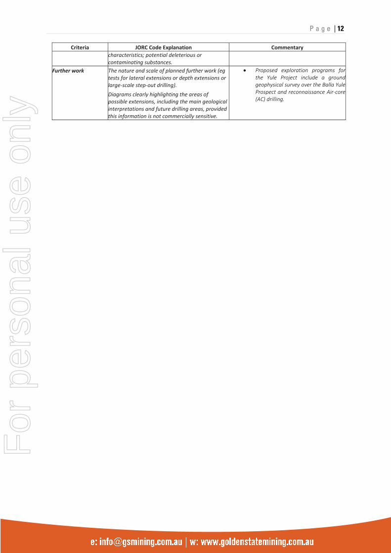
Further work • The nature and scale of planned further work (eg tests for lateral extensions or depth extensions or large-scale step-out drilling).
• Diagrams clearly highlighting the areas of possible extensions, including the main geological interpretations and future drilling areas, provided this information is not commercially sensitive.
• Proposed exploration programs for the Yule Project include a ground geophysical survey over the Balla Yule Prospect and reconnaissance Air-core (AC) drilling.
For
per
sona
l use
onl
y