ICC2013 A4 Prg
56
www.icc2013.org th 26 INTERNATIONAL CARTOGRAPHIC CONFERENCE August 25 – 30, 2013 • Dresden | Germany ICC 2013 under the patronage of the Saxon Prime Minister Stanislaw Tillich FINAL PROGRAMME
Transcript of ICC2013 A4 Prg

www.icc2013.org
th26 INTERNATIONAL CARTOGRAPHIC CONFERENCE
August 25 – 30, 2013 • Dresden | Germany
ICC 2013 under the patronage of the Saxon Prime Minister Stanislaw Tillich
FINAL PROGRAMME

Editorials ...................................................................................................................................... 3
Commitees ................................................................................................................................... 6
Conference Venue ......................................................................................................................... 7
International Congress Center Dresden: Levels ............................................................................. 8
General Information .................................................................................................................... 10
Exhibitions .................................................................................................................................. 10
Additional Programme ................................................................................................................ 12
Deutscher Kartographentag ....................................................................................................... 15
Programme at a Glance ............................................................................................................... 18
Scientific Programme .................................................................................................................. 19
Monday, August 26, 2013 ................................................................................................................ 20
Tuesday, August 27, 2013 ................................................................................................................ 24
Wednesday, August 28, 2013 ........................................................................................................... 33
Thursday, August 29, 2013 ............................................................................................................... 43
Friday, August 30, 2013 ................................................................................................................... 52
Business Meetings ........................................................................................................................... 55
Content

Editorial
Dear colleagues from all over the world,rdIn 2007 Moscow hosted the 23 International Cartographic
Conference (ICC), followed by Santiago de Chile and Paris in 2009 thand 2011. In two years the 27 ICC will be held in Rio de Janeiro and
subsequently in 2017 in Washington DC. So, big global megacities have been and will be host to these biannual cartographic world congresses. Thus, one may be surprised that in 2013 a comparatively small place like Dresden with merely half a million inhabitants has been selected by the Executive Committee of the International Cartographic Association to organise this year’s ICC.
The reasons for that may be manyfold. To begin with, the setting: Dresden boasts a significant quantity of world-class art treasures and can in this respect cope with places like Venice or Florence but also with cities like Athens, London, Paris, Moscow, Berlin, or Rome. In fact, between Italy and the Electoral Court in Dresden have always been close cultural ties. Giacomo Casanova’s mother was actress at the Court Theatre, his brother Director of the Art Academy, and Casanova himself stayed many months in Dresden, finally concluding his life in a Bohemian castle near Dresden. The most famous panoramic veduta of Dresden e.g. stems from the Italian painter Bernardo Bellotto (1722–1780), called Canaletto. Dresden is also frequently referred to as “Florence of the North”.
Further, Dresden is located at the doorstep of the Saxon Switzerland National Park with its unique sandstone cliff- and-spire landscape, a natural gem that also served as the cradle of modern rock climbing which started its triumphal march from here via Yosemite Valley, California, all over the world. It attracts top rock athletes and tourists from all over the world. Finally, the local organisers also conceive the assignment of the 26th ICC to Dresden also as a recognition of the considerable achievements in both cartographic research and academic education in Dresden. Several developments in our scientific discipline either originate from TU Dresden or have been significantly driven forth here. This is why no less a figure than Ferjan Ormeling Jr. attributed Dresden to the Great Schools of Cartography. During the 2013 ICC you might take the chance to personally verify this either in the fabulous International Congress Center Dresden at the banks of River Elbe or at the Institute for Cartography of Technische Universität Dresden.
For us from the LOC this year’s International Cartographic Conference is one more gemstone in the almost 60-year long history of University Cartography in Dresden.
Welcome in Dresden! Enjoy, professionally and privately. You will be amply rewarded in both respects.
Manfred F. BuchroithnerPresident of Organising Committee
3

Editorial
Dear Colleagues,ththe 26 International Cartographic Conference will be held in
Dresden in August 2013. This conference returns to Germany again, with ICA conferences being held previously in Germany in Frankfurt in 1962 and Cologne in 1993. The International Cartographic Conferences take place every two years. 2013 sees the conference in the "Florence of the North".
It will bring together cartographers and GI Science specialists from across the globe to Dresden for the International Cartographic Conference - ICC 2013. The conference will provide a forum for the presentation of scientific papers illustrating the efforts of the research community, professional papers describing the cutting-edge methods employed by mapping organisations, meetings of the ICA Commissions and Working Groups, furthering their international collaborative efforts to advance knowledge and techniques in cartography, map exhibitions and the chance to meet again with colleagues and friends.
Dresden boasts the highest density of art treasures in Europe. And, for cartographers, the possibility to view one of the top international globe collections. Dresden is also the home of educational and research institutions that have progressed the theoretical and practical elements of Cartography and GI Science.
thThe 26 International Cartographic Conference will be held at Dresden’s state-of-the-art congress centre. The congress centre is in the very middle of Dresden, affording the opportunity for conference delegates and accompanying persons to explore this wonderful city.
We urge you to participate in what will be a wonderful occasion. It provides the opportunity to attend presentations and Commission and Working Group meetings, to visit technical and international mapping exhibitions and to meet socially with colleagues from the international Cartography and GI Science community at a place which, for centuries, has been acting as a hinge between Eastern and Central Europe.
thWe look forward to seeing you in Dresden in 2013 for the 26 International Cartographic Conference.
Georg GartnerPresident of the ICA
4
Editorial
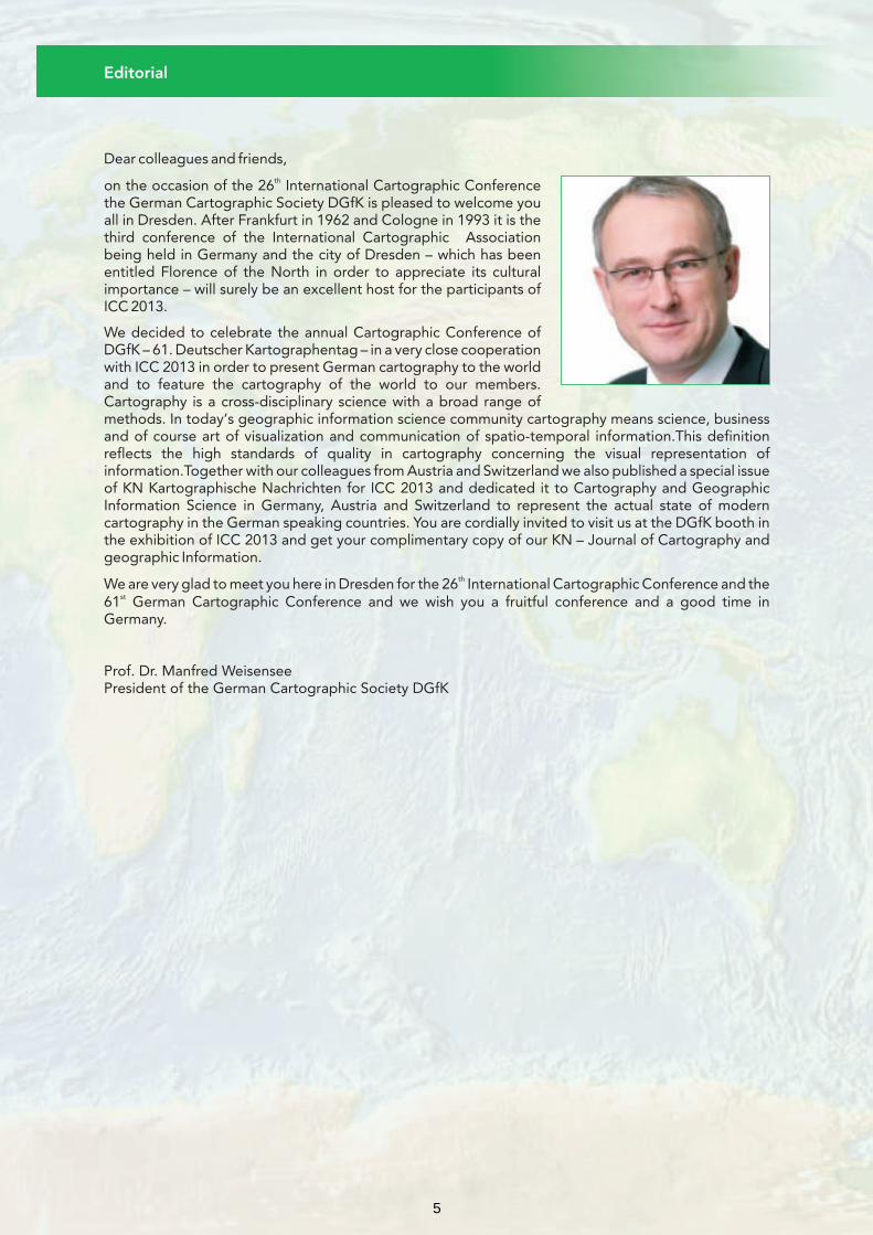
Dear colleagues and friends,thon the occasion of the 26 International Cartographic Conference
the German Cartographic Society DGfK is pleased to welcome you all in Dresden. After Frankfurt in 1962 and Cologne in 1993 it is the third conference of the International Cartographic Association being held in Germany and the city of Dresden – which has been entitled Florence of the North in order to appreciate its cultural importance – will surely be an excellent host for the participants of ICC 2013.
We decided to celebrate the annual Cartographic Conference of DGfK – 61. Deutscher Kartographentag – in a very close cooperation with ICC 2013 in order to present German cartography to the world and to feature the cartography of the world to our members. Cartography is a cross-disciplinary science with a broad range of methods. In today‘s geographic information science community cartography means science, business and of course art of visualization and communication of spatio-temporal information.This definition reflects the high standards of quality in cartography concerning the visual representation of information.Together with our colleagues from Austria and Switzerland we also published a special issue of KN Kartographische Nachrichten for ICC 2013 and dedicated it to Cartography and Geographic Information Science in Germany, Austria and Switzerland to represent the actual state of modern cartography in the German speaking countries. You are cordially invited to visit us at the DGfK booth in the exhibition of ICC 2013 and get your complimentary copy of our KN – Journal of Cartography and geographic Information.
thWe are very glad to meet you here in Dresden for the 26 International Cartographic Conference and the st61 German Cartographic Conference and we wish you a fruitful conference and a good time in
Germany.
Prof. Dr. Manfred WeisenseePresident of the German Cartographic Society DGfK
5
Committees
International Scientific Committee:
Technical Exhibition Committee:
Social Programme Committee:
Technical Tours Committee:
Pre- and Post-Conference Tours Committee:
Sub-Committee Abstracts/Papers:
Accompanying Persons Programme Committee:
Sub-Committee Map Exhibitions:Sub-Committee Public Relations:
Local Organising Committee:
Sub-Committee Orienteering Competition:
• Paolo MENEZES • Werner HAUPT / • Liqiu MENG Barbara WOLTERS
• Suchith ANAND • Harald MOELLERING • Clara TÖPFER• Gennady ANDRIENKO • Carme MONTANER • Tobias KRÜGER• Masatoshi ARIKAWA • José Jesús Reyes NUÑEZ • Dirk BURGHARDT• Hartmut ASCHE • Kristien OOMS • Benjamin SCHRÖTER• Thierry BADARD • Ferjan ORMELING • Karsten PIPPIG• Temenoujka BANDROVA • Alastair PEARSON • Thomas CHUDY• Manfred BUCHROITHNER • Chris PERKINS • Ulf TREBESIUS• Aileen BUCKLEY • Michael P. PETERSON • Sylvia NEUMANN• Dirk BURGHARDT • Barbara PIATTI• Rex G. CAMMACK • Alexander PUCHER• Sébastien CAQUARD • Qingwen QI• William CARTWRIGHT • Waldirene RIBEIRO• Xiaoyong CHEN • Gerd BUZIEK• Bengt RYSTEDT• Steve CHILTON • Manfred WEISENSEE• Anne RUAS• Derek CLARKE • Matthias ALISCH• Manuela SCHMIDT• Peter COLLIER • Irmi RUNKEL• Jörn SEEMAN• Antony COOPER • Manfred BUCHROITHNER• Monika SESTER• Philippe DE MAYER • Sylvia NEUMANN• Kira SHINGAREVA• Imre Josef DEMHARDT • René SIEBER• Frank DICKMANN • Vladimir TIKUNOV• Qingyun DU • Xiaohua TONG• Cecile DUCHENE • Tim TRAINOR • Sylvia NEUMANN• Jason DYKES • Andrew TURNER• Alejandra Coll ESCANILLA • Necla ULUGTEKIN• Sara FABRIKANT • Lynn USERY• David FAIRBAIRN • Corné VAN ELZAKKER• Kenneth FIELD • Thomas CHUDY• Robert WEIBEL• David FORREST • Jana MOSER• Alexander WOLODTSCHENKO• David FRASER • Sylvia NEUMANN• Xiaojun YANG• Georg GARTNER • Xiaobai YAO• Amy GRIFFIN • Liu YAOLIN• Henrik HARGITAI • Long YI• Anja HOPFSTOCK • László ZENTAI• Florian HRUBY • Wieslawa ZYSZKOWSKA • Sylvia NEUMANN• Lorenz HURNI
• Anja BINNING• Bernhard JENNY• Andrea WITSCHEL• Bin JIANG
• Markus JOBST• Peter JORDAN • Nikolas PRECHTEL• Alexander KENT • Manfred BUCHROITHNER• Pyry KETTUNEN • Dirk BURGHARDT• Milan KONECNY • INTERCOM / Sylvia NEUMANN• Menno-Jan KRAAK• Horst KREMERS• Diah K. KRESNAWATI
• Dirk BURGHARDT• Karel KRIZ• Alessio BERTONE • Barbara WOLTERS• Miljenko LAPAINE• Uta HEIDIG • Manfred BUCHROITHNER• Jonathan LI
• Sylvia NEUMANN• Rongxing (Ron) LIBenjamin SCHRÖTER• Zhilin LI
• Elri LIEBENBERG• Christophe LIENERT • Manfred BUCHROITHNER• Evangelos LIVIERATOS (President)• Yuefeng LIU • Manfred WEISENSEE• William A. MACKANESS • Hansjörg KUTTERER / • Robert KRÜGER• Sukendra MARTHA Andreas ILLERT
6
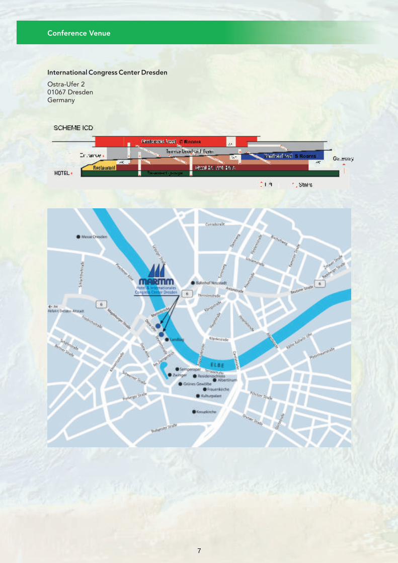
Conference Venue
International Congress Center Dresden
Ostra-Ufer 201067 DresdenGermany
7
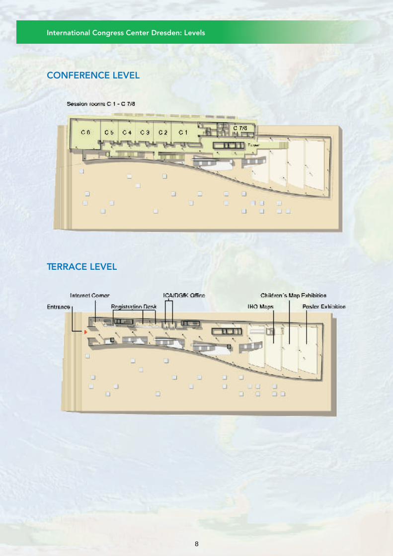
International Congress Center Dresden: Levels
CONFERENCE LEVEL
TERRACE LEVEL
8

SEMINAR LEVEL
International Congress Center Dresden: Levels
HALL LEVEL
9

Conference Organizers
Conference President
Conference Secretary
Conference Homepage:
Coffee Breaks / Lunch:
Disclaimer:
Lost & Found:
Name Badges:
Official Language:
Parking:
Time Differences:
International Cartographic AssociationDepartment of Geoinformation and Cartography Vienna University of Technology
Gußhausstr. 27-291040 WienAustria
Deutsche Gesellschaft für Kartographie e.V.
Postfach 11 1401686 WeinböhlaGermany
Manfred Buchroithner
Technische Universität Dresden
Sylvia Neumann
Intercom Dresden GmbH
Zellescher Weg 301069 DresdenGermany
www.icc2013.org
Coffee breaks and lunches will be served in the exhibition area (Hall 2-5). The breaks are indicated in the programme. The coffee breaks as well as the lunches are included in the conference fee.
The organizers are not liable for damages and/or losses of any kind which may be incurred by the conference or by any other individuals accompanying them, both during the official activities as well as going to/from the conference.
Lost & Found items are handled by the registration desk.
Participants and accompanying persons are required to wear the official conference name badge on all conference occasions. Without name badge no entrance!
The conference language is English.
An underground car park is available at the International Congress Center. Open hours: 24 hours daily
Height limit: 2,10 meters
1,50 € / 1 hour, 14,00 € / 24 hours
Dresden, Germany is in Central European Time.
General Information
10
Registration desk:
Registration Fee on Site:
Poster Information:
August 25, 2013 14.00 – 19.00 August 26, 2013 08.00 – 19.00 August 27, 2013 08.00 – 18.00 August 28, 2013 08.00 – 20.00 August 29, 2013 08.00 – 18.00 August 30, 2013 08.00 – 16.00
Phone: +49 (0) 351 216 1702
Full participant 600,00 €Senior / Student 400,00 €Attendees from Africa 400,00 €One day Attendee 250,00 €Accompanying person 180,00 €Gala Dinner 65,00 €
There will be three poster sessions during ICC 2013. Please visit the conference programme to find out on which day your poster presentation is scheduled. You can use the full text search and enter your abstract ID or author name to get the required information.
Poster sessions will take place on the following three conference days:
Poster Session I:
Tuesday, August 27, 2013; 12.15 – 12.45
Authors are kindly asked to place their posters on Tuesday, August 27, 2013 from 08.30 to 10.30 and to take it off from 17.45 to 19.00.
Poster Session II:
Wednesday, August 28, 2013; 12.15 – 12.45
Authors are kindly asked to place their posters on Wednesday, August 28, 2013 from 08.30 to 10.30 and to take it off from 17.45 to 19.00.
Poster Session III:
Thursday, August 29, 2013; 12.15 – 12.45
Authors are kindly asked to place their posters on Thursday, August 29, 2013 from 08.30 to 10.30 and to take it off from 17.45 to 19.00.
The poster exhibition is located at the “Terrassen Foyer” of the conference venue. During the poster session authors are kindly asked to be present in the area of their posters in order to answer questions that interested viewers may have.
The poster boards have a height of 236 cm (=92,91 inches) and a width of 95 cm (=37,4 inches) and are working for DIN A0 size.
Posters can only be fixed on poster boards, using the fixing material provided at the poster desk.
No liability will be assumed for non-removed posters!
General Information
11
Cartographic Exhibition
Technical Exhibition – Sponsorship Opportunities
The official opening of the International Cartographic Exhibition will take place on Monday the th26 August at 13.00 after the official opening ceremony for the ICC2013.
During the cartographic exhibition countries from all over the world will exhibit most recent cartographic products in digital or paper format. Maps and Cartographic Products are submitted in 5 different categories:
• Paper Maps • Atlases • Digital Products • Educational Cartographic Products • Other Cartographic Products (including globes and tactile maps)
Organisational IssuesthThe conference center will be open on Sunday, the 25 between 14.00 and 19.00 for the preparation of
the Cartographic Exhibition. This will be the best time to hang the maps on the panels. The conference thcenter opens again on Monday, the 26 at 20.00. Thus there is time until lunch for final preparations.
“Power strips” will be used to stick the maps on the panels. The power strips will be provided by the local organisers, of course it is possible touse your own power strips.
ICA has confirmed a new exhibition period from August 27 – 29, 2013.Ice Breaker will take place in the exhibition area August 26, 18.00 – 20.00
A 01 Springer-Verlag GmbHA 02 Saxon State and University Library Dresden (SLUB Dresden)A 03 Kirschbaum Verlag GmbHA 04 Sociedade Brasileira de Cartografia (ICC 2015)A 05 Beuth University for Applied Sciences BerlinA 06 Jade University of Applied SciencesA 07 German Cartographic Society e.V. (DGfK)A 08 AMCAD & Rauch GmbHA 09 OCAD AGA 10 Mercator CPS / 1 SpatialA 11 Leibniz-Institut für LänderkundeA 12 Plastic Logic GmbHA 13 Swiss Confederation: Office of Topography - Statistical OfficeA 14 GiziMapA 15 Interactive Minds Dresden GmbHA 16 EsriA 17 Glówny Urzad Geodezji i KartografiiA 18 Beak Consultants GmbHA 19 RIEGL Laser Measurement Systems GmbHA 20 Maney PublishingA 21 Neenah Lahnstein GmbHA 22 Industrieanlagen-Betriebsgesellschaft mbH (IABG)A23+A24 Arbeitsgemeinschaft der Vermessungsverwaltungen der Länder der
Bundesrepublik Deutschland (AdV): Official Surveying and Cartography GermanyA 25 East View GeospatialA 26 RapidEye AGA 27 DBx GEOMATICS
Exhibitions
12
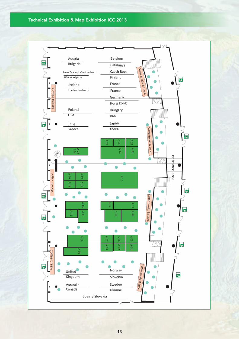
Technical Exhibition & Map Exhibition ICC 2013
A 16
A 13
A 21
A 15
A 09
A 10
A 14
A 22
A 11
A 04
A 01
A 02
A 05
A 06
A 07
A 03
A 17
A 19
A 18
A 20
A 23
/ 24
A 08
A 27
A 26
A 25
entran
ce area
Belgium
Catalunya
Czech Rep.
Finland
France
France
Germany
Hong Kong
Hungary
Iran
Japan
Korea
Norway
Slovenia
Sweden
Ukraine
Turkey/ Algeria
New Zealand /Switzerland
Bulgaria
Austria
The Netherlands
Poland
Jreland
USA
Chile
Greece
United
Kingdom
AustraliaCanada
Spain / Slovakia
A 12
Co
ffee Breaks &
Lun
chC
offee B
reaks & Lu
nch
Co
ffee Breaks &
Lun
ch
Co
ffee Breaks &
Lun
ch
Co
ffee Breaks
Co
ffee Breaks
Co
ffee Breaks
13

Additional Programme
SOCIAL PROGRAMS
ACCOMPANYING PARTNERS PROGRAMS
ICE BREAKER
YOUNG CARTOGRAPHER’S SOCIAL MEETING
GALA DINNER
Walking tour through the historical city centre
Excursion to Pillnitz
Monday, August 26, 2013, 18.00-20.00
The Ice Breaker will be a casual Get Together at the first evening with welcome drinks and snacks served. All participants are invited to this social event in the exhibition area at the International Congress Center.
Wednesday, August 28, 2013, 19:30
The YOUNG CARTOGRAPHER’S SOCIAL MEETING at the ICC 2013 will take place at Wenzel Prager Bierstuben (www.wenzel-bierstuben.de) on August 28, 19:30. The YOUNG CARTOGRAPHER’S SOCIAL MEETING will be the right framework to discuss current research topics, to reflect first impressions of the ICC, or simply to meet other young scientists of the cartographic community in a relaxed atmosphere. Students and PhD students are warmly welcome to attend this meeting.
All those interested are kindly asked to register at the stand of the German Cartographic Society (DGfK, stand no. A07) at the exhibition area on Tuesday (Aug 27) or Wednesday (Aug 28). Please be aware that the number of participants is limited to 80 persons.
Thursday, August 29, 2013, 19.30-23.00
Besides the conference, the Gala Dinner is a good opportunity for social contacts of the participants. From the Westin Bellevue Hotel you will be awarded with the famous Canaletto-view.
Monday, August 26, 14.00-16.00
A guided walking tour through the pedestrian area of the historical city centre of Dresden is a “must” for visitors. In a two hours tour you will get an overview of the most famous sights of Dresden, such as the Residence Castle, the Semper Opera House, the Zwinger and the Church of our Lady.
Good walking shoes and an ability to walk on uneven pavement are recommended.
Wednesday, August 28, 09.00-13.00
A ride on the Elbe river is a special experience. Dresden is the home of the largest and oldest steamboat fleet in the world. You will pass by the three Elbe palaces and the famous “Blue Wonder” bridge. Enjoy the beautiful view on your tour to Pillnitz. Visit the Park of Pillnitz Palace, a former summer residence of the famous Saxon King August the Strong. You will be impressed by the unique location, the gardens and the architecture of the palace built in a Chinese style. The return journey to Dresden will be by motor coach.
Lunch will be by your own. It is possible to purchase refreshments and snacks on the steamer or at the Park.
14
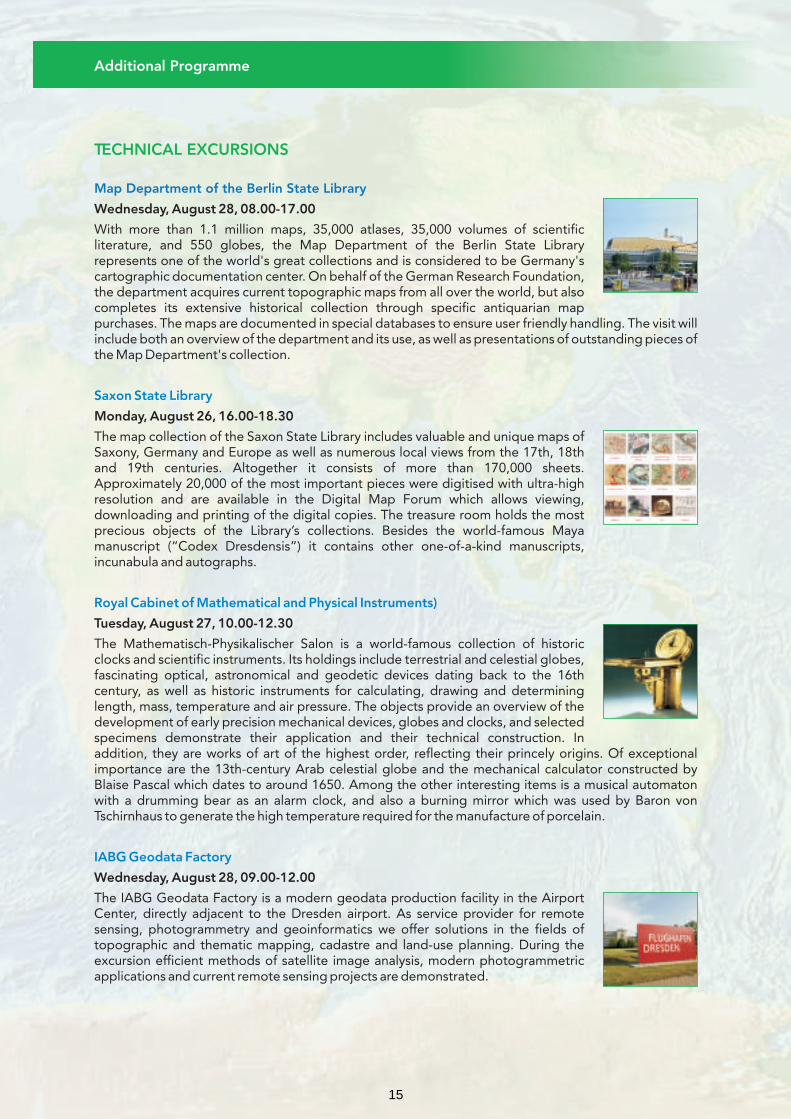
TECHNICAL EXCURSIONS
Map Department of the Berlin State Library
Wednesday, August 28, 08.00-17.00
With more than 1.1 million maps, 35,000 atlases, 35,000 volumes of scientific literature, and 550 globes, the Map Department of the Berlin State Library represents one of the world's great collections and is considered to be Germany's cartographic documentation center. On behalf of the German Research Foundation, the department acquires current topographic maps from all over the world, but also completes its extensive historical collection through specific antiquarian map purchases. The maps are documented in special databases to ensure user friendly handling. The visit will include both an overview of the department and its use, as well as presentations of outstanding pieces of the Map Department's collection.
Monday, August 26, 16.00-18.30
The map collection of the Saxon State Library includes valuable and unique maps of Saxony, Germany and Europe as well as numerous local views from the 17th, 18th and 19th centuries. Altogether it consists of more than 170,000 sheets. Approximately 20,000 of the most important pieces were digitised with ultra-high resolution and are available in the Digital Map Forum which allows viewing, downloading and printing of the digital copies. The treasure room holds the most precious objects of the Library’s collections. Besides the world-famous Maya manuscript (“Codex Dresdensis”) it contains other one-of-a-kind manuscripts, incunabula and autographs.
Tuesday, August 27, 10.00-12.30
The Mathematisch-Physikalischer Salon is a world-famous collection of historic clocks and scientific instruments. Its holdings include terrestrial and celestial globes, fascinating optical, astronomical and geodetic devices dating back to the 16th century, as well as historic instruments for calculating, drawing and determining length, mass, temperature and air pressure. The objects provide an overview of the development of early precision mechanical devices, globes and clocks, and selected specimens demonstrate their application and their technical construction. In addition, they are works of art of the highest order, reflecting their princely origins. Of exceptional importance are the 13th-century Arab celestial globe and the mechanical calculator constructed by Blaise Pascal which dates to around 1650. Among the other interesting items is a musical automaton with a drumming bear as an alarm clock, and also a burning mirror which was used by Baron von Tschirnhaus to generate the high temperature required for the manufacture of porcelain.
Wednesday, August 28, 09.00-12.00
The IABG Geodata Factory is a modern geodata production facility in the Airport Center, directly adjacent to the Dresden airport. As service provider for remote sensing, photogrammetry and geoinformatics we offer solutions in the fields of topographic and thematic mapping, cadastre and land-use planning. During the excursion efficient methods of satellite image analysis, modern photogrammetric applications and current remote sensing projects are demonstrated.
Saxon State Library
Royal Cabinet of Mathematical and Physical Instruments)
IABG Geodata Factory
Additional Programme
15

GeoSN
Orienteering event
Tuesday, August 27, 10.00-12.30
GeoSN is the Saxon state spatial data and land survey agency. The tour will cover both the topographic-cartographic information system, GDI and INSPIRE activities as well as the print on demand technology. In front of the GeoSN building is the famous national museum of military history designed by the architect Daniel Libeskind.
Wednesday, August 28, 17.30
The event will be organised around the conference centre mostly in urban areas (city center). Three courses will be planned:
• long course: for „professional” orienteers, about 5 km,
• medium course: for beginners and masters, about 3 km,
• beginner course in the urban area, about 1.5 km.
The course lengths are the straight line distances, so the actual length to run will be longer due the urban character of the area.
Please note: The entry fee is to be paid directly to the event organizers at the start.
The ICC Orienteering Event will be organized together with a regional orienteering event. The regional event starts at 16:30. The ICC Orienteering Event will be open from 17:30 up to 18:30 as well. For logical reasons the participants who selected the longest course will start earlier.
There will be a short briefing for the participants on Monday, August 26, 17:45 in the Conference Centre (room C2) where the participants can indicate which course they select, SI numbers can be collected, the organizers may also collect the entry fees in advance. They will have demonstrations for the beginners (control flag, SI punching, control descriptions).
OTHER ACTIVITIES
Additional Programme
16

Kontakt
Veranstaltungsort
Registrierungsgebühren
Programm
Deutschen Gesellschaft für Kartographie e. V.
Präsident: Prof. Dr.-Ing. Manfred WeisenseePostfach 11 14, 01686 Weinböhla, Germany
www.dgfk.net
International Congress Center Dresden
Ostra-Ufer 201067 DresdenGermany
Frühregistrierung Spätregistrierungbis 15.04.2013 ab 16.04.2013
1, 3Mitglied DGfK, DVW, VDV und DGPF 200,00 € 250,00 €Nichtmitglied 300,00 € 350,00 €Mitglied DGfK, DVW, VDV und DGPF 100,00 € 125,00 €
2,3 in Ausbildung Nichtmitglied in Ausbildung ² 125,00 € 150,00 €Teilnahme am Deutschen Kartographentag 500,00 € 600,00 €
4und ICC-Kongress
In der Tagungsgebühr sind enthalten:
(1) Teilnahme am wissenschaftlichen Programm des DKT Tagungsunterlagen Teilnahme am wissenschaftlichen Programm der ICC 2013 am 29. und 30.08.2013 Zutritt zur ICC-Technical, Cartographic und Children’s drawing exhibition am 29. und 30.08.2013 Kaffeepausen und Mittagessen am 29. und 30.08.2013 Teilnahme an der Eröffnungsveranstaltung am 28.08.2013
(2) Nachweis erforderlich
(3) Mitgliedschaft erforderlich
(4) zusätzlich zu (1):
Teilnahme am kompletten wissenschaftlichen Programm ICC 2013 Zutritt zur ICC-Technical, Cartographic und Children’s drawing exhibition Tagungsunterlagen ICC 2013 Kaffeepausen, Mittagessen, Ice Breaker ICC 2013
Mittwoch, 28.08.2013, 14:00 - 17:00 • Ort: TU Dresden, Hülssebau, Hörsaal S 186
Mitgliederversammlung der DGfK
Mittwoch, 28.08.13, 19:00 - 21:30
Eröffnung des DKT2013:Festvortrag von Dominique Görlitz „Präkolumbianische Kartenquellen“
Donnerstag, 29.08.13, 09:15 - 10:30
DKT2013: Geodaten heute und morgenModeration: Tobias Krüger
Donnerstag, 11:00 - 12:15
DKT2013: Aus der Aus der Arbeit der DGfK-KommissionenModeration: Dietrich Diez
Freitag, 30.08.13, 09:15 - 10:30
DKT2013: Aktuelle Entwicklung in der AtlaskartographieModeration: Jana Moser
61. Deutscher Kartographentag
17

Programme at a Glance
10:00-12:45
OpeningCeremony
Great Hall
Plenary Keynote
Best Practice Presen-tation
Best Practice Presen-tation
Best Practice Presen-tation
Plenary KeynotePlenary Keynote
Break
BreakBreak
LunchLunch
Plenary Keynote
Plenary Keynote Scientific Awards
Break
Break
Lunch
Plenary Keynote
Break
Break
Lunch
Plenary Keynote
Closing Ceremony
Great Hall
Ice Breaker
Hall level Exhibition area
Gala Dinner(up to 23:00)
Westin Bellevue Hotel
Young Cartogr. Social Meeting
Wenzel Prager
Bierstuben
DKT Eröffnung
Conf. level C6
Internat.Masters of Carto-graphy Ceremony (not public)
Business Meeting
CMC
C4
Young Scientists Speed Pres.
Conf. Level C5
17:30-19:00Orienteering Competition
Briefing Orient. Comp.17:45 - 18:15 C 2
Break
Break
Lunch
Mo
vie-
Car
tog
r. &
Nar
r.
H
all 1
17:45-18:00
18:00-18:30
18:30-19:00
19:00-19:30
19:30-20:00
ICA
Cha
ir M
eeti
ng
S1
20:00-20:30
20:30-21:00
21:00-21:30
MondayAugust 26, 2013
TuesdayAugust 27, 2013
WednesdayAugust 28, 2013
ThursdayAugust 29, 2013
FridayAugust 30, 2013
08:30-09:15
09:15-10:30
10:30-11:00
11:00-12:15
12:15-12:45
12:45-14:00
14:00-14:45
14:45-16:00
16:00-16:30
16:30-17:45
Poster Session 1
Poster Session 3
Poster Session 2
Session 5A Great HallB Hall 1C C6D C1E C2F C3GH C5I C7/8J S1
C4
Session 1A Great HallB Hall 1C C6D C1E C2F C3G C4HI C7/8
C5
Session 9A Great HallB Hall 1C C6D C1E C2F C3
H C5G
I C7/8J S1
C4
Session 13A Great HallB Hall 1C C6D C1E C2F C3G C4HI C7/8
C5
Session 3A Great HallB Hall 1C C6D C1E C2F C3G C4HI C7/8
C5
Session 7A Great HallB Hall 1C C6D C1E C2F C3GH C5I C7/8J S1
C4
Session 11A Great HallB Hall 1C C6D C1E C2F C3G C4
I S1H C5
J C7/8
Session 15A Great HallB Hall 1C C6D C1E C2F C3G C4
I C7/8H C5
Session 4A Great HallB Hall 1C C6D C1E C2F C3G C4HI C7/8J S1
C5
Session 8A Great HallB Hall 1C C6D C1E C2F C3GH C5I C7/8
C4
Session 12A Great HallB Hall 1C C6D C1E C2F C3G C4H C5I S1
Session 16A Great HallB Hall 1C C6D C1E C2F C3G C4
I C7/8H C5
Session 6A Great HallB Hall 1C C6D C1E C2F C3G C4H C5I S1
Session 2A Great HallB Hall 1C C6D C1E C2F C3GH C5I S1
C4
Session 10A Great HallB Hall 1C C6D C1E C2F C3G C4HI C7/8J S1
C5
Session 14A Great HallB Hall 1C C6D C1E C2F C3G C4HI C7/8
C5
18

SCIENTIFIC PROGRAMME
Sessions, Poster Sessions
and
Additional Events
pages 20 – 55
Geospatial Analysis and ModelingMap DesignArt and CartographyCartography in Early Warning and Crisis ManagementMaps and SocietyData QualityCognitive Visualization/Theoretical CartographyNeocartographyMaps and the InternetGeneralisation and Multiple RepresentationMap ProjectionsAtlasesMaps and SecurityGeovisualizationGeoinformation Infrastructures and StandardsCartography and ChildrenOpen Source Geospatial TechnologiesMapping from Remote Sensor ImageryHistory of CartographyMaps and Graphics for Blind and Partially Sighted PeopleGI for SustainabilityMap Production and Geo-BusinessEducation and TrainingPlanetary CartographyDigital Technologies in Cartographic HeritageUse and User IssuesMountain CartographyUbiquitous MappingOrienteering MapsMixed Session
OthersDeutscher Kartographentag
Programme at a Glance
19
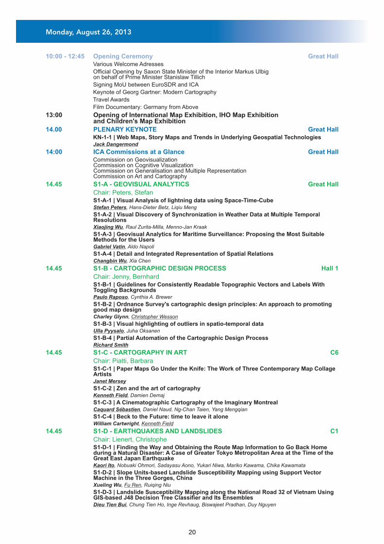
10:00 - 12:45 Opening Ceremony Great Hall Various Welcome Adresses
Official Opening by Saxon State Minister of the Interior Markus Ulbig on behalf of Prime Minister Stanislaw Tillich
Signing MoU between EuroSDR and ICA
Keynote of Georg Gartner: Modern Cartography
Travel Awards
Film Documentary: Germany from Above
13:00 Opening of International Map Exhibition, IHO Map Exhibition and Children's Map Exhibition
Commission on GeovisualizationCommission on Cognitive VisualizationCommission on Generalisation and Multiple RepresentationCommission on Art and Cartography
14.00 PLENARY KEYNOTE Great Hall
14:00 ICA Commissions at a Glance Great Hall
KN-1-1 | Web Maps, Story Maps and Trends in Underlying Geospatial Technologies Jack Dangermond
S1-A-1 | Visual Analysis of lightning data using Space-Time-Cube Stefan Peters, Hans-Dieter Betz, Liqiu Meng
S1-A-2 | Visual Discovery of Synchronization in Weather Data at Multiple Temporal Resolutions
Xiaojing Wu, Raul Zurita-Milla, Menno-Jan Kraak
S1-A-3 | Geovisual Analytics for Maritime Surveillance: Proposing the Most Suitable Methods for the Users
Gabriel Vatin, Aldo Napoli
S1-A-4 | Detail and Integrated Representation of Spatial Relations Changbin Wu, Xia Chen
S1-B-1 | Guidelines for Consistently Readable Topographic Vectors and Labels With Toggling Backgrounds
Paulo Raposo, Cynthia A. Brewer
S1-B-2 | Ordnance Survey's cartographic design principles: An approach to promoting good map design
Charley Glynn, Christopher Wesson
S1-B-3 | Visual highlighting of outliers in spatio-temporal data Ulla Pyysalo, Juha Oksanen
S1-B-4 | Partial Automation of the Cartographic Design Process Richard Smith
S1-C-1 | Paper Maps Go Under the Knife: The Work of Three Contemporary Map Collage Artists
Janet Mersey
S1-C-2 | Zen and the art of cartography Kenneth Field, Damien Demaj
S1-C-3 | A Cinematographic Cartography of the Imaginary Montreal Caquard Sébastien, Daniel Naud, Ng-Chan Taien, Yang Mengqian
S1-C-4 | Beck to the Future: time to leave it alone William Cartwright, Kenneth Field
S1-D-1 | Finding the Way and Obtaining the Route Map Information to Go Back Home during a Natural Disaster: A Case of Greater Tokyo Metropolitan Area at the Time of the Great East Japan Earthquake
Kaori Ito, Nobuaki Ohmori, Sadayasu Aono, Yukari Niwa, Mariko Kawama, Chika Kawamata
S1-D-2 | Slope Units-based Landslide Susceptibility Mapping using Support Vector Machine in the Three Gorges, China
Xueling Wu, Fu Ren, Ruiqing Niu
S1-D-3 | Landslide Susceptibility Mapping along the National Road 32 of Vietnam Using GIS-based J48 Decision Tree Classifier and Its Ensembles
Dieu Tien Bui, Chung Tien Ho, Inge Revhaug, Biswajeet Pradhan, Duy Nguyen
14.45 S1-A - GEOVISUAL ANALYTICS
Chair: Peters, Stefan
14.45 S1-B - CARTOGRAPHIC DESIGN PROCESS Hall 1
Chair: Jenny, Bernhard
14.45 S1-C - CARTOGRAPHY IN ART C6
Chair: Piatti, Barbara
14.45 S1-D - EARTHQUAKES AND LANDSLIDES C1
Chair: Lienert, Christophe
Great Hall
Monday, August 26, 2013
20
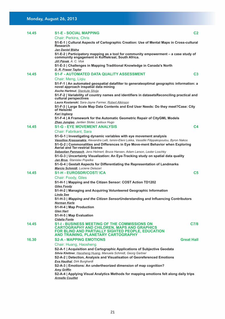
14.45 S1-E - SOCIAL MAPPING C2
Chair: Perkins, Chris
14.45 S1-F - AUTOMATED DATA QUALITY ASSESSMENT C3
Chair: Meng, Liqiu
14.45 S1-G - EYE MOVEMENT ANALYSIS C4
Chair: Fabrikant, Sara
14.45 S1-H - EUROSDR/COST/ ICA C5
Chair: Foody, Giles
14.45 S1-I - BUSINESS MEETING OF THE COMMISSIONS ON C7/8CARTOGRAPHY AND CHILDREN, MAPS AND GRAPHICS FOR BLIND AND PARTIALLY SIGHTED PEOPLE, EDUCATION AND TRAINING, PLANETARY CARTOGRAPHY
16.30 S2-A - MAPPING EMOTIONS Great Hall
Chair: Huang, Haosheng
S1-E-1 | Cultural Aspects of Cartographic Creation: Use of Mental Maps in Cross-cultural Research
Jan Daniel Bláha
S1-E-2 | Participatory mapping as a tool for community empowerment – a case study of community engagement in Koffiekraal, South Africa.
Jiří Pánek, A. C. Vlok
S1-E-3 | Challenges in Mapping Traditional Knowledge in Canada's North D. R. Fraser Taylor
S1-F-1 | An automated geospatial datafilter to generateoptimal geographic information: a novel approach inspatial data mining
Asche Hartmut, Stankute Silvija
S1-F-2 | Variability of country names and identifiers in datasetsReconciling practical and cultural perspectives
Laura Kostanski, Sara-Jayne Farmer, Robert Atkinson
S1-F-3 | Large Scale Map Data Contents and End User Needs: Do they meet?Case: City of Helsinki
Kari Ingberg
S1-F-4 | A Framework for the Automatic Geometric Repair of CityGML Models Zhao Junqiao, Jantien Stoter, Ledoux Hugo
S1-G-1 | Investigating dynamic variables with eye movement analysis Vassilios Krassanakis, Alexandra Lelli, Ismini-Eleni Lokka, Vassiliki Filippakopoulou, Byron Nakos
S1-G-2 | Commonalities and Differences in Eye Move-ment Behavior when Exploring Aerial and Ter-restrial Scenes
Sebastian Pannasch, Jens Helmert, Bruce Hansen, Adam Larson, Lester Loschky
S1-G-3 | Uncertainty Visualization: An Eye-Tracking study on spatial data quality Jan Brus, Stanislav Popelka
S1-G-4 | Gestalt Aspects for Differentiating the Representation of Landmarks Marcio Schmidt, Luciene Delazari
S1-H-1 | Mapping and the Citizen Sensor: COST Action TD1202 Giles Foody
S1-H-2 | Managing and Acquiring Volunteered Geographic Information Linda See
S1-H-3 | Mapping and the Citizen SensorUnderstanding and Influencing Contributors Norman Kerle
S1-H-4 | Map Production Glen Hart
S1-H-5 | Map Evaluation Cidalia Fonte
S2-A-1 | Acquisition and Cartographic Applications of Subjective Geodata Silvia Klettner, Haosheng Huang, Manuela Schmidt, Georg Gartner
S2-A-2 | Detection, Analysis and Visualisation of Georeferenced Emotions Eva Hauthal, Dirk Burghardt
S2-A-3 | Emotions: An undertheorized dimension of map cognition? Amy Griffin
S2-A-4 | Applying Visual Analytics Methods for mapping emotions felt along daily trips Armelle Couillet
Monday, August 26, 2013
21

16.30 S2-B - NEOCARTOGRAPHY Hall 1
Chair: Schmidt, Manuela
16.30 S2-C - MAPS AND THE INTERNET: GENERAL TASKS 1 C6
Chair: Cammack, Rex G.
16.30 S2-D - GENERALISATION OF NETWORKS 1 C1
Chair: Weibel, Robert
16.30 S2-E - MAP PROJECTIONS 1 C2
Chair: Pedzich, Pawel
16.30 S2-F - WEB AND 3D ATLASES C3
Chair: Qi, Qingwen
16.30 S2-G - PLAYING WITH MAPS C4
Chair: Perkins, Chris
S2-B-1 | Is there a new cartography? Steve Chilton, Steve Chilton
S2-B-2 | Neocartography and the Social Web Andrew Turner
S2-B-3 | Mobile Crowd Mapping Jukka Krisp, Alan Cheung
S2-B-4 | Collaborative Mapping: a collective methodology for encountering and documenting an unfamiliar cityscape
Laurene Vaughan
S2-C-1 | Taking Cartography into the Cloud Michael Peterson
S2-C-2 | A process for assessing emergent web mapping technologies Robert Roth, Richard Donohue, Carl Sack, Timothy Wallace, Tanya Buckingham
S2-C-3 | TileServer: Extremely fast, free and open-source OGC WMTS server for pre-rendered tiles
Petr Pridal
S2-C-4 | Scalable Vector GraphicsWeb Standard for Cartography Otakar Cerba
S2-D-1 | Integration Metrics for Cartographic Generalization: Assessment of 1:1,000,000 Scale Hydrography and Terrain
Lawrence V. Stanislawski, Barbara Buttenfield, Cynthia A. Brewer
S2-D-2 | Fuzzy Generalization Inference System - the example of selection parameterization for roads and hydrographic network
Anna Fiedukowicz
S2-D-3 | Deriving Products from a Multi Resolution Database using Automated Generalisation at Ordnance Survey
Nicolas Regnauld, Seb Lessware, Mark Plews
S2-D-4 | Automatic Production and Updating of Topographic Maps - A Case Study Using the German AAA Data Model
Ajay Mathur
S2-E-1 | THE USE OF MAP MASHUPS IN MAP PROJECTION EDUCATION Ýbrahim Oztug Bildirici, Osman Sami Kirtiloglu, Necla Uluðtekin
S2-E-2 | JACOBI CONFORMAL PROJECTION OF THE TRIAXIAL ELLIPSOID.MATHEMATICS AND MAPPING
Maxim Nyrtsov, Maria Fleis, Michael Borisov, Philip Stooke
S2-E-3 | Rendering Vector Geometry with Adaptive Composite Map Projections Bernhard Jenny, Bojan Šavrič
S2-F-1 | Evaluating the suitability of Web 2.0 technologies for online atlas access interfaces
Ender Özerdem, Felix Ortag, Georg Gartner
S2-F-2 | Service Driven 3D Atlas Cartography Nadia Panchaud, Ionu? Iosifescu, Remo Eichenberger, René Sieber, Lorenz Hurni
S2-F-3 | The Power of 3D Real-Time Visualization in Atlases – Concepts, Techniques, and Implementation
René Sieber, Raimund Schnürer, Remo Eichenberger, Lorenz Hurni
S2-F-4 | Web atlas technology as a tool of Czech Official Development Assistance Jiří Pánek, Rostislav Nétek, Aleš Vávra, Vít Voženílek
S2-G-1 | Playful mapping: the potential of a ludic approach to cartography Chris Perkins
S2-G-2 | The casual turn: politics, play and mapping Sam Hind, Alex Gekker
Monday, August 26, 2013
22

S2-G-3 | You Are Here! Playful Mapping, Haptic Navigation and a Cartography of Layers Nanna Verhoeff
S2-G-4 | Mapping the city, playing the city: Location-based apps as navigational interfaces.
Clancy Wilmott, Sybille Lammes
S2-H-1 | EuroSDR and Volunteered Geographic Information Dieter Fritsch
S2-H-2 | The Joint AGILE/EuroSDR Project on Crowd-Sourced Mapping Peter Mooney, Jeremy Morley
S2-H-3 | The OSM-GB Project: Data Analysis, Data Quality and Web Service Jeremy Morley
S2-H-4 | Understanding the activity of contributors to VGI projects. How, why, where, and when do they contribute geographic information?
Peter Mooney
S2-H-5 | Conflation of National Mapping and Crowd-Sourced DataA Comparison of Two Different Approaches
Zihan Liu, Volker Walter, Dieter Fritsch
16.30 S2-H - EUROSDR/COST/ ICA C5
Chair: Fritsch, Dieter
16.30 S2-I - COMPILATION AND COLLABORATION MODELS S1FOR GLOBAL DIGITAL MAPS
Chair: Demaj, Damien
17:45-18:15 Briefing Orienteering Event C2
18:30 - 20:00 ICE BREAKER Hall Level - Exhibition Area
Monday, August 26, 2013
23

08.30
08.30 ICA Commissions at a Glance Great Hall
PLENARY KEYNOTE Great Hall
KN-2-1 | 3D Spatial Monitoring of Marine Animals: Real-time and Archival Systems Imants G. Priede
Commission on Geospatial Analysis and ModelingCommission on AtlasesCommission on Use and User IssuesCommission on Maps and Society
S3-A-1 | Map Quality AssessmentGroundwork and Implementation Approach Lysandros Tsoulos, Natalia Blana
S3-A-2 | Digital elevation model quality assessment with no ground control Laurent Polidori, Mhamad El Hage, Elisabeth Simonetto
S3-A-3 | The Certainty of Ladscape Degradation? Radka Bacova, Jiri Jakubinsky, Eva Svobodova, Petr Kubicek, Vladimir Herber
S3-A-4 | Uncertainty modeling of glacier mapping and morphology estimation, in Arctic Xi Zhao, Songtao Ai, Xiaoping Pang
S3-B-1 | Forensic Mapping in South Africa: Four Examples Peter Schmitz, Corne Eloff, Reynold Talmakkies, Chris Linnen, Rudi Lourens
S3-B-2 | An Anti-compression Fragile Watermark Scheme for Vector Geographical Data Chang-Qing Zhu, Qi-Sheng Wang, Na Ren, Wei Wu
S3-B-3 | A Digital Watermark Algorithm for Tile Map Stored by Indexing Mechanism Na Ren, Chang-Qing Zhu, Shu-Jing Ren, Yi-Shu Zhu
S3-C-1 | The perception of information conveyed by graphic variables building point signatures in the Augmented Reality system on mobile devices
Lukasz Halik
S3-C-2 | Maps with sound as the way of elevation representation Andrey Medvedev
S3-C-3 | «3D geovisualisation of Noise and Visual impact of a proposed wind farm development using a GIS based visual-acoustic 3D simulation»
Papakonstantinou Apostolos, Kontos Themistoklis, Christodoulou Evangelos, Soulakellis Nikolaos
S3-C-4 | Augmented Reality Visualization of archeological data Daniel Eggert, Dennis Hücker, Volker Paelke
S3-D-1 | Development of a web-based system to track airborne and satellite assets to obtain imagery for emergency response
Sarah E. Battersby, Michael E. Hodgson, Bruce A. Davis, Shufan Liu
S3-D-2 | Geo Web Services for transport crisis management in alpine region Eszter Gálicz, Md. Imran Hossain, Wolfgang Reinhardt
S3-D-3 | Evaluation of the adequacy of the land use in sub-basin using GIS and Remote Sensing
Julio Cesar Demarchi, Célia Regina Lopes Zimback
S3-D-4 | Assessment of Risk and Hazard of Technological Emergencies with GIS (on the Example Vinnytsia Region)
Viktor Putrenko
S3-E-1 | Advances in Intelligent Processing of Topographic Map Image Yun Yang, Xiaoya An
S3-E-2 | Imagery Becomes Knowledge - Image Analysis Services in the Enterprise Thomas Bahr
S3-E-3 | Spatial data discovery using general purpose web search engines Samy Katumba, Serena Coetzee
S3-E-4 | Exploring the impact of a spatial data infrastructure on value-added resellers and vice versa
Antony K Cooper, Serena Coetzee, Petr Rapant, Dominique Laurent, David M Danko, Adam Iwaniak, Ammatzia Peled, Harold Moellering, Ulrich Düren
09.15 S3-A - QUALITY ASSESSMENT AND UNCERTAINTY
Chair: Junqiao, Zhao
09.15 S3-B - MAPS AND SECURITY Hall 1
Chair: Leitner, Michael
09.15 S3-C - AUGMENTED REALITY AND SOUND C6
Chair: Schiewe, Jochen
09.15 S3-D - WEB SERVICES AND GIS C1
Chair: Rezník, Tomá?
09.15 S3-E - SPECIAL ISSUES IN SDI C2
Chair: Rapant, Petr
Great Hall
Tuesday, August 27, 2013
24

09.15 S3-F - CARTOGRAPHY FOR CHILDREN C3
Chair: Beconyté, Giedré
09.15 S3-G - MAP PROJECTIONS 2 C4
Chair: Usery, Linn
09.15 S3-H - BUSINESS MEETING OF THE COMMISSION ON ATLASES C5
09.15 S3-I - BUSINESS MEETING OF THE COMMISSIONS ON MAP DESIGN, C7/8NEOCARTOGRAPHY
11.00 S4-A - ENVIRONMENTAL MONITORING Great Hall
Chair: Govorov, Michael
11.00 S4-B - CARTOGRAPHY AND LITERATURE Hall 1
Chair: Caquard, Sébastien
11.00 S4-C - ANALYSIS OF RURAL AND URBAN STRUCTURES C6
Chair: Perkins, Chris
S3-F-1 | Smartphone-based school atlases? Jose Jesus Reyes Nunez
S3-F-2 | Geospatial learning treshold overpassed with digital maps and mobile serious games on the terrain
Yaïves Ferland
S3-F-3 | Mapping my Mangrove: New Technologies applied to cartography to support environmental education in the teaching of Geography
Iomara Sousa
S3-F-4 | GLOBAL WARMING TEACHING THROUGH MAPS AND DIAGRAMS TOUCH Waldirene Ribeiro, Alejandra Coll
S3-G-1 | Atlas of Map Projections: the technology of creation on the basis of program-analytical complex
Gleb Zagrebin
S3-G-2 | Extending Adaptive Composite Map Projections with Wagner's Transformation Method
Bojan Šavrič, Bernhard Jenny
S3-G-3 | Developing PAMS – A Paleolocation Mapping Service Tomislav Urban, Frank Hardisty
S3-G-4 | HEALPix Mapping Technique and Cartographical Application Omur Esen, Vahit Tongur, Ismail Bulent Gundogdu
S4-A-1 | Assessing local variations of deforestation processes in Mexico using geographically weighted regression
Mas Jean-Francois, Cuevas Gabriela, Güiza Frida, Andablo Reyes Araceli
S4-A-2 | GPU-accelerated spatial interpolation rendering for web-based environmental monitoring
Christophe Lienert, Hansruedi Bär, Lorenz Hurni
S4-A-3 | HydroProg: a novel system for hydrological forecasting and flood risk mapping Tomasz Niedzielski, Bartlomiej Mizinski, Maciej Kryza, Malgorzata Wieczorek, Piotr Migon, Marek
Kasprzak, Pawel Netzel, Mariusz Szymanowski, Wieslaw Kosek, Matylda Witek, Justyna Jeziorska
S4-A-4 | Exploring Distribution of Uranium in Ukraine: Geovisualization and Spatial Statistics
Michael Govorov, Viktor Putrenko, Gennady Gienko
S4-B-1 | Dreams, Memories, Longings - Visualising Projected Spaces in Fiction Barbara Piatti, Anne-Kathrin Reuschel, Lorenz Hurni
S4-B-2 | Mapping Out Patience: Cartography, Cinema, and W.G. Sebald Taien Ng-Chan
S4-B-3 | Facts in Fiction: Introducing Cartography and Surveying in Martin Suter's Novel „Die Zeit, die Zeit“
Lorenz Hurni
S4-B-4 | Narrating Place Matthew Bissen, Paul Ritchard, Laurene Vaughan
S4-C-1 | Analysis and mapping of rural-urban interactions Maria Gunko
S4-C-2 | Identifying Residential Land in Rural Areas to Improve Dasymetric Mapping Stefan Leyk, Barbara Buttenfield, Nicholas Nagle, Alexander Stum
S4-C-3 | Automatic Delineation of Urban Blocks from Topographic Maps Sebastian Muhs, Gotthard Meinel, Dirk Burghardt
S4-C-4 | Analysis of European Topographic Maps for Automatic Acquisition of Urban Land Use Information
Ulrike Schinke, Hendrik Herold, Gotthard Meinel, Nikolas Prechtel
Tuesday, August 27, 2013
25
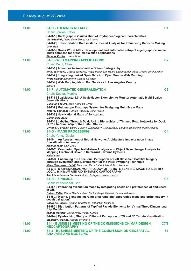
11.00 S4-D - THEMATIC ATLASES C1
Chair: Jordan, Peter
11.00 S4-E - WEB MAPPING APPLICATIONS C2
Chair: Pettit, Chris
11.00 S4-F - AUTOMATED GENERALISATION C3
Chair: Sester, Monika
11.00 S4-G - IMAGE PROCESSING C4
Chair: Yang, Xiaojun
11.00 S4-H - ISPRS/ICA C5
Chair: Veenendaal, Bert
11.00 S4-I - BUSINESS MEETING OF THE COMMISSIONS ON MAP DESIGN, C7/8NEOCARTOGRAPHY
11.00 S4-J - BUSINESS MEETING OF THE COMMISSION ON GEOSPATIAL S1ANALYSIS AND MODELING
S4-D-1 | Cartographic Visualization of Phytophenological Characteristics Vít Voženílek, Alena Vondráková, Aleš Vávra
S4-D-2 | Transportation Data in Maps Special Analysis for Influencing Decision Making Oren Raz
S4-D-3 | Swiss World Atlas: Development and automated setup of a geographical name index database for cross-media atlas applications
Thomas Koblet, Lorenz Hurni
S4-E-1 | Advances in Web-Service Driven Cartography Ionu? Iosifescu, Cristina Iosifescu, Nadia Panchaud, Remo Eichenberger, René Sieber, Lorenz Hurni
S4-E-2 | Integrating Linked Open Data into Open Source Web Mapping Wiafe Owusu-Banahene, Serena Coetzee
S4-E-4 | Web Mapping Metro Rail Services in Los Angeles County Bin Mo
S4-F-1 | ScaleMaster2.0: A ScaleMaster Extension to Monitor Automatic Multi-Scales Generalisations
Guillaume Touya, Jean-François Girres
S4-F-2 | MultimapperPrototype System for Designing Multi-Scale Maps Timofey Samsonov, Anton Podolsky, Nina Yurova
S4-F-3 | New National Maps of Switzerland Dominik Käuferle
S4-F-4 | Labeling Through Scale Using Hierarchies of Thinned Road Networks for Design of The National Map of the United States
Cynthia A. Brewer, Elaine Guidero, Lawrence V. Stanislawski, Barbara Buttenfield, Paulo Raposo
S4-G-1 | An Assessment of Neural Networks Architecture Impacts upon Image Classification Accuracy
Xiaojun Yang, Libin Zhou
S4-G-2 | Comparing Spectral Mixture Analysis and Object Based Image Analysis for Mapping Fractional Cover in Semi-Arid Savanna Systems
Niti Mishra
S4-G-3 | Enhancing the Locational Perception of Soft Classified Satellite Imagery Through Evaluation and Development of the Pixel Swapping Technique
Milad Niroumand Jadidi, Mahmoud Reza Sahebi, Mehdi Mokhtarzade
S4-G-4 | MATHEMATICAL MORPHOLOGY OF REMOTE SENSING IMAGE TO IDENTIFY LOCAL MINIMUM AND AID THEMATIC CARTOGRAPHY
Ana Lúcia Bezerra Candeias, João Rodrigues Tavares Junior
S4-H-1 | Improving evacuation maps by integrating needs and preferences of end-users in GIS
Gaëtan Palka, Kamal Serrhini, Sven Fuchs, Serge Thibault, Emmanuel Neron
S4-H-2 | Mixing, blending, merging or scrambling topographic maps and orthoimagery in geovisualization?
Charlotte Hoarau, Sidonie Christophe, Sébastien Mustière
S4-H-3 | Distribution Patterns of Typified Façade Elements for Virtual Three-Dimensional City Models
Jahnke Mathias, Jukka Krisp, Holger Kumke
S4-H-4 | Eye-tracking Study on Different Perception of 2D and 3D Terrain Visualization Stanislav Popelka, Alzbeta Brychtova
Tuesday, August 27, 2013
26
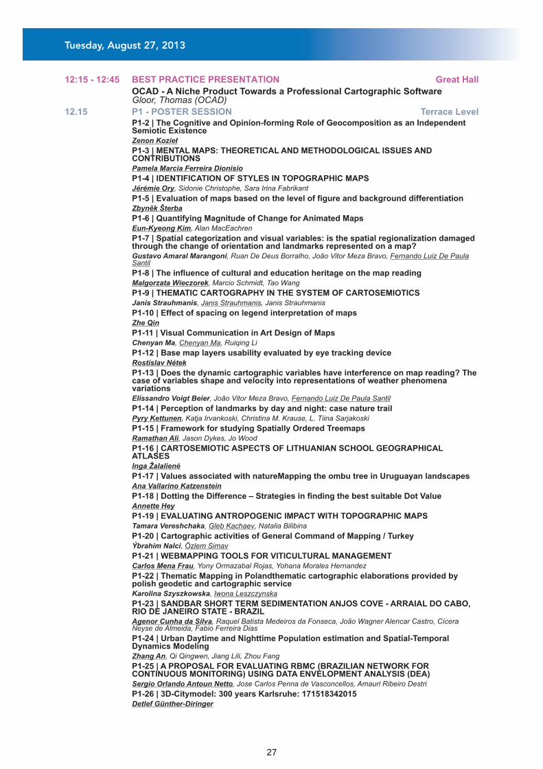
12:15 - 12:45 BEST PRACTICE PRESENTATION Great Hall
OCAD - A Niche Product Towards a Professional Cartographic SoftwareGloor, Thomas (OCAD)
12.15 P1 - POSTER SESSION Terrace Level P1-2 | The Cognitive and Opinion-forming Role of Geocomposition as an Independent Semiotic Existence
Zenon Kozieł
P1-3 | MENTAL MAPS: THEORETICAL AND METHODOLOGICAL ISSUES AND CONTRIBUTIONS
Pamela Marcia Ferreira Dionisio
P1-4 | IDENTIFICATION OF STYLES IN TOPOGRAPHIC MAPS Jérémie Ory, Sidonie Christophe, Sara Irina Fabrikant
P1-5 | Evaluation of maps based on the level of figure and background differentiation Zbyněk Šterba
P1-6 | Quantifying Magnitude of Change for Animated Maps Eun-Kyeong Kim, Alan MacEachren
P1-7 | Spatial categorization and visual variables: is the spatial regionalization damaged through the change of orientation and landmarks represented on a map?
Gustavo Amaral Marangoni, Ruan De Deus Borralho, João Vitor Meza Bravo, Fernando Luiz De Paula Santil
P1-8 | The influence of cultural and education heritage on the map reading Malgorzata Wieczorek, Marcio Schmidt, Tao Wang
P1-9 | THEMATIC CARTOGRAPHY IN THE SYSTEM OF CARTOSEMIOTICS Janis Strauhmanis, Janis Strauhmanis, Janis Strauhmanis
P1-10 | Effect of spacing on legend interpretation of maps Zhe Qin
P1-11 | Visual Communication in Art Design of Maps Chenyan Ma, Chenyan Ma, Ruiqing Li
P1-12 | Base map layers usability evaluated by eye tracking device Rostislav Nétek
P1-13 | Does the dynamic cartographic variables have interference on map reading? The case of variables shape and velocity into representations of weather phenomena variations
Elissandro Voigt Beier, João Vitor Meza Bravo, Fernando Luiz De Paula Santil
P1-14 | Perception of landmarks by day and night: case nature trail Pyry Kettunen, Katja Irvankoski, Christina M. Krause, L. Tiina Sarjakoski
P1-15 | Framework for studying Spatially Ordered Treemaps Ramathan Ali, Jason Dykes, Jo Wood
P1-16 | CARTOSEMIOTIC ASPECTS OF LITHUANIAN SCHOOL GEOGRAPHICAL ATLASES
Inga Žalalienė
P1-17 | Values associated with natureMapping the ombu tree in Uruguayan landscapes Ana Vallarino Katzenstein
P1-18 | Dotting the Difference – Strategies in finding the best suitable Dot Value Annette Hey
P1-19 | EVALUATING ANTROPOGENIC IMPACT WITH TOPOGRAPHIC MAPS Tamara Vereshchaka, Gleb Kachaev, Natalia Bilibina
P1-20 | Cartographic activities of General Command of Mapping / Turkey Ýbrahim Nalci, Özlem Simav
P1-21 | WEBMAPPING TOOLS FOR VITICULTURAL MANAGEMENT Carlos Mena Frau, Yony Ormazabal Rojas, Yohana Morales Hernandez
P1-22 | Thematic Mapping in Polandthematic cartographic elaborations provided by polish geodetic and cartographic service
Karolina Szyszkowska, Iwona Leszczynska
P1-23 | SANDBAR SHORT TERM SEDIMENTATION ANJOS COVE - ARRAIAL DO CABO, RIO DE JANEIRO STATE - BRAZIL
Agenor Cunha da Silva, Raquel Batista Medeiros da Fonseca, João Wagner Alencar Castro, Cícera Neyse de Almeida, Fabio Ferreira Dias
P1-24 | Urban Daytime and Nighttime Population estimation and Spatial-Temporal Dynamics Modeling
Zhang An, Qi Qingwen, Jiang Lili, Zhou Fang
P1-25 | A PROPOSAL FOR EVALUATING RBMC (BRAZILIAN NETWORK FOR CONTINUOUS MONITORING) USING DATA ENVELOPMENT ANALYSIS (DEA)
Sergio Orlando Antoun Netto, Jose Carlos Penna de Vasconcellos, Amauri Ribeiro Destri
P1-26 | 3D-Citymodel: 300 years Karlsruhe: 171518342015 Detlef Günther-Diringer
Tuesday, August 27, 2013
27
P1-27 | Evaluating Web-based Geovisualizations Online: A Case Study with Abstraction-Realism Spectrum in Focus
Aliz Boer, Arzu Coltekin, Keith Clarke
P1-28 | Comparison of intertwined visual and automated methods in the analysis of realistic scenarios
Lisa Clemens, Alessio Bertone, Dirk Burghardt
P1-29 | Testing animated mapping of land cover at Menzel Bouzalfa (Cap Bon_Tunisia) Monaem Nasr, Walid Chouari, Mohsen Dhieb
P1-30 | Essai de cartographie animée de l'occupation du sol à Menzel Bouzalfa (Cap Bon_Tunisie)
Nasr Monaem, Walid Chouari, Dhieb Mohsen
P1-31 | Don't Visualize Big Data Andrew Turner
P1-32 | Urban Subsidence Surveillance combining PS-InSAR and Visual Analytics Lianhuan Wei, Jukka Krisp, Timo Balz, Mingsheng Liao, Linfang Ding
P1-33 | Assembling an Authoritative Global Map Christophe Charpentier, Donald Cooke
P1-34 | Nazca Map Server Arnost Muller, Karolina Hanzalova
P1-35 | Regional geoportals of first-level administrative units of European Union and European Economic Area countries. A comparative study
Dariusz Dukaczewski, Agata Ciolkosz-Styk, Maciej Sochacki
P1-36 | Development of Electronic Map Resource in Russian State Library Marina Golyasheva, Liudmila Zinchuk
P1-37 | Web Mapping: a Solution to Nebraska Heritage Arboretum Data Standardization Spencer Trowbridge, Rex Cammack
P1-38 | A cartographic support for the geodata visual querying Karel Stanek, Lucie Friedmannova
P1-39 | WEB EXPERT SYSTEM TO PRODUCE THEMATIC MAPS Luciene Stamato Delazari, André Luiz de Mendonça
P1-40 | Web Driven Dynamic Generative Mechanism of Thematic Map Fu Ren, Qingyun Du
P1-41 | Research on Measuring Similarity of Spatial Topological Relations based on Topological Predication
Xiaoya An, Yun Yang
P1-43 | Museum and tactile mapping: introduction to heritage education to the visually impaired
Tatiana Mayumi Tamura, Fernando Luiz De Paula Santil, Antonio Oliveira, João Batista Da Silva Silva
P1-44 | Combining digital technologies and traditional artistic procedures for the compilation of cartographic panoramas
Chrysoula Boutoura, Angeliki Tsorlini, Vasoula Nikolaidou
P1-45 | Academic SDI: concept, methods, data Andrey Medvedev
P1-46 | SemGeo - a bridge between GIS and Semantic Web based solutions Marek Strzelecki, Tomasz Kubik
P1-47 | Geospatial Semantics for Topographic Data E. Lynn Usery
P1-48 | PRELIMINARY RESULTS FOR THE INSPIRE GEOSPATIAL DATA MODEL BASED ON USER REQUIREMENTS IN THE NMA OF SPAIN (IGN-E)
Eduardo Maderal, Julián Delgado Hernández, Celia Sevilla, Nuria Valcárcel Sanz, Alicia González, Noelia Aguiar, Javier García García
P1-49 | Retrieving information from spatial planning documents with the use of context analysis
Adam Iwaniak, Iwona Kaczmarek, Jaromar Lukowicz, Marek Strzelecki
P1-50 | Comparison of methods based on Geographic Information Systems and methods based on ontologies using Description Logic (DL) for modelling and spatial analysis
Jaromar Lukowicz, Adam Iwaniak
P1-51 | Spatial data licensing under “Open Data Strategy” Tomislav Ciceli, Željko Hecimovic
P1-52 | Support analyzes delimitation of Geographical Indications in Brazil and local clusters of minority communities
Claudio João Barreto Dos Santos, Alex Da Silva Santos, Lucia Fernandes, Alessandra Luisa Gouveia
P1-53 | Taxonomies of Building Objects Towards Topographic and Thematic Geo-Ontologies
Melih Basaraner
P1-54 | Research Agenda for Managing Roads and Address Geospatial Data Timothy Trainor
Tuesday, August 27, 2013
28
P1-55 | Integrity constraints in spatial databases: study of the administrative network of Tunisia
Hedi Zneti, Mohsen Dhieb, Thierry Saint Gerand
P1-56 | Quality Control Costs in Brazilian Spatial Data Production Simone Sayuri Sato, André Luiz Sá Oliveira, Alex Jailson Barbosa Andrade, Renisson Neponuceno De
Araujo Filho, Alex da Penha
P1-57 | Quality Assessment of Geospatial Data (Logical consistency, topological accuracy)
Meguenni Bouhadjar
P1-58 | Extracting Co-referential Objects Automatically from Multi-source POI Datasets Based on Position-correction and Semantic Matching
Jiping Liu, Yong Wang, Fuhao Zhang, An Luo, Chun Dong
P1-59 | Extracting Co-referential Geo-Entities Automatically from Multi-source POI Datasets Based on Position-correction and Semantic Matching
Jiping Liu, Yong Wang, An Luo, Chun Dong
P1-60 | Barriers for contributing to VGI projects Manuela Schmidt, Silvia Klettner, Renate Steinmann
P1-61 | Interpretative Mapping of Attributive Information of Dokuchaev's Soil Map of European Russia
Vasilisa Kirillova, Irina Alyabina, Dmitry Khitrov
P1-63 | Adaptive Cartography in the Context of Neogeography and Ubiquitous Computing: Research Issues
Xiang Zhang, Tinghua Ai, Xiaoqiang Cheng
P1-64 | Spatio-Temporal Activity Recognition of Crowdsourced GPS-Trajectory Data Lijuan Zhang, Sagi Dalyot, Monika Sester
P1-65 | The research of ancient road in Czech republic - presentation of results on the map server Vectormap
Jan Martínek, Aleš Létal, Jakub Mirijovský, Pavel Šlézar
P1-66 | Coordinating Views within Interactive Web Geovisualization Frank Hardisty, Alexander Savelyev
P1-67 | Soil Map 1:200,000 (BUEK 200)The Distribution of Soils in Germany Dietmar Krug, Ulrich Stegger, Einar Eberhardt, Stefanie Richter
P1-68 | Research and Practice of Electric Map Multi-pattern Display Nan Jiang, Yi-Xin Hua, Ya-Jun Zhang, Xiao-Nan Zhang
P1-69 | TEXTURE MAPSWhat they are; How to create them; Why and where you should use them.
Roger Smith
P1-70 | Knowledge Transfer via MapsExplanation of a Complex Process by Means of Communication Models
Andrea Rau, Jana Moser
P1-71 | The Development of a Census Address Ontology to Enable Successful Spatial Data Sharing between Partners
Kaile Bower
P1-72 | GPS-based Crowd Sourced Intelligent Traffic Information Hub Rui Zhu
P1-73 | How to Use a Timeline to Understand Spatio-temporal Data Better? Peng Wang, Menno-Jan Kraak
P1-74 | Criteria for the production of continental physical maps Fernando García-Soria
P1-75 | Overcoming heterogeneity in Spatial Data Infrastructures (SDIs) Importance, elements, solutions and progress
Mohammad Abusohyon
P1-76 | A Framework for the Automatic Geometric Repair of CityGML Models Zhao Junqiao, Jantien Stoter, Ledoux Hugo
P1-77 | Viewpointsthe world in perspective www.worldmapgenerator.com Julia Mia Stirnemann
P1-78 | U-Spatial: Supporting the Spatial Sciences at the University of Minnesota Francis Harvey, Len Kne
P1-79 | Augmented Reality Visualization of Archeological Data Daniel Hücker
P1-80 | Photorealistic Rendering of Atmospheric Effects in Interactive 3D Geovirtual Environments
Daniel Limberger
P1-81 | Development and Evaluation of an Augmented Reality Tourist Map Application - Case Study: Berlin
Yasmin Dadas
Tuesday, August 27, 2013
29

14.00 KN-3 - VIRTUAL CENTIMETER WORLD MODEL?
14.00 ICA Commissions at a Glance Great Hall
Great Hall
KN-3-1 | The virtual centimeter world model? Franz Leberl, Wolfgang Walcher
S5-A-1 | Assessing the Completeness of Building Footprints in OpenStreetMap: An Example from Germany
Carola Kunze, Robert Hecht, Stefan Hahmann
S5-A-2 | Detecting Level of Detail Inconsistencies in VGI Datasets Guillaume Touya, Carmen Brando
S5-A-3 | Cartographic Representation of Spatial Data Quality Parameters in Volunteered Geographic Information Systems
Farid Karimipour, Roya Esmaily, Gerhard Navratil
S5-B-1 | TACTILE CARTOGRAPHY: THE ADAPTED GLOBE EXPERIENCE ON SOCIAL INCLUSION
Barbara Jordão
S5-B-2 | School Tactile Cartography in Brazil: the challenge of training teachers Waldirene Ribeiro Do Carmo
S5-B-3 | Children's spatial representations: comparative research in France and Poland. Katarzyna Bogacz
S5-C-1 | “The most practicable and economical route for a railroad“: U.S. Army Corps of Topographical Engineers and the Railroad Reconnaissance of the American West
Imre Demhardt
S5-C-2 | The Pole is Impracticable but There is a Land Northward: Austro-Hungarian Polar Expedition and Mapping of the Franz Josef Land
Mirela Altic
S5-C-3 | Routes in the Transvaal, South Africa, 1906, described in Military Report on the Transvaal, Volume II, Communications - related to Major Jackson's Series of maps 1901-2
Christopher Board
S5-C-4 | Streams, irrigations, and the environment change: negotiating the land use in northern Taiwan (1870-1895)
Sen-Hao Yang, Jinn-Guey Lay
S5-D-1 | Towards a National Atlas of the Netherlands as part of the National Spatial Data Infrastructure
Barend Köbben
S5-D-2 | Designing Maps for a New Thematic Atlas of the Czech History Tomas Janata, Pavel Seemann, Jiri Cajthaml, Ruzena Zimova
S5-D-3 | Summary and Achievements of City Atlases in P.R. China Qingwen Qi, Lili Jiang, An Zhang
S5-D-4 | THE NEW ATLAS OF ISRAEL - THE NATIONAL ATLAS Haim Srebro
S5-E-1 | Towards 4D Cartography - Four-dimensional Dynamic Maps for Understanding Spatio-temporal Correlations in Lightning Events
Bernd Resch, Florian Hillen, Andreas Reimer, Wolfgang Spitzer
S5-E-2 | Visual Analysis of Large Amounts of 4-D Building Deformation Data Linfang Ding, Liqiu Meng
S5-E-3 | Geovisualizing spatio-temporal patterns in tennis: An alternative approach to post-match analysis
Damien Demaj
S5-E-4 | Visualization of Trajectory Attributes in Space-Time Cube and Trajectory Wall Gennady Andrienko, Natalia Andrienko, Heidrun Schumann, Christian Tominski
Commission on Open Source Geospatial TechnologiesCommission on NeocartographyCommission on Map ProjectionsCommission on Maps and the InternetWorking Group on International Map Year
14.45 S5-A - VGI: DATA QUALITY AND SOFTWARE
Chair: Chilton, Steve
14.45 S5-B - TACTILE CARTOGRAPHY FOR CHILDREN Hall 1
Chair: Castreghini de Freitas, Maria Isabel
14.45 S5-C - HISTORICAL EXPEDITIONS AND MAPS C6
Chair: Andrienko, Natalia
14.45 S5-D - NATIONAL ATLASES C1
Chair: Jordan, Peter
14.45 S5-E - 4D CARTOGRAPHY C2
Chair: Liebenberg, Elri
Great Hall
Tuesday, August 27, 2013
30
14.45 S5-F - MIXED SESSION C3
14.45 S5-G - BUSINESS MEETING OF THE COMMISSION ON C4GEOINFORMATION INFRASTRUCTURES AND STANDARDS
14.45 S5-H - BUSINESS MEETING OF THE COMMISSION ON ART C5AND CARTOGRAPHY
14.45 S5-I - BUSINESS MEETING OF THE COMMISSION ON GI C7/8FOR SUSTAINABILITY
14.45 S5-J - BUSINESS MEETING OF THE COMMISSION ON S1EDUCATION AND TRAINING
16.30 S6-A - TYPOGRAPHY AND LABELLING Great Hall
Chair: Hopfstock, Anja
16.30 S6-B - ART AND CARTOGRAPHY Hall 1
Chair: Vaughan, Laurene
16.30 S6-C - MAP PERCEPTION C6
Chair: Griffin, Amy
16.30 S6-D - SDI C1
Chair: Moellering, Harold
16.30 S6-E - CARTOGRAPHY FOR PEOPLE WITH DISABILITIES C2
Chair: Tauscher, Sarah
S6-A-1 | Users Characteristic Influence on the Efficiency of Typographic Design Rasha Deeb
S6-A-2 | Silhouette-Based Label Placement in Interactive 3D Maps Christine Lehmann, Jürgen Döllner
S6-A-3 | A Tag Cloud-based Visualization for Geotagged Text Information Yi-Xin Hua, Xiang Li, Jun-Xi Zhao, Li-Na Wang
S6-A-4 | Typography in the US Topo redesign Elaine Guidero
S6-B-1 | Geographic Space in MuseumsEvaluation and Representation of Geographic Space within a Numismatic Exhibition
Alexander Pucher, Karel Kriz
S6-B-2 | Mapping the unreal: the story of Mythical Creatures in Europe Giedre Beconyte
S6-B-3 | Smellmap: Glasgow Kate McLean
S6-B-4 | The artistic approach of modern Greek Urban Cartography [1840-1940] Myron Myridis, Eleni Aga, Anastasia Christodoulou, Nikolaos Dalakis, Bessy Filippakopoulou, Pery
Lafazani, Leda Stamou
S6-C-1 | The Cognitive and Opinion-Forming Role of Geocompositions as Multimedia Presentations
Zenon Kozieł
S6-C-2 | Influence of graphic design of cartographic symbols on perception structure Zdenek Stachon, Cenek Sasinka, Zbynek Sterba, Jiri Zboril, Sarka Brezinova, Jiri Svancara
S6-C-3 | Advanced image processing for maps graphical complexity estimation Agata Ciolkosz-Styk, Adam Styk
S6-C-4 | Symbol Considerations for Bivariate Thematic Maps Martin Elmer
S6-D-1 | Sharing and Coordinating SDIs in the Age of Crowdsourcing and Mobile Technologies
Serena Coetzee, Francis Harvey, Adam Iwaniak, Antony K Cooper
S6-D-2 | Towards a Knowledge Reference System for the Domain of Geographic Information Science and Technology
André Skupin, Marilyn Stowell, Fangming Du, Brandon Plewe, Michael Demers, Sean Ahearn
S6-D-3 | Spatial Identifier Reference Framework (SIRF): Realising the potential of SDI Using Spatial Identifiers to Link Multiple Information Systems
Paul Box, Robert Atkinson, Laura Kostanski
S6-E-1 | Crowdsourcing Techniques for Augmenting Traditional Accessibility Maps with Transitory Obstacle Information
Matthew Rice, R. Daniel Jacobson, Scott Mcdermott, Ahmad Aburizaiza, Fabiana Paez
S6-E-2 | An Information Model for Pedestrian Routing and Navigation Databases Supporting Universal Accessibility
Mari Laakso, Tapani Sarjakoski, Lassi Lehto, L. Tiina Sarjakoski
Tuesday, August 27, 2013
31

S6-E-3 | AN ATLAS OF BRNO CITY CENTRE FOR WHEELCHAIR USERS: CONCEPT, PRODUCTION AND BEYOND
Jana Otrusinová, Tomáš Rezník
S6-E-4 | Design and production of a paper printed and a digital - interactive accessibility map of the Aristotle University of Thessaloniki campus, Greece, for People with Disabilities
Chrysoula Boutoura, Konstantinos Papadopoulos, Angeliki Tsorlini, Christina Dadala
S6-F-1 | Learning from location history for context-aware location recommendation in LBS
Haosheng Huang, Georg Gartner
S6-F-2 | Location-Based Illustration Mapping Applications and Editing Tools Min Lu, Masatoshi Arikawa
S6-F-3 | Developing Interactive Cross-Platform Mobile Applications for Apple iOS (iPhone/iPad/iPod) and Google Android (Phone and Tablets) with Adobe Flash Builder and CartoVista Mobile
Dany Bouchard
S6-F-4 | Web-based Real-time Mapping of Fine Particulate Matter Pollution Xiaoyan Liu, Hong Zhang
S6-G-1 | PARADIGMATIC TENDENCIES IN CARTOGRAPHY AND MAPPING DURING THE SCIENTIFIC AND POSTMODERN PERIODS
Dr. Pablo Azócar Fernández
S6-G-2 | Visualizing in historical context: the study of the Dresden map of Hungary from the 1570s
Zsolt Török
S6-G-3 | Atlas of Fortresses of the Russian Empire in the Map Collection of the Russian State Library
Liudmila Zinchuk, Liudmila Zinchuk, Liudmila Zinchuk
S6-G-4 | The contentious border between Padua territory and Venice as represented by th ththe cartography of 16 -18 century
Silvia Piovan, Franco Benucci
S6-H-1 | Geospatial Service Web: Sharing More Than Geospatial Data for Education and Collaborative Research
Jianya Gong, Huayi Wu
S6-H-2 | Structural Analysis of Urban Areas in Germany from the Perspective of Sustainable Compactness - Representation in a Map Series
Ulrich Schumacher, Anne Bräuer, Martin Behnisch
S6-H-3 | HOLOGRAM : THE FUTURE OF THE CARTOGRAPHIC PUBLISHING Polat Dalkiran, Seunghyun Lee, Sung Chul Park
S6-H-4 | BTN100/BCN200: Collaborative framework for cost optimization Jose Antonio Merino Martín, Javier González-Matesanz, Tania Gullón Muñoz-Repiso, Ángela Del
Carmen Ruiz Ramírez, Jose Luis Sánchez Tello
S6-I-1 | Methodological approach for the development of an Algerian NSDI according to international standards (ISO, W3C, OGC, OMG) enriched by a spatial dictionary adapted.
Toufik Aouameur, Ali Benahmed Daho
S6-I-3 | A Hierarchical Random Graph based Selection Method for Road Network Generalization
Muzi Li
S6-I-4 | GIS mapping and analysis for landing sites of Soviet spacecraft on the Moon Marina Baskakova, Evgeniia Gusakova, Irina Karachevtseva, Kira Shingareva
16.30 S6-F - MOBILE TASKS AND APPLICATIONS C3
Chair: Cerba, Otakar
16.30 S6-G - HISTORY ON MAPS C4
Chair: Altic, Mirela
16.30 S6-H - MIXED SESSION C5
Chair: Hecht, Robert
16.30 S6-I - MIXED SESSION S1
Chair: Krüger, Tobias
17:45 - 22:00 ICA Chair Meeting Seminar level - S1
18:30 - 20:30 Young Scientists Speed Presentation Conference level - C5
ICA Executive Committee meeting with commission chairs (not a public event)
Tuesday, August 27, 2013
32
08.30 KN-4 - TRANSFORMATION OF NATIONAL MAPPING APPROACHES IN THE CONTEXT OF GEOMATICS DEMOCRATIZATION
08.30 ICA Commissions at a Glance Great Hall
Great Hall
KN-4-1 | Transformation of National Mapping Approaches in the Context of Geomatics Democratization
Éric Loubier
S7-A-1 | Land use monitoring by topographical data analysis Tobias Krüger, Gotthard Meinel, Ulrich Schumacher
S7-A-2 | CAN ANALYTICAL CARTOGRAPHY SERVE AS A LINK BETWEEN CARTOGRAPHY AND GISCIENCE?
Harold Moellering
S7-A-3 | Maps as Research Tools Within a Virtual Research Environment. Christian Hanewinkel, Sebastian Specht
S7-A-4 | Designing Origin-Destination flow matrices from individual mobile phone paths - The effect of spatial filters on flow measurement
Françoise Bahoken, Ana-Maria Olteanu-Raimond
S7-B-1 | Activities for developing Global Map Version 3 data Yoshikazu Fukushima, Mamoru Koarai
S7-B-2 | Spatial representation of natural and anthropogenic factors influencing chimpanzee repartition in Sebitoli (Kibale National Park, Uganda): conservation and research applications.
Sarah Bortolamiol, Marianne Cohen, Sabrina Krief
S7-B-3 | Cartographic challenges in Antarctica:Mapping in support of environmental management in the US Antarctic Program
Katharina Lorenz, Colin Harris
S7-B-4 | Geoinformation landscape-geochemical mapping of city territories (the case study of Eastern District of Moscow)
Elena Nikiforova, Natalia Kosheleva, Irina Labutina, Timur Khaybrakhmanov
S7-C-1 | Urban Areas Change Mapping of the Black Sea coastal zone in Bulgaria for the Period 1990 - 2006 Based on Remote Sensing Data
Rumiana Vatseva
S7-C-2 | Urban Expansion and Population Growth in Ras Sudr city Using Remotely Sensed Imagery Urban Expansion and Population Growth in Ras Sudr city Using Remotely Sensed Imagery
Ahmed Ramzi Ibrahim
S7-C-3 | The Image Map: from Broad Practical Use towards Cartographic Concept Bělka Luboš, Vít Voženílek
S7-C-4 | Methodology to analyse multi-temporal planimetric changes of river channels Antonio Mozas-Calvache, Manuel Antonio Ureña-Cámara, Francisco Javier Ariza-López
S7-D-1 | Guidelines for the effective design of spatio-temporal maps Aileen Buckley
S7-D-2 | Presenting Complex Environmental Information Online: A Comparative Empirical Evaluation of Animation versus Text
Patrizia Russo, Chris Pettit, Mark Imhof, Matthew Cox, Arzu Coltekin, Christopher Bayliss
S7-D-3 | Enhancing Cartographic Time-series Animation Helen Jenny, Johannes Liem, Robert Scheller, Melissa Lucash
S7-E-2 | Facilitating the exchange of marine spatial data through a Marine Data Infrastructure for Germany (MDI-DE)
Tillmann Lübker, Peter Hübner, Christian Rüh, Peter Korduan
S7-E-3 | BRAZILIAN NATIONAL SPATIAL DATA INFRASTRUCTURE (INDE): applicability for large scale data
Andrea Lopes Iescheck, Marco Aurélio Dornelles
Commission on Education and TrainingCommission on Planetary CartographyCommission on GI for SustainabilityCommission on Geoinformation Infrastructures and Standards
09.15 S7-A - GEOSPATIAL ANALYTICS 1
Chair: Jiang, Bin
09.15 S7-B - ENVIRONMENTAL MONITORING Hall 1
Chair: Kremers, Horst
09.15 S7-C - CHANGE DETECTION C6
Chair: Vatseva, Rumiana
09.15 S7-D - VISUALISING TIME (ANIMATIONS) C1
Chair: Andrienko, Gennady
09.15 S7-E - NSDI 1 C2
Chair: Coetzee, Serena
Great Hall
Wednesday, August 28, 2013
33

S7-E-4 | Lithuanian spatial information portal for national mapping Giedre Beconyte, Andrius Balciunas, Lina Papsiene, Kestutis Papsys, Jurgita Spuraite, Tomas Ladukas
S7-F-1 | Backend architectures for modern cartography Markus Jobst
S7-F-2 | Map Folding Techniques in the Digital Age Stephan Angsüsser
S7-F-3 | A Propagating Update Method of Multi-represented Vector Map Data Based on Spatial Objective Similarity and Unified Geographic Entity Code
Yanxia Wang, Qingyun Du, Fu Ren, Zhiyuan Zhao
S7-G-1 | Organisation and Strategy of the Official Surveying and Mapping Authorities of Germany
Ulrich Püß
S7-G-2 | The WebAtlasDE - An Example of the Collaboration in Official Surveying and Mapping in Germany
Marcus Wandinger
S7-G-3 | Digital Land Cover Model for GermanyNext update cycle for the Year 2012 Friederike Emig, Michael Hovenbitzer, Christine Wende
S8-A-1 | Exploring the Influence of the Color Distance on the Map Legibility Alžběta Brychtová, Stanislav Popelka
S8-A-2 | The Influence of Colour on the Interpretation of Official Noise Maps Beate Weninger
S8-A-3 | Analysis and improvement of the OpenStreetMap street color scheme for users with color vision deficiencies
Johannes Kröger, Jochen Schiewe, Beate Weninger
S8-B-1 | A systematic comparison of map design for print and web-based technologies Kenneth Field
S8-B-2 | Web Map-based POI Visualization for Spatial Decision Support Changbin Yu, Fu Ren, Qingyun Du, Zhiyuan Zhao, Ke Nie
S8-B-3 | Integrated Cartographic and Programmatic Access to Spatial Data using Object-Oriented Databases in an online Web GIS
Ionu? Iosifescu, Lorenz Hurni
S8-B-4 | Challenges in creating web base maps from distributed datasets Manuela Schmidt, Wolfgang Jörg, Georg Gartner
S8-C-1 | Opinions on the development of theoretical mapping Pal Nikolli, Ferim Gashi, Bashkim Idrizi
S8-C-2 | Understanding Mental Categorization on VGI Systems to Improve Data Management
João Vitor Meza Bravo, Claudia Robbi Sluter, Fernando Luiz De Paula Santil, Luciene Stamato Delazari, Mônica Cristina Castro
S8-C-3 | Map classification according to their visual global properties Catherine Dominguès, Tahar Kharchi
S8-C-4 | Developing a framework for describing and comparing indoor maps Alexander Nossum
09.15 S7-F - TECHNICAL ISSUES IN MAP PRODUCTION C3
Chair: de Maeyer, Philippe
09.15 S7-G - NMCA - NATIONAL MAPPING AND CADASTRAL C4AUTHORITIES: GERMANY
Chair: Kutterer, Hansjörg
09.15 S7-H - BUSINESS MEETING OF THE COMMISSION ON MAPS C5AND THE INTERNET
09.15 S7-I - BUSINESS MEETING OF THE COMMISSION ON C7/8GENERALISATION AND MULTIPLE REPRESENTATION
09.15 S7-J - BUSINESS MEETING OF THE COMMISSION ON S1PLANETARY CARTOGRAPHY
11.00 S8-A - COLOURS IN MAP DESIGN Great Hall
Chair: Jenny, Bernhard
11.00 S8-B - MAPS AND THE INTERNET: GENERAL TASKS 2 Hall 1
Chair: Peterson, Michael
11.00 S8-C - MAP CLASSIFICATION C6
Chair: Al, Tinghua
Wednesday, August 28, 2013
34
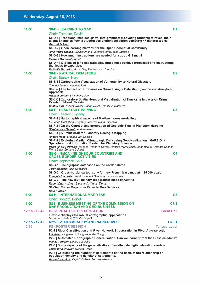
11.00 S8-D - LEARNING TO MAP C1
Chair: Fairbairn, David
11.00 S8-E - NATURAL DISASTERS C2
Chair: Stanek, Karel
11.00 S8-F - PLANETARY MAPPING C3
Chair: Lazarev, Evgeniy
11.00 S8-G - NMCA - NEIGHBOUR COUNTRIES AND C4CROSS-BORDER ACTIVITIES
Chair: Hopfstock, Anja
11.00 S8-H - INTERNATIONAL MAP YEAR C5
Chair: Rystedt, Bengt
11.00 S8-I - BUSINESS MEETING OF THE COMMISSION ON C7/8MAP PRODUCTION AND GEO-BUSINESS
S8-D-1 | Traditional map design vs. info graphics: motivating students to reveal their talentsExamples from a student assignment collection depicting 47 distinct topics
Gertrud Schaab
S8-D-2 | Open learning platform for the Open Geospatial Community Amir Pourabdollah, Suchith Anand, Jeremy Morley, Mike Jackson
S8-D-3 | How much instructions are needed for a good GIS map? Makram Murad-Al-Shaikh
S8-D-4 | GIS-based land-use suitability mapping: cognitive processes and instructions that leads to expertise.
Raffaella Balzarini, Muriel Ney, Paule-Annick Davoine
S8-E-1 | Cartographic Visualization of Vulnerability to Natural Disasters Tomasz Opach, Jan Ketil Rød
S8-E-2 | The Impact of Hurricanes on Crime Using a Data Mining and Visual Analytics Approach
Michael Leitner, Diansheng Guo
S8-E-3 | Exploratory Spatial-Temporal Visualization of Hurricane Impacts on Crime Events in Miami, Florida
Sunhui Sim, William Walker, Regan Doyle, Lisa Keys-Mathews
S8-F-1 | Ñartographical aspects of Martian moons modelling Ekaterina Grishakina, Evgeniy Lazarev, Maria Lazareva
S8-F-2 | On the Concept and Integration of Geologic Time in Planetary Mapping Stephan van Gasselt, Andrea Nass
S8-F-3 | A Framework for Planetary Geologic Mapping Andrea Nass, Stephan van Gasselt
S8-F-4 | Exploring Martian Climatologic Data using Geovisualization : MARSIG, a Spatiotemporal Information System for Planetary Science
Paule-Annick Davoine, Marlene Villanova-Oliver, Christine Plumejeaud, Isaac Baretto, Jerome Gensel, Pierre Beck, Bernard Schmitt
S8-G-1 | Topographic databases on the border states Jerzy Zieliński, Julia Kamińska
S8-G-2 | Cross-border cartography for new French base map at 1:25 000 scale François Lecordix, Paul-Emmanuel Gautreau, Yann Sciardis
S8-G-3 | The new civil-military topographic maps of Austria Robert Ditz, Andreas Stummvoll, Helmut Zierhut
S8-G-4 | Swiss Maps from Paper to Geo Services Reto Künzler
P2-1 | River Classification and River Network Structuration in River Auto-selection Lili Jiang, Qingwen Qi, Fang Zhou, An Zhang
P2-2 | Automated Cartographic Generalisation: Can we learned from the Classical Maps? Vaclav Talhofer, Libuse Sokolova
P2-3 | Some aspects of the generalization of small-scale digital elevation models Zsuzsanna Ungvári, Renáta Szabó
P2-4 | Calculating the number of settlements on the basis of the relationship of population density and density of settlements.
Anton Dvornikov, Olga Shirokova, Varvara Nikeeva
12:15 - 12:45 BEST PRACTICE PRESENTATION Great Hall Flexible displays for robust cartographic applicationsSebastian Kuhne (Plastic Logic)
12:15 - 12:45 MOVIE-CARTOGRAPHY AND NARRATIVES Hall 1
12.15 P2 - POSTER SESSION Terrace Level
Wednesday, August 28, 2013
35
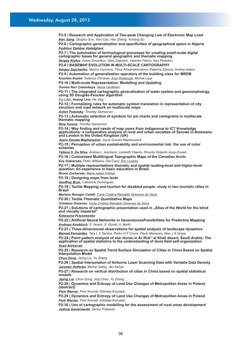
P2-5 | Research and Application of Two-peak Changing Law of Electronic Map Load Nan Jiang, Qinghui Sun, Yani Cao, Hao Zhang, Yuhang Gu
P2-6 | Cartographic generalization and specificities of geographical space in Algeria Kaddour Djebbar Abdelghani
P2-7 | The automation of technological processes for creating small-scale digital cartographic bases for general geographic and thematic mapping
Sergey Krylov, Anton Dvornikov, Gleb Zagrebin, Valentin Petrov, Iliya Plotnikov
P2-8 | BASEMAP EVOLUTION IN MULTI-SCALE CARTOGRAPHY Sergey Zaychenko, Marina Voronina, Timur Khaibrakhmanov, Katerina Zykova, Andrey Isakov
P2-9 | Automation of generalization operators of the building class for MRDB Krystian Kozioł, Tadeusz Chrobak, Artur Krawczyk, Michał Lupa
P2-10 | Multi-scale Representation: Modelling and Updating Osman Nuri Çobankaya, Necla Uluðtekin
P2-11 | The integrated cartographic generalization of water system and geomorphology using 3D Douglas-Peucker algorithm
Fei Lifan, Huang Lina, He Jing
P2-12 | Formalizing rules for automatic symbol translation in representation of city structure and road network on multiscale maps
Anton Podolsky, Timofey Samsonov
P2-13 | Automatic selection of symbols for pie charts and cartograms in multiscale thematic mapping
Nina Yurova, Timofey Samsonov
P2-14 | Way finding and needs of map users from Indigenous to ICT Knowledge applications: a comparative analysis of rural and urban societies of Serowe in Botswana and London in the United Kingdom (UK)
Joyce Gosata Maphanyane, Joyce Gosata Maphanyane
P2-15 | Perception of urban sustainability and environmental risk: the use of color schemes
Tatiana S. Da Silva, Andrea L. Iescheck, Liesbeth Olaerts, Ricardo Noberto Ayup-Zouain
P2-16 | Customized Multilingual Topographic Maps of the Canadian Arctic Eva Siekierska, Peter Williams, Del Carry, Éric Loubier
P2-17 | Multiple representations thematic and spatial reading-level and higher-level question: An experience in basic education in Brazil
Bruno Zucherato, Maria Isabel Freitas
P2-18 | Designing maps from texts Geoffrey Brun, Catherine Dominguès
P2-19 | Tactile Mapping and tourism for disabled people: study in two touristic cities in Brazil
Mariane Ravagio Catelli, Carla Cristina Reinaldo Gimenes de Sena
P2-20 | Tactile Thematic Quantitative Maps Cristiano Gimenez, Carla Cristina Reinaldo Gimenes de Sena
P2-21 | Solutions of cartographic presentation used in „Atlas of the World for the blind and visually impaired”
Katarzyna Przyszewska
P2-22 | Artificial Neural Networks in GeosciencesPossibilities for Predictive Mapping Andreas Knobloch, S. Noack, S. Etzold, A. Barth
P2-23 | Three-dimensional observations for spatial analysis of landscape dynamics Manoel Fernandes, Tata L C Santos, Pedro H F Coura, Paulo Menezes, Alan J S Graça
P2-24 | Point pattern analysis of star dunes in Ar Rub” al Khali desert, Saudi Arabia: The application of spatial statistics to the understanding of dune field self-organization
Saad Alsharrah
P2-25 | Research on Spatial Trend Surface Simulation of Cities in China Based on Spatial Interpolation Model
Chun Dong, Jiping Liu, Yu Zhang
P2-26 | Spatial Interpolation of Airborne Laser Scanning Data with Variable Data Density Jaroslav Hofierka, Michal Gallay, Ján Kaňuk
P2-27 | Research on vertical distribution of cities in China based on spatial statistical models
Jiping Liu, Chun Dong, Jing Chen, Yu Zhang
P2-28 | Dynamics and Entropy of Land Use Changes of Metropolitan Areas in Poland (abstract)
Piotr Werner, Piotr Korcelli, Elżbieta Kozubek
P2-29 | Dynamics and Entropy of Land Use Changes of Metropolitan Areas in Poland Piotr Werner, Piotr Korcelli, Elżbieta Kozubek
P2-30 | Use of cartographic modelling for the assessment of rural areas development Jedrzej Gasiorowski, Zenon Polawski
Wednesday, August 28, 2013
36
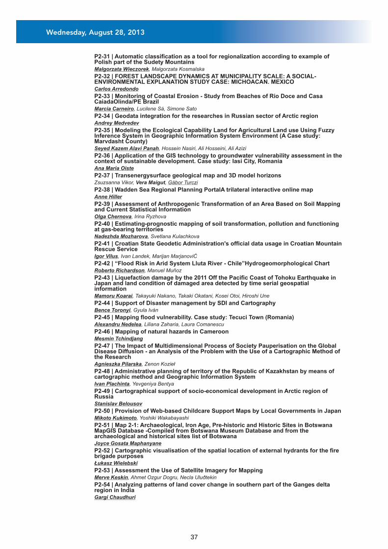
P2-31 | Automatic classification as a tool for regionalization according to example of Polish part of the Sudety Mountains
Malgorzata Wieczorek, Malgorzata Kosmalska
P2-32 | FOREST LANDSCAPE DYNAMICS AT MUNICIPALITY SCALE: A SOCIAL-ENVIRONMENTAL EXPLANATION STUDY CASE: MICHOACAN. MEXICO
Carlos Arredondo
P2-33 | Monitoring of Coastal Erosion - Study from Beaches of Rio Doce and Casa CaiadaOlinda/PE Brazil
Marcia Carneiro, Lucilene Sá, Simone Sato
P2-34 | Geodata integration for the researches in Russian sector of Arctic region Andrey Medvedev
P2-35 | Modeling the Ecological Capability Land for Agricultural Land use Using Fuzzy Inference System in Geographic Information System Environment (A Case study: Marvdasht County)
Seyed Kazem Alavi Panah, Hossein Nasiri, Ali Hosseini, Ali Azizi
P2-36 | Application of the GIS technology to groundwater vulnerability assessment in the context of sustainable development. Case study: Iasi City, Romania
Ana Maria Oiste
P2-37 | Transenergysurface geological map and 3D model horizons Zsuzsanna Vikor, Vera Maigut, Gábor Turczi
P2-38 | Wadden Sea Regional Planning PortalA trilateral interactive online map Anne Hiller
P2-39 | Assessment of Anthropogenic Transformation of an Area Based on Soil Mapping and Current Statistical Information
Olga Chernova, Irina Ryzhova
P2-40 | Estimating-prognostic mapping of soil transformation, pollution and functioning at gas-bearing territories
Nadezhda Mozharova, Svetlana Kulachkova
P2-41 | Croatian State Geodetic Administration's official data usage in Croatian Mountain Rescue Service
Igor Vilus, Ivan Landek, Marijan MarjanoviĆ
P2-42 | “Flood Risk in Arid System Lluta River - Chile”Hydrogeomorphological Chart Roberto Richardson, Manuel Muñoz
P2-43 | Liquefaction damage by the 2011 Off the Pacific Coast of Tohoku Earthquake in Japan and land condition of damaged area detected by time serial geospatial information
Mamoru Koarai, Takayuki Nakano, Takaki Okatani, Kosei Otoi, Hiroshi Une
P2-44 | Support of Disaster management by SDI and Cartography Bence Toronyi, Gyula Iván
P2-45 | Mapping flood vulnerability. Case study: Tecuci Town (Romania) Alexandru Nedelea, Liliana Zaharia, Laura Comanescu
P2-46 | Mapping of natural hazards in Cameroon Mesmin Tchindjang
P2-47 | The Impact of Multidimensional Process of Society Pauperisation on the Global Disease Diffusion - an Analysis of the Problem with the Use of a Cartographic Method of the Research
Agnieszka Pilarska, Zenon Kozieł
P2-48 | Administrative planning of territory of the Republic of Kazakhstan by means of cartographic method and Geographic Information System
Ivan Plachinta, Yevgeniya Bentya
P2-49 | Cartographical support of socio-economical development in Arctic region of Russia
Stanislav Belousov
P2-50 | Provision of Web-based Childcare Support Maps by Local Governments in Japan Mikoto Kukimoto, Yoshiki Wakabayashi
P2-51 | Map 2-1: Archaeological, Iron Age, Pre-historic and Historic Sites in Botswana MapGIS Database -Compiled from Botswana Museum Database and from the archaeological and historical sites list of Botswana
Joyce Gosata Maphanyane
P2-52 | Cartographic visualisation of the spatial location of external hydrants for the fire brigade purposes
Łukasz Wielebski
P2-53 | Assessment the Use of Satellite Imagery for Mapping Merve Keskin, Ahmet Ozgur Dogru, Necla Uluðtekin
P2-54 | Analyzing patterns of land cover change in southern part of the Ganges delta region in India
Gargi Chaudhuri
Wednesday, August 28, 2013
37
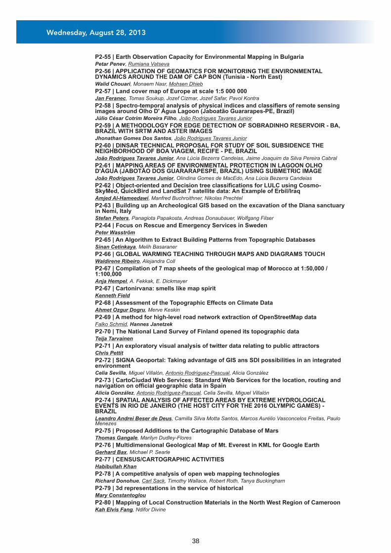
P2-55 | Earth Observation Capacity for Environmental Mapping in Bulgaria Petar Penev, Rumiana Vatseva
P2-56 | APPLICATION OF GEOMATICS FOR MONITORING THE ENVIRONMENTAL DYNAMICS AROUND THE DAM OF CAP BON (Tunisia - North East)
Walid Chouari, Monaem Nasr, Mohsen Dhieb
P2-57 | Land cover map of Europe at scale 1:5 000 000 Jan Feranec, Tomas Soukup, Jozef Cizmar, Jozef Safar, Pavol Kontra
P2-58 | Spectro-temporal analysis of physical indices and classifiers of remote sensing images around Olho D' Água Lagoon (Jaboatão Guararapes-PE, Brazil)
Júlio César Cotrim Moreira Filho, João Rodrigues Tavares Junior
P2-59 | A METHODOLOGY FOR EDGE DETECTION OF SOBRADINHO RESERVOIR - BA, BRAZIL WITH SRTM AND ASTER IMAGES
Jhonathan Gomes Dos Santos, João Rodrigues Tavares Junior
P2-60 | DINSAR TECHNICAL PROPOSAL FOR STUDY OF SOIL SUBSIDENCE THE NEIGHBORHOOD OF BOA VIAGEM, RECIFE - PE, BRAZIL
João Rodrigues Tavares Junior, Ana Lúcia Bezerra Candeias, Jaime Joaquim da Silva Pereira Cabral
P2-61 | MAPPING AREAS OF ENVIRONMENTAL PROTECTION IN LAGOON OLHO D'ÁGUA (JABOTÃO DOS GUARARAPESPE, BRAZIL) USING SUBMETRIC IMAGE
João Rodrigues Tavares Junior, Olindina Gomes de MacEdo, Ana Lúcia Bezerra Candeias
P2-62 | Object-oriented and Decision tree classifications for LULC using Cosmo-SkyMed, QuickBird and LandSat 7 satellite data: An Example of Erbil/Iraq
Amjed Al-Hameedawi, Manfred Buchroithner, Nikolas Prechtel
P2-63 | Building up an Archeological GIS based on the excavation of the Diana sanctuary in Nemi, Italy
Stefan Peters, Panagiota Papakosta, Andreas Donaubauer, Wolfgang Filser
P2-64 | Focus on Rescue and Emergency Services in Sweden Peter Wasström
P2-65 | An Algorithm to Extract Building Patterns from Topographic Databases Sinan Cetinkaya, Melih Basaraner
P2-66 | GLOBAL WARMING TEACHING THROUGH MAPS AND DIAGRAMS TOUCH Waldirene Ribeiro, Alejandra Coll
P2-67 | Compilation of 7 map sheets of the geological map of Morocco at 1:50,000 / 1:100,000
Anja Hempel, A. Fekkak, E. Dickmayer
P2-67 | Cartonirvana: smells like map spirit Kenneth Field
P2-68 | Assessment of the Topographic Effects on Climate Data Ahmet Ozgur Dogru, Merve Keskin
P2-69 | A method for high-level road network extraction of OpenStreetMap data Falko Schmid, Hannes Janetzek
P2-70 | The National Land Survey of Finland opened its topographic data Teija Tarvainen
P2-71 | An exploratory visual analysis of twitter data relating to public attractors Chris Pettit
P2-72 | SIGNA Geoportal: Taking advantage of GIS ans SDI possibilities in an integrated environment
Celia Sevilla, Miguel Villalón, Antonio Rodríguez-Pascual, Alicia González
P2-73 | CartoCiudad Web Services: Standard Web Services for the location, routing and navigation on official geographic data in Spain
Alicia González, Antonio Rodríguez-Pascual, Celia Sevilla, Miguel Villalón
P2-74 | SPATIAL ANALYSIS OF AFFECTED AREAS BY EXTREME HYDROLOGICAL EVENTS IN RIO DE JANEIRO (THE HOST CITY FOR THE 2016 OLYMPIC GAMES) - BRAZIL
Leandro Andrei Beser de Deus, Camilla Silva Motta Santos, Marcos Aurélio Vasconcelos Freitas, Paulo Menezes
P2-75 | Proposed Additions to the Cartographic Database of Mars Thomas Gangale, Marilyn Dudley-Flores
P2-76 | Multidimensional Geological Map of Mt. Everest in KML for Google Earth Gerhard Bax, Michael P. Searle
P2-77 | CENSUS/CARTOGRAPHIC ACTIVITIES Habibullah Khan
P2-78 | A competitive analysis of open web mapping technologies Richard Donohue, Carl Sack, Timothy Wallace, Robert Roth, Tanya Buckingham
P2-79 | 3d representations in the service of historical Mary Constantoglou
P2-80 | Mapping of Local Construction Materials in the North West Region of Cameroon Kah Elvis Fang, Ndifor Divine
Wednesday, August 28, 2013
38
14.00 KN-5 - MY DISCOVERY OF CARTOGRAPHY
14.00 ICA Commissions at a Glance Great Hall
Great Hall
KN-5-1 | My Discovery of Cartography Christopher Board
S9-A-1 | Beyond the Surface: Current Issues and Future Directions in Uncertainty Visualization Research
Jennifer Smith, David Retchless, Christoph Kinkeldey, Alexander Klippel
S9-A-2 | Assessing the Impact of Design Decisions on the Usability of Uncertainty Visualization: Noise Annotation Lines for the Visual Representation of Attribute Uncertainty in Maps
Christoph Kinkeldey, Jennifer Smith, Alexander Klippel, Jochen Schiewe
S9-A-3 | Evaluation of Uncertainty Visualization Techniques for Decision-making in a Bushfire Scenario
Lisa Cheong, Susanne Bleisch, Matt Duckham, Allison Kealy, Kevin Tolhurst, Tom Wilkening
S9-B-1 | On the Influence of Geospatial Context on Mobile Microblogging Content Stefan Hahmann, Dirk Burghardt
S9-B-2 | Mapping Sense of Place: Online Participatory Mapping for Indicating Landscape Values
Carl Sack
S9-B-3 | Where Do Tourists Go? Visualizing and Analyzing the Spatial Distribution of Geotagged Photography
Bálint Kádár, Mátyás Gede
S9-B-4 | Cartograms of self-organizing maps to explore user-generated content André Bruggmann, Marco Michele Salvini, Sara Irina Fabrikant
S9-C-1 | Maps in Decision Making: Why Almost Every Negotiation Starts and Ends With a Map?
Felipe Rufino Atkocius
S9-C-2 | How to measure and visualize emotion when using maps Sara Irina Fabrikant
S9-C-3 | Maps as Decision Support Tool in Political Decision Processes Anja Reinermann-Matatko
S9-D-1 | Estimation of an Unknown Map Projection and its Parameters from the Map Tomas Bayer
S9-D-2 | Old Maps GeoreferencingOverview and a New Method for Map Series Jiri Cajthaml
S9-D-3 | Map Projection Reconstruction of a Mercator's Map Marina Rajaković, Ivka Kljajić, Miljenko Lapaine
S9-D-4 | DATA GENERALIZATION IN THE CARTOGRAPHIC MATERIALS OF GENERAL LAND SURVEY
Aleksey Golubinsky, Olga Shalashova, Irina Alyabina
S9-E-1 | Modular classification and change analysis of vegetation encroachment using object-based image analysis
Elke Krätzschmar, Johann Sehner, Horst Klemm, Albert Böhm, John R. Phillips
S9-E-2 | Rice Yield Estimation by using Objective Yield Survey (OYS) and Remote Sensing (RS) methods; Case study in Singburi and Angthong Province.
Jatuporn Nontasiri
S9-E-3 | Image Classification towards Mapping of Vegetation Structure: A practical approach
Erika Pretorius
Commission on Map Production and Geo-BusinessCommission on Map DesignCommission on Mountain CartographyCommission on Theoretical Cartography
14.45 S9-A - UNCERTAINTY VISUALISATION
Chair: Bertone, Alessio
14.45 S9-B - VGI: EFFECTS Hall 1
Chair: Turner, Andrew
14.45 S9-C - MAPS IN DECISION MAKING C6
Chair: Battersby, Sarah
14.45 S9-D - MAP PROJECTION RECONSTRUCTION C1
Chair: Boutoura, Chrysoula
14.45 S9-E - IMAGE CLASSIFICATION C2
Chair: Krätzschmar, Elke
Great Hall
Wednesday, August 28, 2013
39
14.45 S9-F - ORIENTEERING MAPS C3
Chair: Zentai, László
14.45 S9-G - NMCA - EUROPEAN AUTHORITIES INTRODUCE WEB SERVICES C4
Chair: Illert, Andreas
14.45 S9-H - TECHNOLOGIES IN CARTOGRAPHIC EDUCATION C5
Chair: Akinyemi, Felicia
14.45 S9-I - BUSINESS MEETING OF THE COMMISSION ON C7/8MAPS AND SOCIETY
14.45 S9-J - BUSINESS MEETING OF THE COMMISSION ON S1OPEN SOURCE GEOSPATIAL TECHNOLOGIES
16.30 S10-A - SYMBOLS IN MAP DESIGN Great Hall
Chair: Kent, Alexander
16.30 S10-B - APPLICATIONS IN SUSTAINABLE DEVELOPMENT Hall 1
Chair: Bax, Gerhard
S9-F-1 | Implementation of Cartographic and Digital Techniques in Orienteering Maps László Zentai
S9-F-2 | Automation in orienteering map production – fiction or reality Dušan Petrovič
S9-F-3 | Vegetation height maps derived from digital elevation modelsthe next innovation in the production of orienteering maps?
Thomas Gloor
S9-F-4 | Orienteering moves indoor Terje Midtbø
S9-G-1 | Standardization as a vehicle towards e-government Flemming Nissen, Jan Hjelmager
S9-G-2 | Automation of Data Quality Validation based on Common Rules for Pan-European Geoinformation Production
Matt Beare, Anja Hopfstock, Antti Jakobsson
S9-G-3 | European Location Framework - One Reference Geo-Information Service for Europe
Antti Jakobsson, Anja Hopfstock, Roy Hellesjø Mellum, Dorus Kruse, Clemens Portele, Saulius Urbanas, Jorgen Hartnor, Andy Bray, Laila Aslesen, Olaf Ostensen, Dave Lovell
S9-G-4 | PDOK Kaart, the Dutch mapping API Haico van der Vegt
S9-H-1 | The State of GISc Education and SDI Implementation in the SADC Countries: A Comparative Study
Sanet Eksteen, Serena Coetzee
S9-H-2 | NEW TECHNOLOGIES AS EDUCATIONAL RESOURCES FOR TEACHING CARTOGRAPHY: A CASE STUDY IN GUINEA-BISSAU
Inês Mário Nosoline, Angelica Carvalho di Maio, Dalto Domingos Rodrigues
S9-H-3 | A Survey of Books for Potential Use in SDI Education and Training in South Africa
Victoria Rautenbach, Serena Coetzee
S10-A-1 | Sharing and Discovering Map Symbols with SymbolStore.org Anthony Robinson, Scott Pezanowski, Joshua Stevens, Ryan Mullins, Justine Blanford, Raechel
Bianchetti, Alan MacEachren
S10-A-2 | Designing Map Symbols for Mobile Devices: Challenges, Best Practices, and the Utilization of Skeuomorphism
Joshua Stevens, Anthony Robinson, Alan MacEachren
S10-A-3 | 3D Symbolization and Multi-Scale Representation on Geo-Information Wei Yongjun, Ji Guojie, Chen Yingdong, Han Peng
S10-A-4 | Semiological aspects of urban maps: A case study from the Holy city of Mecca Dhieb Mohsen
S10-B-1 | Automatic Derivation of Urban Structure Types from Topographic Maps by Means of Image Analysis and Machine Learning
Robert Hecht, Hendrik Herold, Gotthard Meinel, Manfred Buchroithner
S10-B-2 | From sensor data to the perception of phenomena: Software architecture for online access and offline analysis
Nader Cheaib, Anne Ruas, Olivier Gaborit
S10-B-3 | Mapping Potential Metro Rail Ridership in Los Angeles County Bin Mo
S10-B-4 | MOSART : A DECISION MAKING TOOL FOR MODELLING SUSTAINABLE DEVELOPMENT WITH SPATIAL ACCESSIBILITY ANALYSIS
Nicolas Ovtracht, Gerald Foliot, Dany Bouchard, Yves Crozet, Aurélie Mercier
Wednesday, August 28, 2013
40
16.30 S10-C - GENERALISATION 3 C6
Chair: Burghardt, Dirk
16.30 S10-D - USER ISSUES IN MAP PRODUCTION C1
Chair: Jobst, Markus
16.30 S10-E - GLOBES C2
Chair: Koussoulakou, Alexandra
16.30 S10-F - MAPS AND SOCIETY C3
Chair: Perkins, Chris
16.30 S10-G - MIXED SESSION C4
Chair: Christophe, Sidonie
S10-C-1 | TileGen - An open source software for applying cartographic generalisation to tile-based mapping
Ralf Klammer
S10-C-2 | Investigations into partitioning of generalization processes in a distributed processing framework
Frank Thiemann, Stefan Werder, Thomas Globig, Monika Sester
S10-C-3 | Clutter Reduction Methods for Point Symbols in Map Mashups Jari Korpi, Paula Ahonen-Rainio
S10-C-3 | Preservation and transformation of relations between thematic and topographic data throughout thematic data migration
Kusay Jaara, Cécile Duchêne, Anne Ruas
S10-D-1 | Designing a map using Open Data coming from different sources. Methodology, problems and solutions concerning the 1:100.000 map of Prefecture of Magnisia, Greece
Chrysoula Boutoura, Angeliki Tsorlini, Vasiliki Zografopoulou, Evangelos Tsipis
S10-D-2 | Legal Issues in Czech Cartography in Relation to the International Cooperation Alena Vondráková
S10-D-3 | Formalization of cartographic edition rules to automate topographic maps quality control
Ana de Las Cuevas Suárez, Ana Maldonado Ibáñez, Javier García García, Javier González-Matesanz, Javier Hernández Enrile
S10-E-1 | Maps vs. Globes - Distance Estimation on Flat and Spherical Displays Florian Hruby, Andreas Riedl
S10-E-2 | Hypsometric Globe of Mars3D Model of the Planet Zhanna Rodionova, Julia Brekhovskikh
S10-E-3 | Virtual Globes Museum 2.0Adding the Power of Community Mátyás Gede, Zsuzsanna Ungvári, László Zentai
S10-E-4 | Lunar and planetary globes in the holdings of the Austrian National Library's Globe Museum.
Jan Mokre
S10-F-2 | Telling stories with web maps Kenneth Field
S10-F-3 | POLITICAL CONSIDERATIONS IN CARTOGRAPHIC MAPS Haim Srebro
S10-F-4 | Analysis of street names regarding the designation of cities Sebastian Thiel, Karsten Pippig, Dirk Burghardt
S10-G-1 | Illustrating Ubiquitous Data Niels-Christian Fritsche
S10-G-2 | A DL-based Approach for Detecting Semantic Relations in Geo-Ontology Matching
Zongyi He, Aihua Hu, Junli Li, Qiaoli Zhu
S10-G-3 | USING ELECTION REGISTRATION DATA AS PROXY FOR MEASURING POPULATION MIGRATION IN SOUTH AFRICA
Johan Maritz, Johan Maritz
S10-G-4 | Mapping of the Landing Areas of the Soviet Lunar Rovers Lunokhod-1, -2 Evgeniia Gusakova, Irina Karachevtseva, Kira Shingareva, Irina Nadezhdina, Anatoliy Zubarev, Jürgen
Oberst
Wednesday, August 28, 2013
41

16.30 S10-H - BUSINESS MEETING OF THE COMMISSION ON COGNETIVE VISUALISATION
16.30 S10-I - BUSINESS MEETING OF THE COMMISSION ON MAPPING C7/8FROM REMOTE SENSOR IMAGERY
C5
17:30 - 18.30 Orienteering Competition
19:00 - 20:30 DKT Eröffnung Conference level - C6 Präkolumbianische KartenquellenDominique Görlitz
19:30 Young Cartographer´s Social Meeting Wenzel Prager Bierstuben
Wednesday, August 28, 2013
42

08.30 KN-6 - THE WALDSEEMüLLER MAP: A PRESENT OF GERMANY TO THE WORLD
08.30 ICA Commissions at a Glance Great Hall
Great Hall
KN-6-1 | "The Waldseemüller Map" - A Gift of Germany to the World Fenella France
S11-A-1 | Cadastral-based expert dasymetric system (CEDS) using census and parcel data
Georgianna Strode, Victor Mesev
S11-A-2 | Mapping the geographical electoral particularities. Case study: European Parliamentary elections (1979-2009) and National Legislative elections in Europe (1991-2010)
Ionel Boamfa, Alina Munteanu
S11-A-3 | Dasymetric Mapping of Saskatchewan's (Canada) Population Julia Siemer, Anne Krahnen
S11-B-1 | Map design aspects, route complexity, or social background? Factors influencing user satisfaction with indoor navigation maps
Alexandra Lorenz, Cornelia Thierbach, Nina Baur, Thomas H. Kolbe
S11-B-2 | Moving Maps: The Relationship Between Mobile Maps and Scale Rex Cammack
S11-B-3 | Schematic Maps Based on User-generated Data Applied on Mobile Devices for Tourist Navigation Tasks
Karsten Pippig, Dirk Burghardt
S11-B-4 | Introducing Usability Heuristics for Mobile Map Applications Liisa Kuparinen, Johanna Silvennoinen, Hannakaisa Isomäki
S11-C-1 | A practical experience on road network generalisation for production device Jérémy Renard, Silvio Rousic
S11-C-2 | Automatic Enrichment of Stream Networks with Primary Paths for Use in the United States National Atlas
Barbara Buttenfield, Lawrence V. Stanislawski, Christopher Anderson-Tarver, Michael J. Gleason
S11-C-3 | A novel approach of selecting arterial road network for route planning purpose Hongchao Fan, Hongbo Gong, Qing Fu
S11-C-4 | DETERMINING WEIGHTS OF PARAMETERS IN GENERALISATION OF RIVER NETWORK
Alper Sen, Turkay Gokgoz
S11-D-1 | J.G. Lehmann´s system of slope hachures - an investigation on the quality of relief representation at the beginning of the 19th Century
Wolf Günther Koch
S11-D-2 | Covert Mapping the Ottoman Empire: the Career of Francis Maunsell Peter Collier
S11-D-3 | Prague Atlas of João Teixeira AlbernazCommented Comparasion maps from Guanabara Bay
Paulo Menezes
S11-D-4 | Ptolemy's World Map and Eratosthenes's Circumference of the Earth Irina Tupikova
S11-E-1 | Solid Landscape Models in the 21st CenturyA Balanced Approach Jeff Welter
S11-E-2 | Towards automating Swiss style rock depiction Roman Geisthövel
S11-E-3 | Digital Rock Drawing on Czech Topographic Maps: Present and Future Development
Jakub Lysák, Michal Traurig
Commission on the History of CartographyCommission on Digital Technologies in Cartographic HeritageCommission on Mapping from Remote Sensor ImageryCommission on Data QualityICA News
09.15 S11-A - STATISTICAL MAPPING
Chair: Hopfstock, Anja
09.15 S11-B - USABILITY 1 Hall 1
Chair: van Elzakker, Corné
09.15 S11-C - GENERALISATION OF NETWORKS 2 C6
Chair: Touya, Guillaume
09.15 S11-D - HISTORICAL CARTOGRAPHERS AND THEIR WORK C1
Chair: Board, Christopher
09.15 S11-E - ROCK DEPICTION AND RELIEF REPRESENTATION C2
Chair: Kriz, Karel
Great Hall
Thursday, August 29, 2013
43
09.15 S11-F - CARTOGRAPHIC EDUCATION 1 C3
Chair: Zentai, Laszlo
09.15 S11-G - PLANETARY C4
Chair: Karachevtseva, Irina
09.15 S11-H - GEODATEN HEUTE UND MORGEN C5
Chair: Krüger, Tobias
09.15 S11-I - MIXED SESSION S1
Chair: Wang, Tao
09.15 S11-J - BUSINESS MEETING OF THE COMMISSION ON DATA QUALITY C7/8
11.00 S12-A - GEOANALYTICS IN URBAN MANAGEMENT Great Hal
Chair: Liu, Gang-Jun
11.00 S12-B - THE RHETORIC OF MAPS Hall 1
Chair: Morita, Takashi
S11-F-1 | Intelligent Solutions Sustaining Urban EconomiesMaster Classes casestudy Agata Ciolkosz-Styk, Eric Goodyer, Alan Wells, Steve Dibnah, Clare Edwards, Suchith Anand, Mike
Jackson, David Convers, Marek Baranowski, Paweł Kwiatkowski, Jacques Bouffier, Gherardo Chirici, Bruno Lasserre, Michela Corvino, Fabrizio Spallone, Teresa Raventos, Marta Gruziel, Hanna-Kaisa Saari, Andrew Groom
S11-F-2 | 3D Cartographic Modeling in Educational Process Temenoujka Bandrova, Silvia Tzvyatkova
S11-F-3 | Analyses of Visualization Methods of the Earthquake Catalog Mapping for Educational Purposes
Andrea Pődör
S11-F-4 | Perspectives on developing critical GI human capacity in a developing country context .
Felicia O. Akinyemi
S11-G-1 | Interactive Visualization of Planet Movements for Highschool Education Stephan Wondrak, Lorenz Hurni
S11-G-2 | “Blind Mouse” on Mars and Moona Map Game for Disseminating Planetary Topographic Knowledge
Mátyás Gede, Henrik Hargitai, Eszter Simonné-Dombóvári
S11-G-3 | A New Mapping Method for the Moon With the Chang'E-1 Data Lingli Mu, Chunlai Li, Jianjun Liu, Xin Ren, Xiaoduan Zou
S11-H-2 | Kartografie im Zeitalter der Apps Martina Forster
S11-H-3 | Generalisierung sehr großer Datenbestände mittels Partitionierung Monika Sester
S11-H-4 | Urbanes WebMapping Matthias Möller
S11-I-1 | A New Algorithm for Extracting Drainage Networks from Gridded DEMs Tao Wang
S11-I-2 | A New spatial Framework for digital Earth: Sphere Shell Space 3D Grid Gang Wan, Xuefeng Cao, Feng Li, Ke Li
S11-I-3 | Living on Fumes: What “small data” interviews can tell us about Location-based Services and Big Data's increasing role in what we know and where we are.
Jim Thatcher
S11-I-4 | Mapping sea ice coverage from Canadian RADARSAT images Jonathan Li
S12-A-1 | A GID-BASED INVESTIGATION OF SPATIAL ACCESSIBILITY TO HEALTH CARE FACILITIES WITHIN AN URBAN FRINGE AREA OF MELBOURNE, AUSTRALIA.
Gang-Jun Liu, Ahmad Salahuddin, Benno Engels
S12-A-2 | GPS-based Crowd Sourced Intelligent Traffic Information Hub Rui Zhu
S12-A-3 | Including a social perspective into urban planning using visualisations based on self-organising maps
Hans-Jörg Stark, Susanne Bleisch, Tanja Klöti
S12-A-4 | Accessibility to Public High Schools and School Performance in Metropolitan Baton Rouge, Louisiana 1990-2010
Shaun Williams
S12-B-1 | Why Maps Are Silent When Texts Can Speak. Detecting Media Differences through Conceptual Modelling
Øyvind Eide
l
Thursday, August 29, 2013
44

S12-B-2 | Four Rhetorical Styles of Persuasive Geocommunication: An Initial Taxonomy Ian Muehlenhaus
S12-B-3 | Ontology of place-names and orientation in their development and evolution on maps
Yaïves Ferland, Yaïves Ferland
S12-C-1 | Dutch NMCA launches Open Data Nico Bakker, Haico van der Vegt, Ben Bruns
S12-C-2 | A Contextual ICA Stakeholder Model Approach for the Namibian Spatial Data Infrastructure (NamSDI)
Kisco M Sinvula, Serena Coetzee, Antony K Cooper, Wiafe Owusu-Banahene, Victoria Rautenbach, Emma Nangolo, Martin Hipondoka
S12-C-3 | Methodology of creating the new generation of official topographic maps in Poland
Robert Olszewski, Jerzy Zieliński, Agata Pillich-Kolipińska, Anna Fiedukowicz, Andrzej Glazewski, Paweł Kowalski
S12-D-1 | From 2D to 3D Modeling – A case study of Walloon region-Belgium Rafika Hajji
S12-D-2 | 3D maps – scale, accuracy, level of details Temenoujka Bandrova, Stefan Bonchev, Silvia Tzvyatkova
S12-D-3 | Z-axis Based Visualisation of Map ElementsCartographic Experiences with 3D Monitors Using Lenticular Foil Technology
Kai Bröhmer, Claudia Knust, Manfred Buchroithner, Frank Dickmann
S12-D-4 | Techniques used for optimizing 3D geovisualization of Terezín Memorial Karel Jedlička, Václav Cada, Radek Fiala, Pavel Hájek, Karel Janečka, Jan Ježek, Jan Roubínek, Jana
Strejcová, Martina Vichrová
S12-E-1 | Issues in cartographic education: how and how many? David Fairbairn
S12-E-2 | Cartography in higher education: changes in the last decades László Zentai, Béla Kovács
S12-E-3 | University 'Mapping' Education in Australiaa Confusing Exposure? Paul Corcoran, David Bruce
S12-E-4 | First resume of the new international Master of Science in Cartography Stefan Peters, Liqiu Meng, Jukka Krisp, Georg Gartner, Felix Ortag, Manfred Buchroithner, Dirk Burghardt,
Nikolas Prechtel
S12-F-1 | Geospatial Data Collection/Use in Disaster Response: A United States Nationwide Survey of State Agencies
Michael E. Hodgson, Sarah E. Battersby, Bruce A. Davis, Shufan Liu, Leanne Sulewski
S12-F-2 | Thematic Mapping for Disaster Management at Local and Regional Level Silvia Tsvyatkova
S12-F-3 | Socio-Environmental Vulnerability and Geotechnologies as Contributions for Risks Cartography
Maria Isabel Freitas
S12-F-4 | Focus on Rescue and Emergency Services in Sweden Peter Wasström
S12-G-1 | The Design and Mapmaking of “ShenZhen and Hong Kong Atlas” Zongyi He, Aihua Hu, Jing Miao, Zhanling Cai
S12-G-2 | New production environment for the National Topographic Database 1:25.000 (BTN25). Intelligence for geographic databases
Javier García García, Ana de Las Cuevas Suárez, Alfonso Marin, Valeriano Martin, Francisco Sanchez-Garcia, Javier González-Matesanz
S12-G-3 | A Construction Theory of Thematic Map Taking A Carto-Linguistic Perspective Zhao Fei, Qingyun Du, Wang Cong, Liu Jianjun
S12-G-4 | GIS-mapping of Phobos based on new results of image processing of Mars Express data
Irina Karachevtseva, Svetlana Afanasyeva, Kira Shingareva, Irina Nadezhdina, Anatoliy Zubarev, Natalia Kozlova, Ludmila Shishkina, Evgeniia Gusakova, Marina Baskakova, Cyril Lorenz
11.00 S12-C - NSDI 2 C6
Chair: Iwaniak, Adam
11.00 S12-D - 3D CARTOGRAPHY C1
Chair: Kraak, Menno-Jan
11.00 S12-E - CARTOGRAPHIC EDUCATION 2 C2
Chair: Gong, Jianya
11.00 S12-F - DISASTER MANAGEMENT C3
Chair: Penev, Petar
11.00 S12-G - MIXED SESSION C4
Chair: Coltekin, Arzu
Thursday, August 29, 2013
45
11.00 S12-H - AUS DER ARBEIT DER DGFK-KOMMISSIONEN C5
Chair: Diez, Dietrich
11.00 S12-I - BUSINESS MEETING OF THE COMMISSION S1ON UBIQUITOUS MAPPING
S12-H-1 | Urheberrecht und Open Government Data - passt das zusammen? Dietrich Diez
S12-H-2 | Die Stadt in 3D - Modellierung und Präsentation Ingrid Jaquemotte
S12-H-3 | Kartographie und Geoinformation für das Management von Desastern Horst Kremers
S12-H-4 | Karten versus GlobenEntfernungen auf ebenen und sphärischen Displays Florian Hruby
P3-1 | The Spanish Provincial Maps: A new way of mapping from geospatial databases Laura Sanz Bueno
P3-2 | Applying cartography to semi-automated map creation Christopher Wesson
P3-3 | A Geospatial Reference Framework for Student Training Survey Camps Samyar Sepehr, David Fraser, Emmanuel Stefanakis
P3-4 | THE GEOLOGY OF POLISH TATRA MOUNTAINSDETAIL DIGITAL CARTOGRAPHIC SERIES OF MAP AT SCALE 1:10 000 BASED ON GIS TECHNOLOGY
Ewa Piotrowska
P3-5 | Geological-Tourist Maps of Poland National ParksImportant tool for popularization and promotion of Geotourism
Anna Tekielska, Joanna Przasnyska
P3-6 | Integration of APRS Network with SDI Tomasz Kubik, Wojciech Penar
P3-7 | A Semantic Matching Method of Heterogeneous Geospatial Service Classification Based on the Concept Lattice
An Luo
P3-8 | A Service- and Cloud-oriented Solution for Thematic Maps Rostislav Nétek, Alena Vondráková, Zdena Dobesova
P3-9 | Web enabled open source GIS based tourist information system for hue city Duy Nguyen
P3-10 | The use of OpenSource technologies for distributing historic maps and creating search engines for searching though the catalogues
János Jeney, Manfred Buchroithner
P3-12 | The interactive gazetteer of a 150-year-old globe Zsuzsanna Ungvári, Tibor Tokai
P3-13 | Advances and Recent Challenges in Cartographic Pattern Recognition Hendrik Herold
P3-14 | 3-D DIGITIZING AND REPRESENTATION OF HISTORICAL BOUND ATLASES AND MAPS USING LOW COST SOLUTIONS
Vassileios Tsioukas, Alexandra Koussoulakou, Miltiades Daniil, Evangelos Livieratos
P3-15 | Georeferencer and Old Maps Online: How to turn scanned maps into attractive discoverable resource
Petr Pridalth P3-16 | Time animations from early maps of the 19 century
Martin Mikloš, Vít Voženílek
P3-17 | Map Archive on Institute of Geography, Masaryk UniversityNew Possibilities Zdenek Stachon, Milan Konečný
P3-18 | Visualizations of the river Danube based on László Vörös' 1833 hydrographic map
Zsolt Török, Domonkos Hillier
P3-19 | Finding the sources of data used for making ethnic maps János Jeney, Manfred Buchroithner
P3-20 | Semiotics, Syntactic and Cartometric Analysis of Müller´s Manuscript Maps of the Czech Regions
Vaclav Cada, Martina Vichrová
P3-21 | Ethnic maps of the Hungarian settlement areas from around the world János Jeney, Manfred Buchroithner
P3-23 | The variable radius cartography - History and perspectives Giancarlo Scalera
P3-24 | The Ortelius Map of Tunisia: an historical and cartographical systematic study. Saada Afef, Dhieb Mohsen
12:15 - 12:45 BEST PRACTICE PRESENTATION Great Hall
12.15 P3 - POSTER SESSION Terrace Level
Thursday, August 29, 2013
46

P3-25 | Analysis of the Historic Development of Maps of Istria Aldo Sošić, Branko Janez Rojc, Dušan Petrovič
P3-26 | Historic Towns Atlases of Poland – A State of Today's Advanced Zenon Kozieł
P3-27 | The developpement of an interactif forest atlas using an open source webmapping solution, case study of the wilaya of Mascara (west of Algeria)
Fekir Youcef, Mederbal Khalladi, Hamadouche Mohamed Amine, Anteur Djamel
P3-28 | Summary and Achievements of City Atlases in China Qingwen Qi, Lili Jiang, An Zhang
P3-29 | COMPLEX ATLAS OF LVIV CITY Rostyslav Sossa, Oleg Shabliy, Oleksandra Vistak
P3-30 | Consistency Matching in the Integration of Contour and River Data by Spatial Knowledge
Tinghua Ai
P3-31 | New approaches to cartographic relief representation with morphometric variables
Sergey Koshel, Oleg Mikhalyov
P3-32 | Mapping geomorphodiversity. Case studyBucegi Mountains (The Southern Carpathians, Romania)
Laura Comanescu, Alexandru Nedelea, Robert Dobre
P3-33 | Geobrowsers vs. Cartographic Artworks: Virtual Planetary Globes Designed for K12 Education
Henrik Hargitai, Mátyás Gede, Zsófia Merk
P3-34 | HIGH RESOLUTION VESTA LAMO ATLAS DERIVED FROM DAWN FC IMAGES Thomas Roatsch, Elke Kersten, Klaus-Dieter Matz, Frank Preusker, Frank Scholten, Ralf Jaumann, Carol
Raymond, Chris Russell
P3-35 | Cartographic Mapping of the Icy Satellites using Cassini ISS images. Elke Kersten, Thomas Roatsch, Angelika Hoffmeister, Carolyn Porco
P3-36 | Main Characteristics of Coordinate and Cartographic Support of Luna-Glob Mission
Anatoliy Zubarev, Natalia Kozlova, Irina Nadezhdina, Alexander Kokhanov, Irina Karachevtseva
P3-37 | Choosing a Suitable Projection for Navigation in the Arctic Andriani Skopeliti, Lysandros Tsoulos
P3-38 | Considerations about the worldwide and Brazilian experiences for the adoption of Geocentric Datum
Vivian de Oliveira Fernandes, Ruth Nogueira, Günter Schmitt
P3-40 | Renewing Cahill's Equal-Area Butterfly Projection Krisztián Kerkovits, János Györffy, Mátyás Gede
P3-41 | Methodology for Generating a Low Cost Tourist Mapping applied to Small Brazilian Municipalities
Simone Sayuri Sato, Katarine Maria Campello Machado, Lucilene A. Correa Marques de Sá, Marcia Carneiro
P3-42 | The scholar cartography in brazilians universities: an experience in Ourinhos/Sao Paulo
Carla Cristina Reinaldo Gimenes De Sena
P3-43 | TRAINING OF STUDENTS FOR WORK IN THE FIELD OF CARTOGRAPHY Janis Strauhmanis, Janis Strauhmanis, Janis Strauhmanis, Janis Strauhmanis
P3-44 | CARTOGRAPHIC EDUCATION OF SURVEYORS WITHIN THE UNIVERSITY OF PRISHTINA
Bashkim Idrizi
P3-45 | PHYSICAL MAPS WITH TACTILE AND VISUAL INFORMATION ACCESSIBLE ALSO TO BLIND AND VISUALLY IMPAIRED PERSONS
Pedro Ruiz-Prieto, Fernando García-Soria, María Jesús Vicente-Mosquete, María Del Mar Díez-Álvarez, Juan Sánchez-Abiétar, José María Durán-Vélez, Marta Baldrich-Caselles
P3-46 | AUSTRIAN-HUNGARIAN SURVEY ON CHERNOFF FACES: AN ALTERNATIVE METHOD OF REPRESENTATION IN SCHOOL CARTOGRAPHY
Eszter Simonné-Dombóvári, Jose Jesus Reyes Nunez, Georg Gartner, Manuela Schmidt, Anita Rohonczi
P3-48 | Historic Town Atlases of Poland - the Progress up of Today Zenon Kozieł, Roman Czaja, Radosław Golba, Agnieszka Pilarska
P3-49 | Using Chorems to Create Visual Summaries of the Recurring Places Appearing in Human Movements
Tiiu Kelviste, Raivo Aunap, Menno-Jan Kraak
P3-50 | The production of orienteering maps in Austria Robert Ditz
P3-51 | Quo Vadis, Geo-Scientific Mapping of States? Eberhard Sandner
P3-52 | The Theory of Geographical Dimensions Eberhard Sandner
Thursday, August 29, 2013
47

P3-53 | Location in Granular Multimedia Digital Cultural Heritage Kremers Horst
P3-55 | Mapping the Olympic Park Paul Naylor, Christopher Wesson
P3-57 | Application of a Simple Method for Coordinates Conversion Josias Paulo Dos Santos
P3-58 | Raster editing and map production in a National Mapping Agency using ArcGIS Ray Patrucco, Derek Bigwood
P3-59 | ANALYSIS OF SATELLITE DATA AIMED AT ENVIRONMENTAL RISK MONITORING Mauro Caprioli
P3-60 | Soil Map 1:200,000 (BUEK 200)The Distribution of Soils in Germany Dietmar Krug, Ulrich Stegger, Einar Eberhardt, Stefanie Richter
P3-61 | PARADIGMATIC TENDENCIES IN CARTOGRAPHY AND MAPPING DURING THE SCIENTIFIC AND POSTMODERN PERIODS
Dr. Pablo Azócar Fernández
P3-62 | Contextual mapping - the importance of the right base map Christopher Wesson
P3-63 | The latest research about Fernando Consag (1703-1759), On the occasion of 310th anniversary of his birth
Mirko Husak
P3-64 | The developpement of an interactif forest atlas using an open source webmapping solution, case study of the wilaya of Mascara (west of Algeria)
Fekir Youcef, Mederbal Khalladi, Hamadouche Mohamed Amine, Anteur Djamel
P3-65 | Atlas of Quality of Life and Sustainable Development in the Region Cienega, the state of Jalisco, Mexico: premise for an operational approach to the concept of Quality of Life."
Armando Antonio Domech González
P3-66 | Visualization of trends and tendencies based on a spatial analysis as a demonstrator for a Local InformationSystem (LIS) based on a sample region
Linxueyang Zhao
P3-67 | Smart Campus Map Shayan Nikoohemat
P3-68 | 3D-modelling and visualization of archeological data - Investigation in Lost-Cost Methods for 3DReconstruction
Pei Zhang
P3-69 | Web mapping and online analysis of lightning cell tracks Mohammad Abusohyon
P3-70 | Users and Uses of OpenStreetMap Jan Behrens
P3-71 | Modeling individual's familiarity of places using social media Wangshu Wang
P3-72 | Persistent Physical Patterns of a Mountain LandscapeDetection and Map Representation
Carlos Vázquez Arias
P3-73 | A web mapping application for operative fire & water services Mostafa Elfouly
P3-74 | 3D Mapping of Volumetric Changes of Selected East Alpine Glaciers Katharina Zöphel
P3-75 | Cross-Media 3D Cartography of 'Europe at the Last Ice Age' Based on Initial Data Compilations
Mara Jaunsproge
P3-76 | A Comparison of Hybrid Autostereoscopic 3D Methods for Depicting High Relief Topography: Case Study - Dachstein, Austria
Jeff Welter
P3-77 | Derivation of continuous zoomable road network maps through utilisation of Space-Scale-Cube
Meysam Aliakbarian
P3-78 | Categorization and visualization of Twitter data Raluca Nicola
P3-79 | The Evolution of Modern Cartography Visualised through Ordnance Survey’s midscale mapping
Charley Glynn, Christopher Wesson
Thursday, August 29, 2013
48

14:00 - 15:45 SCIENTIFIC AWARDS Great Hall
14.45 S13-A - MAP DESIGN 5
Chair: Field, Kenneth
14.45 S13-B - USABILITY 2 Hall 1
Chair: Ooms, Kristien
14.45 S13-C - USER NEEDS IN MAP READING C6
Chair: Hruby, Florian
14.45 S13-D - ONTOLOGIES AND STANDARDS IN SDI C1
Chair: Cooper, Antony
14.45 S13-E - APPLIED ISSUES IN MOUNTAIN CARTOGRAPHY C2
Chair: Hurni, Lorenz
14.45 S13-F - HISTORICAL MAPS C3
Chair: Ruas, Anne
Great Hall
S13-A-1 | TEXTURE MAPSWhat they are; How to create them; Why and where you should use them.
Roger Smith
S13-A-2 | Hot Geospatial Intelligence from a Cold War: The Soviet Military Mapping of Towns and Cities
Alexander J. Kent, John Davies
S13-A-3 | The International Bathymetric Chart of the Southern Ocean (IBCSO)New 'classic' and lenticular Maps of Antarctica for Science and Outreach
Jan Erik Arndt, Hans Werner Schenke, Manfred Buchroithner, Lars Radig, Teresa Schwenn
S13-A-4 | Integrating LiDAR data into the workflow of cartographic representation Thomas Gloor
S13-B-1 | Research into the Usability of the Space-Time Cube Irma Kveladze, Menno-Jan Kraak, Corné van Elzakker
S13-B-2 | Hands-on Maps: a Multi-touch Map Application in a Public Space Mikko Rönneberg, Hanna-Marika Halkosaari, Tapani Sarjakoski, L. Tiina Sarjakoski
S13-B-3 | Identifying Built-up Areas for 2011 Census Outputs Jenny Harding, Bill South, Marc Freeman, Sheng Zhou, Alex Babington
S13-B-4 | TESTING THE USER-DRIVEN WEB MAP INTERFACE Andrius Balciunas
S13-C-1 | Influence of Non-technological Aspect on the Map Information Perception Alena Vondráková
S13-C-3 | Variation of geospatial thinking in answering geography questions based on topographic maps
Yoshiki Wakabayashi, Yuri Matsui
S13-C-4 | Closing the “uncertainty chain”: Enhancing trust by communicating uncertainty information with maps
Jochen Schiewe, Martin K.w. Schweer
S13-D-1 | Standards are the Bones of an SDI, but Where's the Beef? Marek Brylski, Alina Kmiecik, Vince Smith, Bruce Westcott
S13-D-3 | WTF ?(What Type of Feature)? Classifying Features for Advanced Data Linking, Searching and Analysis Capabilities
Laura Kostanski, Pier-Giorgio Zaccheddu, Linda Merrin, Robert Atkinson
S13-D-4 | A formal ontology for historical maps Eleni Gkadolou, Emmanuel Stefanakis
S13-E-1 | Utilizing a Mobile Smartphone Application in a Mountainous Environment Karel Kriz, Benedikt Hajek
S13-E-2 | Designing Interactive Environment for Examination of 3D Maps for a Mountain Map Study
Matevž Domajnko, Mojca Kosmatin Fras, Dušan Petrovič
S13-E-3 | The Application and Effects of Sky Models on Hill Shading Patrick Kennelly, James Stewart
S13-E-4 | Glacier Routes in High Mountain Maps - a No-Chance Challenge for Cartographers
Hannes Künkel, Manfred Buchroithner
S13-F-1 | KARTEN VON ATTIKA : A MAJOR GERMAN CONTRIBUTION TO GREEK CARTOGRAPHIC HERITAGE AND ITS DIGITAL APPROACH.
Evangelos Livieratos, Chrysoula Boutoura, Alexandra Koussoulakou, Nopi Ploutoglou, Maria Pazarli, Angeliki Tsorlini
S13-F-2 | Digital Archiving and On-line Publishing of Old Relief Models Mátyás Gede, János Mészáros
Thursday, August 29, 2013
49

S13-F-3 | Unveiling historical maps - the interdisciplinary Atlas of Geopolitical Imaginaries of East Central Europe
Eric Losang
S13-F-4 | Comparative analysis of historical maps from Canton of Zurich - Switzerland in an interactive online platform
Angeliki Tsorlini, Ionu? Iosifescu, Lorenz Hurni
S13-G-1 | Mapping Of Candidate Russian Landing Sites On The Moon Alexander Kokhanov, Irina Karachevtseva, Anatoliy Zubarev, Jürgen Oberst
S13-G-2 | Municipal School Atlas of Ourinhos/SP: a way from abstract to concrete; from uncertainty to reality
Andréa Aparecida Zacharias, Carla Cristina Reinaldo Gimenes De Sena, Elisabete De Fátima Farias Da Silva, Tadeu Jussani Martins, Ana Paula Mateucci Milena
S13-G-3 | Low Cost Road Condition Data Capture System for Sustainable Road Maintenance in Uganda
Gerhard Bax, Lydia Mazzi KayondoNdandiko, Sandy Tickodri-Togboa
S13-G-4 | Empowering Brazilian Unprivileged Communities with High Geotechnological Tools
Patricia Lustosa Brito, Daniel Nadier Cavalcanti Reis, Ricardo Lustosa Brito, Ivana Silva de Jesus
S13-H-1 | Cartographic use of geodata within the Geo Data Infrastructure Dresden (GDI-DD)
Marcus Dora
S13-H-2 | Cartography and GIS in Columbus, Ohio, USA Harold Moellering, Ola Ahlqvist
S13-H-3 | Hamburg Ekkehard Matthias
S14-A-1 | Identification of Peak Type Based on DEM De Zhang, Yuepeng Zhang, Liming Huang, Yan Zhou
S14-A-2 | Strabo: A Complete System for Label Recognition in Maps Yao-Yi Chiang
S14-A-3 | Budapest 3D underground map Katalin Zsoldi
S14-B-1 | Prosumers and Webmapping-Applications in Web 2.0 Karsten Hoffmann
S14-B-2 | Customizable Map Content and 3D Visualization in the Online Platform GeoVITe
Cristina Iosifescu, Ionu? Iosifescu, Lorenz Hurni
S14-B-3 | Geo Twitter Data Collection and Visualization System Hideyuki Fujita
S14-B-4 | Designing a Web Service to Geo-Locate Subjects of Volunteered, Textual Geographic Information
Ryan Mullins, Frank Hardisty, Scott Pezanowski, Sujatha Das, Alexander Savelyev, Alan MacEachren, Prasenjit Mitra, Anuj Jaiswal
S14-C-1 | Urban building usage labeling by geometric and context analyses of the footprint data
Hai Huang, Birgit Kieler, Monika Sester
S14-C-3 | Multi-Scale Data Organization and Management of 3D Moving Objects Based on GIS
Xu Shenghua
S14-C-4 | Grammar Supported Indoor Mapping Michael Peter, Susanne Becker, Dieter Fritsch
14.45 S13-G - MIXED SESSION C4
Chair: Brewer, Cynthia A.
14.45 S13-H - SISTER CITIES C5
Chair: Dora, Marcus
14.45 S13-I - BUSINESS MEETING OF THE COMMISSION C7/C8ON THE HISTORY OF CARTOGRAPHY
16.30 S14-A - GEOSPATIAL ANALYTICS 2 Great Hall
Chair: Yao, Xiaobai
16.30 S14-B - WEB APPLICATIONS Hall 1
Chair: Kettunen, Pyry
16.30 S14-C - DATA ENRICHMENT C6
Chair: Lu, Min
Thursday, August 29, 2013
50
16.30 S14-D - GENERALISATION 4 C1
Chair: Buttenfield, Barbara
16.30 S14-E - HYDROLOGICAL EXTREME EVENTS C2
Chair: Bandrova, Temenoujka Lubenova
16.30 S14-F - ACCESSING HISTORICAL MAPS C3
Chair: Collier, Peter
16.30 S14-G - MIXED SESSION C4
Chair: Kainz, Wolfgang
16.30 S14-H - SISTER CITIES C5
Chair: Dora, Marcus
16.30 S14-I - BUSINESS MEETING OF THE COMMISSIONS ON USE AND C7/8USER ISSUES, GEOVISUALIZATION, THEORETICAL CARTOGRAPHY
S14-D-1 | Towards Cartographic Constraint Formalization for Quality Evaluation Xiang Zhang, Tinghua Ai, Jantien Stoter
S14-D-2 | Topologically Safe Curved Schematization Arthur van Goethem, Wouter Meulemans, Andreas Reimer, Herman Haverkort, Bettina Speckmann
S14-D-3 | New method of creation data for natural objects in MRDB based on new simplification algorithm
Krystian Kozioł, Stanisław Szombara
S14-D-4 | Measuring locations of critical points along cartographic lines with eye movements
Theodora Bargiota, Vassilios Mitropoulos, Vassilios Krassanakis, Byron Nakos
S14-E-1 | Monitoring hydrological extreme events and their effects using lightweight unmanned aircraft to remote sensing
Justyna Jeziorska, Tomasz Niedzielski, Matylda Witek
S14-E-3 | Proposed interactive maps for informing the population of flood risks: experiment in the City of Saint-Etienne, France
Elisabeth Chesneau, Eric Lieghio
S14-F-1 | GI Science versus Cartography? Consequences of separating data and visualisation expertise in 21st century mapping processes.
Bennet Schulte
S14-F-2 | Journeys through time with the Swiss national map series Martin Rickenbacher
S14-F-3 | Publishing Old Maps as Dynamic Map Services Jakub Havlicek, Arnost Muller, Tomas Janata
S14-G-1 | Inspire Directive implementation in the Spanish NSDI Antonio Rodríguez-Pascual, Alicia González, Celia Sevilla, Miguel Villalón, Emilio López, Paloma Abad,
Alejandra Sánchez
S14-G-2 | GeoVisualisation and Spatio-Temporal Modelling from Satellite Imagery: A Study of Million+ City, Ghaziabad, NCR Region, India.
Mohan Mohan
S14-G-3 | 3D capabilities of SPOT 6 Philippe Nonin, Marc Bernard
S14-G-4 | Implementation of an automated generalisation workflow to generalise a 1:50k map from 1:10k data
Vincent van Altena, Ron Nijhuis, Mark Post, Ben Bruns, Jantien Stoter
S14-H-1 | Wroclaw Tomasz Niedzielski
S14-H-2 | Cartography and Geoinformatics in Salzburg, Austria Barbara Hofer
S14-H-3 | Strasbourg Henri Giraud
17:30 - 19:30 INTERNATIONAL MASTERS OF CARTOGRAPHY CEREMONY
17:30 - 18:30 BUSINESS MEETING OF THE COMMISSION C4ON MOUNTAIN CARTOGRAPHY
(not a public event)
19:30 - 23:00 Gala Dinner Westin Bellevue Hotel
Thursday, August 29, 2013
51

08.30 KN-7 - DIGITAL MAPS FOR HIGHLY AUTOMATED DRIVING
08.30 ICA Commissions at a Glance Great Hall
Great Hall
KN-7-1 | Digital Maps for Highly Automated Driving Martin Haueis
S15-A-1 | The State of the Art in Cartography in 2013 Aileen Buckley, Georg Gartner
S15-B-1 | Maps versus its users in the digital era: interpretation, cognition, and memory Kristien Ooms, Philippe de Maeyer, Veerle Fack
S15-B-2 | Evaluating the usefulness of overview visualisations for users with varying levels of domain knowledge
Susanne Bleisch, Matt Duckham, Jarod Lyon
S15-B-3 | User needs analysis for the design of a new campus geodatabase Peter Yuille, David Forrest
S15-B-4 | DEFINING STANDARD SYMBOLS FOR STREET NETWORK MAPS FOR URBAN PLANNING BASED ON USER REQUIREMENTS
Claudia Robbi Sluter, Maria Cecília Bonato Brandalize, Ivana Ivánová, Corné van Elzakker
S15-C-1 | Spatial Intelligence and Toponyms Željko Hecimovic
S15-C-2 | Geonamesthe Database of Geographical Names of the Czech Republic Tomáš Marek, Ondřej Závodský
S15-C-3 | Towards a Spatial Analysis of Toponym Endings Tobias Dahinden
S15-C-4 | Toponymy and Historical Cartography: the legacy of geographic names on city of Cabo Frio – RJ
Beatriz de Souza, Paulo de Menezes
S15-D-1 | EnerGeoPlanGrid-aware Planning of Renewable Energies Jürgen Knies, Steffen Schütte
S15-D-2 | ThermoMapAn Open Source Web Mapping Solution for Displaying Superficial Geothermic Resources
Lucia Morper-Busch, László Orosz, Benedek Simó, Christian Bialas, David Bertermann
S15-D-3 | Windfarms: GIS-based Visual Impact Assessment and Visualization Tools Pilar Chias, Tomas Abad
S15-E-1 | The Way is the Goal - Modelling of historical roads Markus Breier
S15-E-2 | GéoPeuple: The creation and the analysis of topographic and demographic data over 200 years
Anne Ruas, Christine Plumejeaud, Lucie Nahassia, Eric Grosso, Marie-Christine Vouloir, Claude Motte
S15-E-3 | Cartographic Reconstruction of Historic Settlement Development by Means of Modern Geodata
Lorenz Hurni, Christian Lorenz, Lorenzo Oleggini
S15-E-4 | Georeferencing of the Third Military Survey of Austrian Monarchy Milan Talich, Lubomír Soukup, Jan Havrlant, Klara Ambrozova, Ondrej Bohm
Commission on Ubiquitous MappingCommission on Cartography in Early Warning and Crisis ManagementCommission on Maps and Graphics for Blind and Partially Sighted PeopleCommission on Cartography and ChildrenJoint ICA Working Group and IGU Commission on Toponymy
09.15 S15-A - DISCUSSION FORUM: CARTOGRAPHY 2013
Chair: Gartner, Georg; Buckley, Aileen
09.15 S15-B - USER NEEDS Hall 1
Chair: Pucher, Alexander
09.15 S15-C - TOPONYMS 1 C6
Chair: Schlichtmann, Hans
09.15 S15-D - RENEWABLE ENERGIES C1
Chair: Prechtel, Nikolas
09.15 S15-E - RECONSTRUCTION OF HISTORICAL DATA C2
Chair: Mokre, Jan
Great Hall
Friday, August 30, 2013
52

09.15 S15-F - REMOTE SENSING C3
Chair: Shupe, Scott
09.15 S15-G - MARINE AND ARCTIC DATA INFRASTRUCTURE C4
Chair: Huet, Michel
09.15 S15-H - AKTUELLE ENTWICKLUNG IN DER ATLASKARTOGRAPHIE C5
Chair: Moser, Jana
09.15 S15-I - BUSINESS MEETING OF THE COMMISSION ON C7/8CARTOGRAPHY IN EARLY WARNING AND CRISIS MANAGEMENT
Chair: Konecny, Milan
11.00 S16-A - GEOSPATIAL ANALYTICS 3 Great Hall
Chair: Zhao, Xi
S15-F-1 | Land cover trends in Metro Vancouver, Canada over 45 years: mapping, analysis, and visualization
Scott Shupe
S15-F-2 | Reservoir Water Transparence calculated through Multispectral Ikonos Imagery and Field Spectroradiometry
Adriana Castreghini de Freitas Pereira
S15-F-3 | Qualification of Pleiades stereo pairs for updating IGN-France's BD Topo® data base
Jean-Philippe Cantou
S15-F-4 | Laser Scanning Survey in the Pál-völgy Cave, Budapest Mátyás Gede, Christin Petters, Gábor Nagy, Attila Nagy, János Mészáros, Béla Kovács, Csaba Egri
S15-G-1 | Representation of coastal and marine environment in spatial data infrastructures to the integrated coastal zone management
Raquel Dezidério Souto, Paulo Menezes
S15-G-2 | Gaining better geospatial knowledge about the marine biodiversity by using harmonized data models, adequate cartographic visualizations and by providing easy access
Tillmann Lübker, Peter Hübner, Mirko Hauswirth, Jochen Krause
S15-G-3 | Cooperative Mapping of the Arctic: The Creation of the Arctic Spatial Data Infrastructure
D. R. Fraser Taylor
S15-H-1 | Digitale AtlaskartographieHerausforderungen, Chancen und Lösungen René Sieber
S15-H-2 | Der "Island Auto Atlas" - ein plattformübergreifender Reiseführer Andreas Gollenstede
S15-H-3 | Europe-in-Mapsvon der Vollständigkeit zur Vielfalt Eric Losang, Christian Hanewinkel
S15-H-4 | Deutsche Atlaskartographie im 21. Jahrhundert: Quo vadis? Alexander Wolodtschenko
S15-I-1 | GLOFs - Glacier Lake Outburst Floods, a Worldwide Threat for Alpine Areas Manfred Buchroithner, Juliane Peters, Tobias Bolch
S15-I-2 | Mapping for Crises Management Standards Temenoujka Bandrova, Milan Konečný
S15-I-3 | Cartography in the Communication of Stakeholders in Risk Situations, Disasters and in Civil Protection
Horst Kremers
S15-I-4 | Cartographic and Geoinformatics Strategies for Early Warning and Crises Management
Milan Konečný
S15-I-5 | The Emergency Support System: story of one project Tomáš Rezník
S16-A-1 | The Use of GIS Technology for Planning of GNSS Measurement Dalibor Bartoněk, Irena Opatřilová
S16-A-2 | Site selection for the next Chinese Antarctic research station Xiaoping Pang, Xi Zhao, Haiyan Liu
S16-A-3 | Cave Volumetric Studies Based on Archive Maps of the Pál-völgy Cave (Hungary)
Gáspár Albert, Zsuzsanna Ungvári
Friday, August 30, 2013
53

11.00 S16-B - TOPONYMS 2 Hall 1
Chair: Du, Qingyun
11.00 S16-C - NATIONAL THEMATIC DATA BASES C6
Chair: Ooms, Kristien
11.00 S16-D - GLACIERS IN MOUNTAIN CARTOGRAPHY C1
Chair: Petrovic, Du?an
11.00 S16-E - HISTORICAL SURVEY AND MAPPING C2
Chair: Demhardt, Imre
11.00 S16-F - CARTOGRAPHIC LEARNING ENVIRONMENTS C3
Chair: Ulugtekin, Necla
S16-B-1 | Geographic names as a cultural expression: an analysis of the city of PetrópolisRJ
Beatriz de Souza, Paulo de Menezes, Bruna Miceli, Alessa Duque Estrada
S16-B-2 | Enhancing the reading and understanding the toponymic map features by using TIS: a case study from Tunisia
Dhieb Mohsen
S16-B-3 | Toponyms Placement on Web Maps Robert Župan, Stanislav Frangeš
S16-B-4 | Toponymy Evolution of Rio de Janeiro State, Brazil Paulo Menezes, Santos Kairo, Pamela Dionisio, Beatriz Souza
S16-C-1 | The Informa of the State Map Series in the Czech Republic Michal Traurig, Jan Langr
S16-C-2 | New elevation models of the Czech Republic Karel Brázdil, Iveta Skalická
S16-C-3 | Fundamental Base of Topographic Data of Czech Land Survey Office as a source for database cartography and other applications.
Pavel Šidlichovský
S16-C-4 | The Detailed Geological Map of Poland - 60 years of a project, from a traditional cartography to a digital processing
Katarzyna Jóźwik
S16-D-1 | GEOVISUALISATION OF ALPINE GLACIER ELEVATION CHANGES IN WESTERN CANADA
Roger Wheate
S16-D-2 | Interactive 3D-Visualisation of Glacier Changes Based on the Swiss World Atlas Interactive
Aline Bruengger, Wiesmann Samuel, Lorenz Hurni
S16-D-3 | Documentation of the glacier retreat in the eastern part of the Granatspitz Mountains (Austrian Alps) using aerial photographs for the time period 2003-2009
Viktor Kaufmann
S16-D-4 | The suitability of historical satellite imagery for investigations of the cryosphere
Tino Pieczonka, Nicolai Holzer, Juliane Peters, Tobias Bolch, Manfred Buchroithner
S16-E-1 | "Residentiekaarten", contents and usability of the 19th century topographical maps of Java
Ferjan Ormeling
S16-E-2 | A less known topographic survey: a 1: 50 000 Scale Military Survey of Hungary (1940-1944)
László Zentai
S16-E-3 | 1:1 Million scale mapping of India and the International Map of the World David Forrest, Alastair Pearson
S16-E-4 | The Springboks in East Africa: The role of the SA Survey Company (SAEC) in the East African Campaign of World War II, 1939-1941
Elri Liebenberg
S16-F-1 | The Web-Based "Swiss World Atlas Interactive": First Evaluation of User Experiences in Modern Geography Education
Christian Haeberling, Lorenz Hurni
S16-F-2 | Virtual GIS laboratory for educational needs Andrey Medvedev
S16-F-3 | PaikkaOppi - a virtual learning environment on geographic information for upper secondary school
Jaakko Kähkönen, Lassi Lehto, Juha Riihelä
S16-F-4 | THE ROLE OF UNIVERSITIES IN THE BRAZILIAN NSDI CAPACITY BUILDING PLANTHE CASE OF THE OPEN GEOSPATIAL LABORATORY AT UFPR
Silvana Camboim, Maria Cecília Bonato Brandalize
Friday, August 30, 2013
54
11.00 S16-G - MIXED SESSION C4
Chair: Stevens, Joshua
11.00 S16-H - BUSINESS MEETING OF THE COMMISSION ON C5DIGITAL TECHNOLOGIES IN CARTOGRAPHIC HERITAGE
11.00 S16-I - BUSINESS MEETING OF THE COMMISSION ON C7/8CARTOGRAPHY IN EARLY WARNING AND CRISIS MANAGEMENT
Chair: Konecny, Milan
S16-G-1 | Impact of Spot6/7 data in the constitution and update of Spatial Data Infrastructures over Africa
Karine Guerin, Thierry Rousselin, Marc Bernard
S16-G-2 | GIS Data within a Seamlessly Integrated 3D Environment Robert Gammon, Vince Smith, Bruce Westcott
S16-G-3 | Research and Application of Two-peak Changing Law of Electronic Map Load Nan Jiang, Qinghui Sun, Yani Cao, Hao Zhang, Yuhang Gu
14:00 - 16:00 CLOSING CEREMONY Great Hall ICA Best Map Awards
ICA Petchenik Award
Winners of Orienteering Competition
Presentation of next ICC Events
Friday, August 30, 2013
Business Meetings
55
Commission(s) on Session Day Time Room
Cartography and Children 1F Monday 14:45 - 16:00 C7 / C8
Atlases 3H Tuesday 09:15 - 10:30 C5
Map Design/Neocartography 3I/4I Tuesday 09:15 - 12:15 C7 / C8
Geospatial Analysis and Modeling 4J Tuesday 11:00 - 12:15 S1
Geoinformation Infrastructures and Standards 5G Tuesday 14:45 - 16:00 C4
Art and Cartography 5H Tuesday 14:45 - 16:00 C5
GI for Sustainability 5I Tuesday 14:45 - 16:00 C7 / C8
Education and Training 5J Tuesday 14:45 - 16:00 S1
Maps and the Internet 7H Wednesday 09:15 - 10:30 C5
Generalisation and Multiple Representation 7I Wednesday 09:15 - 10:30 C7 / C8
Planetary Cartography 7J Wednesday 09:15 - 10:30 S1
Map Production and Geo-Business 8I Wednesday 11:00 - 12:15 C7 / C8
Maps and Society 9I Wednesday 14:45 - 16:00 C7 / C8
Open Source Geospatial Technologies 9J Wednesday 14:45 - 16:00 S1
Cognitive Visualization 10H Wednesday 16:30 - 17:45 C5
Mapping from Remote Sensor Imagery 10I Wednesday 16:30 - 17:45 C7 / C8
Data Quality 11J Thursday 09:15 - 10:30 C7 / C8
Ubiquitous Mapping 12I Thursday 11:00 - 12:15 S1
History of Cartography 13I Thursday 14:45 - 16:00 C7 / C8
Use and User Issues/Geovisualization/ 14I Thursday 16:30 -17:45 C7 / C8Theoretical Cartography
Mountain Cartography Thursday 17:45-18:30 C4
Cartography in Early Warning and 15I/16I Friday 09:15 - 12:15 C7 / C8Crisis Management
Digital Technologies in Cartographic Heritage 16H Friday 11:00 - 12:15 C5


![R-prg-intro 07.ppt [互換モード]nfunao.web.fc2.com/files/R-prg-intro/R-prg-intro_07.pdf · Microsoft PowerPoint - R-prg-intro_07.ppt [互換モード] Author: c304120 Created](https://static.fdocuments.us/doc/165x107/60a04c6b70869f4dec51b575/r-prg-intro-07ppt-fff-microsoft-powerpoint-r-prg-intro07ppt-fff.jpg)