
IBM’ DB2 S E M G -S I W T DBMS - ACM SIGMOD Online€™s DB2 Spatial Extender T ABLE OF C ONTENTS...
25
IBM’S DB2 SPATIAL EXTENDER: MANAGING GEO-SPATIAL INFORMATION WITHIN THE DBMS Prepared for IBM Corporation by Judith R. Davis May, 1998
Transcript of IBM’ DB2 S E M G -S I W T DBMS - ACM SIGMOD Online€™s DB2 Spatial Extender T ABLE OF C ONTENTS...

IBM’S DB2 SPATIAL EXTENDER:
MANAGING GEO-SPATIAL INFORMATION
WITHIN THE DBMS
Prepared for IBM Corporationby Judith R. Davis
May, 1998

IBM’s DB2 Spatial Extender
TABLE OF CONTENTS
Executive Summary 1
Overview of DB2 Spatial Extender 2The Business Problem 2Extending The Data Management Environment 3The Evolution of Geographic Information Systems (GIS) 5IBM’s Spatial Offerings 8
Business Applications for DB2 Spatial Extender 10Introduction 10Precision Farming 11Managing Complex Networks 12
How DB2 Spatial Extender Works 12Architecture 12Alternatives To Abstract Data Types For Spatial Data 16Taking Advantage Of DB2 Spatial Extender 17
Conclusions 20
Appendix A. Object-Relational Glossary 22

IBM’s DB2 Spatial Extender
1
EXECUTIVE SUMMARY
IBM has focused research efforts on creating an extensible data-managementinfrastructure for more than a decade. The results of these efforts have become amajor component of IBM’s DB2 Universal Database (UDB), the company’s flagshipobject-relational database management system (ORDBMS), and DB2 DataJoiner,IBM’s ORDBMS for heterogeneous data access. A major goal of an ORDBMS is theability to model complex data and objects—geo-spatial data, text, images, and otheruser-defined data types—directly in the DBMS. This gives users four key benefits:
• Enhances the business value of existing applications and data• Improves business intelligence with integrated searching across all data types• Facilitates the development of new applications and queries• Improves overall application performance
Traditionally, geo-spatial data have been managed by specialized geographicinformation systems (GISs) that cannot integrate spatial data with other business datastored in the RDBMS and other data sources. With the addition of object extensionsto the RDBMS, GIS intelligence can now be incorporated directly into theORDBMS. IBM has collaborated with partner Environmental Systems ResearchInstitute (ESRI), a major developer of GIS systems, to accomplish this through DB2Spatial Extender. IBM is initially delivering Spatial Extender on DB2 DataJoiner,and plans to merge these technologies with DB2 UDB in the next release of UDB.
The integration of Spatial Extender with the DB2 ORDBMS has significantstrengths:
• Full integration of geo-spatial intelligence with the DB2 ORDBMS and SQL,including indexing and cost-based query optimization. DB2 will have newextensions to support Spatial Extender, such as abstract data types and user-defined index structures.
• Compliance with emerging industry standards (SQL3, SQL/MM, and OGIS) andfull support for existing GIS data in three industry formats (ESRI shape format,OGIS well-known text format, and OGIS well-known binary format).
• Full support for popular GIS tools plus built-in support for sophisticatedrendering of map data for business-intelligence visualization, a geocodingfunction for U.S. addresses, and a sample set of world map data.
Another key benefit is Spatial Extender’s ability to exploit DB2 DataJoiner andapply spatial intelligence to data stored in heterogeneous data sources. SpatialExtender can, therefore, address geo-spatial business-intelligence requirementsacross both IBM and non-IBM data sources without having to physically move anydata into DB2. This is an important differentiator for IBM.
By enabling any organization to enhance its understanding of its business, leveragethe value of existing data, and build sophisticated new applications, DB2 Spatial
IBM is focused onextensible datamanagement
DB2 SpatialExtender integratesGIS functionalityinto the DB2ORDBMS
Spatial Extenderand DB2 are astrong combination
Spatial Extender hasappeal regardless ofdatabase platform

IBM’s DB2 Spatial Extender
2
Extender will have broad appeal to a wide variety of database customers.
OVERVIEW OF DB2 SPATIAL EXTENDER
THE BUSINESS PROBLEM
Database users want to ask increasingly complex questions about their data in aneffort to uncover new and valuable business intelligence. This is a driving forcebehind the dramatic growth in the development of decision-support and data-warehousing applications designed to support business-intelligence goals. Here arejust a few examples:
• Retail site selection: “Where should we open our new stores?” A store orrestaurant chain wants to expand and is evaluating possible new locations. Inaddition to typical business criteria, such as lease terms and the size of availablebuildings, the organization also wants to consider the following for eachlocation: the demographics of the surrounding neighborhood (do thedemographics fit our targeted customer base?), the crime rate in the area (a lowcrime rate is important for retail operations), proximity of the site to majorhighways (to attract customers from outside the immediate area), proximity ofmajor competitors (a site with little competition will most likely mean highersales), and proximity to any known problem areas that must be avoided (arestaurant obviously doesn’t want to be close to a landfill).
• Insurance risk assessment: “Is this home location within our risk parameters?What price should we charge for insuring it?” Again, standard businessconsiderations (age of the home, construction quality, size, etc.) are not enoughin assessing candidates and cost for homeowners insurance. Other factors are thecrime rate in the neighborhood, proximity to local emergency services, values ofcomparable properties in the area, and whether or not the house is within aknown flood or earthquake zone.
Another risk-assessment example: “What types of accidents happened within500 feet of this intersection and resulted in total claims payments of more than$10,000? How many of these accidents involved a pedestrian and a compactcar?” In this case, the insurance company is assessing its automobile claimsexperience in relation to a specific accident location in addition to other factors.
• Targeted marketing campaigns: “In which region should we test-market thisnew product?” A consumer-products or mail-order company wants to test-marketa new product on a limited basis before rolling it out across the entire sales area.Selecting the appropriate location for the test involves finding the best match forthe target customer profile among the demographics of each region. Otherfactors in the test-market decision could include availability or absence ofsimilar competitive products, the popularity or name-brand recognition ofvarious products, and relative shipping costs. The ability to graphically displayall of this information on a map will help the company visualize how the criteriaoverlap and to perhaps identify unexpected criteria that may be important.
Businessintelligence isdriving the need fordata integration

IBM’s DB2 Spatial Extender
3
Queries such as these can only be answered if all of the data are available and theDBMS knows how to interpret the data. In the second insurance example, while theDBMS may have information about the location of accidents, it may not have theintelligence to figure out which ones were within a specified distance of theintersection, or which ones involved both a pedestrian and a particular type of car.Traditional DBMSs do not know how to handle spatial data or do complex textsearches. They only understand typical business data expressed as numbers,characters, dates, etc.
The applications described above illustrate the need to integrate geo-spatial data withtraditional business data, to provide advanced query-analysis functions forcorrelating the data, and to offer end-user tools that can visually display the data in ageo-spatial context. This is the precise set of requirements IBM is targeting withdelivery of its new DB2 Spatial Extender.
EXTENDING THE DATA MANAGEMENT ENVIRONMENT
The latest development in relational database management system (RDBMS)technology is extending the database server to understand new types of data,complex business relationships, and additional application semantics. IBM’s DB2Universal Database (DB2 UDB) Version 5 is a leading example of an extended-relational, or object-relational, DBMS (ORDBMS). DB2 UDB has evolved into adatabase server that can better represent real-world objects through theimplementation of an extensible type system; user-defined functions; an extensible,cost-based optimizer; and object-oriented modeling techniques plus many other newfeatures and functions.
An ORDBMS is a key component of a comprehensive and fully extensible data-management architecture. Other important capabilities include transparent access toheterogeneous data, client support for objects, and an extended file managementsystem that allows the RDBMS to manage external files and data. IBM has alreadydelivered most of these components and will continue to enhance its support forextensibility in its DB2 family of products as described in a paper titled Creating AnExtensible, Object-Relational Data Management Environment: IBM’s DB2Universal Database. (This and other papers covering IBM’s data-managementstrategy in more detail, such as DataLinks: Managing External Data with DB2Universal Database, are available on IBM’s web site; see page 21.)
One primary goal for an ORDBMS is to intelligently manage complex objects suchas geo-spatial data, images, video and audio clips, time series, and ultimately, anyuser-defined data types needed to meet unique business requirements. Modelingcomplex data and objects directly in the database gives users four benefits.
New functions enhance the business value of existing applications and data.
The queries above demonstrate that users are discovering new ways to takeadvantage of existing data. In the second insurance example, why not translate theaddresses of the intersection and each accident—which are already in the database ascharacter strings—into “spatial data,” or locations on a map, and compare themusing spatial operators to see which ones meet the criteria? The ability to do a full-
Extending relationalto model complexbusiness objects
Extending existingapplications addsbusiness value

IBM’s DB2 Spatial Extender
4
text search on the contents of a column that describes accident details enables theuser to get additional business value out of the data. By adding these capabilities tothe ORDBMS, they are available to an existing application without reengineering.
Integrated searching across all data types improves business intelligence.
The user wants to generate a single query that can access any data anywhere. TheORDBMS’s ability to provide integrated access to data and perform complexanalyses improves the organization’s overall business intelligence. The organizationcan now use its data assets more effectively to make better business decisions.
Teaching the ORDBMS to understand additional types of data facilitates thedevelopment of new types of applications and queries.
In addition, users can now develop brand-new applications that were not previouslypossible. An example is the emerging use of advanced, precision-farming techniques.Here, a farmer uses detailed information about soil condition in various parts of afield to decide what type and amount of fertilizer to apply to each part. Thisinformation is combined with the geographic location of farm equipment as it movesacross the field to actually apply the specified products in different amounts.
Native understanding of new types of data in the ORDBMS also enhancesperformance of the overall application.
Incorporating native understanding of new data types enables the ORDBMS to applyits well-known performance techniques across a broader set of applicationcomponents. These techniques include cost-based query optimization to select thebest access path for a given query, including the ability to combine access costs fornew data types with access costs for traditional relational data in a single set ofcalculations to get globally-optimal access to all data; parallel query execution onmultiprocessor platforms (SMP and MPP); the ability to leverage I/O performanceoptimization such as prefetching; and other mechanisms for enhancing performancesuch as new types of indexes.
This paper focuses on extending the ORDBMS to handle geo-spatial data. Theconcept of spatial data is universally understood and almost every organization canbenefit from integrating spatial data into its business analysis. Until recently, spatialanalysis has required the use of a specialized, proprietary geographic informationsystem (GIS), a product designed to model and manage data in the form ofgeographic locations and geometry. A GIS system understands how to modelgeometric objects such as circles, polygons, lines, and points, and how to locateobjects geographically. By introducing spatial extensions to the object-relationalDBMS, DB2 Spatial Extender moves this GIS functionality into the ORDBMS,facilitating the integration of spatial data with other business data.
In conjunction with DB2 DataJoiner, IBM’s heterogeneous data-access solution,Spatial Extender also has the unique ability to “spatially enable” data acrossmultiple, heterogeneous data sources. Users can now apply GIS capability to datastored in both DB2 and non-DB2 DBMSs, opening up significant opportunities todevelop new applications and extend existing applications. Spatial Extender
Better businessintelligence
The ability to handlea broader range ofapplications
Improvedperformance
DB2 SpatialExtender integratesGIS with theORDBMS
Spatially-enablingheterogeneous datais a keydifferentiator

IBM’s DB2 Spatial Extender
5
technology is also applicable across all of the traditional applications that drove thedevelopment of GIS in the first place.
DB2 Spatial Extender is a joint effort between IBM and a third-party partner,Environmental Systems Research Institute, Inc. (ESRI). As a market leader in GISsoftware, ESRI offers a broad portfolio of GIS products and tools. The company hasinvested 30 years of effort in research and development of spatial-data systems.ESRI and IBM collaborated on the development of the Spatial Extender, with eachcompany contributing from its area of expertise. IBM added the necessary objectextensions to the DB2 DataJoiner ORDBMS platform; ESRI employed theseextensions to build Spatial Extender’s ability to understand spatial data andfunctions.
This white paper describes the components of a GIS product, how the architecture isevolving, and the business advantages of integrating GIS with the RDBMS from theuser’s perspective. The paper also covers the architecture and functionality of IBM’sDB2 Spatial Extender and assesses its impact on the marketplace.
THE EVOLUTION OF GEOGRAPHIC INFORMATION SYSTEMS (GIS)
A geographic information system (GIS) abstractly models spatial data by combininglocation and proximity intelligence with geographic mapping capabilities. It includesthe actual geometry of objects (shape, size, location) stored as variable lengthrecords, related text attributes for each object for analysis purposes (for example,customer name and address for each location), specialized index structures, and anengine that interprets and manipulates spatial geometry. A GIS knows how todetermine all locations in its database that are within a specified distance of anotherlocation, or whether two roads intersect. A GIS also provides robust data-visualization and analysis tools, enabling users to view their data in completely newways. Instead of receiving a list of stores and their addresses, the user sees a map incolor with store locations identified. The map may also display other information,such as major highways, to enhance the user’s analytical context.
The Evolution of Spatial Queries
First-generation GIS:Find all customers who live within 10 miles of the Alamedastore.
Second-generation GIS:Find all customers whose incomes are greater than $50,000 per year andwho live within 10 miles of the Alameda store.
Third-generation GIS:Find all customers whose incomes are greater than $50,000 per year andwho live within 10 miles of the most profitable store in the eastern region.
Figure 1
Joint effort withpartner ESRI
A GIS understandsgeographiclocations andproximity

IBM’s DB2 Spatial Extender
6
Like document- and image-management systems and other specialized applications,GIS products are moving away from separate, proprietary software to full integrationwith the RDBMS. Figures 1 and 2 show the increasingly complex queries users wantto ask and how the GIS’s architecture is evolving to satisfy these requirements.
In a first-generation GIS, the vendor’s GIS software runs as an application on top ofa file system. All GIS data and indexes are stored in flat files, and the GIS softwareis required to interpret and manipulate the data. These first-generation systems aredesigned to meet the needs of users at the project or departmental level where allrequired data is within the user organization’s domain. Primary users of early GISproducts have been local, state, and federal governments.
While many organizations use a first-generation GIS very successfully, these systemshave several limitations. First, they can handle only spatial data, as illustrated in thefirst query in Figure 1. This is probably the most significant disadvantage from theend-user’s perspective. A query that combines spatial data with other business datarequires “glue code” as part of the application that runs on top of the GIS.
A first-generation GIS also uses a proprietary data model and interface; it is aseparate, self-contained system for accessing and managing all spatial and relateddata. The GIS itself must manage the security, backup and recovery, and integrity ofits data and indexes in the file system.
Evolution of GIS Product Architectures
Geometry, indexes,and attributes storedin file system
Extended RDBMS that understands
GIS data and functions
GIS
To
ols
RDBMS
Geometry and indexesstored in file system(may also be stored inBLOBs in RDBMS)
Attributes storedin RDBMS tables
First-Generation GIS:
Second-Generation GIS:
Third-Generation GIS:
Geometry storedin ADTs in RDBMStables with relatedbusiness data
Proprietary GIS API
SQL
ProprietaryGIS API
SQL
GISdata engineG
IST
oo
ls
Proprietary GIS API
GISdata engineG
IST
oo
ls
Proprietary GIS API
Figure 2
Development of second-generation GIS was driven by the GIS vendor’s desire totake advantage of the built-in data-management capabilities of the RDBMS. Asecond-generation GIS product can initiate a “handshake” with the RDBMS in order
First-generation GISis proprietary andonly handles spatialdata
Second-generationGIS stores data inthe RDBMS

IBM’s DB2 Spatial Extender
7
to store GIS data and attributes in RDBMS tables. This makes life easier for the GISvendor by transferring some of the data-management burden to the RDBMS. It alsogives users access to additional non-spatial attributes and the ability to generate morecomplex queries involving spatial data. The second query in Figure 1 illustrates this.If customer income is now stored as an attribute in the RDBMS, the GIS issues anSQL query to the RDBMS to find all customers with incomes greater than $50,000per year. The GIS then applies the spatial constraint to the customers that qualify.Most GIS solutions available today represent this architecture.
However, second-generation GISs still lack flexibility and do not directly integratespatial data with other business data. The GIS controls the underlying RDBMSschema and the user must continue to use the proprietary GIS API to access andanalyze spatial data and to create and maintain the attributes stored in the RDBMS.Therefore, data that already exist in the RDBMS (such as customer income) must beduplicated through the GIS and maintained in two places, unless the GIS includes adatabase integration tool to access the existing data.
The GIS continues to maintain its own indexes and cannot, on its own, exploit theperformance benefits that integration with the RDBMS would offer. (Thesetechniques, such as global cost-based query optimization and parallel processing, aredescribed earlier in the paper). Second-generation systems also impose complexityon the database administrator, who must manage both systems and understand howthey interact. This lack integration with existing RDBMS data has been a majorobstacle for GIS vendors that want to provide services to large IT organizations.
A second-generation GIS solution is an appealing one for GIS-centric users whowish to continue using GIS tools and applications as the primary access method fortheir data, and do not need to combine GIS data with existing RDBMS data.
The ORDBMS, through its SQL extensions, provides an opportunity for the GIS tomove to yet a third-generation architecture: full integration of spatial data within theORDBMS. With support for abstract data types, user-defined functions, and user-defined indexes, the ORDBMS has the capacity to natively understand spatial dataand operators, and to efficiently access spatial data. (Please refer to Appendix A fora glossary of object-relational terms.) Users can execute integrated queries across alltypes of data—spatial data and existing business data—using extended SQL. Theuser is no longer dependent on separate GIS software for dealing with spatial data.Instead, the user now gains the benefit of the GIS vendor’s expertise within anintegrated ORDBMS environment.
Third-generation GIS changes its orientation from GIS-centric to DBMS-centric inwhich spatial data is simply another data type within the ORDBMS environment.Users can now generate sophisticated queries that integrate spatial data with otherORDBMS data. (The third query in Figure 1 illustrates this.) The ORDBMS canapply its performance optimization techniques to GIS data as well as to traditionalrelational data. And the database administrator has a single set of system-management tools and procedures for managing the integrated environment. Insummary, this more generalized solution to GIS functionality has the flexibility tomeet a broader range of IT requirements and applications and to fit well into anexisting data-management environment. Thus, it is an attractive alternative for many
Limited querycapabilities of GIScannot exploitexisting data
Third-generationGIS fully integratesspatial data into theORDBMS

IBM’s DB2 Spatial Extender
8
organizations seeking to leverage their data assets to create valuable businessintelligence.
IBM’S SPATIAL OFFERINGS
IBM is clearly committed to providing customers with a fully-extensible data-management environment. Integrating spatial data with existing business data is animportant part of this strategy, and IBM’s efforts in this area are evolving in thesame way as the GIS architectures described above. IBM’s direction is to make bothsecond- and third-generation GIS solutions available for DB2.
ESRI’s Spatial Data Engine (SDE) for DB2 UDB supports the second-generationGIS architecture and queries described in the previous section. It offers a valuablesolution for organizations that wish to continue using ESRI’s GIS API to manipulatespatial data. These users can also access other relational data through tools that ESRIprovides.
As a third-generation GIS, the new DB2 Spatial Extender will provide thefunctionality of a GIS system within the DB2 ORDBMS through the addition of pre-defined spatial data types, spatial operators, the ability to generate spatial indexes,and optimization of spatial queries. All of this GIS functionality is integrated into theORDBMS via SQL extensions. Thus, any SQL-based tool or application can takeadvantage of the extensions and users get integrated query access to all data typessupported by the ORDBMS. With its tight integration of spatial functionality andoptimized performance in handling spatial data, DB2 Spatial Extender is clearlypositioned to address customers’ business-intelligence requirements.
IBM is committed to supporting the Open GIS Consortium standard for spatial data.Open GIS is a consortium of GIS vendors that has defined a set of geo-spatial datatypes and a set of functions to manipulate these types. The data types include, forexample, a point (an x and y coordinate), a line (defined by its two end points), and apolygon (defined by its vertices). Sample functions include determining if twoobjects intersect, what objects are within a specified distance of another, and the areaof a polygon. The Open GIS standard includes support for both a text and a binaryrepresentation of spatial data. ESRI, in building DB2 Spatial Extender, hasincorporated support for both formats plus its own “shape” format.
IBM is also committed to the SQL3 standard. A component of this, SQL Multimedia(MM), defines standard SQL extensions for handling text, image, and spatial data.An effort is underway to align the SQL MM effort with the Open GIS standard sothat both define the same functionality for spatial data (i.e., the functionalityimplemented in DB2 Spatial Extender).
IBM will initially deliver Spatial Extender on its DB2 DataJoiner ORDBMSplatform, rather than on DB2 UDB, for one key reason. Business data can be storedanywhere and often is spread across multiple, heterogeneous data sources. Userswant the ability to execute integrated queries on these data—for data-mining, OLAP,and other analytical applications—independent of where the business data are stored.The ideal solution, therefore, does not require the user to physically move or copyinto the DB2 ORDBMS all of the business data that it wants to “spatially enable.”
IBM supports bothsecond- and third-generation GIS
ESRI’s SDE on DB2UDB
DB2 SpatialExtender
Support for both theOpen GISConsortium andSQL3 standards
DB2 DataJoinerapplies spatialintelligence toheterogeneous data

IBM’s DB2 Spatial Extender
9
DB2 DataJoiner is IBM’s solution for heterogeneous data access. (A white papercovering DB2 DataJoiner is available on IBM’s Web site; see page 21.) DB2DataJoiner provides transparent read/write access to all IBM RDBMS products plusVSAM, IMS, Oracle, Sybase, Sybase SQL Anywhere, Informix, Microsoft SQLServer, Oracle Rdb, and any database managers with ODBC- or X/Open-compliantcall-level interfaces, such as Tandem Non-StopSQL (see Figure 3). DB2 DataJoineris not just a simple gateway between DB2 and other database managers. It includesthe following advanced features:
• Full functionality of the DB2 server—DB2 DataJoiner combines the DB2ORDBMS with extensions for heterogeneous data access. Therefore, DB2DataJoiner supports local DB2 tables, triggers, stored procedures, and other DB2objects; and all DB2 management tools for backup/recovery and otheradministration operations.
The DataJoiner Environment
DB2 DataJoinerwith DB2 Spatial
Extender
AIX
OS/2
HP-UX
Solaris
DOS/Windows
Mac
DRDA AR
3270
5250
Webbrowser
ReplicationApply
Others
DB2 for VSE/VMDB2 for OS/400
DB2 UDB
DB2 for OS/390
IMSVSAM
OracleOracle Rdb
Sybase
MicrosoftSQL Server
Informix
Other relationalor non-relationalDBMSs
Sp
atia
l Qu
ery
Sin
gle
-DB
MS
Imag
e
Figure 3
• Global catalog—DB2 DataJoiner’s global catalog provides location transparencyfor heterogeneous data. It includes information about the type, location,metadata, and statistics of data stored in remote data sources.
• Global optimizer—The global optimizer is a key feature with its extensiveknowledge about the various data managers supported and its distributed querycapabilities. A join can be executed across any number of data sources, and theoptimizer considers many factors in deciding how to do each join: volume andlocation of data, the capabilities of each participating data manager, network
DB2 functionality,global catalog,global optimizer,SQL compensation

IBM’s DB2 Spatial Extender
10
costs, and others. DataJoiner can execute joins locally or on remote servers withthe intelligence to move data among servers if that results in better performance.
• SQL compensation capabilities—Another impressive feature of DB2 DataJoineris its ability to handle SQL compensation requirements. If a back-end serverdoesn’t support a DB2 feature, DataJoiner may compensate for that rather thanrestrict the user’s ability to take advantage of the DB2 functionality.
In summary, DB2 DataJoiner takes advantage of DB2’s object-relational extensions,including the ability to simulate these capabilities, where possible, in non-DB2 datamanagers. In addition, DataJoiner v. 2.1.1 has new SQL3 extensions to support DB2Spatial Extender. These extensions provide a generic infrastructure on which ESRIhas defined the spatial data types, spatial functions, and methods for efficient accessto spatial data that comprise the Spatial Extender itself. (These same extensions arealso available to other third parties.) Thus, DB2 DataJoiner can deliver a SQL3-based, object-relational API for accessing data maintained in any supported datamanager.
When combined with the heterogeneous access capabilities of DB2 DataJoiner, DB2Spatial Extender allows the user to leave data where it is, but to make use of itimmediately in a spatial context. Thus, DB2 DataJoiner could execute the third queryin Figure 1 even if (1) customer data are in a DB2 database and stores data are in anon-DB2 data source or (2) both customers and stores are in a non-DB2 data source.
IBM will be merging DB2 DataJoiner’s heterogeneous data-access capability andDB2 Spatial Extender with DB2 UDB in the next major release of UDB. This willresult in a versatile ORDBMS engine that encompasses leading-edge databasefunctionality in all areas of extensibility. DB2 UDB will then have all of the SQL3extensions that are part of DB2 DataJoiner and of UDB v. 5, plus heterogeneousdata-access functionality, plus new object extensions.
BUSINESS APPLICATIONS FOR DB2 SPATIALEXTENDER
INTRODUCTION
Traditional GIS users have been governments, utilities, and telecommunicationscompanies. Today, many other commercial organizations have recognized the needto spatially enable their existing data in order to learn new things about theirbusinesses and customers. Developments driving this increased interest in geo-spatial analysis are the enhanced GIS and mapping capabilities of third-partysoftware; the commercial availability of geographic databases, such as a U.S. streetsdatabase or a database on toxic waste locations; and the ORDBMS’s ability tointegrate spatial data with other types of business data. Descriptions of how someindustries can gain value from incorporating GIS functionality into the RDBMS havealready been covered above.
New object-relationalextensions are thefoundation
Spatial capabilitiesavailable on non-DB2 data sources
IBM will mergeDataJoiner, SpatialExtender into nextrelease of DB2 UDB
Spatial intelligenceis applicable acrossa broad range ofindustries

IBM’s DB2 Spatial Extender
11
In addition, two early beta customers of DB2 Spatial Extender, an independentsoftware vendor (ISV) and an end-user organization, provided perspective on theneed to incorporate support for spatial data within their business processes. Bothclearly appreciate the advantages of a third-generation GIS solution and agree thatintegrating spatial-data intelligence into the RDBMS is the right approach.
PRECISION FARMING
The end-user organization is a large manufacturer of farm, construction, andgrounds-care equipment. This company sees a pervasive need for GIS capability andis evaluating the benefits of implementing spatial-data intelligence at many levels.One new agricultural application is called site-specific agriculture or precisionfarming. Even within a single field there can be significant variability in soilconditions and crop productivity. To optimize the overall yield, the farmer wouldlike to know within a few meters what the different conditions are and use thisinformation to apply the right chemicals in exactly the right place at the right time.This can result in both productivity and environmental benefits.
The convergence of two technologies is making this type of application a reality. Thefirst is advanced electronic instrumentation techniques, such as extremely accurateglobal positioning systems (GPS) and enhanced wireless communication systems.The second is delivery of technology like DB2 Spatial Extender that incorporatesgeo-spatial and other complex data types as first-class citizens in the database. Withspatial-data intelligence in the ORDBMS, the user can overlay with precisiondifferent views of geographical data. An example is the topology of a wheat fieldoverlaid with DBMS statistics about soil conditions and yield information within thatfield. Support for images, video, and audio data types in the ORDBMS mean thatspatial data can be enhanced by the collection of other data, such as videos of fieldoperations or recordings that describe the condition of a crop in a particular location.
The company has been experimenting with ESRI’s SDE and is now looking at theadditional benefits offered by DB2 Spatial Extender. This organization is alreadyfamiliar with DataJoiner, having used it successfully in several areas. By addingnative intelligence about geo-spatial data to DataJoiner, Spatial Extender eliminatesthe need to manage and maintain two separate server architectures—the SDE GISand the RDBMS—for spatial capabilities. The Spatial Extender also supports moresophisticated queries through its spatial operators and by enabling users to developcustom operations to interpret geographic data. Another advantage of SpatialExtender is the use of a standard query language for geo-spatial data (SQL3).
A key strength of IBM’s solution is the integration of spatial intelligence deep in theDB2 relational architecture through ADTs, index extensions, and the ability to takeadvantage of the DB2 query optimizer. (This is discussed in more detail in thesection below on “How DB2 Spatial Extender Works.”) Supporting spatial datathrough BLOBs and spatial functions is not sufficient from this user’s point of view.The partnership with ESRI is also important for IBM. Working closely with ESRI isa proactive approach that enables IBM to deliver comprehensive, integrated GIScapability to customers more quickly than would be possible otherwise.
Taking advantage ofexisting spatial data
Advancedelectronics plusORDBMSextensions
Spatial Extenderoffers a standardAPI for spatial data
Comprehensiveintegration throughpartnership withESRI

IBM’s DB2 Spatial Extender
12
MANAGING COMPLEX NETWORKS
The second beta customer is an ISV that provides automated mapping/facilitiesmanagement (AM/FM) solutions for managing complex networks. AM/FM is asubset of GIS that focuses on managing infrastructures that extend over largegeographic areas. Networks in particular have special characteristics that must bemodeled in the database, such as the connections, or relationships, between variouscomponents in the network. Typical customers include electric, gas, cable TV, andtelecommunications companies, among others. The company’s software allowscustomers to manage valuable resources by defining their locations and connectivity,and tracking the current status of each resource.
This ISV organization has both a proprietary, first-generation product and a second-generation product that takes advantage of the RDBMS. The second-generationversion continues to store the geometry outside the database in a proprietary formatwhile non-spatial information is moved into RDBMS tables. Reference keys tie theproprietary data to the RDBMS data. The company is now moving toward a third-generation system to unify the management and storage of all data within theRDBMS. DB2 is one of the major ORDBMSs supported, and the company isparticipating in the beta program to understand the capabilities and features of theSpatial Extender and IBM’s directions in spatial-data management.
This company is also very positive about the benefits of using an object-relationalapproach for modeling spatial data in the DBMS. This approach enables the user tointegrate spatial data with other business data and with other complex data typessuch as audio and video. “Giving the RDBMS more intelligence and data-modelingcapabilities opens up a whole new world in terms of building much more robustapplications. For example, the user can bring up a map on the screen, click on amanhole, and up pops a video on the manhole. This solves our need to modelnetwork connectivity better than a pure relational solution. We also view ADTs asthe ideal way to implement spatial data types.” (Alternatives to ADTs are discussedin more detail in the section below on “How DB2 Spatial Extender Works.”)
The ISV intends to provide an Open GIS-compliant interface so its products can takeadvantage of any RDBMS that supports this standard. Therefore, Spatial Extender’ssupport for Open GIS is an important advantage for IBM.
HOW DB2 SPATIAL EXTENDER WORKS
ARCHITECTURE
To support DB2 Spatial Extender, IBM is implementing object extensions beyondthose already available in DB2 UDB. New extensions include abstract data types(ADTs) with sub-typing and inheritance, user-defined predicates, user-defined indexstructures, and the ability for the RDBMS to efficiently store and retrieve data that
Networks havespecial modelingrequirements
Moving to a 3rd-generation GISproduct
The need tointegrate and modelcomplex data usingADTs
Open GIS support isvery important
New objectextensions

IBM’s DB2 Spatial Extender
13
can vary greatly in size. These extensions comprise the infrastructure required toenable the DBMS to understand user-defined types (UDTs), and ESRI has built DB2Spatial Extender using these generic extensions.
ABSTRACT DATA TYPES. ADTs are user-defined types that describe complexcolumn structures to the RDBMS. The new type has an encapsulated internalstructure represented as a set of attributes. ADTs allow the user to represent newentities in the database, such as images, text, and spatial data. An example of a textADT is a “document” data type with attributes such as text (a LOB that contains theactual text), language (character), and format (character). A sample spatial ADT is a“polygon” data type with attributes such as geometry (a LOB containing the pointsrepresenting the polygon), area (integer), and number of points (integer). ESRI hasdefined specific spatial data types as ADTs in the Spatial Extender (see Figure 4).
Users who need to define complex spatial types not yet supported by SpatialExtender, such as arcs, splines, ellipses, and circles, can define these as new ADTsor as sub-types of ESRI’s pre-defined ADTs.
DB2 Spatial Extender Data Types
Data Type Category Sample ApplicationsGeometry Super class All geometries have the following
attributes or properties: interior,boundary, exterior; simple or non-simple; empty or not empty;number of points; envelope;dimension; Z coordinates;measures; spatial reference system
Point Linestring Polygon
Base geometry sub-classes Store or customer locationRoad, river, power lineWater body, flood plain
Multipoint Multilinestring Multipolygon
Homogeneous collectionssub-classes
Incidents of epidemic outbreakNetwork of roads, earthquake faultlineNon-contiguous parcel of landsuch as an island chain
Figure 4
ADTs also support “value substitutability.” This is the ability to store different sub-types in the same column on a row-by-row basis. A column of type “geometry” cancontain a point in one row and a polygon in another row if point and polygon areboth sub-types of geometry. Without value substitutability, the data must benormalized so instances of each sub-type are stored in separate tables. This means,for example, that a query asking whether a point is contained within a particularpolygon requires a join among three tables. In contrast, storing a variety of sub-typesin one column avoids the necessity for joins when comparing spatial entities ofdifferent sub-types. This has two significant benefits. It enhances the developer’sflexibility in designing the database structure and improves performance.
Because the contents of ADTs can vary dramatically in size, the DBMS candetermine whether data should be stored inline in a column in the table, or stored
ADTs use attributesto encapsulateinternal structure
Multiple sub-typescan be stored in thesame column
Flexibility in storingADTs

IBM’s DB2 Spatial Extender
14
separately from the rest of the row in a manner similar to the way LOBs are handled.A point, for example, is stored inline as a single set of x,y coordinates. A polygonrepresenting the state of California (many thousands of points) is stored separately.When defining an ADT, the user can specify a threshold, or number of bytes, that theDBMS stores inline. The DBMS relies on this threshold to move data between inlineand separate storage on a row-by-row basis. For example, the user can choose tokeep attributes inline for fast reference. If an ADT value is very small (e.g, a point),it will be stored inline. If the value is very large, it may be stored partially inline andpartially in separate storage or all separately.
TYPE HIERARCHIES. Another important feature of ADTs is support for sub-types and inheritance. By defining hierarchies of ADTs, the developer can reuse bothattributes and methods. Figure 5 illustrates the type hierarchy in DB2 SpatialExtender and the fact that this hierarchy can be extended to incorporate new user-defined types, indicated by dotted lines.
DB2 Spatial Extender Type Hierarchy
GEOMETRY type
Polygon
Rectangle
Square
Sub-typeof polygon
Sub-typeof rectangle
Super-type
•Ellipse
CircleLinestring
Sub-typeof ellipse
Point
Sub-types of geometry
Note: Dotted lines indicate possible extensions to the type hierarchy.
• • •
MultipointMulti-
linestring
Multipolygon
Figure 5
Each sub-type inherits the structure (attributes) and the behavior (methods orfunctions) of its super-type; additional attributes and methods can be defined for asub-type and inherited methods can be modified as appropriate to differentiate thesubtype. An example that applies to spatial geometry is a hierarchy of a shape, apolygon (a two-dimensional shape with three or more vertices), a rectangle (apolygon that has exactly four sides and four right angles), and square (a rectangle inwhich all four sides are of equal length). The shape is the super-type. The polygon isa sub-type of shape. Another sub-type of shape could be an ellipse, which has
Sub-types andinheritance supportcode reuse
IBM’s DB2 Spatial Extender
15
different characteristics than a polygon. The rectangle is a sub-type of a polygon andthe square is a sub-type of the rectangle. In the case of the rectangle and the square,the function to calculate “area” is the same, eliminating the need to define a separatemethod for a square. The square simply inherits the area function from the rectangle.
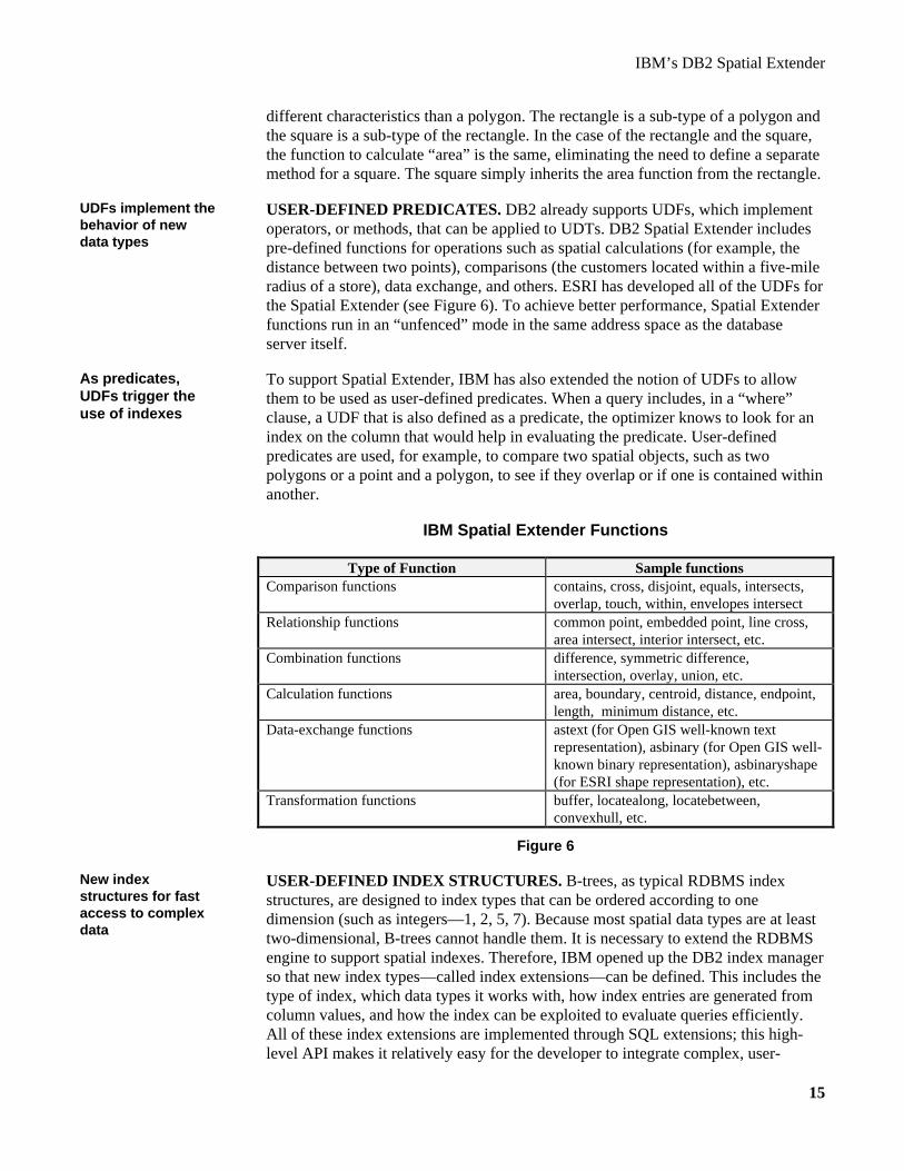
USER-DEFINED PREDICATES. DB2 already supports UDFs, which implementoperators, or methods, that can be applied to UDTs. DB2 Spatial Extender includespre-defined functions for operations such as spatial calculations (for example, thedistance between two points), comparisons (the customers located within a five-mileradius of a store), data exchange, and others. ESRI has developed all of the UDFs forthe Spatial Extender (see Figure 6). To achieve better performance, Spatial Extenderfunctions run in an “unfenced” mode in the same address space as the databaseserver itself.
To support Spatial Extender, IBM has also extended the notion of UDFs to allowthem to be used as user-defined predicates. When a query includes, in a “where”clause, a UDF that is also defined as a predicate, the optimizer knows to look for anindex on the column that would help in evaluating the predicate. User-definedpredicates are used, for example, to compare two spatial objects, such as twopolygons or a point and a polygon, to see if they overlap or if one is contained withinanother.
IBM Spatial Extender Functions
Type of Function Sample functionsComparison functions contains, cross, disjoint, equals, intersects,
overlap, touch, within, envelopes intersectRelationship functions common point, embedded point, line cross,
area intersect, interior intersect, etc.Combination functions difference, symmetric difference,
intersection, overlay, union, etc.Calculation functions area, boundary, centroid, distance, endpoint,
length, minimum distance, etc.Data-exchange functions astext (for Open GIS well-known text
representation), asbinary (for Open GIS well-known binary representation), asbinaryshape(for ESRI shape representation), etc.
Transformation functions buffer, locatealong, locatebetween,convexhull, etc.
Figure 6
USER-DEFINED INDEX STRUCTURES. B-trees, as typical RDBMS indexstructures, are designed to index types that can be ordered according to onedimension (such as integers—1, 2, 5, 7). Because most spatial data types are at leasttwo-dimensional, B-trees cannot handle them. It is necessary to extend the RDBMSengine to support spatial indexes. Therefore, IBM opened up the DB2 index managerso that new index types—called index extensions—can be defined. This includes thetype of index, which data types it works with, how index entries are generated fromcolumn values, and how the index can be exploited to evaluate queries efficiently.All of these index extensions are implemented through SQL extensions; this high-level API makes it relatively easy for the developer to integrate complex, user-
UDFs implement thebehavior of newdata types
As predicates,UDFs trigger theuse of indexes
New indexstructures for fastaccess to complexdata

IBM’s DB2 Spatial Extender
16
defined index functionality. ESRI used these extensions to implement support forspatial indexes, called grids, in the Spatial Extender.
QUERY OPTIMIZER. The DBMS is aware of the existence of spatial operatorsand indexes and the query optimizer takes advantage of these when accessing andmanipulating spatial data. In addition to specifying the cost of using a UDF, thedeveloper can indicate whether the UDF can be used as a predicate in the “where”clause and can be evaluated using an index. This information helps the DBMSefficiently search spatial data.
Spatial UDFs, such as comparing two polygons to see if they overlap, can beextremely expensive to execute in terms of both time and memory requirements.Therefore, optimization techniques to minimize execution cost are very important.One option is to provide “cheap” algorithms for filtering out spatial data that don’tfit query criteria without actually executing an expensive UDF. ESRI, for example,uses an algorithm called “envelope” to accomplish this. Envelope, stored as anattribute of a spatial data type, is a set of points that defines the minimum rectanglethat completely contains the geometry of the type. (The envelope of a point and aline is the geometry itself.) Any polygon whose envelope doesn’t fall within thespace identified in the search criteria can be easily eliminated from the searchwithout reconstructing the actual geometry of the polygon. Polygons that do qualifyin this initial pass are then further evaluated using the more expensive UDF.
The DBMS can take advantage of cheap, filtering algorithms in a couple of ways:
• If an index on a spatial column exists, the DBMS identifies which rows qualifyby doing an index lookup. Because the index is built on the “envelope”algorithm described above, these rows need further evaluation.
• DB2 extensions also support “sargable” predicates. These are predicates that canbe pushed down into and evaluated by the lowest-level component of the DBMS.In other words, as the DBMS is fetching data from disk, it applies the cheapalgorithm to each row. If a row doesn’t qualify, the DBMS doesn’t even transferthe row for further evaluation within the engine.
The final step is to evaluate qualifying rows using the expensive UDF to see whichones really satisfy the user’s request.
ALTERNATIVES TO ABSTRACT DATA TYPES FOR SPATIAL DATA
The ability to define spatial data types as ADTs with attributes has advantages overtwo other alternatives. The key difference is that neither of these alternatives toADTs gives the DBMS native intelligence about spatial data.
One alternative is to store geometry in unstructured “opaque types,” or LOBs, alongwith attributes that are encoded as part of the LOB. Because the DBMS doesn’tunderstand the content of the LOB, the user can only access attributes by callingUDFs that understand how to decode the contents of the opaque type to find theattribute value. With ADTs, the engine doesn’t need these “decoder” UDFs becauseit understands the layout of an ADT and where the attributes are stored. The
New optimizationtechniques are a keyextension
Cheap algorithmsfor filtering dataspeed upperformance
Alternatives do notgive RDBMS spatialintelligence
Using unstructured,opaque types forgeometry

IBM’s DB2 Spatial Extender
17
attributes can be requested directly in a SQL statement, so the query using ADTswill most likely execute faster. For example, if “area” is an attribute for a polygondefined as an ADT, the DBMS engine knows how to find the attribute very fast. Ifthe polygon is defined as an opaque type, the DBMS must take the whole LOB offthe disk and pass it to the specified UDF which then locates or calculates the area.The ability to index on the output of a function would improve query performance inthe case of opaque types, but would degrade update performance because the indexmust also be updated.
Another disadvantage of using opaque data types is the lack of support for sub-typing and inheritance. Therefore, instead of allowing the DBMS to decide whichversion of the “area” function to call based on the data type involved, there must bean “area” function defined for each type and the user must invoke the correctfunction for a particular type.
The second alternative is a “pure relational” approach in which geometry is stored asa normalized set of fixed-length fields. For example, a point is stored as an x- and y-coordinate (each a column value). A line is stored as a reference to two points (itsendpoints), etc. Reconstructing any geometry other than a point, therefore, requiresjoining data from multiple rows and a layer of specialized software on theapplication side that knows how to assemble the geometry. As with opaque types, theDBMS doesn’t natively understand the meaning of the data as geometry; it can onlyuse its generic access methods for standard data types such as integers andcharacters. Performance is obviously an issue with this approach.
GIS vendors and users are clear on the benefits of ADTs in enabling the RDBMS tounderstand and manage new types of data. ESRI and both of the beta users of SpatialExtender reached this conclusion based on their experiences with GIS applications.
TAKING ADVANTAGE OF DB2 SPATIAL EXTENDER
Once the user has installed DB2 Spatial Extender, spatial data types, operators, andgrid indexes are available as built-in functionality. Here are the steps necessary totake full advantage of Spatial Extender’s capabilities.
The first step is to specify which database(s) should be enabled for spatial searches.The next step is to create new tables with columns defined as spatial types or addnew spatial columns to existing tables within these databases. To illustrate thisprocess, let’s assume an existing database with tables containing information aboutcustomers and stores with the following structures:
customers: stores:name varchar (30) id intid int name varchar (30)income float address varchar (50)address varchar (30) revenue floatstate char (2) state char (2)
Using existingrelational data typesfor geometry
Spatial Extenderprovides thefoundation
Enable thedatabase, createspatial columns,load the geometry

IBM’s DB2 Spatial Extender
18
With Spatial Extender, the existing “customers” table, for example, can now have acolumn for the geographic location of each customer, defined as a point, and the“stores” table can have a similar column for location, as follows:
ALTER TABLE customers ADD COLUMN location pointALTER TABLE stores ADD COLUMN location point
The next step is to insert the geometry data and attributes into the new columns. Oneoption is to use a “geocoder” utility. This takes an existing address and constructs thegeometry as x,y coordinates. However, the ability to geocode addresses is notuniformly or universally supported; it varies from country to country and requires astructured streets network against which to map the addresses. DB2 Spatial Extenderships with a geocoding facility and a streets database for major U.S. cities. Otheruser-defined geocoders can be built for applications such as precision farming wherethe usual “street address” technique does not apply.
Another step is to create spatial indexes over the spatial columns to improveperformance on spatial queries. There is a level of tuning required to create anoptimal spatial index from a performance standpoint (that is, defining the best gridsize, which depends on the size and the size variation of the geo-spatial object in theindex). The grid index extension itself is already defined by ESRI as part of SpatialExtender; here are the SQL statements for creating spatial indexes on the customersand stores tables:
CREATE INDEX CustLoc ON customers (location)USING spatial_index (120000.0, 0, 0)
CREATE INDEX StorLoc ON stores (locationUSING spatial_index (120000.0, 0, 0)
Now the user can include spatial constraints in queries such as the following. Thisquery uses both indexes created above.
Find the name and address of all California customers whose income is greater than$50,000 per year and who do not live within 10 miles of any store in California.
SELECT c.id, c.name, c.addressFROM customers c, stores sWHERE c.state = ‘CA’ AND
c.income > 50000 ANDs.state = ‘CA’ ANDNOT EXISTS
(SELECT id FROM stores s WHEREdistance (c.location, s.location) <= 10)
Now, to generate queries that require geographic information about entities outsidethe database, such as rivers or city limits, one more step is necessary: The relevantmap data must be loaded into relational tables. DB2 Spatial Extender includes aMapLoader tool that can take commercially-available map data in ESRI’s “shape”format and load it into relational tables. (ESRI has published this format for use byothers. There are also transformation functions in Spatial Extender that can translateother map formats into the ESRI format.) Spatial Extender also includes sample
Create spatialindexes using indexextensions
Add map data withMapLoader

IBM’s DB2 Spatial Extender
19
geographic feature data. With map data in the database, users can generate spatialqueries such as this one (the index on customer location is again used to speed up thequery):
Find all customers who live within the San Jose city limits.
SELECT c.id, c.name, c.addressFROM customers c, usCities uWHERE u.name = ‘San Jose’ AND
within (c.location, u.boundary) = 1
While these spatial queries can be generated directly using SQL, data visualization isparticularly valuable for spatial data. So visual GIS tools are an important componentin exploiting Spatial Extender functionality. Such tools provide two benefits. First,they can visually display the results of a query. For example, the query above resultsin a map of San Jose with dots showing the location of each customer. Second, theuser can visually generate queries with the tool. Viewing customers as they aredistributed throughout San Jose may prompt the user to add store locations to themap for analysis purposes. Then the user might draw a two-mile circle around aparticular store in San Jose and ask for customers who have purchased at that store tosee the distribution in relation to the circle.
DB2 Spatial Extender includes ESRI’s ARCview tool for visualization of spatialdata. ARCview also includes the ability to correlate different layers of spatial data byputting one on top of another. For example, the user could display a map ofCalifornia as the bottom layer and overlay it with store locations and then withcustomer locations. Queries can be generated to highlight specific data of interest,such as the one above that identifies all customers with incomes over $50,000 thatdon’t live within 10 miles of any store.
DB2 Spatial Extender customers can also use ESRI’s other GIS applications, such asARC/Info and MapObjects, against any data source supported by DB2 DataJoiner.Another important set of tools for customers are third-party tools and applicationsthat are compatible with ESRI’s GIS products. A wide variety of such applicationsare available off-the-shelf to enable customers to make use of spatial data. If avendor has built a crime-analysis system in ARCview, a Spatial Extender user cantake advantage of this pre-defined application. Other vendors’ GIS tools can also beused instead of those from ESRI if the tools are compatible with ESRI’s SDE API.
And finally, all of this functionality is available even if the data are outside the localDB2 engine. Let’s assume stores data are in an Oracle database and customer dataare in IMS files (see Figure 7). (Either could be stored in any other backend thatDB2 DataJoiner supports.) Because spatially-oriented data, such as addresses, are inanother data source, the ADTs representing the geographic locations of stores andcustomers and the necessary index structures to speed up spatial queries are createdin a local DB2 database. The geocoder software is then applied to each foreignaddress character string and the resulting geometry stored in the local ADT.Replication capabilities are used to receive notification of any changes to thisaddress data so that the local ADT can be updated as well. For the stores data in
Tools to visuallydisplay spatial dataare an importantcomponent
DB2 DataJoiner canapply spatialfunctionality toforeign data

IBM’s DB2 Spatial Extender
20
Oracle, for example, DB2 DataJoiner automatically creates the necessary triggers inOracle to trap address changes that DataJoiner needs to know about.
Heterogeneous Spatial Query Example
Spatial Extender indexes
DataJoiner
IMS call to return id, name, addressfor customers whose state is ‘CA’and income is greater than 50000
IMS_customers
IMS
Customers
SELECT id FROM stores WHERE state = ‘CA’
Oracle_stores
Oracle
Stores
SELECT c.id, c.name, c.address FROM IMS_customers c WHERE NOT EXISTS (SELECT id FROM ORACLE_stores s WHERE distance (c.location, s.location) <= 10)
StorLoc
. . .
CustLoc
SELECT c.id, c.name, c.address FROM customers c, stores s WHERE c.state = ‘CA’ AND s.state = ‘CA’ AND c.income > 50000 AND NOT EXISTS (SELECT id FROM stores s WHERE distance (c.location, s.location) <= 10)
Figure 7
In the case of the first query above, DB2 DataJoiner pushes down the selects to theback-end data manager: Oracle selects stores in California and IMS selectscustomers with incomes greater than $50,000 and California addresses. DB2DataJoiner then combines the results extracted from the foreign data sources andevaluates the spatial component of the query locally. All of this is physicallytransparent to the user; the query is written as if all the data are stored in local DB2tables (as illustrated in the syntax of the original query).
CONCLUSIONS
DB2 Spatial Extender illustrates the considerable strengths of the advanced objectextensions IBM is adding to DB2. These provide a solid foundation on which ESRIhas implemented GIS intelligence and full integration of geo-spatial data within theORDBMS environment. DB2 Spatial Extender, when combined with DB2 and DB2DataJoiner extensions, provides significant benefits to users:
DB2 SpatialExtender offersimpressive benefitsto customers

IBM’s DB2 Spatial Extender
21
• Full integration of geo-spatial intelligence with the DB2 ORDBMS and SQL,including indexing and cost-based query optimization for improved performance.
• Full support for popular GIS tools with built-in support for sophisticatedrendering of map data for business-intelligence visualization, a geocodingfunction for U.S. addresses, and a sample set of world map data.
• Full support for existing GIS data in three industry formats (ESRI shape format,OGIS well-known text format, and OGIS well-known binary format).
• Compliance with emerging industry standards (SQL3, SQL/MM, and OGIS).
With DB2 DataJoiner’s federated data-access capabilities, Spatial Extender can alsoapply spatial intelligence to data stored in heterogeneous data sources. IntroducingSpatial Extender on DB2 DataJoiner demonstrates the important role transparent,heterogeneous data access plays in allowing customers to apply extended DBMSfunctionality across a wide array of data sources. This also gives IBM theopportunity to attract both DB2 and non-DB2 customers who want integrated geo-spatial functionality and the ability to leverage existing data assets. This is animportant differentiator for IBM.
The partnership with ESRI has enabled IBM to quickly deliver comprehensive,integrated spatial functionality and a wide variety of GIS tools. IBM’s third-generation architecture also means that other third-party vendors can create theirown extenders or add new functionality on top of DB2 Spatial Extender.Encouraging other vendors to take advantage of IBM’s extensions will ensure choiceand breadth of functionality for customers.
IBM and ESRI need to educate the IT/business community on the benefits of addingspatial information to the ORDBMS and the new types of applications and analysisthat are now possible. IBM clearly plans to focus on the business-intelligencerequirements of users in addition to those who have been traditional users of GISs.
IBM is well on its way to fulfilling its promise to offer customers a fully-extensibledata-management environment. The combined set of capabilities that DB2 UDBultimately represents—object extensions plus parallel execution of databaseoperations, DataLinks, DB2 DataJoiner’s heterogeneous data access, and all of theDB2 Extenders, including DB2 Spatial Extender—provides a formidable platform onwhich IBM, third parties, and customers can integrate new functionality andapplications to meet unique and ever-changing business requirements.
IBM white papers are available on the following IBM web site:http://www.software.ibm.com/data/pubs/papers
Information about ESRI’s products are available on ESRI’s web site:http://www.esri.com
Applying spatialintelligence acrossheterogeneous datais key

IBM’s DB2 Spatial Extender
22
APPENDIX A. OBJECT-RELATIONAL GLOSSARY
Abstract data type (ADT) commonly refers to structured types that are used to definecolumns in tables. See “structured type.”
Used to extend an existing base data type for a column or to encapsulate arbitrarilycomplex internal structures not expressed in SQL (examples are C or Java datastructures). In the latter case, a host language such as C is used to define structureand attributes; the DBMS sees the type as a large object, varchar, integer, etc. User-defined functions are used to access structure and attributes. A distinct type isrepresented as a built-in data type and is sometimes called an “opaque” type. Distincttypes do not support sub-types or inheritance.
The ability to define and use index structures other than traditional B-tree indexes.
Type hierarchies use inheritance to enable the developer to reuse the attributes andmethods of a super-type and modify them as appropriate to differentiate a sub-type.An example is a hierarchy of a polygon, rectangle, and square. See “sub-types.”
Large objects (LOBs) are data types that allow the RDBMS to store a large amountof data (up to 2GB) in a single column.
See “distinct type.”
Row type commonly refers to structured types that are used to define rows in a table.See “structured type.”
Used to describe an entire row or a set of nested attributes in a column of a table as asingle user-defined type (UDT). The DBMS is aware of the attributes and internalstructure of the type. A structured type is represented as a list of attributes orcolumns. Structured types support sub-types and inheritance and can be used eitheras abstract data types (ADTs) or row types.
A sub-type inherits the structure (attributes) and the behavior (methods or functions)of its super-type; additional attributes and methods can be defined for a sub-type andinherited methods can be modified as appropriate to differentiate the subtype.
See “distinct type.”
Used to define the methods by which applications create, manipulate, and accessdata stored in user-defined types (UDTs).
User-defined types (UDTs) enable the user/developer to define new data types,model business objects, and represent complex data or business relationships. See“distinct type” and “structured type.”
Abstract data type(ADT)
Distinct type
Extensible indexingsystem
Type hierarchies
Large objects(LOBs)
Opaque type
Row type
Structured type
Sub-types
Unstructured type
User-definedfunction (UDF)
User-defined type(UDT)

23
ABOUT THE AUTHOR
Judith R. Davis is an independent consultant with over 15 years of experience in thebusiness application of information technology. Her primary interest is databasemanagement systems and related technology. She is a respected consultant andanalyst in this area and has worked extensively with users and major vendors. Shehas also authored many articles for IT publications and magazines. Most recently,she has focused on the technology and business requirements driving thedevelopment of object extensions to the relational DBMS, and the role that theobject-relational DBMS plays in creating a fully-extensible data-managementenvironment.
Copyright © 1998 by Judith R. Davis All Rights Reserved